


Abstract
Seafloor undulations are common on continental shelves and slopes, but their origin is often difficult to determine because similar ridge-and-trough morphologies may originate from depositional processes, post-depositional deformation, or a combination of both. This study investigates seafloor undulations offshore the Sinni River mouth, southern Italy, to assess their depositional, deformational, or hybrid origin, using high-resolution bathymetry, sparker seismic profiles, sub-bottom profiler data, and morphometric analysis. Bathymetric data reveal a seaward-deepening shelf-to-slope system affected by submarine canyons, troughs, slide scarps, crests/ridge, and fields of undulated seafloor. Seismic profiles show that the undulations are mainly developed within the shallow sedimentary wedge, where continuous to gently wavy reflectors pass laterally and downslope into sectors characterized by reduced reflector continuity, local reflector bending, minor reflector offsets, low-angle reflector surfaces, disturbed sediment bodies, vertical to subvertical acoustic anomalies, and locally chaotic to semi-transparent seismic facies. Deeper stratified deposits are generally more continuous, indicating that deformation is mainly confined to the upper sedimentary succession. Morphometric analysis of 65 seabed features distinguishes broader seafloor undulations, characterized by longer wavelengths, low relief, and higher L/H ratios, from shorter, steeper deformation-related sectors with lower L/H ratios. The integrated evidence indicates that the Sinni undulation field is best interpreted as a hybrid depositional–deformational system. Broad, low-relief undulations record depositional accumulation and seabed reworking within the upper sedimentary wedge, whereas shorter, steeper, and more asymmetric sectors indicate localized post-depositional deformation, possibly favored by weak fine-grained deposits, gas/fluid-related acoustic disturbance, slope steepening, and local sediment remobilization.
1. Introduction
Seafloor undulations are common morphological features on continental shelves, slopes, and prodeltaic systems, where they are generally expressed as repeated ridge-and-trough forms with wavelengths ranging from tens to hundreds of meters and relief commonly of a few meters [1,2,3]. Despite their relatively simple morphology, their origin is often difficult to establish because similar seabed morphologies may be produced by different processes, including sediment transport, bedform migration, soft-sediment deformation, and incipient slope failure [2,3]. Undulations may form as depositional or reworking-related bedforms generated by bottom currents, turbidity currents, hyperpycnal flows, storm-related processes, or contour-parallel sediment transport [1,3,4]. However, similar morphologies may also reflect post-depositional deformation, downslope creep, shallow sliding, or the early stages of slope instability [1,3,5,6,7].
Previous studies have distinguished depositional or reworking-related undulations from deformation-related features using a combination of geomorphic, seismic-stratigraphic, and morphometric criteria [2,3]. Depositional sediment waves are commonly recognized by laterally continuous, rhythmically repeated ridge-and-trough forms, internal reflector geometries compatible with aggradation or bedform migration, and spatial relationships with bottom currents, density flows, hyperpycnal flows, storm reworking, or contour-parallel sediment transport [1,2,3,4]. In contrast, deformation-related undulations are generally associated with asymmetric ridge-and-trough geometries, fixed or vertically stacked crest-and-trough positions, reflector bending and truncation, reduced reflector continuity, glide or shear planes, local faults, scarps, chaotic or disrupted seismic facies, and spatial relationships with weak layers, soft-sediment deformation, slope instability, or mass-transport deposits [2,3,5,6,7]. Because these criteria may overlap, previous authors have emphasized that process interpretation should not rely on seabed morphology alone, but should integrate bathymetry, subsurface seismic architecture, morphometry, and geomorphic setting [2,3,6,7].
Late Quaternary and Holocene mud wedges along Mediterranean continental margins provide favorable settings for the development of mixed depositional–deformational seabed morphologies. In particular, studies have demonstrated that undulated seabed morphologies on continental shelves and prodeltas can evolve from initially depositional or reworking-related landforms into deformation-dominated structures, driven by processes such as sediment loading, fluid migration, and slope instability [1,3,5,6,7,8,9]. Rapid accumulation of fine-grained sediment, high water content, reduced sediment strength, local overpressure, slope gradients, and weak horizons may promote gravitational creep and localized failure [1,3].
The study area is located in the northeastern Gulf of Taranto, offshore the mouth of Sinni River, southern Italy, which represents a suitable natural laboratory for investigating the relationship between seafloor undulations, shallow deformation, and slope instability. The area lies along the northern Ionian margin, where Quaternary sedimentation, canyon incision, gravity-driven processes, and structurally controlled deformation have contributed to the development of a complex shelf-to-slope morphology [10,11,12]. Recent studies have documented mass-transport deposits, slide scars, canyon-related morphologies, and geohazard-related features in different sectors of the gulf, highlighting the role of sediment remobilization and shallow gravitational processes in shaping the margin [13,14,15,16].
However, the origin of the seafloor undulations observed along the investigated shelf-slope margin, and their possible relationship with depositional processes and near-seafloor gravitational deformation remain insufficiently constrained. To date, no integrated morphobathymetric and high-resolution seismic analysis has specifically addressed the origin of these undulations along the Sinni shelf-slope margin. Therefore, this study investigates seafloor undulations and associated shallow structures using high-resolution bathymetric data, sparker seismic profiles, sub-bottom profiler data, and morphometric analysis. The main objectives are to: (i) describe the morphology and spatial distribution of seafloor undulations; (ii) analyze the relationship between seafloor morphology and shallow subsurface structures; (iii) quantify their morphometric characteristics and compare them with other Mediterranean undulation fields; and (iv) assess whether the studied features have a predominantly depositional, deformational, or hybrid origin. The results provide new constraints on the role of shallow gravitational deformation in modifying recent shelf-margin deposits and provide a basis for identifying potentially unstable sectors relevant to marine geohazard assessment.
2. Geological Setting
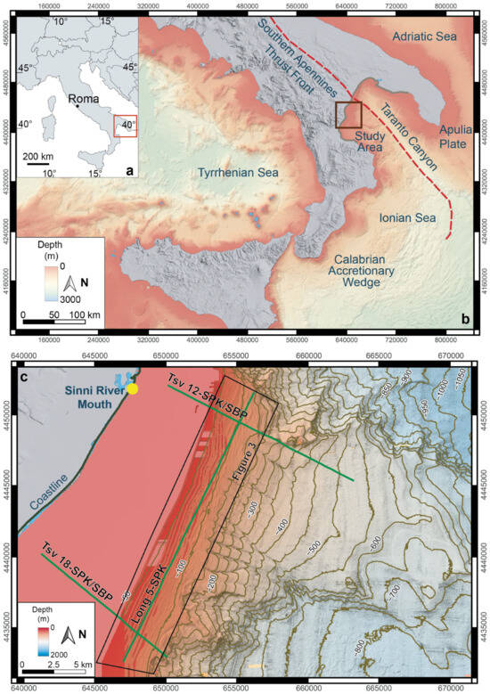
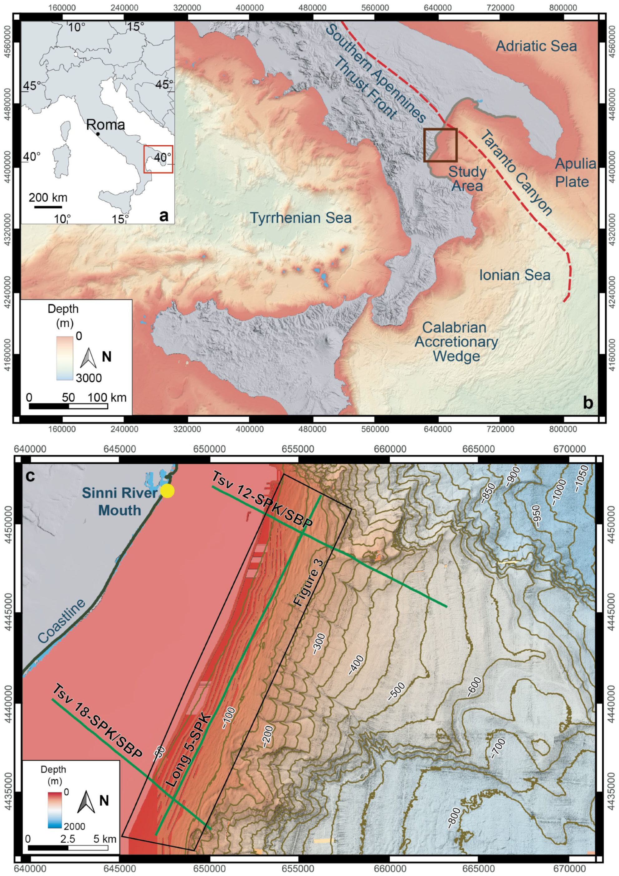
Regionally, the northeastern Gulf of Taranto forms part of the northern Ionian continental margin, between Apulia, Basilicata, and Calabria (Figure 1). It occupies a transition zone between the Southern Apennine–Calabrian orogenic system to the west and the Apulian foreland to the east, affected by Neogene–Quaternary deformation, sediment accumulation, and margin instability [10,17,18,19,20].
Figure 1.
Location of the study area and geophysical dataset in the northeastern Gulf of Taranto, southern Italy: (a) Geographic location of the study area; (b) Regional physiographic setting of the northern Ionian Sea, showing the Southern Apennines thrust front, the Taranto Canyon system, the Apulia Plate, the Calabrian Accretionary Wedge, and the study area; (c) Detailed bathymetric map offshore the Sinni River mouth, showing the geophysical profile traces used in this study. Long 5-SPK represents the along-strike sparker profile, whereas TSV 12-SPK/SBP and TSV 18-SPK/SBP are coincident sparker and sub-bottom profile traces across the shelf-to-slope sector where seafloor undulations are investigated. Bathymetric contours are shown at 50 m intervals.
The Southern Apennines form a fold-and-thrust belt resulting from the deformation of Mesozoic–Cenozoic sedimentary domains during Neogene convergence associated with subduction in the central Mediterranean [21,22,23]. The regional geological architecture reflects the interaction between the advancing Apennine–Calabrian orogenic system and the relatively more stable Apulian foreland. This setting controlled the development of a structurally complex shelf-to-slope system characterized by variable sediment thickness, inherited structural lineaments, canyon incision, and gravity-driven processes [11,12,17,24].
The onshore sector adjacent to the study area records a Late Quaternary to Holocene evolution marked by coastal progradation, sediment redistribution, and changes in accommodation space and sediment supply. This evolution provides a source-to-sink framework for understanding the recent sedimentary dynamics of the shelf margin, particularly in relation to sediment delivery from the coastal plain and river systems draining toward the northern Ionian Sea [25,26]. Among the river systems draining into the northern Ionian Sea, the Sinni River is one of the principal sediment sources to the Gulf of Taranto, supplying fine-grained sediment that contributed to Late Quaternary–Holocene shelf progradation and the development of the upper sedimentary wedge investigated in this study.
The continental shelf and upper slope of the area are marked by heterogeneous seafloor morphology, including submarine canyons, erosional troughs, slide scars, mass-transport deposits, and locally deformed sedimentary bodies. The Taranto Canyon system represents one of the main sediment-routing and erosional elements of the margin, and previous morphometric analysis of its upper reach documented submerged drainage basins with different evolutionary stages and contrasting erosional maturity [13]. Other studies have documented submarine mass movements, slide scars, and geohazard-related features in the gulf and adjacent northern Ionian sectors, indicating repeated sediment remobilization and shallow gravitational instability along the margin [11,12,15,16].
In the study area, the uppermost sedimentary succession includes relatively young, weakly consolidated deposits forming a shallow progradational wedge across the shelf margin. These deposits provide favorable conditions for near-seafloor deformation where sediment loading, slope gradients, possible fluid migration, and pre-existing discontinuities may locally reduce sediment strength.
3. Materials and Methods
3.1. Geophysical Dataset
The study integrates high-resolution multibeam bathymetry, sparker seismic profiles, and sub-bottom profiler data acquired across the shelf-to-slope sector of the northeastern Gulf of Taranto (Figure 1). The dataset was used to investigate the morphology, spatial distribution, and shallow subsurface expression of seafloor undulations and the processes controlling their development.
The bathymetric dataset derives from multibeam surveys carried out during the 2005 CARG Project and the 2010 MaGIC Project oceanographic campaign. The 2005 survey was carried out aboard the R/V Coopernaut Franca, whereas the 2010 survey took place during the “MAGIC Conisma 11/2010” cruise aboard the R/V Minerva Uno. The final bathymetric surface was gridded at 5 × 5 m resolution and referenced to mean sea level.
Bathymetric data were acquired using a RESON SeaBat 8160 multibeam echosounder (Teledyne RESON A/S; Slangerup, Denmark) operating at 50 kHz. The multibeam data were processed using CARIS HIPS & SIPS v 7.1 (CARIS, Fredericton, NB, Canada), including sound-velocity correction, tide correction, beam-refraction correction, spike removal, surface cleaning, and generation of the final digital terrain model.
The seismic dataset includes one along-strike sparker profile, Long 5-SPK, and two dip-oriented transects, TSV 12 and TSV 18, each covered by both sparker seismic and sub-bottom profiler data.
Sub-bottom profiler data were acquired using an EdgeTech Subscan 670C CHIRP system (EdgeTech, West Wareham, MA, USA) operating within a frequency range of 2–16 kHz. The system provides an acoustic penetration of approximately 6–80 m, depending on sediment type, and a vertical resolution of about 6–10 cm. The data were processed using EdgeTech Discover software (EdgeTech, West Wareham, MA, USA), ISIS sona software (Triton Imaging, Watsonville, CA, USA), and CODA softwarev 6.0 (Coda Octopus Products Ltd., Edinburgh, UK).
Sparker seismic data were acquired using a Geo-Spark 200 system powered by a Geo-Spark 1000 unit (Geo Marine Survey Systems B.V., Rotterdam, The Netherlands) and operated with a source power of 300–1000 J. The system was coupled with a Geo-Sense eight-element streamer and a Geo-Trace 2 recording system. Acquisition parameters included a 1 s shot interval, a 0.4 s record length, an 8000 Hz sample rate, and 16-bit SEG-Y recording. The source had a dominant frequency of approximately 500–2000 Hz and an impulse length of approximately 0.5 ms. The data were processed through format conversion, frequency filtering, deconvolution, seabed picking, swell filtering, time-variant bandpass filtering, notch filtering, automatic gain control, and profile export.
The sparker profiles provide greater penetration and were used to record the shallow sedimentary architecture, disturbed sediment bodies, possible mass-transport deposits, slump-related deformation, acoustic anomalies, and larger-scale instability features. The sub-bottom profiles provide higher-resolution images of the near-seafloor deposits and were used to analyze seafloor undulations, deformation-related sectors, minor reflector offsets, and low-angle reflector surfaces. Profile orientation, data type, acquisition details, and main use in this study are summarized in Table 1.
Table 1.
Profiles used to investigate seafloor undulations and shallow deformation.
3.2. Bathymetric Mapping and Morphometric Analysis
The multibeam Digital Terrain Model (DTM) was used to map the main geomorphic elements of the study area, including seafloor undulations, troughs, crests, slide scarps, canyon-related features, slope breaks, and irregular relief associated with shallow deformation. Bathymetric maps were analyzed using hillshade visualization, bathymetric contours, and profile extractions across selected sectors of the shelf and upper slope.
Seafloor morphological analysis was conducted along the trace of the TSV 12 seismic line using 171 bathymetric observations. The seafloor morphology was interpreted based on variations in relief, including alternating elevated and depressed sections, as well as undulatory patterns, to characterize the geomorphological features and spatial variability of the seabed.
To separate local seabed variability from the first-order shelf–slope geometry, a third-order polynomial was fitted in MATLAB 2024 (The MathWorks, Inc., Natick, MA, USA) to the measured bathymetric profile and used to represent the regional trend. Raw residuals were calculated as:
where is the measured seafloor elevation and is the fitted third-order polynomial trend. The resulting residual series was smoothed using a 21-point moving-mean filter, yielding the smoothed residual . For visualization in Figure 2c, the smoothed residuals were normalized and rescaled according to
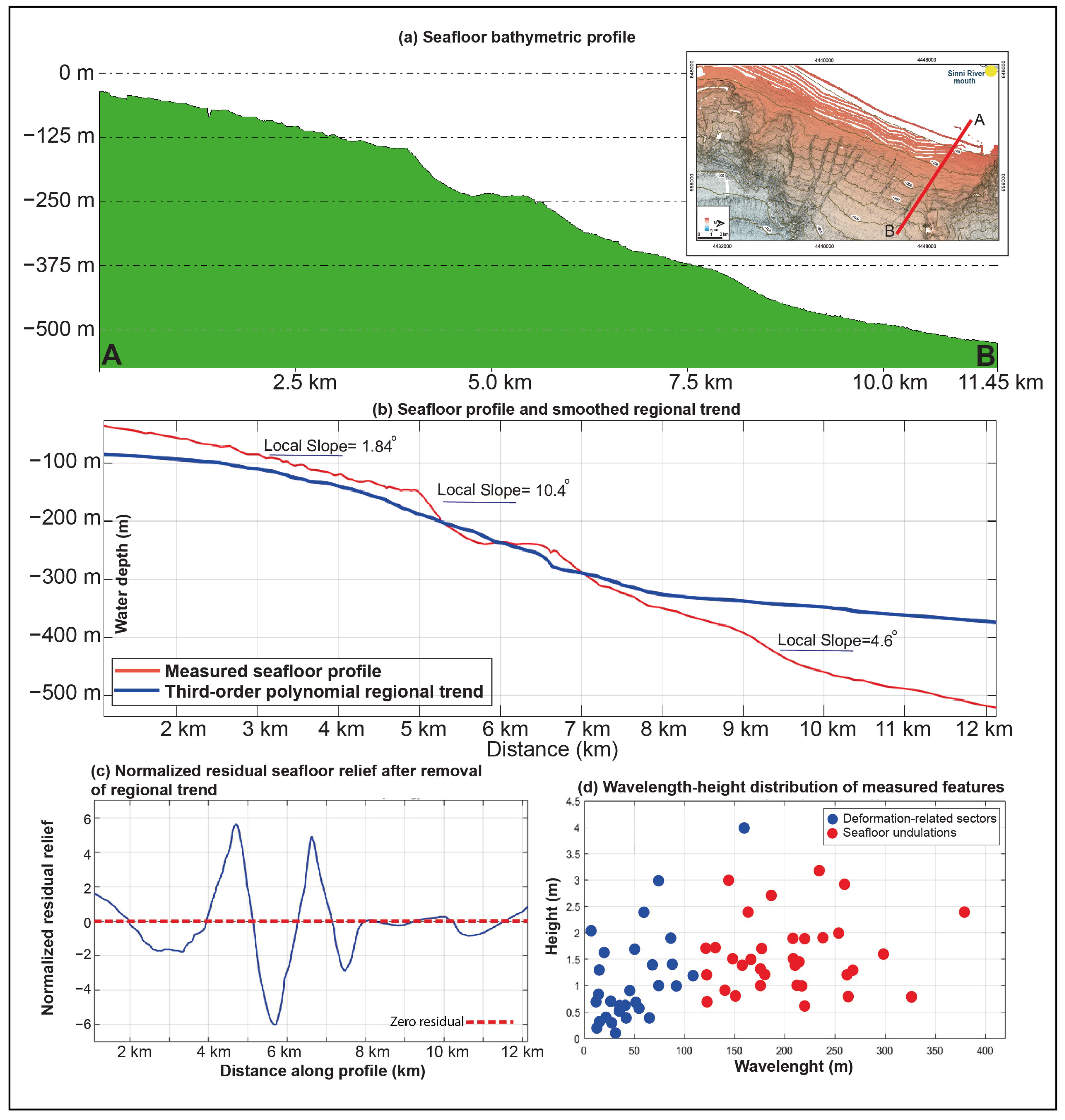
where is the normalized residual plotted in the figure. Positive values indicate seabed sectors located above the regional trend and therefore correspond to relative local highs, whereas negative values indicate sectors below the regional trend and correspond to relative local lows. Because the normalization imposes a numerical range between −6 and +6, the plotted values represent relative scaled deviations from the regional trend rather than absolute residual relief expressed in metres.
Figure 2.
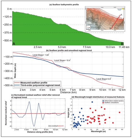
(a) Bathymetric profile showing the progressive seaward deepening from the shelf toward the upper slope; the inset shows the location of the analyzed transect. A and B mark the endpoints of the profile, and the red line in the inset indicates the analyzed transect.; (b) Comparison between the measured seafloor profile and the third-order polynomial regional trend used to represent the first-order shelf–slope geometry. The red line represents the measured seafloor profile, whereas the blue line represents the third-order polynomial regional trend. Representative local seabed gradients are shown along selected sectors of the profile; (c) normalized residual seafloor relief obtained by subtracting the third-order polynomial trend from the measured profile, smoothing the resulting residuals using a 21-point moving-mean filter, and rescaling them by their maximum absolute value to an imposed range between −6 and +6. Positive values represent relative seabed highs above the regional trend, whereas negative values represent relative seabed lows; (d) Wavelength–height distribution of the measured seabed features, showing the first-order separation between broader seafloor undulations and shorter deformation-related sectors.
Morphometric analysis was performed on 65 individual seabed features identified from bathymetric profiles and seismic sections. For each feature, wavelength or feature length (L), height (H), and length-to-height ratio (L/H) were measured. For regularly spaced undulations, L was defined as the horizontal distance between two adjacent crests or equivalent morphological points. For shorter and less regularly spaced features, L corresponds to the measured horizontal length of the individual feature. H was defined as the vertical relief between a crest and the adjacent trough. The L/H ratio is dimensionless and was used to evaluate relative steepness.
The measured features were grouped into two main categories: (i) broader seafloor undulations, characterized by longer wavelengths, low relief, smoother ridge-and-trough morphology, and limited internal deformation; and (ii) shorter and steeper deformation-related sectors, characterized by shorter wavelengths or lengths, greater relative steepness, asymmetric geometry, reflector bending, minor reflector offsets, low-angle reflector surfaces, scarps, or disturbed seismic facies. The classification was based on the integrated interpretation of morphometric parameters, geomorphological characteristics, and seismic attributes, rather than on any single parameter.
Morphometric results were compared with published morphometric data from Mediterranean prodelta and shelf-margin undulation fields to assess whether the identified features in the study area fall within the range of known depositional bedforms, deformation-related undulations, or hybrid depositional–deformational systems.
3.3. Seismic Interpretation of Seafloor Undulations
Seismic and sub-bottom profiles were interpreted to evaluate the relationship between seabed undulations and shallow subsurface seismic architecture. The interpretation focused on reflector geometry, continuity, amplitude changes, truncations, acoustic disturbance, and the relationship between seabed relief and internal structures.
The following criteria were used to distinguish depositional/reworking-dominated undulations from deformation-affected sectors:
- (i)
- Repeated ridge-and-trough morphologies at the seabed;
- (ii)
- Wavy, folded, or bent reflectors beneath the undulated seabed;
- (iii)
- Asymmetric undulations with longer downslope limbs and steeper upslope or frontal limbs;
- (iv)
- Fixed or vertically stacked crest-and-trough positions within the shallow succession;
- (v)
- Reflector truncation or local loss of continuity beneath ridges and troughs;
- (vi)
- Low-angle reflector surfaces, locally interpreted as possible glide/shear surfaces;
- (vii)
- Minor reflector offsets within the shallow sedimentary wedge;
- (viii)
- Vertical to subvertical acoustic disturbance zones;
- (ix)
- Chaotic to semi-transparent seismic bodies with disrupted internal reflections and irregular basal surfaces.
Relatively undeformed deposits were recognized where reflectors are laterally continuous, parallel or sub-parallel, and only weakly affected by bending or disruption. Deformed sectors were identified where reflector continuity decreases, internal geometries become distorted, low-angle reflector surfaces or minor reflector offsets are observed, and seabed morphology is associated with asymmetric ridges, scarps, or disturbed seismic facies.
3.4. Software and Visualization
Bathymetric mapping, profile extraction, hillshade visualization, and contour generation were performed in QGIS v. 3.44 “Solothurn” (QGIS Development Team. QGIS.org, Solothurn, Switzerland). Bathymetric contours were extracted at 50 m intervals and combined with shaded-relief visualization to support the identification of ridge-and-trough morphologies, slope breaks, scarps, and lineaments.
Seafloor morphological analysis, morphometric calculations, and plots were produced using MATLAB 2024 (The MathWorks, Inc., Natick, MA, USA). Seismic profiles were interpreted using IHS Kingdom Suite 2018 (IHS Markit, Houston, TX, USA). Final figure editing and interpretative sketches were prepared using CorelDRAW Graphic Suite 2025 (Alludo, Ottawa, ON, Canada).
4. Results
4.1. Seafloor Morphology
High-resolution bathymetric data show that seafloor undulations are mainly distributed from the outer shelf to the upper slope sector offshore the Sinni River mouth, in the northeastern Gulf of Taranto (Figure 1c). The inner to middle shelf is comparatively smooth and gently deepens toward approximately 80–100 m water depth. Seaward, the seabed steepens toward a narrow shelf-break and upper slope sector characterized by irregular relief, scarps, and sharp gradient changes.
The upper slope is morphologically heterogeneous. Northern and southern sectors are incised by downslope-oriented depressions and small canyon-like features that locally disrupt slope continuity (Figure 1c). The central sector, crossed by the TSV 12-SPK/SBP, TSV 18-SPK/SBP, and Long 5-SPK profiles, is more continuous, although it still shows troughs, crests, subtle scarps, and fields of undulated seabed.
Bathymetric profiles indicate three main slope domains, with representative local slope gradients of approximately 1.8°, 10.4°, and 4.6° (Figure 2). After removal of the third-order polynomial regional trend, the residual profile was smoothed using a 21-point moving-mean filter and normalized to an imposed numerical range between −6 and +6. Positive normalized residuals identify relative seabed highs above the regional trend, whereas negative values identify relative seabed lows. The normalized residual profile highlights the spatial distribution of local seabed irregularities, including highs, depressions, troughs, crests, scarps, and undulated morphology.
The outer sector lies close to the Taranto Canyon system, a major erosional and sediment-routing feature of the northern Ionian margin. Canyon-related incisions locally dissect the slope and increase seabed roughness. Seafloor undulations are concentrated along the outer shelf–upper slope transition. They are broad and smooth in gently sloping areas, whereas they become shorter, sharper, and more asymmetric in steeper or incised sectors.
4.2. Shallow Seismic Architecture of the Undulated Interval
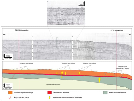
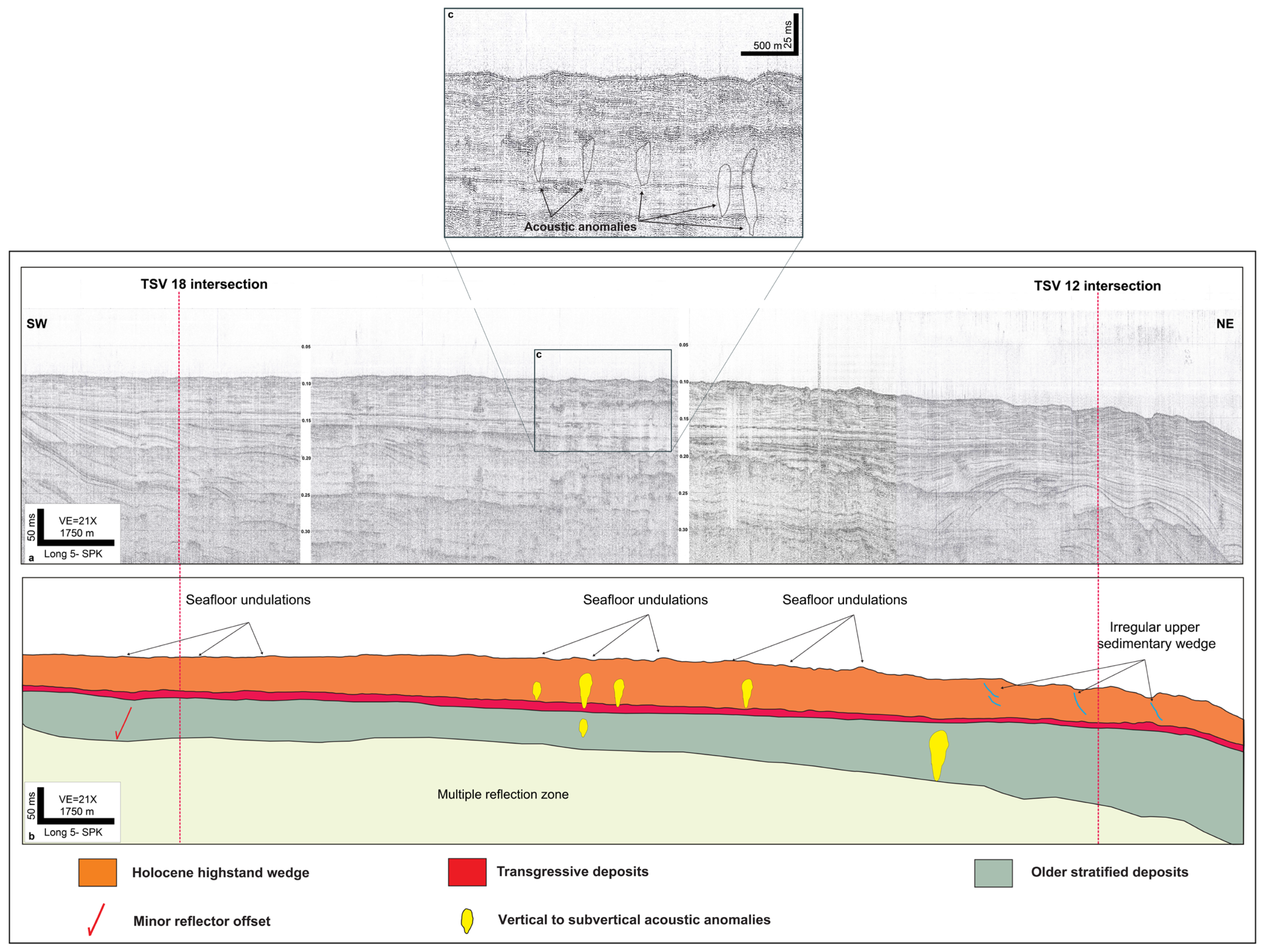
The Long 5-SPK profile images the along-strike architecture of the shallow succession across the sector where seafloor undulations are developed (Figure 3). The profile shows a lower stratified unit overlain by a younger upper sedimentary wedge. The lower unit is characterized by laterally continuous, parallel to sub-parallel reflectors. In contrast, the upper wedge contains wavy to gently undulated reflectors, local reflector bending, minor discontinuities, minor reflector offsets, vertical to subvertical acoustic anomalies, and undulated seabed morphology.
Figure 3.
Shallow seismic architecture of the undulated interval along the Long 5-SPK profile: (a) Uninterpreted Long 5-SPK sparker profile showing the intersections with the TSV 18-SPK/SBP and TSV 12-SPK/SBP transects and the location of the enlarged sector shown in panel (c); (b) General simplified interpretation of the shallow sedimentary succession, showing the Holocene highstand wedge, transgressive deposits, older stratified deposits, seafloor undulations, minor reflector offsets, and vertical to subvertical acoustic anomalies; (c) Enlarged detail of the upper sedimentary wedge showing vertical to subvertical acoustic anomalies beneath the undulated seabed.
A laterally traceable reflector separates the lower stratified deposits from the overlying upper wedge. Above this surface, the shallow succession shows lateral changes in reflector geometry and continuity.
In the TSV 18 sector, the seabed undulations are broad and low relief, and the underlying reflectors are mainly continuous to gently wavy. Toward the TSV 12 sector, the seabed becomes more irregular, and the upper wedge shows more evident reflector bending, reduced continuity, minor reflector offsets, and acoustic anomalies.
The observed structures are mainly confined to the upper sedimentary wedge, whereas the deeper stratified deposits remain comparatively continuous. This vertical distribution shows that the main changes in reflector geometry and acoustic character affect the near-seafloor sedimentary interval rather than the entire Quaternary succession.
4.3. Seismic/Acoustic Character of the Shallow Succession
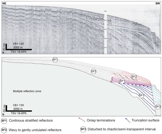
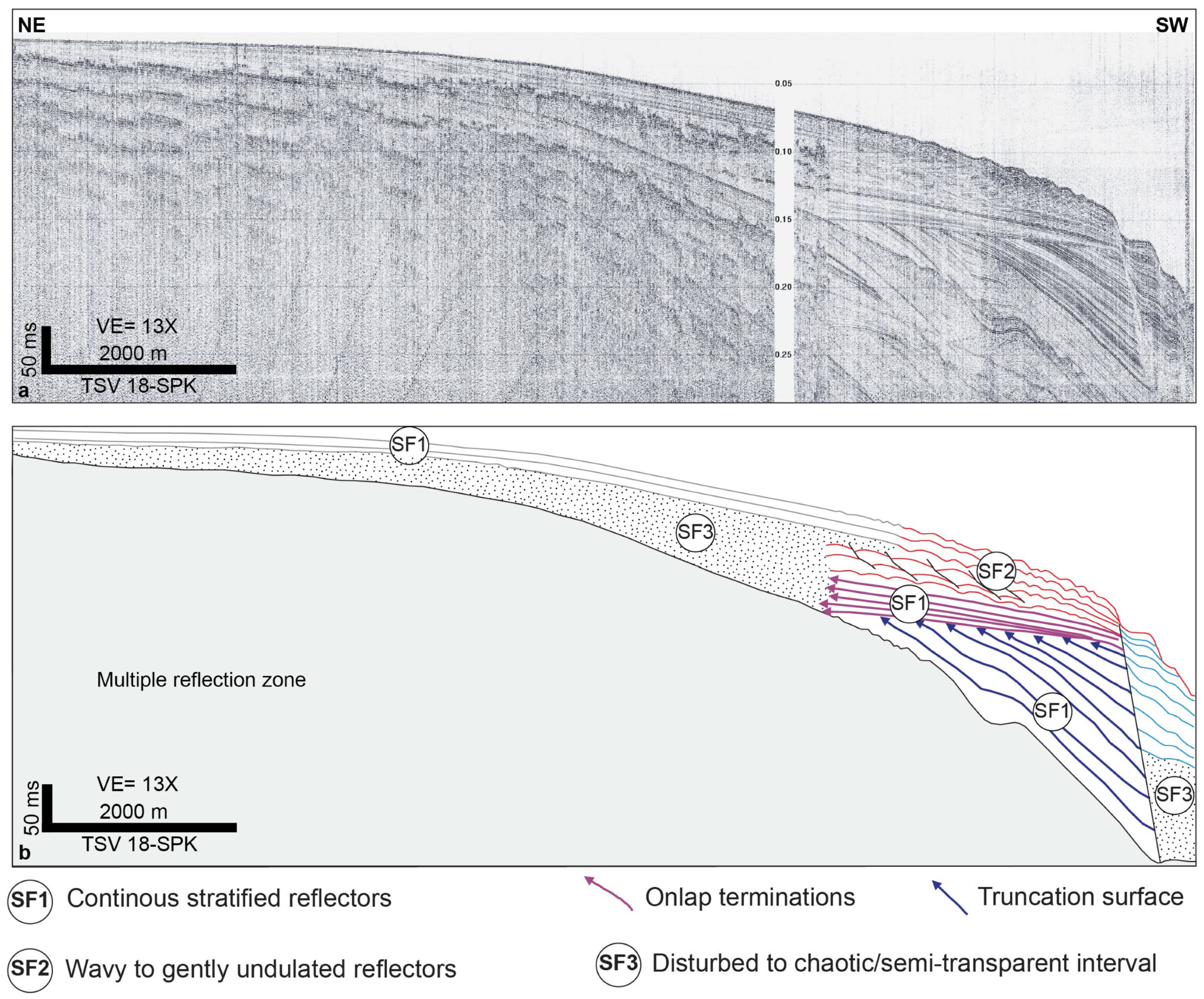
The shallow succession imaged by the sparker and sub-bottom profiler data shows a set of recurring seismic/acoustic characters, distinguished by reflector geometry (Figure 4; Table 2). Continuous stratified reflectors are laterally persistent, parallel to sub-parallel, and show moderate to high continuity. They occur mainly in the lower part of the shallow succession or in less irregular intervals, and provide a reference seismic character against which more irregular intervals can be compared.
Figure 4.
Seismic/acoustic characters of the shallow succession along the TSV18-SPK profile: (a) Uninterpreted sparker profile. (b) Simplified seismic interpretation showing the main acoustic characters recognized in the shallow succession. SF1 indicates continuous stratified reflectors. SF2 indicates wavy to gently undulated reflectors within the upper sedimentary wedge. SF3 indicates disturbed to chaotic or semi-transparent intervals characterized by reduced reflector continuity and irregular internal geometry. Onlap terminations and truncation surfaces are also shown.
Table 2.
Main seismic/acoustic characters recognized in the shallow succession of the study area.
Wavy to gently undulated reflectors occur mainly within the upper sedimentary wedge, beneath sectors where the seabed shows ridge-and-trough morphology. In some areas, these reflectors broadly follow the seabed relief and maintain partial lateral continuity. In other sectors, they show local bending, reduced continuity, or minor truncation beneath ridges and troughs.
Disturbed to chaotic or semi-transparent intervals are characterized by reduced reflector continuity, irregular internal geometry, and locally lens-shaped or poorly organized seismic facies. These intervals occur near scarps, troughs, steepened sectors, and areas of irregular seabed morphology. In some profiles, vertical to subvertical zones of reduced amplitude, reflector attenuation, or acoustic blanking are also observed. Overall, the seismic/acoustic data document a transition from laterally continuous stratified deposits to wavy, disturbed, or acoustically attenuated intervals within the upper sedimentary succession.
4.4. Distribution of Seafloor Undulations and Geomorphic Features
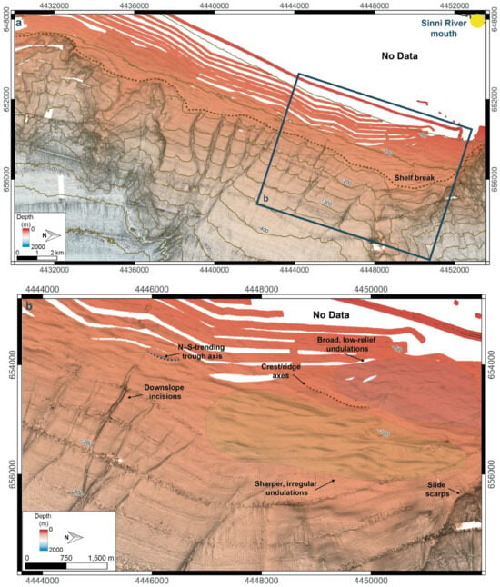
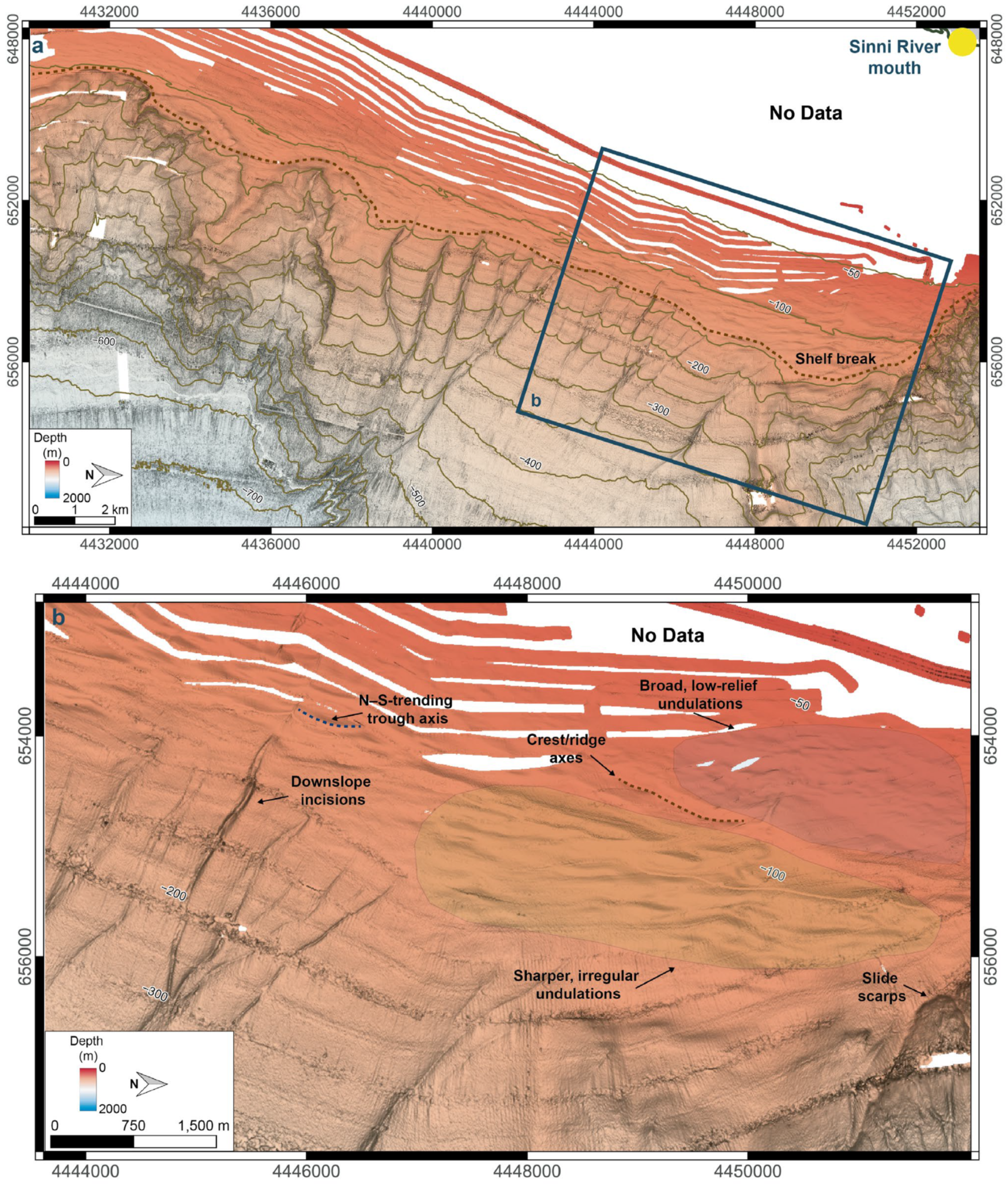
Seafloor undulations are concentrated along the outer shelf–upper slope transition (Figure 5). The mapped morphology includes repeated ridge-and-trough forms, crests/ridges, shallow depressions, scarps, and downslope incisions.
Figure 5.
Detailed bathymetric expression of seafloor undulations and associated geomorphic features: (a) Bathymetric map of the outer shelf and upper-slope sector offshore the Sinni River mouth, showing the shelf-break position and the location of the panel (b); (b) Detailed view of the undulated seabed, showing the N–S-trending trough axis, local crests/ridges, downslope incisions, broad low-relief undulations, sharper and more irregular undulations, and slide scarps. Bathymetric contours are shown at 50 m intervals.
The N–S-trending trough axis and downslope incisions locally interrupt the lateral continuity of the undulated seabed (Figure 5). Broad, low-relief undulations occur mainly in the shallower sector close to the shelf break, whereas sharper and more irregular undulations are observed downslope, near downslope incisions and slide scarps.
4.5. Internal Architecture Beneath the Undulated Seabed
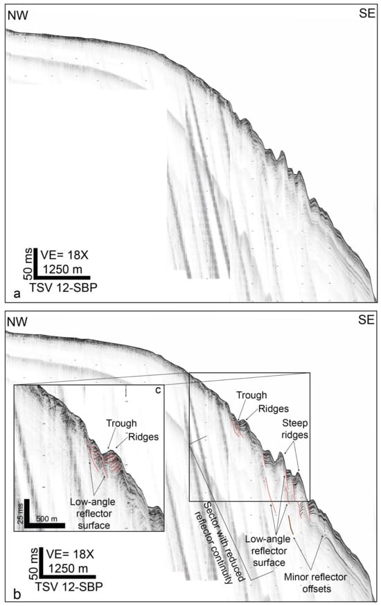
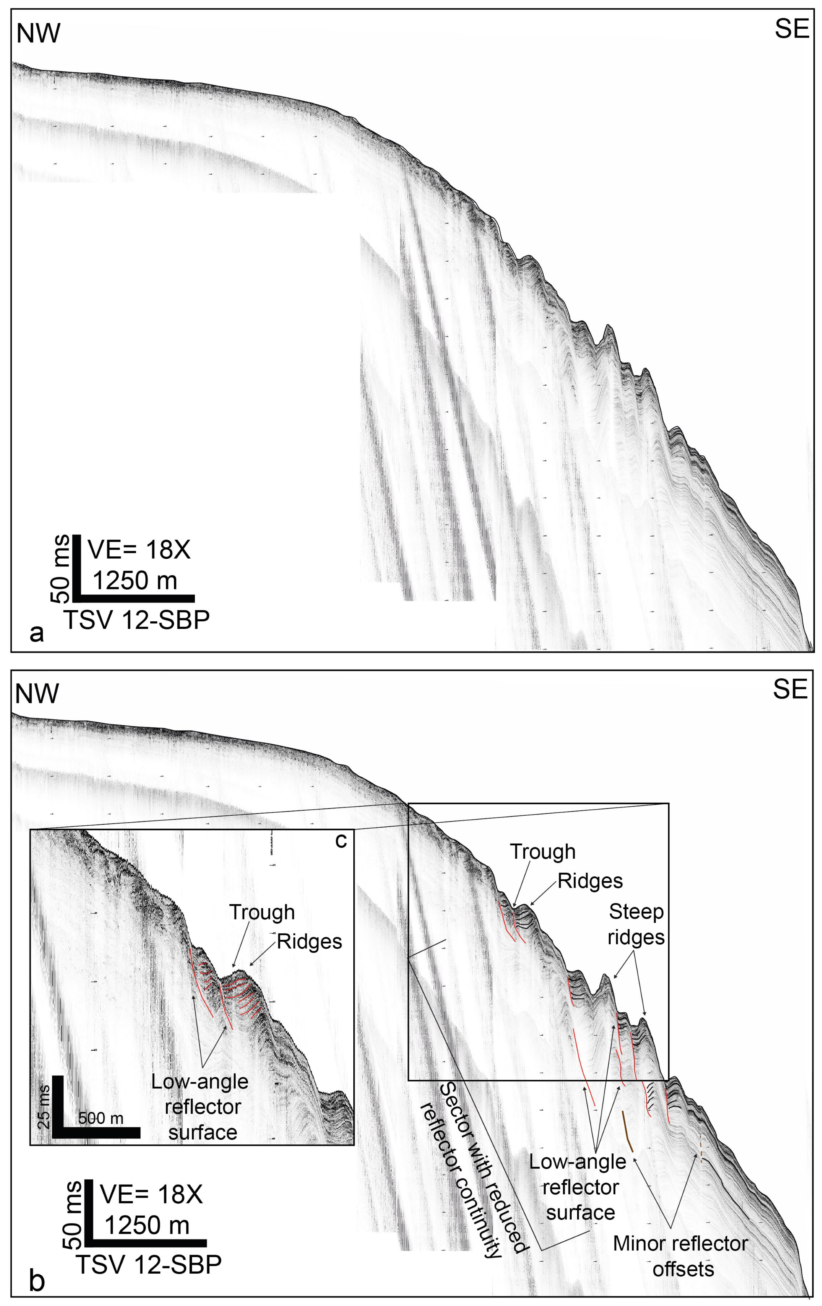
Dip-oriented sub-bottom and sparker profiles show that the ridge-and-trough seabed morphology is associated with changes in the shallow subsurface architecture. Along the TSV 12-SBP profile, the upper sedimentary interval beneath the ridges and troughs is characterized by wavy reflectors, local reflector bending, reduced continuity, and minor reflector offsets (Figure 6). A low-angle reflector surface locally separates this interval from more continuous underlying reflections.
Figure 6.
Sub-bottom expression of ridge-and-trough morphology along the TSV 12-SBP profile: (a) Uninterpreted TSV 12-SBP sub-bottom profile across the outer shelf–upper slope sector; (b) Simplified interpretation of the same profile, showing seabed troughs, ridges, steeper ridge-and-trough forms, a sector characterized by reduced reflector continuity, low-angle reflector surfaces, and minor reflector offsets within the upper sedimentary interval; (c) Enlarged view of a selected sector showing the relationship between seabed ridges and troughs, locally bent and discontinuous reflectors, and a low-angle reflector surface.
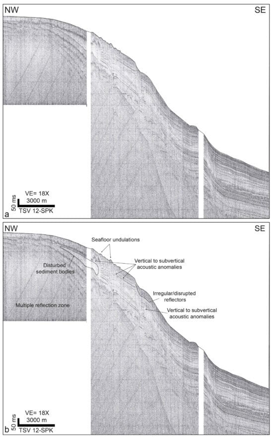
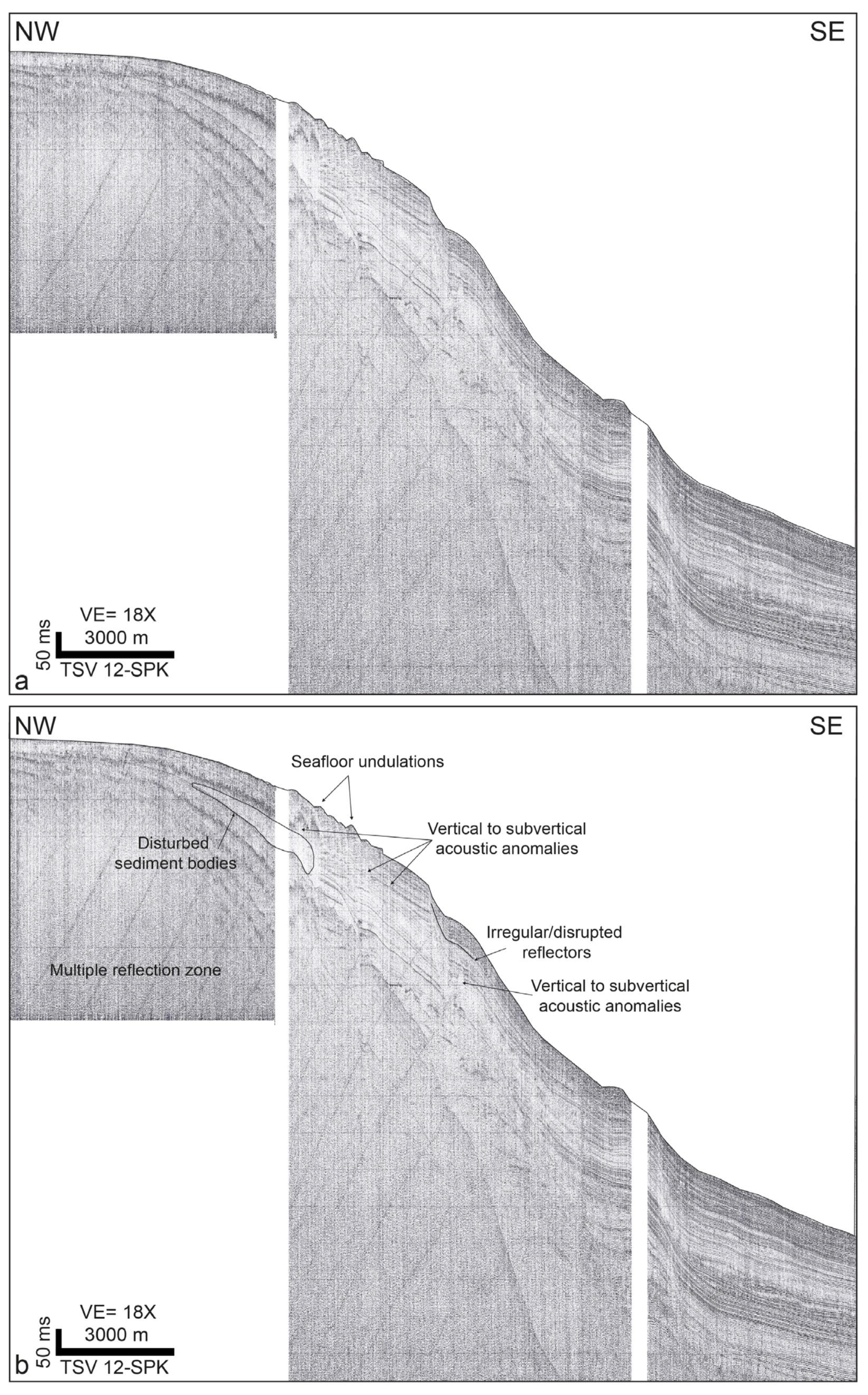
The same sector imaged by the TSV 12-SPK profile shows greater acoustic penetration and a laterally variable acoustic character within the upper sedimentary succession (Figure 7). Disturbed sediment bodies occur in the upper part of the slope, where vertical to subvertical acoustic anomalies are also observed beneath the undulated seabed. Downslope, the profile shows intervals with reduced reflector continuity and irregular internal geometry.
Figure 7.
Sparker seismic expression of disturbed sediment bodies and acoustic anomalies along the TSV 12-SPK profile: (a) Uninterpreted TSV 12-SPK sparker profile across the shelf-to-slope sector; (b) Simplified interpretation showing seafloor undulations, disturbed sediment bodies, irregular or disrupted reflectors, a multiple-reflection zone, and vertical to subvertical acoustic anomalies within the upper sedimentary succession.
4.6. Variability of Undulation Geometry and Shallow Reflector Patterns
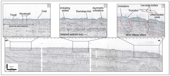
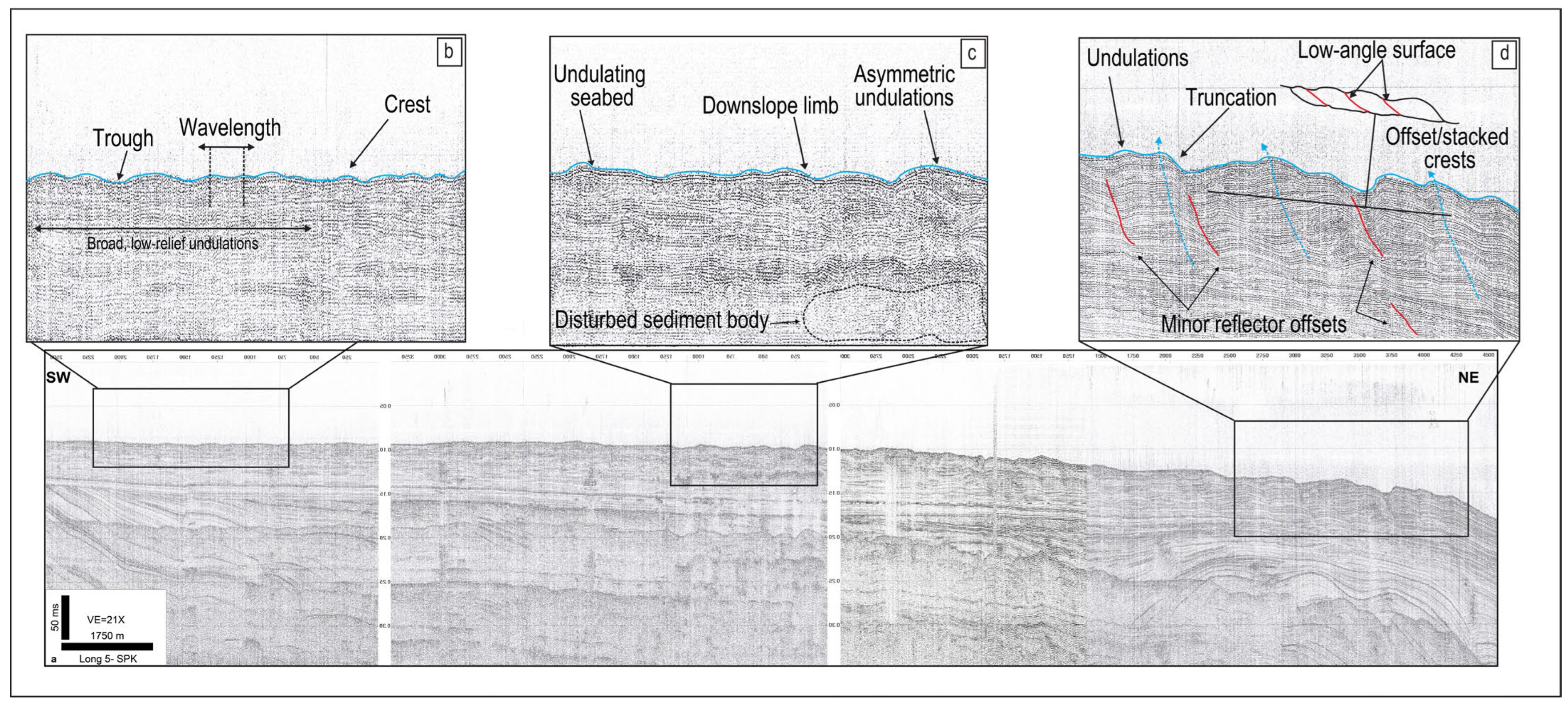
The seismic profiles show lateral and downslope variability in the geometry of the seafloor undulations and in the internal reflector patterns beneath them (Figure 8, Figure 9 and Figure 10). Along the Long 5-SPK profile, broad, low-relief undulations are associated with continuous to gently wavy reflectors. In adjacent sectors, the seabed becomes more asymmetric and the underlying reflections show reduced continuity, local truncation, offset or stacked crest positions, and disturbed sediment bodies (Figure 8).
Figure 8.
Along-strike variability of seafloor undulations and shallow reflector patterns along the Long 5-SPK profile: (a) Long 5-SPK sparker profile showing the location of the enlarged sectors; (b) Sector with broad, low-relief undulations and continuous to gently wavy reflectors; (c) Sector with asymmetric undulations, a longer downslope limb, and a disturbed sediment body; (d) Sector showing undulated seabed morphology, reflector truncation, offset or stacked crest positions, a low-angle surface, and minor reflector offsets.
Figure 9.
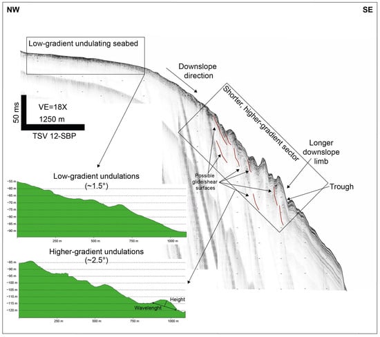
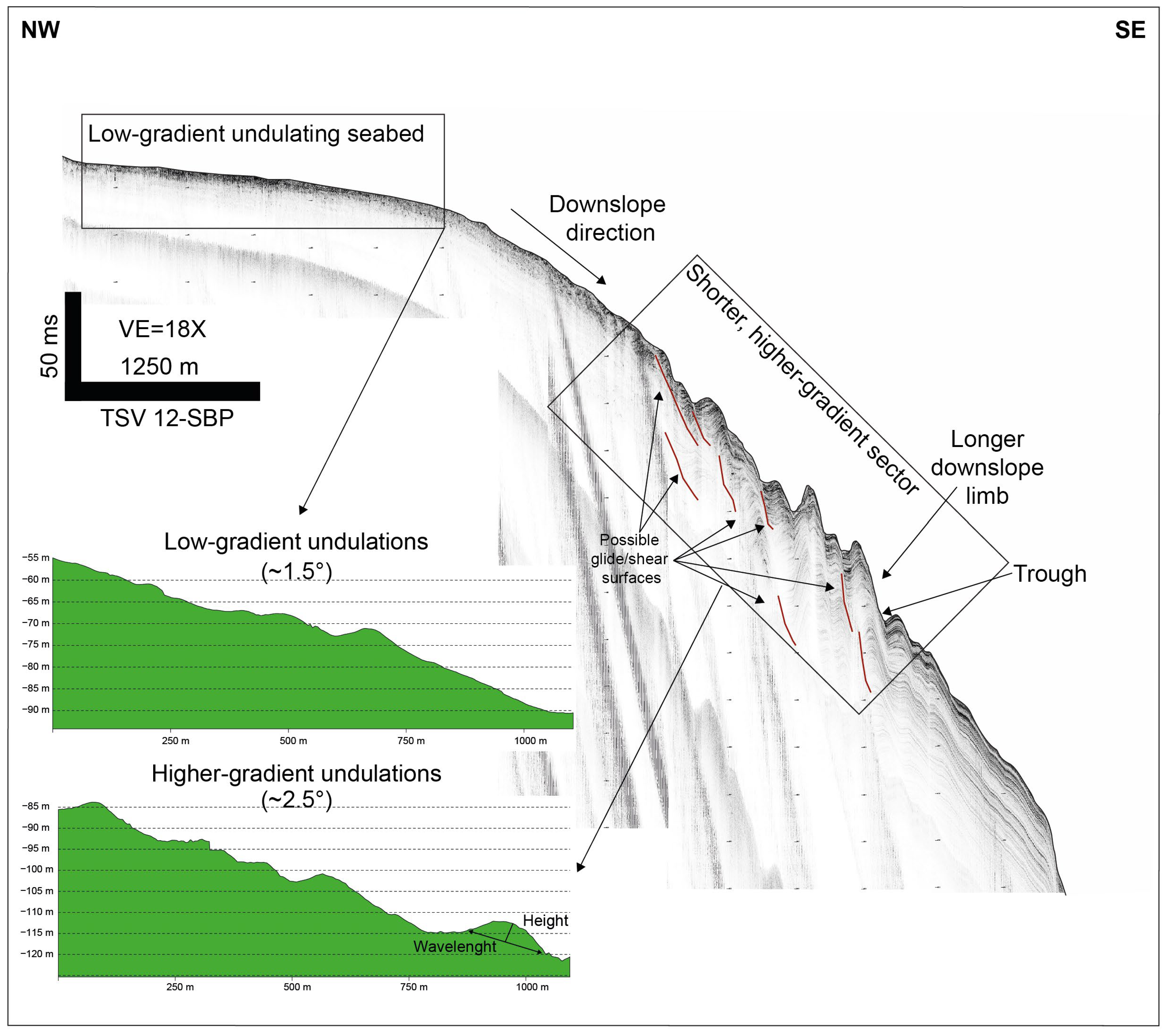
Morphometric comparison of low-gradient and higher-gradient undulations along the TSV 12-SBP profile (see Figure 6 for the uninterpreted profile). The figure highlights the transition from a low-gradient undulating seabed to a sector characterized by shorter, higher-gradient undulations, longer downslope limbs, troughs, and possible glide/shear surfaces. The morphometric profiles illustrate representative local seabed gradients of approximately 1.5° and 2.5°, respectively, and show differences in wavelength, height, and limb geometry. The two morphometric profiles are plotted using comparable horizontal and vertical scales.
Figure 10.
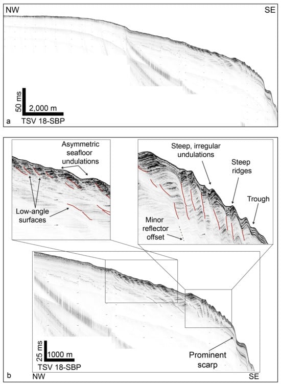
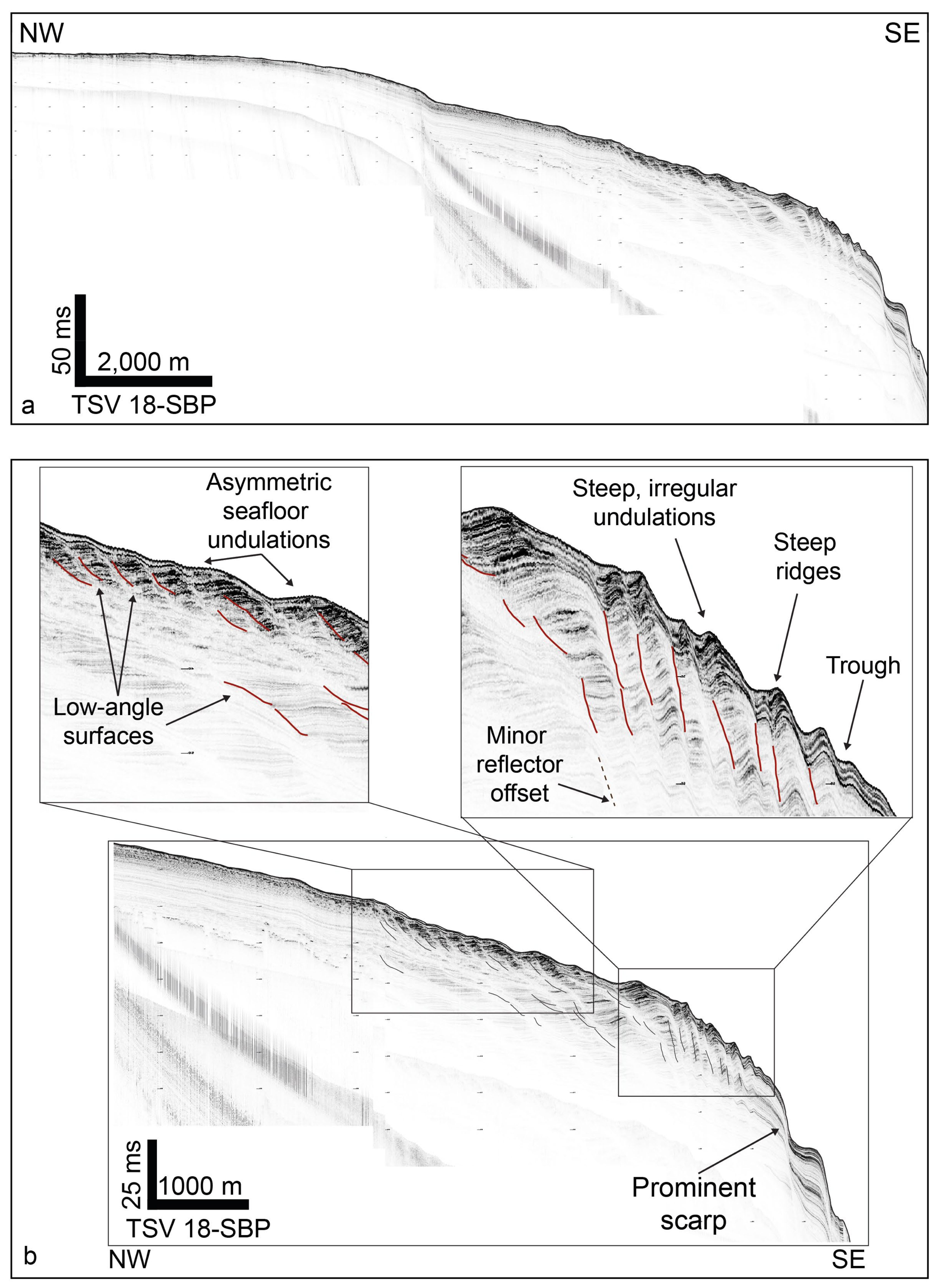
Sub-bottom expression of asymmetric and irregular seafloor undulations along the TSV 18-SBP profile: (a) Uninterpreted TSV 18-SBP sub-bottom profile across the shelf-margin sector; (b) Simplified interpretation of the same profile, showing asymmetric seafloor undulations, low-angle surfaces, steep and irregular undulations, steep ridges, troughs, a minor reflector offset, and a prominent scarp.
The TSV 12-SBP profile shows a transition from broad, lower-gradient undulations to shorter and higher-gradient forms downslope (Figure 9). Representative local seabed gradients calculated from the bathymetric profiles are approximately 1.5° and 2.5°, respectively. The morphometric profiles, plotted using comparable horizontal and vertical scales, show differences in wavelength, height, and limb geometry between the two sectors.
The TSV 18-SBP profile shows similar variability along the shelf-margin sector (Figure 10). A relatively smoother upper sector passes downslope into asymmetric seafloor undulations and then into a more irregular sector characterized by steep ridges, troughs, reflector offsets, low-angle surfaces, and a prominent scarp. These features are mainly developed within the uppermost part of the sedimentary succession, while deeper reflectors remain comparatively more continuous.
4.7. Morphometric Analysis
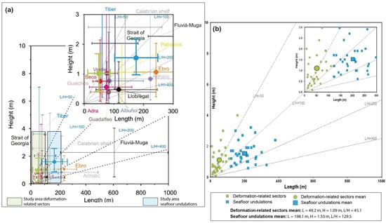
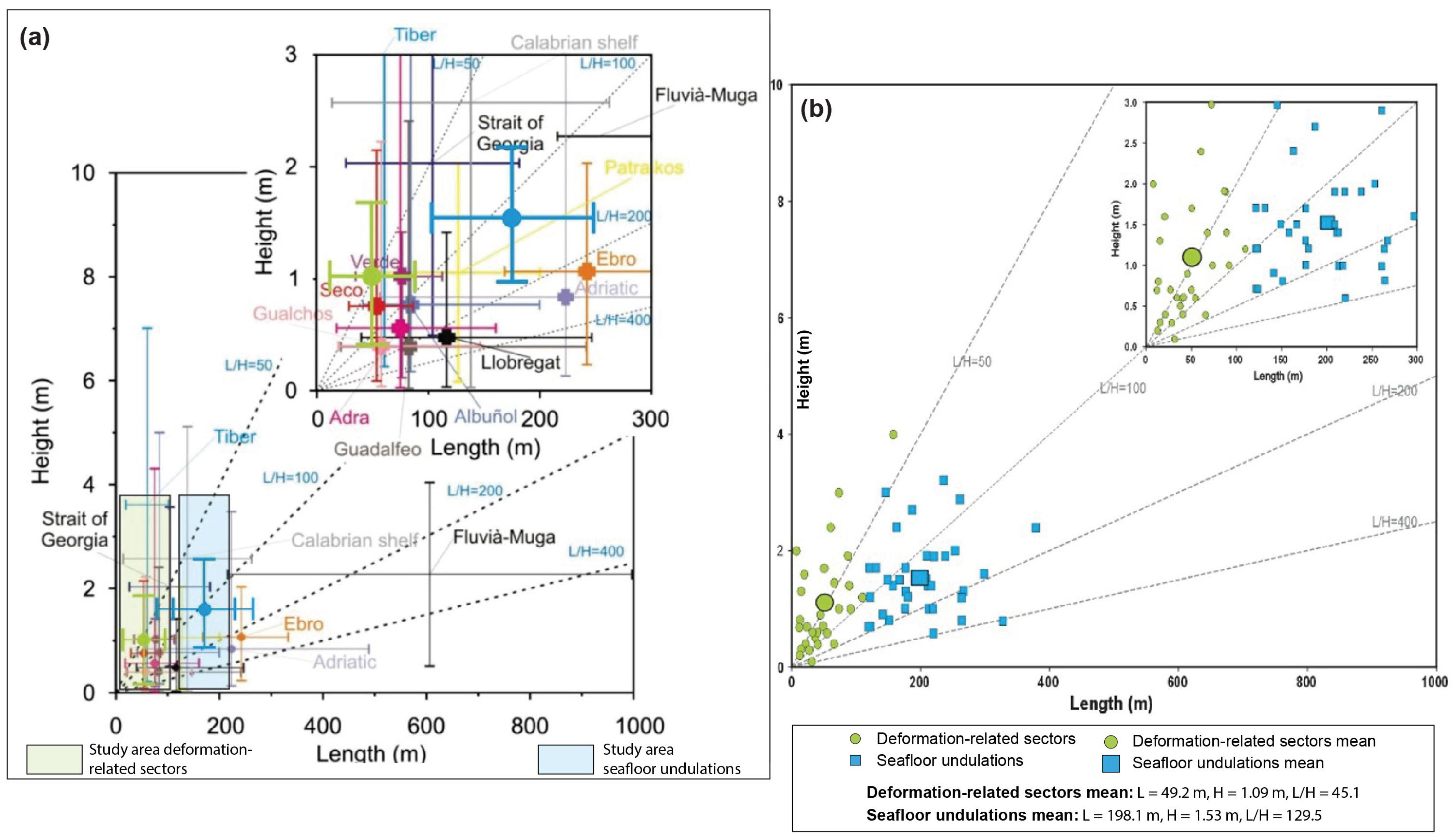
Morphometric analysis of 65 seabed features identifies two main populations: broader seafloor undulations and shorter deformation-related sectors (Figure 11). The broader undulations occur at water depths of 46–89 m, with a mean local slope of 1.6°. They have a mean wavelength of 198.1 m, a mean height of 1.53 m, and a mean L/H ratio of 129.5. The shorter deformation-related sectors occur at water depths of 90–133 m, with a mean local slope of 1.87°. They have a mean length of 49.2 m, a mean height of 1.09 m, and a mean L/H ratio of 45.1. Their lower L/H values indicate shorter and relatively steeper morphologies compared with the broader undulations.
Figure 11.
Morphometric comparison between the study-area features and published Mediterranean prodelta undulation fields: (a) Length–height comparison between the study-area features and Mediterranean prodelta undulation fields, redrawn and modified after [3]. Dashed lines indicate constant length-to-height ratios (L/H). The light-green field represents the morphometric range of the deformation-related sectors measured in this study, whereas the light-blue field represents the range of the broader seafloor undulations. (b) Detailed length–height distribution of the 65 measured study-area features within the same morphometric space. Green circles indicate deformation-related sectors, blue squares indicate seafloor undulations, and larger symbols indicate the respective population mean values. Mean values are L = 49.2 m, H = 1.09 m, and L/H = 45.1 for deformation-related sectors, and L = 198.1 m, H = 1.53 m, and L/H = 129.5 for seafloor undulations.
The two populations also differ in shallow seismic expression. Broader undulations are commonly associated with laterally continuous to gently wavy reflectors, whereas the shorter sectors coincide with reduced reflector continuity, local reflector bending, minor reflector offsets, and low-angle reflector surfaces.
Comparison with published Mediterranean prodelta and shelf-margin undulation fields compiled by [3] shows that the broader undulations fall within the range of compact, low- to moderate-relief undulation fields (Figure 11). The shorter deformation-related sectors plot toward lower L/H values, distinguishing them from the broader, lower-relief population.
5. Discussion
5.1. Interpreting the Sinni Undulation Field
The Sinni undulation field shows marked lateral variability in both seabed morphology and near-seafloor seismic architecture. Low-relief, longer-wavelength undulations occur together with shorter, steeper, and more asymmetric sectors, and this variability is accompanied by changes in reflector continuity, deformation style, and acoustic character (Figure 3, Figure 6, Figure 7, Figure 8, Figure 9, Figure 10 and Figure 11).
In the smoother sectors, the undulated seabed is associated with continuous to gently wavy reflectors and relatively higher L/H values. Where the seabed becomes steeper or more irregular, the upper sedimentary wedge shows reflector bending, local truncation, minor reflector offsets, low-angle reflector surfaces, disturbed sediment bodies, and locally reduced acoustic continuity (Figure 6, Figure 8, Figure 9 and Figure 10). The interpretation therefore relies on the spatial coupling between seabed morphology, upper-wedge seismic architecture, morphometry, and geomorphic position, rather than on seabed relief alone.
Comparable diagnostic problems have been described in shelf-margin and prodelta settings, where depositional bedforms, sediment reworking, soft-sediment deformation, and early slope instability may generate similar ridge-and-trough morphologies [1,2,3,4,6,7,9,27,28]. In the Sinni dataset, two contrasting sets of geomorphic, seismic, and morphometric features can be recognized. Their depositional/reworking-related and deformation-related significance is evaluated separately in the following sections.
5.2. Depositional and Reworking-Related Component
The low-relief, longer-wavelength undulations preserve features compatible with depositional accumulation or seabed reworking. They are characterized by partial lateral continuity, relatively regular ridge-and-trough morphology, and continuous to gently wavy reflectors within the upper sedimentary wedge (Figure 3, Figure 4, Figure 8 and Figure 11). These sectors correspond to parts of the undulation field where sedimentary layering remains largely preserved and deformation is not the dominant control on seabed morphology.
Their morphometric values overlap with published Mediterranean prodelta and shelf-margin undulation fields. The main undulation field has a mean wavelength of 198.1 m, a mean height of 1.53 m, and a mean L/H ratio of 129.5, falling within the range of compact, low- to moderate-relief undulations compiled by [3], including the Adra, Central Adriatic, Albuñol, Ebro, Guadalfeo, Gualchos, Seco, Verde, and Tiber fields (Figure 11; Table 3). This comparison supports an affinity with depositional or reworking-related processes, without requiring the same formative mechanism for all compared examples.
Table 3.
Morphometric and genetic comparison between the seabed features identified in the study area and selected Mediterranean prodelta and shelf-margin undulation fields. Mediterranean comparison data and proposed dominant processes are after [3].
The depositional component is also compatible with the physiographic and sedimentary setting of the study area. Offshore the Sinni River mouth, late Quaternary to Holocene sediment supply contributed to the development of an upper shelf-margin wedge. Within this setting, sediment accumulation, storm-related redistribution, density-driven flows, hyperpycnal processes, contour-parallel transport, and bottom-boundary-layer reworking may have contributed to the development or preservation of broad ridge-and-trough morphology [1,3,4,9,28].
A migration-driven bedform model, including sediment waves or cyclic-step-related forms, may account for some characteristics of the low-relief, longer-wavelength undulations. However, the available profiles do not show systematic upslope migration or backset stacking throughout the undulation field [2,3,4,27,29,30,31,32,33]. Moreover, the transition toward shorter and more asymmetric forms is accompanied by reflector bending, minor reflector offsets, low-angle surfaces, and disturbed sediment bodies (Figure 6, Figure 8, Figure 9 and Figure 10). The data therefore do not exclude local hydrodynamic reworking, but do not support a migration-driven process as a single explanation for the entire field.
5.3. Deformation Within the Upper Sedimentary Wedge
The main evidence for deformation is the coupled change between seabed morphology and upper-wedge seismic architecture. Where the undulations become shorter, steeper, and more asymmetric, the underlying reflectors are no longer simply wavy or gently conformable with the seabed. They are bent, locally truncated, disrupted, or interrupted by minor offsets and low-angle reflector surfaces (Figure 6, Figure 8, Figure 9 and Figure 10). These relationships indicate that part of the upper sedimentary wedge was deformed after the development or preservation of the depositional or reworking-related morphology.
The asymmetric geometry of several ridge-and-trough forms is particularly relevant. Along the TSV 12-SBP and TSV 18-SBP profiles, some undulations show longer downslope limbs, steeper frontal sectors, troughs, and local zones of reflector disruption beneath the seabed relief (Figure 6, Figure 9 and Figure 10). These geometries differ from a simple field of migrating depositional bedforms and are better explained by downslope strain within weak, fine-grained, recently deposited sediments. Comparable associations between asymmetric seabed morphology, reflector deformation, and soft-sediment displacement have been used to identify deformation-related undulations in muddy shelf-margin and prodelta settings [2,3,5,6,7].
Low-angle reflector surfaces and minor reflector offsets further constrain the interpretation. These features are confined to the upper sedimentary wedge and do not continue downward into the deeper, more continuous stratified deposits. They are therefore interpreted as near-seafloor deformation structures, including possible glide or shear surfaces and minor internal offsets, rather than as regional tectonic faults (Figure 6 and Figure 10). Their restricted vertical extent and their association with deformed near-seafloor deposits are compatible with gravitational deformation and creep-like displacement within mechanically weak sediment packages [5,6,29,34,35,36,37,38,39].
The morphometric separation reinforces this interpretation. The deformation-related sectors have a mean length of 49.2 m, a mean height of 1.09 m, and a mean L/H ratio of 45.1, whereas the main undulation field has a mean L/H ratio of 129.5 (Figure 11; Table 3). The lower L/H values indicate more compact and relatively steeper forms, supporting a stronger deformation-related component when compared with the longer-wavelength, lower-relief undulations [3,40].
The distribution of these sectors is also significant. Deformation-related features occur preferentially where the seabed steepens, where troughs and scarps interrupt slope continuity, and close to downslope-oriented incisions (Figure 5, Figure 8, Figure 9 and Figure 10). This geomorphic position links deformation to local slope instability and sediment remobilization rather than to a homogeneous regional bedform field. Previous studies have documented canyon incision, submarine mass movements, slide scars, and geohazard-related morphologies in the Gulf of Taranto and along the northern Ionian margin, providing a regional context for localized gravitational deformation offshore the Sinni River mouth [11,12,13,14,15,16,29].
5.4. Controls on Deformation Localization and Local Instability
The vertical to subvertical acoustic anomalies observed in the seismic profiles are not treated here as direct evidence of creep, but as features that may record local gas- or fluid-related disturbance within the upper sedimentary wedge. These anomalies are expressed by acoustic attenuation, reduced reflector continuity, or local blanking, and locally occur beneath or close to sectors characterized by asymmetric undulations, low-angle reflector surfaces, and disturbed sediment bodies (Figure 3 and Figure 7). Similar acoustic features are commonly interpreted as indicators of focused fluid or gas migration in near-seafloor marine sediments [41,42].
Their significance is mainly mechanical. In weak, fine-grained, and poorly consolidated deposits, excess pore pressure, shallow gas, or focused fluid flow can reduce effective stress and sediment strength, favouring strain localization, shallow sliding, and local failure [5,35,36,37,38]. In the Sinni sector, the spatial association between acoustic anomalies and deformation-related features suggests that fluid- or gas-related weakening may have contributed to the localization of deformation. These anomalies, however, are not interpreted as the primary cause of the entire undulation field, nor as diagnostic evidence of creep by themselves.
The localization of deformation may also have been favoured by the sedimentary setting of the Sinni shelf margin. River-fed sediment supply and highstand progradation likely promoted the accumulation of weak, water-rich, fine-grained deposits within the upper sedimentary wedge, increasing its susceptibility to gravitational deformation [8,25,26,36,43]. Although the available dataset does not allow individual triggering events to be identified, regional seismic shaking represents a plausible external trigger capable of reactivating incipient deformation within mechanically weak shelf-margin deposits [36,44,45].
Disturbed sediment bodies and possible mass-transport deposits represent a more advanced expression of local instability. They are characterized by reduced reflector continuity, chaotic to semi-transparent seismic character, irregular internal geometry, and spatial relationships with scarps, troughs, steeper undulations, and downslope-oriented incisions (Figure 5, Figure 7 and Figure 8). Similar associations between undulated seabed morphology, disturbed sediment bodies, soft-sediment deformation, and slope failure have been described in Mediterranean prodelta and continental-margin settings [1,2,3,5,6,8,29,40,44].
The broader northern Ionian margin provides a regional context for this localized deformation, as the Taranto Canyon system, slope dissection, submarine mass movements, slide scars, and other geohazard-related features document repeated sediment remobilization and gravitational instability [11,12,13,14,15,16,45,46,47]. In the study area, acoustic anomalies, weak sedimentary deposits, scarps, and disturbed bodies help explain why deformation is localized in specific sectors of the upper sedimentary wedge, rather than uniformly affecting the entire undulated seabed.
5.5. Hybrid Depositional–Deformational Model and Implications
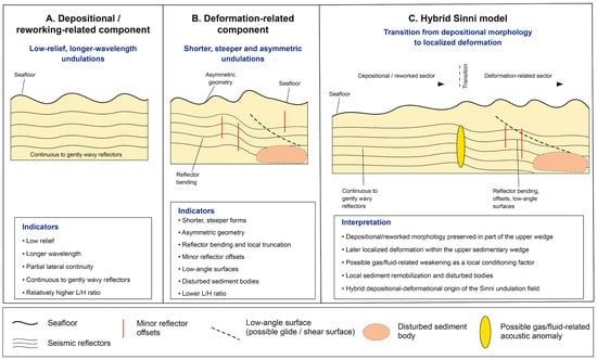
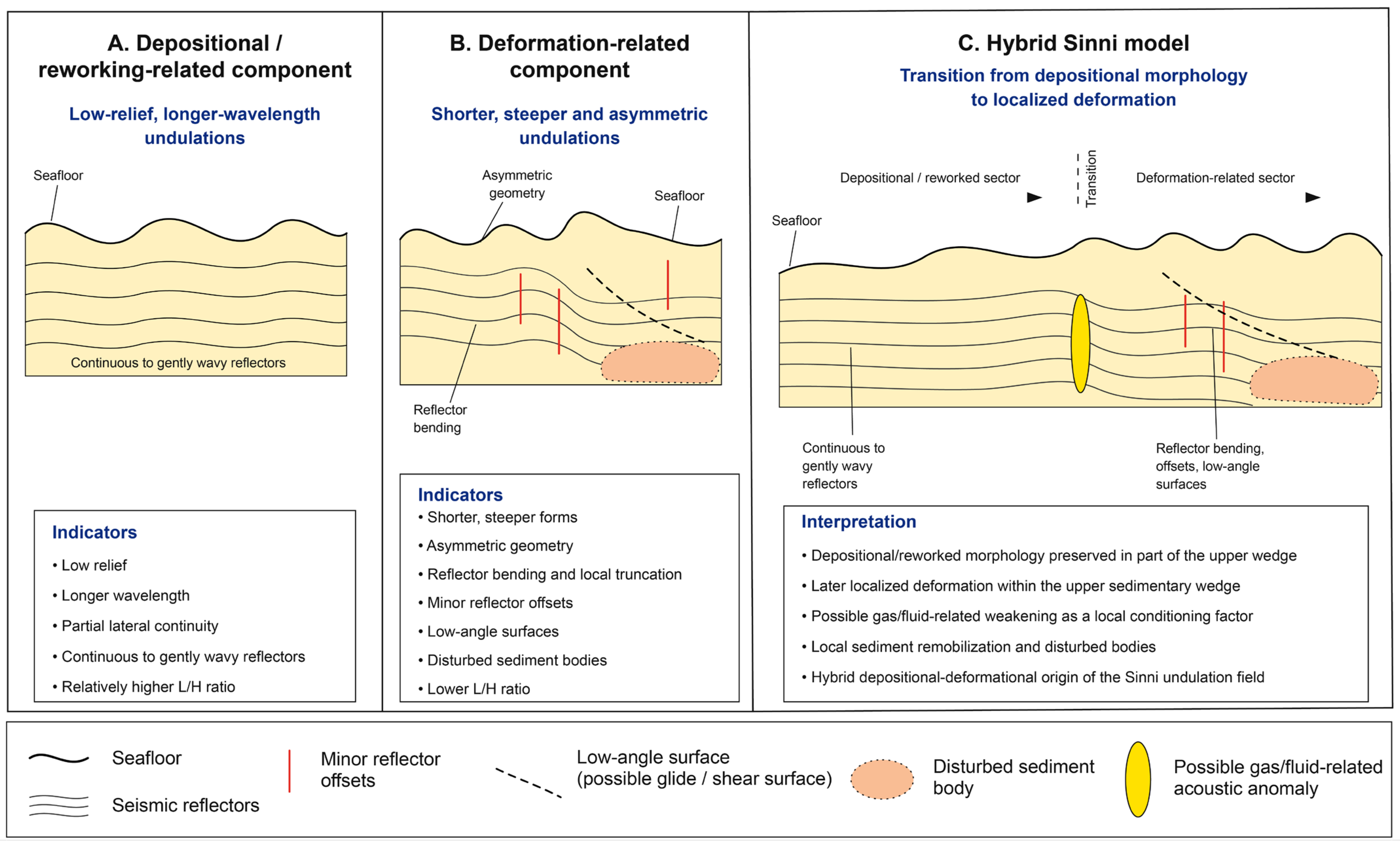
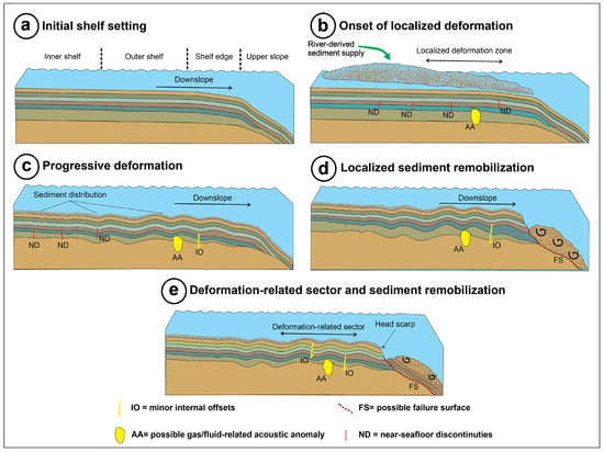
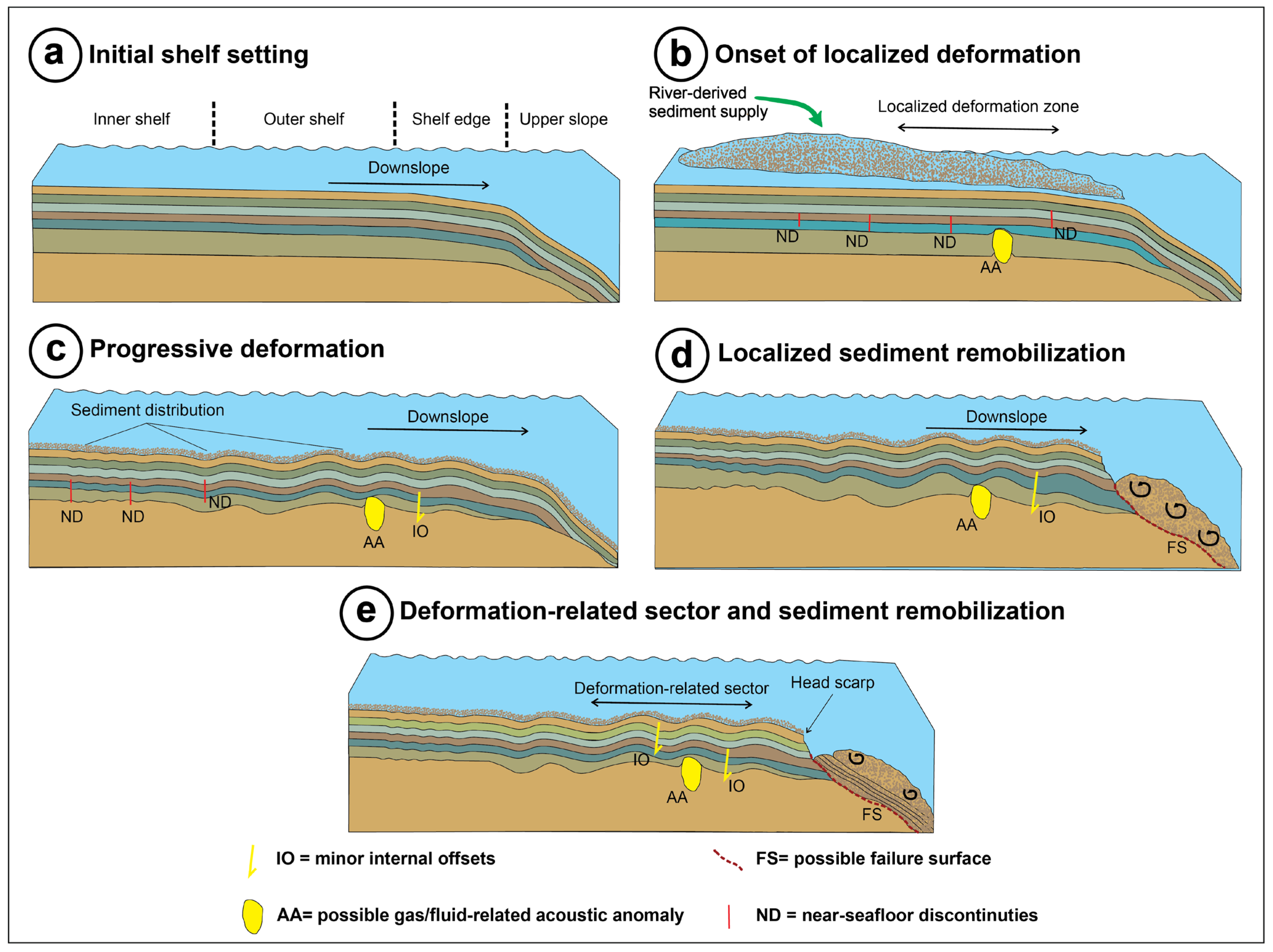
The Sinni undulation field is best interpreted as a hybrid depositional–deformational system, in which depositional or reworking-related morphology is locally overprinted by deformation within the upper sedimentary wedge (Figure 12). This interpretation accounts for the lateral coexistence of low-relief, longer-wavelength undulations with shorter, steeper, and more asymmetric sectors, without implying a single formative mechanism for all the observed features. The conceptual evolutionary model illustrates how an initially stratified shelf-margin wedge, shaped by sediment accumulation and seabed reworking, may subsequently have undergone localized deformation and sediment remobilization within its uppermost deposits (Figure 13).
Figure 12.
Diagnostic synthesis for the interpretation of the Sinni seafloor undulation field. (A) Depositional or reworking-related component, characterized by broad, low-relief and longer-wavelength undulations, partial lateral continuity, continuous to gently wavy reflectors, and relatively higher L/H values. These features are interpreted as recording depositional accumulation and seabed reworking. (B) Deformation-related component, represented by shorter, steeper, and more asymmetric forms associated with reflector bending, local truncation, minor reflector offsets, low-angle surfaces, disturbed sediment bodies, and lower L/H values. These features indicate deformation within the upper sedimentary wedge. (C) Hybrid interpretation for the Sinni shelf margin, showing the spatial juxtaposition of depositional/reworking-related morphology and deformation-related sectors within the same undulation field. The model implies that depositional or reworking-related morphology was locally affected by later deformation, possible gas/fluid-related weakening, and sediment remobilization. The arrows indicate the inferred progression and spatial transition from depositional/reworking-related morphology to deformation-related sectors and the resulting hybrid configuration. Schematic elements are not to scale. Schematic elements are not to scale.
Figure 13.
Conceptual evolutionary model for the development of hybrid depositional–deformational undulations offshore the Sinni River mouth: (a) Initial stratified shelf-to-slope setting; (b) Development of an upper sedimentary wedge related to river-derived sediment supply and highstand progradation, with early near-seafloor discontinuities and possible fluid/gas-related acoustic anomalies; (c) Development or preservation of broad ridge-and-trough morphology within the upper wedge, together with initial internal deformation; (d) Localization of deformation along internal offsets and possible failure surfaces, especially in steeper shelf-edge and upper-slope sectors; (e) Deformation-related sector characterized by asymmetric undulations, minor internal offsets, possible fluid/gas-related acoustic anomalies, head-scarp development, and downslope sediment remobilization. ND: near-seafloor discontinuities; IO: minor internal offsets; FS: possible failure surface; AA: possible gas/fluid-related acoustic anomaly. Schematic elements are not to scale.
During the earlier stage, broad, low-relief ridge-and-trough morphologies developed or were preserved within the upper wedge along the outer shelf and upper slope. These sectors retained continuous to gently wavy reflectors and relatively higher L/H ratios, indicating a dominant contribution from depositional accumulation and seabed reworking (Figure 3, Figure 4, Figure 8, Figure 11 and Figure 13a,c). Comparable processes have been invoked for Mediterranean prodelta and shelf-margin undulations shaped by sediment supply, bottom currents, storm reworking, hyperpycnal flows, density-driven transport, and contour-parallel redistribution [1,3,4,9,28].
During a subsequent stage, deformation became localized where the upper wedge was mechanically weaker or where slope morphology favoured downslope strain. This interpretation is supported by the transition from low-relief undulations to shorter, steeper, and asymmetric forms associated with reflector bending, low-angle surfaces, minor offsets, disturbed sediment bodies, and acoustic anomalies (Figure 6, Figure 7, Figure 8, Figure 9, Figure 10 and Figure 13c,e). These relationships record the superposition of gravitational deformation on an earlier depositional or reworking-related morphology, rather than the formation of a separate and spatially independent instability deposit.
Sectors showing the strongest deformation are characterized by scarps, troughs, disturbed sediment bodies, and possible MTDs, and may record a transition from distributed deformation to localized sediment remobilization and near-seafloor failure. Fluid- or gas-related acoustic anomalies may have contributed to strain localization by weakening the sediment, although they are regarded as possible conditioning factors rather than as diagnostic evidence of creep (Figure 13d,e) [5,35,36,37,38,41,42,43].
This hybrid model has implications for the interpretation of subtle seafloor relief on continental shelf margins. Offshore the Sinni River mouth, several undulated sectors preserve evidence of near-seafloor gravitational deformation within recent, weakly consolidated deposits, in addition to depositional or reworking-related morphology. Their association with localized strain, disturbed sediment bodies, and sediment remobilization identifies areas potentially susceptible to instability and is therefore relevant to the reconstruction of shelf-margin evolution and to marine geohazard assessment along the northern Ionian margin [29,44,45,46,47].
6. Conclusions
This study integrates high-resolution bathymetry, sparker seismic profiles, sub-bottom profiler data, and morphometric analysis to investigate the origin of seafloor undulations offshore the Sinni River mouth, along the outer shelf–upper slope transition of the northern Ionian margin. The results show that the undulated seabed is laterally variable and includes broad, low-relief ridge-and-trough morphologies as well as shorter, steeper, and more asymmetric sectors associated with scarps, troughs, downslope incisions, and locally irregular seabed relief.
Seismic data indicate that the main changes in reflector geometry and acoustic character are concentrated within the upper sedimentary wedge. In the smoother sectors, the undulated seabed is associated with continuous to gently wavy reflectors. In contrast, the more irregular sectors show reduced reflector continuity, local reflector bending, minor reflector offsets, low-angle reflector surfaces, disturbed sediment bodies, and vertical to subvertical acoustic anomalies. Deeper stratified deposits remain comparatively continuous, suggesting that deformation is mainly confined to the near-seafloor sedimentary interval.
Morphometric analysis of 65 measured features distinguishes the broader seafloor undulations from shorter deformation-related sectors. The broader undulations have a mean wavelength of 198.1 m, a mean height of 1.53 m, and a mean L/H ratio of 129.5. The deformation-related sectors have a mean length of 49.2 m, a mean height of 1.09 m, and a mean L/H ratio of 45.1. This contrast indicates that the deformation-related sectors are more compact and relatively steeper than the longer-wavelength, lower-relief undulations.
The Sinni undulation field is best interpreted as a hybrid depositional–deformational system. Broad, low-relief undulations with partial lateral continuity and continuous to gently wavy reflectors record a depositional or seabed-reworking component within the upper sedimentary wedge. Shorter, steeper, and more asymmetric forms associated with reflector bending, minor offsets, low-angle surfaces, disturbed sediment bodies, and lower L/H values indicate post-depositional deformation affecting selected sectors of the same wedge.
Vertical to subvertical acoustic anomalies are interpreted as possible gas- or fluid-related features, rather than as direct evidence of creep. Their spatial association with deformation-related sectors suggests that fluid- or gas-related weakening may have acted as a local conditioning factor, together with weak, water-rich fine-grained deposits, slope steepening, scarps, and downslope incisions. Disturbed sediment bodies and possible mass-transport deposits represent more localized expressions of sediment remobilization within this deformation-prone setting.
The results show that subtle seafloor undulations on continental shelf margins may preserve evidence of both depositional/reworking processes and early-stage gravitational deformation. Offshore the Sinni River mouth, this hybrid character identifies sectors where recent, weakly consolidated deposits have undergone localized strain and sediment remobilization, with implications for reconstructing shelf-margin evolution and assessing potential marine geohazards along the northern Ionian margin.
The results also provide new constraints on the role of near-seafloor gravitational deformation in modifying recent shelf-slope margin deposits and offer a framework for identifying potentially unstable sectors. More broadly, this study highlights the value of an integrated geomorphological, morphometric, and seismic-stratigraphic approach for interpreting seafloor undulations as the product of interacting depositional/reworking and deformation-related processes, thereby helping to explain the spatial variability of morphostratigraphic expressions along continental shelf margins.
Author Contributions
Conceptualization, A.M. and M.M.; methodology, M.M.; validation, A.M. and M.R.S.; analysis, G.R. and M.M.; resources, M.R.S.; writing—original draft preparation, M.M.; writing—review and editing, A.M. and M.R.S.; supervision, M.R.S. All authors have read and agreed to the published version of the manuscript.
Funding
This research was supported within the CARG Project—Geological Map of Italy at 1:50,000 scale. No specific grant number was assigned to this study.
Data Availability Statement
The original contributions presented in this study are included in the article. Further inquiries can be directed to the corresponding author.
Acknowledgments
The authors thank the editor and the anonymous reviewers for their helpful comments and suggestions.
Conflicts of Interest
The authors declare no conflicts of interest.
References
- Cattaneo, A.; Correggiari, A.; Marsset, T.; Thomas, Y.; Marsset, B.; Trincardi, F. Seafloor undulation pattern on the Adriatic shelf and comparison to deep-water sediment waves. Mar. Geol. 2004, 213, 121–148. [Google Scholar] [CrossRef] [Scilit]
- Lee, H.J.; Syvitsky, J.P.M.; Parker, G.; Orange, D.; Locat, J.; Hutton, J.H.W.; Imran, J. Distinguishing sediment waves from slope failure deposits: Field examples, including the “Humboldt Slide” and modelling results. Mar. Geol. 2002, 192, 79–104. [Google Scholar] [CrossRef] [Scilit]
- Urgeles, R.; Cattaneo, A.; Puig, P.; Liquete, C.; De Mol, B.; Amblàs, D.; Sultan, N.; Trincardi, F. A review of undulated sediment features on Mediterranean prodeltas: Distinguishing sediment transport structures from sediment deformation. Mar. Geophys. Res. 2011, 32, 49–69. [Google Scholar] [CrossRef] [Scilit]
- Wynn, R.B.; Stow, D.A.V. Classification and characterisation of deep-water sediment waves. Mar. Geol. 2002, 192, 7–22. [Google Scholar] [CrossRef] [Scilit]
- Trincardi, F.; Cattaneo, A.; Correggiari, A.; Ridente, D. Evidence of soft sediment deformation, fluid escape, sediment failure and regional weak layers within the late Quaternary mud deposits of the Adriatic Sea. Mar. Geol. 2004, 213, 91–119. [Google Scholar] [CrossRef] [Scilit]
- Berndt, C.; Cattaneo, A.; Szuman, M.; Trincardi, F.; Masson, D. Sedimentary structures offshore Ortona, Adriatic Sea—Deformation or sediment waves? Mar. Geol. 2006, 234, 261–270. [Google Scholar] [CrossRef] [Scilit]
- Urgeles, R.; De Mol, B.; Liquete, C.; Canals, M.; De Batist, M.; Hughes-Clarke, J.E.; Amblàs, D.; Arnau, P.A.; Calafat, A.M.; Casamor, J.L.; et al. Sediment undulations on the Llobregat prodelta: Signs of early slope instability or sedimentary bedforms? J. Geophys. Res. Solid Earth 2007, 112, B05102. [Google Scholar] [CrossRef] [Scilit]
- Correggiari, A.; Trincardi, F.; Langone, L.; Roveri, M. Styles of failure in Late Holocene highstand prodelta wedges on the Adriatic shelf. J. Sediment. Res. 2001, 71, 218–236. [Google Scholar] [CrossRef] [Scilit]
- Clementucci, R.; Lafosse, M.; Casalbore, D.; Ridente, D.; d’Acremont, E.; Rabaute, A.; Rabaute, A.; Chiocci, F.L.; Gorini, C. Common origin of coexisting sediment undulations and gullies? Insights from two modern Mediterranean prodeltas (southern Italy and northern Morocco). Geomorphology 2022, 402, 108133. [Google Scholar] [CrossRef] [Scilit]
- Rossi, S.; Sartori, R. A seismic reflection study of the external Calabrian Arc in the northern Ionian Sea (eastern Mediterranean). Mar. Geophys. Res. 1981, 4, 403–426. [Google Scholar] [CrossRef] [Scilit]
- Rebesco, M.; Neagu, R.C.; Cuppari, A.; Muto, F.; Accettella, D.; Dominici, R.; Cova, A.; Romano, C.; Caburlotto, A. Morphobathymetric analysis and evidence of submarine mass movements in the western Gulf of Taranto (Calabria margin, Ionian Sea). Int. J. Earth Sci. 2009, 98, 791–805. [Google Scholar] [CrossRef] [Scilit]
- Ceramicola, S.; Senatore, M.R.; Cova, A.; Meo, A.; Forlin, E.; Critelli, S.; Markezic, N.; Zecchin, M.; Civile, D.; Bosman, A.; et al. Geohazard features of the Gulf of Taranto. J. Maps 2024, 20, 2431073. [Google Scholar] [CrossRef] [Scilit]
- Meo, A.; Chiocci, F.L.; Senatore, M.R. Morphometric measures to assess the maturity of the submerged drainage basins: The case of the Taranto Canyon upper reach. In Proceedings of the IMEKO International Conference on Metrology for the Sea (MetroSea), Naples, Italy, 11–13 October 2017; IMEKO: Budapest, Hungary, 2017; pp. 133–137. [Google Scholar]
- Meo, A.; Senatore, M.R. Morphological and seismostratigraphic evidence of Quaternary mass transport deposits in the North Ionian Sea: The Taranto landslide complex (TLC). Front. Earth Sci. 2023, 11, 116837. [Google Scholar] [CrossRef] [Scilit]
- Meo, A.; Massa, B.; Ciarcia, S.; Senatore, M.R. Ongoing Deformation at the Southern Apennine Front: Insights from the Gulf of Taranto (Italy). Geosciences 2026, 16, 141. [Google Scholar] [CrossRef] [Scilit]
- Meo, A.; Senatore, M.R. Morphometry of Submarine Mass Transport Deposits: Insights from the Taranto Landslide Complex (North Ionian Sea, Southern Italy). J. Mar. Sci. Eng. 2026, 14, 502. [Google Scholar] [CrossRef] [Scilit]
- Senatore, M.R.; Normark, W.R.; Pescatore, T.; Rossi, S. Structural framework of the Gulf of Taranto (Ionian Sea). Mem. Della Soc. Geol. d’Italia 1988, 41, 533–539. [Google Scholar]
- Sartori, R. The Tyrrhenian back-arc basin and subduction of the Ionian lithosphere. Epis. J. Int. Geosci. 2003, 26, 217–221. [Google Scholar] [CrossRef] [Scilit] [PubMed]
- Finetti, I.R.; Del Ben, A. Crustal tectono-stratigraphic setting of the Adriatic Sea from new CROP seismic data. Crop Proj. Deep. Seism. Explor. Cent. Mediterr. Italy 2005, 1, 519–548. [Google Scholar]
- Teofilo, G.; Antoncecchi, I.; Caputo, R. Neogene-Quaternary evolution of the offshore sector of the Southern Apennines accretionary wedge, Gulf of Taranto, Italy. Tectonophysics 2018, 738, 16–32. [Google Scholar] [CrossRef] [Scilit]
- Carminati, E.; Lustrino, M.; Doglioni, C. Geodynamic evolution of the central and western Mediterranean: Tectonics vs. igneous petrology constraints. Tectonophysics 2012, 579, 173–192. [Google Scholar] [CrossRef] [Scilit]
- Vitale, S.; Ciarcia, S. Tectono-stratigraphic setting of the Campania region (southern Italy). J. Maps 2018, 14, 9–21. [Google Scholar] [CrossRef] [Scilit]
- Vitale, S.; Ciarcia, S. The dismembering of the Adria platforms following the Late Cretaceous-Eocene abortive rift: A review of the tectono-stratigraphic record in the southern Apennines. Int. Geol. Rev. 2022, 64, 2866–2889. [Google Scholar] [CrossRef] [Scilit]
- Pepe, F.; Di Donato, V.; Insinga, D.; Molisso, F.; Faraci, C.; Sacchi, M.; Dera, R.; Ferranti, L.; Passaro, S. Seismic stratigraphy of upper Quaternary shallow-water contourite drifts in the Gulf of Taranto (Ionian Sea, southern Italy). Mar. Geol. 2018, 397, 79–92. [Google Scholar] [CrossRef] [Scilit]
- Tropeano, M.; Sabato, L.; Pieri, P.; Festa, V.; Cilumbriello, A.; Moretti, M.; Mastronuzzi, G. Surface and subsurface of the Metaponto Coastal Plain (Gulf of Taranto—Southern Italy): Present-day- vs. LGM-landscape. Geomorphology 2013, 203, 115–131. [Google Scholar] [CrossRef] [Scilit]
- Meo, A.; Senatore, M.R. Late Pleistocene to Holocene Depositional Environments in Foredeep Basins: Coastal Plain Responses to Sea-Level and Tectonic Forcing—The Metaponto Area (Southern Italy). Geosciences 2026, 16, 5. [Google Scholar] [CrossRef] [Scilit]
- Li, J.; Li, W.; Alves, T.M.; Rebesco, M.; Zhan, W.; Sun, J.; Wu, S. Different origins of seafloor undulations in a submarine canyon system, northern South China Sea, based on their seismic character and relative location. Mar. Geol. 2019, 413, 99–111. [Google Scholar] [CrossRef] [Scilit]
- Puig, P.; Palanques, A.; Martín, J. Contemporary sediment-transport processes in submarine canyons. Annu. Rev. Mar. Sci. 2014, 6, 53–77. [Google Scholar] [CrossRef] [Scilit] [PubMed]
- Vanneste, M.; Sultan, N.; Garziglia, S.; Forsberg, C.F.; l’Heureux, J.S. Seafloor instabilities and sediment deformation processes: The need for integrated, multi-disciplinary investigations. Mar. Geol. 2014, 352, 183–214. [Google Scholar] [CrossRef] [Scilit]
- Normark, W.R.; Hess, G.R.; Stow, D.A.V.; Bow, A.J. Sediment waves on the Monterrey Fan levee: A preliminary physical interpretation. Mar. Geol. 1980, 42, 201–232. [Google Scholar] [CrossRef] [Scilit]
- Flood, R.D. A lee-wave model for deep-sea mudwave activity. Deep.-Sea Res. 1988, 35, 973–983. [Google Scholar] [CrossRef] [Scilit]
- Fauge’res, J.-C.; Gonthier, E.; Mulder, T.; Kenyon, N.; Cirac, P.; Grimboulard, R.; Berné, S.; Lesuavé, R. Multi-process generated sediment waves on the Landes Plateau (Bay of Biscay, North Atlantic). Mar. Geol. 2002, 182, 279–302. [Google Scholar] [CrossRef] [Scilit]
- Ercilla, G.; Alonso, B.; Wynn, R.B.; Baraza, J. Turbidity current sediment waves on irregular slopes: Observations from the Orinoco sediment-wave field. Mar. Geol. 2002, 192, 171–187. [Google Scholar] [CrossRef] [Scilit]
- Lee, S.H.; Chough, S.K. High-resolution (2–7 kHz) acoustic and geometric characters of submarine creep deposits in the South Korea Plateau, East Sea. Sedimentology 2001, 48, 629–644. [Google Scholar] [CrossRef] [Scilit]
- Locat, J.; Lee, H.J. Submarine landslides: Advances and challenges. Can. Geotech. J. 2002, 39, 193–212. [Google Scholar] [CrossRef] [Scilit]
- Sultan, N.; Cochonat, P.; Canals, M.; Cattaneo, A.; Dennielou, B.; Haflidason, H.; Laberg, J.S.; Long, D.; Mienert, J.; Trincardi, F.; et al. Triggering mechanisms of slope instability processes and sediment failures on continental margins: A geotechnical approach. Mar. Geol. 2004, 213, 291–321. [Google Scholar] [CrossRef] [Scilit]
- Hill, P.R.; Moran, K.M.; Blasco, S.M. Creep deformation of slope sediments in the Canadian Beaufort Sea. Geo-Mar. Lett. 1982, 2, 163–170. [Google Scholar] [CrossRef] [Scilit]
- Tavenas, F.; Leroueil, S. Creep and failure of slopes in clays. Can. Geotech. J. 1981, 18, 106–120. [Google Scholar] [CrossRef] [Scilit]
- Shillington, D.J.; Seeber, L.; Sorlien, C.C.; Steckler, M.S.; Kurt, H.; Dondurur, D.; Çifçi, G.; İmren, C.; Cormier, M.-H.; McHugh, C.M.G.; et al. Evidence for widespread creep on the flanks of the Sea of Marmara transform basin from marine geophysical data. Geology 2012, 40, 439–442. [Google Scholar] [CrossRef] [Scilit]
- Hovland, M.; Judd, A.G. Seabed Pockmarks and Seepages: Impact on Geology, Biology and the Marine Environment; Graham & Trotman: London, UK, 1988; Volume 293. [Google Scholar]
- Karstens, J.; Berndt, C. Seismic chimneys in the Southern Viking Graben–Implications for palaeo fluid migration and overpressure evolution. Earth Planet. Sci. Lett. 2015, 412, 88–100. [Google Scholar] [CrossRef] [Scilit]
- Hampton, M.A.; Lee, H.J.; Locat, J. Submarine landslides. Rev. Geophys. 1996, 34, 33–59. [Google Scholar] [CrossRef] [Scilit]
- Sultan, N.; Cattaneo, A.; Urgeles, R.; Lee, H.; Locat, J.; Trincardi, F.; Berne, S.; Canals, M.; Lafuerza, S. A geomechanical approach for the genesis of sediment undulations on the Adriatic shelf. Geochem. Geophys. Geosyst. 2008, 9, Q04R03. [Google Scholar] [CrossRef] [Scilit]
- Ilstad, T.; Marr, J.G.; Elverhøi, A.; Harbitz, C.B. Laboratory studies of subaqueous debris flows by measurements of pore-fluid pressure and total stress. Mar. Geol. 2004, 213, 403–414. [Google Scholar] [CrossRef] [Scilit]
- Masson, D.G.; Harbitz, C.B.; Wynn, R.B.; Pedersen, G. Submarine landslides: Processes, triggers and hazard prediction. Philos. Trans. A Math. Phys. Eng. Sci. 2006, 364, 2009–2039. [Google Scholar] [CrossRef] [Scilit] [PubMed]
- Aiello, G. Submarine instability processes on the continental slope offshore of Campania (Southern Italy). GeoHazards 2025, 6, 20. [Google Scholar] [CrossRef] [Scilit]
- Ceramicola, S.; Praeg, D.; Coste, M.; Forlin, E.; Cova, A.; Colizza, E.; Critelli, S. Submarine mass-movements along the slopes of the active Ionian continental margins and their consequences for marine geohazards (Mediterranean Sea). In Submarine Mass Movements and Their Consequences; Krastel, S., Behrmann, J.-H., Völker, D., Stipp, M., Berndt, C., Urgeles, R., Chaytor, J., Huhn, K., Strasser, M., Harbitz, C.B., et al., Eds.; Advances in Natural and Technological Hazards Research; Springer: Cham, Switzerland, 2014; Volume 37, pp. 295–306. [Google Scholar] [CrossRef] [Scilit]

Disclaimer/Publisher’s Note: The statements, opinions and data contained in all publications are solely those of the individual author(s) and contributor(s) and not of MDPI and/or the editor(s). MDPI and/or the editor(s) disclaim responsibility for any injury to people or property resulting from any ideas, methods, instructions or products referred to in the content. |
© 2026 by the authors. Licensee MDPI, Basel, Switzerland. This article is an open access article distributed under the terms and conditions of the Creative Commons Attribution (CC BY) license.