


Highlights
What are the main findings?
- A hybrid viewpoint generation approach and novel boundary heuristic evaluation function reduce exploration time by 7–25% and path length by 9–27% across diverse environments.
- A two-stage global path planning framework integrating history-aware trajectory enhancement and sliding window TSP algorithm achieves significant improvements in flight stability and trajectory smoothness.
What are the implications of the main
findings?
- The proposed framework demonstrates efficient autonomous UAV mapping in various geometrically complex environments, including tunnels, forest areas, and indoor facilities, as validated through both simulation and real-world experiments.
- Enhanced computational efficiency and improved flight stability enable deployment on resource-constrained UAV platforms for geospatial surveying, infrastructure inspection, and environmental monitoring applications.
Abstract
Autonomous exploration is essential for various mapping tasks, including data collection, environmental monitoring, and search and rescue operations. Unmanned aerial vehicles (UAVs), owing to their low cost and high maneuverability, have become key enablers of such applications, particularly in complex or hazardous environments. However, existing approaches often suffer from issues such as redundant exploration and unstable flight behavior. In this study, we propose a hierarchical exploration approach specifically designed for limited-field-of-view UAVs in geospatial mapping applications. The approach addresses these challenges through hybrid viewpoint generation, an innovative boundary exploration sequence, and a two-stage global path planning strategy. To balance exploration efficiency and computational cost, we adopt a hybrid approach that combines collision-free spherical sampling with adaptive viewpoint generation based on stochastic differential equations. This approach generates high-quality candidate viewpoints while minimizing computational overhead. Furthermore, we introduce a novel heuristic evaluation function to prioritize frontiers within small regions, thereby facilitating optimal path planning. Based on this formulation, the global coverage path is modeled as a traveling salesman problem (TSP). The two-stage global planning framework consists of an initial stage that applies a history-aware trajectory enhancement strategy with smoothing corrections, followed by a second stage employing a sliding-window TSP algorithm to construct the global path. This design mitigates motion inconsistencies caused by frequent heuristic updates and enhances flight stability and trajectory smoothness. To evaluate the performance of the proposed framework, we compare it with state-of-the-art approaches in both simulated and real-world environments. Experimental results demonstrate that our approach shortens flight paths and reduces exploration time, thereby improving overall exploration efficiency.
1. Introduction
Unmanned aerial vehicles (UAVs) have become indispensable tools in modern geospatial surveying and mapping, owing to their flexibility, cost-effectiveness, and capability for rapid and high-resolution spatial data acquisition. They play a crucial role in topographic surveying, 3D reconstruction [1], infrastructure inspection [2], and environmental monitoring [3,4], offering an efficient means of collecting geospatial information across diverse and often inaccessible environments. Despite their growing adoption, traditional UAV mapping missions typically depend on predefined flight routes or manual control, which limits their applicability in unknown, GPS-denied, or geometrically complex environments such as tunnels, mines, and indoor industrial facilities. This dependence restricts adaptive data collection and can lead to uneven coverage, redundant scanning, or incomplete spatial reconstruction, thereby compromising the geometric accuracy and efficiency of mapping results. To address these limitations, autonomous UAV-based surveying has emerged as a key research direction in the field of geomatics and remote sensing, aiming to enable intelligent exploration, adaptive viewpoint planning, and optimal trajectory generation for high-fidelity 3D mapping in complex environments. Consequently, both the public and scientific communities have devoted significant research efforts to autonomous exploration for mapping, resulting in the development of numerous advanced algorithms that can be broadly categorized into frontier-based, sampling-based, and machine learning-based approaches. Frontier-based approaches aim to maximize exploration coverage by identifying and exploring the interfaces between known and unknown regions. Although boundary clustering has demonstrated strong performance in improving exploration results, its high computational overhead often prolongs planning time, thereby reducing overall exploration speed and efficiency. Sampling-based approaches, commonly employed in greedy strategies, focus on selecting either the nearest candidate target or the one with the greatest information gain as the next flight location. While this approach provides intuitive advantages in certain scenarios, it tends to overlook potential targets in neighboring areas, leading to limited global path optimality, inefficient backtracking, and hesitant flight behavior—ultimately slowing the overall exploration process. Learning-based approaches, on the other hand, show great potential in leveraging environmental semantic information. Nonetheless, their heavy reliance on computational resources and limited real-time performance restrict their applicability in practical deployments. Among existing research, FUEL [5]—an advanced autonomous exploration framework for surveying and mapping—integrates an incremental boundary information structure (FIS) with a hierarchical planning mechanism to achieve rapid, efficient, and safe exploration in complex environments, producing coherent and smooth flight trajectories. Despite these advances, existing approaches continue to face several practical challenges. For instance, the computational burden associated with ray-casting detection of candidate viewpoints constrains improvements in exploration rate during flight. Inaccurate boundary detection and disordered exploration sequences may also cause the UAV to overlook small regions, resulting in redundant or even ineffective motion patterns. Furthermore, frequent replanning and heuristic recalculations often induce strategic hesitation, thereby degrading the overall responsiveness of the system.
To address the inherent limitations of existing autonomous exploration systems, this paper presents a hierarchical exploration framework designed for restricted-field-of-view (FOV) drones used in mapping and remote sensing. To reduce the computational burden associated with ray casting, the viewpoint generation module adopts a hybrid sampling approach that integrates collision-free spherical sampling with uniform sampling. Additionally, the energy consumption during flight is considered to generate higher-quality candidate viewpoints. After generating these viewpoints, a boundary-heuristic evaluation function is proposed to optimize the boundary exploration sequence by prioritizing boundary regions and incorporating a novel small-region boundary detection approach. To mitigate hesitant stop-and-go flight behavior, the historical perception path of each flight is recorded and utilized during replanning. Furthermore, a flight-smoothness cost is introduced to enhance trajectory stability and continuity. Compared with state-of-the-art approaches, the proposed framework reduces exploration time by 7–25% and path length by 9–27% across three distinct environments. Finally, the practicality of the proposed approach is validated through airborne experiments conducted under real-world conditions. The main contributions of this study can be summarized as follows:
- A hybrid viewpoint generation approach is proposed, integrating collision-free spherical sampling with adaptive viewpoint generation based on stochastic differential equations. This approach efficiently produces high-quality candidate viewpoints while reducing computational overhead.
- A novel heuristic evaluation function is introduced to optimize frontier exploration sequences, prioritize small-area frontiers, which minimizes back-and-forth movement and avoids unnecessary repeated exploration.
- A two-stage global path planning framework is proposed to enhance flight stability and smoothness by integrating a historical trajectory perception enhancement strategy with smoothing correction and a sliding-window TSP approach.
2. Related Works
Autonomous exploration and mapping of UAVs depend on onboard sensors to perceive environmental information and determine the flight path. Numerous autonomous exploration techniques have been developed, which can be categorized into sampling-based, frontier-based, and machine learning-based approaches.
The sampling-based approach creates random points in unexplored regions, with potential viewpoints chosen randomly through the use of the Rapidly-Exploring Random Tree (RRT) algorithm [6]. The next best view (NBV) is selected based on the candidate viewpoint with the highest information gain, following principles closely associated with the NBV concept [7]. To optimize information acquisition, ref. [8] introduced a receding horizon NBV planning strategy, which navigates unexplored areas by evaluating the information available along the complete trajectory. Subsequent studies have refined this approach with diverse information gain metrics tailored to specific mapping tasks. For instance, ref. [9] reduced uncertainty in localization and mapping during exploration, while [10] applied this framework to visually degraded environments such as underground mines and dark areas. Nevertheless, these approaches frequently suffer from getting trapped in local regions, resulting in suboptimal exploration efficiency. However, a fundamental limitation of sampling-based approaches is their susceptibility to local optima, frequently resulting in the drone becoming trapped in local regions and achieving suboptimal exploration efficiency [11]. To address this issue, ref. [11] utilized historical exploration paths to avoid local traps and optimized UAV biases towards unknown regions to enhance sampling efficiency. Similarly, ref. [12] achieved faster estimation of potential information gain and caches previously computed gains via combining frontier search with NBVP, thereby mitigating challenges in vast unexplored environments. In addition, ref. [13] reformulated the information gain metric as a differentiable function, enabling simultaneous optimization of information gain and other quality indicators. To further enhance efficiency, ref. [14] employed motion primitives to sample higher-quality viewpoints, ensuring continuous and rapid navigation. Despite these improvements, a critical bottleneck persists: computational efficiency. The extensive viewpoint generation and ray-casting operations required for information gain evaluation impose prohibitive computational costs, particularly in large-scale and geometrically complex environments. Therefore, ref. [15] integrated incremental sampling with probabilistic roadmaps to boost computational efficiency. Similarly, ref. [16] proposed a dynamically expanding random tree coupled with a global map to facilitate fast backtracking and retained generated nodes for efficient planning. Ref. [17] introduced a hybrid approach combining sampling and frontier-based approaches to minimize inefficiencies in exploring large, unexplored areas. UFOExplore [18] incrementally maintained a roadmap for UAV navigation, allowing quicker reactions and consistent movement toward optimal exploration goals. Nevertheless, these approaches inherently generate numerous invalid viewpoints during the stochastic sampling process, and the high computational burden of viewpoint validation through ray-casting remains a significant impediment to real-time performance on resource-constrained UAV platforms.
The frontier-based approach, which is well known, defines the frontier separating explored from unexplored areas as the frontier, selecting one of these regions as the next exploration target. Exploration is considered complete when there are no frontiers in the environment. Initially proposed by [19] and later improved by [20], this approach has undergone various adaptations. For instance, ref. [21] developed an approach to select boundaries within FOV during each planning step, minimizing speed variations to maintain consistent flight velocity. Ref. [22] utilized the wavefront algorithm’s diffusion process to locate frontier points and marked each frontier unit to enhance frontier search performance. Building on this, ref. [23] avoided the computational overhead of classic frontier clustering by implicitly grouping frontier voxel models within an octree map and introduced a utility function that integrates map entropy with flight duration to assess potential viewpoints. Additionally, ref. [24] proposed an effective frontier exploration approach for resource-constrained drones, demonstrating that slow frontier exploration leads to redundant revisits. A critical weakness of conventional frontier-based approaches lies in their reliance on greedy strategies that prioritize maximizing immediate information gain. While this approach enhances computational efficiency, it systematically fails to consider long-term exploration optimality, resulting in inefficient back-and-forth movements and suboptimal trajectory planning. More specifically, these approaches lack spatial awareness regarding boundary regions and fail to prioritize edge exploration, causing drones to repeatedly traverse interior spaces before eventually exploring boundaries—a pattern that substantially increases total path length and exploration time. A two-stage planning algorithm was introduced by [25], which samples frontier viewpoints and then computes the global shortest path that connects all viewpoints. In another advancement, ref. [26] used Cartographer [27] to create OctoMap [28], enabling efficient frontier clustering and multiresolution frontier point selection. However, the above approaches rely on a greedy strategy that prioritizes maximizing immediate benefits, which helps improve computational efficiency but results in extra round trips and suboptimal exploration. To overcome this limitation, FUEL was proposed [5]. This approach integrates an incremental frontier detection technology, conducts global coverage path planning after frontier clustering, and reformulates the global problem as a variation of the traveling salesman problem (TSP) [25]. This allows FUEL to generate not only high-quality exploration sequences but also produce fast and smooth flight trajectories within a short time. Subsequent works enhanced the evaluation of frontier information gain [29,30]. For example, ref. [31] proposed an efficient Euclidean clustering technique for processing frontiers and identifying pertinent viewpoints, along with an approximate trajectory optimization approach to quickly compute the optimal path covering all viewpoints. However, critical deficiencies persist in existing frontier-based approaches. First, inadequate detection of small, isolated areas: current approaches, including FUEL, frequently overlook frontiers in narrow passages and enclosed corners, necessitating costly long-distance revisits that degrade exploration efficiency. Second, trajectory instability from frequent replanning: existing approaches perform complete global replanning whenever new frontiers are detected, causing hesitant flight behavior with abrupt direction changes and velocity variations. While some approaches attempt to address smoothness through post-processing trajectory optimization [31], they fail to fundamentally resolve the instability inherent in frequent full-scale replanning without historical context.
Autonomous exploration is increasingly viewed as a decision-sequence problem. With advancements in deep reinforcement learning, neural network-based strategies have achieved performance comparable to human capabilities in numerous domains [32]. Ref. [33] compared random roadmap approaches with reinforcement learning approaches, demonstrating the superiority of reinforcement learning in path planning. Ref. [34] proposed a reinforcement learning algorithm incorporating state-chain sequential feedback, optimizing autonomous exploration in static, complex, and unknown environments. Ref. [35] first applied reinforcement learning to UAVs for autonomous exploration using visual sensors. Additionally, ref. [36] proposed a approach employing graph neural networks and reinforcement learning to address exploration decisions in environments with uncertain localization. Ref. [37] integrated frontier-based approaches with deep reinforcement learning, utilizing long short-term memory networks to select optimal frontier points for exploration and adaptively adjusting frontier selection gain parameters to enhance performance. Furthermore, ref. [38] incorporated the self-attention mechanism into autonomous exploration strategies, deriving feasible exploration paths via the self-attention model structure. Similarly, ref. [39] developed an autonomous exploration framework comprising map construction, decision-making, and planning modules, facilitating seamless integration with comprehensive mapping and navigation techniques in robotics. Building on this, ref. [40] introduced an inverse dynamics model and multi-objective joint learning, enabling the visual reinforcement learning system to capture associations between navigation-related states and goals while leveraging unintentional positive experiences. Ref. [41] introduced a novel exploration framework that combines deep learning for predicting likely indoor maps based on prior observations with reinforcement learning for effective exploration. Despite these advances, learning-based approaches face fundamental challenges in practical deployment. The primary limitation is substantially reduced robustness and adaptability when encountering novel scenarios that differ from training environments. This generalization deficiency becomes particularly acute in complex and unstructured real-world environments, where the infinite variety of geometric configurations and environmental conditions far exceeds the coverage of any training dataset. Additionally, the computational demands of neural network inference, while less intensive than training, still impose constraints on resource-limited UAV platforms. These limitations render pure learning-based approaches less suitable for the diverse and unpredictable mapping tasks encountered in real-world geospatial surveying and infrastructure inspection applications.
3. Materials and Approaches
3.1. System Overview
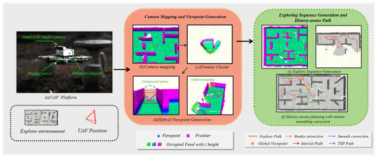
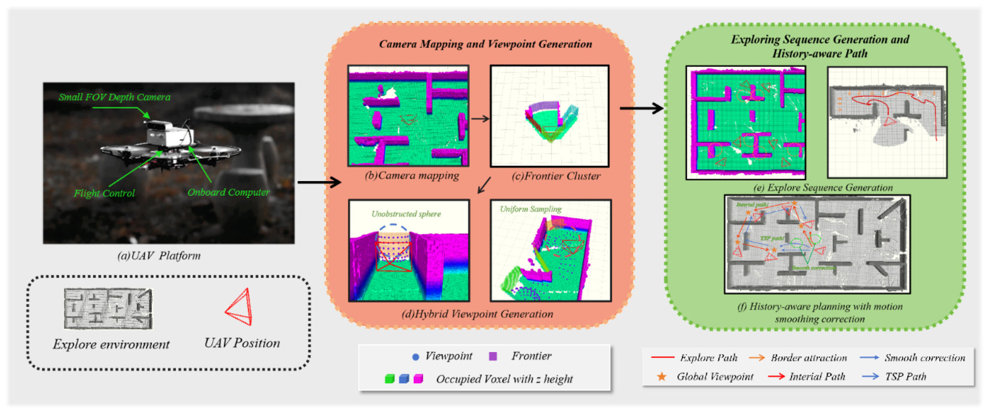
In autonomous UAV exploration for remote sensing and surveying applications, the target region in 3D space is modeled as an unknown environment to be explored by the drone. The UAV employs onboard sensors to detect and analyze observable voxels within this region. During exploration, the unknown space is gradually partitioned into two subsets: free space and occupied space. The boundary is defined as the interface between the known and unknown regions, and exploration terminates when no boundaries remain within the environment. We decompose the autonomous exploration task into three key components: frontier updating, viewpoint generation, and path planning. The overall system framework is illustrated in Figure 1. We propose a hybrid viewpoint generation approach that integrates collision-free spherical sampling with stochastic differential equations, along with a frontier exploration sequence strategy that prioritizes boundaries and small isolated regions. This approach reduces computational overhead while expanding the exploration coverage. Furthermore, to achieve smoother exploration trajectories and prevent hesitant flight behavior, we develop a two-stage global planning approach.
Figure 1.
Overview of our system: (a) Our UAV hardware platform, (b) Utilize sensor-perceived environmental information to construct ESDF, (c) Generate frontiers using region-growing algorithm, (d) Generate candidate viewpoints by combining collision-free spheres and uniform sampling, (e) Prioritize exploration of boundaries and small region detection to generate better exploration sequences, (f) Perform historical-perception planning based on smooth correction.
3.2. Hybrid Viewpoint Generation and Decision-Making
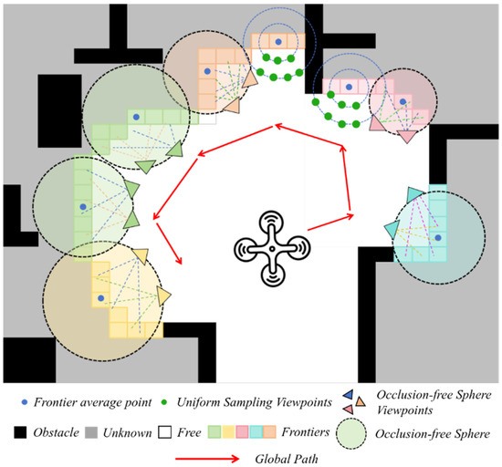
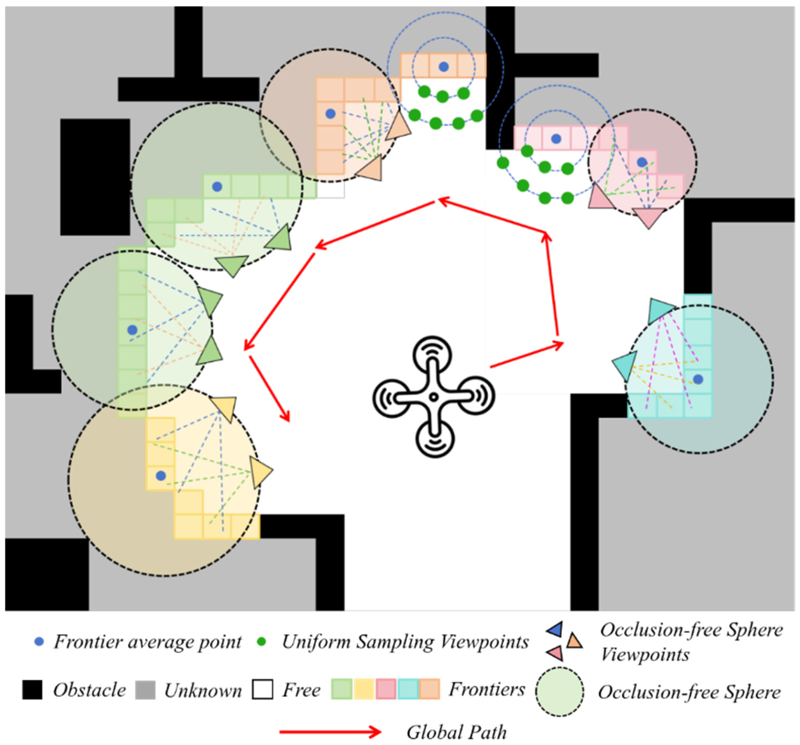
In most existing approaches [5,8,16], viewpoints are utilized to observe unknown voxels within the sensor’s visible range, thereby incrementally expanding the exploration frontier. Typically, there is no occlusion between the viewpoint and the frontier, enabling more effective frontier elimination. However, evaluating the visibility of unknown voxels through viewpoints often requires frequent and computationally expensive ray-casting operations, which significantly reduces exploration efficiency and increases computational overhead. We propose a hybrid viewpoint generation approach that maximizes coverage of the known frontier under the constraints of a small (FOV while substantially reducing computational costs, as shown in Figure 2.
Figure 2.
Illustration of hybrid view generation. View generation using a collision-free sphere and adaptive viewpoint generation based on stochastic differential equations.
3.2.1. Collision-Free Sphere
The collision-free sphere is defined by a circle, where the center represents the centroid of the target frontier cluster, and the radius is determined as:
where denotes the nearest occupied voxel, and represents the sphere’s radius. Because spheres are collision-free and convex [42], any line segment drawn from points inside or on the sphere to its frontier remains unobstructed. High-quality viewpoints can thus be efficiently generated by uniformly sampling the sphere’s surface, thereby eliminating the need for computationally expensive ray casting for each frontier voxel.
3.2.2. Adaptive Viewpoint Generation Based on Stochastic Differential Equations
The collision-free sphere strategy offers a computationally efficient alternative to costly ray-casting operations. However, its efficacy is highly dependent on the scale of the environment. In open spaces where the sphere radius is large, this approach provides broad coverage and is highly effective.
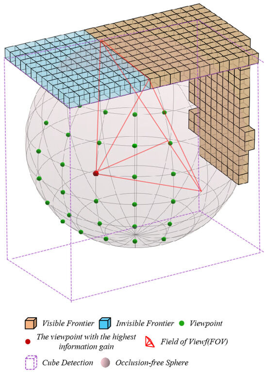
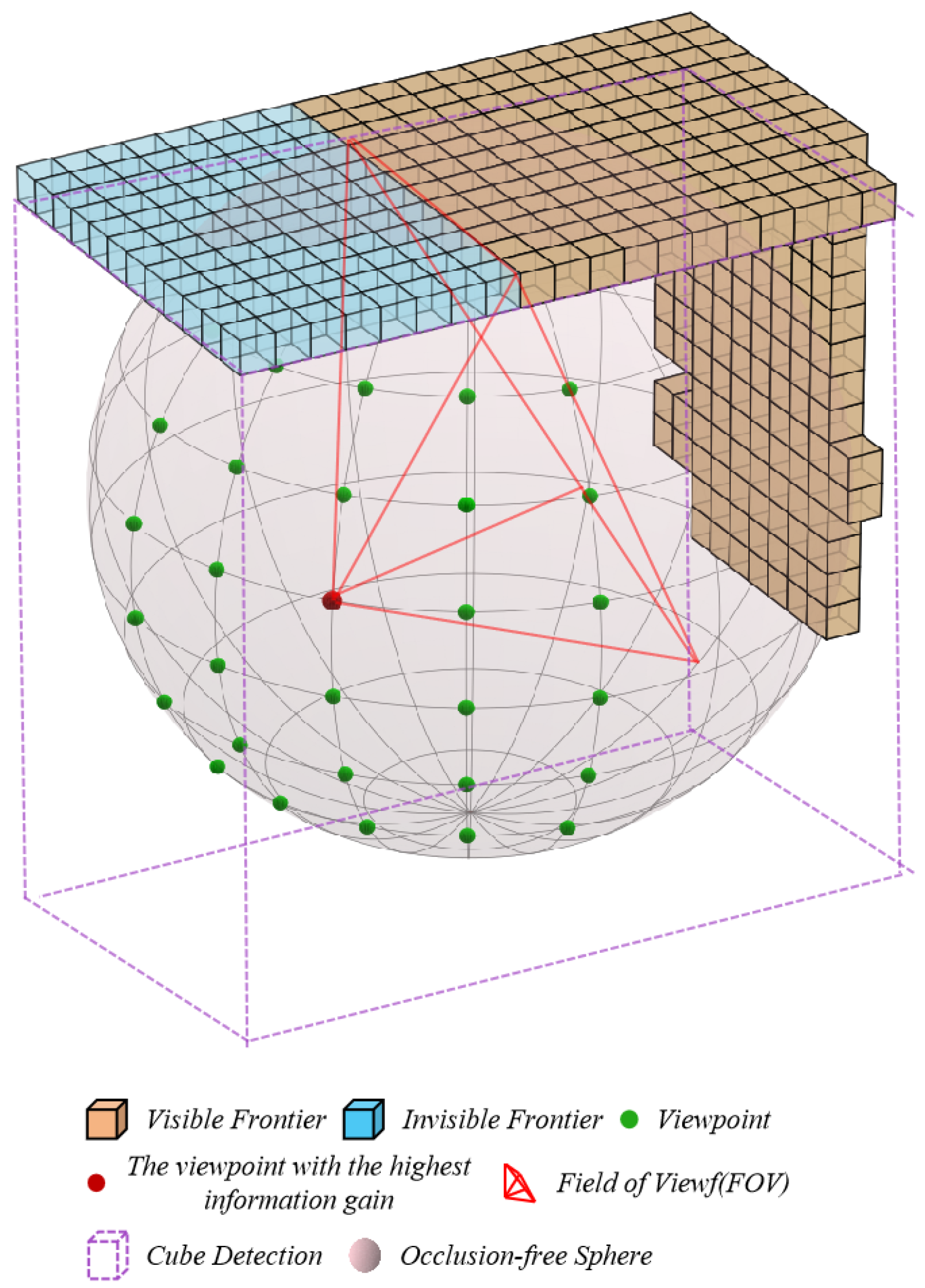
In contrast, within geometrically complex and confined environments—such as narrow corridors and cluttered rooms—the sphere radius is often significantly constrained to maintain a safe distance from obstacles. This results in viewpoints that are excessively close to the frontier cluster. The combination of this proximity and the limited field-of-view (FOV) of typical onboard sensors frequently leads to incomplete frontier observation; for instance, vertical structures may be missed, causing the UAV to circle repetitively without making exploration progress, as visualized in Figure 3. Furthermore, uniform sampling on a small sphere yields numerous, highly redundant, and low-quality viewpoint candidates. To automatically detect this problematic scenario, we introduce a frontier monitoring cube, defined by the spatial extents (the maximum and minimum x, y, z values) of each frontier cluster. The cube detection pseudocode is presented in Algorithm 1. A viewpoint lying within this cube is classified as a near-frontier point, signaling the limitations of the basic sphere sampler.
| Algorithm 1 Cube Detection |
| Require: Frontier cluster , sphere center , sphere radius Ensure: A Boolean value indicating whether cube behavior is detected 1: Calculate frontier centroid: 2: Compute distance: 3: if then 4: return true 5: end if 6: 7: for each frontier point in do 8: 9: 10: if then 11: return true 12: end if 13: end for 14: return false |
Figure 3.
Visualization of cube detection. A viewpoint on the surface of the sphere cannot fully cover the leading edge, resulting in circling behavior.
To address the challenges posed by these confined scenarios, an adaptive viewpoint generation approach based on stochastic differential equations (SDEs) is introduced. This approach is fundamentally different, shifting the paradigm from passive, geometry-only sampling to an active, information-driven process capable of intelligently navigating complex exploration trade-offs.
The core of this approach lies in modeling the viewpoint generation as a stochastic dynamical system. Unlike uniform sampling, the evolution of candidate viewpoints in the polar coordinate system is governed by a dedicated SDE. This SDE incorporates both deterministic drift and stochastic diffusion terms, creating a sophisticated balancing act. The drift term steers viewpoints towards regions of high information gain by following the gradient of the local information field, which is derived from the spatial distribution of the frontier point cloud. This ensures that the generated viewpoints are not merely spread out but are actively pulled towards the most promising directions for exploration, such as the openings of narrow passages. Concurrently, the diffusion term injects a controlled amount of randomness proportional to the local perceptual uncertainty (information entropy). This stochastic component promotes the exploration of alternative paths in high-uncertainty regions, preventing the system from becoming trapped in a local optimum—a common pitfall of purely greedy strategies. This SDE framework enables the generation of a compact yet diverse set of high-quality viewpoints. It dynamically adapts the sampling density, concentrating candidates in complex, high-yield regions while sparsely sampling in simpler, low-information areas.
First, the viewpoint generation process is modeled in the polar coordinate system as the joint evolution of the radius and azimuth , governed by the following stochastic differential equation:
where is the local information field, , are independent Wiener processes. The drift terms , use information gradients to guide viewpoints to gather in high-information areas, and the diffusion terms , enhance the ability to explore unknown areas through controllable noise.
Specifically, a drift term driven by the information gradient is designed to steer the direction of viewpoint evolution based on the gradient of the local information field . The information gradient is computed using the Fisher information matrix derived from the frontier point cloud.
where is the center of the current frontier region, and is the frontier point cloud set. Perform eigenvalue composition on , and the eigenvector corresponding to the maximum eigenvalue is the gradient direction , which points to the direction where the local information grows fastest. We model the radial drift term as a gradient tracking term and a basic expansion term.
When the viewpoint approaches a high-information region, such as a narrow passage, the forward projection of the image gradient direction and the radial unit vector jointly drive a rapid shrinkage of the radius , resulting in dense viewpoint sampling near the channel entrance. In contrast, in low-gradient open areas, the base expansion rate governs the radius growth, promoting outward exploration and preventing local stagnation. Additionally, the angular drift term adjusts the azimuth angle by aligning with the gradient direction and employing a golden-angle spiral mechanism.
where denotes the golden-angle rotation rate, () the gradient alignment term steers the viewpoint toward high-information regions, and (b) the golden-angle mechanism ensures traversability in the absence of significant gradient cues.
We model the diffusion term as random noise reflecting environmental uncertainty, expressed as:
where denotes the local information entropy, representing perceptual uncertainty. In high-entropy regions (e.g., unexplored boundaries), the diffusion term intensifies, generating viewpoints that deviate from the primary gradient direction to explore alternative paths. In contrast, in low-entropy regions, the diffusion term naturally decays, suppressing ineffective perturbations.
Finally, physical constraints are applied to the radius and angle to satisfy sensor performance limitations:
where and corresponds to the minimum and maximum range of the sensor. The Euler-Maruyama approach is used to discretize the SDE and generate candidate viewpoint positions:
3.3. Heuristic Frontier Cost Calculation
After generating a set of candidate viewpoints for each frontier cluster, the viewpoints with the highest scores are selected as reference points to determine the order of frontier exploration. It is crucial to clarify the terminology used in this section and throughout the paper:
- Frontier specifically denotes the interface between known free and unknown regions within the map. These are the essential targets for exploration.
- Boundary refers to the physical spatial limits of the entire environment (e.g., the walls of a room or the extents of a tunnel).
An effective exploration sequence directly influences the overall efficiency of the exploration process. To achieve this, we develop a strategy that considers both the environment’s boundaries and the properties of frontiers. This strategy decreases the cost of reference points located near the environment’s boundaries and increases the cost of those farther away, thereby encouraging the drone to prioritize exploration toward the periphery. Moreover, we introduce a computationally efficient approach for detecting small, isolated frontier regions. This approach computes frontier-parallel vectors to determine whether a reference point lies within an isolated region, assigning such regions with the highest exploration priority. Consequently, in this section, frontier exploration is formulated as a cost matrix construction problem, and the theoretical formulation is presented in detail.
3.3.1. Environment Boundary-Aware Cost
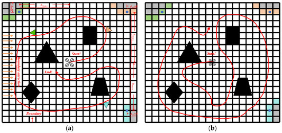
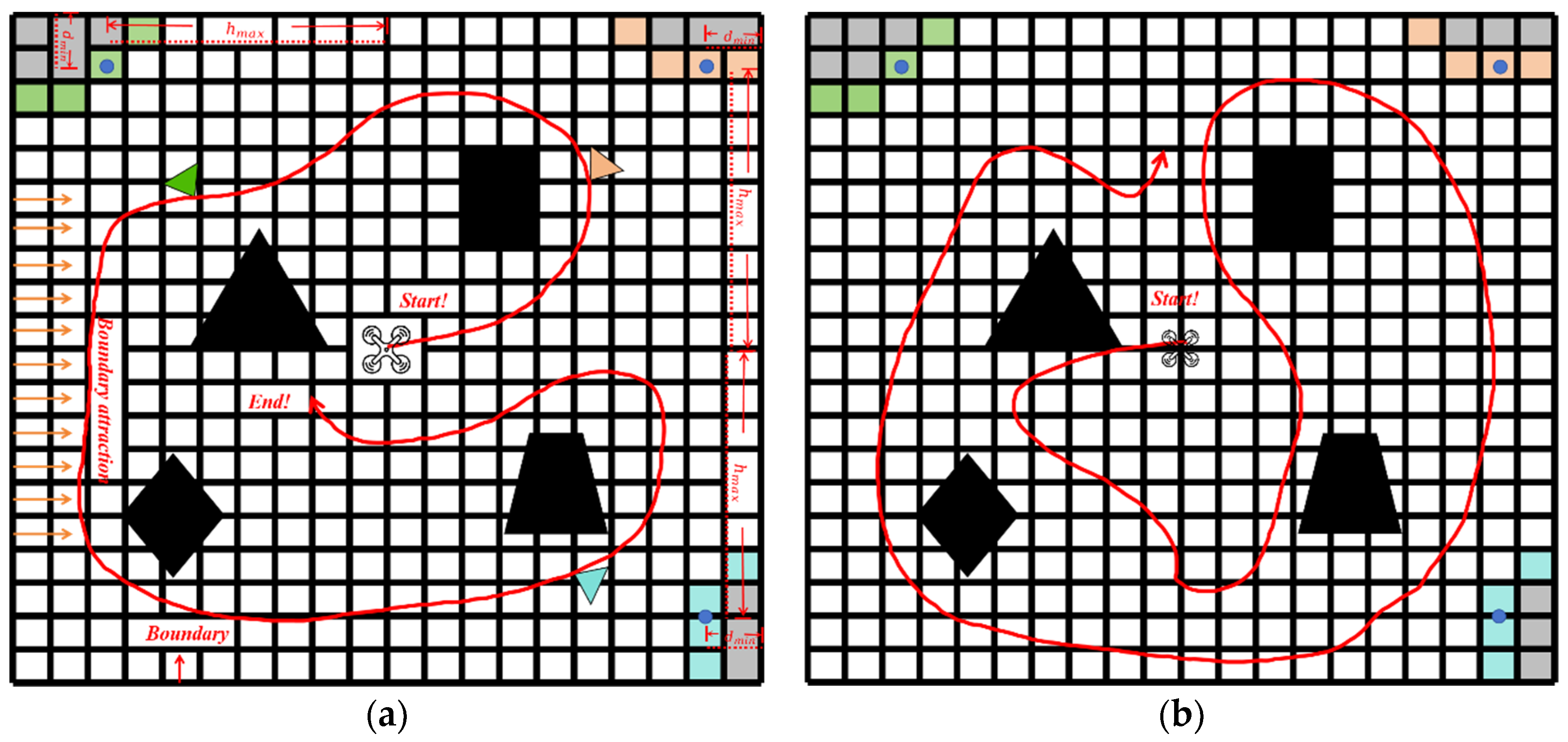
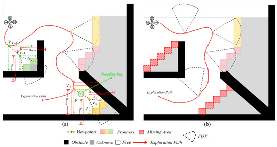
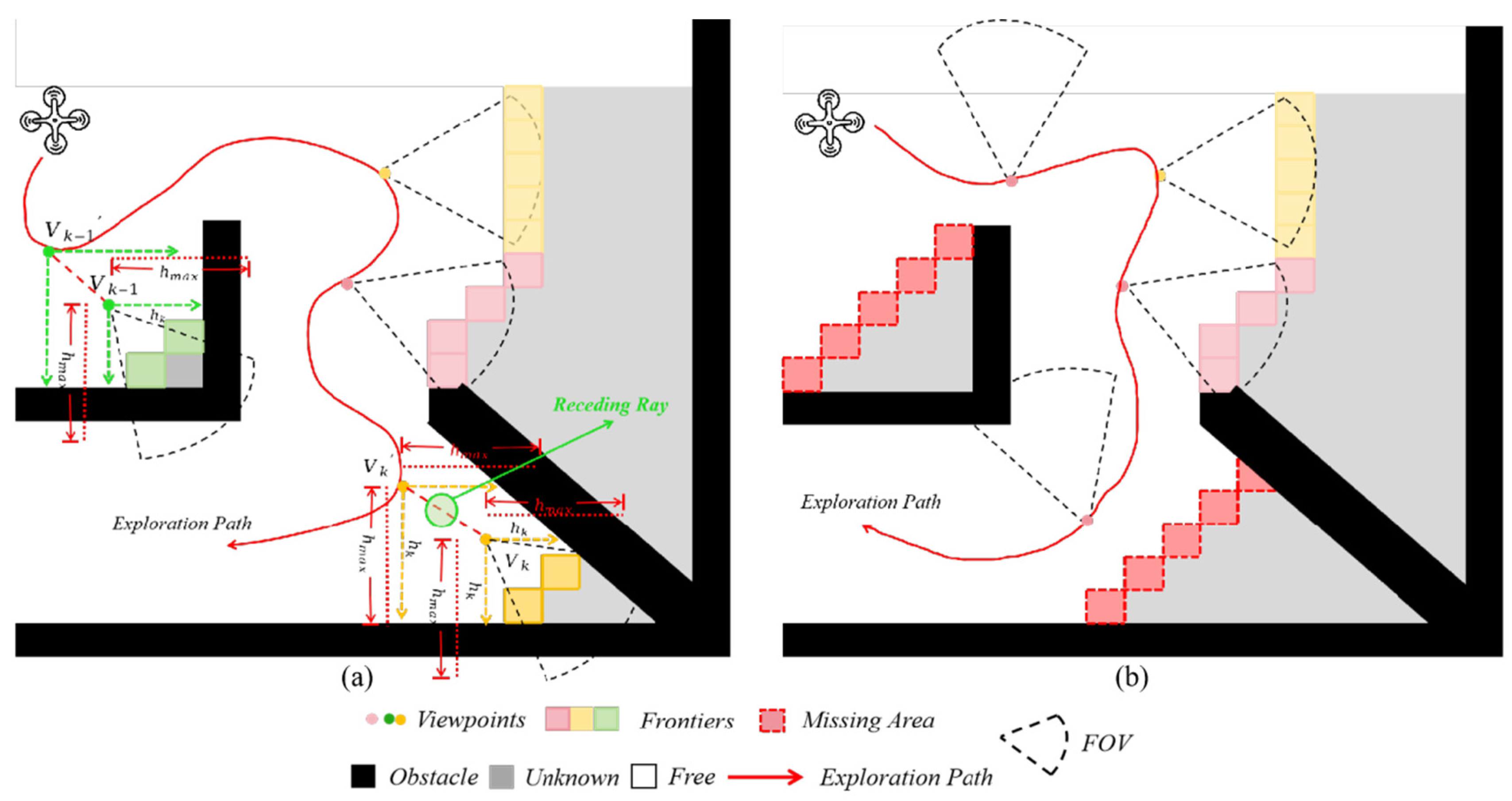
As illustrated in Figure 4b, the drone leaves some unknown areas upon first reaching the boundary after a long flight. This results in the drone repeatedly exploring the boundary at a higher cost after covering other regions. To tackle this challenge, we introduce a boundary-focused exploration approach combined with an innovative boundary cost calculation approach, aiming to reduce the high expense associated with boundary exploration. The initial step involves determining the minimum distance from the mean position of the FIS within the FIS set to the environment boundary:
where , are the minimum distances from the and axes. After obtaining the distances to the edge of and , the boundary cost is further calculated. Here, our calculation principle is that the closer to the edge area, the lower the cost, and the farther away from the edge, the higher the cost. The boundary cost is expressed as:
Figure 4.
(a) Prioritize exploration of border areas; (b) The exploration sequence of frontiers is not optimized, leading to unnecessarily extended trajectories.
and are the boundary values of the exploration areas. As shown in Figure 4a, our proposed approach enables the UAV to follow a more logical sequence for edge exploration, prioritizing boundary costs influenced by virtual attraction forces while avoiding redundant long-distance exploration.
3.3.2. Small Area Cluster Detection
To implement the small area priority principle, we designed a simple, efficient, and lightweight detection approach, as shown in Figure 5. In our approach, the term “edge points” refers specifically to the extreme boundary points of a frontier cluster along the coordinate axes. For each 3D frontier cluster, we identify four distinct edge points: the point with the minimum x-coordinate, the point with the maximum x-coordinate, the point with the minimum y-coordinate, and the point with the maximum y-coordinate. The vectors connecting the x-direction edge points (min-x to max-x) and the y-direction edge points (min-y to max-y) are defined as the frontier-parallel vectors. The frontier average point is then shifted 1 m along the perpendicular to the frontier parallel vector, and the resulting point is referred to as the small area detection point. Starting from the frontier average point and the small area detection point, we perform detection with a step size of 0.1 m, within a radius of 1 m and 1.5 m in the positive and negative directions of the x and y axes, respectively. We determine whether the detection point is an occupied voxel or is close to one. If occupied or nearby voxels are detected in both the x and y directions, we classify the frontier cluster as an independent small area. The cost of an independent small area is expressed as:
Figure 5.
(a)The proposed novel small area detection approach is used to accurately discover small areas. (b) Lack of small area detection missing isolated areas.
Among them, is the detection radius, the measurement distance to the occupied voxel is represented by , while denotes the predetermined fixed cost. The complete implementation of our small-area detection approach is provided in Algorithm 2.
| Algorithm 2 Small-Area Detection |
| Require: Set of frontier clusters , area threshold Ensure: Prioritized small-area clusters 1: Initialize 2: for each cluster do 3: 4: 5: if then 6: 7: if then 8: 9: 10: end if 11: end if 12: end for 13: 14: return |
3.3.3. Cost Matrix Construction
As mentioned above, selecting the next exploration viewpoint accurately is essential for optimizing the overall exploration process. This study defines a cost matrix to solve the ATSP and establish the order of visits, considering the top frontier clusters as possible targets. The cost from the current location to each potential target is formulated based on established frameworks [5,29], with our novel boundary-aware costs, as follows:
- (1)
- Path time cost
This study uses distance–time cost as the main basis for selecting the main frontier sequence, and the path time constraint cost is calculated as follows:
Here, denotes the optimal viewpoint within the frontier cluster, while specifies its position.
- (2)
- Motion consistency cost
To maintain consistency in motion direction, a motion consistency cost is introduced, penalizing frontier clusters that significantly deviate from the current trajectory. The motion consistency cost is defined as:
3.4. Two-Stage Global Path Planning
To mitigate hesitant flight behavior caused by frequent heuristic boundary cost updates, we propose a two-stage global path planning strategy. In the first stage, inspired by historical exploration sequences [43], a history-based path planning approach is introduced. This approach records past exploration sequences and generates a global path that integrates historical information, enabling the drone to make more decisive navigation decisions in complex environments. To further improve path smoothness, a motion-smoothing cost is introduced to minimize abrupt rotations. In the second stage, when the cost of the history-based path exceeds that of the path computed using the Traveling Salesman Problem (TSP), a sliding-window TSP approach is applied to construct the global path. This strategy prevents the drone from prioritizing distant boundaries while neglecting nearby unexplored regions, thereby enhancing exploration efficiency and reducing computational overhead.
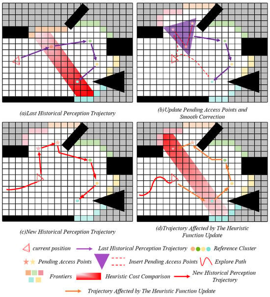
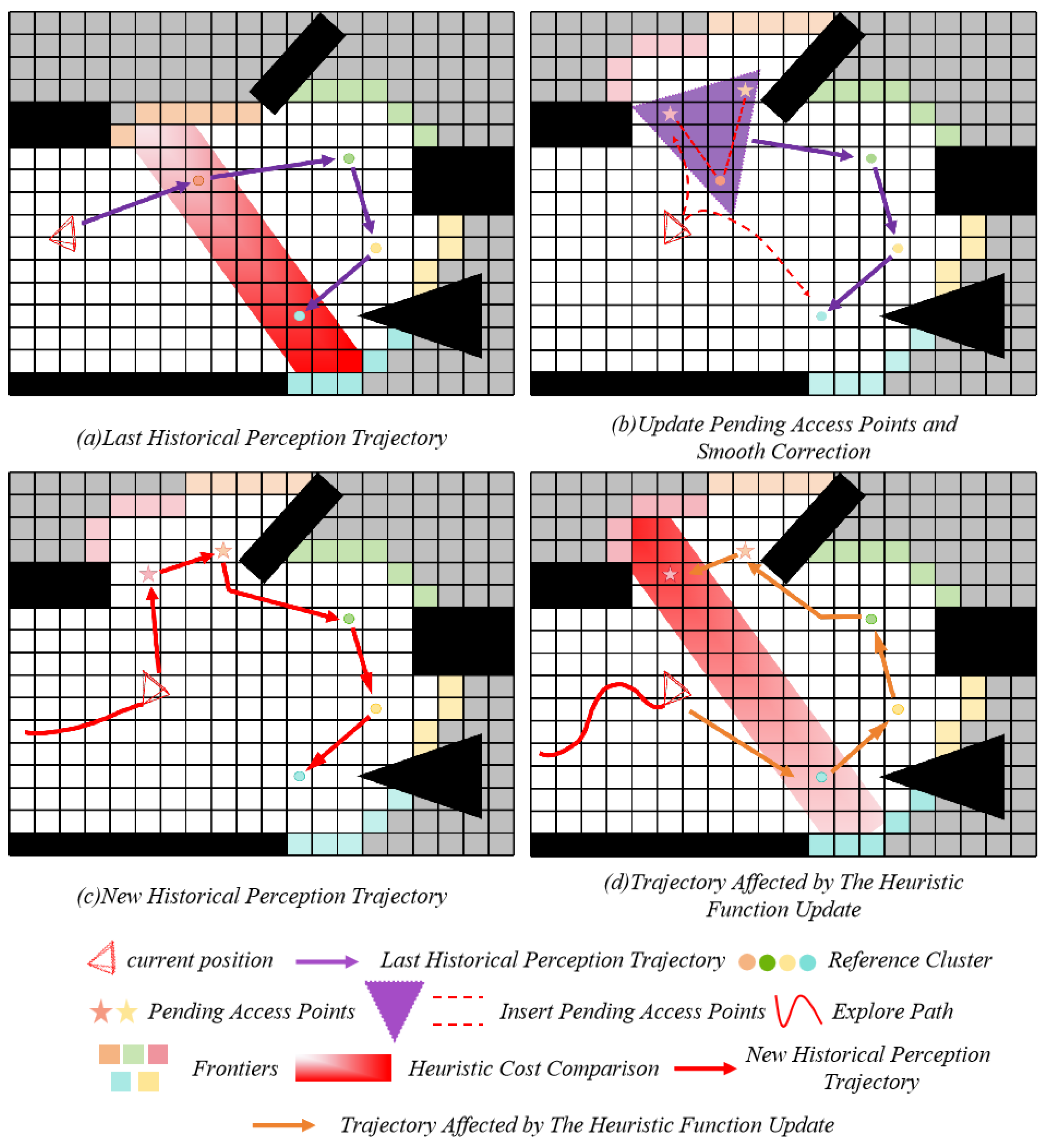
The proposed approach stores each global path and generates a new global path during replanning based on the previous exploration sequence. Since computations are confined to the updated area, unaffected regions remain unchanged, resulting in only a minor increase in computation time despite the additional processing. The update process is illustrated in Figure 6. To ensure the exploration order of newly generated viewpoint clusters aligns with the historical perception path, the historical clusters closest to the new clusters are identified, and distances between them are calculated. The new clusters are then arranged according to their proximity to the nearest center in the historical path. In regions with minimal updates, the newly formed clusters undergo only slight adjustments. Generally, centers with a distance change less than are considered part of the same frontier cluster as the historical perception path, referred to as the benchmark cluster. The drone’s current position is also included in this benchmark cluster. To visit each cluster within the new viewpoint clusters, they are connected to the benchmark cluster to form a continuous path. Adjacent benchmark clusters serve as start and end points; clusters in between are determined, establishing a clear exploration order for which the shortest path is calculated. By connecting these shortest paths between benchmark clusters, a new historical perception path is constructed. Finally, the motion consistency cost between the drone’s current position and the first point of the new path is computed to prevent abrupt changes in motion direction that could reduce exploration efficiency. The historical perception path is calculated as follows:
Figure 6.
Visualization of historical-perception planning based on motion smoothing correction. Record historical trajectories and determine exploration paths based on smooth optimization costs. Without historical-perception paths, hesitant behavior will occur.
Among them, denote the cost of the historical perception path, represent the TSP cost for the historical path, and indicate the motion consistency cost. The cost of the historical perception path is compared with that of the temporary shortest path : if the cost difference is negligible, the historical perception path remains unchanged; if the difference is significant, a sliding-window TSP strategy is employed to reconstruct the global path.
The sliding-window TSP strategy is designed to efficiently compute a near-optimal path within a localized context. Specifically, it dynamically selects the nearest frontier clusters from the UAV’s current position, forming a local planning window :
where is the current set of all frontier clusters, and is the UAV’s current position. The window size is fixed at , which constrains the computational complexity of the resulting TSP instance to . This design ensures real-time planning performance by focusing computational resources on the most immediately relevant frontiers, thereby preventing the myopic decision-making of purely greedy approaches while avoiding the combinatorial explosion of a global TSP solver. The window slides forward as the UAV moves, continuously updating the local planning context and enabling coherent, long-horizon exploration with bounded computational cost per planning cycle. The TSP instances generated by the sliding-window approach are solved using the Lin–Kernighan–Helsgaun (LKH) algorithm, a highly effective heuristic approach for symmetric TSP. The LKH algorithm was selected for its ability to efficiently find near-optimal solutions for moderate-sized TSP instances, which aligns with our requirement for real-time path planning performance.
This strategy uses the drone’s current posture as the reference origin and divides the local optimization window based on spatial proximity. It ensures that the scale of the frontier clusters within the window complies with the computational complexity constraints of the lightweight TSP solver. Within this window, an efficient heuristic algorithm determines the optimal traversal sequence of frontier clusters to generate a local minimum-cost path. Finally, frontier clusters outside the window are concatenated to form a complete global exploration path.
4. Results
The proposed approach’s effectiveness is thoroughly evaluated using a combination of real-world experiments and simulated tests. To examine the contribution of each algorithmic component, ablation studies are conducted by comparing the complete framework against simplified baseline versions. In the viewpoint evaluation, we set , . The parameters in the heuristic function are set to , , , when calculating the cost matrix. In the historical-perception planning, . For the SDE-based viewpoint generation, the parameters are configured as follows: radial drift coefficient , angular drift coefficient , radial diffusion coefficient , angular diffusion coefficient , and discretization step size . The number of sensors is set to deg, and the sensor range is 4.5 m. NLopt is used to solve the problem of trajectory optimization, and the trajectory is represented by a 3rd-order Bspine. To achieve fast autonomous mapping, Fiesta is used to build an occupancy network map [44]. In addition, the ESDF map is incrementally maintained for trajectory planning. Our simulation experiments are conducted on a laptop equipped with an Intel Core i5-12600KF, 32 GB RAM and Ubuntu 20.04 operating system. All codes are written in C++.
4.1. Benchmark Comparisons
We compared our proposed approach with several benchmark approaches, including the classic frontier approach [19], the fast frontier approach [21], ECHO [29], and FUEL [5]. Three representative simulation environments were used for evaluation: an office, a forest, and a DARPA tunnel. The performance of these approaches was qualitatively analyzed in the different environments and quantitatively evaluated in terms of exploration time, path length, and area coverage.
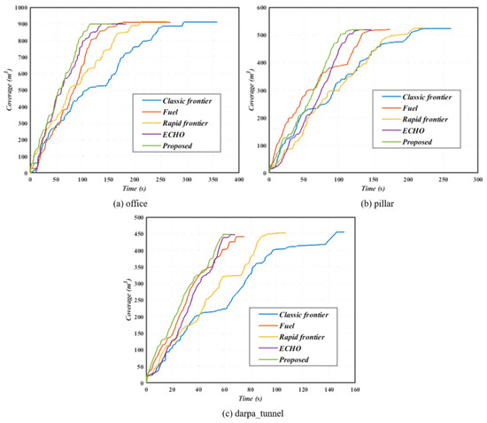
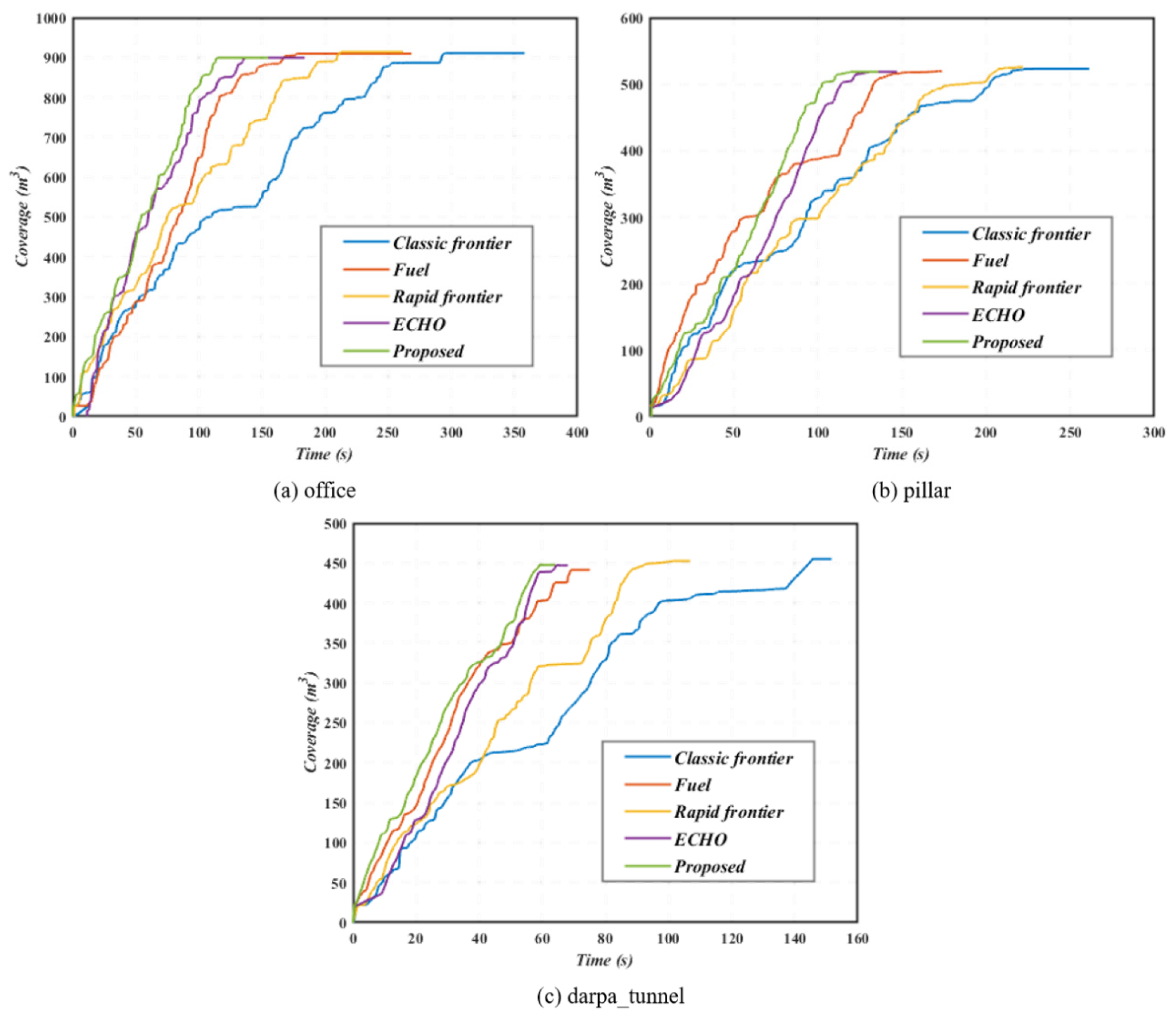
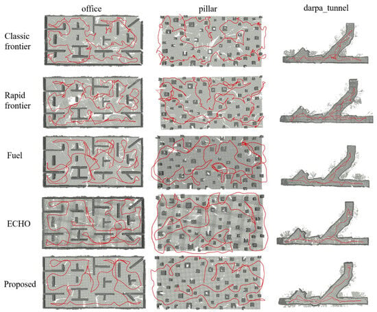
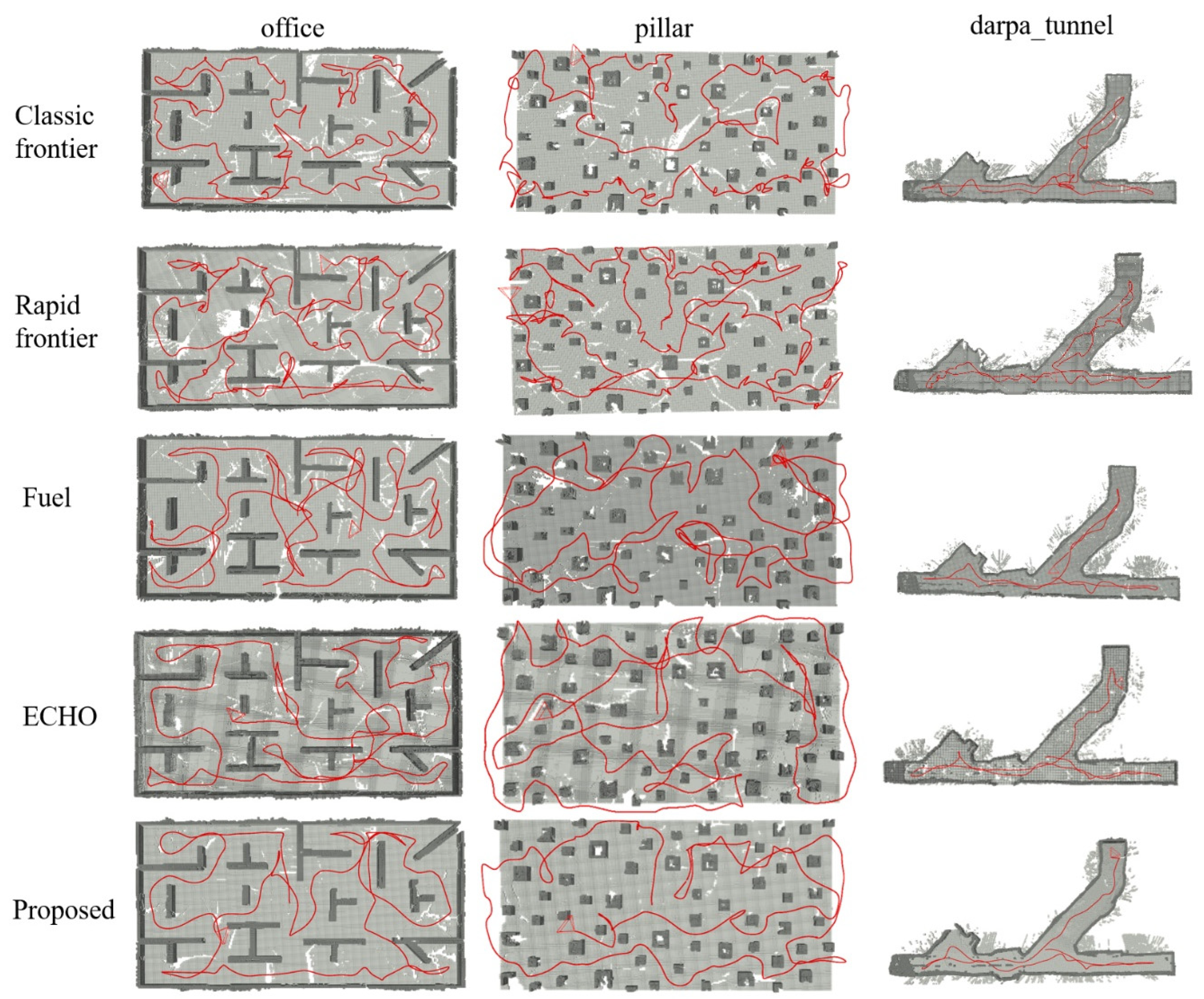
The qualitative comparison with state-of-the-art approaches provides an intuitive assessment of the proposed approach’s performance. As shown in Figure 7, our approach achieves the fastest exploration completion rate among all compared approaches, with the lowest peak time across different unknown environments. Figure 8 further illustrates that our approach explores all three environments with the most concise and smooth trajectories. Notably, our approach accurately detects and prioritizes isolated small regions, ensuring their early exploration while exhibiting minimal backtracking. In contrast, both FUEL and ECHO repeatedly revisit previously explored areas. This occurs because, in unknown environments, improper heuristic cost calculations often lead to greedy exploration behaviors that overlook isolated regions with low information gain and cause inefficient long-distance flight maneuvers. In comparison, our proposed boundary-cost formulation and isolated-region detection strategy, which impose heuristic cost penalties on distant and isolated regions, demonstrate significant advantages, effectively validating the effectiveness of our heuristic boundary-cost design.
Figure 7.
Comparison of exploration processes.
Figure 8.
A comparative analysis of the proposed approach and other approaches in various simulated environments for path exploration.
Our quantitative experiments compared the proposed approach with several state-of-the-art approaches in terms of exploration time, path length, and coverage area. The average value, standard deviation, maximum value, and minimum value were used as evaluation metrics to assess the effectiveness of each exploration approach. Table 1 presents the results of our approach and the baseline approaches across three different simulation environments. Note that the “Coverage (m3)” metric represents the volume of the explored space in cubic meters, estimated from the voxel-based occupancy map. It reflects the actual physical volume of the environment that has been successfully mapped, based on the ground-truth spatial extent. Overall, our approach achieved the shortest exploration time in all environments, demonstrating superior exploration efficiency. This improvement primarily stems from the proposed hybrid viewpoint generation strategy. When the distance to the nearest obstacle is large, the collision-free spherical sampling approach eliminates the need for costly ray casting to check for obstacles between the drone and candidate viewpoints. Sampling viewpoints on the surface of the sphere ensures comprehensive coverage while avoiding collisions. More importantly, we introduce an adaptive viewpoint generation approach based on stochastic differential equations. This approach dynamically couples viewpoint evolution with the local information field to produce a compact set of high-information-gain candidate viewpoints. When the viewpoint approaches areas rich in information, numerous dense, high-quality viewpoint candidates are generated; conversely, in low-information regions, dense sampling is avoided to reduce redundancy. This mechanism significantly decreases the computational cost of viewpoint generation while producing high-quality, information-rich viewpoints. Furthermore, our approach exhibits consistently superior performance in terms of standard deviation, showing significantly lower variability compared with state-of-the-art approaches. This improvement arises because each exploration scenario presents unique environmental conditions and decision-making challenges, which can destabilize exploration efficiency. By employing a two-stage global path planning strategy, our approach enables more decisive viewpoint selection, ensuring stable and robust performance across multiple test scenarios.
Table 1.
Exploration statistics in the three scenarios.
4.2. Ablation Studies
This section presents an ablation experiment to investigate the importance of the three key components of our proposed approach: hybrid viewpoint generation and decision-making (HFGDC), heuristic frontier cost calculation (HFCC), Two-stage Global Path Planning (TGPP).
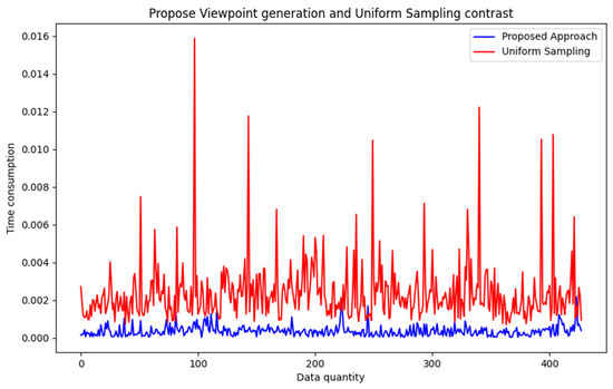
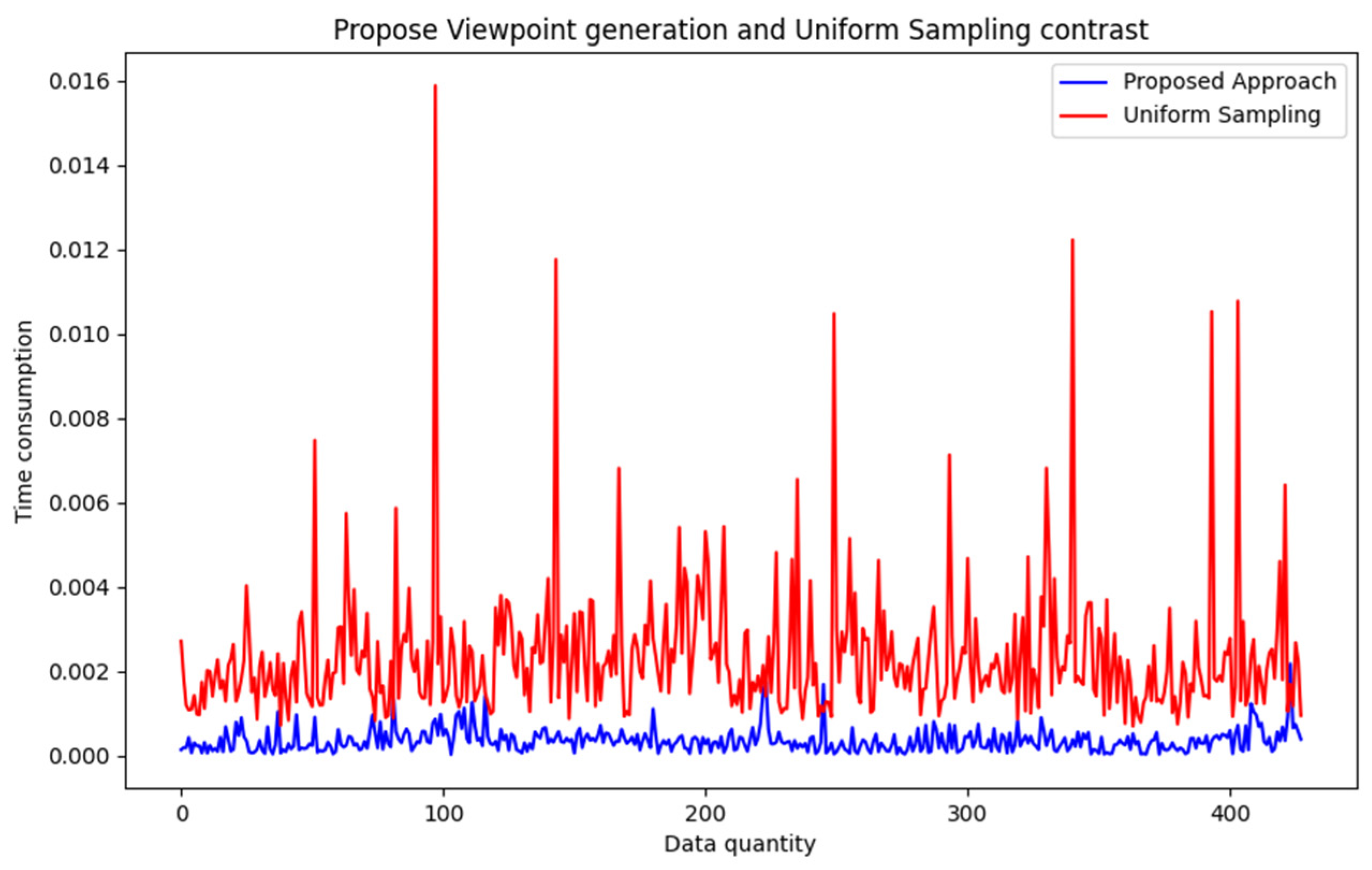
To validate the effectiveness of the proposed HFGDC approach, we compared the time required to generate candidate viewpoints with and without HFGDC in the same exploration environment. The results, illustrated in Figure 9, demonstrate that HFGDC significantly outperforms uniform sampling in terms of time efficiency and exhibits lower variability. Specifically, HFGDC constructs a collision-free sphere and uniformly samples points on its surface. Additionally, through cube and small-sphere detection, when frontier regions or small obstacles are identified, an adaptive viewpoint generation strategy based on stochastic differential equations is employed. This strategy dynamically couples viewpoint evolution with the local information field, enabling the generation of a small number of candidate viewpoints with high information gain.
Figure 9.
Comparison of the time consumption of our proposed viewpoint generation approach and the uniform sampling approach.
To further investigate the robustness of our approach, we analyzed the impact of key parameters within the SDE-based viewpoint generation module. Table 2 summarizes the performance under different parameter settings in the Office environment. The results confirm that our chosen parameters () achieve a commendable balance. Lower values of the radial diffusion coefficient σr lead to insufficient exploration randomness, increasing path length as the planner becomes trapped in local regions. Conversely, higher values degrade stability, as reflected in the increased standard deviation of exploration time. The drift coefficient effectively modulates the exploration–exploitation trade-off, with our chosen value yielding the shortest exploration time.
Table 2.
Analysis of SDE parameters in the Office environment.
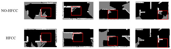
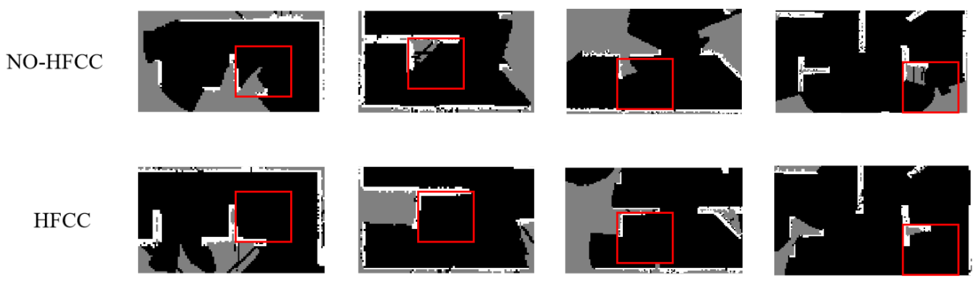
Subsequently, we binarized the ESDF occupancy grid map to more intuitively visualize the progress of unknown space exploration. Additionally, several regions within the office environment that are typically prone to being overlooked were selected for performance comparison with and without the HFCC module. As shown in Figure 10, HFCC employs a lightweight and precise small-area detection technique, enabling timely identification and exploration upon first arrival at the target region, thereby reducing redundant exploration. In contrast, in the absence of the HFCC module, several critical areas were missed, leading to repeated and unnecessary exploration.
Figure 10.
Comparison of the performance of our proposed approach in small area detection.
To quantitatively evaluate the computational efficiency of our sliding-window TSP approach, we compare it with alternative planning strategies in terms of both theoretical complexity and actual computation time. Table 3 presents a comprehensive analysis conducted in the Office environment.
Table 3.
Computational complexity and performance comparison of planning strategies.
The results clearly demonstrate that our sliding-window TSP achieves the best computational performance while maintaining superior exploration efficiency. The single-stage TSP approach, despite its theoretical global optimality, becomes computationally prohibitive even for moderate numbers of frontiers. The incremental planner, while computationally efficient, suffers from short-sighted decision-making that leads to increased exploration time due to excessive backtracking. Our approach strikes the optimal balance, providing near-optimal local paths with constant-time complexity relative to the total number of frontiers.
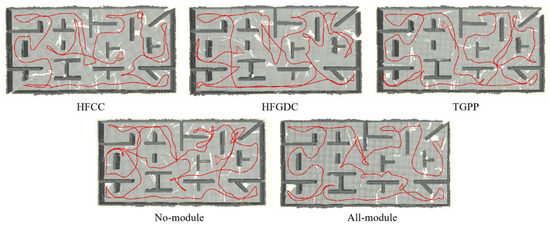
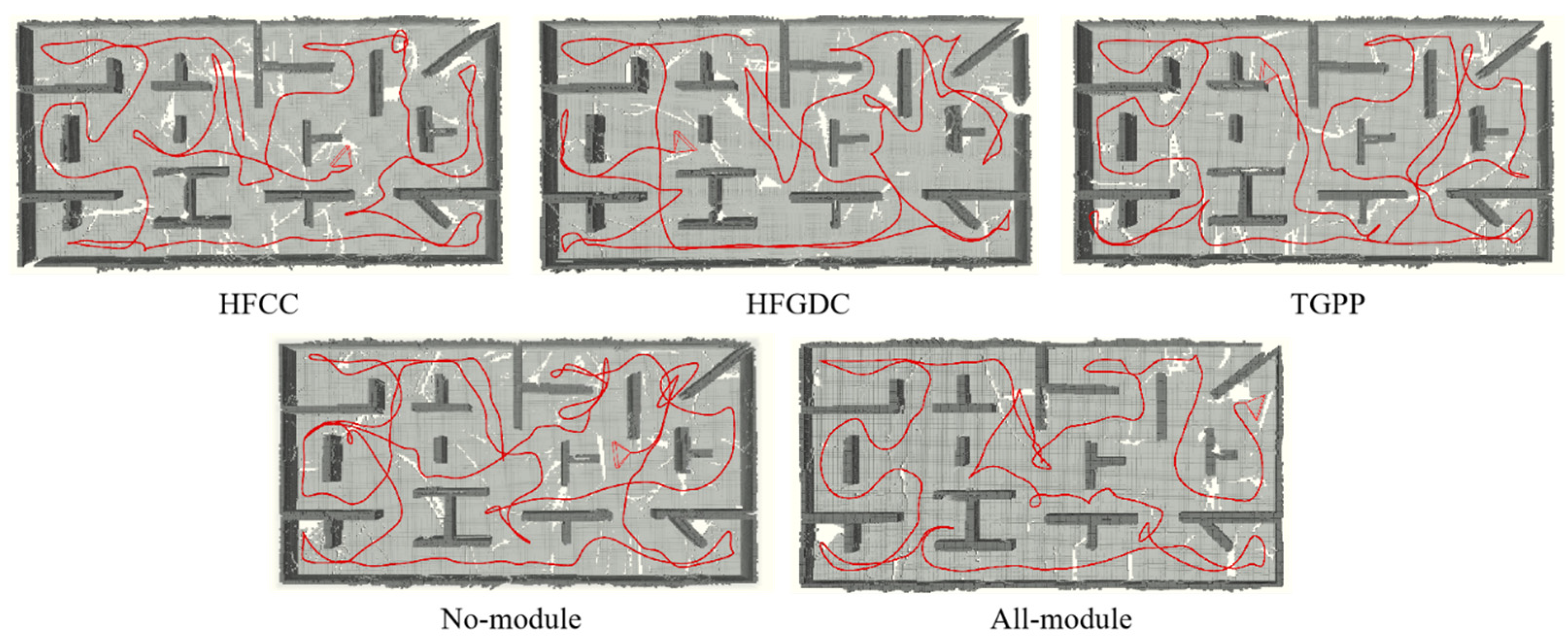
A fair evaluation of the proposed approach’s impact on exploration efficiency was conducted by comparing algorithm performance under identical conditions, with each of the three core components selectively disabled. Table 4 presents the exploration time, trajectory length, and coverage area achieved under each configuration. When none of the modules are integrated, the algorithm performs poorly, exhibiting the most disorganized and prolonged trajectories. This degradation is primarily attributed to the high computational overhead caused by low-quality candidate viewpoints, an unstructured exploration sequence that leads to frequent backtracking, and excessive heuristic calculations resulting in indecisive flight behavior. The HFGDC module, by employing a hybrid viewpoint generation strategy that produces a moderate number of high-quality candidate viewpoints, significantly reduces computational costs and improves both trajectory efficiency and exploration time. Figure 11 illustrates the corresponding exploration paths. The inclusion of the HFCC module further enhances performance by introducing a refined frontier cost function and a small-area detection mechanism, which prioritize frontier regions and isolated areas, effectively minimizing redundant traversal and improving time efficiency. The TGPP-only configuration demonstrates a notably smoother trajectory with minimal hesitation, which can be directly attributed to the proposed two-stage global path planning framework. This improvement stems from the framework’s core mechanism of incorporating historical trajectory information into the replanning process. By maintaining and leveraging past exploration sequences through the history-aware enhancement strategy, the system mitigates the motion inconsistencies and abrupt direction changes typically caused by frequent heuristic boundary updates. This results in more coherent navigation decisions and enhanced flight stability, even when operating without the other proposed modules.
Table 4.
Results in the ablation study.
Figure 11.
Exploration paths of ablation experiments, testing our approach without HFCC module, HFGDC module, and HPP module.
In conclusion, integrating all modules enables our algorithm to produce an efficient and coherent trajectory, facilitating faster exploration of uncharted areas while minimizing redundant revisits.
4.3. Real-World Experiments
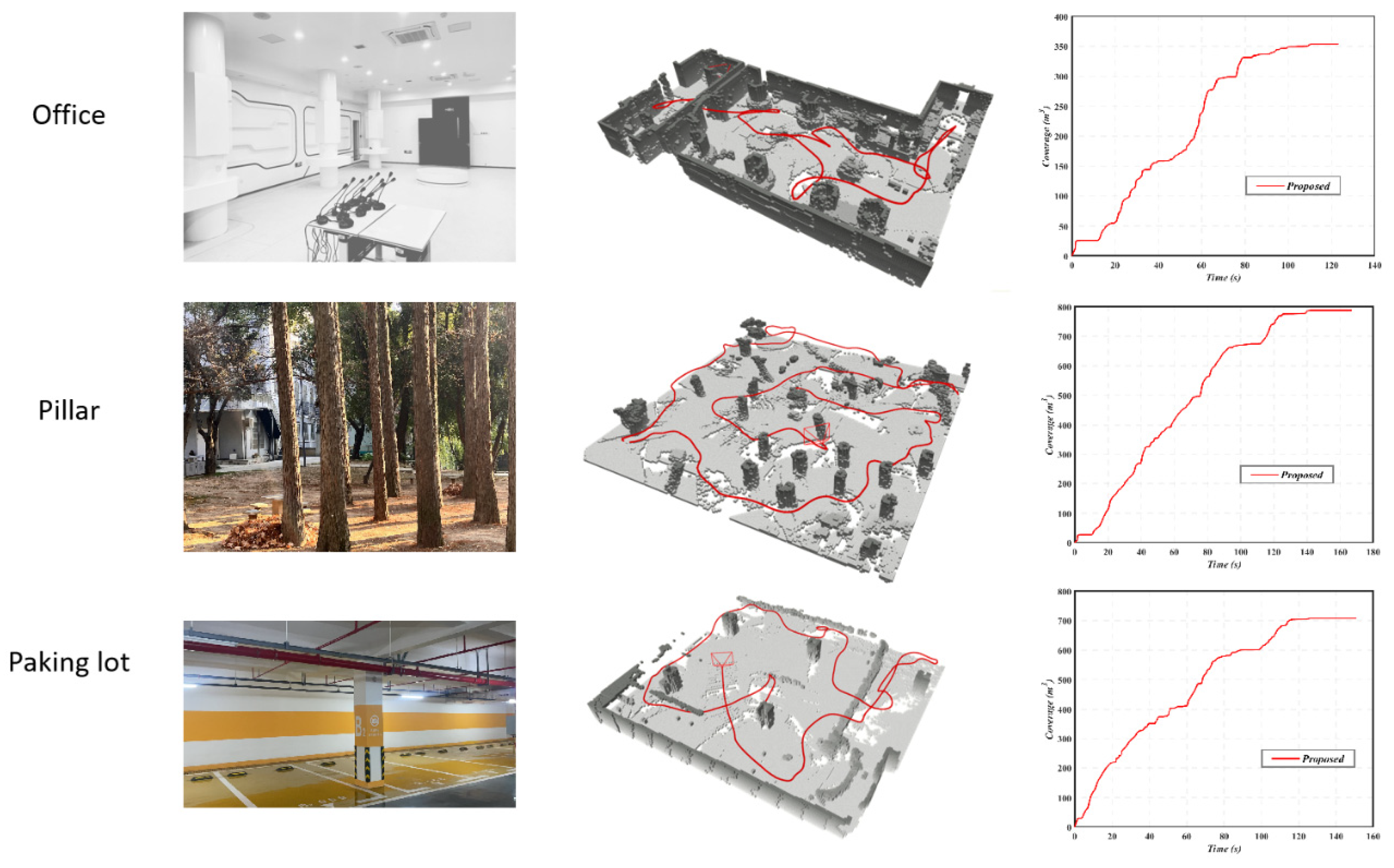
To systematically evaluate the performance of the proposed approach in complex real-world environments, a series of flight experiments were conducted across three representative scenarios: an indoor space, an outdoor forest, and an underground parking lot. These environments, characterized by varying levels of structural complexity, perceptual challenges, and navigation difficulty, were designed to assess the system’s versatility, robustness, and flight stability from multiple perspectives. The experimental platform consisted of an autonomous multirotor drone, as shown in Figure 1. The drone was equipped with an NVIDIA Jetson Orin NX edge computing module as the primary processing unit, providing powerful parallel computing capabilities for high-frequency online perception, environmental mapping, and real-time global path planning. In addition, an Intel RealSense D435i RGB-D camera was employed to capture synchronized depth images and inertial measurement data. The globally planned paths were sent to the platform’s onboard Pixhawk flight controller (running the PX4 firmware with its standard MPC-based position controller), which handled the real-time trajectory tracking and attitude control.
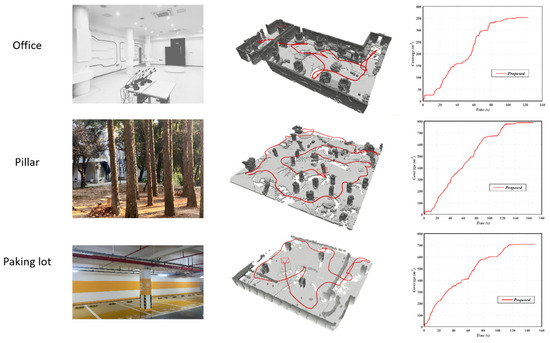
To ensure the reproducibility and fairness of the results, at least five flight trials were conducted in each test environment. All flights were performed under identical dynamic motion constraints, including control parameters such as maximum velocity, angular velocity, and acceleration limits, consistent with those used in the simulation experiments. The flight missions aimed to autonomously explore unknown spaces and achieve complete environmental coverage and mapping. From takeoff to completion, the entire system operated without external positioning systems or human intervention, achieving fully autonomous, closed-loop operation based solely on onboard perception and computation. As shown in Figure 12, the proposed approach effectively guided the drone to achieve rapid and efficient area coverage in completely unknown and complex environments. The generated flight trajectories were evenly distributed, exhibiting minimal redundancy or repeated coverage, thereby validating the effectiveness of the hybrid viewpoint generation and boundary-prioritization strategies in real-world applications. The coverage curves demonstrated a consistent upward trend, indicating strong motion coherence and planning stability throughout the exploration process. In particular, in scenarios with occlusions or partially enclosed areas, the exploration strategy successfully advanced into unknown regions, fully demonstrating the superiority of the proposed approach in real-world autonomous exploration, detection, and mapping tasks across indoor, outdoor, and underground environments.
Figure 12.
Exploration results in real-world experiments.
5. Conclusions
Through this work, we aim to draw the community’s attention to the development of a hierarchical exploration framework specifically designed for UAVs with limited fields of view. As a novel solution for autonomous exploration in unknown environments, the proposed approach enables UAVs to perceive, explore, and map complex and unstructured scenes effectively. While traditional exploration approaches can perform autonomous detection and mapping, they often suffer from inefficiency and instability. In this study, three key design features contribute to the promising results achieved. First, we adopt a hybrid strategy that combines collision-free spherical sampling with adaptive viewpoint generation based on stochastic differential equations to produce high-quality viewpoint candidates while minimizing computational overhead. Second, we introduce a heuristic evaluation function to prioritize isolated small regions, thereby facilitating more optimal path exploration. Third, we formulate the global coverage path as a Traveling Salesman Problem (TSP) and employ a two-stage global planning framework to alleviate motion inconsistencies caused by frequent heuristic updates, thus improving trajectory coherence and flight stability. We believe that the proposed framework provides strong experimental evidence and valuable engineering guidance for potential deployment in practical applications such as urban mapping, post-disaster assessment, and autonomous inspection. While the current work demonstrates robust performance in diverse static environments with complex geometries, including tunnels and forest areas, further research is needed to address challenges such as dynamic obstacles and varying illumination conditions. Furthermore, integrating a tightly coupled, robust tracking controller specifically optimized for the output of our planning module represents a logical and essential next step to further enhance overall system performance. These aspects, together with the incorporation of multi-UAV collaboration mechanisms, dynamic obstacle avoidance strategies, and semantic perception modules, represent important directions for our future work to enhance the system’s scalability and intelligence in more complex operational environments.
Author Contributions
All authors participated in the design of the autonomous exploration and made significant contributions to this work. Y.Y.: Conceptualization, Methodology, Software, Formal analysis, Investigation, Writing—Original Draft, Visualization; X.W.: Software, Validation, Writing—Original Draft, Visualization. H.Z.: Data Curation, Formal analysis. G.G.: Software, Formal analysis. H.L.: Project administration, Writing—Review & Editing. H.S. (Corresponding Author): Resources, Supervision, Funding acquisition, Writing—Review & Editing. All authors have read and agreed to the published version of the manuscript.
Funding
This research was funded by Hubei Provincial Technology Innovation Plan Project [grant number 2024BCB103] and Guangxi Science and Technology Major Project [grant number AA22068072].
Data Availability Statement
Dataset available on request from the authors.
Conflicts of Interest
The authors declare that they have no known competing financial interests or personal relationships that could have appeared to influence the work reported in this paper.
References
- Abd Rahman, M.F. Technological Innovations in UAVs for Geospatial Data Collection: A Review of Current Trends. 2025. Available online: https://www.researchgate.net/publication/388325527_Technological_Innovations_in_UAVs_for_Geospatial_Data_Collection_A_Review_of_Current_Trends (accessed on 3 December 2025).
- He, S.; Tan, X.; Zhong, Y.; Huang, M.; Mei, Z.; Wan, Y.; Wang, H. Evolutionary PSO-Based Emergency Monitoring Geospatial Edge Service Chain in the Emergency Communication Network. Int. J. Digit. Earth 2023, 16, 2797–2817. [Google Scholar] [CrossRef] [Scilit]
- Martinez-Alpiste, I.; Golcarenarenji, G.; Wang, Q.; Alcaraz-Calero, J.M. Search and Rescue Operation Using UAVs: A Case Study. Expert Syst. Appl. 2021, 178, 114937. [Google Scholar] [CrossRef] [Scilit]
- Lyu, M.; Zhao, Y.; Huang, C.; Huang, H. Unmanned Aerial Vehicles for Search and Rescue: A Survey. Remote Sens. 2023, 15, 3266. [Google Scholar] [CrossRef] [Scilit]
- Zhou, B.; Zhang, Y.; Chen, X.; Shen, S. FUEL: Fast UAV Exploration Using Incremental Frontier Structure and Hierarchical Planning. IEEE Robot. Autom. Lett. 2021, 6, 779–786. [Google Scholar] [CrossRef] [Scilit]
- LaValle, S. Rapidly-Exploring Random Trees: A New Tool for Path Planning. Annu. Res. Rep. 1998. [Google Scholar]
- Connolly, C. The Determination of next Best Views. In Proceedings of the 1985 IEEE International Conference on Robotics and Automation, St. Louis, MO, USA, 25–28 March 1985; Institute of Electrical and Electronics Engineers: New York, NY, USA, 1985; Volume 2, pp. 432–435. [Google Scholar]
- Bircher, A.; Kamel, M.; Alexis, K.; Oleynikova, H.; Siegwart, R. Receding Horizon “Next-Best-View” Planner for 3D Exploration. In Proceedings of the 2016 IEEE International Conference on Robotics and Automation (ICRA), Stockholm, Sweden, 16–21 May 2016; pp. 1462–1468. [Google Scholar]
- Papachristos, C.; Khattak, S.; Alexis, K. Uncertainty-Aware Receding Horizon Exploration and Mapping Using Aerial Robots. In Proceedings of the 2017 IEEE International Conference on Robotics and Automation (ICRA), Singapore, 29 May–3 June 2017; pp. 4568–4575. [Google Scholar]
- Papachristos, C.; Khattak, S.; Mascarich, F.; Alexis, K. Autonomous Navigation and Mapping in Underground Mines Using Aerial Robots. In Proceedings of the 2019 IEEE Aerospace Conference, Big Sky, MT, USA, 2–9 March 2019; pp. 1–8. [Google Scholar]
- Witting, C.; Fehr, M.; Behnemann, R.; Oleynikova, H.; Siegwart, R. History-Aware Autonomous Exploration in Confined Environments Using MAVs. In Proceedings of the 2018 IEEE/RSJ International Conference on Intelligent Robots and Systems (IROS), Madrid, Spain, 1–5 October 2018; pp. 1–9. [Google Scholar]
- Selin, M.; Tiger, M.; Duberg, D.; Heintz, F.; Jensfelt, P. Efficient Autonomous Exploration Planning of Large-Scale 3-D Environments. IEEE Robot. Autom. Lett. 2019, 4, 1699–1706. [Google Scholar] [CrossRef] [Scilit]
- Deng, D.; Duan, R.; Liu, J.; Sheng, K.; Shimada, K. Robotic Exploration of Unknown 2D Environment Using a Frontier-Based Automatic-Differentiable Information Gain Measure. In Proceedings of the 2020 IEEE/ASME International Conference on Advanced Intelligent Mechatronics (AIM), In Virtual, 6–10 July 2020; pp. 1497–1503. [Google Scholar]
- Dharmadhikari, M.; Dang, T.; Solanka, L.; Loje, J.; Nguyen, H.; Khedekar, N.; Alexis, K. Motion Primitives-Based Path Planning for Fast and Agile Exploration Using Aerial Robots. In Proceedings of the 2020 IEEE International Conference on Robotics and Automation (ICRA), Paris, France, 31 May–31 August 2020; pp. 179–185. [Google Scholar]
- Xu, Z.; Deng, D.; Shimada, K. Autonomous UAV Exploration of Dynamic Environments Via Incremental Sampling and Probabilistic Roadmap. IEEE Robot. Autom. Lett. 2021, 6, 2729–2736. [Google Scholar] [CrossRef] [Scilit]
- Zhu, H.; Cao, C.; Xia, Y.; Scherer, S.; Zhang, J.; Wang, W. DSVP: Dual-Stage Viewpoint Planner for Rapid Exploration by Dynamic Expansion. In Proceedings of the 2021 IEEE/RSJ International Conference on Intelligent Robots and Systems (IROS), Prague, Czech Republic, 27 September–1 October 2021; pp. 7623–7630. [Google Scholar]
- Respall, V.M.; Devitt, D.; Fedorenko, R.; Klimchik, A. Fast Sampling-Based Next-Best-View Exploration Algorithm for a MAV. In Proceedings of the 2021 IEEE International Conference on Robotics and Automation (ICRA), Xi’an, China, 30 May–5 June 2021; pp. 89–95. [Google Scholar]
- Duberg, D.; Jensfelt, P. UFOExplorer: Fast and Scalable Sampling-Based Exploration with a Graph-Based Planning Structure. IEEE Robot. Autom. Lett. 2022, 7, 2487–2494. [Google Scholar] [CrossRef] [Scilit]
- Yamauchi, B. A Frontier-Based Approach for Autonomous Exploration. In Proceedings of the 1997 IEEE International Symposium on Computational Intelligence in Robotics and Automation CIRA’97. “Towards New Computational Principles for Robotics and Automation”, Monterey, CA, USA, 10–11 July 1997; pp. 146–151. [Google Scholar]
- Juliá, M.; Gil, A.; Reinoso, O. A Comparison of Path Planning Strategies for Autonomous Exploration and Mapping of Unknown Environments. Auton Robot 2012, 33, 427–444. [Google Scholar] [CrossRef] [Scilit]
- Cieslewski, T.; Kaufmann, E.; Scaramuzza, D. Rapid Exploration with Multi-Rotors: A Frontier Selection Approach for High Speed Flight. In Proceedings of the 2017 IEEE/RSJ International Conference on Intelligent Robots and Systems (IROS), Vancouver, BC, Canada, 1–24 September 2017; pp. 2135–2142. [Google Scholar]
- Tang, C.; Liang, Y.; Yu, S.; Sun, R.; Zheng, J. Autonomous 3D Exploration of Indoor Environment Based on Wavefront Algorithm. In Proceedings of the 2020 IEEE International Conference on Networking, Sensing and Control (ICNSC), Nanjing, China, 30 October–2 November 2020; pp. 1–6. [Google Scholar]
- Dai, A.; Papatheodorou, S.; Funk, N.; Tzoumanikas, D.; Leutenegger, S. Fast Frontier-Based Information-Driven Autonomous Exploration with an MAV. In Proceedings of the 2020 IEEE International Conference on Robotics and Automation (ICRA), Paris, France, 31 May–31 August 2020; pp. 9570–9576. [Google Scholar]
- Deng, D.; Xu, Z.; Zhao, W.; Shimada, K. Frontier-Based Automatic-Differentiable Information Gain Measure for Robotic Exploration of Unknown 3D Environments. arXiv 2020, arXiv:2011.05288. [Google Scholar]
- Meng, Z.; Qin, H.; Chen, Z.; Chen, X.; Sun, H.; Lin, F.; Ang, M.H. A Two-Stage Optimized Next-View Planning Framework for 3-D Unknown Environment Exploration, and Structural Reconstruction. IEEE Robot. Autom. Lett. 2017, 2, 1680–1687. [Google Scholar] [CrossRef] [Scilit]
- Batinovic, A.; Petrovic, T.; Ivanovic, A.; Petric, F.; Bogdan, S. A Multi-Resolution Frontier-Based Planner for Autonomous 3D Exploration. IEEE Robot. Autom. Lett. 2021, 6, 4528–4535. [Google Scholar] [CrossRef] [Scilit]
- Hess, W.; Kohler, D.; Rapp, H.; Andor, D. Real-Time Loop Closure in 2D LIDAR SLAM. In Proceedings of the 2016 IEEE International Conference on Robotics and Automation (ICRA), Stockholm, Sweden, 16–21 May 2016; pp. 1271–1278. [Google Scholar]
- Hornung, A.; Wurm, K.M.; Bennewitz, M.; Stachniss, C.; Burgard, W. OctoMap: An Efficient Probabilistic 3D Mapping Framework Based on Octrees. Auton Robot 2013, 34, 189–206. [Google Scholar] [CrossRef] [Scilit]
- Yu, J.; Shen, H.; Xu, J.; Zhang, T. ECHO: An Efficient Heuristic Viewpoint Determination Approach on Frontier-Based Autonomous Exploration for Quadrotors. IEEE Robot. Autom. Lett. 2023, 8, 5047–5054. [Google Scholar] [CrossRef] [Scilit]
- Zhao, Y.; Yan, L.; Xie, H.; Dai, J.; Wei, P. Autonomous Exploration Approach for Fast Unknown Environment Mapping by Using UAV Equipped with Limited FOV Sensor. IEEE Trans. Ind. Electron. 2023, 71, 4933–4943. [Google Scholar] [CrossRef] [Scilit]
- Zhang, H.; Wang, S.; Liu, Y.; Ji, P.; Yu, R.; Chao, T. EFP: Efficient Frontier-Based Autonomous UAV Exploration Strategy for Unknown Environments. IEEE Robot. Autom. Lett. 2024, 9, 2941–2948. [Google Scholar] [CrossRef] [Scilit]
- Mnih, V.; Kavukcuoglu, K.; Silver, D.; Rusu, A.A.; Veness, J.; Bellemare, M.G.; Graves, A.; Riedmiller, M.; Fidjeland, A.K.; Ostrovski, G.; et al. Human-Level Control through Deep Reinforcement Learning. Nature 2015, 518, 529–533. [Google Scholar] [CrossRef] [Scilit]
- Kulkarni, P.; Goswami, D.; Guha, P.; Dutta, A. Path Planning for a Statically Stable Biped Robot Using PRM and Reinforcement Learning. J. Intell. Robot. Syst. 2006, 47, 197–214. [Google Scholar] [CrossRef] [Scilit]
- Ma, X.; Xu, Y.; Sun, G.; Deng, L.; Li, Y. State-Chain Sequential Feedback Reinforcement Learning for Path Planning of Autonomous Mobile Robots. J. Zhejiang Univ. Sci. C 2013, 14, 167–178. [Google Scholar] [CrossRef] [Scilit]
- Tai, L.; Liu, M. Mobile Robots Exploration through Cnn-Based Reinforcement Learning. Robot. Biomim. 2016, 3, 24. [Google Scholar] [CrossRef] [Scilit]
- Deep Reinforcement Learning Supervised Autonomous Exploration in Office Environments|IEEE Conference Publication|IEEE Xplore. Available online: https://ieeexplore.ieee.org/abstract/document/8463213 (accessed on 21 October 2025).
- Niroui, F.; Zhang, K.; Kashino, Z.; Nejat, G. Deep Reinforcement Learning Robot for Search and Rescue Applications: Exploration in Unknown Cluttered Environments. IEEE Robot. Autom. Lett. 2019, 4, 610–617. [Google Scholar] [CrossRef] [Scilit]
- Chen, F.; Martin, J.D.; Huang, Y.; Wang, J.; Englot, B. Autonomous Exploration Under Uncertainty via Deep Reinforcement Learning on Graphs. In Proceedings of the 2020 IEEE/RSJ International Conference on Intelligent Robots and Systems (IROS), Las Vegas, NV, USA, 24 October 2020–24 January 2021; pp. 6140–6147. [Google Scholar]
- Li, H.; Zhang, Q.; Zhao, D. Deep Reinforcement Learning-Based Automatic Exploration for Navigation in Unknown Environment. IEEE Trans. Neural Netw. Learn. Syst. 2020, 31, 2064–2076. [Google Scholar] [CrossRef] [Scilit]
- Rao, Z.; Wu, Y.; Yang, Z.; Zhang, W.; Lu, S.; Lu, W.; Zha, Z. Visual Navigation With Multiple Goals Based on Deep Reinforcement Learning. IEEE Trans. Neural Netw. Learn. Syst. 2021, 32, 5445–5455. [Google Scholar] [CrossRef] [Scilit] [PubMed]
- Tao, Y.; Iceland, E.; Li, B.; Zwecher, E.; Heinemann, U.; Cohen, A.; Avni, A.; Gal, O.; Barel, A.; Kumar, V. Learning to Explore Indoor Environments Using Autonomous Micro Aerial Vehicles. In Proceedings of the 2024 IEEE International Conference on Robotics and Automation (ICRA), Yokohama, Japan, 13–17 May 2024; pp. 15758–15764. [Google Scholar]
- Tang, B.; Ren, Y.; Zhu, F.; He, R.; Liang, S.; Kong, F.; Zhang, F. Bubble Explorer: Fast UAV Exploration in Large-Scale and Cluttered 3D-Environments Using Occlusion-Free Spheres. In Proceedings of the 2023 IEEE/RSJ International Conference on Intelligent Robots and Systems (IROS), Detroit, MI, USA, 1–5 October 2023; pp. 1118–1125. [Google Scholar]
- Luo, Y.; Zhuang, Z.; Pan, N.; Feng, C.; Shen, S.; Gao, F.; Cheng, H.; Zhou, B. Star-Searcher: A Complete and Efficient Aerial System for Autonomous Target Search in Complex Unknown Environments. IEEE Robot. Autom. Lett. 2024, 9, 4329–4336. [Google Scholar] [CrossRef] [Scilit]
- Han, L.; Gao, F.; Zhou, B.; Shen, S. FIESTA: Fast Incremental Euclidean Distance Fields for Online Motion Planning of Aerial Robots. In Proceedings of the 2019 IEEE/RSJ International Conference on Intelligent Robots and Systems (IROS), Macau, China, 3–8 November 2019. [Google Scholar]

Disclaimer/Publisher’s Note: The statements, opinions and data contained in all publications are solely those of the individual author(s) and contributor(s) and not of MDPI and/or the editor(s). MDPI and/or the editor(s) disclaim responsibility for any injury to people or property resulting from any ideas, methods, instructions or products referred to in the content. |
© 2025 by the authors. Licensee MDPI, Basel, Switzerland. This article is an open access article distributed under the terms and conditions of the Creative Commons Attribution (CC BY) license (https://creativecommons.org/licenses/by/4.0/).