


Highlights
What are the main findings?
- TriCross-D2D provides a cross-scene/cross-view/cross-weather D2D detection benchmark with 7045 images and 9771 annotated UAV instances, of which 73.8% are extremely tiny, tiny, or small targets.
- Benchmark results show that existing methods remain limited on TriCross-D2D. In a single-run comparison, SCOPE-DA-RTDETR improves from 28.63/13.12/22.39 to 29.94/13.71/23.40.
What are the implications of the main findings?
- TriCross-D2D provides a standardized and challenging UDA/SSDA benchmark for small-object D2D detection, enabling systematic evaluation of UAV detectors under compound cross-scene, cross-view, and cross-weather domain shifts.
- The benchmark can support future research on robust cross-domain UAV detection, domain adaptation and generalization, lightweight detection, and extensions to RGB–thermal/multimodal sensing or real adverse-weather scenarios for low-altitude intelligent perception.
Abstract
Drone-to-drone (D2D) detection is a critical yet underexplored task in low-altitude intelligent perception, where UAV targets are often small, weakly textured, motion-affected, and disturbed by complex backgrounds and environmental changes. Existing cross-domain detection datasets mainly focus on ground objects or single-factor shifts, making them insufficient for evaluating D2D detection under coupled real-world variations. To address this gap, we present TriCross-D2D, an RGB air-to-air UAV detection dataset and benchmark with three explicit domain shifts: scene, viewpoint, and weather. Built from real flight videos and controlled synthetic fog, TriCross-D2D contains 13 RGB video sequences, 23,403 raw frames, 7045 benchmark images, and 9771 annotated UAV instances. It provides a fixed split of 4045 Source_train images, 2000 Target_train images, and 1000 Target_val images, supporting both unsupervised domain adaptation (UDA) and semi-supervised domain adaptation (SSDA). The dataset is dominated by small objects, with extremely tiny, tiny, and small targets accounting for 73.8% of all instances. Benchmark results show that existing cross-domain detectors still perform limitedly on TriCross-D2D, especially under stricter localization and recall metrics. Single-factor analysis further reveals that the coupled scene–viewpoint–weather protocol is more challenging than isolated shifts, with viewpoint variation producing a particularly strong domain gap. As an exploratory enhanced baseline, SCOPE-DA-RTDETR improves DA-RTDETR from 28.63/13.12/22.39 to 29.94/13.71/23.40 in , showing consistent but modest gains. These findings demonstrate that TriCross-D2D provides a challenging and discriminative benchmark for cross-domain D2D small-object detection.
1. Introduction
With the rapid development of applications such as the low-altitude economy, airspace regulation, intelligent security, emergency response, and collaborative drone operations, drone-to-drone detection (D2D detection) is gradually emerging as one of the key technologies in low-altitude intelligent sensing [1]. Unlike traditional ground object detection or drone-to-ground object detection [2], D2D detection targets dynamic aerial objects [3]. These targets typically exhibit small size [4], high velocity, significant attitude changes, and weak texture information, while also being susceptible to the combined effects of complex backgrounds, relative platform motion [5], lighting variations, and imaging degradation [6]. Consequently, achieving stable and robust drone target detection in real-world complex environments has become a problem of significant research value and practical importance at the intersection of computer vision and UAV applications [7].
However, D2D detection under real-world deployment conditions is not an ideal homogeneous distribution learning problem. When UAVs perform perception tasks in different missions and environments [8], they often face multiple domain shifts simultaneously, such as scene changes [9], variations in observation angles [10], and fluctuating weather conditions. This leads to significant differences in data distribution between training and testing datasets [11], resulting in a marked decline in the detection model’s accuracy and generalization ability. To address this issue, cross-domain object detection offers an effective approach to enhancing a model’s adaptability in unknown environments by reducing the distribution gap between the source and target domains [12]. In recent years, methods such as domain adaptation, adversarial learning, self-training, and contrastive learning have made significant progress in cross-domain object detection [13]; however, their primary validation scenarios remain concentrated on medium-to-large-scale ground targets such as vehicles and pedestrians. For D2D scenarios characterized by “small targets, high dynamics, complex backgrounds, and multiple domain shifts,” existing research remains relatively limited [14].
From a data perspective, currently available public data resources are insufficient to fully support research on cross-domain detection between drones [15]. First, most existing cross-domain object detection datasets are constructed around ground traffic or general visual scenarios, with detection targets primarily consisting of vehicles, pedestrians, and buildings, which differ significantly from D2D scenarios [16]. Second, existing drone-related datasets mostly focus on drone-to-ground detection, aerial surveillance, or target tracking tasks, while data resources specifically designed for “drones as detected targets” are relatively scarce [17]. Furthermore, existing datasets typically cover only a single domain shift, making it difficult to capture the complex transfer challenges in D2D tasks where cross-scene, cross-viewpoint, and cross-weather conditions interact [18]. More importantly, targets in D2D detection are often characterized by long distances and small scales, featuring blurred edges, weak textures, and susceptibility to background interference. However, such samples are significantly underrepresented in existing datasets [19], and there is a lack of a unified, standardized benchmark protocol for fairly comparing the performance of different methods. These shortcomings collectively hinder the development, validation, and standardized evaluation of relevant algorithms [20].
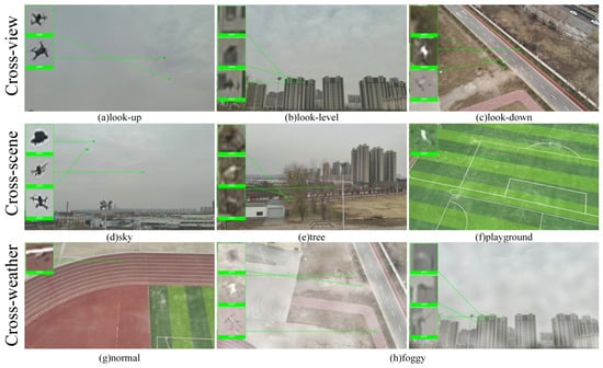
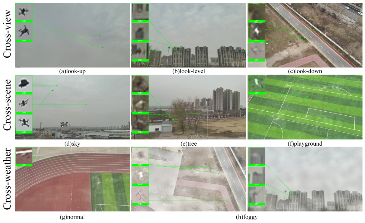
To address these issues, this paper presents TriCross-D2D, a triple-domain-shift dataset and benchmarking platform designed for drone-to-drone detection tasks, as shown in Figure 1. Based on real-world flight data, TriCross-D2D organizes and designs data across three key dimensions—scene, viewpoint, and weather—to more accurately reflect the complex domain-shift characteristics found in actual low-altitude environments. During the dataset construction process, this paper established standardized workflows for data collection, video frame extraction, object annotation, and quality control, and conducted a systematic analysis of the target size distribution, types of challenging samples, and the dataset’s overall difficulty. Building on this foundation, this paper further developed a unified cross-domain detection evaluation protocol and tested several representative cross-domain object detection methods to validate the usability, challenge, and discriminative power of TriCross-D2D as a benchmark for D2D cross-domain small-object detection.
Figure 1.
Schematic diagram of the TriCross-D2D triple-domain offset design.
The main contributions of this paper are summarized as follows:
- We present TriCross-D2D, a dataset specifically designed for drone-to-drone detection. It explicitly incorporates three types of domain shifts—scene, viewpoint, and weather—and captures the complex distribution variations encountered in real-world low-altitude perception environments, thereby providing dedicated data support for cross-domain small-object detection in D2D scenarios.
- We establish a standardized data construction and evaluation pipeline, including data collection, frame selection, bounding-box annotation, quality control, dataset splitting, and statistical analysis. This pipeline forms a relatively complete benchmark protocol for D2D cross-domain detection and provides a reproducible experimental foundation for future research.
- We conduct comprehensive benchmark experiments to validate the research value of the proposed dataset. Under a unified experimental setting, we evaluate several representative cross-domain object detection methods and further verify the sensitivity of TriCross-D2D to methodological improvements through comparison with an enhanced DA-RTDETR [21] baseline. The results demonstrate that TriCross-D2D effectively exposes the performance bottlenecks of existing methods in the challenging setting of joint triple-domain shifts and small-object detection, highlighting its difficulty, discriminative capability, and practical value.
2. Related Work
2.1. Research on Cross-Domain Object Detection Methods
The goal of cross-domain object detection is to mitigate performance degradation caused by differences in data distributions—where the source domain is labeled but the target domain is unlabeled—thereby improving the model’s detection performance in the target domain [22,23]. Existing methods primarily include technical approaches such as sample-level transfer, feature-level alignment, adversarial learning, and self-training based on pseudo-labels [24]. Sample-level methods typically reduce visual differences through style transfer or data augmentation; feature-level methods perform distribution alignment at the image level, instance level, or in multi-scale feature spaces; adversarial learning promotes domain-invariant feature learning through a domain discriminator; and self-training methods utilize pseudo-labels in the target domain to further enhance the model’s adaptability.
Overall, these methods have achieved good results in scenarios such as autonomous driving and urban street scenes, but their research subjects are mostly medium-to-large-scale targets such as vehicles and pedestrians, and most focus on a single domain shift [25]. In contrast, drone-to-drone detection involves small targets, high motion, complex backgrounds, and the coupling of multiple domain shifts [26], placing higher demands on existing methods. Therefore, constructing a dedicated dataset and benchmark for this task is of great significance for systematic evaluation and advancing research on related methods.
2.2. Existing Cross-Domain Object Detection Datasets
High-quality datasets form the foundation for research and fair comparison of cross-domain object detection algorithms. Currently, commonly used datasets in this field primarily originate from autonomous driving, urban street scenes, and synthetic visual scenarios, such as Cityscapes [27] and Foggy Cityscapes [28], Sim10k [29] and Cityscapes, KITTI [30] and Cityscapes, as well as Cityscapes and BDD100K [31]. These datasets provide standardized testing platforms for typical tasks such as cross-weather, cross-city, cross-imaging style, or synthetic-to-real detection, and have played a crucial role in advancing the development of cross-domain object detection methods.
However, in terms of task attributes, existing mainstream cross-domain detection datasets still exhibit significant differences from the drone-to-drone detection scenario addressed in this paper. First, the detection targets in these datasets are mostly vehicles, pedestrians, traffic infrastructure, and other ground-based objects in road scenes; these targets are relatively large in size and have relatively stable appearance information, making it difficult to reflect the characteristic challenges of small aerial object detection, namely “weak texture, low pixel proportion, and high dynamic variation.” Second, existing benchmarks are primarily designed for single-domain shifts, such as cross-weather, cross-city, or synthetic-to-real-world transfer. Although some tasks implicitly involve variations in viewpoint or background, they typically do not explicitly model the combined changes in scene, viewpoint, and weather/visibility, making it difficult to capture the more complex composite domain shifts found in real-world low-altitude environments. Furthermore, these datasets are primarily designed for fixed-viewpoint or relatively stable ground-based observation tasks, which differ fundamentally from air-to-air detection scenarios characterized by significant relative motion between UAV platforms and rapidly changing observation geometries.
Therefore, while existing cross-domain object detection datasets provide a crucial foundation for algorithmic research, they primarily serve ground-based scenarios and lack targeted support for the more challenging task of UAV-to-UAV detection. In particular, under conditions dominated by small targets, complex background interference, and the coupling of multiple domain shift factors, existing datasets struggle to fully reveal the capability limits of algorithms in real-world D2D scenarios, which is one of the direct motivations for constructing TriCross-D2D in this paper. To more clearly position TriCross-D2D among existing data resources, Table 1 extends the comparison beyond task objects and domain-shift attributes to include dataset-level factors, such as sensing geometry, dataset scale, target distance or target scale, annotation type, domain split design, and public availability. The compared datasets cover general cross-domain detection benchmarks, UAV-borne aerial detection and tracking datasets, ground-to-air anti-UAV datasets, UAV tracking datasets, and recent air-to-air UAV datasets, as shown in Table 1.
Table 1.
Comparison of representative existing datasets with TriCross-D2D.
Table 1 shows that existing datasets differ substantially in terms of sensing geometry, target definition, annotation type, and benchmark protocol. General cross-domain detection datasets provide mature source–target setting designs, but they mainly focus on ground traffic objects, such as vehicles and pedestrians. UAV-borne datasets, such as VisDrone, UAVDT, and DroneVehicle, offer large-scale aerial annotations; however, their targets are primarily ground objects rather than UAVs. Ground-to-air anti-UAV datasets directly annotate UAV targets, but they are typically designed for fixed-platform surveillance or tracking, which differs from the moving-platform UAV-to-UAV perception setting. Recent air-to-air UAV datasets are more closely related to the sensing geometry of TriCross-D2D, but most of them are organized for standard detection or tracking rather than source–target cross-domain evaluation. Furthermore, most of these benchmarks only address single-domain offsets, making it difficult to capture the task characteristics of “small targets coupled with multiple domain offsets” in drone-to-drone detection. On the other hand, while existing UAV-related datasets are closer to aerial vision applications, most serve UAV-to-ground detection, anti-UAV surveillance, or tracking tasks, lacking a data organization method and unified benchmark protocol specifically tailored for D2D cross-domain detection.
In contrast, TriCross-D2D integrates air-to-air data acquisition with UAVs as targets, explicit target-distance settings of , , and , horizontal bounding-box annotations, public availability, and a source-rich/target-limited split that supports both UDA and SSDA protocols. Therefore, it is complementary to existing UAV datasets and is specifically designed for UAV-to-UAV cross-domain small-target detection under coupled scene, viewpoint, and cross-weather factors.
2.3. Datasets for Small Object Detection by UAVs
With the continuous advancement of UAV vision research, a number of publicly available UAV-related datasets have emerged in recent years. Existing UAV-related datasets can be categorized by sensing geometry and target definition. UAV-borne aerial datasets [32], such as VisDrone, UAVDT, and DroneVehicle, are collected from drone platforms but mainly focus on ground objects, including vehicles, pedestrians, and cyclists [33], rather than UAV targets. Their data splits are generally designed for conventional detection or tracking instead of cross-domain adaptation.
Ground-to-air anti-UAV datasets focus on UAV targets and contain long-range small objects with bounding-box annotations. However, their sensors are usually fixed or ground-based, leading to different backgrounds, motion patterns, and viewpoint changes from UAV-to-UAV perception.
Air-to-air UAV datasets are the most relevant to TriCross-D2D because they observe UAV targets from airborne platforms. Nevertheless, they are mostly organized for standard detection or tracking, and domain factors are not explicitly defined as source and target domains for UDA or SSDA evaluation [34]. Therefore, existing datasets do not fully meet the needs of air-to-air UAV detection with small targets [35], bounding-box annotations, explicit cross-scene/cross-view/cross-weather splits, and a unified benchmark protocol. TriCross-D2D is designed to fill this gap.
In summary, current relevant data resources primarily suffer from the following shortcomings:
- A lack of publicly available cross-domain datasets specifically designed for UAV-to-UAV detection;
- A lack of composite domain shift designs that simultaneously cover cross-scene, cross-viewpoint, and cross-weather/visibility conditions;
- A lack of data distribution and high-quality annotations focused on small-scale UAV targets at long distances;
- A lack of a unified, reproducible benchmark protocol to fairly compare different cross-domain detection methods.
Based on the current state of research, this paper proposes TriCross-D2D, aiming to provide a more targeted and challenging standardized testing platform for cross-domain small-target UAV-to-UAV detection, and to offer a reliable data foundation for subsequent algorithm design, performance comparison, and practical application validation.
3. Construction and Analysis of the TriCross-D2D Dataset
3.1. Dataset Design Objectives and Multi-Protocol Benchmark Scope
TriCross-D2D aims to establish a cross-domain benchmark for drone-to-drone detection, addressing the shortcomings of existing cross-domain detection datasets, which primarily focus on ground-based targets such as vehicles and pedestrians and lack support for D2D scenarios. Compared to traditional object detection tasks, targets in D2D scenarios are typically smaller in scale, have weaker textures, and move faster, while simultaneously being affected by changes in background scenes, viewing angles, and weather conditions, making cross-domain generalization more challenging. Based on this, this paper constructs TriCross-D2D around three key factors—scene, view, and weather—to characterize composite domain shifts in real-world low-altitude environments. Its overall design is shown in Figure 1.
In terms of task setup, TriCross-D2D is designed for single-class detection tasks based on RGB images, with the detection object being unmanned aerial vehicles (UAVs). The dataset adopts an organization scheme where “source-domain annotations are abundant while target-domain annotations are limited,” and retains the Target_train annotations to support two training protocols: under the UDA setting, training uses only Source_train annotations and ignores Target_train labels; under the SSDA setting, training further utilizes Target_train annotations for cross-domain learning. Consequently, TriCross-D2D is not pre-bound to any single supervision paradigm but serves as a D2D cross-domain benchmark supporting multi-protocol evaluation, providing a unified and flexible experimental foundation for various types of methods. Its task definition and benchmark scope are shown in Table 2.
Table 2.
Overview of the task definition and multi-protocol benchmark scope of TriCross-D2D.
It should be noted that the three domain factors—scene, view, and weather—in TriCross-D2D are explicitly organized. Consequently, this dataset not only supports joint transfer tasks under the combined influence of triple-domain shifts but also enables the independent construction and evaluation of three single-factor subtasks: cross-scene, cross-view, and cross-weather. This paper focuses on experiments using a unified setup where all three domain shifts are coupled simultaneously. This is because this setup corresponds to more challenging composite cross-domain scenarios, allowing for a more thorough evaluation of the methods’ generalization capabilities in complex low-altitude environments. At the same time, based on the same data organization scheme, it is also convenient to further decompose the dataset into single-factor cross-domain subtasks for subsequent finer-grained research and analysis.
3.2. Data Acquisition and Triple-Domain Offset Construction
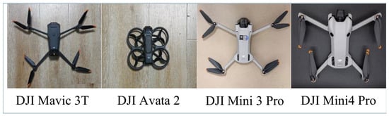
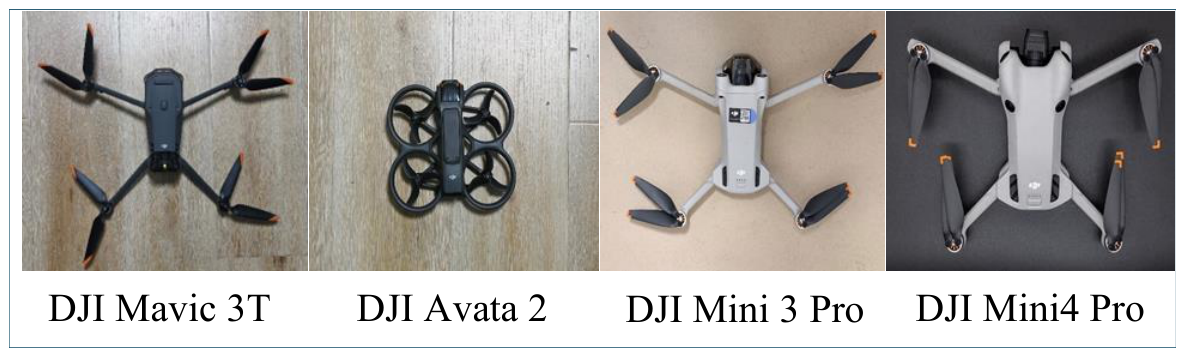
To ensure that TriCross-D2D can accurately characterize real-world low-altitude UAV-to-UAV scenarios, this paper collects raw RGB video data through actual flight operations. The data acquisition platform is the DJI Mavic 3T, while the target UAVs include the DJI Avata 2, DJI Mini 3 Pro, and DJI Mini 4 Pro (DJI, Shenzhen, China). During data acquisition, the DJI Mavic 3T served as the camera-equipped observing platform and was maintained in a hovering, approximately stationary state. The target UAVs were operated to move relative to the observing platform, producing drone-to-drone observations with varying target positions, apparent scales, viewing angles, and background contexts. In this setting, the visual variations in the captured videos mainly arise from the motion of the target UAVs relative to the hovering observing platform, rather than from deliberate translational motion of the camera platform itself. This acquisition strategy reflects a practical airborne monitoring scenario in which a hovering UAV observes nearby moving UAV targets. These target UAVs differ in size, contour, and flight attitude, providing appearance diversity. Although all targets are small consumer-grade DJI quadrotors, TriCross-D2D is designed for single-class UAV detection rather than fine-grained model recognition. Since long-range UAV targets occupy only a few pixels, model-level differences are often difficult to distinguish. Thus, the dataset focuses on reliable small-UAV localization under variations in scene, viewpoint, distance, and weather. A schematic illustration of the acquisition platform and target UAVs is shown in Figure 2.
Figure 2.
Schematic diagram of the data acquisition platform and the target drone.
To improve reproducibility, we also provide the optical and gimbal parameters of the DJI Mavic 3T. All RGB videos were captured by its visible-light wide-angle camera at resolution and 30 fps. The camera uses a -inch CMOS sensor with 48 effective megapixels, an field of view, a equivalent focal length, an aperture, and a focus range from to infinity. It is mounted on a three-axis stabilized gimbal with a controllable tilt range of to and an angular vibration range of , which helps define the imaging geometry and stabilization conditions of the dataset.
Although the DJI Mavic 3T is also equipped with a thermal imaging sensor, the current release of TriCross-D2D is intentionally defined as an RGB image/video benchmark. This scope was chosen to keep the annotation format, data splits, and evaluation protocol consistent with existing RGB object detection and cross-domain detector benchmarks, while avoiding the introduction of a thermal branch before a fully standardized multimodal protocol is established. In particular, incorporating thermal data would require reliable temporal synchronization, cross-sensor calibration and alignment, and modality-specific annotation rules, which are beyond the validated scope of the present release, and the main acquisition configurations and domain factor settings are summarized in Table 3.
Table 3.
Data acquisition configuration and domain factor settings of TriCross-D2D. (Synthetic fog is used as a controlled cross-weather perturbation and does not indicate real foggy-scene acquisition).
Therefore, we do not report thermal images, thermal annotations, or thermal-based experiments in this version. Nevertheless, thermal imaging could provide complementary cues to RGB data for D2D detection under low-visibility conditions or visually cluttered backgrounds, where small UAV targets with weak texture may blend into the background. Extending TriCross-D2D to synchronized RGB–thermal data or broader multimodal settings is therefore regarded as an important limitation of the current release and a promising direction for future work.
It should be noted that the current version of TriCross-D2D was collected by the same research team within a limited local acquisition area. Therefore, the four scene categories, namely “playground,” “tree,” “buildings,” and “construction site,” are defined according to visually and functionally distinct background contexts rather than geographically independent sites. The cross-scene factor in this dataset is intended to characterize scene-appearance shifts caused by variations in background structure, texture density, clutter, and occlusion patterns, while keeping the acquisition platform and annotation protocol consistent. Accordingly, TriCross-D2D does not claim to support geographic generalization across different cities or regions. Instead, it provides a controlled benchmark for evaluating drone-to-drone detection under local background-context shifts combined with viewpoint and weather variations.
3.3. Data Preprocessing, Annotation, and Data Partitioning Protocol
After capturing the raw video, this paper first segments the entire RGB video and performs preprocessing based on scene continuity, object motion, and image redundancy. Given that the raw video contains a total of 23,403 frames, annotating every frame individually would result in significant redundancy and high annotation costs. Therefore, this paper employs a representative frame selection strategy, selecting images with typical domain features and changes in target appearance from different video segments to construct a benchmark subset. This process retains key samples across different scenes, viewpoints, and weather conditions while effectively reducing redundancy caused by the high similarity between adjacent frames. To prevent data leakage, this paper first divides the data into Source_train, Target_train, and Target_val at the video clip level, followed by frame sampling and foggy-day sample generation. This ensures that no highly similar images from the same continuous video clip exist across different subsets, nor does the same clear-day image and its fogged version appear across subsets.
For cross-weather data construction, raw images captured under sunny conditions were used as the basis for generating foggy-day samples through computer simulation. Specifically, synthetic fog was applied to the original clear-weather images to introduce a controlled transition from clear-weather conditions to fog-like visibility degradation. During this process, the fog intensity was adjusted according to the background characteristics of different scenes, so that the generated images exhibit realistic weather/illumination degradation and sky-background interference while keeping the UAV targets visible. This design keeps the scene layout, object distribution, camera viewpoint, and annotations unchanged, thereby allowing the effect of weather-induced visibility degradation to be isolated and evaluated.
Regarding data construction across weather conditions, we use raw images captured under sunny conditions as the basis for generating foggy samples, thereby forming a controlled cross-weather setting. Specifically, the foggy variants are generated following the atmospheric scattering model adopted in Foggy Cityscapes [28], which is a physically based imaging model commonly used to simulate visibility degradation under foggy conditions. In Equation (1), the image formation process is formulated as:
where denotes the clear image radiance, A represents the global atmospheric light, and denotes the scene transmission, which is related to the fog density and scene depth . In this work, we use the same fog density parameter as the dense-fog setting in Foggy Cityscapes, i.e., , to synthesize dense fog images.
After generation, the foggy samples are visually inspected as part of quality control to ensure that the generated fog introduces clear weather-induced visibility degradation while the UAV target remains identifiable. We also verify that no obvious unrealistic artifacts are introduced. This controlled generation strategy enables TriCross-D2D to evaluate cross-weather domain shifts while keeping the underlying target, scene, and annotation information consistent between the clear and foggy variants.
It should be noted that the generated foggy images are not intended to replace real adverse-weather data acquisition. Instead, they provide a reproducible synthetic-fog cross-weather setting for testing whether a model can maintain detection performance when the visual appearance is affected by fog-like atmospheric attenuation. Therefore, this experiment is regarded as a synthetic-fog cross-weather evaluation rather than evidence of full real-world adverse-weather generalization. After video organization, representative frame selection, and weather-based data expansion, the final image dataset was obtained for annotation and evaluation.
During annotation, TriCross-D2D was constructed as a single-class object detection dataset, where all valid targets were labeled as “UAV” using horizontal bounding boxes. Annotators were required to draw tight boxes around the visible UAV structure, including the fuselage, arms, and visible rotors, while excluding irrelevant background regions, shadows, motion trails, and clutter. For partially occluded or truncated targets, only the visible and identifiable parts were annotated. Samples with mild blur, partial occlusion, or complex backgrounds were annotated as long as the UAV could be reliably identified.
A conservative annotation strategy was adopted for ambiguous cases, following the principle of “better to omit than to annotate incorrectly.” Severely blurred, heavily occluded, extremely low-contrast, or excessively small targets that could not be clearly distinguished from the background were not annotated. UAV-like background objects, such as birds, branches, building edges, or distant clutter, were also excluded unless their UAV identity was visually clear. The same criteria were applied to foggy samples, and the detailed annotation rules are summarized in Table 4.
Table 4.
Annotation rules for UAV targets under different visual conditions.
To ensure annotation quality, a multi-stage procedure was conducted, including annotator training, independent labeling, cross-checking, and final correction. All annotators followed unified guidelines and representative examples covering clear targets, tiny targets, blur, occlusion, fog degradation, and complex backgrounds. Each video clip was independently labeled by at least two annotators, and the results were compared using Intersection over Union (IoU) and reviewed by quality-control staff. Disagreements such as missed targets, duplicate labels, inaccurate boxes, or ambiguous cases were corrected through discussion until consensus was reached. The mean consistency IoU exceeded , demonstrating good reliability and spatial consistency of the final annotations.
To ensure annotation quality, all annotators undergo standardized training before beginning formal annotation and follow consistent rules during the annotation process. Each video clip is independently annotated by at least two annotators, followed by review and cross-checking by dedicated staff members. For samples with obvious discrepancies, manual discussion is conducted to reach a consensus on the final correction. In addition, this paper employs Intersection over Union (IoU) to evaluate the consistency of the dual-annotator results. The average consistency IoU exceeds 0.75, indicating that the constructed annotations possess good reliability and stability.
The released TriCross-D2D dataset is organized according to a predefined cross-domain split, rather than being provided as an unordered collection of images. This split is designed based on the three domain factors considered in this work: scene, viewpoint, and weather. Specifically, Source_train consists of samples with relatively simple backgrounds, mainly sky-dominated scenes, captured from a low-angle viewpoint under sunny conditions. In contrast, the target domain, including Target_train and Target_val, contains samples with more complex backgrounds, such as buildings, construction sites, playgrounds, and trees. These samples are captured from level-view or bird’s-eye-view perspectives, with synthetic fog introduced to construct the cross-weather setting.
Therefore, the source–target protocol simultaneously covers shifts in background complexity, observation viewpoint, and weather condition. The dataset directory is released according to this fixed split, with images and annotations stored under Source_train, Target_train, and Target_val. Thus, users can directly reproduce the experimental protocol without re-partitioning the data.
Specifically, Source_train contains 4045 annotated images and serves as the primary supervised data in the source domain; Target_train contains 2000 images with corresponding annotations; and Target_val contains 1000 annotated images for unified validation and evaluation. It is important to note that TriCross-D2D retains the labels of Target_train at the data-resource level, but whether these labels are used during training depends on the specific experimental protocol. Under the UDA setting, Target_train is used only as target-domain training images, and its labels are ignored; under the SSDA setting, a small portion of the Target_train annotations is further utilized for cross-domain training. This partitioning not only supports fair comparisons across different protocols but also better reflects the real-world data usage scenario in which source-domain annotations are relatively abundant while target-domain annotations are relatively limited.
In the TriCross-D2D benchmark configuration, the source domain primarily consists of images captured from a low-angle viewpoint, with a sky background and under sunny conditions. Its background is relatively simple and contains fewer distractions, and can therefore be regarded as a relatively simple domain. In contrast, the target domain mainly consists of images captured from eye-level or bird’s-eye viewpoints, with complex backgrounds such as buildings, trees, construction sites, and playgrounds, as well as images taken under foggy conditions. These scenes exhibit more complex structures, stronger background interference, and more challenging image quality, and can thus be regarded as a relatively complex domain. Consequently, the source-to-target transfer setting in TriCross-D2D covers distribution variations across three dimensions—viewpoint, scene background, and weather conditions—thereby forming a complex cross-domain detection task that more closely resembles real-world application environments. The relevant classifications and protocol support settings are shown in Table 5.
Table 5.
Split protocol and label usage of TriCross-D2D.
3.4. Statistical Characteristics and Challenge Analysis of the Dataset
To further illustrate the composition of TriCross-D2D and its benchmark value, this paper conducts a statistical analysis of the dataset’s overall scale, target size distribution, and typical challenging samples. The raw data of TriCross-D2D consist of 13 RGB video clips containing a total of 23,403 frames. Based on these raw videos, a benchmark subset comprising 7045 images was ultimately constructed through representative frame sampling, annotation, and data partitioning, including 4045 Source_train images, 2000 Target_train images, and 1000 Target_val images. Statistical results indicate that the current version of the dataset contains a total of 9771 annotated UAV instances, covering 4 scene categories, 3 viewpoint types, and 2 weather conditions, effectively reflecting the multi-domain shift characteristics in UAV-to-UAV scenarios.
Accordingly, the “cross-scene” and “cross-weather” settings in TriCross-D2D should be interpreted as controlled distribution shifts in background context and RGB imaging quality, rather than as evidence of generalization to unseen geographic locations or real adverse-weather flights. Specifically, the cross-scene setting mainly reflects a background-context shift: the source domain contains low-angle, sky-dominated, and relatively simple backgrounds, while the target domain includes more cluttered contexts such as playgrounds, trees, buildings, and construction sites. These scenes introduce variations in edge density, texture complexity, background interference, and partial occlusion, which are directly relevant to UAV-to-UAV visual detection.
For RGB-based D2D detection, the cross-weather setting represents visibility and imaging-quality degradation. When the observing UAV faces bright sky backgrounds, target UAVs may appear as small dark silhouettes with weak texture, and their contrast can be affected by solar direction, sky brightness, automatic exposure, and local contrast adjustment. Fog or reduced visibility further introduces atmospheric scattering, which lowers image contrast, softens object boundaries, and weakens the sparse texture cues of distant UAVs. Therefore, TriCross-D2D provides a controlled benchmark for evaluating whether cross-domain detectors can handle background-context changes, contrast loss, edge degradation, sky-background interference, and exposure-related appearance variations in UAV-to-UAV small-object detection.
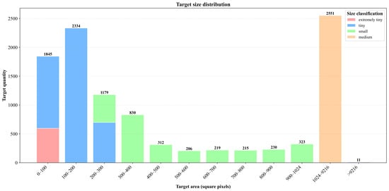
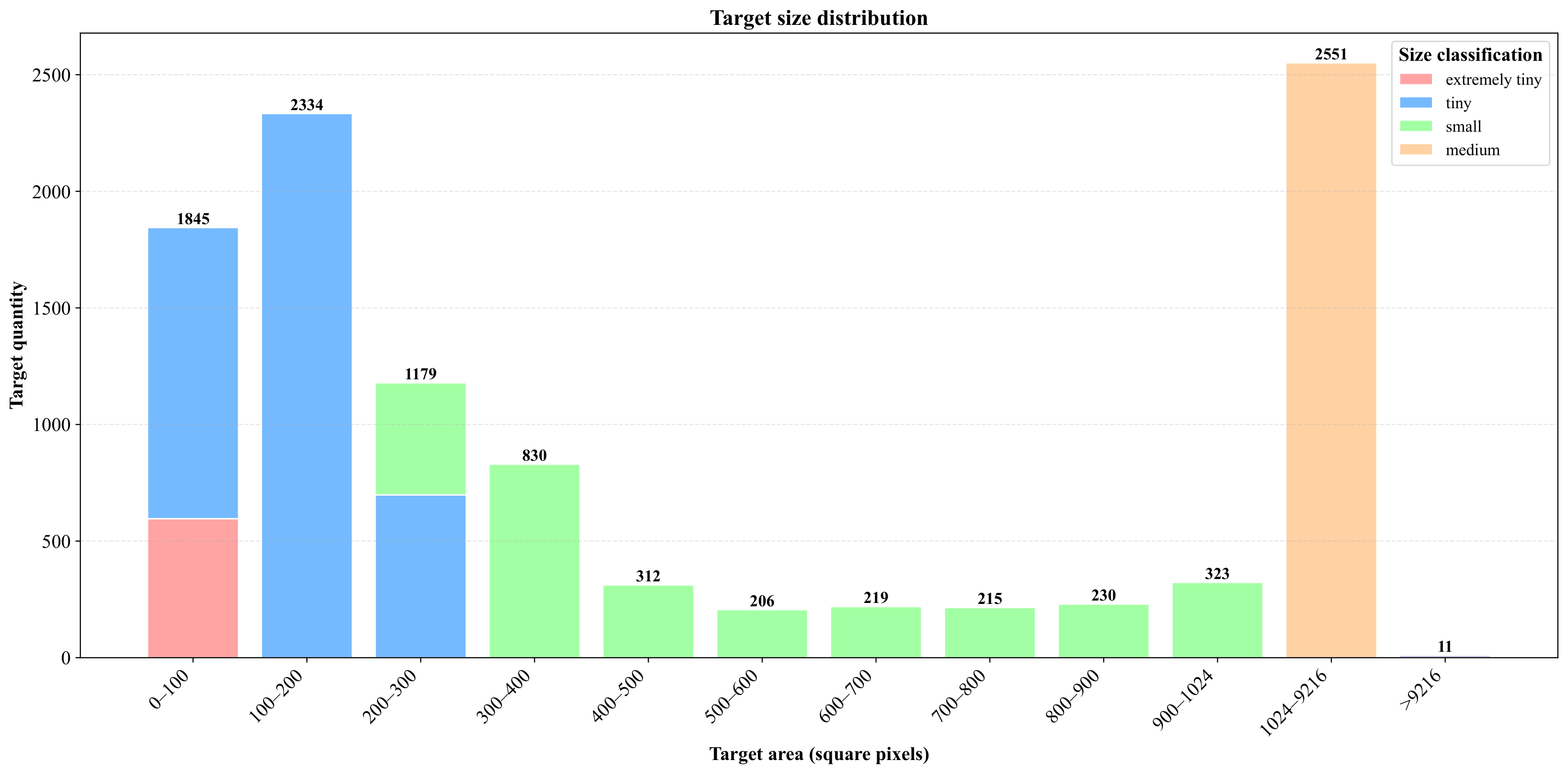
In terms of target size distribution, TriCross-D2D exhibits a significant dominance of small targets. The released TriCross-D2D dataset is organized according to a predefined cross-domain split, rather than being provided as an unordered collection of images. This split is designed based on the three domain factors considered in this work: scene, viewpoint, and weather. Specifically, Source_train consists of samples with relatively simple backgrounds, mainly sky-dominated scenes, captured from a low-angle viewpoint under sunny conditions. In contrast, the target domain, including Target_train and Target_val, contains samples with more complex backgrounds, such as buildings, construction sites, playgrounds, and trees. These samples are captured from level-view or bird’s-eye-view perspectives, with synthetic fog introduced to construct the cross-weather setting. Therefore, the source–target protocol simultaneously covers shifts in background complexity, observation viewpoint, and weather condition. The dataset directory is released according to this fixed split, with images and annotations stored under Source_train, Target_train, and Target_val. Thus, users can directly reproduce the experimental protocol without re-partitioning the data. In this paper, target size is defined based on the pixel area of the annotated bounding box. Let denote the bounding-box area in pixels, where w and h represent the width and height of the bounding box in the original image, respectively. Since each image contains pixels, we also report the corresponding image-area ratio, , for each size interval. The five target-size categories are defined as follows in Table 6:
Table 6.
Target-size category definitions.
The thresholds of and correspond to and pixels, respectively, which are the conventional COCO breakpoints between small, medium, and large objects. Therefore, the Extremely Tiny, Tiny, and Small categories in TriCross-D2D constitute a task-specific subdivision of the COCO small-object range. This finer subdivision is introduced because UAV targets in D2D imagery often occupy far fewer than pixels, and using only the standard COCO small category would obscure the scale variation among extremely small UAV instances. Figure 3 shows the distribution and representative samples across different size intervals.
Figure 3.
Schematic illustration of the target scale distribution and representative samples in the TriCross-D2D dataset.
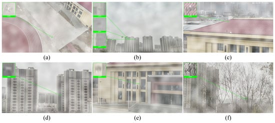
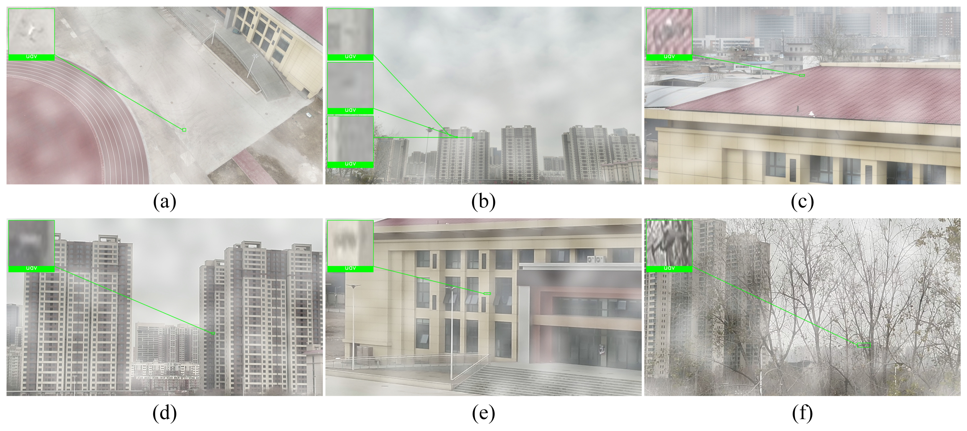
In addition to scale factors, TriCross-D2D contains various challenging samples, including tiny targets, motion blur, complex backgrounds, and weather-induced degradation. Under long-range acquisition, UAVs often occupy only a few pixels with weak texture and blurred contours, making them easily confused with background details. Platform motion and target maneuvers may cause blur or trailing effects, while forests, buildings, and construction sites introduce strong background interference. Weather changes further reduce contrast and weaken edge information. As shown in Figure 4, these factors often occur together, making TriCross-D2D more challenging than conventional detection datasets.
Figure 4.
Typical challenging samples from the TriCross-D2D dataset and corresponding magnified views: (a,b) extremely small-scale targets; (c,d) motion-blurred targets; (e,f) targets with complex background interference.
It should be noted that the current target UAVs are relatively homogeneous, as they are all small consumer-grade DJI quadrotors. This may limit cross-model or cross-category evaluation. However, TriCross-D2D focuses on single-class UAV detection in long-range D2D scenarios, where targets are usually tiny and lack clear model-specific details. Therefore, the main goal is robust UAV localization under variations in scene, viewpoint, distance, and weather, rather than fine-grained UAV model recognition. Future versions will include more UAV types to support broader evaluation.
Overall, TriCross-D2D not only covers the three key dimensions of scene, view, and weather in terms of domain shift types, but also exhibits a pronounced dominance of small objects in terms of target attributes. The combination of triple-domain shift and the challenges of small-object detection enables this dataset to more accurately reveal the performance bottlenecks of existing methods in complex low-altitude perception scenarios, while providing a challenging and discriminative testing foundation for future benchmark evaluations.
4. Experiments
4.1. Experimental Setup and Evaluation Protocol
To assess the benchmark value of TriCross-D2D for cross-domain small-object detection tasks involving unmanned aerial vehicles (UAVs), this paper conducts experiments under a unified data split and evaluation criteria. TriCross-D2D is designed for single-class cross-domain detection tasks based on RGB images, with UAVs as the detection targets. All experiments in Chapter 4 are conducted on the fixed splits Source_train, Target_train, and Target_val, with final results validated on Target_val.
Given the availability of labels in Target_train, TriCross-D2D supports both unsupervised domain adaptation (UDA) and semi-supervised domain adaptation (SSDA) evaluation protocols. For the benchmark comparison reported in Table 7, all compared methods were evaluated under a strictly controlled experimental setting on the same hardware platform, equipped with an Intel Xeon W-2245 CPU and an NVIDIA RTX 3090 24 GB GPU. Specifically, the same Source_train, Target_train, and Target_val splits were used for all methods, and the final performance was evaluated on Target_val. The input image size was fixed at , the batch size was set to 2, the number of training epochs was set to 20, and the random seed was fixed to 66 for all methods. Other routine training and evaluation settings, including data preprocessing, validation split usage, and metric computation, were kept consistent across methods. Therefore, the results in Table 7 were obtained under unified experimental conditions, and the main differences among the compared methods arise from their adaptation strategies and protocol-specific use of target-domain labels. For DA-RTDETR [21] and its enhanced version SCOPE-DA-RTDETR, which are the focus of this paper’s analysis, consistent training settings were adopted: an input size of , a multi-scale training strategy, 50 training epochs, and initialization using pre-trained weights. Both the number of model parameters (Params) and computational cost (FLOPs) were calculated under the input conditions.
Table 7.
Benchmark results of mainstream cross-domain object detection methods on TriCross-D2D.
Regarding evaluation metrics, this paper adopts , , and as the primary detection metrics, where is used to measure detection accuracy under a common IoU threshold, is used to comprehensively reflect the overall detection quality under different localization thresholds, and is used to characterize the model’s recall capability for target instances. Concurrently, this paper reports both Params and FLOPs to provide a comprehensive analysis of different methods from the dual perspectives of detection performance and model complexity.
4.2. Benchmarking and Results Analysis
To evaluate the validity of TriCross-D2D as a benchmark for cross-domain small-object detection on UAVs, this paper compares representative methods such as DA-Ada, RT-DETR, SAPNet, PT, HT, TLL, and ETS under a unified data split and evaluation metrics. The results are shown in Table 7. It should be noted that there are certain differences among these methods in terms of training approaches and label utilization. Therefore, this section primarily analyzes their overall performance on TriCross-D2D from a benchmark perspective, without delving into specific model improvement details. The targeted improvements of SCOPE-DA-RTDETR relative to DA-RTDETR will be further analyzed in Section 4.3.
It should be noted that the primary purpose of introducing these representative methods in this paper is to examine, from a benchmark perspective, the challenge posed by TriCross-D2D to different types of cross-domain detection methods, as well as its ability to distinguish between them and its capacity to respond to improvements. Since the original training settings, implementation details, and methods of utilizing target-domain labels vary across different approaches, the results in the table are primarily intended to demonstrate the overall performance and performance boundaries of various methods on TriCross-D2D.
Overall, existing methods generally perform poorly on TriCross-D2D. As a baseline detector, RT-DETR achieves only a of 6.64 and a of 2.45, indicating that without targeted cross-domain modeling, models struggle to directly adapt to the target domain distribution. Although performance improves when transfer learning or domain adaptation strategies are introduced, the overall improvement remains limited. These results indicate that TriCross-D2D is not a dataset where high scores are easily achieved, and existing methods still face significant performance bottlenecks on this task.
This phenomenon is closely related to the data characteristics of TriCross-D2D. Compared to common cross-domain ground target detection tasks, this dataset simultaneously involves three types of domain shifts: cross-scene, cross-viewpoint, and cross-weather. The target domain and source domain exhibit significant differences in background structure, observational geometry, and image quality. At the same time, the detected objects are primarily small-scale drones at long distances, which generally have low pixel coverage, weak texture information, blurred boundaries, and are prone to background interference. Consequently, models must not only perform distribution transfer across domains but also maintain stable detection and localization capabilities with limited target feature information, which significantly increases the task’s difficulty.
Further analysis of the and metrics reveals that while many methods achieve certain results on , their performance remains limited under stricter localization standards and in terms of target recall. This indicates that the challenges faced by current methods on TriCross-D2D lie not only in cross-domain generalization itself but also in the precise localization and stable detection of small, weak targets. Consequently, TriCross-D2D not only evaluates a model’s fundamental detection capabilities but also more sensitively reflects the differences among various methods in terms of small-target localization and recall.
At the same time, Table 7 still reveals a relatively clear hierarchy of performance among different methods, indicating that TriCross-D2D possesses strong discriminative power. Performance improvements do not simply correlate with model scale; some methods with larger parameter counts or computational demands did not achieve optimal results. This suggests that the key to determining performance on this dataset lies not merely in increasing model complexity, but in whether a method can effectively address the combined effects of cross-domain shifts and the challenges of small-target detection.
Overall, the benchmark results indicate that TriCross-D2D effectively reveals the performance limits of existing methods in cross-domain small-target detection for UAV-to-UAV scenarios. The generally low performance levels on the dataset reflect its challenging nature, while the relatively clear performance differences among methods demonstrate its strong value as a benchmark.
4.3. Validation of the Effectiveness of the Improved DA-RTDETR
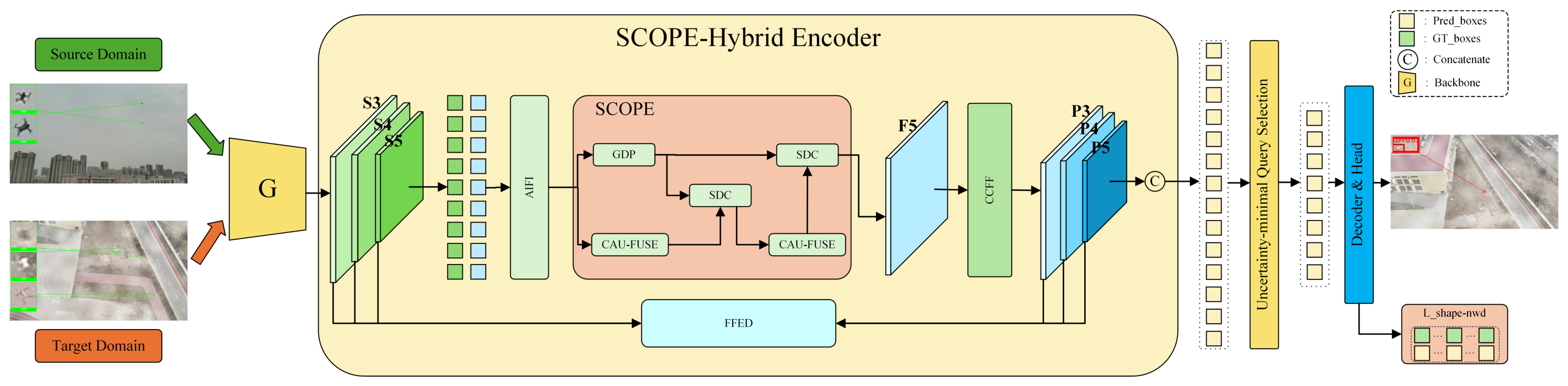
To further validate the responsiveness of TriCross-D2D to model improvements, this paper uses DA-RTDETR as the baseline and constructs an enhanced version, SCOPE-DA-RTDETR. The purpose of introducing this model is not to present a new main algorithmic contribution, but to provide a stronger baseline for D2D cross-domain small-object detection and to examine whether TriCross-D2D can reflect performance changes brought by structural optimization. For a fair comparison, SCOPE-DA-RTDETR and DA-RTDETR use the same backbone, data split, input resolution, training settings, optimizer configuration, and evaluation protocol, with improvements only in feature fusion, localization supervision, and domain-adaptive training. As shown in Figure 5, SCOPE-DA-RTDETR retains the overall DA-RTDETR framework but replaces the original Hybrid Encoder with a SCOPE-Hybrid Encoder. The core idea of SCOPE, namely Stage-wise COntent-aware Prior Enhancement, is to preserve local details of small UAV targets during multi-scale semantic propagation. Specifically, after channel projection of backbone features, fixed depthwise Sobel and Laplacian high-pass operators are used to extract global detail priors, such as edges, textures, and local contours, which are then gated and injected into shallow high-resolution features in a residual manner. During top-down feature fusion, lightweight CARAFE-style content-aware upsampling is adopted and adaptively blended with bilinear upsampling to improve feature reconstruction while avoiding the amplification of domain-specific noise. In addition, stage-wise detail compensation is inserted into each top-down fusion stage to enhance small-object boundaries and weak-texture responses before FPN fusion.
Figure 5.
Schematic diagram of the SCOPE-DA-RTDETR overall framework.
Besides encoder enhancement, SCOPE-DA-RTDETR introduces small-object-oriented geometric consistency supervision during training. Based on Hungarian-matched predicted and ground-truth boxes, this loss combines normalized Wasserstein distance for center and scale consistency with aspect-ratio consistency, assigning higher weights to small objects. Compared with standard and losses, it better constrains center shifts, scale perturbations, and shape variations, while introducing no additional inference cost. For unsupervised domain adaptation, SCOPE-DA-RTDETR follows the DA-RTDETR protocol: source-domain images are trained with detection annotations, while target-domain images are used only for domain alignment. Pixel-level alignment is applied to backbone multi-scale features, instance-level alignment is applied to encoder outputs, and CORAL alignment is performed on decoder logits to reduce second-order statistical discrepancies. Domain classifiers are connected through gradient reversal layers to encourage domain-invariant representations. Overall, the SCOPE-Hybrid Encoder, geometric consistency supervision, and pixel/instance/CORAL alignment are designed for the key challenges of TriCross-D2D, including small targets, weak textures, complex backgrounds, and significant domain shifts.
The relevant results are shown in Table 8. Under the same experimental conditions, SCOPE-DA-RTDETR outperformed DA-RTDETR overall on TriCross-D2D. Specifically, DA-RTDETR achieved , , and values of 28.63, 13.12, and 22.39, respectively, while SCOPE-DA-RTDETR reached 29.94, 13.71, and 23.40, representing improvements of 1.31, 0.59, and 1.01, respectively. These results indicate that the introduced improvements not only enhance overall accuracy at common detection thresholds but also improve bounding box quality under stricter localization criteria and enhance recall for weak and small targets.
Table 8.
Benchmark results of SCOPE-DA-RTDETR and DA-RTDETR on TriCross-D2D.
Since SCOPE is used as an enhanced accuracy-oriented baseline rather than as the main algorithmic contribution, we retain the main comparison in Table 9 and report a separate component-level ablation below.
Table 9.
Ablation study of the SCOPE enhanced baseline under a fixed random seed .
Table 9 presents a controlled ablation study conducted under the same random seed, i.e., . Introducing the SCOPE-Hybrid Encoder/structure-only modification (A1) improves from to compared with the DA-RTDETR baseline, with a modest increase from to . Adding geometric consistency supervision (A2) further improves to , while reaches , indicating that this supervision mainly benefits the criterion in this run and is not uniformly additive across all IoU thresholds. The full SCOPE configuration (A3) achieves the best and in this ablation, reaching and , respectively. Overall, the results support the use of SCOPE as an enhanced accuracy-oriented baseline: the improvement is consistent but moderate and comes with increased computational cost.
To further examine the robustness of the proposed SCOPE module, we repeated the experiments using three random seeds, namely 7, 17, and 66. As shown in Table 10, SCOPE-DA-RTDETR consistently outperforms DA-RTDETR under all three seeds. In terms of the averaged results, SCOPE-DA-RTDETR achieves and , whereas DA-RTDETR obtains and . This corresponds to average improvements of and .
Table 10.
Robustness comparison under repeated random seeds. Green represents DA-RTDETR, while blue represents SCOPE-DA-RTDETR and light pink represents the difference between the two compared values.
The repeated-seed results indicate that the performance gain is not due to a single favorable initialization. The gains are positive across all three seeds, providing limited but consistent evidence that the SCOPE module improves performance on TriCross-D2D. However, the magnitude of the improvement remains modest and should not be interpreted as a large or statistically definitive algorithmic breakthrough, as shown in Table 10.
The accuracy improvement comes with a moderate increase in computational cost. Compared with DA-RTDETR, SCOPE-DA-RTDETR increases the number of parameters from to and the FLOPs from to . This corresponds to increases of parameters and FLOPs. Considering the averaged gains of and across three random seeds, the proposed module provides a moderate accuracy improvement at a clear computational cost.
Accordingly, we provide a more cautious interpretation of the SCOPE results. In this paper, SCOPE-DA-RTDETR is introduced as an exploratory enhancement to the DA-RTDETR baseline rather than as an efficiency-oriented detector or a claim of substantial algorithmic advancement. Its role is to examine whether a small-object-oriented modification can lead to consistent performance changes under repeated random seeds on TriCross-D2D. The observed improvements suggest that TriCross-D2D is sensitive to targeted model adaptations and can reflect meaningful differences among detection methods. Together with the relatively low absolute performance of existing approaches and the clear performance gaps among representative detectors, these results further support the usefulness of TriCross-D2D as a challenging benchmark for cross-domain drone-to-drone small-object detection.
4.4. Single-Factor Domain Analysis
To further analyze the factor-wise characteristics of TriCross-D2D, we evaluate SCOPE-DA-RTDETR under three single-factor transfer protocols: cross-weather, cross-scene, and cross-view. The results are summarized in Table 11. Among the three single-factor settings, the cross-weather protocol achieves the highest performance, with and . The cross-scene protocol obtains and , indicating that changes in background structure and scene composition introduce a stronger domain gap than weather-related appearance degradation alone. The cross-view protocol is the most challenging single-factor setting, achieving only and , suggesting that changes in observation geometry have a particularly strong impact on drone-to-drone detection.
Table 11.
Factor-wise and coupled-domain performance of SCOPE-DA-RTDETR on TriCross-D2D.
We further compare these single-factor results with the coupled three-factor result of SCOPE-DA-RTDETR reported in Table 11. Under the joint TriCross (S/V/W) protocol, which combines cross-scene, cross-view, and cross-weather shifts, SCOPE-DA-RTDETR achieves and , which are lower than the results obtained under all three single-factor settings. Compared with the cross-weather, cross-scene, and cross-view protocols, the coupled setting reduces by , , and points, respectively, and reduces by , , and points, respectively. These results indicate that the difficulty of TriCross-D2D does not arise from any isolated domain factor. Instead, scene complexity, viewpoint variation, and weather degradation jointly weaken target appearance, geometric consistency, and localization reliability. Therefore, the coupled three-factor protocol provides a more challenging evaluation setting for UAV-to-UAV cross-domain small-object detection.
5. Conclusions
This paper investigates cross-domain small-target detection between UAVs and introduces TriCross-D2D, a dedicated UAV-to-UAV benchmark covering three practical domain shifts: scene, viewpoint, and weather. Built from real flight data, TriCross-D2D contains 13 RGB video sequences, 23,403 raw frames, and 7045 benchmark images, which are split into 4045 source training images, 2000 target training images, and 1000 target validation images, with 9771 annotated UAV instances. The dataset is strongly dominated by small targets, with extremely tiny, tiny, and small targets accounting for 73.8% of all instances. It also includes challenging factors such as complex backgrounds, motion blur, illumination/weather degradation, and sky-background interference.
Benchmark experiments under unified settings show that existing representative methods still achieve limited performance on TriCross-D2D, revealing clear bottlenecks under composite domain shifts and small-target conditions. The performance differences among methods further indicate that the dataset has sufficient discriminative capability. In addition, SCOPE-DA-RTDETR, built upon DA-RTDETR, achieves stable improvements under the same settings, suggesting that TriCross-D2D can reflect method-level progress without reducing its challenge.
A limitation of the current release is that its cross-scene setting captures background-context shifts within a limited acquisition region, rather than geographic generalization across independent locations. Future versions will expand the dataset to include multiple geographically separated sites and larger-scale video collections.
Future work could be further developed in the following areas:
- We will expand the dataset scale, scene coverage, and target UAV diversity by including UAVs from different manufacturers, sizes, and configurations, thereby supporting cross-model and cross-category generalization beyond the current single-class small-UAV setting.
- We will collect real-world data under more complex environmental conditions, such as nighttime, backlighting, real fog, rain, and snow, and provide the original clear-weather data to support user-defined simulated weather variants.
- We will extend TriCross-D2D from RGB-only single-class detection toward fine-grained UAV recognition and synchronized multimodal D2D detection, especially RGB–thermal settings, with consistent temporal synchronization, sensor calibration, annotation rules, and evaluation protocols.
- We will further investigate domain generalization, test-time adaptation, lightweight detection, and joint detection–tracking modeling for more practical UAV-to-UAV perception.
Overall, TriCross-D2D provides a targeted and standardized data platform for UAV-to-UAV cross-domain small-target detection. It complements existing ground-target-oriented datasets and supports the design, comparison, and optimization of methods for low-altitude intelligent perception.
Author Contributions
Conceptualization, W.T., Q.L. and Y.P.; methodology, W.T., Q.L. and H.H.; software, W.T., Q.L. and H.H.; validation, W.T. and Q.L.; formal analysis, Q.L., H.H. and W.K.; investigation, W.T., L.H. and W.K.; resources, Y.P.; data curation, H.H. and H.L.; writing—original draft preparation, W.T., Q.L. and L.H.; writing—review and editing, Y.P., H.H., X.Z. and H.L. All authors have read and agreed to the published version of the manuscript.
Funding
This work was supported by the Second-Batch 2024 Scientific Research Project for Research and Innovation Teams of the Engineering University of the PAP, “Research on Anti-Low-Slow-Small UAV System Based on Airborne Vision”; the 2025 Basic Frontier Innovation Project of the Engineering University of the PAP (Grant No. WJY202509); and the 2025 Comprehensive Equipment Research Project of the PAP (Grant No. WJ2025C0401013).
Data Availability Statement
The data used in this analysis are publicly available, and access is provided in the text. The dataset associated with this study will be made publicly available at the following GitHub repository: https://github.com/vv0930/TriCross-D2D, accessed on 23 April 2026. The dataset is also available via 115 Netdisk: https://115cdn.com/s/swsn5jn3hac?password=n707&, accessed on 8 June 2026.
Conflicts of Interest
The authors declare no conflicts of interest.
References
- Adade, R.; Aibinu, A.M.; Ekumah, B.; Asaana, J. Unmanned Aerial Vehicle (UAV) Applications in Coastal Zone Management—A Review. Environ. Monit. Assess. 2021, 193, 154. [Google Scholar] [CrossRef] [Scilit]
- Fan, B.; Li, Y.; Zhang, R.; Fu, Q. Review on the Technological Development and Application of UAV Systems. Chin. J. Electron. 2020, 29, 199–207. [Google Scholar] [CrossRef] [Scilit]
- Li, T.; Hu, H. Development of the Use of Unmanned Aerial Vehicles (UAVs) in Emergency Rescue in China. Risk Manag. Healthc. Policy 2021, 14, 4293–4299. [Google Scholar] [CrossRef] [Scilit] [PubMed]
- Silvagni, M.; Tonoli, A.; Zenerino, E.; Chiaberge, M. Multipurpose UAV for Search and Rescue Operations in Mountain Avalanche Events. Geomat. Nat. Hazards Risk 2017, 8, 18–33. [Google Scholar] [CrossRef] [Scilit]
- Hao, H.; Peng, Y.; Ye, Z.; Han, B.; Zhang, X.; Tang, W.; Kang, W.; Li, Q. A High Performance Air-to-Air Unmanned Aerial Vehicle Target Detection Model. Drones 2025, 9, 154. [Google Scholar] [CrossRef] [Scilit]
- Yasmeen, A.; Daescu, O. Recent Research Progress on Ground-to-Air Vision-Based Anti-UAV Detection and Tracking Methodologies: A Review. Drones 2025, 9, 58. [Google Scholar] [CrossRef] [Scilit]
- Liu, Y.; Sun, Z.; Xi, L.; Zhang, L.; Dong, W.; Chen, C.; Lu, M.; Fu, H.; Deng, F. MMFW-UAV Dataset: Multi-sensor and Multi-View Fixed-Wing UAV Dataset for Air-to-Air Vision Tasks. Sci. Data 2025, 12, 185. [Google Scholar] [CrossRef] [Scilit]
- Zheng, Y.; Huang, D.; Liu, S.; Wang, Y. Cross-Domain Object Detection through Coarse-to-Fine Feature Adaptation. In Proceedings of the 2020 IEEE/CVF Conference on Computer Vision and Pattern Recognition (CVPR); IEEE: Piscataway, NJ, USA, 2020; pp. 13763–13772. [Google Scholar] [CrossRef] [Scilit]
- Deng, J.; Xu, D.; Li, W.; Duan, L. Harmonious Teacher for Cross-Domain Object Detection. In Proceedings of the IEEE/CVF Conference on Computer Vision and Pattern Recognition; IEEE: Piscataway, NJ, USA, 2023; pp. 23829–23838. [Google Scholar]
- Deng, J.; Li, W.; Chen, Y.; Duan, L. Unbiased Mean Teacher for Cross-Domain Object Detection. In Proceedings of the IEEE/CVF Conference on Computer Vision and Pattern Recognition; IEEE: Piscataway, NJ, USA, 2021; pp. 4091–4101. [Google Scholar]
- Li, Y.-J.; Dai, X.; Ma, C.-Y.; Liu, Y.-C.; Chen, K.; Wu, B.; He, Z.; Kitani, K.; Vajda, P. Cross-Domain Adaptive Teacher for Object Detection. In Proceedings of the IEEE/CVF Conference on Computer Vision and Pattern Recognition; IEEE: Piscataway, NJ, USA, 2022; pp. 7581–7590. [Google Scholar]
- Chu, Z.; Song, T.; Jin, R.; Jiang, T. An Experimental Evaluation Based on New Air-to-Air Multi-UAV Tracking Dataset. In Proceedings of the 2023 IEEE International Conference on Unmanned Systems (ICUS); IEEE: Piscataway, NJ, USA, 2023; pp. 671–676. [Google Scholar] [CrossRef] [Scilit]
- Azad, H.; Mehta, V.; Dadboud, F.; Bolic, M.; Mantegh, I. Air-to-Air Simulated Drone Dataset for AI-powered Problems. In Proceedings of the 2023 IEEE/AIAA 42nd Digital Avionics Systems Conference (DASC); IEEE: Piscataway, NJ, USA, 2023; pp. 1–7. [Google Scholar] [CrossRef] [Scilit]
- Rassas, B.; Singoji, S.; Waslander, S.; Faieghi, R. Synthetic Dataset for Vision-Based Air-to-Air Object Detection. In Proceedings of the 2025 IEEE 21st International Conference on Automation Science and Engineering (CASE); IEEE: Piscataway, NJ, USA, 2025; pp. 140–145. [Google Scholar] [CrossRef] [Scilit]
- Hao, H.; Peng, Y.; Ye, Z.; Han, B.; Tang, W.; Kang, W.; Zhang, X.; Li, Q.; Liu, W. TMRGBT-D2D: A Temporal Misaligned RGB-thermal Dataset for Drone-to-Drone Target Detection. Drones 2025, 9, 694. [Google Scholar] [CrossRef] [Scilit]
- Tzeng, E.; Hoffman, J.; Saenko, K.; Darrell, T. Adversarial Discriminative Domain Adaptation. In Proceedings of the IEEE Conference on Computer Vision and Pattern Recognition; IEEE: Piscataway, NJ, USA, 2017; pp. 7167–7176. [Google Scholar]
- Long, M.; Cao, Z.; Wang, J.; Jordan, M.I. Conditional Adversarial Domain Adaptation. In Proceedings of the Advances in Neural Information Processing Systems; Curran Associates, Inc.: Red Hook, NY, USA, 2018; Volume 31. [Google Scholar]
- HassanPour Zonoozi, M.; Seydi, V. A Survey on Adversarial Domain Adaptation. Neural Process. Lett. 2023, 55, 2429–2469. [Google Scholar] [CrossRef] [Scilit]
- Chen, D.; Lu, L.; Lu, Y.; Yu, R.; Wang, S.; Zhang, L.; Liu, T. Cross-Domain Scene Text Detection via Pixel and Image-Level Adaptation. In Neural Information Processing; Gedeon, T., Wong, K.W., Lee, M., Eds.; Springer International Publishing: Cham, Switzerland, 2019; Volume 1143, pp. 135–143. [Google Scholar] [CrossRef] [Scilit]
- Li, X.; Luo, M.; Ji, S.; Zhang, L.; Lu, M. Evaluating Generative Adversarial Networks Based Image-Level Domain Transfer for Multi-Source Remote Sensing Image Segmentation and Object Detection. Int. J. Remote Sens. 2020, 41, 7343–7367. [Google Scholar] [CrossRef] [Scilit]
- Geng, H.; Wang, Y.; Liu, Z.; Fang, L.; Fan, Z. DA-RTDETR: Domain-Adaptive RT-DETR with Feature Fusion and Category-Level Constraints. Complex Intell. Syst. 2026, 12, 26. [Google Scholar] [CrossRef] [Scilit]
- Du, Y.; Fu, Z.; Liu, Q. Pixel-Level Domain Adaptation: A New Perspective for Enhancing Weakly Supervised Semantic Segmentation. IEEE Trans. Image Process. 2024, 33, 4654–4669. [Google Scholar] [CrossRef] [Scilit]
- Bejiga, M.B.; Melgani, F. Gan-Based Domain Adaptation for Object Classification. In Proceedings of the IGARSS 2018—2018 IEEE International Geoscience and Remote Sensing Symposium; IEEE: Piscataway, NJ, USA, 2018; pp. 1264–1267. [Google Scholar] [CrossRef] [Scilit]
- Ge, Y.; Zhu, F.; Chen, D.; Zhao, R.; Li, H. Self-Paced Contrastive Learning with Hybrid Memory for Domain Adaptive Object Re-ID. In Proceedings of the Advances in Neural Information Processing Systems; Curran Associates, Inc.: Red Hook, NY, USA, 2020; Volume 33, pp. 11309–11321. [Google Scholar]
- Choi, J.; Kim, T.; Kim, C. Self-Ensembling with GAN-based Data Augmentation for Domain Adaptation in Semantic Segmentation. In Proceedings of the IEEE/CVF International Conference on Computer Vision; IEEE: Piscataway, NJ, USA, 2019; pp. 6830–6840. [Google Scholar]
- Hu, L.; Yuan, J.; Cheng, B.; Xu, Q. CSFPR-RTDETR: Real-time Small Object Detection Network for UAV Images Based on Cross-Spatial-Frequency Domain and Position Relation. IEEE Trans. Geosci. Remote Sens. 2025, 63, 5638219. [Google Scholar] [CrossRef] [Scilit]
- Lindner, C. (Ed.) Urban Space and Cityscapes; Routledge: New York, NY, USA, 2006. [Google Scholar] [CrossRef] [Scilit]
- Sakaridis, C.; Dai, D.; Van Gool, L. Semantic Foggy Scene Understanding with Synthetic Data. Int. J. Comput. Vis. 2018, 126, 973–992. [Google Scholar] [CrossRef] [Scilit]
- Johnson-Roberson, M.; Barto, C.; Mehta, R.; Sridhar, S.N.; Rosaen, K.; Vasudevan, R. Driving in the Matrix: Can Virtual Worlds Replace Human-Generated Annotations for Real World Tasks? arXiv 2017, arXiv:1610.01983. [Google Scholar] [CrossRef] [Scilit]
- Geiger, A.; Lenz, P.; Urtasun, R. Are We Ready for Autonomous Driving? The KITTI Vision Benchmark Suite. In Proceedings of the 2012 IEEE Conference on Computer Vision and Pattern Recognition; IEEE: Piscataway, NJ, USA, 2012; pp. 3354–3361. [Google Scholar] [CrossRef] [Scilit]
- Yu, F.; Chen, H.; Wang, X.; Xian, W.; Chen, Y.; Liu, F.; Madhavan, V.; Darrell, T. BDD100K: A Diverse Driving Dataset for Heterogeneous Multitask Learning. In Proceedings of the IEEE/CVF Conference on Computer Vision and Pattern Recognition; IEEE: Piscataway, NJ, USA, 2020; pp. 2636–2645. [Google Scholar]
- Wang, X.; Liu, X.; Yang, H.; Wang, Z.; Wen, X.; He, X.; Qing, L.; Chen, H. Degradation Modeling for Restoration-Enhanced Object Detection in Adverse Weather Scenes. IEEE Trans. Intell. Veh. 2025, 10, 2064–2079. [Google Scholar] [CrossRef] [Scilit]
- Gupta, H.; Kotlyar, O.; Andreasson, H.; Lilienthal, A.J. Robust Object Detection in Challenging Weather Conditions. In Proceedings of the IEEE/CVF Winter Conference on Applications of Computer Vision; IEEE: Piscataway, NJ, USA, 2024; pp. 7523–7532. [Google Scholar]
- Wang, L.; Qin, H.; Zhou, X.; Lu, X.; Zhang, F. R-YOLO: A Robust Object Detector in Adverse Weather. IEEE Trans. Instrum. Meas. 2023, 72, 5000511. [Google Scholar] [CrossRef] [Scilit]
- Pan, L.; Song, C.; Gan, X.; Xu, K.; Xie, Y. Military Image Captioning for Low-Altitude UAV or UGV Perspectives. Drones 2024, 8, 421. [Google Scholar] [CrossRef] [Scilit]
- Chen, Y.; Hao, Y.; Li, H.; Li, L.; Li, X.; Song, X.; Yao, H.; Zhang, R.; Zhang, X.; Zhao, Y. DA-Ada: Learning Domain-Aware Adapter for Domain Adaptive Object Detection. In Proceedings of the Advances in Neural Information Processing Systems; Curran Associates, Inc.: Red Hook, NY, USA, 2024; Volume 37, pp. 103574–103598. [Google Scholar] [CrossRef] [Scilit]
- Li, C.; Du, D.; Zhang, L.; Wen, L.; Luo, T.; Wu, Y.; Zhu, P. Spatial Attention Pyramid Network for Unsupervised Domain Adaptation. In Proceedings of the Computer Vision—ECCV 2020; Springer: Cham, Switzerland, 2020; pp. 481–497. [Google Scholar] [CrossRef] [Scilit]
- Chen, M.; Chen, W.; Yang, S.; Song, J.; Wang, X.; Zhang, L.; Yan, Y.; Qi, D.; Zhuang, Y.; Xie, D.; et al. Learning Domain Adaptive Object Detection with Probabilistic Teacher. arXiv 2022, arXiv:2206.06293. [Google Scholar] [CrossRef] [Scilit]
- Jiang, J.; Shu, Y.; Wang, J.; Long, M. Transferability in Deep Learning: A Survey. arXiv 2022, arXiv:2201.05867. [Google Scholar] [CrossRef] [Scilit]
- Pan, J.; Liu, Y.; He, X.; Peng, L.; Li, J.; Sun, Y.; Huang, X. Enhance Then Search: An Augmentation-Search Strategy with Foundation Models for Cross-Domain Few-Shot Object Detection. arXiv 2025, arXiv:2504.04517. [Google Scholar] [CrossRef] [Scilit]

Disclaimer/Publisher’s Note: The statements, opinions and data contained in all publications are solely those of the individual author(s) and contributor(s) and not of MDPI and/or the editor(s). MDPI and/or the editor(s) disclaim responsibility for any injury to people or property resulting from any ideas, methods, instructions or products referred to in the content. |
© 2026 by the authors. Licensee MDPI, Basel, Switzerland. This article is an open access article distributed under the terms and conditions of the Creative Commons Attribution (CC BY) license.