


Highlights
What are the main findings?
- Drone-In-A-Box systems can increase efficiency in drone-based wildlife monitoring, permitting higher flight frequency, longer operating hours, and reduced personnel requirements.
- Remotely operated, autonomous missions using Drone-In-A-Box technology were effective for real-time detection of marine megafauna; however, post-flight analysis improves the accuracy of drone-based abundance estimates.
What are the implications of the main findings?
- Autonomous operations using remotely operated drones can enhance long-term marine megafauna research, particularly when combined with post-flight analysis.
- For shark surveillance, the use of artificial intelligence may provide a valuable tool to support pilots with real-time detectability and species identification.
Abstract
Drones are increasingly used in marine science for detecting and monitoring large megafauna in nearshore areas. Remotely operated, autonomous drone missions have the potential to improve the overall efficiency of drone-based research. We assessed the utility of autonomous drone operations by comparing real-time detection rates of marine megafauna (i.e., dolphins, rays, sharks, turtles) between a remotely operated Drone-In-A-Box (DIAB) system using pre-programmed missions and standard site-operated manual flight procedures. Megafauna were identified in real time during each drone mission, and missed detections were quantified through post-analysis of drone footage. A total of 71 missions were completed, with autonomous and manual flights operating concurrently at either 60 m or 80 m altitude, and a flight speed of 8 m/s. There were 107 and 117 real-time megafauna observations recorded for autonomous and manual operations, respectively. Post-flight analysis determined an overall missed detection of 52.4% for autonomous and 30.4% for manual operations, with undercounting higher for autonomous operations across all faunal groups. Dolphin detection in real time had the highest agreement with post-flight analysis, while real-time turtle detection proved the most difficult. Cloud cover, sea state, time of day, and water clarity significantly affected real-time false negative detection rates, though their relative importance varied across faunal groups and between flight procedures. Overall, remotely operated, autonomous drones have the potential to enhance long-term marine megafauna research, particularly when combined with post-flight analysis. Integrating artificial intelligence into autonomous drone operations will also be beneficial, especially for shark surveillance programs where real-time detection is essential for beach-user safety.
1. Introduction
Drone use in marine wildlife research has rapidly increased due to their reliability, efficiency, and relatively low operational costs [1,2]. Drone-based methods are minimally invasive to wildlife, allowing researchers to observe animals in their natural environment without disrupting their behaviour [3,4]. Drone observations have proven effective in studying marine megafauna, including dolphins [5,6,7], rays [8,9,10], sea turtles [11,12,13], sharks [14,15,16], and whales [17,18,19].
Drone surveillance is also being used to monitor surf zones for sharks as a non-lethal shark mitigation method [20,21]. When a shark is detected, the pilot can continue tracking its movements using the drone. If the shark is in proximity to water users, precautionary countermeasures, such as activating the drone’s alert system, sounding a beach siren, or evacuating people from the water, can be implemented to minimise the risk of human–shark interactions. While the primary objective of drone-based shark surveillance is to improve the safety of beach water users, these methods also enable the collection of high-quality data on marine megafauna assemblages [22,23].
Despite the advantages of drone-based methods, small quadcopters commonly used in marine research and shark surveillance programs have limitations that restrict operational efficiency [1,24]. Small electric drones typically have a maximum flight time of ~25 min, necessitating multiple battery changes to complete operations. Additionally, current drone-based research often requires on-site personnel to manually operate the drone or manage pre-programmed flight missions. While these methods may be adequate for short-term or localised research, they may be inefficient for large-scale and long-term wildlife monitoring.
Emerging technologies, such as Drone-In-A-Box (DIAB) systems, could enhance drone-based marine megafauna research and shark surveillance programs along coastal beaches. The integration of an autonomous, self-contained drone and docking station enables the system to remain on-site, with the capability to allow an off-site pilot to manage flight operations remotely [25,26]. The docking station contains a landing platform and a self-charging station within a secure box, enabling the drone to land and recharge upon mission completion [27,28]. Docking stations typically include a weather station to monitor wind speed, rainfall, and temperature, ensuring that conditions are suitable before drone operations commence [27,29]. Advanced camera systems are integrated into the drone, providing real-time aerial visualisation to the off-site pilot, with the ability to record high-resolution footage that can be directly uploaded to a cloud-based storage platform [30]. DIAB technologies have the potential to improve operational efficiency by increasing flight frequency while reducing the need for human intervention and associated labour costs [25,26,28]. Although these systems can operate fully autonomously, such use is often restricted by civil aviation rules and regulations, usually requiring further approvals and licensing before operations commence [31,32].
Although DIAB systems have been successfully implemented in military, security, and emergency response operations [25], their application in marine wildlife research is yet to be explored. To evaluate the efficacy of DIAB technology for marine megafauna monitoring and shark surveillance, we compared the detection reliability of remotely operated, autonomous drone missions using a DIAB system with manual flight operations used by professional shark-spotting drone pilots from Surf Life Saving New South Wales. We assessed the accuracy of real-time drone observations of marine megafauna (dolphins, rays, sharks, and turtles) by comparison with post-flight analysis. In addition, we examined how environmental factors, such as water and weather conditions, affected real-time detectability and false-negative rates for each faunal group. These findings underscore the utility of remotely operated DIAB systems for long-term research and monitoring of marine megafauna.
2. Materials and Methods
2.1. Sampling Methodology
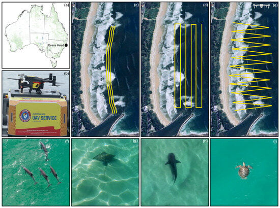
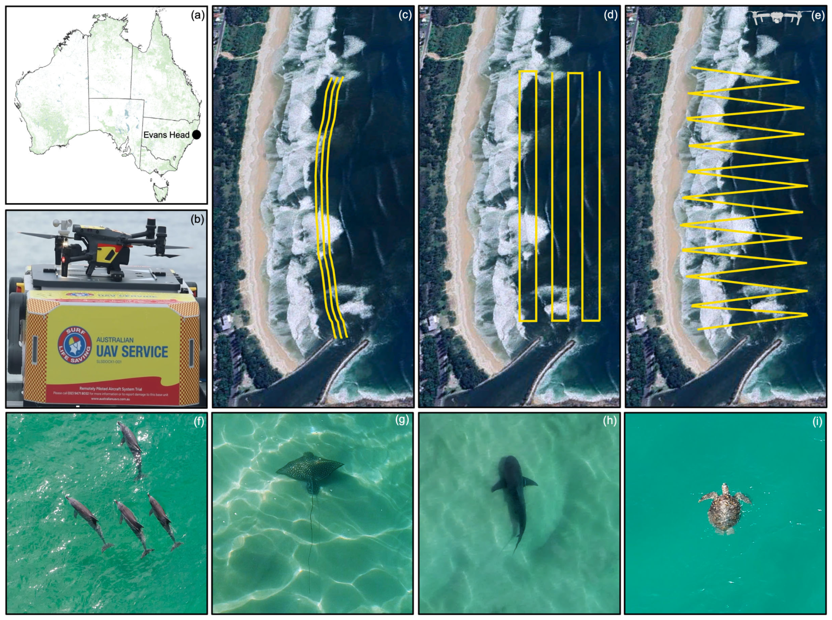
Drone-based survey methods were used to observe marine megafauna off a wave-exposed beach at Evans Head (−29.1120, 153.4349), New South Wales, on the east coast of Australia (Figure 1a).
Figure 1.
(a) Drone-based marine megafauna surveys were completed at Evans Head, located on the east coast of Australia. (b) The autonomous Drone-In-A-Box (DIAB) system with the M30T drone. (c) The approximate manual flight path using a stand-alone M30T drone and (d,e) the approximate two pre-programmed autonomous flight paths using the M30T drone and DIAB system, indicated by the yellow lines. Examples of marine megafauna observed during drone-based surveys: (f) dolphins (Tursiops spp.), (g) a white-spotted eagle ray (Aetobatus ocellatus), (h) a bull shark (Carcharhinus leucas), and (i) a sea turtle (Cheloniidae).
Flights were completed between 0745 and 1530 on each day of sampling, during rain-free periods with light-to-moderate winds. Individual surveys were 16 min and involved one manual drone and one autonomous drone operating concurrently. One drone was operated at 60 m altitude, while the other drone was at 80 m altitude to maintain vertical separation. Altitude was alternated between the manual and autonomous missions across flights each day to reduce confounding of operator and altitude effects.
Open communication was maintained between the off-site drone pilot in the Remote Operations Centre, located in Sydney, New South Wales, Australia (−33.7050, 151.2082) and the on-site crew in Evans Head (~550 km apart) during all drone operations, using a minimum of two independent modes of communication. An ICOM Airband Radio and an Omnitronics voice-over IP radio were also linked together and tuned into the Local Area Frequency, enabling the Remote Operations Centre to send and receive local broadcasts. The DIAB Base Unit was connected to the internet via Starlink satellites, allowing remote communications through an IP network.
An on-site pilot manually operated one DJI M30T drone (DJI, Shenzhen, China), completing 1 km transects parallel to the shoreline and directly behind the surf break (Figure 1c). An off-site pilot operated the autonomous drone missions remotely using a DJI M30T drone and DIAB system (DJI, Shenzhen, China) with the support of an on-site observer. Two pre-programmed flight missions were trialled to test DIAB wildlife detection rates, with each flight route designed to ensure surveillance of the surf zone despite daily tidal changes (Figure 1d,e).
Drone footage was recorded for the entirety of each automated and manual survey. Drones were flown at a speed of 8 m/s, permitting marine fauna observation in real time. Any suspected animal detections were verified by the pilot during flight. When an animal sighting was confirmed during manual flights, the pilot would typically hover the drone over the animal to allow real-time identification and faunal counts. During autonomous flights, the automated mission was paused, allowing manual control of the drone for identification purposes. Once identification had been completed, the autonomous flight mission was resumed, continuing from where the task had been paused. While pause duration varied with animal sightings and the number of animals observed during manual and autonomous flights, it was limited to the minimum time required to complete the task, ensuring the prompt continuation of the survey. The zoom camera was often manually operated for animal identification during manual and autonomous surveys; however, altitude was maintained throughout the flight. Megafauna sightings were identified in real time by the drone pilot using broad classifications (e.g., ‘dolphin’, ‘ray’, ‘shark’, or ‘turtle’), with the number of animals observed also recorded.
Start and finish times for each flight, along with the drone’s operating altitude, were recorded. Water (clarity and sea state) and weather (cloud cover and wind speed) conditions were documented before each flight operation. Water clarity was classified from 1 (very poor) to 5 (very good), and sea state was estimated using the Beaufort scale (ranging from 1 to 4). Cloud cover was categorised from 0 (clear sky) to 8 (overcast) oktas. The number of drone missions conducted under varying environmental conditions is illustrated in Figure S4.
2.2. Post-Flight Analysis
Drone footage from all manual and autonomous flights was collected and reviewed at single speed using VLC media player (ver. 3.0.21; https://www.videolan.org) to quantify real-time missed detection rates. Real-time observations were verified during post-flight analysis, and any additional megafauna sightings were documented. Drone footage was zoomed, paused, replayed, or reviewed at a slower playback speed to ensure the highest possible accuracy in megafauna detection, particularly when uncertainty arose regarding animal classification or counts. Post-analysis review using this method demonstrates high detection precision and a lower likelihood of missed detections [33,34]. Wherever possible, further identification efforts were made to determine the taxa included within each faunal category. The dolphin group included bottlenose (Tursiops spp.) and common (Delphinus spp.) dolphins, and the ray group comprised devil ray (Mobulidae), guitarfish (Rhinobatidae), white-spotted eagle ray (Aetobatus ocellatus), southern eagle ray (Myliobatis australis), and stingray (Dasyatidae spp.) species. The turtle group contained sea turtles (Cheloniidae), and the shark group included bull (Carcharhinus leucas) and whaler (Carcharhinus spp.) sharks. There were, however, instances where identification beyond the broader faunal categories was not possible due to environmental conditions (e.g., increased sea state, poor water clarity, sun glint) or when the animal was too deep in the water column to be identified with certainty.
2.3. Statistical Analysis
Although the autonomous and manual drones were in the same airspace at the same time, their field of view was unlikely to be identical during each mission. Given the potential movement patterns of the animals, it is unreasonable to directly compare the observations by each method on a flight-by-flight basis. However, assuming the post-flight analyses of the footage yielded the true number of animals that were visible to count in real time, a measure of real-time accuracy for each flight can be estimated. Since all other factors were as equal as possible, a comparison between autonomous and manual drones based on real-time accuracy is justifiable.
Missions that failed to detect a member of the faunal group during post-flight review were excluded from the analysis to remove spurious agreement and noting that no false positive sightings were recorded in real time. The number of missions analysed for each faunal group and flight operations is given (see column “N” in Table 2).
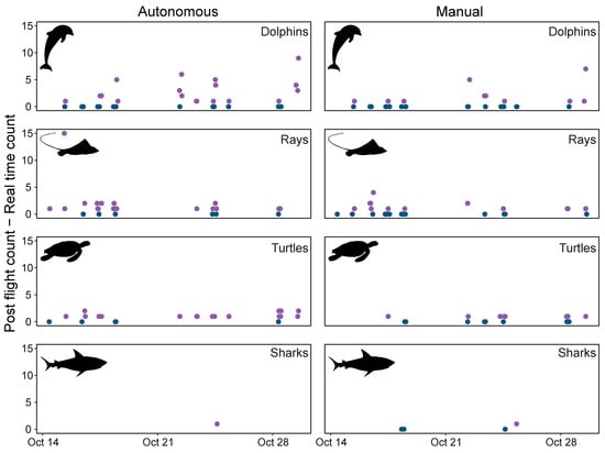
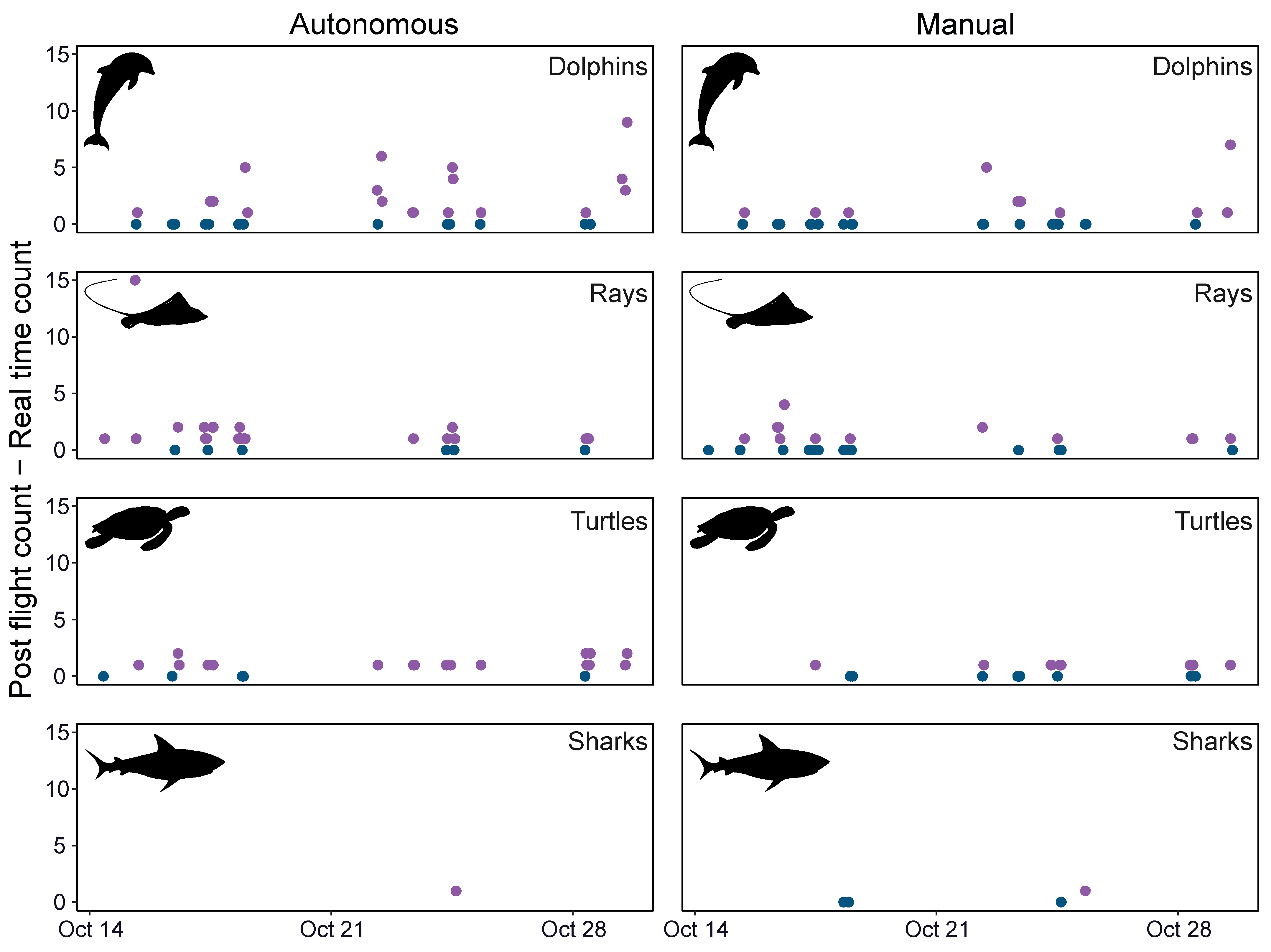
Real-time counts were subtracted from post-flight counts for each faunal group to visualise variation in detection accuracy by flight procedure during the survey (see Figure 2).
Multiplicative counting error (ratio of post-flight to real-time counts) for each faunal group and flight procedure was estimated by application of generalised linear models (GLM). The models were fitted assuming a Poisson distribution and log link function parameterised as follows:
where
= The observed count on mission i by method j (real-time or post-flight).
= Poisson rate parameter for each mission and method.
= baseline real-time count.
= The effect of mission i.
= Indicator variable with value 1 if j = “post-flight” and 0 if j = “real-time”.
= log post-flight to real-time count ratio.
The multiplicative change in post-flight counts relative to real-time was then estimated as follows.
The for each faunal group and flight operation is given (see “Ratio” column in Table 2) along with the standard error (SE) and the chi-squared test for the hypothesis that = 0. Pearson’s test for over-dispersion was conducted and found non-significant (p > 0.05) for all models.
The effect of environmental variables during the missions on the probability of undercounting was then considered. Given the small number of unique discrete outcomes observed (see Figure 2), real-time undercounting was converted to a binary variable (0/1). A value of ‘1’ was assigned to a flight if the real-time count was less than the post-flight count, and ‘0’ if the counts were equal. The effect of environmental variables (i.e., altitude, cloud cover, sea state, time of day, and water clarity) on the probability of undercounting during a flight was assessed by logistic regression, considering each factor in turn, given the limited number of flights with faunal detections (see Table 2).
Change in deviance associated with each effect was compared to the chi-squared distribution to determine if the probability of undercounting varied significantly in response to the environmental variables for each flight operation and faunal group. Test results are given (see Table 3) and selected effects on selected faunal groups are presented graphically (see Figure 3). Sharks were excluded from this analysis due to the rarity of sightings. All data analysis and visualisation were conducted in the R environment [35].
3. Results
Over 71 missions, 107 and 117 real-time megafauna observations were recorded for autonomous and manual operations, respectively. During post-flight analysis of video footage, there were 225 megafauna detections documented for autonomous operations, and 168 for manual operations. Post-flight analysis of autonomous and manual operations recorded higher counts of all faunal groups than the totals observed in real time (Table 1).
Table 1.
Empirical summary of real-time and post-flight counts, and percentage of missed detections for different faunal groups (dolphin, ray, shark, turtle) using autonomous and manual drone flight operations.
Turtles had the highest (45.5%) and the second-highest missed detection rate (76.7%) for manual and autonomous operations, respectively (Table 1; Figure 2). Autonomous operations significantly undercounted turtles in real-time, with 4.29 times more individuals detected during post-flight analysis (p < 0.001; Table 2). The only shark detected during post-flight analysis of autonomous drone footage was not spotted in real time (Figure 2). Rays were significantly undercounted by autonomous (p < 0.0001) and manual operations (p = 0.05), with missed detection rates of 62.7% and 34.6%, respectively (Table 1 and Table 2; Figure 2). Dolphins had the lowest missed detection rate for autonomous (40.9%) and manual operations (24.4%), with post-flight review of autonomous operations counts being 1.69 times higher compared to real-time counts (p < 0.001; Figure 2; Table 2). Although post-flight counts of dolphins, turtles, and sharks for manual operations were higher than real-time detection rates, the effects were not significant (p > 0.05; Figure 2; Table 1 and Table 2). Overall, autonomous operations had greater real-time missed detection rates compared to manual operations across all faunal groups (Table 1).
Figure 2.
Accuracy of each flight (post-flight—real-time count) for each faunal group (dolphins, rays, turtles, sharks) during autonomous and manual drone operations. Purple dots are flights where post-flight exceeded real-time counts, and blue dots are flights where the counts agreed. Flights with no faunal detections in post-flight review were excluded.
Table 2.
Summary of Poisson GLMs to estimate under-counting in real time of faunal groups using autonomous and manual drone operations. Number of flights with at least one animal observed in post-flight (N), exponent of the post-flight count effect (“Ratio” of post-flight to real-time count), standard error of the ratio (SE), p-value and statistics for the hypothesis that real-time and post-flight counts were equal (i.e., Ratio = 1; * denotes ratios determined significantly different from 1 with criteria p ≤ 0.05). Sharks were not included in the analysis for autonomous operations due to only one flight with one detection during post-flight analysis.
Environmental Factors Affecting Real-Time Detection Rates of Faunal Groups
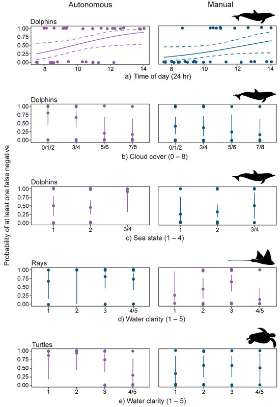
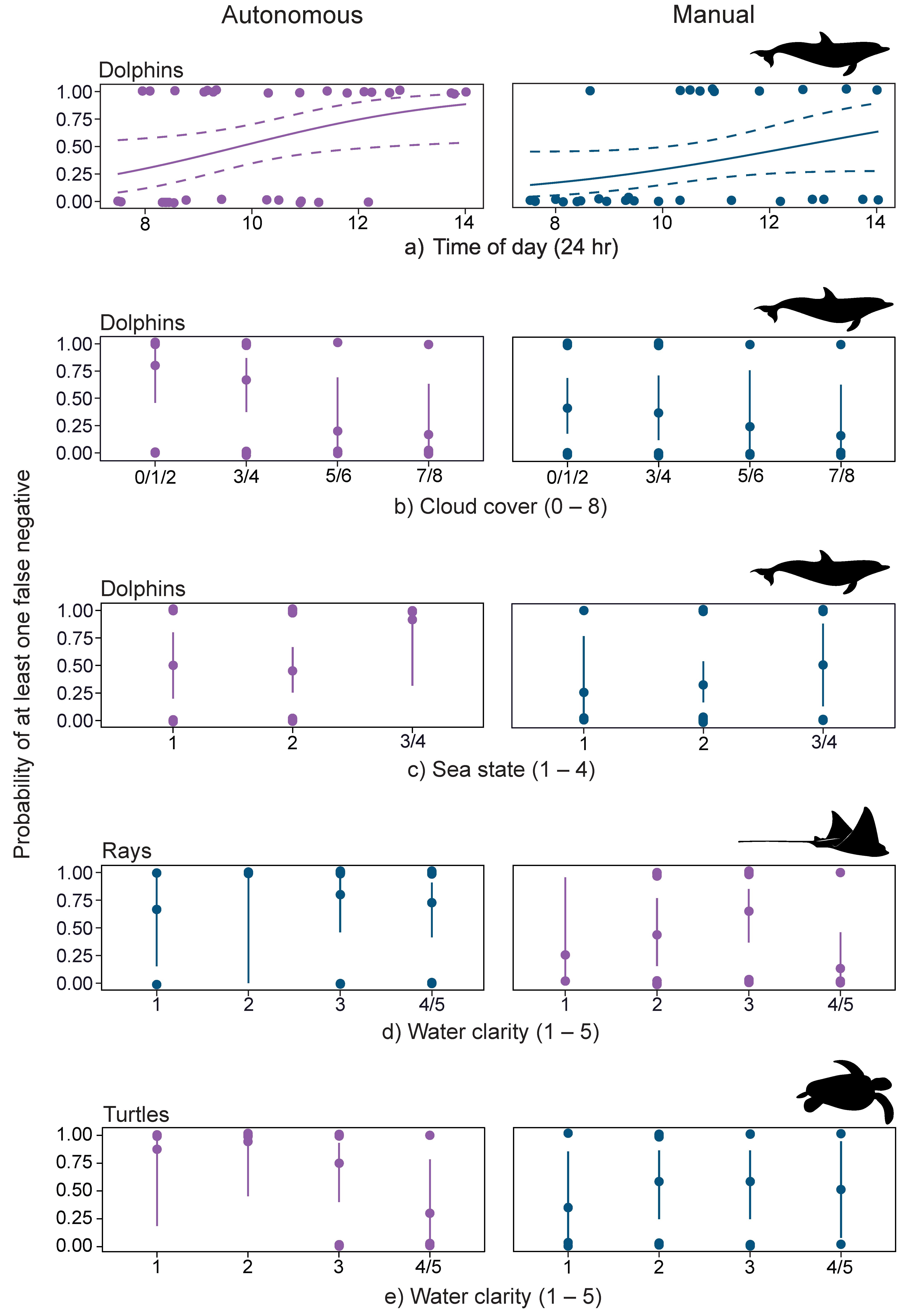
Cloud cover (p = 0.02) and time of day (p = 0.02) significantly influenced the real-time false negative detection rate of dolphins during autonomous operations, with a higher probability of missed detections in flights that occurred later in the day, or when cloud cover was reduced (Table 3; Figure 3a,b). An increased sea state also significantly increased dolphin false negative detection probability during autonomous operations (p = 0.05; Table 3; Figure 3c). In contrast, environmental factors did not significantly influence the false negative detection rates of dolphins during manual operations (Figure S1).
Table 3.
Analysis of deviance results (p-values and statistics) for the effect of environmental factors on the probability of undercounting faunal groups using autonomous and manual drone flight operations. Statistically significant effects are presented graphically in Figure 3. * denotes statistically significant relationships (p ≤ 0.05). Sharks were excluded from the analysis due to the rarity of sightings.
Figure 3.
Logistic GLM estimated effects of environmental factors: (a) time of day, (b) cloud cover, (c) sea state, and (d,e) water clarity on the probability of undercounting by at least one animal for faunal groups (dolphins, rays, turtles) in real time during autonomous and manual drone operations. Statistically significant relationships (p ≤ 0.05; illustrated in purple) are presented together with their counterparts (illustrated in blue), with 95% confidence regions (dotted lines) or intervals (vertical lines). Additional related figures are provided in Supplementary Materials, and Table 3 contains p-values and chi-squared statistics for the hypothesis tests.
While the false negative detection probability of rays was not significantly influenced by environmental factors during autonomous operations (Figure S2), manual operations indicated a significant increase as water clarity declined (p = 0.03; Table 3; Figure 3d). False negative detection of turtles significantly increased with a decrease in water clarity during autonomous operations (p = 0.03; Table 3; Figure 3e). For manual operations, there was no significant effect of environmental factors on turtle false negatives (Figure S3). Altitude had no significant effect on real-time detection rates across any of the faunal groups (Figures S1b, S2b and S3b).
4. Discussion
Autonomous DIAB and manual operations were effective in detecting marine megafauna presence along coastal beaches; however, there were fewer real-time individuals detected than post-flight analysis across all faunal groups. This disparity was especially evident in autonomous operations. These findings suggest that relying solely on real-time detection, whether through autonomous or manual drone operations, may result in the underestimation of megafaunal abundance. For shark surveillance programs that require real-time detection and species identification for beach safety measures, these limitations are an important consideration for risk mitigation of shark bites.
Turtles exhibited the highest missed real-time detection rates across autonomous and manual operations. Colefax et al. [34] similarly reported lower real-time turtle detections during drone-based beach surveys compared to other faunal groups. The lower detection rates are likely due to the relatively small size of turtles observed during our study, with juvenile green turtles (Chelonia mydas) being the most common sea turtle on northern beaches of NSW [36,37]. The behaviour of turtles may have also been important, as sea turtles spend a substantial amount of time submerged, reducing visibility, especially when deeper in the water column [38,39,40]. Drones are often flown at relatively higher altitudes (>60 m) to increase the field of view when sampling megafauna in nearshore habitats [41,42,43]. This practice can potentially decrease the sightability of smaller animals, such as turtles <60 cm in length [44]. Turtle sightings within surf zones often involve solitary individuals, making detection more challenging compared to animals in groups, such as dolphins [23,45]. Drones have, however, proven more efficient than boat-based surveys for turtle detection [46,47], particularly when conducted at lower altitudes or in known aggregation sites, which can effectively maximise detection probability [44,48,49].
Dolphins exhibited the lowest missed detection rates during real-time observations. Dolphins are easily detected during aerial surveys due to their relatively large body size, frequent surfacing behaviour, and gregarious nature [50,51]. Aerial surveys have previously demonstrated greater accuracy in dolphin population counts compared to boat-based surveys [52,53]. Despite this, accurate real-time counts can be challenging when dolphins aggregate in large pods or when individuals or subgroups break away from the main pod [54,55]. Post-flight analysis of drone video footage resulted in increased detections for autonomous and manual flight operations, providing more reliable dolphin counts [56,57].
Rays were significantly undercounted during real-time autonomous and manual operations compared to post-flight. This may be attributed to autonomous flights surveying deeper waters, which increases the likelihood of rays being further in the water column, making them more difficult to detect in real time. Rays also commonly aggregate in multilayered fevers, which may result in undercounting individuals [58,59]. The undercounting of rays during manual operations may be due to the increased turbidity and the turbulent nature of sandy beach surf zones, reducing visibility of benthic fauna [22,41]. Reliance on a relatively small drone-controller screen for real-time megafauna detection and identification during manual operations may further hinder detection accuracy.
Shark detection was rare in surf zones, compared to other marine fauna. Previous studies have reported similar findings, suggesting that shark presence along coastal beaches is relatively infrequent [23,60]. While post-flight analysis revealed that sharks were undercounted during real-time detections, no definitive conclusions can be drawn due to the low number of observations. Nevertheless, these results highlight potential challenges for shark surveillance, where accurate real-time detection and location monitoring of sharks in nearshore areas plays a critical role in management strategies (e.g., water-user evacuations) to minimise the risk of shark bites.
Environmental factors, such as weather or water conditions, can affect marine megafauna detectability during drone surveillance [61,62,63]. We found that time of day, cloud cover, and sea state significantly affected dolphin detection in real time during autonomous operations. Water clarity, however, significantly influenced the real-time detection of turtles and rays during autonomous and manual operations, respectively. Benavides et al. [64] found time of day to be a significant factor for shark detection, with higher detection probability during midday. In contrast, Kelaher et al. [33] reported no effect of time of day or cloud cover on megafauna detection during aerial surveys conducted over relatively shallow waters. We found that as cloud cover increased, dolphins were significantly less likely to be undercounted during autonomous operations. Increased cloud cover reduces sun glint on the ocean surface [65], which may enhance dolphin visibility. Dolphins also typically occur in larger groups, increasing the likelihood that individuals are near the surface [66,67,68]; therefore, reduced subsurface illumination is less likely to affect detectability. Dolphins were, however, significantly more likely to be undercounted later in the day during autonomous operations. This result was somewhat unexpected, as flights conducted earlier and later in the day reduce glare on the water’s surface, with more overhead glare occurring during midday flights [64]. It is therefore more likely attributed to the increase in sea state observed at the study site in the afternoon.
Rough ocean conditions can reduce surface visibility, further challenging detection and accuracy in identification during aerial surveys [69,70]. Despite our drone operations being conducted during relatively calm sea conditions (≤4 Beaufort scale) to maximise faunal observations [54,71], an increased sea state resulted in significant undercounting of dolphins in real time during autonomous operations. Decreased water clarity also significantly increased the likelihood of undercounting turtles and rays by autonomous and manual operations, respectively. Poor water clarity can hinder marine megafauna detection, particularly for animals that spend the majority of their time submerged [59,72,73]. Survey altitudes (i.e., 60 m and 80 m) did not, however, significantly affect real-time detection rates for either autonomous or manual operations across any of the faunal groups, likely due to the relatively small difference (20 m) between altitudes.
Overall, DIAB and manual flight operations of DJI M30T drones were effective in detecting marine megafauna within surf zones during relatively clear and calm conditions. While manual flight operations consistently exhibited lower missed detection rates across all faunal groups, this may be partially attributed to the presence of additional on-site pilots, allowing for the division of flight responsibilities. In contrast, each sample day involved autonomous flight missions operated by a single off-site pilot, assisted by an on-site observer. The autonomous pre-programmed DIAB missions also surveyed sections of deeper water compared to manual flights, ensuring comprehensive surveillance of the surf zone despite tidal variation. This may have contributed to reduced detectability, as animals were potentially located deeper in the water column, hindering real-time observations during aerial surveys [74,75].
Compared to autonomous and manual real-time detections, post-flight analysis provides higher accuracy in animal sightings due to the ability to pause, rewind, and review footage [33,34]. The combined task of piloting the drone and observing megafauna likely reduces the pilot’s ability to detect wildlife in real time. Post-flight analysis can, therefore, improve accuracy in marine megafauna estimates during long-term drone-based research, irrespective of whether autonomous or manual flight operations are used.
Recently, artificial intelligence (AI) has been increasingly explored for its potential in the automatic detection of various species across diverse environments [76,77]. AI-based detection approaches using video data have demonstrated relatively high accuracy in identifying dolphins, rays, sharks, and turtles during aerial surveys, particularly in clear and calm water conditions [78,79,80]. The integration of AI may therefore be beneficial for drone-based surveys of marine megafauna. Yet, challenges still remain in detectability for submerged fauna deep in the water column, or when water conditions (e.g., clarity, turbidity) are sub-optimal [81]. As AI-based detection approaches continue to develop, it is expected that accuracy in faunal detection will improve, further enhancing marine monitoring [80,82]. Despite these limitations, AI can be used as an effective tool to support drone pilots during flight, especially for shark surveillance, as real-time detection is crucial for implementing appropriate countermeasures to increase beach safety.
5. Conclusions
Our study highlights the potential for using autonomous DIAB systems for long-term marine megafauna research and shark surveillance programs. Our findings provide a baseline for the utility of the DIAB system and offer recommendations for enhancing the effectiveness of autonomous drone operations. Overall, the utilisation of autonomous operations using remotely operated DIAB systems could significantly increase the efficiency of drone-based monitoring methods, allowing higher flight frequency and longer operating hours, while decreasing personnel requirements. Post-flight analysis remains a crucial component for improving the accuracy of drone-based abundance estimates, irrespective of whether autonomous or manual operations are used. Despite the rarity of shark observations during this study, it is recommended that mitigation programs integrate AI-based video analysis to provide drone pilots with a valuable tool to support real-time detection and species identification.
Supplementary Materials
The following supporting information can be downloaded at https://www.mdpi.com/article/10.3390/drones10020122/s1, Figure S1. Logistic GLM estimated effects of environmental factors (a) time of day, (b) altitude, (c) cloud cover, (d) sea state, and (e) water clarity on the probability of undercounting by at least one animal for dolphins in real time during autonomous and manual drone operations, with 95% confidence regions (dotted lines) or intervals (vertical lines). Statistically significant relationships (p ≤ 0.05) are illustrated in purple. Figure S2. Logistic GLM estimated effects of environmental factors (a) time of day, (b) altitude, (c) cloud cover, (d) sea state, and (e) water clarity on the probability of undercounting by at least one animal for rays in real time during autonomous and manual drone operations, with 95% confidence regions (dotted lines) or intervals (vertical lines). Statistically significant relationships (p ≤ 0.05) are illustrated in purple. Figure S3. Logistic GLM estimated effects of environmental factors (a) time of day, (b) altitude, (c) cloud cover, (d) sea state, and (e) water clarity on the probability of undercounting by at least one animal for turtles in real time during autonomous and manual drone operations, with 95% confidence regions (dotted lines) or intervals (vertical lines). Statistically significant relationships (p ≤ 0.05) are illustrated in purple. Figure S4. Number of drone-based missions comparing marine megafauna detectability using manual and autonomous (Drone-In-A-Box system) flight operations, conducted under varying environmental conditions, including (a) cloud cover, (b) sea state, (c) time of day, and (d) water clarity.
Author Contributions
Conceptualization, K.I.M., B.P.K. and P.A.B.; Methodology, K.I.M., B.P.K. and P.A.B.; Validation, B.P.K. and P.A.B.; Formal Analysis, S.G.M.; Investigation, K.I.M., B.P.K. and P.A.B.; Resources, B.P.K. and P.A.B.; Data Curation, K.I.M.; Writing—Original Draft Preparation, K.I.M.; Writing—Review and Editing, K.I.M., B.P.K., P.A.B. and S.G.M.; Visualisation, K.I.M. and S.G.M.; Supervision, B.P.K. and P.A.B.; Project Administration, B.P.K. and P.A.B.; Funding Acquisition, B.P.K. and P.A.B. All authors have read and agreed to the published version of the manuscript.
Funding
This research was made possible through funding from the NSW Department of Primary Industries and Regional Development Shark Management Program and Southern Cross University. Analyses of data were further supported by a Seaworld Research and Rescue Foundation Inc. grant (SWR/5/2020) to B.P.K. and P.A.B.
Data Availability Statement
The data underlying this article cannot be shared publicly due to being obtained under contract from a government agency. The data will be shared on reasonable request to the corresponding author.
Acknowledgments
We would like to thank James Bassam, Mark Atkins, Ryan Atkins, Gabriel Roxburgh, Stuart Jackson, Nick Newton, and Oliver Heys of the Surf Life Saving NSW drones team for their invaluable assistance with drone operations and data collection for this project. Thank you to Marcel Green and the NSW Department of Primary Industries and Regional Development through the Shark Management Program team for making this research possible.
Conflicts of Interest
The authors declare no conflicts of interest.
References
- Butcher, P.A.; Colefax, A.P.; Gorkin, R.A.; Kajiura, S.M.; López, N.A.; Mourier, J.; Purcell, C.R.; Skomal, G.B.; Tucker, J.P.; Walsh, A.J.; et al. The drone revolution of shark science: A review. Drones 2021, 5, 8. [Google Scholar] [CrossRef] [Scilit]
- Colefax, A.P.; Butcher, P.A.; Kelaher, B.P. The potential for unmanned aerial vehicles (UAVs) to conduct marine fauna surveys in place of manned aircraft. ICES J. Mar. Sci. 2018, 75, 1–8. [Google Scholar] [CrossRef] [Scilit]
- Bevan, E.; Whiting, S.; Tucker, T.; Guinea, M.; Raith, A.; Douglas, R. Measuring behavioral responses of sea turtles, saltwater crocodiles, and crested terns to drone disturbance to define ethical operating thresholds. PLoS ONE 2018, 13, e0194460. [Google Scholar] [CrossRef] [Scilit]
- Christiansen, F.; Rojano-Doñate, L.; Madsen, P.T.; Bejder, L. Noise levels of multi-rotor unmanned aerial vehicles with implications for potential underwater impacts on marine mammals. Front. Mar. Sci. 2016, 3, 277. [Google Scholar] [CrossRef] [Scilit]
- Fettermann, T.; Fiori, L.; Bader, M.; Doshi, A.; Breen, D.; Stockin, K.A.; Bollard, B. Behaviour reactions of bottlenose dolphins (Tursiops truncatus) to multirotor unmanned aerial vehicles (UAVs). Sci. Rep. 2019, 9, 8558. [Google Scholar] [CrossRef] [Scilit]
- Principe, N.; McFee, W.; Levine, N.; Balmer, B.; Ballenger, J. Using unoccupied aerial systems (UASs) to determine the distribution patterns of Tamanend’s bottlenose dolphins (Tursiops erebennus) across varying salinities in Charleston, South Carolina. Drones 2023, 7, 689. [Google Scholar] [CrossRef] [Scilit]
- Perkins-Taylor, C.M.; McFee, W.E.; McGlinn, D.J.; Greig, T.W.; Levine, N.S. Utilizing drones to assess the body condition of Tamanend’s bottlenose dolphins (Tursiops erebennus) in the Charleston Estuarine System. Aquat. Mamm. 2024, 50, 526–548. [Google Scholar] [CrossRef] [Scilit]
- Bourke, E.; Raoult, V.; Williamson, J.E.; Gaston, T.F. Estuary stingray behaviour does not change in response to drone altitude. Drones 2023, 7, 164. [Google Scholar] [CrossRef] [Scilit]
- Grew, M.; Gaston, T.F.; Griffin, A.S.; Duce, S.J.; Raoult, V. Ray bioturbation rates suggest they shape estuary processes. Remote Sens. Ecol. Conserv. 2025, 11, 74–87. [Google Scholar] [CrossRef] [Scilit]
- Palacios, M.D.; Trejo-Ramírez, A.; Velázquez-Hernández, S.; Huesca-Mayorga, S.A.K.; Stewart, J.D.; Cronin, M.R.; Lezama-Ochoa, N.; Zilliacus, K.M.; González-Armas, R.; Galván-Magaña, F.; et al. Reproductive behavior, seasonality, and distribution of three devil ray species (Mobula mobular, M. thurstoni, and M. munkiana) in the Southern Gulf of California, Mexico. Mar. Biol. 2024, 171, 12. [Google Scholar] [CrossRef] [Scilit]
- Schofield, G.; Esteban, N.; Katselidis, K.A.; Hays, G.C. Drones for research on sea turtles and other marine vertebrates—A review. Biol. Conserv. 2019, 238, 108214. [Google Scholar] [CrossRef] [Scilit]
- Wilson, A.; Ramsewak, D.; Mitchell, K.; Ali, C.; Jagassar, A.; Mastay, B.; Lakhan-Baptiste, S. Sea-turtle observations at Matura Beach, Trinidad, using thermal UAS imagery: A strategy to support monitoring and conservation efforts. Wildl. Soc. Bull. 2025, 49, e1595. [Google Scholar] [CrossRef] [Scilit]
- Varela, M.R.; Patrício, A.R.; Anderson, K.; Broderick, A.C.; DeBell, L.; Hawkes, L.A.; Tilley, D.; Snape, R.T.E.; Westoby, M.J.; Godley, B.J. Assessing climate change associated sea-level rise impacts on sea turtle nesting beaches using drones, photogrammetry and a novel GPS system. Glob. Change Biol. 2019, 25, 753–762. [Google Scholar] [CrossRef] [Scilit]
- Monteforte, K.I.; Butcher, P.A.; Morris, S.G.; Tucker, J.P.; Griffin, K.J.; Kelaher, B.P. The influence of human and marine wildlife presence on white shark behaviour in nearshore areas. ICES J. Mar. Sci. 2024, 82, fsae146. [Google Scholar] [CrossRef] [Scilit]
- Ayres, K.A.; Ketchum, J.T.; González-Armas, R.; Galván-Magaña, F.; Hearn, A.; Elorriaga-Verplancken, F.R.; Martínez-Rincón, R.O.; Hoyos-Padilla, E.M.; Kajiura, S.M. Seasonal aggregations of blacktip sharks Carcharhinus limbatus at a marine protected area in the Gulf of California, assessed by unoccupied aerial vehicle surveys. Mar. Ecol. Prog. Ser. 2021, 678, 95–107. [Google Scholar] [CrossRef] [Scilit]
- Doan, M.D.; Kajiura, S.M. Adult blacktip sharks (Carcharhinus limbatus) use shallow water as a refuge from great hammerheads (Sphyrna mokarran). J. Fish Biol. 2020, 96, 1530–1533. [Google Scholar] [CrossRef] [Scilit]
- Kotik, C.; Durban, J.W.; Fearnbach, H.; Barrett-Lennard, L.G. Morphometrics of mammal-eating killer whales from drone photogrammetry, with comparison to sympatric fish-eating killer whales in the eastern North Pacific. Mar. Mamm. Sci. 2023, 39, 42–58. [Google Scholar] [CrossRef] [Scilit]
- Pirotta, V.; Smith, A.; Ostrowski, M.; Russell, D.; Jonsen, I.D.; Grech, A.; Harcourt, R. An economical custom-built drone for assessing whale health. Front. Mar. Sci. 2017, 4, 425. [Google Scholar] [CrossRef] [Scilit]
- Christiansen, F.; Bejder, L.; Burnell, S.; Ward, R.; Charlton, C. Estimating the cost of growth in southern right whales from drone photogrammetry data and long-term sighting histories. Mar. Ecol. Prog. Ser. 2022, 687, 173–194. [Google Scholar] [CrossRef] [Scilit]
- Mitchell, J.D.; Scott-Holland, T.B.; Butcher, P.A. Factors affecting shark detection from drone patrols in Southeast Queensland, eastern Australia. Biology 2022, 11, 1552. [Google Scholar] [CrossRef] [Scilit] [PubMed]
- McPhee, D.; Blount, C.; MacBeth, W. NSW Shark Management Strategy and Shark Program Review; NSW Department of Primary Industries: Australia, 2022. [Google Scholar]
- Cross, M.C.; Mitchell, J.D.; Dudgeon, C.L.; Townsend, K.A.; Scott-Holland, T.B.; Holmes, B.J. Spatial and temporal variation of marine megafauna off coastal beaches of south-eastern Queensland, Australia. Mar. Freshw. Res. 2024, 75, MF24094. [Google Scholar] [CrossRef] [Scilit]
- Kelaher, B.P.; Monteforte, K.I.; Morris, S.G.; Schlacher, T.A.; March, D.T.; Tucker, J.P.; Butcher, P.A. Drone-based assessment of marine megafauna off wave-exposed sandy beaches. Remote Sens. 2023, 15, 4018. [Google Scholar] [CrossRef] [Scilit]
- Raoult, V.; Colefax, A.P.; Allan, B.M.; Cagnazzi, D.; Castelblanco-Martínez, N.; Ierodiaconou, D.; Johnston, D.W.; Landeo-Yauri, S.; Lyons, M.; Pirotta, V.; et al. Operational protocols for the use of drones in marine animal research. Drones 2020, 4, 64. [Google Scholar] [CrossRef] [Scilit]
- Grlj, C.G.; Krznar, N.; Pranjić, M. A decade of UAV docking stations: A brief overview of mobile and fixed landing platforms. Drones 2022, 6, 17. [Google Scholar] [CrossRef] [Scilit]
- Bene, V.; Kristóf, Z.; Elek, B. The DJI Dock 2 is a “Drone in a Box” to enhance the unmanned guard solution–scientific research with the cooperation of Duplitec Ltd. Repüléstud. Közl. 2023, 35, 171–181. [Google Scholar] [CrossRef] [Scilit]
- DJI Enterprise. DJI Dock 1: Drone in a Box Systems. Available online: https://enterprise.dji.com/dock (accessed on 28 October 2025).
- Kodeeswaran, S.; Kannabhiran, A.; Elangovan, D. A comparative study of energy sources, docking stations and wireless charging technologies for certain quadrotor unmanned aerial vehicles. Aerosp. Sci. Technol. 2025, 166, 110628. [Google Scholar] [CrossRef] [Scilit]
- Bláha, L.; Severa, O.; Goubej, M.; Myslivec, T.; Reitinger, J. Automated drone battery management system—Droneport: Technical overview. Drones 2023, 7, 234. [Google Scholar] [CrossRef] [Scilit]
- DJI Enterprise. DJI Dock 2: Drone-in-a-Box Systems. Available online: https://enterprise.dji.com/dock-2 (accessed on 1 November 2025).
- Bhat, G.R.; Dudhedia, M.A.; Panchal, R.A.; Shirke, Y.S.; Angane, N.R.; Khonde, S.R.; Khedkar, S.P.; Pansare, J.R.; Bere, S.S.; Wahul, R.M.; et al. Autonomous drones and their influence on standardization of rules and regulations for operating—A brief overview. Results Control Optim. 2024, 14, 100401. [Google Scholar] [CrossRef] [Scilit]
- Civil Aviation Safety Authority. Australian Drone Rules; Civil Aviation Safety Authority: Canberra, Australia, 2025. [Google Scholar]
- Kelaher, B.P.; Peddemors, V.M.; Hoade, B.; Colefax, A.P.; Butcher, P.A. Comparison of sampling precision for nearshore marine wildlife using unmanned and manned aerial surveys. J. Unmanned. Veh. Syst. 2020, 8, 30–43. [Google Scholar] [CrossRef] [Scilit]
- Colefax, A.P.; Butcher, P.A.; Pagendam, D.E.; Kelaher, B.P. Reliability of marine faunal detections in drone-based monitoring. Ocean Coast. Manag. 2019, 174, 108–115. [Google Scholar] [CrossRef] [Scilit]
- R Core Team. R: A Language and Environment for Statistical Computing; R Foundation for Statistical Computing: Vienna, Austria, 2024. [Google Scholar]
- March, D.T.; Ariel, E.; Munns, S.; Rudd, D.; Blyde, D.; Christidis, L.; Kelaher, B.P. Physiological changes in post-hatchling green turtles (Chelonia mydas) following short-term fasting: Implications for release protocols. Conserv. Physiol. 2019, 7, coz016. [Google Scholar] [CrossRef] [Scilit]
- Day, J.; Hall, J.; Rose, K.; Vinette Herrin, K.; March, D.; Pitt, O.; FitzSimmons, N.N.; Hall, L.; Marshall, K.; Iredell, S.; et al. Mixed stock analysis identifies natal origins of green turtles at foraging grounds in southeastern Australia. Front. Mar. Sci. 2024, 11, 1346932. [Google Scholar] [CrossRef] [Scilit]
- Roberts, K.E.; Garrison, L.P.; Ortega-Ortiz, J.; Hu, C.; Zhang, Y.; Sasso, C.R.; Lamont, M.; Hart, K.M. The Influence of satellite-derived environmental and oceanographic parameters on marine turtle time at surface in the Gulf of Mexico. Remote Sens. 2022, 14, 4534. [Google Scholar] [CrossRef] [Scilit]
- Thomson, J.A.; Cooper, A.B.; Burkholder, D.A.; Heithaus, M.R.; Dill, L.M. Correcting for heterogeneous availability bias in surveys of long-diving marine turtles. Biol. Conserv. 2013, 165, 154–161. [Google Scholar] [CrossRef] [Scilit]
- Odzer, M.N.; Brooks, A.M.L.; Heithaus, M.R.; Whitman, E.R. Effects of environmental factors on the detection of subsurface green turtles in aerial drone surveys. Wildl. Res. 2022, 49, 79–88. [Google Scholar] [CrossRef] [Scilit]
- Hodgson, A.; Kelly, N.; Peel, D. Unmanned aerial vehicles (UAVs) for surveying marine fauna: A dugong case study. PLoS ONE 2013, 8, e79556. [Google Scholar] [CrossRef] [Scilit]
- Dickson, L.C.D.; Negus, S.R.B.; Eizaguirre, C.; Katselidis, K.A.; Schofield, G. Aerial drone surveys reveal the efficacy of a protected area network for marine megafauna and the value of sea turtles as umbrella species. Drones 2022, 6, 291. [Google Scholar] [CrossRef] [Scilit]
- Bierlich, K.C.; Hewitt, J.; Bird, C.N.; Johnston, D.W.; Dale, J.; Pirotta, E.; Schick, R.S.; Stewart, J.D.; New, L.; Chimienti, E.; et al. A workflow of open-source tools for drone-based photogrammetry of marine megafauna. PeerJ 2025, 13, e19768. [Google Scholar] [CrossRef] [Scilit]
- Piovani, B.; Monteiro-Neto, C.; de Oliveira, L.L.; Guimarães, S.M. Use of unmanned aerial system for monitoring sea turtles in coastal areas. Reg. Stud. Mar. Sci. 2025, 81, 104002. [Google Scholar] [CrossRef] [Scilit]
- Pirotta, V.; Hocking, D.P.; Iggleden, J.; Harcourt, R. Drone observations of marine life and human–wildlife interactions off Sydney, Australia. Drones 2022, 6, 75. [Google Scholar] [CrossRef] [Scilit]
- Yaney-Keller, A.; San Martin, R.; Reina, R.D. Comparison of UAV and boat surveys for detecting changes in breeding population dynamics of sea turtles. Remote Sens. 2021, 13, 2857. [Google Scholar] [CrossRef] [Scilit]
- Dunstan, A.; Robertson, K.; Fitzpatrick, R.; Pickford, J.; Meager, J. Use of unmanned aerial vehicles (UAVs) for mark-resight nesting population estimation of adult female green sea turtles at Raine Island. PLoS ONE 2020, 15, e0228524. [Google Scholar] [CrossRef] [Scilit] [PubMed]
- Dickson, L.C.D.; Tugwell, H.; Katselidis, K.A.; Schofield, G. Aerial drones reveal the dynamic structuring of sea turtle breeding aggregations and minimum survey effort required to capture climatic and sex-specific effects. Front. Mar. Sci. 2022, 9, 864694. [Google Scholar] [CrossRef] [Scilit]
- Finucci, B.; Dunn, M.R.; Duffy, C.A.J.; Erdmann, M.V.; Hayden, M.; Middleton, I. Confirmation of green turtle (Chelonia mydas) foraging grounds in northern New Zealand. Pac. Conserv. Biol 2025, 31, PC25048. [Google Scholar] [CrossRef] [Scilit]
- Connor, R.; Wells, R.; Mann, J.; Read, A. The Bottlenose Dolphin, Tursiops sp.: Social Relationships in a Fission-Fusion Society. In Cetacean Societies: Field Studies of Dolphins and Whales; Mann, J., Connor, R., Tyack, P., Whitehead, H., Eds.; The University of Chicago Press: Chicago, IL, USA, 2000; pp. 91–126. [Google Scholar]
- Mann, J.; Karniski, C. Diving beneath the surface: Long-term studies of dolphins and whales. J. Mammal. 2017, 98, 621–630. [Google Scholar] [CrossRef] [Scilit]
- Fettermann, T.; Fiori, L.; Gillman, L.; Stockin, K.; Bollard, B. Drone surveys are more accurate than boat-based surveys of bottlenose dolphins (Tursiops truncatus). Drones 2022, 6, 82. [Google Scholar] [CrossRef] [Scilit]
- Oliveira-da-Costa, M.; Marmontel, M.; da-Rosa, D.S.X.; Coelho, A.; Wich, S.; Mosquera-Guerra, F.; Trujillo, F. Effectiveness of unmanned aerial vehicles to detect Amazon dolphins. Oryx 2020, 54, 696–698. [Google Scholar] [CrossRef] [Scilit]
- Barreto, J.; Cajaíba, L.; Teixeira, J.B.; Nascimento, L.; Giacomo, A.; Barcelos, N.; Fettermann, T.; Martins, A. Drone-monitoring: Improving the detectability of threatened marine megafauna. Drones 2021, 5, 14. [Google Scholar] [CrossRef] [Scilit]
- Gerrodette, T.; Perryman, W.L.; Oedekoven, C.S. Accuracy and precision of dolphin group size estimates. Mar. Mamm. Sci. 2019, 35, 22–39. [Google Scholar] [CrossRef] [Scilit]
- Brown, A.M.; Allen, S.J.; Kelly, N.; Hodgson, A.J.; Pettorelli, N.; Quick, N. Using unoccupied aerial vehicles to estimate availability and group size error for aerial surveys of coastal dolphins. Remote Sens. Ecol. Conserv. 2023, 9, 340–353. [Google Scholar] [CrossRef] [Scilit]
- Guizada Duran, L.A.; Aliaga-Rossel, E. A comparative analysis of drone and boat monitoring for the endangered Bolivian River Dolphin. Aquat. Mamm. 2024, 50, 469–478. [Google Scholar] [CrossRef] [Scilit]
- Frixione, M.G.; Gómez García, M.d.J.; Gauger, M.F.W. Drone imaging of elasmobranchs: Whale sharks and golden cownose rays co-occurrence in a zooplankton hot-spot in southwestern Sea of Cortez. Food Webs 2020, 24, e00155. [Google Scholar] [CrossRef] [Scilit]
- Oleksyn, S.; Tosetto, L.; Raoult, V.; Joyce, K.E.; Williamson, J.E. Going batty: The challenges and opportunities of using drones to monitor the behaviour and habitat use of rays. Drones 2021, 5, 12. [Google Scholar] [CrossRef] [Scilit]
- Monteforte, K.I.P.; Butcher, P.A.; Morris, S.G.; Kelaher, B.P. The relative abundance and occurrence of sharks off ocean beaches of New South Wales, Australia. Biology 2022, 11, 1456. [Google Scholar] [CrossRef] [Scilit]
- Fortuna, J.; Ferreira, F.; Gomes, R.; Ferreira, S.; Sousa, J. Using low cost open source UAVs for marine wild life monitoring-field report. IFAC Proc. Vol. 2013, 46, 291–295. [Google Scholar] [CrossRef] [Scilit]
- Castelblanco-Martínez, D.N.; Blanco-Parra, M.P.; Charruau, P.; Prezas, B.; Zamora-Vilchis, I.; Niño-Torres, C.A. Detecting, counting and following the giants of the sea: A review of monitoring methods for aquatic megavertebrates in the Caribbean. Wildl. Res. 2019, 46, 545–556. [Google Scholar] [CrossRef] [Scilit]
- Hodgson, A.J.; Kelly, N.; Peel, D. Drone images afford more detections of marine wildlife than real-time observers during simultaneous large-scale surveys. PeerJ 2023, 11, e16186. [Google Scholar] [CrossRef] [Scilit]
- Benavides, M.T.; Fodrie, J.F.; Johnston, D.W. Shark detection probability from aerial drone surveys within a temperate estuary. J. Unmanned. Veh. Syst. 2020, 8, 44–56. [Google Scholar] [CrossRef] [Scilit]
- Doukari, M.; Topouzelis, K. Overcoming the UAS limitations in the coastal environment for accurate habitat mapping. Remote Sens. Appl. Soc. Environ. 2022, 26, 100726. [Google Scholar] [CrossRef] [Scilit]
- Hawkins, E.R.; Gartside, D.F. Social and behavioural characteristics of Indo-Pacific bottlenose dolphins (Tursiops aduncus) in northern New South Wales, Australia. Aust. Mammal. 2008, 30, 71–82. [Google Scholar] [CrossRef] [Scilit]
- Miketa, M.L.; Patterson, E.M.; Krzyszczyk, E.; Foroughirad, V.; Mann, J. Calf age and sex affect maternal diving behaviour in Shark Bay bottlenose dolphins. Anim. Behav. 2018, 137, 107–117. [Google Scholar] [CrossRef] [Scilit]
- Methion, S.; Giralt Paradell, O.; Padín, X.A.; Corrège, T.; Díaz López, B. Group size varies with climate and oceanographic conditions in bottlenose dolphins. Mar. Biol. 2023, 170, 7. [Google Scholar] [CrossRef] [Scilit]
- Pollock, K.H.; Marsh, H.D.; Lawler, I.R.; Alldredge, M.W. Estimating animal abundance in heterogeneous environments: An application to aerial surveys for dugongs. J. Wildl. Manag. 2006, 70, 255–262. [Google Scholar] [CrossRef] [Scilit]
- Bigal, E.; Galili, O.; van Rijn, I.; Rosso, M.; Cleguer, C.; Hodgson, A.; Scheinin, A.; Tchernov, D. Reduction of Species identification errors in surveys of marine wildlife abundance utilising unoccupied aerial vehicles (UAVs). Remote Sens. 2022, 14, 4118. [Google Scholar] [CrossRef] [Scilit]
- Hodgson, A.; Peel, D.; Kelly, N. Unmanned aerial vehicles for surveying marine fauna: Assessing detection probability. Ecol. Appl. 2017, 27, 1253–1267. [Google Scholar] [CrossRef] [Scilit] [PubMed]
- Hazel, J.; Lawler, I.R.; Hamann, M. Diving at the shallow end: Green turtle behaviour in near-shore foraging habitat. J. Exp. Mar. Biol. Ecol. 2009, 371, 84–92. [Google Scholar] [CrossRef] [Scilit]
- Southwood, A.L.; Reina, R.D.; Jones, V.S.; Jones, D.R. Seasonal diving patterns and body temperatures of juvenile green turtles at Heron Island, Australia. Can. J. Zool. 2003, 81, 1014–1024. [Google Scholar] [CrossRef] [Scilit]
- Curtis, T.H.; Scannell, B.J.; Metzger, G.; Cahill, B.V.; Paparo, C.; Galuardi, B.; Berkhout, M.; Zublionis, W.; Iudica, L.; Newton, A.; et al. Scratching the surface: Swimming depths of multiple shark species in New York coastal waters and implications for aerial monitoring. Mar. Coastal Fish. 2025, 17, vtaf010. [Google Scholar] [CrossRef] [Scilit]
- Butcher, P.A.; Piddocke, T.P.; Colefax, A.P.; Hoade, B.; Peddemors, V.M.; Borg, L.; Cullis, B.R. Beach safety: Can drones provide a platform for sighting sharks? Wildl. Res. 2019, 46, 701–712. [Google Scholar] [CrossRef] [Scilit]
- Hua, A.; Martin, K.; Shen, Y.; Chen, N.; Mou, C.; Sterk, M.; Reinhard, B.; Reinhard, F.F.; Lee, S.; Alibhai, S.; et al. Protecting endangered megafauna through AI analysis of drone images in a low-connectivity setting: A case study from Namibia. PeerJ 2022, 10, e13779. [Google Scholar] [CrossRef] [Scilit]
- Zhao, F.; Shao, X.; Wang, J.; Chen, Y.; Xi, D.; Liu, Y.; Chen, J.; Sasaki, J.; Mizuno, K. A novel underwater Holothurians monitoring system using consumer-grade amphibious UAV with Mamba-based Super-Resolution Reconstruction and enhanced YOLOv10. Mar. Environ. Res. 2025, 212, 107510. [Google Scholar] [CrossRef] [Scilit]
- Gorkin, R.; Adams, K.; Berryman, M.J.; Aubin, S.; Li, W.; Davis, A.R.; Barthelemy, J. Sharkeye: Real-time autonomous personal shark alerting via aerial surveillance. Drones 2020, 4, 18. [Google Scholar] [CrossRef] [Scilit]
- Agabiti, C.; Baldi, G.; Moscoloni, G.; Pandocchi, G.A.A.; Gonzalez-Bernando, E.; Casale, P. High sea turtle density in a Mediterranean foraging ground revealed by UAV surveys and machine learning. Endanger. Species Res. 2025, 58, 241–256. [Google Scholar] [CrossRef] [Scilit]
- Purcell, C.R.; Walsh, A.J.; Colefax, A.P.; Butcher, P. Assessing the ability of deep learning techniques to perform real-time identification of shark species in live streaming video from drones. Front. Mar. Sci. 2022, 9, 981897. [Google Scholar] [CrossRef] [Scilit]
- Dujon, A.M.; Ierodiaconou, D.; Geeson, J.J.; Arnould, J.P.Y.; Allan, B.M.; Katselidis, K.A.; Schofield, G. Machine learning to detect marine animals in UAV imagery: Effect of morphology, spacing, behaviour and habitat. Remote Sens. Ecol. Conserv. 2021, 7, 341–354. [Google Scholar] [CrossRef] [Scilit]
- Ditria, E.M.; Buelow, C.A.; Gonzalez-Rivero, M.; Connolly, R.M. Artificial intelligence and automated monitoring for assisting conservation of marine ecosystems: A perspective. Front. Mar. Sci. 2022, 9, 918104. [Google Scholar] [CrossRef] [Scilit]

Disclaimer/Publisher’s Note: The statements, opinions and data contained in all publications are solely those of the individual author(s) and contributor(s) and not of MDPI and/or the editor(s). MDPI and/or the editor(s) disclaim responsibility for any injury to people or property resulting from any ideas, methods, instructions or products referred to in the content. |
© 2026 by the authors. Licensee MDPI, Basel, Switzerland. This article is an open access article distributed under the terms and conditions of the Creative Commons Attribution (CC BY) license.