Next Issue
Volume 2, June
Previous Issue
Volume 1, December


Urban Sci., Volume 2, Issue 1 (March 2018) – 28 articles

Cover Story (view full-size image): 
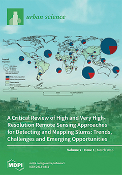
The United Nations estimates that as many as one billion (one in eight) people live in slums worldwide. The cover image illustrates variations in slum populations across the world. The size of the discs represents total urban population per nation, expressing the combined effect of total population and levels of urbanization per country. The red portion of each disc represents the percentage of the urban population that lives in slums in each country, capturing variations across and within continents (compare e.g., Africa to South America, and sub-Saharan to north Africa). With accelerated rates of global urbanization we are facing a pressing need to identify suitable data (e.g., remote sensing and volunteer geographic information) and methods (e.g., data mining) for mapping and monitoring slums. View the paper
  • Issues are regarded as officially published after their release is announced to the table of contents alert mailing list.
  • You may sign up for e-mail alerts to receive table of contents of newly released issues.
  • PDF is the official format for papers published in both, html and pdf forms. To view the papers in pdf format, click on the "PDF Full-text" link, and use the free Adobe Reader to open them.
Order results
Result details
Select all
Export citation of selected articles as:
24 pages, 2871 KiB  
Article
The Integration of Socio-Economic Indicators in the CASBEE-UD Evaluation System: A Case Study
by Francesco Cappai, Daniel Forgues and Mathias Glaus
Urban Sci. 2018, 2(1), 28; https://doi.org/10.3390/urbansci2010028 - 19 Mar 2018
Cited by 6 | Viewed by 4930
Abstract
The use of tools to measure the degree of sustainability of cities is the approach that receives the most attention in developed countries. However, studies of evaluation tools at the neighborhood level reveal that there are many weaknesses in the most widely-used evaluation [...] Read more.
The use of tools to measure the degree of sustainability of cities is the approach that receives the most attention in developed countries. However, studies of evaluation tools at the neighborhood level reveal that there are many weaknesses in the most widely-used evaluation systems (LEED-ND, BREEAM Communities, CASBEE-UD). There are ambiguities and gaps in weighting and in scoring and in most cases, there is no mechanism for local adaptability and participation. The purpose of this study is to provide an overview of the current situation by highlighting the strengths and weaknesses of these evaluation tools in order to integrate social and economic aspects for the improvement of the CASBEE-UD (neighborhood level) evaluation tool. The selection of socio-economic aspects was made through the use of a multi criteria Analysis Hierarchical Process (AHP) and a Geographic Integration System (GIS). The results of this case study indicate that most evaluation tools need to be revised because most do not include socio-economic aspects. We have demonstrated that applying the CASBEE-UD assessment tool integrated with socio-economic aspects to four boroughs in the City of Montreal can measure success by addressing the objectives of sustainable development. Full article
Show Figures

Figure 1

22 pages, 845 KiB  
Article
Social Resistances and the Creation of Another Way of Thinking in the Peripheral “Self-Constructed Popular Neighborhoods”: Examples from Mexico, Argentina, and Bolivia
by Chryssanthi (Christy) Petropoulou
Urban Sci. 2018, 2(1), 27; https://doi.org/10.3390/urbansci2010027 - 19 Mar 2018
Cited by 4 | Viewed by 4226
Abstract
This study refers to urban social movements, creative social resistances, and the collectives that are emerging today in “self-constructed popular neighborhoods” (“barrios de auto-construcción popular” in Latin-American, Spanish bibliography; “quartiers d’auto-construction populaire” in French bibliography and “self-help housing” in Anglophone bibliography), with a [...] Read more.
This study refers to urban social movements, creative social resistances, and the collectives that are emerging today in “self-constructed popular neighborhoods” (“barrios de auto-construcción popular” in Latin-American, Spanish bibliography; “quartiers d’auto-construction populaire” in French bibliography and “self-help housing” in Anglophone bibliography), with a special focus on the new characteristics of these movements and the poetics of their daily practices. Firstly, a cartographic approach is explained through the concept of eco-landscapes; a qualitative analysis follows based on interviews and a review of the secondary literature. In particular, this research focuses on cases of movements and collectives in villas in South Greater Buenos Aires, barrios of Ciudad Nezahualcóyotl in the Metropolitan Area of Mexico City, and barrios of El Alto in the Metropolitan Area of La Paz. It shows that the poetics of creative resistances question the symbolic power of territorial stigmatization. Full article
(This article belongs to the Special Issue Urban Inequality)
22 pages, 5466 KiB  
Article
Intra-Urban Microclimate Effects on Phenology
by Tammy E. Parece and James B. Campbell
Urban Sci. 2018, 2(1), 26; https://doi.org/10.3390/urbansci2010026 - 16 Mar 2018
Cited by 12 | Viewed by 5108
Abstract
The urban heat island effect is commonly defined as the thermal differences between cooler rural and warmer urban areas, but it also refers to microclimatic differences within an urban area that arises from varied combinations of land cover related to different land uses. [...] Read more.
The urban heat island effect is commonly defined as the thermal differences between cooler rural and warmer urban areas, but it also refers to microclimatic differences within an urban area that arises from varied combinations of land cover related to different land uses. Microclimatic variations should also produce intra-urban differences in vegetation phenophases, although few studies have investigated urban phenology. Most phenological studies are usually regional to continental in scale, predominantly tracking changes in start of season related to climate change. This study reports results of an exploratory analysis using TIMESAT (Lund University, Lund, Sweden) software and MODIS NDVI 250-m resolution data (Goddard Space Flight Center, Greenbelt, MD, USA) to identify intra-urban differences in start of season for the City of Roanoke, Virginia. We compare these results to our in-situ temperature collection campaign. Additionally, we completed an in-situ start of season data collection by observing select tree species. Our results demonstrate that MODIS, processed by TIMESAT software, identified intra-urban start of season variations, and these variations are consistent with differing intra-urban microclimates and our in-situ start of season observations. Furthermore, results from such analyses can aid plans for increasing the urban tree canopy or in cultivating locations for urban agriculture—i.e., warmer areas with a longer growing season could accommodate warmer weather trees and crops. Full article
(This article belongs to the Special Issue Urban Landscape Degradation and Restoration)
Show Figures

Graphical abstract

13 pages, 251 KiB  
Article
Urban Chickens as a Pathway for Human Illness: An Examination of Knowledge, Behavior and Risk
by Stella Capoccia, Michael Masters and Scott Risser
Urban Sci. 2018, 2(1), 25; https://doi.org/10.3390/urbansci2010025 - 14 Mar 2018
Cited by 3 | Viewed by 5527
Abstract
This research investigates the relationships between human knowledge, behavior and risk as they relate to urban chicken husbandry in the United States. Concern over zoonotic diseases has been on the rise, especially with increasing contact between birds and humans. In particular, avian influenza—or [...] Read more.
This research investigates the relationships between human knowledge, behavior and risk as they relate to urban chicken husbandry in the United States. Concern over zoonotic diseases has been on the rise, especially with increasing contact between birds and humans. In particular, avian influenza—or bird flu—and Salmonella enterica (Salmonella) and Escherichia coli (E. coli) can all cross species lines between people and poultry. This study analyzed knowledge and practices in urban chicken husbandry to assess how they relate to risk of disease acquisition, hypothesizing that certain practices associated with a lower knowledge base may heighten the risk. This study used a survey distributed via social media to examine the self-reported knowledge base of individuals involved in chicken husbandry as they relate to beliefs and behaviors associated with the care of these animals. These results identify key factors that may heighten the risk of disease transmission and demonstrate that an increased knowledge base could act to lessen this risk. Full article
(This article belongs to the Special Issue Urban Food Security)
17 pages, 1037 KiB  
Article
Retailing of Processed Dairy and Grain Products in Mali: Evidence from a City Retail Outlet Inventory
by Veronique Theriault, Ryan Vroegindewey, Amidou Assima and Naman Keita
Urban Sci. 2018, 2(1), 24; https://doi.org/10.3390/urbansci2010024 - 09 Mar 2018
Cited by 8 | Viewed by 4454
Abstract
As in many sub-Saharan African countries, Mali is experiencing an unprecedented rate of urbanization and, with it, changes to its agri-food system. As more people live in urban areas, the demand for processed foods has been increasing rapidly. These changes have important implications [...] Read more.
As in many sub-Saharan African countries, Mali is experiencing an unprecedented rate of urbanization and, with it, changes to its agri-food system. As more people live in urban areas, the demand for processed foods has been increasing rapidly. These changes have important implications for food and nutrition security. Yet, little is known about the scale and scope of the retailing of processed foods. To better understand this segment, we conducted a city retail outlet inventory of processed dairy and cereal foods in 2016. The main findings are that: (1) food availability is greater in the capital, high-income neighborhoods, and supermarkets; (2) there is a high prevalence of imported foods; (3) added sugar and vegetable fats are listed as a top-three ingredient in a quarter of processed products, highlighting issues related to healthfulness; (4) price premiums are paid for products that are imported from Europe, use improved packaging, and are retailed in supermarkets. Taken together, our findings indicate that the transformation in the Malian agri-food system is still at an early stage. The growing demand for processed foods presents economic opportunities for Malian farmers and processors, especially if they can improve product quality, packaging, and distribution. Full article
(This article belongs to the Special Issue Urban Food Security)
Show Figures

Figure 1

21 pages, 712 KiB  
Review
Grassroots Initiatives as Sustainability Transition Pioneers: Implications and Lessons for Urban Food Systems
by Maria Gernert, Hamid El Bilali and Carola Strassner
Urban Sci. 2018, 2(1), 23; https://doi.org/10.3390/urbansci2010023 - 08 Mar 2018
Cited by 28 | Viewed by 9436
Abstract
This review explores the current evidence on the role and success factors of grassroots initiatives in sustainability transitions, with special attention given to social innovations and the transformation of urban food systems, a field that is still rather scantly dealt with in literature [...] Read more.
This review explores the current evidence on the role and success factors of grassroots initiatives in sustainability transitions, with special attention given to social innovations and the transformation of urban food systems, a field that is still rather scantly dealt with in literature compared to technological innovations in other sectors such as energy. In addition to their contributions to get the necessary transformation towards sustainable futures off the ground, the preconditions for grassroots initiatives to thrive are presented—as well as limitations regarding their possibilities and the challenges they face. Increasingly, the importance of civil society and social movements in facilitating societal transformation is recognized by both researchers and policy makers. Within their radical niches, grassroots initiatives do not have to adhere to the logics of the wider systems in which they are embedded. This allows them to experiment with diverse solutions to sustainability challenges such as local food security and sovereignty. By means of democratic, inclusive and participatory processes, they create new pathways and pilot a change of course. Nevertheless, upscaling often comes at the loss of the transformative potential of grassroots initiatives. Full article
(This article belongs to the Special Issue Urban Food Security)
Show Figures

Figure 1

13 pages, 3022 KiB  
Article
Urban Informality and Vulnerability: A Case Study in Kampala, Uganda
by Amy Richmond, Ian Myers and Hafisa Namuli
Urban Sci. 2018, 2(1), 22; https://doi.org/10.3390/urbansci2010022 - 07 Mar 2018
Cited by 42 | Viewed by 13661
Abstract
Urbanization increasingly means that the poorest, most vulnerable people move into large, highly distressed informal areas. These areas exhibit high levels of poverty and inequality. This paper uses Kampala, Uganda to identify drivers of vulnerability in informal communities that are a consequence of [...] Read more.
Urbanization increasingly means that the poorest, most vulnerable people move into large, highly distressed informal areas. These areas exhibit high levels of poverty and inequality. This paper uses Kampala, Uganda to identify drivers of vulnerability in informal communities that are a consequence of urbanization. Specifically, this paper adapts a vulnerability framework, developed for Uganda as a whole, for an urban environment. Using data collected by the NGO ACTogether along with interviews, this paper determines that the most important drivers of vulnerability in Kampala’s 57 slum communities are water and sanitation. Vulnerability caused by water and sanitation issues can be alleviated with adequate urban planning. However, planning in Kampala is difficult and not well implemented. This paper concludes that informal settlements are a critical part of the fabric of the city, yet poor planning creates risk which in turn increases vulnerability. As these cities grow, the burden on environmental resources, such as water, will continue to increase making adequate municipal services and infrastructure even more important. Bottom-up approaches to urban planning capture the individual requirements of each community and can more effectively inform urban planning and policy that focuses on reducing overall water vulnerability. Full article
Show Figures

Figure 1

21 pages, 884 KiB  
Review
How Does the Urban Environment Affect Health and Well-Being? A Systematic Review
by Anne Caroline Krefis, Matthias Augustin, Katharina Heinke Schlünzen, Jürgen Oßenbrügge and Jobst Augustin
Urban Sci. 2018, 2(1), 21; https://doi.org/10.3390/urbansci2010021 - 02 Mar 2018
Cited by 83 | Viewed by 19196
Abstract
In times of rapid urbanization, health and well-being of citizens is increasingly recognized as a challenge. A remarkable amount of research on relations between urban environments and health or well-being has been conducted. To get an insight about the existing measurements on both [...] Read more.
In times of rapid urbanization, health and well-being of citizens is increasingly recognized as a challenge. A remarkable amount of research on relations between urban environments and health or well-being has been conducted. To get an insight about the existing measurements on both health combined with well-being, a systematic literature search was conducted using the databases PubMed and ScienceDirect including references until July 2017. To classify the references a conceptual model describing interrelationships between factors that may be associated with health-related urban well-being was used. The keywords “urban”, “well-being”, and “health” were applied together with factors described in the model. Twenty-four articles met the inclusion criteria. Of these, most studies focused on associations between urban green, health and well-being showing the great importance of green space usage in urban settings to promote better health and well-being. Health was mostly assessed by the General Health Questionnaire (GHQ-12); to measure well-being, the Warwick-Edinburgh Mental Well-Being Scale (WEMWBS) was mostly used. There are still only a few studies investigating the great complexity of urban health and well-being. More specifically, there is a lack in interdisciplinary approaches that highlight the complexity of urban structures and dynamics and their possible influence on urban health and well-being. Full article
Show Figures

Figure 1

25 pages, 14174 KiB  
Article
Relation between Observed and Perceived Traffic Noise and Socio-Economic Status in Urban Blocks of Different Characteristics
by Malte Von Szombathely, Myriam Albrecht, Jobst Augustin, Benjamin Bechtel, Isabel Dwinger, Philine Gaffron, Anne Caroline Krefis, Jürgen Oßenbrügge and Anke Strüver
Urban Sci. 2018, 2(1), 20; https://doi.org/10.3390/urbansci2010020 - 28 Feb 2018
Cited by 28 | Viewed by 8637
Abstract
Living in cities offers many benefits and thus more and more people are living in urban areas. However, the concentration of human activities also creates environmental stressors with severe influence on people’s health and well-being. Noise is an environmental stressor with known health [...] Read more.
Living in cities offers many benefits and thus more and more people are living in urban areas. However, the concentration of human activities also creates environmental stressors with severe influence on people’s health and well-being. Noise is an environmental stressor with known health impact. Despite this, studies investigating small-scale difference in noise exposure and annoyance are lacking. Against this background, this case study investigates environmental justice empirically, focusing on the distribution of road traffic noise and its perception in Hamburg, Germany. The study outlines a methodological approach that takes into account subjective and objective measures of exposure in small-scale residential blocks. The results show that annoyance by noise is clearly related to noise emission. Moreover, different groups are affected by noise pollution in our study area unequally. In particular, younger people and people with lower socio-economic status have higher probabilities to be affected by noise. Additionally, it emerged that participants reporting higher levels of annoyance from noise are on average younger than those feeling less annoyed. Overall, these results show that the current legal noise limits applicable to residential planning processes in German cities are not sufficient to prevent substantial annoyance effects in residential populations. Full article
Show Figures

Figure 1

14 pages, 1134 KiB  
Article
Active Transportation Decision-Making against the Background of Air Quality Information Provision: Walking Route Preferences of German Residents
by Joerg Koenigstorfer
Urban Sci. 2018, 2(1), 19; https://doi.org/10.3390/urbansci2010019 - 28 Feb 2018
Cited by 9 | Viewed by 3469
Abstract
The study aims to assess whether, and how, provision of information about air quality along inner-city roads influences individuals’ intentions to walk further away from traffic-dense roads. In an experiment, German residents (n = 597) were either exposed to a map that [...] Read more.
The study aims to assess whether, and how, provision of information about air quality along inner-city roads influences individuals’ intentions to walk further away from traffic-dense roads. In an experiment, German residents (n = 597) were either exposed to a map that showed, or a map that did not show, air pollution levels along two routes. The routes had the same starting and end points but differed with respect to expected traffic density. Furthermore, the availability of green space (i.e., a park environment) and two air pollution information provision elements—traffic light color-coding and explanations about the relationship between air pollution and health—were experimentally manipulated. Both the availability of green space and the provision of air quality information along the two routes increased the intentions to walk along the low (vs. high) traffic density road. Spatial psychological distance mediated the effect of the availability of green space on intentions to walk along the low traffic density road. The mediation effect disappeared when traffic lights were used for informing individuals about air pollution levels. Public policy makers can therefore be recommended to increase availability of green space and raise awareness of air quality conditions along roads via intuitively interpretable schemes. Full article
Show Figures

Figure 1

14 pages, 2319 KiB  
Article
Impact of Highly Reflective Materials on Meteorology, PM10 and Ozone in Urban Areas: A Modeling Study with WRF-CHIMERE at High Resolution over Milan (Italy)
by Serena Falasca and Gabriele Curci
Urban Sci. 2018, 2(1), 18; https://doi.org/10.3390/urbansci2010018 - 23 Feb 2018
Cited by 13 | Viewed by 4278
Abstract
The Urban Heat Island (UHI) is a well-known phenomenon concerning an increasing percentage of the world’s population due to the growth rates of metropolitan areas. Given the health and economic implications of UHIs, several mitigation techniques are being evaluated and tested. In this [...] Read more.
The Urban Heat Island (UHI) is a well-known phenomenon concerning an increasing percentage of the world’s population due to the growth rates of metropolitan areas. Given the health and economic implications of UHIs, several mitigation techniques are being evaluated and tested. In this study, we consider the use of highly reflective materials for urban surfaces, and we carried out numerical experiments using the Weather Research and Forecasting model coupled with the CHIMERE model in order to investigate the effects of these materials on the meteorology and air quality in the urban area of Milan (Italy). Results show that an increase in albedo from 0.2 to 0.7 for urban roofs, walls and streets leads to a decrease in UHI intensity by up to 2–3 °C and of the planetary boundary layer (PBL) height of about 500 m. However, the difference of PM10 and ozone between urban and surrounding areas increases by a factor of about 2, attributable to the reduction of PBL height and wind speed and to the increased reflected solar radiation that may enhance photochemical production during the daytime. Therefore, if anthropogenic emissions are held at the same levels, the potential benefit to the UHI in terms of thermal discomfort may have negative repercussions on air quality. Full article
(This article belongs to the Special Issue Urban Heat Island and Mitigation Technologies—Impact and Mitigation)
Show Figures

Figure 1

20 pages, 1511 KiB  
Article
Clarifying Theoretical and Applied Land-Use Planning Concepts
by Alexandros Ph. Lagopoulos
Urban Sci. 2018, 2(1), 17; https://doi.org/10.3390/urbansci2010017 - 18 Feb 2018
Cited by 13 | Viewed by 12550
Abstract
Land-use planning is currently characterised by three weaknesses: a relative lack of systematic analysis of the theoretical and technical aspects of planning, a neglect of methodology and a lack of interest in clarifying key concepts. The present paper attempts to address these issues [...] Read more.
Land-use planning is currently characterised by three weaknesses: a relative lack of systematic analysis of the theoretical and technical aspects of planning, a neglect of methodology and a lack of interest in clarifying key concepts. The present paper attempts to address these issues in a systematic manner on the basis of an explicit epistemological background. The strategy adopted is to focus on ten critical concepts covering the key areas of the field of land-use planning theory. The discussion is organised into two main sections, one on theory and one on methodology, which are examined both in their general sense and specifically as they apply to planning theory. Through an analytical discussion of each of the ten concepts and a critique of previous approaches, the paper proposes a new kind of land-use planning theory, spatiology, considered as a prerequisite for applied land-use planning, and a new view on the structuring of land-use planning methodology. The final aim of the paper is not simply to list the concepts, but to formulate an organised conceptual whole resulting from their interrelation which can provide a solid foundation for planning theory. Full article
Show Figures

Figure 1

16 pages, 6417 KiB  
Article
Quantifying the Trends in Land Surface Temperature and Surface Urban Heat Island Intensity in Mediterranean Cities in View of Smart Urbanization
by Anastasios Polydoros, Thaleia Mavrakou and Constantinos Cartalis
Urban Sci. 2018, 2(1), 16; https://doi.org/10.3390/urbansci2010016 - 17 Feb 2018
Cited by 31 | Viewed by 6912
Abstract
Land Surface Temperature (LST) is a key parameter for the estimation of urban fluxes as well as for the assessment of the presence and strength of the surface urban heat island (SUHI). In an urban environment, LST depends on the way the city [...] Read more.
Land Surface Temperature (LST) is a key parameter for the estimation of urban fluxes as well as for the assessment of the presence and strength of the surface urban heat island (SUHI). In an urban environment, LST depends on the way the city has been planned and developed over time. To this end, the estimation of LST needs adequate spatial and temporal data at the urban scale, especially with respect to land cover/land use. The present study is divided in two parts: at first, satellite data from MODIS-Terra 8-day product (MOD11A2) were used for the analysis of an eighteen-year time series (2001–2017) of the LST spatial and temporal distribution in five major cities of the Mediterranean during the summer months. LST trends were retrieved and assessed for their statistical significance. Secondly, LST values and trends for each city were examined in relation to land cover characteristics and patterns in order to define the contribution of urban development and planning on LST; this information is important for the drafting of smart urbanization policies and measures. Results revealed (a) positive LST trends in the urban areas especially during nighttime ranging from +0.412 °K in Marseille to +0.923 °K in Cairo and (b) the SUHI has intensified during the last eighteen years especially during daytime in European Mediterranean cities, such as Rome (+0.332 °K) and Barcelona (+0.307 °K). Full article
(This article belongs to the Special Issue Urban Heat Island and Mitigation Technologies—Impact and Mitigation)
Show Figures

Figure 1

19 pages, 3010 KiB  
Article
Influencing Mechanism Analysis of Urban Form on Travel Energy Consumption—Evidence from Fukuoka City, Japan
by Sarita Maharjan, Naoki Tsurusaki and Prasanna Divigalpitiya
Urban Sci. 2018, 2(1), 15; https://doi.org/10.3390/urbansci2010015 - 13 Feb 2018
Cited by 8 | Viewed by 4055
Abstract
The increasing threat of transportation energy insecurity, environmental issues and public health issues have led to a growing body of research that looks at the potential contribution of urban planning in reducing travel energy consumption. The sustainable planning strategies aimed at reducing travel [...] Read more.
The increasing threat of transportation energy insecurity, environmental issues and public health issues have led to a growing body of research that looks at the potential contribution of urban planning in reducing travel energy consumption. The sustainable planning strategies aimed at reducing travel energy consumption need to understand the relationships between urban form, travel behavior and energy consumption. This study provided additional insights into the relationships between urban form, travel mode choice and energy consumption via mode-wise (non-motorized, motorcycle, car, bus and rail) stratified models and travel energy consumption model by applying the multiple linear regression model based on 108 zones of Fukuoka city, Japan. This study suggests that urban form makes a major contribution towards conserving travel energy in cities. This study shows that the provision of bus stops and rail stations are essential alongside an increase in road connectivity, otherwise increasing only road connectivity encourages people to use private modes of transport, which is not good for travel energy conservation. The findings suggest that better transit accessibility promotes public mode use, and reduces private mode use and travel energy consumption even where travel distance is longer. Higher density with greater land use mix and better transit accessibility has a more profound influence on increasing use of the non-motorized mode. Full article
Show Figures

Figure 1

18 pages, 3371 KiB  
Article
Spatial Heterogeneity of Sustainable Transportation Offer Values: A Comparative Analysis of Nantes Urban and Periurban/Rural Areas (France)
by Julie Bulteau, Thierry Feuillet and Rémy Le Boennec
Urban Sci. 2018, 2(1), 14; https://doi.org/10.3390/urbansci2010014 - 07 Feb 2018
Cited by 9 | Viewed by 5191
Abstract
Innovative solutions have been implemented to promote sustainable mobility in urban areas. In the Nantes area (northwestern part of France), alternatives to single-occupant car use have increased in the past few years. In the urban area, there is an efficient public transport supply, [...] Read more.
Innovative solutions have been implemented to promote sustainable mobility in urban areas. In the Nantes area (northwestern part of France), alternatives to single-occupant car use have increased in the past few years. In the urban area, there is an efficient public transport supply, including tramways and a “busway” (Bus Rapid Transit), as well as bike-sharing services. In periurban and rural areas, there are carpool areas, regional buses and the new “tram-train” lines. In this article, we focus on the impact on house prices of these “sustainable” transportation infrastructures and policies, in order to evaluate their values. The implicit price of these sustainable transport offers was estimated through hedonic price functions describing the Nantes urban and periurban/rural housing markets. Spatial regression models (SAR, SEM, SDM and GWR) were carried out to capture the effect of both spatial autocorrelation and spatial heterogeneity. The results show patterns of spatial heterogeneity of transportation offer implicit prices at two scales: (i) between urban and periurban/rural areas, as well as (ii) within each territory. In the urban area, the distance to such offers was significantly associated with house prices. These associations varied by type of transportation system (positive for tramway and railway stations and negative for bike-sharing stations). In periurban and rural areas, having a carpool area in a 1500-m buffer around the home was negatively associated with house prices, while having a regional bus station in a 500-m buffer was non-significant. Distance to the nearest railway station was negatively associated with house prices. These findings provide research avenues to help public policy-makers promote sustainable mobility and pave the way for more locally targeted interventions. Full article
Show Figures

Figure 1

16 pages, 255 KiB  
Article
Social Innovation Systems for Building Resilient Communities
by Donagh Horgan and Branka Dimitrijević
Urban Sci. 2018, 2(1), 13; https://doi.org/10.3390/urbansci2010013 - 01 Feb 2018
Cited by 15 | Viewed by 6969
Abstract
Social innovation—while not a new practice in itself—has re-emerged since the global financial crisis in 2008 as an approach to solving our collective intractable global challenges. Despite its renewed popularity, there is no common definition for the phenomenon, not least in the context [...] Read more.
Social innovation—while not a new practice in itself—has re-emerged since the global financial crisis in 2008 as an approach to solving our collective intractable global challenges. Despite its renewed popularity, there is no common definition for the phenomenon, not least in the context of its application when planning the built environment or civic infrastructures. This paper seeks to position the practice of social innovation as a means for holistic collaboration between disciplines to develop sustainable social ecologies and systems that provide for resilient communities. It tests a hypothesis that social innovation develops over phases (feedback loops)—that of the network, framework and architecture phase—to design for social, environmental and economic resilience. It looks to theories emerging in other subject areas like sociology and technology, that can inform its application in a planning context, such as Actor-Network and Adaptive Complexity theories. It explores the mechanisms that provide for resilience through action research and engagement with a number of international case studies and scenarios. Lastly, the paper identifies further avenues of research pertaining to networks, frameworks and architectures to develop models of best practice for inclusive, sustainable and iterative community development. Full article
Show Figures

Graphical abstract

22 pages, 2922 KiB  
Review
Is It Possible to Distinguish Global and Regional Climate Change from Urban Land Cover Induced Signals? A Mid-Latitude City Example
by Sarah Wiesner, Benjamin Bechtel, Jana Fischereit, Verena Gruetzun, Peter Hoffmann, Bernd Leitl, Diana Rechid, K. Heinke Schlünzen and Simon Thomsen
Urban Sci. 2018, 2(1), 12; https://doi.org/10.3390/urbansci2010012 - 31 Jan 2018
Cited by 16 | Viewed by 8294
Abstract
The local climate in cities differs from the one in rural areas, most prominently characterized by increased surface and air temperatures, known as the “(surface) urban heat island”. As climate has changed and continues to change in all areas of the world, the [...] Read more.
The local climate in cities differs from the one in rural areas, most prominently characterized by increased surface and air temperatures, known as the “(surface) urban heat island”. As climate has changed and continues to change in all areas of the world, the question arises whether the effects that are noticeable in urban areas are “homemade”, or whether some of them originate from global and regional scale climate changes. Identifying the locally induced changes of urban meteorological parameters is especially relevant for the development of adaptation and mitigation measures. This study aims to distinguish global and regional climate change signals from those induced by urban land cover. Therefore, it provides a compilation of observed and projected climate changes, as well as urban influences on important meteorological parameters. It is concluded that evidence for climate change signals is found predominantly in air temperature. The effect of urban land cover on local climate can be detected for several meteorological parameters, which are air and surface temperature, humidity, and wind. The meteorology of urban areas is a mixture of signals in which the influencing parameters cannot be isolated, but can be assessed qualitatively. Blending interactions between local effects and regional changes are likely to occur. Full article
Show Figures

Figure 1

23 pages, 15750 KiB  
Review
Projecting Land-Use and Land Cover Change in a Subtropical Urban Watershed
by John J. Lagrosa IV, Wayne C. Zipperer and Michael G. Andreu
Urban Sci. 2018, 2(1), 11; https://doi.org/10.3390/urbansci2010011 - 31 Jan 2018
Cited by 11 | Viewed by 4142
Abstract
Urban landscapes are heterogeneous mosaics that develop via significant land-use and land cover (LULC) change. Current LULC models project future landscape patterns, but generally avoid urban landscapes due to heterogeneity. To project LULC change for an urban landscape, we parameterize an established LULC [...] Read more.
Urban landscapes are heterogeneous mosaics that develop via significant land-use and land cover (LULC) change. Current LULC models project future landscape patterns, but generally avoid urban landscapes due to heterogeneity. To project LULC change for an urban landscape, we parameterize an established LULC model (Dyna-CLUE) under baseline conditions (continued current trends) for a sub-tropical urban watershed in Tampa, FL. Change was modeled for 2012–2016 with observed data from 1995–2011. An ecosystem services-centric classification was used to define 9 LULC classes. Dyna-CLUE projects change using two modules: non-spatial quantity and spatial reallocation. The data-intensive spatial module requires a binomial logistic regression of socioecological driving factors, maps of restricted areas, and conversion settings, which control the sensitivity of class-to-class conversions. Observed quantity trends showed a decrease in area for agriculture, rangeland and upland forests by 49%, 56% and 27% respectively with a 22% increase in residential and 8% increase in built areas, primarily during 1995–2004. The spatial module projected future change to occur mostly in the relatively rural northeastern section of the watershed. Receiver-operating characteristic curves to evaluate driving factors averaged an area of 0.73 across classes. The manipulation of these baseline trends as constrained scenarios will not only enable urban planners to project future patterns under many ecological, economic and sociological conditions, but also examine changes in urban ecosystem services. Full article
(This article belongs to the Special Issue Urban Modeling and Simulation)
Show Figures

Figure 1

18 pages, 223 KiB  
Review
Pipe Dreams: Urban Wastewater Treatment for Biodiversity Protection
by Caitlin Cunningham and Mohammad Gharipour
Urban Sci. 2018, 2(1), 10; https://doi.org/10.3390/urbansci2010010 - 30 Jan 2018
Cited by 4 | Viewed by 5288
Abstract
Wastewater treatment systems in urban areas of the United States have reached a critical replacement age. From century-old, deteriorating systems raw sewage overflows into basements, streets and surface waters. In economically depressed cities, sewage overflows are frequent and heavily fined, costing municipalities millions [...] Read more.
Wastewater treatment systems in urban areas of the United States have reached a critical replacement age. From century-old, deteriorating systems raw sewage overflows into basements, streets and surface waters. In economically depressed cities, sewage overflows are frequent and heavily fined, costing municipalities millions of dollars. Pollution by untreated wastewater severely degrades aquatic and wetland ecosystems and exacerbates serious risks to public health. Necessary and extensive clean water infrastructure repairs are imperative to protect the health and habitat of humans and other organisms. As accelerating human development contributes to wide spread losses of naturally occurring wetlands, dwindling patches of habitat native plant and animal species rely on for survival are further threatened. Within this alarming situation is an opportunity to rebuild and retrofit our wastewater treatment systems with infrastructure that enhances long-term ecosystem sustainability. Full article
(This article belongs to the Special Issue Urban Inequality)
21 pages, 3242 KiB  
Article
Modeling Exposure to Heat Stress with a Simple Urban Model
by Peter Hoffmann, Jana Fischereit, Stefan Heitmann, K. Heinke Schlünzen and Ingenuin Gasser
Urban Sci. 2018, 2(1), 9; https://doi.org/10.3390/urbansci2010009 - 24 Jan 2018
Cited by 10 | Viewed by 5330
Abstract
As a first step in modeling health-related urban well-being (UrbWellth), a mathematical model is constructed that dynamically simulates heat stress exposure of commuters in an idealized city. This is done by coupling the Simple Urban Radiation Model (SURM), which computes the mean radiant [...] Read more.
As a first step in modeling health-related urban well-being (UrbWellth), a mathematical model is constructed that dynamically simulates heat stress exposure of commuters in an idealized city. This is done by coupling the Simple Urban Radiation Model (SURM), which computes the mean radiant temperature ( T m r t ), with a newly developed multi-class multi-mode traffic model. Simulation results with parameters chosen for the city of Hamburg for a hot summer day show that commuters are potentially most exposed to heat stress in the early afternoon when T m r t has its maximum. Varying the morphology with respect to street width and building height shows that a more compact city configuration reduces T m r t and therefore the exposure to heat stress. The impact resulting from changes in the city structure on traffic is simulated to determine the time spent outside during the commute. While the time in traffic jams increases for compact cities, the total commuting time decreases due to shorter distances between home and work place. Concerning adaptation measures, it is shown that increases in the albedo of the urban surfaces lead to an increase in daytime heat stress. Dramatic increases in heat stress exposure are found when both, wall and street albedo, are increased. Full article
Show Figures

Figure 1

38 pages, 7757 KiB  
Review
A Critical Review of High and Very High-Resolution Remote Sensing Approaches for Detecting and Mapping Slums: Trends, Challenges and Emerging Opportunities
by Ron Mahabir, Arie Croitoru, Andrew T. Crooks, Peggy Agouris and Anthony Stefanidis
Urban Sci. 2018, 2(1), 8; https://doi.org/10.3390/urbansci2010008 - 24 Jan 2018
Cited by 102 | Viewed by 18644
Abstract
Slums are a global urban challenge, with less developed countries being particularly impacted. To adequately detect and map them, data is needed on their location, spatial extent and evolution. High- and very high-resolution remote sensing imagery has emerged as an important source of [...] Read more.
Slums are a global urban challenge, with less developed countries being particularly impacted. To adequately detect and map them, data is needed on their location, spatial extent and evolution. High- and very high-resolution remote sensing imagery has emerged as an important source of data in this regard. The purpose of this paper is to critically review studies that have used such data to detect and map slums. Our analysis shows that while such studies have been increasing over time, they tend to be concentrated to a few geographical areas and often focus on the use of a single approach (e.g., image texture and object-based image analysis), thus limiting generalizability to understand slums, their population, and evolution within the global context. We argue that to develop a more comprehensive framework that can be used to detect and map slums, other emerging sourcing of geospatial data should be considered (e.g., volunteer geographic information) in conjunction with growing trends and advancements in technology (e.g., geosensor networks). Through such data integration and analysis we can then create a benchmark for determining the most suitable methods for mapping slums in a given locality, thus fostering the creation of new approaches to address this challenge. Full article
Show Figures

Figure 1

3 pages, 160 KiB  
Editorial
Acknowledgement to Reviewers of Urban Science in 2017
by Urban Science Editorial Office
Urban Sci. 2018, 2(1), 7; https://doi.org/10.3390/urbansci2010007 - 18 Jan 2018
Viewed by 2356
Abstract
Peer review is an essential part in the publication process, ensuring that Urban Science maintains high quality standards for its published papers.[...] Full article
15 pages, 1866 KiB  
Article
Long Term Land Use Effects of New Rail Investment: Lessons from San Diego
by David A. King and Lauren Ames Fischer
Urban Sci. 2018, 2(1), 6; https://doi.org/10.3390/urbansci2010006 - 18 Jan 2018
Cited by 4 | Viewed by 4748
Abstract
In recent decades, U.S. cities have invested in rail transit for reasons beyond supplying alternatives to driving. Increasingly, rail investments are specifically promoted to reshape the built environment for property-led economic development. In these cases, new investment in rail transit is claimed to [...] Read more.
In recent decades, U.S. cities have invested in rail transit for reasons beyond supplying alternatives to driving. Increasingly, rail investments are specifically promoted to reshape the built environment for property-led economic development. In these cases, new investment in rail transit is claimed to facilitate particular types of land use changes, mostly in the form of dense multi-family residential and mixed-use developments. Although rail’s effects on land use are widely claimed, scholarly evaluations offer mixed results. This paper examines two potential reasons for these mixed results. First, as most empirical examinations tend to be conducted shortly after new transit investment opens analysis is often criticized on the basis that short time frames may not allow land use changes to materialize. The second is that rail investment often includes changes to local zoning and land use regulations, creating opportunities for types of development that were previously outlawed. This paper evaluates these two critiques through an analysis of long-term land use effects associated with new rail transit service in San Diego, California. The results suggest that even after three decades of development cycles, rail transit has not led to consistent regulatory patterns of increased density or new mixed-use development. Full article
Show Figures

Figure 1

14 pages, 246 KiB  
Article
Sustainable Accessibility and the Implementation of Automated Vehicles: Identifying Critical Decisions
by Enrica Papa and António Ferreira
Urban Sci. 2018, 2(1), 5; https://doi.org/10.3390/urbansci2010005 - 12 Jan 2018
Cited by 72 | Viewed by 10747
Abstract
The emergence of fully Automated Vehicles (AVs) is expected to occur in the next 10 to 30 years. The uncertainties related to AVs pose a series of questions about what the societal consequences of such technology are. Mainly, what are the consequences of [...] Read more.
The emergence of fully Automated Vehicles (AVs) is expected to occur in the next 10 to 30 years. The uncertainties related to AVs pose a series of questions about what the societal consequences of such technology are. Mainly, what are the consequences of AVs regarding accessibility? This paper uses Geurs and Van Wee’s definition of accessibility to give an exploratory answer to this question. Using a scenario-based approach which allows identifying critical decisions that will emerge shortly (or are already emerging) concerning automated travelling, this paper proposes that AVs have great potential to both seriously aggravate and considerably alleviate accessibility problems. A great deal will depend on how these critical decisions will be approached and the choices that will be made. This debate is most needed because existing research on AVs tends to focus on how to make them a commercially viable and safe technological enterprise, and on what their benefits and drawbacks are regarding variables such as carbon emissions, energy consumption, and total miles travelled. Narratives of this nature can be problematic, as they are unlikely to promote sufficient awareness about the real disruptive potential of AVs. It is crucial that stakeholders realise the extent to which—if the governance of AVs implementation processes is not taken very seriously, and the identified critical decisions are not carefully approached—these machines can materialise a dystopian mobility future. Full article
(This article belongs to the Special Issue The Future of Urban Transportation and Mobility Systems)
20 pages, 5547 KiB  
Article
Assessing the Cooling Benefits of Tree Shade by an Outdoor Urban Physical Scale Model at Tempe, AZ
by Qunshan Zhao, Jiachuan Yang, Zhi-Hua Wang and Elizabeth A. Wentz
Urban Sci. 2018, 2(1), 4; https://doi.org/10.3390/urbansci2010004 - 08 Jan 2018
Cited by 25 | Viewed by 9157
Abstract
Urban green infrastructure, especially shade trees, offers benefits to the urban residential environment by mitigating direct incoming solar radiation on building facades, particularly in hot settings. Understanding the impact of different tree locations and arrangements around residential properties has the potential to maximize [...] Read more.
Urban green infrastructure, especially shade trees, offers benefits to the urban residential environment by mitigating direct incoming solar radiation on building facades, particularly in hot settings. Understanding the impact of different tree locations and arrangements around residential properties has the potential to maximize cooling and can ultimately guide urban planners, designers, and homeowners on how to create the most sustainable urban environment. This research measures the cooling effect of tree shade on building facades through an outdoor urban physical scale model. The physical scale model is a simulated neighborhood consisting of an array of concrete cubes to represent houses with identical artificial trees. We tested and compared 10 different tree densities, locations, and arrangement scenarios in the physical scale model. The experimental results show that a single tree located at the southeast of the building can provide up to 2.3 °C hourly cooling benefits to east facade of the building. A two-tree cluster arrangement provides more cooling benefits (up to 6.6 °C hourly cooling benefits to the central facade) when trees are located near the south and southeast sides of the building. The research results confirm the cooling benefits of tree shade and the importance of wisely designing tree locations and arrangements in the built environment. Full article
Show Figures

Figure 1

20 pages, 8240 KiB  
Article
Spatiotemporal Analysis of Human Mobility in Manila Metropolitan Area with Person-Trip Data
by Kai Liu
Urban Sci. 2018, 2(1), 3; https://doi.org/10.3390/urbansci2010003 - 05 Jan 2018
Cited by 11 | Viewed by 9063
Abstract
The metropolitan area can be regarded as a multi-functional structure consisting of plural coordinated urban nucleuses. This study aims to clarify the characteristics of urban nucleuses and a spatiotemporal pattern of human mobility in the Manila metropolitan area. Hourly density of human mobility [...] Read more.
The metropolitan area can be regarded as a multi-functional structure consisting of plural coordinated urban nucleuses. This study aims to clarify the characteristics of urban nucleuses and a spatiotemporal pattern of human mobility in the Manila metropolitan area. Hourly density of human mobility from 00:00 to 24:00 in the whole study area is quantitatively studied. Urban nucleuses with six types: central city, business city, commuter town, south suburb, north suburb, and subcenter city, are identified. Differences of human mobility owing to different human behaviors or properties are also analyzed in 10 typical areas with different urban functions. Results prove that pattern of human mobility in each area depends on its human social division, population composition, infrastructure condition, and functional structure. This study provides an effective thinking on handling geo-tagged big data supported by MATLAB programming and GIS technology. Moreover, spatiotemporal analysis of human mobility also possesses a meaningful academic value for transport geography. Full article
Show Figures

Figure 1

14 pages, 3784 KiB  
Article
Pixel-Wise vs. Object-Based Impervious Surface Analysis from Remote Sensing: Correlations with Land Surface Temperature and Population Density
by Chunzhu Wei and Thomas Blaschke
Urban Sci. 2018, 2(1), 2; https://doi.org/10.3390/urbansci2010002 - 02 Jan 2018
Cited by 13 | Viewed by 3991
Abstract
Impervious surface areas (ISA) are heavily influenced by urban structure and related structural features. We examined the effects of object-based impervious surface spatial pattern analysis on land surface temperature and population density in Guangzhou, China, in comparison to classic per-pixel analyses. An object-based [...] Read more.
Impervious surface areas (ISA) are heavily influenced by urban structure and related structural features. We examined the effects of object-based impervious surface spatial pattern analysis on land surface temperature and population density in Guangzhou, China, in comparison to classic per-pixel analyses. An object-based support vector machine (SVM) and a linear spectral mixture analysis (LSMA) were integrated to estimate ISA fraction using images from the Chinese HJ-1B satellite for 2009 to 2011. The results revealed that the integrated object-based SVM-LSMA algorithm outperformed the traditional pixel-wise LSMA algorithm in classifying ISA fraction. More specifically, the object-based ISA spatial patterns extracted were more suitable than pixel-wise patterns for urban heat island (UHI) studies, in which the UHI areas (landscape surface temperature >37 °C) generally feature high ISA fraction values (ISA fraction >50%). In addition, the object-based spatial patterns enable us to quantify the relationship of ISA with population density (correlation coefficient >0.2 in general), with global human settlement density (correlation coefficient >0.2), and with night-time light map (correlation coefficient >0.4), and, whereas pixel-wise ISA did not yield significant correlations. These results indicate that object-based spatial patterns have a high potential for UHI detection and urbanization monitoring. Planning measures that aim to reduce the urbanization impacts and UHI intensities can be better supported. Full article
Show Figures

Figure 1

1163 KiB  
Article
According to the Plan: Testing the Influence of Housing Plan Quality on Low-Income Housing Production
by Darrel Ramsey-Musolf
Urban Sci. 2018, 2(1), 1; https://doi.org/10.3390/urbansci2010001 - 22 Dec 2017
Cited by 5 | Viewed by 4134
Abstract
For more than 20 years, scholars have assessed a plan’s content to determine the plan’s quality, with quality serving as a proxy for planning efficacy. However, scholars rarely examine the relationship between a plan’s quality and the plan’s intended outcome. Thus, it is [...] Read more.
For more than 20 years, scholars have assessed a plan’s content to determine the plan’s quality, with quality serving as a proxy for planning efficacy. However, scholars rarely examine the relationship between a plan’s quality and the plan’s intended outcome. Thus, it is unclear whether quality influences planning outcomes or even advances equity. To close this gap, this study assessed a non-random sample of housing plans from 43 cities in California’s Los Angeles and Sacramento regions to observe how cities accommodated low-income housing needs and to observe whether each plan’s quality influenced low-income housing production. The analysis indicates that the plans identified 42 different planning tools to accommodate low-income housing needs, and nearly 60% of the implementing objectives proposed construction programs. Quality is influential after the city’s location, land-use, population, and the plan’s compliance with state housing law are taken into account. In summary, quality illuminated how these cities accommodated low-income housing needs and, in conjunction with other city conditions, quality influences low-income housing production. Due to this non-random sample, this study calls on planning scholars to subject quality to more empirical tests on planning outcomes in other areas to increase quality’s importance in scholarship. Full article
Show Figures

Figure 1

Previous Issue
Next Issue
Back to TopTop