


Abstract
Designing sustainable pedestrian infrastructure in hyper-arid cultural landscapes requires balancing visitor experience, heritage protection, and environmental constraints. This study develops a statistically grounded model for planning sustainable walking trails in Al-Ula, Saudi Arabia, using multi-spectral remote sensing data integrated with expert-based evaluation. A GIS-based Multi-Criteria Decision-Making (MCDM) framework was applied to assess topographic slope, vegetation cover (NDVI), built-up density (NDBI), Land Surface Temperature (LST), and solar exposure. Indicator weights were validated through a three-round Delphi survey involving fifteen experts. The results indicate strong consensus among experts, identifying LST (21%) and slope (20%) as the most influential determinants of trail suitability in desert environments. These findings highlight the critical role of thermal stress in shaping safe and sustainable pedestrian mobility in hot climates. The optimized 44.5 km trail network, classified into three difficulty levels, improves energetic efficiency by reducing caloric expenditure by 24% compared to conventional routing. In addition, the proposed network has the potential to reduce carbon emissions associated with heritage-related travel by approximately 75% through modal shift from vehicles to walking. The framework provides a practical decision-support tool for planners seeking to develop low-carbon, climate-responsive tourism infrastructure aligned with the objectives of Saudi Arabia’s Vision 2030.
1. Introduction
Tourism is a powerful source of economic development, social advancement, and environmental preservation when it is well-organized and effectively controlled [1]. The tourism industry is a major driver of global economic development, contributing significantly to global GDP and the annual earnings of about US 1.5 trillion in the form of exports by countries [2]. However, overtourism can undermine these benefits, highlighting the need for scientifically informed planning approaches and the identification of alternative destinations to redistribute visitor flows within sustainable carrying capacities [3]. The unregulated use of sensitive environments, such as the Dikgatlhong Dam in Botswana, threatens to disrupt the normal functioning of critical water resources and poses significant risks to ecological features, including natural habitats [4]. This situation underscores the fragile balance between economic development and environmental sustainability. Historically, destination development has tended to prioritize promotional efforts while giving insufficient attention to the planning and provision of appropriate transport networks [5]. This imbalance has often resulted in unplanned and unsustainable growth, ultimately diminishing visitor satisfaction.
Sustainable tourism infrastructure planning (STIP) aims at addressing these threats by providing a holistic approach of sustainability standards, such as development goals, visitor experiences of choice, and carrying capacity outcomes, to address issues of resource strain in delicate jurisdictions [5]. This framework acknowledges that infrastructure not only constitutes a physical need but also a strategic mediator that can facilitate conservation by creating more visibility as it manages the forces of commodification [6]. The international trend of moving towards a concept of Slow Tourism only adds further importance to the necessity of green infrastructures that facilitate localized and immersive experiences, which could help fight the rural depopulation and boost the resilience of cultural landscapes [7]. The transformation of historical routes like transhumance routes or pilgrimage routes into heritage trails allows planners to enhance a stronger connection between tourists and the local identities as a strong incentive to geo-conservation and the regeneration of rural economies [8]. Table 1 illustrates the diversity of sustainability strategies and confirms the increasing reliance on GIS-supported decision tools in tourism planning.
Table 1.
Sustainability Strategy Focus and Key Implementation Tools in Various Case Studies.
Moreover, the element of heritage in the given paradigm plays a pivotal role because it serves as a facilitator of sustainable development, as it helps to create a sense of place and cultural continuity in the fast-changing destinations [12]. This interdisciplinary approach supports the achievement of the Sustainable Development Goals (SDGs) by promoting social inclusion and economic growth through the integration of local cultural heritage [12]. Rural tourism gives many countries an opportunity to observe traditions and customs, and it can take visitors to old temples and outdoor markets, evoking positive effects, such as social development and better standards of living of locals [12].
The application of Geographical Information Systems (GIS) and remote sensing (RS) technologies has transformed the planning and management of sustainable walking trails [13]. These technologies provide powerful spatial analysis capabilities, enabling planners to integrate multiple geographic layers simultaneously for more effective and informed decision-making. Geospatial technologies facilitate the management and analysis of complex spatial data, supporting coordinated development planning and helping to reduce environmental degradation [14]. When evaluating ecotourism potential, the combination of GIS, remote sensing, and crowd-sourced information has been proven to be more effective in terms of planning because it incorporates local knowledge into the space analysis [15]. Spatial Decision Support Systems (SDSS) are particularly useful for environmental assessment, site suitability analysis, and managing conflicts between development and conservation [5,15].
The last developments focus on Smart tourism infrastructure, which leverages big data and Artificial Intelligence (AI) to allocate resources and efficiently track the flow of visitors [16]. Smart pedestrian networks (SPNs) are a conceptual framework of enhancing the walkability of a community through the incorporation of urban planning elements with a smartphone application as a pedestrian enhancement tool [17]. The Least Cost Path (LCP) analysis is a GIS-based tool that is at the core of this paradigm because it determines the most effective paths between the points of interest by taking terrain characteristics as cost parameters [18,19]. Viewshed analysis integrated within LCP algorithms enables the generation of multiple path types, including scenic, strategic, or hidden paths due to the visual size and the features of the terrain [16]. The knowledge of viewshed properties is necessary because it may affect the experience of pedestrians, encourage exercise, and guide the development of urban trails to achieve improved health effects on people [20].
Using high-resolution satellite images (VHRI) and Light Detection and Ranging (LiDAR) data, the planners will be able to estimate the speed of travel and the cost of its energy with accurate predictions depending on the slope, vegetation density, and surface roughness [18,20]. The accuracy of the STRIDE model, as an example, has been shown in predicting walking travel rates in many different environments, demonstrating 80 percent accuracy by offering one broadly applicable function capable of explaining the continuously varying landscape structure [18]. It is also able to overcome the constraints of the old slope-only models, which produce more realistic estimates of travel time and emphasize the significance of surface roughness in path choosing, even in geographically intricate urban areas [18]. Also, three-dimensional (3-D) GIS with Digital Elevation Models can instigate much safer and more individual route options to pedestrians, taking into account road gradients and safety metrics, e.g., crime rate or flood vulnerability [21,22]. With these tools, it is possible to generate the surfaces of displacement costs that recreate the actual environmental circumstances, which allows urban planners to optimize the infrastructure needed on the sidewalk to facilitate the local activities [21].
Recent research suggests that walkability and thermal comfort should not be treated as separate planning themes, particularly in climate-sensitive urban environments. Studies on thermal-comfort modeling have increasingly emphasized decision-support approaches that integrate heat-stress indicators, vulnerability mapping, and multi-criteria evaluation rather than relying only on descriptive climatic observations [23]. In parallel, GIS-based walkability research has moved beyond static accessibility description toward route-based and network-based assessment, showing that pedestrian experience is shaped by spatially variable factors such as connectivity, infrastructure quality, and environmental conditions [24]. More recent tourism-oriented GIS studies have demonstrated that route optimization combined with multi-criteria weighting can improve pedestrian accessibility and heritage experience in historic urban cores [25]. This broader shift is also supported by emerging spatial mobility research that links active transportation demand to accessibility, infrastructure equity, and network effects through GIS-integrated analytical frameworks [26]. Taken together, these studies indicate that the strongest contemporary approach is not simply to identify suitable walking environments, but to model how thermal stress, pedestrian infrastructure, and spatial decision criteria interact within a single planning framework. It is within this combined theoretical space that the present study is positioned.
In hyper-arid areas, the conventional emphasis of LCP on slope and distance is not enough to assure the safety and comfort of pedestrians. Studies in Kuwait and Abu Dhabi point to the influence of Land Surface Temperature (LST) and thermal comfort indices as the dominant factor in pedestrian behavior. Research in Kuwait found an urban cool island (UCI) effect during the day, and a night urban heat island (UHI) effect, which can have significant consequences in the field of population health and urban planning policies [27]. The urban cool island (UCI) phenomenon is common in arid regions and results from processes such as: the increase in shade in the cities due to the high buildings and evaporation in moist urban and dry rural soil [27]. On the other hand, when there is an increase in high temperatures, the diseases are difficult to manage because the body is vulnerable to heat stress and a decrease in air quality, which endangers the health of people in urban areas [28]. A summary of these mechanisms is presented in Table 2.
Table 2.
Thermal Observations and Cooling Mechanisms in Arid City Case Studies.
The effect of vegetation and shading on these effects is paramount because vegetated surfaces are cooler than paved surfaces due to the evapotranspiration cooling effect and shading [31]. It has also been discovered that shading of buildings and trees has a cumulative cooling effect; cooling at surfaces caused by morning shade remains all afternoon [29]. In urban arid climates, such as Tempe, Arizona, a 6 × 6 m shade cover (prepared in the early morning) reached a cooling effect of 2.3 °C by mid-afternoon and up to 11.3 °C when the shade cover was maintained throughout the entire day [29]. These thermal processes should be incorporated into trail planning to provide comfort to visitors, especially when summer temperatures often go above 45 °C [30]. Microclimate, computational fluid dynamics (CFD) models such as ENVI-met enable planners to consider interactive components of morphological parameters and vegetation and emphasize the need to adopt site-specific interventions instead of generic strategies [32].
Moreover, evergreen trees have been demonstrated to cause microclimate fluctuations that lower the air temperatures and humidity by several folds in arid Algeria, which is as cool as several air conditioners [33]. Combining microclimatic factors with the subjective thermal measurements, planners will be able to create urban areas that will be used even in hot seasons, since the inhabitants of such climatic areas tend to have a greater scope of adjustment to the local weather [30]. These levels of comfort differ greatly with location and time, which is why urban design is a challenge in hot summer cities in which sensation of air temperature and solar radiation are the dominant factors of perceived comfort [34,35]. Thus, the knowledge of spatio-temporal changes of heat islands is crucial to sustainable urban planning and design of adaptive management systems leading to smart desert cities [36].
Although GIS-based studies are popular, the existing trail planning frameworks have rather severe drawbacks that influence their implementation in the specific heritage setting [13,37]. Among the key gaps, the challenge with quantifying sociocultural aspects that require qualitative assessments and quantitative GIS analysis to guarantee that planning is driven by community values is just one of them [38]. The majority of the LCP research works mainly to address the topographic impedance, the distance, and slope of objects, while the microclimatic stressors and the physiological requirements that determine the real movement of a pedestrian during extreme weather are mostly ignored. Moreover, classic shortest path algorithms often do not take into account the topography and human energy cost and offer paths that are less stable and physically demanding to users [39]. The traditional models are implicit or one-dimensional, and they do not consider the three-dimensionality of roads or the effects of the vertical terrain on accessibility.
Current walkability indices are also mostly ad hoc-based, with arbitrary weights being used, which do not rely on the independent measured preferences of residents or visitors [40]. Current spatial decision support systems can make use solely of public data, and do not have the capacity to combine disaggregated socio-economic or intra-destination travel data, which narrows their applicability to mobility planning [17]. In dry areas, the inability to unify LST and thermal comfort indices leads to trails that can be challenging physically and even dangerous, but there is a significant lack of solutions to measure the effect of a proposed pedestrian network on sustainability indicators, including carbon reduction and caloric efficiency [27]. Lastly, the issues of merging various information sources, such as crowd-sourced traces and real-time tracking, are still unresolved, which prevents the creation of adaptive management systems of tourism destinations [15].
There is a critical research gap in the synthesis of microclimatic friction surface with skilled-expert qualitative indicators in designing the pedestrian paths in the hyper-arid archeological sites. This paper responds to the necessity of an integrated assessment instrument that integrates GIS technology with expert opinion to assess ecotourism land suitability in a more comprehensive way [38]. This study fills this gap by providing a comprehensive framework of Al-Ula, Saudi Arabia, to integrate developed spatial analysis with Delphi–Analytic Hierarchy Process (AHP). This strategy acknowledges that sustainable development must be based on achieving a balance between the needs of society and the integrity of the natural system by combining technical and local knowledge [31].
This study introduces three key contributions. First, it integrates a microclimatic friction surface based on LST and hillshade into GIS-based routing. Second, it validates spatial criteria using a structured three-round Delphi–AHP process. Third, it quantifies sustainability through energetic efficiency and carbon reduction metrics, providing a comprehensive and operational framework for sustainable trail planning.
2. Materials and Methods
2.1. Research Context
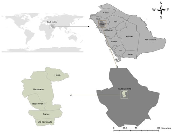
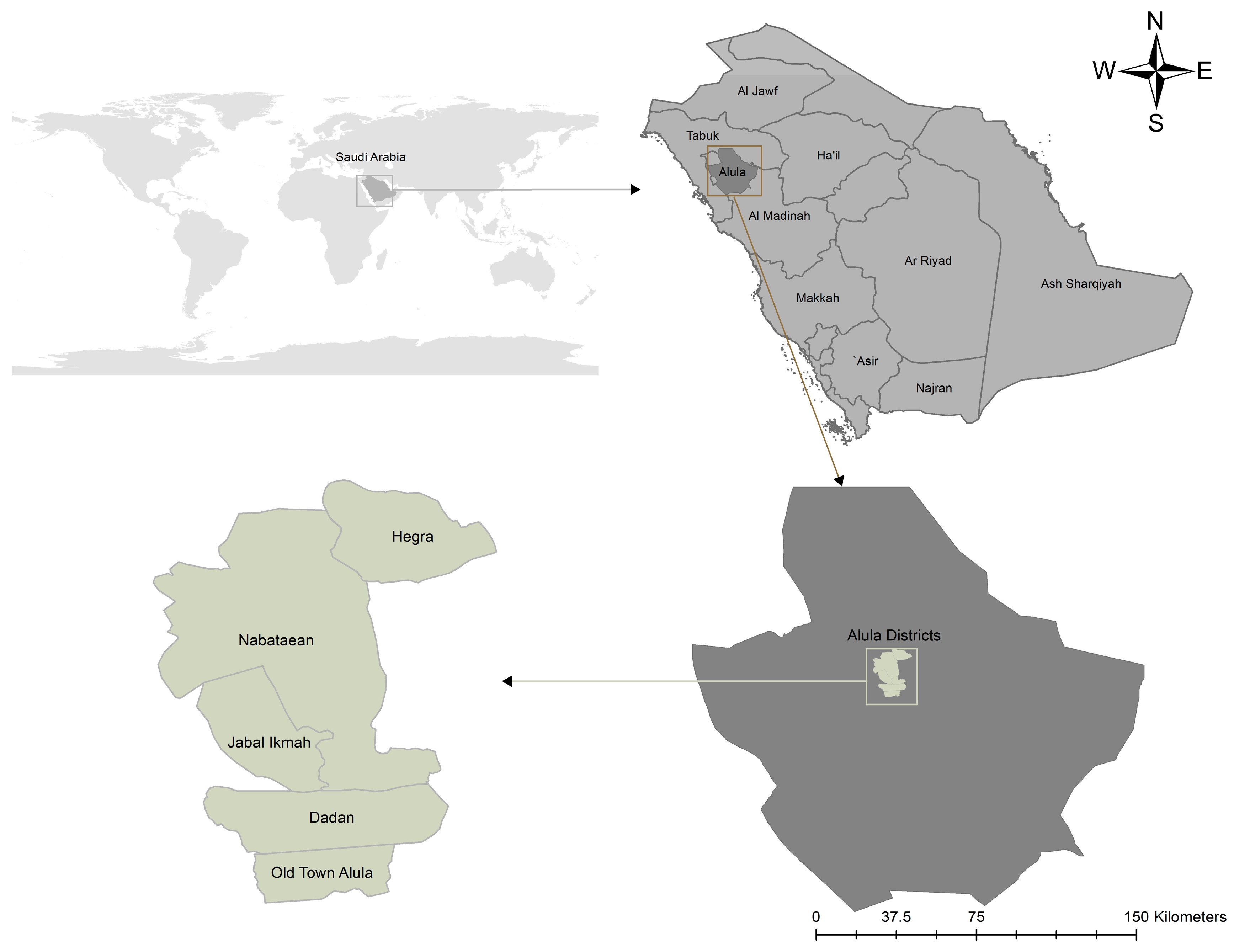
Al-Ula is an ancient city in northwestern Saudi Arabia, which is already being developed into a world open-air museum and cultural site as a flagship project of the Saudi Arabian Vision 2030. Five distinctive regions are covered by the region: Al-Hegra (UNESCO World Heritage site), the Old Town (traditional heritage labyrinth), Dadan (ancient capital of the Dadanite and Lihyanite kingdoms), the Nabatean area, and the open-air library of the ancient inscriptions (as shown in Figure 1) [41]. The preservation of these heritage sites is a strategic focus of Saudi Arabia in ensuring a sustainable tourism interest to improve the tourism package and enhance the national identity, as well as to appreciate the local customs [42].
Figure 1.
Study Area.
In 2023, Saudi Arabia received more than 100 million visitors, which is seven years earlier than its first target of 2030. In the case of Al-Ula, a city with a 40% annual growth in the number of visitors, more than 265,000 visitors were hosted in the city alone in 2023, which necessitates an urgent requirement to establish a smart pedestrian network to cater to the high growth of urban expansion and alleviate walking conditions [16]. The climate is hyper-arid, and the summer temperatures are often above 45 °C and can be over 50 °C in the open areas, which leads to the fact that the trail design should have thermal safety as a priority, and the risks associated with cardiovascular stress and air pollution should be reduced in the urban centers [36].
2.2. Staged Methodological Framework
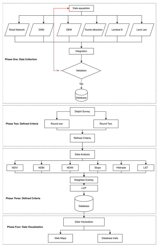
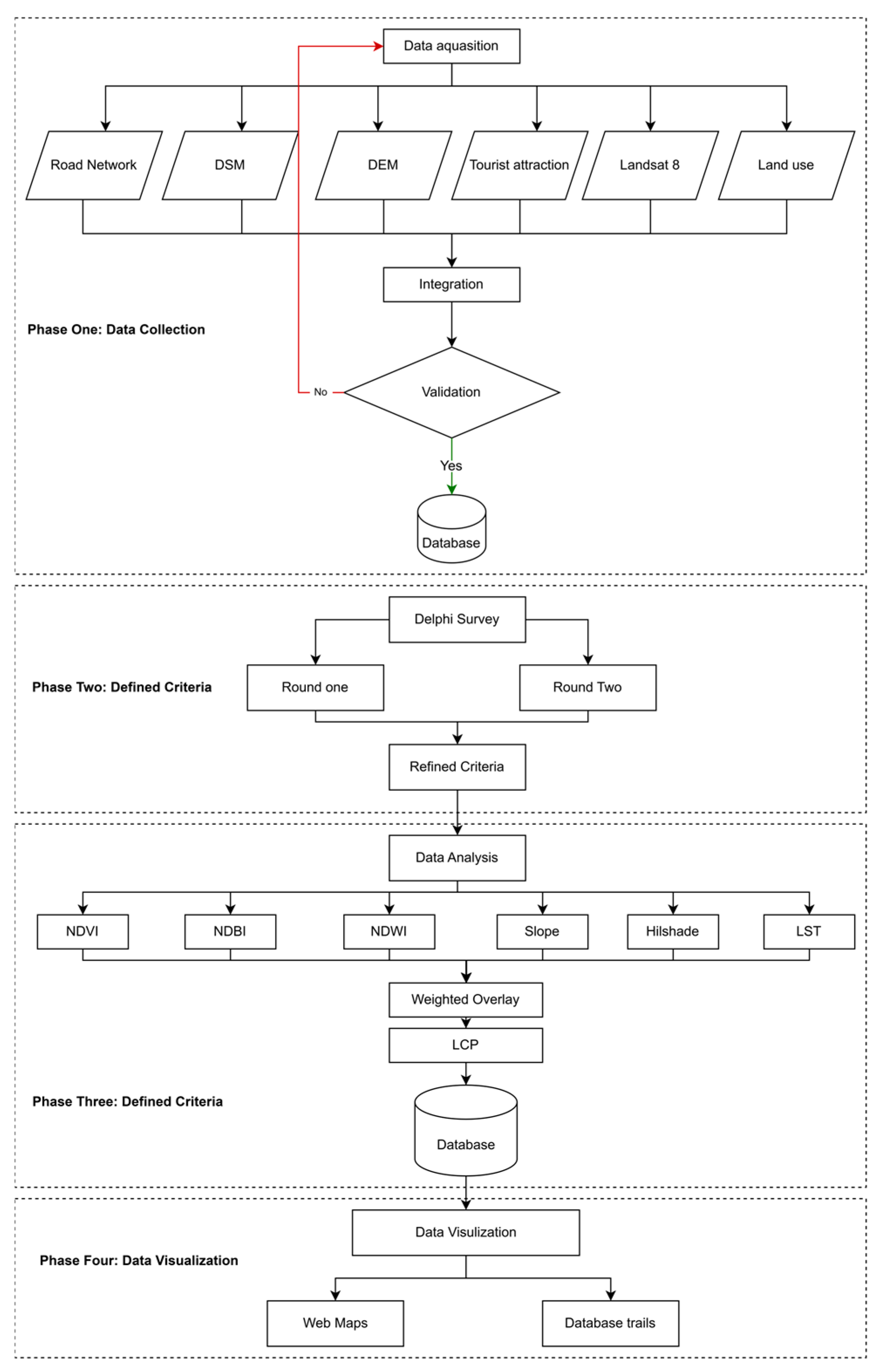
This study employed a structured four-stage framework designed to integrate spatial data with expert judgment, which is visualized in a flowchart. This practice-based approach operates on the foundations of community-based heritage management, which focuses on the inclusion and participation of local social capital via the regeneration processes of the area through the idea of the Rural Heritage Hubs.
2.2.1. Phase 1: Data Collection and Pre-Processing
The former stage was the acquisition of a high-resolution Digital Surface Model (DSM) and multi-spectral satellite imaging. DSM was derived at a resolution of 12.5 m to extract slope, aspect, and elevation. The DSM resolution (12.5 m) represents a trade-off between spatial coverage and detail. While suitable for regional-scale analysis, finer-resolution data may improve pedestrian-scale accuracy. Additionally, LST values represent specific temporal conditions and may vary seasonally. These models are sensitive because with small spatial resolutions of slope data, the accuracy of forecasting moving times and the similarity between simulated tracks are far higher [43]. Detailed models are created by using high-resolution aerial surveying and cadastral maps, which are used to generalize the relief to support successful routing in recreation areas. Land cover classification and thermal analysis were obtained using satellite imagery of Landsat 8 OLI/TIRS and Sentinel-2. The Landsat Band 10 was picked by LST retrieval, as it has lower uncertainty over Band 11 [44]. The pre-processing involved radiometric calibration and atmospheric correction, which are required to guarantee the precision of spectral indices, which is a mandatory measure to conduct ecological performance analysis and track the changes in land-use over time [45].
2.2.2. Phase 2: Refinement of Expert Indicator (Delphi Survey)
The three-round Delphi survey was developed to ensure that the framework captured the priorities of the management. The Delphi technique is a sequential communication tool that allows teams of professionals to contribute to understanding complicated issues, including harmonizing different ideas on visitor management and sustainable indicators [46]. A panel comprising fifteen experts representing academia, government planning, and the tourism industry was sampled through purposive sampling. This stakeholder consultation is essential in finding a consensus in management practices and resolving the trade-offs between management and environmental conservation of tourism [47].
Round 1: During this round, experts confirmed an original list of environmental cues (LST, slope, shadow, vegetation, built-up density, and moisture). The step entailed the collection of both theoretical and conceptual knowledge by conducting key informant interviews to ascertain the correctness of the indicators that are being selected [48].
Round 2: Pairwise comparison was carried out in the context of the AHP scale (19). The pairwise comparison method of multi-criteria analysis enables specialists to prioritize criteria in both conservation and development aspects and underscore the most viable strategies [49].
Round 3: The final weights have been adjusted according to the panel feedback. The validation of the weights through iterative refinement makes the methodology more objective and flexible in examining various alternatives in decisions. The measurement statistical consensus was the Kendall Coefficient of Concordance (W). There was also a Consistency Ratio (CR) to guarantee that the weights given to the criteria were logically steady and proved the validity of the procedure [50]. The selected experts were chosen based on their experience in GIS, tourism planning, and environmental management. While the sample size (n = 15) aligns with established Delphi studies, potential selection bias and sample limitations are acknowledged. Future studies may expand the expert panel and conduct sensitivity analysis.
2.2.3. Phase 3: Spatial Analysis and Spectral Indices
Each indicator was classified into suitability ranges based on its impact on pedestrian comfort and environmental sensitivity. Higher LST values indicate increased thermal stress and lower suitability, while higher NDVI values represent cooling effects and improved walkability. Similarly, slope gradients were categorized to reflect physical effort and accessibility constraints. The selection of these indicators was based on their direct influence on thermal comfort, ecological preservation, and mobility efficiency in hyper-arid environments.
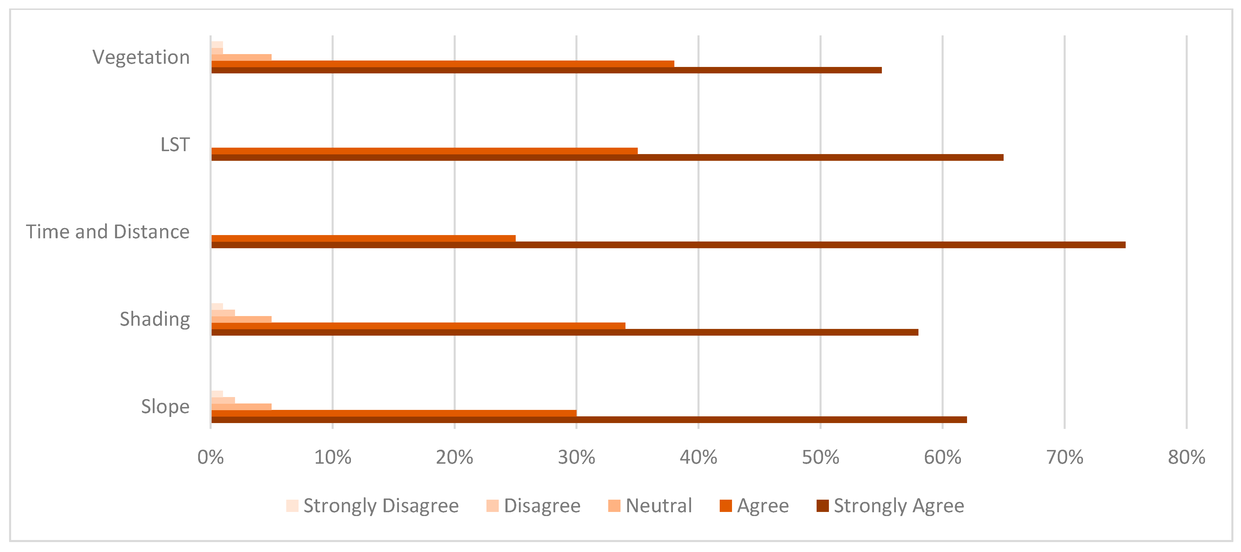
The distributions were reconstructed proportionally based on the agreement percentages illustrated in Figure 2 to ensure graphical reproducibility and clarity, where agreement levels reached 92% for slope, 92% for shading, 100% for time and distance, 100% for Land Surface Temperature (LST), and 93% for vegetation. The evaluated indicators include slope (representing terrain difficulty), shading (indicating thermal protection), time and distance (reflecting travel efficiency), Land Surface Temperature (LST) as a measure of thermal stress, and vegetation (indicating cooling effects).
Figure 2.
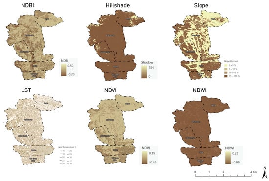
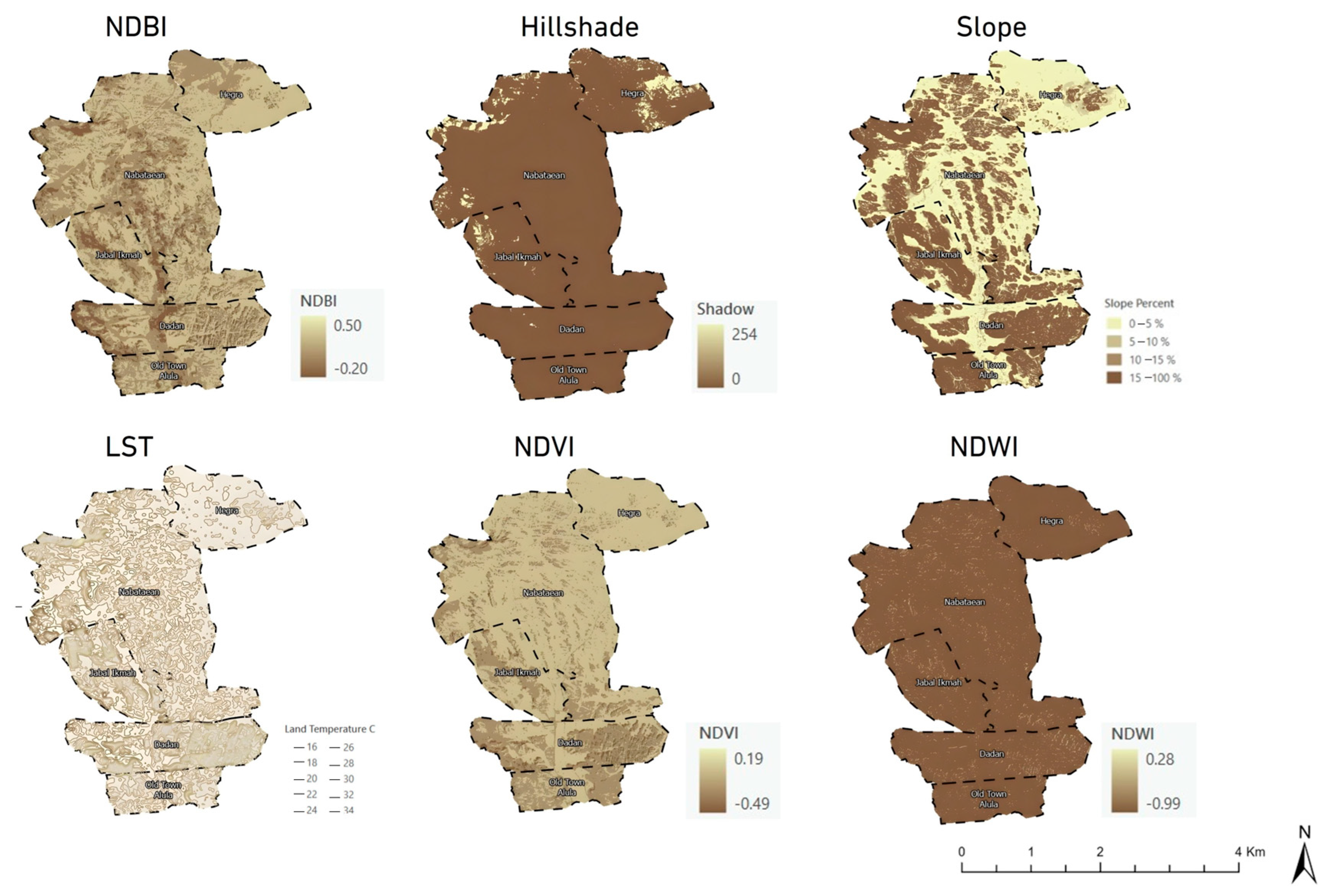
Spectral indices and microclimatic surface characterization derived by GIS.
NDVI (Normalized Difference Vegetation Index): It is used to determine transpiration cooling areas. NDVI becomes the most significant cause of spatial differences in LST, and the regions of healthy vegetation coincide with colder thermal groups [31].
LST (Land Surface Temperature): The thermal bands were used to compute it with emissivity correction. The LST values are also much different between various types of land-use, with the hottest temperatures of the summer in exposed rocky terrain and inhabited land.
NDBI (Normalized Difference Built-up Index): This is employed in order to distinguish between natural terrain and a built-up area that therefore reflects a lot of heat. The high density of built-up space has a positive effect on median LST in urban and rural areas, highlighting why the urban greening process is necessary to reduce the heat island effect [36,45].
Hillshade Analysis: This is used to compute the daytime shade cover, the location of so-called thermal sanctuaries, which are naturally shaded by rock features. A more subtle view of the geographic proximity and the amount of energy used by people can be seen by visualizing energetic cost surfaces and paths of least caloric effort on Digital Elevation Models [51].
2.2.4. Phase 4: Optimization and Trail Routing
The composite friction surface (F) was calculated using a weighted linear combination of normalized environmental variables as follows:
where w1–w5 represent weights derived from the Delphi–AHP process. All variables were standardized to a common scale (0–1) prior to integration. This formulation allows direct incorporation of microclimatic and topographic constraints into the routing model.
F = w1(LST) + w2(Slope) + w3(NDVI) + w4(NDBI) + w5(Hillshade)
The Least Cost Path (LCP) algorithm was used to find the least cost trail across the weighted friction surface, which was the final optimization. The LCP analysis calculates the fastest or the most energy-efficient paths through constructions of the friction surfaces depending on the visibility data, surface distance, and slope degree [16]. Per pixel costs were allocated depending on the weighted average of environmental indicators. This method involves the use of a topographical network that helps in routing at minimum costs in accordance with the exertion parameters of the gradient and surface attributes of the road [52]. Trails were divided into three (Easy, Mid, and Hard) according to a mixture of slope impedance and thermal load. This classification ensures that the proposed trails meet the needs of diverse user groups, the requirements of various visitor groups, and, at the same time, reduce negative effects on both natural and cultural resources [5]. The analysis was conducted using ArcGIS 10.8.2. All raster layers were resampled to a uniform spatial resolution of 12.5 m to ensure consistency. Indicator values were normalized using min–max scaling, and cost values were standardized before integration into the friction surface. This harmonization ensures comparability across datasets and stability of the LCP results.
2.3. Statistical Rigor and Derivation of Weights
The results of the Delphi were used to obtain the priority weights of the GIS model, which were calculated by the analytic hierarchy process (AHP). The method of AHP is a solidly proven MCDM tool in sustainable tourism studies and has been applied to evaluate tourism destinations in terms of multiple stakeholder interests and sustainability indicators [53]. The values were put in a pair-wise comparison matrix to compute Eigenvectors, which are relative values. Such an algorithm is organized and can be applied to consider physical and environmental variables and use satellite shots to support the decision-making process in tourism zoning [54]. A Consistency Ratio (CR) of below 0.10 was required to attain the reliability of the expert judgment. The accuracy check with the help of the CR makes the weights that are applied in the multi-criteria spatial decision analysis sound and logically consistent [50]. The study’s four-stage and structured framework aimed to combine spatial data and professional judgment, which is visualized in a flowchart in Figure 3:
Figure 3.
Adopted Methodological framework.
3. Results
3.1. The Delphi Survey
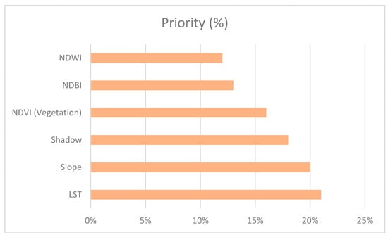
The Delphi survey led to a high level of consensus amongst the panel on the six indicators in the environment that are significant. The statistical findings have been summarized in Table 3, and the weights have been depicted in Figure 4. This was a collaborative process that enabled the stakeholders to come to a general conclusion regarding the most suitable zones to develop, taking into consideration the environmental, economic, and societal requirements.
Table 3.
Descriptive Statistics and Priority Weights for Environmental Indicators.
Figure 4.
Priority Weights of Environmental Indicators Derived from the Delphi Survey.
A Kendall’s W value of 0.82 indicates strong agreement among experts. This agreement is important because it offers a powerful policy base to identify the ecotourism suitability and tourism development plans on a regional basis [9]. Although minor variations in standard deviation were observed, the high Kendall’s W value confirms strong agreement among experts, indicating that the distribution of responses does not affect the robustness or reliability of the prioritization process. The fact that LST (21%) and slope (20%) have been prioritized above the rest proves that thermal load is taken to be as important as topography when it comes to trail safety in arid conditions. These results correlate with the findings of the literature that point out distance from water and slope as the high-priority criteria in assessing the suitability of land to ecotourism [50].
3.2. Analysis of Space and Surface Characterization
As shown in Figure 5, the topographic slope analysis found low slopes (0–5) to be best used by families and seniors, with steep slopes (greater than 15) dedicated to fitness-oriented paths known as Hard. Greater resolutions of Digital Elevation Models need to be used in mountainous regions, because less detailed data may lead to poorer predictions of the moving times, which is crucial to the planning of effective routes [43]. Heterogeneity of LST was very high as observed through microclimatic analysis. Exposed rock and bare soil experienced peak daytime temperatures, and palm oases and narrow corridors were found to be associated with the cool islands.
Figure 5.
Topographical Slope Analysis of Al-Ula Landscape.
Hillshade analysis revealed natural shading in the middle of the day, which was the major “comfort” layer for the route. The visual openness and perceived greenness were also modeled to increase the knowledge of perception of the landscape, which has a positive correlation with the amount of non-motorized trail traffic [20]. The high NDVI values were an indication of healthy landscapes that were needed to feel comfortable. This study confirms that a higher vegetation density and reduced building densities have a positive correlation with the degree of thermal comfort and thus are useful in guiding ecological restoration planning [55]. Moreover, a correlation analysis shows that the paved area cover is positively related to PET and UTCI, showing the negative effect of hardscape features on the comfort of outdoors [35].
3.3. Optimized Path Network and Sustainability Metrics
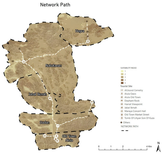
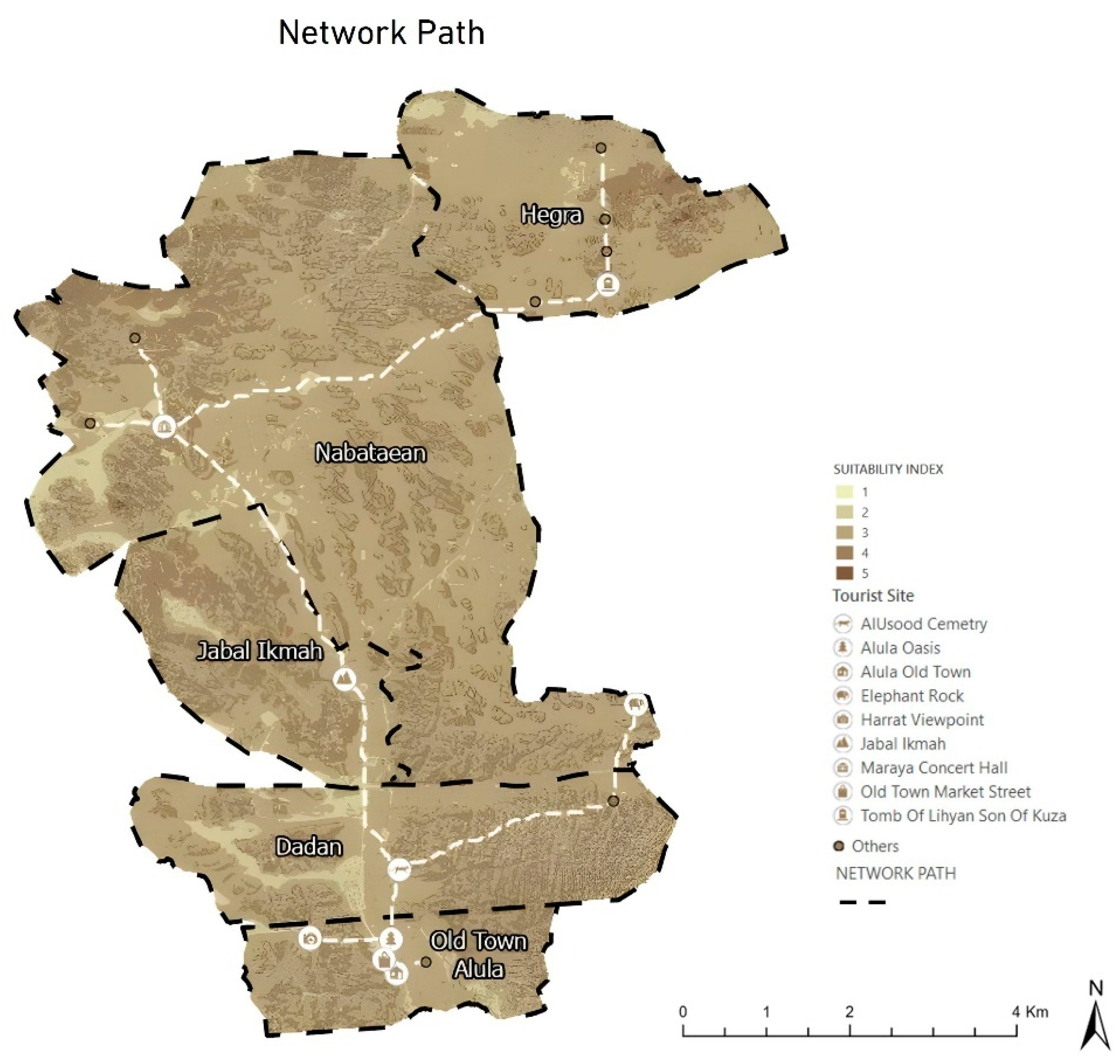
The optimized 44.5 km path network is shown in Figure 6, and is ranked in terms of difficulty. Table 4 gives the network statistics. The allocation of tourist traffic to these newly researched sites is an effective approach to over-tourism as well as the elimination of congestion in the established heritage sites [3].
Figure 6.
The Final Optimized Integrated Path (white dashes lines) Network for Al-Ula.
Table 4.
Path Statistics and Sustainability Quantification for the Integrated Network.
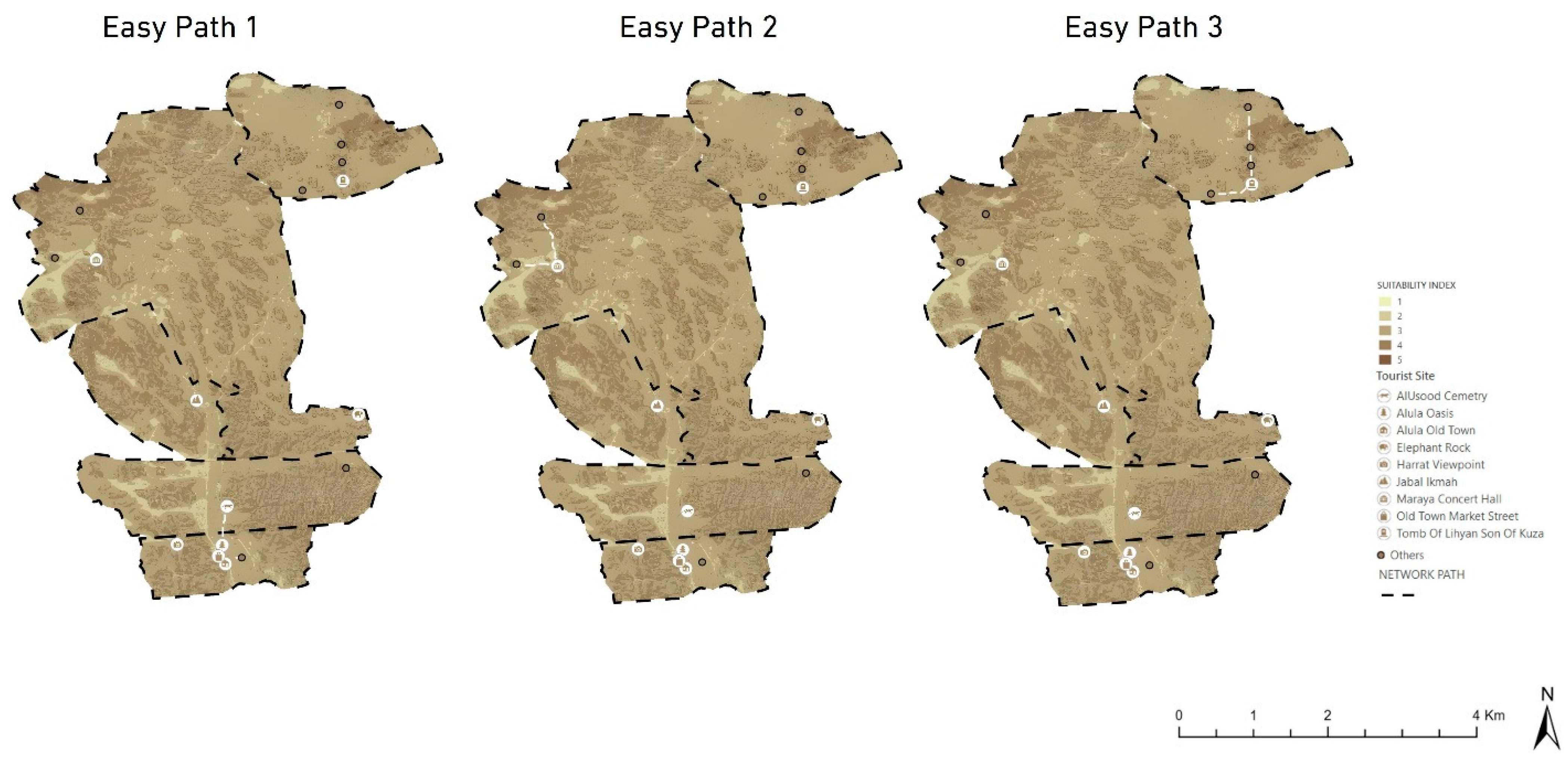
3.3.1. Easy Paths
These paths (as shown in Figure 7) are also designed with accessibility in mind, and may be considered as similar to the “cultural experience” routes mentioned in the recent literature, which are differentiated according to the special emphasis on leisure and sightseeing rather than physical activity [56]. They are similar to the ”Golden Leaves Paths” [11] in Italy, which are intended as open virtual and physical itineraries pathways linking the villages. Costantino, Mantini, Benedetti, Bartolomei and Predari [11] explored how a digital survey combined with web technologies can enable the creation of a network that supports territorial as well as cultural patrimony in the village.
Figure 7.
Easy-Level Paths (white dashes lines) Linking Secondary Attractions in Al-Ula.
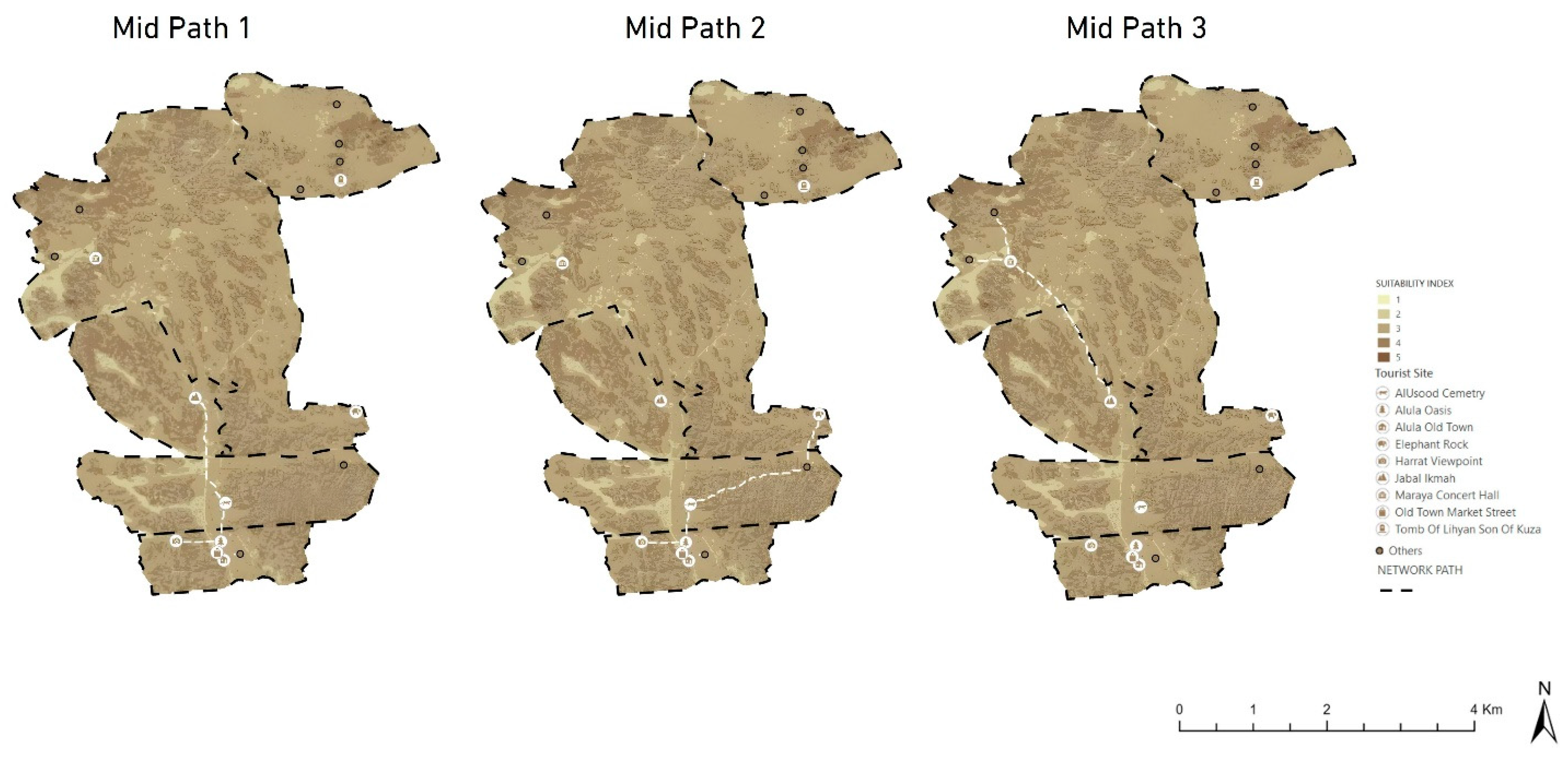
3.3.2. Mid Paths
The Mid-level Paths, depicted in (Figure 8), provide further links and alternative pathways to secondary attractions, which offer the customer greater choice. These mid-range paths present a compromise between overall accessibility and environment sensitivity, by using moderate grade routes that bypass the most sensitive or steepest areas depicted in the suitability analysis. In broadening the network, the Mid-level also helps to relieve pressure on main trails and to accommodate a wider range of visitor fitness levels and interests. Path statistics in terms of length and difficulty indexes for this network are also given in (Table 1). Recent studies by [57] advocate for the addition of intermediate trail difficulty levels, with benefits to visitor distribution, ecosystem damage reduction, and overall trail system resilience.
Figure 8.
Mid-Level Paths (white dashes lines) Linking Secondary Attractions in Al-Ula.
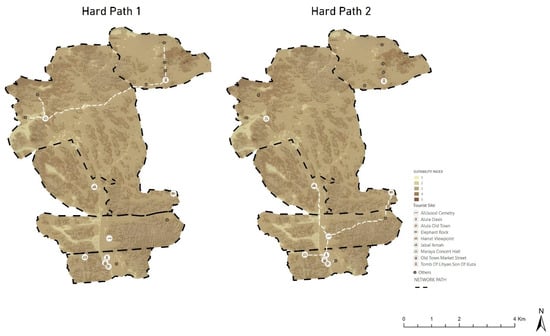
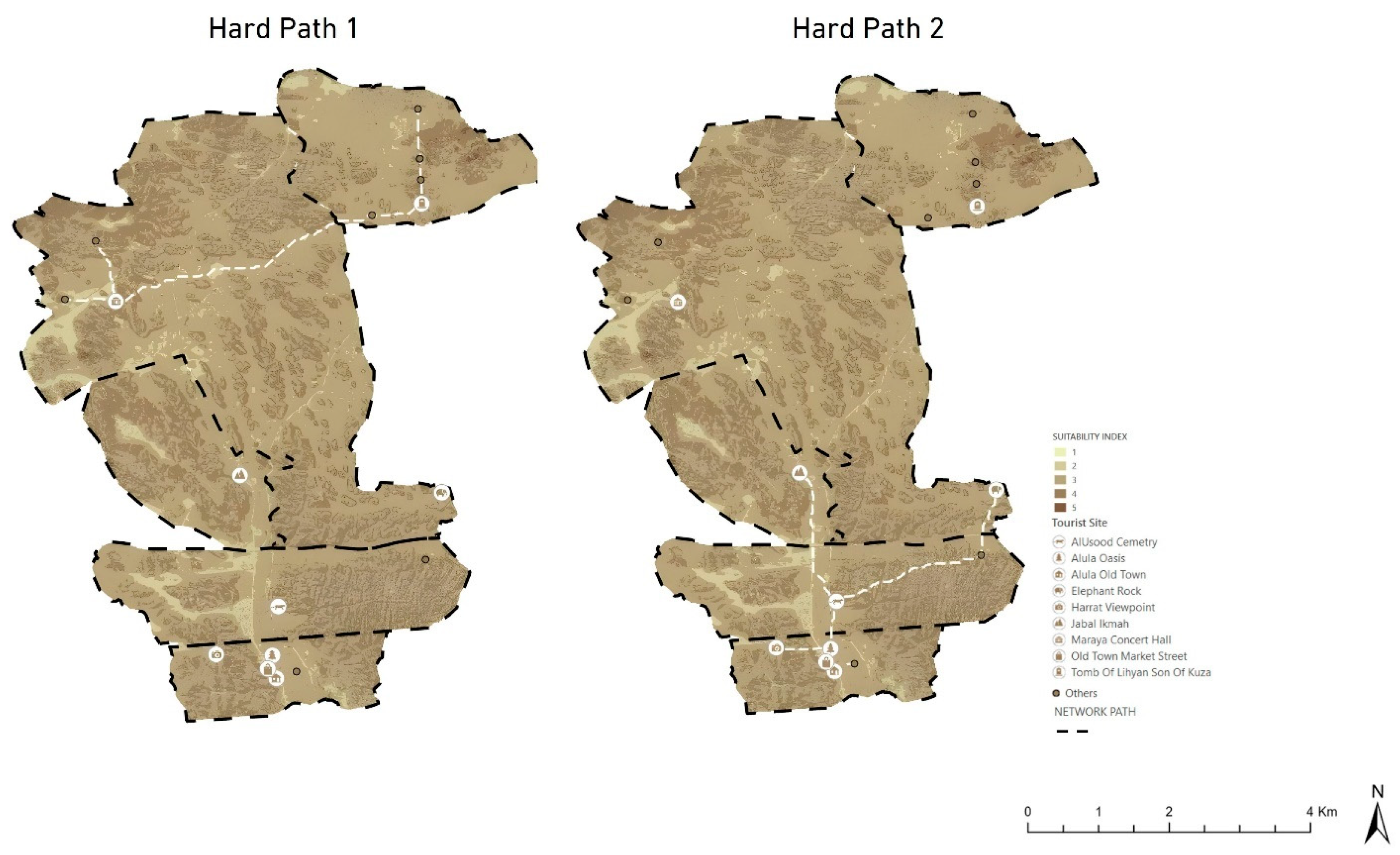
3.3.3. Hard Paths
These routes (Figure 9) are created for users who enjoy the challenge of doing such strenuous workouts. Like “sports and fitness” tour routes found in Baiwangshan Forest Park by Jiao and He [56], these trails exploit steeper terrain to deliver gymnasium-like user experiences. Jiao and He used GIS to calculate elevation and slope factors, and the created routes reflected the humanized efficiency and rationality of forest park planning.
Figure 9.
Hard-Level Paths (white dashes lines) Linking Secondary Attractions in Al-Ula.
Caloric expenditure was estimated using a modified version of Tobler’s hiking function, which relates walking speed to slope. Energy consumption was calculated by incorporating terrain gradient and distance into a metabolic cost model, allowing comparison between optimized and shortest-path routes. The LCP model reduces caloric expenditure by up to 24% compared to the shortest path models. This reduction in energy expenditure contributes directly to improved pedestrian safety in hyper-arid environments by lowering physical fatigue and reducing the risk of heat stress, dehydration, and cardiovascular strain during prolonged exposure to high temperatures. It is done through the use of metabolic equations to compute the least calorie expenditure paths, surpassing the conventional quantification with consideration to human preferences in energy savings [39]. By replacing car travel with this infrastructure, the CO2 emission of heritage trips can be cut by about 50% with this infrastructure. Carbon reduction was estimated by comparing average vehicle-based emissions per trip with equivalent walking-based scenarios, using standard emission factors per kilometer. The shift from motorized transport to pedestrian movement resulted in an estimated reduction of approximately 50% in CO2 emissions. Well-designed walking infrastructure supports a modal shift toward active transportation that underlies the model of the 15 min city, where connectivity enhances the livability and safety of cities [40].
4. Discussion
This study aimed to develop a scientifically grounded framework for designing sustainable walking trails in the hyper-arid cultural landscape of Al-Ula, balancing visitor comfort, heritage conservation, and environmental sustainability. To achieve this, this research adopted an integrated methodology combining GIS-based spatial analysis, remote sensing-derived microclimatic indicators, and a three-round Delphi–AHP multi-criteria decision-making process to weight environmental and thermal variables. The findings demonstrate that Land Surface Temperature and topographic slope are the most influential determinants of trail suitability in desert environments, highlighting the critical role of thermal exposure in shaping pedestrian mobility. The optimized trail network not only improves energetic efficiency but also contributes to carbon reduction and better distribution of visitor flows, supporting both environmental protection and sustainable tourism development.
The findings of the presented paper highlight a shift in the paradigm of trail planning in arid areas: walkability is not only dependent on topographic distance, but mostly on thermal exposure. This change is crucial since, with urbanization, the temperatures rise considerably, and neglecting to consider such changes may result in the spread of heat-related illnesses. The support of giving the LST (21%) the highest weight of priority is highly justified according to newer evidence of other arid metropolitan centers. In Kuwait, Alahmad, Tomasso, Al-Hemoud, James and Koutrakis [27] found that there was a daytime Urban Cool Island (UCI) effect in which the temperature of the surfaces of the shaded or vegetated urban spaces was considerably lower than that of the surrounding desert, which was barren. This day, the temperature is cool, with an average of −1.1 °C in Kuwait, which is a complex condition of successful climate change adaptation practices and improvement of outdoor thermal comfort [27].
Heat and cool islands are especially difficult to characterize in desert landscapes where bare soil tends to act unusually unlike in the countryside [45]. The LST mapping in Al-’Ula showed that the Old Town, with its high-walled passages and a thick canopy of the palm oases, is the thermal sanctuary. It agrees with observations in Baghdad, where conventional arid urban forms could lower the mean radiant temperature (Tmrt) by up to 10.5 °C in relation to contemporary Western-style layouts [30]. Moreover, lower vegetation cover in the regions can also help reduce the heat, and it provides the sky-view factor to the night radiation flux, but enhances the daytime comfort of the pedestrians [29]. The introduction of LST into the LCP algorithm verifies the metric of Cool Walkability, which identifies shade as the key factor in promoting active movement within spaces with high exposure to sunlight [51]. The shade cumulative cooling effect is a very crucial element in the endurance of the pedestrian that traditional models tend to ignore [29]. The concept of “Cool Walkability” is aligned with established thermal comfort frameworks, emphasizing the role of microclimatic conditions in shaping pedestrian experience. While LST serves as a proxy indicator, future studies may incorporate advanced indices such as PET or UTCI.
Observations of hot-arid city climates such as Tempe, Arizona, have demonstrated that building and tree shading have cumulative effects of reducing LST; morning shading has the potential to reduce afternoon peak temperatures by up to 11.3 °Con exposed surfaces [29]. Our LCP model, based on a hillshade, takes advantage of this effect by directing trails along corridors, which have long periods of shadow cover, and practically transforming the sensation of warmth in visitor comfort to neutral [30]. Subjective evaluations indicate that individuals can adapt to local climatic conditions, supporting the design of thermally responsive urban spaces to the local environment, also indicating the application of the local comfort data to the design of performative urban spaces that can be used even in the season of overheating [30]. This flexibility is critical to urban resilience because when subjected to extreme heat conditions, coupled with air pollution, there is a significant threat to health in fast urbanizing arid areas [36].
The inclusion of NDVI and NDBI in the spatial framework would help facilitate the ecological and archeological integrity of Al-Ula. The palm oases, which serve to offer transpirational cooling, are also sensitive biological resources characterized by high NDVI. These natural land coverings play a major role in thermal regulation, but on the contrary, surface heat and the creation of severe heat islands are amplified by built-up expansion [58]. The model identifies conservation areas, which will not be involved in the hard infrastructure development, to avoid degrading the resources and preserving the ecological equilibrium by adopting a criteria-based zoning strategy such as the Sustainable Tourism Infrastructure Planning (STIP) framework implemented in Sri Lanka [5]. This combined method of conservation of nature focuses on ranking the criteria, including the area of habitat and the quality of water, to replicate the various assessment lenses [49]. This is in line with the concept of the Ecotourism Potential Assessment, which focuses on environmental monitoring through satellite data to determine the appropriate sites, besides gauging the susceptibility of the site to any anthropogenic activity [15].
The purpose of the “Mid Paths”, designed in this paper, is a crucial managerial role of distributing visitor flows not only around the main attractions but also necessary since, due to the large number of visitors, archeological sites can be endangered [5]. The Al-’Ula framework would handle this issue of carrying capacity, which is to identify the secondary points of interest that have high interpretive value and low current traffic, leading to the creation of a so-called Slow Tourism model that encourages more involvement in the cultural environment [7]. The construction of tourism corridors that spread historical culture contributes to the regeneration of tangible and intangible heritage, which stimulates the ordinary development of every region along the path [59].
Also, these trails can improve the preservation of the intangible cultural heritage, including traditional crafts and festivals, adding to the visitor experience and reinforcing the identity of local communities [60,61]. The stakeholders should be involved in planning, which is necessary to ensure that the development is built in accordance with the needs and values of the community, as has happened in the Kambo Tourism Village, where the cooperation of stakeholders led to the creation of a sustainable and inclusive masterplan [46]. Effective strategies that promote tourism competitiveness and the stability of the environment and culture in the long term include the use of inclusive governance models, which engage the academia, government, and community members [61,62]. It is also possible to utilize digital tools to promote geotourism and, consequently, make the heritage sites more visible and contribute to the local productivity, as shown by the Priorities UNESCO Global Geopark in the COVID-19 pandemic [10].
The sustainable pedestrian infrastructure focus of the framework is directly in line with Vision 2030 and the National Tourism Strategy in Saudi Arabia. Saudi Arabia is proactively working on non-oil economies, and reforming the tourism sector is one of the foundations of the country’s policy to become the best in the world in further development [42]. Due to this vision, the Kingdom stimulates the glorification of local culture and Islamic tradition to enhance national identity and offer services of world standards in the sphere of hospitality [42]. The heritage villages rehabilitation and the participation of the local communities are at the core of the awareness creation of the Saudi culture and enhancement of the local investment in the tourism offers [42]. Smart County Program and Digital Twin system of Royal Commission for Al-’Ula can be used to combine this trail model to improve the real-time analytics of visitors and accessibility [41]. These efforts are supplemented by the modernization of the national airports and the Mecca Metro project, which offered a sustainable economy and public transportation to international visitors [42].
The ability of heritage trails to boost the local economy is not new; similar initiatives in Italy have demonstrated that physical itineraries between villages can fight depopulation and create new business opportunities for local masters [11]. The intangible cultural heritage, including food and wine memories, can also improve the experiential value of the visitors and increase the quality of life of the residents by turning social capital into economic capital [60,61]. The importance of public–private partnerships is also vital, as it uses a combination of both the tools of the policy of the state and the funds of the business sector to preserve and utilize heritage resources in a sustainable manner. Such collaborations can help in ensuring community involvement and responsible development where the economic gains of tourism are shared fairly throughout the region [63]. Prioritizing the concept of Slow Tourism in green infrastructures, Al-’Ula will be able to serve as a regional identity symbol, revitalizing the local community and addressing the aspect of access and alleviating the disparity in regions [7]. The strategy directly addresses the strategic priorities of Vision 2030, as it facilitates a successful and sustainable model of global excellence [42].
The methodological level of the research is the next step of the current research, GIS-LCP, where the two-dimensional surface of friction is replaced with a multidimensional surface. Although the conventional models emphasize the slope, our model includes a new cost, the Thermal Friction Layer, which takes the Land Surface Temperature and hillshade-calculated solar exposure as its main cost [52,64]. This consideration of microclimatic conditions increases the predictive degree of human mobility models in mountainous landscapes since the steep cost structure is more indicative of the human apprehension of effort and exaggeration of slopes [64]. This will solve the major void in the knowledge of the effect of microclimatic conditions on human route choice in mountainous arid regions [65]. The STRIDE model proved that walking rate is more accurate with the magnitude of the lidar-derived measures of surface roughness and vegetation density by 80% [18]. The ability of airborne lidar to measure three-dimensional vegetation and terrain structure with high spatial resolution is needed to predict walking rates in a wide range of environments, generating significantly more accurate but much larger estimates of travel time compared to slope-only models [18].
Our framework adds to the latter with remote sensing spectral indices (NDVI, NDBI) to capture the entire range of landscape structure and evaluate ecological sensitivity to regional planning [66]. We have developed a strong weighting model, which lowers subjectivity and vagueness of group decision-making by incorporating a three-round Delphi survey to statistically prove these criteria [67]. Moreover, the creation of routing systems on the sidewalk that would take into account individual accessibility profiles will guarantee the safety and negotiability of the routes by pedestrians with various mobility requirements that go beyond vehicle-focused methods [22]. With the development of geoinformation technologies that may be used to derive orthophotos by using UAVs, high-resolution digital surface models, etc., the generalization of the relief models and the possibility of mapping the potential barriers to travelers can be made. This spatial assessment is not bound by the rigid hierarchies and can offer a common planning option to factor in the technical information and a professional opinion to create a resilient landscape [68]. The combination of perception-based research and spatial analysis makes this approach to the study of walkability a comprehensive assessment of a healthier and more efficient urban environment [16].
Sustainability measurement of this network indicates that there are great environmental gains. The quality of the pedestrian infrastructure will allow a transition between vehicle-based and active transportation. Replacing motorized journeys with walks is also a good solution to make cities more accessible and comfortable to the residents and to reduce greenhouse gas emissions [16]. It has been observed that the average CO2 caused by travel can be reduced by about 75 per cent in the case of heritage-bound trips by walking or cycling, and that travel transportation emissions can be reduced on a large scale in cities. At the individual level, every walking trip will be able to save extensive quantities of CO2 and help the goals of the international community on climate resilience and environmental sustainability [69]. The network helps the 15 min city model, where all the necessary facilities and cultural resources are within a walking radius, making the streets livelier and minimizing the distance of trips [16].
In Al-Ula, this density and land-use hybrid is translated into a decrease in fuel use and traffic jams at large hubs such as Hegra and Old Town, and more sustainable and habitable urban environments were formed [16,36]. Moreover, the energetic cost analysis takes into consideration that our LCP model uses 24% of the amount of calories needed to travel through rough terrain as compared to the traditional shortest-path models, which improves the quality of the visitor experience and promotes the creation of active mobility [19]. Unhealthy sun exposure is likely to inhibit active mobility because of global warming, which is why shade is an affordable measure to reduce health hazards associated with heat. He or she is supported by a comfortable thermal environment, allowing people to walk to promote physical and mental health, productivity, and engagement in the life of the people [31]. A limitation of this study is the absence of empirical validation using field data or user-based assessments. Future research should incorporate GPS tracking and visitor feedback to validate the proposed trail network and assess its real-world applicability.
5. Conclusions
This study developed and tested an integrated GIS–Delphi–MCDM framework for designing sustainable walking trails in the hyper-arid cultural landscape of Al-Ula. By combining remote sensing data with expert-based weighting, the model addressed a critical planning challenge: how to balance visitor thermal comfort, heritage conservation, and energy-efficient mobility in extreme desert conditions. Unlike conventional routing approaches that focus mainly on distance or slope, the proposed model incorporated microclimatic factors, particularly Land Surface Temperature and solar exposure, into the cost surface, producing a more realistic representation of pedestrian movement in hot environments.
The findings demonstrate that thermal exposure and topographic slope are the most influential determinants of trail sustainability, confirming that walkability in desert heritage sites is strongly shaped by microclimatic stress. The optimized 44.5 km network reduces caloric expenditure by up to 24% compared to traditional shortest-path models and has the potential to lower heritage-related transport emissions by approximately 75% through modal shift from vehicles to walking. Beyond mobility efficiency, the framework supports spatial redistribution of visitor flows, protects ecologically sensitive zones, and enhances the long-term resilience of Al-Ula as a living cultural landscape aligned with Vision 2030 objectives.
Future research should incorporate real-time visitor behavior data, high-resolution 3D thermal modeling, and adaptive decision-support systems to further improve predictive accuracy and management responsiveness. Additional investigation is also needed on vegetation strategies, governance models, and the long-term socio-economic impacts of heritage trail systems in arid regions.
In this study, we introduced a microclimatic friction surface within a GIS-based least cost path model and validated its criteria through a structured Delphi process. We demonstrated that integrating thermal comfort into spatial decision-making significantly improves the sustainability and practical performance of walking infrastructure in extreme desert environments.
Author Contributions
Conceptualization, A.A.; methodology, A.M.; software, R.M.S., A.A. and A.F.; validation, R.M.S. and A.F.; formal analysis, R.M.S. and A.A.; investigation, R.M.S. and A.M.; resources, A.F.; data curation, R.M.S. and A.A.; writing—original draft preparation, R.M.S.; writing—review and editing, R.M.S. and A.M.; visualization, R.M.S. and A.F. All authors have read and agreed to the published version of the manuscript.
Funding
The project was funded by KAU Endowment (WAQF) at King Abdulaziz University, Jeddah, Saudi Arabia.
Institutional Review Board Statement
In accordance with the institutional policies of King Abdulaziz University and relevant national research regulations, this study was conducted in full compliance with the principles of the Dec-laration of Helsinki, particularly with regard to voluntary participation, informed consent, ano-nymity, and data confidentiality, and does not require formal ethical approval, as it is a low-risk, non-interventional study involving voluntary expert participation and does not include any sensi-tive personal data.
Informed Consent Statement
Informed consent was obtained from all subjects involved in the study.
Data Availability Statement
The data presented in this study are available on request from the corresponding author.
Acknowledgments
The authors acknowledge with thanks WAQF and the Deanship of Scientific Research (DSR) for technical and financial support. Also, the authors acknowledge the use of artificial intelligence-based language tools to assist with improving the clarity, readability, and linguistic quality of the paper. The AI tools were utilized primarily for language enhancement and editing support. All conceptual formulation, methodological design, data analysis, interpretation of results, and final scientific judgments remain the sole responsibility of the authors.
Conflicts of Interest
The authors declare no conflict of interest.
References
- Telfer, D.J.; Sharpley, R. Tourism and Development in the Developing World; Routledge: New York, NY, USA, 2015. [Google Scholar]
- World Travel & Tourism Council. Business Travel Set to Surpass Pre-Pandemic Levels to Reach a Record US$1.5 trillion in 2024. Available online: https://wttc.org/news/business-travel-set-to-surpass-pre-pandemic-levels-to-reach-a-record-us1-5-trillion-in-2024 (accessed on 24 March 2024).
- Allouche, F.K.; Bouzaida, D.O.; Souguir, A.L.; Gad, A.-A. Integrated Remote Sensing and GIS Applications for Mapping diverse Landscapes and Potential Touristic Destination in Zarzis, Tunisia. Int. J. Innov. Sci. Res. 2016, 26, 435–444. [Google Scholar]
- Agnes, D.; Nandatama, A.; Isdyantoko, B.A.; Nugraha, F.A.; Ghivarry, G.; Aghni, P.P.; ChandraWijaya, R.; Widayani, P. Remote sensing and GIS-based site suitability analysis for tourism development in Gili Indah, East Lombok. In Proceedings of the IOP Conference Series: Earth and Environmental Science; IOP Publishing: Bristol, UK, 2016; p. 012013. [Google Scholar]
- Boers, B.; Cottrell, S. Sustainable tourism infrastructure planning: A GIS-supported approach. Tour. Geogr. 2007, 9, 1–21. [Google Scholar] [CrossRef] [Scilit]
- Al-Matarneh, R.T. Sustainable urban development in historical cities using the heritage trail approach: A case study of the old city of Karak, Jordan. J. Cult. Soc. Dev. 2015, 12, 48–60. [Google Scholar]
- Balletto, G.; Milesi, A.; Ladu, M.; Borruso, G. A dashboard for supporting slow tourism in green infrastructures. A methodological proposal in Sardinia (Italy). Sustainability 2020, 12, 3579. [Google Scholar] [CrossRef] [Scilit]
- Somoza Medina, X.; Lois González, R.C.; Somoza Medina, M. Walking as a cultural act and a profit for the landscape. A case study in the Iberian Peninsula. GeoJournal 2023, 88, 2171–2186. [Google Scholar] [CrossRef] [Scilit]
- Acharya, A.; Mondal, B.K.; Bhadra, T.; Abdelrahman, K.; Mishra, P.K.; Tiwari, A.; Das, R. Geospatial analysis of geo-ecotourism site suitability using AHP and GIS for sustainable and resilient tourism planning in West Bengal, India. Sustainability 2022, 14, 2422. [Google Scholar] [CrossRef] [Scilit]
- Fassoulas, C.; Nikolakakis, E.; Staridas, S. Digital tools to serve geotourism and sustainable development at Psiloritis UNESCO Global Geopark in COVID times and beyond. Geosciences 2022, 12, 78. [Google Scholar] [CrossRef] [Scilit]
- Costantino, C.; Mantini, N.; Benedetti, A.C.; Bartolomei, C.; Predari, G. Digital and territorial trails system for developing sustainable tourism and enhancing cultural heritage in rural areas: The case of San Giovanni Lipioni, Italy. Sustainability 2022, 14, 13982. [Google Scholar] [CrossRef] [Scilit]
- Giliberto, F.; Labadi, S. Harnessing cultural heritage for sustainable development: An analysis of three internationally funded projects in MENA Countries. Int. J. Herit. Stud. 2022, 28, 133–146. [Google Scholar] [CrossRef] [Scilit]
- Sieng, K.T.; Eboy, O.V.; Pugh-Kitingan, J.; Bee, B.B.B.; Bagul, A.H.B.P.; Baco, Z. Megalithic stone heritage trail mapping using GIS as tourism product for cultural sustainability in Tambunan. Sustainability 2023, 15, 3714. [Google Scholar] [CrossRef] [Scilit]
- Potsiou, C.; Ioannidis, C.; Soile, S.; Boutsi, A.-M.; Chliverou, R.; Apostolopoulos, K.; Gkeli, M.; Bourexis, F. Geospatial tool development for the management of historical hiking trails—The case of the holy site of Meteora. Land 2023, 12, 1530. [Google Scholar] [CrossRef] [Scilit]
- Amin, G.; Haroon, E.; Imtiaz, I.; Saqib, N.U.; Shahzad, M.I. Ecotourism potential assessment for Gilgit-Baltistan, Pakistan using integration of GIS, remote sensing, AHP and crowd-sourced data. Geocarto Int. 2022, 37, 8724–8745. [Google Scholar] [CrossRef] [Scilit]
- Alshammari, T.O. Smart pedestrian network is an approach for promoting walkability: A case of Riyadh city. Period. Eng. Nat. Sci. 2022, 10, 40–56. [Google Scholar] [CrossRef] [Scilit]
- Fonseca, F.; Ribeiro, P.; Jabbari, M.; Petrova, E.; Papageorgiou, G.; Conticelli, E.; Tondelli, S.; Ramos, R. Smart Pedestrian Network: An integrated conceptual model for improving walkability. In Proceedings of the International Conference on Society with Future: Smart and Liveable Cities, Braga, Portugal, 4–6 December 2019; pp. 125–142. [Google Scholar]
- Kudinov, S.; Smirnov, E.; Malyshev, G.; Khodnenko, I. Planning optimal path networks using dynamic behavioral modeling. In Proceedings of the International Conference on Computational Science, Wuxi, China, 11–13 June 2018; pp. 129–141. [Google Scholar]
- Gowen, K.M.; de Smet, T.S. Testing least cost path (LCP) models for travel time and kilocalorie expenditure: Implications for landscape genomics. PLoS ONE 2020, 15, e0239387. [Google Scholar] [CrossRef] [Scilit]
- Burow, S.; Majors, J. Assessment of the Impact of the Indianapolis Cultural Trail: A Legacy of Gene and Marilyn Glick. 2015. Available online: https://hdl.handle.net/2450/11297 (accessed on 24 March 2024).
- Valls, F.; Roca, J. Visualizing digital traces for sustainable urban management: Mapping tourism activity on the virtual public space. Sustainability 2021, 13, 3159. [Google Scholar] [CrossRef] [Scilit]
- Zhang, Y.; Mehta, S.; Caspi, A. Collecting sidewalk network data at scale for accessible pedestrian travel. In Proceedings of the 23rd International ACM SIGACCESS Conference on Computers and Accessibility, Virtual, 18–22 October 2021; pp. 1–4. [Google Scholar]
- Tang, Z.; Zhao, Y.; Fu, M. Towards human-centered urbanization: Interaction effects of multidimensional environmental factors on walk score in mountain cities’ urban trails. Environ. Dev. Sustain. 2025, 27, 1–19. [Google Scholar] [CrossRef] [Scilit]
- Tuydes-yaman, H.; Sevinen, P.K.; Oncu, Z.P.; Dalkic, G. Towards a New Walking Evaluation Approach: Power of Surveys and Route-based Evaluations in GIS Environment. Kocaeli J. Sci. Eng. 2022, 5, 212–226. [Google Scholar] [CrossRef] [Scilit]
- Mansourihanis, O.; Soltani, A.; RoohaniQadikolaei, M. Promoting sustainable urban tourism in Historic Sari, Iran through GIS-based walkability planning. Sci. Rep. 2026, 16, 5746. [Google Scholar] [CrossRef] [Scilit]
- Adepitan, A.A. Modeling Active Transportation Demand using GIS-Integrated Spatial Econometrics to Evaluate Infrastructure Accessibility, Sustainability, and Equity in Urban Mobility. Int. J. Comput. Appl. Technol. Res. 2025, 14, 1–15. [Google Scholar]
- Alahmad, B.; Tomasso, L.P.; Al-Hemoud, A.; James, P.; Koutrakis, P. Spatial distribution of land surface temperatures in Kuwait: Urban heat and cool islands. Int. J. Environ. Res. Public Health 2020, 17, 2993. [Google Scholar] [CrossRef] [Scilit]
- Hsu, A.; Sheriff, G.; Chakraborty, T.; Manya, D. Disproportionate exposure to urban heat island intensity across major US cities. Nat. Commun. 2021, 12, 2721. [Google Scholar] [CrossRef] [Scilit]
- Rchid, A. The effects of green spaces (Palme trees) on the microclimate in arides zones, case study: Ghardaia, Algeria. Energy Procedia 2012, 18, 10–20. [Google Scholar] [CrossRef] [Scilit]
- Ridha, S.; Ginestet, S.; Lorente, S. Adopting a sustainable urban design to improve thermal comfort in an arid climate. J. Eng. Sustain. Dev. 2023, 27, 171–179. [Google Scholar] [CrossRef] [Scilit]
- Puliafito, S.E.; Bochaca, F.R.; Allende, D.G.; Fernandez, R.P. Green areas and microscale thermal comfort in arid environments: A case study in Mendoza, Argentina. Atmos. Clim. Sci. 2013, 3, 372–384. [Google Scholar] [CrossRef]
- Ayman El Deeb, D.; Nagy Sarhan, A.; Sobhy Kandile, Y. The Use of Green Design Strategies for Achieving Thermal Comfort (Applying PMV as a Measurement Tool). Eng. Res. J. 2021, 171, 35–46. [Google Scholar] [CrossRef] [Scilit]
- Djaghrouril, D.; Boudjellal, L.; Afren, R.; Benabbas, M. The Universal Thermal Climate Index (UTCI) applications for microclimatic analysis in urban thermal environments. Case study; Oasis University campus, Algeria. Technium Soc. Sci. J. 2023, 39, 873. [Google Scholar]
- Ballout, A.; Lacheheb, D.E.Z.; Bouchahm, Y. Improvement of thermal comfort conditions in an urban space (Case study: The square of independence, Sétif, Algeria). Eur. J. Sustain. Dev. 2015, 4, 407–416. [Google Scholar] [CrossRef] [Scilit]
- Liu, B.; Lian, Z.; Brown, R.D. Effect of landscape microclimates on thermal comfort and physiological wellbeing. Sustainability 2019, 11, 5387. [Google Scholar] [CrossRef] [Scilit]
- Espinoza-Molina, J.; Acosta-Caipa, K.; Chambe-Vega, E.; Huayna, G.; Pino-Vargas, E.; Abad, J. Spatiotemporal analysis of urban heat islands in relation to urban development, in the vicinity of the atacama desert. Climate 2022, 10, 87. [Google Scholar] [CrossRef] [Scilit]
- Rahaman, L.A.; Naharudin, N. Assessing potentially walkable heritage trail in Johor Bahru, Malaysia, using analytical hierarchical process and Geographical Information System. Plan. Malays. 2024, 22, 315–328. [Google Scholar] [CrossRef] [Scilit]
- Jurkus, E.; Taminskas, J.; Povilanskas, R.; Kontautienė, V.; Baltranaitė, E.; Dailidė, R.; Urbis, A. Delivering tourism sustainability and competitiveness in seaside and marine resorts with GIS. J. Mar. Sci. Eng. 2021, 9, 312. [Google Scholar] [CrossRef] [Scilit]
- Nourian, P.; Rezvani, S.; Valeckaite, K.; Sariyildiz, S. Modelling walking and cycling accessibility and mobility: The effect of network configuration and occupancy on spatial dynamics of active mobility. Smart Sustain. Built Environ. 2018, 7, 101–116. [Google Scholar] [CrossRef] [Scilit]
- Nourian, P.; Rezvani, S.; Sariyildiz, S.; van der Hoeven, F. Urban configuration analysis for walking and cycling via easiest paths. In Proceedings of the eCAADe 2015 33rd Annual Conference, Vienna, Austria, 16–18 September 2015; pp. 16–18. [Google Scholar]
- Royal Commission for Alula. About Alula. Available online: https://www.rcu.gov.sa/en/about-us/about-alula/ (accessed on 14 May 2024).
- Mazzetto, S. Sustainable heritage preservation to improve the tourism offer in Saudi Arabia. Urban Plan. 2022, 7, 195–207. [Google Scholar] [CrossRef] [Scilit]
- Molnár, A.J. Modeling the Variety of Trip Opportunities in Recreational Route Networks. Inf. Model. Knowl. Bases XXXIII 2022, 343, 264–288. [Google Scholar]
- Abaas, Z.R. Impact of development on Baghdad’s urban microclimate and human thermal comfort. Alex. Eng. J. 2020, 59, 275–290. [Google Scholar] [CrossRef] [Scilit]
- Aicha, C.; Moussadek, B.; Djamila, D. The Effect of Sky View Factor on the Thermic Ambiances: Case of Batna City. Int. J. Innov. Stud. Sociol. Humanit. 2022, 7, 209–220. [Google Scholar] [CrossRef] [Scilit]
- Kunwar, R.R.; Pandey, C. Tamang heritage trail: A study of Gatlang village in Rasuwa District of Nepal. Gaze J. Tour. Hosp. 2014, 6, 1–41. [Google Scholar]
- Lally, A.M.; O’Donovan, I.; Quinlan, T. Stakeholder engagement in destination management: Exploring key success factors. In Proceedings of the 11th Annual Tourism and Hospitality Research in Ireland Conference (THRIC 2015), Letterkenny, Ireland, 11–12 June 2015; Available online: https://research.thea.ie/handle/20.500.12065/1233 (accessed on 24 March 2024).
- Bunruamkaew, K.; Murayama, Y. Land use and natural resources planning for sustainable ecotourism using GIS in Surat Thani, Thailand. Sustainability 2012, 4, 412–429. [Google Scholar] [CrossRef] [Scilit]
- Aminu, M. A Geographic Information System (GIS) and Multi-Criteria Analysis for Sustainable Tourism Planning; Universiti Teknologi Malaysia Johor Bahru: Johor, Malaysia, 2007. [Google Scholar]
- Adigana, M.; Setyono, J.S. Ecotourism site suitability using GIS and AHP: A case study of Ngargoyoso district in Karanganyar Regency. Int. J. Ind. Eng. Comput. 2019, 4, 1893–1898. [Google Scholar] [CrossRef] [Scilit]
- Tanaka, K.-I.; Miyashiro, R.; Miyamoto, Y. A layered network formulation for the safe walking route design problem. J. Adv. Mech. Des. Syst. Manuf. 2018, 12, JAMDSM0065. [Google Scholar] [CrossRef] [Scilit]
- Vartholomaios, A. Follow the shade: Detection of optimally shaded pedestrian paths within the historic city center of Thessaloniki. In Proceedings of the IOP Conference Series: Earth and Environmental Science; IOP Publishing: Bristol, UK, 2023; p. 012070. [Google Scholar]
- Li, H.; Lin, Y.; Wang, Y.; Liu, J.; Liang, S.; Guo, S.; Qiang, T. Multi-criteria analysis of a people-oriented urban pedestrian road system using an integrated fuzzy AHP and DEA approach: A case study in Harbin, China. Symmetry 2021, 13, 2214. [Google Scholar] [CrossRef] [Scilit]
- Oladi, J. Feasibility study on ecotourism potential areas using remote sensing and geographic information system (Case study: Abbasabad forest area, Veresk, Iran). Casp. J. Environ. Sci. 2012, 10, 83–90. [Google Scholar]
- Elnabawi, M.H.; Hamza, N. Outdoor thermal comfort: Coupling microclimatic parameters with subjective thermal assessment to design urban performative spaces. Buildings 2020, 10, 238. [Google Scholar] [CrossRef] [Scilit]
- Jiao, Y.; He, Z. GIS-Based Touring Route Planning for Forest Parks-Baiwangshan Forest Park as an Example. In Proceedings of the IOP Conference Series: Earth and Environmental Science; IOP Publishing: Bristol, UK, 2022; p. 012008. [Google Scholar]
- Kroeff, L.L.; Verdum, R. IDENTIFICAÇÃO DE ÁREAS POTENCIAIS AO MAPEAMENTO DE TRILHAS ECOTURÍSTICAS NA PROPRIEDADE DO ECOPARQUE, EM CANELA/RS. Rev. Bras. De Geomorfol. 2011, 12, 131–136. [Google Scholar] [CrossRef] [Scilit]
- Diego, d.M.B.; Souza-Silva, M.; Vasconcellos, A.; Bellini, B.C.; Prous, X.; Ferreira, R.L. Subterranean “oasis” in the Brazilian semiarid region: Neglected sources of biodiversity. Biodivers. Conserv. 2021, 30, 3837–3857. [Google Scholar] [CrossRef] [Scilit]
- Wu, Z.; Ma, J.; Zhang, H. Spatial reconstruction and cultural practice of linear cultural heritage: A case study of Meiguan Historical Trail, Guangdong, China. Buildings 2023, 13, 105. [Google Scholar] [CrossRef] [Scilit]
- Koščak, M. Heritage trails through Dolenjska and Bela Krajina in Slovenia: A multi-stakeholder approach to tourism development. TIMS Acta 2016, 10, 109–118. [Google Scholar] [CrossRef] [Scilit]
- Cornellia, A.; Priyambodo, T.; Gusriza, F. Crafting Sustainable Destinations: Integrative Models from Desa Wisata Sambirejo, Yogyakarta, Indonesia. J. Media Manag. 2025, 1, 1–6. [Google Scholar]
- Della Spina, L.; Giorno, C. Cultural landscapes: A multi-stakeholder methodological approach to support widespread and shared tourism development strategies. Sustainability 2021, 13, 7175. [Google Scholar] [CrossRef] [Scilit]
- She, C.; Michelon, G. A governance approach to stakeholder engagement in sustainable enterprises—Evidence from B Corps. Bus. Strategy Environ. 2023, 32, 5487–5505. [Google Scholar] [CrossRef] [Scilit]
- Landmark, K.; Messel, E. Hierarchical path planning for walking (almost) anywhere. Int. Arch. Photogramm. Remote Sens. Spat. Inf. Sci. 2018, 42, 109–116. [Google Scholar] [CrossRef] [Scilit]
- Andreev, S.; Dibbelt, J.; Nöllenburg, M.; Pajor, T.; Wagner, D. Towards realistic pedestrian route planning. In Proceedings of the 15th Workshop on Algorithmic Approaches for Transportation Modelling, Optimization, and Systems (ATMOS 2015), Patras, Greece, 17 September 2015; pp. 1–15. [Google Scholar]
- Andalu, A.; Naik, M.G.; Budde, S. Spatio-temporal analysis of land use and land cover (LULC) changes using an object-based image analysis (OBIA) approach: A case study of Telangana state agglomeration, India. GeoJournal 2025, 90, 135. [Google Scholar] [CrossRef] [Scilit]
- Ocampo, L.; Ebisa, J.A.; Ombe, J.; Escoto, M.G. Sustainable ecotourism indicators with fuzzy Delphi method—A Philippine perspective. Ecol. Indic. 2018, 93, 874–888. [Google Scholar] [CrossRef] [Scilit]
- Lazoglou, M.; Angelides, D.C. Development of a spatial decision support system for land-use suitability assessment: The case of complex tourism accommodation in Greece. Res. Glob. 2020, 2, 100022. [Google Scholar] [CrossRef] [Scilit]
- Liu, Y.; He, J. Pedestrian Environment Optimization of Xiaobailou District of Tianjin. MUHON J. Archit. Landsc. Archit. Des. Environ. 2019, 2, 31–42. [Google Scholar]

Disclaimer/Publisher’s Note: The statements, opinions and data contained in all publications are solely those of the individual author(s) and contributor(s) and not of MDPI and/or the editor(s). MDPI and/or the editor(s) disclaim responsibility for any injury to people or property resulting from any ideas, methods, instructions or products referred to in the content. |
© 2026 by the authors. Licensee MDPI, Basel, Switzerland. This article is an open access article distributed under the terms and conditions of the Creative Commons Attribution (CC BY) license.