


Abstract
Mountainous regions often experience a hydrological paradox where high monsoon rainfall coincides with severe dry-season water scarcity. The Chittagong Hill Tracts (CHT) of southeastern Bangladesh represent this challenge, as steep terrain, fractured geology, rapid runoff and limited monitoring constrain sustainable water-resource planning. This review critically evaluated water-resource characteristics, modeling approaches and decision-support strategies for the CHT. The literature shows that standalone models such as SWAT, MODFLOW and SWMM are useful for specific water-cycle components but do not adequately represent cross-domain processes including deep recharge, baseflow and stream–aquifer exchange in steep, complex terrain. International analogue studies indicate that coupled surface water–groundwater models can improve process representation when streamflow, groundwater-level, lithological and recharge data are available. However, their direct calibration and validation in the CHT remain limited by sparse groundwater monitoring and weak hydrogeological characterization. CHT-related and comparable Bangladesh studies indicate that machine-learning (ML) models can improve predictive suitability mapping when representative training data and independent validation are available; however, their relative advantage over the Analytic Hierarchy Process (AHP) is application-specific and depends on data quality, validation design, spatial autocorrelation, and model interpretability. The review identifies three key gaps: inadequate groundwater monitoring, absence of calibrated coupled modeling for fractured aquifers, and limited integration of socio-economic factors in rainwater-harvesting feasibility. Finally, a staged modeling pathway is proposed.
1. Introduction
Global water security is increasingly jeopardized by the dual pressures of climate change and rapid urbanization. Global water scarcity represents a major and increasing challenge, with approximately four billion people estimated to experience severe water scarcity for at least one month in a year [1]. This crisis is most acute in mountainous and hilly regions characterized by high runoff, low infiltration, and complex hydrogeology. As an extension of Hindu Kush Himalayan (HKH), the Chittagong Hill Tracts (CHT) (Figure 1) in southeastern Bangladesh presents a unique environmental paradox. Despite receiving higher annual monsoon rainfall ranging from 2000 to 4000 mm, the region is facing escalating water scarcity during the dry season [2]. The scarcity is driven by factors such as population expansion, changes in land use, rapid urbanization, traditional shifting cultivation (Jhum) and shifts in climate patterns, which have degraded the natural watershed [3,4,5].
Figure 1.
Study Area: Chittagong Hill Tracts [2].
The CHT covers approximately 10% of the country’s land area (12,395 km2) to accommodate diverse Indigenous communities and Bengali settlers [3,6,7]. Approximately 50% of the population suffers from severe dry-season water crisis in the CHT, particularly during the dry winter and summer months [8]. Groundwater extraction is constrained by the folded and fractured sedimentary geology of the CHT, where aquifer storage and flow depend strongly on lithology, structural position and fracture connectivity, increasing reliance on springs and seasonal surface-water sources [2,8]. Consequently, water levels have declined by up to 20 m in recent decades and more than 60% of households lack reliable access to safe drinking water [9]. To secure water availability in the dry season, suitable hydrological modeling is crucial for groundwater (GW), surface water (SW) and rainwater (RW) [10,11,12]. Hydrologic numerical models play a vital role in regulatory, planning, research, and decision-making activities. These models are fundamentally designed to represent water circulation in natural systems, helping to reconstruct historical events or to assess system responses under present or future scenarios, e.g., climate variability or land-use change [13,14]. Traditional watershed analysis often utilizes individual models, viz. the Soil and Water Assessment Tool (SWAT) for surface runoff, sediment, and nutrient transport [14,15,16] or the Modular Three-Dimensional Finite-Difference Groundwater Flow (MODFLOW) for groundwater flow dynamics [15,17]. Moreover, the Storm Water Management Model (SWMM), a rainfall–runoff model broadly utilized for continuous or single-event simulation of urban water quantity and quality, often focuses on flow routing through interconnected infrastructure [16,18]. On the other hand, for the simulation of the river system, various models have been recommended in the past, including the Hydrologic Engineering Center’s River Analysis System (HEC-RAS), Soil and Water Assessment Tool (SWAT), MIKE 11 (1D river modeling) and SWMM, which have been used widely for 1D simulations in rivers.
However, traditional hydrological models are limited to their specific simulation domain, either surface or subsurface, and often represent SW and GW interactions in a simplified manner. Relying on performance metrics derived from a single domain may not accurately represent the overall water system, as critical fluxes, such as baseflow, are the result of inter-domain interactions [14,15,19]. For instance, SW models may use simplified representations of deep groundwater dynamics, while groundwater models may poorly simulate surface runoff and infiltration processes, leading to limitations in representing critical physical realities, e.g., stream–aquifer interactions [19,20,21]. Coupled SW–GW models provide a more process-based framework for representing recharge, groundwater heads, streamflow fluctuation and baseflow contribution than standalone surface-water or groundwater models [19]. Coupled models, such as SWAT–MODFLOW and WEAP–MODFLOW, can improve the representation of runoff, recharge, groundwater heads and streamflow interactions where adequate input data and calibration targets are available [14,15,19,20,21,22,23,24]. However, their usefulness depends strongly on the availability of groundwater-level records, lithological information, streamflow observations, recharge estimates and appropriate calibration targets.
Hydrological modeling should be complemented by decision-support approaches that translate physical-process information into practical water-resource planning. GIS–RS, Multicriteria Decision Analysis (MCDA) and Analytic Hierarchy Process (AHP) are widely used for groundwater-recharge and rainwater-harvesting suitability screening, while machine-learning approaches increasingly support nonlinear spatial prediction [13,25,26]. Comparative studies indicate that machine learning (ML) models can provide higher predictive performance than AHP in some groundwater, erosion, and rainwater-harvesting suitability applications, particularly when representative training data and independent validation observations are available [27,28,29]. However, this advantage is application-specific rather than universal. Model performance varies with the prediction target, input-data quality, sample size, spatial autocorrelation, predictor selection, and validation design. AHP remains useful for transparent preliminary screening where field observations are limited, whereas ML is more appropriate for predictive refinement when adequate training and validation data are available. However, the relative suitability of these methods depends on data availability, validation design, interpretability and decision objectives.
Previous reviews of hydrological modeling in South Asia have largely focused on data-rich, flat alluvial plains or large, well-monitored river basins, leaving the CHT largely unaddressed. The novelty of this review lies in integrating SW, GW and RW evidence for the CHT within a common modeling and decision-support framework; distinguishing direct regional evidence from Bangladesh-relevant and international analogue evidence; critically evaluating model suitability against data availability, calibration and validation requirements and uncertainty; and proposing a staged pathway from reconnaissance screening and watershed modeling to targeted hydrogeological monitoring and pilot-scale coupled SW–GW simulation. This synthesis therefore goes beyond descriptive literature compilation by linking evidence strength, model–data compatibility, uncertainty and practical implementation for water-resource planning in the data-scarce CHT. Based on these gaps, this review addresses the following research questions:
- How do the hydro-physical and socio-economic characteristics of the CHT influence SW, GW and RW interactions?
- What are the strengths and limitations of standalone and coupled hydrological models for representing CHT water-resource processes?
- How effective are GIS–RS, MCDA, AHP and ML approaches in supporting groundwater recharge, rainwater harvesting and watershed-management decisions?
- What monitoring, modeling and policy gaps must be addressed to improve long-term water security in the CHT?
2. Methodology
A structured narrative review methodology was adopted to ensure the comprehensiveness, transparency, and replicability of the study.
2.1. Review Design
The review was designed to synthesize existing knowledge on SW, GW and RW interactions in the CHT, with particular emphasis on hydrological modeling, groundwater recharge assessment, RWH, GIS–MCDA, AHP and ML-based decision-support approaches. A structured narrative review rather than a formal systematic review or meta-analysis was adopted. This selection is due to the available evidence being heterogeneous in study design, geographical relevance, modeling objectives, datasets, and reported performance metrics. Nevertheless, systematic-style database searching, explicit eligibility criteria, transparent screening, and structured evidence classification were applied to improve reproducibility and reduce the potential for selection bias.
2.2. Literature Search Strategy
Relevant literature was searched from Scopus, Web of Science and Google Scholar. The search was conducted between November 2025 to May 2026. The year 2003 was selected as the lower boundary because several early studies on runoff, erosion and shifting cultivation in the CHT were published around this period, while the upper boundary captured the most recent developments in coupled hydrological modeling, machine learning and decision-support systems. The search strategy combined region-specific keywords, hydrological-process keywords, modeling tools and decision-support terms. The following Boolean search strings were used and adapted according to the syntax and search capabilities of each database:
2.2.1. Scopus Search String
TITLE-ABS-KEY (“Chittagong Hill Tracts” OR “Chattogram Hill Tracts” OR CHT OR “hilly Bangladesh” OR “southeastern Bangladesh”)
AND
TITLE-ABS-KEY (“surface water” OR groundwater OR rainwater OR recharge OR runoff OR spring OR baseflow OR “water scarcity”)
AND
TITLE-ABS-KEY (SWAT OR MODFLOW OR SWMM OR “HEC-HMS” OR “HEC-RAS” OR “SWAT-MODFLOW” OR “WEAP-MODFLOW” OR “hydrological modeling” OR “groundwater modeling” OR “rainwater harvesting” OR GIS OR “remote sensing” OR MCDA OR AHP OR “machine learning” OR “random forest” OR “boosted regression tree”)
2.2.2. Web of Science Search String
TS = (“Chittagong Hill Tracts” OR “Chattogram Hill Tracts” OR CHT OR “hilly Bangladesh” OR “southeastern Bangladesh”)
AND
TS = (“surface water” OR groundwater OR rainwater OR recharge OR runoff OR spring OR baseflow OR “water scarcity”)
AND
TS = (SWAT OR MODFLOW OR SWMM OR “HEC-HMS” OR “HEC-RAS” OR “SWAT-MODFLOW” OR “WEAP-MODFLOW” OR “hydrological modeling” OR “groundwater modeling” OR “rainwater harvesting” OR GIS OR “remote sensing” OR MCDA OR AHP OR “machine learning” OR “random forest” OR “boosted regression tree”)
2.2.3. Google Scholar Search Strings
Because Google Scholar does not support complex Boolean syntax in the same way as Scopus and Web of Science, several simplified keyword combinations were used:
- “Chittagong Hill Tracts” groundwater recharge rainwater harvesting
- “Chittagong Hill Tracts” water scarcity springs runoff
- “Chittagong Hill Tracts” hydrological modeling SWAT–MODFLOW
- “Hilly Bangladesh” groundwater potential GIS–AHP
- “Bangladesh” rainwater harvesting machine learning AHP
- “SWAT-MODFLOW” surface water–groundwater interaction hilly catchment
- “SWMM-MODFLOW” groundwater surface runoff interaction
- “GIS MCDA” groundwater recharge rainwater harvesting hilly terrain
Reference lists of highly relevant papers were also checked manually to identify additional studies that were not captured in the database searches.
2.3. Inclusion and Exclusion Criteria
Studies were included only when they satisfied both (i) a regional/thematic relevance criterion and (ii) a methodological or empirical-evidence criterion.
- (i)
- Regional/thematic relevance criterion
A study was required to meet at least one of the following conditions:
- directly focuses on the CHT or hilly regions of Bangladesh; or
- investigates a mountainous, steep, monsoon-dominated, fractured-aquifer, or data-scarce setting with clear relevance to hydrological or water-resource processes characteristic of the CHT.
AND
- (ii)
- Methodological or empirical-evidence criterion
A study was also required to:
- examine one or more water-resource processes relevant to the review, including SW, GW, RWH, runoff, recharge, springs, baseflow, or water scarcity; and
- either (i) apply, evaluate, or critically examine a relevant hydrological, hydraulic or groundwater model, including SWAT, MODFLOW, SWMM, HEC-HMS, HEC-RAS, SWAT, MODFLOW coupled surface water–groundwater models, GIS–MCDA, AHP, or ML methods; or (b) provide empirical hydrological, hydrogeological, environmental, or socio-economic water-security evidence needed to assess the applicability, limitations, or management relevance of these approaches in the CHT.
Studies were excluded if they:
- focused only on flat alluvial floodplains without relevance to hilly or fractured-terrain hydrology;
- focused only on coastal salinity, storm surge or tidal flooding without connection to CHT water-resource processes;
- did not contain hydrological, hydrogeological, modeling, decision-support or water-security relevance;
- lacked sufficient methodological detail to support critical assessment;
- were duplicate records, inaccessible full texts or non-technical commentaries;
- were non-peer-reviewed documents, unless they contained regionally important data not available in peer-reviewed sources.
2.4. Screening and Selection Process
A total of 182 records were initially identified. After removal of 31 duplicate records, 151 unique records remained for title-and-abstract screening (Figure 2). During this stage, 64 records were excluded because they were outside the thematic scope of the review, focused on unrelated coastal or floodplain settings, or did not address modeling, water-resource assessment or decision-support methods. The remaining 87 full-text records were assessed in detail. Of these, 24 records were excluded because they lacked sufficient methodological relevance, did not provide transferable evidence for hilly or data-scarce catchments, or duplicated findings already reported in more complete studies. Finally, 63 studies were retained for synthesis.
Figure 2.
PRISMA-type flow diagram showing the identification, deduplication, screening, eligibility assessment, and final inclusion of studies in this structured narrative review.
2.5. Classification of Reviewed Studies
To avoid overgeneralizing findings from different hydrological settings, the retained studies were classified into three evidence categories (Table 1): CHT-specific studies, Bangladesh-relevant studies and international analogue studies. CHT-specific studies were treated as the primary evidence base for identifying regional water-security challenges. Bangladesh-relevant studies were used to support interpretation where direct CHT evidence was limited. International analogue studies were used mainly to evaluate modeling approaches, coupled surface water–groundwater frameworks and decision-support methods that may be transferable to the CHT under appropriate data conditions.
Table 1.
Classification of reviewed studies according to geographical relevance and role.
This classification was used throughout the synthesis to avoid overgeneralizing findings from non-CHT settings. (Table 1). Conclusions regarding regional water scarcity, spring dependency, land-use pressure, rainwater harvesting potential and socio-economic vulnerability were primarily drawn from Category I studies. Category II studies were used to support interpretation where direct CHT evidence was limited but the hydrological or physiographic setting was relevant to Bangladesh. Category III studies were not treated as direct evidence for the CHT; instead, they were used to evaluate methodological strengths, limitations, data requirements and transferability of modeling and decision-support approaches. International analogue studies were retained only when they satisfied both eligibility criteria; geographical or methodological similarity alone was not considered sufficient without a clear and explicitly identifiable relevance to the hydrological processes or modeling challenges of the CHT.
2.6. Data Extraction and Synthesis
For each retained study, relevant information was extracted on study location, hydrological setting, data sources, modeling or decision-support method, calibration and validation approach, performance metrics, key findings, limitations and relevance to the CHT. Attention was given to whether the study addressed SW–GW interaction, groundwater recharge, spring/baseflow behavior, RWH potential, spatial suitability zoning, uncertainty or socio-economic feasibility. The synthesis was organized around four analytical themes:
- (a)
- hydro-physical and socio-economic drivers of water insecurity in the CHT;
- (b)
- SW, GW and RWH system dynamics;
- (c)
- strengths and limitations of standalone and coupled hydrological models; and
- (d)
- decision-support approaches, including GIS–MCDA, AHP and ML.
Because the reviewed studies differed in location, scale, data availability and modeling objectives, reported performance metrics such as NSE, RMSE, R2, PBIAS and Area Under the Curve (AUC) were not treated as directly comparable across all studies. Instead, they were used to identify methodological trends, relative strengths and limitations, and the suitability of different approaches for data-scarce mountainous catchments, i.e., the CHT.
During evidence synthesis, particular attention was given to potential transferability limitations. Findings from international analogue studies were assessed in relation to climatic regime, geological setting, aquifer characteristics, catchment scale, monitoring density, calibration variables, validation design, and model uncertainty. General hydrological and methodological statements were supported preferentially by multiple independent sources.
Assessment of Model and Decision-Support Suitability
The suitability assessments were developed from the evidence classification described in Section 2.5 together with information extracted from the reviewed studies. Each modeling or decision-support approach was considered in terms of six practical aspects: (i) how well it represents hydrological processes relevant to the CHT; (ii) whether its data requirements are compatible with the information currently available in the region; (iii) the level of calibration and independent validation required; (iv) its suitability for steep, fractured, monsoon-dominated and data-scarce catchments; (v) the main sources of uncertainty and limitations in transferring the method between locations; and (vi) its usefulness for the intended water-resource planning task.
Greater emphasis was placed on evidence from CHT-specific studies, followed by studies from comparable settings in Bangladesh. International analogue studies were mainly used to understand the capabilities, data requirements and transferability of the different methods where direct evidence from the CHT was limited. The terms low, medium and high used for data requirements are qualitative descriptions of the amount, resolution and range of information generally needed for model setup, calibration and validation. They should not be interpreted as numerical scores or rankings of model performance. The suitability assessments therefore reflect the overall consistency of evidence across relevant case studies rather than direct comparison of performance statistics obtained under different catchment, data and calibration conditions.
3. Hydro-Physical and Socio-Economic Settings
The CHT region is geographically characterized by undulating, erosive, and steep terrain [10,45] and represents a distinct hydrogeological zone within the HKH extension. This mountainous ecosystem provides important ecological and hydrological services but is highly vulnerable due to the combination of natural constraints and intensifying human interventions [7,9,12] The interaction of steep topography and low-permeability geology creates a flashy hydrological response, where rainwater flows downstream very quickly, leaving limited opportunity for infiltration and groundwater recharge [9]. Details are available in the following sub-sections.
3.1. Geological and Hydrogeological Setting
The CHT is characterized by folded sedimentary formations, principally the Dupi Tila and Tipam sandstones, with groundwater occurrence strongly influenced by anticlines, synclines, fractures, joints, faults and weathered bedding planes [9,36]. Unlike the extensive alluvial aquifers of central Bangladesh, groundwater storage and movement in the CHT are spatially heterogeneous and are partly controlled by secondary porosity associated with fractures and weathered zones. Consequently, aquifer continuity, hydraulic conductivity, recharge pathways and spring discharge may vary considerably over short distances, complicating groundwater abstraction, aquifer characterization and numerical modeling [9,36]. These geological conditions also promote localized preferential flow and create uncertainty in estimating recharge and SW–GW exchange.
3.2. Land-Use Dynamics and Hydrological Response
Human alteration of the landscape has become the primary driver of hydrological change in the CHT over the last few decades [7]. The region has experienced a major decline in forest cover, which is critical for maintaining water resources [46]. Historically, the CHT experienced loss of forest resources due to displacement and settlement following the construction of the Kaptai Dam, which has reduced natural infiltration, and increased surface runoff [9,30]. Studies indicate an exponential rise in forest fragmentation since 1990, while Jhum cultivation is traditional agricultural practice among Indigenous communities in the CHT [7,32,47]. This traditional agricultural practice involves clearing vegetation on hill slopes. Studies indicate that soil loss during the cultivation year is approximately six times higher than in fallow periods [47]. From a modeling perspective, this changes surface roughness, increases sediment production, degrades spring sources, and reduces stream capacity [7]. More than 80% of respondents believe that shifting cultivation in upland catchments causes water quality degradation [46]. Rapid infrastructure development to support tourism has led to a surge in built-up areas. Between 2010 and 2020, urban areas increased by 139% in Bandarban and 91% in Rangamati [7]. This conversion of green spaces to impervious surfaces such as roads and concrete reduces natural infiltration and prevents groundwater recharge, fundamentally disrupting the regional water balance [11,12,18,20].
3.3. Socio-Economic Impacts on Water Resources
Water scarcity in the CHT is deeply interconnected with socio-economic pressures (Table 2) [9]. Water demand is escalating rapidly due to population expansion and economic activities [46]. In tourist-heavy areas like Sajek, water demand rises by 10% annually due to population growth and tourism [3]. The high influx of tourists into the CHT has seriously jeopardized the local ecosystem and water resources [7]. Increased human use and the influx of tourists are perceived by communities as major factors contributing to water resource decline. Socio-economic factors like low income exacerbate the safe drinking water crisis for hilly residents. Despite the low income, the local cost of water in Sajek is reported to be five times higher compared to the general rate in areas supplied by the Chittagong WASA (CWASA). Low-income groups often cannot afford to buy freshwater bottles or jars [9]. CHT is home to numerous Indigenous communities, who are often poor and rely heavily on natural resources for their livelihoods [5,10,48].
Table 2.
Socio-hydrological drivers, impacts and consequences in the CHT.
Due to the hilly topography and lack of network-based water delivery systems, local people must walk long distances to collect water from streams and springs (Figure 3) [48]. This task is frequently carried out by women, posing time management challenges as they fulfill domestic responsibilities simultaneously [9]. Microbial contamination is a significant drinking-water concern in the CHT. In Sajek, Rangamati, fecal coliform concentrations reached 149 CFU/100 mL in Chara water during June and 155 CFU/100 mL during October, exceeding the reported national drinking-water limit of 0 CFU/100 mL [49]. Water scarcity also causes social issues, including conflicts over the scarce resources among rural communities and conflicts within families due to delays in domestic work and inadequate sanitation [3,46].
Figure 3.
Water Scarcity Drivers in the CHT [4,7,9,31,34,35,46,47,48,50,51].
4. Hydrological System Dynamics and Characterization
In the CHT, the interaction among SW, GW, and RW is strongly influenced by monsoon seasonality, steep terrain and land-use landcover (LULC) changes, which together drive rapid runoff and limit infiltration, reducing groundwater recharge (Figure 4). During the dry season, diminished recharge lowers baseflow and intensifies water scarcity, highlighting the need for integrated management approaches that link surface runoff control, RWH, groundwater recharge, and coupled SW–GW modeling.
Figure 4.
Conceptual framework of SW–GW–RW interaction in the CHT. High monsoon rainfall in the CHT is quickly converted into hill-slope runoff due to steep terrain, LULC changes, and limited infiltration, reducing groundwater recharge and weakening dry-season water availability.
4.1. Surface Water Dynamics and Runoff Characteristics
The surface hydrological regime of the CHT is characterized by extreme temporal disparity and a rapid response to precipitation events, typical of high-relief tropical catchments. The region’s main rivers, the Sangu and Matamuhuri, exhibit a distinct pluvial regime where discharge is tightly coupled with intense monsoon rainfall. Due to the steep catchment slopes, these rivers display a flashy hydrograph response with a short time of concentration (), where rainfall converts to peak runoff rapidly, leaving minimal opportunity for natural attenuation or infiltration. Quantitative analysis reveals that approximately 79–84% of the total annual runoff volume occurs during the wet season (May–October), with runoff coefficients ranging from 0.36 to 0.49. This high runoff-to-rainfall ratio indicates the watershed’s limited depression storage and low soil permeability. Conversely, dry-season flows (November–April) contribute only 16–21% of the annual volume [52]. Trend analysis further indicates increasing wet-season runoff, which raises the risk of flash floods, and decreasing dry-season runoff, which intensifies seasonal water scarcity.
Sediment transport and non-point source pollution represent major stressors on the surface water system. Land-use practices, particularly shifting cultivation (Jhum) on steep slopes, generate massive sediment yields (Figure 5). Soil loss from watersheds under mixed perennial vegetation or fallow was reported at approximately 3 Mg/ha/yr, whereas losses during the cultivation year were approximately six times higher; upland soil loss was estimated at approximately 30 Mg/ha/yr [53]. This erosion contributes to high suspended solid concentrations in receiving bodies like the Kaptai Reservoir, where parameters such as Total Dissolved Solids (TDS) and Biological Oxygen Demand (BOD) frequently exceed recommended limits [30,33]. Furthermore, small watersheds under Jhum cultivation demonstrate sharp hydrological alterations, with peak discharges increasing by up to seven times and annual runoff rising by 16% after clearing [36,47]. In urban clusters like Bandarban, the direct discharge of municipal waste into streams introduces severe contamination, complicating the modeling of pollutant transport.
Figure 5.
Insights and uncertainties of SW [21,22,23,24,54].
4.2. Groundwater and Aquifer–Stream Interactions
Groundwater behavior in the CHT is strongly controlled by the heterogeneous and fractured hydrogeological setting described in Section 3.1. These characteristics complicate representation using conventional homogeneous porous-media assumptions and –have important implications for groundwater–stream connectivity and dry-season baseflow. The interaction between shallow aquifers and surface streams is the lifeline of the ecosystem during the dry season. Rural communities depend heavily on gravity-fed springs locally known as ‘Chara’, which are directly fed by groundwater discharge (baseflow). However, this connection is under increasing stress. Local assessments indicate substantial deterioration in dry-season groundwater and spring-source availability. A possible hydrogeological consequence of declining groundwater heads is temporary hydraulic disconnection between shallow aquifers and streams when groundwater levels fall below the streambed elevation. However, this mechanism has not yet been directly demonstrated through long-term coupled groundwater–stream observations in the CHT and should therefore be regarded as a conceptual inference requiring field verification. Evidence of this rapid connectivity is also found in water quality data. The presence of fecal coliforms in spring water indicates that surface runoff enters the aquifer rapidly through fractures without adequate filtration [9]. For modelers, this suggests that GW assessment in the CHT may require coupled frameworks or fracture-sensitive conceptual approaches capable of representing transient water-table fluctuations, spring discharge and rapid preferential flow. A critical barrier to physically based groundwater modeling is the severe scarcity of hydrogeological data. Unlike the floodplains, the CHT lacks a unified national protocol for groundwater monitoring [55]. There is a significant deficiency in long-term piezometric (water level) records and lithological logs, particularly in remote areas like Sajek. This absence of high-resolution spatiotemporal data makes the calibration of transient groundwater models difficult and introduces high uncertainty into recharge estimation [21,36].
Groundwater behavior in the CHT cannot be adequately represented as flow through a homogeneous porous medium, as a significant portion of movement occurs through fractures, joints, faults and weathered bedding planes, leading to rapid recharge, localized flow and variable spring responses. Consequently, conventional MODFLOW approaches may be insufficient, and while advanced models such as MODFLOW-CFP or dual-porosity frameworks may improve representation, limited data availability necessitates simplified conceptual models supported by essential datasets including well logs, groundwater levels, spring discharge, hydraulic properties, recharge, streamflow and rainfall. Where borehole and lithological data are sparse, aquifer architecture should be represented as uncertain rather than deterministic. Stochastic approaches such as T-PROGS can generate multiple plausible hydrostratigraphic realizations, which can be propagated through groundwater models to assess structural uncertainty in heads, recharge, baseflow and stream–aquifer exchange. Geostatistical or machine-learning methods can also combine sparse borehole data with geological, geophysical and geospatial covariates to estimate aquifer geometry and hydraulic properties, subject to independent validation [37,41]. Accordingly, explicit representation and propagation of subsurface structural uncertainty should be considered a key requirement for reliable groundwater modeling in the data-scarce CHT.
4.3. Rainwater Harvesting Potential
Rainwater harvesting (RWH) in the CHT shows promising potential but remains limited by strong seasonal contrasts and the region’s challenging hydro-climatic and geographic conditions. The area receives very high annual rainfall (2000–4000 mm), and most runoff occurs in the wet season (May–October) [2,35]. However, the central challenge is that yield is seasonal, but demand is continuous. Stored RW is often insufficient to meet daily needs during the long dry winter and summer months. This gap is especially severe in tourism-heavy areas like Sajek, where nearly 80% of residents report declining dry-season water availability due to increased extraction [9]. Moreover, human activities like deforestation, hill cutting, stone extraction from streams, and LULC changes reduce infiltration rates, leading to soil erosion and higher sediment loads and shrinking the reservoir capacity of springs and natural water sources [7,9].
Steep slopes generally shorten runoff concentration times and reduce the availability of stable and accessible land for rainwater-harvesting structures. However, slope alone does not determine site suitability; lithology, soil permeability, drainage density, land cover, contributing area, storage geometry, sediment yield, accessibility, and land-tenure conditions must also be considered. Studies conducted in hilly environments show that these interacting factors can substantially restrict suitable storage and recharge locations despite high rainfall conditions [27,41,51]. Similar site-specific limitations have been reported in RWH assessments in the CHT [56]. To provide year-round supply, larger and more permanent storage systems are needed to retain monsoon water for several months.
A review of the RWH literature reveals several critical methodological gaps. First, GIS–MCDA and AHP approaches are widely used for preliminary RWH and groundwater-recharge suitability screening; however, suitability-based approaches do not explicitly represent all distributed hydrological and subsurface processes (Figure 6) [2,57,58]. This methodological limitation has been discussed in the broader literature [25,28,41]. Applications in Bangladesh and the CHT illustrate their usefulness for reconnaissance-scale zoning [2,26,37]. There is a clear need to transition toward data-driven modeling, specifically ML techniques that can better resolve these spatial complexities [10,50]. Second, RWH assessments rarely apply Life Cycle Assessment (LCA), resulting in incomplete evaluation of environmental benefits such as flood mitigation or reduced energy demand [39]. Third, major hydrogeological uncertainties persist, particularly the lack of groundwater depth and fluctuation data in hilly areas, which limits assessment of recharge-focused RWH strategies [9]. Future frameworks must therefore integrate surface zoning with subsurface characterization to optimize both storage and aquifer replenishment. Finally, socio-economic and behavioral factors, viz. land ownership, cost, water-use practices, and community acceptance, are often excluded, despite being essential for successful implementation and long-term sustainability [10,57].
Figure 6.
Critical findings of GW, SW, and RW.
4.4. District-Scale Water Availability and Storage Evidence
Although the CHT receives high monsoon rainfall, the reviewed literature does not provide a consistent basis for estimating the total volume of water stored in Bandarban, Rangamati and Khagrachhari. Gross precipitation volume, calculated from rainfall depth and district area, should not be interpreted as hydrologically available storage because rainfall is subsequently partitioned among surface runoff, evapotranspiration, infiltration, groundwater recharge and other water-balance components. The most defensible quantitative evidence currently available concerns seasonal water availability rather than total storage. For example, approximately 79–84% of annual runoff in the Sangu–Matamuhuri system occurs during the wet season (May–October), whereas only 16–21% occurs during November–April [35]. Available studies do not provide consistent district-scale estimates of combined SW, GW and RW storage for the three CHT districts (Table 3). This limitation reflects the scarcity of reservoir inventories, GW-level records, aquifer-storage parameters, spring-discharge observations and long-term hydrometric monitoring. Consequently, a defensible district-scale seasonal storage balance cannot presently be constructed from the reviewed evidence.
Table 3.
District-scale evidence on water availability, storage sources and data gaps in the CHT.
A further priority is the development of district-scale seasonal water balances for Bandarban, Rangamati and Khagrachhari by integrating precipitation, streamflow, reservoir and local SW-storage inventories, GW-level fluctuations, aquifer-storage properties, spring discharge, evapotranspiration and water abstraction. Such datasets are necessary before defensible estimates of total wet- and dry-season water storage can be produced. Importantly, the reviewed evidence does not presently support reliable estimates of total water stored in each of the three CHT districts; the absence of district-scale seasonal water balances and integrated SW–GW storage inventories represents a major knowledge gap.
5. Critical Review of Hydrological Modeling Approaches
Modeling the hydrology of the CHT requires balancing model detail with the limited availability of reliable data. While watershed-scale models are essential for water resource planning, their use in steep, data-scarce environments poses significant practical and structural challenges. A central issue in applying hydrological models to the CHT is the trade-off between process realism and data availability. Standalone models are often easier to implement and calibrate, but they may simplify cross-domain processes, e.g., GW recharge, stream–aquifer exchange and baseflow contribution. Coupled models can represent these processes more explicitly, but they also require substantially greater input data and multi-variable calibration. This creates a “complexity trap” in poorly monitored catchments, where a theoretically superior model may become unreliable if the required field data are unavailable. Because hydrological modeling in the CHT is constrained by steep terrain, fractured aquifers, rapid runoff and limited monitoring, model selection should balance process realism with data availability, calibration feasibility and planning objectives. Table 4 summarizes the suitability of commonly used hydrological, GW, and decision-support tools for water-resource assessment in the CHT.
Table 4.
Suitability of hydrological modeling and decision-support tools for CHT water-resource assessment.
No single model is sufficient for all CHT water-resource problems, as SWAT and HEC-HMS are better suited for watershed-scale runoff and event-flow assessment, while MODFLOW-based tools are more appropriate for groundwater studies where hydrogeological data are available. Coupled SW–GW models offer stronger process representation but require high data inputs and are best applied in monitored pilot catchments, whereas GIS–AHP, MCDA, and ML approaches support suitability mapping, making a staged modeling pathway more appropriate than immediate use of complex fully coupled models across the region.
5.1. Suitability and Limitations of Standalone Models
The CHT experiences acute dry-season water scarcity together with rapid monsoon runoff and associated flood hazards [2,42,63]. However, no single standalone modeling framework can represent all relevant surface-water and groundwater processes, particularly recharge, baseflow and stream–aquifer exchange [14,15,19]. Standalone hydrological models often oversimplify the complex physical interactions characteristic of hilly terrains. The discussion of individual models like SWAT, MODFLOW, and SWMM must be framed by highlighting their structural deficiencies when applied to interconnected systems [15,18,65]. Hydrological models, for instance SWAT, are well suited to data-scarce context because they operate effectively at the watershed scale with limited data, using conceptual Hydrological Response Units (HRUs) to simulate runoff, infiltration, evapotranspiration, and recharge [9,24,59]. However, standalone SWAT is constrained by its simplified representation of subsurface processes. It relies on a lumped linear reservoir approach that cannot adequately capture the complex, fractured aquifer systems of the CHT or accurately reproduce extreme low-flow conditions that are vital for dry-season water [15,20]. A SWAT application in the monsoon-dominated Upper Halda Basin of southeastern Bangladesh also showed limitations in reproducing extreme low-flow conditions, indicating uncertainty in the representation of dry-season baseflow processes [39]. Furthermore, SWAT tends to overestimate streamflow in non-zero balance catchments because it fails to account for deep groundwater outflow, a critical flux in highland areas [14,23]. This simplification creates the risk of equifinality, where calibration focused solely on streamflow metrics (like NSE) yields mathematically satisfactory results while misrepresenting the underlying physical water circulation.
Reliable groundwater simulation requires defensible aquifer geometry, hydraulic properties, recharge estimates, and groundwater-level observations. These requirements are particularly challenging in the CHT because long-term groundwater monitoring and detailed lithological information remain sparse [21,49,55]. Hydrodynamic models are essential for detailed flood hazard assessment, as they resolve flow depth and velocity, but their heavy reliance on high-resolution topographic and spatial data limits their standalone applicability in the remote and data-limited regions.
5.2. Process Integration Through Coupled SW–GW Frameworks
Coupled SW–GW models offer improved process representation by simulating recharge, groundwater heads, baseflow, and streamflow interactions within an integrated framework, where models like SWAT and MODFLOW exchange fluxes to enhance realism and reduce calibration inconsistencies [14,20]. In this framework, SWAT handles the watershed scale processes, calculating surface flow, evapotranspiration, and percolation fluxes (recharge estimates) to provide distributed recharge inputs to MODFLOW. By accepting distributed recharge inputs from SWAT, MODFLOW simulates the physics-based hydraulic head in the saturated zone, which controls baseflow discharge back to the streams [14,20,42].
This bidirectional feedback helps address equifinality by stabilizing the overall system representation using groundwater heads and storage responses [14]. For agricultural systems, coupled models like SWAT–MODFLOW address the problem of generating accurate inputs, as the integrated framework is designed to handle components like SWAT runoff, infiltration, and percolation to provide recharge input to MODFLOW [15,42]. This integration seems necessary to model GW dynamics and improve the representation of complex features such as multi-level canal systems [43]. A critical comparison between individual and coupling modeling by metrics is shown in Table 4. Similarly, in the irrigated Miyandoab plain, a WEAP–MODFLOW model allowed for simultaneous multi-objective calibration of both streamflow and GW parameters, quantifying historical drought impacts in a more process-complete manner than standalone methods [19]. However, their reliability depends on the availability of high-quality data, and in data-scarce regions like the CHT, they should be applied cautiously, starting with well-monitored pilot catchments rather than immediate large-scale implementation.
Coupling is also vital for modeling contaminant fate and urban dynamics. For basin-scale nitrate studies, consideration of SW–GW interactions is necessary. Multi-model approach like SWAT–MODFLOW–RT3D reveal the spatial and temporal interactions of nitrate in SW and GW, which is essential for tracking agricultural pollution in the CHT [20,25,66]. Although contaminant-transport models from highly urbanized international settings are not directly transferable to the CHT, they demonstrate how coupled hydrological frameworks can be extended to water-quality applications when sufficient monitoring data are available.
In urban environments, standalone models like SWMM often fail to account for the influence of shallow groundwater on infiltration. Integrated models like SWMM–MODFLOW address this through process-complete simulation of underdrain flow and percolation rates [59,61,65]. This integration is critical for evaluating low-impact development (LID) practices, where optimization must encompass surface water benefits, economic costs, and groundwater table regulation [20]. Most quantitative evidence on coupled SW–GW modeling performance comes from international analogue studies rather than direct CHT applications. Therefore, the reported metrics in Table 5 are used to evaluate methodological potential and data requirements, rather than to claim direct model performance in the CHT.
Table 5.
Comparison of standalone and coupled modeling studies based on reported performance metrics.
5.3. Model Complexity, Data Availability and Staged Implementation
Although coupled SW–GW models offer stronger process representation than standalone models, their application in the CHT is constrained by the scarcity of GW-level records, lithological logs, streamflow observations and spatially distributed rainfall data. Therefore, the best model is not necessarily the most complex one, but the model that balances process realism, data availability, calibration feasibility and decision relevance. For the CHT, a tiered modeling strategy is more realistic: GIS–MCDA or ML screening at reconnaissance scale, SWAT/HEC-HMS for watershed runoff assessment, MODFLOW or equivalent tools where hydrogeological data exist, and coupled SWAT–MODFLOW or WEAP–MODFLOW only in pilot catchments with adequate monitoring.
6. Decision Support System for Watershed Management
Effective hydrologic simulation must be paired with robust decision-based approaches to translate model outputs into actionable policy. Integrated Watershed Management (IWM) has emerged as the primary framework for handling complex resource problems in the CHT, requiring the integration of social, economic, ecological, and policy concerns [13]. Combining hydrological models with GIS–MCDA and ML-based decision-support tools can help translate physical water-process simulations into spatial planning outputs, such as groundwater recharge zones, RWH suitability zones and priority monitoring areas. While physics-based models like SWAT–MODFLOW simulate water flows and surface–groundwater interactions, they do not directly support planning decisions. MCDA or ML use these model outputs together with spatial data to identify water availability and suitability zones (Table 5). This integrated approach is especially useful in the data-scarce, hilly environment of the CHT, where both physical understanding and decision-oriented mapping are needed [34,38,64].
6.1. Knowledge-Driven Approaches
Traditionally, spatial planning relies on integrating Geographic Information Systems (GIS) and Remote Sensing (RS) to delineate Groundwater Potential Zones (GWPZ) or suitable RWH sites. These studies utilize thematic layers, i.e., slope, soil texture, land use, and runoff potential [2,10,26,31,58]. To structure the decision-making process, MCDA techniques, specifically the AHP, are widely used. AHP allows planners to assign weighted preferences to conflicting criteria, for example balancing ecological conservation with economic extraction [13,26]. The consistency of these decisions is typically evaluated using a Consistency Ratio (CR), where a value of less than 0.1 indicates satisfactory logic [25]. While transparent, AHP is criticized for its reliance on subjective human judgment and its assumption of linear relationships between factors. In the complex, heterogeneous geology of the CHT, these linear assumptions often fail to capture the intricate, nonlinear reality of groundwater occurrence [10,31,44].
6.2. Data-Driven Approaches
Recent studies have increasingly applied ML algorithms to water-resource suitability mapping, groundwater vulnerability assessment and rainwater-harvesting potential analysis. ML models including Random Forest (RF), Boosted Regression Trees (BRT), Support Vector Machine (SVM), Classification and Regression Trees (CART) and Artificial Neural Networks (ANNs) can capture nonlinear relationships between conditioning factors such as slope, elevation, drainage density, land use, rainfall, soil type and lithology [10,15,40]. This capability is particularly relevant in hilly and heterogeneous environments where linear weighted-overlay approaches may oversimplify spatial complexity.
Although some ML algorithms can handle high-dimensional and nonlinear datasets, their reliability depends on representative training samples, high-quality predictor layers and independent validation. However, ML should not be interpreted as automatically superior to knowledge-driven approaches. Its performance depends strongly on the availability of sufficient, representative and high-quality training data, appropriate predictor selection, spatially independent validation and careful control of overfitting. Errors or low-resolution inputs can introduce systematic biases or limit model robustness [44]. Developing and calibrating ML models require careful data preprocessing and validation, and can lead to increased computational time compared to simpler, traditional models [27,40]. In data-scarce regions such as the CHT, poor-quality input layers, limited field observations or spatially biased training samples may produce apparently high statistical accuracy but weak physical reliability. Therefore, ML outputs should be interpreted together with hydrological understanding, field verification and uncertainty assessment.
6.3. Comparative Performance Analysis
Comparative studies suggest that ML models can provide higher predictive performance than AHP in some water-resource suitability applications, particularly where nonlinear spatial relationships are important and sufficient training data are available. For example, a recent rainwater-harvesting suitability study in hilly Bangladesh, RF and BRT produced reported AUC values of 0.93 for RF and BRT, compared with 0.82 for AHP [10]. This result demonstrates the potential of nonlinear models within that dataset and validation framework but does not establish a universal performance hierarchy. Evidence from other GW and environmental-zoning studies shows that the relative performance of AHP, MIF, RF, SVM, ANN, and related methods varies among locations, datasets, and prediction targets [27,44]. This indicates that nonlinear ML algorithms may better capture complex interactions among terrain, rainfall, land use and drainage-related factors.
Direct comparison among reported AUC values is limited by differences in sample size, predictor resolution, reference data, class definitions, validation procedures and spatial autocorrelation. Randomly divided spatial samples may also produce optimistic accuracy when neighboring training and validation observations are strongly correlated. Therefore, the reported results should be interpreted as application-specific evidence rather than proof that ML will universally outperform AHP in the CHT [12] (Table 6). For the CHT, the evidence therefore supports a complementary rather than competitive use of AHP and ML: AHP can provide transparent preliminary criterion structuring under data scarcity, while ML can refine spatial prediction where representative training and independent validation data are available.
Table 6.
Comparative review of methodological approaches for GW and RWH suitability zoning.
7. Discussion
7.1. Evidence Strength and Transferability
The reviewed literature shows that the evidence base for SW–GW–RW interaction in the CHT is unevenly distributed across direct regional studies, Bangladesh-relevant studies and international analogue studies.
Category I studies provide the strongest evidence for defining the regional water-resource problem because they directly document dry-season water scarcity, spring dependency, LULC change, shifting cultivation, tourism pressure and socio-economic vulnerability in the CHT. These studies confirm that the water crisis is not caused by low annual rainfall, but by the seasonal mismatch between high monsoon runoff and limited dry-season storage, recharge and water-access infrastructure.
Category II studies from hilly or comparable regions of Bangladesh provide useful national evidence, particularly for streamflow behavior, GW potential mapping, recharge zoning and RWH suitability. These studies are valuable because they reflect similar institutional, climatic and data-scarcity conditions, even when they are not located entirely within the CHT. However, their findings should be transferred cautiously because local geology, slope, LULC, drainage density and socio-economic conditions may differ substantially across watersheds.
Category III international analogue studies provide the main evidence for coupled SW–GW modeling, WEAP–MODFLOW, SWAT–MODFLOW, SWMM–MODFLOW, uncertainty analysis and advanced decision-support frameworks. These studies are important for evaluating methodological options, but they should not be interpreted as direct evidence of model performance in the CHT. Their main value is to show what coupled and hybrid approaches can achieve under adequate data conditions. Therefore, the conclusions of this review distinguish between direct CHT evidence and methodological inference from comparable or international settings.
7.2. Transferability, Calibration, Validation, and Uncertainty Requirements
Hydrological models developed elsewhere should not be transferred directly to the CHT merely because the source catchments are mountainous, monsoon-dominated, or data-scarce. Transferability depends on similarities in rainfall seasonality, catchment scale, slope, soil depth, land cover, drainage structure, aquifer type, fracture connectivity, GW residence time, and stream–aquifer exchange. Therefore, model parameters require local calibration or defensible regionalization supported by field observations.
Rainfall–runoff models should be calibrated against flow volume, peaks, recession, low flow, and water balance, while GW and coupled models should also use GW heads, seasonal fluctuations, spring discharge, baseflow, recharge, and storage. Independent temporal validation should include wet and dry periods, and spatial validation is essential for suitability mapping and machine-learning applications to avoid optimistic results caused by spatial autocorrelation. Four main uncertainties should be considered: input-data, parameter, structural, and scenario uncertainty. These arise from sparse monitoring, uncertain hydraulic properties, simplified representation of fractured aquifers and preferential flow, and future changes in climate, land use, tourism, population, and management. Sensitivity analysis, Monte Carlo simulation, Bayesian or ensemble methods, and weight or threshold testing for GIS–MCDA and AHP should accompany calibration. International performance metrics should therefore indicate methodological potential, not expected CHT performance without local verification.
7.3. Data Scarcity and the Complexity Trap
A central finding of this review is that the CHT faces a modeling complexity trap. Coupled SW–GW models are theoretically attractive because they can represent recharge, GW heads, baseflow and stream–aquifer exchange more explicitly than standalone models. However, these models require GW-level time series, lithological logs, hydraulic parameters, spring-discharge records, streamflow observations, recharge estimates and spatially distributed rainfall data. These datasets are currently limited or absent in many parts of the CHT. This creates a risk that a physically advanced model may produce uncertain or misleading results if it is implemented before adequate monitoring data are available. In such settings, model complexity alone does not guarantee reliability. A simpler model supported by defensible assumptions and available observations may be more useful than a highly complex model calibrated with insufficient data. This is particularly relevant for fractured and folded sedimentary terrain, where groundwater movement may be controlled by preferential flow through fractures, joints, faults and weathered bedding planes rather than by homogeneous porous-media flow.
Therefore, coupled modeling should not be rejected, but its application should be staged. In the short term, GIS–MCDA, AHP, ML screening, SWAT, HEC-HMS and conceptual groundwater assessments may provide useful reconnaissance-scale information. Fully coupled SW–GW models should be introduced only where monitoring wells, stream gauges, spring-flow measurements and hydrogeological characterization are sufficient to support calibration and validation.
7.4. Staged Modeling Pathway for the CHT
The practical implication of this review is that a staged modeling pathway is more suitable for the CHT than immediate region-wide application of complex coupled models. The first stage should involve reconnaissance-scale GIS–MCDA, AHP or ML-based screening to identify potential recharge zones, rainwater-harvesting sites, spring-dependent communities and priority monitoring locations. This stage is appropriate where field data are limited and rapid planning support is required.
The second stage should apply watershed-scale rainfall–runoff models such as SWAT or event-based models such as HEC-HMS to quantify runoff generation, peak-flow response, sediment yield and land-use impacts. These models can help evaluate how deforestation, Jhum cultivation, hill cutting, urban expansion and tourism-related infrastructure affect runoff, erosion and infiltration opportunities. Where river hydraulics and inundation are important, HEC-RAS or equivalent hydraulic models may be added, provided that cross-sections, boundary conditions and calibration data are available.
The third stage should focus on targeted monitoring and hydrogeological characterization through monitoring wells, lithological logs, spring-discharge measurements, GW-level records, hydraulic-property estimation and rainfall–runoff–recharge analysis. Where borehole data are sparse, stochastic facies simulation and ML/geostatistical integration of geological, geophysical and geospatial information can be used to develop multiple plausible hydrostratigraphic realizations and quantify structural uncertainty before coupled SW–GW modeling [18,54,60]. Thus, improved hydrogeological characterization and explicit treatment of subsurface uncertainty are essential prerequisites for reliable coupled modeling in the CHT.
The fourth stage should implement pilot-scale coupled SW–GW simulations in selected monitored catchments. SWAT–MODFLOW, WEAP–MODFLOW, SWMM–MODFLOW or fracture-sensitive conceptual approaches may then be used to test recharge interventions, baseflow sustainability, spring protection, RWH impacts and climate-stress scenarios. This staged pathway allows the CHT to move progressively from screening to process-based modeling without falling into the complexity trap.
7.5. Socio-Economic Feasibility of RWH and Recharge Interventions
The review also shows that technical suitability alone is insufficient for solving water scarcity in the CHT. Rainwater harvesting, GW recharge zoning and spring protection must be evaluated together with socio-economic feasibility. In many hill communities, water scarcity imposes high household stress, increases water-purchasing costs and creates a disproportionate burden on women and Indigenous communities who often travel long distances to collect water. These realities mean that water-resource interventions must be socially acceptable, affordable and locally maintainable.
RWH has strong potential because the CHT receives high monsoon rainfall, but its effectiveness depends on storage capacity, roof area, household demand, maintenance, water quality, affordability and dry-season duration. In tourism-intensive locations such as Sajek, rising seasonal demand may exceed the capacity of small household-level storage systems, requiring community-scale storage or hybrid systems that combine RWH, spring protection and recharge enhancement. Land ownership and access rights are also important because recharge structures, storage tanks and spring-protection zones require suitable land and long-term community cooperation.
Recharge zoning should therefore not be treated only as a GIS exercise. Zones identified as hydrologically suitable must also be assessed for land tenure, community acceptance, environmental sensitivity, construction feasibility and maintenance requirements. Similarly, ML-based suitability maps should not be used as final planning decisions without field verification and stakeholder consultation. A socially grounded decision-support framework is necessary to ensure that technically suitable interventions are also equitable, sustainable and implementable.
Scale-Specific Water-Management Interventions
Water-security interventions in the CHT should be differentiated according to settlement and livelihood scale because household, urban and agricultural systems face different water-demand, storage, runoff and management constraints. At the village and household scale, the immediate priority is reliable drinking-water access through rainwater harvesting, protection of springs and small decentralized storage. At the town and city scale, increasing population, tourism, impervious surfaces and concentrated water demand require larger storage systems, runoff capture, recharge-zone protection and systematic groundwater monitoring. At the farm scale, interventions should focus on retaining monsoon runoff, improving soil-moisture storage, reducing erosion and supporting dry-season irrigation. These interventions should be treated as scale-specific components of an integrated CHT water-management strategy rather than as isolated solutions (Table 7).
Table 7.
Scale-specific priority interventions for improving water security in the CHT.
The appropriate combination of interventions will vary among locations and should be selected through field assessment rather than applied uniformly across the CHT. Village-scale measures should emphasize reliability, affordability and water quality; town-scale interventions require integration with land-use planning, groundwater monitoring and seasonal demand management; and farm-scale measures should simultaneously address water retention, irrigation efficiency and erosion control. GIS–MCDA or ML-based suitability screening can assist in locating storage and recharge interventions, but final implementation should incorporate field validation, hydrogeological conditions, land tenure and community acceptance.
7.6. Future Research Priorities
Future research should prioritize the development of a long-term hydro-meteorological and hydrogeological monitoring network in the CHT. At minimum, selected pilot catchments should include rainfall stations, stream gauges, GW monitoring wells, spring-flow measurement points and basic water-quality monitoring. These datasets are essential for understanding seasonal recharge, baseflow contribution, spring depletion, water-quality risks and climate sensitivity. Spring hydrology deserves particular attention because springs are central to rural water security in the CHT but remain poorly monitored. Future studies should measure seasonal spring discharge, spring recession behavior, catchment characteristics, water quality and local dependency. Tracer studies, geophysical surveys and fracture mapping could also help identify recharge pathways and groundwater residence times in folded and fractured sedimentary formations.
Recharge mapping should be improved by integrating remote sensing, field surveys, soil and lithological data, LULC change analysis and hydrological modeling. ML and GIS–MCDA approaches should be validated using field-based recharge indicators rather than relying only on thematic overlay or spatial correlation. Future studies should also quantify uncertainty in suitability maps, model outputs and climate projections.
Finally, pilot coupled SW–GW modeling should be undertaken only in catchments where minimum monitoring data are available. Such pilot studies should test whether coupled models can realistically simulate recharge, GW heads, streamflow, spring discharge and dry season baseflow in the CHT. The results can then be used to develop a scalable decision-support framework for RWH planning, recharge-zone protection, spring-source management and long-term water-security planning under climate and socio-economic change.
8. Conclusions
This study evaluated water resources and its management in CHT, focusing on hydrological modeling. The key findings are as follows:
- Despite receiving mean annual rainfall exceeding 3000 mm, approximately 50% of the CHT population faces seasonal water scarcity, a crisis that standalone hydrological models (SWAT, MODFLOW, SWMM) are structurally ill-equipped to address. Their domain-specific architectures fail to represent the cross-domain fluxes (baseflow, deep recharge, fracture flow) that govern dry-season water availability in steep, geologically complex terrain.
- Reported modeling studies indicate that coupled frameworks can improve the representation of recharge, GW heads, baseflow and streamflow interactions compared with standalone models. However, the numerical performance metrics reviewed in this paper come from different study areas and calibration conditions; therefore, they should be interpreted as evidence of methodological potential rather than direct proof of higher predictive performance in the CHT. For the CHT, coupled SW–GW modeling should be implemented progressively through pilot catchments supported by GW monitoring, streamflow records, lithological data and multi-variable calibration.
- In some rainwater-harvesting and suitability-mapping applications, RF and BRT have achieved higher predictive accuracy than AHP. However, this advantage is not universal and depends on training-data quality, predictor selection, spatially independent validation, and control of overfitting. AHP remains useful for transparent preliminary screening in data-scarce catchments, whereas ML can support predictive refinement where adequate observations exist. A hybrid AHP–ML framework is therefore recommended for the CHT.
- The reviewed studies demonstrate substantial spatial variability in GW-recharge and RWH suitability. Suitable locations depend on interacting controls including slope, lithology, soil permeability, drainage characteristics, land use, rainfall, storage feasibility, accessibility, and socio-economic conditions. Consequently, suitability proportions reported for individual study areas should not be extrapolated directly to the wider CHT, and field-validated local assessments are required for planning and implementation.
Technical hydrological solutions cannot be evaluated in isolation from social and economic realities. The finding that water costs in CHT hill areas are five times higher than in Chittagong city, combined with the disproportionate burden on women and Indigenous communities, confirms that water security in the CHT is simultaneously a technical, economic, and social equity challenge. Future modeling frameworks must systematically integrate socio-economic assessments and community acceptance analyses to ensure that technically sound interventions are also equitable and sustainable.
Accordingly, water-security interventions in the CHT should be implemented at multiple scales: household and village measures should prioritize RWH, spring protection and safe drinking-water storage; town-scale planning should integrate runoff capture, recharge protection, groundwater monitoring and seasonal supply management; and farm-scale interventions should emphasize runoff retention, soil-moisture conservation, erosion control and efficient irrigation.
Author Contributions
A.A. supervised the process of writing this manuscript; A.M.K. drafted the write-up; S.M.F. provided logistical support with the research project. All authors have read and agreed to the published version of the manuscript.
Funding
The Chittagong University of Engineering and Technology in Bangladesh provided the funds for a research project titled ‘Integrated Assessment of Groundwater, Surface Water, and Rainwater Availability under Climate Change Scenarios in the Chattogram Hill Tracts (Integrated Water CHT) (CUET/DRE/2025-26/CE/075)’.
Institutional Review Board Statement
Not applicable.
Data Availability Statement
Data will be provided upon reasonable request.
Acknowledgments
This research is part of the ‘Integrated Assessment of Groundwater, Surface Water, and Rainwater Availability under Climate Change Scenarios in the Chattogram Hill Tracts (Integrated Water CHT) (CUET/DRE/2025-26/CE/075)’ research project funded by the Chittagong University of Engineering and Technology in Bangladesh.
Conflicts of Interest
The authors declare no conflicts of interest.
References
- Mekonnen, M.M.; Hoekstra, A.Y. Four billion people facing severe water scarcity. Sci. Adv. 2026, 2, e1500323. [Google Scholar] [CrossRef] [Scilit]
- Fahim, M.A.R.; Akter, A. Potential Rainwater Harvesting Zoning for the Chittagong Hill Tracts. In Proceedings of the 8th International Conference on Engineering Research, Innovation, and Education 2025 (ICERIE 2025); Atlantis Press: Paris, France, 2025; pp. 246–254. [Google Scholar] [CrossRef] [Scilit]
- Hasan, S.S.; Sarmin, N.S.; Miah, M.G. Assessment of scenario-based land use changes in the Chittagong Hill Tracts of Bangladesh. Environ. Dev. 2020, 34, 100463. [Google Scholar] [CrossRef] [Scilit]
- Rasul, G.; Gurung, P. Unlocking the potentials of sustainable livelihoods in Chattogram Hill Tracts of Bangladesh. Nat.-Based Solut. 2024, 5, 100108. [Google Scholar] [CrossRef] [Scilit]
- Ahammad, R.; Stacey, N.; Sunderland, T.C.H. Use and perceived importance of forest ecosystem services in rural livelihoods of Chittagong Hill Tracts, Bangladesh. Ecosyst. Serv. 2019, 35, 87–98. [Google Scholar] [CrossRef] [Scilit]
- Ahammad, R.; Stacey, N.; Sunderland, T.; Sangha, K.K. Land Use Preference for Ecosystem Services and Well-Being in Chittagong Hill Tracts of Bangladesh. Forests 2022, 13, 2086. [Google Scholar] [CrossRef] [Scilit]
- Siddiqui, T.; Islam, E.; Billah, T. Ecosystem Functioning in the Chattogram Hill Tracts, Bangladesh: Scopes and Challenges for Indigenous Communities Adaptation to Climate Change. In Warming Mountains: Implications for Livelihood and Sustainability; Springer Nature: Berlin/Heidelberg, Germany, 2024; pp. 45–72. [Google Scholar] [CrossRef] [Scilit]
- Talukdar, I.H.; Rifat, M.A.; Sarkar, P.; Saha, N.; Tessma, M.K.; Miah, M.I. Perceived difficulties in maintaining menstrual hygiene practices among indigenous adolescents during seasonal water scarcity periods in Bandarban hill district of Bangladesh: A cross-sectional study. Int. J. Hyg. Environ. Health 2023, 254, 114268. [Google Scholar] [CrossRef] [Scilit]
- Rahman, M.T.U.; Khairullah, A. Assessment of water security challenges in hilly terrain of Bangladesh: An insight of quantity and quality concerns and implementation of effective solutions. Sustain. Water Resour. Manag. 2024, 10, 153. [Google Scholar] [CrossRef] [Scilit]
- Hasan, M.M.; Talha; Akter, M.M.; Ferdous, T.; Mojumder, P.; Roy, S.K.; Nasher, N.R. Assessing the performance of machine learning and analytical hierarchy process (AHP) models for rainwater harvesting potential zone identification in hilly region, Bangladesh. J. Asian Earth Sci. X 2025, 13, 100189. [Google Scholar] [CrossRef] [Scilit]
- Chen, B.; Chui, T.F.M. Exploring the effectiveness, risks and strategies for implementing sustainable drainage systems in a landslide-prone catchment. J. Hydrol. 2025, 652, 132645. [Google Scholar] [CrossRef] [Scilit]
- Sadia, H.; Sarkar, S.K.; Haydar, M. Soil erosion susceptibility mapping in Bangladesh. Ecol. Indic. 2023, 156, 111182. [Google Scholar] [CrossRef] [Scilit]
- Biswas, S.; Vacik, H.; Swanson, M.E.; Haque, S.M.S. Evaluating integrated watershed management using multiple criteria analysis—A case study at chittagong hill tracts in Bangladesh. Environ. Monit. Assess. 2012, 184, 2741–2761. [Google Scholar] [CrossRef] [Scilit]
- Acero Triana, J.S.; Chu, M.L.; Guzman, J.A.; Moriasi, D.N.; Steiner, J.L. Beyond model metrics: The perils of calibrating hydrologic models. J. Hydrol. 2019, 578, 124032. [Google Scholar] [CrossRef] [Scilit]
- Guzman, J.A.; Moriasi, D.N.; Gowda, P.H.; Steiner, J.L.; Starks, P.J.; Arnold, J.G.; Srinivasan, R. A model integration framework for linking SWAT and MODFLOW. Environ. Model. Softw. 2015, 73, 103–116. [Google Scholar] [CrossRef] [Scilit]
- Rai, P.K.; Dhanya, C.T.; Chahar, B.R. Coupling of 1D models (SWAT and SWMM) with 2D model (iRIC) for mapping inundation in Brahmani and Baitarani river delta. Nat. Hazards 2018, 92, 1821–1840. [Google Scholar] [CrossRef] [Scilit]
- Mandal, U.; Dhar, A.; Panda, S.N. Enhancement of sustainable agricultural production system by integrated natural resources management framework under climatic and operational uncertainty. Agric. Water Manag. 2021, 252, 106903. [Google Scholar] [CrossRef] [Scilit]
- Ahmadi, H.; Scott, D.; Sample, D.J. Coupling SWAT+ and SWMM Models to Quantify Streamflow in Mixed Rural–Urban Watersheds. Hydrol. Process. 2025, 39. [Google Scholar] [CrossRef] [Scilit]
- Dehghanipour, A.H.; Zahabiyoun, B.; Schoups, G.; Babazadeh, H. A WEAP-MODFLOW surface water-groundwater model for the irrigated Miyandoab plain, Urmia lake basin, Iran: Multi-objective calibration and quantification of historical drought impacts. Agric. Water Manag. 2019, 223, 105704. [Google Scholar] [CrossRef] [Scilit]
- Jiang, Y.; Li, J.; Gao, J.; Xia, J. A multi-objective optimization and evaluation framework for LID facilities considering urban surface runoff and shallow groundwater regulation. J. Clean. Prod. 2024, 478, 143921. [Google Scholar] [CrossRef] [Scilit]
- Mengistu, T.D.; Chung, I.M.; Kim, M.; Chang, S.W. Coupled SWAT-MODFLOW model for assessing watershed responses to groundwater sustainability: A novel ensemble approach. J. Hydrol. Reg. Stud. 2025, 61, 102689. [Google Scholar] [CrossRef] [Scilit]
- Zhang, L.; Li, X.; Han, J.; Lin, J.; Dai, Y.; Liu, P. Identification of surface water—Groundwater nitrate governing factors in Jianghuai hilly area based on coupled SWAT-MODFLOW-RT3D modeling approach. Sci. Total Environ. 2024, 912, 168830. [Google Scholar] [CrossRef] [Scilit]
- Rumph Frederiksen, R.; Molina-Navarro, E. The importance of subsurface drainage on model performance and water balance in an agricultural catchment using SWAT and SWAT-MODFLOW. Agric. Water Manag. 2021, 255, 107058. [Google Scholar] [CrossRef] [Scilit]
- Guevara-Ochoa, C.; Sierra, A.M.; Vives, L.; Barrios, M. Impact of rainfed agriculture on spatio-temporal patterns of water balance and the interaction between groundwater and surface water in sub-humid plains. Sci. Total Environ. 2024, 912, 169247. [Google Scholar] [CrossRef] [Scilit]
- Gdoura, K.; Anane, M.; Jellali, S. Geospatial and AHP-Multicriteria Analyses to Locate and Rank Suitable Sites for Groundwater Recharge with Reclaimed Water. Resour. Conserv. Recycl. 2015, 104, 19–30. [Google Scholar] [CrossRef] [Scilit]
- Akter, A.; Uddin, A.M.H.; Ben Wahid, K.; Ahmed, S. Predicting groundwater recharge potential zones using geospatial technique. Sustain. Water Resour. Manag. 2020, 6, 24. [Google Scholar] [CrossRef] [Scilit]
- Dar, T.; Rai, N.; Bhat, A. Delineation of potential groundwater recharge zones using analytical hierarchy process (AHP). Geol. Ecol. Landsc. 2021, 5, 292–307. [Google Scholar] [CrossRef] [Scilit]
- Pande, C.B.; Moharir, K.N.; Singh, S.K.; Elbeltagi, A.; Pham, Q.B.; Panneerselvam, B.; Varade, A.M.; Kouadri, S. Groundwater flow modeling in the basaltic hard rock area of Maharashtra, India. Appl. Water Sci. 2022, 12, 12. [Google Scholar] [CrossRef] [Scilit]
- Islam, M.M.; Afrin, S.; Tarek, M.H.; Rahman, M.M. Reliability and financial feasibility assessment of a community rainwater harvesting system considering precipitation variability due to climate change. J. Environ. Manag. 2021, 289, 112507. [Google Scholar] [CrossRef] [Scilit]
- Karmakar, S.; Haque, S.M.S.; Hossain, M.M.; Shafiq, M. Water quality of Kaptai reservoir in Chittagong Hill Tracts of Bangladesh. J. For. Res. 2011, 22, 87–92. [Google Scholar] [CrossRef] [Scilit]
- Chakma, U.B.; Hossain, A.; Islam, K.; Hasnat, T.; Kabir, M.H. Water Crisis and Adaptation Strategies by Tribal Community: A Case Study in Baghaichari Upazila of Rangamati District in Bangladesh. Int. J. Disaster Risk Manag. 2020, 2, 37–46. [Google Scholar] [CrossRef] [Scilit]
- Gafur, A.; Jensen, J.R.; Borggaard, O.K.; Petersen, L. Runoff and losses of soil and nutrients from small watersheds under shifting cultivation (Jhum) in the Chittagong Hill Tracts of Bangladesh. J. Hydrol. 2003, 274, 30–46. [Google Scholar] [CrossRef] [Scilit]
- Xu, X.; Huang, G.; Zhan, H.; Qu, Z.; Huang, Q. Integration of SWAP and MODFLOW-2000 for modeling groundwater dynamics in shallow water table areas. J. Hydrol. 2012, 412–413, 170–181. [Google Scholar] [CrossRef] [Scilit]
- Raisa, S.S.; Sarkar, S.K.; Sadiq, M.A. Advancing groundwater vulnerability assessment in Bangladesh: A comprehensive machine learning approach. Groundw. Sustain. Dev. 2024, 25, 101128. [Google Scholar] [CrossRef] [Scilit]
- Rudra, A.K.; Alam, A.K.M.R. Streamflow characteristics of Sangu-Matamuhuri watershed in the southeastern part of Bangladesh. Heliyon 2023, 9, e14559. [Google Scholar] [CrossRef] [Scilit]
- Shahjahan Mondal, M. Groundwater Resources in the Hard to Reach Areas of Bangladesh: Constraints for Drinking Water Supply and Strategies for Sustainable Use. 2015. Available online: https://api.semanticscholar.org/CorpusID:13195200 (accessed on 1 March 2026).
- Akter, A.; Ahmed, S. Potentiality of rainwater harvesting for an urban community in Bangladesh. J. Hydrol. 2015, 528, 84–93. [Google Scholar] [CrossRef] [Scilit]
- Babu, M.A.H.; Islam, M.R.; Farzana, F.; Uddin, M.J.; Islam, M.S. Application of GIS and Remote Sensing for Identification of Groundwater Potential Zone in the Hilly Terrain of Bangladesh. Grassroots J. Nat. Resour. 2020, 3, 16–27. [Google Scholar] [CrossRef] [Scilit]
- Raihan, F.; Beaumont, L.J.; Maina, J.; Saiful Islam, A.; Harrison, S.P. Simulating streamflow in the Upper Halda Basin of southeastern Bangladesh using SWAT model. Hydrol. Sci. J. 2020, 65, 138–151. [Google Scholar] [CrossRef] [Scilit]
- Hosan, S.; Sarkar, S.K.; Haydar, M. Predicting future groundwater levels in Bangladesh under climate change using boosting algorithms. J. Water Clim. Change 2025, 16, 3508–3544. [Google Scholar] [CrossRef] [Scilit]
- Jha, M.K.; Chowdary, V.M.; Kulkarni, Y.; Mal, B.C. Rainwater harvesting planning using geospatial techniques and multicriteria decision analysis. Resour. Conserv. Recycl. 2014, 83, 96–111. [Google Scholar] [CrossRef] [Scilit]
- Wang, J.; Cheng, D. Integration application of finite difference flow modeling and SWAT model in the distribution and transformation of water resources in irrigation areas. Desalin. Water Treat. 2023, 313, 300–314. [Google Scholar] [CrossRef] [Scilit]
- Wang, R.; Ren, D.; Jessen, S.; Xiong, L.; Jensen, K.H.; Huang, G. Enhancing the representation of multi-level canal systems and reactive transport of nitrate in agro-hydrological modelling of arid irrigation districts. J. Hydrol. 2025, 658, 133203. [Google Scholar] [CrossRef] [Scilit]
- Pande, C.B.; Moharir, K.N.; Panneerselvam, B.; Singh, S.K.; Elbeltagi, A.; Pham, Q.B.; Varade, A.M.; Rajesh, J. Delineation of groundwater potential zones for sustainable development and planning using analytical hierarchy process (AHP), and MIF techniques. Appl. Water Sci. 2021, 11, 186. [Google Scholar] [CrossRef] [Scilit]
- Tariqul Islam, M.; Mohabbat Ullah, M.; Mostofa Amin, M.G.; Hossain, S. Rainwater harvesting potential for farming system development in a hilly watershed of Bangladesh. Appl. Water Sci. 2017, 7, 2523–2532. [Google Scholar] [CrossRef] [Scilit]
- Ahammad, R.; Stacey, N.; Eddy, I.M.S.; Tomscha, S.A.; Sunderland, T.C.H. Recent trends of forest cover change and ecosystem services in eastern upland region of Bangladesh. Sci. Total Environ. 2019, 647, 379–389. [Google Scholar] [CrossRef] [Scilit]
- Chakma, S.; Hossain, M.N.; Islam, M.K.; Hossain, M.M.; Sarker, M.N.I. Water Scarcity, Seasonal Variation and Social Conflict in Mountain Regions of Bangladesh. Grassroots J. Nat. Resour. 2021, 4, 62–79. [Google Scholar] [CrossRef] [Scilit]
- A Journal for Social Development YPSA Young Power in Social Action an Organisation of Social Development. 2016. Available online: www.ypsa.org (accessed on 1 March 2026).
- Polemio, M.; Casarano, D. Climate change, drought and groundwater availability in southern Italy. Geol. Soc. Spec. Publ. 2008, 288, 39–51. [Google Scholar] [CrossRef] [Scilit]
- Chiew, F.H.S.; Kirono, D.; Kent, D.; Frost, A.; Charles, S.; Timbal, B.; Nguyen, K.; Fu, G. Comparison of runoff modelled using rainfall from different downscaling methods for historical and future climates. J. Hydrol. 2010, 387, 10–23. [Google Scholar] [CrossRef] [Scilit]
- Gupta, M.; Srivastava, P.K. Integrating GIS and remote sensing for identification of groundwater potential zones in the hilly terrain of Pavagarh, Gujarat, India. Water Int. 2010, 35, 233–245. [Google Scholar] [CrossRef] [Scilit]
- Bhuiyan, R.H.; Rahman, S.; Ali, M.E.; Mostafa, G.; Bhuiyan, M.R.; Bhuyan, Z.H.; Uddin, R. Seasonal variation, spatial distribution, and health risk assessment of trace elements in a major canal of Chittagong, Bangladesh: Implications for irrigation suitability. Reg. Stud. Mar. Sci. 2025, 90, 104431. [Google Scholar] [CrossRef] [Scilit]
- Ali, K.M.B.; Molla, M.H.; Faisal, M.M. Urban Socio-Economic and Environmental Condition of Hill Tracts Bangladesh: A Case Study in Bandarban Municipality. 2014. Available online: www.iosrjournals.org (accessed on 1 March 2026).
- Enemark, T.; Madsen, R.B.; Sonnenborg, T.O.; Andersen, L.T.; Sandersen, P.B.E.; Kidmose, J.; Møller, I.; Hansen, T.M.; Jensen, K.H.; Høyer, A.-S. Incorporating interpretation uncertainties from deterministic 3D hydrostratigraphic models in groundwater models. Hydrol. Earth Syst. Sci. 2024, 28, 505–523. [Google Scholar] [CrossRef] [Scilit]
- Singh, C.K.; Katpatal, Y.B. A Review of the Historical Background, Needs, Design Approaches and Future Challenges in Groundwater Level Monitoring Networks; Eastern Macedonia and Thrace Institute of Technology: Drama, Greece, 2020. [Google Scholar] [CrossRef] [Scilit]
- Zhang, K.; Chui, T.F.M. Assessing the impact of spatial allocation of bioretention cells on shallow groundwater—An integrated surface-subsurface catchment-scale analysis with SWMM-MODFLOW. J. Hydrol. 2020, 586, 124910. [Google Scholar] [CrossRef] [Scilit]
- Martins Vaz, I.C.; Istchuk, R.N.; Oneda, T.M.S.; Ghisi, E. Sustainable Rainwater Management and Life Cycle Assessment: Challenges and Perspectives. Sustainability 2023, 15, 12133. [Google Scholar] [CrossRef] [Scilit]
- Rahman, M.M.; Thompson, J.R.; Flower, R.J. An enhanced SWAT wetland module to quantify hydraulic interactions between riparian depressional wetlands, rivers and aquifers. Environ. Model. Softw. 2016, 84, 263–289. [Google Scholar] [CrossRef] [Scilit]
- Zhang, K.; Chui, T.F.M.; Yang, Y. Simulating the hydrological performance of low impact development in shallow groundwater via a modified SWMM. J. Hydrol. 2018, 566, 313–331. [Google Scholar] [CrossRef] [Scilit]
- Tilahun, T.; Korus, J. 3D hydrostratigraphic and hydraulic conductivity modelling using supervised machine learning. Appl. Comput. Geosci. 2023, 19, 100122. [Google Scholar] [CrossRef] [Scilit]
- Edward, S. Development and Application of a Coupled SWMM-MODFLOW Model for an Urban Wetland. 2010. Available online: https://rucore.libraries.rutgers.edu/rutgers-lib/26615/ (accessed on 1 March 2026).
- Shammi, M.; Rahman, M.; Islam, A.; Doza, B.; Zahid, A.; Akter, Y.; Quaiyum, S.; Kurasaki, M. Spatio-temporal assessment and trend analysis of surface water salinity in the coastal region of Bangladesh. Environ. Sci. Pollut. Res. 2017, 24, 14273–14290. [Google Scholar] [CrossRef] [Scilit]
- Mahmud, M.S.; Amin, S.M.A.; Rashed, M.A.W.; Mahmud, R. International Journal Of Current Research Water, Sanitation And Hygiene Practices Among Ethnic Communities In Chittagong Hill Tracts, Bangladesh. Int. J. Curr. Res. 2020, 12, 13269–13275. [Google Scholar] [CrossRef][Green Version]
- Yifru, B.A.; Mitiku, D.B.; Tolera, M.B.; Chang, S.W.; Chung, I.M. Groundwater Potential Mapping Using SWAT and GIS-Based Multi-Criteria Decision Analysis. KSCE J. Civ. Eng. 2020, 24, 2546–2559. [Google Scholar] [CrossRef] [Scilit]
- Zhang, K.; Chui, T.F.M. Spatial allocation of bioretention cells considering interaction with shallow groundwater: A simulation-optimization approach. Sci. Total Environ. 2024, 935, 173369. [Google Scholar] [CrossRef] [Scilit]
- Li, Y.; He, T.; Yang, J.; Ding, F.; Li, X.; Huang, Y.; Yin, G.; He, E.; Li, Y.; Wang, Y.; et al. A coupled hydrological multimedia model used to simulate PFASs transport and fate in the river network of megacity Shanghai. J. Hydrol. 2025, 651, 132592. [Google Scholar] [CrossRef] [Scilit]
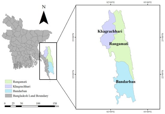
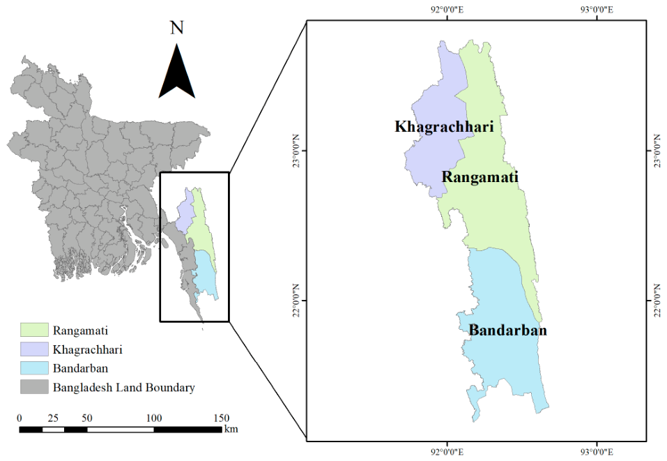
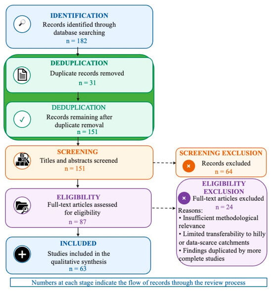
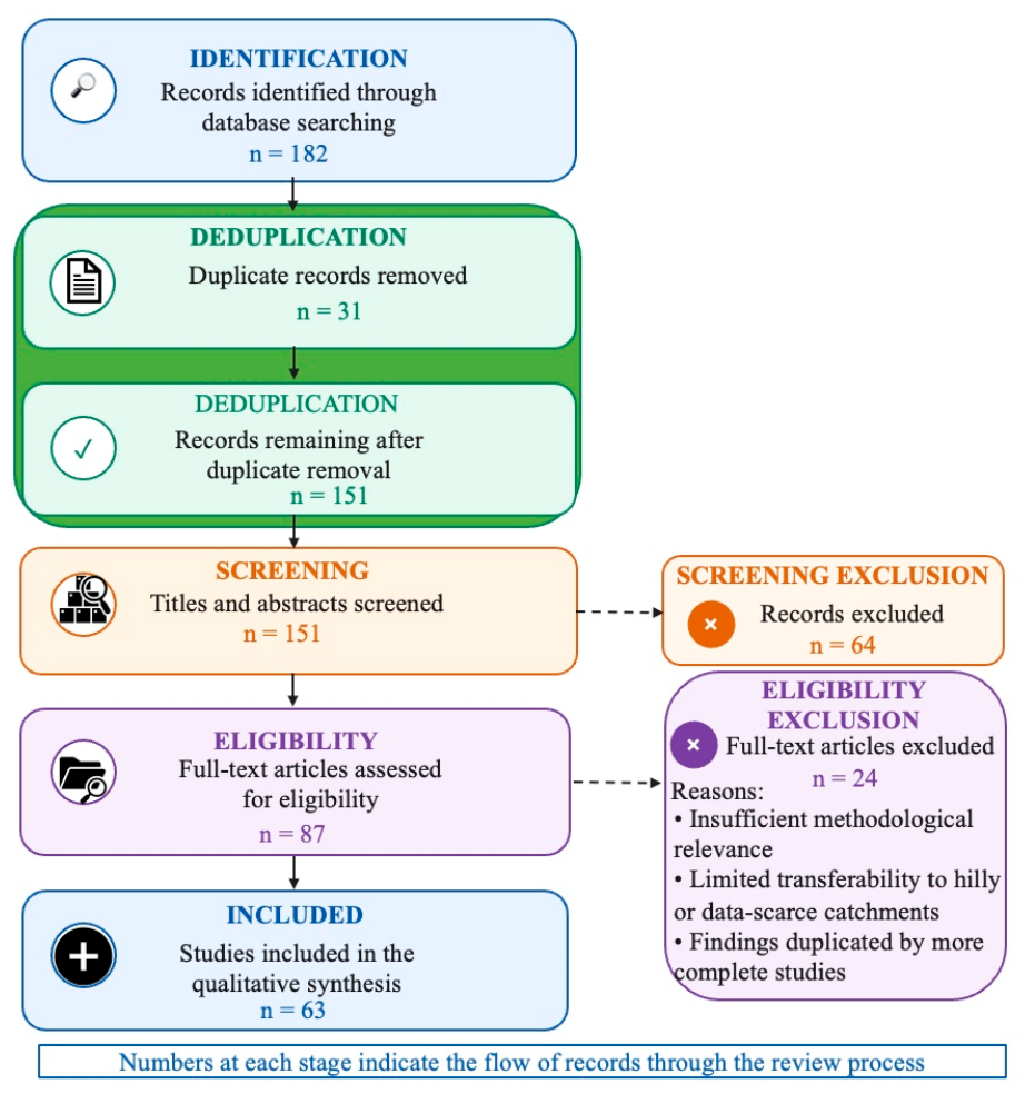
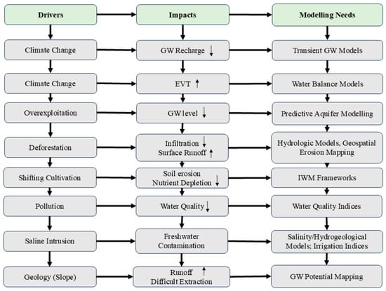
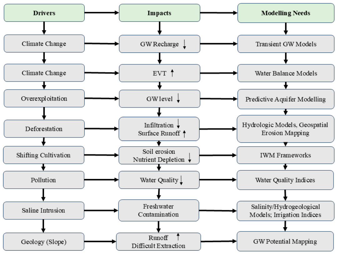
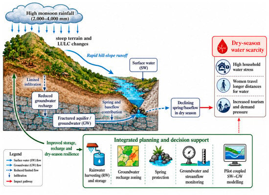
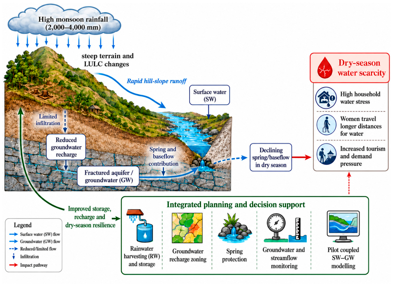
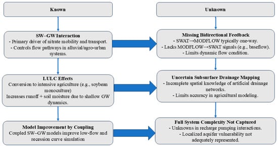
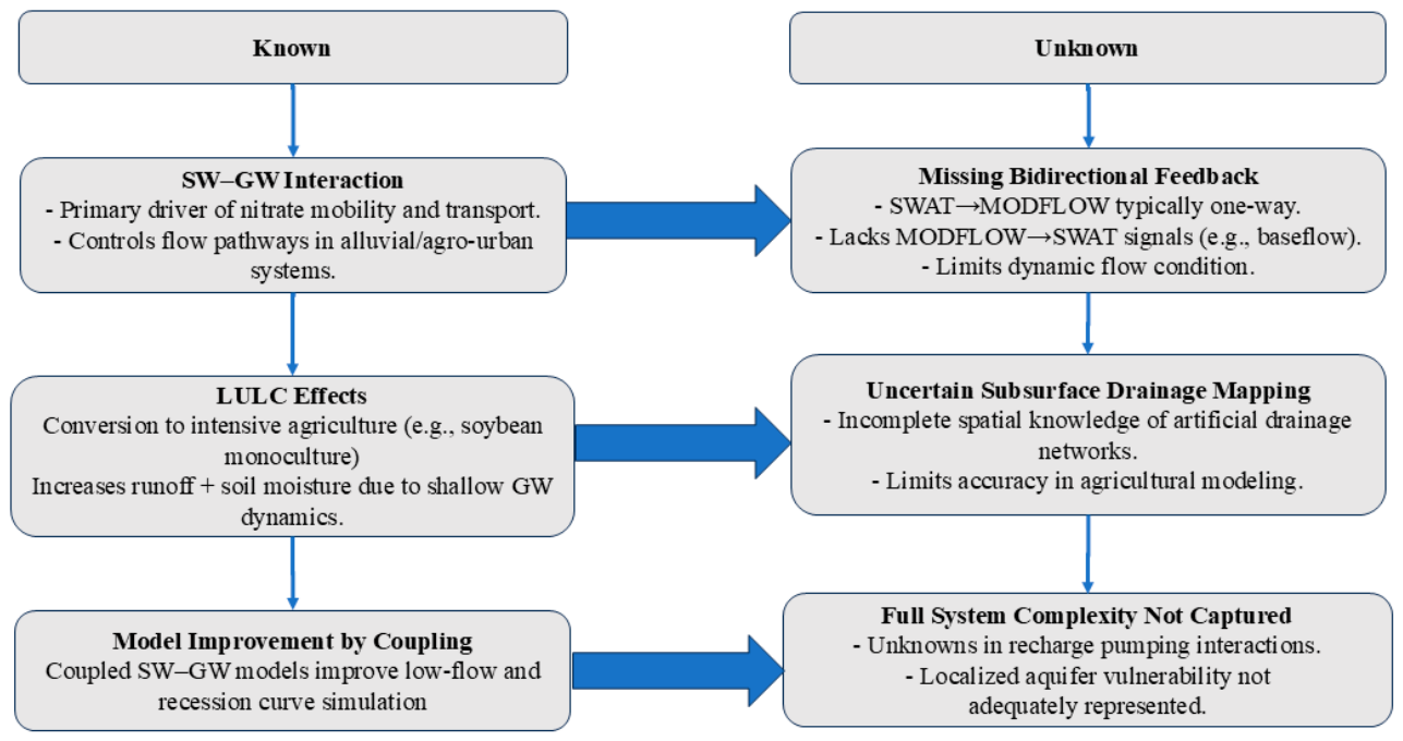
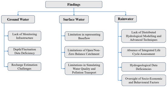
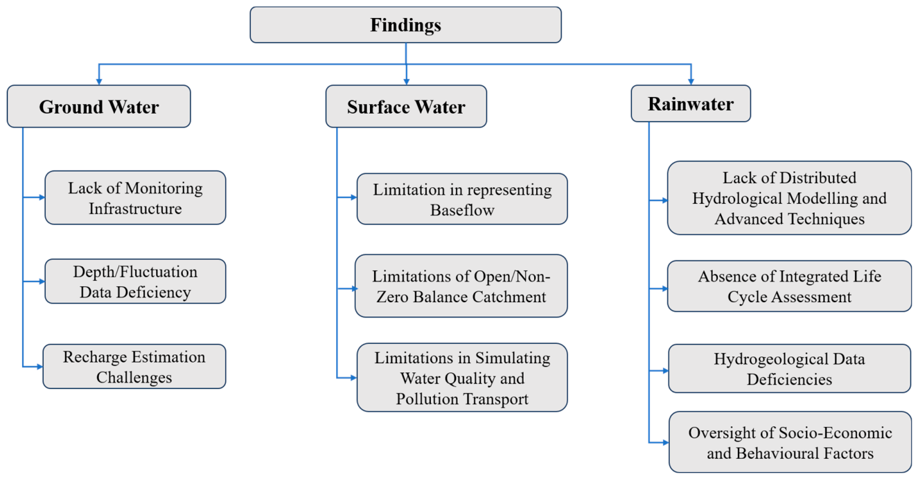

Disclaimer/Publisher’s Note: The statements, opinions and data contained in all publications are solely those of the individual author(s) and contributor(s) and not of MDPI and/or the editor(s). MDPI and/or the editor(s) disclaim responsibility for any injury to people or property resulting from any ideas, methods, instructions or products referred to in the content. |
© 2026 by the authors. Licensee MDPI, Basel, Switzerland. This article is an open access article distributed under the terms and conditions of the Creative Commons Attribution (CC BY) license.