


Abstract
To address the challenges of sparse point clouds, incomplete structures, and noise interference in on-orbit perception of non-cooperative satellites, this study develops a reconstruction method that integrates multi-frame point cloud fusion with an energy-driven optimization strategy. A self-developed experimental platform for non-cooperative targets is employed to acquire multi-view point cloud data, which are subsequently fused to improve geometric coverage and structural completeness. Based on this dataset, four representative 3D reconstruction algorithms are systematically evaluated. The results indicate that the Local Delaunay method achieves a favorable balance between geometric accuracy and structural preservation (RMSE = 6.152 mm). However, its performance is limited by reliance on multiple geometric thresholds and fixed-scale constraints, leading to reduced robustness and stability under challenging conditions. To overcome these limitations, an energy-based normal-consistent adaptive reconstruction method (ENALD) is developed within the Local Delaunay framework. The proposed approach incorporates a normal consistency constraint and an adaptive scale mechanism and constructs a multi-feature energy model to guide triangle selection. An energy-ranking strategy is further introduced, retaining the top 50% of candidates to improve reconstruction quality. Experimental results demonstrate that, compared with the conventional Local Delaunay method, ENALD reduces the maximum deviation, average deviation, and RMSE by 21.3%, 10.0%, and 11.9%, respectively, while improving computational efficiency by approximately 45.4%. In addition, the reconstructed surfaces exhibit enhanced structural continuity and better preservation of local details, without introducing noticeable topological artifacts.
1. Introduction
With the rapid advancement of active sensing technologies such as LiDAR, point clouds have become a primary representation for describing the geometric structure of space targets [1]. In on-orbit servicing and space situational awareness tasks, accurate three-dimensional reconstruction of non-cooperative targets from LiDAR point clouds is a fundamental prerequisite for autonomous rendezvous, fault diagnosis, and orbit control. Unlike cooperative targets with known structural priors, non-cooperative targets exhibit unknown geometries and complex surface characteristics. Furthermore, target motion, limited viewpoints, and sensor noise often result in sparse and incomplete point clouds, posing significant challenges to reliable surface reconstruction [2,3,4].
To improve data completeness, multi-frame point cloud fusion is widely adopted to increase point density and geometric coverage [5,6]. Nevertheless, accumulated registration errors introduced during fusion may degrade geometric consistency and adversely affect subsequent surface reconstruction. Therefore, reconstruction algorithms should not only preserve geometric details but also maintain robustness against non-uniform sampling and accumulated errors.
Existing surface reconstruction methods can generally be classified into explicit and implicit approaches. Explicit methods based on Delaunay triangulation are widely adopted because of their computational efficiency and geometric interpretability. Representative methods include global Delaunay triangulation [7,8], the Crust algorithm [9], and geometry-driven local reconstruction approaches [10,11]. Although these methods exhibit satisfactory performance under ideal sampling conditions, their reconstruction quality often depends on manually selected geometric thresholds, making them sensitive to non-uniform sampling, noise, and accumulated registration errors [9,10,11,12]. Implicit methods, represented by Poisson Surface Reconstruction (PSR), formulate surface reconstruction as a global optimization problem over implicit functions defined from oriented point clouds [13,14,15,16,17,18]. Owing to their global formulation, these methods exhibit strong robustness to noise and incomplete observations. However, their inherent smoothing characteristics frequently blur sharp geometric features and object boundaries, which is undesirable for non-cooperative satellite targets with complex structural details.
To reduce erroneous long-range connections while preserving local geometric structures. Local Delaunay triangulation that enables adaptive reconstruction within local neighborhoods has attracted growing attention [5,7,8,11,19,20,21,22,23]. Nevertheless, existing Local Delaunay methods still rely on multiple independent geometric thresholds and fixed neighborhood scales, resulting in limited adaptability to spatially varying point distributions and reduced reconstruction stability under complex sensing conditions. Several challenges remain in reconstructing non-cooperative satellite point clouds. First, the absence of a unified criterion for candidate triangle evaluation leads to high parameter sensitivity and unstable reconstruction quality. Second, fixed geometric constraints are insufficient for handling spatially varying sampling densities. Third, reconstruction robustness remains limited when point clouds are affected by fusion errors and measurement noise.
To address these issues, this paper proposes an Energy-based Normal-consistent Adaptive Local Delaunay reconstruction method (ENALD). Multi-frame point clouds acquired from a self-developed LiDAR experimental platform are first fused to improve structural completeness. Surface normals are then consistently oriented to establish coherent geometric constraints, while adaptive neighborhood scales are employed to accommodate spatially varying sampling densities. Finally, multiple geometric features, including circumradius, edge length, triangle area, and normal consistency, are integrated into a unified energy model, and candidate triangles are selected through an energy-ranking strategy instead of conventional threshold-based filtering. Considering the scarcity of large-scale annotated datasets for non-cooperative space targets and the uncertainty of their geometric structures, this study focuses on a geometry-driven reconstruction framework that operates directly on raw point clouds without requiring prior training data, making it more suitable for practical on-orbit perception scenarios. ENALD method transforms conventional heuristic filtering into a unified geometry–energy optimization framework, enabling more accurate and robust reconstruction of non-cooperative satellite point clouds. The reconstructed models provide reliable geometric support for downstream tasks such as target recognition, pose estimation, and autonomous on-orbit servicing.
2. Experimental Platform and Data Acquisition Method
2.1. LiDAR-Based Non-Cooperative Target Experimental Platform
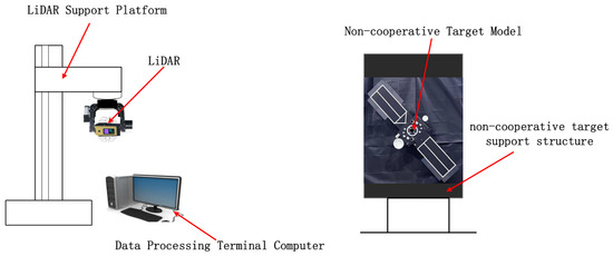
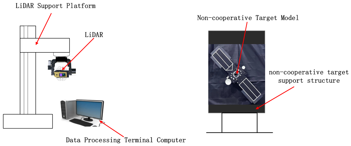
A LiDAR-based experimental platform for non-cooperative targets is established in this study, comprising a LiDAR sensor, a LiDAR mounting platform, a data processing terminal, a satellite mock-up, and a non-cooperative target support structure. The linear distance between the LiDAR and the target is maintained within 7–10 m, as illustrated in Figure 1. A rendezvous and docking scenario is simulated to emulate the approach of a servicing spacecraft, during which three-dimensional point cloud data of a moving non-cooperative target are acquired. The resulting LiDAR point clouds serve as the initial input for subsequent 3D reconstruction. All data processing and reconstruction simulations are conducted on the MATLAB platform. Data processing and reconstruction experiments were implemented using MATLAB R2024b (MathWorks, Natick, MA, USA).
Figure 1.
Non-cooperative Target Experimental Platform.
Considering detection range, field of view, angular resolution, ranging accuracy, and repetition rate, the Titan M1-A LiDAR (Lingwei Technology) is selected in this study. Detailed specifications are listed in Table 1. The sensor operates at a wavelength of 1550 nm, offering enhanced eye safety, as radiation at this wavelength is primarily absorbed by the cornea and lens, thereby reducing potential retinal exposure. In addition, the longer wavelength improves penetration in foggy or dusty environments and reduces interference from solar radiation and ambient light, contributing to more reliable environmental perception. The Titan M1-A supports up to 700 scanning lines, with a per-line resolution of 1750 pixels. This high angular resolution enables longer effective detection ranges under comparable conditions and provides richer structural details of the target.
Table 1.
Titan M1-A LiDAR Parameters.
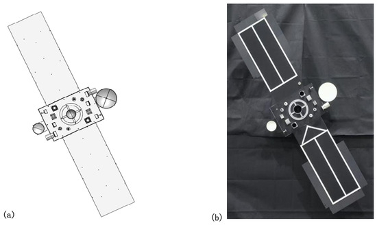
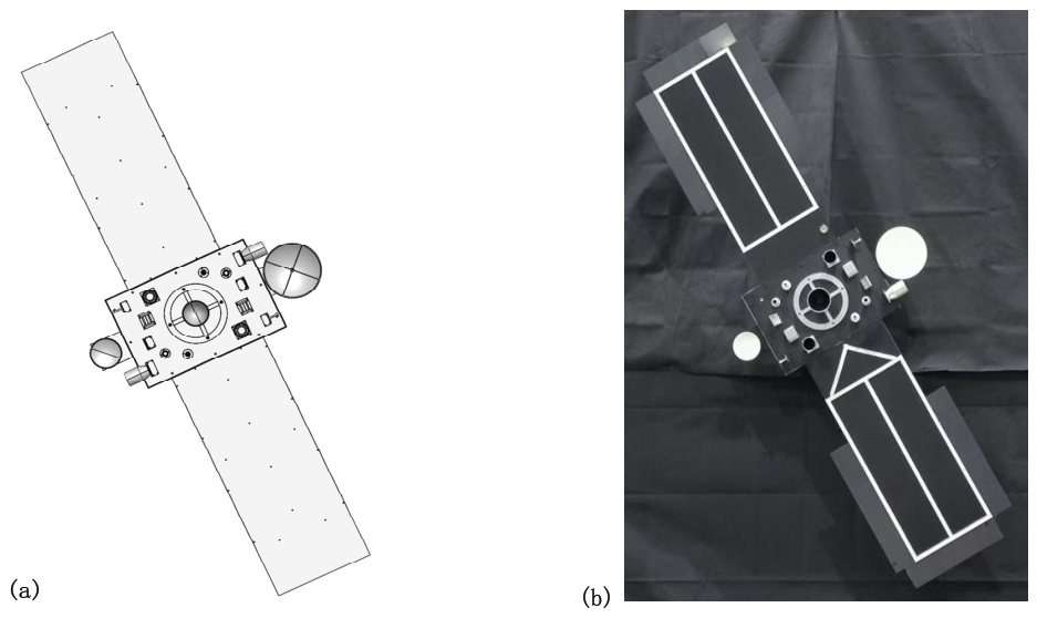
As shown in Figure 2a, a 1:5 scaled model of a non-cooperative target satellite is developed according to project requirements. The model is designed to replicate the physical geometry and reflective characteristics of a real satellite, thereby supporting experimental validation under laboratory conditions. The physical prototype of the satellite model is presented in Figure 2b.
Figure 2.
Non-cooperative Target Satellite Model: (a) Satellite model, (b) Satellite physical object.
The target satellite consists of a central bus and two symmetrically deployed solar panels, forming a highly symmetric cross-shaped configuration. The non-cooperative target is rigidly fixed in place by a dedicated support structure. A rotary mechanism and controller are mounted on the rear side of the satellite model, enabling precise rotation at a prescribed angular velocity, thereby facilitating the acquisition of multi-frame point cloud data under dynamic conditions.
Numerous small features on the satellite surface are primarily intended for experiments involving vision-based sensors in integrated systems. Due to the relatively long sensing distance in this study, the LiDAR data captures only the central bus, the two solar panels, and other large-scale structures. Accordingly, subsequent experiments are conducted based on these components.
2.2. Non-Cooperative Target Point Cloud Data Acquisition
Data Processing Terminal Computer
To meet the computational demands of point cloud processing and three-dimensional reconstruction, a dedicated data processing terminal computer is designed and assembled. The system serves as the core processing unit of the non-cooperative target experimental platform, responsible for data acquisition, point cloud preprocessing, registration, reconstruction, and accuracy evaluation.
The computer is equipped with a 10-core, 20-thread processor operating at a base frequency of 2.8 GHz, providing sufficient computational capability for handling complex tasks such as point cloud registration and surface reconstruction. A dual-channel memory architecture, combined with a high-speed solid-state drive (Samsung 980 Pro, PCIe 4.0, with a read speed of up to 7000 MB/s), forms an efficient data access and storage system, significantly improving the processing efficiency of large-scale point cloud datasets. Detailed system specifications are listed in Table 2.
Table 2.
Control computer details.
3. Results
3.1. Multi-Frame Point Cloud Superposition Fusion
The point cloud models acquired in the laboratory are used as the experimental dataset in this study. All point clouds employed for three-dimensional reconstruction have been pre-registered and contain minimal noise, resulting in negligible impact on subsequent reconstruction processes. Therefore, they are considered suitable as input data for the experiments.
An appropriate reconstruction method is selected to reconstruct the three-dimensional geometry of the non-cooperative target from fused LiDAR point clouds. Since single-frame observations acquired under target motion are typically sparse and contain limited geometric information, multi-frame point clouds are first registered and fused to improve point density and structural completeness. After statistical outlier removal, the reconstructed point cloud is used as the input for subsequent surface reconstruction. The multi-frame fusion process can be expressed as:
Let the multi-frame point cloud sequence be defined as:
The superposition fusion operation is then formulated as:
where denotes the fused point cloud obtained by integrating all registered point clouds . Compared with single-frame data, the fused point cloud provides more complete geometric information, thereby improving the reliability of the subsequent reconstruction process. Figure 3 shows a representative single-frame point cloud, while Figure 4 presents the corresponding fused point cloud after multi-frame registration.
Figure 3.
Single-frame point cloud.
Figure 4.
Multi-frame overlapped point clouds.
When selecting point cloud data with different frame numbers for superposition and fusion, a multi-criteria comprehensive evaluation approach is employed to determine the optimal number of fused frames. The analysis is conducted from two aspects, namely point cloud density and noise distribution, thereby ensuring the rationality and reliability of the frame selection strategy under different superposition conditions.
The noise level of the fused point cloud, denoted as Noise, is evaluated based on variance and is defined as follows [24]:
where denotes the number of points; represents the nearest-neighbor distance of the -th point; and is the mean distance.
The noise standard deviation is then defined as:
The mean neighborhood distance reflects the spatial resolution of the point cloud, whereas the noise standard deviation characterizes the degree of fluctuation of neighborhood distances relative to the mean value. The combination of these two metrics enables a comprehensive evaluation of point cloud quality. Specifically, a smaller mean distance indicates higher point cloud density, while a lower standard deviation suggests a more uniform spatial distribution and reduced noise levels.
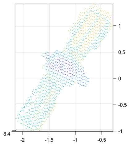
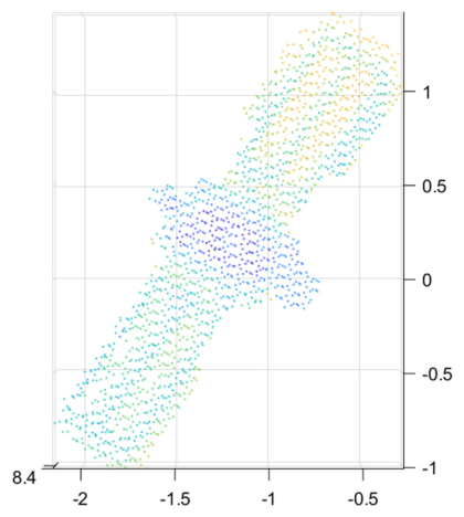
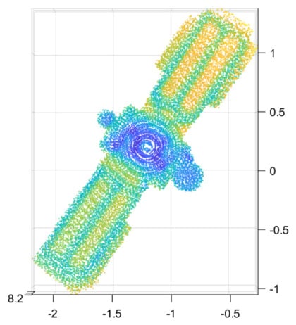
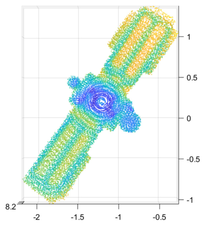
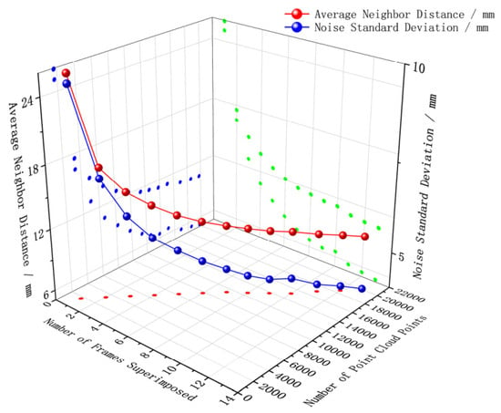
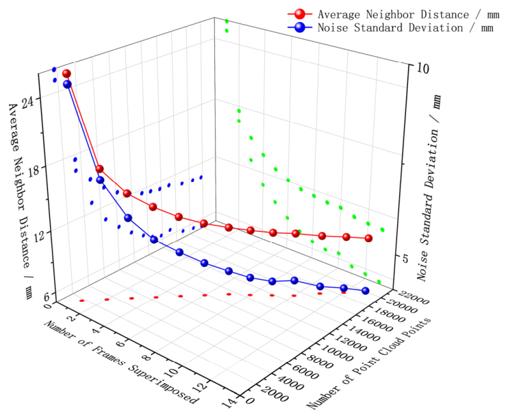
As shown in Table 3 and Figure 5, it can be observed that with the increase in the number of superimposed frames, both point cloud density and spatial distribution uniformity are progressively improved. Specifically, the number of point cloud points increases from 1697 for a single frame to 18,520 for 12 frames. Meanwhile, the average neighborhood distance decreases from 25.924 mm to 10.589 mm, corresponding to a reduction of approximately 59.2%, which indicates a significant enhancement in spatial sampling density. In addition, the noise standard deviation decreases from 9.725 mm to 4.132 mm, representing a reduction of approximately 57.5%. This result demonstrates that the point cloud distribution becomes more stable, and local fluctuations are effectively suppressed.
Table 3.
Spatial Distribution of Point Clouds with Different Superimposed Frame Counts.
Figure 5.
Spatial distribution of point clouds under different multi-frame superposition configurations.
However, when the number of superimposed frames increases from 12 to 13, the improvement in all evaluation metrics becomes marginal. The total number of points increases by only 6.7% (from 18,520 to 19,770), while the average neighborhood distance decreases by merely 0.093 mm (approximately 0.88%) and the noise standard deviation is reduced by only 0.066 mm (approximately 1.6%). In contrast to the earlier stage (e.g., the 1–6 frame range, where the average neighborhood distance decreases by more than 50%), the enhancement in point cloud quality approaches saturation, exhibiting a clear diminishing marginal improvement trend.
Furthermore, considering the inevitable accumulation of registration errors in the multi-frame fusion process, an increase in the number of frames may amplify small alignment deviations during successive superposition, thereby degrading local geometric consistency. Consequently, while the growth rate of point cloud density progressively diminishes, further increasing the number of frames may instead introduce additional uncertainty and potentially compromise reconstruction quality.
Based on the above analysis, the 12-frame superposition achieves a balanced trade-off between point cloud density enhancement and noise suppression. On the one hand, it significantly compensates for structural information loss in single-frame data; on the other hand, it effectively mitigates the error accumulation induced by excessive frame fusion. Therefore, the fused results of 12 frames are selected as the input for subsequent 3D reconstruction.
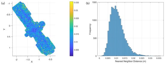
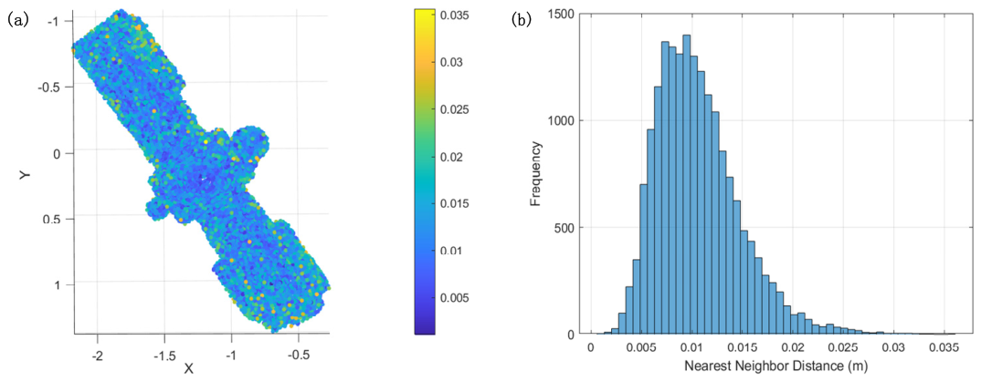
Figure 6 presents the spatial noise distribution and the nearest-neighbor distance distribution of the point cloud data obtained from 12-frame superposition fusion.
Figure 6.
Point Cloud Distribution after 12-Frame Superposition and Fusion. (a) Spatial Distribution of Noise Points, (b) Nearest Neighbor Distance Distribution.
3.2. Comparison of Reconstruction Algorithms
To identify an optimal reconstruction strategy for non-cooperative target satellite point clouds, this study systematically compares several representative methods, including Delaunay triangulation, Poisson surface reconstruction (PSR), the Crust algorithm, and Local Delaunay.
To comprehensively evaluate the performance of the proposed reconstruction framework, a multi-dimensional assessment is conducted in terms of geometric accuracy, surface integrity, computational efficiency, and 3D reconstruction quality. Specifically, geometric accuracy is quantified using point-to-surface distance error, reflecting the spatial approximation capability of the reconstructed model. Surface integrity is evaluated using metrics such as boundary edge density, which characterizes mesh closure and structural continuity. Computational efficiency is assessed in terms of algorithm runtime, thereby indicating its practicality for real-world applications. The quality of 3D reconstruction is further examined through visual inspection of local structural representation and topological consistency, reflecting the model’s structural fidelity and representational capability in realistic scenarios. Through the integrated analysis of these complementary metrics, a comprehensive and objective evaluation of reconstruction performance is achieved in terms of accuracy, completeness, efficiency, and overall reconstruction quality.
3.2.1. Geometric Accuracy
To ensure an objective and unbiased evaluation of reconstruction performance, the input point cloud is randomly partitioned into two mutually exclusive subsets: one for reconstruction and the other for evaluation. Let the complete point cloud be denoted as , which is divided as:
where is used for surface reconstruction and serves as an independent validation set. In this study, approximately 70% of the points are randomly selected for reconstruction, while the remaining 30% are reserved for evaluation.
Based on , a triangular mesh representation of the reconstructed surface is generated:
where denotes the -th triangular facet.
The geometric accuracy is quantified by computing the point-to-surface distance between each evaluation point and the reconstructed mesh. The evaluation point set is defined as:
For each point the reconstruction error is defined as the minimum Euclidean distance to the mesh:
where denotes the point-to-triangle distance.
Based on the distance set the following metrics are employed:
- Maximum Deviation
- 2.
- Average Deviation
- 3.
- RMSE
These metrics provide complementary insights into reconstruction quality. Specifically, captures worst-case local geometric errors, reflects overall accuracy, and RMSE emphasizes sensitivity to large deviations, making it a critical indicator for evaluating reconstruction robustness and structural fidelity.
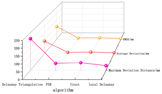
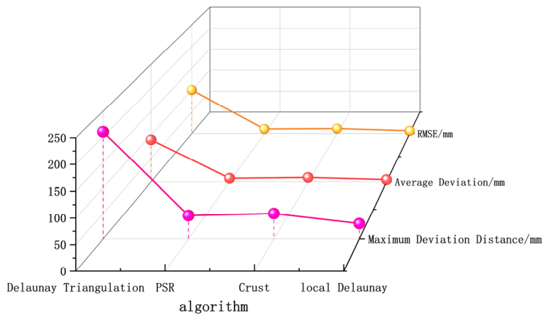
The quantitative reconstruction results are summarized in Table 4 and Figure 7. Among the four evaluated methods, the Local Delaunay algorithm achieves the highest reconstruction accuracy, yielding a maximum deviation of 30.379 mm, an average deviation of 4.771 mm, and an RMSE of 6.152 mm. In comparison, the Delaunay triangulation, PSR, and Crust algorithms exhibit lower reconstruction accuracy, particularly under sparse and non-uniform sampling conditions.
Table 4.
Quantitative comparison of reconstruction accuracy metrics for the four surface reconstruction algorithms.
Figure 7.
Visual comparison of reconstruction accuracy metrics for the four surface reconstruction algorithms.
Using the optimal reconstruction method identified for non-cooperative target satellite point clouds, comparative simulation experiments are conducted. The results in terms of geometric accuracy are summarized in Table 4 and Figure 7. The Delaunay triangulation algorithm exhibits substantial reconstruction errors, with an RMSE of 100.737 mm, which is insufficient for high-precision reconstruction requirements. The PSR and Crust methods demonstrate improved error control, yielding RMSE values of 10.274 mm and 11.302 mm, respectively. In contrast, the Local Delaunay-based method achieves the best overall accuracy performance, with an RMSE of 6.152 mm and an average deviation of 4.771 mm, indicating its superior capability in preserving local geometric details.
These results indicate that the superior performance of the Local Delaunay method can be attributed to its local neighborhood reconstruction strategy, which effectively suppresses erroneous long-range connections while better preserving local geometric structures. Compared with the PSR and Crust methods, the Local Delaunay algorithm demonstrates stronger adaptability to irregular point distributions and provides a more reliable baseline for the subsequent optimization proposed in this study.
3.2.2. Surface Integrity
Surface integrity is primarily evaluated based on mesh boundary information.
- The total boundary edge length is defined over the edge set and the boundary edge subset , and is used to characterize the scale of unclosed regions in the reconstructed model:where denotes the Euclidean length of edge .
- The boundary edge density , a dimensionless metric, is introduced to quantify the topological integrity of the reconstructed model:where
A lower value of indicates a higher degree of surface closure and better continuity of the reconstructed surface, whereas higher values suggest the presence of more voids or fragmented structures.
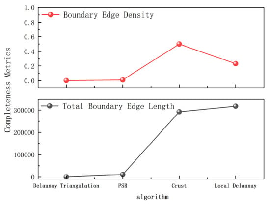
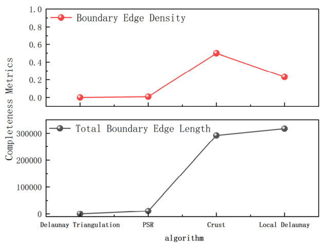
Table 5 and Figure 8 present a comparative analysis of the four algorithms in terms of surface integrity metrics. Although the Delaunay triangulation algorithm does not form an effectively closed surface (with a boundary edge density of 0), this result lacks practical significance due to severe topological inconsistency. The PSR method achieves the lowest boundary edge density (0.009795), indicating strong surface continuity, albeit at the expense of geometric detail preservation. In contrast, the Crust algorithm exhibits a high boundary edge density (0.500003), reflecting pronounced topological instability. The Local Delaunay method achieves a favorable balance between surface integrity and detail preservation, with a boundary edge density of 0.230454, effectively suppressing over-connection and structural fragmentation.
Table 5.
Quantitative comparison of surface integrity metrics for the four surface reconstruction algorithms.
Figure 8.
Visual comparison of surface integrity metrics for the four surface reconstruction algorithms.
From the experimental results, it is further observed that the PSR algorithm exhibits a low boundary edge density of 0.0098, which is primarily attributed to its enforced watertight surface reconstruction. This approach solves the Poisson equation to smoothly interpolate and fill regions with sparse or missing point data, thereby ensuring global surface closure. However, such global smoothing inevitably compromises geometric fidelity, as true depressions, occluded edges, and fine-scale structures are excessively smoothed and partially removed. This over-smoothing effect also explains why its RMSE is higher than that of the Local Delaunay algorithm. In comparison with the Crust algorithm, the Local Delaunay method achieves a reduction of approximately 54% in boundary edge density. This improvement indicates that the Local Delaunay algorithm provides significantly enhanced robustness to point cloud noise while better preserving mesh topological integrity.
3.2.3. Computational Efficiency
The computational efficiency is evaluated in terms of the algorithm execution time , which is defined as:
where and denote the start and end times of the algorithm execution, respectively.
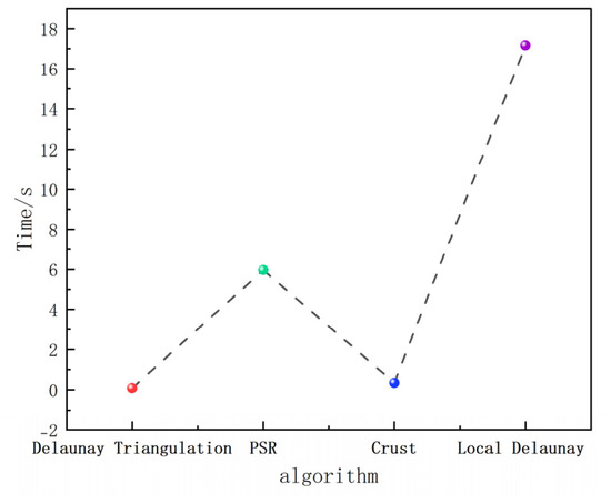
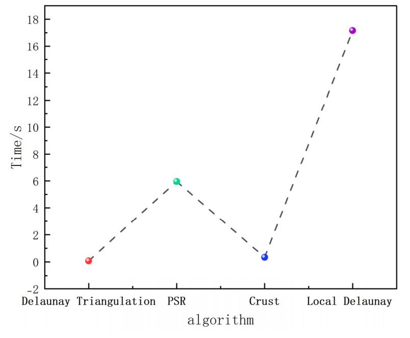
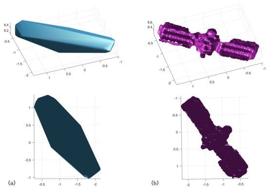
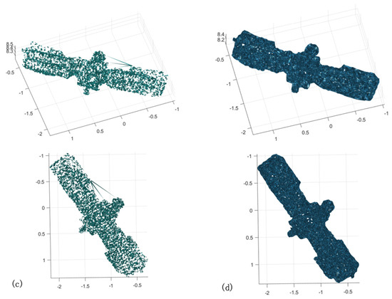
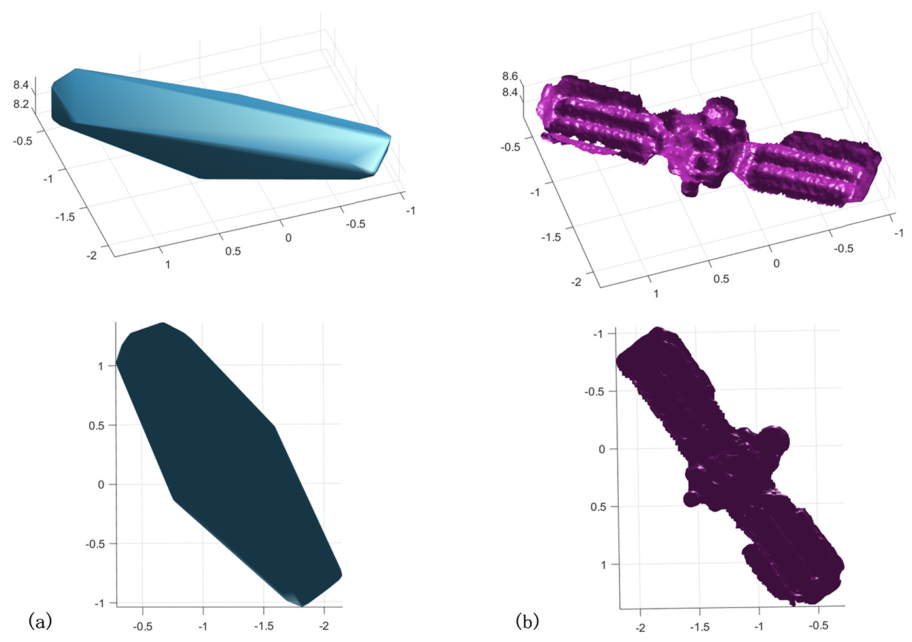
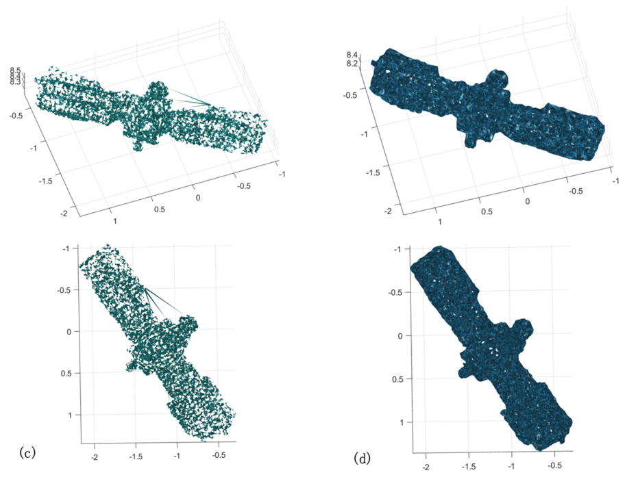
The comparative results of the four algorithms in terms of computational efficiency are presented in Figure 9 and Table 6. The Delaunay triangulation algorithm achieves the highest efficiency, with a minimum runtime of 0.0795 s. In contrast, the PSR and Local Delaunay methods require 5.9536 s and 17.1604 s, respectively, indicating a substantially higher computational cost. Although the Local Delaunay algorithm is computationally more expensive, it provides clear advantages in terms of reconstruction accuracy and structural preservation. As further demonstrated in the 3D reconstruction results shown in Figure 10, the Local Delaunay method yields superior visual quality compared with both the PSR and Crust-based approaches, making it more suitable for high-fidelity reconstruction of complex non-cooperative targets.
Figure 9.
Visual comparison of computational efficiency for the four surface reconstruction algorithms.
Table 6.
Quantitative comparison of computational efficiency for the four surface reconstruction algorithms.
Figure 10.
D Reconstruction Results. (a) Delaunay Triangulation, (b) PSR, (c) Crust, (d) Local Delaunay.
3.2.4. 3D Reconstruction Performance
The fused point cloud data are reconstructed using four methods, namely Delaunay triangulation, PSR, the Crust algorithm, and the Local Delaunay algorithm. A comparative analysis of the reconstruction results is conducted. The corresponding visual results are presented in Figure 10.
It can be observed from Figure 10a that the 3D reconstruction results obtained by the Delaunay triangulation algorithm exhibit pronounced over-simplification. Although the global geometric outline is approximately preserved, the reconstructed surface is overly smooth, with significant loss of fine-scale geometric details, particularly in regions with complex local structures. This limitation is primarily attributed to the fact that the method relies solely on the spatial distribution of points for global connectivity, without incorporating local geometric constraints or directional information. Consequently, the reconstructed surface tends to approximate a convex hull, making it difficult to faithfully represent the true surface characteristics.
The 3D reconstruction results obtained by the PSR algorithm are shown in Figure 10b. From a visual perspective, the reconstructed model demonstrates good global continuity and a relatively smooth surface, indicating satisfactory global consistency. However, excessive smoothing can be clearly observed in local regions, where fine structural details are significantly attenuated. In addition, varying degrees of structural blurring and boundary deviation are evident, which are mainly caused by the inherent nature of implicit function-based reconstruction. When processing non-uniform point clouds and incomplete boundary regions, this method is prone to introducing additional smoothing artifacts, thereby reducing the fidelity of local geometric features.
The 3D reconstruction results obtained by the Crust algorithm are presented in Figure 10c. From a visual perspective, the overall geometric structure of the target is partially recovered; however, several notable deficiencies remain. A large number of spurious triangles are generated, local connectivity appears disordered, and the resulting surface lacks regularity. In particular, in regions with sparse point distribution or complex geometric configurations, the method is prone to erroneous connections and topological inconsistencies. These results indicate that the Crust algorithm is highly sensitive to point cloud quality and exhibits limited robustness in complex real-world scenarios.
The reconstruction results of the Local Delaunay algorithm are shown in Figure 10d. Compared with the previous three methods, this approach demonstrates superior visual performance. The main structural features of the target are clearly preserved, the overall geometric contour is well maintained, and the number of noise-induced triangles is significantly reduced. By constructing the mesh based on local neighborhood information, this method effectively mitigates the false connectivity issues commonly observed in global Delaunay triangulation to a certain extent. Nevertheless, some limitations can still be observed. Local structural discontinuities persist in certain regions, and minor noise-induced connections or unstable mesh patches are present in a few areas. These issues indicate that further improvements are still required under conditions of complex geometries and non-uniform point distributions.
Based on the above analysis, the Local Delaunay method achieves the best overall performance in terms of geometric accuracy, structural completeness, and representation capability, demonstrating strong potential as a foundational reconstruction framework. Accordingly, this study adopts it as the basis of the improved algorithm and further integrates a multi-constraint optimization strategy to address its limitations in noise suppression, local topological consistency, detail preservation, and computational efficiency.
3.3. An Energy-Based Normal-Consistent Adaptive Local Delaunay Reconstruction Method
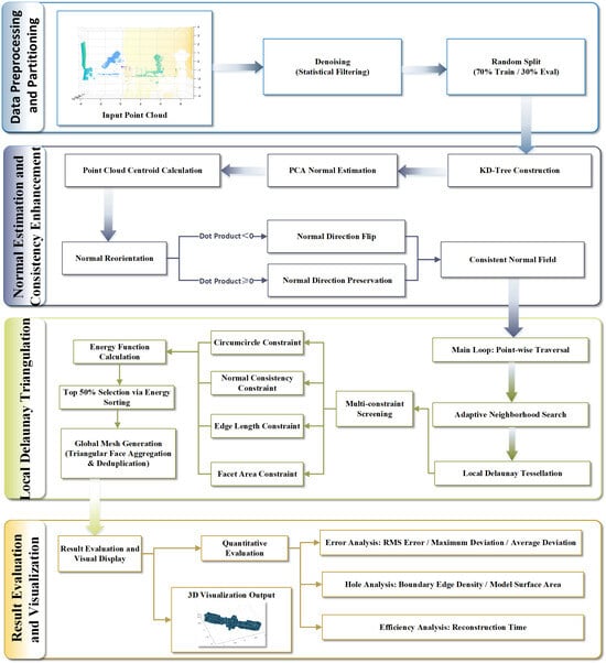
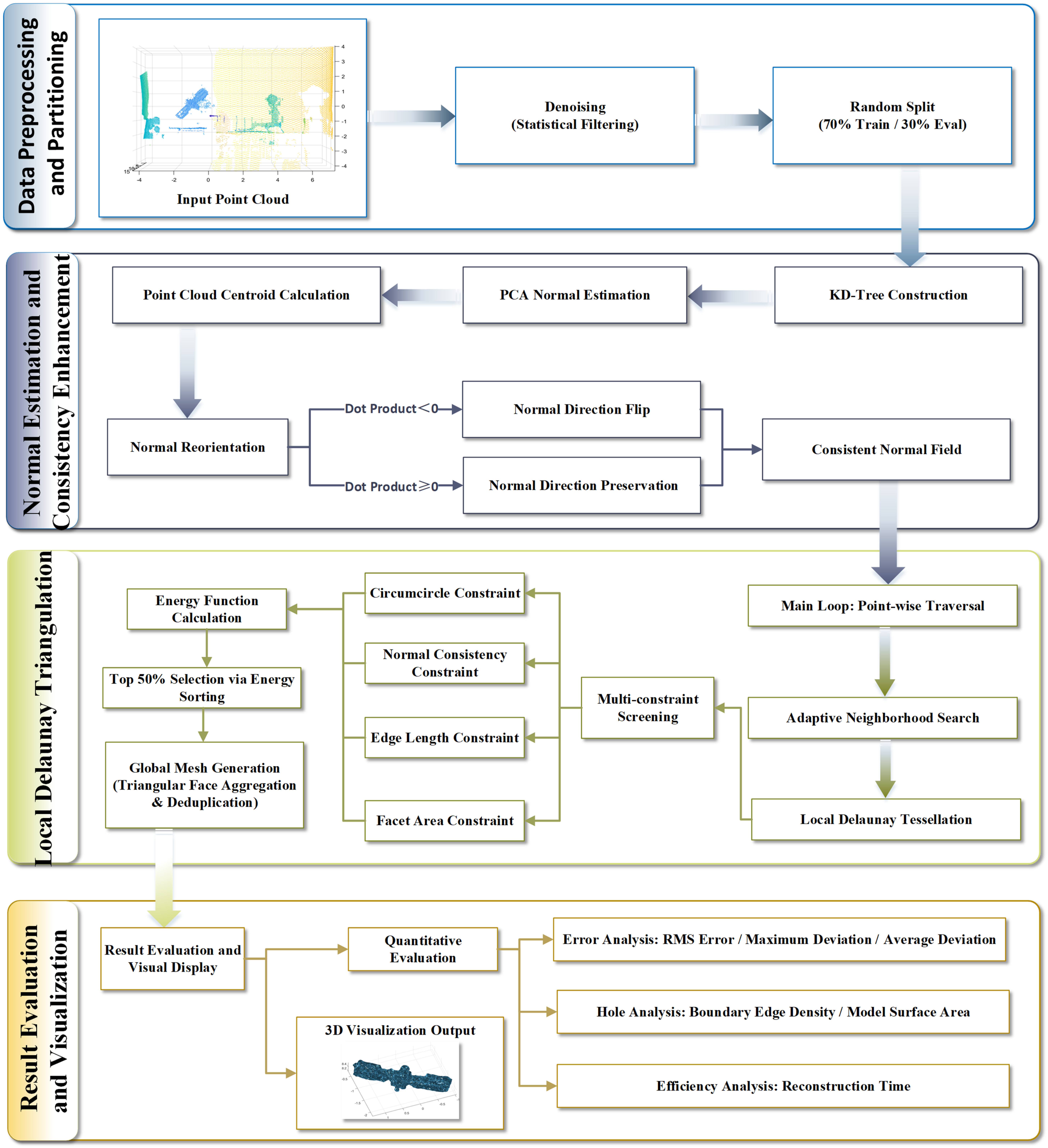
Based on the Local Delaunay reconstruction framework, this study proposes an Energy-based Normal-consistent Adaptive Local Delaunay (ENALD) reconstruction method to improve the robustness and accuracy of surface reconstruction for sparse and non-uniform LiDAR point clouds. Compared with the conventional Local Delaunay algorithm, the proposed ENALD method introduces normal consistency constraints, an adaptive scale mechanism, and an energy-based optimization strategy to improve point cloud preprocessing, geometric constraint enforcement, candidate triangle evaluation, and mesh generation. The overall workflow of the proposed ENALD reconstruction method is illustrated in Figure 11 and consists of the following four stages.
Figure 11.
Workflow of the proposed ENALD reconstruction method.
- (1)
- Data preprocessing stage: This stage includes point cloud loading, statistical outlier removal, and dataset partitioning for training and evaluation.
- (2)
- Normal estimation and consistency enhancement stage: Surface normals are estimated using PCA-based local plane fitting, followed by global normal orientation alignment to ensure consistency.
- (3)
- Local triangle construction and multi-constraint screening stage: Candidate triangles are generated based on an adaptive neighborhood strategy and subsequently filtered under multiple geometric constraints. The remaining triangles are ranked using an energy function, and the final mesh is constructed through global assembly.
- (4)
- Result evaluation and visualization stage: The reconstructed mesh is quantitatively evaluated, and the final 3D model is generated for visual analysis.
The process progressively shifts from geometric construction to energy-based optimization, enabling a transition from local heuristic rules to globally consistent optimization.
3.3.1. Normal Consistency Constraint
Conventional Delaunay reconstruction relies solely on the spatial relationships among points and lacks directional constraints, which makes it prone to triangle flipping and noise-induced artifacts. To address this limitation, a normal consistency constraint is introduced to improve reconstruction quality at both point and surface levels.
Point normal estimation and direction unification.
First, surface normals are estimated based on local neighborhoods. For a given point , the covariance matrix is constructed using its -nearest neighbors, and principal component analysis (PCA) is applied. The eigenvector corresponding to the smallest eigenvalue is adopted as the initial normal direction:
Due to the sign ambiguity inherent in PCA-based normal estimation, a global orientation alignment is required. Using the point cloud centroid as a reference, the normal direction is consistently oriented according to:
This procedure ensures a globally consistent normal orientation, providing a unified directional basis for subsequent triangulation screening.
Normal consistency constraint for triangular patches.
For each candidate triangle, the triangle normal is computed using the cross product:
where , , and denote the vertices of the candidate triangle. The average vertex normal is defined as:
To enforce consistency between the triangular patch and the local surface orientation, the angle between the triangle normal and the average neighborhood normal is computed as:
A filtering criterion is then imposed:
The choice of the 45° threshold is motivated by both geometric and robustness considerations. Geometrically, a 45° angle corresponds to a dot-product value of approximately 0.707, indicating strong directional consistency between the triangle normal and the local reference orientation, which is sufficient to preserve the underlying surface structure. From a robustness perspective, point cloud data inevitably contain noise and normal estimation uncertainties; overly restrictive thresholds may remove valid geometric primitives, whereas excessively loose thresholds may introduce cross-surface connections. Therefore, 45° represents a balanced trade-off between geometric fidelity and robustness. In addition, previous studies have demonstrated that normal-angle-based similarity measures are widely used in point cloud reconstruction for enforcing local geometric consistency [25,26,27]. In this work, the adopted threshold consistently yields stable reconstruction performance and improved structural quality. This constraint effectively aligns triangular patch orientations with the local surface geometry and suppresses both flipped triangles and noise-induced artifacts.
3.3.2. Adaptive Scale Constraints
To address the non-uniform sampling characteristics of point cloud data, an adaptive scale mechanism based on local point spacing is introduced.
- Local scale definition
For each point , the local average point spacing is defined as:
This metric reflects the local point cloud density and serves as a scale reference for subsequent geometric constraints.
- 2.
- Edge length constraint
Based on the local scale, an upper bound on the triangle edge length is imposed as:
To prevent cross-scale erroneous connections and preserve local geometric integrity, this study introduces an edge length constraint derived from local point spacing.
Previous studies have demonstrated that adaptive scale constraints based on local point spacing can effectively enhance reconstruction stability [5]. In practice, the distance threshold is typically set within 2–3 times the local point spacing. This empirical range has been widely adopted in Ball-Pivoting reconstruction and related methods (Bernardini et al., 1999) [11,28], as it ensures local structural preservation while suppressing spurious long-range connections. Accordingly, a scaling factor of 2.5 is selected in this study to achieve a balanced trade-off between preventing excessive edge formation and avoiding structural fragmentation. This constraint effectively preserves fine geometric details in dense regions, maintains structural coherence in sparse regions, and suppresses cross-scale erroneous connections.
3.3.3. Multi-Constraint Energy Function
To overcome the instability associated with single-threshold selection, a unified multi-constraint energy function is constructed to evaluate candidate triangles in a consistent manner [29]:
The individual energy terms are defined as follows:
- Circumcircle radius constraint:
- 2.
- Normal consistency constraint:
- 3.
- Edge length constraint:
- 4.
- Area constraint:
Each term is normalized to a comparable scale to prevent any single component from dominating the optimization process.
The weighting coefficients are defined as:
These weights are selected based on both geometric significance and numerical characteristics. Specifically, the circumcircle radius and normal consistency terms directly influence surface smoothness and topological correctness and are therefore assigned higher weights. The edge length term provides auxiliary control over local scale and is given a moderate weight. The area term is introduced to penalize degenerate triangles; due to its reciprocal form and potentially large numerical range, a relatively small weight is assigned to avoid disproportionate influence. Parameter sensitivity experiments further confirm that this combination achieves an effective balance between reconstruction accuracy and structural integrity. This weighting strategy is consistent with robust M-estimation principles [30], where adaptive weight functions down-weight unreliable observations—analogous to our area term penalizing degenerate triangles.
Traditional multi-threshold approaches rely on independently defined thresholds for each geometric constraint, often leading to parameter coupling and unstable screening results [31,32]. To address this issue, triangle selection is reformulated as a ranking problem based on the unified energy function. Under this framework, the screening process no longer depends on absolute thresholds but instead evaluates the relative quality of candidate triangles within the global distribution. Consequently, fixed-ratio truncation (Top-) is adopted as a more stable and scale-invariant strategy.
Candidate triangles are first ranked in ascending order of energy, and the top subset is retained:
In this study, a ranking-based triangle screening strategy is employed, in which the 50% of triangles with the lowest energy values are retained. This approach effectively suppresses noise-induced triangles while preserving surface completeness. The strategy is conceptually consistent with the median principle in robust statistics, whereby the influence of outliers is mitigated by discarding high-energy tail samples. The median estimator is known to have a 50% breakdown point in robust statistics [30], providing a theoretical upper bound for reliable outlier rejection.
Moreover, similar ranking- or priority-based filtering strategies have been widely applied in surface reconstruction and mesh optimization to improve overall model quality by preferentially preserving high-quality geometric primitives [9,33]. In this work, selecting the lowest-energy 50% of triangular facets serves as a median-based truncation strategy rather than an empirical threshold. This approach enables reliable separation of valid and anomalous triangles in an unsupervised manner. Experimental results demonstrate that it achieves a stable trade-off between structural integrity and noise suppression, while effectively reducing parameter sensitivity and improving the generalization capability of the algorithm.
3.4. Experimental Verification and Comparative Evaluation
3.4.1. Selection of Reconstruction Methods
It should be noted that the comparative evaluation in this study is conducted among classical geometry-based reconstruction methods rather than deep-learning-based approaches. This design is deliberate and motivated by the specific characteristics of the non-cooperative target reconstruction problem. Learning-based methods for point cloud surface reconstruction, such as Occupancy Networks [34], typically require large-scale annotated training datasets to achieve generalization, and their performance degrades significantly under out-of-distribution target geometries. However, in the context of on-orbit non-cooperative target perception, the target structure is inherently unknown a priori, and acquiring a large pre-training dataset is often impractical due to the unique nature of each space object. Geometry-based methods, including the proposed ENALD approach, operate directly on the input point cloud without requiring training data, making them naturally well-suited to this scenario. As surveyed by Berger et al. [19], classical geometry-based methods can remain competitive with learning-based approaches under conditions of limited data or significant domain shift.
Based on the above considerations, the proposed ENALD method is quantitatively evaluated against the baseline Local Delaunay algorithm using the established evaluation framework. The comparative analysis focuses on four aspects, namely geometric accuracy, surface integrity, computational efficiency, and overall reconstruction quality.
3.4.2. Comparative Evaluation of Reconstruction Accuracy
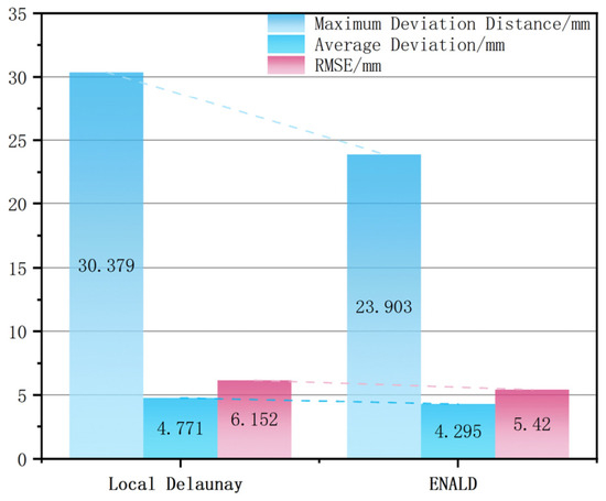
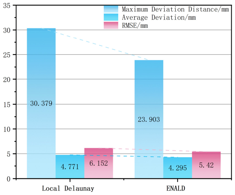
The quantitative accuracy results are presented in Table 7 and Figure 12. From the perspective of geometric accuracy, the ENALD algorithm consistently outperforms the baseline method across all error metrics. Specifically, the maximum deviation is reduced from 30.379 mm to 23.903 mm, the mean deviation decreases from 4.771 mm to 4.295 mm, and the root mean square error (RMSE) is lowered from 6.152 mm to 5.42 mm. These results demonstrate that the proposed multi-constraint optimization strategy effectively enhances surface fitting accuracy for point cloud reconstruction.
Table 7.
Quantitative comparison of reconstruction accuracy achieved.
Figure 12.
Visual comparison of reconstruction accuracy achieved.
The comprehensive comparison results indicate that the proposed ENALD reconstruction method achieves significant improvements in both geometric accuracy and computational efficiency. Compared with the Local Delaunay method, the maximum deviation is reduced by approximately 21.3%, the mean deviation by 10.0%, and the RMSE by 11.9%.
3.4.3. Comparative Evaluation of Surface Integrity
Table 8.
Quantitative comparison of surface integrity metrics.
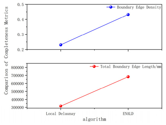
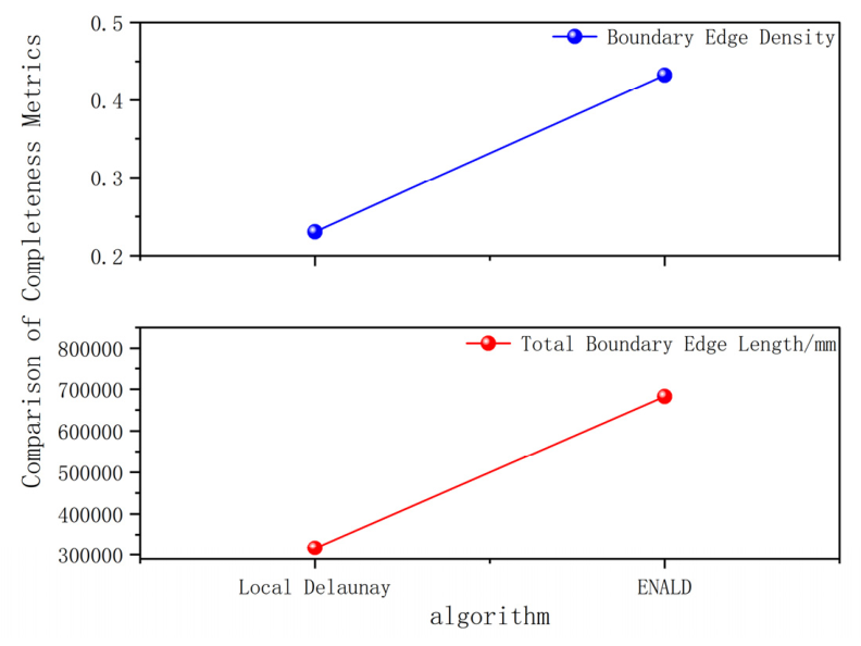
Figure 13.
Visual comparison of surface integrity metrics.
In terms of surface integrity, the ENALD method yields a boundary edge density of 0.432382, which is higher than that of the Local Delaunay method (0.230454). This result indicates that, although the proposed method achieves superior performance in geometric accuracy and detail preservation, its stricter triangle screening strategy suppresses certain local connections, thereby introducing a degree of boundary discontinuity. The increase from 0.23 to 0.43 indicates stricter screening that suppresses bridging artifacts. ENALD trades surface completeness for improved topological reliability.
Compared with the Local Delaunay approach, the increase in boundary edge density (0.23 → 0.43) further demonstrates that the ENALD method effectively suppresses bridging artifacts through the incorporation of normal consistency and edge length constraints. While this leads to an increase in mesh boundaries, it significantly enhances the geometric fidelity and topological reliability of the reconstructed surface. In essence, ENALD trades a certain level of surface completeness for improved geometric accuracy and topological correctness, resulting in more reliable reconstruction outcomes.
3.4.4. Comparative Evaluation of Computational Efficiency
The efficiency metrics are presented in Table 9.
Table 9.
Quantitative comparison of computational efficiency.
In terms of computational efficiency, the ENALD method requires 9.3764 s, compared with 17.1604 s for the Local Delaunay method, corresponding to an improvement of approximately 45.4%. This result indicates that the energy-based ranking and screening mechanism effectively reduces redundant triangles, thereby lowering the overall computational burden of subsequent processing stages.
3.4.5. Comparative Evaluation of 3D Reconstruction Quality
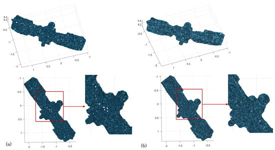
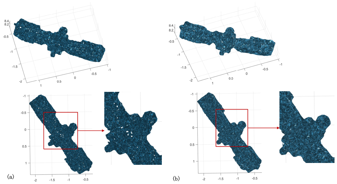
The 3D reconstruction results are presented in Figure 14.
Figure 14.
Comparison of 3D reconstruction results. (a) Local Delaunay, (b) ENALD.
Both methods are capable of recovering the overall shape of the target satellite; however, clear differences can be observed in terms of surface quality and local geometric detail. The model reconstructed by the Local Delaunay method still exhibits noticeable irregular fluctuations and holes in local regions, particularly near structural transitions and boundary areas. In addition, the triangular distribution is relatively disordered, indicating sensitivity to noise.
In contrast, the ENALD method demonstrates improved stability in these regions, with enhanced surface continuity and more natural structural transitions. Further examination of the reconstruction results shown in Figure 14 indicates that the ENALD algorithm does not introduce evident over-smoothing or loss of structural detail in fine-scale regions. Combined with the quantitative accuracy evaluation presented in Table 7 and the surface integrity analysis summarized in Table 8, these observations demonstrate that geometric fidelity is well preserved while noise-induced artifacts are effectively suppressed. This improvement is primarily attributed to the synergistic effect of normal consistency constraints and multi-geometry constraints, which effectively eliminate triangles inconsistent with local geometric characteristics while mitigating the cross-region misconnection issues commonly observed in conventional methods.
Overall, based on the quantitative comparisons presented in Table 7, Table 8 and Table 9 and the visual reconstruction results shown in Figure 14, the proposed ENALD method achieves more effective surface regulation while maintaining structural completeness, resulting in superior visual consistency and geometric rationality compared with the conventional Local Delaunay algorithm.
In summary, the comprehensive quantitative evaluation in Table 7, Table 8 and Table 9 together with the visual comparison of reconstructed meshes in Figure 14 demonstrates that the proposed ENALD method provides more geometrically consistent and topologically reliable reconstructions than the conventional Local Delaunay algorithm. These results confirm its superior robustness and structural representation capability when processing non-uniform and noisy point cloud data.
3.5. Ablation Study of the Proposed Optimization Components
3.5.1. Experimental Design
To quantitatively evaluate the contribution of each optimization component, we conducted a component-wise ablation study. Three optimization modules proposed in ENALD were investigated, namely the normal consistency constraint (NC), the adaptive scale mechanism (AS), and the energy-based optimization module (EO).
Using the Local Delaunay reconstruction algorithm as the baseline model (M1), we adopted an incremental integration strategy to introduce each optimization module sequentially. At each step, only one new component was added, ensuring that only a single variable changed between experiments. This design enabled an accurate assessment of both the individual contribution and the synergistic effects of each module on reconstruction performance.
Ultimately, four experimental models were constructed, as summarized in Table 10.
Table 10.
Configurations of the component-wise ablation study.
3.5.2. Quantitative Results
All experiments were conducted using the same point cloud datasets, uniform parameter settings, and consistent evaluation metrics to ensure the comparability of the experimental results. Four ablation configurations (M1–M4) were evaluated using an incremental integration strategy. M1 represents the baseline Local Delaunay reconstruction method without the proposed optimization components. M2 incorporates the normal consistency constraint (NC) into M1, M3 further introduces the adaptive scale mechanism (AS), and M4 incorporates the energy-based optimization module (EO), corresponding to the complete ENALD framework. This progressive design enables the contribution of each optimization component to be examined by comparing consecutive configurations while also assessing the cumulative effect of their integration. The quantitative results of M1–M4 are evaluated in terms of geometric accuracy, surface integrity, and computational efficiency, as summarized in Table 11.
Table 11.
Quantitative results of the ablation study.
3.5.3. Contribution Analysis of Individual Components
- (1)
- Normal Consistency Constraint
The effectiveness of the Normal Consistency constraint (NC) can be evaluated by comparing M1 and M2 in Table 11. After introducing the NC module, the maximum deviation decreased from 30.379 mm to 27.103 mm, while the average deviation was reduced from 4.771 mm to 3.960 mm. Meanwhile, the RMSE decreased from 6.152 mm to 5.110 mm, corresponding to an improvement of approximately 16.9%. In addition, the boundary edge density increased from 0.230454 to 0.317435, indicating that the reconstructed mesh preserved more realistic surface boundaries while effectively suppressing incorrect triangle connections.
These improvements can be attributed to the normal consistency constraint, which filters candidate triangles whose surface orientations are inconsistent with the estimated local point cloud normals. By removing geometrically inconsistent triangles during local reconstruction, the NC module effectively reduces erroneous surface connections and enhances local geometric fidelity, thereby improving both reconstruction accuracy and mesh quality.
- (2)
- Adaptive Scale Mechanism
The contribution of the Adaptive Scale mechanism (AS) is reflected by comparing M2 and M3. After replacing the global fixed edge-length threshold with the adaptive local spacing, the RMSE was further reduced from 5.110 mm to 5.054 mm, while the average deviation slightly decreased from 3.960 mm to 3.950 mm. Although the improvement is relatively moderate, the adaptive strategy enables the reconstruction process to better accommodate local variations in sampling density without introducing additional computational complexity.
Unlike the fixed global threshold adopted in M2, the adaptive scale mechanism dynamically adjusts the allowable edge length according to the local neighborhood spacing. Consequently, overly restrictive constraints in sparse regions and excessively loose constraints in dense regions can be effectively avoided. This adaptive behavior improves the robustness of local triangulation under non-uniform sampling conditions and provides a more reliable geometric foundation for subsequent optimization.
- (3)
- Energy-based Optimization Module
The effectiveness of the Energy-based Optimization module (EO) can be observed by comparing M3 and M4. After introducing the unified energy model together with energy-based candidate ranking, the computational time decreased substantially from 14.6230 s to 9.3764 s, representing an efficiency improvement of approximately 35.9%. Meanwhile, the boundary edge density increased significantly from 0.312515 to 0.432382, suggesting that the reconstructed mesh better preserves structural boundaries while reducing undesirable long-range triangle connections.
It is worth noting that the RMSE increased slightly from 5.054 mm to 5.420 mm, whereas the maximum deviation decreased considerably from 28.308 mm to 23.903 mm. This result indicates that the proposed energy-based optimization favors globally consistent mesh topology over purely minimizing point-to-surface distance. By jointly considering circumradius, edge length, triangle area, and normal consistency within a unified energy function, low-quality candidate triangles are effectively eliminated through energy ranking. Consequently, the proposed optimization, Although a slight increase in RMSE is observed, the substantial reduction in maximum deviation, together with the significant improvement in boundary preservation and computational efficiency, indicates that the energy-based optimization produces a more reliable mesh representation for practical reconstruction tasks, simultaneously improving mesh integrity, reducing extreme geometric errors, and significantly accelerating the reconstruction process.
3.5.4. Overall Performance and Synergistic Effects of the Optimization Components
The ablation results demonstrate that the three optimization modules contribute to the proposed ENALD framework through different but complementary mechanisms. Specifically, the NC module primarily enhances local geometric consistency by suppressing incorrectly oriented triangles, leading to substantial improvements in reconstruction accuracy. Building upon this foundation, the AS module further improves the adaptability of local triangulation by dynamically adjusting the reconstruction scale according to local sampling density, thereby enhancing robustness under non-uniform point distributions. Finally, the EO module introduces a unified geometric evaluation strategy that simultaneously considers multiple geometric characteristics and performs global candidate selection through energy ranking. Although this optimization results in a slight increase in RMSE, it significantly reduces the maximum reconstruction error, improves boundary preservation, and considerably decreases computational time.
These observations indicate that the three optimization components are not independent improvements but function cooperatively throughout the reconstruction process. The NC module provides reliable local geometric information, the AS module ensures appropriate neighborhood adaptation, and the EO module further refines candidate selection by balancing multiple geometric constraints. Their combination enables the proposed ENALD framework to achieve a favorable trade-off among reconstruction accuracy, mesh quality, and computational efficiency.
Overall, the component-wise ablation study provides clear quantitative evidence for the contribution of each optimization module. The observed performance improvement is not attributable to a single component but results from the coordinated effect of the three complementary optimization strategies, thereby validating the design rationale of the proposed ENALD reconstruction framework.
3.6. Discussion: Practical Applicability, Generalizability, and Limitations
The preceding sections have quantitatively evaluated the reconstruction performance of ENALD and examined the contributions and synergistic effects of its individual optimization components. This section further discusses the practical applicability, generalizability, and limitations of the proposed method beyond the laboratory experiments.
Beyond the quantitative improvements demonstrated in the experimental results, the proposed ENALD framework has practical significance for on-orbit perception of non-cooperative targets. Unlike data-driven reconstruction methods that rely on extensive annotated datasets, ENALD directly operates on raw LiDAR point clouds without prior model training, making it suitable for scenarios where target geometry is unknown or unavailable. This characteristic is particularly valuable for on-orbit servicing, active debris removal, autonomous rendezvous, and space situational awareness, where reliable geometric reconstruction must often be performed immediately after data acquisition. This characteristic makes ENALD particularly suitable for engineering applications where rapid and reliable surface reconstruction must be achieved without the availability of prior target models or extensive training datasets.
Although the experiments were conducted using a laboratory-based satellite model, the proposed reconstruction framework is expected to remain applicable to real on-orbit scenarios because all optimization components are derived from local geometric relationships rather than scene-specific prior information. Because the proposed optimization framework relies exclusively on local geometric relationships rather than scene-specific prior information or training data, it is expected to remain applicable to different non-cooperative targets observed by LiDAR sensors.
Nevertheless, several limitations should be acknowledged when extending the proposed framework to real on-orbit applications. Although the experimental platform reproduces the sensing geometry encountered during rendezvous operations, the validation was conducted using a laboratory-scale satellite model rather than real spaceborne measurements. Consequently, several factors that may influence reconstruction performance under operational conditions were not fully represented, including increased LiDAR noise, long-range observations, spacecraft attitude disturbances, varying illumination conditions, and the diverse structural characteristics of non-cooperative targets such as debris fragments, rocket bodies, and defunct satellites. Furthermore, the current study evaluates only a single representative satellite configuration, while actual on-orbit targets may exhibit substantially greater geometric diversity. Finally, ENALD remains a geometry-driven reconstruction framework and does not explicitly exploit semantic or learned geometric priors, which may further improve reconstruction performance under extremely sparse observations. Future work will therefore focus on validating the proposed framework using high-fidelity simulation environments and, when available, real on-orbit LiDAR datasets.
4. Conclusions
To address the challenges of sparse point cloud data, incomplete structural representation, and noise interference in the on-orbit sensing of non-cooperative target satellites, this study proposes an energy-driven adaptive 3D reconstruction strategy (ENALD) based on multi-frame LiDAR point cloud fusion. By integrating geometric constraints, normal consistency, and an adaptive scale mechanism into a unified framework, the proposed method achieves stable and consistent 3D reconstruction under conditions of non-uniform sampling and noise contamination. A dedicated experimental platform was established for data acquisition and validation. The main conclusions are summarized as follows:
The multi-frame point cloud fusion strategy is systematically investigated to improve geometric completeness and data quality. The results indicate that increasing the number of fused frames continuously enhances point cloud density and spatial uniformity. However, excessive frame fusion leads to performance saturation and may introduce cumulative registration errors. Experimental results demonstrate that a 12-frame fusion configuration achieves an optimal trade-off between data completeness and stability, providing reliable input for subsequent reconstruction.
Among the evaluated reconstruction methods, the Local Delaunay algorithm achieves the best balance between geometric accuracy (RMSE = 6.152 mm) and structural representation capability, outperforming Delaunay triangulation, Poisson surface reconstruction (PSR), and the Crust algorithm. However, its reliance on multiple manually defined geometric thresholds and fixed-scale constraints results in high parameter sensitivity, thereby limiting its robustness under noisy and non-uniform sampling conditions.
An energy-based normal-consistent adaptive reconstruction method (ENALD) is developed within the Local Delaunay framework. By introducing normal consistency constraints and an adaptive scale mechanism, multiple geometric features—including circumcircle radius, edge length, triangle area, and normal consistency—are integrated into a unified energy formulation. Based on energy ranking, a selection strategy retaining the lowest 50% of energy-valued triangles is adopted. This approach replaces conventional multi-threshold screening, resulting in a more stable triangle selection process with improved generalization capability.
The experimental results demonstrate that, compared with the Local Delaunay algorithm, the proposed method reduces the maximum deviation, mean deviation, and RMSE by 21.3%, 10.0%, and 11.9%, respectively, while improving computational efficiency by approximately 45.4%. Although the boundary edge density increases, the geometric fidelity of the reconstructed model is significantly enhanced, and erroneous topological connections are effectively suppressed. Consequently, the overall integrity and reliability of the reconstruction results are further improved. The component-wise ablation study further demonstrates that the improvements originate from the complementary effects of the normal consistency constraint, adaptive scale mechanism, and energy-based optimization module, thereby validating the effectiveness of the proposed framework.
Author Contributions
Original draft preparation, Formal analysis, T.L.; Supervision, Support, Review & Editing, J.D.; Software, Conceptualization, Methodology, Y.L.; Data curation, Formal analysis, W.W.; Visualization, Investigation, G.Q. and F.L. All authors have read and agreed to the published version of the manuscript.
Funding
This work was supported in part by Henan Science and Technology Attack Project (252102220117).
Data Availability Statement
The data presented in this study are available upon request from the corresponding author.
Conflicts of Interest
The authors declare no conflicts of interest.
References
- Xia, S.; Chen, D.; Wang, R.; Li, J.; Zhang, X. Geometric Primitives in LiDAR Point Clouds: A Review. IEEE J. Sel. Top. Appl. Earth Obs. Remote Sens. 2020, 13, 685–707. [Google Scholar] [CrossRef] [Scilit]
- Zhang, C.; Guo, Y.; Meng, D.; Zhu, W.; Li, W.; Peng, J.; Liang, B. Hybrid Iteration and Optimization-Based Three-Dimensional Reconstruction for Space Non-Cooperative Targets with Monocular Vision and Sparse Lidar Fusion. Aerosp. Sci. Technol. 2023, 140, 108484. [Google Scholar] [CrossRef] [Scilit]
- Nishishita, T.; Nakajima, Y.; Sasaki, T.; Okamoto, H.; Nakamura, R. LiDAR-Based Navigation Strategies for a Non-Cooperative Target Considering Rendezvous Trajectory. J. Space Saf. Eng. 2025, 12, 217–226. [Google Scholar] [CrossRef] [Scilit]
- Chi, H.; Chen, K.; Zhang, J. Monocular Modeling of Non-Cooperative Space Targets Under Adverse Lighting Conditions. Aerospace 2025, 12, 901. [Google Scholar] [CrossRef] [Scilit]
- Huang, H.; Li, D.; Zhang, H.; Ascher, U.; Cohen-Or, D. Consolidation of Unorganized Point Clouds for Surface Reconstruction. ACM Trans. Graph. 2009, 28, 1–7. [Google Scholar] [CrossRef] [Scilit]
- Xue, X.; Yang, X.; Yue, J.; Mao, Q.; Qin, Y.; Ma, H.; Yang, J.; Wan, H.; Zhang, E.; Qiu, J.; et al. Digital Modelling Method of Coal-Mine Roadway Based on Millimeter-Wave Radar Array. Sci. Rep. 2024, 14, 18585. [Google Scholar] [CrossRef] [Scilit] [PubMed]
- Xu, Y.; Liu, K.; Ni, J.; Li, Q. 3D Reconstruction Method Based on Second-Order Semiglobal Stereo Matching and Fast Point Positioning Delaunay Triangulation. PLoS ONE 2022, 17, e0260466. [Google Scholar] [CrossRef] [Scilit] [PubMed]
- Dey, T.K.; Goswami, S. Tight Cocone: A Water-Tight Surface Reconstructor. J. Comput. Inf. Sci. Eng. 2003, 3, 302–307. [Google Scholar] [CrossRef] [Scilit]
- Amenta, N.; Choi, S.; Kolluri, R.K. The Power Crust, Unions of Balls, and the Medial Axis Transform. Comput. Geom. 2001, 19, 127–153. [Google Scholar] [CrossRef] [Scilit]
- Dey, T. Curve Reconstruction: Connecting Dots with Good Reason. Comput. Geom. 2000, 15, 229–244. [Google Scholar] [CrossRef] [Scilit]
- Bernardini, F.; Mittleman, J.; Rushmeier, H.; Silva, C.; Taubin, G. The Ball-Pivoting Algorithm for Surface Reconstruction. IEEE Trans. Vis. Comput. Graph. 1999, 5, 349–359. [Google Scholar] [CrossRef] [Scilit]
- Zahida, T.; Bouhadja, K.; Azouaoui, O.; Ghoualmi-Zine, N. Enhanced Unstructured Points Cloud Subdivision Applied for Parallel Delaunay Triangulation. Clust. Comput. 2023, 26, 1877–1889. [Google Scholar] [CrossRef] [Scilit]
- Pan, F.; Liu, J.; Yang, H.; Zhao, H.; Chen, W.; Zhang, R.; Zhang, J. Improved Poisson surface reconstruction algorithm based on hybrid tree. Laser Technol. 2023, 47, 816–823. [Google Scholar] [CrossRef]
- Kazhdan, M.; Chuang, M.; Rusinkiewicz, S.; Hoppe, H. Poisson Surface Reconstruction with Envelope Constraints. Comput. Graph. Forum 2020, 39, 173–182. [Google Scholar] [CrossRef] [Scilit]
- Hou, F.; Wang, C.; Wang, W.; Qin, H.; Qian, C.; He, Y. Iterative Poisson Surface Reconstruction (iPSR) for Unoriented Points. ACM Trans. Graph. 2022, 41, 128. [Google Scholar] [CrossRef] [Scilit]
- Kazhdan, M.; Hoppe, H. Screened Poisson Surface Reconstruction. ACM Trans. Graph. 2013, 32, 29. [Google Scholar] [CrossRef] [Scilit]
- Ai, Y.; Sun, N.; Han, S.; Zhou, M. An Improved Octree-Based Surface Reconstruction Method for Weld Appearance with High Efficiency During Oscillating Laser Welding. Adv. Mater. Technol. 2026, 11, e01090. [Google Scholar] [CrossRef] [Scilit]
- Zhou, K.; Gong, M.; Huang, X.; Guo, B. Data-Parallel Octrees for Surface Reconstruction. IEEE Trans. Vis. Comput. Graph. 2011, 17, 669–681. [Google Scholar] [CrossRef] [Scilit] [PubMed]
- Berger, M.; Tagliasacchi, A.; Seversky, L.M.; Alliez, P.; Guennebaud, G.; Levine, J.A.; Sharf, A.; Silva, C.T. A Survey of Surface Reconstruction from Point Clouds. Comput. Graph. Forum 2017, 36, 301–329. [Google Scholar] [CrossRef] [Scilit]
- Dey, T.K.; Levine, J.A.; Slatton, A. Localized Delaunay Refinement for Sampling and Meshing. Comput. Graph. Forum 2010, 29, 1723–1732. [Google Scholar] [CrossRef] [Scilit]
- Dey, T.K.; Slatton, A.G. Localized Delaunay Refinement for Volumes. Comput. Graph. Forum 2011, 30, 1417–1426. [Google Scholar] [CrossRef] [Scilit]
- Gopi, M.; Krishnan, S.; Silva, C.t. Surface Reconstruction Based on Lower Dimensional Localized Delaunay Triangulation. Comput. Graph. Forum 2000, 19, 467–478. [Google Scholar] [CrossRef] [Scilit]
- Fuchs, A. Almost Regular Delaunay-Triangulations. Int. J. Numer. Methods Eng. 1997, 40, 4595–4610. [Google Scholar]
- Taitelbaum, H.; Kopelman, R.; Weiss, G.H.; Havlin, S. Statistical Properties of Nearest-Neighbor Distances at an Imperfect Trap. Phys. Rev. A 1990, 41, 3116–3120. [Google Scholar] [CrossRef] [Scilit] [PubMed]
- Kazhdan, M.; Bolitho, M.; Hoppe, H. Poisson Surface Reconstruction. In Proceedings of the Fourth Eurographics Symposium on Geometry Processing; Eurographics Association: Goslar, Germany, 2006; pp. 61–70. [Google Scholar]
- Hoppe, H.; DeRose, T.; Duchamp, T.; McDonald, J.; Stuetzle, W. Surface Reconstruction from Unorganized Points. In Proceedings of the 19th Annual Conference on Computer Graphics and Interactive Techniques; Association for Computing Machinery: New York, NY, USA, 1992. [Google Scholar]
- Estellers, V.; Scott, M.A.; Soatto, S. Robust Surface Reconstruction. SIAM J. Imaging Sci. 2016, 9, 2073–2098. [Google Scholar] [CrossRef] [Scilit]
- Sharma, R.; Abrol, P. Parameter Extraction and Performance Analysis of 3D Surface Reconstruction Techniques. Int. J. Adv. Comput. Sci. Appl. (IJACSA) 2023, 14, 35. [Google Scholar] [CrossRef] [Scilit]
- Wan, M.; Wang, Y.; Wang, D. Variational Surface Reconstruction Based on Delaunay Triangulation and Graph Cut. Int. J. Numer. Methods Eng. 2011, 85, 206–229. [Google Scholar] [CrossRef] [Scilit]
- Huber, P.J. Robust Statistics; Wiley: New York, NY, USA, 1981. [Google Scholar]
- Han, D.; Jiao, Z.; Zhou, L.; Ding, C.; Wu, Y. Geometric Constraints Based 3D Reconstruction Method of Tomographic SAR for Buildings. Sci. China Inf. Sci. 2022, 66, 112301. [Google Scholar] [CrossRef] [Scilit]
- Annich, A.; Abderrahmani, A.E.; Satori, K. Beautification and Efficiency Improvement of 3D Modelling with the Help of Geometric Constraints. Int. J. Intell. Eng. Inform. 2016, 4, 354–376. [Google Scholar] [CrossRef] [Scilit]
- Dey, T.K.; Goswami, S. Provable Surface Reconstruction from Noisy Samples. Comput. Geom. 2006, 35, 124–141. [Google Scholar] [CrossRef] [Scilit]
- Mescheder, L.; Oechsle, M.; Niemeyer, M.; Nowozin, S.; Geiger, A. Occupancy Networks: Learning 3D Reconstruction in Function Space. arXiv 2019, arXiv:1812.03828. [Google Scholar] [CrossRef] [Scilit]

Disclaimer/Publisher’s Note: The statements, opinions and data contained in all publications are solely those of the individual author(s) and contributor(s) and not of MDPI and/or the editor(s). MDPI and/or the editor(s) disclaim responsibility for any injury to people or property resulting from any ideas, methods, instructions or products referred to in the content. |
© 2026 by the authors. Licensee MDPI, Basel, Switzerland. This article is an open access article distributed under the terms and conditions of the Creative Commons Attribution (CC BY) license.