


Abstract
This article discusses a novel aircraft coordination algorithm for automated vertiport operation. New applications of Innovative Air Mobility (IAM) including inspection, logistics and security UAVs, Urban Air Mobility (UAM) or Regional Air Mobility (RAM) present a coordination challenge, especially near vertiports, as large numbers of vehicles with different characteristics share the airspace, and so avoiding collisions, optimizing resource usage and operating with low human intervention is important.In this paper, this problem is addressed by proposing a new formulation of the aircraft coordination problem that makes use of a discretized airspace to detect potential conflicts and collisions between cooperative and non-cooperative aircraft in the surroundings of a vertiport. The proposed algorithm not only considers the cells traversed by the aircraft, but also the set of adjacent cells, making the algorithm more conservative and robust than other algorithms found in the literature, and achieving a 100% conflict-detection rate. A mathematical model of aircraft dynamics is employed to turn high-level flight plans into detailed aircraft trajectories, using those trajectories to detect potential collisions. The deconfliction problem is formulated as a mixed-integer optimization program that computes orders of pass for every conflict while minimizing the divergence between requested time of arrival (RTA) and estimated time of arrival (ETA). This problem is implemented in OR-Tools to be solved by means of the CP-SAT solver. The validity of the solution is tested by extensive simulation, showing tactical coordination of up to 25 aircraft landing on a vertiport.
1. Introduction
The advent of electric vertical takeoff and landing (eVTOL) vehicles is revolutionizing transportation, giving rise to Innovative Air Mobility (IAM) as a viable mode of movement within cities (Urban Air Mobility, UAM) and between cities (Regional Air Mobility, RAM). Current urban transport networks (both ground mobility and conventional aviation) face growing inefficiencies: road congestion limits last-mile delivery and emergency response, while low-altitude airspace remains largely underused. eVTOL vehicles, combining vertical take-off and landing capability with electric propulsion, offer a scalable solution across a wide range of missions: passenger transport, freight and logistics, infrastructure inspection, emergency services, and surveillance [1]. Their commercial viability is advancing rapidly, with multiple manufacturers conducting crewed and autonomous test flights and regulators developing dedicated certification frameworks [1]. IAM encompasses a wide range of applications, including the transportation of goods and people, last-mile logistics, emergency deliveries, safety and surveillance, and infrastructure inspection, among others. This trend has also received the label of Advanced Air Mobility (AAM) or Low-Altitude Economy (LAE).
However, the increasing presence of flying vehicles in urban environments poses significant coordination challenges for traditional Air Traffic Control (ATC) methods, which rely on human controllers issuing voice clearances for separation, sequencing and spacing, supported by radar surveillance and procedural rules. These methods do not scale to the traffic densities, heterogeneous vehicle performance, and low-altitude urban complexity expected in IAM scenarios, where the number of simultaneously active vehicles may far exceed human controller workload limits and tactical decisions must be made on sub-minute timescales [2,3]. To address this need, new autonomous or automated coordination mechanisms are required to efficiently manage airspace, in what has been named UTM (Unmanned aircraft system Traffic Management).
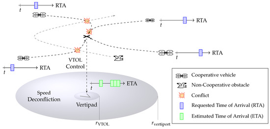
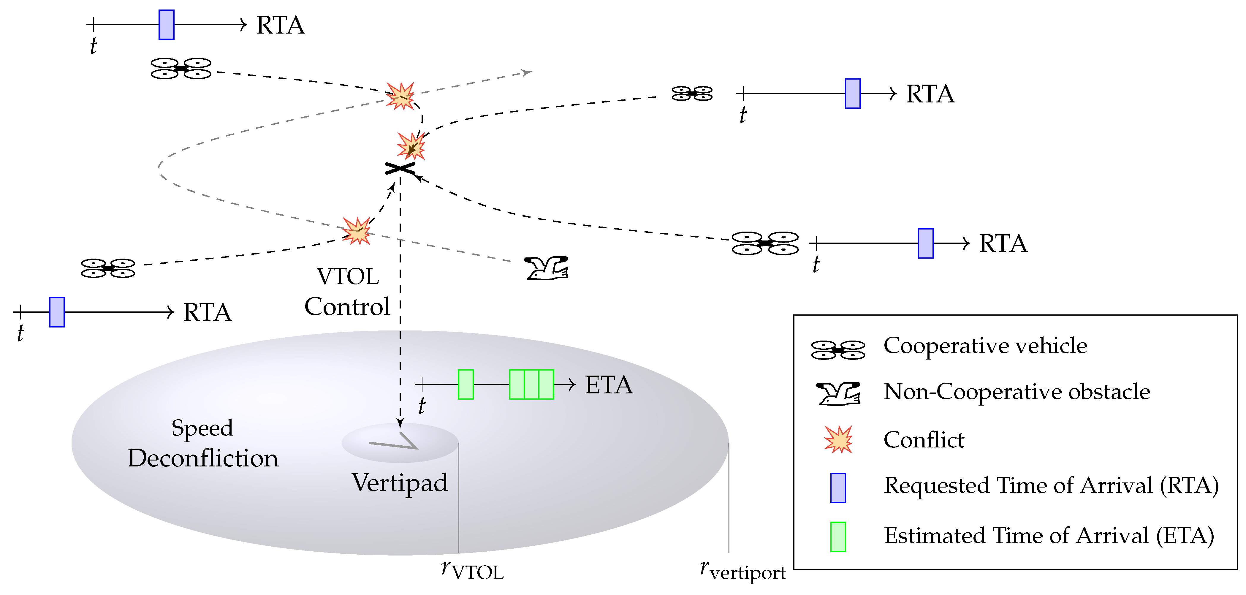
This paper presents a novel formulation for the multiple air vehicle coordination problem, as represented in Figure 1, which accounts for the dynamics of diverse aerial vehicles, utilizes a discretized airspace, detects conflicts and potential collisions, and resolves them through speed variation. Furthermore, our approach computes an optimal scheduling strategy that minimizes the deviation between requested and estimated times of arrival for all aircraft, thereby reducing overall delay. The validity of our methodology is demonstrated through extensive simulation, showcasing its potential to address the complexities of IAM coordination.
Figure 1.
Schematic representation of the vertiport operation problem. Several VTOL aircraft register their flight plans to reach the vertiport, as well as their RTAs, as they enter the controlled airspace volume. The vertiport monitors all registered cooperative aircraft as well as non-cooperative flying systems and estimates of their trajectories. The vertiport operation algorithm detects conflicting points in the registered trajectories over a moving horizon time window, and it optimizes the speeds profiles of the cooperative aircraft to minimize the divergence between RTA and ETA while guaranteeing conflict-free trajectories.
1.1. Related Work
ATC techniques employed in commercial airports frequently rely on a set of components [4]:
- An aircraft trajectory synthesizer to estimate real times of arrival of the involved aircraft.
- A specific airspace architecture designed to conveniently schedule arrivals and absorb delays.
- A conflict detection and resolution algorithm.
The expansion of such techniques to the broad scenario of IAM remains a challenging topic, which has been explored in the scientific literature. The following section summarizes the main approaches and related methods to be found in the literature.
1.1.1. Aircraft Trajectory Synthesis
In the context of commercial aviation, several trajectory synthesizer algorithms are employed to turn high level flight plans and waypoints into realistic aircraft trajectories, therefore reliably estimating their time of arrival. These algorithms generally include a model of the aircraft performance, trajectory constraints, atmospheric conditions and, based on the aircraft’s current state (ground speed, heading, altitude and position) and desired flight plan, compute a realistic trajectory [5]. A comprehensive review of 4D trajectory prediction techniques is provided in [6].
Aircraft performance modeling techniques can be classified between kinematic, where the aircraft is described as a particle with some displacement and velocity, disregarding the exact forces acting on the aircraft and kinetic, where the underlying physics of the system are captured in higher detail. The Base of Aircraft Data (BADA), developed by Eurocontrol [7] constitutes a widely used kinetic model of commercial aircraft performance. The model captures the equations of motion of generic aircraft under several propulsion forces and atmospheric conditions, and it employs a wide database of flight records for different aircraft models to fit, with system identification techniques, the set of parameters that best captures the dynamics of each aircraft. This highly detailed model provides realistic trajectory estimates, including metrics such as fuel consumption and facilitating optimization and decision-making. More recently, these traditional physical modeling based aircraft trajectory prediction methods are being complemented by more modern learning based methods, as is thoroughly reviewed in [8].
Several attempts have been made to expand the kinetic modeling procedure of BADA to the new landscape of eVTOL vehicles. For instance, ref. [9] proposes a detailed kinetic model for multirotor eVTOL air taxi vehicles in UAM applications, using this model to compute, through trajectory optimization techniques, a database of vertical descent profiles that would lead to different delay absorptions and different RTAs. In [10], a similar kinetic model is proposed for a tilt-wing eVTOL aircraft. An alternative approach is explored in [11], where kinetic models for different UAM vehicle architectures (multirotor, decoupled lift + cruise, tilt-wing) are proposed, and synthetic performance data is generated in a detailed simulator to conveniently characterize such models.
Despite these efforts, the generation of accurate kinetic performance models for IAM vehicles remains challenging because of the inherent variability in vehicle architectures, mission types and lack of flight data for these systems. While some of our previous work developed highly detailed dynamic models for UAM [12] and aerial robotics [13] vehicles, in this paper, a simpler, less detailed kinematic approach is employed for trajectory synthesis, which does not require the large amounts of data used for system identification in kinetic systems.
1.1.2. Vertiport Airspace Architecture
Because of the recent nature of IAM, research is still being carried out to determine the configuration of future airspace near vertiports. Some researchers have proposed specific vertiport airspace architectures to facilitate aircraft coordination, delay absorption, deconfliction and scheduling.
In [14], a vertiport ATC concept is proposed, introducing “holding points” for multirotor VTOLs. This work evaluates three arrival-scheduling strategies: branch queuing approach, sequence-based approach, and sequence-based approach with moving circles. Another vertiport airspace structure with spatially segregated routes is proposed in [6] to eliminate collisions between ascending and descending drones, significantly reducing take-off and landing times compared to traditional funnel-shaped configurations. In addition, the authors develop a real-time sequencing model based on the Hungarian algorithm that incorporates battery levels and mission priorities to optimize scheduling and enhance operational safety. Similarly, ref. [15] analyzes three different possible vertiport airspace architectures of hovering points with concentric rings.
It is important to remark that, while all VTOLs are capable of hovering, it is often very inefficient to do so and hovering time should be limited to the landing phase and not to the approach or waiting phase. Thus, other approaches, such as [16] minimize inefficient hovering by imposing circular waiting trajectories to the arriving VTOLs. The authors study the final landing phase of high-density vertiports, structuring the airspace in circular waiting trajectories. In addition, the airspace management and collision avoidance problem is modeled as a Markov Decision Process (MDP), and solved in a decentralized manner, where each aircraft has a reward function to provide separation and collision avoidance in the terminal arrival sequencing problem, descending concentric rings as required by the sequencing problem. A similar circular waiting arrangement of the vertiport is proposed by [17], presenting a rolling-horizon scheduling framework combined with a library of optimal pre-computed descent trajectories that enable delay absorption as required by the scheduler. Another moving concentric circle based vertiport is proposed in [18], where a reinforcement learning based controller is developed to handle large-scale sequencing problems. A similar setup of moving concentric circles is presented in [19] as the solution to a fully decentralized reinforcement learning based vertiport arrival algorithm. A more complex structure of rings can be shown in [20], where an adaptive control system is proposed for multi-ring vertiport terminal areas. A categorization of different arrival and departure structures for vertiports is explored in [21], where the authors provide a parametric model for such air routes. In addition, the work introduces an optimization method to evaluate these configurations, identifying specific route structures that minimize delays and maximize throughput during high-volume UAV operations.
In our work, we focus on performing speed deconfliction on the flight phase previous to the vertiport terminal area control phase, assuming that, once arrived at the vertiport controlled area, the wait time of the different aircraft will be managed by a dedicated controller.
1.1.3. Conflict Detection and Resolution
In traditional aviation, ATC guarantees that separation is maintained, and no conflict arises between aircraft. Many methods have been proposed for conflict detection and resolution (CD&R), ref. [22] cataloged 68 modelling approaches, distinguishing them among dimensions of state information (vertical, horizontal, 3D), propagation methods (nominal, worst-case or probabilistic), conflict detection thresholds and resolution modalities (prescribed, optimized, force field or manual), maneuvering dimensions (speed change, lateral, vertical, or combined maneuvers) and handling of multi-aircraft conflicts (pairwise or global). Trajectory deconfliction is generally divided between strategic and tactical: strategic deconfliction takes a longer time horizon and approves flight plans before flight to match the throughput of the infrastructure, while tactical deconfliction handles detailed trajectories in a lower time horizon, usually in real-time, while the aircraft is flying. A more recent comprehensive taxonomy of CD&R methods with a focus on IAM can be found in [23].
Recent works explore the use of novel techniques for the resolution of the strategic deconfliction and scheduling problem in traditional aviation. A data-driven ATC tool for conflict detection is developed in [24], utilizing a combination of classification and regression algorithms to identify situations of interest and predict the minimum expected separation between aircraft. A strategy for enhancing tactical conflict resolution is proposed in [25] by establishing specific traveling rules in urban airspace, such as separating traffic into different layers based on heading and altitude. In addition, the authors utilize a reinforcement learning agent to implement variable speed limits, creating a more homogeneous traffic flow between cruising and maneuvering aircraft to improve overall operational safety. Ref. [26] proposes a multi-agent reinforcement method to perform a collective CD&R capable of handling high levels of traffic. In [27], a trajectory replanning and strategic deconfliction method that takes weather into account is presented. It divides the multi aircraft deconfliction problem in sub-problems of pairwise aircraft conflict resolution.
Several attempts have been made at adapting strategic and tactical deconfliction techniques to the challenges of IAM. Ref. [28] introduced an adaptive two-layer optimization framework for multi-UAV routes. This strategic deconfliction framework selects among scheduling, speed-adjustment and rerouting strategies for each conflict type, and solves the resulting mixed-integer nonlinear problem with an improved stochastic fractal search algorithm, thereby producing conflict-free 4D routes with lower operational cost, fewer conflicts and reduced delays. Tactical conflict prevention and resolution improvements for high-density U-space environments are investigated in [29], with a focus on prioritizing vertical separation at intersections and utilizing aircraft intent for detection. Ref. [30] proposes a suite of Tactical Conflict-Resolution Solvers that rely on a transformer-based multi-agent reinforcement-learning core, trained under realistic perturbations (position noise, communication loss, sensor faults). The study analyzed mixed cooperative and non-cooperative traffic, as well as concurrent general aviation and IAM operations. Ref. [31] introduces a two-level ATC framework for UAM scenarios that first optimizes waypoint-based routes across space and time, then applies a collision-avoidance scheme to generate safe 3D trajectories, demonstrating large-scale in terms of UAM traffic safety and efficiency.
One way of handling the large scale of the CD&R problem is using a discretized airspace to detect potential collisions instead of storing and verifying the four dimensional distance between all involved aircraft. For example, ref. [32] presented grid-based strategic conflict-detection methods that discretize the 4D airspace into a space-time lattice, storing aircraft trajectories in cells so that an occupied cell signals a potential conflict. The authors introduced a deterministic and a stochastic variant of the algorithm, the latter incorporating trajectory and weather-uncertainty. A performance-based airspace model is introduced in [33], which employs a novel discretization methodology to dynamically manage resources through the use of occupancy grids. In addition, the authors propose an airspace sectorization approach that incorporates protection buffers tailored to navigation uncertainty, communication constraints, and surveillance performance to ensure safety among diverse vehicle types in dense urban environments.
This same approach can also be appreciated in tactical and combined deconfliction scenarios. For instance, ref. [34] introduced an online velocity-planning scheme that combines a search-tree to generate a feasible order of pass with a linear-programming (LP) formulation to minimize deviation from the originally planned trajectories. In addition, ref. [35] proposes a near-real-time air-conflict resolution approach that discretizes the 3D airspace into a finite set of critical trajectory points and formulates a mixed-integer linear program capable of handling both speed- and heading-change maneuvers. Ref. [36] proposes a multi-level spatio-temporal grid indexing scheme that replaces pairwise trajectory algebra with fast grid-state queries, enabling real-time low-altitude conflict detection for dense traffic, while markedly reducing computational load. A novel operational framework for 4D trajectory conflict management is proposed in [37], employing 3D grid-based airspace discretization to efficiently handle restricted areas. The authors implemented a two-stage planning process to enable fuel-optimal trajectories that satisfy controlled times of arrival and trajectory recovery requirements. Ref. [38] presents a three-stage CD&R pipeline for low-altitude eVTOL operations that decouples 4D motion into independent geodetic components and refines trajectory prediction, performs dynamic conflict detection on a spatial grid using the Gilbert–Johnson–Keerthi algorithm, and resolves conflicts in real time with an enhanced artificial-potential-field controller, demonstrating improved safety and efficiency for six coordinated eVTOL flights. In [39], a three-dimensional digital-grid framework with a hierarchical altitude-layer structure is introduced. It detects conflicts via set-based cell-overlap operations and resolves them by means of a constrained genetic-algorithm optimizer, achieving >94% detection accuracy, 95% resolution success and low processing times in high-density airspace scenarios. An end-to-end framework for high-density environments is proposed in [40], which utilizes octree spatial partitioning to enable hierarchical conflict detection. In addition, the authors implement a resolution module to minimize adjustment offsets while strictly adhering to safety separation standards.
Table 1 summarizes these representative discretisation-based CD&R methods and relates the present work to them. Two recurring limitations emerge across the literature: conflict detection based on shared-cell occupancy leaves boundary false negatives, and resolution typically relies on heuristic or metaheuristic optimisers with no optimality guarantee. These grid-based deconfliction methods are well suited for real-time resolution of large scale deconfliction problems. However, they present the caveat that some false-negatives can arise if the grid division lays between conflicting trajectories. In other words, they can not always guarantee 100% conflict detection accuracy, which is concerning for safety critical applications. In this article, we want to address this issue by proposing a grid-based conservative conflict detection and resolution algorithm.
Table 1.
Comparison of representative discretisation-based CD&R methods.
1.2. Contributions
The main contributions of this paper are the following:
- A new airspace discretization technique that enables reliable and conservative conflict detection.
- A mathematical program formulation to conveniently solve the tactical coordination problem in the airspace near vertiports using speed variation commands.
- An implementation of such program using the Google OR-Tools CP-SAT solver, version 9.11.4210 [41].
- Extensive simulations showing the validity and limitations of the proposed approach.
1.3. Overview
This work is structured as follows: After the current Section 1 that summarizes the relevant state of the art and contributions of the current work, Section 2 describes the mathematical formulation of the vertiport operation algorithm, as well as the assumptions that were chosen for its formulation. Then, Section 3 presents a set of simulations showing the validity and limitations of the proposed approach. Finally, Section 4 summarizes the key insights of the present work and outlooks at future research directions.
2. Vertiport Operation Algorithm
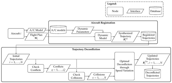
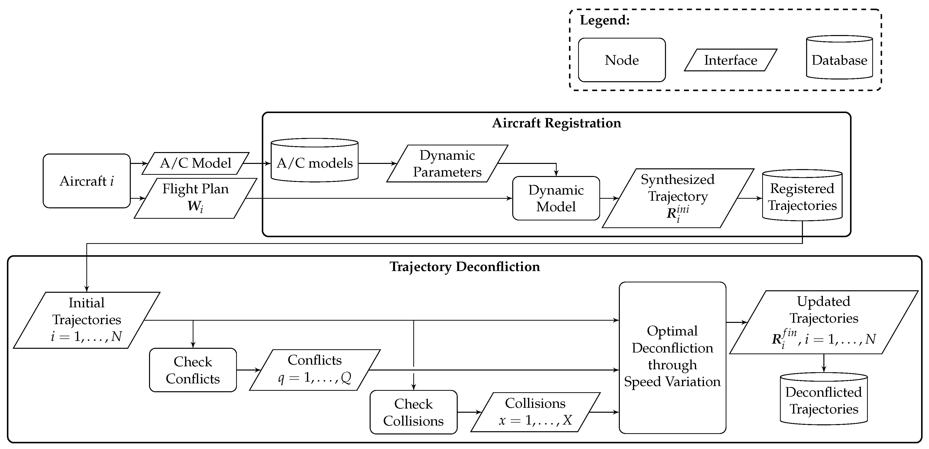
In the following section, a mathematical formulation of the vertiport operation problem is presented, clearly stating the assumptions and airspace configuration choices made. Figure 2 shows a schematic representation of the vertiport operation algorithm, showing the steps and interfaces between the different nodes.
Figure 2.
System architecture diagram. Every time a new aircraft enters the vertiport controlled airspace it gets registered, turning its flight plan into a synthetic trajectory that matches the dynamic properties of the specific aircraft model. When the registered trajectory database is updated, the trajectory deconfliction algorithm gets executed, detecting conflicts and collisions between the different trajectories and optimizing the speeds profiles of all aircraft to minimize the net delay of the system, generating an updated database of feasible trajectories.
2.1. Assumptions
The vertiport operation problem is restricted with the following assumptions:
- The airspace controlled by the vertiport is limited to a cylinder of radius and height .
- Several cooperative aircraft intend to land at a requested time of arrival (RTA) at the vertiport.
- Several non-cooperative aircraft are crossing the vertiport airspace but do not intend to land on the vertiport and do not respond to the coordination commands of the vertiport operation algorithm.
- Throughout this work, non-cooperative aircraft denotes traffic that does not accept vertiport speed commands; its motion is provided as a fixed estimated trajectory (not a cooperative flight plan), discretised into occupied grid cells for conflict detection.
- It is assumed that, in the range between and , the vertiport operator will only be able to modify the speed profile of the cooperative trajectories, slowing the down but without making translational modifications.
- The aircraft involved in the deconfliction problem will be in forward flight mode, hovering will be avoided before the VTOL phase as much as possible for efficiency reasons.
- Once the is crossed, a dedicated VTOL control algorithm will handle the landing of the vehicle. This algorithm is outside the scope of the current work and a constant landing time will be assumed .
- The flight plans of all the aircraft flying in the controlled airspace are known.
- -
- The flight plan of cooperative aircraft is provided at registration.
- -
- In the general case, the trajectory of non-cooperative aircraft must be estimated from available sensor data and surveillance systems. Appropriate estimation algorithms for this purpose are outside the scope of the current work. It is therefore assumed that an estimated trajectory of each non-cooperative aircraft is available as input to the coordination algorithm, and that such trajectories are treated as fixed, unmodifiable constraints (the vertiport coordination algorithm cannot alter them, and they are always assigned priority over cooperative aircraft). Non-cooperative obstacles are ultimately represented as a set of occupied grid cells with fixed entry and exit times, and processed by the conflict detection and collision avoidance algorithm regardless of how the trajectory estimate is obtained.
- An aircraft trajectory is defined to have a conflict whenever its computed trajectory is below a certain spatial threshold with respect to other registered trajectory.
- An aircraft trajectory is defined to have a collision in one of its conflicts when the time separation between the two aircraft involved in such conflict is below a certain temporal threshold .
- The vertiport coordination algorithm must be executed iteratively on a moving horizon basis, every time a new aircraft is registered or if a modification with respect to the planned trajectories is detected.
- The local Earth frame of reference is defined using NED (North-East-Down) convention and having the vertipad as origin of coordinates.
While the above assumptions simplify the coordination problem, they reflect realistic operational constraints. Speed-only deconfliction (without path modification or speed-up commands) is consistent with the limited authority a vertiport coordination agent can realistically exercise over autonomous vehicles: rather than imposing trajectory changes that may conflict with each vehicle’s own mission planning and onboard autonomy, the coordinator requests only a slowdown of the originally reported trajectory, which is the least invasive intervention available. The cylindrical controlled airspace maps naturally to the terminal area of a vertiport. The constant VTOL landing time is a conservative simplification of the landing phase, which is handled by a dedicated controller outside the scope of this work. Finally, the assumption of available estimated trajectories for non-cooperative aircraft is the most idealized: in practice, an estimation layer would be required, and its design is identified as future work.
2.2. Flight Plan Registration and Trajectory Synthesis
Whenever a cooperative aircraft enters the controlled airspace and manifests its interest in landing at the vertiport, it must declare its vehicle model, its flight plan and the RTA matching such flight plan. For non-cooperative aircraft, an estimated-trajectory is assumed to be available, as described above. The flight plan for aircraft is a time series containing the Cartesian waypoints and associated timestamps with a low sampling frequency and dynamic accuracy. These waypoints are expressed in an inertial reference frame Earth.
Every registered flight plan will be used to synthesize a smooth and feasible trajectory, employing a dynamic model of the aircraft dynamics. In order to do so, the flight plan gets augmented by computing the reference linear speeds for each waypoint by means of a First-Order Hold (FOH).
This leads to the augmented flight plan which contains Cartesian positions and estimates of velocities
The dynamic model chosen to synthesize the trajectories is based on a simplified kinematic model described in the literature [34,42]. This model takes as input the augmented flight plan and delivers a smooth and feasible trajectory composed of samples of Cartesian positions and speeds expressed in Earth.
To compute this trajectory, first, a variable transformation is performed to the waypoints, computing the reference heading and horizontal speed magnitude variables.
Then, dynamics are propagated forward in time, assuming a first-order linear system for the heading and horizontal speed modulus and a second-order linear system for the vertical velocity
Maximum vertical acceleration and heading acceleration are limited for each aircraft by means of parameters , . Defining
These variables can be transformed back into the Cartesian position variables expressed in Earth by considering the effect of the rotation of frames of reference
The feasible trajectory is computed propagating the flight plan through the equations of motion by means of a numeric Explicit Runge-Kutta method of order 5.
2.3. Conflict Detection
Two trajectories
are said to be in state of conflict in every instant t when there is less than the minimum allowable distance between them
However, keeping track of this metric becomes very resource intensive as the number of trajectories N increases. In particular, it would require keeping track of a number of time-signals given by the binomial coefficient
and checking for the time instants when each one of these signals stays below the admissible threshold. In addition, on a sufficiently large 3D airspace, the circumstances under which a conflict will happen will be relatively sparse, and using a directed search algorithm will be more efficient than comparing, for all time instants, the relative distances of all the possible trajectory pair combinations.
One way of avoiding this issue is making use of a discretized airspace to direct the conflict detection algorithm. The idea is to divide the tracked airspace into smaller cells whose Cartesian positions are given by indices
With this discretization, it is possible to transform, for all trajectories , the continuous paths defined in , to the corresponding sequence of traversed cells
where each corresponds to one cell traversed by the original path such that
And it must be guaranteed that only one of the three-dimensional indices increases between consecutive cells of the sequence, ensuring that all cells are connected through one of their faces.
Intermediate sampling points shall be added to the trajectories through linear interpolation as required to satisfy this condition.
Once every trajectory has been converted into an ordered sequence of cells, it is possible to establish, for each of these cells, a boolean variable
that is True if the corresponding cell is in a conflict, False otherwise. Different strategies could be applied for the determination of the values of :
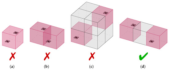
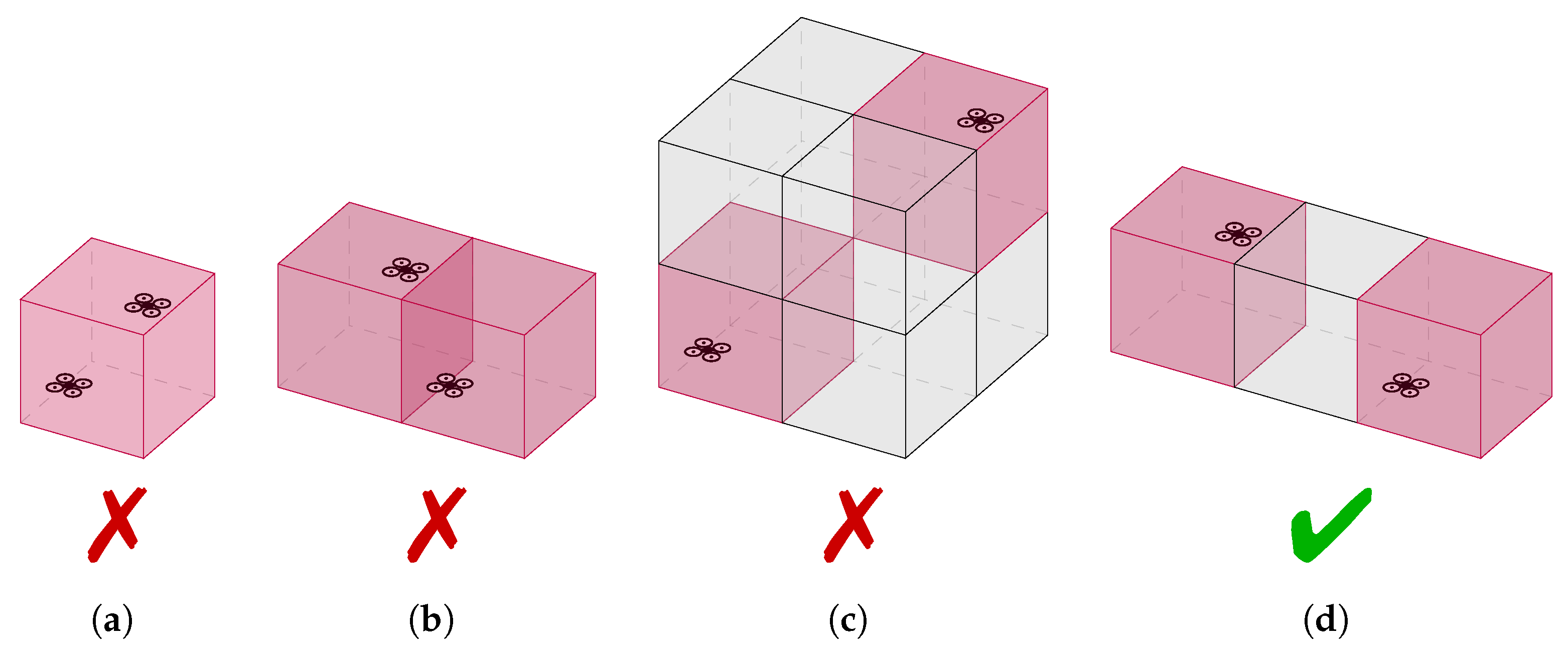
- Conflict detection Rule A: Previous approaches found in the literature (e.g., [34,35,36,37,38,39]) make use of the approximation that two trajectories () will be in state of conflict whenever they pass through the same cell. Thus, cell c of trajectory i will be in conflict with cell d of trajectory j if they are the same cellIn this case, the set of critical cells which would constitute a conflict for trajectory i would exactly match the traversed cellsThis approach, however, presents the handicap that it would lead to false negatives in situations such as the one depicted in Figure 3b, where the actual distance between trajectories could be smaller than even if both trajectories do not lay in the same cell.
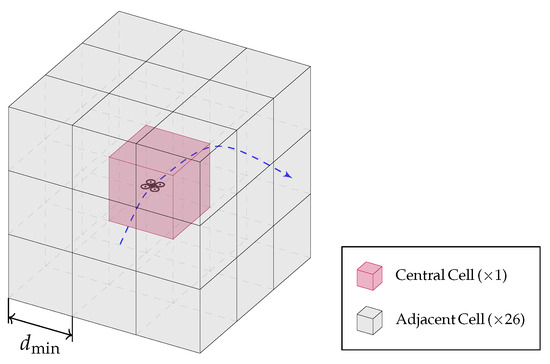
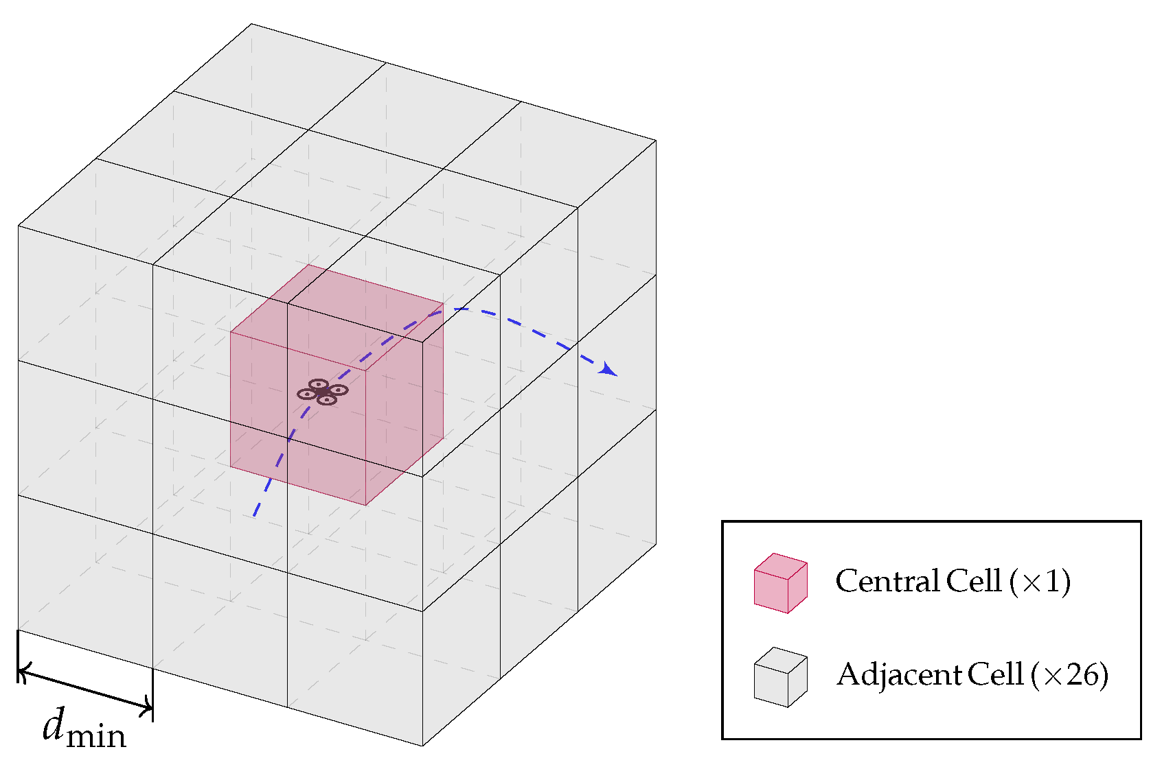
- Conflict detection Rule B: In this work, we propose a more conservative approach that, with a slight increase of overload, guarantees the avoidance of false negatives. Therefore, cell c of trajectory i will be in conflict with cell d of trajectory j if there is a distance of one cell or less between them.This approximation treats as conflicts situations where not only central cells of two trajectories coincide, but also any of the 26 adjacent cells to the central cell, as depicted in Figure 4. Figure 3 shows a more detailed address of the kind of situations that are considered conflicts under the current rule. This rule is more conservative since there are no false negatives but at the cost of some false positives limited to the worst case scenario of two aircraft located at opposing vertices of diagonally adjacent cells (Figure 3c) where a conflict will be detected if the distance between trajectories is below a threshold ofwould be treated as a conflict, which constitutes a safety factor of almost . To determine the set of cells satisfying Equation (27), the sequence of cells of every trajectory will be augmented with the non-overlapping set of adjacent cells
Figure 3.
Conservative criteria for the definition of conflicts with a discretized airspace. (a) Conflict between central cells. (b) Conflict between adjacent cells. (c) Conflict between adjacent cells. (d) No conflict. There is a potential false positive with a maximum distance between aircraft of when the aircraft are located at opposing vertices of diagonally adjacent cells (case (c)), but no false negatives are possible; whenever the distance between two aircraft is lower than , the algorithm will classify it as a conflict.
Figure 4.
The airspace is discretized using the minimum allowable distance between aircraft . Thus, for each aircraft at every instant of its trajectory there is a total of 27 cells that could potentially lead to conflicts (1 central and 26 adjacent cells).
With these conflict detection rules, the set of conflicts between i and j () will be given by the intersecting cells between and . Each individual conflict will be characterized by a tuple containing the cells of the two trajectories involved in such conflict.
It is therefore possible to constitute the set of all conflicts involved in the vertiport management scenario, for all possible combinations of i and j
and a unique index can be assigned to each conflict, such that
2.4. Collision Detection
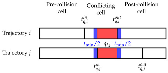
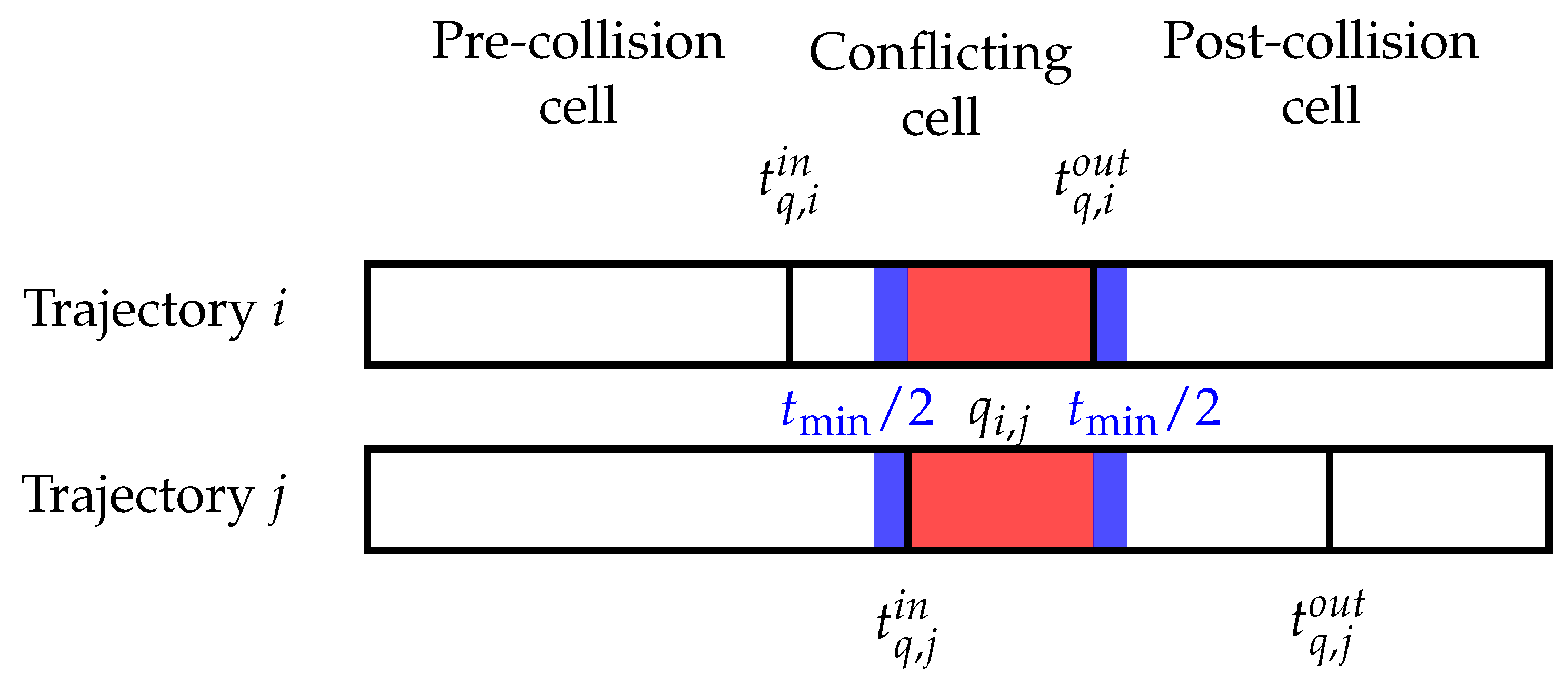
Let us define, for conflict and trajectory i the entrance and departure times in the conflicting cell as and respectively. Similarly, for trajectory j, and .
A particular conflict between two trajectories i and j is said to be in state of collision if the time separation between the trajectory entering the conflicting cell and the trajectory departing the conflicting cell does not exceed a minimum safety buffer . That is, the set of all collisions is defined as
This condition can more clearly be seen in the diagram shown in Figure 5.
Figure 5.
Diagram showing that a collision happens in a conflicting cell , whenever the departure time of the earliest departing trajectory is below the departure time of the latest departing trajectory plus a safety buffer .
Following this procedure we have determined the set of all collisions for the present trajectories, and a unique index can be assigned to each collision, such that
2.5. Mathematical Program Formulation
As it was specified in the assumptions, the strategy to avoid collisions is speed variation, exclusively reducing the speed of the cooperative aircraft. In order to formulate the problem as a mathematical program, the following optimization variables will be defined for all registered trajectories i = 1, …, N:
- Cell-crossing time-interval: , c = 1, …, . Each of these real-valued variables corresponds with the total time in seconds that each trajectory i will spend crossing each of the cells c.
- Order-of-pass: , q = 1, …, Q. Each of these binary variables corresponds to 1 if trajectory i has priority over trajectory j in conflict .
Thus, the Estimated Time of Arrival for trajectory i will be computed as the sum of all the resulting cell-crossing time-intervals after the optimization:
where is the time when the trajectory i enters the controlled airspace.
In addition to these variables, the flight plan gets codified in the reference cell-crossing time-intervals , which is directly computed for all trajectories i, considering the flight trajectory and the sequence of cells . Hence, the Requested Time of Arrival can be defined as the sum of all cell-crossing times as follows:
In order to satisfy the restrictions of the problem, the following set of constraints must be imposed to the variables:
- For two trajectories involved in a conflict, it must be that only one of them has priority
- Non-cooperative aircraft (fixed estimated trajectories) will always have priority in a conflict (their trajectory is not modifiable by the program)
- The order-of-pass must be enforced by modifying correspondingly. This means that, for each conflict , if i has priority over j (= 1), the time of arrival to cell q of trajectory j must be modified to guarantee sequential arrival in the conflicting cell.where the input and output times to cell q can be computed in terms of the crossing variables such as
- For a given trajectory i, if two conflicts of its trajectory happen in time-consecutive cells , , with the same conflicting trajectory j, it must be ensured that they share the same priority.
- Upper bound to time variable is given by the minimum flight speed of the aircraft Given the length required to traverse the cellAlthough eVTOL vehicles are hover-capable, the minimum speed is taken strictly positive in this formulation: hovering is excluded as a coordination degree of freedom in the cell-crossing approximation, consistent with limiting inefficient hover outside the VTOL landing phase. This constraint also caps how much each crossing time can be stretched; when the reference time is already at the minimum-speed bound, the vertiport cannot slow that aircraft further.
- Only speed slowdowns are permitted (never accelerate a given aircraft)
- Aircraft landing scheduling must satisfy the landing and storing times of previous aircraftwhere
The goal of the optimization program will be to minimize the divergence between the ETAs and the RTAs of all trajectories, while keeping the original trajectory as similar as possible to the requested Flight Plan. This would, in principle, require a quadratic cost function, generating a Mixed-Integer Quadratic Program (MIQP).
However, in order to simplify the complexity of the problem, an alternative linear cost function will also be analyzed. In this implementation, an intermediate variable will be defined to represent the absolute time difference for each trajectory and cell
And another variable will represent the maximum error difference due to the following set of constraints
Thus, the linear cost function to be minimized would be
In this case, the problem would be a Mixed-Integer Linear Problem (MILP).
2.6. Resolution
In this work, an exact solution (provably optimal) of the problem will be looked for, using Google’s OR-Tools’ CP-SAT solver [41]. CP-SAT is a modern, SAT-backed (boolean satisfiability) constraint programming optimizer designed for discrete models. Unlike classical linear-programming-based MIP solvers, CP-SAT operates purely over integers for speed and reliability; as a consequence, all variables and all coefficients in constraints and in the objective must be integers.
As our problem formulation contains non-integer coefficients, these must be conveniently scaled to integers that capture all required significant figures. The solver then searches the discrete space and returns standard statuses indicating whether an optimal solution was proven, a feasible (but not proven optimal) solution was found or the model is infeasible. In addition, in the MIQP formulation, the quadratic expression are linearized through auxiliary-variable constructions so that the final model is fully compatible with CP-SAT.
3. Simulations
In the following section some simulation results will be presented to show the validity of the proposed methodology. First, a simple tactical deconfliction scenario with 4 cooperative aircraft landing at a vertiport and a non-cooperative aircraft flying near the vertiport will be presented. Afterwards, a tactical deconfliction between 25 aircraft will be presented. Finally, a scalability analysis will be performed, showing the challenges that the methodology presents. Different scenarios will be used to showcase the implications of alternative resolution possibilities: conflict detection Rule A vs. Rule B and cost function vs. , see Section 2 for a detailed explanation.
3.1. Simulation Set-Up
All simulations assume the set of aircraft parameters described in Table 2. While the framework allows for varying parameters, for the sake of simplicity, all trajectories will be generated with the same set.
Table 2.
Aircraft parameters chosen for the experiments.
The origin of coordinates will be chosen as the approach fix over the vertipad where all aircraft should approximate before landing. Incoming aircraft trajectories will be generated at random times following a uniform distribution with spread . In order to make the deconfliction interesting, the trajectories do not follow straight paths and some curvature is forced in the original flight plan generation.
Conflict detection rule effectivity will be measured in terms of error metrics. For every conflict detected by Rule B, a KD-Tree (K-dimensional tree) algorithm is used to model the segment of the trajectories involved in such conflict and to determine the distance between trajectories. If such distance is below but Rule A has not detected the conflict (see Figure 3), the conflict is annotated as a false-negative of Rule A. On the contrary, if the true distance is over it will be a false-positive of Rule B.
The proposed setup has no intrinsic feasibility guarantees. Speed-reduction-based deconfliction becomes infeasible in several identifiable geometry classes: pure face-to-face (head-on) conflicts, where no amount of slowing resolves the encounter; sustained close-parallel same-direction paths, where separation cannot be achieved without trajectory modification; simultaneous entry of two aircraft to the controlled vertiport airspace into the same cell; and throughput saturation, where the landing rate demanded by the registered aircraft exceeds the vertiport’s capacity; and minimum-speed saturation, where a cooperative aircraft already flies at or near so that is at the limit imposed by and no further slowdown can restore separation. In all these cases, the CP-SAT solver correctly returns an infeasible status, which is itself a useful output, as it signals that the current set of trajectories cannot be safely coordinated under speed-only constraints. This case is exacerbated by the presence of non-cooperative trajectories. In order to address these issues, feasible combinations of trajectories have been chosen for the scenarios shown below.
The systematic handling of infeasible corner cases (potentially through limited speed-up allowances or trajectory modifications) is identified as an important direction for future work. In a realistic future operation, a higher level strategic deconfliction algorithm will have to guarantee that the accepted trajectories match the throughput of the infrastructure. In addition, our approach could be complemented with trajectory modification and structural waiting and delay absorption techniques like the ones described in [14,15,16,17,18,19,20] to guarantee broader applicability to real vertiport management scenarios.
Experiments were performed on a machine equipped with an Intel Core i9-13900K processor (24 cores, max 5.8 GHz) and 62 GB RAM, running Ubuntu 22.04.5 LTS. Computation time for the solver is limited to = 900 s. If it has not found an optimal solution then, it delivers the best feasible solution.
3.2. Five Trajectory Deconfliction Scenario
In this first scenario, a set of 4 cooperative trajectories approaching the vertiport and one non-cooperative trajectory will be deconflicted to showcase the effectivity of the proposed method. The parameters describing the deconfliction algorithm configuration are shown in Table 3.
Table 3.
Airspace configuration parameters for 5 trajectory deconfliction.
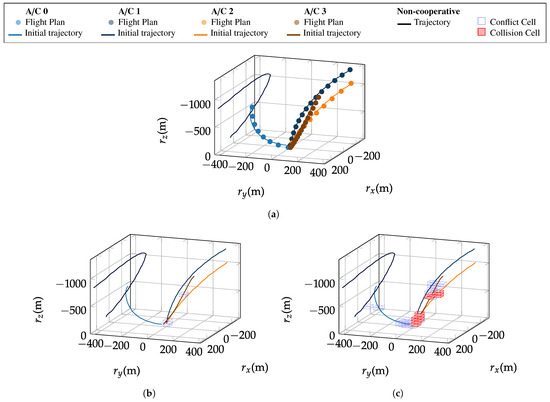
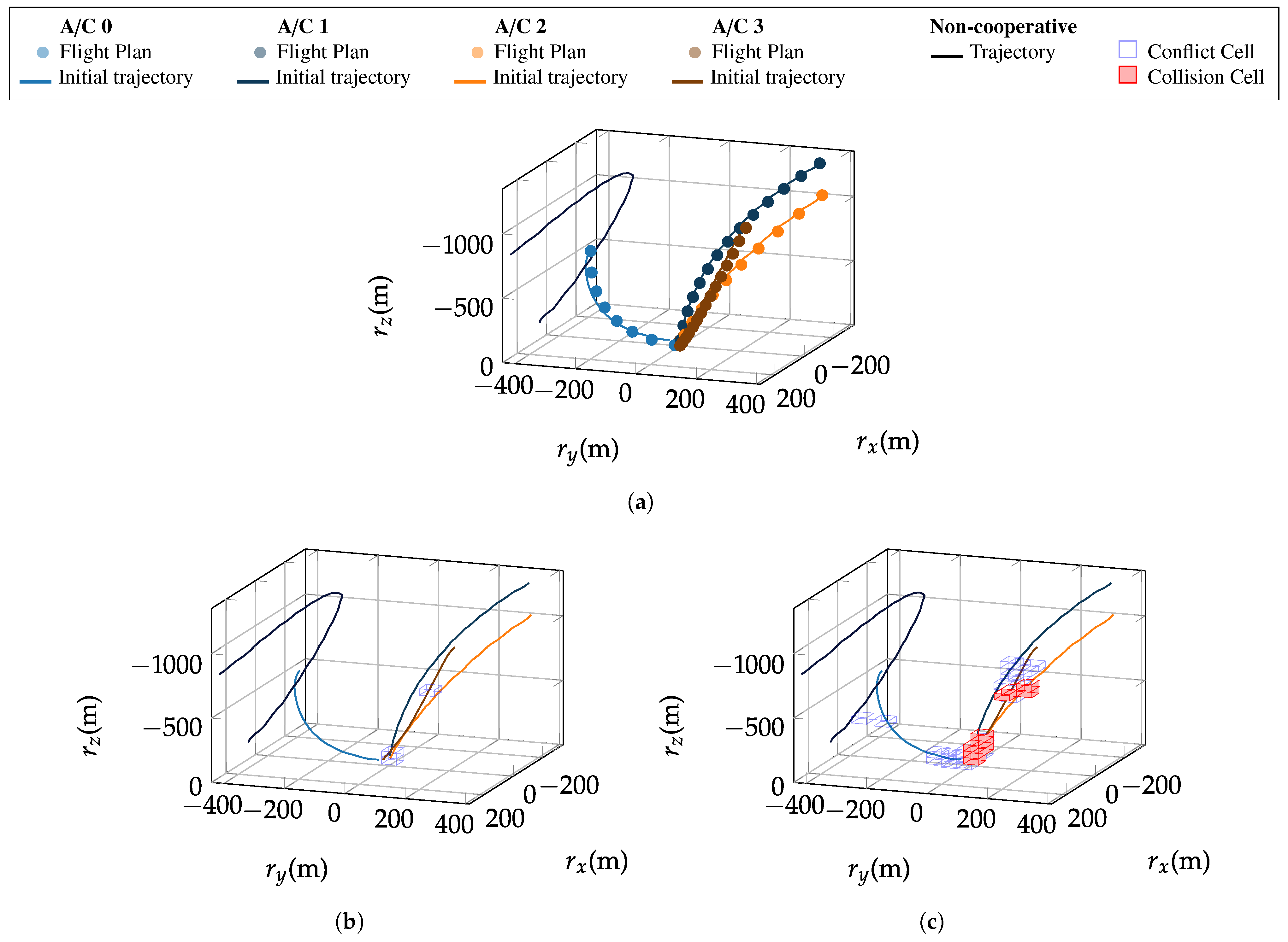
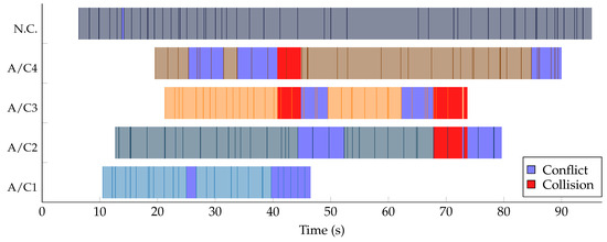
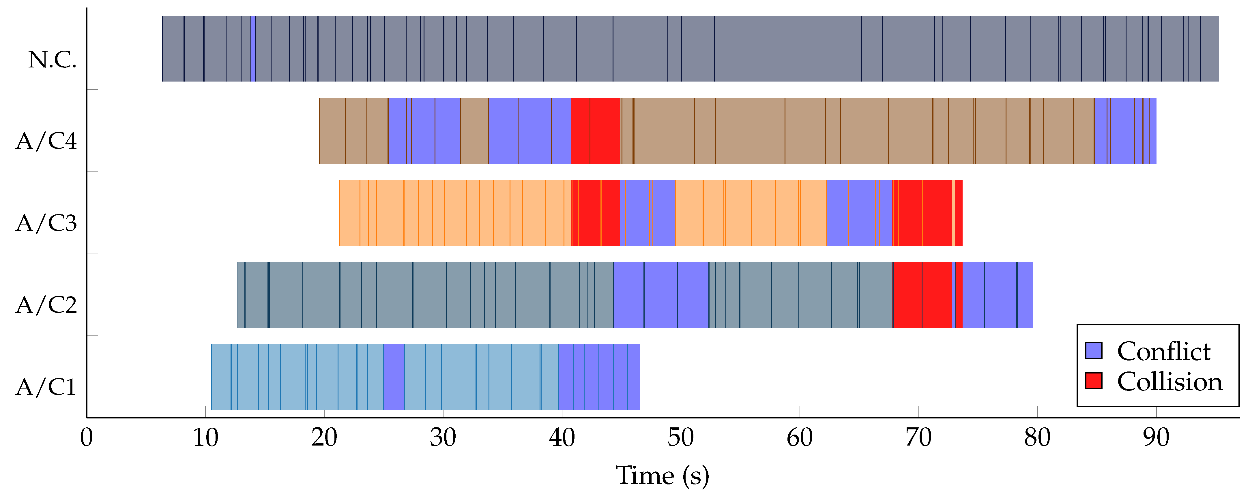
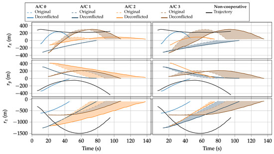
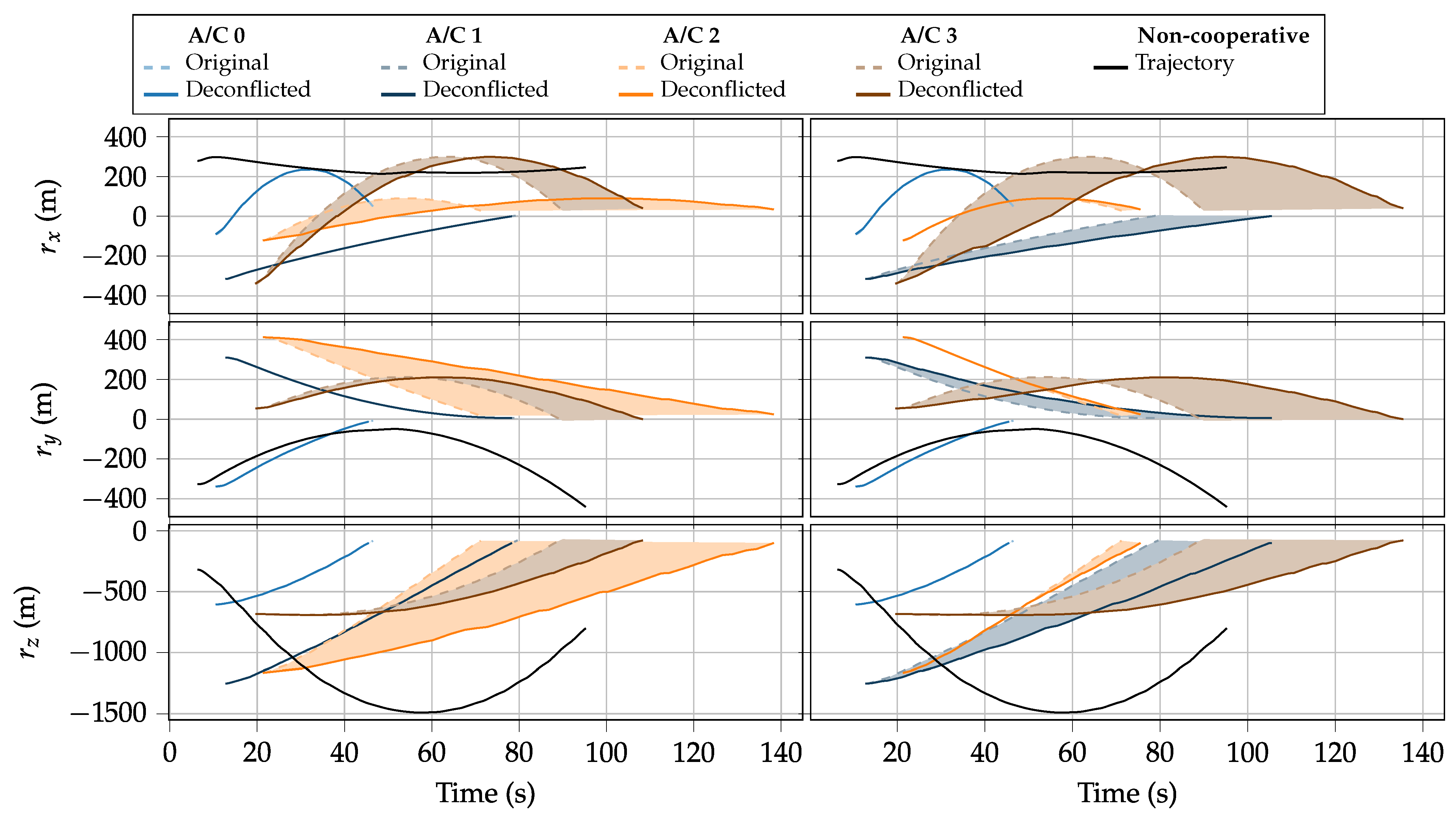
The registered flight plans (0.2 Hz sample time) are introduced to the dynamic model to generate suitable detailed trajectories (100 Hz sample time). Figure 6a illustrates how the low-rate flight plans are converted into dynamically consistent high-rate trajectories by the kinematic model: the smooth curves reflect the first-order heading and speed dynamics, imposing realistic turn radii and acceleration limits on each vehicle. Comparing Figure 6b,c, the sharp increase in detected conflict cells from Rule A to Rule B is immediately apparent: Rule B surrounds each trajectory cell with its 26 neighbours, producing a denser conflict region but guaranteeing no false negatives, as discussed in Section 2. Figure 7 reveals the temporal structure of the problem: each row encodes one trajectory as a sequence of unique cell identifiers, and the conflict and collision markers show that most interactions are brief and localized, validating the assumption that conflicts are sparse in a sufficiently large airspace. These representations make clear the spatial nature of conflicts and the temporal character of collisions, as defined in Section 2. Eventually, the output trajectories of the CD&R algorithm for Rule B can be seen in Figure 8. It can be seen that the optimizer achieves proper scheduling of the arrivals respecting the declared between aircraft while avoiding all detected conflicts and collisions.
Figure 6.
Combined detection and trajectory generation process. (a) Generation of high-rate dynamically consistent trajectories from flight plans. (b) Detection of conflicting cells and collisions of the current trajectory set (Rule A). (c) Detection of conflicting cells and collisions of the current trajectory set (Rule B).
Figure 7.
All trajectories get encoded in a discrete sequence of crossed cells with unique identifiers, there conflicts and collisions are detected (Rule B).
Figure 8.
Output of the deconfliction algorithm for Rule B, some cooperative trajectories are slowed down to avoid collisions and ensure a proper sequencing of the arrivals. The shadowed area depicts the deconfliction of each trajectory. (Left): resolution with . (Right): resolution with . A video animation of the trajectories can be found in the Supplementary Materials.
The output metrics of the optimizer have been summarized in Table 4. It can be seen that Rule A makes the problem much more tractable than Rule B, identifying a total of 5 instead of 105 conflicts. It is however remarkable that it does not achieve to detect 44 real conflicts, which, for a safety critical application as this one, is a strong handicap. On the contrary, Rule B has a 100% detection rate, but at the cost of making the problem 53% artificially larger, with a total of 56 conflicts that are not real, but do add a safety buffer. Nevertheless, this 21× difference in amount of conflicts size does not directly extrapolate to execution time, as Rule B only takes 42% more execution time.
Table 4.
Deconfliction algorithm output for 5 trajectories.
Regarding cost function selection, it can be seen that different cost functions clearly lead to different output trajectories. It is remarkable that both results are qualitatively very similar, introducing a similar total delay to the system and similar modifications to the trajectories. Figure 8 clearly shows that the total time by which all aircraft have landed is virtually indistinguishable between and , that is, both cost functions resolve all conflicts within the same overall time window, confirming that the choice of objective primarily affects how the delay is distributed among aircraft, not the total duration of the operation. However, the computation times increase by almost two orders of magnitude (≈60×). This is attributed to the linearization of the quadratic objective (see Section 2) required by CP-SAT, which operates purely over integers: each squared term must be expanded into auxiliary integer variables and product constraints, adding a significant number of auxiliary variables per trajectory. By contrast, introduces only a single auxiliary variable and a corresponding set of linear constraints. The resulting increase in model size significantly enlarges the search space explored by the SAT-backed solver.
3.3. Twenty-Five Trajectory Deconfliction Scenario
In order to see the challenges of scaling up the methodology to larger scenarios, let us now analyze the use case of 24 cooperative aircraft landing on a vertiport and a non-cooperative vehicle traversing the airspace. The parameters describing the scenario can be seen in Table 5.
Table 5.
Airspace configuration parameters for 25 trajectory deconfliction.
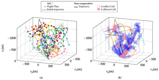
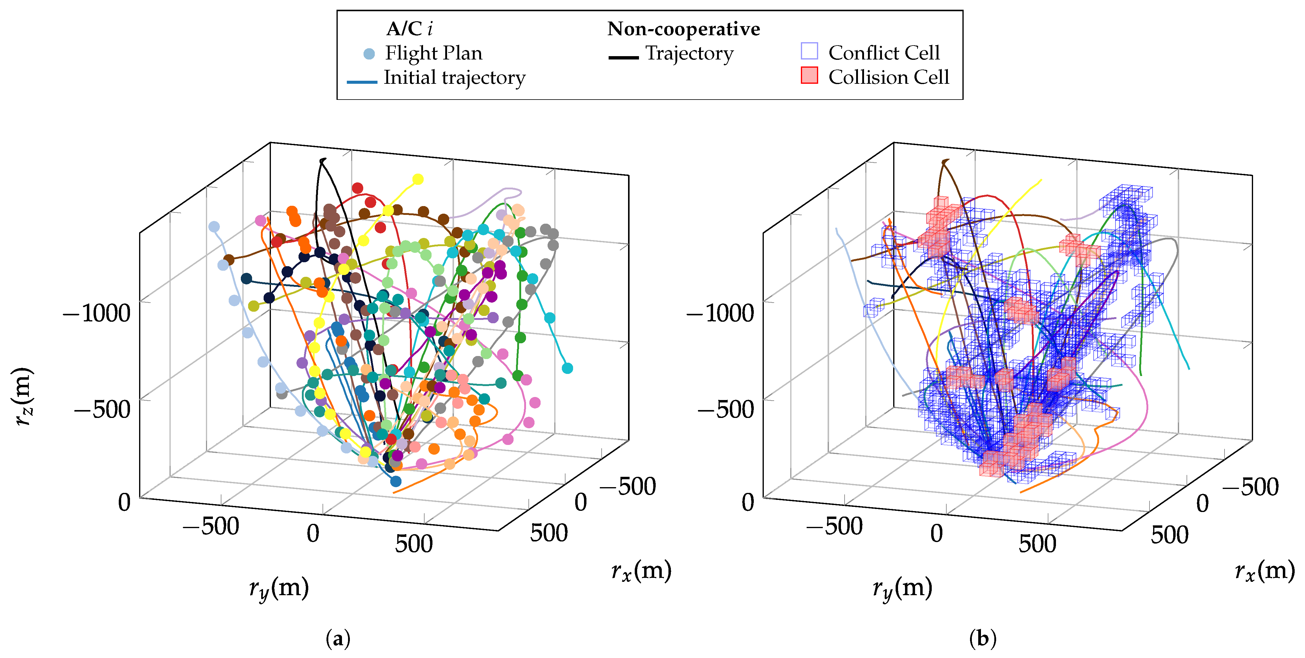
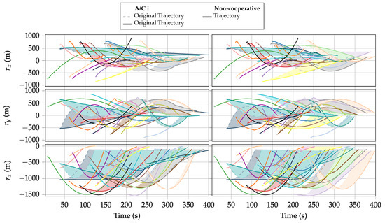
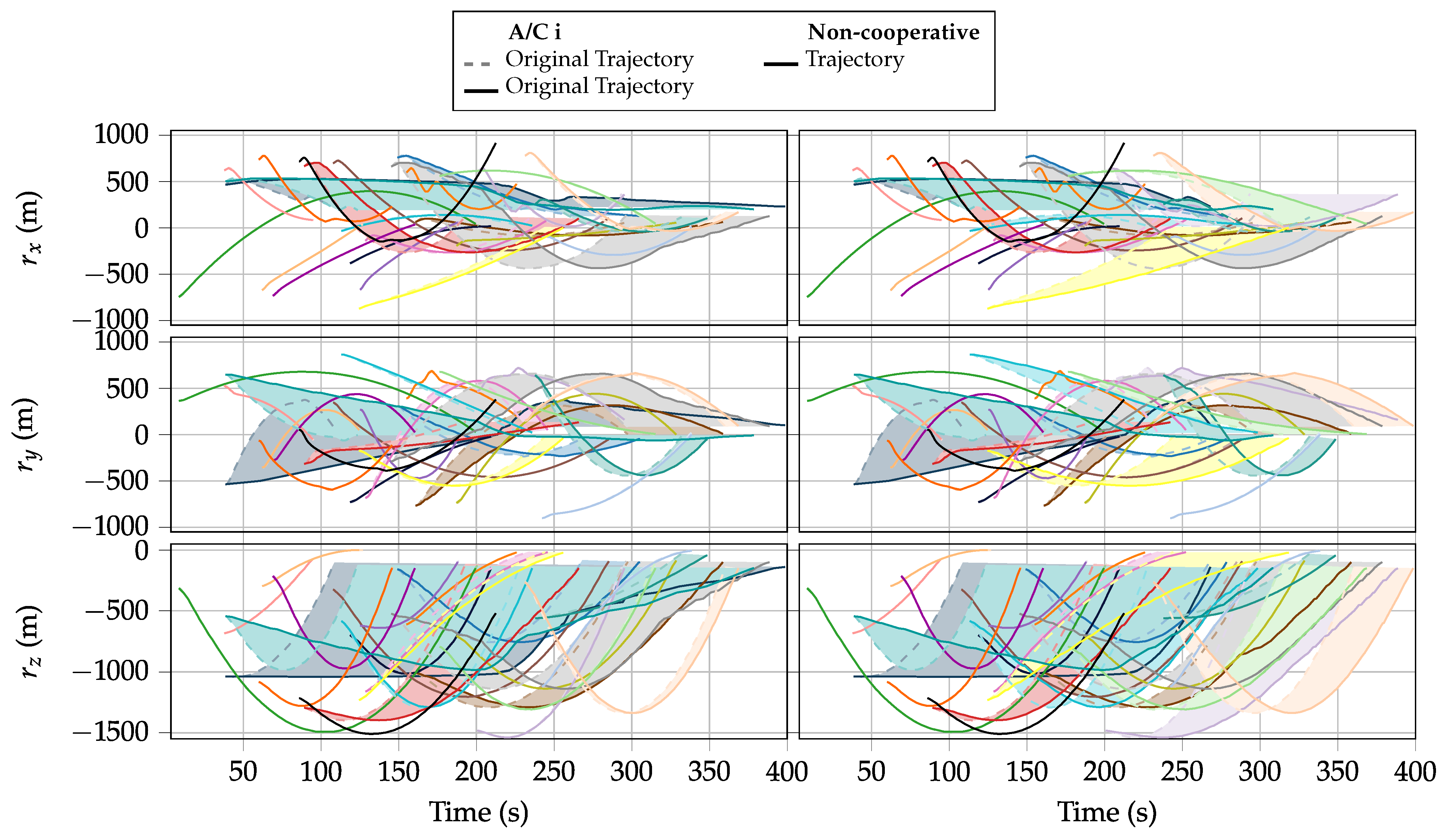
Once again, the registered flight plans are propagated through the dynamic model to obtain the detailed trajectories (see Figure 9a). Figure 9a shows the higher density of trajectories compared to the 5-aircraft scenario, with aircraft approaching from a wider radius. Figure 9b reveals the correspondingly larger conflict structure under Rule B, with conflict cells concentrated near the origin where all trajectories converge. In Figure 10, the shadowed deconfliction bands show that the solver must impose substantially longer delays on several aircraft to clear the high-density conflict zone near the vertiport. The non-cooperative trajectory, assigned unconditional priority (see Equation (46)), forces the cooperative aircraft around it to wait, which is visible as an extended deconfliction shadow for the affected aircraft. Finally, the solver produces the deconflicted output trajectories which satisfy the scheduling between landings and avoid all conflicts and collisions. Figure 10 clearly shows that the total time by which all aircraft have landed is virtually indistinguishable between and : both cost functions resolve all conflicts within the same overall time window, confirming that the choice of objective primarily affects how the delay is distributed among aircraft, not the total duration of the operation.
Figure 9.
Overview of the trajectory and conflict detection process. (a) Generation of high-rate dynamically consistent trajectories from flight plans. (b) Detection of conflicting cells and collisions of the current trajectory set (Rule B).
Figure 10.
The shadowed area depicts the deconfliction of each trajectory. (Left): resolution with . (Right): resolution with . A video animation of the trajectories can be found in the Supplementary Materials.
The output metrics of the optimizer have been summarized in Table 6. Most of the phenomena identified in the case of 5 trajectories gen exacerbated here, as Rule A only identifies 127 conflict neglecting a total of 926 real conflicts, which, once again, is a strong handicap for a safety critical application. On the contrary, Rule B detects all 1053 real conflicts, but adds 1896 extra conflicts where the distance between the trajectories is slightly over the . However, when execution times are analyzed, something interesting happens. As expected, cost function for Rule B does take a longer time than to find a solution. But, unexpectedly, Rule A also takes a longer time than Rule B for both cost function choices. This must be attributed to the fact that, when the size of the problem increases, CP-SAT spends a lot of time searching between similarly good solutions for Rule A, which is less constrained. On the contrary, Rule B adds more constraints, which limits the search space, easing the process of finding an optimal solution in lower time.
Table 6.
Deconfliction algorithm output for 25 trajectories.
3.4. Scalability Analysis
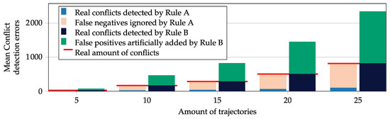
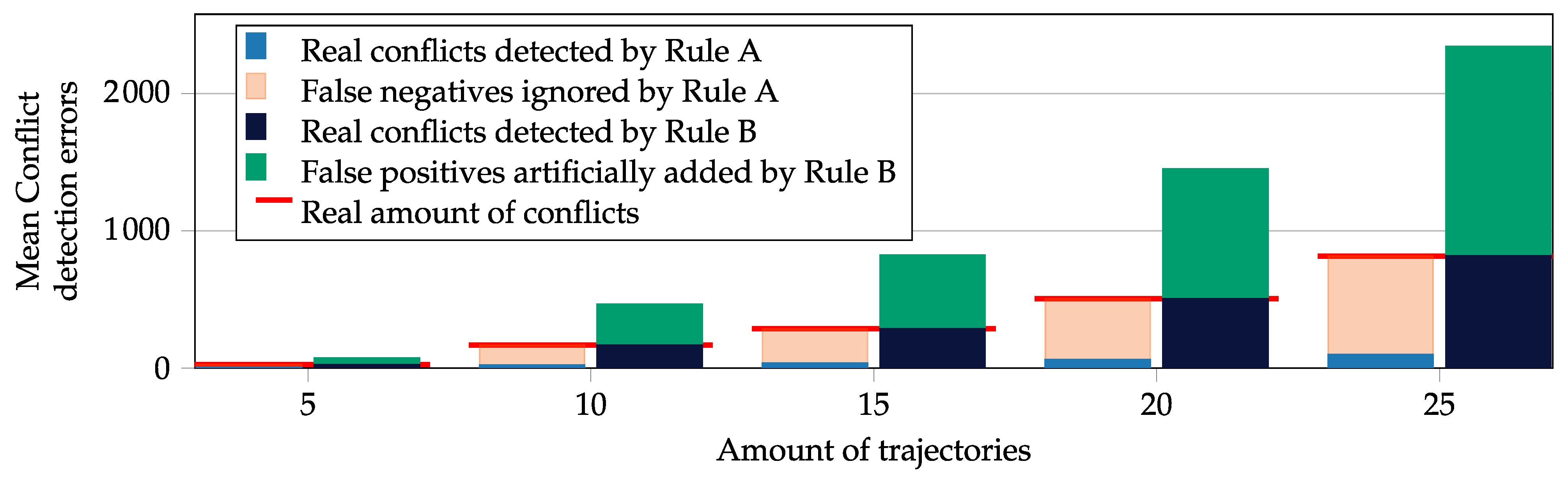
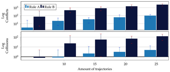
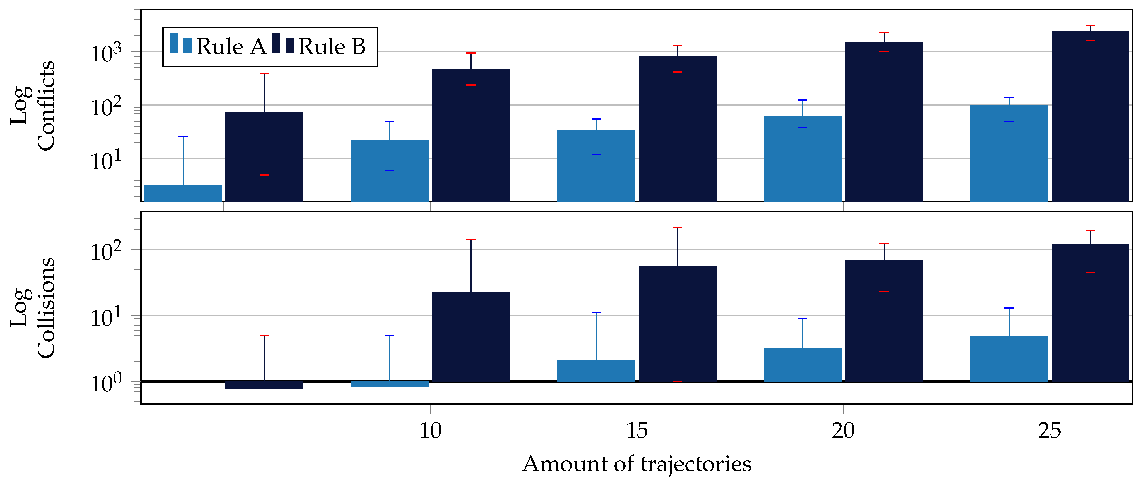
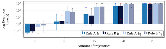
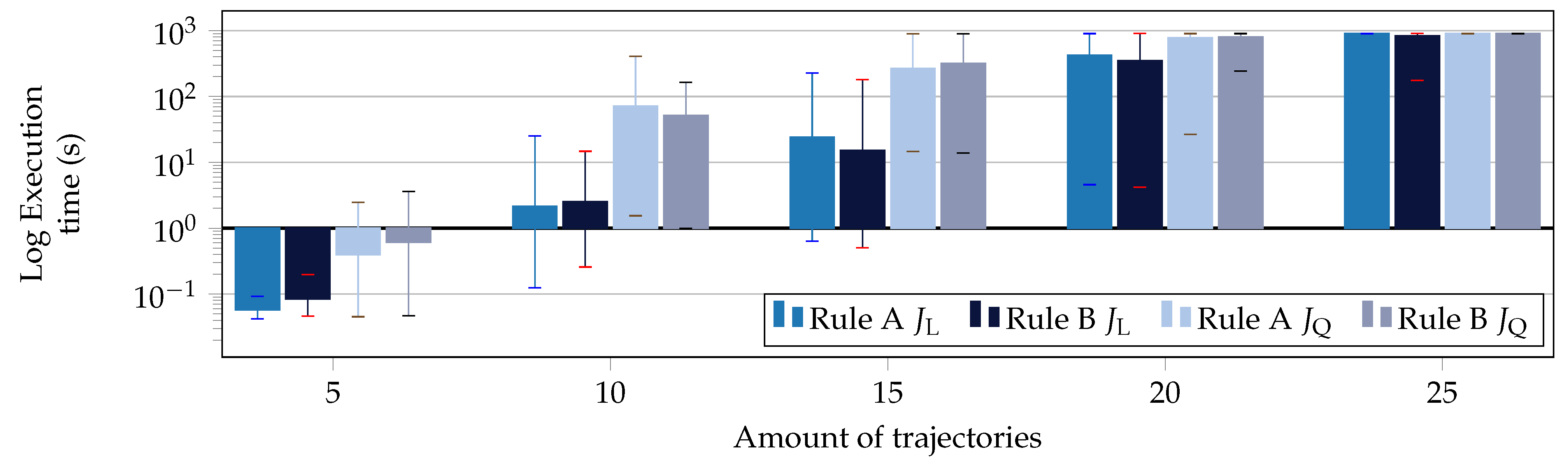
In this section, a broader set of simulations is carried out to extract more general conclusions. Five distinct simulation scenarios are formulated: the deconfliction of, respectively, 5, 10, 15, 20, and 25 trajectories, where one of the trajectories is non-cooperative. For each of the simulation scenarios, 20 different simulations were carried out, with varying sets of trajectories. The results of these simulations can be appreciated in Figure 11, Figure 12 and Figure 13 and Table 7. These results confirm that the scale of the problem and resolution times increase exponentially with the amount of aircraft involved.
Figure 11.
Mean conflict detection errors of conflict detection rules A and B as the number of involved aircraft increases.
Figure 12.
Increase in the amount of detected conflicts and collisions for rules A and B over 20 simulations for each scenario.
Figure 13.
Increase in execution time as the number of involved aircraft grows for the different detection rules and cost functions, maximum search time is limited ( = 900 s). 20 different runs per scenario.
Table 7.
Scalability output metrics, 20 deconflictions per scenario, minimum, maximum and mean values.
Figure 11 shows that the gap between false negatives (Rule A) and false positives (Rule B) widens consistently with traffic density, confirming that Rule A becomes increasingly unsafe at scale while Rule B’s conservatism remains bounded. Figure 12 highlights that both conflict and collision counts grow super-linearly with the number of aircraft. The variance in Table 7 (particularly the wide min–max spread in execution times at 20 and 25 aircraft) reflects two competing effects: the sensitivity of the CP-SAT search to the specific conflict geometry of each randomly generated scenario, and the degree of constraint in the problem. When many feasible solutions exist and the problem is loosely constrained (as in Rule A), the solver may spend considerable time distinguishing between similarly good candidates before proving optimality; when the problem is more tightly constrained (as in Rule B), the search space is pruned more aggressively, sometimes yielding faster convergence, as evidenced by the lower minimum execution times for Rule B in several scenarios of Table 7.
It is particularly noteworthy that, in scenarios of more than 15 trajectories, rule A seems to take a longer time than rule B to find a solution. Indeed, for the case of 25 AC, all simulations of rule A take as minimum time 900s while this is not the case for B. One possible explanation to clarify this issue is that with rule B the problem is more constrained. In CP-SAT, any constraint that cuts away infeasible regions early helps the solver prune large parts of the search tree. Thus, the more restrictive model (rule B) finds sooner the optimal solution while the less restrictive model (rule A) takes a longer time exploring similarly feasible solutions without finding the optimal one.
With respect to cost function selection, these results consistently confirm that is more time-efficient than .
4. Conclusions
In this paper, we introduced a grid-based, conservative conflict-detection and resolution framework for the tactical coordination of multiple VTOL aircraft in the vicinity of a vertiport. Registered flight plans get converted into realistic trajectories by means of a suitable kinematic trajectory synthesizer. By discretizing the airspace into a 3D lattice and storing aircraft trajectories in cells, the method can reliably identify potential conflicts and collisions, checking cell overlaps for both the cells traversed by the trajectory and the set of adjacent cells. The conflict resolution and scheduling problem is formulated as a mixed-integer linear and quadratic program, using a minimally invasive rule for conflict resolution: aircraft paths can not be modified and speed can only be reduced to the reported minimum speed of each aircraft, avoiding pure hover for efficiency reasons. Such program is implemented in Google OR-Tools package for exact resolution with the CP-SAT solver. Simulation campaigns ranging from five to twenty-five trajectory scenarios demonstrated the approach’s capability to tactically deconflict and schedule dense aircraft arrivals, and comparative studies of different detection rules and cost functions highlight the trade-offs between safety margins and operational efficiency.
The simulation results demonstrate three key findings. First, the proposed conservative conflict-detection Rule B achieves a 100% detection rate with zero false negatives across all tested scenarios, whereas the widely used Rule A misses a substantial and growing fraction of real conflicts (up to 926 out of 1053 in the 25-aircraft case), making it unsuitable for safety-critical applications. Second, the linear cost function resolves conflicts in a fraction of the time required by while producing virtually identical total delay, making it the preferred choice for operational use. Third, the framework successfully coordinates up to 25 aircraft simultaneously, with computation times remaining tractable for moderate traffic densities. Together, these results establish the proposed approach as a viable tactical coordination layer for vertiport traffic management, to be paired with a higher-level strategic deconfliction algorithm that guarantees the admitted traffic matches the throughput of the infrastructure.
The presented approach, however, has several limitations. It currently relies solely on speed variations and does not consider trajectory-shape modifications, which may restrict its applicability in more complex scenarios. Future work could complement the current approach with trajectory modification, delay absorption and waiting mechanisms to guarantee feasibility in all conceivable vertiport operation scenarios.
In addition, as the number of involved aircraft increases, the computation times scale exponentially. To fully exploit the advantages of the discretized conflict detection mechanism, future work could focus on the use of heuristic rules (genetic algorithms, reinforcement learning, etc.) to solve the proposed problem in a probabilistic way, finding a good-enough feasible solution in finite time, instead of attempting to find the provably optimal solution. Moreover, an efficient false-positive filtering algorithm could be applied to Rule B, limiting the size of the problem before resolution, although the presented simulations show that this is not the determining factor in the large increase of computation times.
Future research could recursively run the algorithm in a moving-horizon, real-time setting, warming up the optimizer with previous solutions. It could include several vertipad coordination with simultaneous landings and departures. In addition, more sophisticated trajectory synthesis models could be evaluated, nurturing them with system identification techniques from real flight data of specific IAM aircraft and introducing probabilistic models, especially for non-cooperative intruders.
The development of suitable estimation algorithms for non-cooperative aircraft trajectories (including reachable-set methods, sensor fusion, and surveillance-based tracking) is identified as an important complementary research direction. Furthermore, the systematic handling of infeasible coordination scenarios, such as head-on conflicts or throughput saturation, where speed-reduction alone is insufficient, is an important open problem. A dedicated algorithm for these corner cases, potentially allowing limited speed-ups or trajectory modifications as a last resort, is left for future investigation.
Overall, this work establishes a solid foundation for scalable, safety-critical coordination of IAM traffic, and the outlined improvements are expected to enhance its applicability in real scenarios.
Supplementary Materials
The following supporting information can be downloaded at: https://www.mdpi.com/article/10.3390/aerospace13060519/s1, Video S1: 5ac deconfliction with ; Video S2: 5ac deconfliction with ; Video S3: 25ac deconfliction with ; Video S4: 25ac deconfliction with .
Author Contributions
Conceptualization, I.I. (Imanol Iriarte), I.I. (Iñaki Iglesias), S.V. and S.L.; methodology, I.I. (Imanol Iriarte) and S.V.; software, I.I. (Imanol Iriarte), E.N.R. and J.D.R.; validation, I.I. (Imanol Iriarte) and E.N.R.; formal analysis, I.I. (Imanol Iriarte); investigation, I.I. (Imanol Iriarte); writing—original draft preparation, I.I. (Imanol Iriarte); writing—review and editing, I.I. (Imanol Iriarte), J.D.R. and B.S.; visualization, I.I. (Imanol Iriarte); supervision, J.L. and B.S.; project administration, I.I. (Iñaki Iglesias), J.L. and S.L.; funding acquisition, I.I. (Iñaki Iglesias), J.L. and S.L. All authors have read and agreed to the published version of the manuscript.
Funding
This research was funded by the Centro para el Desarrollo Tecnológico Industrial (CDTI), grant agreement No. PTAP-20231014 and the Eusko Jaurlaritza, grant agreement No. KK-2025/00045.
Data Availability Statement
All data used in this research is synthetic trajectories that can be generated according to the procedure established in the document.
Conflicts of Interest
The authors declare no conflicts of interest.
Abbreviations
The following abbreviations are used in this manuscript:
| AAM | Advanced Air Mobility |
| ADS-B | Automatic Dependent Surveillance-Broadcast |
| APF | Artificial Potential Field |
| ATC | Air Traffic Control |
| BADA | Base of Aircraft Data |
| CD&R | Conflict Detection and Resolution |
| CNS | Communications, Navigation, and Surveillance |
| CP-SAT | Constraint Programming and SAT solving |
| CTA | Controlled Time of Arrival |
| DB | Database |
| ETA | Estimated Time of Arrival |
| eVTOL | electric Vertical Take-Off and Landing |
| FNs | False Negatives |
| GA | Genetic Algorithm |
| GJK | Gilbert-Johnson-Keerthi |
| IAM | Innovative Air Mobility |
| IMM | Interacting Multiple Model |
| LAE | Low-Altitude Economy |
| LP | Linear Programming |
| MDP | Markov Decision Process |
| MILP | Mixed-Integer Linear Program |
| MIQP | Mixed-Integer Quadratic Program |
| NED | North-East-Down |
| RAM | Regional Air Mobility |
| RTA | Required Time of Arrival |
| UAM | Urban Air Mobility |
| UAV | Unmanned Aerial Vehicle |
| UTM | Unmanned (or Uncrewed) Aircraft System Traffic Management |
| VTOL | Vertical Take-Off and Landing |
References
- Garrow, L.A.; German, B.J.; Leonard, C.E. Urban Air Mobility: A Comprehensive Review and Comparative Analysis with Autonomous and Electric Ground Transportation for Informing Future Research. Transp. Res. Part C Emerg. Technol. 2021, 132, 103377. [Google Scholar] [CrossRef] [Scilit]
- Shyr, M.C.; Farrahi, A.H.; Verma, S. Predictive Workload Model for Air Traffic Controllers During UAM Operations. In Proceedings of the 2024 AIAA DATC/IEEE 43rd Digital Avionics Systems Conference (DASC), San Diego, CA, USA, 29 September–3 October 2024; IEEE: New York, NY, USA, 2024; pp. 1–6. [Google Scholar] [CrossRef] [Scilit]
- Patrinopoulou, N.; Daramouskas, I.; Badea, C.A.; Veytia, A.M.; Lappas, V.; Ellerbroek, J.; Hoekstra, J.; Kostopoulos, V. Dynamic Capacity Management for Air Traffic Operations in High Density Constrained Urban Airspace. Drones 2023, 7, 395. [Google Scholar] [CrossRef] [Scilit]
- Erzberger, H.; Field, M.; Itoh, E. Design Principles and Algorithms for Air Traffic Arrival Scheduling. 2014. Available online: https://ntrs.nasa.gov/api/citations/20140010277/downloads/20140010277.pdf (accessed on 1 July 2025).
- Slattery, R. Terminal Area Trajectory Synthesis for Air Traffic Control Automation. In Proceedings of the 1995 American Control Conference—ACC’95, Seattle, WA, USA, 21–23 June 1995; IEEE: New York, NY, USA, 1995; Volume 2, pp. 1206–1210. [Google Scholar] [CrossRef] [Scilit]
- Zeng, W.; Chu, X.; Xu, Z.; Liu, Y.; Quan, Z. Aircraft 4D Trajectory Prediction in Civil Aviation: A Review. Aerospace 2022, 9, 91. [Google Scholar] [CrossRef] [Scilit]
- Nuic, A.; Poles, D.; Mouillet, V. BADA: An Advanced Aircraft Performance Model for Present and Future ATM Systems. Int. J. Adapt. Control Signal Process. 2010, 24, 850–866. [Google Scholar] [CrossRef] [Scilit]
- Xie, X.; Tian, Y.; Li, J.; Wan, L. Shifting from Physical Models to Learning Methods for Trajectory Prediction: A Review. Expert Syst. Appl. 2026, 297, 129303. [Google Scholar] [CrossRef] [Scilit]
- Pradeep, P.; Wei, P. Energy-Efficient Arrival with RTA Constraint for Multirotor eVTOL in Urban Air Mobility. J. Aerosp. Inf. Syst. 2019, 16, 263–277. [Google Scholar] [CrossRef] [Scilit]
- Pradeep, P.; Wei, P. Energy Optimal Speed Profile for Arrival of Tandem Tilt-Wing eVTOL Aircraft with RTA Constraint. In Proceedings of the 2018 IEEE CSAA Guidance, Navigation and Control Conference (CGNCC), Xiamen, China, 10–12 August 2018; IEEE: New York, NY, USA, 2018; pp. 1–6. [Google Scholar] [CrossRef] [Scilit]
- Hartman, D.; Foster, J.; Hartman, C. Performance Modeling of Urban Air Mobility Vehicles to Support Air Traffic Management Research. In Proceedings of the AIAA SCITECH 2023 Forum, National Harbor, MD, USA, 23–27 January 2023; AIAA: Reston, VA, USA, 2023. [Google Scholar] [CrossRef] [Scilit]
- Iriarte, I.; Iglesias, I.; Lasa, J.; Calvo-Soraluze, H.; Sierra, B. Enhancing VTOL Multirotor Performance with a Passive Rotor Tilting Mechanism. IEEE Access 2021, 9, 64368–64380. [Google Scholar] [CrossRef] [Scilit]
- Iriarte, I.; Gorostiza, J.; Iglesias, I.; Lasa, J.; Calvo-Soraluze, H.; Sierra, B. An Overactuated Aerial Robot Based on Cooperative Quadrotors Attached through Passive Universal Joints: Modeling, Control and 6-DoF Trajectory Tracking. Robot. Auton. Syst. 2024, 180, 104761. [Google Scholar] [CrossRef] [Scilit]
- Song, K.; Yeo, H. Development of Optimal Scheduling Strategy and Approach Control Model of Multicopter VTOL Aircraft for Urban Air Mobility (UAM) Operation. Transp. Res. Part C Emerg. Technol. 2021, 128, 103181. [Google Scholar] [CrossRef] [Scilit]
- Lei, Y.; Qin, R.; Li, Q.; Chen, D. TLOF Final Approach Methodology Proposal Utilizing Dual Landing Pads. IET Intell. Transp. Syst. 2023, 17, 2052–2062. [Google Scholar] [CrossRef] [Scilit]
- Bertram, J.; Wei, P. An Efficient Algorithm for Self-Organized Terminal Arrival in Urban Air Mobility. In Proceedings of the AIAA Scitech 2020 Forum, Orlando, FL, USA, 6–10 January 2020; AIAA: Reston, VA, USA, 2020. [Google Scholar] [CrossRef] [Scilit]
- Kleinbekman, I.C.; Mitici, M.; Wei, P. Rolling-Horizon Electric Vertical Takeoff and Landing Arrival Scheduling for On-Demand Urban Air Mobility. J. Aerosp. Inf. Syst. 2020, 17, 150–159. [Google Scholar] [CrossRef] [Scilit]
- Conrad, C.; Xu, Y.; Panda, D.; Tsourdos, A. Intelligent Vertiport Traffic Flow Management for Scalable Advanced Air Mobility Operations. In Proceedings of the 2023 IEEE/AIAA 42nd Digital Avionics Systems Conference (DASC), Barcelona, Spain, 1–5 October 2023; IEEE: New York, NY, USA, 2023; pp. 1–10. [Google Scholar] [CrossRef] [Scilit]
- Waltz, M.; Okhrin, O.; Schultz, M. Self-Organized Free-Flight Arrival for Urban Air Mobility. Transp. Res. Part C Emerg. Technol. 2024, 167, 104806. [Google Scholar] [CrossRef] [Scilit]
- Shao, Q.; Shao, M.; Lu, Y. Terminal Area Control Rules and eVTOL Adaptive Scheduling Model for Multi-Vertiport System in Urban Air Mobility. Transp. Res. Part C Emerg. Technol. 2021, 132, 103385. [Google Scholar] [CrossRef] [Scilit]
- Li, Z.; Zhao, Y.; Ren, X. Parametric Modeling and Evaluation of Departure and Arrival Air Routes for Urban Logistics UAVs. Drones 2025, 9, 454. [Google Scholar] [CrossRef] [Scilit]
- Kuchar, J.; Yang, L. A Review of Conflict Detection and Resolution Modeling Methods. IEEE Trans. Intell. Transp. Syst. 2000, 1, 179–189. [Google Scholar] [CrossRef] [Scilit]
- Ribeiro, M.; Ellerbroek, J.; Hoekstra, J. Review of Conflict Resolution Methods for Manned and Unmanned Aviation. Aerospace 2020, 7, 79. [Google Scholar] [CrossRef] [Scilit]
- Pérez-Castán, J.A.; Pérez-Sanz, L.; Serrano-Mira, L.; Saéz-Hernando, F.J.; Rodríguez Gauxachs, I.; Gómez-Comendador, V.F. Design of an ATC Tool for Conflict Detection Based on Machine Learning Techniques. Aerospace 2022, 9, 67. [Google Scholar] [CrossRef] [Scilit]
- Ribeiro, M.; Ellerbroek, J.; Hoekstra, J. Velocity Obstacle Based Conflict Avoidance in Urban Environment with Variable Speed Limit. Aerospace 2021, 8, 93. [Google Scholar] [CrossRef] [Scilit]
- Papadopoulos, G.; Bastas, A.; Vouros, G.A.; Crook, I.; Andrienko, N.; Andrienko, G.; Cordero, J.M. Deep Reinforcement Learning in Service of Air Traffic Controllers to Resolve Tactical Conflicts. Expert Syst. Appl. 2024, 236, 121234. [Google Scholar] [CrossRef] [Scilit]
- Zhou, J.; Zhang, H.; Xue, Q.; Li, Y. Real-Time 4D Trajectory Planning Method for Civil Aircraft with High Security in Congested, Stochastic, and Dynamic Airspace Environment. Expert Syst. Appl. 2025, 260, 125347. [Google Scholar] [CrossRef] [Scilit]
- Pang, B.; Low, K.H.; Lv, C. Adaptive Conflict Resolution for Multi-UAV 4D Routes Optimization Using Stochastic Fractal Search Algorithm. Transp. Res. Part C Emerg. Technol. 2022, 139, 103666. [Google Scholar] [CrossRef] [Scilit]
- Badea, C.A.; Morfin Veytia, A.; Patrinopoulou, N.; Daramouskas, I.; Ellerbroek, J.; Lappas, V.; Kostopoulos, V.; Hoekstra, J. Unifying Tactical Conflict Prevention, Detection, and Resolution Methods in Non-Orthogonal Constrained Urban Airspace. Aerospace 2023, 10, 423. [Google Scholar] [CrossRef] [Scilit]
- Fremond, R.; Xu, Y.; Zhao, J.; Tsourdos, A.; Inalhan, G. Resilient Multi-Agent Reinforcement Learning for Centralised Tactical Conflict Resolution under Uncertain Perturbations and Non-Cooperative Traffic in Urban Air Mobility. Transp. Res. Part C Emerg. Technol. 2026, 184, 105542. [Google Scholar] [CrossRef] [Scilit]
- Weng, C.; Chen, C.; Tan, J.; Pan, T.; Zhong, R. Real-Time Traffic Simulation and Management for Large-Scale Urban Air Mobility: Integrating Route Guidance and Collision Avoidance. Transp. Res. Part C Emerg. Technol. 2026, 183, 105477. [Google Scholar] [CrossRef] [Scilit]
- Jardin, M. Grid-Based Strategic Air Traffic Conflict Detection. In Proceedings of the AIAA Guidance, Navigation, and Control Conference and Exhibit, San Francisco, CA, USA, 15–18 August 2005; AIAA: Reston, VA, USA, 2005; p. 5826. [Google Scholar] [CrossRef] [Scilit]
- Pongsakornsathien, N.; Bijjahalli, S.; Gardi, A.; Symons, A.; Xi, Y.; Sabatini, R.; Kistan, T. A Performance-Based Airspace Model for Unmanned Aircraft Systems Traffic Management. Aerospace 2020, 7, 154. [Google Scholar] [CrossRef] [Scilit]
- Rebollo, J.; Maza, I.; Ollero, A. A Two Step Velocity Planning Method for Real-time Collision Avoidance of Multiple Aerial Robots in Dynamic Environments. IFAC Proc. Vol. 2008, 41, 1735–1740. [Google Scholar] [CrossRef] [Scilit]
- Omer, J. A Space-Discretized Mixed-Integer Linear Model for Air-Conflict Resolution with Speed and Heading Maneuvers. Comput. Oper. Res. 2015, 58, 75–86. [Google Scholar] [CrossRef] [Scilit]
- Miao, S.; Cheng, C.; Zhai, W.; Ren, F.; Zhang, B.; Li, S.; Zhang, J.; Zhang, H. A Low-Altitude Flight Conflict Detection Algorithm Based on a Multilevel Grid Spatiotemporal Index. ISPRS Int. J. Geo-Inf. 2019, 8, 289. [Google Scholar] [CrossRef] [Scilit]
- Chen, Y.; Hu, M.; Yang, L. Autonomous Planning of Optimal Four-Dimensional Trajectory for Real-Time En-Route Airspace Operation with Solution Space Visualisation. Transp. Res. Part Emerg. Technol. 2022, 140, 103701. [Google Scholar] [CrossRef] [Scilit]
- Chen, J.; Liu, Y.; Zhang, Y.; Lin, X. Conflict Detection and Resolution Strategy for eVTOLs in Low-Altitude Urban Environments Based on the Geodetic Coordinate System. IEEE Trans. Aerosp. Electron. Syst. 2024, 60, 8823–8838. [Google Scholar] [CrossRef] [Scilit]
- Bingyu, L. A Conflict Detection and Resolution Algorithm Based on a Digital Airspace Grid Model. In Proceedings of the 2025 the 15th International Workshop on Computer Science and Engineering, WCSE, Jeju Island, Republic of Korea, 28–30 June 2025. [Google Scholar] [CrossRef] [Scilit]
- Li, Q.; Wan, L.; Xiao, B.; Zhou, Y. Research on Multi-Airspace Conflict Detection and Resolution Method Based on Octree Spatial Grid Partitioning. Aerospace 2025, 13, 15. [Google Scholar] [CrossRef] [Scilit]
- Perron, L.; Didier, F. CP-SAT; Google: Mountain View, CA, USA, 2025. [Google Scholar]
- McLain, T.W.; Beard, R.W. Coordination Variables, Coordination Functions, and Cooperative Timing Missions. J. Guid. Control Dyn. 2005, 28, 150–161. [Google Scholar] [CrossRef] [Scilit]

Disclaimer/Publisher’s Note: The statements, opinions and data contained in all publications are solely those of the individual author(s) and contributor(s) and not of MDPI and/or the editor(s). MDPI and/or the editor(s) disclaim responsibility for any injury to people or property resulting from any ideas, methods, instructions or products referred to in the content. |
© 2026 by the authors. Licensee MDPI, Basel, Switzerland. This article is an open access article distributed under the terms and conditions of the Creative Commons Attribution (CC BY) license.