


Abstract
Reliable onboard state estimation plays an important role in autonomous lunar surface mobility, given the lack of conventional global navigation satellite system (GNSS) coverage and the challenges of variable illumination and terrain texture. This review synthesizes model-based, learning-based, and hybrid visual–inertial odometry (VIO) approaches and assesses their relevance to lunar surface operations. The reviewed studies suggest that learned components can improve feature extraction, matching, depth estimation, and measurement confidence in selected datasets and operating conditions. However, representative lunar validation and uncertainty calibration remain limited. Given these limitations, hybrid architectures integrating learned components with explicit model-based estimators offer a comparatively testable design direction. Reduced lunar gravity alone does not render monocular scale unobservable; practical scale–bias performance also depends jointly on motion excitation, inertial quality, visual geometry, calibration, and estimation-window length. Stereo, wheel, crater, and map cues can provide additional metric information but introduce source-specific risks involving calibration, slip, association, and registration. Within the resources surveyed, we found no publicly available flight-derived lunar traverse dataset combining synchronized camera–IMU measurements, independent trajectory ground truth, and onboard timing. Evidence-based priorities include representative lunar validation, uncertainty-aware integration of learned components, consistency monitoring across metric sources, explicit estimator health and fallback mechanisms, and target-hardware resource evaluation.
1. Introduction
Planned and ongoing lunar programs increasingly call for longer and more autonomous surface operations than the Apollo traverses [1,2,3,4,5,6]. Communication delay, intermittent Earth visibility, limited relay coverage, and operational constraints imposed by extreme temperatures and variable illumination increase the importance of reliable onboard navigation. These challenges may be particularly significant within deep crater basins and on the lunar far side, where terrain occlusion can interrupt direct communication and continuous orbital-relay coverage cannot always be assumed.
Lunar surface vehicles operate without a terrestrial global navigation satellite system (GNSS), and may have incomplete orbital priors [7], necessitating reliable onboard state estimation for mobility. Visual–inertial fusion is an attractive state-estimation baseline because cameras provide geometric measurements while an inertial measurement unit (IMU) supplies high-rate motion information when visual constraints weaken. Established terrestrial approaches include multi-state constraint Kalman filter (MSCKF) filtering [8,9] and sliding-window or factor-graph estimation [10,11,12]. Here, visual–inertial navigation refers to onboard state estimation from visual and inertial measurements: visual–inertial odometry (VIO) provides local motion estimates, as shown in Figure 1, whereas visual–inertial simultaneous localization and mapping (VI-SLAM) additionally maintains a map and may include loop closure or global constraints. Map-aided localization and auxiliary metric cues are included only when they constrain this estimator. Mission-level planning, trajectory generation, and rover control are excluded. Terrestrial performance does not establish performance over the full lunar operating envelope. Illumination, texture, motion, sensor configuration, and size, weight, and power (SWaP) limits can affect different parts of the pipeline in different regimes. This review therefore examines artificial intelligence (AI)-enhanced VIO for lunar surface mobility across the processing pipeline, from visual and inertial measurement formation to tightly coupled estimation, metric-scale integrity (defined in Section 4.1), robustness, validation evidence, and onboard implementation constraints. It synthesizes the methods and evidence reported in the literature and identifies the remaining research gaps.
Figure 1.
Representative imagery for lunar surface mobility and onboard navigation. (a) Lunar surface in a representative operational setting; (b) rover-navigation view illustrating onboard perception, localization, or traverse execution.
Three groups of lunar operating stressors organize the review. First, non-Lambertian regolith reflectance, albedo variation, and hard sunlit–shadow transitions can violate standard photometric models [13,14]. Depending on terrain, viewpoint, exposure settings, and the algorithm, these effects may reduce repeatable feature measurements or shift learned components away from their training distributions or datasets; they should not be interpreted as uniform defects across all lunar imagery. Second, some lunar motion and sensing conditions may weaken metric-state estimation. Lunar gravity is approximately , but reduced gravity alone does not make metric scale unobservable. Instead, practical scale–bias estimation depends jointly on rover motion excitation, inertial-sensor quality, visual geometry, calibration, and the length of the estimator’s sliding window. Calibrated stereo cameras, wheel odometry, crater catalogs, and orbital maps can provide additional metric constraints, but each introduces its own failure mechanisms. Weak disparity, calibration drift, wheel slip, incorrect landmark association, and map-registration error can make an otherwise metric measurement intermittent, biased, or inconsistent with the local VIO estimate. Permanently shadowed regions (PSRs) create an additional configuration-dependent challenge because passive visible-light measurements may become weak or unavailable [15]. Third, candidate mitigation methods impose different size, weight, and power (SWaP) requirements. Public mission descriptions do not support a single SWaP allocation that applies to all lunar vehicles. Deployment claims should therefore be tied to a specified sensor configuration, onboard processor, image resolution, numerical precision, update rate, and duty cycle [16,17,18].
Table 1 maps lunar operating stressors onto the VIO processing pipeline. Lunar photometry primarily affects the availability and reliability of visual measurements. These measurements, together with inertial and auxiliary metric cues, determine whether the estimator can maintain metric-scale integrity. Residuals, finite-horizon conditioning, sensor health, and source disagreement then support robust gating, reweighting, fallback, and failure reporting inside the navigation estimator. Within this pipeline, AI is used as an umbrella term for learning-based components and includes both modular and end-to-end approaches; component-level discussions throughout use the specific architecture or algorithm (e.g., learned features, neural depth prediction, or semantic segmentation networks). Current lunar evidence more strongly supports integrating testable learned components with explicit model-based estimation.
Table 1.
Key lunar operating stressors, estimator impacts, required responses, and representative approaches reviewed. Listed approaches are not necessarily lunar-validated; evidence boundaries for representative systems are given in Section 6.1 and Section 6.3.
Available evidence does not reproduce the complete operating envelope in a single benchmark. Terrestrial datasets [56,57,58], planetary analogs and facilities [59,60,61,62,63,64,65,66,67,68,69,70], and simulators each represent only part of the problem. For example, SPICE-HL3 [63] provides synchronized stereo-inertial, wheel-odometry, and illumination information, along with precise ground-truth sequences under controlled high-latitude lunar-analog conditions; however, it does not constitute lunar flight telemetry. This review identified no publicly available, flight-derived lunar surface dataset that combines rover camera–IMU measurements, independent trajectory ground truth, and onboard timing information. Accordingly, the modality and limitations of the supporting evidence are specified throughout the front-end, estimator, robustness, and benchmarking sections. This review focuses on post-landing visual–inertial state estimation for surface mobility. Powered descent, orbital operations, pure remote sensing, mission planning, and motion control lie outside its scope. Monocular, stereo, map-aided, wheel-assisted, learned, and model-based methods are considered only if they contribute to the formation of visual–inertial measurements or to state estimation. The review is organized around three interconnected technical layers. Front end: Which model-based, learning-based, and hybrid front-end designs improve the availability and reliability of visual measurements under lunar illumination, texture, geometry, and SWaP constraints? Estimator: How should visual, inertial, stereo, wheel, crater, and map information be fused to maintain observable, well-conditioned, accurate, and temporally continuous metric state estimates? Robustness and failure handling: Which residual tests, conditioning measures, robust costs, uncertainty models, sensor-health checks, and fallback mechanisms have credible foundations for lunar VIO? The discussion of robustness is confined to mechanisms within the VIO estimator or at its measurement interfaces. Mission planning, trajectory generation, rover control, and higher-level autonomous decision-making remain outside the scope of this review.
This review provides a VIO-centered system synthesis rather than proposing a new navigation algorithm. It traces the evolution of post-landing lunar surface localization from controlled external aids and dead reckoning to visual odometry, map- and crater-aided localization, and modern tightly coupled VIO and VI-SLAM. The technical discussion is organized along the processing chain, progressing from visual and inertial measurement formation to estimator architecture and metric-scale integrity, and then to robustness and failure handling. Representative model-based, learning-based, and hybrid systems are linked to their corresponding evidence modalities, while datasets and facilities are compared according to the claims they can substantiate. The resulting synthesis emphasizes benchmark validity, robust VIO design, metric-source compatibility, and flight-relevant implementation. Figure 2 presents the overall structure of the review and the relationships among its sections.
Figure 2.
Overall structure and relationships between different sections. Section numbers in parentheses indicate where each topic is reviewed.
2. Background, AI-Enhanced VIO Framework, and Review Scope
2.1. Evolution of Lunar Surface Navigation
Lunar surface localization has evolved through overlapping and complementary architectures rather than through a strictly sequential replacement of previous approaches. In controlled laboratory and proving-ground systems, artificial fiducial or barcode markers, beacons, or surveyed targets are often employed to provide repeatable absolute position information. These aids are valuable for calibration and algorithm verification, but dependence on pre-installed infrastructure limits their relevance to unconstrained lunar traverses. The limited scalability of infrastructure-dependent approaches has motivated the development of onboard dead reckoning and visual odometry for planetary vehicles. Wheel encoders and inertial propagation provide high-rate local motion but accumulate errors due to bias, slip, and sinkage. Stereo visual odometry adds geometric motion constraints and has flight heritage on Mars [71], while lunar surface localization has also used stereo imagery, terrain reconstruction, and map-relative constraints [16]. Field trials and mission analyses provide additional evidence for rover visual motion estimation and localization under analog and lunar operating conditions [68,72,73,74,75]. Integrated analog systems, including Seeker and related planetary-rover field trials, further demonstrate long-range autonomous navigation at the system level [68,76].
Landmark- and map-aided methods address long-term drift by associating rover observations with known terrain, crater catalogs, or orbital products [49,50,51,52,77]. Their absolute information is intermittent and depends on viewpoint compatibility, catalog completeness, and registration quality. Modern VIO and VI-SLAM systems can incorporate these cues as optional factors while tightly coupling camera with IMU measurements for local state estimation. Local-to-orbital registration using boulders, imagery, light detection and ranging (LiDAR), or elevation maps demonstrates several mechanisms for periodically bounding local odometric drift [78,79,80,81,82,83]. More recent studies have investigated learned local features, semantic landmark extraction, monocular depth priors, measurement confidence, and health classification within lunar VIO pipelines [19,20,52,53,54,84,85,86,87,88,89,90,91,92,93,94,95].
Figure 3 summarizes this evolution. The sequence should not be interpreted as a claim that VIO makes wheel, map, crater, or external-reference methods obsolete. A practical lunar navigator may combine complementary information sources according to terrain, illumination, vehicle configuration, and resource availability.
Figure 3.
Evolution of post-landing lunar surface localization toward AI-enhanced visual–inertial navigation. The key stages progress from controlled aids and dead reckoning to visual odometry and map- or landmark-aided localization, and finally to hybrid lunar VIO using learned features, semantics, confidence, or depth priors. The sequence is architectural rather than strictly chronological: wheel, crater, map, calibration, and estimator-health cues remain complementary.
2.2. Mathematical Formulation of Lunar VIO
A visual–inertial navigator estimates platform motion by combining the complementary bandwidth and failure characteristics of cameras and an IMU. A representative keyframe state is
where denotes the world frame and the body (IMU) frame; , , and are body attitude, position, and velocity in the world frame; and are the accelerometer and gyroscope biases, respectively; and denotes estimated camera–IMU calibration or timing parameters. The continuous-time IMU measurement model is conventionally written as
where and denote the measured angular velocity and acceleration, respectively; and are the true angular velocity and linear acceleration in the body frame; is the rotation matrix that transforms the world frame to the body frame—here and throughout, subscripts and superscripts on R and T denote the source and target frames, respectively, and a superscript denotes the IMU body frame at time ; gᵂ = [0, 0, g]T denotes the gravity term in a z-up world frame, with the sign convention under which (3) gives the specific force sensed by the accelerometer (i.e., the negative of the gravitational acceleration vector), while and denote the corresponding measurement noise. For a landmark observed by camera , a calibrated visual measurement can be represented as
where is the camera projection model; and denote the world-to-body and body-to-camera (extrinsic) transforms, respectively; and is the visual measurement noise. Feature-based systems form reprojection residuals from (4), whereas direct systems form photometric residuals. A fixed-lag smoother or factor graph estimates the state by minimizing a robust objective of the form:
where collects the keyframe states over the estimation window; and are the prior and inertial residuals, respectively; is the visual reprojection residual formed from (4); limits the influence of visual outliers; and may encode stereo, wheel, crater, digital elevation model (DEM), or other configuration-dependent constraints. Filtering methods represent the same information recursively through state propagation and measurement updates. Equations (1)–(5) expose the central review logic: Learned components may improve measurement quality, but metric integrity and uncertainty still depend on the estimator, calibration, motion excitation, and compatibility of all metric sources. In AI-enhanced lunar VIO, a learned module may propose a measurement, prior, covariance, or gating score, but its output should be incorporated into an explicit estimation structure with calibrated uncertainty, geometric or statistical validity checks, and a defined response to unreliable inputs.
2.3. Model-Based, Learning-Based, and Hybrid VIO Architectures
This review classifies VIO approaches into three architectural categories according to the role of learned models in measurement formulation and state estimation: model-based, learning-based, and hybrid architectures. These categories describe differences in system design rather than technological maturity.
Model-based VIO relies primarily on explicit camera and inertial measurement models, handcrafted or direct visual residuals, and filtering or optimization with physically interpretable states and uncertainty [8,9,10,11,12]. Its advantages include physically interpretable state and residuals, explicit representations of measurement uncertainty, and established methods for calibration and observability analysis. However, its limitations may arise when the assumed photometric, noise, data-association, or motion models are violated. ROVIO [96], stereo MSCKF variants [97], factor-recovery mapping [98], ICE-BA [99], robocentric VIO [100], HybVIO [101], and PIVO [102] illustrate different choices in residual construction, state frame, filtering, optimization, mapping, and uncertainty propagation. Related systems such as Kimera [103] and SVO [104] provide relevant spatial-perception and visual-odometry frameworks, respectively, but do not themselves provide direct evidence of performance in lunar VIO applications.
Learning-based VIO estimates pose, motion, or visual–inertial fusion representations primarily through learned mappings. End-to-end methods such as VINet and causal transformer-based VIO [94,95] exemplify this category. These methods may learn complex cross-modal relationships and reduce reliance on manually designed measurement models within the evaluated distributions. However, the available evidence does not establish reliable transfer to representative lunar conditions, calibrated uncertainty, or flight-relevant robustness.
Hybrid VIO architectures integrate learned components with explicit model-based state estimation. Within these architectures, learned modules may support visual feature extraction and matching [19,20,53,54,86,87,88], depth or geometric-prior prediction [89,90,91,92,93], detector-free or dense matching [105,106], semantic landmark detection [21,22,23], and confidence or uncertainty estimation [86,107,108]; shape-from-shading terrain reconstruction in PSRs [109] provides a physics-based, non-learned source of terrain priors. Their outputs may be incorporated as measurements, priors, covariance estimates, or gating scores within a filtering or optimization framework. Learned image-quality and sensor-health assessment are considered separately in Section 5 because evidence of their integration into lunar VIO remains limited [110,111]. Under this taxonomy, a system that uses a learned front end while retaining an explicit geometric or probabilistic estimator is classified as hybrid rather than fully learning-based. In hybrid VIO, the explicit estimator can provide a framework for evaluating learned outputs through geometric residuals, uncertainty calibration, and consistency checks against inertial and auxiliary metric constraints. However, these safeguards require explicit design and validation and do not follow automatically from the adoption of a hybrid architecture.
2.4. Scope Relative to Existing Reviews
The literature relevant to lunar visual–inertial state estimation spans VIO, learning-based simultaneous localization and mapping (SLAM), planetary navigation, and spacecraft fault management. General SLAM and VIO surveys establish the foundations for estimation. Cadena et al. [112] framed robust perception, high-level understanding, and resource awareness as central open problems. Huang [113] reviewed the visual–inertial core, including MSCKF filtering, inertial pre-integration, and optimization-based estimation, while Macario Barros et al. [114] provided a broader visual-SLAM taxonomy. These surveys are platform-agnostic: they explain estimator architecture, but not how lunar photometry, weak excitation, PSRs, and flight SWaP jointly alter its operating envelope.
Learning-based SLAM reviews cover a complementary layer. Chen et al. [84] organized deep localization and mapping into modular versus end-to-end designs, supervision, and uncertainty, and Mokssit et al. [85] extended that account to newer learned front ends. They provide the basis for discussing learned features, depth, matching, and uncertainty, but terrestrial scenes dominate their evidence. They do not establish that these components retain their calibration or robustness on non-Lambertian, high-dynamic-range lunar imagery. Planetary navigation provides stronger operational heritage but only partial environmental transfer. Mars Exploration Rover (MER) visual odometry [71] demonstrates that stereo visual odometry (VO) can operate on flight compute, yet Mars and the Moon differ in illumination, surface photometry, gravity, motion profiles, and available sensing. Terrain-relative navigation reviews and lunar landing demonstrations [5,77] establish map-relative localization during descent, but not sustained post-landing visual–inertial mobility. More recent resources—S3LI, OAISYS, LunarSim, and LuSNAR —more directly expose the domain gap, but are datasets, simulators, or system papers rather than reviews of the complete navigation stack.
Finally, spacecraft AI and fault-management reviews operate mainly above or outside the VIO estimator. Izzo et al. [115] surveyed deep learning across spacecraft guidance, navigation, and control, while fault detection, isolation, and recovery (FDIR) reviews [116] address platform-level health management. They provide useful fault-management context but do not specify how a lunar VIO estimator should use residuals, uncertainty, conditioning, and sensor status to preserve a valid navigation state. The review focus also reflects the spacecraft AI and robotics themes of the target Special Issue [117]. Prior studies provide complementary coverage of general estimation methods, planetary operational experience, learning-based perception, and spacecraft autonomy; however, their integration within a lunar-specific VIO framework remains limited. The remaining gap is therefore a synthesis problem: to determine which techniques address the failure chain in Table 1, what evidence supports their use in lunar transfer, and where that evidence remains simulation-dependent. Table 2 positions the present synthesis against representative reviews and adjacent engineering reports. Four dimensions are discriminating: fused visual–inertial estimation, explicit lunar operating conditions, systematic treatment of learned components, and robust estimator design.
Table 2.
Coverage of representative reviews and adjacent engineering studies. VIO = visual–inertial odometry; VI-SLAM = visual–inertial simultaneous localization and mapping; AI = artificial intelligence. Yes = explicit primary objective; Partial = secondary or incomplete coverage; No = absent or incidental background.
Decision rules for Table 2: Yes denotes that the topic is an explicit primary objective of the reviewed source and is supported by dedicated methodological development or results. Partial denotes substantive secondary coverage, coverage of only part of the relevant estimation chain, or discussion without end-to-end evaluation. No denotes that the topic is absent or appears only as incidental background without dedicated analysis. These labels describe the scope of coverage, not methodological quality or maturity.
The table is not a claim that every topic is absent from every prior source. It identifies the combination that remains weakly synthesized. The present review uses lunar conditions as the organizing constraint, evaluates AI only where it has a defined function in the navigation pipeline, accounts for scale across multiple sensor configurations, and separates evidence of estimator failure from runtime policies for responding to it.
2.5. Literature Search, Screening, and Evidence Appraisal
This review is a narrative technical synthesis rather than a prospectively registered systematic review; its literature identification and screening are therefore documented retrospectively. Records were identified through targeted searches of IEEE Xplore and Google Scholar, supplemented by forward and backward citation tracing and author-curated sources. The evidence synthesis was limited to the literature available up to 1 August 2026. To document the search and screening process, a retrospective audit was conducted on 25–27 September 2026 while applying the same literature cutoff. No lower publication-year limit was applied. The resulting reference list spans 1981–2026; this range describes the bibliography and was not an eligibility restriction. IEEE Xplore Query B combined “visual-inertial odometry” OR “visual-inertial SLAM” ( = 2361). Within these results, secondary searches for “lunar” and “Moon” yielded seven and 13 records, respectively; all seven “lunar” records were contained within the 13-record “Moon” set. IEEE Xplore Query C combined (“lunar rover” OR “Moon rover”) AND “navigation” ( = 232). Query labels follow the original search log; a planned stand-alone lunar query (Query A) was superseded by the within-Query-B “lunar” and “Moon” searches, so the IEEE Xplore screening flow in Figure 4 is based on these three exports. Google Scholar was searched using “visual-inertial odometry lunar rover” and returned approximately 2250 results, with patents excluded.
Figure 4.
PRISMA-ScR-style retrospective documentation of literature identification and screening. The IEEE Xplore branch is a complete retrospective eligibility flow; the Google Scholar, citation-tracing, and author-curation strands are documented only where auditable records were available. The 78 eligible reports are specific to the reconstructed IEEE branch; the 203 references constitute the full cited corpus, not an included-study count.
Across the three documented IEEE Xplore exports, 252 records were collected and 240 unique records remained after removal of 12 duplicates. Title and abstract screening conducted in two passes excluded 151 records, leaving 89 reports for full-text retrieval. All 89 reports were retrieved and assessed in full. Eleven were excluded: four lacked sufficient topical relevance to the review question; three concerned planning, control, platform, or communications without relevant visual-navigation evidence; two addressed powered descent, orbital, or remote sensing applications only; and two addressed non-visual localization only. The remaining 78 met the stated eligibility criteria for the retrospective IEEE Xplore branch. This eligibility count is specific to the reconstructed IEEE branch and should not be interpreted as the number of studies incorporated into the manuscript’s narrative synthesis. Google Scholar screening was limited to the first 100 relevance-ranked results, of which approximately 63 were judged topic-relevant and approximately 37 were excluded. Because no item-level export was retained for the Google Scholar strand, subsequent duplicate-removal and full-text counts could not be reconstructed. Counts for historical citation tracing and author-curated sources were likewise not retrospectively recorded. Figure 4 therefore presents a complete retrospective eligibility flow for the IEEE Xplore branch and transparent partial documentation for the other, overlapping strands; these strands are not summed.
Eligible sources addressed visual–inertial estimation, lunar-relevant perception, metric-scale constraints, robust estimation, failure handling, datasets, or onboard implementation. Studies limited to powered descent, orbital rendezvous, pure remote sensing, or non-visual localization without a relevant visual component were excluded. Screening was performed by the first author without independent duplicate assessment. Eligibility screening was separate from evidence appraisal. Given the heterogeneity of the reviewed evidence, no common numerical quality or maturity score was assigned; instead, each source was characterized by the type of claim its evidence can support, using the decision rules given with Table 3 and Table 4. The reference list contains 203 contextual, dataset, technical, and author-curated sources. It should not be interpreted as either 203 included studies or as a one-to-one list of the 78 reports meeting the retrospective IEEE eligibility criteria.
3. AI-Enhanced Front Ends for Lunar VIO
This section examines whether and under what conditions model-based, learning-based, and hybrid visual front ends improve the availability and reliability of measurements supplied to a VIO estimator. Learned local features and matching, semantic landmarks, geometric priors, and illumination-aware processing are assessed with respect to lunar operating conditions, the validation domain of the available evidence, and reported computational requirements. Handcrafted feature and direct photometric methods are retained as reference baselines.
3.1. Lunar Visual Degeneracy
In the visual–inertial estimation literature, the term visual degeneracy is used at two levels. At the estimator level, degeneracy denotes rank deficiency in the visual contribution to the information matrix, whereas near-degeneracy is reflected in poor numerical conditioning. A commonly used operational characterization examines the eigenvalues of the visual information matrix, particularly its smallest eigenvalue [38]. At the front-end level—which is what concerns us in this section—visual degeneracy denotes the more concrete phenomenon of the front-end producing measurements that are either too few, too poorly localized, or too geometrically degenerate to constrain the camera’s motion. The same information matrix links the two levels. For residual Jacobians with covariance , the local matrix summarizes finite-horizon conditioning: rank deficiency or a small minimum eigenvalue indicates weakly constrained directions for the current trajectory and measurement geometry [38]. Front-end measurement deficiencies can contribute to weak estimator conditioning, although their effects on the estimated state require estimator-level information or observability analysis.
The literature suggests three recurring, but configuration-dependent, measurement risks. Low-texture or repetitive terrain can reduce the number and spatial distribution of reliable correspondences. Hard illumination transitions and view-dependent reflectance may degrade brightness-based tracking or produce unstable gradients [13,14]. Limited depth variation and certain motion geometries may weaken directional constraints [118]. Their prevalence depends on terrain, illumination, camera configuration, exposure, and trajectory; the available evidence does not justify treating any one of them as universal across the Moon. Polar illumination models indicate that local illumination depends on location, topography, solar geometry, and secondary reflection [119,120,121,122,123]; benchmark design should therefore represent variation within permanently shadowed regions (PSRs), rather than treating all PSRs as a single, uniformly dark condition [109,121,122,123].
3.2. Learning-Based Local Features and Matching
One learning-based design replaces or augments hand-crafted detectors and descriptors with learned alternatives. The relevant question is not terrestrial benchmark rank alone, but whether match repeatability, spatial coverage, calibration, and runtime transfer to representative lunar data. Representative learned features include SuperPoint [19], reliability-aware R2D2 [86], policy-trained DISK [87], deformable ALIKED [88], and efficiency-oriented XFeat [20]. They illustrate different trade-offs among repeatability, ambiguity rejection, viewpoint tolerance, and compute, but their reported terrestrial results are not evidence of lunar superiority. D2-Net, LoFTR, DKM, and RoMa broaden the comparison from sparse learned detectors to detector-free and dense matching, but their lunar calibration and computational trade-offs remain unestablished [105,106,124,125].
Direct lunar evaluations of these descriptors remain sparse; most traceable evidence comes from simulator and planetary-analog resources rather than lunar flight telemetry [59,61,62]. LuVo uses LightGlue inside a stereo lunar–VO pipeline [54], while BEVIO studies feature association under sparse day/night updates in simulation and on a rover analog [53]. These studies support the value of learned matching or geometry-aware warping in specific conditions, but they do not establish uniform superiority across mare, highlands, sunlit terrain, and deep shadow. A controlled cross-descriptor lunar benchmark remains missing. More numerous and better distributed correct matches can improve the finite-horizon visual information available to the back end. A learned descriptor cannot, however, create geometric information absent from the scene, and current lunar comparisons do not establish a general conditioning improvement. Figure 5 contrasts the measurement patterns produced by representative point-tracking and matching strategies.
Figure 5.
Schematic comparison of visual tracking and matching on a terrestrial indoor corridor sequence. The corridor is used as an illustrative example because, like much lunar terrain, it is dominated by repetitive structure and weak texture; it does not reproduce lunar illumination or surface reflectance. (a) Pyramidal optical flow propagates selected points between nearby frames but may lose tracks or produce outliers at strong shadows; (b) Oriented FAST and Rotated BRIEF (ORB)—where FAST means Features from Accelerated Segment Test and BRIEF means Binary Robust Independent Elementary Features—detects oriented keypoints and computes binary descriptors for frame-to-frame association; (c) learned or geometry-aware matchers establish wider-baseline correspondences and require explicit outlier filtering. The overlays illustrate algorithm behavior and are not comparative benchmark results; (d) actual neural energy activation illustration from the learning-based feature description.
3.3. Learning-Based Semantic Lunar Landmarks
Semantic detectors can supplement generic keypoints with lunar-relevant structures that may also carry catalog or geometric priors. Their contribution is conditional on detectability, correct association, and the compatibility of orbital and rover viewpoints. Crater detection: A prominent lunar landmark class. Impact craters are widespread and can provide recognizable geometric structure and catalog-linked priors. Conic projections can often approximate their rims, and their diameters and center coordinates may be cross-referenced against orbital catalogs. Detectability from a rover is nevertheless conditional on terrain, range, viewpoint, illumination, image quality, and catalog coverage. Two broad generations of crater detectors are represented in the literature. Recent object-oriented and foundation-model methods extend this direction by targeting explicit lunar SLAM and zero-shot geological landmark matching [55,126].
Classical template and edge-fitting approaches [21,22] and later convolutional detectors [23,24,25,26] have mainly been evaluated on orbital imagery or DEMs. Those results support crater detection in their tested domains but do not establish equivalent performance for oblique, near-field rover views. When a rover-view crater is correctly associated with a catalog entry, known geometric and map information can add an absolute constraint to the estimator [49,50,51]. This action is the principal link between semantic perception and metric state estimation. Its effectiveness depends on visibility, catalog coverage, association accuracy, and uncertainty modeling. Flight and high-fidelity crater-navigation studies also provide stronger geometric and association baselines than orbital detector accuracy alone [127,128,129,130,131]. General onboard optical-navigation image-processing foundations provide additional context for these landmark pipelines [132]. Global lunar crater catalogs provide candidate priors, although the catalog scale and completeness must match the rover’s operating range [133].
Boulders and isolated rocks are plausible local semantic landmarks, but the cited orbital mapping evidence [134] does not establish a validated boulder-based lunar VI-SLAM system. They are therefore retained only as a prospective option. ShadowNav combines enhancement, stereo geometry, active illumination, and crater-edge matching [49], demonstrating one specific localization configuration rather than a general shadow-mask solution for VIO. Exposure modeling and illumination-robust methods [135,136] provide transferable components; their activation and weighting should be treated as estimator configuration and robustness questions.
3.4. Learning-Based Depth and Geometric Priors
A third family of learning-based front-end designs supplies the back end with learned geometric priors—typically per-pixel depth, but also surface normals, planar segmentation, or relative pose between consecutive frames—that supplement the sparse keypoint stream. The proximate motivation, especially for monocular configurations, is to recover information about scene depth that the sparse front end leaves implicit and that the back end would otherwise have to estimate from inertial excitation alone. Modern models range from relative-depth methods such as MiDaS [89] to domain-conditioned or large-scale models including ZoeDepth and Depth Anything [90,91,92]. Their terrestrial and zero-shot results motivate evaluation as soft geometric priors, but do not validate metric lunar depth. In a VIO back end, learned depth is mostly treated as a soft residual with explicit uncertainty rather than as an unquestioned metric measurement. Self-supervised depth and transformer-based dense prediction supply additional candidate priors whose metric validity must still be tested under lunar domain shift [137,138].
Most cited networks are trained predominantly on terrestrial imagery. LuSNAR supplies simulated lunar depth and semantics [62], but the review identified no controlled study establishing transfer error across representative lunar terrain and illumination classes. Uncalibrated fusion may therefore introduce systematic error. A metric output learned from terrestrial training data is not, by itself, a physical lunar scale anchor. Until validated, it should be fused as a relative or uncertain prior whose scale is constrained by IMU excitation, stereo, or map-linked geometry. Learned surface normals [93] and map-derived DEM normals [52] are distinct priors. The former remain prospective for lunar VIO; the latter inherit map resolution and registration errors. End-to-end learned VIO maps images and IMU samples directly to motion [94,95]. Its lunar out-of-distribution behavior and uncertainty have not been established. The reviewed evidence therefore supports discussing it as an experimental prior or comparison, not ruling it in or out as a flight estimator. DROID-SLAM, DeepVIO, SelfVIO, and TLIO represent recurrent optimization, self-supervised visual–inertial fusion, and learned inertial fallback, respectively [139,140,141,142].
3.5. Lunar Direct Methods and AI Computational Constraints
Direct methods such as Large-Scale Direct Monocular Simultaneous Localization and Mapping (LSD-SLAM), Direct Sparse Odometry (DSO), and Delayed Marginalization Visual–Inertial Odometry (DM-VIO) [143,144,145] rely on photometric residuals whose standard models can be stressed by view-dependent reflectance, clipping, exposure changes, and albedo variation. Calibration and illumination-aware models [135,136] may mitigate these effects. Because controlled lunar comparisons are lacking, the defensible conclusion is that risk is configuration-dependent rather than categorical inferiority to feature-based methods. Planetary-mission testing also provides a recent robust monocular VO comparison under visually difficult analog conditions [146]. An adequate comparison should therefore vary exposure response, shadow fraction, terrain texture, and viewpoint while holding the estimator and compute budget fixed. Reporting only trajectory error would hide whether failure originated in photometric calibration, correspondence loss, or back-end conditioning; front-end survival rate, inlier spatial coverage, and residual stability should be reported alongside pose error.
Deployment depends on resolution, frame rate, precision, hardware, and duty cycle as well as accuracy. Lightweight features such as XFeat [20] and larger depth models [92] occupy different compute regimes, but operation counts alone do not establish flight feasibility [17,18]. Quantization, distillation, and hardware co-design [147,148,149] are candidate implementation tools. Their lunar accuracy–resource trade-offs must be measured on a specified target platform rather than inferred from terrestrial benchmarks. Field-programmable gate array (FPGA) rover visual odometry and the Navion accelerator demonstrate that major reductions in latency and power are feasible, although neither result alone establishes lunar flight qualification [150,151]. For flight-oriented studies, latency distributions, peak memory, energy per update, thermal throttling, and recovery after a missed deadline are as important as mean throughput. Measurements should also include the geometric verification and uncertainty calibration stages surrounding the neural model, because an apparently lightweight network can shift rather than reduce system cost.
3.6. Lunar Front-End and AI Findings
The front-end evidence supports three bounded conclusions. First, learned features, semantic landmarks, illumination handling, and geometric priors address different measurement risks; none has been shown to dominate across representative lunar conditions. Second, crater-linked constraints provide a clear bridge from perception to metric estimation, but depend on viewpoint, catalog quality, and association quality. Third, direct lunar comparisons and target-hardware measurements remain too sparse for universal accuracy or SWaP rankings. Reliable measurements are necessary but do not ensure a metrically trustworthy state. The next section therefore evaluates the back-end property that front-end performance alone cannot establish: whether visual, inertial, stereo, wheel, and map constraints produce a stable and compatible metric state. This evidence suggests a practical experimental design that crosses terrain and illumination strata with sensor configuration, front-end family, and compute target. Such a design would show whether a gain comes from better measurement availability, improved outlier rejection, or merely a more favorable operating point, and would make negative or conditional results reusable across missions. The metrics required at each evaluation level are consolidated in the recommended evaluation matrix in Section 6.3.
4. Lunar VIO Estimation, AI Integration, and Metric-Scale Integrity
This section examines the tightly coupled VIO estimator: whether the metric scale is identifiable, sufficiently conditioned, and accurate over the estimation horizon, and whether it is continuous across time and changes in the metric source. Monocular VIO is the limiting theoretical case; stereo, wheel, crater, and map constraints add metric information but introduce configuration-specific calibration, association, registration, or slip risks. The analysis separates structural observability from practical conditioning, then compares the metric information and failure modes of representative sensor configurations. Within this lunar estimator, AI is relevant when it supplies visual correspondences, semantic or depth constraints, heteroscedastic uncertainty, source-quality scores, or health indicators. These outputs can improve the availability of practical information, but they do not change the structural observability of the underlying camera–IMU model.
4.1. Lunar Estimation and AI Evaluation Criteria
Metric-scale integrity is used here as an operational umbrella rather than as a standardized term from a single prior theory. It comprises four related properties. Observability asks whether the metric scale is identifiable from the sensor model and the trajectory under the stated assumptions. Conditioning describes the sensitivity of that estimate to finite-horizon geometry, noise, bias, and calibration. Metric accuracy concerns agreement with physical distance and velocity. Temporal and cross-source consistency concerns continuity over initialization, keyframe and map updates, loop closure, reinitialization, and sensor handover. This last meaning must not be conflated with statistical estimator consistency, which compares reported uncertainty with realized error. An AI component used in lunar VIO must additionally be evaluated for calibration, out-of-distribution behavior, geometric consistency, temporal stability, false confidence, and compute cost [84,85,107,108]. Formally, observability and conditioning are analyzed through the visual–inertial information matrix (Section 3.1) and its minimum eigenvalue (Section 5.2), together with the accelerometer scale-recovery model and excitation–bias ratio in Section 4.3 (Equations (5) and (6)), while metric accuracy and cross-source consistency concern the agreement of the local estimate with ground truth and with the auxiliary metric constraints in Equation (4). For evaluation, metric accuracy over a traverse segment can be summarized by the scale error , where and denote estimated and ground-truth positions, and cross-source consistency by the normalized discontinuity at a reinitialization, map update, or source handover, where and are the state estimates immediately before and after the event, denotes the difference on the state manifold, and is the associated covariance.
Metric-scale error matters because downstream consumers express motion, hazards, and map constraints in physical units. This review does not analyze planning or control; it uses those interfaces only to explain why the estimator must report a metrically meaningful state and uncertainty. Wheel-slip checks and map fusion likewise require compatible local and auxiliary metric estimates [112,152,153]. Figure 6 summarizes the fixed-lag factor graph underlying the optimization-based estimators discussed below.
Figure 6.
Lunar VIO optimization back end with bounded AI components. IMU pre-integration links consecutive navigation states; geometric visual factors connect states to landmarks; stereo, wheel, crater, and DEM constraints provide configuration-dependent lunar metric information. Learned features, semantic landmarks, depth priors, or confidence may enter as validated factors with explicit uncertainty. Robust fixed-lag optimization with marginalization retains responsibility for motion, bias, scale-related quantities, calibration, consistency, and marginalized prior information.
4.2. Observability of Monocular Lunar VIO
Classical monocular visual–inertial observability results provide the baseline against which lunar operating conditions must be interpreted. Under standard assumptions, monocular VI-SLAM retains four gauge freedoms: global position and rotation about gravity [154,155]. These structural freedoms are distinct from metric scale and must be handled consistently by the estimator. Consistency-preserving extended Kalman filter (EKF) linearization, observability-constrained design, heterogeneous geometric features, and invariant filtering provide complementary formulations for preserving the correct unobservable subspace [40,41,42,43]. Metric scale is conditionally observable under sufficiently informative visual–inertial motion [39]. The result depends on excitation that separates translational acceleration, gravity, and bias over the estimation horizon; it does not mean that gravity magnitude alone determines scale quality. Specific motion classes can introduce additional unobservable or weakly conditioned directions that couple scale and bias [155,156]. Some smooth, nearly constant-motion rover segments may approach such conditions, but this is trajectory-dependent and should not be generalized to lunar mobility as a whole. Accelerometer and gyroscope biases are also observable only under appropriate motion [154,157]; weak bias estimation can in turn degrade scale conditioning. Online temporal calibration and dedicated initialization methods further show that timing, gravity, velocity, scale, and bias should be analyzed jointly rather than treated as independent setup steps [44,45,46]. Dedicated VIO-initialization benchmarks provide an additional basis for evaluating convergence speed and the accuracy of scale, gravity, velocity, and bias estimates [158]. Existing sufficient conditions do not directly provide mission-specific bounds linking motion, sensor noise, geometry, horizon length, and scale error. That translation from theory to quantitative design requirements remains an evidence gap. Learned features or depth can improve measurement density in a tested lunar regime, but no learned representation can remove gauge freedom or recover information absent from the sensor trajectory; AI benefits must therefore be reported as conditioning, accuracy, coverage, or failure-rate improvements rather than altered observability.
4.3. Effects of Lunar Gravity and Motion
Building on the analysis developed in Section 4.2, we can now characterize precisely what changes when the underlying gravitational acceleration is rather than . The accelerometer signal serves as the scale-recovery channel. The accelerometer measurement model, written in the body frame and ignoring rotation rate effects within a short integration step, takes the standard form:
where is the rotation matrix from the world frame to the body frame at time t, is the world-frame linear acceleration, is the gravity term defined after Equation (3), is the slowly varying accelerometer bias, and is the white noise. Metric scale can be recovered when vision constrains the direction of motion (up to scale), and the visual–inertial fusion problem must therefore explain the residual signal from the accelerometer, in turn requiring that this signal be distinguishable from the dominant gravitational contribution . In a level traverse with bounded translational acceleration, a potential diagnostic is the ratio between the non-gravitational excitation and the accelerometer-bias uncertainty:
where is expressed in acceleration units representing the uncertainty of the accelerometer bias. This process is a conditioning heuristic, not a formal observability theorem: values near unity indicate that translational excitation can be difficult to distinguish from bias. Lunar gravity changes the specific-force decomposition and attitude reference, but low alone does not imply poorer scale recovery. The practical concern is the joint regime of slow, smooth rover motion and constrained inertial sensing. Ref. [71] documents Mars rover traverses in such a low-excitation regime, but this does not establish a universal lunar-to-Earth penalty. Mission-specific motion profiles and IMU specifications are therefore required to quantify conditioning. In that regime, the conditional observability established by [39] can remain formally intact while being practically weak. Temperature-dependent IMU bias may also affect long traverses [17,159,160], but its magnitude is sensor- and thermal-design-specific. It should be treated as a calibration and validation requirement rather than a universal failure of the lunar scale. Reduced gravity changes the specific force and attitude reference environment but, by itself, does not make the metric scale unobservable. The supported conclusion is conditional: low excitation, finite-grade inertial sensing, and weak visual geometry can jointly produce poor finite-horizon scale–bias conditioning.
4.4. Lunar Sensor, AI, and Compute Constraints
SWaP affects practical metric integrity through sensor grade, measurement rate, image quality, and feasible estimation horizon; it does not, by itself, change structural observability. Inertial sensors exhibit broad trade-offs among stability, power, mass, and thermal design [159,160], but product-level variation prevents a universal grade-to-performance mapping. Lunar system claims should therefore use mission-specific IMU specifications and temperature calibration rather than a generic, approximate taxonomy. The resulting design variable is not sensor-grade alone, but the combined error budget across thermal calibration, sampling, synchronization, and the estimator horizon. Optical dynamic range, frame rate, resolution, and field of view jointly determine the rate and geometry of visual constraints, as well as the associated compute load. High dynamic range (HDR), event-based, or scheduled exposure can help in selected regimes but carry configuration-specific costs. BEVIO shows that sparse visual updates can work in its tested architecture [53], not that one update rate is generally sufficient. Front-end, back-end, and health-monitor workloads must be evaluated together for processing time, memory, and power on the intended flight processor [17,18]. Learning-based front ends add model storage, memory traffic, accelerator dependence, and confidence-calibration workloads; quantization, distillation, and duty cycling can reduce cost but require lunar-regime accuracy and uncertainty checks [147,148].
The aggregate effect of these three axes is configuration-dependent. An IMU, camera, and compute platform selected within a tight SWaP budget may provide less favorable scale–bias conditioning than a higher-resource terrestrial system, particularly during low-excitation motion. SWaP does not alter structural observability in itself; it constrains sensor quality, measurement rate, and estimation horizon and can therefore weaken practical metric-scale integrity even when scale remains theoretically observable.
4.5. Lunar Metric Constraints and AI-Assisted Consistency
Metric sources are compared based on the information they provide and the mechanisms by which that information can become biased, intermittent, or incompatible with the current state. Calibrated stereo supplies direct metric depth when correspondence and disparity are adequate, reducing reliance on inertial excitation [12,54,161]. Distant or low-texture scenes, calibration drift, thermal baseline changes, and monocular fallback can still weaken or interrupt that cue. Its suitability therefore depends on geometry and platform cost, not baseline alone.
A correctly associated, catalog-linked crater can provide an absolute map and geometric constraint [49,50,51]. Availability, catalog coverage, oblique-view detection, and false association limit when that constraint is valid; an accepted mismatch can create an abrupt state correction. DEM or orbital-map matching can provide periodic absolute constraints [52,77], but accuracy and consistency depend on map resolution, datum, registration, and terrain-match uncertainty. It is therefore a complementary global cue rather than a substitute for local metric estimation. Rover-to-orbital localization has been demonstrated with ground imagery, boulder registration, LiDAR, and onboard global-localization systems, but each method inherits map-resolution and registration assumptions [78,79,80,81,82,83].
Wheel odometry provides a low-power metric distance cue for wheeled platforms, while slip and sinkage can bias it [16,152,153]. Its contribution should therefore be weighted by contact or innovation evidence and does not transfer to legged or hopping configurations. Learned monocular depth can enter as a soft prior [91,162], but no lunar-specific fusion evidence identified here establishes its metric calibration or temporal consistency. A terrestrial metric-depth output should not be treated as an absolute lunar anchor without validation. Gravity-direction information is already part of visual–inertial estimation [39,155]. Additional lunar gravity priors may improve attitude or conditioning in specified models, but the review found limited lunar evaluation and does not claim a direct independent scale source. Current-based slip detection, visual–inertial slip compensation, and terrain-conditioned slip prediction offer complementary approaches for identifying or correcting corrupted wheel constraints [163,164,165,166]. Learned confidence or terrain classification may modulate these auxiliary factors, but the resulting weights must be calibrated against lunar or representative analog data and checked against estimator innovations rather than accepted as absolute truth [107,108,163,164,165,166]. The reviewed systems combine local odometry with selected geometric, map, illumination, or inertial cues [49,51,52,53], but no common architecture implements and evaluates handover among all sources. Metric compatibility at reinitialization, map update, or sensor handover is therefore a core estimator property and a principal input to failure detection and recovery.
4.6. Lunar Estimator and AI Integration Findings
The estimator analysis yields three conclusions. Scale is conditionally observable in monocular visual–inertial estimation, but practical accuracy depends jointly on motion, bias, geometry, and horizon. Nominally metric stereo, wheel, crater, and map cues remain vulnerable to distinct consistency failures. Finally, current studies lack a shared protocol for unaligned scale error, temporal drift, and discontinuities at reinitialization or handover. Quantitative lunar-specific bounds and comparable datasets remain priorities rather than established results. A fourth conclusion concerns AI: learned measurements and confidence can strengthen finite-horizon lunar VIO only when their calibration, domain validity, geometric compatibility, uncertainty, and fallback behavior are explicitly represented. Metric-scale integrity is therefore configuration-dependent. Its observable indicators—visual conditioning, residuals, uncertainty, calibration checks, and disagreement among metric sources—provide the evidence needed for robust estimation and failure handling.
5. Robust Lunar VIO and AI-Assisted Failure Recovery
This section examines how a VIO estimator detects unreliable measurements, weak state conditioning, sensor faults, and resource-induced degradation, while preserving a valid navigation state. Model-based mechanisms form the evidence baseline; learned components are included only where they perform a defined estimation, confidence, or health function. The visual front end provides candidate measurements, while the tightly coupled back end defines the metric state and the uncertainty to be preserved. Robust estimation connects these layers through measurement rejection, reweighting, constrained updates, source fallback, reinitialization, and explicit health reporting. Learning-based fault or confidence classifiers are included only when their outputs are calibrated, monitored for lunar domain shift, and coupled to a bounded estimator response.
5.1. Robustness Requirements
The resulting supervisory layer may gate or reweight measurements, select a fallback source, alter window or update settings, and report health to higher-level autonomy. These functions have different levels of evidence maturity and should not be presented as a single established autonomous-agent architecture. Three bounded requirements motivate this layer: measurement quality varies across a traverse; calibration, bias, and source compatibility can degrade; and higher-level autonomy requires a trustworthy state, uncertainty, and health output. The objective is not general decision-making but preservation of estimator validity. Operationally, these requirements imply more than detecting a bad frame. The estimator must distinguish transient visual degradation from persistent calibration or sensor faults, prevent a low-quality source from corrupting other factors, and expose whether the current state is nominal, degraded, or invalid. Each health transition should be tied to observable evidence and a bounded response, with hysteresis or dwell logic to prevent rapid switching that could create discontinuities. Validation should measure detection delay, false alarms, accumulated state error during degradation, and recovery transients, rather than reporting nominal trajectory accuracy alone.
5.2. Degeneracy Detection, Constrained Updates, and Window Management
The most robust function is the detection of front-end or back-end degeneracy, followed by a controlled change in the state update. Hand-crafted degeneracy detectors: The seminal contribution is [38], which analyzes degeneracy via the eigendecomposition of the optimization Hessian or pseudo-Hessian. A small minimum eigenvalue indicates weak finite-horizon information, while the associated eigenvector identifies the corresponding weakly constrained state direction. A zero eigenvalue under the stated linearization indicates rank deficiency; a merely small value should not be described as proof of strict unobservability. Candidate responses include projecting, damping, or withholding updates along weak directions, depending on the estimator and its consistency requirements [38,47,48]. Condition-number and per-direction indicators follow from the same information-matrix analysis [155], but their thresholds remain sensor-, state-, horizon-, and operating-regime-dependent.
Analytic degeneracy indicators require thresholds and modeling choices whose usefulness depends on sensor noise, state parameterization, the horizon, and the operating regime. This move motivates adaptive or learned thresholds as a hypothesis, not evidence that fixed thresholds necessarily fail on the Moon. A learned classifier could use match distribution, residuals, or visual–inertial agreement, but the reviewed evidence remains dominated by analytic measures [38,47,48]. Terrestrial domain adaptation work [167] motivates the experiments; it does not demonstrate lunar directional-degeneracy classification. Detection is useful only when linked to a defined response. Supported patterns include projecting or withholding updates along weak directions [38] and temporarily relying on inertial, wheel, stereo, or map prediction when a visual measurement stream is unavailable. Existing lunar systems expose complementary cues [49,51,52,53,54], but do not establish a common switching architecture or prove that switching the entire back-end formulation is beneficial. Sliding-window estimators bound computation through keyframe selection and marginalization [11,168]. Information-aware feature or graph sparsification [169,170] and delayed marginalization [145] illustrate accuracy–resource trade-offs. No cited study establishes a lunar-specific adaptive window mechanism that is jointly validated against estimator accuracy, numerical conditioning, runtime, and power.
5.3. Outlier Rejection and Uncertainty
Measurement acceptance ranges from model-based sampling and robust costs to learned match scores and uncertainty. The key boundary is whether a method merely outputs a score or demonstrates calibrated-estimator behavior. Random sample consensus (RANSAC)-family methods [171,172] provide a model-based baseline. Learned correspondence models [173,174,175] can produce scores and cleaner match sets; LuVo supplies lunar-simulation evidence for learned matching [54], but does not establish calibration or transfer across lunar terrain.
Robust losses and graduated non-convexity [176,177] provide back-end alternatives for limiting the influence of outliers. Their relevance to lunar high-outlier regimes is plausible, but comparative lunar evidence was not identified. Learned covariance or confidence is useful only if empirical coverage is calibrated, especially under distribution shift [107,108]. Lunar-specific demonstrations remain sparse, so learned uncertainty is treated as an input requiring validation rather than as an established robustness mechanism. Dynamic covariance scaling, switchable constraints, Max-Mixtures, TEASER, adaptive robust losses, MAGSAC++, and riSAM provide established alternatives for downweighting, modeling, certifying, or incrementally rejecting outliers [178,179,180,181,182,183,184]. Calibration should be assessed using reliability diagrams or empirical coverage across separate terrain and illumination strata, not just by ranking matches within a single sequence. The downstream test is whether the reported uncertainty predicts residual and trajectory error sufficiently well to support gating; an overconfident learned score can be more damaging than a conservative but less accurate one.
5.4. Lunar Sensor Health, AI-Assisted Fusion, and Resource Configuration
Sensor-health monitoring lies at the estimator boundary: it detects whether camera or IMU measurements remain usable and passes a health indication upward. Mission-level recovery actions remain outside the scope of this review. Potential camera degradations include saturation, occlusion, or dust contamination, and temperature-dependent focus changes [185]. Their occurrence and severity are design- and mission-specific. Generic image-quality models [110] offer possible detectors, but the review identified no integrated lunar VIO validation. Bias jumps, saturation, and camera–IMU timing errors can invalidate nominal bias models. Innovation tests and statistical gating provide established tools [111], while performance during long stationary periods and lunar thermal operation requires configuration-specific validation. Multiple-model filters [186] and configurable frameworks such as OpenVINS [9] provide relevant architectural elements, but the cited sources do not establish a lunar health-driven soft-switching system. Discrete and continuous weighting therefore remain alternatives for evaluating the estimator—health interface. The VIO boundary adopted here ends with a state estimate, its uncertainty, and a health indication passed to higher-level autonomy. Halting, replanning, and vehicle-level reconfiguration remain outside the scope of the review.
Resource-aware estimator configuration is comparatively immature for lunar VIO. Window size, module activation, image resolution, and sensor update rate influence both estimator quality and SWaP. Existing work provides information-aware selection and active-perception concepts [169,170,187], but no direct lunar VIO study establishes a validated controller that jointly guarantees estimation quality and resource limits. Reinforcement learning [188] may be considered an implementation option, but the VIO architecture does not require it and is not treated as an established navigation component. Figure 7 integrates these tests and bounded responses into an estimator-level health-and-recovery loop.
Figure 7.
Estimator-level robustness and failure-recovery loop for lunar VIO. Measurement-quality tests, finite-horizon conditioning, source agreement, timing, sensor status, and resource pressure inform a model-based or learning-based health state. Bounded responses include gating or reweighting measurements, constraining weak states, resizing the estimation window, switching available metric sources, and reinitialization, with the resulting state and uncertainty reported as nominal, degraded, or invalid. The loop closes through the feedback path from the bounded responses back to the estimator: after any bounded response, the estimator continues, and its updated measurements and state re-enter the same tests at the next epoch. Mission planning and rover control are outside the scope of this review.
5.5. Robustness Findings
Robust lunar VIO is currently supported by a collection of mechanisms rather than a single validated architecture. Analytic gating, robust estimation, innovation testing, and bounded-window estimation have the strongest foundations. Lunar evidence remains limited for learned degeneracy classification, calibrated learned uncertainty, integrated sensor-health fallback, and adaptive resource configuration. The supported near-term design is therefore an explicit model-based estimator with measurable health indicators and carefully validated learned components. A credible integrated evaluation should therefore inject defined visual, inertial, timing, and compute faults and record detection delay, false-alarm rate, peak state error, uncertainty coverage, and recovery continuity. This action would separate mechanisms that improve average accuracy from those that preserve estimator validity during rare but consequential failures.
6. Lunar VIO Systems, AI Components, Datasets, and Evaluation
Section 3, Section 4 and Section 5 analyzed perception, metric-scale integrity, and estimator-level responses separately. This section recombines the evidence at two levels. Section 6.1 compares representative systems and the evidence boundaries of their reported mechanisms; Section 6.2 examines the datasets and facilities that support—or limit—sim-to-real claims; and Section 6.3 draws the joint implications. Architecture and evaluation evidence are kept distinct because a plausible system design is not flight-relevant merely because it performs well in one simulator or analog. For AI-enhanced systems, the evaluation must separate gains from the learned component, the geometric estimator, and auxiliary lunar metric sources, and must report domain, training data, calibration, and target-hardware cost.
6.1. Representative Methods, Demonstrations, and Evidence for Lunar VIO
Table 3 is a selective comparison of terrestrial reference methods, operational planetary localization evidence, lunar surface-mobility prototypes, and end-to-end learned VIO. The terrestrial block is limited to exemplars needed to distinguish filtering, keyframe and direct optimization, platform, multi-map, and probabilistic formulations; additional terrestrial variants are discussed in Section 2.3 [96,101,103]. MER visual odometry [71] and Yutu localization [16] provide operational evidence, whereas crater-based methods [49,50,51], LuVo [54], DEM-anchored SLAM [52], BEVIO [53], and Lo-SLAM [55] remain prototypes or studies at the evidence levels stated in the final column. For compactness, Table 3 combines role with estimator, inputs with the source of metric information, and any learned component with the principal distinguishing mechanism. Labels follow what each cited source supports: a method paper, prototype, analog demonstration, or operational result is not promoted to a flight system without corresponding evidence. In particular, PIVO [102] is a probabilistic inertial–visual odometry method and is classified as a terrestrial reference method, not as a lunar or planetary operational system. Seeker [76] is retained in the surrounding discussion as an integrated Earth-analog rover demonstration rather than a directly comparable VIO estimator.
Table 3.
Representative methods, demonstrations, and evidence relevant to lunar VIO. Evidence labels state the reported validation boundary and do not imply equal maturity or flight readiness.
Decision rules for Table 3: Evidence categories are claim-specific and non-ordinal. Method or modeling denotes an analytical formulation or algorithm without representative system validation; terrestrial test denotes evaluation using real non-planetary data or platforms; simulation denotes evaluation in a model-generated environment; planetary analog denotes a physical Earth or laboratory experiment designed to reproduce selected planetary conditions; mission data denotes analysis of actual lunar or planetary observations without a complete synchronized camera–IMU ground-truth trajectory; and operational mobility denotes use during surface mission operations. Each entry is assigned the most specific boundary directly demonstrated by the cited source; relevance alone does not justify promotion to a stronger evidence category. The categories are non-additive and are not converted into a numerical quality or maturity score. Publication status (e.g., preprint) is reported separately and does not change the evidence category.
Four cross-cutting patterns clarify what Table 3 does—and does not—show. They separate evidence modality, lunar-specific measurement design, integrated robustness, and end-to-end learning so that differences in evidence boundary are not mistaken for differences in algorithmic merit.
Pattern 1—Evidence modality. The reported validation domain limits the conclusion that can be drawn. Yutu publications provide lunar imagery and operational localization evidence [16,72,73,74,75], and crater-landmark work processes Chang’e stereo imagery [50], whereas most newer methods use simulation or Earth analogs. SPICE-HL3, BASEPROD, MADMAX, Katwijk, and Devon Island strengthen analog benchmarking [63,64,65,66,67], but no public end-to-end lunar flight camera–IMU trajectory benchmark with independent ground truth has been identified. Authentic lunar imagery can validate selected perception functions without validating the complete inertial, thermal, timing, and closed-loop chain.
Pattern 2—Lunar-specific measurement design. Lunar prototypes commonly retain established filtering, smoothing, visual odometry, or particle filter back ends while focusing on crater or DEM anchoring, geometry-aware matching, and illumination handling. This pattern differs from Pattern 1: it concerns where the technical contribution is placed, not where it was tested. The comparison indicates that dependable metric cues under lunar conditions are as important as estimator architecture; it does not imply that back-end estimation is solved.
Pattern 3—Integrated robustness. Most entries provide an individual robustness mechanism rather than a complete architecture that monitors state quality and coordinates rejection, fallback, and recovery. DM-VIO contributes delayed marginalization; ShadowNav addresses illumination; LuVo reports fail-safe logic; and BEVIO uses sparse visual updates as a resource lever. Unlike Pattern 2, this pattern concerns system-level health and recovery across components, for which a commonly validated lunar VIO design remains absent.
Pattern 4—End-to-end learning. End-to-end methods jointly learn motion and fusion representations [94,95], unlike the modular lunar prototypes in Patterns 2 and 3. Table 3 contains no lunar evaluation or explicit estimator-level health mechanism for this class, so current evidence cannot support a primary or supplementary flight role. A fair comparison requires frozen training data, explicit uncertainty, and ablation against a geometric back end using the same sensor stream; average pose error alone does not establish preserved metric scale or predictable out-of-distribution failure. The failure mode of concern for this class is not only larger error under domain shift but absent or miscalibrated confidence. The representative end-to-end methods [94,95] output relative-pose point estimates without an accompanying uncertainty, so out-of-distribution degradation is not signaled to the estimator. Where learned confidence or covariance is added, its calibration is typically established on data drawn from the training distribution; modern networks can be miscalibrated even in distribution, and post hoc recalibration on held-out data does not by itself guarantee coverage under domain shift [107,108]. The learned fusion path also offers no explicit residual interface at which such degradation can be detected or gated. Published evaluations of end-to-end VIO under controlled distribution shift remain scarce, and none under lunar conditions was identified. Until uncertainty calibration is evaluated under lunar-representative conditions, end-to-end outputs should be treated as experimental comparisons rather than as state estimates with trustworthy covariance.
6.2. Lunar Datasets and AI Sim-to-Real Validation
Sim-to-real validation requires tiered evidence. Real lunar orbital or surface products test authentic radiometry, morphology, and mission hardware in the variables they expose; Earth or laboratory analogs provide controllable sensor motion and ground truth; synthetic resources provide synchronized multi-sensor data and exact labels. These levels support different claims and should not be pooled as if they sampled the same distribution. The tiers differ in the claims they can support; they do not form an ordinal quality scale. Lunar Reconnaissance Orbiter Camera (LROC) products in the Planetary Data System (PDS) provide extensive real lunar orbital imagery, calibration levels, geometry metadata, mosaics, and derived terrain products [189]. They are valuable for illumination studies, crater or terrain detection, and orbital priors, but do not reproduce rover viewpoint, surface motion, onboard IMU measurements, or traverse ground truth. The China Lunar and Planetary Data System (CLPDS) manages Chang’e scientific, engineering, telemetry, and auxiliary product classes, with public availability depending on mission, product, and release policy [190]. Published Chang’e-3/4 mapping, localization, and teleoperation studies provide genuine lunar operational evidence [16,50,72,73,74,75], but the reviewed public products do not form a standardized rover camera–IMU trajectory benchmark with independent ground truth.
Analog and synthetic resources fill different portions of this gap. S3LI supplies a terrestrial planetary-analog multi-sensor sequence [59]. The National Aeronautics and Space Administration (NASA) POLAR Traverse Dataset provides controlled stereo exposures, calibration, camera positions, and dense geometry under simulated polar lighting [191], but no IMU stream or rover dynamics. Publicly described VIPER-related resources include the RSIM simulator and associated test infrastructure [192]; the reviewed source documents cover sensor, terrain, illumination, and slip modeling, but do not establish a downloadable, synchronized VIPER test-telemetry benchmark. It should therefore not be labeled as VIPER flight or rover telemetry. OAISYS, LunarSim, and LuSNAR [60,61,62] provide controllable synthetic evidence; LunarSim and LuSNAR include camera–IMU and ground-truth outputs, but their realism remains conditional on rendering, sensor, terrain, and dynamics models. Recent public analog resources broaden this evidence: SPICE-HL3 supplies 88 calibrated high-latitude stereo-inertial sequences with wheel odometry and precise ground truth [63]; BASEPROD combines navigation, terrain, and scientific sensing [64]; and MADMAX, Katwijk, and Devon Island provide field-scale rover navigation data [65,66,67]. Large facilities such as LUNA and associated regolith simulants support controlled integration testing [69,70]. PennCOSYVIO, ADVIO, UZH-FPV, TartanAir, Blackbird, Newer College, and the comparative VIO benchmark provide terrestrial or synthetic stress tests for calibration, transitions, aggressive motion, dynamics, and cross-modal estimation [193,194,195,196,197,198,199].
Table 4 is a claim-to-evidence guide, not an exhaustive catalog. Real lunar archives, analog datasets, synthetic resources, and terrestrial stress tests support different claims. It therefore lists only each resource’s primary VIO use and the principal limit on lunar transfer.
Table 4.
Representative resources for lunar VIO development and validation. Contents and availability reflect sources accessed on 1 August 2026.
Decision rules for Table 4: A resource is classified by its acquisition setting and the variables it directly exposes, not by visual resemblance alone. Real lunar orbital or surface products may support claims about authentic radiometry, morphology, mission imagery, or the specific telemetry provided, but not trajectory-level VIO accuracy without synchronized camera–IMU data and independent ground truth. Planetary analogs may support sensor-integration and trajectory claims under the tested Earth or laboratory conditions, whereas synthetic resources support controlled pose, depth, semantic, and failure-injection studies subject to their rendering and dynamics assumptions. Terrestrial VIO or event-camera datasets support algorithm regression and stress testing but do not establish lunar transfer. The evidence types are non-ordinal and non-additive and are not converted into a common numerical score.
The representativeness gap is therefore joint rather than merely numerical: real lunar archives lack the complete synchronized state-estimation stream, whereas the most complete camera–IMU datasets are synthetic or analog. A useful benchmark suite should report raw and processed image products, hardware timestamps, camera–IMU calibration, inertial noise and bias models, trajectory ground truth independent of the tested estimator, terrain and illumination strata, motion excitation, scale handover events, and target-hardware timing. Component-only resources should support component-level claims; end-to-end VIO claims require synchronized trajectories and metric ground truth. Existing terrestrial VIO benchmarks remain useful for controlled algorithm regression, but they cannot replace lunar illumination, motion, thermal, and terrain strata [193,194,195,196,197,198,199].
A defensible sim-to-real protocol would tune on synthetic data, freeze the evaluated configuration, test it on analog sequences with independent ground truth, and then assess only the observable components on real lunar products. Performance should be reported separately at each level, including calibration and failure cases, rather than presenting the simulation-to-lunar transfer as established solely by visual similarity. Figure 8 organizes this protocol as an evidence ladder, linking each level to the metrics that can be supported.
Figure 8.
Evidence ladder for lunar VIO development and evaluation. The rungs indicate domain relevance for claims about lunar operation, not methodological quality; each rung supports different claims. Synthetic scenes support controlled parameter sweeps and dense ground-truth labels; planetary analogs provide real sensors, motion, compute, and terrain; flight-derived lunar products offer the highest domain relevance but often lack synchronized inertial data or independent trajectory ground truth. Estimator configurations should be frozen prior to cross-domain transfer, and trajectory, integrity, failure-mode, and resource metrics should be reported separately at each evidence level.
6.3. Lunar AI-VIO Evaluation and System Integration
AI components occupy distinct interfaces in the estimation chain and should not be treated as interchangeable. In the representative methods below, learned models generate visual correspondences, semantic associations, depth priors, or relative-motion estimates; the downstream state estimator remains geometric or probabilistic in several hybrid systems. BEVIO is included as a model-based comparator because its bird’s-eye-view association is geometric rather than learned.
Table 5 and Table 6 separate algorithmic evidence from implementation reporting. Table 5 retains each source’s native dataset, metric, and evaluation protocol; Table 6 reports only explicitly stated hardware and computational measurements. NR denotes information not reported by the original source. Values obtained under different datasets or protocols are not ranked or treated as directly comparable.
Table 5.
Source-reported comparison of representative AI components and a model-based comparator relevant to lunar VIO. Results retain the original metrics and protocols; they are not directly comparable across rows. NR = not reported. Metric abbreviations: mAP = mean average precision; AUC = area under the cumulative pose-error curve up to the stated threshold; ATE = absolute trajectory error; ARE = absolute rotation error; RMSE = root-mean-square error; RPE = relative pose error; AbsRel = absolute relative depth error; δ1 = fraction of pixels for which max(d/d*, d*/d) < 1.25, where d and d* are the predicted and ground-truth depths; IoU = intersection over union. Other abbreviations: CNN = convolutional neural network; ICP = iterative closest point; LSTM = long short-term memory; MAV = micro aerial vehicle; SAM = Segment Anything Model.
Table 6.
Source-reported hardware and computational information for the methods in Table 5. Sensor acquisition or deliberately subsampled update rates are not interpreted as processing throughput. NR = applicable but not reported; NA = not applicable to the component or estimator architecture. FPS = frames per second; VGA = Video Graphics Array resolution (640 × 480 pixels); VRAM = video random-access memory.
Table 6 exposes a reporting gap rather than a complete resource ranking. None of the eight methods in Table 5 and Table 6 reports processor, inference latency or throughput, peak inference memory, measured power, estimator window or context, and numerical precision together. In particular, none of the eight sources reports measured power consumption, peak inference memory, or numerical precision. A sliding-window size is not applicable to stand-alone feature or depth components, pairwise pose estimation, or EKF-based state estimation; where an architecture has a relevant context or optimization horizon but no value is provided, the entry is marked NR. Workstation timings and sensor acquisition or subsampled update rates do not establish onboard flight readiness. Consequently, no normalized SWaP score or ranking is assigned.
Read together, Table 3, Table 4, Table 5 and Table 6 show two independent requirements. Candidate system components must be compatible at the estimator level, and claims about those components must be supported by an evaluation resource appropriate to the claimed operating condition. Mature filtering or smoothing back ends provide useful baselines, while learned features, semantic constraints, illumination handling, and multiple metric cues remain configuration-dependent options. The evidence does not identify a single flight-grade default; instead, it supports evaluation across explicit terrain, illumination, motion, sensor, and SWaP conditions. System-level comparisons should consequently be organized around matched claims: front-end studies need measurement-level metrics; estimator studies need trajectory and consistency metrics; robustness studies need fault-response metrics; and deployment studies need target-hardware measurements. A strong result at one level cannot substitute for evidence at another. The most informative experiment would hold the back-end and sensor inputs constant while ablating each learned or auxiliary component across synthetic, analog, and real-product strata. This design would reveal whether observed gains arise from the learned module, additional metric information, or differences in tuning and evaluation conditions.
Table 7 organizes these requirements into a recommended evaluation matrix for lunar AI-VIO studies; a strong result at one level does not substitute for evidence at another.
Table 7.
Recommended evaluation matrix for lunar AI-VIO studies, organized by evaluation level. The matrix consolidates the metrics discussed in Section 3, Section 4, Section 5, Section 6 and Section 7; reporting examples refer to the reviewed sources in Table 5 and Table 6 where such metrics are reported. Metric abbreviations follow Table 5; NIS = normalized innovation squared; NEES = normalized estimation error squared.
7. Open Challenges and Research Directions for AI-Enhanced Lunar VIO
The preceding technical sections identify recurring limitations in evidence, metric compatibility, robustness, and deployment assessment. This section consolidates the cross-cutting challenges and research directions required to establish lunar-domain validity, calibrated uncertainty, estimator compatibility, recoverable failure behavior, and SWaP-bounded implementation. The emphasis is on testable evidence and technical dependencies, so prospective sensing and learning methods are evaluated against measurable uncertainty, interfaces, failure behavior, and hardware constraints.
7.1. Cross-Cutting Challenges
Read together, the front-end, estimator, robustness, and deployment gaps resolve into three cross-cutting challenges.
Validation Evidence and Benchmarking: The central validation problem is not a simple shortage of data but a mismatch between what each evidence source can establish. Established terrestrial VIO benchmarks support reproducible trajectory comparisons under instrumented conditions [56,57,58], planetary and lunar simulation resources expose selected terrain and sensing factors [59,60,61,62], analog traverses provide coupled vehicle–environment effects [64,65,66,67,68,69,191], and orbital or mission archives preserve genuine lunar appearance and topography [189,190]. None alone demonstrates end-to-end surface navigation across lunar illumination, dust, thermal variation, vibration, timing error, and long-duration drift. This distinction matters because an aggregate accuracy figure can hide the conditions that trigger estimator inconsistency, relocalization failure, scale loss, or unacceptable compute load. Evidence should therefore remain labeled by modality and by the state variables directly observed; image realism, for example, does not establish inertial fidelity or closed-loop trajectory accuracy.
A credible benchmark should specify sensor models and synchronization, intrinsic and extrinsic calibration, exposure and timestamp behavior, inertial noise and bias, terrain and illumination strata, motion excitation, fault injection, independent ground-truth uncertainty, and target-hardware runtime, memory, energy, and latency. Public development data should be separated from frozen calibration and hidden test sequences, with predeclared metrics for absolute and relative trajectory error, scale drift, uncertainty coverage, tracking availability, failure-detection delay, recovery continuity, and resource use. Results should include per-stratum distributions and failure counts rather than only mean performance, and repeated tuning on the test domain should be disclosed. Progress would be evidenced by independently repeatable rankings across versioned splits, bounded degradation across synthetic, analog, and lunar-product tests, and conclusions that remain stable when algorithm settings and compute budgets are fixed—not by a single improved score in a single domain.
Lunar-Domain Transfer: Lunar-domain transfer is consequential because learned features, depth, segmentation, enhancement, and confidence models can preserve terrestrial benchmark performance while altering their error structure under unfamiliar reflectance, illumination, terrain texture, or sensor response conditions. Lunar photometry and polar thermal conditions are physically distinctive [13,14,15], whereas transfer learning and cross-dataset depth studies show that generalization depends on the source and target distributions rather than automatically following from model scale [89,90,91,167]. The reviewed lunar low-light and permanently shadowed-region studies provide task-specific perception evidence [27,28], but they do not by themselves establish calibrated VIO measurements, metric scale, or estimator consistency. Consequently, apparent qualitative recovery, feature count, or segmentation accuracy should not be treated as navigation benefit unless the resulting residuals and state estimates are evaluated.
Transfer studies should report training and pretraining sources, synthetic-to-real proportions, target-domain samples used for adaptation, frozen hyperparameters, camera response and radiometric processing, and results stratified by incidence angle, dynamic range, texture, terrain type, motion, and sensor temperature. At the estimator interface, learned outputs require geometric validity checks, covariance or confidence calibration, out-of-distribution indicators, and ablations against non-learned measurements under the same compute budget; calibration error and uncertainty coverage should accompany task accuracy [107,108]. Relevant failure modes include confident mismatches, depth-scale bias, hallucinated structure after enhancement, and adaptation that improves one stratum while degrading another. Progress would mean lower transfer degradation on held-out lunar-like conditions, calibrated confidence that predicts navigation error, and reproducible estimator-level gains after configuration freezing. The evidence boundary should remain explicit: success on synthetic or orbital imagery motivates further testing but does not establish surface-operational robustness.
Flight Readiness and SWaP-Constrained Integration: The gap to flight readiness arises because component accuracy, integrated estimator behavior, and implementability are different claims. Embedded vision studies and space-edge reviews show that processor architecture, memory movement, numeric precision, and radiation-tolerant implementation constrain achievable performance [17,18,150]. Quantization and distillation can reduce neural inference cost [147,148], but compression may also alter feature repeatability, confidence calibration, or rare-condition behavior. Likewise, a front end that meets the average frame rate can still violate worst-case latency, memory, or energy limits when image content, event rate, optimization iterations, or recovery processing increases. These interactions matter in VIO because delayed or dropped measurements, thermal throttling, and unsynchronized duty cycling can alter estimator observability and uncertainty, rather than merely slowing the pipeline.
Reporting should therefore couple trajectory and consistency metrics with processor type, precision, clocking, peak and sustained memory, per-stage latency distributions, energy per update, sensor duty cycle, start-up and reinitialization cost, and worst-case load. Tests should include long runs, timing jitter, dropped frames, compute saturation, sensor faults, and transitions between nominal and degraded modes; fault-detection and recovery claims should be aligned with established space FDIR concerns [116]. Comparisons need a common hardware and accuracy envelope so that lower power is not credited when measurement quality or update rate has changed without disclosure. Progress would consist of an integrated, frozen pipeline meeting declared worst-case deadlines and resource margins on representative hardware while retaining calibrated uncertainty and recoverable failure behavior across the tested strata. Such evidence supports increasing implementation maturity, but it should not be described as flight readiness without environmental qualification, mission-specific assurance, and representative system-level validation.
7.2. AI-Enhanced Lunar VIO Research Directions
Four prospective directions connect multiple parts of the VIO pipeline. They are framed as testable research priorities supported by enabling evidence, not as demonstrated lunar navigation solutions.
Continuous-Time Estimation: Continuous-time trajectory representations provide a principled interface for asynchronous events, rolling-shutter observations, multi-rate inertial data, and measurements with non-coincident timestamps. Spline-based VIO and efficient Lie-group derivatives provide established formulations [200,201]. However, the interface must specify the trajectory state, knot placement, measurement support, bias evolution, clock offsets, and how covariance or information is transferred to downstream mapping, control, and health monitoring. This action is particularly important because temporal calibration and camera–IMU observability are coupled [44,154,157]: a flexible trajectory can absorb timing or calibration error rather than identify it, producing visually plausible estimates with overconfident uncertainty. Initialization and bias estimation remain separate failure points [45,46], and continuous-time modeling does not remove weak excitation or poor visual geometry. Computational and memory cost is a first-order constraint for this direction. Space-grade processors offer substantially lower throughput and memory than the commercial hardware on which the formulations above are typically evaluated [17,18], and the per-update cost of continuous-time optimization grows with knot density and measurement rate. Table 6 contains no continuous-time estimator, but its source-reported figures illustrate the gap between workstation and embedded execution: XFeat runs at 27.1 FPS on a laptop CPU at VGA resolution but at 1.8 FPS on a Cortex-A53 at 480 × 360 [20], and the latter is not a space-grade processor. A single computational and memory estimate for this research direction would therefore not be evidence-based; the evaluation directions in Section 7.1 and Section 7.2 instead call for latency, memory, and energy or power to be quantified under explicit compute limits.
Evaluation should compare continuous- and discrete-time estimators using identical sensor data, calibration priors, optimization windows, compute limits, and output rates, with ablations for knot density and adaptation policy. Required measurements include trajectory and scale error, timestamp and extrinsic estimation error, normalized innovation or estimation error, uncertainty coverage, latency, memory, solver iterations, and sensitivity to event bursts, gaps, jitter, bias change, and marginalization. Public VIO comparisons and initialization benchmarks provide useful protocol precedents [158,199], although their domains do not establish lunar performance. Data should include accurately time-stamped high-rate motion with independent trajectory truth and deliberately perturbed timing and calibration. Progress would be a repeatable accuracy–consistency or accuracy–compute improvement in the strata where asynchrony matters, without degradation elsewhere. Evidence should remain bounded to the tested sensor rates and motion regimes; modeling convenience alone is not proof of a lunar advantage.
Event and Thermal Sensing: Event and thermal sensing address different observability gaps and should not be grouped as universally low-light sensors. Event cameras provide high temporal resolution and dynamic range, but measurements require incident light and temporal contrast, and their rate depends on scene motion, threshold variation, and noise [202]. Thermal cameras can operate without visible illumination, yet usable geometric contrast depends on terrain temperature structure, optics, resolution, non-uniformity correction, and thermal drift [203]. Existing thermal–inertial, thermal-edge, hybrid frame–event–IMU, and event-only systems demonstrate workable estimator architectures in terrestrial settings [31,32,33,34,35,36,37]; event datasets support controlled comparison [29,30]. These studies establish feasibility and interfaces, not general performance in permanently shadowed regions of the Moon. Low-light enhancement and recovered PSR image information [27,28] are complementary forms of perceptual evidence but do not replace direct navigation evaluation.
Each modality should expose timestamped measurements, calibration state, valid operating range, and uncertainty to the estimator. Required datasets should pair frames, events, thermal imagery, and IMU data with independent trajectory truth; record illumination, temperature, exposure, event thresholds, motion, scene contrast, and sensor self-heating; and include static darkness, low-texture terrain, rapid shadow transitions, saturation, hot pixels, event bursts, and prolonged low-event intervals. Comparisons should include visible-only, event-only, thermal-only, and fused configurations under matched compute and power budgets, reporting calibration stability, trajectory error, uncertainty coverage, tracking availability, latency, bandwidth, and incremental SWaP. Failure handling should reject or down-weight stale, bursty, or weakly calibrated measurements without concealing loss of observability. Progress would be a statistically supported extension of the tested operating envelope with calibrated estimator uncertainty and acceptable incremental resource cost. It would not establish all-illumination navigation beyond the measured thermal and photometric conditions.
Tiered Simulation-to-Reality Validation: A tiered protocol is needed because synthetic, analog, orbital, and surface-derived evidence answer different questions. Simulation permits controlled variation and exact state truth [60,61,192], analog datasets expose physical optics, rover motion, and terrain interactions [63,64,65,66,67,68,69,191], and lunar archives provide genuine appearance or topography [189,190] but often lack synchronized surface IMU and trajectory truth. General VIO datasets and comparisons can stress motion, initialization, and algorithmic robustness [158,193,194,195,196,197,198,199], while planetary visual-odometry studies add relevant terrain evidence [59,146]. Combining these sources is valuable only if domain boundaries remain visible; pooling them into one score can mistake synthetic coverage for physical validity or image realism for estimator validation.
The protocol should freeze code, weights, calibration policy, and decision thresholds before each transfer stage; reserve adaptation data separately; and predefine pass, fail, and abstention criteria. Sensor and rendering parameters, random seeds, ground-truth uncertainty, analog-site geometry, and any post hoc exclusions should be versioned. Comparisons should use common sensor subsets and compute budgets, then report error, consistency, availability, failure, and recovery by domain and operating stratum, together with the performance change between stages. Deliberate mismatches—photometry, blur, dust-like occlusion, inertial bias, timing error, terrain frequency, and thermal conditions—are needed to identify which assumptions fail. Progress would be narrowing and explaining the transfer gap on frozen tests, reproducing it across independent sites or generators, and predicting which configurations will fail before exposure to the next tier. Passing a lower tier justifies the next experiment; it does not certify performance in a higher-evidence domain.
Evidence-Driven Research Priorities: Evidence-driven prioritization should target the uncertainties that currently prevent comparison and integration, rather than ranking technologies by novelty. The priority is measurement infrastructure: synchronized camera, IMU, and candidate auxiliary-sensor data; traceable calibration and ground truth; explicit illumination, terrain, motion, timing, and fault strata; and representative compute profiles. The next is estimator compatibility: learned or alternative-sensor outputs should be compared with model-based baselines, supplied with calibrated covariance or confidence [107,108], and tested for geometric and metric validity before end-to-end gains are interpreted. Robust estimation methods provide well-founded tools for rejecting or bounding contaminated measurements [176,177], but their thresholds, false rejections, and behavior during sustained degradation still require system-level measurement. These priorities prioritize evidence quality over unsupported claims about a particular architecture.
Within frozen experiments, front-end accuracy should be linked to residual quality and state error; estimator studies should isolate scale, timing, calibration, and initialization; and integration studies should quantify worst-case latency, memory, power, and recovery. Quantization and distillation [147,148] should be evaluated for calibration and rare-condition regressions, as well as for throughput. At the same time, fault-management claims should report detection delay, false alarms, bounded state growth, and transition continuity in a form consistent with space FDIR practice [116]. Candidate event, thermal, adaptation, or continuous-time modules should advance only when they improve a declared metric without violating the test’s uncertainty or resource limits. Progress is therefore cumulative and falsifiable: shared data and protocols, reproducible component effects, estimator-level consistency, representative-hardware margins, and clearly bounded system evidence. Where these conditions are absent, the appropriate outcome is an identified evidence gap, not an extrapolated claim of operational benefit.
8. Conclusions
This review examined AI-enhanced visual–inertial navigation for post-landing lunar surface mobility as a coupled sensing, estimation, robustness, validation, and deployment problem. The literature supports VIO as a useful GNSS-denied state-estimation framework, but it does not support a single flight-ready architecture or a universally superior front end. Lunar illumination, terrain, motion, sensor configuration, calibration, and compute constraints interact, while much of the available evidence remains synthetic, analog, orbital, or terrestrial. Conclusions must therefore remain bounded by the measurement, state variables, operating strata, and validation level actually observed.
AI is most defensible as a measured component within an explicit estimator: learned features, depth or semantic priors, illumination handling, confidence estimates, and health classifiers may improve particular measurements, but terrestrial benchmark rank is not lunar validity. Their outputs require lunar-domain transfer tests, calibrated uncertainty, geometric and metric compatibility, and ablation against model-based baselines. At the estimator level, reduced gravity alone does not make monocular scale unobservable; practical metric integrity depends jointly on motion excitation, inertial noise and bias, visual geometry, estimation horizon, and the calibration and association quality of stereo, wheel, crater, or map cues. Scale drift, source handover, and re-initialization should consequently be evaluated as coupled estimator properties rather than attributed to one sensor in isolation. Estimator-level robustness has stronger foundations in residual and innovation gating, robust costs, conditioning checks, constrained updates, and bounded-window estimation than in learned supervisory policies. Lunar evidence remains limited for calibrated learned uncertainty, integrated sensor-health fallback, adaptive resource configuration, and recovery across metric-source transitions. These mechanisms should be evaluated based on fault-detection delay, false alarms, uncertainty coverage, accumulated state error during degradation, and recovery continuity. AI-assisted decisions are credible only when tied to observable health evidence, bounded estimator responses, and an explicit degraded or invalid state.
The principal evidence gap is thus both infrastructural and algorithmic. Table 3 identifies the validation boundaries of representative systems, and Table 4 shows that current datasets and simulators support complementary claims but do not enable a common end-to-end comparison. A tiered benchmark should combine synchronized sensing, independent truth, terrain and illumination strata, excitation and handover events, fault annotations, and target-hardware timing while preserving separate synthetic, analog, and lunar-product evidence. Evidence-driven priorities should begin with benchmark and calibration foundations, advance to uncertainty-compatible estimator integration, and culminate in resource-aware flight validation and recovery. This dependency ordering keeps SWaP, robustness, and transfer claims testable and positions AI as a constrained contributor to navigation integrity rather than a substitute for estimator design or evidence.
Author Contributions
Conceptualization, X.B., K.l.K., K.L.Y., A.W.H.I. and C.K.M.L.; Methodology, X.B., K.l.K., K.L.Y. and A.W.H.I.; Software, X.B. and K.l.K.; Validation, X.B. and K.l.K.; Formal Analysis, X.B. and K.l.K.; Investigation, X.B. and K.l.K.; Resources, K.L.Y. and A.W.H.I.; Data Curation, X.B.; Writing—Original Draft Preparation, X.B. and K.l.K.; Writing—Review and Editing, X.B., K.l.K., K.L.Y., A.W.H.I. and C.K.M.L.; Visualization, X.B. and K.l.K.; Supervision, K.L.Y., A.W.H.I. and C.K.M.L.; Project Administration, X.B. and K.l.K.; Funding Acquisition, K.L.Y. All authors have read and agreed to the published version of the manuscript.
Funding
This work was supported by the Department of Industrial and Systems Engineering, the Hong Kong Polytechnic University, Hong Kong. Our gratitude is also extended to the Innovation and Technology Commission, the Government of the Hong Kong SAR, Hong Kong, for their support of this project (ITS/008/24SC/ZPEV).
Institutional Review Board Statement
Not applicable.
Informed Consent Statement
Not applicable.
Data Availability Statement
No new experimental data were generated. The bibliographic records and extracted characteristics analyzed in this review are reported in the article and its comparative tables.
Conflicts of Interest
Kai Leung Yung and Andrew W. H. Ip serve as Guest Editors of this Special Issue. This relationship has been disclosed to the journal, which should arrange independent editorial handling in accordance with its policies. The other authors declare no conflicts of interest.
References
- National Aeronautics and Space Administration (NASA). Artemis Plan: NASA’s Lunar Exploration Program Overview. Available online: https://www.nasa.gov/wp-content/uploads/2020/12/artemis_plan-20200921.pdf (accessed on 25 August 2026).
- National Aeronautics and Space Administration (NASA). Commercial Lunar Payload Services. Available online: https://www.nasa.gov/commercial-lunar-payload-services/ (accessed on 25 August 2026).
- Li, C.; Liu, D.; Liu, B.; Ren, X.; Liu, J.; He, Z.; Zuo, W.; Zeng, X.; Xu, R.; Tan, X. Chang’E-4 initial spectroscopic identification of lunar far-side mantle-derived materials. Nature 2019, 569, 378–382. [Google Scholar] [CrossRef] [Scilit] [PubMed]
- Indian Space Research Organisation (ISRO). Chandrayaan-3. Available online: https://www.isro.gov.in/Chandrayaan3.html (accessed on 25 August 2026).
- Sakai, S.; Sawai, S.; Fukuda, S.; Kushiki, K.; Ueda, S.; Shibasaki, Y.; Saito, H. Smart Lander for Investigating Moon (SLIM): Results from the Moon Landing. In Proceedings of the IAF Space Exploration Symposium; IAF: Paris, France, 2024; pp. 83–91. [Google Scholar]
- Colaprete, A.; Elphic, R.C.; Shirley, M.; Ennico-Smith, K.; Lim, D.S.S.; Zacny, K.; Captain, J.; Siegler, M.; Balaban, E.; Beyer, R. The Volatiles Investigating Polar Exploration Rover (VIPER) Mission Update. In Proceedings of the 53rd Lunar and Planetary Science Conference; LPI: Houston, TX, USA, 2022; p. Abstract 2675. [Google Scholar]
- Smith, D.E.; Zuber, M.T.; Neumann, G.A.; Lemoine, F.G.; Mazarico, E.; Torrence, M.H.; McGarry, J.F.; Rowlands, D.D.; Head, J.W.; Duxbury, T.H. Initial observations from the Lunar Orbiter Laser Altimeter (LOLA). Geophys. Res. Lett. 2010, 37, 2010GL043751. [Google Scholar] [CrossRef] [Scilit]
- Mourikis, A.I.; Roumeliotis, S.I. A Multi-State Constraint Kalman Filter for Vision-Aided Inertial Navigation. In Proceedings of the IEEE International Conference on Robotics and Automation (ICRA); IEEE: New York, NY, USA, 2007; pp. 3565–3572. [Google Scholar]
- Geneva, P.; Eckenhoff, K.; Lee, W.; Yang, Y.; Huang, G. OpenVINS: A Research Platform for Visual-Inertial Estimation. In Proceedings of the IEEE International Conference on Robotics and Automation (ICRA); IEEE: New York, NY, USA, 2020. [Google Scholar]
- Forster, C.; Carlone, L.; Dellaert, F.; Scaramuzza, D. On-Manifold Preintegration for Real-Time Visual–Inertial Odometry. IEEE Trans. Robot. 2017, 33, 1–21. [Google Scholar] [CrossRef] [Scilit]
- Qin, T.; Li, P.; Shen, S. VINS-Mono: A Robust and Versatile Monocular Visual-Inertial State Estimator. IEEE Trans. Robot. 2018, 34, 1004–1020. [Google Scholar] [CrossRef] [Scilit]
- Campos, C.; Elvira, R.; Rodríguez, J.J.G.; Montiel, J.M.M.; Tardós, J.D. ORB-SLAM3: An Accurate Open-Source Library for Visual, Visual-Inertial, and Multimap SLAM. IEEE Trans. Robot. 2021, 37, 1874–1890. [Google Scholar] [CrossRef] [Scilit]
- Hapke, B. Theory of Reflectance and Emittance Spectroscopy, 2nd ed.; Cambridge University Press: Cambridge, UK, 2012. [Google Scholar]
- Sato, H.; Robinson, M.S.; Hapke, B.; Denevi, B.W.; Boyd, A.K. Resolved Hapke parameter maps of the Moon. J. Geophys. Res. Planets 2014, 119, 1775–1805. [Google Scholar] [CrossRef] [Scilit]
- Paige, D.A.; Siegler, M.A.; Zhang, J.A.; Hayne, P.O.; Foote, E.J.; Bennett, K.A.; Vasavada, A.R.; Greenhagen, B.T. Diviner Lunar Radiometer Observations of Cold Traps in the Moon’s South Polar Region. Science 2010, 330, 479–482. [Google Scholar] [CrossRef] [Scilit] [PubMed]
- Wan, W.; Liu, Z.; Di, K.; Wang, B.; Zhou, J. A Cross-Site Visual Localization Method for Yutu Rover. In Proceedings of the International Archives of the Photogrammetry, Remote Sensing and Spatial Information Sciences; Copernicus GmbH: Göttingen, Germany, 2014; pp. 279–284. [Google Scholar]
- Lentaris, G.; Maragos, K.; Stratakos, I.; Papadopoulos, L.; Papanikolaou, O.; Soudris, D.; Lourakis, M.; Zabulis, X.; Gonzalez-Arjona, D.; Furano, G. High-Performance Embedded Computing in Space: Evaluation of Platforms for Vision-Based Navigation. J. Aerosp. Inf. Syst. 2018, 15, 178–192. [Google Scholar] [CrossRef] [Scilit]
- Furano, G.; Meoni, G.; Dunne, A.; Moloney, D.; Ferlet-Cavrois, V.; Tavoularis, A.; Byrne, J.; Buckley, L.; Psarakis, M. Towards the Use of Artificial Intelligence on the Edge in Space Systems: Challenges and Opportunities. IEEE Aerosp. Electron. Syst. Mag. 2020, 35, 44–56. [Google Scholar] [CrossRef] [Scilit]
- DeTone, D.; Malisiewicz, T.; Rabinovich, A. SuperPoint: Self-Supervised Interest Point Detection and Description. In Proceedings of the IEEE/CVF Conference on Computer Vision and Pattern Recognition Workshops (CVPRW); IEEE: New York, NY, USA, 2018. [Google Scholar]
- Potje, G.; Cadar, F.; Araujo, A.; Martins, R.; Nascimento, E.R. XFeat: Accelerated Features for Lightweight Image Matching. In Proceedings of the IEEE/CVF Conference on Computer Vision and Pattern Recognition (CVPR); IEEE: New York, NY, USA, 2024. [Google Scholar]
- Salamunićcar, G.; Lončarić, S.; Mazarico, E. LU60645GT and MA132843GT catalogues of Lunar and Martian impact craters developed using a Crater Shape-based interpolation crater detection algorithm for topography data. Planet. Space Sci. 2012, 60, 236–247. [Google Scholar] [CrossRef] [Scilit]
- DeLatte, D.M.; Crites, S.T.; Guttenberg, N.; Yairi, T. Automated Crater Detection Algorithms from a Machine Learning Perspective in the Convolutional Neural Network Era. Adv. Space Res. 2019, 64, 1615–1628. [Google Scholar] [CrossRef] [Scilit]
- Lin, X.; Zhu, Z.; Yu, X.; Ji, X.; Luo, T.; Xi, X.; Zhu, M.; Liang, Y. Lunar Crater Detection on Digital Elevation Model: A Complete Workflow Using Deep Learning and Its Application. Remote Sens. 2022, 14, 621. [Google Scholar] [CrossRef] [Scilit]
- Silburt, A.; Ali-Dib, M.; Zhu, C.; Jackson, A.; Valencia, D.; Kissin, Y.; Tamayo, D.; Menou, K. Lunar crater identification via deep learning. Icarus 2019, 317, 27–38. [Google Scholar] [CrossRef] [Scilit]
- Wang, H.; Jiang, J.; Zhang, G. CraterIDNet: An End-to-End Fully Convolutional Neural Network for Crater Detection and Identification in Remotely Sensed Planetary Images. Remote Sens. 2018, 10, 1067. [Google Scholar] [CrossRef] [Scilit]
- Ali-Dib, M.; Menou, K.; Jackson, A.P.; Zhu, C.; Hammond, N. Automated crater shape retrieval using weakly-supervised deep learning. Icarus 2020, 345, 113749. [Google Scholar] [CrossRef] [Scilit]
- Park, J.-M.; Hong, S.; Shin, H.-S. Pilot Study of Low-Light Enhanced Terrain Mapping for Robotic Exploration in Lunar PSRs. Remote Sens. 2023, 15, 3412. [Google Scholar] [CrossRef] [Scilit]
- Bickel, V.T.; Moseley, B.; Lopez-Francos, I.; Shirley, M. Peering into Lunar Permanently Shadowed Regions with Deep Learning. Nat. Commun. 2021, 12, 5607. [Google Scholar] [CrossRef] [Scilit] [PubMed]
- Zhu, A.Z.; Thakur, D.; Özaslan, T.; Pfrommer, B.; Kumar, V.; Daniilidis, K. The Multi Vehicle Stereo Event Camera Dataset: An Event Camera Dataset for 3D Perception. IEEE Robot. Autom. Lett. 2018, 3, 2032–2039. [Google Scholar] [CrossRef] [Scilit]
- Gehrig, M.; Aarents, W.; Gehrig, D.; Scaramuzza, D. DSEC: A Stereo Event Camera Dataset for Driving Scenarios. IEEE Robot. Autom. Lett. 2021, 6, 4947–4954. [Google Scholar] [CrossRef] [Scilit]
- Khattak, S.; Papachristos, C.; Alexis, K. Keyframe-Based Thermal–Inertial Odometry. J. Field Robot. 2020, 37, 552–579. [Google Scholar] [CrossRef] [Scilit]
- Wang, Y.; Chen, H.; Liu, Y.; Zhang, S. Edge-Based Monocular Thermal-Inertial Odometry in Visually Degraded Environments. IEEE Robot. Autom. Lett. 2023, 8, 2078–2085. [Google Scholar] [CrossRef] [Scilit]
- Gong, G.; Hu, F.; Wang, F. TEVIO: Thermal-Aided Event-Based Visual–Inertial Odometry for Robust State Estimation in Challenging Environments. IEEE Trans. Instrum. Meas. 2025, 74, 1–11. [Google Scholar] [CrossRef] [Scilit]
- Vidal, A.R.; Rebecq, H.; Horstschaefer, T.; Scaramuzza, D. Ultimate SLAM? Combining Events, Images, and IMU for Robust Visual SLAM in HDR and High-Speed Scenarios. IEEE Robot. Autom. Lett. 2018, 3, 994–1001. [Google Scholar] [CrossRef] [Scilit]
- Rebecq, H.; Horstschaefer, T.; Gallego, G.; Scaramuzza, D. EVO: A Geometric Approach to Event-Based 6-DOF Parallel Tracking and Mapping in Real Time. IEEE Robot. Autom. Lett. 2017, 2, 593–600. [Google Scholar] [CrossRef] [Scilit]
- Zhu, A.Z.; Atanasov, N.; Daniilidis, K. Event-Based Visual Inertial Odometry. In Proceedings of the IEEE Conference on Computer Vision and Pattern Recognition; IEEE: New York, NY, USA, 2017; pp. 5391–5399. [Google Scholar]
- Saputra, M.R.U.; de Gusmão, P.P.B.; Lu, C.X.; Almalioglu, Y.; Rosa, S.; Chen, C.; Wahlström, J.; Wang, W.; Markham, A.; Trigoni, N. DeepTIO: A Deep Thermal-Inertial Odometry with Visual Hallucination. IEEE Robot. Autom. Lett. 2020, 5, 1672–1679. [Google Scholar] [CrossRef] [Scilit]
- Zhang, J.; Kaess, M.; Singh, S. On Degeneracy of Optimization-Based State Estimation Problems. In Proceedings of the IEEE International Conference on Robotics and Automation (ICRA); IEEE: New York, NY, USA, 2016. [Google Scholar]
- Martinelli, A. Closed-form Solution of Visual-Inertial Structure from Motion. Int. J. Comput. Vis. 2014, 106, 138–152. [Google Scholar] [CrossRef] [Scilit]
- Li, M.; Mourikis, A.I. High-Precision, Consistent EKF-Based Visual-Inertial Odometry. Int. J. Robot. Res. 2013, 32, 690–711. [Google Scholar] [CrossRef] [Scilit]
- Huang, G.P.; Mourikis, A.I.; Roumeliotis, S.I. Observability-Based Rules for Designing Consistent EKF SLAM Estimators. Int. J. Robot. Res. 2010, 29, 502–528. [Google Scholar] [CrossRef] [Scilit]
- Yang, Y.; Huang, G. Observability Analysis of Aided INS with Heterogeneous Features of Points, Lines, and Planes. IEEE Trans. Robot. 2019, 35, 1399–1418. [Google Scholar] [CrossRef] [Scilit]
- Barrau, A.; Bonnabel, S. The Invariant Extended Kalman Filter as a Stable Observer. IEEE Trans. Autom. Control 2017, 62, 1797–1812. [Google Scholar] [CrossRef] [Scilit]
- Li, M.; Mourikis, A.I. Online Temporal Calibration for Camera–IMU Systems: Theory and Algorithms. Int. J. Robot. Res. 2014, 33, 947–964. [Google Scholar] [CrossRef] [Scilit]
- Kaiser, J.; Martinelli, A.; Fontana, F.; Scaramuzza, D. Simultaneous State Initialization and Gyroscope Bias Calibration in Visual Inertial Aided Navigation. IEEE Robot. Autom. Lett. 2017, 2, 18–25. [Google Scholar] [CrossRef] [Scilit]
- Campos, C.; Montiel, J.M.M.; Tardós, J.D. Fast and Robust Initialization for Visual-Inertial SLAM. In Proceedings of the IEEE International Conference on Robotics and Automation; IEEE: New York, NY, USA, 2019; pp. 1288–1294. [Google Scholar]
- Hinduja, A.; Ho, B.-J.; Kaess, M. Degeneracy-Aware Factors with Applications to Underwater SLAM. In Proceedings of the IEEE/RSJ International Conference on Intelligent Robots and Systems (IROS); IEEE: New York, NY, USA, 2019. [Google Scholar]
- Tagliabue, A.; Tordesillas, J.; Cai, X.; Santamaria-Navarro, A.; How, J.P.; Carlone, L.; Agha-mohammadi, A. LION: Lidar-Inertial Observability-Aware Navigator for Vision-Denied Environments. In Proceedings of the Experimental Robotics: The 17th International Symposium; Springer: Cham, Switzerland, 2021; pp. 380–390. [Google Scholar]
- Cauligi, A.; Swan, R.M.; Ono, H.; Daftry, S.; Elliott, J.; Matthies, L.; Atha, D. ShadowNav: Crater-Based Localization for Nighttime and Permanently Shadowed Region Lunar Navigation. In Proceedings of the IEEE Aerospace Conference; IEEE: New York, NY, USA, 2023; pp. 1–12. [Google Scholar]
- Matthies, L.; Daftry, S.; Tepsuporn, S.; Cheng, Y.; Atha, D.; Swan, R.M.; Ravichandar, S.; Ono, M. Lunar Rover Localization Using Craters as Landmarks. In Proceedings of the IEEE Aerospace Conference; IEEE: New York, NY, USA, 2022; pp. 1–17. [Google Scholar]
- Daftry, S.; Chen, Z.; Cheng, Y.; Tepsuporn, S.; Khattak, S.; Matthies, L.; Coltin, B.; Naal, U.; Ma, L.M.; Deans, M. LunarNav: Crater-based Localization for Long-range Autonomous Lunar Rover Navigation. In Proceedings of the IEEE Aerospace Conference; IEEE: New York, NY, USA, 2023; pp. 1–15. [Google Scholar]
- Dai, A.; Casadesus Vila, G.; Gao, G. Visual SLAM with DEM Anchoring for Lunar Surface Navigation. arXiv 2026, arXiv:2603.17229. [Google Scholar] [CrossRef] [Scilit]
- Singh, M.; Khattak, S.; Goel, A.; Paton, M.; Alexis, K.; Nesnas, I.A. BEVIO: Efficient Bird’s-Eye-View Based Sparse-Update Visual-Inertial Odometry for Lunar Day-Night Navigation. arXiv 2026, arXiv:2606.00709. [Google Scholar] [CrossRef] [Scilit]
- Soussan, R.; McCaffery, J.; McMichael, S.; Deans, M. LuVo: Lunar Visual Odometry Using Homography-Based Image Feature Matching. In Proceedings of the IEEE International Conference on Robotics and Automation (ICRA); IEEE: New York, NY, USA, 2025; pp. 13428–13435. [Google Scholar]
- Tian, Y.; Wan, X.; Zhang, S.; Zuo, J.; Shao, Y.; Liu, B.; Yang, M. Lo-SLAM: Lunar Target-Oriented SLAM Using Object Identification, Relative Navigation, and Multilevel Mapping. IEEE Trans. Geosci. Remote Sens. 2025, 63, 1–16. [Google Scholar] [CrossRef] [Scilit]
- Geiger, A.; Lenz, P.; Urtasun, R. Are We Ready for Autonomous Driving? The KITTI Vision Benchmark Suite. In Proceedings of the IEEE Conference on Computer Vision and Pattern Recognition (CVPR); IEEE: New York, NY, USA, 2012. [Google Scholar]
- Burri, M.; Nikolic, J.; Gohl, P.; Schneider, T.; Rehder, J.; Omari, S.; Achtelik, M.W.; Siegwart, R. The EuRoC Micro Aerial Vehicle Datasets. Int. J. Robot. Res. 2016, 35, 1157–1163. [Google Scholar] [CrossRef] [Scilit]
- Schubert, D.; Goll, T.; Demmel, N.; Usenko, V.; Stückler, J.; Cremers, D. The TUM VI Benchmark for Evaluating Visual-Inertial Odometry. In Proceedings of the IEEE/RSJ International Conference on Intelligent Robots and Systems (IROS); IEEE: New York, NY, USA, 2018. [Google Scholar]
- Giubilato, R.; Stürzl, W.; Wedler, A.; Triebel, R. Challenges of SLAM in Extremely Unstructured Environments: The DLR Planetary Stereo, Solid-State LiDAR, Inertial Dataset. IEEE Robot. Autom. Lett. 2022, 7, 8721–8728. [Google Scholar] [CrossRef] [Scilit]
- Müller, M.G.; Durner, M.; Gawel, A.; Stürzl, W.; Triebel, R.; Siegwart, R. A Photorealistic Terrain Simulation Pipeline for Unstructured Outdoor Environments. In Proceedings of the IEEE/RSJ International Conference on Intelligent Robots and Systems (IROS); IEEE: New York, NY, USA, 2021; pp. 9765–9772. [Google Scholar]
- Pieczyński, D.; Ptak, B.; Kraft, M.; Drapikowski, P. LunarSim: Lunar Rover Simulator Focused on High Visual Fidelity and ROS 2 Integration for Advanced Computer Vision Algorithm Development. Appl. Sci. 2023, 13, 12401. [Google Scholar] [CrossRef] [Scilit]
- Liu, J.; Zhang, Q.; Wan, X.; Zhang, S.; Tian, Y.; Han, H.; Zhao, Y.; Liu, B.; Zhao, Z.; Luo, X. LuSNAR: A Lunar Segmentation, Navigation and Reconstruction Dataset based on Muti-sensor for Autonomous Exploration. arXiv 2024, arXiv:2407.06512. [Google Scholar] [CrossRef] [Scilit]
- Rodríguez-Martínez, D.; van der Meer, D.; Song, J.; Bera, A.; Pérez-del-Pulgar, C.J.; Olivares-Mendez, M.A. SPICE-HL3: Single-Photon, Inertial, and Stereo Camera Dataset for Exploration of High-Latitude Lunar Landscapes. Sci. Data 2026, 13, 374. [Google Scholar] [CrossRef] [Scilit] [PubMed]
- Gerdes, L.; Wiese, T.; Castilla Arquillo, R. BASEPROD: The Bardenas Semi-Desert Planetary Rover Dataset. Sci. Data 2024, 11, 1054. [Google Scholar] [CrossRef] [Scilit] [PubMed]
- Meyer, L.; Smíšek, M.; Fontan Villacampa, A. The MADMAX Data Set for Visual-Inertial Rover Navigation on Mars. J. Field Robot. 2021, 38, 833–853. [Google Scholar] [CrossRef] [Scilit]
- Hewitt, R.A.; Boukas, E.; Azkarate, M. The Katwijk Beach Planetary Rover Dataset. Int. J. Robot. Res. 2018, 37, 3–12. [Google Scholar] [CrossRef] [Scilit]
- Furgale, P.; Carle, P.; Enright, J.; Barfoot, T.D. The Devon Island Rover Navigation Dataset. Int. J. Robot. Res. 2012, 31, 707–713. [Google Scholar] [CrossRef] [Scilit]
- Bakambu, J.N.; Langley, C.; Pushpanathan, G.; MacLean, W.J.; Mukherji, R.; Dupuis, E. Field Trial Results of Planetary Rover Visual Motion Estimation in Mars Analogue Terrain. J. Field Robot. 2012, 29, 413–425. [Google Scholar] [CrossRef] [Scilit]
- Casini, A.E.M.; Mittler, P.; Cowley, A. Lunar Analogue Facilities Development at EAC: The LUNA Project. J. Space Saf. Eng. 2020, 7, 510–518. [Google Scholar] [CrossRef] [Scilit]
- Engelschiøn, V.S.; Eriksson, S.R.; Cowley, A. EAC-1A: A Novel Large-Volume Lunar Regolith Simulant. Sci. Rep. 2020, 10, 5473. [Google Scholar] [CrossRef] [Scilit] [PubMed]
- Maimone, M.; Cheng, Y.; Matthies, L. Two Years of Visual Odometry on the Mars Exploration Rovers. J. Field Robot. 2007, 24, 169–186. [Google Scholar] [CrossRef] [Scilit]
- Di, K.; Liu, Z.; Wan, W. Geospatial Technologies for Chang’e-3 and Chang’e-4 Lunar Rover Missions. Geo-Spat. Inf. Sci. 2020, 23, 87–97. [Google Scholar] [CrossRef] [Scilit]
- Liu, Z.; Di, K.; Peng, M. High Precision Landing Site Mapping and Rover Localization for Chang’e-3 Mission. Sci. China Phys. Mech. Astron. 2015, 58, 1–11. [Google Scholar] [CrossRef] [Scilit]
- Liu, Z.; Di, K.; Li, J. Landing Site Topographic Mapping and Rover Localization for Chang’e-4 Mission. Sci. China Inf. Sci. 2020, 63, 140901. [Google Scholar] [CrossRef] [Scilit]
- Wang, J.; Li, J.; Wang, S. Computer Vision in the Teleoperation of the Yutu-2 Rover. ISPRS Ann. Photogramm. Remote Sens. Spat. Inf. Sci. 2020, V-3-2020, 595–602. [Google Scholar] [CrossRef] [Scilit]
- Woods, M.; Shaw, A.; Tidey, E. Seeker—Autonomous Long-Range Rover Navigation for Remote Exploration. J. Field Robot. 2014, 31, 940–968. [Google Scholar] [CrossRef] [Scilit]
- Johnson, A.E.; Montgomery, J.F. Overview of Terrain Relative Navigation Approaches for Precise Lunar Landing. In Proceedings of the IEEE Aerospace Conference; IEEE: New York, NY, USA, 2008. [Google Scholar]
- Hourdakis, E.; Lourakis, M. Countering Drift in Visual Odometry for Planetary Rovers by Registering Boulders in Ground and Orbital Images. In Proceedings of the IEEE/RSJ International Conference on Intelligent Robots and Systems; IEEE: New York, NY, USA, 2015; pp. 111–116. [Google Scholar]
- Boukas, E.; Gasteratos, A.; Visentin, G. Towards Orbital Based Global Rover Localization. In Proceedings of the IEEE International Conference on Robotics and Automation; IEEE: New York, NY, USA, 2015; pp. 2874–2881. [Google Scholar]
- Nefian, A.V.; Bouyssounouse, X.; Edwards, L. Planetary Rover Localization within Orbital Maps. In Proceedings of the IEEE International Conference on Image Processing; IEEE: New York, NY, USA, 2014; pp. 1628–1632. [Google Scholar]
- Carle, P.J.F.; Furgale, P.T.; Barfoot, T.D. Long-Range Rover Localization by Matching LIDAR Scans to Orbital Elevation Maps. J. Field Robot. 2010, 27, 344–370. [Google Scholar] [CrossRef] [Scilit]
- Nash, J.; Dwight, Q.; Saldyt, L. Censible: A Robust and Practical Global Localization Framework for Planetary Surface Missions. In Proceedings of the IEEE International Conference on Robotics and Automation; IEEE: New York, NY, USA, 2024; pp. 8642–8648. [Google Scholar]
- Verma, V.; Nash, J.; Saldyt, L. Enabling Long & Precise Drives for the Perseverance Mars Rover via Onboard Global Localization. In Proceedings of the IEEE Aerospace Conference; IEEE: New York, NY, USA, 2024; pp. 1–18. [Google Scholar]
- Chen, C.; Wang, B.; Lu, C.X.; Trigoni, N.; Markham, A. Deep Learning for Visual Localization and Mapping: A Survey. IEEE Trans. Neural Netw. Learn. Syst. 2024, 35, 17000–17020. [Google Scholar] [CrossRef] [Scilit] [PubMed]
- Mokssit, S.; Bonilla Licea, D.; Guermah, B.; Ghogho, M. Deep Learning Techniques for Visual SLAM: A Survey. IEEE Access 2023, 11, 20026–20050. [Google Scholar] [CrossRef] [Scilit]
- Revaud, J.; Souza, C.d.; Humenberger, M.; Weinzaepfel, P. R2D2: Reliable and Repeatable Detector and Descriptor. In Proceedings of the Advances in Neural Information Processing Systems (NeurIPS); Curran Associates, Inc.: Red Hook, NY, USA, 2019. [Google Scholar]
- Tyszkiewicz, M.J.; Fua, P.; Trulls, E. DISK: Learning Local Features with Policy Gradient. In Proceedings of the Advances in Neural Information Processing Systems (NeurIPS); Curran Associates, Inc.: Red Hook, NY, USA, 2020. [Google Scholar]
- Zhao, X.; Wu, X.; Chen, W.; Chen, P.C.Y.; Xu, Q.; Li, Z. ALIKED: A Lighter Keypoint and Descriptor Extraction Network via Deformable Transformation. IEEE Trans. Instrum. Meas. 2023, 72, 1–16. [Google Scholar] [CrossRef] [Scilit]
- Ranftl, R.; Lasinger, K.; Hafner, D.; Schindler, K.; Koltun, V. Towards Robust Monocular Depth Estimation: Mixing Datasets for Zero-Shot Cross-Dataset Transfer. IEEE Trans. Pattern Anal. Mach. Intell. 2022, 44, 1623–1637. [Google Scholar] [CrossRef] [Scilit] [PubMed]
- Bhat, S.F.; Birkl, R.; Wofk, D.; Wonka, P.; Müller, M. ZoeDepth: Zero-shot Transfer by Combining Relative and Metric Depth. arXiv 2023, arXiv:2302.12288. [Google Scholar] [CrossRef] [Scilit]
- Yang, L.; Kang, B.; Huang, Z.; Xu, X.; Feng, J.; Zhao, H. Depth Anything: Unleashing the Power of Large-Scale Unlabeled Data. In Proceedings of the IEEE/CVF Conference on Computer Vision and Pattern Recognition (CVPR); IEEE: New York, NY, USA, 2024. [Google Scholar]
- Yang, L.; Kang, B.; Huang, Z.; Zhao, Z.; Xu, X.; Feng, J.; Zhao, H. Depth Anything V2. arXiv 2024, arXiv:2406.09414. [Google Scholar] [CrossRef] [Scilit]
- Eftekhar, A.; Sax, A.; Malik, J.; Zamir, A. Omnidata: A Scalable Pipeline for Making Multi-Task Mid-Level Vision Datasets from 3D Scans. In Proceedings of the IEEE/CVF International Conference on Computer Vision (ICCV); IEEE: New York, NY, USA, 2021. [Google Scholar]
- Clark, R.; Wang, S.; Wen, H.; Markham, A.; Trigoni, N. VINet: Visual-Inertial Odometry as a Sequence-to-Sequence Learning Problem. In Proceedings of the AAAI Conference on Artificial Intelligence; AAAI: Palo Alto, CA, USA, 2017. [Google Scholar]
- Kurt, Y.B.; Akman, A.; Alatan, A. Causal Transformer for Fusion and Pose Estimation in Deep Visual Inertial Odometry. arXiv 2024, arXiv:2409.08769. [Google Scholar] [CrossRef] [Scilit]
- Bloesch, M.; Omari, S.; Hutter, M.; Siegwart, R. Robust Visual Inertial Odometry Using a Direct EKF-Based Approach. In Proceedings of the IEEE/RSJ International Conference on Intelligent Robots and Systems; IEEE: New York, NY, USA, 2015; pp. 298–304. [Google Scholar]
- Sun, K.; Mohta, K.; Pfrommer, B.; Watterson, M.; Liu, S.; Mulgaonkar, Y.; Taylor, C.J.; Kumar, V. Robust Stereo Visual Inertial Odometry for Fast Autonomous Flight. IEEE Robot. Autom. Lett. 2018, 3, 965–972. [Google Scholar] [CrossRef] [Scilit]
- Usenko, V.; Demmel, N.; Schubert, D.; Stückler, J.; Cremers, D. Visual-Inertial Mapping with Non-Linear Factor Recovery. IEEE Robot. Autom. Lett. 2020, 5, 422–429. [Google Scholar] [CrossRef] [Scilit]
- Liu, H.; Chen, M.; Zhang, G.; Bao, H.; Bao, Y. ICE-BA: Incremental, Consistent and Efficient Bundle Adjustment for Visual-Inertial SLAM. In Proceedings of the IEEE Conference on Computer Vision and Pattern Recognition; IEEE: New York, NY, USA, 2018; pp. 1974–1982. [Google Scholar]
- Huai, Z.; Huang, G. Robocentric Visual–Inertial Odometry. Int. J. Robot. Res. 2022, 41, 667–689. [Google Scholar] [CrossRef] [Scilit]
- Seiskari, O.; Rantalankila, P.; Kannala, J.; Ylilammi, J.; Rahtu, E.; Solin, A. HybVIO: Pushing the Limits of Real-Time Visual-Inertial Odometry. In Proceedings of the IEEE/CVF Winter Conference on Applications of Computer Vision; IEEE: New York, NY, USA, 2022. [Google Scholar]
- Solin, A.; Cortés, S.; Rahtu, E.; Kannala, J. PIVO: Probabilistic Inertial-Visual Odometry for Occlusion-Robust Navigation. In Proceedings of the IEEE Winter Conference on Applications of Computer Vision; IEEE: New York, NY, USA, 2018; pp. 616–625. [Google Scholar][Green Version]
- Rosinol, A.; Violette, A.; Abate, M.; Hughes, N.; Chang, Y.; Shi, J.; Gupta, A.; Carlone, L. Kimera: From SLAM to Spatial Perception with 3D Dynamic Scene Graphs. Int. J. Robot. Res. 2021, 40, 1510–1546. [Google Scholar] [CrossRef] [Scilit]
- Forster, C.; Zhang, Z.; Gassner, M.; Werlberger, M.; Scaramuzza, D. SVO: Semidirect Visual Odometry for Monocular and Multicamera Systems. IEEE Trans. Robot. 2017, 33, 249–265. [Google Scholar] [CrossRef] [Scilit]
- Dusmanu, M.; Rocco, I.; Pajdla, T.; Pollefeys, M.; Sivic, J.; Torii, A.; Sattler, T. D2-Net: A Trainable CNN for Joint Description and Detection of Local Features. In Proceedings of the IEEE/CVF Conference on Computer Vision and Pattern Recognition; IEEE: New York, NY, USA, 2019; pp. 8092–8101. [Google Scholar]
- Edstedt, J.; Sun, Q.; Bökman, G.; Wadenbäck, M.; Felsberg, M. RoMa: Robust Dense Feature Matching. In Proceedings of the IEEE/CVF Conference on Computer Vision and Pattern Recognition; IEEE: New York, NY, USA, 2024; pp. 19790–19800. [Google Scholar]
- Guo, C.; Pleiss, G.; Sun, Y.; Weinberger, K.Q. On Calibration of Modern Neural Networks. In Proceedings of the International Conference on Machine Learning (ICML); PMLR: Cambridge, MA, USA, 2017. [Google Scholar]
- Kuleshov, V.; Fenner, N.; Ermon, S. Accurate Uncertainties for Deep Learning Using Calibrated Regression. In Proceedings of the International Conference on Machine Learning (ICML); PMLR: Cambridge, MA, USA, 2018. [Google Scholar]
- Jia, R.; Wu, B.; Mahanti, P. Shape-from-Shading Derived DEMs from ShadowCam Images in Permanently Shadowed Regions at the Lunar South Pole: A First Look. Int. Arch. Photogramm. Remote Sens. Spat. Inf. Sci. 2024, XLVIII-3-2024, 245–250. [Google Scholar] [CrossRef] [Scilit]
- Bosse, S.; Maniry, D.; Müller, K.-R.; Wiegand, T.; Samek, W. Deep Neural Networks for No-Reference and Full-Reference Image Quality Assessment. IEEE Trans. Image Process. 2018, 27, 206–219. [Google Scholar] [CrossRef] [Scilit] [PubMed]
- Hwang, I.; Kim, S.; Kim, Y.; Seah, C.E. A Survey of Fault Detection, Isolation, and Reconfiguration Methods. IEEE Trans. Control Syst. Technol. 2010, 18, 636–653. [Google Scholar] [CrossRef] [Scilit]
- Cadena, C.; Carlone, L.; Carrillo, H.; Latif, Y.; Scaramuzza, D.; Neira, J.; Reid, I.; Leonard, J.J. Past, Present, and Future of Simultaneous Localization and Mapping: Toward the Robust-Perception Age. IEEE Trans. Robot. 2016, 32, 1309–1332. [Google Scholar] [CrossRef] [Scilit]
- Huang, G. Visual-Inertial Navigation: A Concise Review. In Proceedings of the International Conference on Robotics and Automation (ICRA); IEEE: New York, NY, USA, 2019. [Google Scholar]
- Macario Barros, A.; Michel, M.; Moline, Y.; Corre, G.; Carrel, F. A Comprehensive Survey of Visual SLAM Algorithms. Robotics 2022, 11, 24. [Google Scholar] [CrossRef] [Scilit]
- Izzo, D.; Märtens, M.; Pan, B. A Survey on Artificial Intelligence Trends in Spacecraft Guidance Dynamics and Control. Astrodynamics 2019, 3, 287–299. [Google Scholar] [CrossRef] [Scilit]
- Tipaldi, M.; Bruenjes, B. Survey on Fault Detection, Isolation, and Recovery Strategies in the Space Domain. J. Aerosp. Inf. Syst. 2015, 12, 235–256. [Google Scholar] [CrossRef] [Scilit]
- Special Issue “Advanced AI and Robotic Technologies for Spacecraft Modelling, Optimization, and Decision-Making”. Available online: https://www.mdpi.com/journal/aerospace/special_issues/16I88946H5 (accessed on 25 August 2026).
- Hartley, R.; Zisserman, A. Multiple View Geometry in Computer Vision, 2nd ed.; Cambridge University Press: Cambridge, UK, 2003. [Google Scholar]
- Mazarico, E.; Neumann, G.A.; Smith, D.E.; Zuber, M.T.; Torrence, M.H. Illumination Conditions of the Lunar Polar Regions Using LOLA Topography. Icarus 2011, 211, 1066–1081. [Google Scholar] [CrossRef] [Scilit]
- Speyerer, E.J.; Robinson, M.S. Persistently Illuminated Regions at the Lunar Poles: Ideal Sites for Future Exploration. Icarus 2013, 222, 122–136. [Google Scholar] [CrossRef] [Scilit]
- Mahanti, P.; Thompson, T.J.; Robinson, M.S.; Humm, D.C. View Factor-Based Computation of Secondary Illumination within Lunar Permanently Shadowed Regions. IEEE Geosci. Remote Sens. Lett. 2022, 19, 1–4. [Google Scholar] [CrossRef] [Scilit]
- Lucey, P.G.; Hayne, P.O.; Costello, E.S. The Spectral Radiance of Indirectly Illuminated Surfaces in Regions of Permanent Shadow on the Moon. Acta Astronaut. 2021, 180, 25–34. [Google Scholar] [CrossRef] [Scilit]
- Mahanti, P.; Williams, J.-P.; Robinson, M.S. Dynamic Secondary Illumination in Permanent Shadows within Artemis III Candidate Landing Regions. Planet. Sci. J. 2024, 5, 62. [Google Scholar] [CrossRef] [Scilit]
- Sun, J.; Shen, Z.; Wang, Y.; Bao, H.; Zhou, X. LoFTR: Detector-Free Local Feature Matching with Transformers. In Proceedings of the IEEE/CVF Conference on Computer Vision and Pattern Recognition; IEEE: New York, NY, USA, 2021; pp. 8922–8931. [Google Scholar]
- Edstedt, J.; Athanasiadis, I.; Wadenbäck, M.; Felsberg, M. DKM: Dense Kernelized Feature Matching for Geometry Estimation. In Proceedings of the IEEE/CVF Conference on Computer Vision and Pattern Recognition; IEEE: New York, NY, USA, 2023; pp. 17765–17775. [Google Scholar]
- Pérez-Ramos, C.; Altamirano-Robles, L.; Chávez-Dagostino, M. Zero-Shot Semantic Landmark-Based Visual Odometry Using Foundation Models for Unstructured Planetary Exploration. Front. Robot. AI 2026, 13, 1819714. [Google Scholar] [CrossRef] [Scilit] [PubMed]
- Ishida, T.; Fukuda, S.; Kariya, K. Onboard Reference Crater Map for SLIM Vision-Based Navigation. Aerosp. Technol. Jpn. 2025, 24, s113–s121. [Google Scholar] [CrossRef] [Scilit]
- Ishida, T.; Fukuda, S.; Kariya, K. Vision-Based Navigation and Obstacle Detection Flight Results in SLIM Lunar Landing. Acta Astronaut. 2025, 226, 772–781. [Google Scholar] [CrossRef] [Scilit]
- Maass, B.; Woicke, S.; Oliveira, W.M.; Razgus, B.; Krüger, H. Crater Navigation System for Autonomous Precision Landing on the Moon. J. Guid. Control Dyn. 2020, 43, 1414–1431. [Google Scholar] [CrossRef] [Scilit]
- Christian, J.A.; Derksen, H.; Watkins, R. Lunar Crater Identification in Digital Images. J. Astronaut. Sci. 2021, 68, 1056–1144. [Google Scholar] [CrossRef] [Scilit] [PubMed]
- McLeod, S.; Chng, C.-K.; Rodda, M.; Chin, T.-J. AI-Enabled Crater-Based Navigation for Lunar Mapping. Astrodynamics 2026, 10, 483–505. [Google Scholar] [CrossRef] [Scilit]
- Christian, J.A.; Lightsey, E.G. Onboard Image-Processing Algorithm for a Spacecraft Optical Navigation Sensor System. J. Spacecr. Rockets 2012, 49, 337–352. [Google Scholar] [CrossRef]
- Robbins, S.J. A New Global Database of Lunar Impact Craters 1–2 km: 1. Crater Locations and Sizes, Comparisons with Published Databases, and Global Analysis. J. Geophys. Res. Planets 2019, 124, 871–892. [Google Scholar] [CrossRef] [Scilit]
- Bickel, V.T.; Aaron, J.; Manconi, A.; Loew, S.; Mall, U. Impacts drive lunar rockfalls over billions of years. Nat. Commun. 2020, 11, 2862. [Google Scholar] [CrossRef] [Scilit] [PubMed]
- Park, S.; Schöps, T.; Pollefeys, M. Illumination Change Robustness in Direct Visual SLAM. In Proceedings of the IEEE International Conference on Robotics and Automation (ICRA); IEEE: New York, NY, USA, 2017; pp. 4523–4530. [Google Scholar]
- Bergmann, P.; Wang, R.; Cremers, D. Online Photometric Calibration of Auto Exposure Video for Realtime Visual Odometry and SLAM. IEEE Robot. Autom. Lett. 2018, 3, 627–634. [Google Scholar] [CrossRef] [Scilit]
- Godard, C.; Mac Aodha, O.; Firman, M.; Brostow, G.J. Digging into Self-Supervised Monocular Depth Estimation. In Proceedings of the IEEE/CVF International Conference on Computer Vision; IEEE: New York, NY, USA, 2019; pp. 3828–3838. [Google Scholar]
- Ranftl, R.; Bochkovskiy, A.; Koltun, V. Vision Transformers for Dense Prediction. In Proceedings of the IEEE/CVF International Conference on Computer Vision; IEEE: New York, NY, USA, 2021; pp. 12179–12188. [Google Scholar]
- Teed, Z.; Deng, J. DROID-SLAM: Deep Visual SLAM for Monocular, Stereo, and RGB-D Cameras. In Proceedings of the Advances in Neural Information Processing Systems (NeurIPS); Curran Associates, Inc.: Red Hook, NY, USA, 2021; pp. 16558–16569. [Google Scholar]
- Han, L.; Lin, Y.; Du, G.; Lian, S. DeepVIO: Self-Supervised Deep Learning of Monocular Visual Inertial Odometry Using 3D Geometric Constraints. In Proceedings of the IEEE/RSJ International Conference on Intelligent Robots and Systems; IEEE: New York, NY, USA, 2019; pp. 6906–6913. [Google Scholar]
- Almalioglu, Y.; Turan, M.; Saputra, M.R.U.; de Gusmão, P.P.B.; Markham, A.; Trigoni, N. SelfVIO: Self-Supervised Deep Monocular Visual–Inertial Odometry and Depth Estimation. Neural Netw. 2022, 150, 119–136. [Google Scholar] [CrossRef] [Scilit] [PubMed]
- Liu, W.; Caruso, D.; Ilg, E.; Dong, J.; Mourikis, A.I.; Daniilidis, K.; Kumar, V.; Engel, J. TLIO: Tight Learned Inertial Odometry. IEEE Robot. Autom. Lett. 2020, 5, 5653–5660. [Google Scholar] [CrossRef] [Scilit]
- Engel, J.; Schöps, T.; Cremers, D. LSD-SLAM: Large-Scale Direct Monocular SLAM. In Proceedings of the European Conference on Computer Vision (ECCV); Springer: Cham, Switzerland, 2014. [Google Scholar]
- Engel, J.; Koltun, V.; Cremers, D. Direct Sparse Odometry. IEEE Trans. Pattern Anal. Mach. Intell. 2018, 40, 611–625. [Google Scholar] [CrossRef] [Scilit] [PubMed]
- Stumberg, L.v.; Cremers, D. DM-VIO: Delayed Marginalization Visual-Inertial Odometry. IEEE Robot. Autom. Lett. 2022, 7, 1408–1415. [Google Scholar] [CrossRef] [Scilit]
- Wudenka, M.; Müller, M.G.; Demmel, N.; Wedler, A.; Triebel, R.; Cremers, D.; Stürzl, W. Towards Robust Monocular Visual Odometry for Flying Robots on Planetary Missions. In Proceedings of the IEEE/RSJ International Conference on Intelligent Robots and Systems; IEEE: New York, NY, USA, 2021; pp. 8737–8744. [Google Scholar]
- Jacob, B.; Kligys, S.; Chen, B.; Zhu, M.; Tang, M.; Howard, A.; Adam, H.; Kalenichenko, D. Quantization and Training of Neural Networks for Efficient Integer-Arithmetic-Only Inference. In Proceedings of the IEEE/CVF Conference on Computer Vision and Pattern Recognition (CVPR); IEEE: New York, NY, USA, 2018. [Google Scholar]
- Hinton, G.; Vinyals, O.; Dean, J. Distilling the Knowledge in a Neural Network. In Proceedings of the NeurIPS Deep Learning Workshop; Curran Associates, Inc.: Red Hook, NY, USA, 2015. [Google Scholar]
- Lentaris, G.; Stamoulias, I.; Soudris, D.; Lourakis, M. HW/SW Codesign and FPGA Acceleration of Visual Odometry Algorithms for Rover Navigation on Mars. IEEE Trans. Circuits Syst. Video Technol. 2016, 26, 1563–1577. [Google Scholar] [CrossRef] [Scilit]
- Howard, T.M.; Morfopoulos, A.; Morrison, J. Enabling Continuous Planetary Rover Navigation through FPGA Stereo and Visual Odometry. In Proceedings of the IEEE Aerospace Conference; IEEE: New York, NY, USA, 2012; pp. 1–9. [Google Scholar]
- Suleiman, A.; Zhang, Z.; Carlone, L.; Karaman, S.; Sze, V. Navion: A 2-mW Fully Integrated Real-Time Visual-Inertial Odometry Accelerator for Autonomous Navigation of Nano Drones. IEEE J. Solid-State Circuits 2019, 54, 1106–1119. [Google Scholar] [CrossRef] [Scilit]
- Iagnemma, K.; Kang, S.; Shibly, H.; Dubowsky, S. Online Terrain Parameter Estimation for Wheeled Mobile Robots with Application to Planetary Rovers. IEEE Trans. Robot. 2004, 20, 921–927. [Google Scholar] [CrossRef] [Scilit]
- Reina, G.; Ojeda, L.; Milella, A.; Borenstein, J. Wheel Slippage and Sinkage Detection for Planetary Rovers. IEEE/ASME Trans. Mechatron. 2006, 11, 185–195. [Google Scholar] [CrossRef] [Scilit]
- Kelly, J.; Sukhatme, G.S. Visual-Inertial Sensor Fusion: Localization, Mapping and Sensor-to-Sensor Self-Calibration. Int. J. Robot. Res. 2011, 30, 56–79. [Google Scholar] [CrossRef] [Scilit]
- Hesch, J.A.; Kottas, D.G.; Bowman, S.L.; Roumeliotis, S.I. Consistency Analysis and Improvement of Vision-aided Inertial Navigation. IEEE Trans. Robot. 2014, 30, 158–176. [Google Scholar] [CrossRef] [Scilit]
- Wu, K.J.; Guo, C.X.; Georgiou, G.; Roumeliotis, S.I. VINS on Wheels. In Proceedings of the IEEE International Conference on Robotics and Automation (ICRA); IEEE: New York, NY, USA, 2017; pp. 5155–5162. [Google Scholar]
- Mirzaei, F.M.; Roumeliotis, S.I. A Kalman Filter-Based Algorithm for IMU-Camera Calibration: Observability Analysis and Performance Evaluation. IEEE Trans. Robot. 2008, 24, 1143–1156. [Google Scholar] [CrossRef] [Scilit]
- Zhao, Z.; Chen, B.M. Benchmark for Evaluating Initialization of Visual-Inertial Odometry. In Proceedings of the 42nd Chinese Control Conference; IEEE: New York, NY, USA, 2023; pp. 3935–3940. [Google Scholar]
- El-Sheimy, N.; Youssef, A. Inertial Sensors Technologies for Navigation Applications: State of the Art and Future Trends. Satell. Navig. 2020, 1, 2. [Google Scholar] [CrossRef] [Scilit]
- Aggarwal, P.; Syed, Z.; Niu, X.; El-Sheimy, N. A Standard Testing and Calibration Procedure for Low Cost MEMS Inertial Sensors and Units. J. Navig. 2008, 61, 323–336. [Google Scholar] [CrossRef] [Scilit]
- Qin, T.; Pan, J.; Cao, S.; Shen, S. A General Optimization-based Framework for Local Odometry Estimation with Multiple Sensors. arXiv 2019, arXiv:1901.03642. [Google Scholar] [CrossRef] [Scilit]
- Godard, C.; Mac Aodha, O.; Brostow, G.J. Unsupervised Monocular Depth Estimation with Left-Right Consistency. In Proceedings of the IEEE Conference on Computer Vision and Pattern Recognition (CVPR); IEEE: New York, NY, USA, 2017. [Google Scholar]
- Ojeda, L.; Cruz, D.; Reina, G.; Borenstein, J. Current-Based Slippage Detection and Odometry Correction for Mobile Robots and Planetary Rovers. IEEE Trans. Robot. 2006, 22, 366–378. [Google Scholar] [CrossRef] [Scilit]
- Helmick, D.M.; Cheng, Y.; Clouse, D.S. Slip Compensation for a Mars Rover. In Proceedings of the IEEE/RSJ International Conference on Intelligent Robots and Systems; IEEE: New York, NY, USA, 2005; pp. 2806–2813. [Google Scholar]
- Angelova, A.; Matthies, L.; Helmick, D.; Perona, P. Learning and Prediction of Slip from Visual Information. J. Field Robot. 2007, 24, 205–231. [Google Scholar] [CrossRef] [Scilit]
- Helmick, D.; Angelova, A.; Matthies, L. Terrain Adaptive Navigation for Planetary Rovers. J. Field Robot. 2009, 26, 391–410. [Google Scholar] [CrossRef] [Scilit]
- Pan, S.J.; Yang, Q. A Survey on Transfer Learning. IEEE Trans. Knowl. Data Eng. 2010, 22, 1345–1359. [Google Scholar] [CrossRef] [Scilit]
- Leutenegger, S.; Lynen, S.; Bosse, M.; Siegwart, R.; Furgale, P. Keyframe-Based Visual-Inertial Odometry Using Nonlinear Optimization. Int. J. Robot. Res. 2015, 34, 314–334. [Google Scholar] [CrossRef] [Scilit]
- Carlevaris-Bianco, N.; Eustice, R.M. Generic Factor-Based Node Marginalization and Edge Sparsification for Pose-Graph SLAM. In Proceedings of the IEEE International Conference on Robotics and Automation (ICRA); IEEE: New York, NY, USA, 2013; pp. 5748–5755. [Google Scholar]
- Carlone, L.; Karaman, S. Attention and Anticipation in Fast Visual-Inertial Navigation. In Proceedings of the IEEE International Conference on Robotics and Automation (ICRA); IEEE: New York, NY, USA, 2017; pp. 3886–3893. [Google Scholar]
- Fischler, M.A.; Bolles, R.C. Random Sample Consensus: A Paradigm for Model Fitting with Applications to Image Analysis and Automated Cartography. Commun. ACM 1981, 24, 381–395. [Google Scholar]
- Barath, D.; Matas, J.; Noskova, J. MAGSAC: Marginalizing Sample Consensus. In Proceedings of the IEEE/CVF Conference on Computer Vision and Pattern Recognition (CVPR); IEEE: New York, NY, USA, 2019. [Google Scholar]
- Yi, K.M.; Trulls, E.; Ono, Y.; Lepetit, V.; Salzmann, M.; Fua, P. Learning to Find Good Correspondences. In Proceedings of the IEEE/CVF Conference on Computer Vision and Pattern Recognition (CVPR); IEEE: New York, NY, USA, 2018. [Google Scholar]
- Sarlin, P.-E.; DeTone, D.; Malisiewicz, T.; Rabinovich, A. SuperGlue: Learning Feature Matching with Graph Neural Networks. In Proceedings of the IEEE/CVF Conference on Computer Vision and Pattern Recognition (CVPR); IEEE: New York, NY, USA, 2020. [Google Scholar]
- Lindenberger, P.; Sarlin, P.-E.; Pollefeys, M. LightGlue: Local Feature Matching at Light Speed. In Proceedings of the IEEE/CVF International Conference on Computer Vision (ICCV); IEEE: New York, NY, USA, 2023. [Google Scholar]
- Yang, H.; Antonante, P.; Tzoumas, V.; Carlone, L. Graduated Non-Convexity for Robust Spatial Perception: From Non-Minimal Solvers to Global Outlier Rejection. IEEE Robot. Autom. Lett. 2020, 5, 1127–1134. [Google Scholar] [CrossRef] [Scilit]
- Carlone, L. Estimation Contracts for Outlier-Robust Geometric Perception. Found. Trends Robot. 2023, 11, 90–224. [Google Scholar] [CrossRef] [Scilit]
- Agarwal, P.; Tipaldi, G.D.; Spinello, L.; Stachniss, C.; Burgard, W. Robust Map Optimization Using Dynamic Covariance Scaling. In Proceedings of the IEEE International Conference on Robotics and Automation; IEEE: New York, NY, USA, 2013; pp. 62–69. [Google Scholar]
- Sünderhauf, N.; Protzel, P. Switchable Constraints for Robust Pose Graph SLAM. In Proceedings of the IEEE/RSJ International Conference on Intelligent Robots and Systems; IEEE: New York, NY, USA, 2012; pp. 1879–1884. [Google Scholar]
- Olson, E.; Agarwal, P. Inference on Networks of Mixtures for Robust Robot Mapping. Int. J. Robot. Res. 2013, 32, 826–840. [Google Scholar] [CrossRef] [Scilit]
- Yang, H.; Shi, J.; Carlone, L. TEASER: Fast and Certifiable Point Cloud Registration. IEEE Trans. Robot. 2021, 37, 314–333. [Google Scholar] [CrossRef] [Scilit]
- Barron, J.T. A General and Adaptive Robust Loss Function. In Proceedings of the IEEE/CVF Conference on Computer Vision and Pattern Recognition; IEEE: New York, NY, USA, 2019; pp. 4331–4339. [Google Scholar]
- Baráth, D.; Nosková, J.; Ivashechkin, M.; Matas, J. MAGSAC++, a Fast, Reliable and Accurate Robust Estimator. In Proceedings of the IEEE/CVF Conference on Computer Vision and Pattern Recognition; IEEE: New York, NY, USA, 2020; pp. 1304–1312. [Google Scholar]
- McGann, D.; Rogers, J.G., III; Kaess, M. Robust Incremental Smoothing and Mapping (riSAM). In Proceedings of the IEEE International Conference on Robotics and Automation (ICRA); IEEE: New York, NY, USA, 2023; pp. 4157–4163. [Google Scholar]
- Heiken, G.H.; Vaniman, D.T.; French, B.M. (Eds.) Lunar Sourcebook: A User’s Guide to the Moon; Cambridge University Press: Cambridge, UK, 1991. [Google Scholar]
- Bar-Shalom, Y.; Li, X.R.; Kirubarajan, T. Estimation with Applications to Tracking and Navigation; John Wiley & Sons: New York, NY, USA, 2001. [Google Scholar]
- Bajcsy, R.; Aloimonos, Y.; Tsotsos, J.K. Revisiting Active Perception. Auton. Robots 2018, 42, 177–196. [Google Scholar] [CrossRef] [Scilit] [PubMed]
- Alshiekh, M.; Bloem, R.; Ehlers, R.; Könighofer, B.; Niekum, S.; Topcu, U. Safe Reinforcement Learning via Shielding. In Proceedings of the AAAI Conference on Artificial Intelligence; AAAI: Palo Alto, CA, USA, 2018. [Google Scholar]
- Lunar Reconnaissance Orbiter Camera Science Operations Center. LROC Planetary Data System Archive. Available online: https://pds.lroc.im-ldi.com/ (accessed on 30 July 2026).
- Zuo, W.; Li, C.; Zhang, Z.; Zeng, X.; Liu, Y.; Xiong, Y. China’s Lunar and Planetary Data System: Preserve and Present Reliable Chang’e Project and Tianwen-1 Scientific Data Sets. Space Sci. Rev. 2021, 217, 88. [Google Scholar] [CrossRef] [Scilit]
- Hansen, M.; Wong, U.; Fong, T. Polar Optical Lunar Analog Reconstruction (POLAR) Traverse Dataset; NASA Ames Research Center. 2023. Available online: https://ti.arc.nasa.gov/dataset/PolarTrav/ (accessed on 30 July 2026).
- Fong, T. Digital Proving Ground: VIPER Rover Simulator (RSIM). In Proceedings of the 2024 LSIC Fall Meeting, Las Vegas, NV, USA, 13–15 November 2024. [Google Scholar]
- Pfrommer, B.; Sanket, N.; Daniilidis, K.; Cleveland, J. PennCOSYVIO: A Challenging Visual Inertial Odometry Benchmark. In Proceedings of the IEEE International Conference on Robotics and Automation; IEEE: New York, NY, USA, 2017; pp. 3847–3854. [Google Scholar]
- Cortés, S.; Solin, A.; Rahtu, E.; Kannala, J. ADVIO: An Authentic Dataset for Visual-Inertial Odometry. In Proceedings of the In Computer Vision—ECCV; Springer: Cham, Switzerland, 2018; pp. 425–440. [Google Scholar]
- Delmerico, J.; Cieslewski, T.; Rebecq, H.; Faessler, M.; Scaramuzza, D. Are We Ready for Autonomous Drone Racing? The UZH-FPV Drone Racing Dataset. In Proceedings of the IEEE International Conference on Robotics and Automation; IEEE: New York, NY, USA, 2019; pp. 6713–6719. [Google Scholar]
- Wang, W.; Zhu, D.; Wang, X.; Hu, Y.; Qiu, Y.; Wang, C.; Hu, Y.; Kapoor, A.; Scherer, S. TartanAir: A Dataset to Push the Limits of Visual SLAM. In Proceedings of the IEEE/RSJ International Conference on Intelligent Robots and Systems; IEEE: New York, NY, USA, 2020; pp. 4909–4916. [Google Scholar]
- Antonini, A.; Guerra, W.; Murali, V.; Sayre-McCord, T.; Karaman, S. The Blackbird UAV Dataset. Int. J. Robot. Res. 2020, 39, 1346–1364. [Google Scholar] [CrossRef] [Scilit]
- Ramezani, M.; Wang, Y.; Camurri, M.; Wisth, D.; Mattamala, M.; Fallon, M. The Newer College Dataset: Handheld LiDAR, Inertial and Vision with Ground Truth. In Proceedings of the IEEE/RSJ International Conference on Intelligent Robots and Systems; IEEE: New York, NY, USA, 2020; pp. 4353–4360. [Google Scholar]
- Delmerico, J.; Scaramuzza, D. A Benchmark Comparison of Monocular Visual-Inertial Odometry Algorithms for Flying Robots. In Proceedings of the IEEE International Conference on Robotics and Automation; IEEE: New York, NY, USA, 2018; pp. 2502–2509. [Google Scholar]
- Mueggler, E.; Gallego, G.; Rebecq, H.; Scaramuzza, D. Continuous-Time Visual-Inertial Odometry for Event Cameras. IEEE Trans. Robot. 2018, 34, 1425–1440. [Google Scholar] [CrossRef] [Scilit]
- Sommer, C.; Usenko, V.; Schubert, D.; Demmel, N.; Cremers, D. Efficient Derivative Computation for Cumulative B-Splines on Lie Groups. In Proceedings of the IEEE/CVF Conference on Computer Vision and Pattern Recognition (CVPR); IEEE: New York, NY, USA, 2020. [Google Scholar]
- Gallego, G.; Delbrück, T.; Orchard, G.; Bartolozzi, C.; Taba, B.; Censi, A.; Leutenegger, S.; Davison, A.J.; Conradt, J.; Daniilidis, K. Event-Based Vision: A Survey. IEEE Trans. Pattern Anal. Mach. Intell. 2022, 44, 154–180. [Google Scholar] [CrossRef] [Scilit] [PubMed]
- Maddern, W.; Vidas, S. Towards Robust Night and Day Place Recognition Using Visible and Thermal Imaging. In Proceedings of the RSS Workshop: Beyond Laser and Vision: Alternative Sensing Techniques for Robotic Perception; University of Sydney: Sydney, Australia, 2012. [Google Scholar]
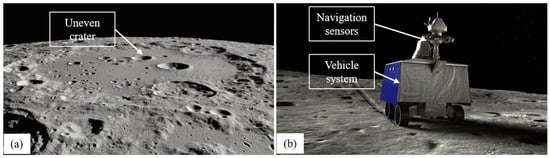
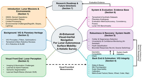
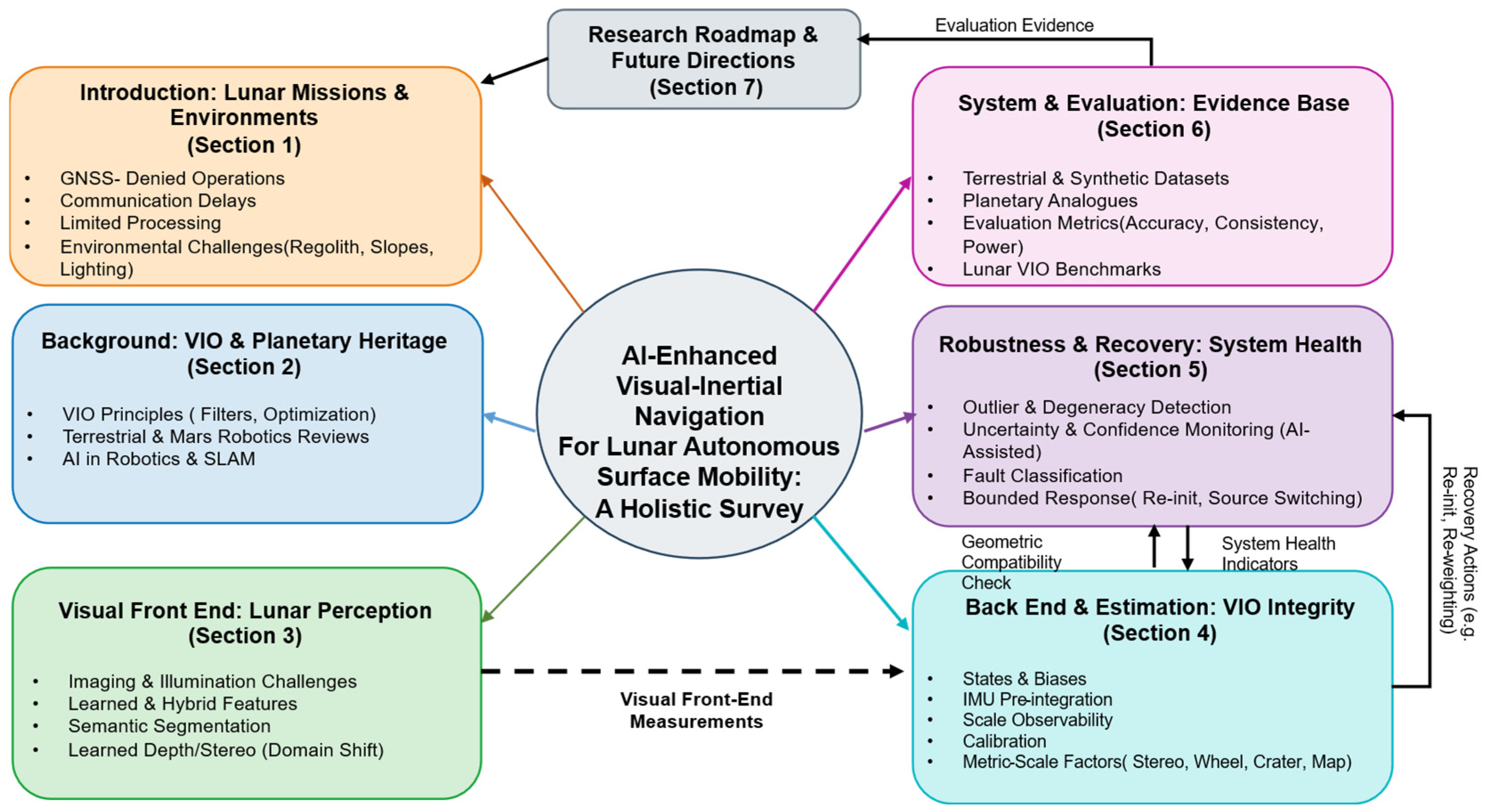
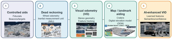
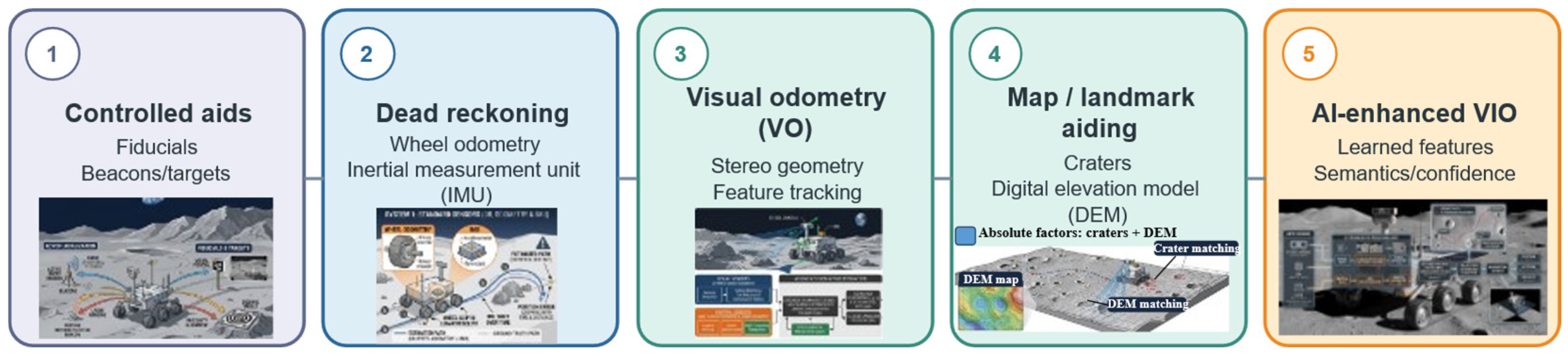
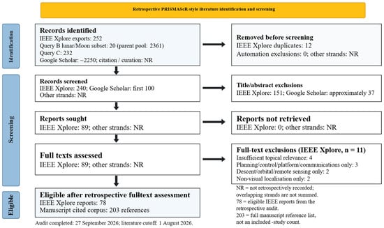
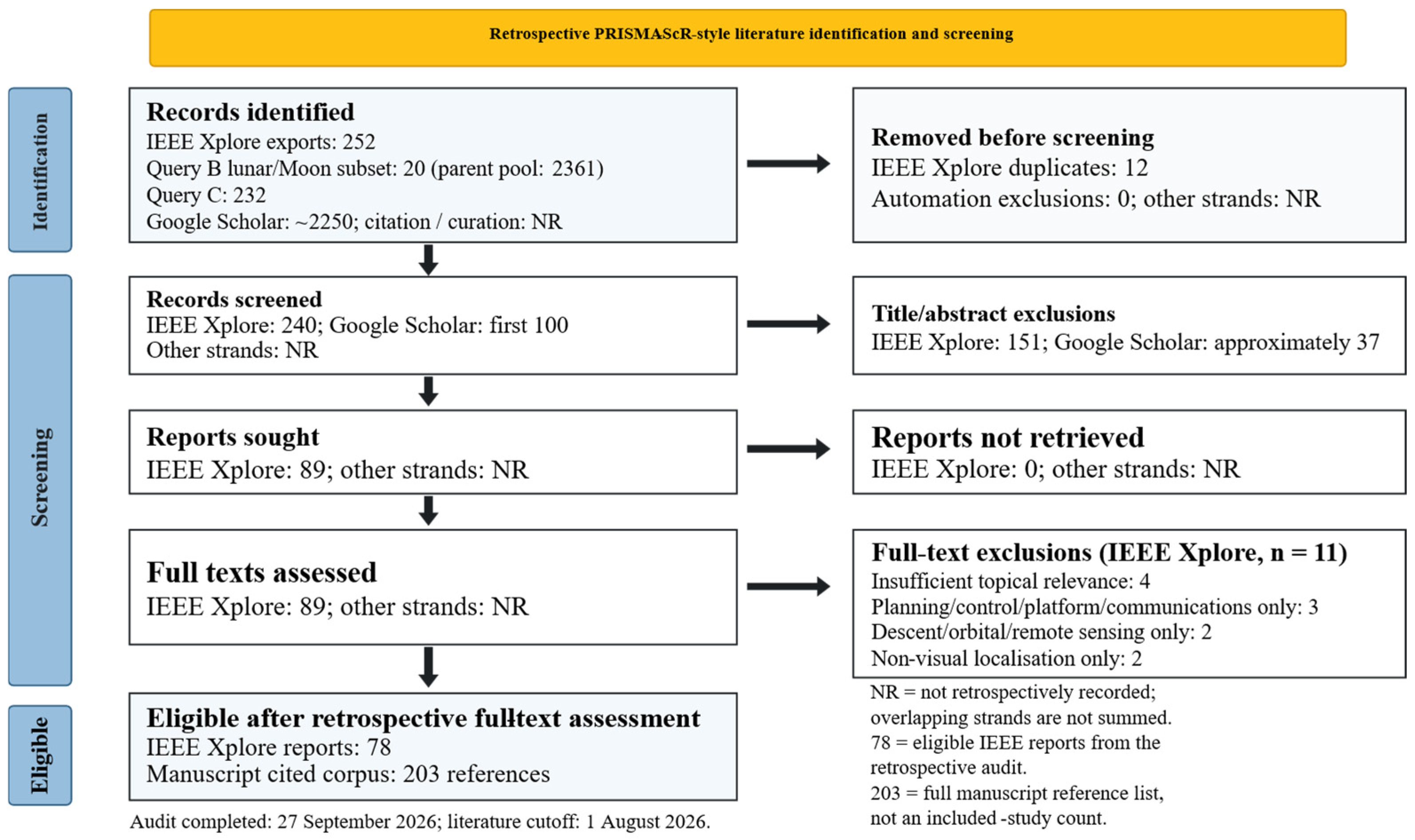
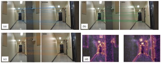
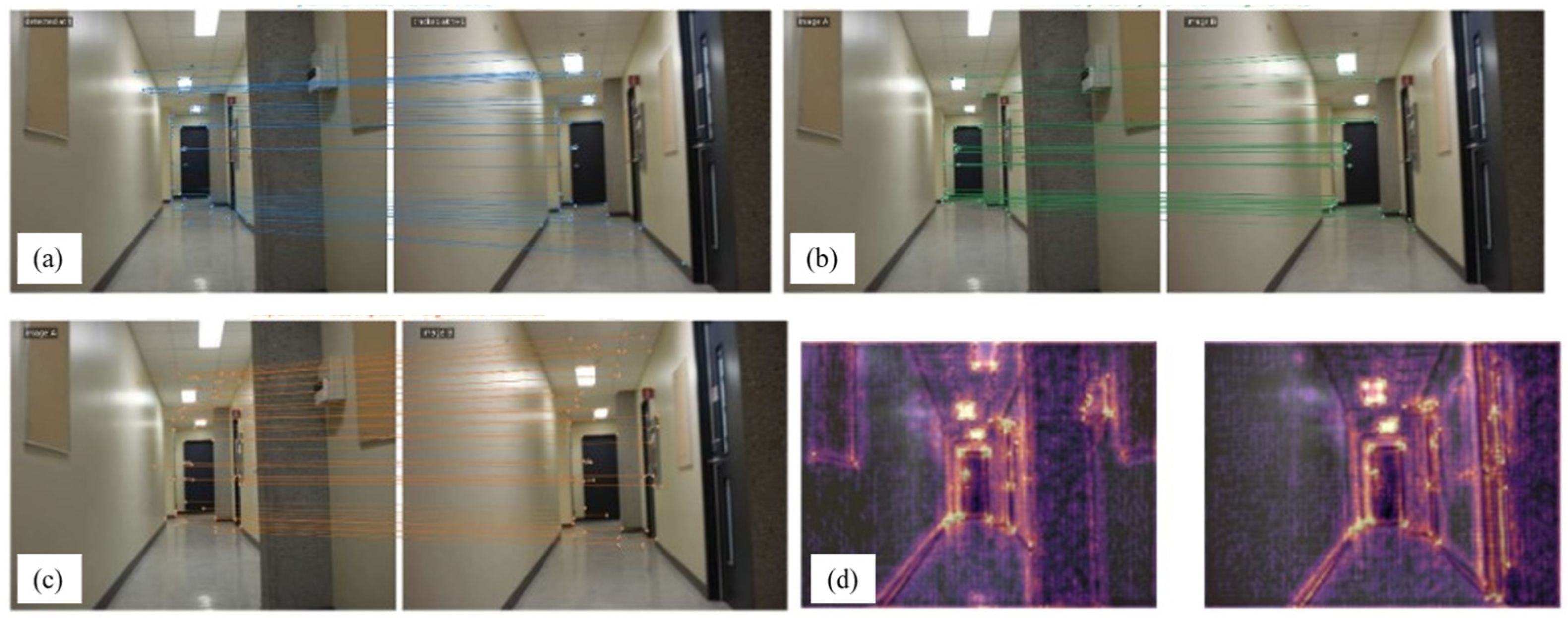
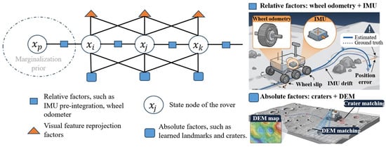
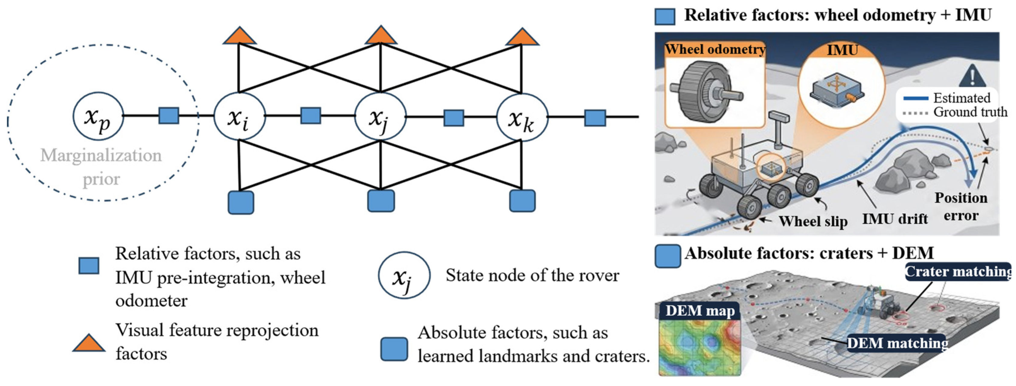
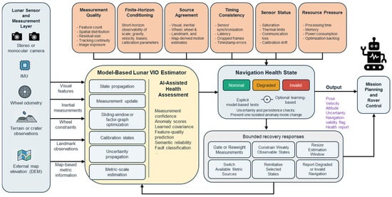
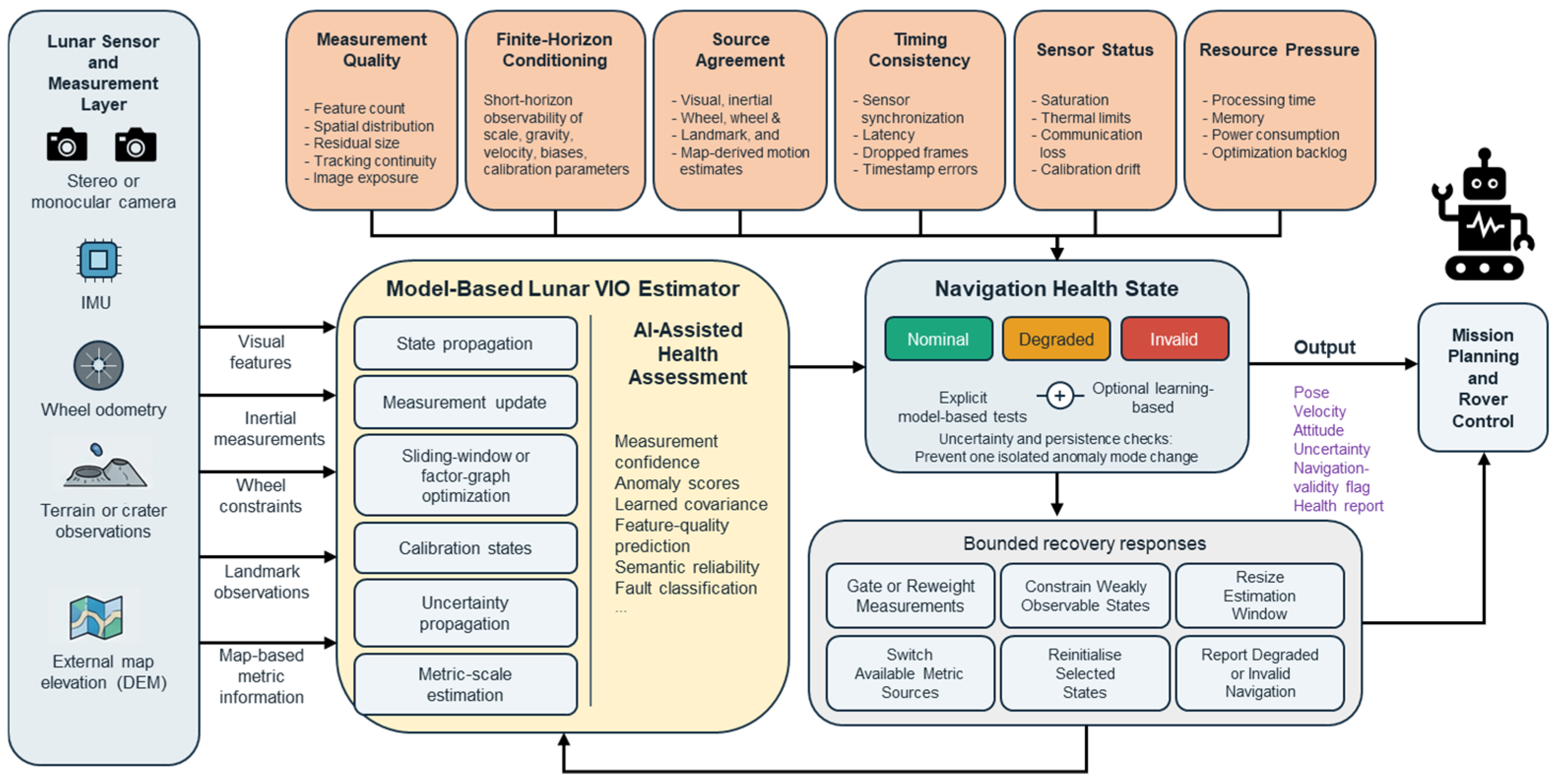
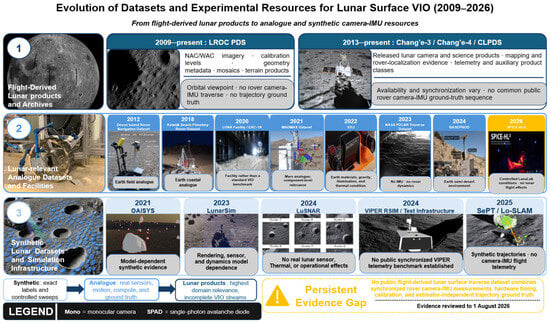
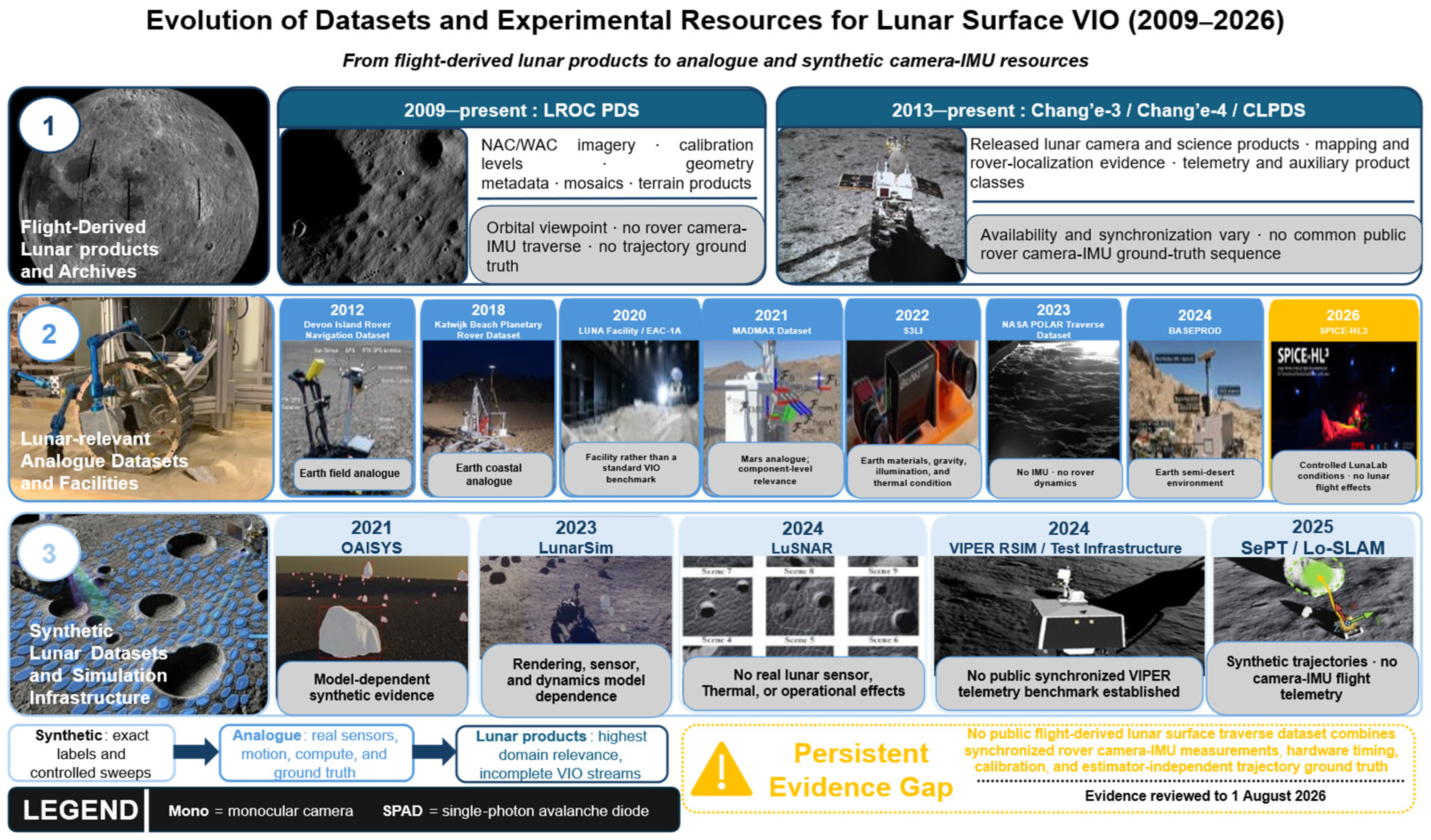

Disclaimer/Publisher’s Note: The statements, opinions and data contained in all publications are solely those of the individual author(s) and contributor(s) and not of MDPI and/or the editor(s). MDPI and/or the editor(s) disclaim responsibility for any injury to people or property resulting from any ideas, methods, instructions or products referred to in the content. |
© 2026 by the authors. Licensee MDPI, Basel, Switzerland. This article is an open access article distributed under the terms and conditions of the Creative Commons Attribution (CC BY) license.