


Abstract
Geographic information generalization underpins multi-scale spatial databases and cartography, and reliable DEM downscaling is critical to maintaining geomorphological consistency across map scales. Traditional DEM simplification and resampling methods rely on local geometric filtering and overlook global terrain structures, frequently causing structural distortions such as broken ridges and deformed slopes. This study proposes DD-GAN, a generative adversarial network constrained by terrain morphological factors for high-fidelity DEM downscaling. Built on a GAN architecture, the model embeds local relief and gradient as physical loss terms to prioritize major geomorphic skeletons and suppress trivial micro-terrain during resolution reduction, avoiding the indiscriminate over-smoothing of conventional sampling approaches. Multi-scale experiments covering downscaling factors ranging from 2× to 5× are conducted using mountainous datasets from Chongqing, Alaska, and Colorado. Quantitative and visual comparisons against raster interpolation, TIN-based simplification, and ordinary CNN show that DD-GAN mitigates terrain structural distortion and better retains elevation extremes and slope features, with more prominent strengths under large downscaling multiples. This physics-constrained deep learning paradigm provides an automated DEM downscaling solution that facilitates multi-scale terrain representation, supporting cartographic production and geomorphometric analysis.
1. Introduction
With the advancement of global geospatial data acquisition technologies, ranging from spaceborne LiDAR (e.g., ICESat-2, GEDI) to UAV photogrammetry and airborne LiDAR, the dynamic updating and efficient representation of multi-scale geographic information have become core topics in Geographic Information Science (GIScience). Geographic information generalization, as a bridge connecting spatial data at different scales, essentially involves applying operators such as selection, simplification, and exaggeration according to specific cartographic purposes and application scenarios, reducing data complexity while maintaining the spatial structure and semantic consistency of geographic entities [1,2]. Therefore, how to extract macroscopic and clear skeleton information that conforms to human geographic cognition from massive high-resolution data has become an urgent challenge for achieving “one dataset for multiple uses” and “multi-scale representation” [3,4].
However, terrain generalization of continuous spatial data such as DEMs is fundamentally different from the generalization of discrete features such as roads and settlements. As continuous representations of the terrain surface, DEM downsampling essentially involves geometric reconstruction and topological preservation of the terrain surface during scale transformation [5,6]. This process requires suppressing high-frequency, low-amplitude micro-terrain noise while preserving or even enhancing low-frequency, high-amplitude macroscopic structures, making it far more complex than the selection and displacement of discrete features.
To address the complexity of continuous terrain scale transformation, researchers have developed a series of classic terrain simplification approaches, including TIN simplification methods guided by geomorphological structural lines [7] and channel enforcement algorithms for hydrological continuity preservation [8]. In recent years, further advances in structure-preserving simplification have been achieved by methods such as Integrated Graph Laplacian Downsampling (IGLD) [9], watershed-based drainage unit generalization [6], and error-metric-driven simplification frameworks [10]. Despite these improvements, state-of-the-art geometry-based algorithms still rely heavily on local geometric statistics and empirically tuned heuristic thresholds. They have limited capacity to model the nonlinear scale-evolution patterns of complex landforms, and their generalizability across diverse geomorphic regions and level of automation remain restricted.
Benefiting from its powerful nonlinear mapping and hierarchical feature abstraction capabilities, deep learning (DL) has opened up a new research direction to break through the above limitations [11,12]. To date, DL applications in the DEM field have been predominantly focused on super-resolution (SR) reconstruction, which trains deep networks to recover missing high-frequency terrain details from low-resolution inputs [13,14]. Representative works include the multi-terrain feature-based deep convolutional neural network proposed by Zhou et al. [15], which introduces slope and curvature priors to enrich terrain feature representations yet still follows the LR-to-HR super-resolution pipeline; furthermore, the Transformer-based TTSR network proposed by Wang et al. [16] captures long-range geomorphic dependencies for DEM SR, while its task objective remains terrain detail enhancement from low-resolution data. Nevertheless, this “low-to-high” detail enhancement paradigm is fundamentally opposed to the “high-to-low” simplification objective of DEM downscaling in terms of core mathematical goals: SR aims to reconstruct lost high-frequency terrain components, whereas terrain generalization requires the selective elimination of nonessential fine-grained features while retaining the macro-geomorphological skeleton.
A small number of studies have attempted to repurpose SR architectures for DEM downscaling tasks, yet the adapted models still suffer from prominent structural and methodological deficiencies. Upon systematic review of the latest research, three core research gaps can be clearly identified:
- (1)
- Weak explicit morphological constraint mechanism. Most current deep learning-based DEM downscaling approaches are dominated by pixel-level elevation loss optimization and lack differentiable terrain morphological constraints built into the training pipeline. Without targeted constraints on relief amplitude and slope gradient, the macro-geomorphological skeleton tends to degrade gradually as the downscaling factor increases, deviating from the statistical characteristics of real low-resolution terrain.
- (2)
- Scarcity of downscaling-specific architectures. Existing multi-scale deep learning terrain models are mostly developed for super-resolution (upscaling) tasks. Only a few works focus on end-to-end networks for resolution-reduction terrain generalization, and their cross-scale generalization robustness under large downscaling multiples still lacks systematic verification.
- (3)
- Incomplete cross-paradigm performance comparison. Current studies generally only compare deep learning methods with basic raster interpolation methods and rarely carry out full-coverage comparative analysis covering classical interpolation, TIN-based simplification, and data-driven models, which makes it difficult to clarify the applicable scenarios and performance boundaries of different technical routes.
Although a few studies have attempted to adapt SR models for downscaling, their network architecture and loss function are originally designed for detail generation. As a result, the downsampling process cannot actively discard secondary information and often produces blurry results that fail to meet cartographic requirements. On the one hand, the model lacks constraints imposed by terrain morphological characteristics and is prone to generating “pseudo-terrain.” On the other hand, the logic of generalization is inconsistent: image compression pursues pixel-error minimization, which is inconsistent with the goals of terrain generalization, namely “preserving the essential while discarding the secondary” and achieving semantic simplification. Critically, terrain downscaling and generalization processes are accompanied by inevitable error propagation and accumulation in DEM-based quantitative analysis, which has been systematically verified by Oksanen and Sarjakoski [17] in their research on DEM terrain analysis error transmission mechanisms. In the field of 3D geometry processing, the Quadric Error Metrics (QEM) method proposed by Garland et al. [10] laid an important foundation for surface simplification. However, dedicated contractive generation architectures for regular-grid DEMs remain immature to date.
To address the core demand of macro-geomorphological skeleton preservation during DEM downscaling—a fundamental prerequisite for data-driven terrain generalization research—this paper proposes a Terrain-Factor-Constrained GAN Model for Feature Preservation in DEM downscaling (DD-GAN). It should be clarified that this work focuses on reconstructing high-fidelity low-resolution DEMs from high-resolution inputs at fixed downscaling multiples, aiming to retain the overall terrain framework and morphological statistical properties of real low-reference terrain. It forms a foundational exploration of learning-based terrain simplification, rather than a complete cartographic generalization system involving scale-specific feature selection, merging, and exaggeration operators.
The core idea is to incorporate terrain morphological factors, including local terrain relief and terrain gradient, as differentiable physical error terms directly into the loss function, thereby updating network parameters through backpropagation. This design ensures that during training, the model not only fits elevation values against the reference low-resolution DEM but is also constrained to maintain statistical consistency in terrain relief amplitude and gradient variation. In this way, the model achieves physically constrained terrain skeleton preservation in the DEM downscaling process and provides a technical basis for further systematic multi-scale cartographic generalization research.
The specific research objectives are as follows: (1) To design a generative adversarial network (DD-GAN) tailored for DEM downscaling terrain simplification. (2) To improve DD-GAN’s capability of capturing terrain morphological features by integrating loss functions for local terrain relief and terrain gradient into the model training pipeline to constrain the network to retain core geomorphic structures during resolution reduction. (3) To extend the model to multiple downscaling factors (2×, 3×, 4×, and 5×) and explore its performance and adaptation rules across different scale conversion gradients.
2. The Related Literature
This section reviews the literature from three perspectives: traditional DEM downscaling methods, exploratory applications of deep learning in terrain processing, and the origins of pseudo-terrain effects and the potential solutions offered by Generative Adversarial Networks. Based on this review, the research gap addressed in this study is identified.
2.1. Traditional DEM Terrain Generalization Methods
Over the past three decades, research on DEM downscaling can be broadly divided into two categories: error-driven and structure-driven methods. The key distinction between these two categories lies in how they define the terrain features that should be preserved during generalization.
Error-driven methods usually take RMSE as the main optimization objective, assuming that elevation points with larger numerical errors carry more important information. Typical methods include the maximum Z-tolerance method, the Very Important Points (VIP) algorithm, and various filtering-based schemes. However, as pointed out by Chen et al. [9], such methods have an inherent limitation: the maximum Z-tolerance method tends to retain only points with the largest elevation errors, while local structural details that are essential for maintaining slope morphology and surface roughness may be discarded. In other words, RMSE measures numerical deviation rather than structural deviation.
Structure-driven methods have been developed precisely to compensate for this deficiency. Ai et al. [6] explicitly proposed that DEM generalization should be understood as “information abstraction” rather than “data compression,” and proposed a dual-layer framework that separates geographic decision-making from geometric operations. Jenny et al. [18] further decomposed terrain generalization into two directional processes: “valley filling” and “ridge reduction.” The Integrated Graph Laplacian Downsampling (IGLD) method proposed by Chen et al. [9] represents elevation points as a graph structure and uses the maximum eigenvector of the Laplacian matrix to distinguish terrain structural skeletons from removable details at a global level. This method significantly improves slope preservation compared with the maximum Z-tolerance method. Feciskanin et al. [19,20] introduced the QEMS method and demonstrated that quadric error minimization can effectively balance global accuracy and local feature preservation in DEM simplification.
Despite these advances, structure-driven methods still face a common bottleneck: their performance often depends on explicit rules or manually defined thresholds. For example, IGLD requires a preset number of retained points; QEMS depends on the extrema of the K0 curve and becomes unreliable when the number of triangles is less than approximately 100 [19], and structural-line-based methods require setting valley depth thresholds [20]. Although these thresholds may be effective in specific geomorphological settings, they are difficult to transfer across different terrain types because terrain “importance” is highly context-dependent. The experiments of Callow et al. [21] also revealed a deeper dilemma: any local modification to a DEM inevitably affects derived terrain variables such as slope, and different methods produce inconsistent results. This means that methods optimizing only a single dimension inevitably introduce unpredictable trade-offs in other terrain properties.
2.2. Deep Learning in Terrain Processing: Exploratory Applications
Deep learning provides a potential solution to the above challenges by shifting the DEM downscaling process from expert-defined rule design to data-driven representation learning. Instead of requiring experts to explicitly prescribe “what is important,” deep learning models can autonomously learn mapping relationships from large numbers of samples. Hinton et al. [22] demonstrated that deep autoencoders can learn nonlinear low-dimensional manifolds of high-dimensional data and preserve richer structural information than PCA during dimensionality reduction. This suggests that neural networks can implicitly discover, through end-to-end training, which structures in the data are essential and which are removable. Goodfellow et al. [23] further showed that adversarial training can implicitly learn complex data distributions without explicit probabilistic modeling. This aligns with the perspective proposed by Reichstein et al. [11], who argued that machine learning can not only support prediction but also help reveal intrinsic structures and physical regularities behind data.
However, existing deep learning studies in the DEM domain exhibit a prominent directional imbalance. From SRCNN proposed by Dong et al. [13] and SRGAN proposed by Ledig et al. [14] to D-SRGAN proposed by Demiray et al. [24], TfaSR proposed by Zhang et al. [25], the CGAN-based terrain reconstruction model integrating topographic skeletons proposed by Chen et al. [26], the topographic knowledge-constrained TKCGAN developed by Li et al. [27], and the Transformer-based multi-path network proposed by Guo et al. [28], most models are designed to recover high-resolution DEMs from low-resolution inputs. These methods learn a “low-to-high” mapping, and their encoder–decoder or symmetric hourglass architectures are tailored for detail restoration and enhancement.
In contrast, DEM downscaling follows the opposite direction: it starts from high-resolution data and generates a low-resolution representation. This process is not a simple reversal of super-resolution. The objective of DEM downscaling is not to approximate a predefined high-resolution “true value,” but to reduce data resolution while maximizing the recognizability of essential geomorphological structures. Therefore, directly adapting SR networks for DEM downscaling is theoretically problematic because models designed for detail recovery are not naturally suited to selective detail removal. Existing studies related to dimensionality reduction are also not specifically designed for DEM downscaling. For example, Gavriil et al. [29] focused on DEM void filling, which is essentially a restoration task rather than a DEM downscaling task. The deep learning mesh simplification method proposed by Lan et al. [30] targets 3D meshes rather than regular-grid DEMs. To date, dedicated contractive generation architectures for regular-grid DEMs that incorporate terrain-specific physical constraints remain underdeveloped.
2.3. Origins of Pseudo-Terrain and the Potential of GANs
Even if the directional misalignment problem is resolved, contractive generation networks still face the risk of pseudo-terrain distortion under a purely supervised learning paradigm. When elevation Mean Squared Error is used as the only optimization objective, the network tends to generate results that are “numerically correct but morphologically inconsistent.” In such cases, elevation values statistically approximate the reference DEM, but local slopes are distorted, ridges may become blunted, and aspect patterns may become disordered. These distortions are not always sufficiently reflected in MSE-based evaluation. Courtial et al. [31] revealed a similar dilemma in the deep learning-based evaluation of road generalization, showing that pixel-level accuracy alone is insufficient for judging the quality of cartographic generalization.
Physics-Informed Neural Networks (PINNs) provide an important reference for addressing this problem. Raissi et al. [32] demonstrated that embedding residual terms of physical equations into the loss function enables neural networks to satisfy physical laws while fitting data. Wu et al. [33] further validated this strategy in geophysical inversion. In the DEM domain, Zhang et al. [25] and Guo et al. [28] incorporated slope constraints into the loss function and effectively alleviated over-smoothing. However, a common limitation of these studies is that physical constraints mainly act as post hoc penalty terms. That is, when the network outputs a DEM with abnormal slopes, the loss function penalizes the result and updates the parameters through backpropagation. However, during the feature extraction stage of forward propagation, the network still lacks an active mechanism for recognizing and preserving key terrain structures.
This limitation provides the core motivation for introducing GANs into DEM downscaling in this paper. The GAN framework proposed by Goodfellow et al. [23]. enables the generator to implicitly learn the structural distribution of data through the dynamic adversarial competition between the generator and discriminator, that is, to learn “what kind of output looks realistic.” Ledig et al. [14] and Demiray et al. [24] have demonstrated that adversarial loss can recover structural features smoothed out by MSE. However, this paper applies GANs in a fundamentally different direction: rather than using the discriminator to distinguish “high-resolution DEM” from “super-resolved generated DEM,” it is used to distinguish “terrain conforming to geomorphological regularities” from “pseudo-terrain with close elevation but distorted morphology.” The discriminator is trained to recognize the structural consistency of terrain in derived dimensions such as overall elevation distribution, local terrain relief, and terrain gradient. When the generator produces terrain with abnormal relief or gradient, the discriminator can detect this morphological-level distortion and feed it back to the generator for correction.
On this basis, this paper further incorporates terrain morphological factors, such as local terrain relief and terrain gradient, into the parameter update process. This dual-channel physically aware mechanism, which combines adversarial constraints with terrain morphological factor learning, is the core feature that distinguishes DD-GAN from existing methods.
2.4. Research Gap and Positioning of This Paper
From the foregoing review, the impasse confronting current DEM downscaling research has come into sharp focus. It is not a single-dimensional shortcoming but rather a set of mutually reinforcing problems.
The most conspicuous problem is task direction. Deep learning applications in the DEM domain have been overwhelmingly concentrated on super-resolution reconstruction [13,14,24,25], which learns a “low-to-high” mapping and pursues detail recovery. DEM downscaling, by contrast, demands “high-to-low” abstraction. Its “ground truth” is non-unique, and the task involves complex trade-offs. Traditional structure-driven methods [6,9,18] do target generalization tasks, but the generalizability of their explicit rules remains fundamentally constrained. The few works that touch upon dimensionality reduction [29,30] belong to the domains of restoration and irregular-grid meshes, respectively; neither addresses regular-grid DEM downscaling. The second problem, tightly coupled with the first, concerns how physical constraints are deployed. PINNs [32] and sensing prior constraints [33] have demonstrated the value of incorporating domain knowledge into neural networks, and within the DEM field, attempts have been made to add slope constraints to the loss function [25,28]. Yet terrain factors have consistently played the role of an “examiner,” judging at the output end rather than guiding the feature extraction process. The third problem pertains to the generation mechanism itself. Under a purely supervised learning framework, even if the network direction is correct and physical constraints have been introduced, an MSE-dominated loss may still tolerate results that are “numerically correct but morphologically suspect.” GANs offer a mechanism for implicitly learning structural distributions [23], but existing work usually positions the discriminator to distinguish high-resolution ground truth from super-resolved outputs, serving an enhancement-oriented logic. If the discriminator is repositioned to distinguish terrain conforming to morphological regularities from morphologically distorted pseudo-terrain, the adversarial mechanism could instead serve a morphological-fidelity preservation objective. However, this line of thought remains in its infancy.
The three problems described above are mutually reinforcing: directional misalignment deprives existing networks of the structural foundation for “preserving the essential while discarding the secondary”. Current studies merely impose terrain constraints at the output layer rather than embedding geomorphic awareness within feature extraction. Even for networks optimized for downscaling tasks, an intrinsic terrain perception mechanism remains absent. Additionally, training driven solely by pixel-wise supervised loss can yield so-called pseudo-terrain, where elevation values match references, yet geomorphic structures are severely distorted.
To tackle this interconnected set of limitations in an integrated manner, this work proposes the DD-GAN model. Drawing on the SRDCGAN architecture introduced by Hu et al. [34], we redesign the generative adversarial framework, which departs from the symmetric encoder–decoder layouts widely adopted for DEM super-resolution. In terms of constraint design, we integrate local terrain relief and terrain gradient as differentiable physical loss terms into the backpropagation workflow. This setup drives the model to optimize network parameters under geomorphological consistency constraints throughout the training process. At the generation-mechanism level, the discriminator’s objective is adjusted to distinguish surfaces conforming to real terrain morphological regularities from pseudo-surfaces with close elevation values but distorted morphology. This mechanism forms a complementary relationship with the multi-objective loss function that integrates elevation fidelity and terrain gradient preservation. Through systematic comparisons with traditional methods, including nearest-neighbor interpolation, bilinear interpolation, and cubic convolution, as well as conventional CNNs and the baseline GAN model, the effectiveness and advantages of the proposed approach are validated.
3. Data and Methods
3.1. Study Areas
3.1.1. Training Areas
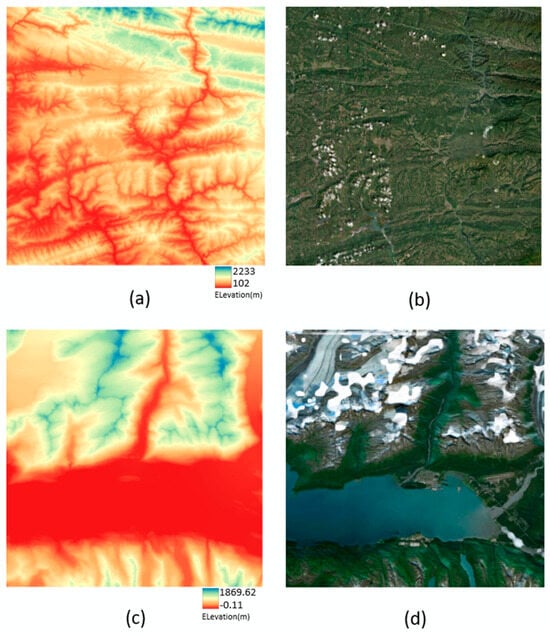
To ensure the DEM downscaling capability of model training and avoid overfitting caused by single landform samples, this study selected two mountainous study areas with typical geomorphological characteristics and distinct terrain formation mechanisms as training data sources (Figure 1). Both areas have a pixel size of 1500 × 1500, providing rich sample support for the model to learn universal DEM downscaling rules.
Figure 1.
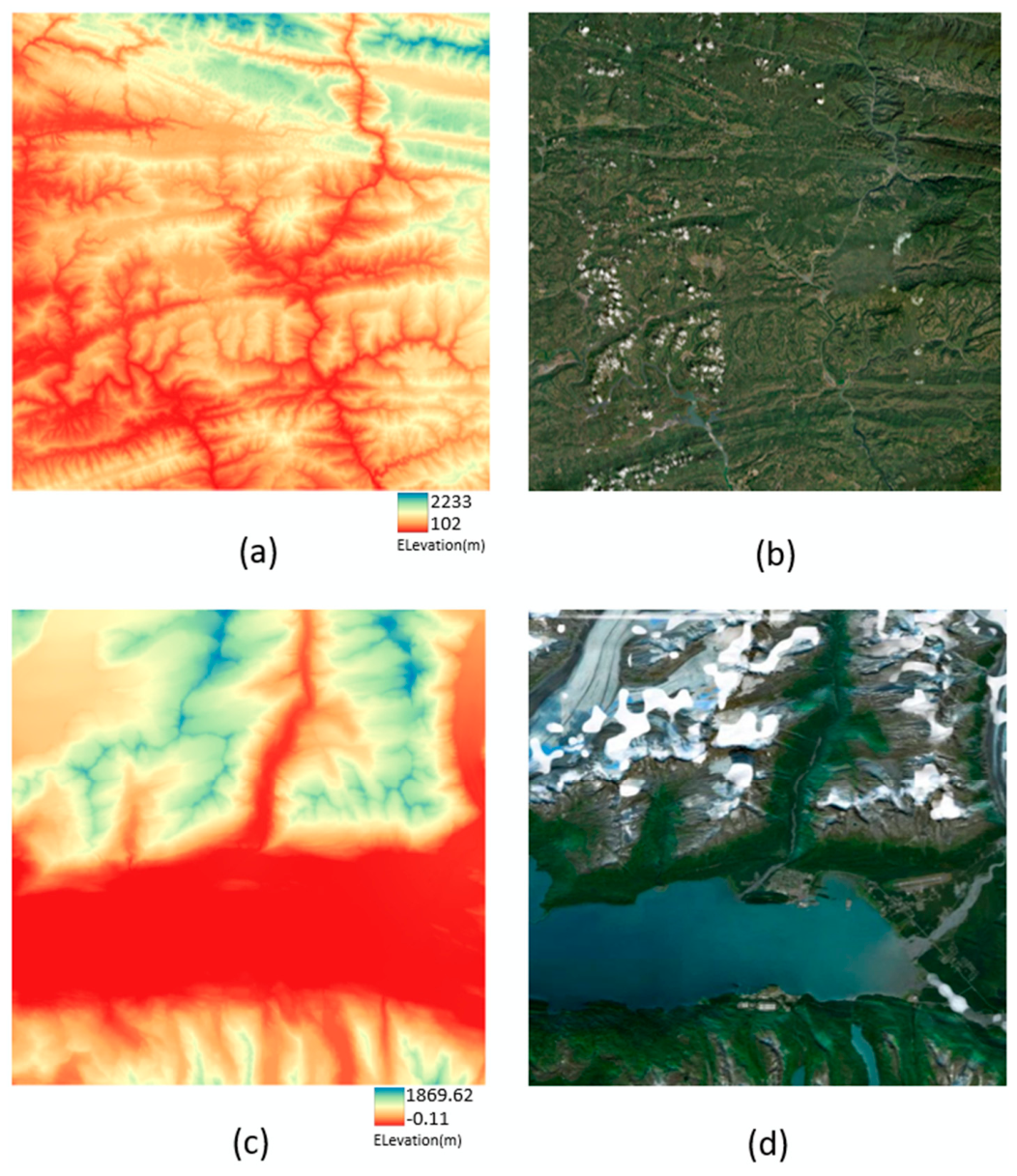
Training Area: (a) DEM of Chongqing (30 m). (b) Remote sensing image of Chongqing. (c) DEM of Valdez (15 m). (d) Remote sensing image of Valdez.
The first training area is the mountain-hill transitional zone in northeastern Chongqing, China, located at the intersection of the eastern Sichuan parallel ridge-and-valley region and the Daba Mountain range, with geographic coordinates between 108°30′–109° E and 31–31°30′ N. This area, subjected to long-term fluvial erosion, has formed typical erosional mountainous terrain characterized by high mountains and deep valleys with crisscrossing gullies. The elevation span reaches 2131 m, from 102 m to 2233 m, and the significant relative relief provides an ideal scenario for the model to capture terrain gradient variations. This study uses DEM data at 30 m and 90 m resolutions from this area, which are taken from an exact 3× downscaling relationship, specifically dedicated to model training for 3× DEM downscaling tasks.
The second training area is the Valdez region in southern Alaska, USA (Table 1), located in the middle section of the Alaska Range, and represents high-altitude fold-and-fault mountainous terrain. Under the combined effects of tectonic uplift and glacial erosion, the terrain relief is dramatic, and the geomorphological forms are complex. This study uses the multi-resolution DEM dataset released by Tom Patterson (Version 1.0, 2019), which is constructed based on the NAD83 datum with Albers Equal-Area projection, covering data at multiple resolutions. From this dataset, DEMs at 15 m, 30 m, 250 m, and 1000 m resolutions were selected to construct training samples for 2× (15 m → 30 m) and 4× (250 m → 1000 m) downscaling tasks, covering terrain generalization scenarios with different simplification extents.
Table 1.
Training Area 2 (Valdez) Details.
Although both training areas are dominated by mountainous landforms, their terrain genesis, relief morphology, and micro-topographic characteristics show significant differences: the Chongqing area is characterized by parallel ridge-and-valley systems shaped by fluvial processes, while the Valdez area combines the dual influences of tectonics and glaciation. The complementary landform types of these two areas provide the model with diverse samples of ridge lines, valley networks, and terrain gradients, effectively mitigating the overfitting risk of single landform samples and ensuring the generalizability of the proposed model across different mountainous environments.
3.1.2. Testing Area
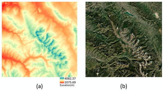
This study selected the Gore Range (Figure 2) in Colorado, USA, as the testing area, adopting the multi-resolution DEM dataset released by Tom Patterson in 2020. Four sub-regions were prepared for 2× to 5× downscaling tasks, corresponding to resolution pairs of 15/30 m, 30/90 m, 250/1000 m, and 500/2500 m. The native high-resolution (HR) and low-resolution (LR) reference DEMs are independently derived from USGS 3DEP and ViewFinderPanoramas terrain products, with inherent natural elevation deviations of several decimeters between different original resolutions. The official dataset has pre-generated synthetic LR DEMs through bicubic interpolation from matching HR data to serve as comparative baselines. Detailed terrain attributes of this study area are listed in Table 2. Its distinct landform characteristics complement those of the training regions, facilitating an objective assessment of the model’s cross-scene generalization performance.
Figure 2.
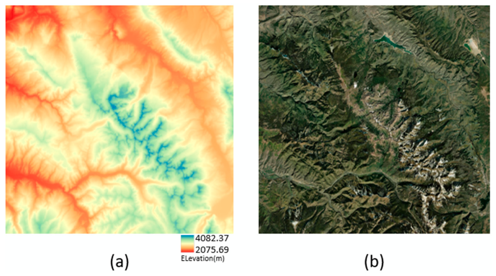
Testing Area: (a) DEM of Gore Range (30 m). (b) Remote sensing image of Gore Range.
Table 2.
Testing Area Details.
3.2. Experimental Data and Preprocessing
The training experimental data used in this study can be divided into two categories: the Valdez and Gore Range areas use the multi-resolution DEM benchmark dataset released by Tom Patterson (Zenodo archive), providing standardized multi-scale mountainous terrain samples for terrain research; the Chongqing area uses SRTM DEM (30 m/90 m resolution), covering typical mountainous terrain at the intersection zone of the eastern Sichuan hills and the Daba Mountains.
The high-resolution DEMs used in this study were uniformly standardized to a size of 1500 × 1500 pixels. To ensure strict geospatial correspondence between high- and low-resolution DEMs, the real low-resolution DEMs were first precisely spatially cropped to make their spatial extent completely match that of the high-resolution DEMs, eliminating terrain feature misalignment problems caused by spatial offsets.
All high-resolution (HR) and low-resolution (LR) DEM pairs adopted for subsequent model training in this paper are authentic native terrain products derived exclusively from the above two datasets. Each HR and LR DEM possesses independent official survey sources and native spatial resolutions, rather than synthetic low-resolution data interpolated or resampled from a single high-resolution DEM. This independent multi-source real-measurement dataset eliminates the risk of circular validation and guarantees the objectivity and reliability of all experimental results in the follow-up analysis.
Before model training, a standardized preprocessing workflow was executed on the spatially matched DEM data: first, a fixed window of 100 × 100 pixels was used to tile both high- and low-resolution DEMs, constructing one-to-one corresponding training sample pairs to improve model training efficiency. For null values, NaN values, and infinite value anomalies in the DEM data, zero filling was applied to ensure data validity and stability. To eliminate differences in elevation numerical magnitude across different regions, min-max normalization was performed on all elevation data, mapping values to the [0, 1] interval to accelerate model convergence.
To enhance the model’s generalization capability and avoid overfitting, an online data augmentation strategy was introduced during the training phase: random horizontal flipping, random vertical flipping, and random rotations of 90°, 180°, and 270° were consistently applied to the high- and low-resolution DEM sample pairs, and slight Gaussian noise was added with a small probability, expanding the diversity of training samples without destroying the core terrain features.
All preprocessing operations were completed under the premise of maintaining the physical meaning and spatial topological relationships of the terrain, providing high-quality, high-consistency sample data for subsequent model training.
3.3. Neural Network Architecture
3.3.1. SRDCGAN
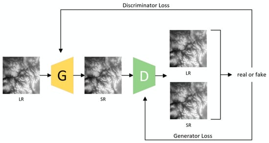
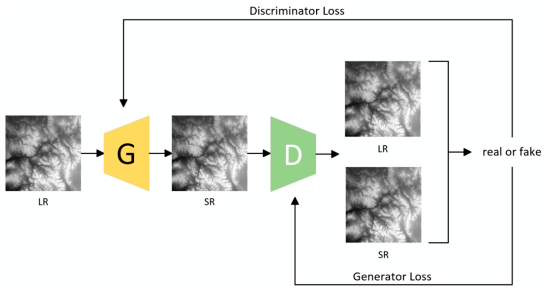
SRDCGAN is a Generative Adversarial Network for DEM super-resolution reconstruction proposed by Hu et al. [30], specifically designed to address the problems of noticeable artifacts, noise, and insufficient terrain feature preservation in traditional interpolation and deep learning methods for DEM reconstruction, achieving 4× resolution enhancement. Its overall adversarial architecture follows the generator-discriminator game framework, as shown in Figure 3: the low-resolution DEM is fed into the generator to obtain the super-resolution reconstruction result, while the discriminator simultaneously receives the real high-resolution DEM and the generated result, performing real/fake discrimination on the samples. Through adversarial training, the reconstruction accuracy is continuously improved.
Figure 3.
Architecture of SRDCGAN. (LR: Low-Resolution DEM, SR: Super-Resolution DEM).
The specific structure of the generator is shown in Figure 4. The generator uses Residual-in-Residual Dense Block (RRDB) with Batch Normalization (BN) layers removed as the core feature extraction unit. This module is composed of multiple Residual Dense Blocks (RDBs) stacked together: each RDB adopts a dense connection structure, in which the outputs of convolutional layers are concatenated across layers to achieve efficient reuse and transmission of terrain features. Local residual connections are then used to strengthen feature propagation. The removal of BN layers avoids artifact introduction during reconstruction while enhancing the model’s generalization capability across different terrain scenarios. The network realizes the reuse and enhancement of multi-scale terrain features by stacking multiple groups of RRDB modules while introducing Deformable Convolutional Network (DCN) modules that allow the network to adaptively adjust the sampling positions of convolutional kernels and better learn irregular terrain features such as ridges and valleys. Global skip connections and point-wise addition operations effectively alleviate the gradient vanishing problem in deep networks.
Figure 4.
Generator Architecture of SRDCGAN.
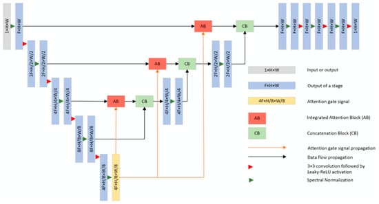
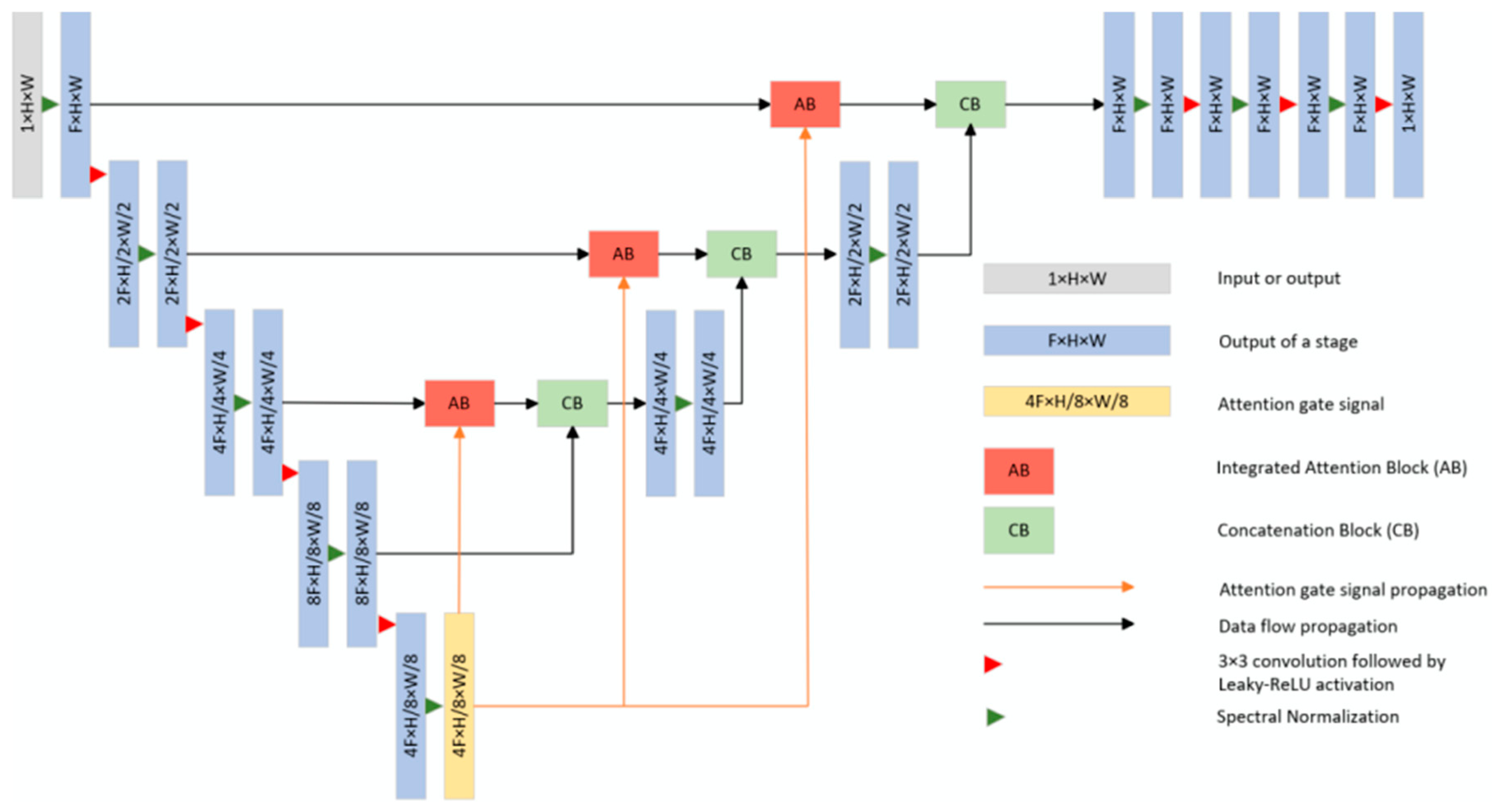
The discriminator adopts a U-Net architecture with integrated attention mechanisms, as shown in Figure 5; in the encoding path, the input DEM undergoes three downsampling stages to construct a multi-scale feature space, while integrated attention modules and concatenation modules are introduced to enhance attention to key terrain regions and suppress background noise interference through signal gating mechanisms, completing feature fusion and normalization. The decoding path recovers feature dimensions through upsampling, and the decoded features are fused with the attention features from the encoding path via skip connections, ultimately producing pixel-level discrimination results. This design not only expands the receptive field to capture semantic contextual information from large-scale terrain but also focuses on critical details through attention mechanisms, thereby improving training stability and discrimination accuracy.
Figure 5.
Discriminator Architecture of SRDCGAN.
The network’s loss function combines global content loss, measured by MSE, with adversarial loss, guiding the generator to simultaneously optimize overall error and local feature consistency by balancing elevation accuracy and terrain detail recovery. Experimental results demonstrate that, compared with bicubic interpolation, SRGAN, and other baseline methods, SRDCGAN achieves significant reductions in error metrics such as RMSE and MAE. It effectively removes artifacts and noise from reconstruction results while preserving critical terrain topological features, providing a robust baseline architecture for DEM super-resolution reconstruction tasks.
3.3.2. DD-GAN
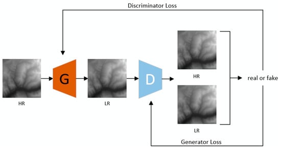
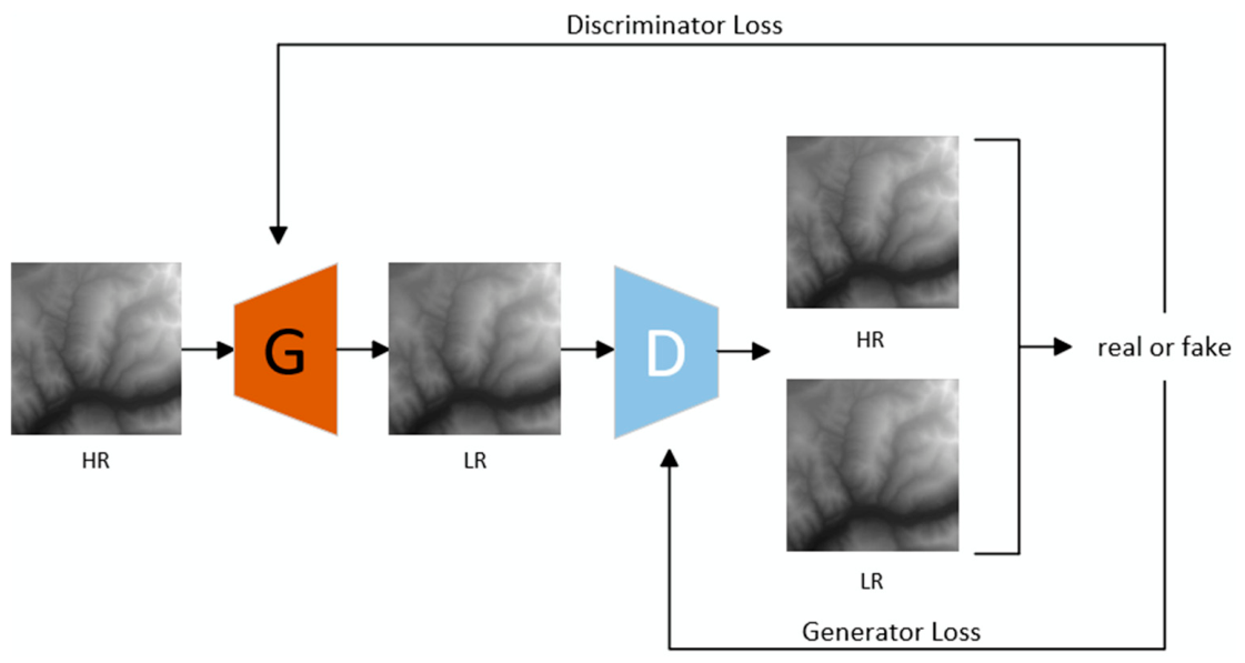
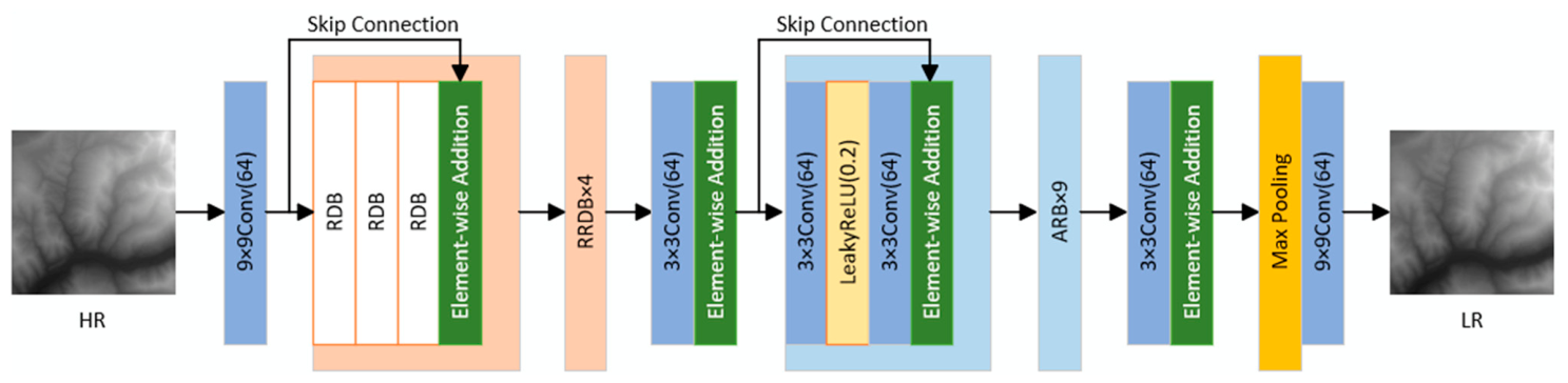
Inspired by the above SRDCGAN model, this paper proposes a DEM downsampling model, DD-GAN (DEM Downsampling Generative Adversarial Network). Its overall architecture is shown in Figure 6. The model has been adapted and extended to accommodate the specific characteristics of multi-rate DEM downscaling. It retains the generator-discriminator adversarial learning framework and achieves robust scale transformation from a high-resolution DEM to a low-resolution DEM through game-theoretic optimization between the two networks. In the overall workflow, the high-resolution DEM is fed into the generator, which produces the target low-resolution DEM via multi-scale feature extraction and downsampling operations. The discriminator simultaneously receives the real low-resolution DEM and the generated output from the generator and supplies gradient feedback to the generator through pixel-level “real/fake” discrimination. The two networks are optimized jointly, preserving critical terrain features while ensuring elevation numerical accuracy.
Figure 6.
Architecture of DD-GAN. (HR: High-Resolution DEM, LR: Low-Resolution DEM).
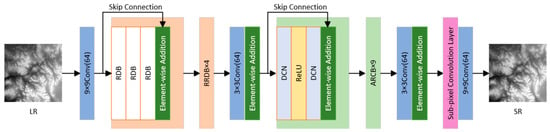
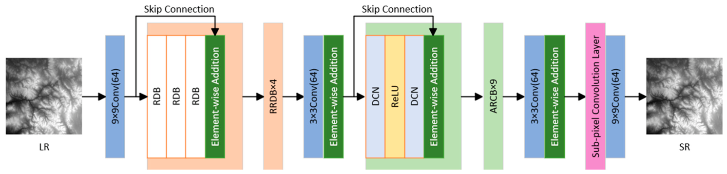
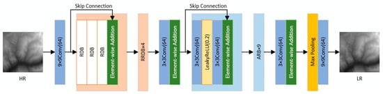
The detailed structure of the generator is shown in Figure 7. The generator draws on the core strengths of SRDCGAN. It employs a Residual-in-Residual Dense Block (RRDB) without batch normalization as the primary feature extraction unit, where stacked Residual Dense Blocks (RDBs) reuse and strengthen multi-scale terrain features. Skip connections and element-wise addition propagate features across modules, alleviating gradient vanishing. To tailor the architecture to the downscaling task, three key modifications were made: (1) the original low-to-high super-resolution workflow was inverted into a high-to-low downscaling workflow; (2) sub-pixel convolution upsampling was replaced with max-pooling layers to support multiple downscaling factors; and (3) the deformable convolution module was substituted with a lightweight Adaptive Residual Block (ARB) after the RRDB modules, preserving adaptive feature learning while reducing complexity. The two terminal layers of the generator use large-kernel convolutions to expand the receptive field for capturing large-scale terrain context. The discriminator follows the attention-augmented U-Net architecture of SRDCGAN, achieving pixel-level discrimination through a multi-scale encoder–decoder structure with attention mechanisms that focus on critical terrain regions. As its structure deviates minimally from the original, it is not further elaborated here.
Figure 7.
Generator Architecture of DD-GAN.
3.4. Training Loss Function of DD-GAN
To ensure both the elevation accuracy and topographic integrity in DEM downscaling results, DD-GAN employs a composite loss function that balances global numerical consistency and local terrain feature preservation. The loss function consists of four components, each targeting a specific aspect of the downscaling task.
3.4.1. Content Loss
The content loss enforces global elevation consistency between the generated low-resolution DEM and the reference low-resolution DEM using Mean Squared Error (MSE), thereby ensuring the overall numerical accuracy of the model.
where is the content loss, denotes the expectation operation, is the downscaling DEM output by the generator, and is the real low-resolution DEM.
3.4.2. Adversarial Loss
The adversarial loss narrows the data distribution gap between generated samples and real samples through adversarial training, guiding the generator to produce realistic DEM outputs that match the true data distribution.
where is the generator’s adversarial loss, is the prediction score output by the discriminator, and 1 is the label assigned to real samples.
3.4.3. Terrain Roughness Loss
The terrain roughness loss constrains the consistency of local topographic texture features. It calculates the local standard deviation of elevation via a 3 × 3 average pooling window to characterize terrain roughness, ensuring the generated DEM preserves the undulation patterns of the real terrain.
where is the terrain roughness loss, is the local elevation mean calculated by 3 × 3 average pooling, is the local terrain roughness of the input DEM, and denotes the 3 × 3 window average.
3.4.4. Gradient Loss
The gradient loss preserves critical topographic edges (e.g., ridges, valleys, and slope breaks) using the Sobel operator to extract gradient features in horizontal and vertical directions. It constrains the gradient amplitude consistency between the generated and real DEMs, ensuring fine-scale terrain features are retained.
where is the gradient loss, and are the 3 × 3 Sobel convolution kernels in the x and y directions, and are the gradient components of the DEM in the horizontal and vertical directions, is the gradient amplitude of the input DEM, and denotes the convolution operation.
3.4.5. Total Generator Loss
The total loss fuses the four loss components with fixed weights to balance the optimization objectives of numerical accuracy and topographic feature preservation.
where is the total loss of the generator, and , , are the weight coefficients for the adversarial loss, terrain roughness loss, and gradient loss, respectively.
3.5. Experiments
The experimental environment is a Windows 11 system equipped with an NVIDIA (Santa Clara, CA, USA) RTX 4070 Ti GPU (driver 591.86, CUDA 12.4). The software is built on Python 3.10 and PyTorch 2.5.1. Training employed the Adam [35] optimizer with cosine annealing learning rate scheduling, combined with mixed-precision training, gradient accumulation, and early stopping mechanisms. Data augmentation is applied during training, together with composite loss supervision. The dataset is split at an 8:2 ratio, and model performance is evaluated using MAE and RMSE. Table 3 presents the training and test set information for different generalization ratios.
Table 3.
Experiment Dataset.
To address the terrain-detail deviation in the model-generated low-resolution DEM, a post-processing optimization method based on Inverse Distance Weighted (IDW) interpolation was proposed. First, the initial predicted low-resolution DEM is obtained through the trained generative model. Then, using the high-resolution DEM as a reference, a 3 × 3 window is used to extract neighboring elevation points, and the reference elevation of the target pixel is calculated through IDW interpolation:
where is the Euclidean distance between the target pixel and the k-th sampling point extracted from the high-resolution reference DEM, are the coordinates of the target pixel in the low-resolution DEM, are the coordinates of the k-th sampling point, is the reference elevation value of the target pixel calculated by IDW interpolation, is the elevation value of the k-th sampling point, p is the power parameter controlling the distance weight attenuation (set to 2 in this study), M is the total number of sampling points in the 3 × 3 local window, is the final optimized elevation value of the low-resolution DEM at position , is the weight coefficient balancing the predicted and interpolated values (set to 0.5 in this study), and is the initial predicted elevation value from the generator model.
3.6. Comparative Baseline Methods
This study selects four mainstream traditional DEM resampling and downscaling approaches as comparative baselines for subsequent performance validation: nearest-neighbor interpolation, bilinear interpolation, cubic convolution resampling, and a TIN-based DEM simplification method implemented via WhiteboxTools [36]. These approaches cover interpolation algorithms of varying complexity as well as classic feature-preserving terrain simplification strategies, collectively representing the most widely adopted solutions for DEM downscaling tasks. All of them are involved in the following cross-method comparative experiments to benchmark the performance of the proposed DD-GAN model.
4. Results
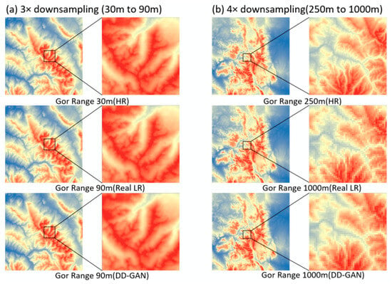
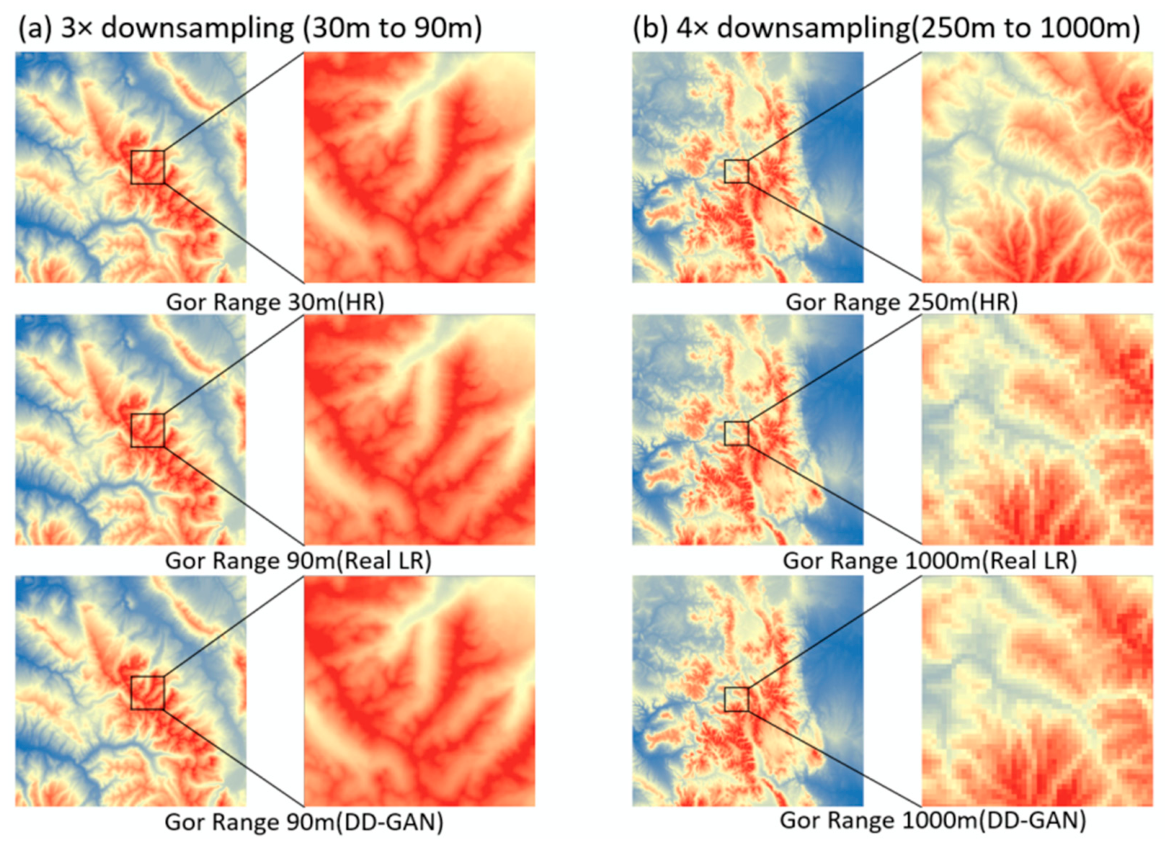
The resulting images, using 3× and 4× DEM downscaling as examples, are shown in Figure 8.
Figure 8.
Results of DEM downscaling. Downscaling Factor: (a) 3. (b) 4. DD-GAN results are optimized by IDW interpolation.
To intuitively reveal the optimization effect brought by IDW interpolation on the proposed model and demonstrate DD-GAN’s performance in multi-scale terrain generalization tasks, this study adopted Global Mapper software (v21.0) for visual comparative analysis of DEM datasets to complete qualitative evaluation.
Four core types of DEM data are arranged for side-by-side visual comparison: the input high-resolution (HR) DEM, the real low-resolution (LR) ground-truth reference DEM, low-resolution outputs predicted by the original DD-GAN without IDW optimization, and low-resolution outputs from the IDW-optimized DD-GAN variant. Global Mapper’s built-in hillshade rendering tool is used to generate uniform shaded relief maps, enabling synchronized comparison of the identical study region under consistent display parameters.
From these visualizations, researchers can capture macroscopic shifts in the overall terrain skeleton and major geomorphic units and directly observe how terrain morphology evolves throughout multi-scale downscaling. More importantly, pairwise comparison between unoptimized and IDW-optimized DD-GAN predictions against the real LR reference reflects the improvement in terrain morphological reconstruction introduced by the IDW optimization module. For all four resolution gradient scenarios (15 m → 30 m, 30 m → 90 m, 250 m → 1000 m, and 500 m → 2500 m), cross-scale visual comparison further intuitively validates how IDW optimization steadily enhances DD-GAN’s generalization robustness across varying terrain downscaling magnitudes.
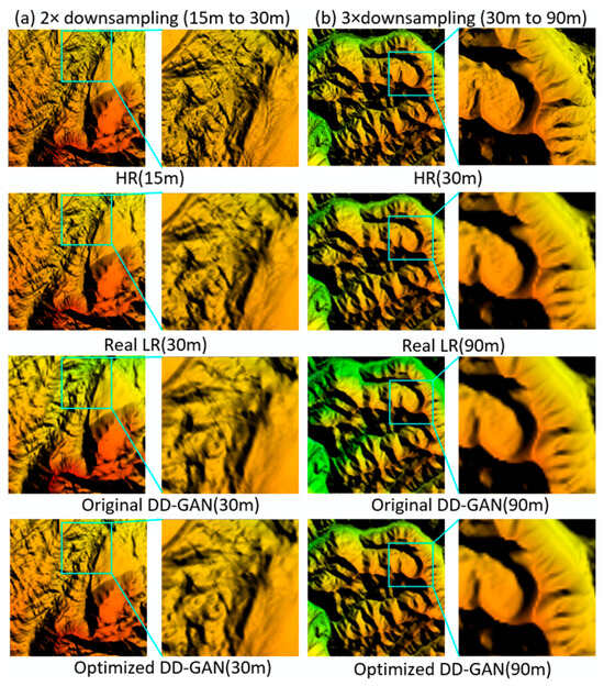
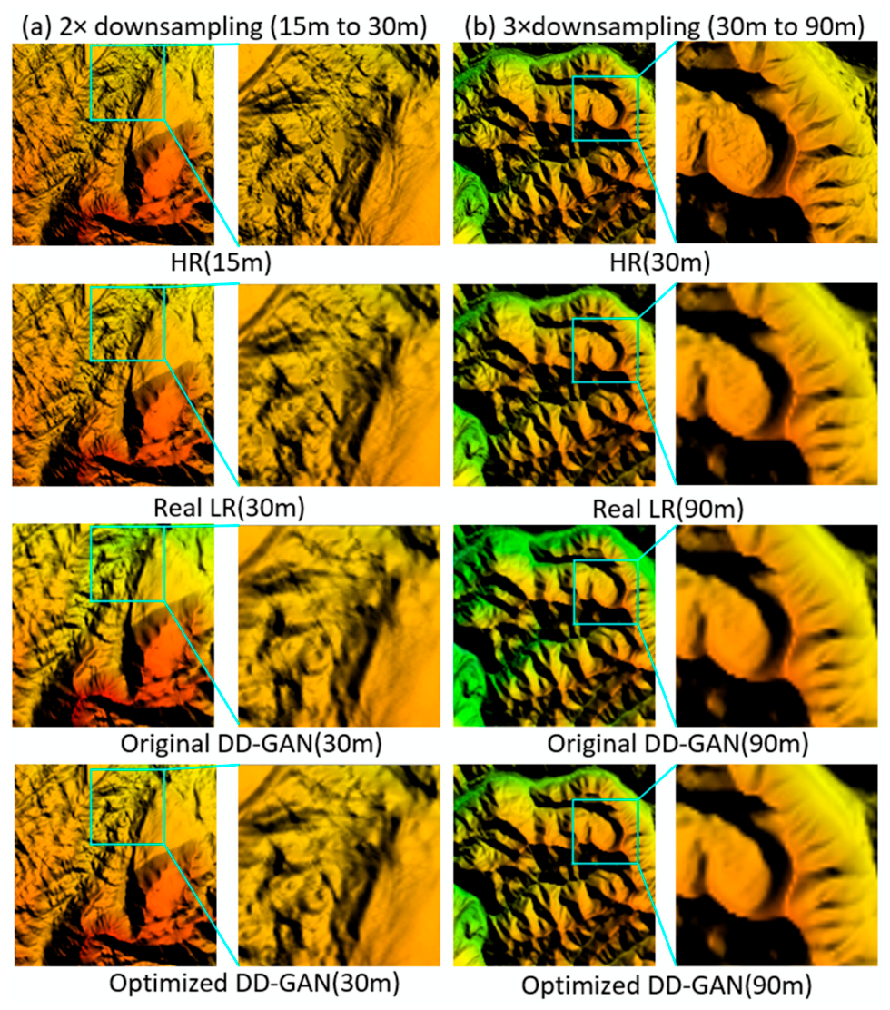
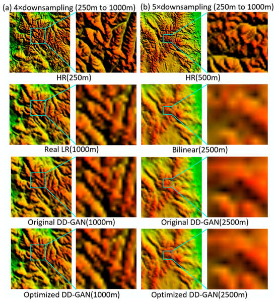
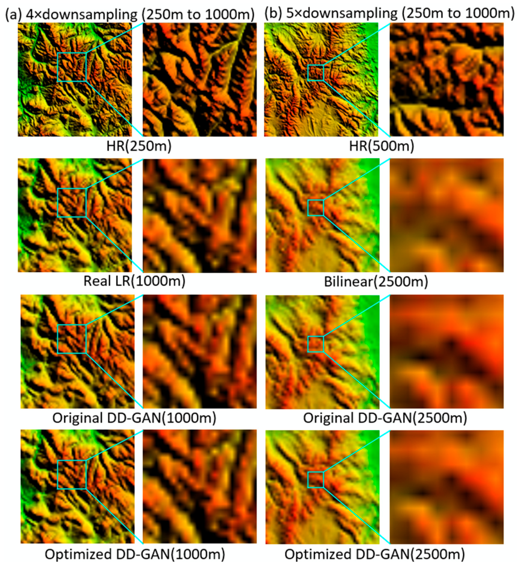
As shown in Figure 9 and Figure 10, each group of subplots contains four rows of terrain visualization results: high-resolution input DEM, real reference low-resolution DEM, outputs of the original DD-GAN, and outputs of the IDW-optimized DD-GAN, respectively. The figure covers four typical downscaling ratios, which are divided into two groups: the high-detail small-scale group (2×, 3×) and the large-span coarse-scale group (4×, 5×), facilitating targeted visual comparison of DEM downscaling performance under distinct spatial scales.
Figure 9.
Visualization of Multi-scale Terrain Generalization. Downscaling Factor: (a) 2. (b) 3.
Figure 10.
Visualization of Multi-scale DEM downscaling. Downscaling Factor: (a) 4. (b) 5.
In Figure 9, for the 2× and 3× mild downscaling scenarios, both original and optimized DD-GAN outputs show strong consistency with real low-resolution reference DEMs in terrain texture, ridge-valley alignment, and micro-topographic undulation. No severe over-smoothing, terrain edge distortion, or false geomorphic artifacts can be identified. The critical fine-scale geomorphic characteristics from high-resolution source data are well preserved, leading to high morphological matching against ground-truth LR DEMs.
In Figure 10, for the 4× and 5× extreme downscaling cases, dramatic resolution reduction requires substantial simplification of subtle topographic details. Even so, the DD-GAN predictions still reliably retain the global terrain skeleton and primary geomorphic patterns of real low-resolution DEMs. The spatial distribution and orientation of ridge and valley lines remain highly aligned with reference data, with no observable structural offset or global terrain deformation.
Overall, the predictions generated by DD-GAN maintain favorable morphological consistency with real low-resolution DEMs across all four downscaling levels. The model recovers fine micro-topographic features for mild 2×/3× downsampling tasks while preserving intact macro terrain structures under aggressive 4×/5× resolution reduction, without prominent artificial artifacts or structural deviations.
By further comparing the outputs of the original DD-GAN and IDW-optimized DD-GAN, it can be concluded that the original DD-GAN already achieves satisfactory downscaling performance on its own, capturing the primary geomorphic framework of reference low-resolution DEMs. Benefiting from IDW interpolation optimization, the improved version can additionally reconstruct richer subtle topographic details, delivering more accurate alignment of ridge and valley textures with ground-truth data. This qualitative visualization intuitively validates the effectiveness and robustness of the proposed DD-GAN for multi-scale terrain generalization and delivers intuitive visual evidence to support the following quantitative metric evaluation.
5. Discussion
5.1. Quantitative Evaluation of DD-GAN and Comparison with Traditional DEM Downscaling Methods
Building upon the qualitative visualization analysis of multi-scale DEM downscaling, this study conducts a multi-scale quantitative comparative evaluation to further and objectively quantify DD-GAN’s downscaling performance and overcome the limitations of subjective visual interpretation.
The evaluation uses reference low-resolution DEM as the benchmark and conducts multi-metric comparisons of the prediction outputs of all competing methods across four typical downscaling scenarios: 15 m → 30 m, 30 m → 90 m, 250 m → 1000 m, and 500 m → 2500 m.
Taking the reference low-resolution DEM as the evaluation benchmark, this study conducts multi-metric comparisons between the proposed DD-GAN model and four competing baseline methods—nearest-neighbor interpolation, bilinear interpolation, cubic convolution resampling, and the TIN-based simplification method—across four typical downscaling scenarios: 15 m → 30 m, 30 m → 90 m, 250 m → 1000 m, and 500 m → 2500 m.
The evaluation employs three core metrics (as shown in Equations (14) and (16)): Mean Absolute Error (MAE) and Root Mean Square Error (RMSE) are used to quantify elevation numerical deviation, reflecting the overall error level and sensitivity to large errors, respectively; the Structural Similarity Index (SSIM) measures the terrain structural consistency between the prediction results and the reference DEM, reflecting the model’s ability to reconstruct terrain morphology and texture features. All the above indicators are calculated against real low-resolution (LR) DEM data. Through a comprehensive comparison across multi-scale, method, and metric, DD-GAN’s prediction accuracy at different downscaling factors can be thoroughly analyzed. This evaluation verifies its capability in numerical error control and terrain structure preservation and provides quantitative support for model performance assessment.
where RMSE is the root mean square error, MAE is the mean absolute error, is the structural similarity index between the reference DEM x and predicted DEM y, n is the number of valid sampling points, and are the elevation values of the i-th point in the reference and predicted DEMs,, are the mean elevations,, are the variances, is the covariance, and , are stability constants.
According to the comparison results in Table 4, the MAE and RMSE values between DD-GAN’s downscaling predictions and the reference low-resolution DEM stay within a controllable range, verifying that the model can serve as a reliable DEM downscaling approach. Its SSIM values all exceed 0.99 across all tested scales, indicating small morphological differences between predicted and real results and demonstrating the model’s favorable terrain reconstruction capability. The introduced IDW interpolation optimization effectively reduces elevation errors and improves terrain structural similarity, particularly under medium and large downscaling factors, narrowing the performance gap with traditional generalization methods. Compared with classical baselines, DD-GAN outperforms TIN-based simplification and nearest-neighbor interpolation at the 2× downscaling scale, while its numerical errors are slightly higher than those two methods at larger downscaling ratios. Although DD-GAN generally has marginally larger elevation errors than bilinear interpolation and cubic convolution resampling, it delivers competitive overall performance for multi-scale terrain generalization tasks.
Table 4.
Comparison of Loss.
From a mechanistic view, we further analyze model errors regarding underlying assumptions, influencing factors, applicability, and inherent limitations. The DD-GAN is built on the assumption that major geomorphic skeletons can be maintained by terrain morphological constraints during resolution reduction. Different from traditional interpolation focusing on pixel-level elevation fitting, our model prioritizes reasonable terrain morphology for cartographic demands, which creates a natural trade-off between elevation precision and geomorphic integrity and accounts for the slight numerical disadvantage compared with bilinear and cubic resampling. The downscaling factor acts as the primary influencing factor: elevation errors rise continuously from 2× to 4×, as heavier resolution compression makes balanced terrain simplification more challenging, while the IDW-based optimization significantly mitigates error accumulation under medium and large scaling ratios. In terms of applicability, DD-GAN achieves the optimal balance of error and terrain preservation under the 2× downscaling factor and fits multi-scale mapping applications that emphasize geomorphic rationality. Nevertheless, this method has clear limitations. If the research target requires strict minimum elevation error regardless of terrain shape, conventional interpolation approaches remain preferable. In addition, the model performance is constrained by the diversity of training terrain samples, and its cross-landform generalization needs further improvement. The fixed weighting strategy of terrain loss terms also cannot adaptively respond to variable local terrain complexity, which may cause inconsistent simplification effects across different landscape units.
5.2. Comparison of Terrain Characteristics Before and After DEM Generalization
To evaluate model performance more comprehensively, relying solely on generic metrics such as MAE, RMSE, and SSIM has limitations. These metrics primarily reflect overall elevation numerical deviation and structural similarity, making it difficult to deeply characterize the preservation capability of key terrain features, especially the reconstruction effectiveness of geomorphological elements such as slope and aspect. Therefore, building upon elevation accuracy assessment, this study further introduces a multi-dimensional terrain feature evaluation framework, conducting verification at the distributional statistical level of elevation, slope, and aspect (calculated using Equations (17) and (18)), to systematically assess DD-GAN’s capability in preserving the key terrain features of high-resolution DEMs, providing a more comprehensive and geomorphologically meaningful evaluation basis for the model’s overall effectiveness. Meanwhile, to demonstrate DD-GAN’s ability to extract primary terrain and smooth secondary terrain during DEM downscaling, we introduce ridge and valley lines to evaluate the model’s extraction capability for the main terrain skeleton.
where and are the x- and y-direction gradients of the DEM (computed via the Sobel operator and normalized by the DEM cell size), is the slope in radians, and is the final slope converted to degrees.
where represents the elevation value at pixel (i, j), and c represents the resolution of the DEM.
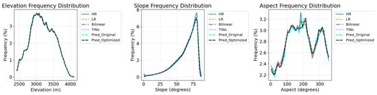
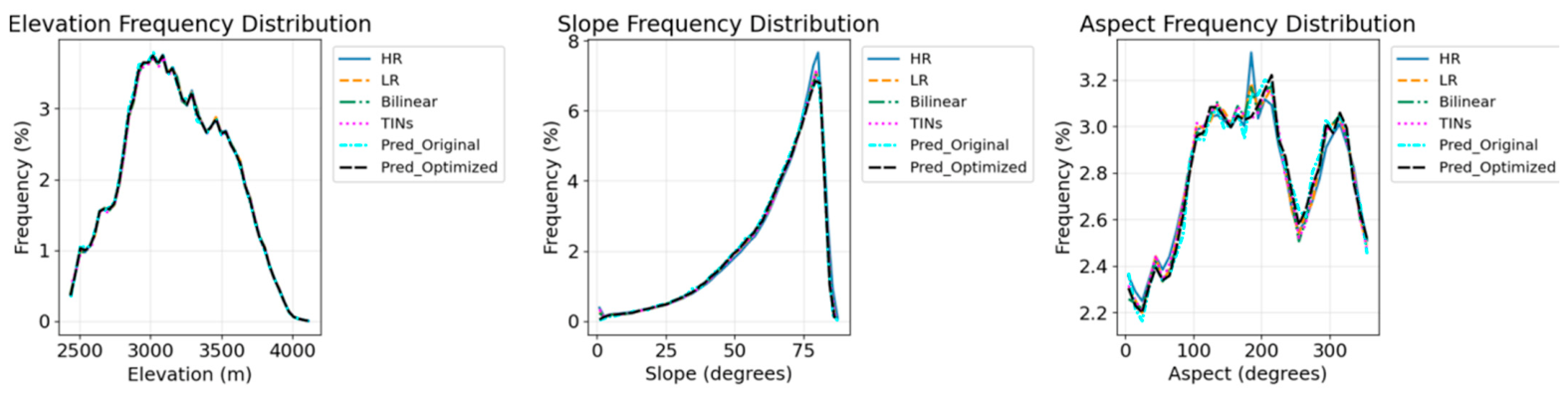
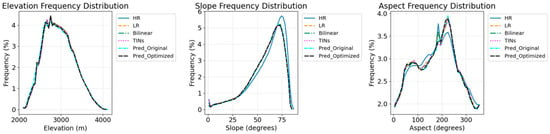
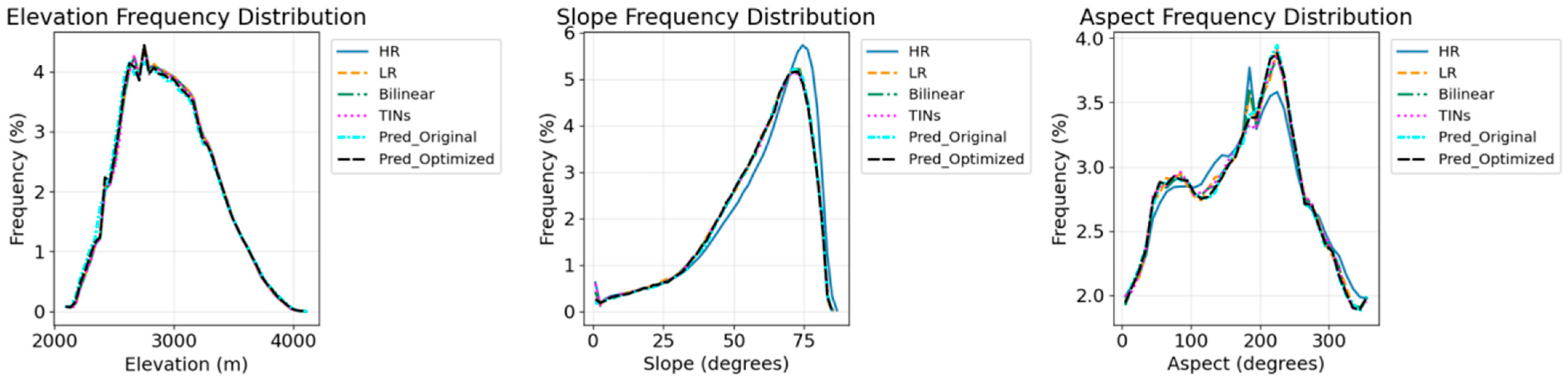
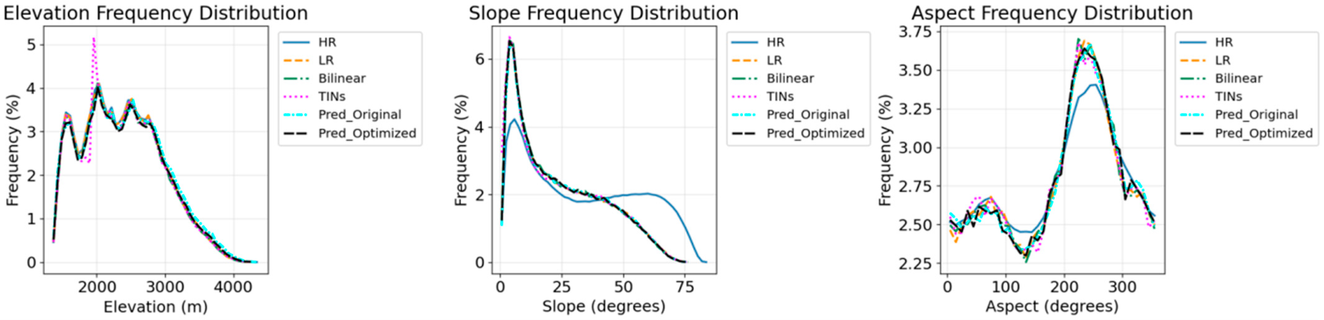
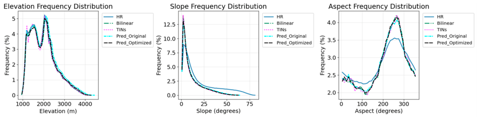
Combining the statistical metrics in Table 5 with the frequency distribution results (Figure 11, Figure 12, Figure 13 and Figure 14), we compare the DEM downscaling performance of DD-GAN, bilinear interpolation, and TIN-based simplification across multiple scales, with the real low-resolution (LR) DEM as the unified evaluation benchmark. It should be noted that no real reference LR DEM is available for the 5× downscaling scenario; thus, only a brief cross-method comparison is performed for this scale.
Table 5.
Comparison of Elevation and Slope.
Figure 11.
Frequency Distribution Maps of Elevation, Slope and Aspect (Downscaling Factor: 2).
Figure 12.
Frequency Distribution Maps of Elevation, Slope and Aspect (Downscaling Factor: 3).
Figure 13.
Frequency Distribution Maps of Elevation, Slope and Aspect (Downscaling Factor: 4).
Figure 14.
Frequency Distribution Maps of Elevation, Slope and Aspect (Downscaling Factor: 5).
For elevation features, both bilinear interpolation and TIN-based simplification achieve high accuracy in mean elevation reconstruction, with small deviations from the reference LR DEM across 2× to 4× scales. By contrast, DD-GAN shows clear advantages in preserving elevation extremes and overall distribution patterns: its maximum and minimum elevation values generally fit the LR DEM better, and its elevation frequency curve aligns more closely with the reference distribution, alleviating the extreme value loss caused by over-smoothing in traditional interpolation and TIN-based simplification.
For slope characteristics, all methods are evaluated against the reference LR DEM, as the core goal of DEM downscaling is to reproduce the slope statistical features of LR terrain rather than retaining high-slope details of the original HR DEM. At 2× and 3× mild downscaling scales, bilinear interpolation and TIN-based simplification yield mean slope and slope standard deviation values that are more consistent with the LR DEM. At the 4× larger downscaling factor, the IDW-optimized DD-GAN achieves smaller deviations in slope statistics from the LR DEM compared with the other two methods, and its slope frequency distribution also matches the reference LR pattern better, effectively restoring the slope proportion characteristics of low-resolution terrain. The aspect distribution performance of DD-GAN is comparable to that of bilinear interpolation and TIN-based simplification at most scales.
For the 5× downscaling scenario without ground-truth LR data, the elevation and slope distribution trends of DD-GAN are generally consistent with those of bilinear interpolation and TIN-based simplification, with no obvious structural deviation. Overall, DD-GAN delivers competitive comprehensive performance, with advantages in reconstructing elevation extremes and slope morphology of LR DEM under large downscaling factors, while traditional bilinear interpolation and TIN-based simplification maintain higher stability in mean elevation and slope statistics at small downscaling scales.
The performance divergence observed between different methods stems from their distinct terrain processing logics. Traditional geometric approaches prioritize uniform pixel averaging to minimize overall elevation bias, which inevitably weakens the signal of steep ridges and deep valleys during smoothing. In contrast, the terrain-aware loss functions embedded in DD-GAN constrain the network to retain the statistical characteristics of raw terrain, making it more suitable for cartographic analysis that relies on intact geomorphic structures. Meanwhile, the scaling multiple acts as a decisive factor affecting each method’s output quality: the gap in terrain preservation capability widens significantly when resolution compression becomes severe. It is also worth noting that the model’s performance is bounded by the landform diversity of training samples, and the lack of independent ground truth at the 5× scale restricts quantitative error quantification for extreme downscaling tasks.
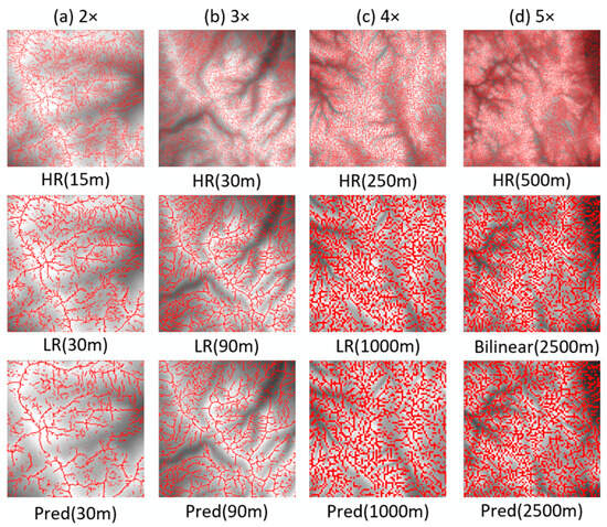
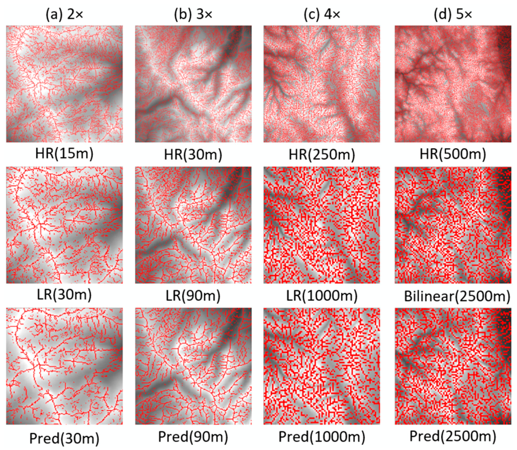
Figure 15 presents a comparison of ridge and valley lines before and after DD-GAN downscaling. In low-factor downscaling scenarios (2–3×), the ridge lines of the high-resolution (HR) DEM contain numerous secondary branches by micro-terrain features, while the reference LR DEM has already completed the simplification of secondary ridges, retaining only the main ridges and key secondary skeletons that control the overall terrain pattern. DD-GAN’s predicted ridge line distribution is highly consistent with the LR DEM: it both eliminates the micro-ridge branches in the HR DEM that lack terrain-controlling significance and completely preserves the orientation, extension path, and topological relationships of the main ridges, clearly delineating the overall terrain skeleton while avoiding the skeleton weakening problem caused by over-smoothing, meeting the simplification requirements of small-scale terrain representation.
Figure 15.
Comparison of Ridge and Valley Lines Before and After Terrain Generalization Downscaling Factor: (a) 2. (b) 3. (c) 4. (d) 5.
In high-factor downscaling scenarios (4–5×), as the resolution decreases substantially, the identifiability of terrain details drops significantly. The LR DEM’s ridge lines have been further simplified to a core skeleton that only reflects the macroscopic terrain pattern. DD-GAN’s prediction results follow this same reasonable simplification logic: its extracted ridge lines are highly consistent with the LR DEM’s main skeleton, accurately capturing the core ridges that control watershed boundaries and terrain orientation. The disappearance of secondary ridges is a normal generalization result under resolution constraints. The model neither loses critical terrain skeletons through over-simplification nor introduces false ridge lines, ensuring the accuracy and readability of the downscaled DEM’s terrain representation in small-scale scenarios.
5.3. Comparison Between DD-GAN and Convolutional Neural Networks
After completing the multi-dimensional comparison with traditional interpolation methods, this study further introduces a conventional downsampling Convolutional Neural Network (CNN) as a deep learning baseline model to highlight the relatively better performance of DD-GAN in multi-scale terrain generalization tasks from the perspective of model architecture. Both DD-GAN and the baseline CNN adopt IDW interpolation as an optimization module in their respective prediction pipelines to unify the data processing benchmark of comparative experiments. The CNN was trained using exactly the same source datasets as the DD-GAN model, but its architecture consists only of several simple residual blocks, convolutional layers, and max-pooling downsampling layers. A comparative evaluation was conducted from two core dimensions—quantitative accuracy and terrain feature reconstruction—to analyze the performance differences between the two types of models at different downscaling factors.
As shown in the comparison results of Table 6 and Table 7, in 2–4× downscaling scenarios, DD-GAN’s MAE and RMSE are significantly lower than those of the conventional CNN, and its SSIM values are closer to 1, indicating clear numerical accuracy advantages. Furthermore, its elevation extremes, mean slope, and slope standard deviation are also closer to the real LR DEM, with its terrain feature reconstruction capability surpassing that of the CNN. The advantage is particularly pronounced at high downscaling factors, making DD-GAN more suitable for multi-scale DEM downscaling tasks.
Table 6.
Comparison of Loss (DD-GAN and CNN).
Table 7.
Comparison of Elevation and Slope (DD-GAN and CNN).
The consistent performance gap mainly derives from the unique adversarial discrimination mechanism introduced in DD-GAN. Although the ordinary CNN can set basic auxiliary loss terms to regularize terrain features, it only conducts static one-way loss supervision during training without a dynamic discriminator to examine the overall geomorphological rationality of generated DEM surfaces. The discriminator in DD-GAN continuously distinguishes morphologically distorted pseudo-terrain from authentic low-resolution terrain samples throughout model optimization and feeds back structural deviation signals to the generator iteratively. This closed-loop adversarial optimization continuously calibrates the output terrain distribution, especially when dealing with large downscaling multiples where massive micro-topography needs to be eliminated. Benefiting from this dynamic correction effect, DD-GAN avoids the gradual degradation of ridge and valley structures observed in plain CNN outputs and maintains stable consistency of elevation and slope statistics against real reference DEMs.
6. Conclusions
This study constructs a terrain morphology-constrained DD-GAN network to implement DEM downscaling, targeting three core limitations of existing downscaling deep learning approaches: inadequate explicit terrain morphological constraint mechanisms, a scarcity of dedicated downscaling network structures, and incomplete cross-paradigm comparative analyses. A composite loss function incorporating local relief and gradient constraints is designed to drive the model to retain major geomorphic skeletons during resolution reduction, and an IDW post-processing step is adopted to alleviate local elevation bias of raw prediction results.
Qualitative visualization and multi-metric quantitative experiments covering four downscaling gradients demonstrate differentiated strengths among all tested technical schemes, including nearest-neighbor, bilinear, cubic convolution interpolation, TIN-based simplification, ordinary CNN, and the proposed DD-GAN. Judging from MAE, RMSE, and SSIM metrics that reflect elevation prediction error and terrain structural consistency, DD-GAN delivers competitive overall performance. It exhibits prominent advantages in reconstructing elevation extremes and maintaining complete slope morphological features when facing large downscaling multiples. By contrast, the three interpolation methods and TIN-based simplification yield more stable mean elevation and slope statistical distributions under mild scale reduction tasks. In comparison with an ordinary CNN without terrain morphological constraints, DD-GAN obtains smaller elevation prediction errors and higher structural similarity values across most experimental scales.
It should be clarified that the deep learning-based DEM downscaling framework proposed in this paper is only a preliminary exploratory attempt. The current model is still unable to realize all-round, systematic, complete multi-scale downscaling that adapts to arbitrary resolution conversion and diverse landform types. In subsequent research, we will take the realization of comprehensive multi-scale DEM downscaling as our core research objective to further expand the model’s applicability and practical value.
Author Contributions
Conceptualization, Yanchen Wan and Wenping Jiang; methodology, Yanchen Wan and Wenping Jiang; software, Yanchen Wan; validation, Yanchen Wan; formal analysis, Yanchen Wan and Yue Wang; resources, Wenping Jiang; data curation, Yanchen Wan and Haowen Jiang; writing—original draft preparation, Yanchen Wan and Haowen Jiang; writing—review and editing, Wenping Jiang and Yue Wang; visualization, Yanchen Wan and Xinyue Lyu; supervision, Wenping Jiang; project administration, Wenping Jiang; funding acquisition, Wenping Jiang. All authors have read and agreed to the published version of the manuscript.
Funding
This research was financially supported by the National Key Research and Development Program of China [grant number 2022YFB3904100]; the National Natural Science Foundation of China [grant number 42571515 and 41371428]; and LIESMARS Special Research Funding.
Data Availability Statement
All research data and visualization examples are published on the Figshare open research platform and can be accessed via https://doi.org/10.6084/m9.figshare.32440548.
Conflicts of Interest
The authors declare no conflicts of interest.
Abbreviations
The following abbreviations are used in this manuscript:
| DEM | Digital Elevation Model |
| GAN | Generative Adversarial Network |
| DD-GAN | DEM Downscaling Generative Adversarial Network |
| SRDCGAN | Super-Resolution Deep Convolutional Generative Adversarial Network |
| RMSE | Root Mean Square Error |
| MAE | Mean Absolute Error; SSIM: Structural Similarity Index |
| SSIM | Structural Similarity Index Measure |
| IDW | Inverse Distance Weighted |
| TIN | Triangulated Irregular Network |
| QEM | Quadric Error Metrics |
| IGLD | Integrated Graph Laplacian Downsample |
| PINN | Physics-Informed Neural Network |
| CNN | Convolutional Neural Network |
| SRTM | Shuttle Radar Topography Mission |
| USGS | United States Geological Survey |
References
- Mackaness, W.; Ruas, A.; Sarjakoski, L.T. (Eds.) Generalisation of Geographic Information: Cartographic Modelling and Applications; Elsevier: Amsterdam, The Netherlands, 2007. [Google Scholar] [CrossRef] [Scilit]
- Li, Z.; Zhu, C.; Gold, C. Digital Terrain Modeling: Principles and Methodology; CRC Press: Boca Raton, FL, USA, 2004. [Google Scholar] [CrossRef] [Scilit]
- Goodchild, M.F.; Guo, H.; Annoni, A.; Bian, L.; de Bie, K.; Campbell, F.; Craglia, M.; Ehlers, M.; van Genderen, J.; Jackson, D.; et al. Next-generation Digital Earth. Proc. Natl. Acad. Sci. USA 2012, 109, 11088–11094. [Google Scholar] [CrossRef] [Scilit] [PubMed]
- Guo, H.; Wang, L.; Liang, D. Big Earth Data from space: A new engine for Earth science. Sci. Bull. 2016, 61, 505–513. [Google Scholar] [CrossRef] [Scilit]
- Weibel, R.; Dutton, G. Generalizing Spatial Data and Dealing with Multiple Representations. In Geographical Information Systems: Principles, Techniques, Management and Applications, 2nd ed.; Longley, P.A., Goodchild, M.F., Maguire, D.J., Rhind, D.W., Eds.; Wiley: New York, NY, USA, 1999; pp. 125–155. [Google Scholar]
- Ai, T.; Li, J. A DEM generalization by minor valley branch detection and grid filling. ISPRS J. Photogramm. Remote Sens. 2010, 65, 198–207. [Google Scholar] [CrossRef] [Scilit]
- Weibel, R. Generalization of spatial data: Principles and selected algorithms. In Algorithmic Foundations of Geographic Information Systems; van Kreveld, M., Nievergelt, J., Roos, T., Widmayer, P., Eds.; Springer: Berlin, Germany, 1997; pp. 99–152. [Google Scholar] [CrossRef] [Scilit] [PubMed]
- Hutchinson, M.F. A new procedure for gridding elevation and stream line data with automatic removal of spurious pits. J. Hydrol. 1989, 106, 211–232. [Google Scholar] [CrossRef] [Scilit]
- Chen, Z.; Ma, X.; Yu, W.; Wu, L. An integrated graph Laplacian downsample (IGLD)-based method for DEM generalization. Earth Sci. Inform. 2020, 13, 973–987. [Google Scholar] [CrossRef] [Scilit]
- Garland, M.; Heckbert, P.S. Surface simplification using quadric error metrics. In Proceedings of the 24th Annual Conference on Computer Graphics and Interactive Techniques (SIGGRAPH ′97), Los Angeles, CA, USA, 3–8 August 1997; pp. 209–216. [Google Scholar] [CrossRef] [Scilit]
- Reichstein, M.; Camps-Valls, G.; Stevens, B.; Jung, M.; Denzler, J.; Carvalhais, N.; Prabhat. Deep learning and process understanding for data-driven Earth system science. Nature 2019, 566, 195–204. [Google Scholar] [CrossRef] [Scilit] [PubMed]
- Bergen, K.J.; Johnson, P.A.; de Hoop, M.V.; Beroza, G.C. Machine learning for data-driven discovery in solid Earth geoscience. Science 2019, 363, eaau0323. [Google Scholar] [CrossRef] [Scilit] [PubMed]
- Dong, C.; Loy, C.C.; He, K.; Tang, X. Learning a Deep Convolutional Network for Image Super-Resolution. In Proceedings of the European Conference on Computer Vision (ECCV), Zurich, Switzerland, 6–12 September 2014; pp. 184–199. [Google Scholar] [CrossRef] [Scilit]
- Ledig, C.; Theis, L.; Huszár, F.; Caballero, J.; Cunningham, A.; Acosta, A.; Aitken, A.; Tejani, A.; Totz, J.; Wang, Z.; et al. Photo-Realistic Single Image Super-Resolution Using a Generative Adversarial Network. In Proceedings of the 2017 IEEE Conference on Computer Vision and Pattern Recognition (CVPR), Honolulu, HI, USA, 21–26 July 2017; pp. 4681–4690. [Google Scholar] [CrossRef] [Scilit]
- Zhou, A.; Chen, Y.; Wilson, J.P.; Chen, G.; Min, W.; Xu, R. A multi-terrain feature-based deep convolutional neural network for constructing super-resolution DEMs. Int. J. Appl. Earth Obs. Geoinf. 2023, 120, 103338. [Google Scholar] [CrossRef] [Scilit]
- Wang, Y.; Jin, S.; Yang, Z.; Guan, H.; Ren, Y.; Cheng, K.; Zhao, X.; Liu, X.; Chen, M.; Liu, Y.; et al. TTSR: A transformer-based topography neural network for digital elevation model super-resolution. IEEE Trans. Geosci. Remote Sens. 2024, 62, 4403719. [Google Scholar] [CrossRef] [Scilit]
- Oksanen, J.; Sarjakoski, T. Error propagation analysis of DEM-based drainage basin delineation. Int. J. Remote Sens. 2005, 26, 3085–3102. [Google Scholar] [CrossRef] [Scilit]
- Jenny, B.; Jenny, H.; Hurni, L. Terrain Generalization with Multi-scale Pyramids Constrained by Curvature. Cartogr. Geogr. Inf. Sci. 2011, 38, 110–116. [Google Scholar] [CrossRef] [Scilit]
- Feciskanin, R.; Minár, J. Polygonal simplification and its use in DEM generalization for land surface segmentation. Trans. GIS 2021, 25, 2361–2375. [Google Scholar] [CrossRef] [Scilit]
- Feciskanin, R.; Minár, J. Advancing Raster DEM Generalization with a Quadric Error Metric Approach. Comput. Geosci. 2025, 202, 105963. [Google Scholar] [CrossRef] [Scilit]
- Callow, J.N.; Van Niel, K.P.; Boggs, G.S. How does modifying a DEM to reflect known hydrology affect subsequent terrain analysis? J. Hydrol. 2007, 332, 30–39. [Google Scholar] [CrossRef] [Scilit]
- Hinton, G.E.; Salakhutdinov, R.R. Reducing the Dimensionality of Data with Neural Networks. Science 2006, 313, 504–507. [Google Scholar] [CrossRef] [Scilit] [PubMed]
- Goodfellow, I.; Pouget-Abadie, J.; Mirza, M.; Xu, B.; Warde-Farley, D.; Ozair, S.; Courville, A.; Bengio, Y. Generative adversarial networks. Commun. ACM 2020, 63, 139–144. [Google Scholar] [CrossRef] [Scilit]
- Demiray, B.Z.; Sit, M.; Demir, I. D-SRGAN: DEM Super-Resolution with Generative Adversarial Networks. SN Comput. Sci. 2021, 2, 48. [Google Scholar] [CrossRef] [Scilit]
- Zhang, Y.; Yu, W.; Zhu, D. Terrain feature-aware deep learning network for digital elevation model superresolution. ISPRS J. Photogramm. Remote Sens. 2022, 189, 143–162. [Google Scholar] [CrossRef] [Scilit]
- Chen, K.; Wang, C.; Lu, M.; Dai, W.; Fan, J.; Li, M.; Lei, S. Integrating topographic skeleton into deep learning for terrain reconstruction from GDEM and Google Earth Image. Remote Sens. 2023, 15, 4490. [Google Scholar] [CrossRef] [Scilit]
- Li, S.; Hu, G.; Cheng, X.; Xiong, L.; Tang, G.; Strobl, J. Integrating topographic knowledge into deep learning for the void-filling of digital elevation models. Remote Sens. Environ. 2022, 269, 112818. [Google Scholar] [CrossRef] [Scilit]
- Guo, M.; Xiong, F.; Huang, Y.; Zhang, Z.; Zhang, J. A Multi-Path Feature Extraction and Transformer Feature Enhancement DEM Super-Resolution Reconstruction Network. Remote Sens. 2025, 17, 1737. [Google Scholar] [CrossRef] [Scilit]
- Gavriil, K.; Muntingh, G.; Barrowclough, O.J.D. Void Filling of Digital Elevation Models With Deep Generative Models. IEEE Geosci. Remote Sens. Lett. 2019, 16, 1645–1649. [Google Scholar] [CrossRef] [Scilit]
- Lan, J.; Zeng, B.; Li, S.; Zhang, W.; Shi, X. A Deep Learning-Based Salient Feature-Preserving Algorithm for Mesh Simplification. Comput. Mater. Contin. 2025, 83, 2865–2888. [Google Scholar] [CrossRef] [Scilit]
- Courtial, A.; Touya, G.; Zhang, X. Constraint-Based Evaluation of Map Images Generalized by Deep Learning. J. Geovis. Spat. Anal. 2022, 6, 13. [Google Scholar] [CrossRef] [Scilit]
- Raissi, M.; Perdikaris, P.; Karniadakis, G.E. Physics-informed neural networks: A deep learning framework for solving forward and inverse problems involving nonlinear partial differential equations. J. Comput. Phys. 2019, 378, 686–707. [Google Scholar] [CrossRef] [Scilit]
- Wu, X.; Ma, J.; Si, X.; Bi, Z.; Yang, J.; Gao, H.; Xie, D.; Guo, Z.; Zhang, J. Sensing prior constraints in deep neural networks for solving exploration geophysical problems. Proc. Natl. Acad. Sci. USA 2023, 120, e2219573120. [Google Scholar] [CrossRef] [Scilit] [PubMed]
- Hou, X.; Deng, X.; Hua, W.; Yin, W.; Li, P.; Qi, C. DEM Super-Resolution Reconstruction Method Based on Adaptive Generative Adversarial Network. Geomat. Inf. Sci. Wuhan Univ. 2024, 51, 557–566. [Google Scholar] [CrossRef]
- Kingma, D.P.; Ba, J. Adam: A Method for Stochastic Optimization. In Proceedings of the 3rd International Conference on Learning Representations, San Diego, CA, USA, 7–9 May 2015. [Google Scholar]
- Rudin, C. Stop Explaining Black Box Machine Learning Models for High Stakes Decisions and Use Interpretable Models Instead. Nat. Mach. Intell. 2019, 1, 206–215. [Google Scholar] [CrossRef] [Scilit] [PubMed]

Disclaimer/Publisher’s Note: The statements, opinions and data contained in all publications are solely those of the individual author(s) and contributor(s) and not of MDPI and/or the editor(s). MDPI and/or the editor(s) disclaim responsibility for any injury to people or property resulting from any ideas, methods, instructions or products referred to in the content. |
© 2026 by the authors. Published by MDPI on behalf of the International Society for Photogrammetry and Remote Sensing. Licensee MDPI, Basel, Switzerland. This article is an open access article distributed under the terms and conditions of the Creative Commons Attribution (CC BY) license.