


Abstract
A common challenge when modeling social–ecological systems (SESs) is defining the spatial extent of the system. Boundaries that do not adequately capture both social and ecological processes and their interactions can lead to mischaracterization of the system, while expanding boundaries too widely can impact model complexity and required resources. Socially, boundaries can invoke and influence identity, culture, power, and sense of place. Boundary decisions benefit from flexible, iterative approaches and the expertise of local communities. Here, we use a structured database search supplemented with citation searching to identify and review the literature that addresses choosing or defining spatial boundaries in SESs mapping or modeling and, when applicable, how participatory methods were used in the research process. In a review of the resulting 79 studies, we discovered that pre-existing social or ecological boundaries were used most frequently (36 and 18 publications, respectively). Twenty-one publications combined social and ecological boundaries or data to create custom boundaries, and four studies used an alternative approach to conventional boundaries. Informed by the literature review, we present a general framework for defining boundaries at the outset of SES research. We then connect the framework to a specific case study based on a collaborative project with Tribal, university, and federal scientists to develop a social–ecological climate adaptation plan. We present guiding questions alongside candidate boundaries for our study system and explore the tradeoffs of these boundary options, which can function as a useful template for other social–ecological research collaborations.
1. Introduction
Increased recognition of the need for interdisciplinary science to meet sustainability challenges has led to a growing body of research aiming to address the complexity of characterizing and managing social–ecological systems (SESs). SESs describe complex systems in which social and biophysical systems are linked and interact at multiple spatial and temporal scales [1,2,3]. Many systems can be conceptualized as SESs, which may also be referred to as socio-environmental systems, coupled human and natural systems, or other related terms. Examples of SESs include rural village landscapes, in which people and the environment are tightly coupled, and local resources are collectively managed [4,5,6,7]; river basins and the communities to which they provide important natural and cultural ecosystem services [8,9,10,11,12,13]; and protected areas or managed landscapes that are strongly connected to the livelihood of surrounding communities [14,15,16,17,18]. However, it is only within the last few decades that ecologists and social scientists have begun to explicitly model and characterize these as integrated systems [19]. Social–ecological frameworks are often used to discuss concepts of resilience and sustainability [20,21,22,23], but are also commonly applied to domains like ecosystem services and natural resource management [19].
Across domains, one of the challenges often cited in SES modeling is defining the spatial boundaries or extent of the system [24,25,26]. Even the few examples of SESs provided above show the different types of boundaries that could be associated with SESs, representing governance, ecological processes, and administrative management units. Conceptualizing or clearly defining the system is frequently emphasized as a critical early step in modeling [27]. When system boundaries are defined in a model, everything inside the boundaries is considered integral to the system, while everything outside of the boundaries is considered external, which can substantially impact model outcomes [28,29]. For SESs, defining spatial boundaries can be especially challenging because of the spatial and temporal mismatches between social and ecological processes, and because social and ecological data typically have disparate boundaries and are collected and aggregated at different scales [30].
The phenomenon of scale mismatch has been the subject of considerable attention in the social–ecological literature [31,32,33,34,35,36]. Scale mismatch can occur in many different forms, including spatial, temporal, and functional [34]. For managed systems, spatial mismatch can occur between the geographic extent of the system and the jurisdictional scale at which decision-makers have authority to act [34]. This type of scale mismatch is especially evident in instances such as transboundary water management, like the Murray–Darling Basin, which spans across four Australian states and where institutions acting at the state or local scale cannot effectively govern the basin as a whole [37]. Temporal mismatch can occur when long-term processes are managed through short governance cycles, when leadership changes disrupt the consistency or continuity of regulations or management actions, or when rapid environmental change requires immediate action, but the response is slowed by bureaucratic processes [34]. For example, Upton and Nielsen-Pincus [38] found that despite broad support for the redistribution of water rights to support the wine industry in Tasmania, legal processes would likely occur too slowly to meet the urgency of the impacts of climate change on the industry. Functional scale mismatch describes misalignment between ecosystem processes and governance, or management processes, or the “scope” of processes governed by an institution [31,34,35]. For example, resource users focused on a specific set of resources, such as timber production, may employ a narrow management action on a complex ecological process or system, which can have unintended consequences for other parts of the system, such as species migration or freshwater provisioning [34,35,37]. Functional scale mismatch may be at play when there is a disparity between the supply and demand of ecosystem services [39,40,41]. In participatory science and policy contexts, functional scale mismatch may emerge between what communities value and where decisions are being made [42]. Scale mismatches have been linked to such impacts as overexploitation of resources, including the collapse of several fisheries in the northwest Atlantic Ocean due to commercial overfishing [43,44], exacerbation of biodiversity loss [45], and failure to achieve desired management goals due to insufficient operational authority [46].
Beyond the technical challenges, defining boundaries can also be socially and politically complex. Boundaries and the way societies interact with them at different scales affect how people live, how institutions govern, and how information and resources are shared [47]. Social and political boundaries reflect power and ownership of resources, while also shaping culture, identity, and sense of belonging [34,48]. Additionally, governance is shared across both formal and informal institutions, systems, and norms, which can impact the instrumentality and “fit” between institutions and the SESs that they govern [38,49]. For example, the concept of boundaries as defined by rigid and definitive lines on a map is not shared across all cultures, and in some cases, this can cause conflict [50]. For example, Fox et al. [51] warn that mapping practices can alter the quality of the relationship between people and their environment to one of control over land and resource use within newly defined boundaries. Modern mapping of Hawaiian ahupua’a, land divisions that traditionally encompassed the distribution of resources from the mountains to the sea, also illustrates this issue. At their conception, ahupua’a embodied Indigenous conceptions of boundaries as fluid and inclusive, but over time they have been mischaracterized in Western maps as fixed and exclusive, which has had implications for ownership, exclusive rights, and land-use planning [52]. For many Indigenous cultures, Western conceptions of boundaries and cartographic processes have been recognized as instruments of colonization and control [53].
SESs include groups with diverse and often conflicting interests, vulnerabilities, and capabilities when approaching problems or solutions [54]. This phenomenon has been recently termed “Chimaera Modeling,” named for the mythical creatures made up from parts of different animals, to describe the combination of different goals and elements required for SES modeling [55]. One way to reduce conflict and improve outcomes when defining a SES is to engage communities in the process of mapping or conceptualizing the system through participatory engagement. Participatory engagement can vary greatly in its purpose and level of involvement [56], but typically includes collaborating with communities or practitioners through methods such as mailed surveys, in-person interviews, online GIS platforms, or workshops with hands-on drawing or mapping activities. We note that there has been a recent call for an end to the use of the term “stakeholder,” particularly when working with Indigenous groups, as it inadvertently perpetuates colonialism and inequities that are at odds with the positive intentions that spurred its usage [57]. We will therefore use terms like communities, citizens, partners, and practitioners to describe participants. Like SES research, participatory research has expanded across disciplines in recent years [58]. The deepest level of participatory engagement is co-production, in which multiple groups work collaboratively and as equal partners to generate knowledge towards improving environmental understanding and decision-making [59].
Many participatory modeling studies describe both the benefits and challenges of working with external partners or community groups. Defining boundaries that meet project needs requires consideration, collaboration, and iteration. Data that are relevant to communities on a finer scale may be limited or inaccessible, and researchers should consider that available datasets may define communities in ways that communities would not use to identify themselves. For example, people likely do not define their own neighborhood, town, or community through formal administrative boundaries but rather the network of streets, places, and people with whom they interact most [30]. Collaborating with communities to incorporate local, place-based, and experiential knowledge can compensate for gaps in existing datasets or reveal what is important to a community, which can improve decision-making and planning [60]. Several studies indicate that incorporating local knowledge into their model was instrumental for conceptualizing the system [61,62]. Researchers should also be open to iteration as project needs or scope change over time, especially for projects requiring long-term engagement. Engaging directly with communities through participatory methods may be required for those interested in data about community values, preferences, and perspectives—such methods are increasingly being employed by scientists, planners, and practitioners across disciplines.
Research that fails to meaningfully include those most affected has faced criticisms of lacking impact or having a “relevance gap” [63]. Co-production aims to address this by incorporating multiple ways of knowing and valuing the lived experiences and expertise of those closest to the issue [63]. In the pursuit of defining spatial boundaries for a system, engaging communities in the process of mapping or modeling can help personalize the connections between communities and the problem at hand [42]. It has been demonstrated that positive environmental and social change is more likely to take shape when those who depend on or manage a resource or ecosystem are directly involved in diagnosing problems and developing solutions [64].
The examples above highlight the complexities of modeling SESs—there are few absolute spatial and temporal boundaries, social or administrative boundaries are often disparate from ecological boundaries, and cultural norms and boundaries reciprocally influence each other. Despite a large body of literature that describes boundary definition for SESs as a difficult but crucial step [29,31,33,35,56,65], few offer prescriptive guidance, i.e., by providing methods, applying concepts in primary research, or describing a case study [66].
In a recent publication by Vukomanovic et al. [67] synthesizing lessons learned from participatory SES research, defining boundary conditions as a collaborative process was identified as a key lesson. This recommendation provides an opportunity to understand how spatial boundaries have been chosen or delineated in SES research, as SES boundaries are often subjective and context-dependent [68,69]. While prior reviews and frameworks have examined various aspects of SES research, to our knowledge, there has been no synthesis focusing solely on the boundary definition stage. Therefore, we review empirical research or case studies that explicitly discuss spatial or geographic boundaries or issues of scale mismatch in SESs and that identify or delineate a system boundary. We explore boundary decisions in relation to the research domain, focal ecosystem or resource, and primary study objectives, and document the role of participatory engagement when applicable. Based on this work, we propose an iterative framework intended to guide collaborative SES research for which appropriate boundaries may not be immediately apparent or would benefit from expert or community participation.
We conclude with a case study of a collaborative climate adaptation project involving federal, university, and Tribal researchers. We apply our iterative framework to a guided participatory exercise to select appropriate study area boundaries, including questions to prompt examination and iteration of the boundary selection process and results. This case study illustrates tradeoffs of different spatial boundary decisions through its focus on multi-scale modeling and consideration of Tribal history, current needs, and future priorities.
2. Methods
We conducted a structured literature review to identify peer-reviewed publications related to “choosing spatial boundaries in social–ecological systems modeling.” Our focus included scale mismatch, methodologies for delineating SESs boundaries, socio-cultural dynamics of boundaries, and participatory engagement in boundary definition. We limited our search to articles that were published in English and excluded books, book chapters, review articles, conference proceedings, and gray literature from our analysis. We conducted a Web of Science Core Collection (WOS) database search in June 2025 using the following query: (“social-ecological system*” OR “socio-ecological system*” OR “social-environmental system*” OR “socio-environmental system*” OR “coupled human and natural”) AND (“boundar*” OR “geographic extent” OR “spatial” OR “scale mismatch”) AND (“map” OR “mapping”) AND (“characteriz*” OR “define” OR “defining” OR “delineat*”). This query returned 67 results, four of which were ineligible and excluded before screening. Through title and abstract screening, we excluded articles that did not meet our criteria for inclusion (i.e., some included more general discussion of SES, or boundary objects rather than spatial boundaries), which narrowed the sample to 42. Through manual full-text screening, we identified 27 “applied studies” that (1) explicitly discuss the social–ecological context of the research, and (2) choose a spatial boundary or delineate social–ecological units for a model, mapping exercise, or case study.
Because SES research is interdisciplinary and terms are not used consistently across publications, we supplemented the database search with backward and forward citation searching (i.e., snowball sampling) following the TARCiS guidelines [70]. We initiated backward citation searching using Vukomanovic et al. [67] as a seed reference, focusing on references cited within the section “Lesson 3: Define the boundary conditions as a team,” since this publication motivated this work but did not appear in the database search. We conducted three levels of backward citation searching, in which we conducted a manual review of reference lists and screened based on title. Level 1 identified relevant articles cited by our seed reference, Level 2 identified articles that cite Level 1 articles, and Level 3 identified articles that cite Level 2 articles. Based on title screening alone, this resulted in 87 articles. After removing three duplicates that were identified in the WOS database search, backward citation searching yielded 84 articles to move on to abstract and full-text screening. Most of these publications were conceptual and did not meet the inclusion criteria described above for manual full-text screening, resulting in 17 articles identified as applied studies.
To conduct forward citation searching, we used Vukomanovic et al. [67] again as a seed reference, along with two additional seed references, Koch et al. [8] and Martín-López et al. [66], which were included in the sample of background citation searches. These were selected based on their relevance to the topic, as well as each leading to a large set of new studies during the backward citation search; Koch et al. [8] led to the most Level 2 studies in the citation search (including Martín-López et al. [66]), and Martín-López et al. [66] led to the most Level 3 studies and was also discovered in the database search. Using the Google Scholar database in February 2026 with these three seed references returned 199 results (7, 19, and 173 citing articles, respectively). Removing duplicates and ineligible records resulted in 138 records advancing to title and abstract screening, in which results were narrowed further to 64 records. Following the same inclusion criteria described above for manual full-text screening, we identified 35 applied studies. This process resulted in a total of 79 applied studies (Figure 1). Although no search strategy can comprehensively capture this topic, combining database and citation searching resulted in a diverse representation of boundary selection in SES research.
Figure 1.
Flow chart describing the literature search strategy for identifying studies that (1) explicitly discuss the social–ecological context of the research, and (2) choose a spatial boundary or delineate social–ecological units for a model, mapping exercise, or case study. Citation searching follows TARCiS guidelines [70]. Ineligible records include books or book chapters, gray literature, review articles, or works not published in English. References within the figure include: Vukomanovic et al. [67], Koch et al. [8], and Martín-López et al. [66].
For each applied study that we identified, we conducted a detailed qualitative review and summarized descriptive information, including the boundary decision, geographic location, focal landscape or resource, and primary research objective (Table A1). We did not apply predetermined coding categories, but rather developed categories relevant to boundary decisions inductively throughout the process of reading and full-text analysis. We classify each paper into one of four boundary decision types: Ecological, Social, Combined, or Other. Ecological boundaries include those related explicitly to ecological or biophysical properties, such as watersheds, ecoregions, or mountain ranges. Social boundaries are related to governance or management, including administrative boundaries such as states or provinces, or management units like parks and protected areas. Boundaries categorized as Combined represent custom or novel boundaries for either a study system or for the delineation of SES units within a larger region, which are created by combining, clustering, or aggregating social and ecological boundaries and data. Other represents studies that do not use traditional boundaries but still provide spatial results for their SES. We categorized the research domain into one of four broad areas: Ecosystem services, Landscape and natural resources management, Protected areas and conservation, and Resilience, sustainability, and adaptation. Each study was assigned to a domain based on its stated primary research objective, even though it may bridge multiple domains. For example, if a study was done within a protected area but its primary goal was to evaluate ecosystem services, it was assigned to ecosystem services. For studies that incorporated participatory methods, we also identified at which stage participation occurred in the research process (Project conceptualization, Research design, Data collection, and Validation/Iteration). We provide descriptive statistics as well as examples of how participatory engagement was conducted at each stage.
Using the lessons learned throughout the literature review, we propose a generalized framework with key considerations and guiding questions intended to help with the process of boundary definition for SESs at the outset of research collaborations. We then apply this framework to a case study involving federal, university, and Tribal researchers to explore tradeoffs among different boundary decisions for social–ecological modeling for climate adaptation planning. We explore how input from the Tribal community and other collaborators can contribute to boundary definition and other model parameterization decisions.
3. Results and Discussion
3.1. Boundary Decision Types
Seventy-nine publications included the characteristics required for review: empirical research or case studies that discussed spatial boundaries or scale mismatch between social and ecological components and that mapped or modeled a SES by choosing a geographic boundary or spatial extent for the model or study site. Across all studies, 67% (54 of 79) opted to use predefined social (36) or ecological (18) boundaries, while 32% (25) combined or developed novel boundaries for their study area that integrated both social and ecological components of the system. Four studies (5%) were categorized as Other because they used alternative approaches to conventional boundaries but still employed spatial methods. Examples of each type of boundary are provided below, and a concise summary of each study’s boundary is provided in Table A1.
Some ambiguous cases arose while categorizing the boundary decision types of each study, which required differentiation between what the authors chose as a study area and what they considered the SES. In these cases, we opted to define the study based on how the SES was conceptualized rather than defaulting to the study area chosen. For example, Aho et al. [71] defined “social-ecological zones” (SEZs) for the U.S. state of Idaho on a 5 km grid by combining land cover types (e.g., shrub steppe, arid mountains, forest) with land use types (e.g., rural public lands, urban). We classified this as “combined” due to the combination of ecological and social data used for the SEZs, despite the study area being limited to a state boundary, because the zones are conceptualized as the SES rather than the state itself. Ropero et al. [72] similarly divided their study into “socio-ecological sectors” on a 1 km grid using Bayesian clustering for the Andarax catchment in Spain. Despite the similarities between the two studies, we classified this study as “ecological” because the authors explicitly characterize the entire watershed as a cultural landscape and social–ecological system. These examples show the difficulty of assigning definitive categories to SESs, even if the categories seem broad or easily distinguishable.
We also examined whether boundary decisions were related to the research domain (e.g., are Landscape and natural resources management studies more likely to choose social boundaries to align with management or governance boundaries?). However, domains were fairly evenly represented both geographically and across boundary decision types, suggesting no strong association (Figure 2).
Figure 2.
(a) The geographic distribution of the final set of 79 applied studies is shown using pie charts. The size of the pie chart represents the number of studies within each country, and the pie charts are filled by their primary research domains. Smallest dots indicate a single study; (b) Studies were categorized into the final boundary decision type for the social–ecological system represented. For each boundary decision, the breakdown of primary research domains is also shown. See Table A1 for a summary of each study.
The prevalence of predefined boundaries likely reflects convention, data availability, and practicality, as relevant data are typically already aggregated to these boundaries. Administrative units such as state, provincial, or county boundaries are widely available, generally stable over time, and are commonly used for demographic, social, and economic data aggregation. Ecological boundaries like watersheds, soil types, species ranges, or forested areas may also be accessible, but may be less consistent over the study area or more difficult to compare across regions. Some ecological classifications, like ecoregions, which are primarily based on biophysical conditions, may be difficult to define or face disagreement over a common set of criteria for delineation of these regions [73]. Other boundaries, like watersheds, can be easily defined by topography, but decisions still need to be made about the unit or scale.
In the studies reviewed, common ecological boundaries included watersheds of various scales, ecoregions or ecozones, and areas delineated by topography, such as mountain ranges or valleys. For some small islands, the island boundaries were selected as the system boundaries. Plieninger et al. [74] describe geographically isolated islands, such as the Faroe Islands, as tightly coupled SESs that often hold strong place attachment among their residents.
In contrast to preconceptions that biophysical aspects of landscapes are a larger focus of landscape planning or ecosystem services mapping [10], social or administrative boundaries were most common in our sample (34 of 79, 43%). These included national boundaries, states, provinces, municipalities, prefectures, metropolitan areas, villages, or other scales of administrative units. Several studies describe villages as the spatial unit that best represents the ties between people and their land uses, especially for more rural areas that rely on smallholder or subsistence agriculture or fishing [4,5,6,7,75]. Castella et al. [4] also pointed out that in the mountainous regions of northern Vietnam, village territories tend to correspond to small watersheds, and village communities manage resources collectively.
Other studies chose protected area boundaries, conservation designations, or research cooperation areas such as national parks or biosphere reserves [16,17,18,41]. Though areas designated for conservation often reflect ecological importance, we classify these as social because they function as administrative management units. A small number of studies chose more individualized representations of social–ecological units, such as ejidos, communal land governance units in Mexico [76,77], or very fine-scale units such as plots, fields, and farms [78].
Over one-quarter of the studies (22 of 79, 27.8%) used what we categorized as a Combined boundary type. In some cases, this included aggregating or overlaying various social and ecological boundaries and datasets. For example, Feng and Koch [26] and Parvez and Feng [69] developed methods for integrating raster and vector datasets through image segmentation and regionalization to create novel socio-environmental units. Castellarini et al. [79] overlaid broad ecoregions with social regions defined by the Human Development Index in Mexico, resulting in groups of non-contiguous polygons representing each socio-ecoregion.
Some studies created custom or novel boundaries through statistical clustering of social and ecological data, while others delineated smaller social–ecological units, zones, or archetypes within a larger SES. Martín-López et al. [66] developed a methodological framework to delineate the boundaries of SESs into social–ecological units representing the interactions between local biophysical and socioeconomic subsystems in Spanish Mediterranean cultural landscapes. This methodology has since been used or adapted by several other studies, though in many of these studies, the social–ecological units are assigned back to administrative boundaries [76,80,81,82].
Two studies that mapped the coastal zone of Andalusia, Spain, illustrate the subjectivity of defining SES boundaries. Lazzari et al. [80] clustered municipalities into coastal marine SESs based on marine and socioeconomic data. Because this method retained municipal boundaries, we categorized this as a Social boundary. In contrast, de Andrés et al. [83] combined social boundaries like urban centers and roads with ecological boundaries like coastal forests and estuary limits, while also incorporating distinct intertidal and marine coastal zones. Both approaches are valid but may be suited to different purposes, i.e., modeling versus governance contexts.
Four studies were categorized as Other because they represent unique examples of social–ecological space. Two studies collected point data, rather than polygons, from participants [74,84], which were represented as hotspots. Alessa et al. [84] assert that the point-mapping approach eliminates issues around the size and locations of polygons, which are common drawbacks in participatory mapping exercises. Another study presented a cross-sectional view, using the landscape profile of a transect to detect where biophysical boundaries and anthropogenic boundaries overlap [85]. This side-view of the system boundaries is a departure from the birds-eye view with which GIS users tend to consider boundaries. Finally, Huggins et al. [86] classified groundwaterscapes globally at a ~10 km grid cell resolution. We considered this Other because the global scale and gridded structure minimized the need for explicit boundary selection.
Several applied studies reused previously defined SES boundaries in subsequent research, sometimes representing a different research domain. For example, Gomez-Baggethun et al. [87] identified scale mismatch of the supply, demand, and governance of ecosystem services in the Doñana SES as previously identified by Martín-López et al. [14]. Santillán-Carvantes et al. [76] characterized social–ecological units for Tropical Dry Forest management in Mexico, and then later compared the subjective well-being of smallholders across these same social–ecological units [77]. Kumar et al. [81] combined socioeconomic and ecological units to map SESs across the Indian state of Uttarakhand. In a later study, these researchers focus on a subset of these SESs to assess vulnerability and develop climate adaptation strategies at the SES and village scale [88]. These examples illustrate the long-term value of carefully defined SES boundaries.
3.2. Participatory Engagement
While the use of participatory engagement (PE) was not part of our inclusion criteria, our final set of literature likely reflects some bias towards participatory studies due to the seed references and may not indicate larger trends in social–ecological systems research. Still, even those studies that did not engage participants frequently note the value of community input in defining or validating boundaries [69,89]. Of the 79 applied studies identified in our review, 41 included some form of PE. However, a few of these incorporated PE into boundary definition, which can have cascading effects throughout other stages of the research. For consistency, we only coded PE if it occurred within the focal publication, though some studies were building on previous research that used PE [6,41] and others published only a portion of a larger project that included additional PE in other stages [18], or planned to use PE in future work for their study area [75].
We classified a study as participatory if experts or community members were engaged in one or more of the following project stages: (1) Project development, including conceptualization, problem framing and boundary definition; (2) Research design, including development of methods, scenarios, or model parameters; (3) Data collection, meaning the primary data collected for the project through interviews, surveys, online GIS platforms, etc.; or (4) Validation, iterative refinement, or follow-up engagement.
Of the 41 studies, 31 (75.6%) used PE for primary data collection (i.e., ecosystem service use, mapping landscape values, etc.). Eighteen studies used PE exclusively for data collection, while 13 also incorporated it in other research stages (Figure 3). Fifteen studies engaged with participants across multiple research stages, and four studies incorporated PE throughout all stages.
Figure 3.
For studies that incorporated participatory engagement (PE) methods with experts or community participants (41 out of 79), we indicate the stage of the project in which PE was implemented. Fifteen studies engaged participants at multiple stages and are represented more than once. Four studies used PE at each stage of the project. See Table A1 for an indication of which studies incorporated participatory engagement.
In some cases, PE directly impacted SES boundary decisions. For example, researchers modeling land-use change near the Doñana National Park in Spain organized a workshop in which possible boundaries for the study area were presented. After discussing the tradeoffs of five possible boundaries, participants decided that the Guadiamar River basin boundary provided a better representation of the land-use change processes in the region compared with the smaller extent of the Doñana protected area boundary [90]. Another example includes the spatial mismatch between the catchment boundary of the Rio Grande/Rio Bravo basin (RGB) and the irrigation districts that draw from the river [8]. While the hydrological boundary of the RGB originally appeared to be the logical choice for system boundaries, data from ethnographic interviews identified a large extent of water usage from irrigation districts, leading the research team to expand the boundary to include three additional counties that encompassed these districts [8]. These examples demonstrate that input from the community can provide invaluable and unexpected insights when defining the spatial boundaries of a study system.
Participants were also engaged in research design (14, or 34.1%), including the development of methods, model parameters, or future scenarios. Kumar et al. [88] developed an online survey for experts to identify the top three priority SESs for vulnerability assessment out of the 18 SESs that were identified for the region during previous research [81]. Garau et al. [10] consulted a panel of water management experts to select the six most important water ecosystem services, which participants from across sectors then mapped. Swetnam et al. [91] sought feedback from key informants to refine socio-economic scenarios related to land-use change in Tanzania that were developed with participants through workshops. Scenario development, particularly related to land-use planning scenarios, was a common use of PE [5,92,93,94]. Staiano et al. [95] engaged participants in defining and weighting criteria to create a map of grasslands’ conservation values.
Pursuing opportunities for validation or iteration with participants after initial project conceptualization or data collection can be challenging due to limited time, funding, or ongoing availability of participants, though some studies suggested that iteration would be beneficial in the future for validating data or creating dialogue about policy and management options [60,96,97]. Despite these challenges, validation of results or iteration throughout or at the conclusion of a project was undertaken by 12 studies (29.3%). For example, Lagabrielle et al. [92] convened two different groups of scientists, practitioners, and support staff to map biodiversity (Group 1) and land use (Group 2) to create a model of conservation priorities. They then had Group 1 validate the model by comparing a final map of conservation priorities to their own conceptualizations of conservation priorities. Similarly, Martín-López et al. [66] validated their empirical delineations of the Doñana and Sierra Nevada SESs through participatory mapping workshops with scientists and environmental managers. Castella et al. [4] describe an iterative process in which participant feedback was incorporated throughout the different stages of field work, modeling, role playing, and developing tools for natural resource management. Käyhkö et al. [98], who collected data from local villagers related to values and activities on Unguja Island (Zanzibar, Tanzania), later returned to the villages to share and validate the results of the mapping process. Finally, Alessa et al. [84] took the approach of convening a post-survey focus group to discuss the effectiveness of the participatory engagement itself, such as the ease of working with the resolution and scale of the map used.
PE occurred across all domains at relatively similar proportions to the number of overall studies (Table 1). Ecosystem services research was more highly represented among the studies that used PE than across all studies. In many of these studies, PE involved participants mapping or otherwise quantifying the use of or values related to ecosystem services to identify a mismatch between ecosystem service use and provisioning. Additionally, we explored the proportion of participatory studies that chose certain boundary types. The proportions were broadly similar to the proportion of each boundary type across all studies, though participatory studies showed a slightly higher use of combined boundaries (Table 1). Five of the studies incorporated PE during multiple stages, three of which did so during the project development and conceptualization stages, and one of which used PE throughout each stage. Six of the studies only used PE during primary data collection, and two used PE only during the validation stage. Though based on a small sample, this could suggest that participatory engagement may help researchers create more tailored boundaries for their particular study system or research question.
Table 1.
The proportion of studies within each domain and within each boundary decision type that included participatory engagement (PE) and the comparison to the total number of applied studies.
3.3. Generalized Framework for Making Boundary Decisions
Despite the importance of defining boundaries for SESs to accurately represent and model these systems, our results found no clear rules or best practices that emerged. Defining boundaries remains context-dependent, but is typically influenced by research objectives, data availability, governance structures, and collaborator priorities. However, our results do reflect a growing effort towards more nuanced approaches, including creating custom or novel boundaries for a study system, employing statistical methods to better incorporate both social and ecological data, consulting with locals or managers, and even using GIS techniques to merge raster and vector datasets. To this end, we provide a generalized, iterative framework with questions intended to guide researchers and collaborators who are interested in defining SES boundaries (Figure 4).
Figure 4.
Generalized framework with guiding questions to help collaborative or interdisciplinary teams think about boundary definition at the outset of a SES modeling project.
This framework can serve as a supplement to existing guidance on environmental modeling and SES conceptualization, with specific attention to system conceptualization steps (e.g., [27,67]). This process and the guiding questions, along with the examples of methods and boundary options provided in this review, offer a useful resource for collaborators at the outset of SES research to consider the importance and utility of selecting appropriate boundaries for their system.
4. Case Study: Guided Participatory Boundary Definition
We apply the lessons learned from this review to the development of an adaptive management plan co-produced by the Eastern Band of Cherokee Indians (EBCI) and federal and university researchers. The EBCI and their lands constitute a SES due to the relationships between land, culture, and stewardship extending back thousands of years, and the social–ecological approach to resource management that the Tribe continues to pursue [99]. This partnership provides a meaningful case study in which to consider system boundaries because boundary decisions are not obvious. The history of colonization and dispossession of Cherokee lands, and the Tribe’s ongoing efforts to sustain access to culturally and ecologically important resources beyond current Tribal boundaries, present many candidate boundaries. As part of our climate adaptation planning efforts, we will be modeling exurban development under future population scenarios and will forecast forest dynamics under future climate scenarios, both of which require explicit decisions about spatial scale and extent. Working closely with the EBCI Natural Resources Department and convening participatory workshops with community members to identify culturally and economically important species, places, and processes will be critical to understanding the scope of modeling and the appropriate delineation of system boundaries.
Historical Context of Cherokee homelands
EBCI is a sovereign nation located within the Qualla Boundary, which currently has over 16,000 enrolled members. The Qualla Boundary is a land base of approximately 56,000 acres of forested land in the southern Appalachian Mountains in western North Carolina (Figure 5). The Cherokee were once the largest Tribe in the southeastern U.S., and the pre-colonial homelands extended over a vast region encompassing several present-day states, though some areas are thought to have been used seasonally and shared by other Tribes [100,101].
Figure 5.
(a) The Qualla Boundary (magenta), located in the southern Appalachian Mountains in western North Carolina, is the sovereign territory of the Eastern Band of Cherokee Indians (EBCI). It is surrounded by federally protected land, including Great Smoky Mountains National Park (yellow) and national forests (green). Urban and exurban development pressures stem from rapidly growing nearby urban areas (charcoal). This topographically varied (b) and biodiverse landscape holds many important natural and cultural resources for both Tribal and non-Tribal communities in the region, including elk (c), sochan (d), rainbow trout (e), and freshwater mussels (f). Photo credits: (b) C. Perella, (c) EBCI Natural Resources, (d) EBCI Public Health and Human Services, (e,f) Fish Cherokee.
The Cherokee ancestral lands shrank significantly over time through colonial land cessions and other coercive pressures beginning in 1721 and carried out over several decades [99,101]. Following the Indian Removal Act, most of the Cherokee people were subjected to forced migration to present-day Oklahoma during the Trail of Tears in 1838 and 1839 [102]. Those who survived and resettled in Oklahoma formed what is known today as the Cherokee Nation and the United Keetoowah Band. Those who escaped removal and remained in the mountains of North Carolina became known as the Eastern Band of Cherokee Indians. The Qualla Boundary is the land base they developed, which remains held in trust by the U.S. Government [99,102].
Encroaching threats to the Qualla Boundary
The Qualla Boundary neighbors large tracts of federally managed and protected lands, such as Great Smoky Mountains National Park and Nantahala National Forest. However, there has been an increase in development on privately owned land in this region over recent decades. This growth is driven in part by amenity migration, as second-home owners, retirees, or those seeking access to outdoor recreation and a higher quality of life move into the area [103]. Increasingly, “climate migrants” are relocating from coastal and southern regions of the United States, particularly Florida, to avoid extreme heat, sea-level rise, and flooding [104]. These land-use impacts, along with potential climate change impacts on forest and water resources, pose challenges for EBCI in terms of conservation and stewardship priorities as well as Tribal members’ ability to access vulnerable natural and cultural resources.
Guided boundary definition framework and considerations
To select boundaries that are appropriate for modeling impacts of future land use and climate change and heed cultural and historical considerations, we apply the framework presented in Section 3. We present a suite of candidate boundaries based on project scoping and initial conversations with Tribal staff. These options, along with the guiding questions from the framework, provide discussion points for participatory workshops with EBCI members and external partners (Figure 6; Table A2). Presenting candidate boundaries makes spatial decisions more explicit and facilitates the discussion of tradeoffs. This method of presenting candidate boundaries aligns with the participatory modeling work by Hewitt et al. [90], in which five possible boundaries for their system were presented, and the advantages and disadvantages were discussed. As with any SES modeling project, each candidate boundary has tradeoffs in regard to project goals, community needs, and important components of the social–ecological system, as well as the technical limitations of data availability, scale, and resolution.
Figure 6.
Participatory framework based on the case study, with a set of guiding questions in the left panel and examples on the right. The primary goal, determined through project scoping and development, is maintaining Tribal access to natural and cultural resources. We highlight the primary driving forces that threaten access to resources and present candidate boundaries that could adequately capture these threats. We then prompt discussion about the spatial fit of the candidate boundaries and whether boundaries need to be expanded, contracted, or modified to incorporate the values identified by workshop participants and Tribal staff. In each map, the Qualla Boundary is shown in red. An overview of tradeoffs and considerations for the candidate boundaries is provided in Table A2.
Project scoping conversations required us to think beyond the smallest extent option, the Qualla Boundary, though this option does have advantages. For example, it would limit complexity with external partners or land tenure, as the EBCI government has jurisdiction within this boundary, and the plan would not have to consider competing management objectives of external partners. The Tribe has also generated substantial data, reports, and expertise related to natural resources and wildlife management within this area. The smaller extent would allow for higher resolution modeling while reducing computational demands, which could allow for the incorporation of additional scenarios or model replicates. However, there are both logistical and cultural reasons for not choosing the Qualla Boundary as the system boundary. The Qualla Boundary encompasses non-contiguous parcels extending over several North Carolina counties, making it harder to model continuous phenomena like species’ ranges or movement. Additionally, many Tribal members live near-to but outside of the Qualla Boundary. Most importantly, it does not honor the vast historical extent of Cherokee lands nor include the full range of habitats and resources to which the tribe values sustained access.
Conversely, using the entire aboriginal extent of the Cherokee people [105], which would constitute the largest extent, could strengthen the tribe’s historical connection to the land while also covering the broadest array of ecosystem and habitat types that contain important resources. A larger study area could better identify the geographic shifts in certain resources. However, the use area of the past does not necessarily cover the areas of interest that would be similar climatically or suitable for future use. Additionally, the aboriginal extent was historically used and shared by several tribes in addition to the Cherokee people, which may require additional considerations for access and use. Considering current land use and land tenure, the use of a larger boundary would introduce challenges such as the need to incorporate many jurisdictions, managers, and additional external groups, which could limit the utility of the results for decision-making.
We therefore begin our participatory approach with a set of intermediate candidate boundaries that can adequately capture the climate and land use change processes that represent the primary threats to access to natural and cultural resources (Figure 6). To forecast development and population trends, for example, administrative boundaries like counties are likely the most appropriate. Our candidate boundary presents the five counties directly adjacent to the Qualla Boundary (Figure 6), but it will be important to understand whether this adequately captures the spread of where Tribal members currently live or the resources to which they are interested in maintaining access. For example, some Tribal members already travel long distances to hunt deer or gather plants. Understanding how future development could impact these resources outside of the candidate boundary might be a priority for some Tribal members. Surrounding urban areas like Asheville, Knoxville, and even Atlanta also drive both urban and exurban development in and around the southern Appalachians, so extending the study area to include urban counties may improve land change forecasts. Alternative administrative boundaries could include the network of protected areas in the region to facilitate conversations about land acquisition or partnerships with other organizations or agencies that are interested in conservation.
To model ecosystem dynamics under future climate change, it may be more appropriate to choose environmental boundaries, such as the United States Environmental Protection Agency ecoregions. The Southern Blue Ridge Ecoregion encompasses the Qualla Boundary and much of the montane ecosystems that are important to the Tribe today. It also aligns with potential northward shifts in species ranges, making it an appropriate boundary for modeling forest habitat dynamics under climate change. However, due to the broader historical extent of the Tribe, there may be interest in expanding this area to multiple ecoregions. Watersheds present another useful boundary option, given the importance of water quality and quantity for economically important species like trout. Hydrological units (e.g., United States Geological Survey HUCs) are nested and range in size from the smallest subwatersheds (HUC12) to subbasins (HUC08, shown in Figure 6) and larger. If water resources prove to be a primary concern, collaboratively selecting the appropriate level and extent of watersheds could define the system boundary. These candidate boundary options, which represent social and ecological processes and require data aggregated to different boundaries, demonstrate the dilemma of spatial mismatch described earlier.
In addition to representing social and ecological processes, system boundaries should aim to reflect Tribal priorities. Therefore, we may want to exclude areas that are less relevant to Tribal needs, less resilient to climate and land-use change impacts, or where land tenure or jurisdictional authority would make partnerships fraught or uncertain. Potential land-use agreements or co-stewardship opportunities with neighboring states could also support extending system boundaries beyond North Carolina. Temporal considerations are also important. We recognize that the mountain landscapes that are important to the Tribe today represent only a portion of the landscapes that were historically accessed by the Cherokee people. Additionally, the Cherokee peoples in Oklahoma (Cherokee Nation of Oklahoma and the United Keetoowah Band of Cherokee Indians) may retain knowledge of what resources are important to the homeland, even though they have not resided there for several generations. Like many Tribes, EBCI’s philosophy is grounded in ecological adaptation and resilience, and continues to adapt to environmental and social changes that have occurred within and surrounding the current Qualla Boundary [99,106].
This initial set of candidate administrative, ecological, and cultural boundaries will serve as a starting point for participatory workshops. Using a combination of interactive digital and paper maps, we can display these candidate boundaries and discuss the strengths and limitations of each option. Small group workshops guided by the questions provided in Figure 6 offer opportunities to initiate conversations about Tribal priorities within and beyond the Qualla Boundary. Subsequent workshops and conversations with partners from other natural resource and conservation agencies in the region can allow for further iteration. The advantages, disadvantages, and tradeoffs of the candidate boundaries presented above emphasize the difficulties associated with selecting boundaries for a complex social–ecological collaboration, even when applying a consistent framework. However, using the framework presented in Figure 4 ensures that the final boundary, or set of boundaries, reflects a collaborative, iterative effort through which we aim to define system boundaries that reflect technical modeling needs as well as support those who will be most directly impacted by the climate adaptation plan and decisions made from it.
5. Conclusions
Defining boundaries for SESs that adequately capture social processes, ecological flows, and community values, while remaining useful for modeling, is a complex and context-dependent process. Our review demonstrates that boundary definition benefits from iteration and, when feasible, participatory engagement. Although we did not find any strong associations between the boundary decision and research domains or use of participatory engagement, our review suggests that choosing a predefined social or ecological boundary is the most common approach. However, it appears to be an increasingly common practice to combine predefined social and ecological boundaries or develop novel boundaries tailored to the needs of the study or characteristics of the system. While many studies do not explicitly state their final boundary selection rationale, reasons given for boundary selection often include the scope and goals of the project, the funding or collaborating institutions, convention, data availability, established study sites or management areas, the need for comparison across units, community input, or alignment with governance, management, or institutional boundaries or entities.
This review synthesizes the range of boundary decisions made in social–ecological modeling and underscores the role of participatory engagement. Boundary decisions are not arbitrary; they are embedded in cultural, historical, and political contexts and can shape modeling outcomes and influence management decisions. Although our review may be biased towards participatory studies or may have missed relevant work due to the use of different terms across domains, we believe that the findings and framework presented will be a useful starting point for SES research collaborations across disciplinary boundaries.
The accompanying case study translates insights from the literature into a guided participatory exercise designed to elicit feedback about appropriate boundaries for different social and ecological processes. By presenting a set of potential boundaries as mapped places, this exercise makes abstract ideas of space concrete and serves as a catalyst for conversation among participants. We suggest that this guided approach, which combines discussion questions and candidate boundaries, provides a practical template for other collaborative research projects, particularly in complex or culturally significant landscapes. These conversations can act as a starting place for compiling data, suitable models, and more specific advantages, disadvantages, and operability for each boundary option.
While no single best practice emerged for defining boundaries in SESs, the literature shows that prior to designating a SES boundary, researchers should (1) carefully assess system characteristics and processes; (2) assess data availability and methodological constraints; (3) clarify the goals and applications of the research; (4) pursue opportunities for input from affected communities or relevant partners; and (5) seek to iterate throughout the process.
This is particularly relevant in Indigenous contexts, where boundary-setting is intertwined with cultural identity, sovereignty, and place-based knowledge [107]. Ensuring these perspectives are embedded in SES modeling is critical for legitimacy and improving research outcomes.
Future work could prioritize developing geodatabases of relevant data to support system understanding and elucidate boundary options (e.g., [108,109]). More broadly, SES research publications should consider explicitly addressing why particular boundaries were selected to represent a SES, what tradeoffs arise from that decision, and whether the final decision was influenced by participatory engagement or required iteration from the original boundary conception. Greater transparency in boundary justification can strengthen the comparability and reproducibility of SES research.
Author Contributions
Conceptualization, Christina D. Perella, Jelena Vukomanovic, Caleb R. Hickman, Adam J. Terando, Mitchell J. Eaton, and Marie Schaefer; methodology, Christina D. Perella and Jelena Vukomanovic; investigation, Christina D. Perella and Jelena Vukomanovic; writing—original draft preparation, Christina D. Perella; writing—review and editing, Christina D. Perella, Jelena Vukomanovic, Caleb R. Hickman, Adam J. Terando, Mitchell J. Eaton, and Marie Schaefer; visualization, Christina D. Perella and Jelena Vukomanovic; funding acquisition, Jelena Vukomanovic, Caleb R. Hickman, Adam J. Terando, and Mitchell J. Eaton. All authors have read and agreed to the published version of the manuscript.
Funding
This research was funded by the U.S. Geological Survey (USGS) Southeast Climate Adaptation Science Center, grant number G24AC00006-00.
Data Availability Statement
The original contributions presented in this study are included in the article. Further inquiries can be directed to the corresponding author.
Acknowledgments
The authors would like to thank Kate Jones, Rachel Layko, and Jennifer Koch for feedback on early drafts of this manuscript. We would also like to thank the anonymous reviewers whose suggestions strengthened this work.
Conflicts of Interest
Author Dr. Marie Schaefer was employed by the company Sweet Grass Consulting, Loveland, CO, United States. The remaining authors declare that the research was conducted in the absence of any commercial or financial relationships that could be construed as a potential conflict of interest. The funders had no role in the design of the study; in the collection, analyses, or interpretation of data; in the writing of the manuscript; or in the decision to publish the results. Any use of trade, firm, or product names is for descriptive purposes only and does not imply endorsement by the U.S. Government.
Abbreviations
The following abbreviations are used in this manuscript:
| SES | Social–Ecological System |
| PE | Participatory Engagement |
| EBCI | Eastern Band of Cherokee Indians |
Appendix A
Table A1.
Summary of applied studies identified from the literature review; Domain categories: ES = Ecosystem Services, LNRM = Landscape and Natural Resources Management, PAC = Protected Areas and Conservation, RSA = Resilience, Sustainability and Adaptation; Heading “PE” stands for participatory engagement, indicated for each study as Yes (Y) or No (N).
Table A2.
Summary of the advantages, disadvantages, suitable models, and governance operability of the candidate boundaries presented in the case study.
References
- Berkes, F.; Folke, C. (Eds.) Linking Social and Ecological Systems: Management Practices and Social Mechanisms for Building Resilience; Cambridge University Press: Cambridge, UK, 1998. [Google Scholar]
- Liu, J.; Dietz, T.; Carpenter, S.R.; Alberti, M.; Folke, C.; Moran, E.; Pell, A.N.; Deadman, P.; Kratz, T.; Lubchenco, J.; et al. Complexity of Coupled Human and Natural Systems. Science 2007, 317, 1513–1516. [Google Scholar] [CrossRef] [Scilit] [PubMed]
- Ostrom, E. A diagnostic approach for going beyond panaceas. Proc. Natl. Acad. Sci. USA 2007, 104, 15181–15187. [Google Scholar] [CrossRef] [Scilit] [PubMed]
- Castella, J.-C.; Trung, T.N.; Boissau, S. Participatory Simulation of Land-Use Changes in the Northern Mountains of Vietnam: The Combined Use of an Agent-Based Model, a Role-Playing Game, and a Geographic Information System. Ecol. Soc. 2005, 10, 27. [Google Scholar] [CrossRef] [Scilit]
- Hanspach, J.; Hartel, T.; Milcu, A.I.; Mikulcak, F.; Dorresteijn, I.; Loos, J.; von Wehrden, H.; Kuemmerle, T.; Abson, D.; Kovács-Hostyánszki, A.; et al. A holistic approach to studying social-ecological systems and its application to southern Transylvania. Ecol. Soc. 2014, 19, 32. [Google Scholar] [CrossRef] [Scilit]
- Hanspach, J.; Loos, J.; Dorresteijn, I.; Abson, D.J.; Fischer, J. Characterizing social–ecological units to inform biodiversity conservation in cultural landscapes. Divers. Distrib. 2016, 22, 853–864. [Google Scholar] [CrossRef] [Scilit]
- Sinare, H.; Gordon, L.J.; Enfors Kautsky, E. Assessment of ecosystem services and benefits in village landscapes—A case study from Burkina Faso. Ecosyst. Serv. 2016, 21, 141–152. [Google Scholar] [CrossRef] [Scilit]
- Koch, J.; Friedman, J.R.; Paladino, S.; Plassin, S.; Spencer, K. Conceptual modeling for improved understanding of the Rio Grande/Río Bravo socio-environmental system. Socio-Environ. Syst. Model. 2019, 1, 16127. [Google Scholar] [CrossRef] [Scilit]
- Rocha, J.; Malmborg, K.; Gordon, L.; Brauman, K.; DeClerck, F. Mapping social-ecological systems archetypes. Environ. Res. Lett. 2020, 15, 034017. [Google Scholar] [CrossRef] [Scilit]
- Garau, E.; Pueyo-Ros, J.; Jiménez-Aceituno, A.; Peterson, G.; Norström, A.; Ribas Palom, A.; Josep, V.-S. Landscape features shape people’s perception of ecosystem service supply areas. Ecosyst. Serv. 2023, 64, 101561. [Google Scholar] [CrossRef] [Scilit]
- Builes, S.; Congote, D.; Villegas-Palacio, C.; Berrio-Giraldo, L.; Berrouet, L. Trajectories of socio-ecological systems: Does social capital matter? A case study in the tropical Andes. Environ. Dev. 2024, 51, 101047. [Google Scholar] [CrossRef] [Scilit]
- Li, Y.; Huang, J.; Wang, Y. Identifying the Optimal Area Threshold of Mapping Units for Cultural Ecosystem Services in a River Basin. Land 2024, 13, 346. [Google Scholar] [CrossRef] [Scilit]
- Wang, Y.; Gong, J.; Zhu, Y. Integrating social-ecological system into watershed ecosystem services management: A case study of the Jialing River Basin, China. Ecol. Indic. 2024, 160, 111781. [Google Scholar] [CrossRef] [Scilit]
- Martín-López, B.; García-Llorente, M.; Palomo, I.; Montes, C. The conservation against development paradigm in protected areas: Valuation of ecosystem services in the Doñana social–ecological system (southwestern Spain). Ecol. Econ. 2011, 70, 1481–1491. [Google Scholar] [CrossRef] [Scilit]
- Senf, C.; Pflugmacher, D.; Hostert, P.; Seidl, R. Using Landsat time series for characterizing forest disturbance dynamics in the coupled human and natural systems of Central Europe. ISPRS J. Photogramm. Remote Sens. 2017, 130, 453–463. [Google Scholar] [CrossRef] [Scilit]
- Castillo-Eguskitza, N.; Martín-López, B.; Onaindia, M. A comprehensive assessment of ecosystem services: Integrating supply, demand and interest in the Urdaibai Biosphere Reserve. Ecol. Indic. 2018, 93, 1176–1189. [Google Scholar] [CrossRef] [Scilit]
- Frietsch, M.; Zafra-Calvo, N.; Ghoddousi, A.; Loos, J. Advancing protected area effectiveness assessments by disentangling social-ecological interactions: A case study from the Luangwa Valley, Zambia. Conserv. Sci. Pract. 2023, 5, e12974. [Google Scholar] [CrossRef] [Scilit]
- Beaty, F.; John, B.; Antone, M.; Williams, J.; Bennett, N.; Wallia, N.; Harley, C. Centering community values in marine planning. Mar. Policy 2024, 170, 106363. [Google Scholar] [CrossRef] [Scilit]
- Herrero-Jáuregui, C.; Arnaiz-Schmitz, C.; Reyes, M.F.; Telesnicki, M.; Agramonte, I.; Easdale, M.H.; Schmitz, M.F.; Aguiar, M.; Gómez-Sal, A.; Montes, C. What do We Talk about When We Talk about Social-Ecological Systems? A Literature Review. Sustainability 2018, 10, 2950. [Google Scholar] [CrossRef] [Scilit]
- Berkes, F.; Colding, J.; Folke, C. (Eds.) Navigating Social-Ecological Systems: Building Resilience for Complexity and Change; Cambridge University Press: Cambridge, UK, 2003. [Google Scholar]
- Crane, T.A. Of Models and Meanings: Cultural Resilience in Social–Ecological Systems. Ecol. Soc. 2010, 15, 19. [Google Scholar] [CrossRef] [Scilit]
- Ostrom, E. A General Framework for Analyzing Sustainability of Social-Ecological Systems. Science 2009, 325, 419–422. [Google Scholar] [CrossRef] [Scilit] [PubMed]
- Peterson, G. Political ecology and ecological resilience: An integration of human and ecological dynamics. Ecol. Econ. 2000, 35, 323–336. [Google Scholar] [CrossRef] [Scilit]
- Hamann, M.; Biggs, R.; Reyers, B. Mapping social–ecological systems: Identifying ‘green-loop’ and ‘red-loop’ dynamics based on characteristic bundles of ecosystem service use. Glob. Environ. Change 2015, 34, 218–226. [Google Scholar] [CrossRef] [Scilit]
- Uehara, T.; Sakurai, R.; Hidaka, T. The importance of relational values in gaining people’s support and promoting their involvement in social-ecological system management: A comparative analysis. Front. Mar. Sci. 2022, 9, 1001180. [Google Scholar] [CrossRef] [Scilit]
- Feng, X.; Koch, J. Combining vector and raster data in regionalization: A unified framework for delineating spatial unit boundaries for socio-environmental systems analyses. Int. J. Appl. Earth Obs. Geoinf. 2024, 128, 103745. [Google Scholar] [CrossRef] [Scilit]
- Jakeman, A.J.; Letcher, R.A.; Norton, J.P. Ten iterative steps in development and evaluation of environmental models. Environ. Model. Softw. 2006, 21, 602–614. [Google Scholar] [CrossRef] [Scilit]
- Mahmoud, M.; Liu, Y.; Hartmann, H.; Stewart, S.; Wagener, T.; Semmens, D.; Stewart, R.; Gupta, H.; Dominguez, D.; Dominguez, F.; et al. A formal framework for scenario development in support of environmental decision-making. Environ. Model. Softw. 2009, 24, 798–808. [Google Scholar] [CrossRef] [Scilit]
- Schlüter, M.; Mcallister, R.R.J.; Arlinghaus, R.; Bunnefeld, N.; Eisenack, K.; Hölker, F.; Milner-Gulland, E.; Müller, B.; Nicholson, E.; Quaas, M.; et al. New Horizons for Managing the Environment: A Review of Coupled Social-Ecological Systems Modeling. Nat. Resour. Model. 2012, 25, 219–272. [Google Scholar] [CrossRef] [Scilit]
- Evans, T.P.; Ostrom, E.; Gibson, C. Scaling issues with social data in integrated assessment modeling. Integr. Assess. 2002, 3, 135–150. [Google Scholar] [CrossRef] [Scilit]
- Lee, K.N. Greed, Scale Mismatch, and Learning. Ecol. Appl. 1993, 3, 560–564. [Google Scholar] [CrossRef] [Scilit]
- Gibson, C.; Ostrom, E.; Ahn, T.K. The concept of scale and the human dimensions of global change: A survey. Ecol. Econ. 2000, 32, 217–239. [Google Scholar] [CrossRef] [Scilit]
- Lovell, C.; Mandondo, A.; Moriarty, P. The Question of Scale in Integrated Natural Resource Management. Conserv. Ecol. 2002, 5, 25. [Google Scholar] [CrossRef] [Scilit]
- Cumming, G.; Cumming, D.H.M.; Redman, C. Scale Mismatches in Social-Ecological Systems: Causes, Consequences, and Solutions. Ecol. Soc. 2006, 11, 14. [Google Scholar] [CrossRef] [Scilit]
- Folke, C.; Pritchard, L., Jr.; Berkes, F.; Colding, J.; Svedin, U. The Problem of Fit between Ecosystems and Institutions: Ten Years Later. Ecol. Soc. 2007, 12, 30. [Google Scholar] [CrossRef] [Scilit]
- Vervoort, J.M.; Rutting, L.; Kok, K.; Hermans, F.L.P.; Veldkamp, T.; Bregt, A.K.; van Lammeren, R. Exploring Dimensions, Scales, and Cross-scale Dynamics from the Perspectives of Change Agents in Social-ecological Systems. Ecol. Soc. 2012, 17, 24. [Google Scholar] [CrossRef] [Scilit]
- Guerrero, A.M.; McAllister, R.R.J.; Corcoran, J.; Wilson, K.A. Scale Mismatches Conservation Planning and the Value of Social-Network Analyses. Conserv. Biol. 2013, 27, 35–44. [Google Scholar] [CrossRef] [Scilit]
- Upton, E.; Nielsen-Pincus, M. Climate Change and Water Governance: Decision Making for Individual Vineyard Owners in Global Wine Regions. Front. Clim. 2021, 3, 654953. [Google Scholar] [CrossRef] [Scilit]
- García-Nieto, A.P.; García-Llorente, M.; Iniesta-Arandia, I.; Martín-López, B. Mapping forest ecosystem services: From providing units to beneficiaries. Ecosyst. Serv. 2013, 4, 126–138. [Google Scholar] [CrossRef] [Scilit]
- García-Llorente, M.; Iniesta-Arandia, I.; Willaarts, B.A.; Harrison, P.A.; Berry, P.; Bayo, M.D.M.; Castro, A.J.; Montes, C.; Martín-López, B. Biophysical and sociocultural factors underlying spatial trade-offs of ecosystem services in semiarid watersheds. Ecol. Soc. 2015, 20, 39. [Google Scholar] [CrossRef] [Scilit]
- Schirpke, U.; Egarter Vigl, L.; Tasser, E.; Tappeiner, U. Analyzing Spatial Congruencies and Mismatches between Supply, Demand and Flow of Ecosystem Services and Sustainable Development. Sustainability 2019, 11, 2227. [Google Scholar] [CrossRef] [Scilit]
- Vukomanovic, J.; Skrip, M.M.; Meentemeyer, R.K. Making It Spatial Makes It Personal: Engaging Stakeholders with Geospatial Participatory Modeling. Land 2019, 8, 38. [Google Scholar] [CrossRef] [Scilit]
- Wilson, J.A. Matching Social and Ecological Systems in Complex Ocean Fisheries. Ecol. Soc. 2006, 11, 9. [Google Scholar] [CrossRef] [Scilit]
- Johnson, T.R.; Wilson, J.A.; Cleaver, C.; Vadas, R.L. Social-Ecological Scale Mismatches and the Collapse of the Sea Urchin Fishery in Maine, USA. Ecol. Soc. 2012, 17, 15. [Google Scholar] [CrossRef] [Scilit]
- Srivathsa, A.; Vasudev, D.; Nair, T.; Chakrabarti, S.; Chanchani, P.; DeFries, R.; Deomurari, A.; Dutta, S.; Ghose, D.; Goswami, V.R.; et al. Prioritizing India’s landscapes for biodiversity, ecosystem services and human well-being. Nat. Sustain. 2023, 6, 568–577. [Google Scholar] [CrossRef] [Scilit]
- Johnson, F.A.; Eaton, M.J.; McMahon, G.; Nilius, R.; Bryant, M.R.; Case, D.J.; Martin, J.; Wood, N.J.; Taylor, L. Global change and conservation triage on National Wildlife Refuges. Ecol. Soc. 2015, 20, 14. [Google Scholar] [CrossRef] [Scilit]
- Sternlieb, F.; Bixler, R.P.; Huber-Stearns, H.; Huayhuaca, C. A question of fit: Reflections on boundaries, organizations and social–ecological systems. J. Environ. Manag. 2013, 130, 117–125. [Google Scholar] [CrossRef] [Scilit] [PubMed]
- Fabinyi, M.; Evans, L.; Foale, S.J. Social-ecological systems, social diversity, and power: Insights from anthropology and political ecology. Ecol. Soc. 2014, 19, 28. [Google Scholar] [CrossRef] [Scilit]
- Epstein, G.; Pittman, J.; Alexander, S.M.; Berdej, S.; Dyck, T.; Kreitmair, U.; Rathwell, K.J.; Villamayor-Tomas, S.; Vogt, J.; Armitage, D. Institutional fit and the sustainability of social–ecological systems. Curr. Opin. Environ. Sustain. 2015, 14, 34–40. [Google Scholar] [CrossRef] [Scilit]
- McCall, M.K.; Dunn, C.E. Geo-information tools for participatory spatial planning: Fulfilling the criteria for ‘good’ governance? Geoforum 2012, 43, 81–94. [Google Scholar] [CrossRef] [Scilit]
- Fox, J.; Suryanata, K.; Hershock, P.; Pramono, A.H. Mapping Boundaries, Shifting Power: The Socio-Ethical dimensions of Participatory Mapping. In Contentious Geographies: Environmental Knowledge, Meaning, Scale; Boykoff, M.T., Goodman, M.K., Eds.; Routledge: Oxfordshire, UK, 2016; pp. 203–217. [Google Scholar] [CrossRef] [Scilit]
- Pearce, M.; Louis, R. Mapping Indigenous Depth of Place. Am. Indian Cult. Res. J. 2008, 32, 107–126. [Google Scholar] [CrossRef] [Scilit]
- Pearce, M.W. Encroachment by Word, Axis, and Tree: Mapping Techniques from the Colonization of New England. Cartogr. Perspect. 2004, 48, 24–38. [Google Scholar] [CrossRef] [Scilit]
- Eelderink, M.; Vervoort, J.M.; van Laerhoven, F. Using participatory action research to operationalize critical systems thinking in social-ecological systems. Ecol. Soc. 2020, 25, 16. [Google Scholar] [CrossRef] [Scilit]
- Edmonds, B.; Hofstede, G.J.; Koch, J.; Le Page, C.; Lim, T.; Lippe, M.; Nöldeke, B.; Van Delden, H. Chimaera Modelling—When the modellers must reconcile inconsistent elements or purposes. Socio-Environ. Syst. Model. 2025, 6, 18593. [Google Scholar] [CrossRef] [Scilit]
- Voinov, A.; Bousquet, F. Modelling with stakeholders. Environ. Model. Softw. 2010, 25, 1268–1281. [Google Scholar] [CrossRef] [Scilit]
- Reed, M.S.; Merkle, B.G.; Cook, E.J.; Hafferty, C.; Hejnowicz, A.P.; Holliman, R.; Marder, I.D.; Pool, U.; Raymond, C.M.; Wallen, K.E.; et al. Reimagining the language of engagement in a post-stakeholder world. Sustain. Sci. 2024, 19, 1481–1490. [Google Scholar] [CrossRef] [Scilit]
- Reed, M.S. Stakeholder participation for environmental management: A literature review. Biol. Conserv. 2008, 141, 2417–2431. [Google Scholar] [CrossRef] [Scilit]
- Hickman, C.R.; Thorstenson, J.; Carlisle, A.; Hoagland, S.J.; Albert, S. Research with Tribes: A Suggested Framework for the Co-Production of Knowledge. In Wildlife Stewardship on Tribal Lands: Our Place Is in Our Soul; Hoagland, S.J., Albert, S., Eds.; Johns Hopkins University Press: Baltimore, MD, USA, 2023; pp. 229–247. [Google Scholar]
- Debolini, M.; Marraccini, E.; Rizzo, D.; Galli, M.; Bonari, E. Mapping local spatial knowledge in the assessment of agricultural systems: A case study on the provision of agricultural services. Appl. Geogr. 2013, 42, 23–33. [Google Scholar] [CrossRef] [Scilit]
- Gaddis, E.J.B.; Falk, H.H.; Ginger, C.; Voinov, A. Effectiveness of a participatory modeling effort to identify and advance community water resource goals in St. Albans, Vermont. Environ. Model. Softw. 2010, 25, 1428–1438. [Google Scholar] [CrossRef] [Scilit]
- Elsawah, S.; Guillaume, J.H.A.; Filatova, T.; Rook, J.; Jakeman, A.J. A methodology for eliciting, representing, and analysing stakeholder knowledge for decision making on complex socio-ecological systems: From cognitive maps to agent-based models. J. Environ. Manag. 2015, 151, 500–516. [Google Scholar] [CrossRef] [Scilit]
- Durose, C.; Beebeejaun, Y.; Rees, J.; Richardson, J.; Richardson, L. Towards Co-Production in Research with Communities; Arts and Humanities Research Council: Manchester, UK, 2012. [Google Scholar]
- Lynam, T.; De Jong, W.; Sheil, D.; Kusumanto, T.; Evans, K. A Review of Tools for Incorporating Community Knowledge, Preferences, and Values into Decision Making in Natural Resources Management. Ecol. Soc. 2007, 12, 5. [Google Scholar] [CrossRef] [Scilit]
- Palomo, I.; Montes, C.; Martín-López, B.; González, J.A.; García-Llorente, M.; Alcorlo, P.; Mora, M.R.G. Incorporating the Social–Ecological Approach in Protected Areas in the Anthropocene. BioScience 2014, 64, 181–191. [Google Scholar] [CrossRef] [Scilit]
- Martín-López, B.; Palomo, I.; García-Llorente, M.; Iniesta-Arandia, I.; Castro, A.J.; García Del Amo, D.; Gómez-Baggethun, E.; Montes, C. Delineating boundaries of social-ecological systems for landscape planning: A comprehensive spatial approach. Land Use Policy 2017, 66, 90–104. [Google Scholar] [CrossRef] [Scilit]
- Vukomanovic, J.; Smart, L.S.; Koch, J.; Dale, V.H.; Plassin, S.; Byrd, K.B.; Beier, C.; Wilson, M.; Doyon, F. Translating stakeholder narratives for participatory modeling in landscape ecology. Landsc. Ecol. 2023, 38, 2453–2474. [Google Scholar] [CrossRef] [Scilit]
- Vallejos, M.; Aguiar, S.; Baldi, G.; Mastrángelo, M.E.; Gallego, F.; Pacheco-Romero, M.; Alcaraz-Segura, D.; Paruelo, J.M. Social-Ecological Functional Types: Connecting People and Ecosystems in the Argentine Chaco. Ecosystems 2020, 23, 471–484. [Google Scholar] [CrossRef] [Scilit]
- Parvez, M.S.; Feng, X. Generic Method for Social–Environmental System Boundary Delineation—An Amalgamation of Spatial Data Integration, Optimization, and User Control for Resource Management. ISPRS Int. J. Geo-Inf. 2024, 13, 447. [Google Scholar] [CrossRef] [Scilit]
- Hirt, J.; Nordhausen, T.; Fuerst, T.; Ewald, H.; Appenzeller-Herzog, C. Guidance on terminology, application, and reporting of citation searching: The TARCiS statement. BMJ 2024, 385, e078384. [Google Scholar] [CrossRef] [Scilit]
- Aho, K.; Parsons, S.; Castro, A.J.; Lohse, K.A. Mapping socio-ecological systems in Idaho: Spatial patterns and analytical considerations. Ecosphere 2022, 13, e4242. [Google Scholar] [CrossRef] [Scilit]
- Ropero, R.F.; Maldonado, A.D.; Uusitalo, L.; Salmerón, A.; Rumí, R.; Aguilera, P.A. A Soft Clustering Approach to Detect Socio-Ecological Landscape Boundaries Using Bayesian Networks. Agronomy 2021, 11, 740. [Google Scholar] [CrossRef] [Scilit]
- Omernik, J.M. Perspectives on the Nature and Definition of Ecological Regions. Environ. Manag. 2004, 34, S27–S38. [Google Scholar] [CrossRef] [Scilit]
- Plieninger, T.; Rana, H.Á.A.; Fagerholm, N.; Ellingsgaard, G.F.; Magnussen, E.; Raymond, C.M.; Olafsson, A.S.; Verbrugge, L.N.H. Identifying and assessing the potential for conflict between landscape values and development preferences on the Faroe Islands. Glob. Environ. Change 2018, 52, 162–180. [Google Scholar] [CrossRef] [Scilit]
- Baumann, M.; Duguma, D.; Vögele, S.; Wollni, M.; Sun, P.; Ndayizeye, G.; Fischer, J. Design principles for social-ecological research at the landscape scale applied to western Rwanda. PLoS ONE 2025, 20, e0330704. [Google Scholar] [CrossRef] [Scilit]
- Santillán-Carvantes, P.; Balvanera, P.; Thomsen, S.; Mora, F.; Pérez-Cárdenas, N.; Cohen-Salgado, D.; Ramírez-Ramírez, R.; Gavito, M.E.; Martín-López, B. Spatial characterization of social-ecological systems units for management in Tropical Dry Forests. Landsc. Ecol. 2023, 38, 4303–4323. [Google Scholar] [CrossRef] [Scilit]
- Santillán-Carvantes, P.; Tauro, A.; Balvanera, P.; Requena-Mullor, J.M.; Castro, A.J.; Quintas-Soriano, C.; Martín-López, B. Impact of land transformation, management and governance on subjective wellbeing across social–ecological systems. Sustain. Sci. 2025, 20, 469–483. [Google Scholar] [CrossRef] [Scilit]
- Meyer, S.N.; Muro, J.; Wöllauer, S.; Schwarz, L.-M.; Männer, F.A.; Dubovyk, O.; Linstädter, A. Land-use intensity effects on the biodiversity-ecosystem functioning relationship in semi-natural grasslands at management-relevant spatial scales. Landsc. Ecol. 2025, 40, 170. [Google Scholar] [CrossRef] [Scilit]
- Castellarini, F.; Siebe, C.; Lazos, E.; de la Tejera, B.; Cotler, H.; Pacheco, C.; Boege, E.; Moreno, A.R.; Saldívar, A.; Larrazábal, A.; et al. A social-ecological spatial framework for policy design towards sustainability: Mexico as a study case. Investig. Ambient. 2014, 6, 45–59. [Google Scholar]
- Lazzari, N.; Becerro, M.A.; Sanabria-Fernandez, J.A.; Martín-López, B. Spatial characterization of coastal marine social-ecological systems: Insights for integrated management. Environ. Sci. Policy 2019, 92, 56–65. [Google Scholar] [CrossRef] [Scilit]
- Kumar, P.; Fürst, C.; Joshi, P.K. Socio-Ecological Systems (SESs)—Identification and Spatial Mapping in the Central Himalaya. Sustainability 2021, 13, 7525. [Google Scholar] [CrossRef] [Scilit]
- Fernandes, M.D.L.; Sanz Larruga, F.J.; Alves, F.L. Spatial characterization of marine socio-ecological systems: A Portuguese case study. J. Clean. Prod. 2022, 363, 132381. [Google Scholar] [CrossRef] [Scilit]
- De Andrés, M.; Barragán Muñoz, J.M.; García Onetti, J.; Chavarria Zuniga, L.D. Mapping services for an ecosystem based management along the Andalusian coastal zone (Spain). Ocean Coast. Manag. 2023, 231, 106402. [Google Scholar] [CrossRef] [Scilit]
- Alessa, L.L.; Kliskey, A.K.; Brown, G. Social–ecological hotspots mapping: A spatial approach for identifying coupled social–ecological space. Landsc. Urban Plan. 2008, 85, 27–39. [Google Scholar] [CrossRef] [Scilit]
- Pukowiec-Kurda, K.; Myga-Piątek, U.; Rahmonov, O. The landscape profile method as a new tool for sustainable urban planning. J. Environ. Plan. Manag. 2019, 62, 2548–2566. [Google Scholar] [CrossRef] [Scilit]
- Huggins, X.; Gleeson, T.; Villholth, K.G.; Rocha, J.C.; Famiglietti, J.S. Groundwaterscapes: A Global Classification and Mapping of Groundwater’s Large-Scale Socioeconomic, Ecological, and Earth System Functions. Water Resour. Res. 2024, 60, e2023WR036287. [Google Scholar] [CrossRef] [Scilit]
- Gómez-Baggethun, E.; Kelemen, E.; Martín-López, B.; Palomo, I.; Montes, C. Scale Misfit in Ecosystem Service Governance as a Source of Environmental Conflict. Soc. Nat. Resour. 2013, 26, 1202–1216. [Google Scholar] [CrossRef] [Scilit]
- Kumar, P.; Fürst, C.; Joshi, P.K. Differentiated socio-ecological system approach for vulnerability and adaptation assessment in the Central Himalaya. Mitig. Adapt. Strateg. Glob. Change 2024, 29, 7. [Google Scholar] [CrossRef] [Scilit]
- Baró, F.; Gómez-Baggethun, E.; Haase, D. Ecosystem service bundles along the urban-rural gradient: Insights for landscape planning and management. Ecosyst. Serv. 2017, 24, 147–159. [Google Scholar] [CrossRef] [Scilit]
- Hewitt, R.; Van Delden, H.; Escobar, F. Participatory land use modelling, pathways to an integrated approach. Environ. Model. Softw. 2014, 52, 149–165. [Google Scholar] [CrossRef] [Scilit]
- Swetnam, R.D.; Fisher, B.; Mbilinyi, B.P.; Munishi, P.K.T.; Willcock, S.; Ricketts, T.; Mwakalila, S.; Balmford, A.; Burgess, N.D.; Marshall, A.R.; et al. Mapping socio-economic scenarios of land cover change: A GIS method to enable ecosystem service modelling. J. Environ. Manag. 2011, 92, 563–574. [Google Scholar] [CrossRef] [Scilit]
- Lagabrielle, E.; Botta, A.; Daré, W.; David, D.; Aubert, S.; Fabricius, C. Modelling with stakeholders to integrate biodiversity into land-use planning—Lessons learned in Réunion Island (Western Indian Ocean). Environ. Model. Softw. 2010, 25, 1413–1427. [Google Scholar] [CrossRef] [Scilit]
- Pérez-Ramírez, I.; García-Llorente, M.; Benito, A.; Castro, A.J. Exploring sense of place across cultivated lands through public participatory mapping. Landsc. Ecol. 2019, 34, 1675–1692. [Google Scholar] [CrossRef] [Scilit]
- Lin, J.; Huang, L.; Zheng, Y.; Chen, C.; Wang, L.; Wang, K.; Qiu, J. Integrating ecosystem services, stakeholders’ perspective, and land-use scenarios to safeguard sustainability of the Mulberry-Dyke and Fish-Pond System. Landsc. Ecol. 2024, 39, 127. [Google Scholar] [CrossRef] [Scilit]
- Staiano, L.; Gallego, F.; Altesor, A.; Paruelo, J.M. Where and why to conserve grasslands socio-ecosystems? A spatially explicit participative approach. Front. Environ. Sci. 2022, 10, 820449. [Google Scholar] [CrossRef] [Scilit]
- Li, R.; Du, Z.; Yan, Y.; Wu, S.; Wu, Z.; Ma, K. Integrating Ecosystem Health and Human Footprint in ecological function zoning: A framework for sustainable landscape management in Sanchuan River Watershed, China. Landsc. Ecol. 2025, 40, 213. [Google Scholar] [CrossRef] [Scilit]
- Yu, Z.; Zhao, X.; Wang, K.; Qiu, L. Spatial characterisation of social-ecological systems for ecological restoration along the coast cities of Zhejiang, China. Sci. Rep. 2025, 15, 30156. [Google Scholar] [CrossRef] [Scilit] [PubMed]
- Käyhkö, N.; Khamis, Z.A.; Eilola, S.; Virtanen, E.; Muhammad, M.J.; Viitasalo, M.; Fagerholm, N. The role of place-based local knowledge in supporting integrated coastal and marine spatial planning in Zanzibar, Tanzania. Ocean Coast. Manag. 2019, 177, 64–75. [Google Scholar] [CrossRef] [Scilit]
- Hickman, C.R.; LaVoie, M. A Social-Ecological Framework to Adaptively Manage and Conserve Fish and Wildlife; Eastern Band of Cherokee Indians Office of Fisheries and Wildlife Management: Cherokee, NC, USA, 2018; p. 54. [Google Scholar]
- Hodge, F.W. Handbook of American Indians North of Mexico, Part I; Bulletin 30; Smithsonian Institution Bureau of American Ethnology: Washington, DC, USA, 1907. [Google Scholar]
- Owl, H.M. The Eastern Band of Cherokee Indians Before and After the Removal; University of North Carolina: Chapel Hill, NC, USA, 1929. [Google Scholar]
- Cherokee History in the North Carolina Mountains and Beyond. Blue Ridge National Heritage Area. Available online: https://www.blueridgeheritage.com/heritage/cherokee/cherokee-history/ (accessed on 28 October 2024).
- Kirk, R.W.; Bolstad, P.V.; Manson, S.M. Spatio-temporal trend analysis of long-term development patterns (1900–2030) in a Southern Appalachian County. Landsc. Urban Plan. 2012, 104, 47–58. [Google Scholar] [CrossRef] [Scilit]
- McGrath, G. People are Moving to NC from Other States in Droves. Where are They Coming from, and Why? The Fayetteville Observer. 9 August 2021. Available online: https://www.fayobserver.com/story/news/2021/08/09/ncs-growing-population-fueled-people-moving-nearby-states/5405710001/ (accessed on 28 October 2024).
- Native Land Territories. Available online: https://native-land.ca (accessed on 16 January 2025).
- Steele, M. Indigenous Resilience. Ariz. Law Rev. 2020, 62, 305. [Google Scholar]
- Whyte, K.P. On the role of traditional ecological knowledge as a collaborative concept: A philosophical study. Ecol. Process. 2013, 2, 7. [Google Scholar] [CrossRef] [Scilit]
- Plassin, S.; Koch, J.; Paladino, S.; Friedman, J.R.; Spencer, K.; Vaché, K.B. A socio-environmental geodatabase for integrative research in the transboundary Rio Grande/Río Bravo basin. Sci. Data 2020, 7, 80. [Google Scholar] [CrossRef] [Scilit]
- Pacheco-Romero, M.; Alcaraz-Segura, D.; Vallejos, M.; Cabello, J. An expert-based reference list of variables for characterizing and monitoring social-ecological systems. Ecol. Soc. 2020, 25, 1. [Google Scholar] [CrossRef] [Scilit]
- Castro, A.J.; Verburg, P.H.; Martín-López, B.; García-Llorente, M.; Cabello, J.; Vaughn, C.C.; López, E. Ecosystem service trade-offs from supply to social demand: A landscape-scale spatial analysis. Landsc. Urban Plan. 2014, 132, 102–110. [Google Scholar] [CrossRef] [Scilit]
- Dupont, A.; Botrel, M.; St-Gelais, N.F.; Poisot, T.; Maranger, R. A social–ecological geography of southern Canadian lakes. FACETS 2023, 8, 1–16. [Google Scholar] [CrossRef] [Scilit]
- Reyers, B.; O’Farrell, P.J.; Cowling, R.M.; Egoh, B.N.; Le Maitre, D.C.; Vlok, J.H.J. Ecosystem Services, Land-Cover Change, and Stakeholders: Finding a Sustainable Foothold for a Semiarid Biodiversity Hotspot. Ecol. Soc. 2009, 14, 38. [Google Scholar] [CrossRef] [Scilit]
- Galván, C.; Puente, A.; Juanes, J.A. Nested Socio-Ecological Maps as a Spatial Planning Instrument for Estuary Conservation and Ecosystem-Based Management. Front. Mar. Sci. 2021, 8, 730762. [Google Scholar] [CrossRef] [Scilit]
- Neumann, A.; Kim, D.-K.; Perhar, G.; Arhonditsis, G.B. Integrative analysis of the Lake Simcoe watershed (Ontario, Canada) as a socio-ecological system. J. Environ. Manag. 2017, 188, 308–321. [Google Scholar] [CrossRef] [Scilit]
- Widyaningsih, Y.; Setiawan, M.A.; Samodra, G. Governing Landscape in Way Khilau Micro-Catchment, Lampung Province. IOP Conf. Ser. Earth Environ. Sci. 2022, 1039, 012052. [Google Scholar] [CrossRef] [Scilit]
- Duan, S.; Yang, Z.; Han, F.; Bayarhuu, B.; Mazbayev, O.; Dunets, A.; Shishin, M. Assessment and mapping of priority areas for transboundary ecological conservation: Suggestions for the protection of the Altai Mountains in Central Asia. J. Nat. Conserv. 2024, 81, 126671. [Google Scholar] [CrossRef] [Scilit]
- Needham, J.L.; Beazley, K.F.; Papuga, V.P. Accessing Local Tacit Knowledge as a Means of Knowledge Co-Production for Effective Wildlife Corridor Planning in the Chignecto Isthmus, Canada. Land 2020, 9, 332. [Google Scholar] [CrossRef] [Scilit]
- Chen, M.; Li, M.; Wang, P. Spatiotemporal patterns and dynamic mechanisms of ecosystem services in the coastal zone of China. Front. Environ. Sci. 2025, 13, 1506136. [Google Scholar] [CrossRef] [Scilit]
- Jaligot, R.; Hasler, S.; Chenal, J. National assessment of cultural ecosystem services: Participatory mapping in Switzerland. Ambio 2019, 48, 1219–1233. [Google Scholar] [CrossRef] [Scilit]
- Lyu, R.; Clarke, K.C.; Zhang, J.; Feng, J.; Jia, X.; Li, J. Spatial correlations among ecosystem services and their socio-ecological driving factors: A case study in the city belt along the Yellow River in Ningxia, China. Appl. Geogr. 2019, 108, 64–73. [Google Scholar] [CrossRef] [Scilit]
- Madrigal-Martínez, S.; Miralles, I.; García, J.L. Assessment Method and Scale of Observation Influence Ecosystem Service Bundles. Land 2020, 9, 392. [Google Scholar] [CrossRef] [Scilit]
- Narducci, J.; Quintas-Soriano, C.; Castro, A.; Som-Castellano, R.; Brandt, J.S. Implications of urban growth and farmland loss for ecosystem services in the western United States. Land Use Policy 2019, 86, 1–11. [Google Scholar] [CrossRef] [Scilit]
- Xia, Z.; Huang, J.; Huang, Y.; Liu, K.; Zhu, R.; Shen, Z.; Yuan, C.; Liu, L. A social–ecological approach for identifying and mapping ecosystem service trade-offs and conservation priorities in peri-urban areas. Ambio 2024, 53, 1522–1540. [Google Scholar] [CrossRef] [Scilit]
- You, C.; Qu, H.; Guo, L. A framework of composite factors for assessing ecosystem service supply drivers: A sustainable socio-ecological perspective. Ecol. Indic. 2024, 169, 112811. [Google Scholar] [CrossRef] [Scilit]
- Lomba, A.; Strohbach, M.; Jerrentrup, J.S.; Dauber, J.; Klimek, S.; McCracken, D.I. Making the best of both worlds: Can high-resolution agricultural administrative data support the assessment of High Nature Value farmlands across Europe? Ecol. Indic. 2017, 72, 118–130. [Google Scholar] [CrossRef] [Scilit]
- Pacheco-Romero, M.; Kuemmerle, T.; Levers, C.; Alcaraz-Segura, D.; Cabello, J. Integrating inductive and deductive analysis to identify and characterize archetypical social-ecological systems and their changes. Landsc. Urban Plan. 2021, 215, 104199. [Google Scholar] [CrossRef] [Scilit]
- Qian, Y.; Zhou, W.; Pickett, S.T.A.; Yu, W.; Xiong, D.; Wang, W.; Jing, C. Integrating structure and function: Mapping the hierarchical spatial heterogeneity of urban landscapes. Ecol. Process. 2020, 9, 59. [Google Scholar] [CrossRef] [Scilit]
- Winter, K.B.; Lucas, M. Spatial Modeling of Social-Ecological Management Zones of the Ali‘i Era on the Island of Kaua‘i with Implications for Large-Scale Biocultural Conservation and Forest Restoration Efforts in Hawai‘i. Pac. Sci. 2017, 71, 457–477. [Google Scholar] [CrossRef] [Scilit]
- Gopal, S.; Tang, X.; Phillips, N.; Nomack, M.; Pasquarella, V.; Pitts, J. Characterizing urban landscapes using fuzzy sets. Comput. Environ. Urban Syst. 2016, 57, 212–223. [Google Scholar] [CrossRef] [Scilit]
- Yang, Y.; Bao, W.; De Sherbinin, A. Mapping fine-resolution nested social-ecological system archetypes to reveal archetypical human-environmental interactions. Landsc. Urban Plan. 2023, 239, 104863. [Google Scholar] [CrossRef] [Scilit]
- De Andrés, M.; Barragán Muñoz, J.M. The limits of coastal and marine areas in Andalusia (Spain). A socio-ecological approach for ecosystem-based management. Land Use Policy 2022, 120, 106250. [Google Scholar] [CrossRef] [Scilit]
- Quintas-Soriano, C.; García-Llorente, M.; Norström, A.; Meacham, M.; Peterson, G.; Castro, A.J. Integrating supply and demand in ecosystem service bundles characterization across Mediterranean transformed landscapes. Landsc. Ecol. 2019, 34, 1619–1633. [Google Scholar] [CrossRef] [Scilit]
- Rodríguez-Morales, B.; Roces-Díaz, J.V.; Kelemen, E.; Pataki, G.; Díaz-Varela, E. Perception of ecosystem services and disservices on a peri-urban communal forest: Are landowners’ and visitors’ perspectives dissimilar? Ecosyst. Serv. 2020, 43, 101089. [Google Scholar] [CrossRef] [Scilit]
- Zaehringer, J.G.; Schwilch, G.; Andriamihaja, O.R.; Ramamonjisoa, B.; Messerli, P. Remote sensing combined with social-ecological data: The importance of diverse land uses for ecosystem service provision in north-eastern Madagascar. Ecosyst. Serv. 2017, 25, 140–152. [Google Scholar] [CrossRef] [Scilit]
- Guo, C.; Xie, G.; Yu, W.; Zhou, W.; Pickett, S.T.A. An integrative social-ecological approach for urban boundary mapping. Appl. Geogr. 2025, 180, 103665. [Google Scholar] [CrossRef] [Scilit]
- Raymond, C.M.; Bryan, B.A.; MacDonald, D.H.; Cast, A.; Strathearn, S.; Grandgirard, A.; Kalivas, T. Mapping community values for natural capital and ecosystem services. Ecol. Econ. 2009, 68, 1301–1315. [Google Scholar] [CrossRef] [Scilit]
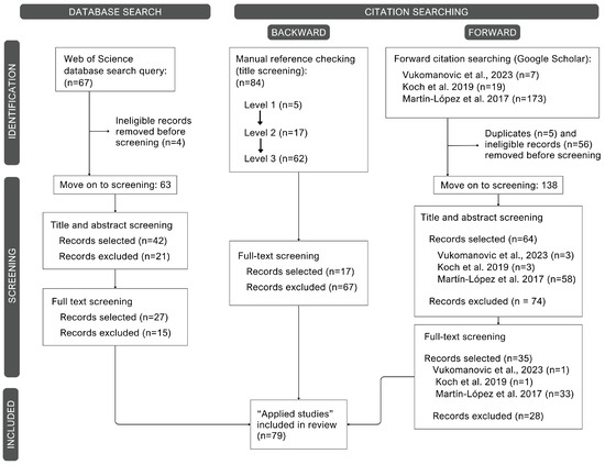
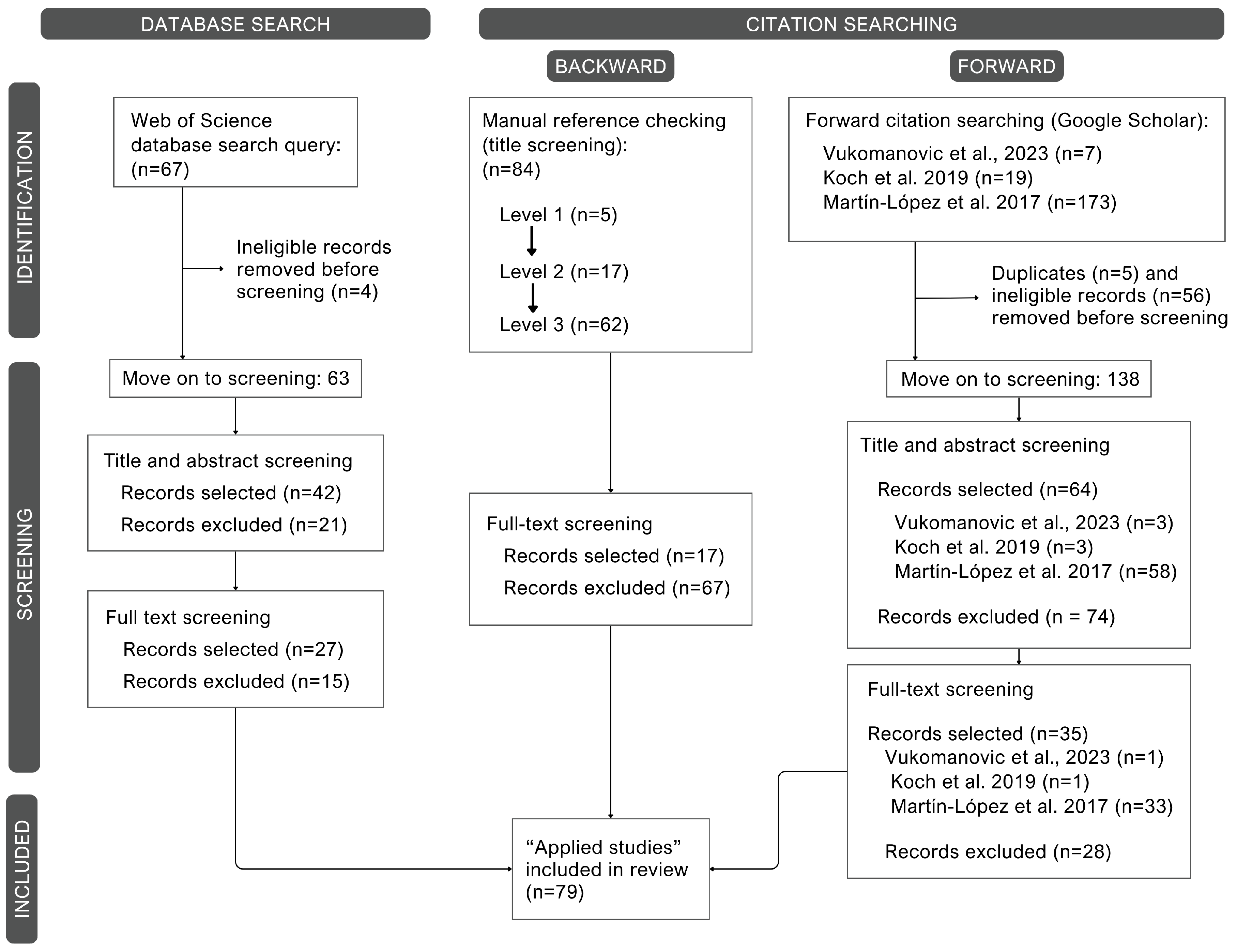
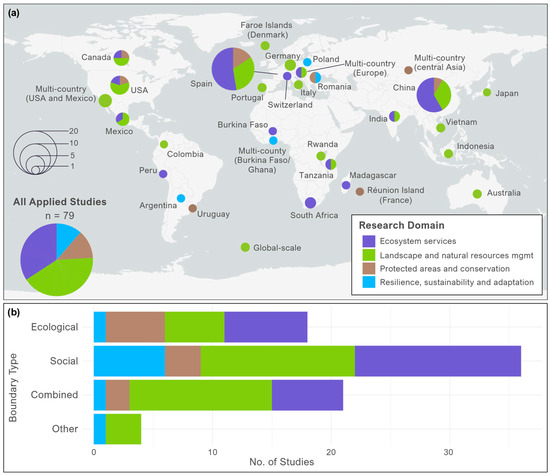
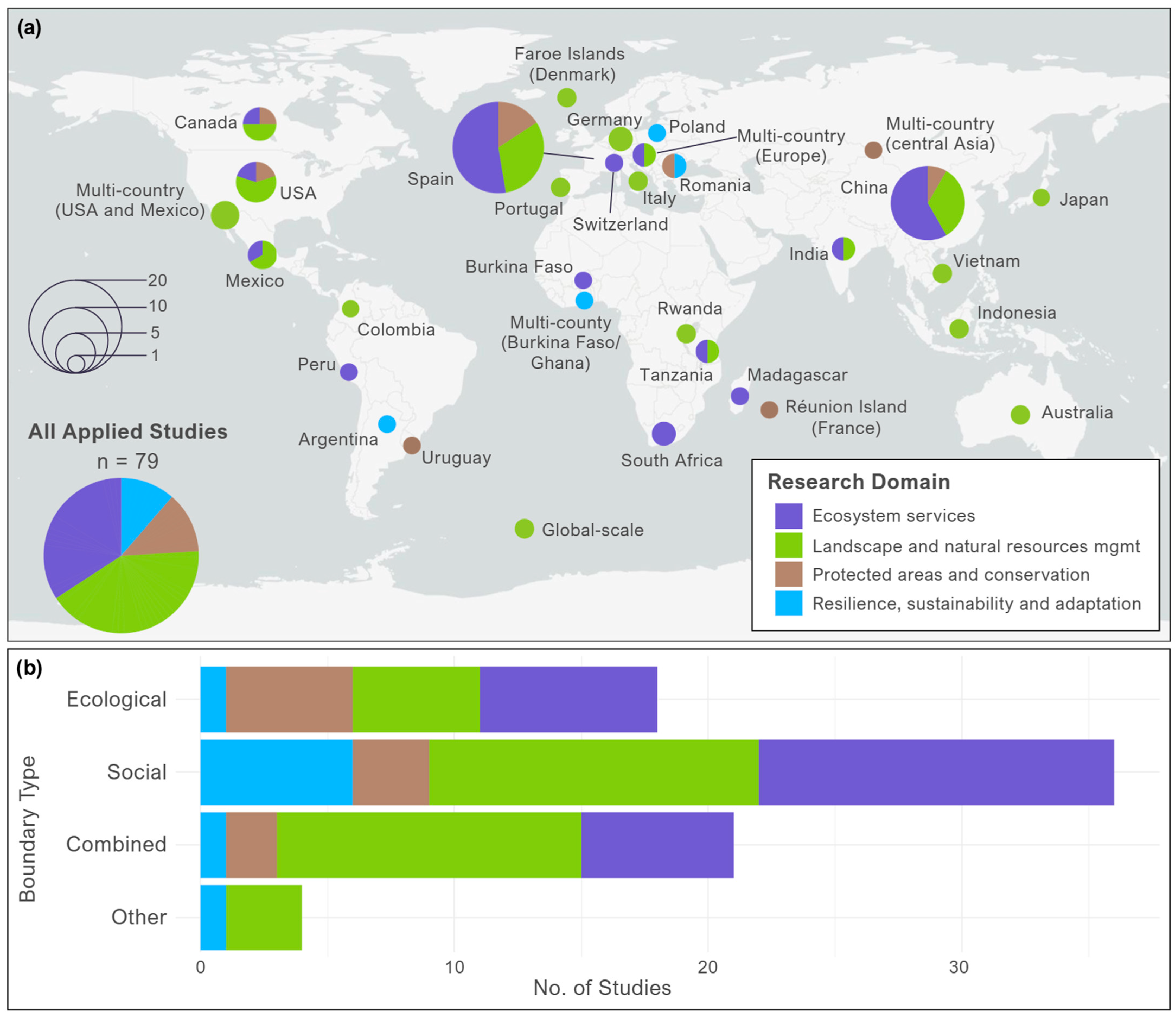
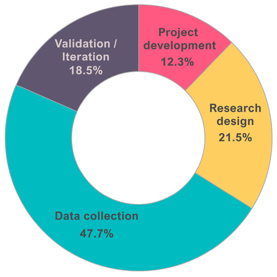
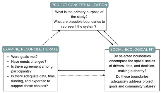
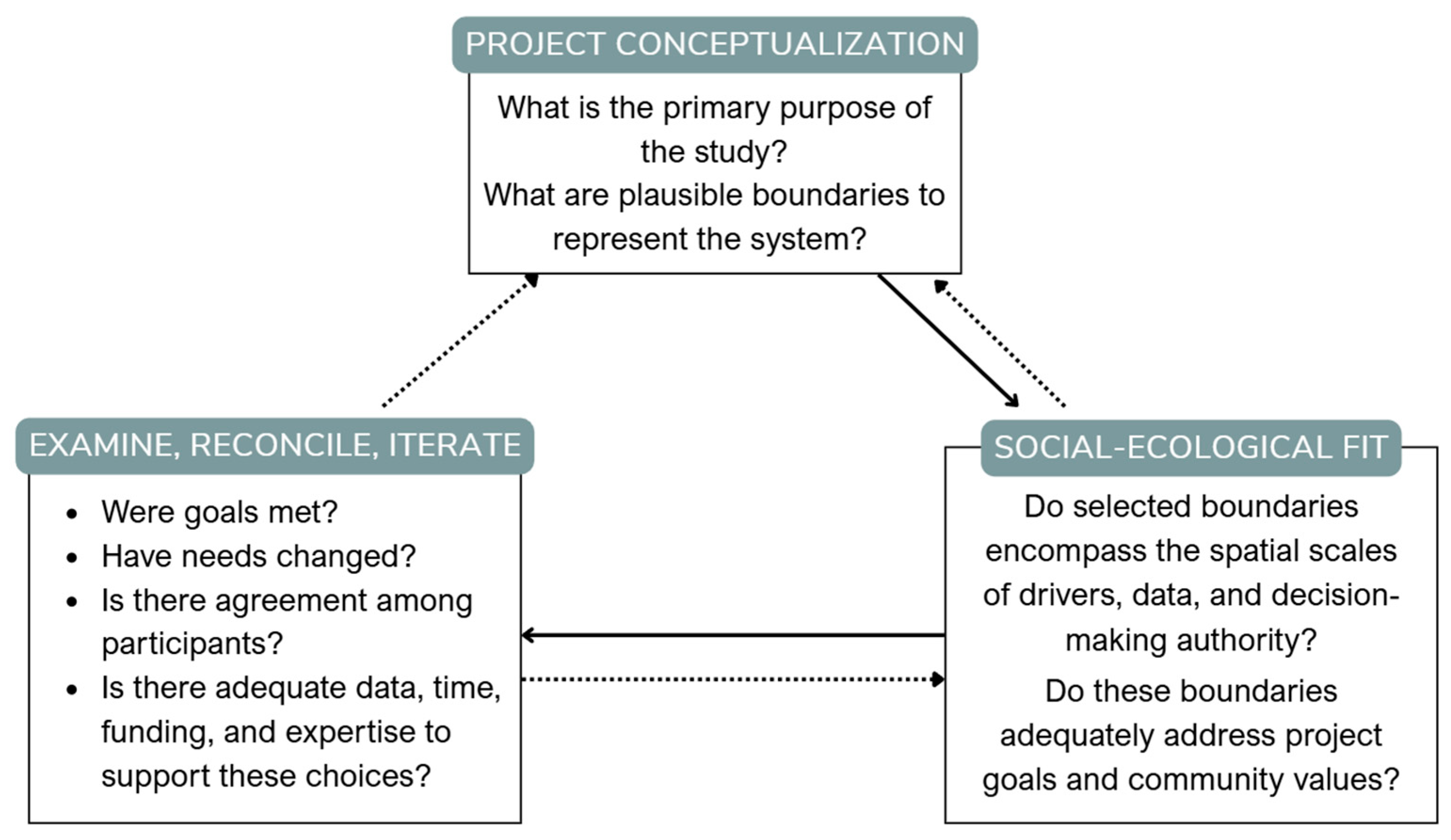
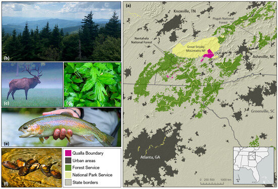
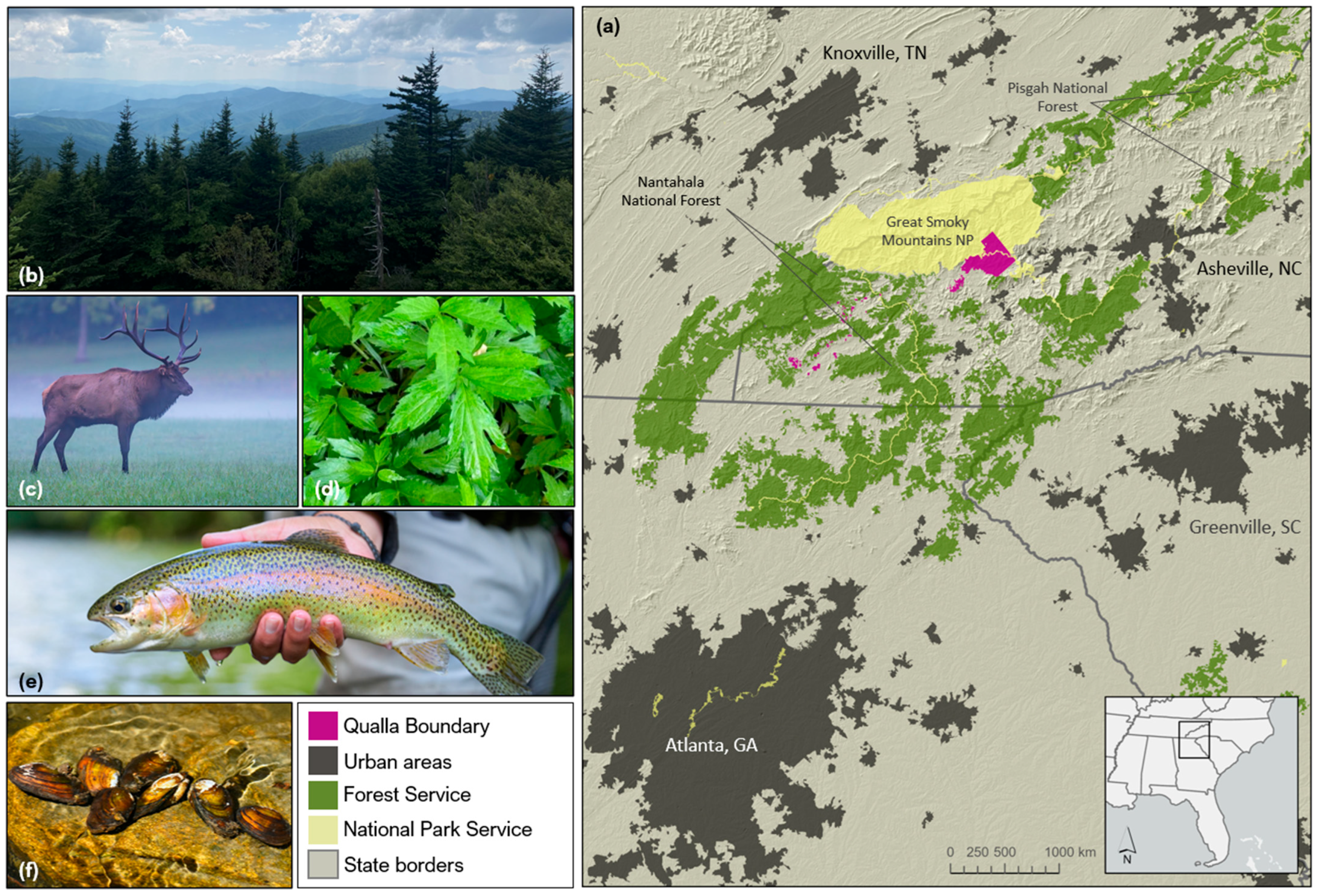
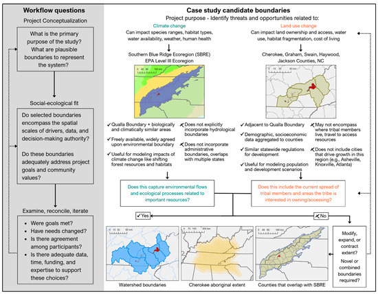
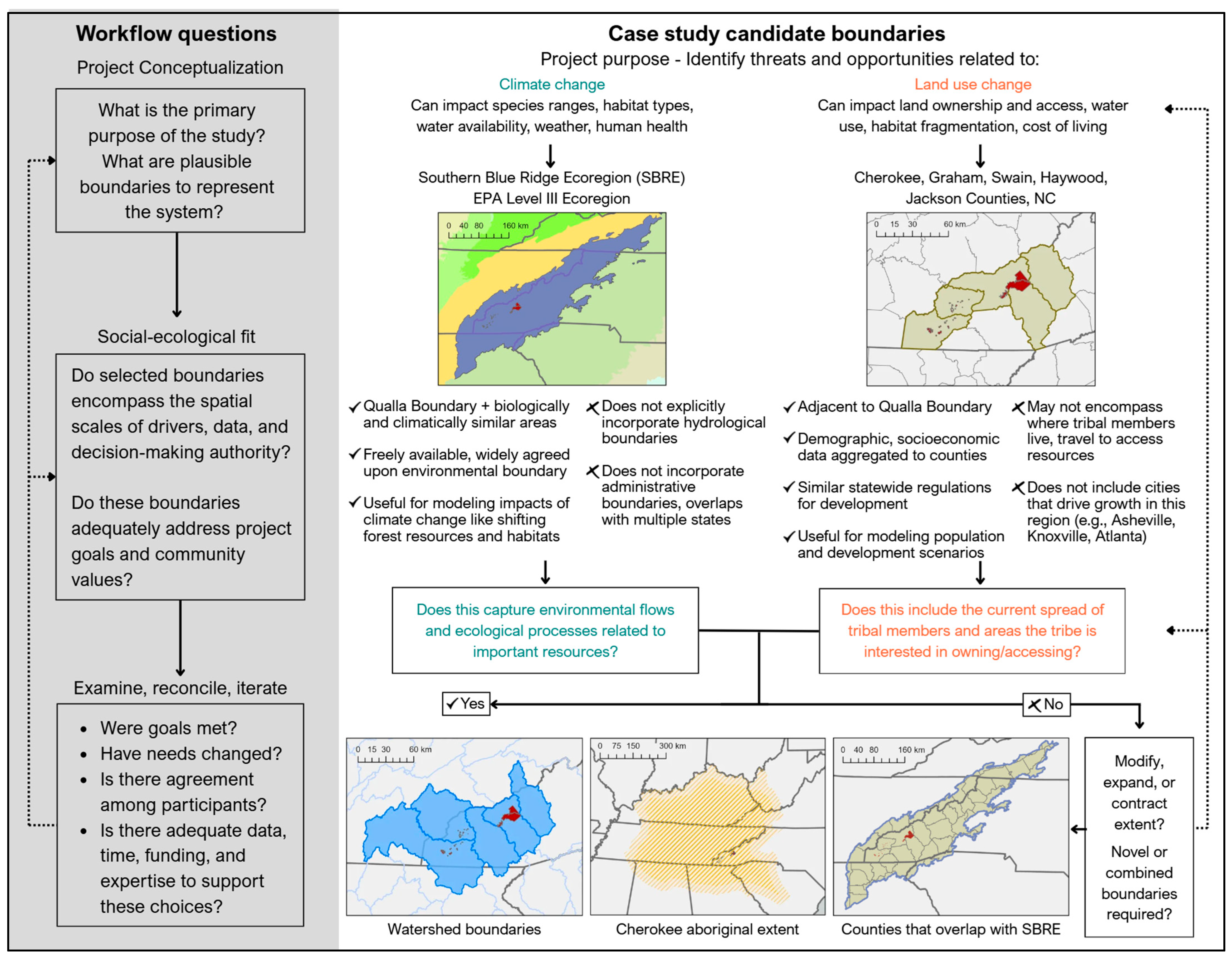

Disclaimer/Publisher’s Note: The statements, opinions and data contained in all publications are solely those of the individual author(s) and contributor(s) and not of MDPI and/or the editor(s). MDPI and/or the editor(s) disclaim responsibility for any injury to people or property resulting from any ideas, methods, instructions or products referred to in the content. |
© 2026 by the authors. Published by MDPI on behalf of the International Society for Photogrammetry and Remote Sensing. Licensee MDPI, Basel, Switzerland. This article is an open access article distributed under the terms and conditions of the Creative Commons Attribution (CC BY) license.