


Abstract
Despite advancements in navigation apps for wheelchair users, there is no consensus on which environmental factors to prioritize for personalized accessible routes. This scoping review synthesizes factors influencing wheelchair mobility in urban settings, evaluates measurement methods, and assesses their integration into routing algorithms. Following Arksey and O’Malley’s framework and PRISMA-ScR guidelines, we analyzed six databases for English-language articles from 2005 to 2023, supplemented by an updated search covering 2023 to 2026. Two reviewers screened 6966 records and examined 79 full-text articles, with 24 meeting the inclusion criteria for data extraction. Environmental factors were categorized into static and dynamic factors affecting mobility. Key components included sidewalks (96%), ramps (63%), curb cuts (54%), stairs (50%), crosswalks (50%), and streets (38%). Common factors examined were length, slope, width, and surface properties. Data collection methods varied: 42% relied on measurements, 8% used user assessments and sensors, while 50% combined both approaches. Recent studies (2023–2026) demonstrate increasing adoption of AI and machine learning techniques, including crowdsourced smartphone data and generative AI for feature detection. This review identifies essential factors for wheelchair navigation and highlights significant gaps in dynamic factor assessment and real-time data integration.
1. Introduction
Mobility is a major contributor to the social participation of people with disabilities (PWD). While this is a global challenge, Canadian data provides a compelling example: according to the Canadian Survey on Disability (2022), 8.0 million Canadians aged 15 years and older have one or several physical or mental disabilities (27% of the population). Among them, almost 39% have motor disabilities, which makes mobility disabilities the third most common type of disability in Canada. Furthermore, mobility disabilities are more prevalent among older people, with a prevalence rate of 10.6% among the total Canadian population [1,2]. Similar prevalence rates are observed internationally, with the WHO reporting that over 1 billion people worldwide experience some form of disability. Social participation without physical or social barriers is recognized as a fundamental human right, as enshrined in the United Nations Convention on the Rights of Persons with Disabilities [3], particularly Article 9 on accessibility, and reflected in national legislation such as the Accessible Canada Act (2019). However, people with motor disabilities (PWMD) remain hindered in their daily mobility due to diverse physical and social barriers limiting their social participation [4].
According to the Disability Creation Process (DCP) model [5], the realization of life habits (such as mobility) depends on the complex interaction between personal and environmental factors. Personal factors include individual capabilities, confidence levels, and skills, while environmental factors encompass both physical factors (e.g., sidewalk slopes, weather conditions) and social factors (e.g., crowd density, societal attitudes toward disability). This framework highlights the importance of the consideration of both the individual’s capabilities and the environmental context in the development of personalized assistive technologies to assist PWMD, including wheelchair users, in their mobility and social participation.
While assistive devices such as wheelchairs, walkers, and mobility scooters provide essential support for PWMD, they alone cannot overcome all environmental barriers. A wheelchair user with appropriate equipment may still face insurmountable obstacles such as steep slopes, broken sidewalks, or inaccessible building entrances. This gap highlights the importance of geospatial navigation tools that can assist wheelchair users in planning and navigating accessible routes adapted to their own profiles and capabilities.
To address these limitations, several assistive navigation technologies have emerged in recent years. These applications can be divided into two categories: location-based applications (LBAs), such as AXSMap (https://www.axsmap.com/ (accessed on 2 February 2026)), Wheelmap (https://wheelmap.org/ (accessed on 2 February 2026)), MobiliSIG, and AccessNow, which provide accessibility information about specific locations (toilets, restaurants, parking lots) but lack navigation features. In contrast, assistive navigation applications such as U-Access [6], MAGUS (modeling access with GIS in urban systems) [7], Rout4U (https://route4u.org/ (accessed on 2 February 2026)), and AccessMap (https://www.accessmap.io/ (accessed on 2 February 2026)) [8] provide routing features specifically designed for PWMD, using algorithms to model route accessibility through Geographic Information Systems (GISs).
The realization of life habits (such as mobility) depends on the complex intricacy of personal and environmental factors. Thus, assistive navigation applications should provide the possibility of considering the interactions between individual and environmental factors for sidewalk accessibility assessment. Regarding personal factors, it is essential to note that people have different levels of capability to engage in an activity within a given environment. To propose safe and convenient routes, it is necessary for the assistive navigation applications to evaluate the user’s capabilities and confidence to move while interacting with different environmental factors, such as WheelCon [9] and Wheelchair Skill Test (WST) [10]. Although these are helpful, they are not suitable for capturing users’ profiles for the development of personalized navigation applications. This is because they rely on too many questions that are not suitable for capturing users’ profiles for personalized navigation purposes. Additionally, these tools use a variety of measurement units (e.g., degrees for a sidewalk slope), which can be difficult for users to interpret accurately. Furthermore, most of the questions are based on a laboratory setting, not in a real urban setting (e.g., Wheelchair Skills Test Questionnaire).
Despite these technological advances, there is no consensus regarding which environmental factors should be prioritized in assistive navigation applications for personalized route planning. For instance, MAGUS [7] considers 21 environmental factors, U-Access focuses on nine [6], and MobiliSIG [11] outlines twelve. This variability reflects the complexity of prioritizing the most impactful environmental factors for personalized assistive navigation application development.
Previous systematic reviews have examined accessibility barriers for wheelchair users [12,13], but none have specifically synthesized the environmental factors considered in navigation applications. Comai et al. (2021) conducted a systematic mapping study analyzing 111 papers on accessible wayfinding but focused on people with diverse disabilities rather than wheelchair users specifically [12]. Rodrigues et al. (2023) reviewed assistive navigation primarily for blind and visually impaired people [13], while other reviews have focused on improving wheelchair technology by integrating artificial intelligence (AI) and robotics rather than on focusing on the identification of environmental factors [14,15]. This scoping review addresses this gap by specifically examining outdoor environmental factors to support the development of personalized wheelchair navigation applications.
This scoping review aims to identify and synthesize the environmental factors that impact wheelchair users’ mobility as reported in navigation application research. Specifically, we seek to:
- Identify which environmental factors are most frequently considered in wheelchair navigation applications. These factors will then be used to define the profile of wheelchair users and integrated into personalized assistive navigation tools. The results of such a study will enable us to further refine the development of mobile personalized assistive navigation technologies tailored to the needs and profiles of wheelchair users.
- Examine the data collection methods used to capture data on these environmental factors.
- Analyze how these factors are assessed and integrated into routing algorithms.
- Beyond mapping the current state of knowledge, this scoping review seeks to provide a forward-looking perspective by identifying research gaps and priorities for future investigation.
The findings will contribute to the scientific understanding of accessibility requirements and provide evidence-based recommendations for future navigation application development. While this review does not directly develop an application, it establishes the foundational knowledge necessary to create more effective personalized assistive navigation tools and to refine algorithms for sidewalk accessibility assessment.
2. Materials and Methods
We employed the five-stage scoping review framework by Arksey and O’Malley [15,16] to identify and map environmental factors affecting wheelchair navigation in outdoor environments. This methodology was selected over a systematic review for several reasons: (1) the research question is broad and exploratory in nature, aiming to chart the breadth of the existing literature rather than assess the effectiveness of specific interventions; (2) the field lacks a comprehensive synthesis that maps key concepts, identifies knowledge gaps, and informs future research directions; and (3) quality assessment of individual studies was not the primary objective, as the goal was to capture the full spectrum of factors examined across diverse contexts [17]. Following PRISMA-ScR guidelines [18], we defined our methodology to ensure transparency and reproducibility.
Our scoping review aims to address the following question: What are the key environmental factors that should be considered for accessibility assessment and personalized route planning and navigation for wheelchair users? We define a factor’s significance based on its frequency of citation in the articles that will be selected through this review process. Consequently, the more frequently an environmental factor is mentioned in studies related to accessibility assessment and navigation for PWMD, the more important it is deemed. We acknowledge that citation frequency may not fully capture importance, as some critical but context-specific factors may be underrepresented in the literature. However, this approach provides an objective and reproducible method for identifying commonly recognized factors across diverse scientific articles. The main steps of the methodology are presented in the following subsections.
2.1. Eligibility Criteria
Clear inclusion and exclusion criteria were established prior to the literature search:
- Inclusion criteria:
- Peer-reviewed journal articles;
- Published between January 2005 and July 2023;
- Focus on outdoor wheelchair navigation, routing, or wayfinding;
- Empirical studies, systematic reviews, or technical papers;
- Assessment of environmental factors affecting wheelchair users;
- English-language publications.
- Exclusion criteria:
- Studies focusing exclusively on indoor navigation;
- Absence of routing or navigation components;
- Focus solely on cognitive or visual impairments without wheelchair-specific considerations;
- Conference abstracts without full papers;
- Studies on multimodal transportation (buses, trains) without wheelchair-specific analysis;
- The gray literature and non-peer-reviewed sources.
The start date of 2005 was selected based on the limited availability of smartphones before this year, the launch of Google Maps in 2005, and the restricted availability of navigation applications prior to this period. While we acknowledge the availability of translation tools, we limited our search to English-language publications to ensure accurate technical translation of specialized terminology, which would require validation resources beyond our current capacity.
2.2. The Literature Search Strategy
On 27 July 2023, the first two authors conducted systematic searches across six databases: Compendex, Inspec, GeoBASE, and GeoRef (accessed through the Engineering Village platform), plus PubMed and Transport as standalone databases. These databases are selected due to their relevance to the subject; for instance, engineering and computing aspects are covered by Compendex and Inspec; geospatial and environmental components by GeoBASE and GeoRef; rehabilitation and health sciences by PubMed; and mobility and accessibility studies by Transport. Search strategies were developed collaboratively through iterative refinement and pilot-tested for consistency across platforms. Then the search results from different databases were combined in a review platform. Furthermore, a complementary literature review was conducted in January 2026 using the same strategies and databases, allowing the consideration of relevant articles published between 2023 and 2026.
Table 1 presents the search terms and Boolean operators used. While each search engine uses its own syntax, we used the same search terms across all platforms, making only minor adjustments where necessary. Terms in column 4 were specifically excluded to refine the results to wheelchair-user navigation, excluding studies focused on visual and cognitive disabilities that might introduce environmental factors beyond the scope of this study.
Table 1.
A comprehensive list of the search terms and search strategy defined for the scoping review.
2.3. Article Selection
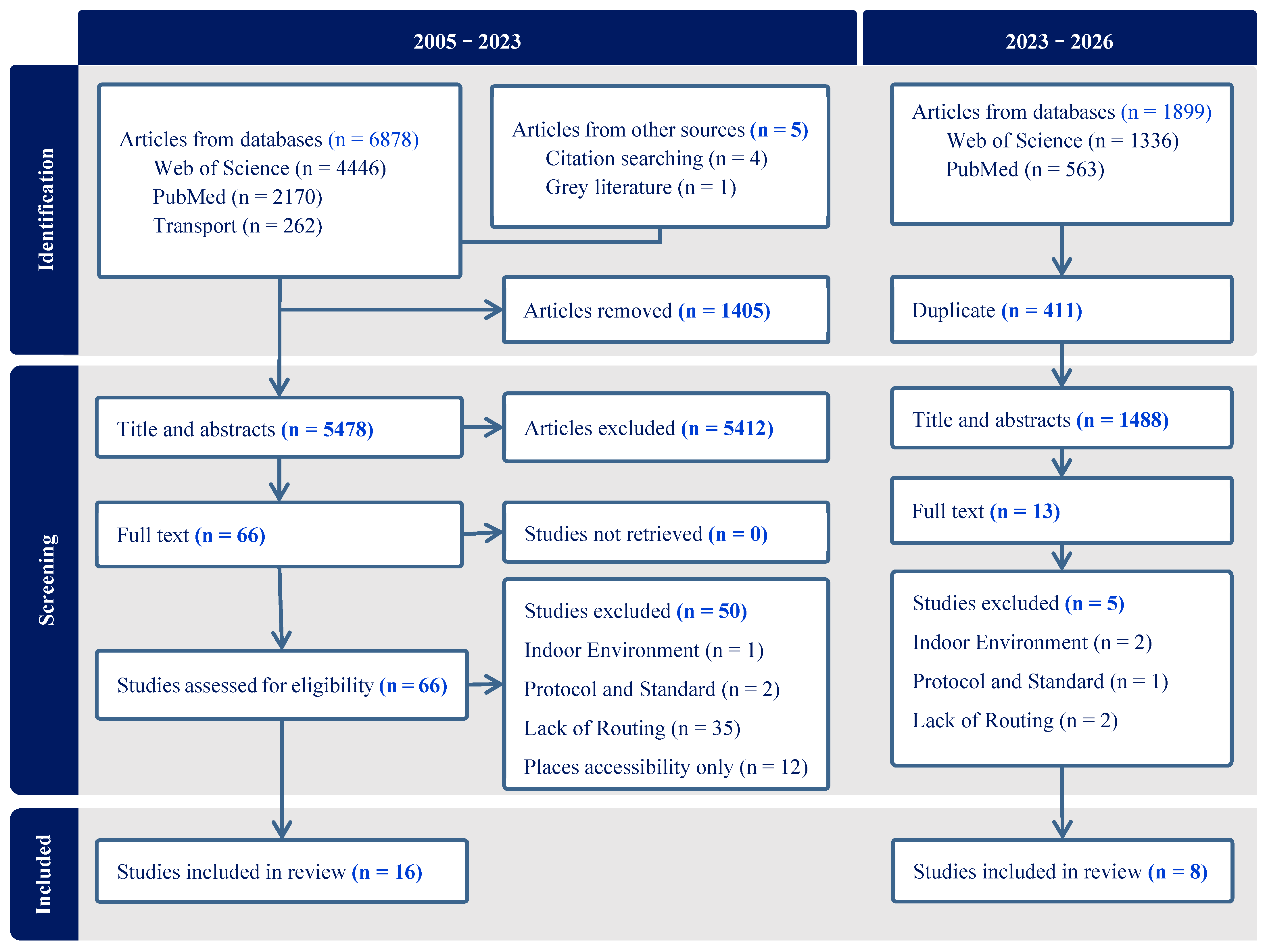
The article selection process was conducted using the Covidence platform, https://www.covidence.org/ (accessed on 2 February 2026), which is a web-based collaboration software platform that streamlines the production of systematic and other literature reviews. As illustrated in Figure 1, the selection process comprised three distinct stages:
Figure 1.
PRISMA diagram illustrating the steps involved in the article selection process (2005–2026).
Identification: The initial search yielded 6883 articles (Web of Science: 4446; PubMed: 2170; Transport: 262; other sources: 5). After importing all records into Covidence, 1405 duplicates were automatically identified and removed, leaving 5478 unique records.
Screening: Two authors independently screened all 5478 records based on titles and abstracts using the predetermined inclusion/exclusion criteria. Inter-rater agreement was calculated using Cohen’s kappa (κ = 0.82), indicating substantial agreement [19]. Disagreements (n = 312) were resolved through discussion, resulting in 66 articles advancing to full-text review and 5412 articles excluded.
Full-text review: The same two authors independently reviewed the full text of 66 articles. Fifty articles were excluded for the following reasons:
- Navigation and routing not discussed (n = 35);
- Focus on accessible locations without a routing component (n = 12);
- Discussion limited to built environment protocols and standards (n = 2);
- Exclusive focus on indoor navigation (n = 1).
The third author served as the methodological advisor throughout the review process and adjudicated three instances in which consensus could not be reached during full-text screening. The final sample consisted of 16 articles that met all inclusion criteria.
It should be noted that among the 35 articles excluded for lacking navigation/routing components, many examined environmental factors affecting wheelchair accessibility through accessibility audits, barrier identification studies [20,21,22] and built environment assessments [23,24,25,26,27]. A retrospective comparison indicates substantial overlap in core physical factors (slope, width, surface conditions) between these studies and our included navigation-focused articles, suggesting our review captures factors consistently recognized across the accessibility literature. However, non-navigation studies tended to emphasize destination-related factors (building entrances, public facilities), social barriers, and maintenance conditions more frequently than navigation-oriented research.
Following the same process, for the second round of the literature review, we identified 1899 papers across the selected databases from 2023 to 2026. After removing 411 duplicate records, the remaining papers underwent screening based on the established inclusion and exclusion criteria, resulting in 8 papers being available for the final review.
2.4. Data Extraction and Synthesis
Figure 1 presents the complete PRISMA-ScR flow diagram detailing the selection process during two rounds of the literature review process, including 2005–2023 and 2023–2026.
- Two authors independently extracted data using a standardized extraction form developed in Microsoft Excel and pilot-tested on three randomly selected articles. The extraction form captured:
- Study characteristics: Authors, publication year, country of first author, and study design.
- Methodological approaches: Data collection methods, assessment tools, and sample sizes.
- Environmental factors: Extraction with context and operational definitions.
- Factors measurement methods: Classification of approaches used (manual, automated, or both).
- Routing applications: Algorithms and implementation details (if applicable).
Inter-rater reliability for data extraction was assessed using Cohen’s kappa (κ = 0.79), indicating substantial agreement. Disagreements occurred in 18% of extractions, primarily regarding factor categorization and measurement method classification. All disagreements were resolved through discussion, with the third author consulted in two instances where consensus was not initially reached.
Table 2 and Table 3 (see the Results Section) summarize the extracted data, while the full extraction database is available in an Excel sheet.
Table 2.
Summary data extracted from the 24 papers selected in the final review step (2005–2026).
Table 3.
Data extracted on the environmental factors, methodologies, key findings, and proposed solutions from the selected papers.
2.5. Identification and Categorization of Environmental Factors
Environmental factors were systematically extracted from the 24 included articles through a two-stage process:
Initial Extraction: Two authors independently reviewed each article and documented all environmental factors mentioned as influencing wheelchair accessibility. Factors were recorded with their source article.
Categorization and synthesis:
- Static factors (permanent infrastructure) were distinguished from dynamic factors (temporary/changeable conditions).
- Inclusion criteria for factors: mentioned in ≥2 articles OR identified as a critical barrier in a single study with empirical validation.
- Exclusion criteria: factors related solely to indoor navigation, social interactions, or requiring specialized equipment beyond standard wheelchairs.
- Disagreements were resolved through discussion, with the third author consulted when consensus could not be reached.
2.6. Data Collection Methods
Through inductive analysis of the methodological approaches in the reviewed literature, we identified and classified data collection methods into two main categories:
Based on Measurement and Scale (BMS): Methods utilizing objective measurement tools, including:
- Direct field measurements using instruments (meters, inclinometers, GPS devices)
- Digital extraction from imagery (satellite, street view, aerial photography)
- LiDAR data analysis
- GIS-based spatial analysis
Based on Assessment of Wheelchair Users and Sensors (BAWS): Methods incorporating user experience and real-world usage data, including:
- Sensors attached to wheelchairs or users (accelerometers, gyroscopes, GPS trackers)
- User evaluation through accompanied journeys
- Self-reported accessibility assessments
- Crowdsourced accessibility ratings
This categorization emerged through iterative coding and was validated by all authors. The classification helps distinguish between objective infrastructure assessment and experiential evaluation approaches, both critical for comprehensive accessibility assessment.
3. Results
Based on our review, most of the environmental factors impacting mobility of the wheelchair users are related to the characteristics of the pedestrian network (sidewalks, crosswalks, curb cuts), entrances of the buildings (ramps and stairs), and, in some cases, sections of the streets that pedestrians use in the absence of sidewalks. These factors are presented in more detail in the following sections.
3.1. Factors Related to the Pedestrian Network
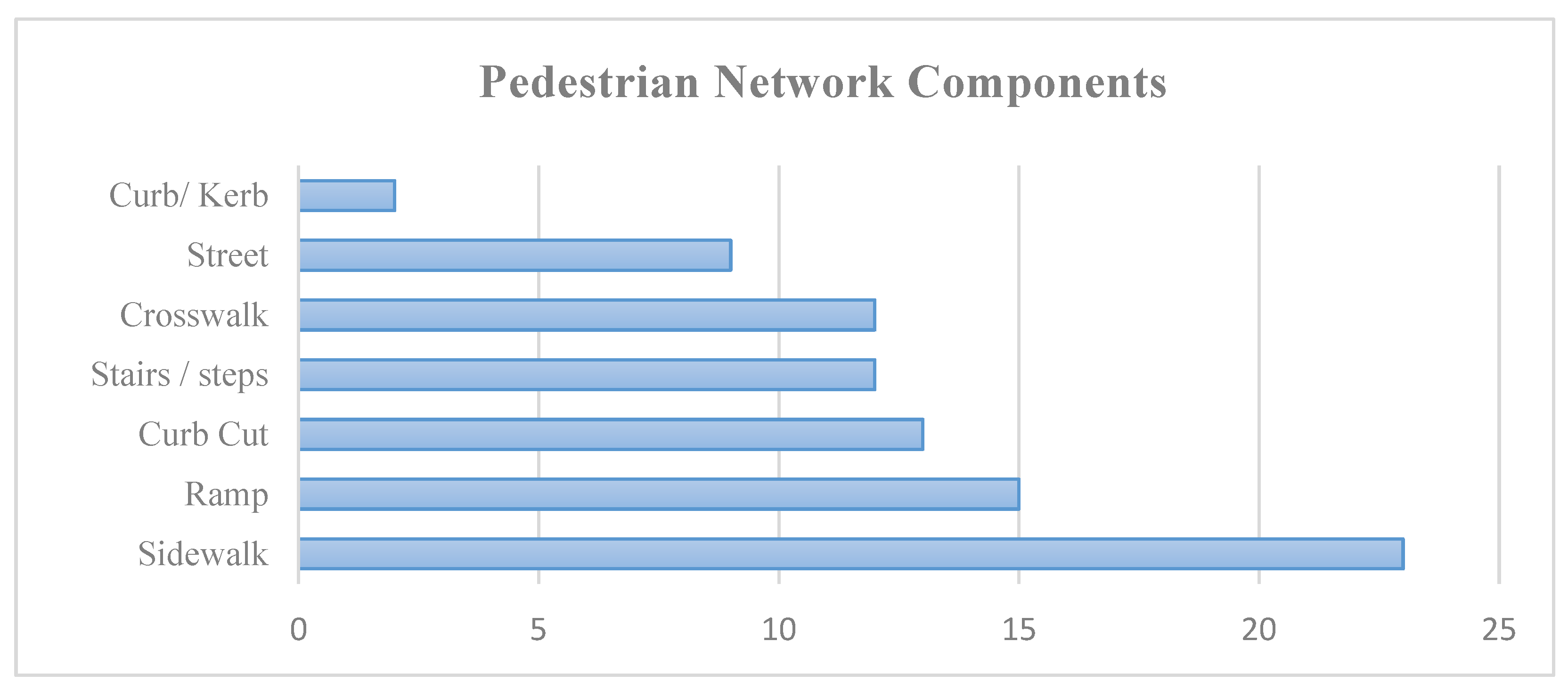
We have identified six key components of the pedestrian network, as well as the building entries most used by wheelchair users for mobility. The frequency of these components was assessed in the selected articles presented in Figure 2. Among these, sidewalks have been cited as the most critical component featured in all the studies except [50]. The other components include steps (addressed in 12 studies) [28,29,30,31,32,33,35,36,37,38,39,40], curb cuts (in 13 studies) [6,28,30,32,33,35,36,37,39,40,41,42,43,44], ramps (in 15 studies) [6,28,30,33,35,36,38,39,40,43,44,45,46,47,48,49], crosswalks (in 12 studies) [28,32,33,35,36,38,39,41,44,45,48,50], and streets (in 9 studies) [28,31,33,36,37,40,44,48,50]. Each of these components encompasses several attributes that serve as environmental factors affecting wheelchair users’ mobility, which will be explored in detail in the following sections.
Figure 2.
Most cited pedestrian network components identified in the selected papers.
3.1.1. Sidewalks
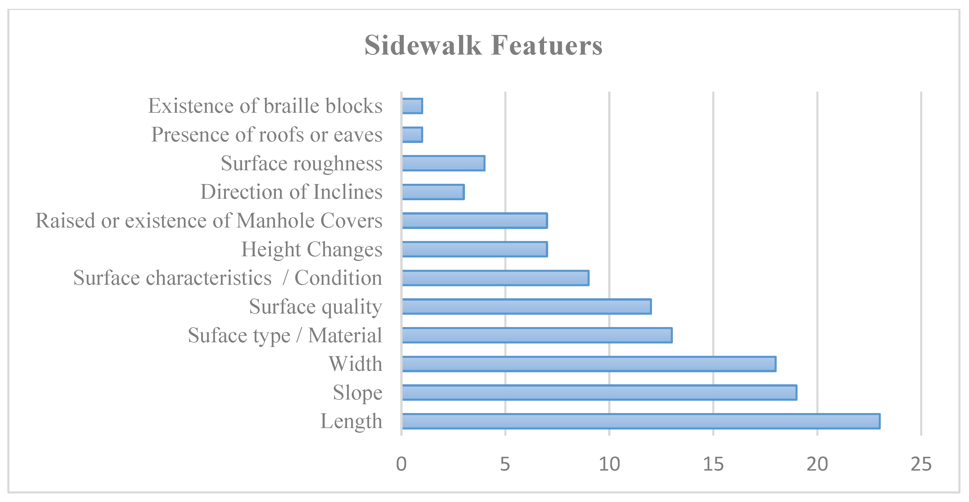
Sidewalk is a component of the pedestrian network that is present in almost all the selected studies except [50]. Figure 3 illustrates how sidewalk features are considered in the different papers. Based on our review, the length of a sidewalk, its slope, and its width are the three most significant attributes to be considered in assessing navigation accessibility for PWMD, cited in more than 75% of the selected studies. Then come the surface properties (material, condition) that are cited in more than 50% of the studies. Conversely, the least considered features are the cross slope, Braille blocks, and the presence of roofs or eaves.
Figure 3.
Sidewalk features were identified across all 24 selected studies.
3.1.2. Ramps
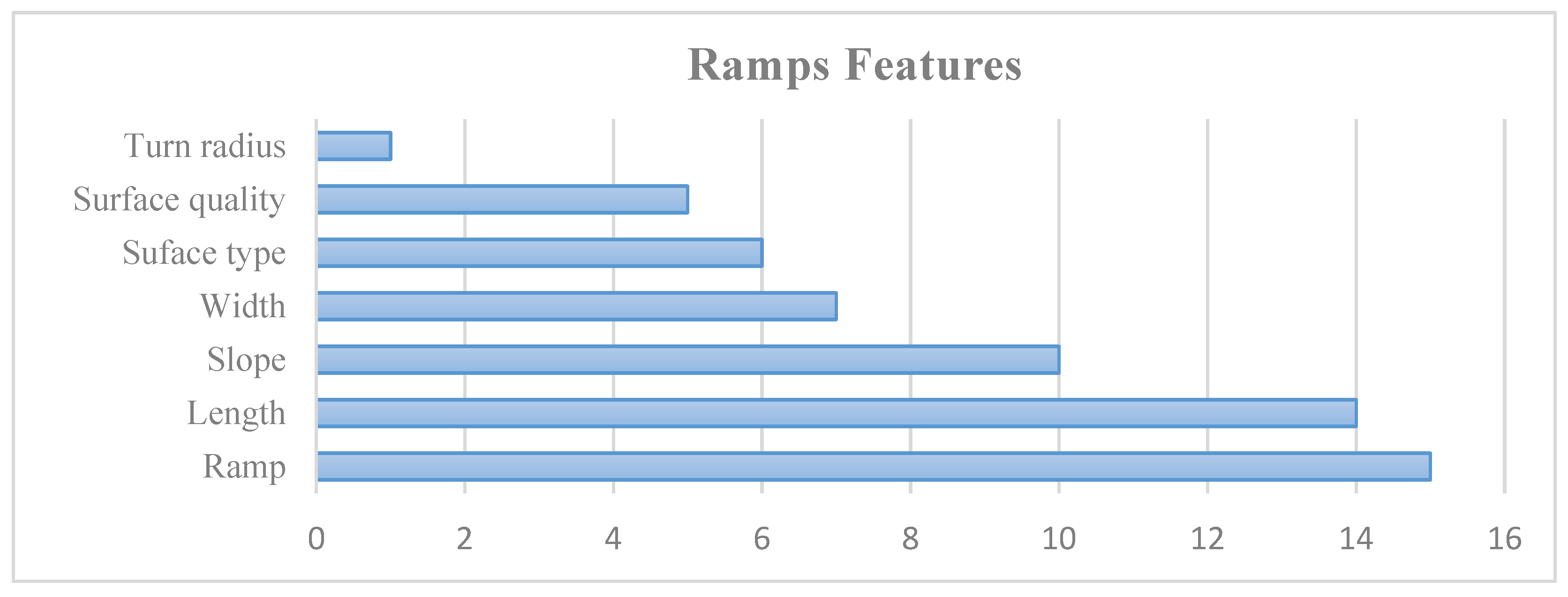
As shown in Figure 2, the ramp is the second most cited component of the pedestrian network that might impact PWMD mobility, and that should be considered in routing (cited by nine studies). Although the slope of the ramp might be the first feature to come to mind for ramps, Figure 4 shows that ramps are considered in 15 studies, and the length is cited in more than 58% of the studies. In contrast, the turn radius factor is the least considered characteristic in the reviewed studies.
Figure 4.
Ramp features identified in the selected studies.
3.1.3. Curb Cuts
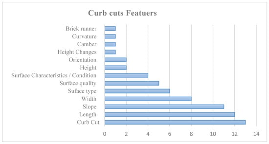
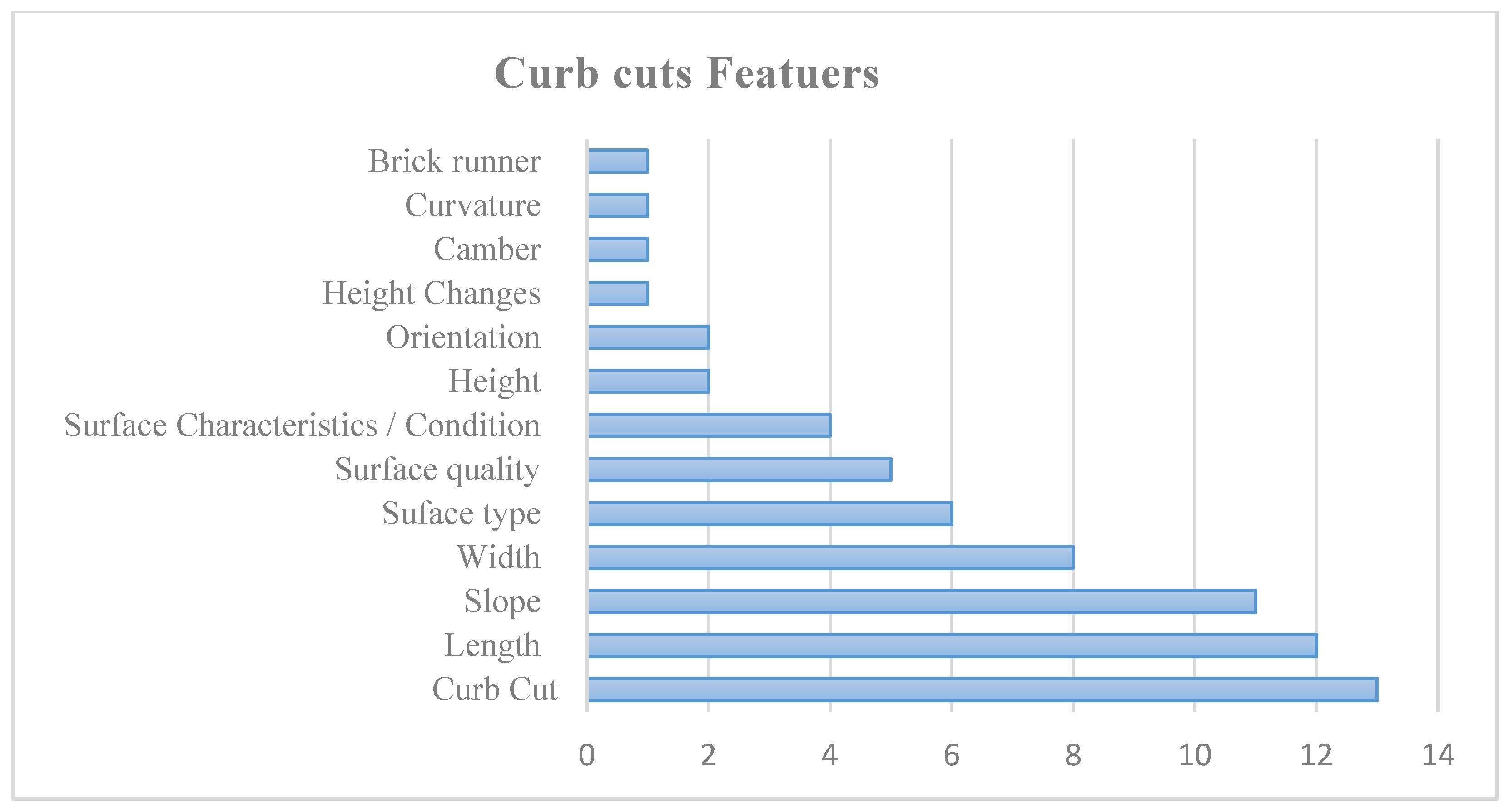
The third most frequently mentioned component is the curb cut or curb ramps, which appear in 13 of the reviewed studies. Curb cuts are solid ramps, typically made of concrete, that connect a sidewalk to the adjacent street. As illustrated in Figure 5, the length of the curb cut and the degree of slopes are the most critical features evaluated, appearing in almost 50% of the studies. In contrast, features such as brick runners, curvature, camber, and variations in height are considered far less frequently.
Figure 5.
Curb cut features identified in the selected studies.
3.1.4. Stairs
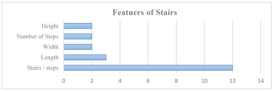
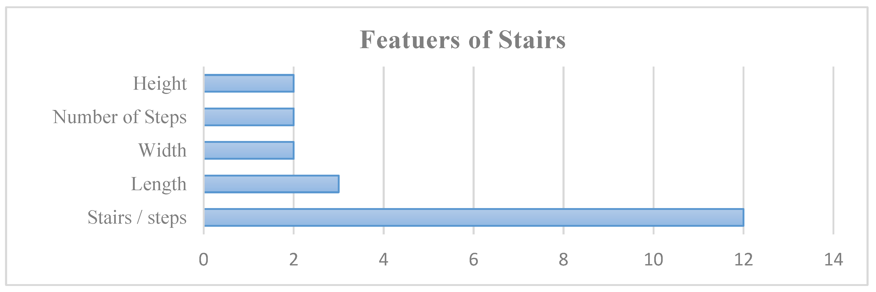
When examining the pedestrian network, stairs or steps emerge as the fourth most frequently discussed component, highlighted in a total of 12 studies. As illustrated in Figure 6, these stairs often pose significant obstacles for PWMD, especially wheelchair users, with 50% of the research indicating that they are unable to navigate them effectively. Notably, many of these studies overlook important characteristics of stairs, such as the total number of steps, their width, and height, which can further impact accessibility and usability for individuals facing mobility challenges.
Figure 6.
Stairs features identified in the selected studies.
3.1.5. Crosswalks
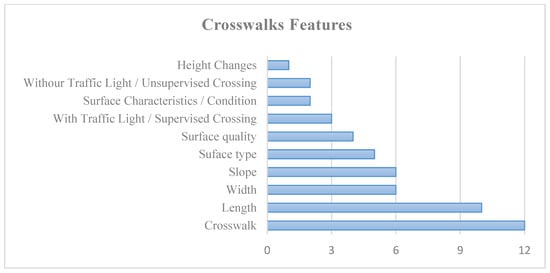
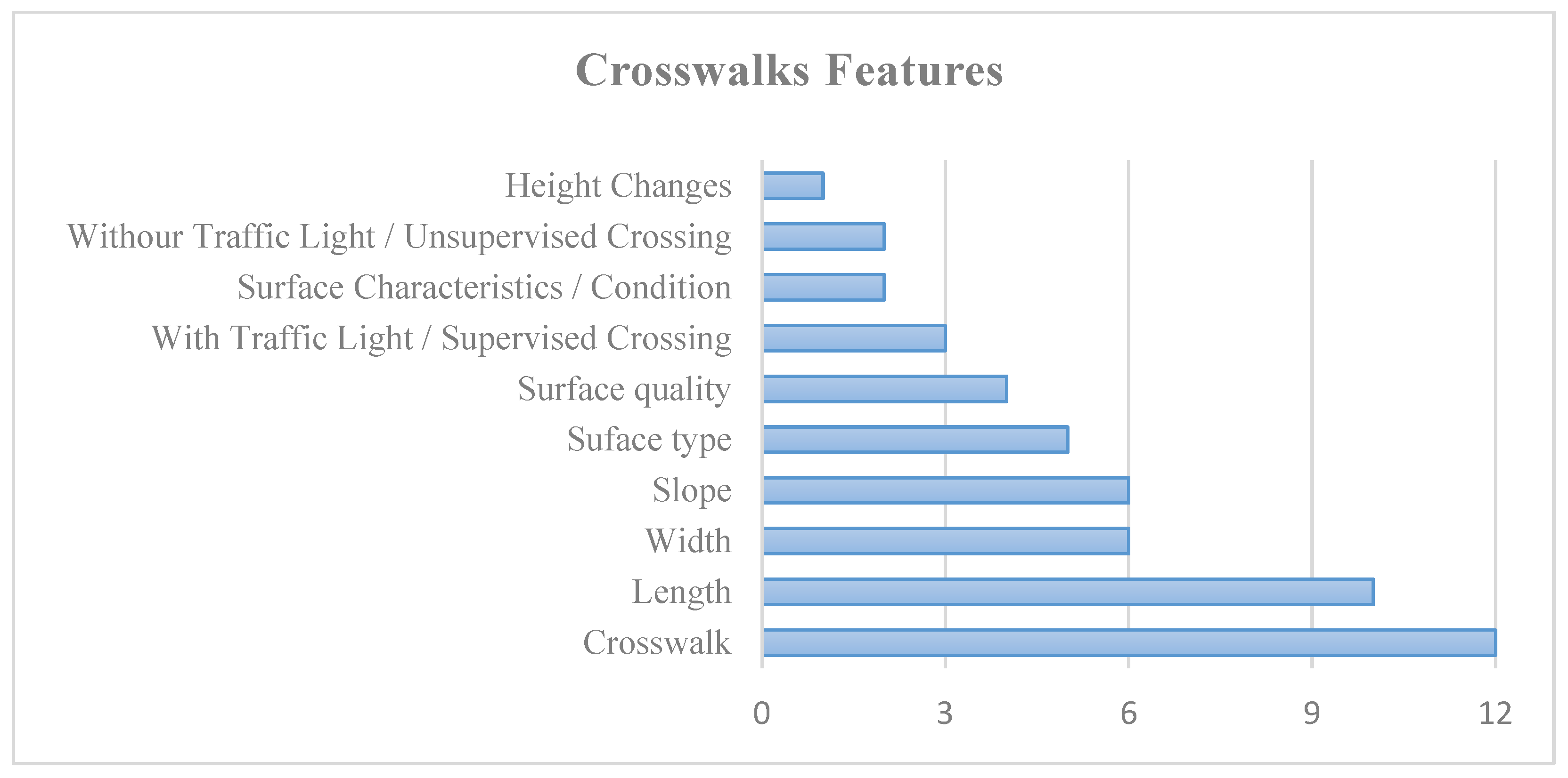
Twelve studies (50%) cite crosswalks. As presented in Figure 7, the presence of crosswalks and their length are the most cited features. On the other hand, height changes are the least cited characteristic of crosswalks. A single study concentrated specifically on crosswalk extraction, employing artificial intelligence and various data types to detect crosswalks for people with motor disabilities [50].
Figure 7.
Crosswalk characteristics are mentioned in 12 of the 24 selected studies.
3.1.6. Streets
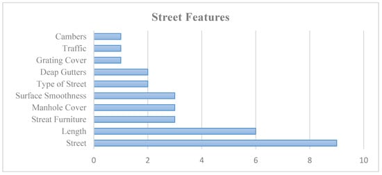
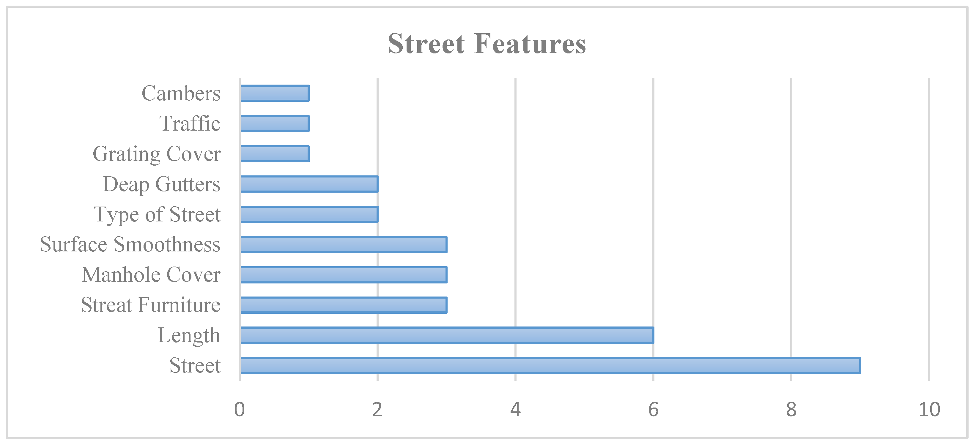
The street itself received less attention in the reviewed studies. As shown in Figure 8, street length was considered in six studies, making it the most significant street feature for PWMD. On the contrary, camber, traffic, and grating covers are discussed in only one study.
Figure 8.
Street features identified in the 9 reviewed studies.
Table 4 summarizes the static physical factors cited in the reviewed studies for one or more pedestrian network components. The length, slope, width, and surface properties seem to be of greater interest for routing and accessibility assessment for PWMD. The existence of stairs is also of great importance. However, we do not mention the street in this table because it shares one factor (length) with other components.
Table 4.
Most frequently cited pedestrian network components across the 24 reviewed studies.
3.1.7. Other Factors
Some object classes of the mobility infrastructure that are not part of the pedestrian network are cited in the reviewed literature, but none of them are present in more than 25% of the studies. These object classes include parking, lighting, doors, immovable obstacles, emergency call buttons, wheelchair lifts, grab bars, counters, mobility aids, Braille blocks, construction, mobile obstacles, and weather conditions. While some of the listed object classes may have several features that act as static or dynamic factors in routing and accessibility assessments, only the existence of these object classes has been considered in the reviewed studies. For instance, entrances may include manual doors, automatic doors, semi-automatic doors, sliding doors, and revolving doors, although each type has some variations in sociocultural and behavioral factors that are not discussed. In many cases, a factor that can be an obstacle for someone can be a facilitator for someone else. For example, while a revolving door may pose a challenge for some wheelchair users, it can be a facilitator for others, such as older people with canes, who do not need to push a heavy door. This principle applies to factors related to the ramps, steps, and even sidewalks.
Regarding weather conditions, various factors are discussed, including wind, fog, snow, rain, sun, and weather temperatures, as dynamic factors. Based on our review, two of the studies [39,41] considered the weather conditions. Among other dynamic factors, traffic on sidewalks or in crowds is the most frequently cited factor, appearing in 9 of 24 papers (38%). In contrast, there was only one study that considered pedestrian flow, noise, and personal safety [28].
3.2. Analysis of Data Collection Approaches
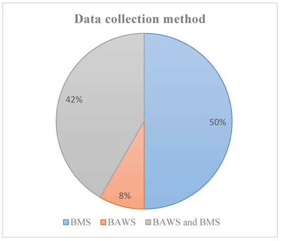
All the studies reviewed are interested in the pedestrian network to identify the environmental factors necessary for the accessibility assessment and routing for wheelchair users. For accessibility assessment, data collection is a vital part of the process. As stated in the previous section, we divided the data collection methods into two types: first, based on the measurement and scale (BMS), and second, based on the perception and assessment of wheelchair users and sensors (BAWS). Figure 9 depicts the type of data collection used in 24 selected papers. In almost 50% of the studies, data were collected using the BMS method; 42% used both methods, and 8% used the BAWS method.
Figure 9.
Overview of the various data collection methods identified in the reviewed papers.
3.3. Accessibility Assessment Methods
Accessibility assessment methodologies across 24 studies reveal a diverse landscape, highlighting the complexity and diversity of methods for the assessment of accessibility of pedestrian networks for wheelchair users. A prominent trend is the use of multi-method approaches, employed in 33% of the studies, notably by [28,37,40,42]. This trend reflects the understanding that no single assessment technique can fully capture the nuances of accessibility, underscoring the need for multiple evaluation frameworks.
Fuzzy logic-based methodologies constitute 29% of the studies, including fuzzy–AHP by [29,34], pure fuzzy logic by [30], fuzzy–TOPSIS by [35,41,43], and weighting fuzzy–TOPSIS by [49]. These approaches represent a shift from binary classifications to continuous assessments that address the variations in accessibility levels.
Weighting method approaches, used by Kasemsuppakorn et al. in 2015 and Inada et al. in 2014 [31,32], assign numerical weights to different factors based on their importance, requiring careful calibration to meet diverse user needs.
Several unique methodologies also emerged. Sobek & Miller in 2006 focused on the creation of a Spatial Network Database to manage accessibility data [6]. Pascal Neis (2015) emphasized reliability factors in accessibility information [33]. Barczyszyn et al. (2018) explored a user feedback approach that incorporated insights from wheelchair users [36]. Orellana et al. (2020) proposed a Synthetic Accessibility Index [38], and Wheeler et al. (2020) introduced Ade-Ap for standardizing accessibility data across platforms [39]. More recently, MobiliSIG (2023) introduced a confidence-based approach for multimodal route planning combining pedestrian and public transit networks in Canada [44]. In Turkey, e-Rota (2024) employed Dijkstra’s algorithm with binary classification for real-time obstacle avoidance [45]. Two studies in 2024 proposed novel assessment methods: one from New Zealand introduced an energy-based objective route assessment measuring actual propulsive force required by wheelchair users [46], while MyPath from the USA utilized a modified Prim’s minimum spanning tree algorithm with ML-based surface classification from crowd-sensed smartphone data [47]. Most recently, a pilot study from South Korea (2025) developed a three-tier wheelability classification system, distinguishing between manual and electric wheelchair capabilities [48].
3.4. Routing Algorithm Implementation
The routing algorithm landscape prominently features Dijkstra’s algorithm, cited in eight studies (33%) [29,32,34,35,36,41,45,49]. This algorithm, developed in 1956, remains effective for wheelchair routing due to its ability to guarantee optimal paths in weighted graphs. Its continued use suggests either limited advantages from newer algorithms or implementation complexities that deter adoption.
Multi-method routing approaches appear in four studies [28,39,42,44], accounting for 17% of the studies. These methods blend various routing strategies to tackle diverse navigation challenges, reflecting the complexities of wheelchair navigation that require balancing multiple objectives.
The optimal routes category, seen in Karimi et al. (2014) and Inada et al. (2014), employs multi-objective optimization techniques, going beyond simple shortest-path calculations to consider factors like travel distance, elevation changes, and traffic [30,31]. Specialized approaches, such as the Absolute Restriction Method by Pascal Neis (2015), focus on routing that excludes inaccessible segments, ensuring navigability but sometimes leading to longer paths [33]. MyPath [47] employs a modified Prim’s minimum spanning tree algorithm combined with depth-first search to minimize maximum edge weights, thereby avoiding the most challenging segments rather than optimizing for the shortest distance. MobiliSIG [44] uniquely addresses multimodal mobility by integrating pedestrian and public transit networks, while OmniAcc [50] proposes a conversational AI interface for hands-free navigation guidance.
The introduction of reinforcement learning in Darko et al. in 2022 marks a shift towards modern machine learning in wheelchair routing, enabling systems to learn from user interactions for improved recommendations [42]. Additionally, three studies [35,37,38] did not specify algorithms, but just represented them on a map and focused more on accessibility assessments.
3.5. Integration Patterns: Data Collection, Assessment, and Routing
The methodological combinations outlined in Table 2 highlight distinct patterns in how data collection approaches, accessibility assessment techniques, and routing algorithms interact to address environmental factors. Studies that utilize a combination of BAWS and BMS data collection methods [28,31,34,35,43] (e.g., Beale et al., Inada et al., Hashemi & Karimi, Gharebaghi et al.) typically adopt more sophisticated assessment frameworks, such as fuzzy–AHP and fuzzy–TOPSIS. This underscores the necessity for advanced decision-making tools when managing multi-source environmental data, including slope, surface conditions, and physical obstacles. In contrast, studies that rely solely on BMS data collection tend to use simpler assessment methods alongside established routing algorithms such as Dijkstra’s, suggesting that single-source data streams are more compatible with traditional shortest-path computations. Notably, the environmental factors addressed vary systematically across these combinations: studies that include BAWS emphasize dynamic urban obstacles such as curb ramps, steps, and surface irregularities, while BMS-only approaches focus more on network-level attributes, including sidewalk width, slope gradients, and ADA compliance standards. This methodological alignment suggests that the choice of data collection strategy fundamentally influences both the complexity of accessibility assessments and the sophistication of routing solutions. Integrated approaches provide more comprehensive coverage of the environmental factors that impact wheelchair navigation in urban settings.
4. Discussion and Insights for Future Research
This section explores the key findings on the most important factors, discusses the data collection methods, examines the different types of accessibility assessments, and finally highlights potential avenues for future research.
4.1. Data Collection
As discussed in the previous section, the data collection is divided into two methods. Each data collection method has its own advantages and disadvantages. A major drawback of the BMS method is that it uses some measurements that are difficult for people to perceive or interpret. This variation suggests that one person’s understanding of a slope may not align with another’s, particularly regarding the slope’s length. On the other hand, data collected from wheelchair users’ assessments, along with sensor technology, is highly personalized, making it impossible to assess accessibility universally. Every wheelchair user’s needs are unique, emphasizing the complexity of this issue. Even with BMS methods, a significant portion of data collection is performed manually. This manual data acquisition is not only time-consuming but also labor-intensive and inefficient. Consequently, the complexity of data collection and the demand for detailed information might explain why most studies focus primarily on high-level physical characteristics. For instance, as noted in the previous section on ramps (Section 3.1.2), the length of the ramps is more frequently considered than their slope in the reviewed studies. While knowing the length is essential for routing applications, the information on the slope is not. However, for accessibility assessment, this information is an essential part of the information we need. Furthermore, the collected data must be clear and unambiguous in all aspects. Currently, most data collection efforts reported in the selected papers are manual, and the category or label definitions are likely to vary depending on the individuals in charge of the collection or the time period. For example, ordinal data (e.g., low, medium, and high) and nominal data (e.g., asphalt, concrete, and paving stones) cannot be measured numerically and require precise definitions to ensure data consistency and the reliability of the accessibility assessment. This creates opportunities to develop standard definitions for use in the assistive navigation application for wheelchair users.
The eight studies identified in the second round of the literature review (2023–2026) demonstrate a notable diversification in data collection methodologies. While manual data collection through field surveys and user interviews remains prevalent, emerging approaches increasingly leverage technological innovations. Six studies [43,44,45,47,48,49] incorporated user studies ranging from small-scale semi-structured interviews with three to four wheelchair users to larger surveys involving 77 participants. Crowdsourcing has emerged as a significant data collection paradigm, with both e-Rota [45] and MyPath [47] implementing mobile applications that enable wheelchair users to contribute real-time accessibility information. Notably, two studies employed artificial intelligence and machine learning techniques: MyPath [47] utilizes smartphone accelerometer and gyroscope data to automatically classify surface types from vibration patterns, while OmniAcc [50] represents a paradigm shift by employing GPT-4o for zero-shot detection of accessibility features from satellite imagery, achieving 97.5% accuracy in crosswalk detection.
Finally, little attention is dedicated to dynamic and social factors in the reviewed works. This might be explained by the difficulties in collecting, storing, and processing real-time data on those factors. Access to real-time data from a dynamic environment is also challenging and requires advanced technologies to ensure continuous, complete coverage of the mobility environment. Snow or rain, for instance, changes the surface properties, thereby directly affecting the network’s accessibility. This opens the door to developing new technologies or algorithms that can handle real-time data to enable accurate accessibility assessments and routing, assisting wheelchair users with their mobility. Furthermore, social factors are more challenging to measure and might vary from one country to another. While psychological comfort factors such as anxiety, stress, and personal safety concerns are inherently subjective, they can be translated into measurable environmental proxies for navigation purposes. For example, users who wish to avoid crowded spaces can be accommodated by routing algorithms that consider pedestrian density data or that deliberately exclude areas with high commercial activity. Likewise, concerns regarding personal safety can be addressed by analyzing environmental indicators such as lighting conditions, street activity levels, and visibility. This approach enables psychological factors to influence route planning through objective and quantifiable environmental characteristics, rather than relying on direct measurements of subjective experiences.
The varying approaches to street characteristics in routing applications for wheelchair users highlight a disparity between research conducted in North America and that in Europe and Japan. For instance, none of the studies from the United States [6,30,32,34,39,42] or Canada [35,41] collect the street characteristics for routing applications for wheelchair users. These represent 55% of the total articles reviewed in this study (38% from the United States and 17% from Canada). In contrast, studies conducted in Europe [28,33,40] and Japan [31] considered streets a shared component used by both pedestrians and cars, and that needs to be considered for routing applications. This is a significant difference across studies based on the publication’s origin, showing that some of the identified factors are more significant than others by geographic region, which impacts the development of pedestrian routing applications in those regions.
The geographic distribution of the recent studies (2023–2026) reflects growing international attention to wheelchair accessibility research. Studies were conducted across nine countries spanning four continents: Iran [43,49], Canada [44,49], Turkey [45], South Korea [48], New Zealand [46], and the United States [47,50]. This geographic diversity encompasses varying urban morphologies, regulatory frameworks, and climatic conditions, enhancing the generalizability of findings.
4.2. Accessibility Assessment
The progression from simple weighting methods to sophisticated fuzzy logic implementations represents a fundamental shift in how researchers conceptualize accessibility—from a binary state to a continuous spectrum. This evolution has profound implications for how we design inclusive urban spaces and navigation systems.
From the point of accessibility assessment, the 16 reviewed studies can be categorized into two types: universal accessibility assessments and personalized accessibility assessments. A universal accessibility assessment measures a segment’s accessibility by evaluating each factor against the standard [51,52]. For example, a ramp’s slope should not exceed 8.33% based on the Canadian standard for accessible design for the built environment [53]. Although requiring detailed data, this approach is easy to apply in routing algorithms.
In a personalized accessibility assessment, however, the importance of the environmental factors can vary depending on the wheelchair user’s capabilities, skills [10], and confidence [29]. Although personalized routing services can be extremely useful and safe for people with disabilities, especially in unfamiliar environments, these approaches require more detailed information from wheelchair users for each segment and for all other objects within it. These approaches require information on the personalized interaction between each wheelchair user and the environment and thus tend to consider more factors in accessibility assessment than the first category of studies.
More recent selected studies (2023–2026) employ diverse methodological approaches for quantifying accessibility of pedestrian networks. Fuzzy logic-based methods feature prominently, with three studies [43,44,49] utilizing fuzzy–TOPSIS algorithms that incorporate user confidence levels as input parameters. The adaptive weighting fuzzy-based approach [49] extends this methodology by introducing length-adaptive weighting that accounts for cumulative fatigue effects over extended distances, demonstrating a 20% improvement in assessment accuracy when validated against existing systems. An alternative paradigm is presented by the objective route assessment study [46], which employs physical force measurements to quantify the actual propulsive energy required for manual wheelchair propulsion, revealing significant directional asymmetries wherein downhill segments required approximately 3.5 kJ compared to 8.5 kJ for return journeys. Machine learning approaches are represented by MyPath [47], which classifies surface types from smartphone sensor vibration patterns, and OmniAcc [50], which leverages large language models with chain-of-thought prompting for visual feature extraction.
4.3. The Routing Algorithm
The dominance of Dijkstra’s algorithm in wheelchair navigation research presents an interesting paradox. Despite advancements in assessment methodologies, classical routing algorithms remain prevalent. This reliance on Dijkstra’s may stem from its reliability, efficiency, and ease of implementation, as well as challenges in adapting complex accessibility assessments for advanced algorithms.
The limited use of machine learning, with only Darko et al. (2022) employing reinforcement learning, is notable given the broader shift towards AI in transportation [42]. This suggests opportunities for innovation, as machine learning could enhance routing by learning from user experiences, adapting to accessibility changes, and predicting obstacles. The slow adoption may be due to technical barriers, practical constraints, the difficulty in learning the dynamic aspects of the environment, or inertia in the research community.
Among the eight recent studies, five incorporate routing or navigation functionality [44,45,47,49,50], while three focus exclusively on accessibility assessment or mapping methodologies [43,46,48]. Dijkstra’s algorithm remains the predominant pathfinding approach [45,49]. MyPath [47] employs a modified Prim’s minimum spanning tree algorithm combined with depth-first search to minimize maximum edge weights, thereby avoiding the most challenging segments rather than optimizing for the shortest distance. MobiliSIG [44] uniquely addresses multimodal mobility by integrating pedestrian and public transit networks, while OmniAcc [50] proposes a conversational AI interface for hands-free navigation guidance.
4.4. Environmental Factors
In all the papers we reviewed in this study, the main factors are related to the features of the components of the pedestrian network (e.g., width of sidewalks, ramps, steps). However, other zones, such as a parking lot, bicycle paths, entrances, and bridges, might be used by wheelchair users for their mobility. These are of great concern for accessibility assessment but are rarely considered in reviewed articles. Considering all these entities and their characteristics can help increase accessibility and make the suggested path as short as possible by suggesting shortcuts. This opens the door to developing more comprehensive assistive navigation applications than the existing ones by integrating a broader set of geographic data. Such consideration would necessitate further investigations to ensure the security and accessibility of those areas.
Regarding the facture measurement, the more precise the data for each factor, the better our chances of offering a safe, pleasant, accessible, and realistic route for wheelchair users. While length, width, slope, and surface properties are the most important factors identified in this study (whatever the pedestrian network’s component), several other factors can be considered, including cross slopes, lighting conditions, urban amenities presence, other surrounding objects, height of the street, etc. For example, a wide sidewalk might be poorly accessible if it features a bench in the middle. This requires more detailed consideration of the mobility environment compared to what is reported in the selected studies for this scoping review. Better data-collection strategies are also needed to achieve more accurate and efficient accessibility assessments. This opens the door to developing new automated, scalable spatial data collection methods.
Analysis of the network components addressed across recent studies reveals consistent priorities within the research community. Sidewalks constitute the most frequently examined component, addressed in all eight studies [43,44,45,46,47,48,49,50], followed by ramps or curb cuts [43,44,45,47,48,49] and crosswalks [45,48,50]. Slope and gradient emerged as universal accessibility features, examined in all nine studies, reflecting the critical importance of terrain inclination for wheelchair mobility. Surface type and quality were addressed in five studies [43,44,47,48,49], while path width received attention in only three studies [43,46,50]. Emerging considerations include dynamic environmental factors such as crowd density and movement patterns [43,44], weather conditions including snow presence [44,48], and real-time obstacle tracking [45]. The integration of public transit accessibility alongside pedestrian networks was addressed in MobiliSIG [44] and e-Rota [45], highlighting the growing recognition of multimodal mobility needs.
The reviewed literature shows a limited focus on dynamic and social factors that impact mobility, likely due to challenges in collecting, storing, and processing real-time data. Social factors vary significantly across different countries and are difficult to quantify. Changes in environmental conditions, such as inclement weather, also affect network accessibility, underscoring the need for advanced technologies that integrate real-time data for accurate assessments and routing, particularly for wheelchair users.
Our focus on navigation-oriented studies may underrepresent certain environmental factors that are more commonly addressed in accessibility assessment research without routing components. Specifically, building entrance characteristics, public facility accessibility, and social/attitudinal barriers—while critical to the overall accessibility experience—are less frequently integrated into navigation algorithms. Future navigation applications could benefit from incorporating these factors to provide more holistic accessibility guidance that extends beyond route-level considerations to destination accessibility.
4.5. Future Perspective
According to our results, we have identified three main points that open perspectives for future research. First, when considering how to assist wheelchair users with their mobility, any factor that might impact the accessibility of the pedestrian network should be carefully evaluated. Second, it is essential to have highly accurate and up-to-date data for accessibility assessment. Third, a greater focus on dynamic and social factors is necessary for accurate accessibility assessment and routing applications.
Understanding the relationships among accessibility assessment methods, routing algorithms, and environmental factors is essential for effective wheelchair navigation systems. Environmental characteristics encompassing physical attributes like slope gradients and dynamic factors, such as weather and construction, must be accurately measured using appropriate methodologies. The choice of assessment approach, whether fuzzy logic, multi-criteria analysis, or machine learning, determines how these complex variables are processed by routing algorithms. A mismatch between the sophistication of routing algorithms and the output of assessment methods can lead to critical accessibility information loss, resulting in theoretically optimal routes that fail in practical application.
Different environmental contexts necessitate tailored methodological approaches; for instance, urban environments may benefit from multi-method assessments and adaptive algorithms, while suburban settings may be better served by weighted assessments and traditional shortest-path algorithms. This interconnected framework underscores that advancements in wheelchair navigation technology require not only enhancements of individual components but also a holistic optimization of their integration to accommodate environmental complexities effectively.
However, in these new papers, there is some notable progress in research and development in the area compared to the previous studies. For instance, Mostafavi et al. in 2023 proposed a new geospatial assistive navigation technology for seamless multimodal mobility [44] or collecting accessibility data automation via OmniAcc [50] and considering the impact of length and vibration on segment accessibility [49].
Table 5 outlines the primary research gaps in accessibility assessment and navigation for wheelchair users, highlighting opportunities for innovation and future development. From integrating real-time data on dynamic factors to enhancing user-centric design and personalization, the gaps emphasize the need for advanced technologies, standardized data sharing, and collaborative efforts involving users, city planners, technology developers, city authorities, and stakeholders. Addressing social factors (social relations, cultural factors) and conducting and developing global benchmarking, such as WheelCon, Wheelchair Skill Test, and cost–benefit analyses, presents opportunities to create more inclusive, efficient, and sustainable accessibility solutions. Each identified gap is paired with actionable opportunities to drive meaningful progress in the field.
Table 5.
Key research gaps and opportunities for further investigation on the assistive navigation technology development for inclusive mobility.
5. Conclusions
This scoping review presents a comprehensive synthesis of environmental factors critical to wheelchair navigation in urban settings. A systematic analysis of 24 studies over two decades highlights essential environmental factors for effective wheelchair routing applications.
Our findings indicate that while some physical factors—such as characteristics of sidewalks, stairs, curb cuts, and ramps—are well documented, existing navigation systems often fail to consider real-world complexities for accessibility assessment in more systematic ways. The predominance of static factors over dynamic considerations for accessibility assessment, limited integration of human factors (user-specific profiles and capabilities), and geographic variations in factor prioritization reveal significant opportunities for further research and innovation efforts.
The range of methodologies employed—from binary classifications to advanced fuzzy logic implementations and energy-based assessments—reflects a paradigm shift in recognizing accessibility as a continuous spectrum rather than a simple pass/fail condition. The continued reliance on classical algorithms such as Dijkstra’s, alongside emerging innovations like modified minimum spanning tree approaches, underscores both the reliability of traditional methods and the potential for adaptive technologies. We have also noticed that the methodological landscape has evolved considerably, particularly in the 2023–2026 period, with the emergence of AI-powered approaches, including machine learning for surface classification and generative AI for automated feature detection, achieving up to 97.5% accuracy. Adaptive weighting approaches demonstrated 20% improvement over conventional methods, while multimodal navigation systems now integrate pedestrian and public transit networks for comprehensive, inclusive mobility solutions.
Our review effort may serve as a valuable resource for developers, urban planners, and policymakers striving for more inclusive cities. Key factors identified, such as slope (79% of sidewalk studies), width (75%), and surface properties (54%), provide concrete targets for infrastructure improvements for a significant increase in the accessibility of the network for wheelchair users. Our findings show that 50% of studies integrate objective measurements with users’ perception, emphasizing the importance of combining technical specifications with lived experiences for the improvement of accessibility of the network.
To advance the field, three critical challenges must be addressed: (1) developing scalable methods for high-resolution accessibility data collection, including AI-powered automated detection; (2) integrating real-time environmental changes and social factors into navigation systems; and (3) creating adaptive algorithms that learn from user interactions. As cities globally strive to meet accessibility commitments, these findings can guide the development of navigation technologies that empower wheelchair users and transform urban mobility into an avenue for inclusive mobility and enhanced social participation.
Author Contributions
Conceptualization, Ali Ahmadi and Maryam Naghdizadegan Jahromi; methodology, Ali Ahmadi, Mir Abolfazl Mostafavi, and Maryam Naghdizadegan Jahromi; software, Ali Ahmadi and Maryam Naghdizadegan Jahromi; validation, Mir Abolfazl Mostafavi, Ernesto Morales, and Nouri Sabo; formal analysis, Mir Abolfazl Mostafavi; investigation, Ali Ahmadi and Maryam Naghdizadegan Jahromi; resources, Ali Ahmadi and Maryam Naghdizadegan Jahromi; data curation, Ali Ahmadi and Maryam Naghdizadegan Jahromi; writing—original draft preparation, Ali Ahmadi and Maryam Naghdizadegan Jahromi; writing—review and editing, Ali Ahmadi and Maryam Naghdizadegan Jahromi; visualization, Ali Ahmadi; supervision, Mir Abolfazl Mostafavi, Ernesto Morales, and Nouri Sabo; project administration, Mir Abolfazl Mostafavi. All authors have read and agreed to the published version of the manuscript.
Funding
This research received no external funding.
Data Availability Statement
Data is contained within the article.
Acknowledgments
The authors would like to express their sincere gratitude to the Participation Sociale et Villes Inclusives (PSVI) and the Canada Research Chair in Senseable Cities for Empowered Mobility funded by the Canada Research Chairs Program for their valuable support. Their commitment to advancing knowledge and promoting inclusion has been instrumental in the successful completion of this study.
Conflicts of Interest
The authors declare no conflict of interest.
Abbreviations
The following abbreviations are used in this manuscript:
| PWD | People with Disabilities |
| PWMD | People with Motor Disabilities |
| AI | Artificial Intelligence |
| GIS | Geographic Information Systems |
| WHO | World Health Organization |
| IoT | Internet of Things |
| DCP | Disability Creation Process |
| HDM-DCP | Human Development Model-Disability Creation Process |
| PRISMA-ScR | PRISMA Extension for Scoping Reviews |
| LBA | Location-Based Applications |
| MAGUS | Modeling Access with GIS in Urban Systems |
| WST | Wheelchair Skill Test |
| WheelCon | Wheelchair Use Confidence Scale |
| BMS | Based on Measurement and Scale |
| BAWS | Based on Assessment of Wheelchair Users and Sensors |
| AHP | Analytic Hierarchy Process |
| Fuzzy–AHP | Fuzzy Analytic Hierarchy Process |
| TOPSIS | Technique for Order of Preference by Similarity to Ideal Solution |
| Fuzzy–TOPSIS | Fuzzy TOPSIS |
| ADA | Americans with Disabilities Act |
References
- Manini, T.M. Mobility decline in old age: A time to intervene. Exerc. Sport Sci. Rev. 2013, 41, 2. [Google Scholar] [CrossRef] [Scilit] [PubMed]
- Statistics Canada. Canadian Survey on Disability 2017 to 2022. 2023. Available online: https://www150.statcan.gc.ca/n1/en/daily-quotidien/231201/dq231201b-eng.pdf?st=Upd_l4_M (accessed on 14 January 2024).
- United Nations. Convention on the Rights of Persons with Disabilities and Optional Protocol; UNCRPD: New York, NY, USA, 2006. [Google Scholar]
- Gharebaghi, A.; Mostafavi, M.A.; Chavoshi, S.H.; Edwards, G.; Fougeyrollas, P. The role of social factors in the accessibility of urban areas for people with motor disabilities. ISPRS Int. J. Geoinf. 2018, 7, 131. [Google Scholar] [CrossRef] [Scilit]
- Fougeyrollas, P. International Classification Human Development Model-Disability Creation Process (HDM-DCP, 2018). Kinesitherapie 2021, 21, 15–19. [Google Scholar] [CrossRef] [Scilit]
- Sobek, A.D.; Miller, H.J. U-Access: A web-based system for routing pedestrians of differing abilities. J. Geogr. Syst. 2006, 8, 269–287. [Google Scholar] [CrossRef] [Scilit]
- Matthews, H.; Beale, L.; Picton, P.; Briggs, D. Modelling Access with GIS in Urban Systems (MAGUS): Capturing the experiences of wheelchair users. Area 2003, 35, 34–45. [Google Scholar] [CrossRef] [Scilit]
- Beckwith, J.S. Custom Pedestrian Routing for People with Visual Impairments: Expanding the Capabilities of AccessMap. 2020. Available online: https://jsbeckwith.github.io/files/Beckwith_DREU_FinalReport.pdf (accessed on 2 February 2026).
- Rushton, P.; Miller, W.C. WheelCon Manual: Version 1.0; Wheelchair Use Confidence Scale (WheelCon) Manual. 2013. Available online: http://millerresearch.osot.ubc.ca/resources/mobility-outcome-tools/ (accessed on 2 February 2026).
- Kirby, R.L.; Dupuis, D.J.; MacPhee, A.H.; Coolen, A.L.; Smith, C.; Best, K.L.; Newton, A.M.; Mountain, A.D.; A MacLeod, D.; Bonaparte, J.P. The wheelchair skills test (version 2.4): Measurement properties. Arch. Phys. Med. Rehabil. 2004, 85, 794–804. [Google Scholar] [CrossRef] [Scilit]
- Mostafavi, M.A. MobiliSIG: Development of a Geospatial assistive technology for navigation of people with motor disabilities. In Proceedings of the Conference: Spatial Knowledge and Information-Canada, Banff, AB, Canada, 27 February–1 March 2015. [Google Scholar]
- Prandi, C.; Barricelli, B.R.; Mirri, S.; Fogli, D. Accessible Wayfinding and Navigation: A Systematic Mapping Study; Springer Science and Business Media Deutschland GmbH: Berlin/Heidelberg, Germany, 2023. [Google Scholar] [CrossRef] [Scilit]
- Rodrigues, A.; Montague, K.; Nicolau, H.; Guerreiro, T. Getting smartphones to talkback: Understanding the smartphone adoption process of blind users. In ASSETS 2015—Proceedings of the 17th International ACM SIGACCESS Conference on Computers and Accessibility; Association for Computing Machinery, Inc.: New York, NY, USA, 2015; pp. 23–32. [Google Scholar] [CrossRef] [Scilit]
- Sahoo, S.; Choudhury, B. AI advances in wheelchair navigation and control: A comprehensive review. J. Process Manag. New Technol. 2023, 11, 115–132. [Google Scholar] [CrossRef] [Scilit]
- Leaman, J.; La, H.M. A Comprehensive Review of Smart Wheelchairs: Past, Present, and Future; Institute of Electrical and Electronics Engineers Inc.: New York, NY, USA, 2017. [Google Scholar] [CrossRef] [Scilit]
- Arksey, H.; O’Malley, L. Scoping studies: Towards a methodological framework. Int. J. Soc. Res. Methodol. 2005, 8, 19–32. [Google Scholar] [CrossRef] [Scilit]
- Peterson, J.; Pearce, P.F.; Ferguson, L.A.; Langford, C.A. Understanding scoping reviews: Definition, purpose, and process. J. Am. Assoc. Nurse Pract. 2017, 29, 12–16. [Google Scholar] [CrossRef] [Scilit]
- Tricco, A.C.; Lillie, E.; Zarin, W.; O’Brien, K.K.; Colquhoun, H.; Levac, D.; Moher, D.; Peters, M.D.J.; Horsley, T.; Weeks, L.; et al. PRISMA Extension for Scoping Reviews (PRISMA-ScR): Checklist and Explanation; American College of Physicians: Philadelphia, PA, USA, 2018. [Google Scholar] [CrossRef] [Scilit]
- McHugh, M.L. Interrater reliability: The kappa statistic. Biochem. Med. 2012, 22, 276–282. [Google Scholar] [CrossRef] [Scilit]
- Dryvendra; Ramalingam, M.; Chinnavan, E.; Puviarasi; Raguraman. A better engineering design: Low cost assistance kit for manual wheelchair users with enhanced obstacle detection. J. Eng. Technol. Sci. 2015, 47, 389–405. [Google Scholar] [CrossRef] [Scilit]
- Duvall, J.; Sinagra, E.; Cooper, R.; Pearlman, J. Proposed pedestrian pathway roughness thresholds to ensure safety and comfort for wheelchair users. Assist. Technol. 2016, 28, 209–215. [Google Scholar] [CrossRef] [Scilit] [PubMed]
- Ferdiana, A.; Post, M.W.M.; Bültmann, U.; van der Klink, J.J.L. Barriers and facilitators for work and social participation among individuals with spinal cord injury in Indonesia. Spinal Cord 2021, 59, 1079–1087. [Google Scholar] [CrossRef] [Scilit] [PubMed]
- Barclay, L.; Mcdonald, R.; Lentin, P.; Bourke-Taylor, H. Facilitators and barriers to social and community participation following spinal cord injury. Aust. Occup. Ther. J. 2016, 63, 19–28. [Google Scholar] [CrossRef] [Scilit]
- Bennett, S.; Kirby, R.L.; MacDonald, B. Wheelchair accessibility: Descriptive survey of curb ramps in an urban area. Disabil. Rehabil. Assist. Technol. 2009, 4, 17–23. [Google Scholar] [CrossRef] [Scilit]
- Bertocci, G.; Frost, K.; Smalley, C. Public transit bus ramp slopes measured in situ. Disabil. Rehabil. Assist. Technol. 2016, 11, 133–138. [Google Scholar] [CrossRef] [Scilit]
- Bonehill, J.; von Benzon, N.; Shaw, J. ‘The shops were only made for people who could walk’: Impairment, barriers and autonomy in the mobility of adults with Cerebral Palsy in urban England. Mobilities 2020, 15, 341–361. [Google Scholar] [CrossRef] [Scilit]
- Cooper, R.A.; Molinero, A.M.; Souza, A.; Collins, D.M.; Karmarkar, A.; Teodorski, E.; Sporner, M. Effects of cross slopes and varying surface characteristics on the mobility of manual wheelchair users. Assist. Technol. 2012, 24, 102–109. [Google Scholar] [CrossRef] [Scilit]
- Beale, L.; Field, K.; Briggs, D.; Picton, P.; Matthews, H. Mapping for wheelchair users: Route navigation in urban spaces. Cartogr. J. 2006, 43, 68–81. [Google Scholar] [CrossRef] [Scilit]
- Kasemsuppakorn, P.; Karimi, H.A. Personalised routing for wheelchair navigation. J. Locat. Based Serv. 2009, 3, 24–54. [Google Scholar] [CrossRef] [Scilit]
- Karimi, H.A.; Zhang, L.; Benner, J.G. Personalized accessibility map (PAM): A novel assisted wayfinding approach for people with disabilities. Ann. GIS 2014, 20, 99–108. [Google Scholar] [CrossRef] [Scilit]
- Inada, Y.; Izumi, S.; Koga, M.; Matsubara, S. Development of Planning Support System for Welfare Urban Design–Optimal Route Finding for Wheelchair Users. Procedia Environ. Sci. 2014, 22, 61–69. [Google Scholar] [CrossRef] [Scilit]
- Kasemsuppakorn, P.; Karimi, H.A.; Ding, D.; Ojeda, M.A. Understanding route choices for wheelchair navigation. Disabil. Rehabil. Assist. Technol. 2015, 10, 198–210. [Google Scholar] [CrossRef] [Scilit]
- Neis, P. Measuring the Reliability of Wheelchair User Route Planning based on Volunteered Geographic Information. Trans. GIS 2015, 19, 188–201. [Google Scholar] [CrossRef] [Scilit]
- Hashemi, M.; Karimi, H.A. Collaborative personalized multi-criteria wayfinding for wheelchair users in outdoors. Trans. GIS 2017, 21, 782–795. [Google Scholar] [CrossRef] [Scilit]
- Gharebaghi, A.; Mostafavi, M.-A.; Edwards, G.; Fougeyrollas, P.; Morales-Coayla, P.; Routhier, F.; Leblond, J.; Noreau, L. A confidence-based approach for the assessment of accessibility of pedestrian network for manual wheelchair users. In International Cartographic Conference; Lecture Notes in Geoinformation and Cartography; Springer: Berlin/Heidelberg, Germany, 2017; pp. 463–477. [Google Scholar] [CrossRef] [Scilit]
- Barczyszyn, G.L.; Camenar, L.M.D.O.; Nascimento, D.D.F.D.; Kozievitch, N.P.; Da Silva, R.D.; Almeida, L.D.A.; De Santi, J.; Minetto, R. A collaborative system for suitable wheelchair route planning. ACM Trans. Access. Comput. 2018, 11, 1–26. [Google Scholar] [CrossRef] [Scilit]
- Šakaja, L.; Bašić, K.; Vuk, R.; Stiperski, Z.; Horvat, A. Accessibility in zagreb for power wheelchair users. Hrvat. Geogr. Glas. 2019, 81, 43–68. [Google Scholar] [CrossRef] [Scilit]
- Orellana, D.; Bustos, M.E.; Marín-Palacios, M.; Cabrera-Jara, N.; Hermida, M.A. Walk’n’roll: Mapping street-level accessibility for different mobility conditions in Cuenca, Ecuador. J. Transp. Health 2020, 16, 100821. [Google Scholar] [CrossRef] [Scilit]
- Wheeler, B.; Syzdykbayev, M.; Karimi, H.A.; Gurewitsch, R.; Wang, Y. Personalized accessible wayfinding for people with disabilities through standards and open geospatial platforms in smart cities. Open Geospat. Data Softw. Stand. 2020, 5, 2. [Google Scholar] [CrossRef] [Scilit]
- Mascetti, S.; Civitarese, G.; El Malak, O.; Bettini, C. SmartWheels: Detecting urban features for wheelchair users’ navigation. Pervasive Mob. Comput. 2020, 62, 101115. [Google Scholar] [CrossRef] [Scilit]
- Gharebaghi, A.; Mostafavi, M.A.; Edwards, G.; Fougeyrollas, P. User-specific route planning for people with motor disabilities: A fuzzy approach. ISPRS Int. J. Geoinf. 2021, 10, 65. [Google Scholar] [CrossRef] [Scilit]
- Darko, J.; Folsom, L.; Pugh, N.; Park, H.; Shirzad, K.; Owens, J.; Miller, A. Adaptive personalized routing for vulnerable road users. IET Intell. Transp. Syst. 2022, 16, 1011–1025. [Google Scholar] [CrossRef] [Scilit]
- Naghdizadegan Jahromi, M.; Neysani Samany, N.; Mostafavi, M.A.; Argany, M. A New Approach for Accessibility Assessment of Sidewalks for Wheelchair Users Considering the Sidewalk Traffic. In International Symposium on Web and Wireless Geographical Information Systems; Lecture Notes in Computer Science (Including Subseries Lecture Notes in Artificial Intelligence and Lecture Notes in Bioinformatics); Springer Science and Business Media Deutschland GmbH: Berlin/Heidelberg, Germany, 2023; pp. 76–92. [Google Scholar] [CrossRef] [Scilit]
- Mostafavi, M.A.; Bahloul, M.; Boucher, N.; Routhier, F. A Novel Geospatial Assistive Navigation Technology for Seamless Multimodal Mobility of Wheelchair Users. In Assistive Technology: Shaping a Sustainable and Inclusive World; IOS Press: Amsterdam, The Netherlands, 2023. [Google Scholar] [CrossRef] [Scilit]
- Kırmızıbiber, A.; Gökgöz, T. A Collaborative System Design for Avoiding and Removing the Unexpected Obstacles Encountered during Wheelchair Navigation. Appl. Sci. 2024, 14, 5396. [Google Scholar] [CrossRef] [Scilit]
- Lee, T.T.; Flemmer, C. Improving Access to the Built Environment for Manual Wheelchair Users Through Objective Route Assessment. In International Conference on Engineering, Project, and Production Management; Lecture Notes in Mechanical Engineering; Springer Science and Business Media Deutschland GmbH: Berlin/Heidelberg, Germany, 2024; pp. 177–190. [Google Scholar] [CrossRef] [Scilit]
- Nguyen, T.; Islam, F.; Banerjee, R.; Noyce, H.M.; Olejniczak, E.M.; Smith, R.O.; Gani, O.; Raychoudhury, V. MyPath: Accessible Route Generation Using Crowd-Sensed Surface Information. In International Conference on Mobile and Ubiquitous Systems: Computing, Networking, and Services; Lecture Notes of the Institute for Computer Sciences, Social-Informatics and Telecommunications Engineering, LNICST; Springer Science and Business Media Deutschland GmbH: Berlin/Heidelberg, Germany, 2024; pp. 28–39. [Google Scholar] [CrossRef] [Scilit]
- Hong, S. A Pilot Study on Mapping Wheelability in Urban Environment; Taylor and Francis Ltd.: Abingdon, UK, 2025. [Google Scholar] [CrossRef] [Scilit]
- Jahromi, M.N.; Samany, N.N.; Argany, M.; Mostafavi, M.A. Enhancing sidewalk accessibility assessment for wheelchair users: An adaptive weighting fuzzy-based approach. Heliyon 2025, 11, e41101. [Google Scholar] [CrossRef] [Scilit]
- Karki, S.; Han, E.; Mahmud, N.; Bhunia, S.; Femiani, J.; Raychoudhury, V. OmniAcc: Personalized Accessibility Assistant Using Generative AI. arXiv 2025, arXiv:2509.07220. [Google Scholar] [CrossRef] [Scilit]
- The Americans with Disabilities Act. 2010 ADA Standards for Accessible Design. 2010. Available online: www.ADA.gov (accessed on 2 August 2022).
- World Disability Union. The Universal Standards Guide for Persons With Disabilities. 2012. Available online: https://worlddisabilityunion.com/images/contents//FILE9c491d8cf77a815.pdf (accessed on 2 February 2026).
- Canadian Standards Association. Accessible Design for the Built Environment B651-18. 2018. Available online: https://otc-cta.gc.ca/eng/standards-and-guidelines-accessibility-additional-references#a2 (accessed on 2 February 2026).
- Saha, M.; Saugstad, M.; Maddali, H.T.; Zeng, A.; Holland, R.; Bower, S.; Dash, A.; Chen, S.; Li, A.; Hara, K.; et al. Project Sidewalk: A Web-based Crowdsourcing Tool for Collecting Sidewalk Accessibility Data at Scale. In Conference on Human Factors in Computing Systems-Proceedings; Association for Computing Machinery: New York, NY, USA, 2019. [Google Scholar] [CrossRef] [Scilit]
- Ahmadi, A.; Argany, M.; Neysani Samany, N.; Rasooli, M. URBAN VISION DEVELOPMENT IN ORDER TO MONITOR WHEELCHAIR USERS BASED ON THE YOLO ALGORITHM. Int. Arch. Photogramm. Remote Sens. Spat. Inf. Sci. 2019, XLII-4/W18, 25–27. [Google Scholar] [CrossRef] [Scilit]
- Lee, Y.H.; Medioni, G. RGB-D camera based wearable navigation system for the visually impaired. Comput. Vis. Image Underst. 2016, 149, 3–20. [Google Scholar] [CrossRef] [Scilit]
- Huang, R.; Pedoeem, J.; Chen, C. YOLO-LITE: A Real-Time Object Detection Algorithm Optimized for Non-GPU Computers. In Proceedings of the 2018 IEEE International Conference on Big Data, Big Data, Seattle, WA, USA, 10–13 December 2018; pp. 2503–2510. [Google Scholar] [CrossRef] [Scilit]
- Leo, M.; Medioni, G.; Trivedi, M.; Kanade, T.; Farinella, G.M. Computer vision for assistive technologies. Comput. Vis. Image Underst. 2017, 154, 1–15. [Google Scholar] [CrossRef] [Scilit]
- Rushton, P.W.; Miller, W.C.; Kirby, R.L.; Janice, J. Measure for the ass essment of confidence wit h manua l wheelchair use (wheelcon-m) version 2.1: Relia bility and validity. J. Rehabil. Med. 2013, 45, 61–67. [Google Scholar] [CrossRef] [Scilit] [PubMed]

Disclaimer/Publisher’s Note: The statements, opinions and data contained in all publications are solely those of the individual author(s) and contributor(s) and not of MDPI and/or the editor(s). MDPI and/or the editor(s) disclaim responsibility for any injury to people or property resulting from any ideas, methods, instructions or products referred to in the content. |
© 2026 by the authors. Published by MDPI on behalf of the International Society for Photogrammetry and Remote Sensing. Licensee MDPI, Basel, Switzerland. This article is an open access article distributed under the terms and conditions of the Creative Commons Attribution (CC BY) license.