


Abstract
All-sky cameras provide continuous hemispherical observations essential for atmospheric monitoring and observatory operations; however, automated classification of sky conditions in tropical environments remains challenging due to strong illumination variability, atmospheric scattering, and overlapping thin-cloud structures. This study proposes EfficientNet-Attention-SPP Multi-scale Network (EASMNet), a physics-aware deep learning framework for robust all-sky scene classification using hemispherical imagery acquired at the Thai National Observatory. The proposed architecture integrates Squeeze-and-Excitation (SE) blocks for radiometric channel stabilization, the Convolutional Block Attention Module (CBAM) for spatial–semantic refinement, and Spatial Pyramid Pooling (SPP) for hemispherical multi-scale context aggregation within a fully fine-tuned EfficientNetB7 backbone, forming a domain-aware atmospheric representation framework. A large-scale dataset comprising 122,660 RGB images across 13 day–night sky-scene categories was curated, capturing diverse tropical atmospheric conditions including humidity, haze, illumination transitions, and sensor noise. Extensive experimental evaluations demonstrate that the EASMNet achieves 93% overall accuracy, outperforming representative convolutional (VGG16, ResNet50, DenseNet121) and transformer-based architectures (Swin Transformer, Vision Transformer). Ablation analyses confirm the complementary contributions of hierarchical attention and multi-scale aggregation, while class-wise evaluation yields F1-scores exceeding 0.95 for visually distinctive categories such as Day Humid, Night Clear Sky, and Night Noise. Residual errors are primarily confined to physically transitional and low-contrast atmospheric regimes. These results validate the EASMNet as a reliable, interpretable, and computationally feasible framework for real-time observatory dome automation, astronomical scheduling, and continuous atmospheric monitoring, and provide a scalable foundation for autonomous sky-observation systems deployable across diverse climatic regions.
1. Introduction
All-sky cameras (ASC) [1] are specialized devices capturing wide-angle images of the entire celestial hemisphere. Equipped with fish-eye lenses and weatherproof enclosures, these systems enable continuous, panoramic sky monitoring day and night. The imagery provides crucial data on atmospheric conditions, including cloud coverage, humidity, clarity, and illumination. Consequently, ASCs have become integral tools across diverse scientific fields like meteorology [2,3,4,5], astronomy [6,7,8,9,10,11], renewable energy management [12,13,14], and environmental monitoring [15,16], significantly contributing to informed decision-making processes including telescope dome operations and weather forecasting.
Despite their utility, accurately classifying atmospheric conditions like cloud coverage, clear sky, or rain from all-sky imagery presents significant challenges. Early approaches primarily relied on threshold-based image processing techniques. For instance, Pfister et al. [17] used pixel intensity thresholds for cloud-solar irradiance correlation, while Yun Mi Kim et al. [18] developed an automated algorithm leveraging the red-to-blue (R/B) ratio to quantify cloudiness, distinguishing clouds from reflective light and haze. Joaquín Alonso-Montesinos [19] further advanced real-time detection using RGB and HSV color space transformations. However, these traditional methods often struggled with varying lighting and environmental noise. More recent refinements to threshold-based methods include the cost-effective, real-time system by Joaquín Alonso-Montesinos [19], which used RGB and HSV color spaces in MATLAB to differentiate sky pixels based on color, saturation, brightness, and sun distance. Mohammad Afiq Dzuan Mohd Azhar et al. [20] developed a physics-based threshold algorithm for nocturnal cloud detection in urban environments, improving accuracy by segmenting sky images into clear, partially cloudy, and overcast categories via optimized histogram analysis. Beyond simple thresholds, feature-specific algorithms emerged to mitigate these limitations. J. Yang et al. [21] introduced the GBSAT algorithm, exclusively using the green channel to reduce noise and scattering inaccuracies. Similarly, Mondragón et al. [22] applied optical flow techniques, specifically the Lucas-Kanade method, for accurate real-time cloud movement tracking, vital for solar energy optimization.
Subsequently, classical machine learning (ML) methods emerged, further improving detection accuracy and adaptability. Kazantzidis et al. [23] developed an automatic system using multi-color criteria (RGB) and a k-Nearest-Neighbor (kNN) classifier to categorize seven cloud types, particularly effective for thin and dense clouds. Alonso et al. [24] integrated all-sky imagery with radiometric data to classify sky conditions into clear, partially cloudy, and overcast, enhancing precision through solar radiation analysis. Tulpan et al. [25] introduced a novel method combining feature extraction via image moments with ML classification for accurate cloud pixel differentiation. Further advancements include Cheng and Lin [26], who improved cloud detection by integrating multi-scale image processing with supervised learning classifiers (random forest (RF), support vector machine (SVM), Bayesian classifier), outperforming traditional methods. Xiaotong Li et al. [27] proposed innovative cloud cover indicators (cloud weight, area ratio, dispersion) using various classical ML classifiers like Decision Trees, SVM, kNN, and RF, achieving high accuracy (97.28%). Other notable works include Huertas-Tato et al. [28], who combined all-sky imagery with ceilometer data and RF classifiers for robust cloud categorization, and Krauz et al. [29], who utilized a modified k-means++ clustering algorithm for enhanced cloud segmentation. Mommert [30] demonstrated the efficacy of gradient-boosting techniques, specifically LightGBM, for large datasets, while Bhandari et al. [31] introduced a resource-efficient binary classification (sunny/cloudy) method using SVM and kNN, achieving deep learning-comparable accuracy.
However, classical ML approaches often required manually engineered features, limiting their flexibility. To address this, deep learning (DL) methods were introduced, enabling models to automatically learn hierarchical and complex features directly from raw images. Paletta et al. [32] compared various DL architectures (Convolutional Neural Networks (CNN), CNN + LSTM, 3D-CNN, ConvLSTM) for short-term solar irradiance prediction using hemispherical all-sky images. Rajagukguk et al. [33] introduced an LSTM-based approach for forecasting cloud coverage and solar irradiance from fish-eye lens images. Rezk et al. [34] developed a CNN-based method to classify and discard poor-quality all-sky images, ensuring robust real-time solar irradiance estimation. More recently, Ma et al. [35] integrated physical and deep learning methods, utilizing spatiotemporal convolutional Transformers for high-resolution regional solar irradiance estimation. Ogliari et al. [36] proposed an Enhanced CNN (ECNN) for advanced short-term irradiance forecasting, integrating external measurements. For classification, Sakaino et al. [37] introduced PanopticBlue, leveraging transformers and advanced DL for robust atmospheric condition classification, including severe weather. Manandhar et al. [38] employed a custom CNN architecture for sky condition classification, achieving superior accuracy and faster real-time processing. Finally, Zhoolideh Haghighi et al. [39] implemented EfficientNet architectures for detecting precipitation clouds, crucial for protecting astronomical instruments.
To further enhance deep learning performance, increasingly complex and deeper network architectures have been developed. Early advancements included CNNs like AlexNet (Krizhevsky et al. [40]), pioneering automated feature extraction. Subsequent architectures, such as VGGNet (Simonyan and Zisserman [41]) and ResNet (He et al. [42]). ResNet, introduced greater depth, notably introduced residual connections to ease training and boost accuracy in deeper networks. More recent innovations include DenseNet (Huang et al. [43]), with dense inter-layer connections for enhanced feature propagation, and EfficientNet (Tan and Le [44]), which uses compound scaling for balanced accuracy and computational efficiency. In parallel, attention mechanisms like the SE module (Hu et al. [45]) and the CBAM (Woo et al. [46]) emerged to improve feature representation by selectively emphasizing significant features. Additionally, the SPP (He et al. [47]) was developed to capture multi-scale contextual information, enhancing model robustness. More recently, Transformers, initially for NLP (Vaswani et al. [48]), have been adapted to vision. The Vision Transformer (ViT) (Dosovitskiy et al. [49]) leverages self-attention for global context, while SegFormer (Xie et al. [50]) and Swin Transformer (Liu et al. [51]) integrate hierarchical structures with local-global attention, significantly improving complex scene classification. Despite substantial progress, significant challenges persist, particularly in classifying the highly diverse and rapidly changing sky conditions found in tropical regions like Thailand. The Thai atmosphere experiences frequent and dramatic variations in cloud formation, humidity, haze, precipitation, and illumination, leading to highly heterogeneous visual patterns that complicate automated classification. Given these complexities and the nuanced visual characteristics unique to Thailand’s all-sky imagery, general-purpose DL models or simplistic architectures are often insufficient to address these unique classification challenges.
This research directly addresses the limitations of existing sky-scene classification approaches by developing and rigorously evaluating a deep learning architecture tailored for the complex and highly variable atmospheric conditions of tropical regions such as Thailand. All-sky atmospheric imagery is governed by three interacting physical imaging mechanisms, (i) radiometric instability caused by atmospheric scattering and abrupt illumination transitions between day and night, (ii) spatial fragmentation of thin-cloud boundaries induced by hemispherical fisheye projection, and (iii) extreme multi-scale cloud structures spanning from localized cumulus fragments to sky-wide stratiform layers across the celestial dome. Although existing attention-based CNNs and transformer models enhance generic visual saliency, they do not encode these atmospheric imaging characteristics into architectural design, resulting in suboptimal representation learning under tropical sky conditions. To overcome this limitation, this work introduces a hierarchical attention–context modeling framework that directly maps atmospheric imaging physics into network architecture, forming a domain-aware atmospheric representation model. The proposed the EASMNet integrates radiometric channel stabilization via the SE, spatial–semantic refinement via the CBAM, and hemispherical multi-scale context aggregation via the SPP within an EfficientNetB7 backbone, significantly enhancing feature representation, robustness, and generalization. The effectiveness of the proposed architecture is systematically evaluated through extensive ablation experiments and comparative benchmarking against state-of-the-art CNN and transformer-based models. Ultimately, this framework aims to deliver high-accuracy, real-time sky-scene classification to support critical applications such as telescope dome operations and comprehensive atmospheric monitoring.
2. All-Sky Image Dataset
The all-sky image dataset for this study was meticulously collected from a continuous monitoring system at the Thai National Observatory (TNO). Located at the summit of Doi Inthanon in Chiang Mai, Thailand, and officially named the 7th Cycle Birthday Anniversary Chaloem Phrakiat Observatory, TNO sits at an elevation of 2457 m above sea level within Doi Inthanon National Park. This high-altitude site, characterized by low atmospheric pollution and minimal light interference, provides optimal year-round conditions for astronomical observations and atmospheric studies. For real-time atmospheric monitoring, TNO is equipped with an advanced ASC system. This installation features a Moravian Instruments G1-2000 astronomical CCD camera, incorporating a SONY ICX274AL sensor. This sensor boasts high quantum efficiency (over 50% in the 450–550 nm range) and operates across approximately 400 to 900 nm. The imaging setup utilizes a 185-degree fish-eye varifocal lens, capturing nearly the entire celestial dome in each exposure. Housed in weatherproof casings with internal heating, the system maintains operational stability in diverse environmental conditions. An integrated miniPC system manages image acquisition, controlling power and iris adjustments to ensure automated, uninterrupted data collection.
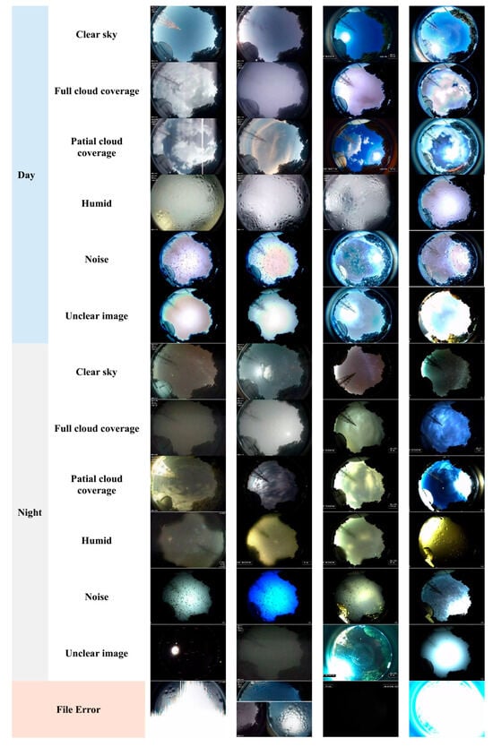
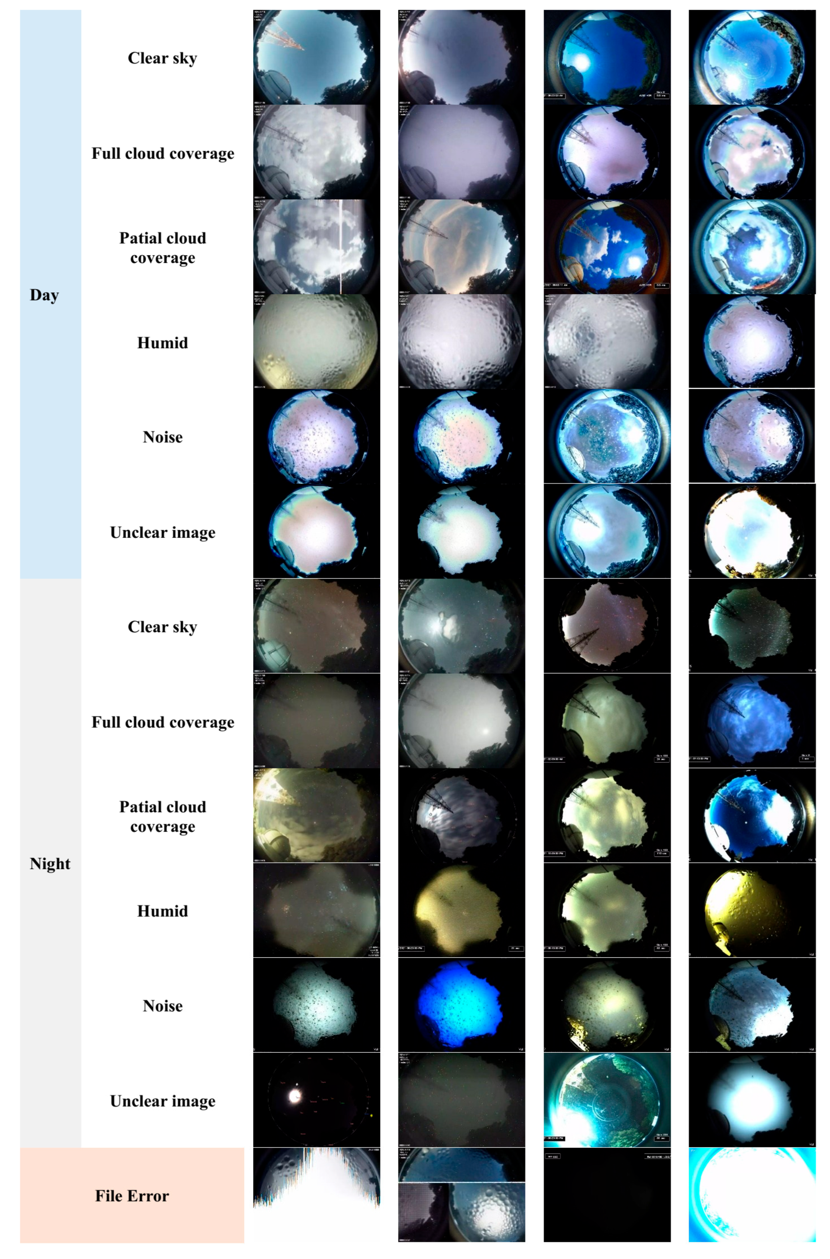
The TNO ASC system captures high-resolution RGB images periodically, day and night. To enhance data fidelity, each exposure is immediately followed by a dark frame to minimize sensor noise. Image calibration is also performed to correct for lens distortion and accurately map pixel to sky coordinates, facilitating precise sky condition analysis. While environmental factors like rain, fog, haze, condensation, and moonlight can affect image quality, the ASC system is designed to operate robustly even under these variable conditions. Leveraging this robust imaging infrastructure, a comprehensive all-sky dataset of 122,660 RGB images was curated for this research. It was collected continuously from September 2020 to February 2022, covering two full annual cycles to ensure representation of monsoon, dry, transition, and winter seasons. This temporal span captures substantial variability in cloud density, humidity, haze, precipitation, and illumination conditions, supporting seasonal generalization. These images capture a broad range of atmospheric conditions, including clear skies, partial and full cloud coverage, humidity interference, noise artifacts, and visibility degradations during both daytime and nighttime. Each image was manually annotated into 13 specific classes, designed to capture both environmental phenomena and critical image quality factors for sky monitoring. These classes as shown in Figure 1 include File Error, Daytime Clear Sky, Daytime Partial Cloud Coverage, Daytime Full Cloud Coverage, Daytime Unclear Image, Daytime Humidity Interference, Daytime Noise, Nighttime Clear Sky, Nighttime Partial Cloud Coverage, Nighttime Full Cloud Coverage, Nighttime Unclear Image, Nighttime Humidity Interference, and Nighttime Noise. This meticulous categorization allows the dataset to reflect subtle distinctions in atmospheric conditions, such as differentiating between partial and full cloud cover during the day or detecting humidity blurring and noise artifacts in low-light night-time periods. To ensure rigorous model development and evaluation, the dataset was partitioned into three subsets including Training Set (60%), comprising 73,591 images, which is used to train the deep learning model and learn generalizable feature representations. The Validation Set (20%), with 24,527 images, is crucial for hyperparameter tuning and monitoring overfitting during training. The Testing Set (20%), consisting of 24,542 images, was reserved for final model evaluation, providing an unbiased assessment of classification performance. Table 1 summarizes the class-wise distribution of the curated dataset across the training, validation, and testing subsets for all 13 sky-scene categories. The dataset exhibits a realistic, moderately imbalanced distribution, reflecting the true frequency of atmospheric phenomena observed at high-altitude tropical observatory sites. The most prevalent categories include Daytime Humidity Interference (19,585 samples) and Nighttime Clear Sky (19,398 samples), corresponding to the dominant humid and clear-sky regimes of the tropical mountain climate. Other frequent classes such as Daytime Partial Cloud Coverage (14,741 samples) and Nighttime Full Cloud Coverage (11,512 samples) represent transitional and overcast conditions that commonly occur during monsoon and post-monsoon seasons. In contrast, visually distinctive but less frequent classes, including Nighttime Noise (2136 samples) and File Error (4342 samples), represent rare operational and sensor-related conditions. This natural imbalance was intentionally preserved to maintain deployment realism and to ensure that model evaluation reflects real-world operational distributions. The stratified 60/20/20 data partitioning maintains consistent class proportions across training, validation, and testing subsets, enabling robust learning, reliable hyperparameter tuning, and unbiased performance assessment. Collectively, the dataset’s diversity in class frequency, illumination regimes, and atmospheric complexity provides a strong foundation for evaluating generalization performance under heterogeneous tropical sky conditions.
Figure 1.
Representative examples of the all-sky scene dataset covering all 13 classes.
Table 1.
Class-wise distribution of training, validation, and testing subsets across all 13 sky-scene categories.
The comprehensive nature of this dataset (capturing spatial, temporal, and atmospheric variability under real-world tropical conditions) makes it an invaluable resource for advancing automated sky condition classification using deep learning. Its inherent diversity and complexity provide the necessary foundation to train robust models capable of supporting real-time decision-making systems, particularly for telescope dome operations and atmospheric monitoring at astronomical observatories.
3. Materials and Methods
All-sky scene classification requires network architecture capable of modeling complex radiometric variability, fragmented cloud structures, and large-scale hemispherical context under real-world tropical conditions. To address these requirements, this study proposes the EASMNet, a domain-optimized deep learning architecture designed to provide stable and discriminative sky-scene representations for both daytime and nighttime all-sky imagery. The EASMNet is constructed upon the EfficientNetB7 backbone and enhanced through the integration of three targeted architectural modules, the SE blocks for channel-wise recalibration, the CBAM for spatial–semantic refinement, and the SPP for multi-scale context aggregation. These modules jointly improve feature discrimination, robustness, and generalization across heterogeneous atmospheric conditions and illumination regimes. Rather than a simple combination of existing components, the EASMNet adopts a hierarchical attention–context modeling strategy that enables stable representation learning under fisheye-projected hemispherical sky imagery. The complete architecture is logically organized into five sequential stages, which are described in detail in the following subsections.
3.1. Feature Extraction Backbone: EfficientNetB7
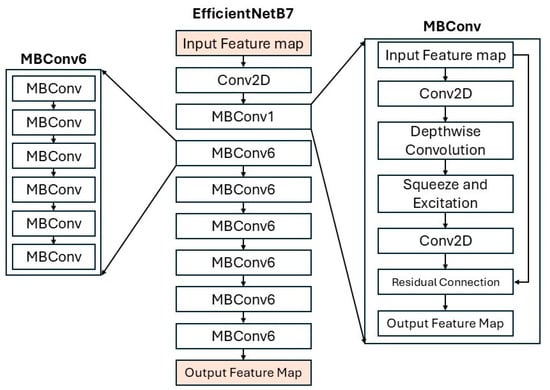
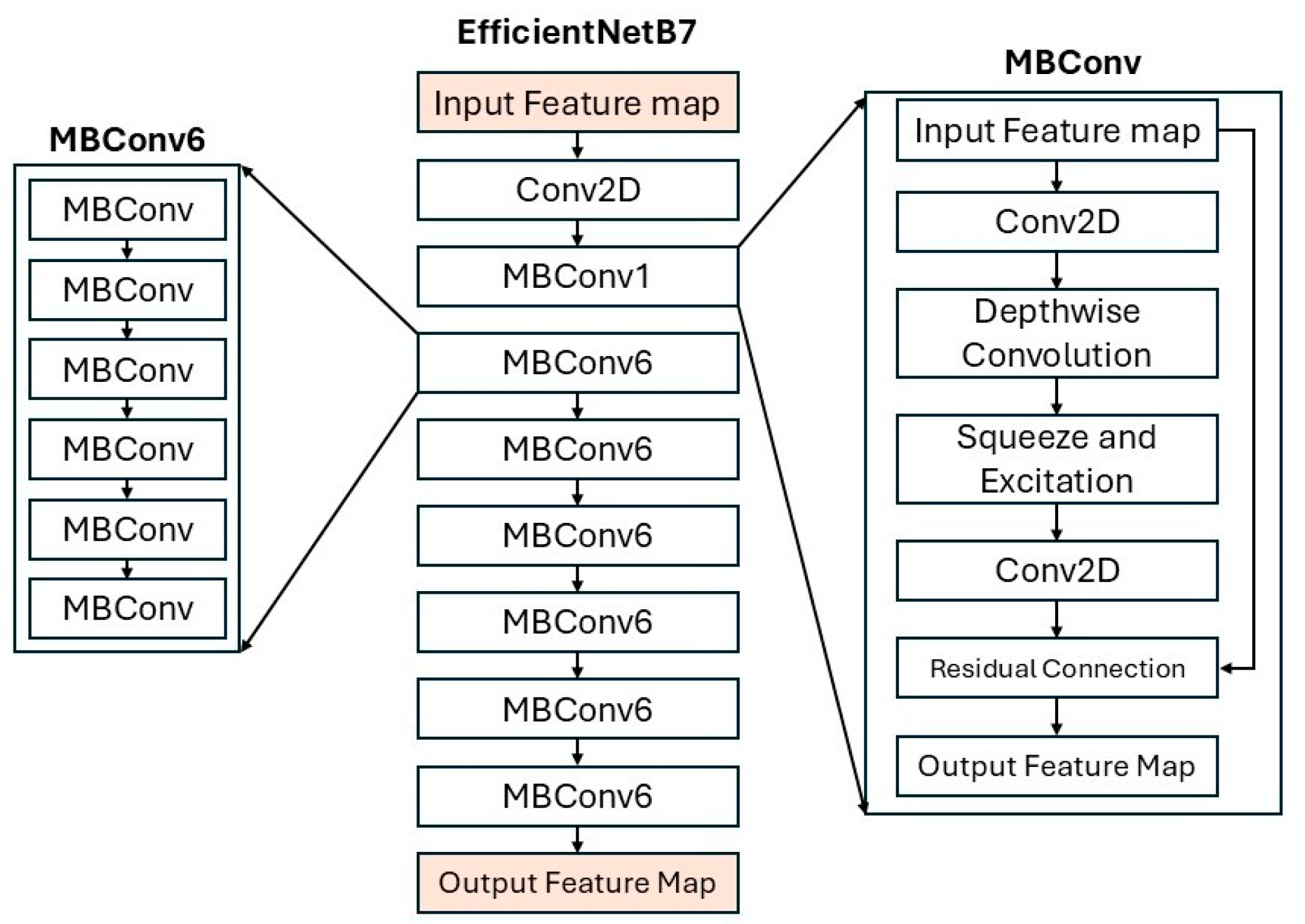
The core of the EASMNet’s feature extraction is the EfficientNetB7 architecture, a highly efficient convolutional neural network that adopts a compound scaling strategy to uniformly balance network depth, width, and resolution. This systematic scaling mechanism, proposed by Tan and Le [44], enables the model to achieve state-of-the-art performance with fewer parameters and floating-point operations compared to conventional architectures such as ResNet or DenseNet. EfficientNetB7 effectively combines accuracy and efficiency by leveraging Mobile Inverted Bottleneck Convolution (MBConv) blocks and depthwise separable convolutions, which significantly reduce computational costs while preserving representational capacity. Each MBConv6 block (where the expansion ratio t = 6) consists of five main stages such as an expansion phase that applies a 1 × 1 convolution to increase the number of channels sixfold (e.g., 160 to 960), a depthwise convolution phase using 3 × 3 or 5 × 5 kernels to extract spatial features per channel independently, a SE phase that recalibrates channel importance through global average pooling (GAP) and fully connected layers, a projection phase that reduces the channels back to a compact representation (e.g., 960 to 224) using another 1 × 1 convolution, and a residual connection that preserves low-level information when the input and output shapes are identical as shown in Figure 2.
Figure 2.
Network architecture of the EfficientNetB7 backbone.
These MBConv blocks are hierarchically stacked across seven stages, progressively reducing spatial resolution while increasing feature depth. For an input image of size 640 × 480 × 3, the representation evolves through successive layers from 320 × 240 × 64 after the initial stem convolution, to 160 × 120 × 96 and 80 × 60 × 144 in the early MBConv stages, then 40 × 30 × 240 and 20 × 15 × 384 in the mid-level layers, and finally 20 × 15 × 2560 in the deepest stage. The final 1 × 1 convolution and GAP layer yield a 1 × 1 × 2560 global feature tensor, encapsulating rich semantic information essential for downstream modules such as SE, CBAM, and SPP within the EASMNet. This hierarchical and efficient design ensures that the EASMNet maintains high discriminative capability while minimizing computational cost, making it highly suitable for large-scale all-sky image scene classification.
3.2. Channel Attention Enhancement—Squeeze-and-Excitation (SE) Blocks
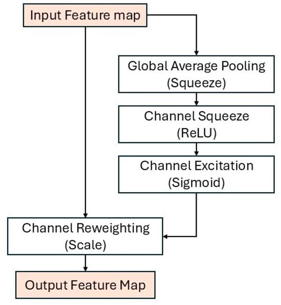
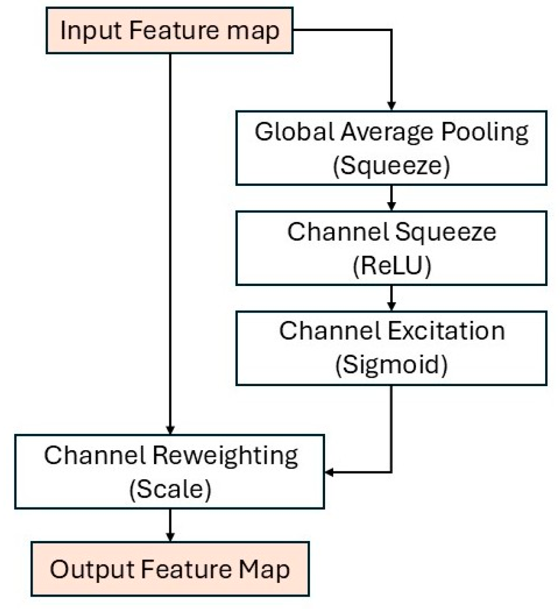
The Squeeze-and-Excitation (SE) block [45] is introduced to address radiometric inconsistency and humidity scattering by dynamically re-weighting spectral channels, allowing the network to emphasize physically informative bands (e.g., blue-sky contrast, haze-affected luminance channels) and suppress illumination-induced noise. It enhances a CNN’s representational capacity by modeling interdependencies among feature channels. Instead of treating all channels equally, SE adaptively recalibrates channel-wise responses to emphasize informative features and suppress less relevant ones. Given an input feature map of size H × W × C (e.g., 20 × 15 × 2560 from EfficientNetB7), the block performs three sequential operations. In the squeeze stage, the GAP aggregates spatial information within each channel, producing a compact 1 × 1 × C descriptor. In the excitation stage, this descriptor passes through two fully connected layers that capture channel dependencies—the first reduces the dimension to C/16 with ReLU activation and the second expands back to C with a sigmoid activation to generate normalized attention weights. In the scale stage, these weights are broadcast and multiplied with the original feature map, yielding a recalibrated output of the same size (H × W × C) with adaptively emphasized channels. The SE mechanism introduces negligible parameters while effectively improving feature discrimination, generalization, and robustness. Its process and dimensional transformations are illustrated in Figure 3.
Figure 3.
Architectural diagram of the Squeeze-and-Excitation (SE) block.
3.3. Spatial and Channel Attention Refinement—Convolutional Block Attention Module (CBAM)
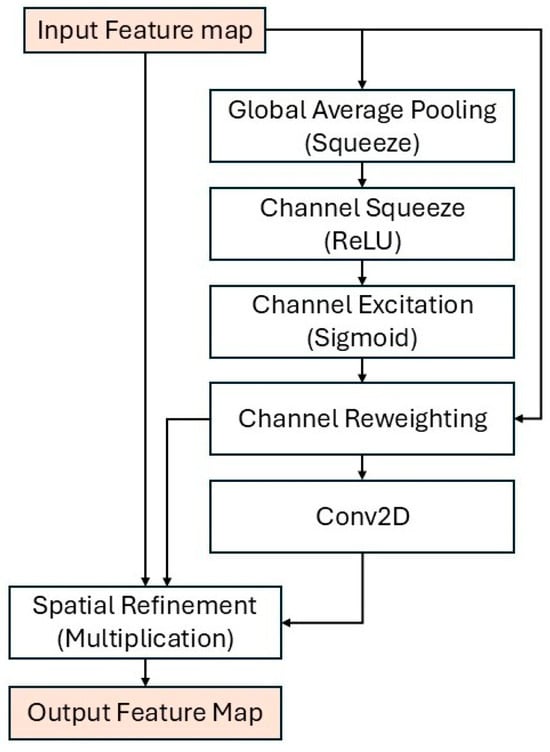
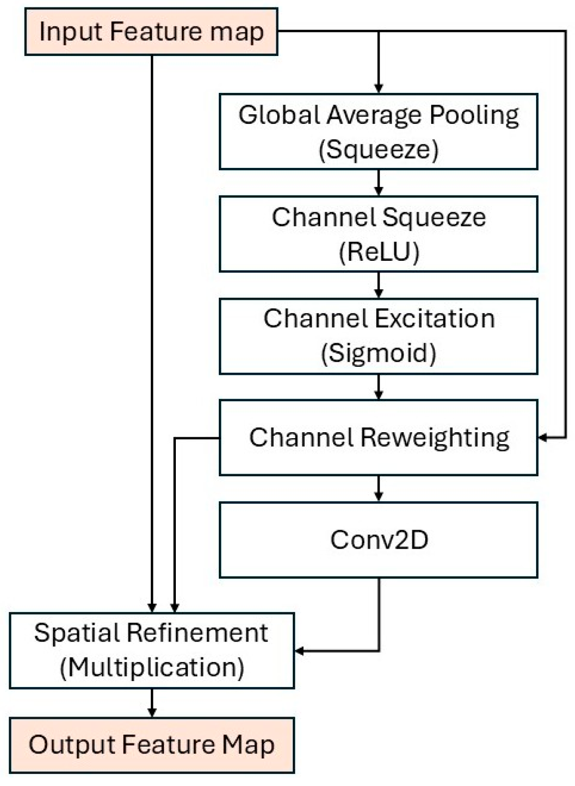
The Convolutional Block Attention Module (CBAM) [46], as illustrated in Figure 4, is incorporated to capture localized cloud structures, partial cloud fragments, and thin cloud boundaries that frequently cause misclassification in tropical sky conditions. The sequential channel–spatial attention enables the network to distinguish overlapping cloud layers and subtle atmospheric textures that are poorly modeled by standard convolution alone. It refines intermediate feature representations by sequentially applying channel and spatial attention to highlight informative features both across channels and spatial locations. Given an input feature map of size H × W × C, where H and W denote the spatial dimensions and C represents the number of feature channels (e.g., 20 × 15 × 2560 from the SE block), CBAM first applies channel attention by aggregating spatial information using both global average pooling (GAP) and global max pooling (GMP), each producing a 1 × 1 × C descriptor. These are passed through a shared multi-layer perceptron (MLP) with one hidden layer that compresses the dimension to C/16 and then restores it to C, followed by a sigmoid activation to yield a channel attention map . This map reweights the input feature map along the channel axis. Next, spatial attention is applied to the channel-refined feature map by computing two H × W × 1 maps via channel-wise average and max pooling. These are concatenated into an H × W × 2 map and processed by a 7 × 7 convolution followed by a sigmoid activation to produce a spatial attention map . Multiplying with the channel-refined features generates the final CBAM output, maintaining the same size (H × W × C) but with adaptively enhanced focus on salient spatial regions and feature channels. Integrating CBAM after SE allows the EASMNet to jointly capture global channel dependencies and fine-grained spatial cues, improving discriminative capacity and scene classification accuracy across diverse sky conditions.
Figure 4.
Architectural diagram of the Convolutional Block Attention Module (CBAM).
3.4. Multi-Scale Feature Aggregation—Spatial Pyramid Pooling (SPP)
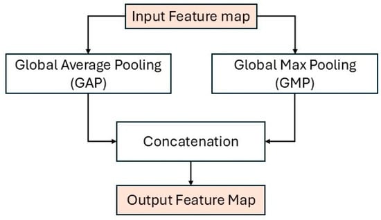
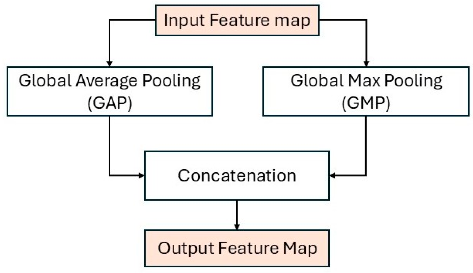
The Spatial Pyramid Pooling (SPP) module [47], as illustrated in Figure 5, is integrated to address large-scale variation in cloud formations, ranging from small fragmented cumulus clouds to sky-wide overcast layers. Multi-scale global pooling allows the model to preserve both local textural details and global sky coverage statistics, improving robustness across diverse meteorological patterns. It enhances the EASMNet’s capacity to capture multi-scale contextual information by aggregating features from different receptive fields without requiring fixed input dimensions. Given an input feature map of size H × W × C (e.g., 20 × 15 × 2560 after CBAM refinement), the SPP performs multiple pooling operations, typically the GAP and global max pooling (GMP), to extract both average contextual cues and dominant spatial responses. Each operation yields a 1 × 1×C descriptor, which is concatenated into a unified 1 × 1 × (2C) representation encoding complementary global statistics. This concatenated feature vector is subsequently forwarded to the classification head. By aggregating multi-scale features, SPP preserves spatial context lost during downsampling and enhances robustness to varying cloud patterns and illumination conditions. The final output of SPP is a 1 × 1 × (2C) compact yet semantically rich representation, effectively combining local detail and global context for accurate all-sky scene classification.
Figure 5.
Architectural diagram of the Spatial Pyramid Pooling (SPP) module.
3.5. Classification Head
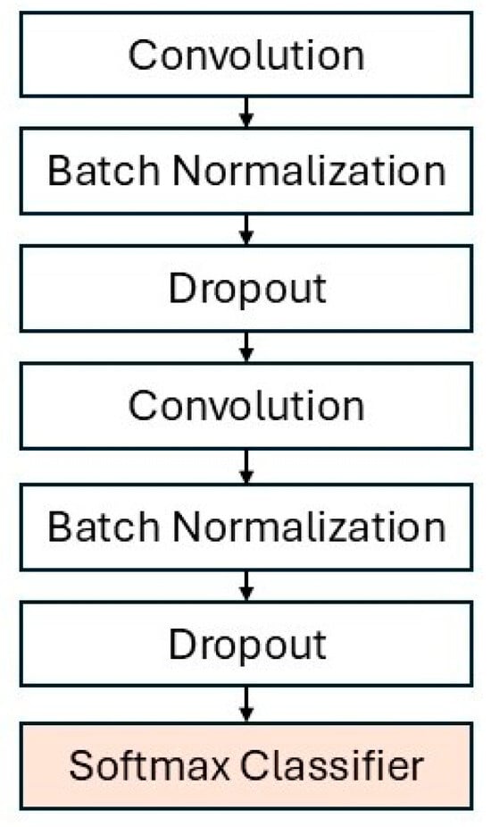
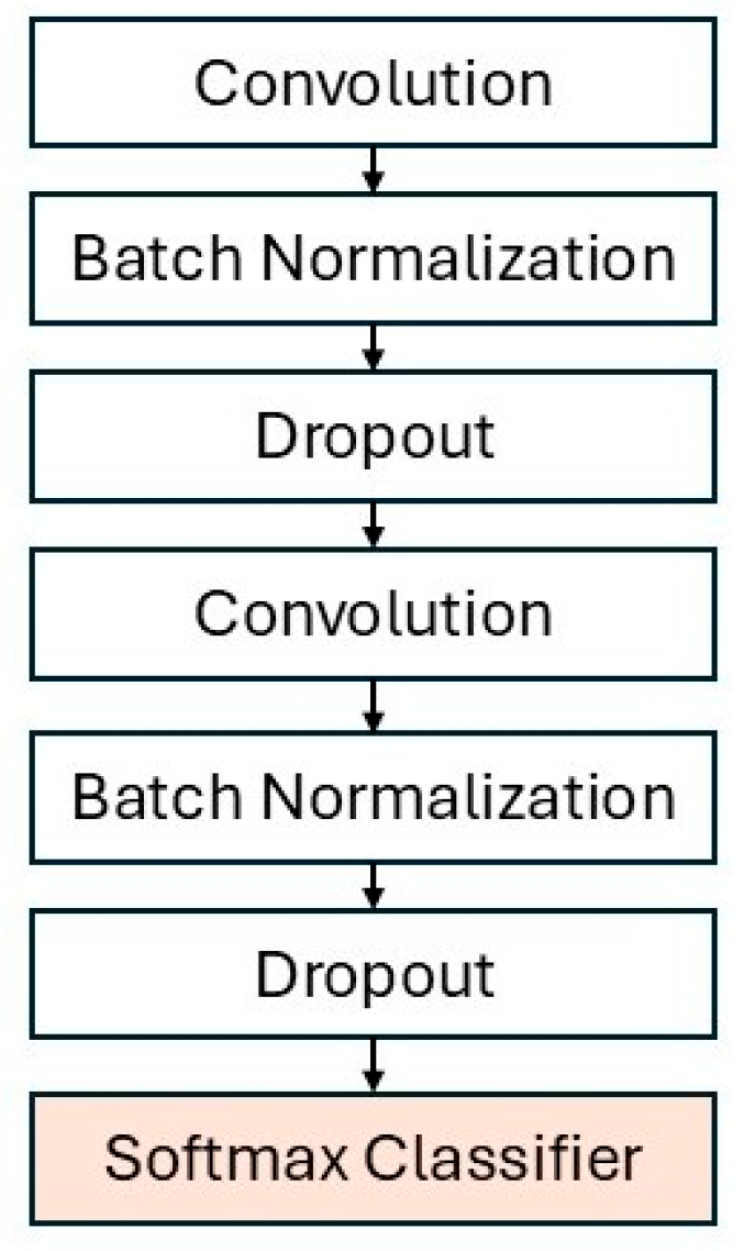
Features from the SPP layer (1 × 1 × (2C) e.g., 1 × 1 × 5120 for C = 2560) are flattened and fed into two dense layers (512 units each, ReLU), each followed by Batch Normalization to stabilize training and Dropout (0.5 then 0.6) to mitigate overfitting. This head learns non-linear decision boundaries for subtly different sky scenes. A final Softmax layer with 13 units outputs class probability, with the highest value indicating the predicted category, as illustrated in Figure 6. The classification head effectively bridges spatial, contextual feature hierarchies to semantic decisions while maintaining strong discriminative performance across diverse sky conditions.
Figure 6.
Architectural diagram of the classification head in the EASMNet.
3.6. The EASMNet Architectures
Before being fed into the EASMNet model, all input images undergo preprocessing, these images are resized to 640 × 480 pixels while preserving aspect ratios, and pixel values are normalized to the [0, 1] range. To enhance the model’s generalization and robustness, data augmentation techniques such as random horizontal flips and brightness adjustments are applied during training.
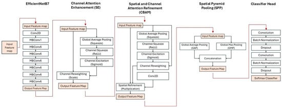
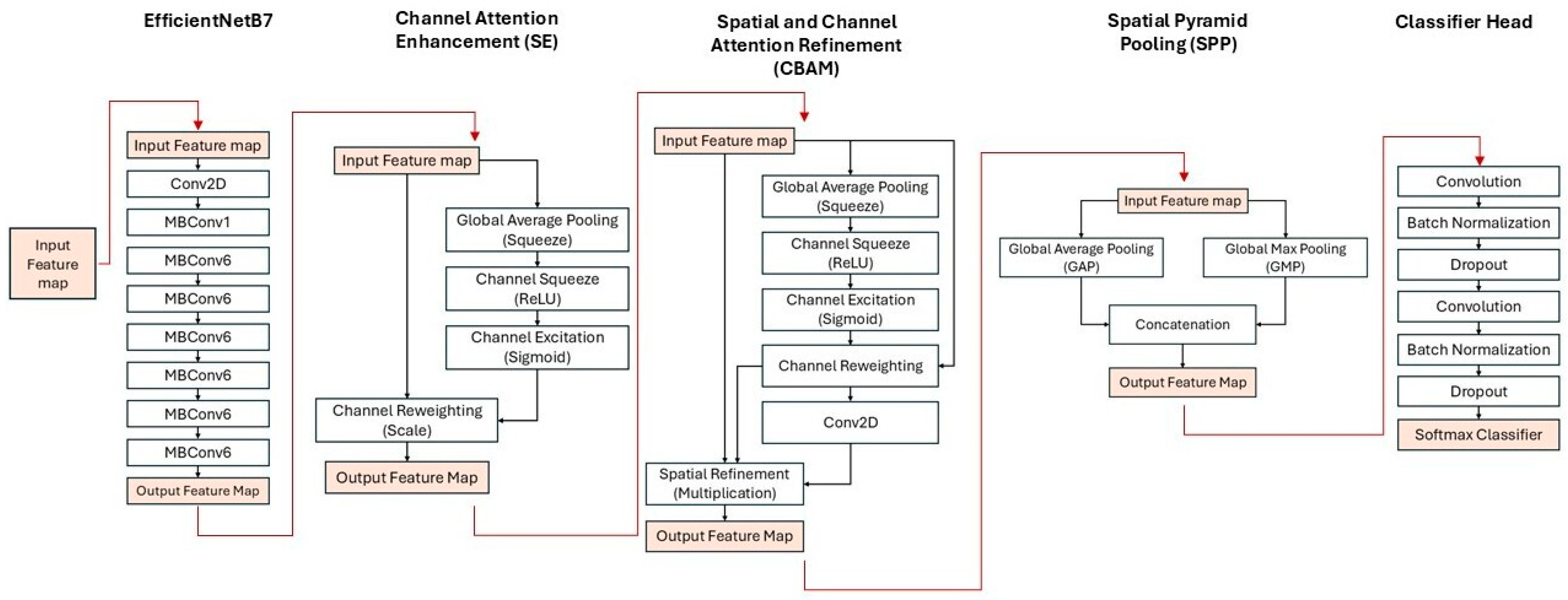
The EASMNet is a custom-designed deep learning architecture specifically optimized for classifying diverse all-sky scenes under varying atmospheric and illumination conditions. It’s built upon the EfficientNetB7 backbone, which is initialized with pre-trained ImageNet weights. This initialization provides a strong foundation, allowing flexible fine-tuning that balances general feature reuse with adaptation to the domain-specific radiometric and textural characteristics of all-sky imagery. The EfficientNetB7 backbone is further enhanced by integrating three key modules including the SE, the CBAM, and the SPP, as illustrated in Figure 7. The SE block is embedded within EfficientNet’s internal MBConv blocks to perform early-stage spectral recalibration, dynamically stabilizing low-level radiometric channels affected by illumination changes, humidity scattering, and haze prevalent in tropical atmospheres. This design allows the network to emphasize physically informative spectral responses while suppressing illumination-induced noise. CBAM is applied at the final high-level feature stage to enhance spatial–semantic discrimination, enabling the network to focus on spatially localized cloud boundaries, fragmented cloud textures, and thin cloud overlaps that are not sufficiently highlighted by early-stage channel recalibration alone. Although CBAM includes a channel attention submodule similar in formulation to SE, their functional roles within the EASMNet are intentionally distinct. SE focuses on low-level spectral stabilization, while CBAM enhances high-level spatial and semantic saliency, forming a hierarchical attention strategy that significantly improves robustness under complex tropical sky conditions. SE is therefore employed twice in EASMNet, first within EfficientNet’s internal MBConv blocks and again at the high-level feature stage, to stabilize both low-level radiometric channels and high-level semantic representations. This dual placement ensures consistent channel calibration across the feature hierarchy and contributes to improved generalization across day–night transitions and heterogeneous atmospheric patterns. SPP is integrated after CBAM to aggregate multi-scale spatial context, allowing the model to capture both fine and coarse sky structures simultaneously. By combining local texture cues with global sky-coverage statistics, SPP improves robustness across varying cloud formations and illumination conditions. Following feature extraction and hierarchical attention enhancement, the refined features are passed to the classification head. As previously described, this head includes dense layers, batch normalization, and dropout, culminating in the final 13-neuron Softmax output layer that predicts the specific sky-scene category (e.g., File Error, Daytime Clear Sky, Daytime Partial Cloud Coverage, Daytime Full Cloud Coverage, Daytime Unclear Image, Daytime Humidity Interference, Daytime Noise, Nighttime Clear Sky, Nighttime Partial Cloud Coverage, Nighttime Full Cloud Coverage, Nighttime Unclear Image, Nighttime Humidity Interference, and Nighttime Noise). This hierarchical integration directly reflects the physical formation processes and radiometric behavior of atmospheric scenes, transforming the model into a domain-aware atmospheric analysis framework rather than a generic backbone enhancement. The ablation results subsequently validate the necessity of each physically motivated component.
Figure 7.
Overall network architecture of the proposed EASMNet.
3.7. Optimization and Learning Rate Scheduling
Our models were trained using the Adam optimizer with an initial learning rate of 0.0001. To promote stable convergence and help the model escape local minima, we employed a Cosine Decay Restarts scheduler for dynamic learning rate adjustment. The training objective was defined by the sparse categorical cross-entropy loss function. We set the batch size to 4 to accommodate GPU memory constraints while ensuring sufficient diversity in the gradients. Each experiment ran for 100 epochs. To optimize memory usage and accelerate computation, mixed-precision training was enabled. All training was conducted on an NVIDIA Tesla V100-SXM2 GPU with 32 GB HBM2 memory (CUDA 11.5) (NVIDIA Corporation, Santa Clara, CA, USA) with TensorFlow’s automatic mixed-precision policy activated.
3.8. Performance Metrics
The performance of EASMNet was evaluated using standard classification metrics, including overall accuracy (OA), per-class precision, recall, and F1-score, along with confusion matrix analysis to assess class-wise discriminative capability. These metrics provide a comprehensive evaluation of model performance under both balanced and imbalanced class conditions. Precision and recall were computed for each of the 13 sky scene classes to measure the model’s ability to correctly identify both frequent and infrequent categories. The F1-score, representing the harmonic mean of precision and recall, was used to balance these aspects. A confusion matrix was also generated to visualize inter-class misclassifications and identify categories that the model commonly confuses. Together, these metrics offer a robust and interpretable assessment framework for quantifying classification performance across diverse sky conditions.
3.9. Experimental Protocol
To rigorously assess the effectiveness of the proposed EASMNet architecture and to quantify the contribution of each domain-driven component, a two-stage experimental protocol was designed, consisting of ablation analysis and benchmark comparison. In the first stage, ablation experiments were conducted to isolate and quantify the individual contribution of each architectural enhancement, namely the EfficientNet backbone, the SE blocks, the CBAM, and the SPP. Twelve model variants were systematically constructed, including baseline EfficientNet models (B1–B7), variants with individual module removal (No SE, No CBAM, No SPP), a Frozen EfficientNetB7 variant, and the Full EASMNet model. In the second stage, a benchmark comparison was performed to contextualize the EASMNet against representative convolutional and transformer-based architectures, including AlexNet, VGG16, ResNet50, DenseNet, MobileNetV3, EfficientNetB7, ConvNeXt, the ViT, Swin Transformer, and CaiT. All models were trained and evaluated under identical experimental conditions to ensure a fair and unbiased comparison. Evaluation metrics included OA, per-class Precision, Recall, and F1-score, along with Confusion Matrix analysis to investigate class-wise misclassification behavior. All baseline CNN and transformer models were trained using the same dataset partitions, input resolution (640 × 480), optimizer (Adam), learning rate (1 × 10⁻⁴ with cosine decay restarts), batch size (4), number of training epochs (100), and data augmentation strategies. The ViT employed a patch size of 16 × 16, while the Swin Transformer used a shifted window size of 7. The EfficientNetB7 backbone was initialized with ImageNet pre-trained weights, and all layers were fully unfrozen and jointly fine-tuned. Furthermore, uniform fine-tuning was adopted for all layers. Data augmentation included random horizontal flips and brightness adjustment to simulate illumination variability. Geometric rectification and fisheye distortion correction were deliberately not applied, as fisheye projection represents a physically meaningful imaging geometry for all-sky observation and rectification could distort authentic atmospheric structures. Mixed-precision training was implemented using TensorFlow’s automatic mixed-precision policy (mixed_float16), with FP16 computation and FP32 loss scaling to maintain numerical stability and accelerate training.
4. Results
This section presents a comprehensive evaluation of the proposed EASMNet through quantitative and qualitative experiments. The results include ablation studies, computational efficiency analysis, benchmark comparisons with standard deep learning models, and detailed class-wise performance and error analysis.
4.1. Ablation Experiment
To rigorously validate the contribution of each physically motivated architectural component in the EASMNet, a comprehensive ablation study was conducted. Twelve model variants were systematically constructed by selectively removing or modifying individual modules, including the SE blocks, the CBAM, the SPP, and the fine-tuning strategy of the EfficientNet backbone (B1–B7). All variants were trained and evaluated under identical experimental conditions to ensure fair and unbiased comparison. In addition to module removal experiments, stacking-order sensitivity experiments were performed to analyze the hierarchical interaction between SE, CBAM, and SPP. Results consistently demonstrated that applying CBAM after SE outperformed the reverse ordering. This confirms that early-stage radiometric channel stabilization prior to spatial–semantic refinement yields more stable saliency learning, which motivated the hierarchical attention strategy adopted in the EASMNet.
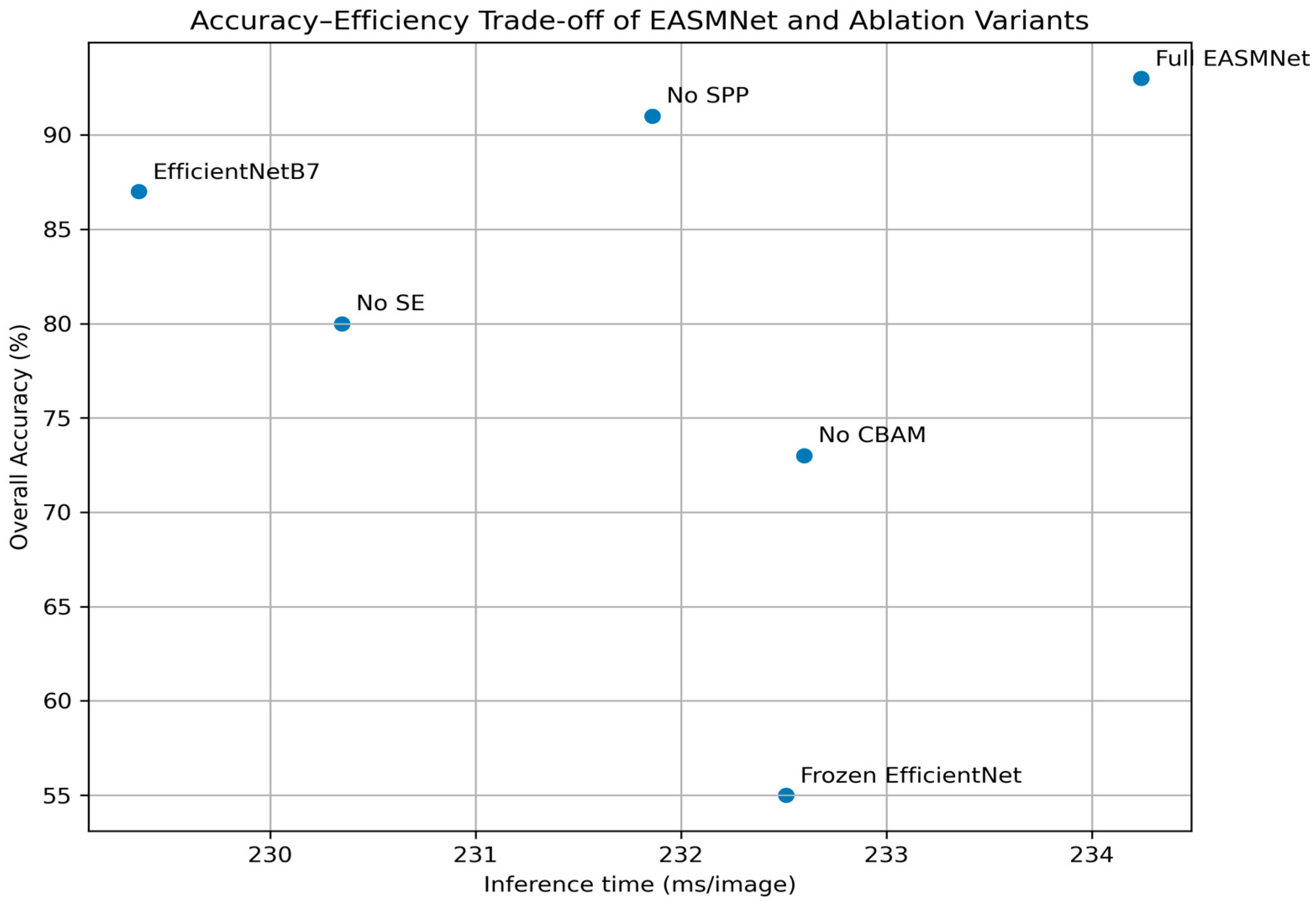
The quantitative results in Table 2 clearly demonstrate the effectiveness of the proposed domain-aware architecture. Among baseline backbones, EfficientNetB7 achieved the highest standalone accuracy (87%), with consistent improvement observed as model depth increased from B1 to B7. This confirms that deeper hierarchical feature extraction improves representation capacity for complex hemispherical sky patterns. When hierarchical attention and multi-scale context modules were integrated, performance improved substantially. The Full EASMNet model achieved the best overall performance with 93% accuracy, 92% precision, 93% recall, and 92% F1-score, validating the synergistic integration of SE, CBAM, and SPP. In contrast, removing individual components caused systematic performance degradation. No CBAM caused the most severe degradation (accuracy dropped to 73%), highlighting that spatial–semantic attention is critical for resolving fragmented thin-cloud boundaries and overlapping cloud layers under fisheye projection. No SE reduced accuracy to 80%, confirming the importance of early-stage radiometric channel stabilization in suppressing illumination scattering and haze-induced noise. No SPP maintained relatively high accuracy (91%), indicating that multi-scale aggregation mainly improves robustness across extreme cloud-scale variations rather than serving as the primary discriminative driver. Frozen EfficientNet exhibited catastrophic degradation (55%), confirming a substantial domain gap between natural image statistics and atmospheric hemispherical imagery, and demonstrating the necessity of full fine-tuning for domain-aware representation learning.
Table 2.
Quantitative results (%) of the ablation experiments. ✓ and ✕ indicate whether each module is in-cluded or excluded, respectively.
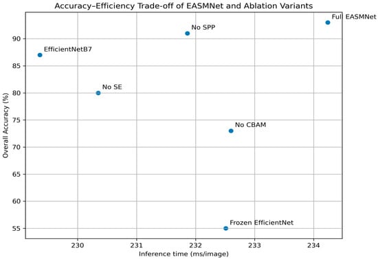
The efficiency analysis in Table 3 and Figure 8 further reveals the practical benefits of the proposed architecture. While EASMNet introduces a marginal increase in inference latency compared to EfficientNetB7 (234 ms vs. 229 ms per image), this small computational overhead yields a significant accuracy gain of +6%. Notably, removing CBAM slightly improves inference speed but leads to dramatic accuracy loss, indicating that CBAM is a critical efficiency–accuracy trade-off component. Similarly, the No SPP variant shows comparable efficiency to the EASMNet but lower robustness, confirming that SPP primarily contributes to generalization stability rather than speed. Figure 8 illustrates that the EASMNet lies on the Pareto frontier of the accuracy–efficiency spectrum, achieving the best balance between classification performance and real-time feasibility, making it suitable for continuous dome-operation environments. Progressive ablation further demonstrates that the SE and CBAM combination consistently outperforms either module alone, confirming a synergistic interaction between radiometric channel stabilization and spatial–semantic refinement. The addition of SPP further improves robustness by incorporating hemispherical sky-context statistics, yielding the optimal configuration. Collectively, these results validate that the EASMNet is not merely an aggregation of architectural modules but a physically grounded hierarchical atmospheric representation framework, in which each component plays a complementary role in resolving the radiometric, spatial, and scale-variant complexities of tropical all-sky imagery.
Table 3.
Model complexity and inference performance of EfficientNet backbones and the EASMNet in terms of parameters, FLOPs, per-image inference time, and frames per second (FPS).
Figure 8.
Accuracy–efficiency trade-off of EfficientNet backbones and the EASMNet, showing overall classification accuracy versus inference time per image.
4.2. Benchmark Comparison with Standard Deep Learning Models
To comprehensively evaluate the competitiveness and generalization capability of the proposed EASMNet, a benchmark comparison was conducted against representative convolutional and transformer-based deep learning architectures, including AlexNet, VGG16, ResNet50, DenseNet, MobileNetV3, EfficientNetB7, ConvNeXt, ViT, Swin Transformer, and CaiT. All models were trained and evaluated under identical experimental conditions using the same tropical all-sky dataset to ensure fair and unbiased comparisons. The quantitative results in Table 4 demonstrate that the EASMNet achieves the highest overall performance among all evaluated architectures, attaining 93% OA, 92% precision, 93% recall, and a 92% F1-score. This superior performance confirms the EASMNet’s enhanced capability to model hemispherical atmospheric scenes characterized by strong illumination transitions, haze scattering, thin-cloud fragmentation, and extreme multi-scale cloud structures. Among conventional CNN architectures, VGG16 showed strong generalization (89% accuracy), benefiting from its deep but structurally stable convolutional design. EfficientNetB7, which serves as the backbone of the EASMNet, also performed competitively (87% accuracy), validating its capacity as a high-quality feature extractor for hemispherical sky imagery. In contrast, lightweight architectures such as MobileNetV3 and ConvNeXt exhibited reduced performance due to limited capacity to capture fine-grained cloud boundaries and subtle radiometric variations. ResNet50 performed weakest among CNNs, suggesting that residual-only designs are insufficient for resolving the heterogeneous radiometric and spatial complexity of all-sky atmospheric imagery. Transformer-based models demonstrated mixed performance. Swin Transformer achieved the best transformer performance (90% accuracy), highlighting the benefit of hierarchical window-based attention for modeling large-scale sky structures. However, ViT and CaiT showed inferior results (79% and 82% accuracy, respectively), indicating that pure global-attention designs lack sufficient inductive bias for capturing localized thin-cloud boundaries and radiometric scattering patterns. These results demonstrate that accurate all-sky scene classification requires simultaneous radiometric stabilization, localized spatial–semantic refinement, and hemispherical multi-scale context aggregation. Architectures relying solely on convolution or transformer global attention are insufficient to fully address these requirements. The EASMNet’s hierarchical integration of SE, CBAM, and SPP within EfficientNetB7 provides a balanced inductive bias that effectively bridges convolutional locality and attention-based global contextual modeling.
Table 4.
Comparative performance (%) of the proposed EASMNet and standard deep learning architectures.
The computational efficiency analysis in Table 5 shows that EASMNet introduces a marginal computational overhead compared to EfficientNetB7. Lightweight CNNs achieve high FPS but sacrifice accuracy, while transformer-based models exhibit slower inference with inferior performance trade-offs. The EASMNet lies near the Pareto-optimal frontier of the accuracy–efficiency spectrum, making it suitable for real-time dome operation environments where both reliability and response time are critical. Collectively, the benchmark results confirm that the EASMNet is not merely a larger model, but a domain-aware atmospheric representation framework that systematically resolves the radiometric, spatial, and scale-variant complexities of tropical all-sky imagery more effectively than generic CNN or transformer architectures.
Table 5.
Computational complexity and inference performance of the EASMNet and benchmark deep learning models in terms of parameters, FLOPs, inference time, and frames per second (FPS).
4.3. Classification Performance and Error Analysis of the EASMNet
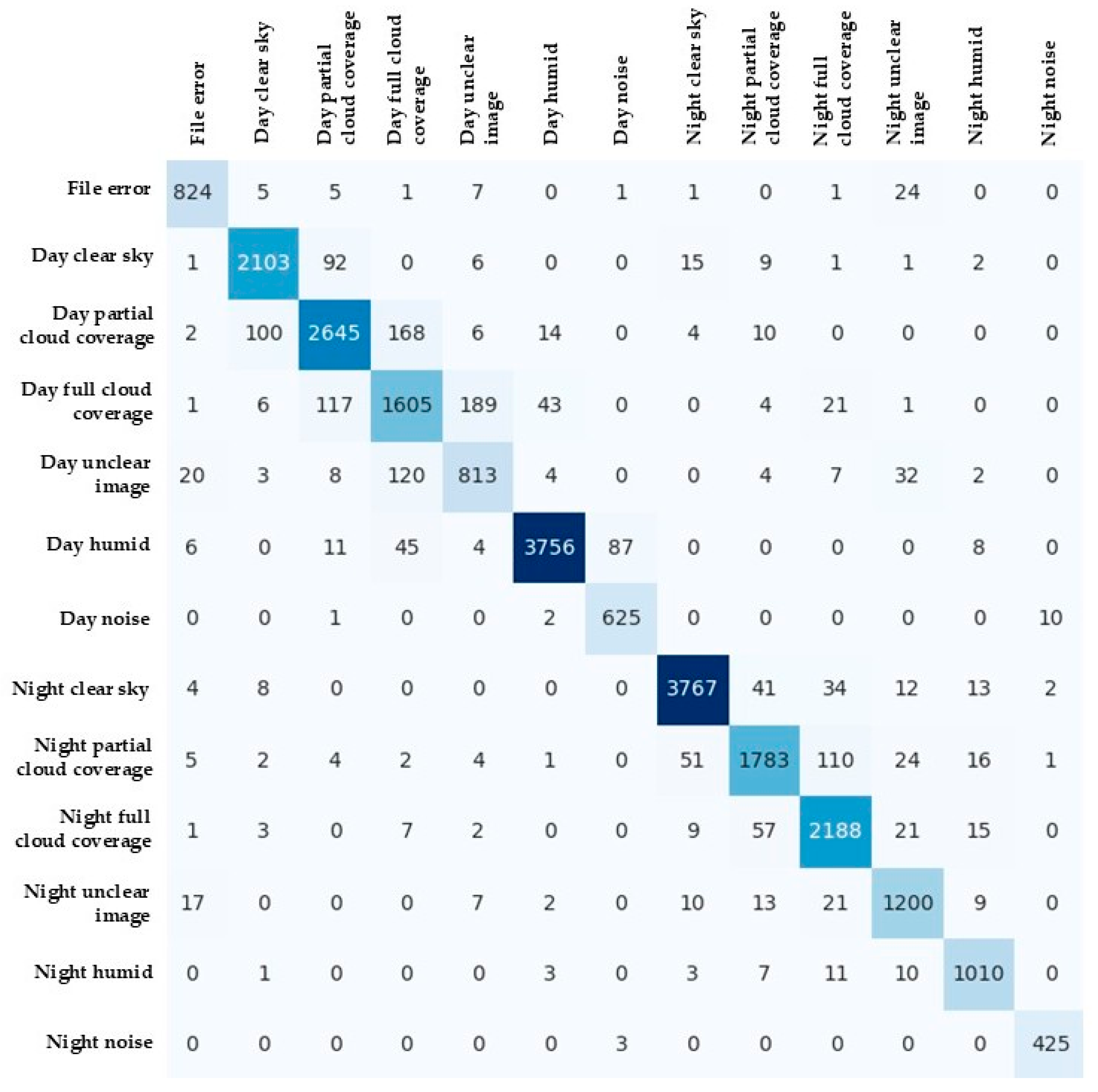
Table 6 summarizes the detailed performance metrics of the optimized CNN model in terms of precision, recall, F1-score, and support for each of 13 all-sky scene classes. The model achieved an OA of 93%, with macro- and weighted-average F1-score of 0.92 and 0.93, respectively, demonstrating consistently high predictive performance across most categories. The best-performing classes include Day Humid (F1-score of 0.97), Night Noise (F1-score of 0.98), and Night Clear Sky (F1-score of 0.97), all of which represent visually distinctive conditions characterized by strong contrast, stable illumination, and uniform brightness. In contrast, lower F1-score were observed for Day Partial Cloud Coverage (0.82) and Day Unclear Image (0.79), where the sky conditions are visually ambiguous or transitional, leading to increased misclassification.
Table 6.
Class-wise classification performance (%) of the EASMNet for all-sky image classification.
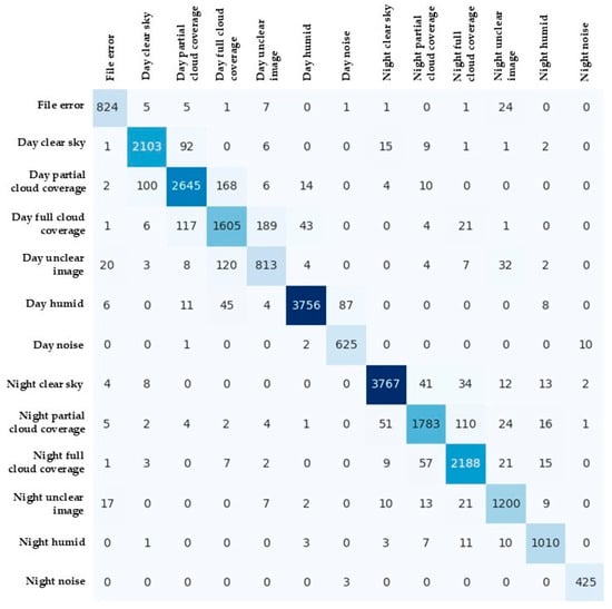
Figure 9 presents the confusion matrix illustrating the distribution of classification results across 13 classes. The matrix exhibits strong diagonal dominance in several categories such as Day Full Cloud Coverage, Day Humid, Night Clear Sky, and Night Full Cloud Coverage, confirming the model’s ability to correctly identify distinct atmospheric patterns. These well-performing classes show clear and consistent textural and luminance features that enable effective learning and reliable recognition. Misclassifications primarily occur among visually similar or overlapping categories. For instance, Day Partial Cloud Coverage and Day Unclear Image show substantial confusion due to similar brightness and cloud density variations, particularly when thin clouds or haze create intermediate patterns between clear and overcast skies. Similarly, Night Partial Cloud Coverage and Night Full Cloud Coverage were often interchanged because of illumination variability under moonlit conditions, which reduces visual contrast between different cloud densities. Day Unclear Image was occasionally confused with Night Unclear Image, likely caused by fog, condensation, or exposure imbalance that weakens edge definition. In addition, minor overlaps were observed for the File Error class with Day Unclear Image and Night Unclear Image, as overexposed or corrupted frames share similar featureless luminance characteristics.
Figure 9.
Confusion matrix illustrating the classification performance of the EASMNet across 13 all-sky scene categories.
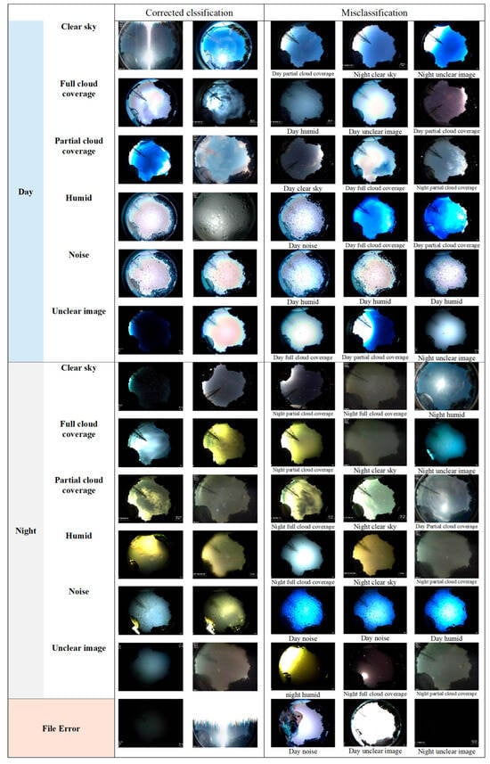
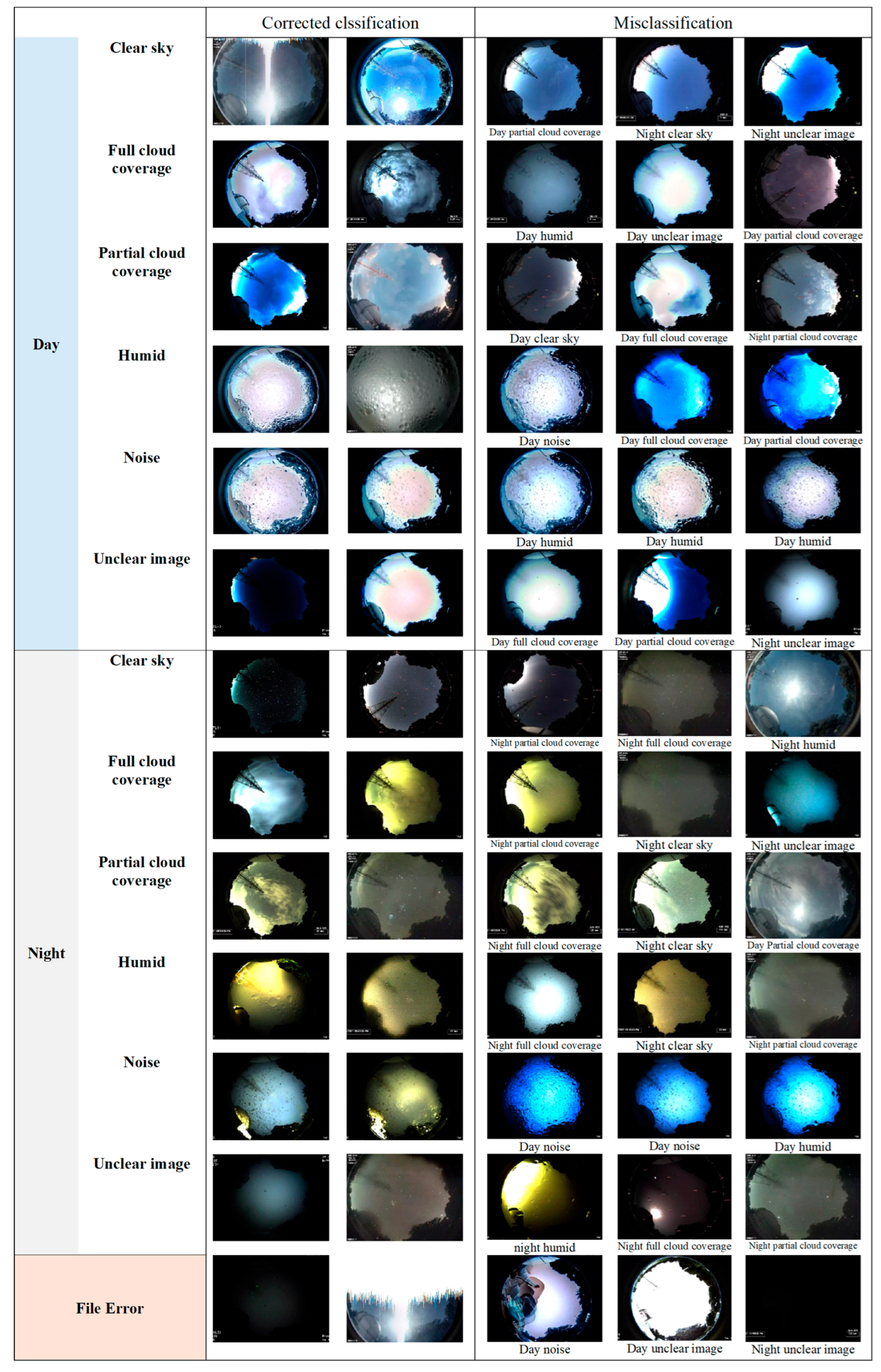
Figure 10 illustrates representative examples of both correctly classified and misclassified samples across 13 sky-scene categories, providing a visual interpretation of the EASMNet’s classification behavior. Correctly identified images reveal that the model effectively distinguishes classes with strong visual signatures. Day Clear Sky and Night Clear Sky exhibit high contrast and smooth luminance, allowing precise separation from cloudy or hazy conditions. Day Full Cloud Coverage and Night Full Cloud Coverage show uniformly bright textures and diffuse illumination, while Day Humid and Night Humid present consistent low-contrast, soft-scattering patterns that the network learns reliably. Distinct artifacts in Day Noise and Night Noise—caused by camera interference or pixel distortion—are also correctly recognized due to their high-frequency speckle features. These observations align with the strong diagonal dominance observed in the confusion matrix for these categories. In contrast, the misclassified samples reveal characteristic ambiguities among visually similar or transitional scenes. Day Partial Cloud Coverage is often confused with Day Full Cloud Coverage or Day Clear Sky because intermediate cloud density and uneven illumination blur the boundaries between clear and overcast skies. Day Unclear Image is sometimes misclassified as Day Full Cloud Coverage or Night Unclear Image, primarily due to fog, dome condensation, or exposure imbalance that suppresses edge contrast. Day Humid may be mistaken for Day Full Cloud Coverage or Day Partial Cloud Coverage, as heavy moisture produces diffuse scattering that mimics overcast brightness. Night Partial Cloud Coverage and Night Full Cloud Coverage are frequently interchanged under moonlit conditions, where illumination variability diminishes contrast between thin and thick clouds. Night Unclear Image may be predicted as Night Humid because both displays blurred, low-contrast structures caused by atmospheric moisture. Day Noise and Night Noise are occasionally misclassified as Day Humid, given overlapping brightness irregularities and speckle distributions. Finally, a few File Error samples were incorrectly labeled as Day Unclear Image or Night Unclear Image, since uniform brightness or corrupted regions visually resemble degraded atmospheric images.
Figure 10.
Examples of correctly classified and misclassified samples across all-sky scene classes.
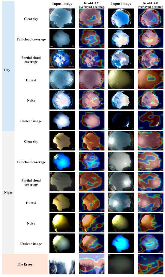
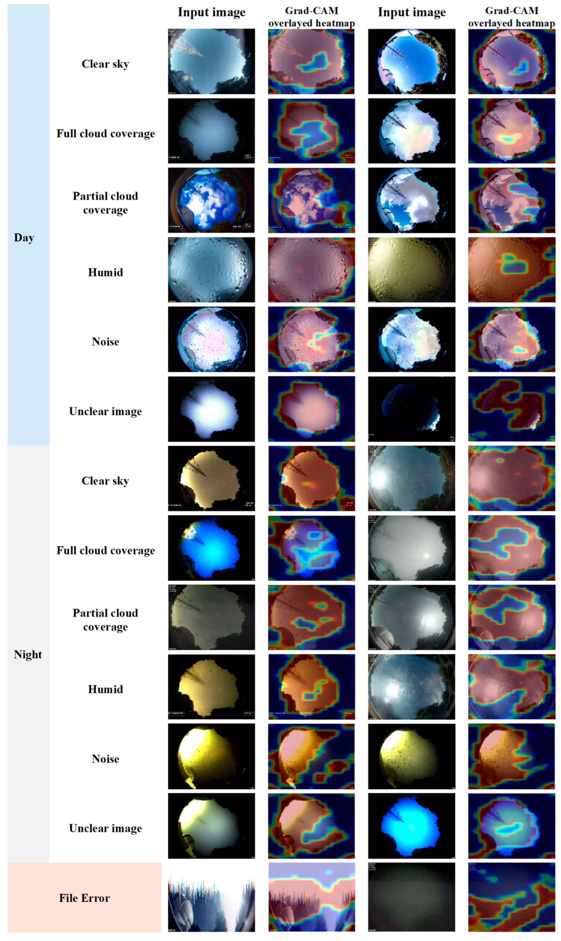
To further interpret the decision-making behavior of the EASMNet, Gradient-weighted Class Activation Mapping (Grad-CAM) was employed to visualize the spatial regions that most strongly contributed to the model’s predictions. Representative Grad-CAM heatmaps for major all-sky scene categories are shown in Figure 11. The activation maps reveal that the EASMNet consistently focuses on physically meaningful atmospheric structures rather than irrelevant background regions. For clear-sky scenes, the network primarily attends to smooth high-luminance sky regions while suppressing peripheral non-sky elements, indicating that classification decisions are driven by uniform radiometric patterns rather than edge artifacts. In full cloud coverage conditions, strong activation is concentrated over dense stratiform cloud layers occupying the central sky dome, confirming that the model captures global overcast brightness distributions. For partial cloud coverage, Grad-CAM highlights fragmented cloud boundaries and localized high-contrast cloud patches, reflecting sensitivity to thin-cloud discontinuities produced by fisheye projection. In humid scenes, the network consistently emphasizes regions exhibiting low-contrast diffuse scattering and condensation blur, demonstrating its ability to identify humidity-induced radiometric attenuation. Noise categories show activation over high-frequency speckle regions and sensor-interference artifacts, validating that the EASMNet effectively learns non-atmospheric image degradation patterns. For unclear image and file error classes, the activation maps concentrate on uniformly saturated or corrupted regions, indicating that the model distinguishes structural image failure from true atmospheric phenomena. Collectively, the Grad-CAM visualizations confirm that the EASMNet’s hierarchical SE–CBAM–SPP attention mechanism guides the network to attend to radiometrically and physically relevant atmospheric features, thereby supporting the interpretability, reliability, and operational trustworthiness of the proposed domain-aware sky-scene classification framework.
Figure 11.
Grad-CAM visualizations of representative all-sky scenes, highlighting the spatial regions that most strongly contribute to the EASMNet’s classification decisions across different sky-condition categories.
These qualitative observations reinforce quantitative metrics. The EASMNet performs robustly in detecting distinct sky conditions such as clear, humid, and fully overcast scenes but encounters challenges in transitional or low-contrast cases where atmospheric dynamics and sensor artifacts reduce class separability. The findings highlight the need to incorporate temporal and environmental contextual cues such as humidity, illumination, and exposure parameters to further enhance classification stability in real-world all-sky monitoring applications.
5. Discussion
The experimental results demonstrate that the EASMNet constitutes a robust and generalizable framework for hemispherical all-sky scene classification under highly heterogeneous tropical atmospheric conditions. The strong quantitative performance, combined with detailed ablation, benchmark, and error analyses, confirms that the proposed architecture effectively resolves the radiometric, spatial, and scale-variant complexities inherent to fisheye all-sky imagery. The observed performance improvements arise from the synergistic integration of hierarchical attention refinement, multi-scale context aggregation, and domain-specific fine-tuning. The SE blocks stabilize radiometric channel responses by adaptively recalibrating spectral bands affected by illumination transitions, humidity scattering, and haze. The CBAM further enhances spatial–semantic discrimination by emphasizing fragmented thin-cloud boundaries and localized contrast variations produced by hemispherical projection. The SPP aggregates hemispherical multi-scale sky-context statistics, enabling the network to capture both fine-grained cloud textures and global cloud-coverage distributions. Full fine-tuning of the EfficientNetB7 backbone proved indispensable for adapting ImageNet-derived features to the unique radiometric and textural statistics of all-sky imagery, highlighting the necessity of domain-aware representation learning.
Benchmark comparisons reveal that the EASMNet outperforms both conventional convolutional and transformer-based architectures. While Swin Transformer demonstrated strong capability in modeling long-range dependencies, its global attention emphasis was less effective in resolving localized thin-cloud fragmentation and low-contrast haze boundaries. Lightweight CNNs, such as MobileNetV3 and ConvNeXt, exhibited limited expressive capacity for complex atmospheric patterns, reflecting a trade-off between efficiency and representational richness. These findings indicate that hybrid architectures combining convolutional inductive biases with hierarchical attention and multi-scale aggregation provide superior modeling capacity for hemispherical atmospheric imagery.
Class-wise and confusion-matrix analyses reveal that residual misclassifications are primarily associated with physically transitional atmospheric regimes rather than architectural deficiencies. Ambiguities between Day Partial Cloud Coverage and Day Full Cloud Coverage arise from continuous radiance gradients produced by thin stratiform clouds and humidity-induced scattering, which form physically ambiguous states frequently observed during tropical convection cycles. Nighttime confusion between partial and full cloud categories is exacerbated by moonlight scattering and low-illumination noise, which reduce spatial contrast and blur cloud boundaries. Importantly, such confusion does not compromise operational safety for telescope dome automation, as both categories represent conservative closure conditions.
Despite its strong performance, the EASMNet exhibits reduced accuracy under extreme atmospheric disturbances such as heavy rain, dense fog, and lens condensation, where visibility loss fundamentally limits discriminative information. Future improvements may integrate illumination normalization, rare-condition augmentation strategies, and temporal continuity modeling to mitigate these challenges. Incorporating auxiliary meteorological sensor data (e.g., humidity, rainfall, sky luminance) may further enhance classification stability under ambiguous radiometric regimes. The dataset was collected at a single high-altitude tropical observatory. Although this environment exhibits strong atmospheric variability representative of tropical climates, cross-regional validation across coastal, urban, and low-altitude environments is required to assess global generalizability. The preserved class imbalance reflects realistic deployment distributions, and the strong class-wise performance confirms robust learning under operational conditions. The severe degradation observed in frozen-backbone experiments confirms the substantial domain gap between natural images and atmospheric hemispherical imagery, emphasizing the necessity of full-network domain-aware fine-tuning.
Unlike generic attention networks that emphasize generic visual saliency, the EASMNet introduces a hierarchical atmospheric modeling paradigm that explicitly maps atmospheric imaging physics into network design. Radiometric channel stabilization, thin-cloud fragmentation refinement, and hemispherical multi-scale aggregation collectively form a domain-aware atmospheric representation framework. This physics-aligned modeling strategy constitutes a substantive theoretical advancement beyond incremental architectural integration.
6. Conclusions
This study presents the EASMNet, a physics-aware deep learning framework for automated all-sky scene classification using hemispherical imagery acquired at the Thai National Observatory. By embedding atmospheric imaging principles into network design, the EASMNet integrates the SE for radiometric channel stabilization, the CBAM for spatial–semantic refinement of thin-cloud fragmentation, and the SPP for hemispherical multi-scale context aggregation within a fully fine-tuned EfficientNetB7 backbone. This hierarchical attention–context modeling strategy transforms conventional convolutional architectures into a domain-aware atmospheric representation framework rather than a generic classification network. Extensive experimental evaluations demonstrate that the EASMNet achieves 93% OA, consistently outperforming representative convolutional and transformer-based baselines, including Swin Transformer, EfficientNetB7, and DenseNet121. Ablation analyses confirm that each architectural component contributes complementary and physically interpretable functionality. SE stabilizes radiometric responses under illumination variability, CBAM enhances spatial discrimination of fragmented thin-cloud structures, and SPP improves robustness across extreme cloud-scale variations. Class-wise performance further indicates that the EASMNet excels in visually distinctive categories such as Day Humid, Night Clear Sky, and Night Noise, while remaining challenges are confined primarily to physically transitional and low-contrast regimes, such as Day Partial Cloud Coverage and Day Unclear Image. Overall, the EASMNet establishes a strong balance between classification accuracy, interpretability, and computational feasibility, making it well-suited for real-time observatory dome automation, astronomical scheduling, and continuous atmospheric monitoring. Future work will focus on extending robustness under extreme weather and illumination disturbances through temporal modeling, illumination normalization, and the integration of auxiliary environmental sensor data. Beyond its immediate application, the proposed framework provides a scalable and transferable foundation for autonomous atmospheric observation systems deployable across diverse climatic and geographic regions.
Author Contributions
Conceptualization, Wuttichai Boonpook, Peerapong Torteeka, Kritanai Torsri, Daroonwan Kamthonkiat, Yumin Tan, Asamaporn Sitthi and Patcharin Kamsing; methodology, Wuttichai Boonpook, Peerapong Torteeka and Kritanai Torsri; software, Wuttichai Boonpook, Utane Sawangwit and Kritanai Torsri; validation, Wuttichai Boonpook, Kritanai Torsri and Peerapong Torteeka; formal analysis, Wuttichai Boonpook and Peerapong Torteeka; investigation, Wuttichai Boonpook; resources, Wuttichai Boonpook and Peerapong Torteeka; data curation, Wuttichai Boonpook, Thanachot Ngamcharoensuktavorn and Kijnaphat Suksod; writing—original draft preparation, Wuttichai Boonpook, Daroonwan Kamthonkiat and Yumin Tan; writing—review and editing, Daroonwan Kamthonkiat, Yumin Tan and Asamaporn Sitthi; visualization, Wuttichai Boonpook; supervision, Wuttichai Boonpook; project administration, Wuttichai Boonpook; funding acquisition, Wuttichai Boonpook and Chomchanok Arunplod. All authors have read and agreed to the published version of the manuscript.
Funding
This work is funded by the Faculty of Social Science, Srinakharinwirot University (No. 313/2566).
Data Availability Statement
The data presented in this study are available on request from the corresponding author. The data is not publicly available due to the permission of the data sharing policy.
Acknowledgments
All authors gratefully acknowledge the Faculty of Social Sciences, Srinakharinwirot University, for providing research funding. This work utilized datasets captured by the all-sky camera and computational resources from the Chalawan High-Performance Computing (HPC) cluster, operated and maintained by the National Astronomical Research Institute of Thailand (NARIT), under the Ministry of Higher Education, Science, Research, and Innovation, Royal Thai Government. The authors would also like to express their sincere gratitude to the reviewers and editors for their valuable, thorough, and constructive comments that have significantly improved this paper.
Conflicts of Interest
The authors declare no conflicts of interest.
References
- Bettonvil, F. A digital all-sky camera. In Proceedings of the International Meteor Conference, 24th IMC, Oostmalle, Belgium, 15–18 September 2005; pp. 90–98. [Google Scholar]
- Scarlatti, F.; Gómez-Amo, J.; Valdelomar, P.; Estellés, V.; Utrillas, M.P. An improved approach to determine aerosol properties from all-sky camera imagery: Sensitivity to the partially cloud scenes. Atmos. Environ. 2024, 327, 120495. [Google Scholar] [CrossRef] [Scilit]
- Scarlatti, F.; Gómez-Amo, J.L.; Valdelomar, P.C.; Estellés, V.; Utrillas, M.P. A machine learning approach to derive aerosol properties from all-sky camera imagery. Remote Sens. 2023, 15, 1676. [Google Scholar] [CrossRef] [Scilit]
- Jankowsky, F.; Wagner, S. Weather and atmosphere observation with the ATOM all-sky camera. EPJ Web Conf. 2015, 89, 03008. [Google Scholar] [CrossRef] [Scilit]
- Román, R.; González-Fernández, D.; Antuña-Sánchez, J.C.; Herrero del Barrio, C.; Herrero-Anta, S.; Barreto Velasco, Á.; Cachorro, V.E.; Doppler, L.; González, R.; Ritter, C. Star photometry with all-sky cameras to retrieve aerosol optical depth at night-time. Atmos. Meas. Tech. 2025, 18, 2847–2875. [Google Scholar] [CrossRef] [Scilit]
- Parisot, O.; Hitzelberger, P.; Bruneau, P.; Krebs, G.; Destruel, C.; Vandame, B. MILAN Sky Survey, a dataset of raw deep sky images captured during one year with a Stellina automated telescope. Data Brief. 2023, 48, 109133. [Google Scholar] [CrossRef] [Scilit] [PubMed]
- Rao, J.; Partamies, N.; Amariutei, O.; Syrjäsuo, M.; Van De Sande, K.E. Automatic auroral detection in color all-sky camera images. IEEE J. Sel. Top. Appl. Earth Obs. Remote Sens. 2014, 7, 4717–4725. [Google Scholar] [CrossRef] [Scilit]
- Gonçalves, J.A.; Bastos, L.; Pinho, J.; Granja, H. Digital aerial photography to monitor changes in coastal areas based on direct georeferencing. In Proceedings of the 5th EARSeL Workshop on Remote Sensing of the Coastal Zone, Prague, Czech Republic, 1–3 June 2011; pp. 1–3. [Google Scholar]
- Muztaba, R.; Yusuf, A.; Oktaviandra, A.; Wahidin, A.; Malasan, H.; Arifin, S.; Hafizah, I.; Kurniawan, M.; Sevira, Q.; Almahi, A. Development of an All-sky Camera for The Indonesian Sky Patrol Network. J. Phys. Conf. Ser. 2024, 2734, 012027. [Google Scholar] [CrossRef] [Scilit]
- Hirasawa, N.; Yabuki, M.; Shiobara, M.; Shimode, Y.; Kuji, M. Long-term all-sky-camera images and evaluated cloud-cover data at Syowa Station, Antarctica. Polar Data J. 2023, 7, 35–49. [Google Scholar]
- Tian, J.; Ge, L.; Wu, Y.; Zhou, Z. Astrometric calibration for all-sky camera with machine learning. Publ. Astron. Soc. Pac. 2022, 134, 035002. [Google Scholar] [CrossRef] [Scilit]
- Trigo-González, M.; Cortés-Carmona, M.; Marzo, A.; Alonso-Montesinos, J.; Martínez-Durbán, M.; López, G.; Portillo, C.; Batlles, F.J. Photovoltaic power electricity generation nowcasting combining sky camera images and learning supervised algorithms in the Southern Spain. Renew. Energy 2023, 206, 251–262. [Google Scholar] [CrossRef] [Scilit]
- Antuña-Sánchez, J.C.; Román, R.; Cachorro, V.E.; Toledano, C.; López, C.; González, R.; Mateos, D.; Calle, A.; de Frutos, Á.M. Relative sky radiance from multi-exposure all-sky camera images. Atmos. Meas. Tech. Discuss. 2020, 2020, 2201–2217. [Google Scholar] [CrossRef] [Scilit]
- Sun, S.; Ernst, J.; Sapkota, A.; Ritzhaupt-Kleissl, E.; Wiles, J.; Bamberger, J.; Chen, T. Short term cloud coverage prediction using ground based all sky imager. In Proceedings of the 2014 IEEE International Conference on Smart Grid Communications (SmartGridComm), Venice, Italy, 3–6 November 2014; pp. 121–126. [Google Scholar]
- da Rocha, V.R.; Fisch, G.; Costa, R.S.; Ruano, A. Anomaly detection in all-sky images: An approach using robust ensemble modeling of cloud cover fraction and prediction bounds. Eng. Appl. Artif. Intell. 2025, 143, 110003. [Google Scholar] [CrossRef] [Scilit]
- Akdemir, K.Ü.; Dindar, M.; Şenel, F.A.; Helhel, S. Development of a new hybrid cloud cover detection method for all sky mapping. Astron. Comput. 2022, 38, 100551. [Google Scholar] [CrossRef] [Scilit]
- Pfister, G.; McKenzie, R.; Liley, J.; Thomas, A.; Forgan, B.; Long, C.N. Cloud coverage based on all-sky imaging and its impact on surface solar irradiance. J. Appl. Meteorol. Climatol. 2003, 42, 1421–1434. [Google Scholar] [CrossRef] [Scilit]
- Kim, Y.M.; Kim, J.; Cho, H.K. Development of objective algorithm for cloudiness using all-sky digital camera. Atmosphere 2008, 18, 1–14. [Google Scholar]
- Alonso-Montesinos, J. Real-time automatic cloud detection using a low-cost sky camera. Remote Sens. 2020, 12, 1382. [Google Scholar] [CrossRef] [Scilit]
- Azhar, M.A.D.M.; Hamid, N.S.A.; Kamil, W.M.A.W.M.; Mohamad, N.S. Night Time Clouds Detection Above Permatapintar Observatory Using All-Sky Imagery. J. Teknol. 2022, 84, 33–42. [Google Scholar] [CrossRef] [Scilit]
- Yang, J.; Min, Q.; Lu, W.; Yao, W.; Ma, Y.; Du, J.; Lu, T.; Liu, G. An automated cloud detection method based on the green channel of total-sky visible images. Atmos. Meas. Tech. 2015, 8, 4671–4679. [Google Scholar] [CrossRef] [Scilit]
- Mondragón, R.; Alonso-Montesinos, J.; Riveros-Rosas, D.; Bonifaz, R. Determination of cloud motion applying the Lucas-Kanade method to sky cam imagery. Remote Sens. 2020, 12, 2643. [Google Scholar] [CrossRef] [Scilit]
- Kazantzidis, A.; Tzoumanikas, P.; Bais, A.F.; Fotopoulos, S.; Economou, G. Cloud detection and classification with the use of whole-sky ground-based images. Atmos. Res. 2012, 113, 80–88. [Google Scholar] [CrossRef] [Scilit]
- Alonso, J.; Batlles, F.; López, G.; Ternero, A. Sky camera imagery processing based on a sky classification using radiometric data. Energy 2014, 68, 599–608. [Google Scholar] [CrossRef] [Scilit]
- Tulpan, D.; Bouchard, C.; Ellis, K.; Minwalla, C. Detection of clouds in sky/cloud and aerial images using moment based texture segmentation. In Proceedings of the 2017 International Conference on Unmanned Aircraft Systems (ICUAS), Miami, FL, USA, 13–16 June 2017; pp. 1124–1133. [Google Scholar]
- Cheng, H.-Y.; Lin, C.-L. Cloud detection in all-sky images via multi-scale neighborhood features and multiple supervised learning techniques. Atmos. Meas. Tech. 2017, 10, 199–208. [Google Scholar] [CrossRef] [Scilit]
- Li, X.; Wang, B.; Qiu, B.; Wu, C. An all-sky camera image classification method using cloud cover features. Atmos. Meas. Tech. 2022, 15, 3629–3639. [Google Scholar] [CrossRef] [Scilit]
- Huertas-Tato, J.; Rodríguez-Benítez, F.; Arbizu-Barrena, C.; Aler-Mur, R.; Galvan-Leon, I.; Pozo-Vázquez, D. Automatic cloud-type classification based on the combined use of a sky camera and a ceilometer. J. Geophys. Res. Atmos. 2017, 122, 11045–11061. [Google Scholar] [CrossRef] [Scilit]
- Krauz, L.; Janout, P.; Blažek, M.; Páta, P. Assessing cloud segmentation in the chromacity diagram of all-sky images. Remote Sens. 2020, 12, 1902. [Google Scholar] [CrossRef] [Scilit]
- Mommert, M. Cloud identification from all-sky camera data with machine learning. Astron. J. 2020, 159, 178. [Google Scholar] [CrossRef] [Scilit]
- Bhandari, H.; Palit, S.; Chowdhury, S.; Dey, P. Can a camera tell the weather? In Proceedings of the 2021 36th International Conference on Image and Vision Computing New Zealand (IVCNZ), Tauranga, New Zealand, 8–10 December 2021; pp. 1–6. [Google Scholar]
- Paletta, Q.; Arbod, G.; Lasenby, J. Benchmarking of deep learning irradiance forecasting models from sky images–An in-depth analysis. Sol. Energy 2021, 224, 855–867. [Google Scholar] [CrossRef] [Scilit]
- Rajagukguk, R.A.; Kamil, R.; Lee, H.-J. A deep learning model to forecast solar irradiance using a sky camera. Appl. Sci. 2021, 11, 5049. [Google Scholar] [CrossRef] [Scilit]
- Rezk, M.; Tiwari, V.K.; Manandhar, P.; Krishnan, V.; Pomares, L.M. A CNN-Based Classifier for Quality Image Selection from Sky Cameras. In Proceedings of the 2024 7th International Conference on Signal Processing and Information Security (ICSPIS), Dubai, United Arab Emirates, 12–14 November 2024; pp. 1–6. [Google Scholar]
- Ma, W.; Zhou, H.; Wu, J.; Yang, F.; Cheng, X.; Li, D. Optimizing spatiotemporal prediction accuracy of regional solar irradiance through multi-angle cloud layer 3D reconstruction. Energy Convers. Manag. 2025, 334, 119814. [Google Scholar] [CrossRef] [Scilit]
- Ogliari, E.; Sakwa, M.; Cusa, P. Enhanced Convolutional Neural Network for solar radiation nowcasting: All-Sky camera infrared images embedded with exogeneous parameters. Renew. Energy 2024, 221, 119735. [Google Scholar] [CrossRef] [Scilit]
- Sakaino, H.; Gaviphatt, N.; Insisiengmay, A.; Zamora, L.; Ningrum, D.F.; Sumantyo, J.T.S. PanopticBlue: Transformer-based Camera Sky-Cloud-Weather Recognition and Classification. In Proceedings of the IGARSS 2023—2023 IEEE International Geoscience and Remote Sensing Symposium, Pasadena, CA, USA, 16–21 July 2023; pp. 5814–5817. [Google Scholar]
- Manandhar, P.; Tiwari, V.K.; Rezk, M.; Krishnan, V.; Pomares, L.M. Convolutional Deep Learning hierarchical classifier to identify synoptic sky conditions based on sky images. In Proceedings of the 2024 7th International Conference on Signal Processing and Information Security (ICSPIS), Dubai, United Arab Emirates, 12–14 November 2024; pp. 1–6. [Google Scholar]
- Zhoolideh Haghighi, M.H.; Ghasrimanesh, A.; Khosroshahi, H. Deep learning-based identification of precipitation clouds from all-sky camera data for observatory safety. arXiv 2025, arXiv:2503.18670. [Google Scholar] [CrossRef] [Scilit]
- Krizhevsky, A.; Sutskever, I.; Hinton, G.E. Imagenet classification with deep convolutional neural networks. Adv. Neural Inf. Process. Syst. 2012, 25, 1106–1114. [Google Scholar] [CrossRef] [Scilit]
- Simonyan, K.; Zisserman, A. Very deep convolutional networks for large-scale image recognition. arXiv 2014, arXiv:1409.1556. [Google Scholar]
- He, K.; Zhang, X.; Ren, S.; Sun, J. Deep residual learning for image recognition. In Proceedings of the 2016 IEEE Conference on Computer Vision and Pattern Recognition, Las Vegas, NV, USA, 27–30 June 2016; pp. 770–778. [Google Scholar]
- Huang, G.; Liu, Z.; Van Der Maaten, L.; Weinberger, K.Q. Densely connected convolutional networks. In Proceedings of the 2017 IEEE Conference on Computer Vision and Pattern Recognition, Honolulu, HI, USA, 21–26 July, 2017; pp. 4700–4708. [Google Scholar]
- Tan, M.; Le, Q. Efficientnet: Rethinking model scaling for convolutional neural networks. In Proceedings of the 36th International Conference on Machine Learning, Long Beach, CA, USA, 9–15 June 2019; pp. 6105–6114. [Google Scholar]
- Hu, J.; Shen, L.; Sun, G. Squeeze-and-excitation networks. In Proceedings of the 2018 IEEE Conference on Computer Vision and Pattern Recognition, Salt Lake City, UT, USA, 18–22 June 2018; pp. 7132–7141. [Google Scholar]
- Woo, S.; Park, J.; Lee, J.-Y.; Kweon, I.S. Cbam: Convolutional block attention module. In Proceedings of the European Conference on Computer Vision (ECCV), Munich, Germany, 8–14 September 2018; pp. 3–19. [Google Scholar]
- He, K.; Zhang, X.; Ren, S.; Sun, J. Spatial pyramid pooling in deep convolutional networks for visual recognition. IEEE Trans. Pattern Anal. Mach. Intell. 2015, 37, 1904–1916. [Google Scholar] [CrossRef] [Scilit] [PubMed]
- Vaswani, A.; Shazeer, N.; Parmar, N.; Uszkoreit, J.; Jones, L.; Gomez, A.N.; Kaiser, Ł.; Polosukhin, I. Attention is all you need. Adv. Neural Inf. Process. Syst. 2017, 30, 5998–6008. [Google Scholar]
- Dosovitskiy, A. An image is worth 16x16 words: Transformers for image recognition at scale. arXiv 2020, arXiv:2010.11929. [Google Scholar]
- Xie, E.; Wang, W.; Yu, Z.; Anandkumar, A.; Alvarez, J.M.; Luo, P. SegFormer: Simple and efficient design for semantic segmentation with transformers. Adv. Neural Inf. Process. Syst. 2021, 34, 12077–12090. [Google Scholar]
- Liu, Z.; Lin, Y.; Cao, Y.; Hu, H.; Wei, Y.; Zhang, Z.; Lin, S.; Guo, B. Swin transformer: Hierarchical vision transformer using shifted windows. In Proceedings of the 2021 IEEE/CVF International Conference on Computer Vision, Montreal, QC, Canada, 11–17 October 2021; pp. 10012–10022. [Google Scholar]

Disclaimer/Publisher’s Note: The statements, opinions and data contained in all publications are solely those of the individual author(s) and contributor(s) and not of MDPI and/or the editor(s). MDPI and/or the editor(s) disclaim responsibility for any injury to people or property resulting from any ideas, methods, instructions or products referred to in the content. |
© 2026 by the authors. Published by MDPI on behalf of the International Society for Photogrammetry and Remote Sensing. Licensee MDPI, Basel, Switzerland. This article is an open access article distributed under the terms and conditions of the Creative Commons Attribution (CC BY) license.