


Abstract
The A* algorithm is widely used in path planning for Automated Guided Vehicles (AGVs), but the path it generates is prone to collision with random obstacles. To address this issue, this paper proposes a hybrid path planning algorithm integrating the improved A* algorithm with Dynamic Window Approach (DWA). Firstly, a global key point extraction strategy is adopted, and Bresenham’s line algorithm is used to eliminate redundant path points and turning inflection points, optimizing the conciseness and continuity of the path while redefining the child nodes of the current position. Secondly, in complex environments, the inflection points of the global path are taken as the target points of DWA to segment the path, and local dynamic planning is combined to achieve real-time obstacle avoidance. Simulation results show that compared with the traditional A* algorithm, the improved algorithm reduces the planning time by 24.19%, decreases the number of inflection points by 40.00%, and shortens the path length by 1.49%. In environments with random obstacles, the path generated by the hybrid algorithm is smoother, which can effectively enhance the local obstacle avoidance capability and improve the safety of path planning. Furthermore, physical experiments on an AGV platform with a distributed master-slave control architecture (STM32 microcontroller and Jetson embedded processor) verify the algorithm’s hardware compatibility and real-time computing performance, validating its engineering applicability in practical industrial scenarios.
1. Introduction
Automated Guided Vehicles (AGVs) are a typical class of mobile robots and have become essential components in intelligent manufacturing, smart logistics, and automated material handling systems. In practical applications, AGVs are required to perform autonomous navigation efficiently, safely, and stably in complex and dynamic environments. Path planning is thus a critical technology for enhancing AGV autonomy and operational efficiency. An effective path planning algorithm should generate globally optimal paths while maintaining path smoothness, high computational efficiency, and real-time obstacle avoidance capability [1].
Path planning methods for mobile robots are generally divided into global and local approaches. Global path planning aims to search for the optimal path from a start point to a goal in a known environment. Common algorithms include A* [2], Dijkstra [3], genetic algorithms [4], and ant colony optimization [5]. Among these, A* is widely adopted due to its high search efficiency and good path quality. However, conventional A* algorithms often generate excessive redundant nodes and sharp turns when expanding nodes on a grid map, resulting in reduced path smoothness and increased computational load.
To address these issues, several improvements have been proposed. Yu et al. introduced heuristic weighting parameters into the A* evaluation function, improving search efficiency and reducing path turning points [6]. Nonetheless, the method still relies on conventional neighborhood expansion, leading to redundant nodes in complex environments. Zhang et al. increased the number of search directions to enhance path flexibility, producing paths closer to the true shortest route [7].; however, this approach significantly increases computational complexity due to the larger number of expanded nodes. Zhao et al. applied directional sampling to reduce the search space and improve planning efficiency [8], but sharp path turns remain in complex obstacle scenarios, which affects the smoothness of AGV motion.
In dynamic environments, relying solely on global path planning is insufficient for real-time obstacle avoidance, necessitating the integration of local path planning. The Dynamic Window Approach (DWA) is a representative local planner, which samples linear and angular velocities in the velocity space and evaluates candidate trajectories to achieve real-time obstacle avoidance [9]. DWA demonstrates high computational efficiency and responsiveness.; however, it is prone to local optima and may deviate from the globally optimal path due to its dependence on local information [10].
To balance global optimality and local obstacle avoidance, hybrid strategies combining A* and DWA have been developed. Liu et al. [11] incorporated kinematic constraints into the A* node expansion and heuristic function, guiding DWA with key global nodes, which improved path smoothness and tracking performance. However, redundant nodes persist in the global path due to conventional grid expansion. Liao et al. [12] applied adaptive heuristic weights to A* and combined it with DWA, reducing redundant nodes and enhancing search efficiency, but the suppression of sharp path turns in complex obstacle environments remains limited. Jiang et al. [13] introduced risk-based costs into the A* evaluation function and considered robot kinematics, employing path segmentation and B-spline smoothing to improve dynamic obstacle avoidance and path safety. Nevertheless, redundant nodes in the global path still affect planning efficiency. Han et al. [14] proposed a hybrid path planning method based on non-uniform Theta* and improved DWA for unmanned surface vehicles, enhancing path smoothness and dynamic obstacle avoidance in simulation, but real-world hardware validation was not performed. Despite the improvements achieved by these methods, challenges remain in complex environments, including excessive redundant nodes, dense turning points, and limited computational efficiency. Therefore, it is necessary to develop a path planning method that effectively reduces redundant nodes, enhances path smoothness, and maintains real-time obstacle avoidance capability.
To address the obstacle avoidance problem of AGVs in complex environments, this paper proposes a hybrid path planning algorithm that combines an improved A* algorithm with the Dynamic Window Approach (DWA). First, to overcome the issues of excessive redundant nodes, low search efficiency, and insufficient path smoothness inherent in the traditional A* algorithm, global key points are extracted based on the spatial distribution of obstacles, and the Bresenham line algorithm is employed to optimize child node selection. This approach significantly reduces the number of node expansions and improves search efficiency. Second, in complex and dynamic scenarios, the key inflection points of the global path are used as local target points for DWA, enabling real-time obstacle avoidance while maintaining coordination between global optimality and local dynamic safety. The proposed hybrid method effectively integrates the global optimality of the improved A* algorithm with the adaptability of DWA to complex environments, ensuring collision-free navigation in the presence of random obstacles while preserving overall path optimality. Furthermore, to verify the engineering feasibility of the proposed algorithm, a physical experiment is conducted on an actual AGV platform with a distributed master-slave control architecture (STM32 microcontroller coupled with a Jetson embedded processor), demonstrating its hardware compatibility and practical applicability in real-world navigation tasks.
The main contributions of this work are summarized as follows:
- (1)
- A global key-point extraction strategy based on obstacle dilation and erosion is proposed. It effectively reduces redundant nodes and path turning points from the source, eliminating the need for additional post-processing optimization.
- (2)
- A segment-based A*-DWA hybrid mechanism is designed, where global key points serve as local target points. This mechanism achieves efficient coordination between global guidance and local obstacle avoidance, thus addressing the frequent switching and motion oscillation issues of traditional hybrid algorithms.
- (3)
- The proposed algorithm is validated on an industrial-grade AGV hardware platform with an STM32 + Jetson distributed architecture. Experimental results demonstrate its feasibility and compatibility in terms of real-time performance, path smoothness, and dynamic obstacle avoidance.
2. Basic Environment
2.1. Map Environment Model
The core goal of AGV path planning is to design a safe and efficient navigation path in a known or detectable environment, considering constraints such as obstacle layout, feasible region definition, and AGV physical characteristics [15]. To achieve effective path planning, the actual environment needs to be abstracted and modeled into a form that can be processed by computers.
The grid method is an intuitive and easy-to-understand environmental modeling method. By dividing the environment into regular grid meshes, it can quickly generate path planning results and obtain relatively smooth paths [16]. Map the environmental information in the world coordinate system of the mobile robot’s motion area to the grid map. Let the side length of the square grid be , the angular resolution of the grid map be , and the maximum values of the x-axis and y-axis be and respectively. Then the number of rows and columns of the grid are and respectively. If the position of the robot in the world coordinate system is and the heading angle is , its state in the grid environment can be expressed as:
where round denotes the rounding operation; are the row and column coordinates of the grid center; a is the orientation in the grid map; the state parameters of node pi can be expressed as .
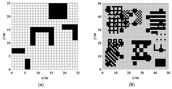
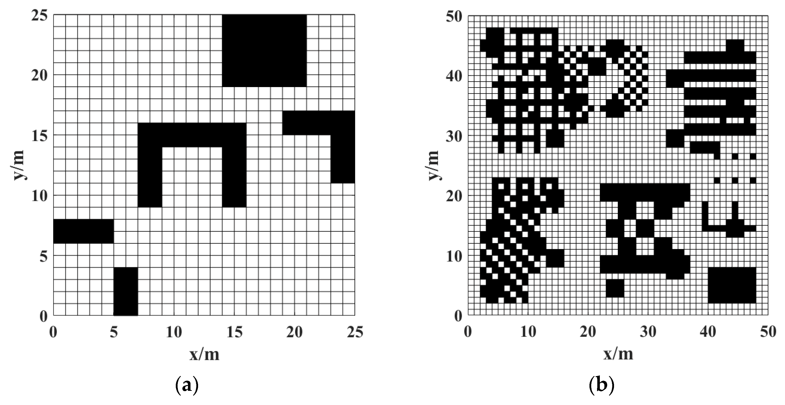
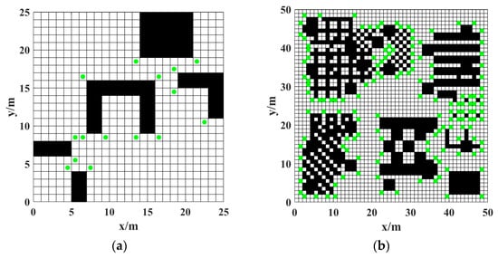
To simplify calculations and improve efficiency, obstacle expansion is performed during the modeling process, and the expansion distance is equal to the radius of the AGV’s circumscribed circle to ensure the reliability of local obstacle avoidance. As shown in Figure 1, there are two grid maps of different sizes, where the black grids represent obstacle areas (impassable) and the white grids represent obstacle-free areas (freely passable).
Figure 1.
Grid maps. (a) 25 × 25 grid map; (b) 50 × 50 grid map.
2.2. Search Range
The traditional A* algorithm introduces an estimated cost on the basis of the Dijkstra algorithm, and evaluates the total node cost through the sum of the actual cost and the estimated cost to the target point, namely:
where is the obstacle-free distance from the current node to the target node; is the cumulative actual movement cost from the start node to the current node. When the node is close to the end point, decreases and increases, is closer to the true value, the number of node expansions is reduced, and the calculation speed is improved; when there are obstacles between the node and the end point, the estimated value of is less than the true value, and the number of node expansions increases.
In the design of the cost function, the Euclidean distance and Manhattan distance are used to measure the actual cost (Formula (3)) and the estimated cost (Formula (4)) respectively:
where is the actual cost of the current parent node; are the coordinates of the current parent node; are the coordinates of the current node; are the coordinates of the target point.
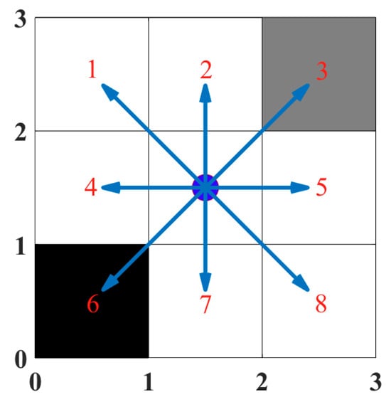
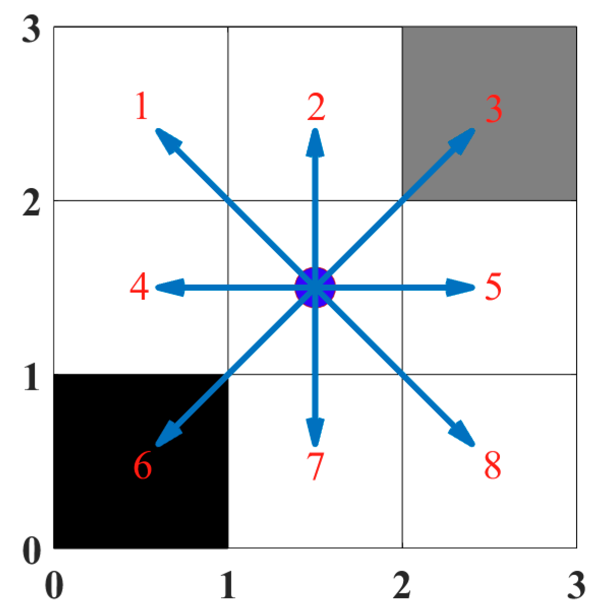
In terms of the node expansion mechanism, the traditional A* algorithm adopts an 8-neighborhood expansion strategy (as shown in Figure 2), generating 8 adjacent nodes of the current node as candidate child nodes in the 2D grid map. Nodes located on obstacles (such as nodes 3 and 6) are excluded through the obstacle detection module, and the remaining legal nodes (1, 2, 4, 5, 7, 8) form the child nodes of the current node.
Figure 2.
Schematic diagram of child node expansion in the traditional A* algorithm.
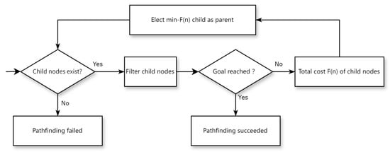
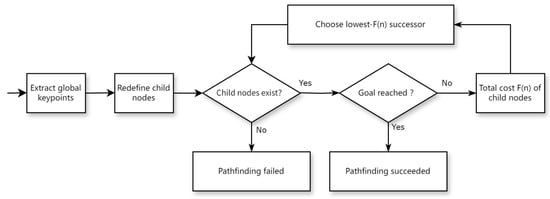
The algorithm execution process (Figure 3) adopts a priority queue-driven iterative optimization mechanism: the start node is added to the OPEN list during initialization; in each cycle, the node with the smallest F(n) value is selected for expansion, child nodes are generated and their cost functions are calculated; when the child nodes include the target node, the optimal path is constructed by backtracking through the parent node pointer; if the target node is not found after the OPEN list is exhausted, it is determined that there is no feasible path. This process achieves progressive optimal path search through dynamic sorting of the cost function.
Figure 3.
Pathfinding flow of the traditional A* algorithm.
3. Improved A* Algorithm
3.1. Extraction of Global Key Points
To reduce the number of redundant points and inflection points and improve path search efficiency, the expanded corner points of obstacles are selected as global key points, as defined in Formula (5):
where denotes the dilation operation, denotes the erosion operation, is the binary map to be dilated and eroded, is the structuring element for dilation, is the structuring element for erosion, and is the resulting image.
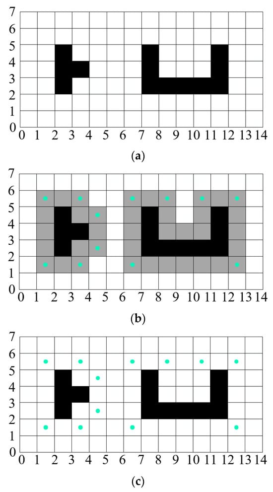
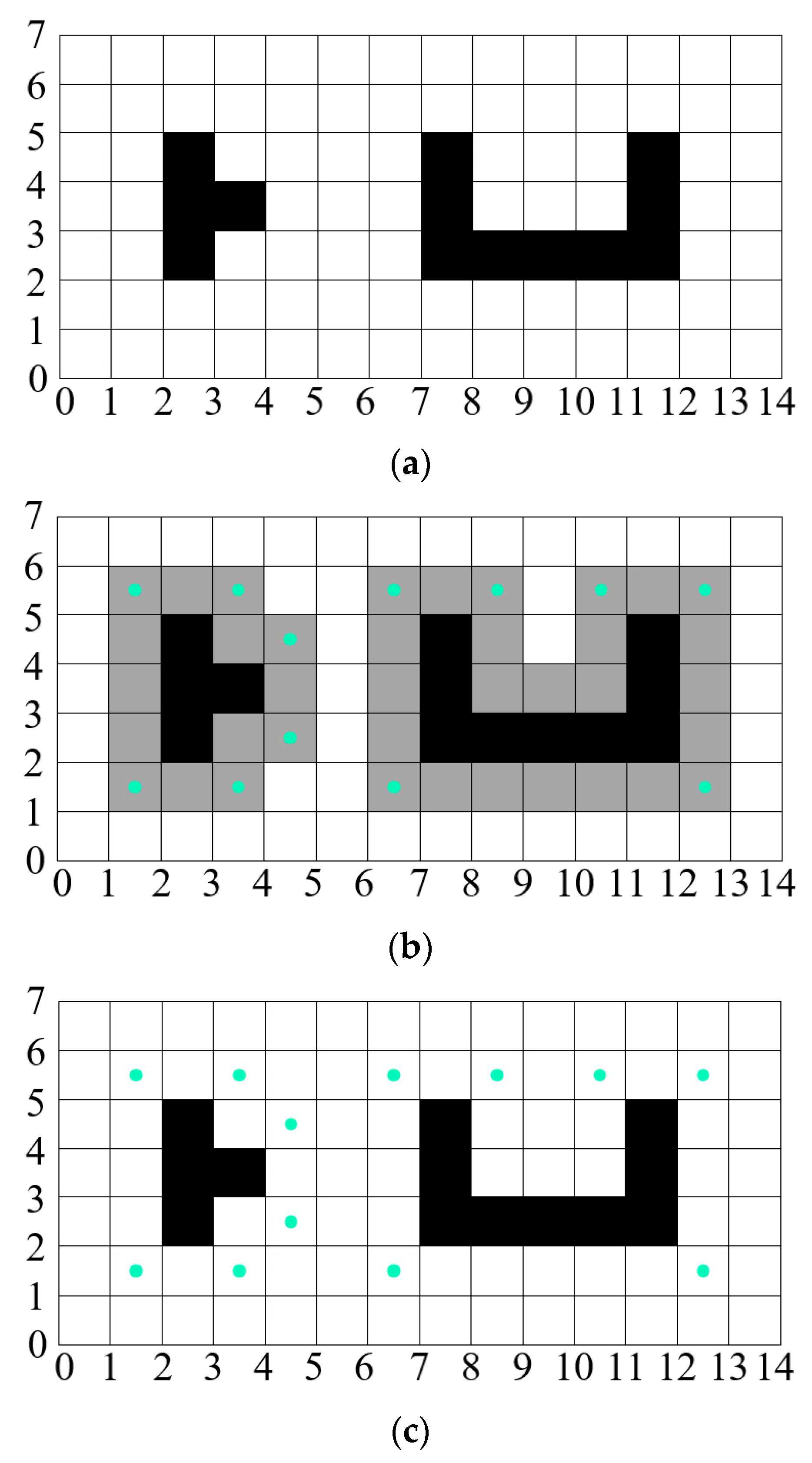
Taking the obstacle shown in Figure 4a as an example, the extraction steps are as follows: The obstacle is dilated according to its location information, with the gray grids in Figure 4b indicating the dilated result. Erosion is subsequently applied to the gray area to preserve the corner points of the dilated region, depicted as green points. These resulting green points constitute the desired global key nodes, as illustrated in Figure 4c.
Figure 4.
Schematic diagram of global key point extraction: (a) example obstacle; (b) obstacle area expansion and dilation; (c) key point screening result.
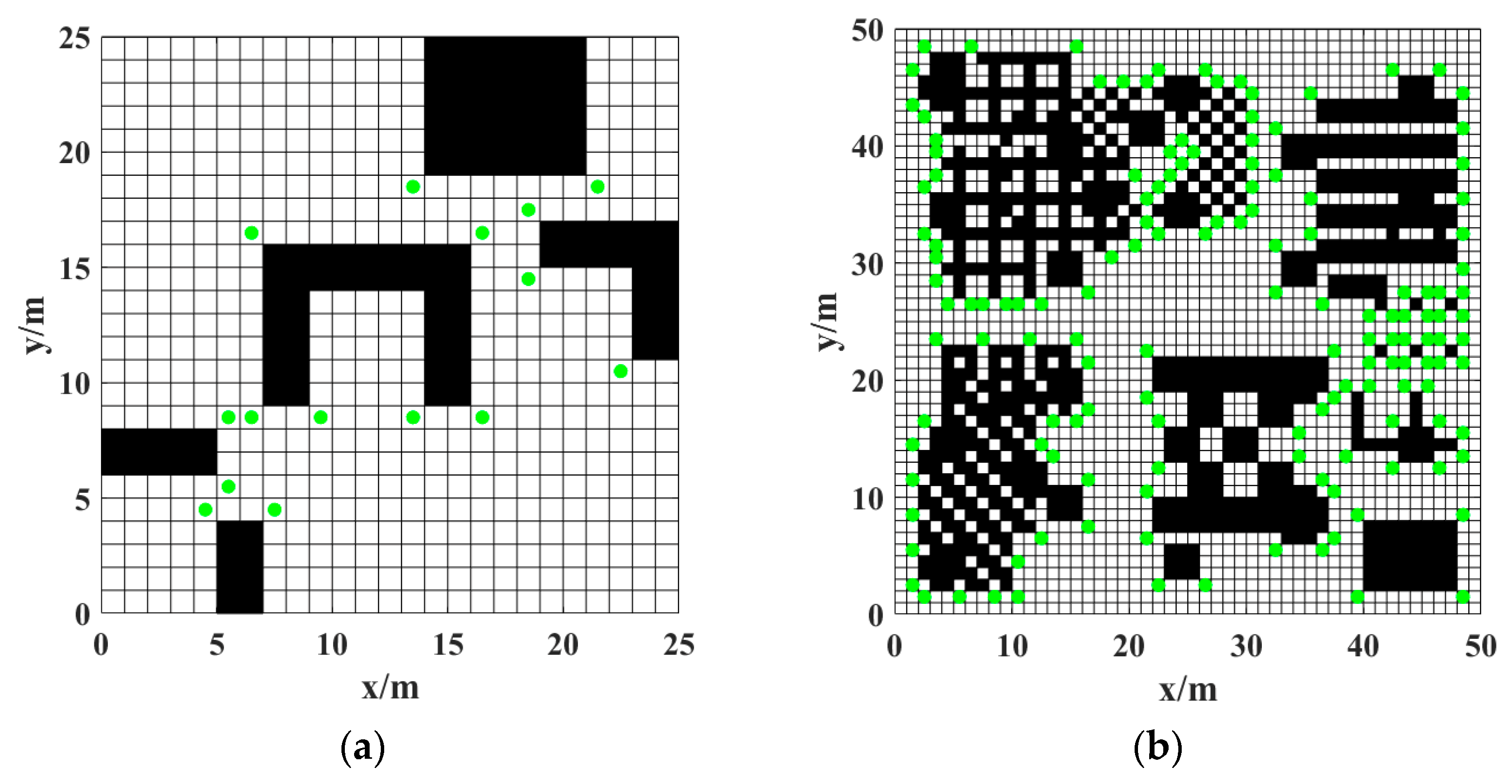
This approach condenses the path planning search space from the entire set of grid nodes to a select few critical corner points. By ensuring that adjacent key nodes satisfy the condition of “straight-line reachability,” it fundamentally eliminates the numerous redundant nodes and inflection points generated by traditional A* algorithms in free space. As a result, path smoothness is inherently guaranteed during the planning stage itself, obviating the need for additional post-processing optimization. Using the above method, the global key points (green points) are marked in grid maps, as shown in Figure 5.
Figure 5.
Distribution of global key points in grid maps. (a) 25 × 25 grid map; (b) 50 × 50 grid map.
3.2. Redefinition of Child Nodes
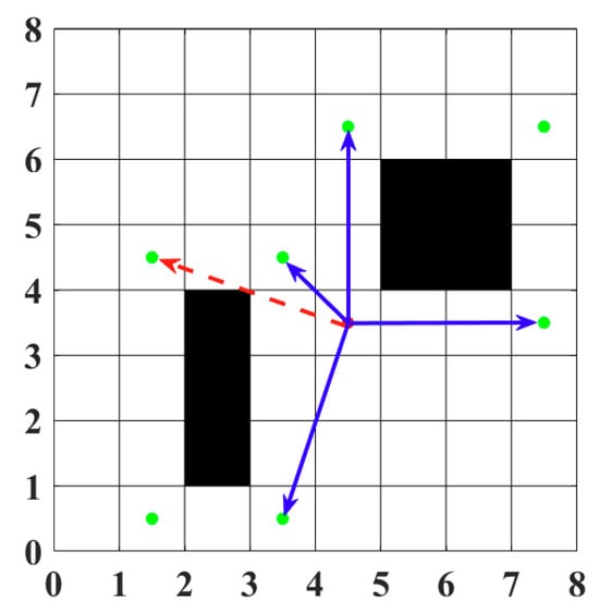
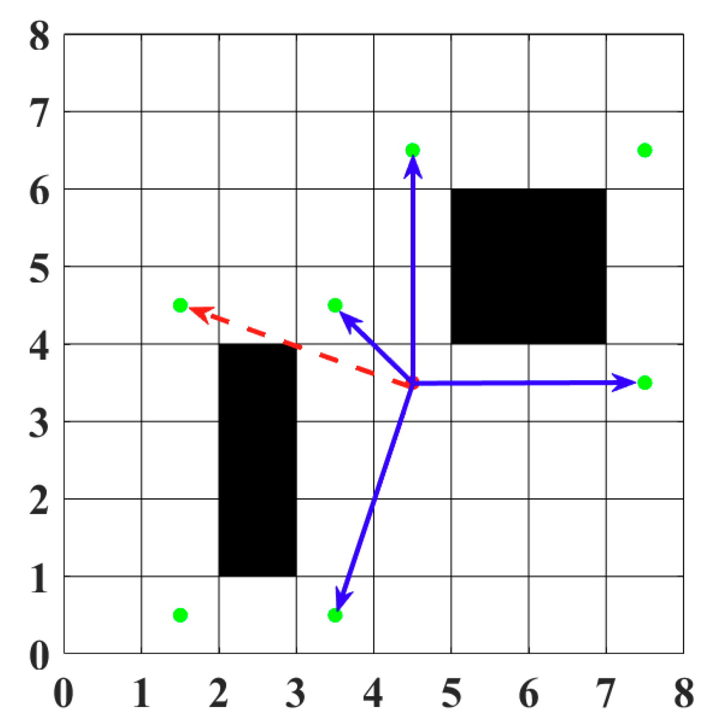
Bresenham’s line algorithm [17] is used to screen key nodes that can be directly reached by the current node without passing through obstacle areas. As shown in Figure 6, the red dashed arrows point to key nodes at extreme positions, and the blue solid arrows point to key nodes that can be directly reached. After eliminating the key nodes at extreme positions, the key nodes pointed to by the blue arrows are defined as the child nodes of the current node.
Figure 6.
Schematic diagram of child node definition for the current node.
This process of redefining child nodes refines the core search logic of the A* algorithm. Instead of exhaustively expanding all neighboring nodes, it only considers globally critical key points that satisfy the straight-line reachability condition as valid expansion directions. This constraint mechanism directly addresses the issue of path tortuosity caused by the traversal of redundant nodes in traditional A* algorithms.
3.3. Implementation Flow of the Improved A* Algorithm
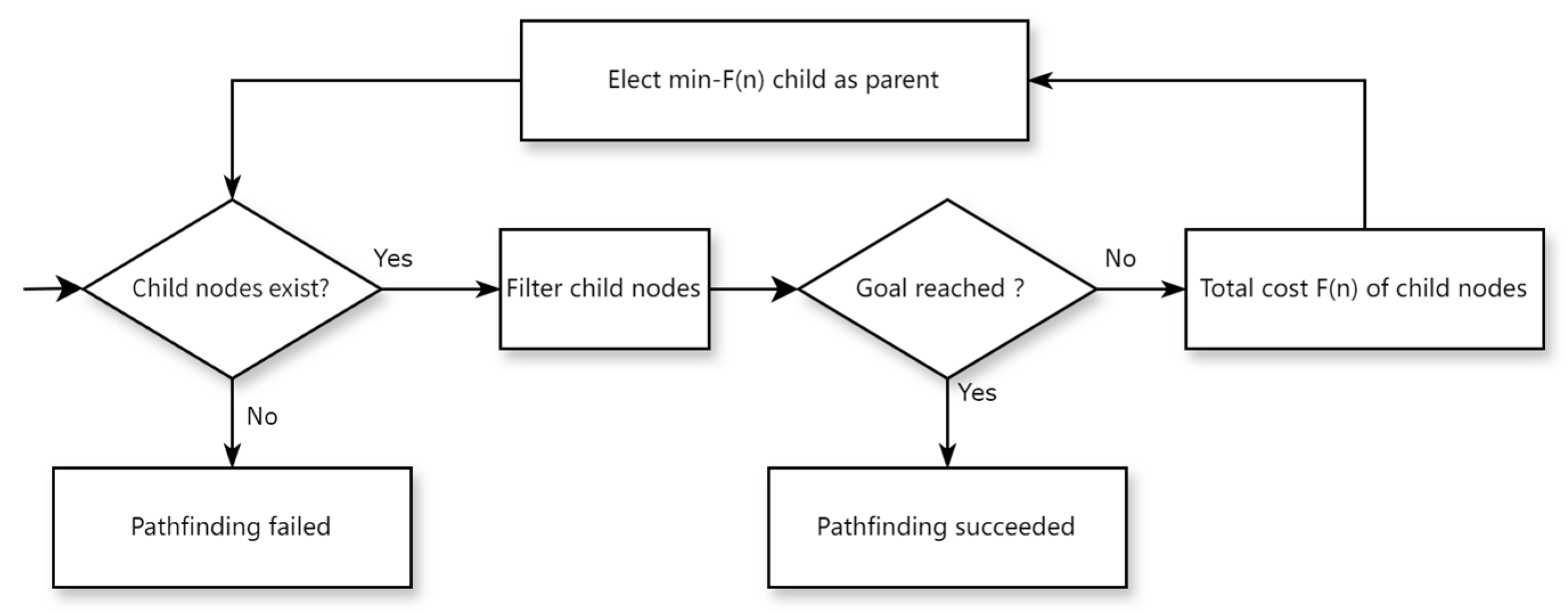
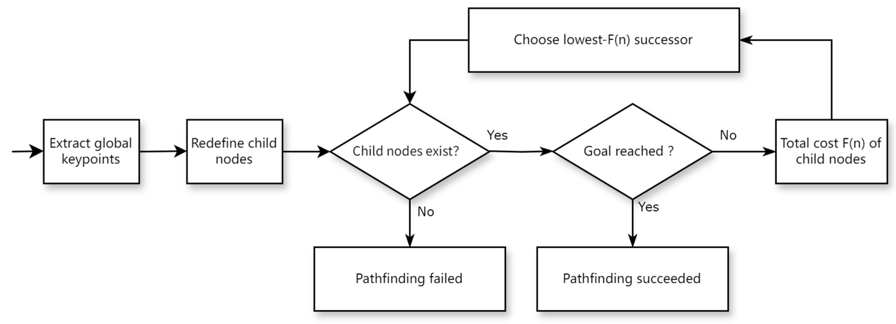
Figure 7 shows the decision flow of the improved A* algorithm: first, extract global key points; second, redefine the child nodes of the current position; finally, in the iterative process, select the node with the smallest total cost as the parent node using the A* algorithm evaluation function. Continuously check the existence of child nodes and whether the target point appears; if the target point appears, the pathfinding is successful; if there are no optional child nodes and the target point is not found, the pathfinding fails.
Figure 7.
Decision flow of the improved A* algorithm.
4. Fusion with Dynamic Window Approach (DWA)
The Dynamic Window Approach (DWA) establishes the AGV motion model and evaluates candidate trajectories using an evaluation function to select the optimal path trajectory.
4.1. AGV Kinematic Model
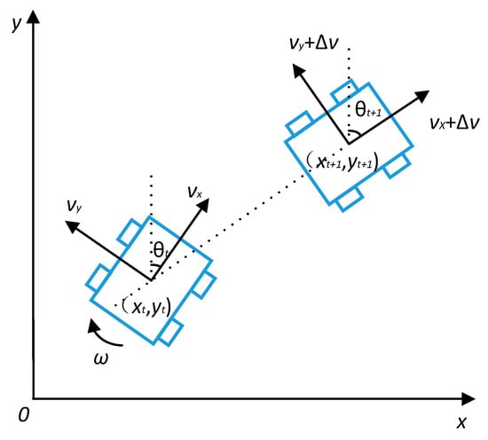
Assume that within the time interval , the AGV moves at a constant linear velocity v and angular velocity . Decompose the linear velocity into the forward direction component and the steering component . Let the position of the AGV in the map at time be and the heading angle be ; the position at time be and the heading angle be . The kinematic model of the AGV between time and is shown in Figure 8.
Figure 8.
Schematic Diagram of the AGV Kinematic Model.
The relationship between the displacement, linear velocity, angular velocity, and heading angle of the AGV is shown in Formula (6):
4.2. Velocity Sampling
Velocity sampling needs to comprehensively consider the AGV’s velocity constraints, its own performance, and safe braking distance to ensure the controllability and safety of motion.
4.2.1. AGV Velocity Constraints
The linear velocity v and angular velocity of the AGV need to be limited within a reasonable range, as shown in Formula (7):
where and are the maximum and minimum linear velocities respectively; and are the maximum and minimum angular velocities respectively.
4.2.2. AGV Performance Constraints
Motor performance determines the acceleration and deceleration capabilities of the AGV. At any time , the maximum linear acceleration , maximum linear deceleration , maximum angular acceleration , and maximum angular deceleration of the motor limit the variation range of the linear velocity and angular velocity , as shown in Formula (8):
4.2.3. Safe Braking Distance Constraints
When the AGV moves with the maximum linear deceleration and maximum angular deceleration , the linear velocity and angular velocity must satisfy Formula (9) to ensure that it can stop before collision:
where is the distance from the AGV to the nearest obstacle on the trajectory.
4.3. Evaluation Function
Combining the AGV kinematic model, preset velocity range, and obstacle distribution, the evaluation function scores candidate trajectories through Formula (10) and selects the trajectory with the highest score to guide the AGV’s motion:
where is the angle between the predicted trajectory and the target point; is the smoothing coefficient; , , and are weighting coefficients.
The weighting coefficients , and are determined based on empirical prior knowledge combined with systematic tuning according to specific application scenarios. The smoothing coefficient is introduced to maintain the continuity and stability of velocity transitions, thereby enhancing the smoothness of the overall trajectory.
4.4. Algorithm Hybrid Strategy
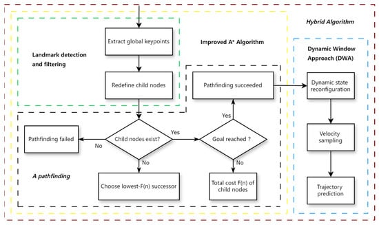
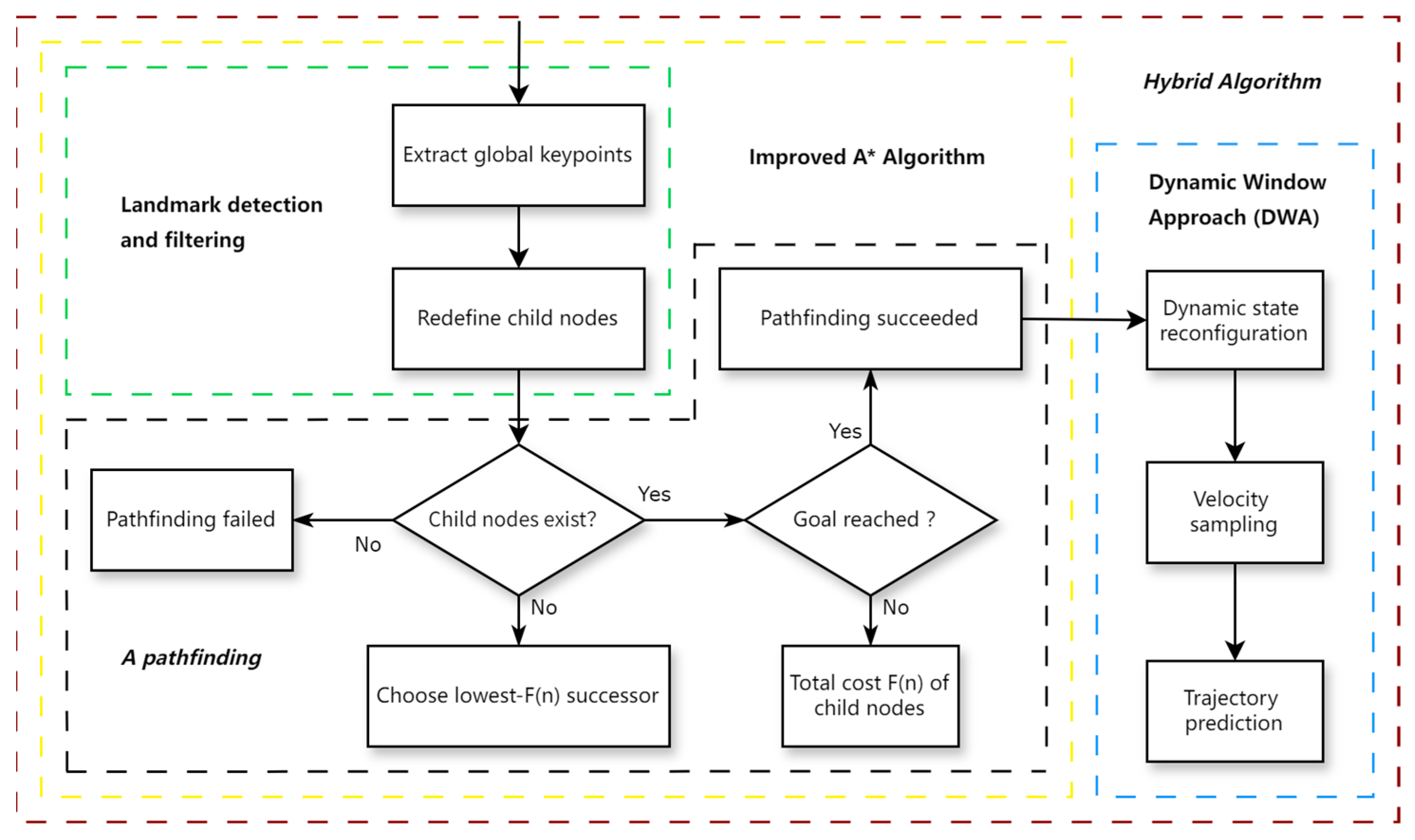
Fusing the improved A* algorithm with DWA can obtain the globally optimal path while retaining the local obstacle avoidance advantage of DWA. The specific process is: first, generate the globally optimal path through the improved A* algorithm; second, take the inflection points on the global path as the target points of DWA, segment the global path, and complete local path optimization. The main steps of the hybrid algorithm are shown in Figure 9.
Figure 9.
Schematic diagram of the hybrid algorithm flow.
The hybrid strategy proposed in this paper is a switching mechanism based on path segmentation. As the inflection points of the global path planned by the improved A* algorithm are all key points satisfying straight-line reachability, these inflection points naturally partition the entire path into multiple continuous, obstacle-free straight-line sub-paths. Consequently, these inflection points are quantitatively designated as the segmented local target points for the DWA. During navigation, the AGV sequentially uses each inflection point as a temporary goal and invokes the DWA for local path planning. When the AGV approaches a current inflection point within a certain range, the local target point automatically switches to the next inflection point on the path until the destination is reached. This segmentation-based switching mechanism effectively integrates global optimality with local real-time obstacle avoidance capabilities.
5. Simulation Experiments
To comprehensively verify the effectiveness, scalability and stability of the proposed algorithm, 25 × 25 and 50 × 50 grid maps with different complexity levels are constructed for simulation experiments, where the 50 × 50 grid map is designed to further test the algorithm’s performance in large-scale and more complex environmental scenarios. All experimental results reported in this manuscript are the average values obtained from 20 repeated independent trials for each algorithm under identical experimental conditions, ensuring the statistical reliability and repeatability of the experimental data. The experimental environment is configured as follows: Windows 11 operating system, NVIDIA GeForce RTX 4060 Laptop GPU, Intel(R) Core(TM) i7-14700HX 2.10 GHz processor, with all algorithms implemented and simulated based on MATLAB R2023b software.
5.1. Verification of Global Path Planning
- A. Experiment of 25 × 25 Grid Map
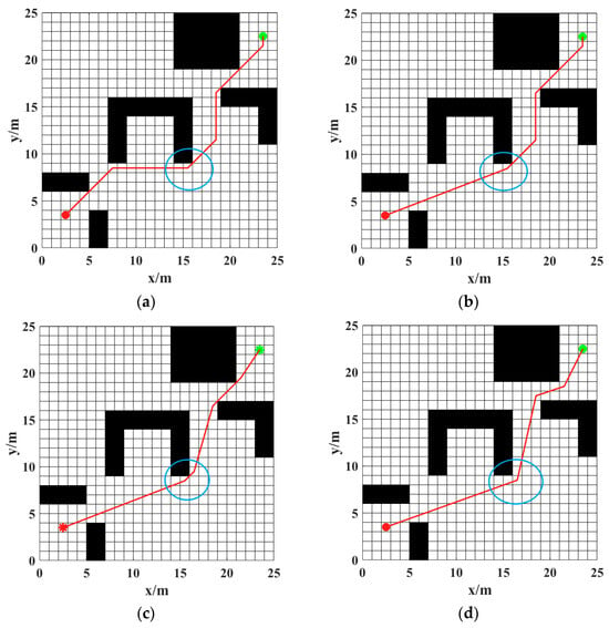
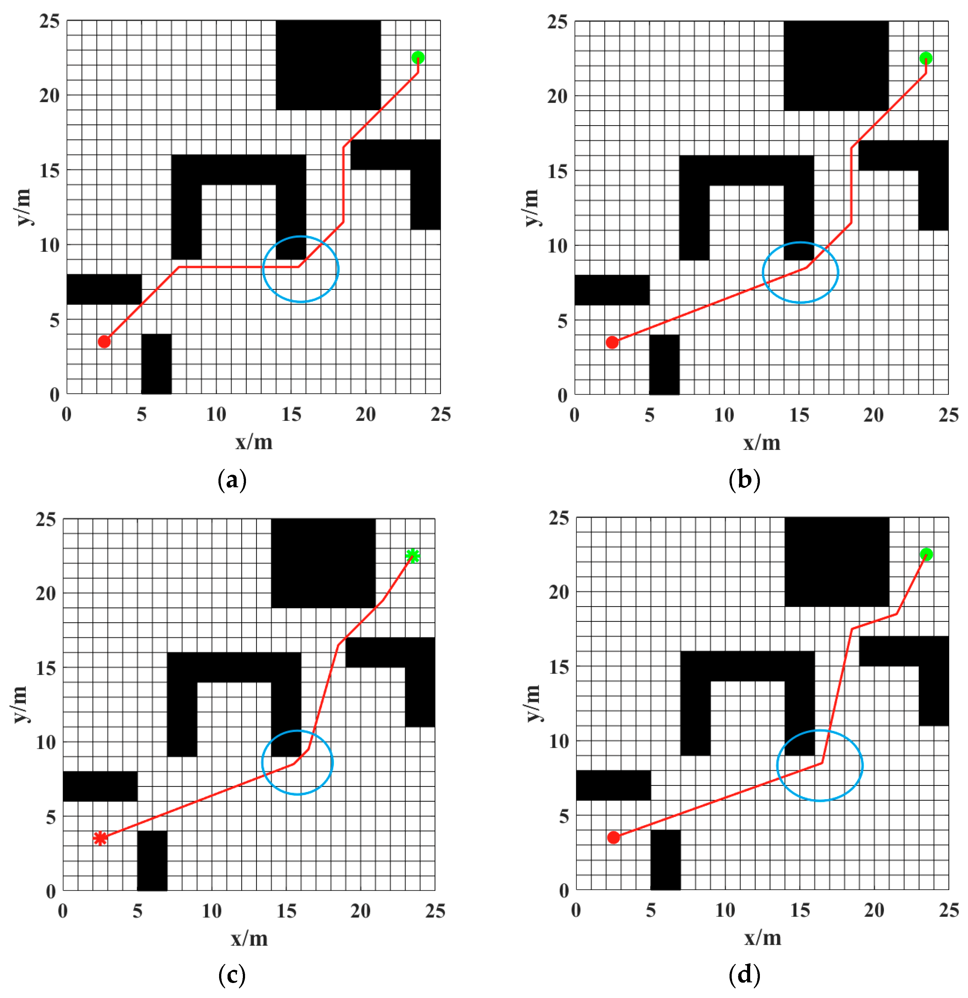
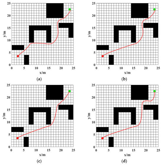
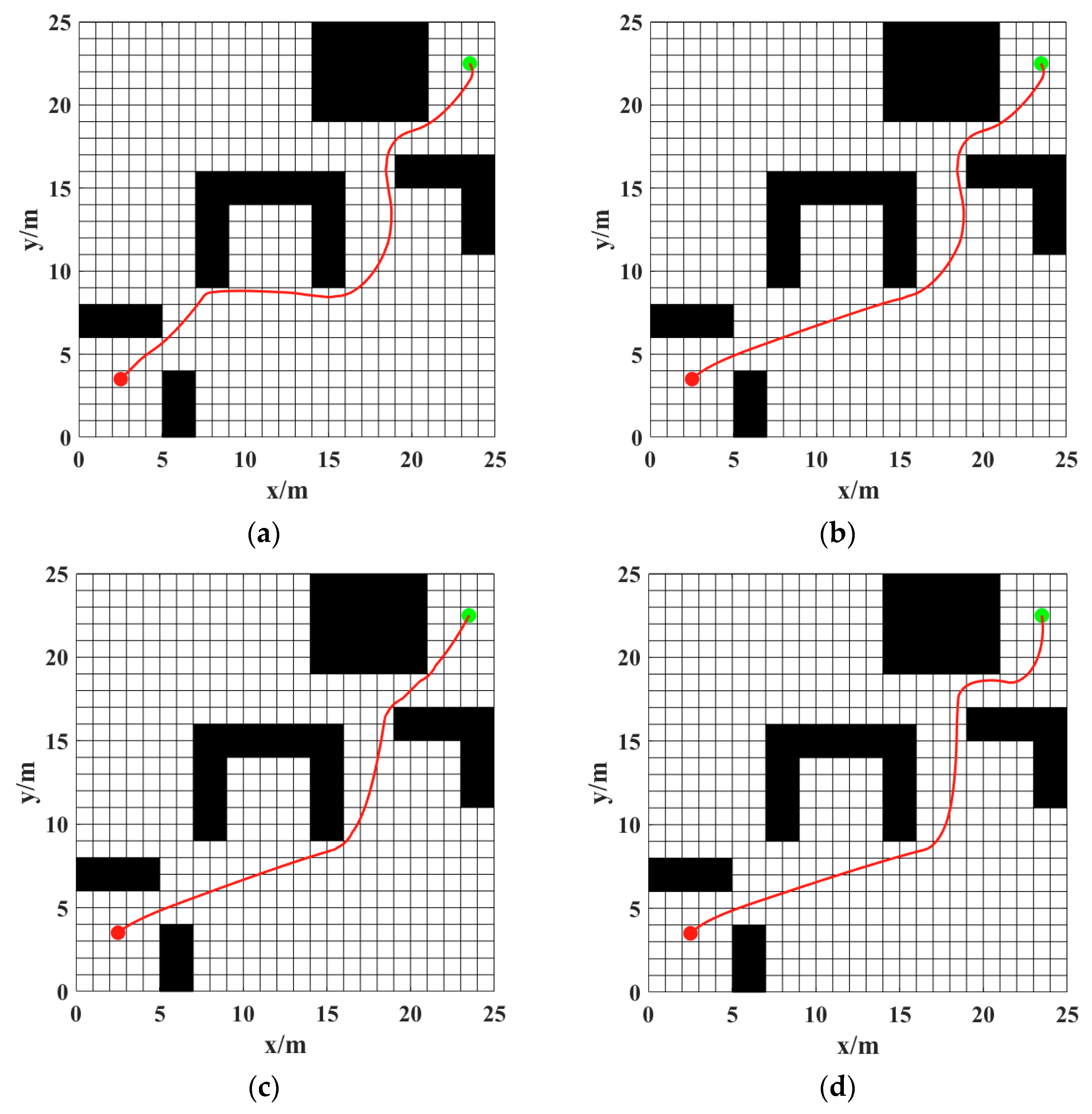
The global path planned by the improved A* algorithm is shown in Figure 10d. To evaluate its performance, this path is compared with the path of the traditional A* algorithm (Figure 10a), Chen et al. [18] (Figure 10b), and Han et al. [14]. Furthermore, the final path results show that, compared with other methods, the path planned by the proposed method can maintain a safer distance from obstacles, as indicated within the light blue circle in the figure.
Figure 10.
Comparison of global paths of different A* algorithms in the 25 × 25 grid map: (a) traditional A* algorithm; (b) Chen et al. [18]; (c) Han et al. [14]; (d) improved A* algorithm in this paper.
Planning time (s), number of inflection points (pieces), and path length (m) are selected as performance evaluation indicators, and the comparison results are shown in Table 1.
Table 1.
Comparison of Several A* Algorithms in the 25 × 25 Grid Map.
Comparison results show that compared with the traditional A* algorithm, the planning time of the improved algorithm in this paper is reduced by 24.19%, the number of inflection points is decreased by 40.00%, and the path length is shortened by 1.49%; compared with Chen et al. [18], although the path length of the proposed algorithm is slightly increased (by 1.53%), the number of inflection points is reduced by 25.00% and the planning time is decreased by 14.66%. When compared to Han et al. [14], the proposed method, despite its marginally higher path cost, produces a smoother path with fewer inflection points and a shorter planning time. Overall, the proposed algorithm has better path planning efficiency, and the planned path has fewer inflection points and better smoothness.
- B. Experiment of 50 × 50 Grid Map
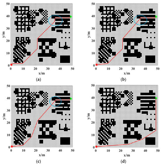
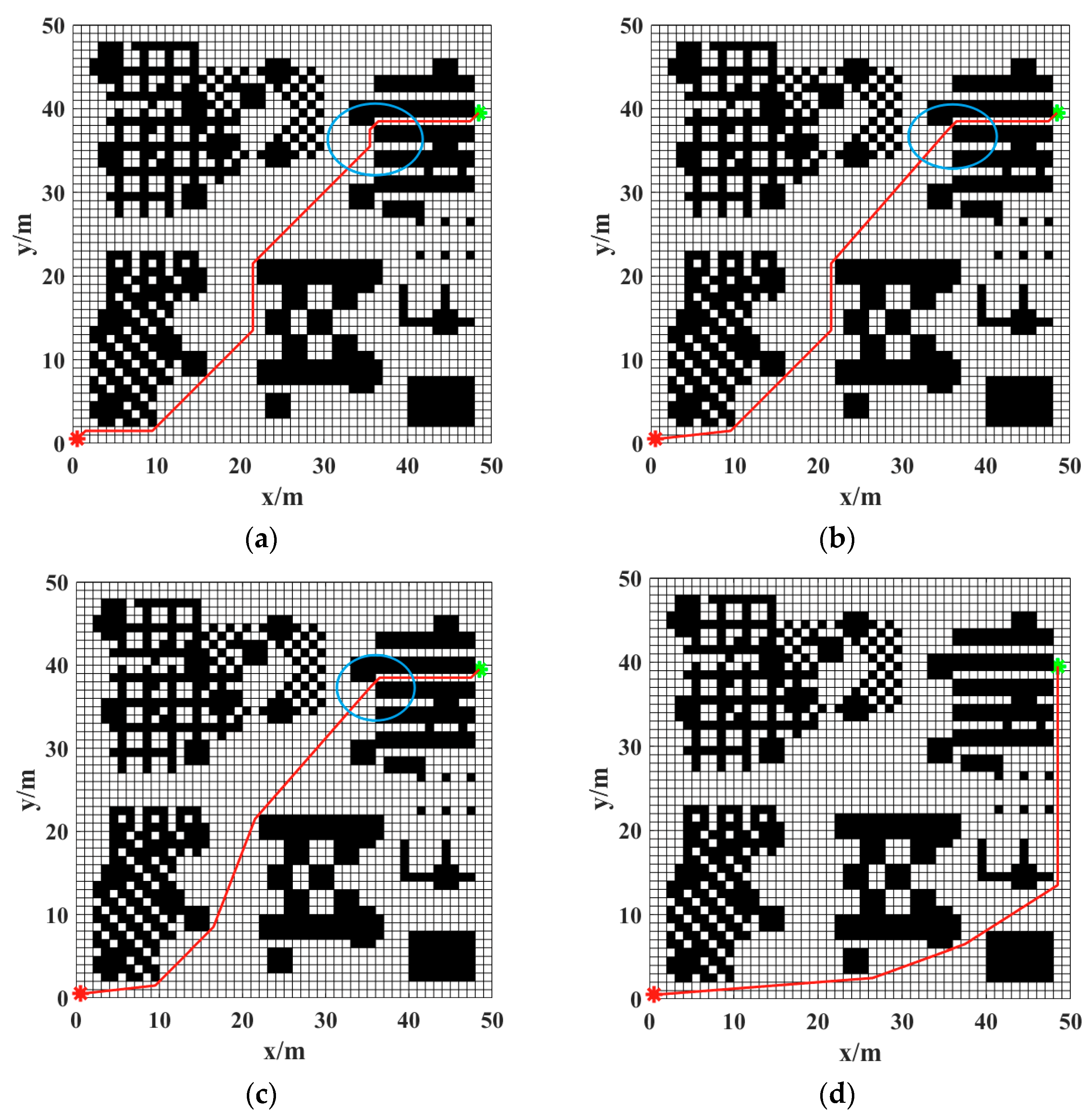
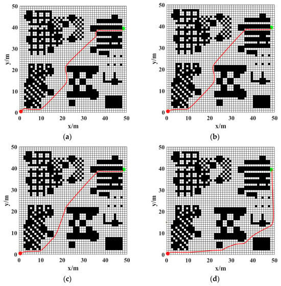
The global path planned by the improved A* algorithm in the 50 × 50 grid map environment is shown in Figure 11d. To further evaluate its scalability and performance in more complex scenarios, this path is compared with those generated by the traditional A* algorithm (Figure 11a), Chen et al. [18] (Figure 11b), and Han et al. [14] (Figure 11c). The results demonstrate that, even in a larger-scale map, the proposed method maintains a safer distance from obstacles (as highlighted within the light blue circle), effectively avoiding the issue of paths being planned too close to obstacle edges, which is observed in other methods.
Figure 11.
Comparison of global paths of different A* algorithms in the 50 × 50 grid map: (a) traditional A* algorithm; (b) Chen et al. [18]; (c) Han et al. [14]; (d) improved A* algorithm in this paper.
To quantitatively evaluate the performance of each algorithm in the 50 × 50 map, planning time (s), number of inflection points, and path length (m) are selected as evaluation metrics. The comparative results are presented in Table 2.
Table 2.
Comparison of Several A* Algorithms in the 50 × 50 Grid Map.
The comparison results indicate that the proposed algorithm maintains strong comprehensive performance in the larger 50 × 50 grid map. Compared with the traditional A* algorithm, the proposed algorithm reduces planning time by 63.29% and the number of inflection points by 62.50%, albeit with a 9.72% increase in path length. Relative to Chen et al. [18], although the proposed method exhibits a 16.86% increase in planning time and an 11.15% longer path, it achieves a substantial 50.00% reduction in inflection points, demonstrating superior path smoothness. When compared to Han et al. [14], despite a 13.02% increase in path length, the proposed algorithm reduces planning time by 13.19% and inflection points by 50.00%, indicating more efficient planning and smoother paths. These results underscore the advantages of the proposed algorithm in terms of planning efficiency and path smoothness, particularly in its significant reduction in inflection points, which yields smoother and more AGV-friendly paths. Although the path length is slightly longer, this represents a reasonable trade-off for enhanced safety and smoothness in larger-scale, complex environments.
5.2. Verification of the Fusion Algorithm
To adapt to complex and changing practical application scenarios, a hybrid strategy of the improved A* algorithm and DWA is proposed: first, generate the globally optimal path through the improved A* algorithm, then take the inflection points of the global path as the local target points of DWA to realize local path planning. The AGV’s own attribute parameters are shown in Table 3, and the initial parameter settings of DWA are shown in Table 4.
Table 3.
AGV Own Attributes.
Table 4.
Initial Attributes of the Dynamic Window Approach (DWA).
The parameter values in Table 3 and Table 4 are determined through empirical knowledge and systematic tuning. In cluttered environments, higher weight is assigned to to prioritize safety, while in open areas, and are emphasized to improve efficiency. Additionally, a distance threshold of 0.5 m is used to determine arrival at the target point.
- A. Fusion Experiment of 25 × 25 Grid Map
Figure 12 presents the path planning results of different hybrid algorithms in a 25 × 25 grid map without random obstacles. The comparative methods include the traditional hybrid algorithm, the method proposed by Chen et al. [18], the method by Han et al. [14], and the hybrid algorithm proposed in this study.
Figure 12.
Comparison of paths of different hybrid algorithms in the 25 × 25 grid map: (a) traditional hybrid algorithm; (b) Chen et al. [18]; (c) Han et al. [14]; (d) proposed hybrid algorithm in this paper.
As observed from the path morphologies, all four algorithms can generate feasible collision-free paths, but significant differences exist in terms of path smoothness and safe distance from obstacles. The path generated by the traditional hybrid algorithm exhibits obvious turns in some regions, while the methods proposed by Chen et al. [18] and Han et al. [14] have improved the path morphology to a certain extent. Among them, some path segments generated by Han et al. [14] are relatively close to obstacles. In contrast, the proposed algorithm optimizes path inflection points while ensuring path feasibility, resulting in an overall smoother generated path.
Planning time (s) and path length (m) are selected as performance evaluation indicators for local path planning, with the quantitative results presented in Table 5. In terms of overall performance, the proposed algorithm shows obvious advantages in computational efficiency. Compared with the traditional A*-DWA hybrid algorithm, the planning time is reduced by approximately 18.77% and the path length is slightly shortened, indicating that the method does not sacrifice path quality while improving planning efficiency. Compared with the method by Chen et al. [18], the proposed algorithm reduces the planning time by about 6.30%; although the path length is slightly increased, the overall path remains reasonably feasible. Compared with Han et al. [14], despite their slightly shorter path length, the proposed method achieves a more balanced performance in terms of planning efficiency and path safety. In addition, while the proposed method exhibits a slightly higher trajectory tracking error compared to other approaches, it offers enhanced path safety.
Table 5.
Comparative Analysis of Hybrid Approaches in the 25 × 25 Grid Map.
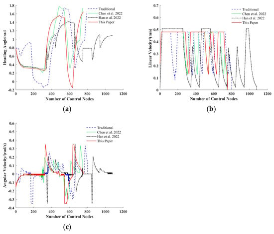
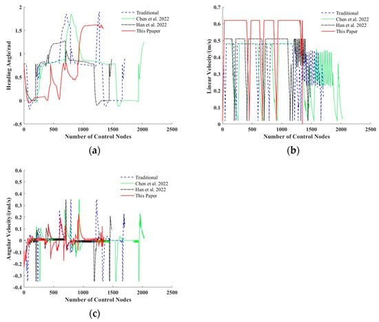
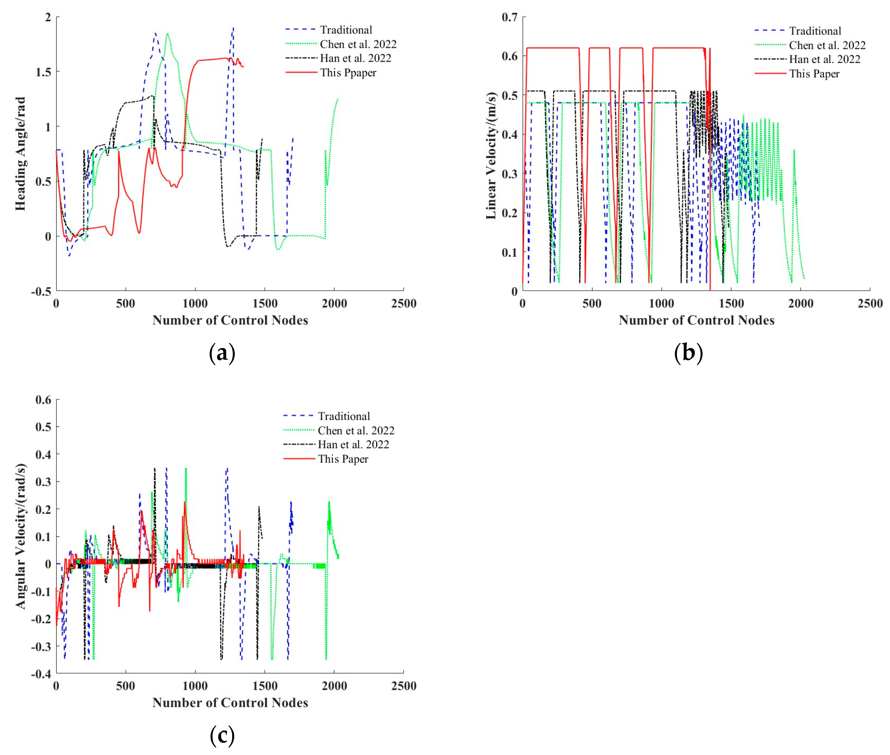
To further analyze the stability of the AGV during operation, Figure 13 presents the variation curves of the AGV’s heading angle, linear velocity, and angular velocity under different algorithms. It can be observed that the proposed algorithm exhibits an overall gentle variation throughout the motion process without significant drastic fluctuations.
Figure 13.
Variation curves of AGV motion parameters in the 25 × 25 grid map: (a) heading angle; (b) linear velocity; (c) angular velocity. The curve shown in green corresponds to the experimental results obtained by the method presented in [18], and the black curve corresponds to that described in [14].
To further analyze the stability of the AGV during motion, Figure 13 presents the variation curves of the AGV’s heading angle, linear velocity, and angular velocity under different algorithms. It can be observed that the proposed algorithm exhibits an overall gentle variation during operation without significant drastic fluctuations. The corresponding variance comparison is shown in Table 6.
Table 6.
Comparison of Variances of AGV Motion Parameters of Different Hybrid Algorithms in the 25 × 25 Grid Map.
Combining the path planning results and variations in motion parameters as reflected in Figure 13 and Table 6, it can be concluded that the hybrid algorithm proposed in this paper maintains a relatively stable motion state while ensuring path safety, thereby enhancing the motion stability of the AGV in practical operations.
- B. Fusion Experiment of 50 × 50 Grid Map
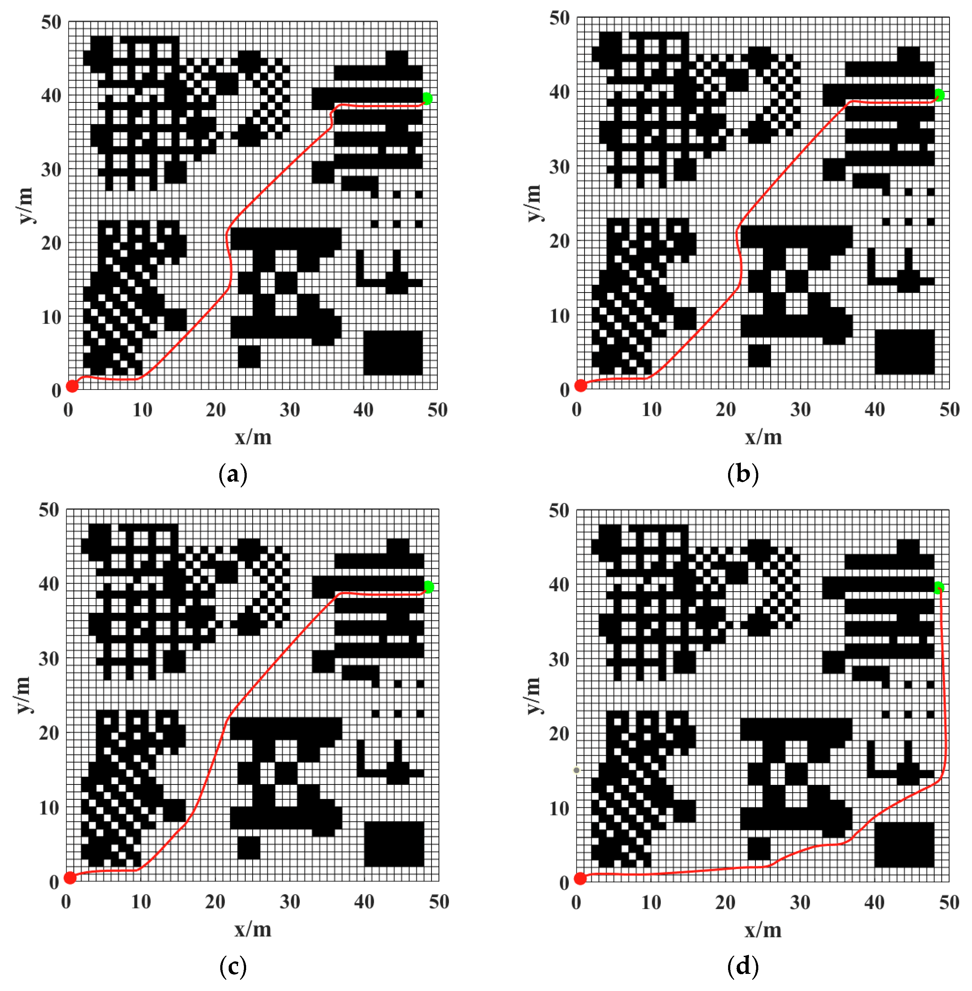
To further verify the applicability of the proposed algorithm in larger-scale environments, comparative experiments were conducted on a 50 × 50 grid map, with the results presented in Figure 14.
Figure 14.
Comparison of paths of different hybrid algorithms in the 50 × 50 grid map: (a) traditional hybrid algorithm; (b) Chen et al. [18]; (c) Han et al. [14]; (d) proposed hybrid algorithm in this paper.
As the map scale increases, the differences in path planning performance among various algorithms become more pronounced. In terms of path morphology, the path generated by Han et al. [14] still maintains a certain advantage in length, but some segments are relatively close to obstacles. In contrast, the proposed algorithm places greater emphasis on path safety during planning. By appropriately adjusting the path direction, it maintains a more reasonable safe distance between the planned path and obstacles overall.
Table 7 presents the quantitative comparison results of different algorithms in terms of planning time and path length. The results indicate that the proposed algorithm still achieves good planning efficiency in larger-scale map environments. Compared with the traditional hybrid algorithm, the planning time is slightly reduced by approximately 0.71%. When compared to Chen et al. [18], the proposed algorithm shows a significant reduction in planning time of about 19.90%, demonstrating a strong advantage in computational efficiency. Although the path length is slightly increased, this increase is mainly attributed to the improved path safety margin. Compared with Han et al. [14], the proposed algorithm has a slight increase in both planning time and path length; however, as can be seen from the path comparison in Figure 14c,d, the path generated by the proposed algorithm maintains a larger safe distance from obstacles. Furthermore, as indicated by the trajectory tracking error, the proposed method trades off a certain degree of tracking accuracy to enhance overall path safety.
Table 7.
Comparative Analysis of Hybrid Approaches in the 50 × 50 Grid Map.
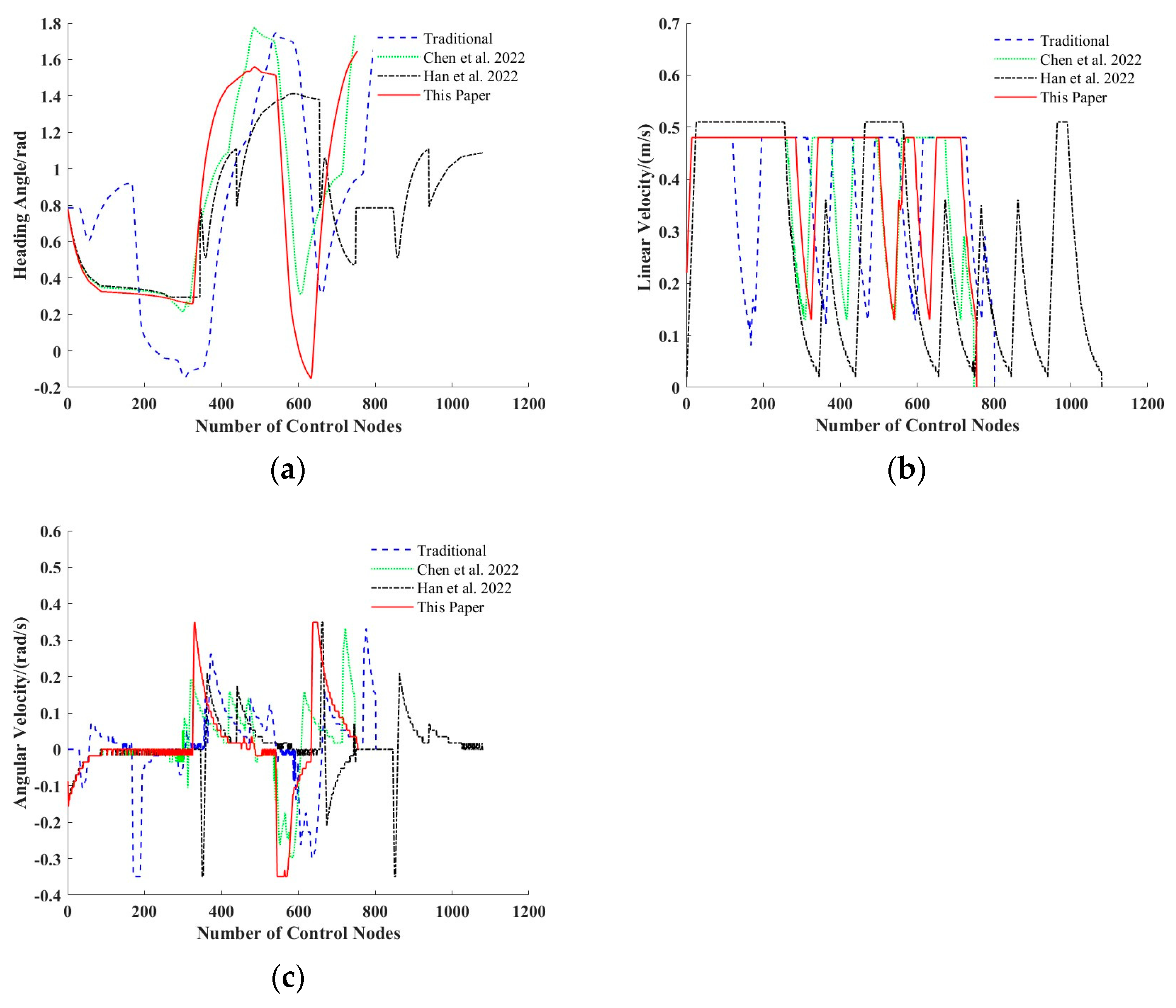
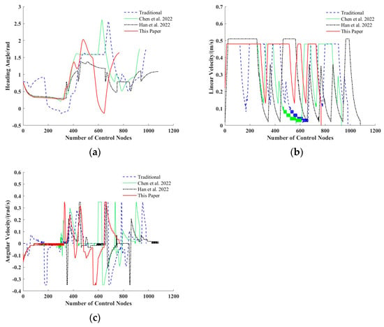
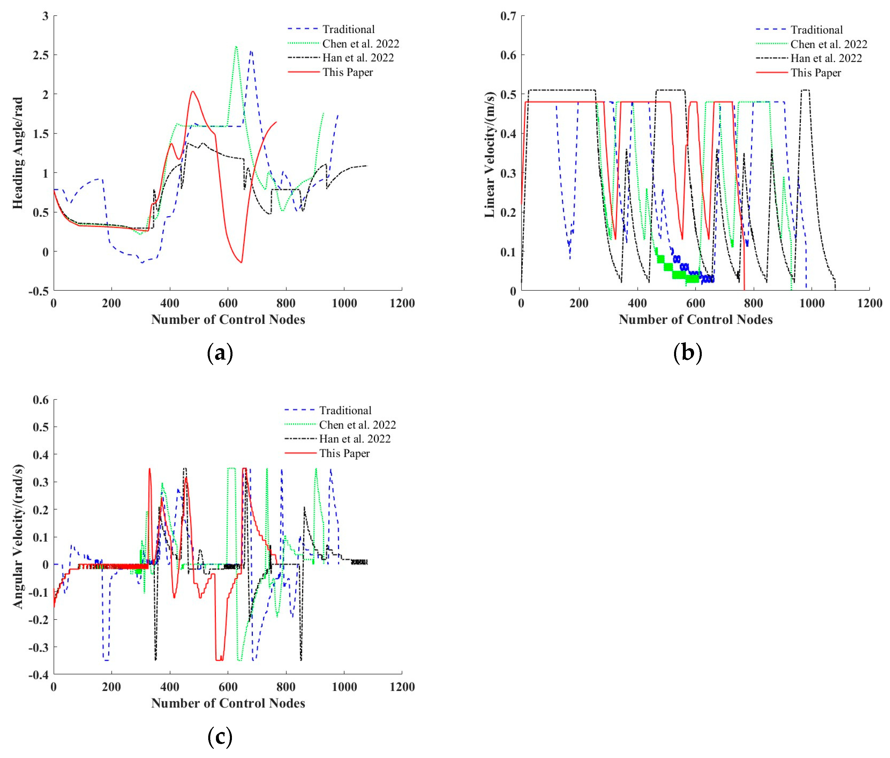
Figure 15 presents the variation curves of the AGV’s heading angle, linear velocity, and angular velocity for different algorithms. Overall, the proposed algorithm maintains a relatively stable motion state during path tracking, with particularly gentler changes in steering.
Figure 15.
Variation curves of AGV motion parameters in the 50 × 50 grid map: (a) heading angle; (b) linear velocity; (c) angular velocity. The curve shown in green corresponds to the experimental results obtained by the method presented in [18], and the black curve corresponds to that described in [14].
Table 8 further presents the comparative results of the variances of each motion parameter. It can be observed that compared with the traditional algorithm, the proposed algorithm achieves a significant reduction of approximately 53.25% in the angular velocity variance, indicating that it can effectively reduce drastic steering changes during path tracking, thereby improving the stability of steering control. When compared to Chen et al. [18], the linear velocity variance of the proposed algorithm is reduced by about 34.20%, demonstrating that velocity fluctuations are effectively suppressed. Relative to Han et al. [14], the proposed algorithm also exhibits certain advantages in terms of angular velocity stability.
Table 8.
Comparison of Variances of AGV Motion Parameters of Different Hybrid Algorithms in the 50 × 50 Grid Map.
Although the heading angle variance is relatively large, this variation is mainly attributed to the algorithm’s need to appropriately adjust the heading during planning to maintain a safe distance from obstacles. Overall, the proposed algorithm maintains a reasonably safe path while achieving a relatively stable motion state, with superior stability particularly in steering control.
- C. Fusion Experiment with random obstacles
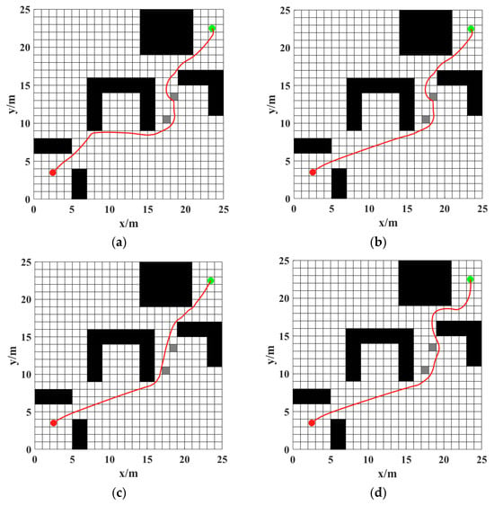
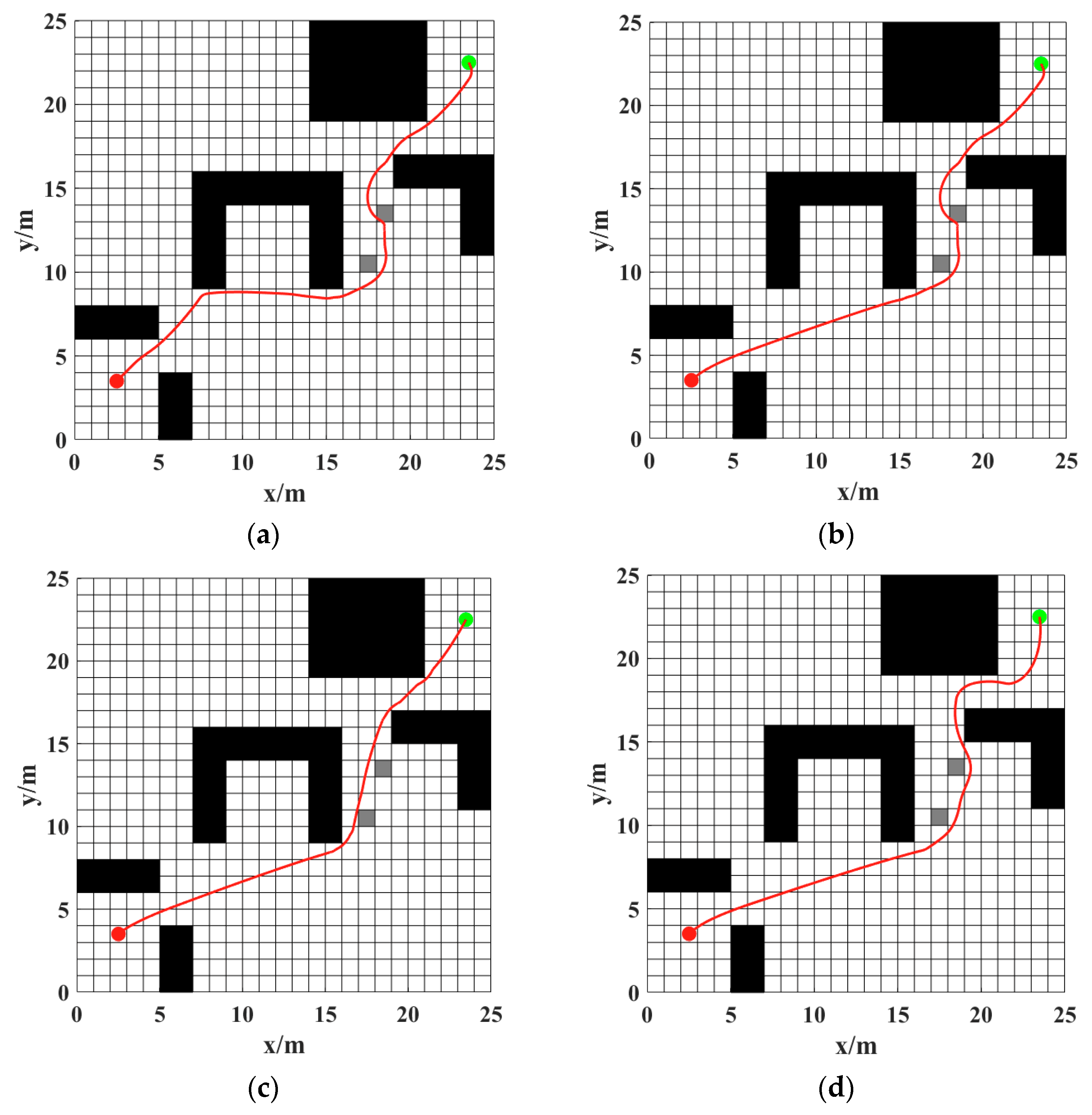
To further validate the obstacle avoidance capability of the proposed algorithm in complex environments, experiments are conducted on a 25 × 25 grid map with the introduction of random obstacles, and the path planning results are presented in Figure 16.
Figure 16.
Comparison of paths of different hybrid algorithms with random obstacles in the 25 × 25 grid map: (a) Traditional hybrid algorithm; (b) Chen et al. [18]; (c) Han et al. [14]; (d) proposed hybrid algorithm in this paper.
In environments with random obstacles, the complexity of path planning problems increases significantly, and the differences in path quality and planning efficiency among various algorithms become more pronounced. As observed from the path distribution, the paths generated by traditional algorithms contain numerous turns in complex environments, while the methods proposed by Chen et al. [18] and Han et al. [14] have improved path quality to a certain extent. Among these, some paths generated by Han et al. [14] remain relatively close to obstacles. In contrast, the proposed algorithm not only ensures a high obstacle avoidance success rate but also achieves an overall smoother path with a more reasonable safe distance from obstacles.
Table 9 presents the comparative results of all algorithms in terms of planning time and path length. The experimental results demonstrate that the proposed algorithm maintains high planning efficiency even in environments with random obstacles. Compared with the traditional hybrid algorithm, its planning time is reduced by approximately 36.86%, with a slight decrease in path length simultaneously. When compared to Chen et al. [18], the proposed algorithm exhibits a more prominent advantage in planning efficiency, with a planning time reduction of about 32.56%. Although the path length is slightly increased, the overall path remains safe and feasible. Furthermore, as observed from Figure 16 and the tracking error data in Table 9, the proposed method exhibits a slightly increased tracking error compared to other approaches but offers superior path safety.
Table 9.
Comparative Analysis of Hybrid Approaches with Random Obstacles in the 25 × 25 Grid Map.
Figure 17 shows the variation curves of the AGV’s motion parameters in the environment with random obstacles. Overall, the proposed algorithm maintains good stability in terms of velocity variations.
Figure 17.
Variation curves of AGV motion parameters with random obstacles in the 25 × 25 grid map: (a) heading angle; (b) linear velocity; (c) angular velocity. The curve shown in green corresponds to the experimental results obtained by the method presented in [18], and the black curve corresponds to that described in [14].
Table 10 presents the comparative results of the variances for all motion parameters. It can be found that compared with the traditional hybrid algorithm, the linear velocity variance of the proposed algorithm is reduced by approximately 59.31%, indicating a significant reduction in velocity fluctuations and thus helping to enhance the motion stability of the AGV during dynamic obstacle avoidance. When compared with Chen et al. [18], the proposed algorithm also exhibits a notable advantage in velocity stability, with a linear velocity variance reduction of about 60.67%. Although the angular velocity variance increases slightly, this is mainly due to the need for moderate heading adjustments to achieve effective obstacle avoidance in environments with random obstacles.
Table 10.
Comparison of Variances of AGV Motion Parameters of Different Hybrid Algorithms with Random Obstacles in the 25 × 25 Grid Map.
Overall, in environments with random obstacles, the hybrid algorithm proposed in this paper not only achieves effective obstacle avoidance but also maintains relatively stable velocity variations, thus ensuring the safe operation of the AGV in complex environments.
5.3. Additional Experiment
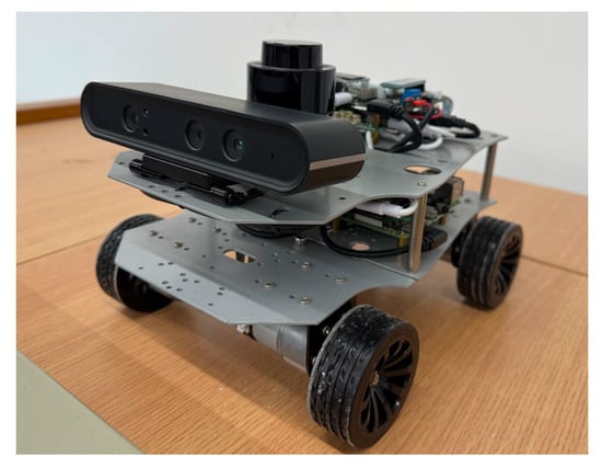
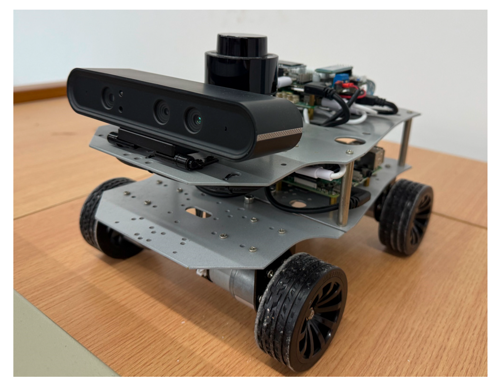
To further validate the practical effectiveness and engineering feasibility of the proposed hybrid path planning algorithm in real-world scenarios, a comparative physical experiment was conducted using the AGV platform shown in Figure 18. The experimental platform adopts a distributed master–slave control architecture comprising an STM32 microcontroller and a Jetson embedded processor. Specifically, the STM32 is responsible for low-level motor actuation and motion control, enabling closed-loop velocity regulation. The Jetson serves as the high-level processing unit, executing the proposed hybrid path planning algorithm and acquiring real-time environmental information via an onboard laser radar to facilitate environment perception and path decision-making.
Figure 18.
AGV experimental platform.
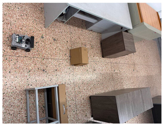
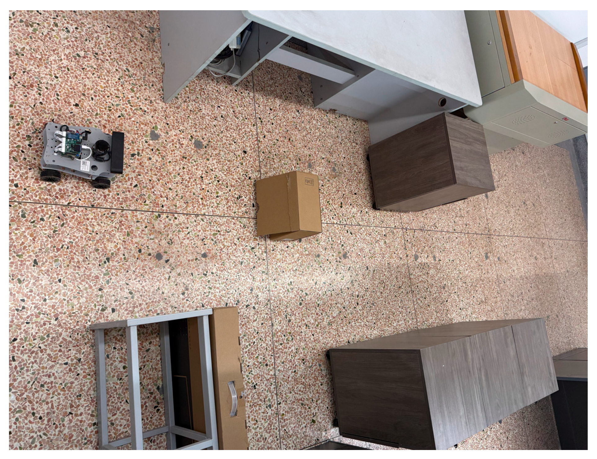
The experimental setup is depicted in Figure 19. To replicate typical operational scenarios encountered by AGVs during material handling tasks in industrial environments, various static obstacles were strategically placed within the test site, such as cardboard boxes, tables, and chairs. This realistic and complex environment was established to rigorously assess the feasibility and stability of transferring the proposed algorithm from simulation to a physical system.
Figure 19.
Layout of the experimental environment.
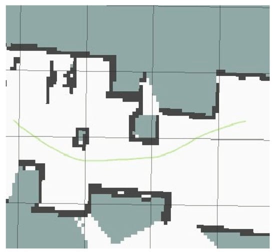
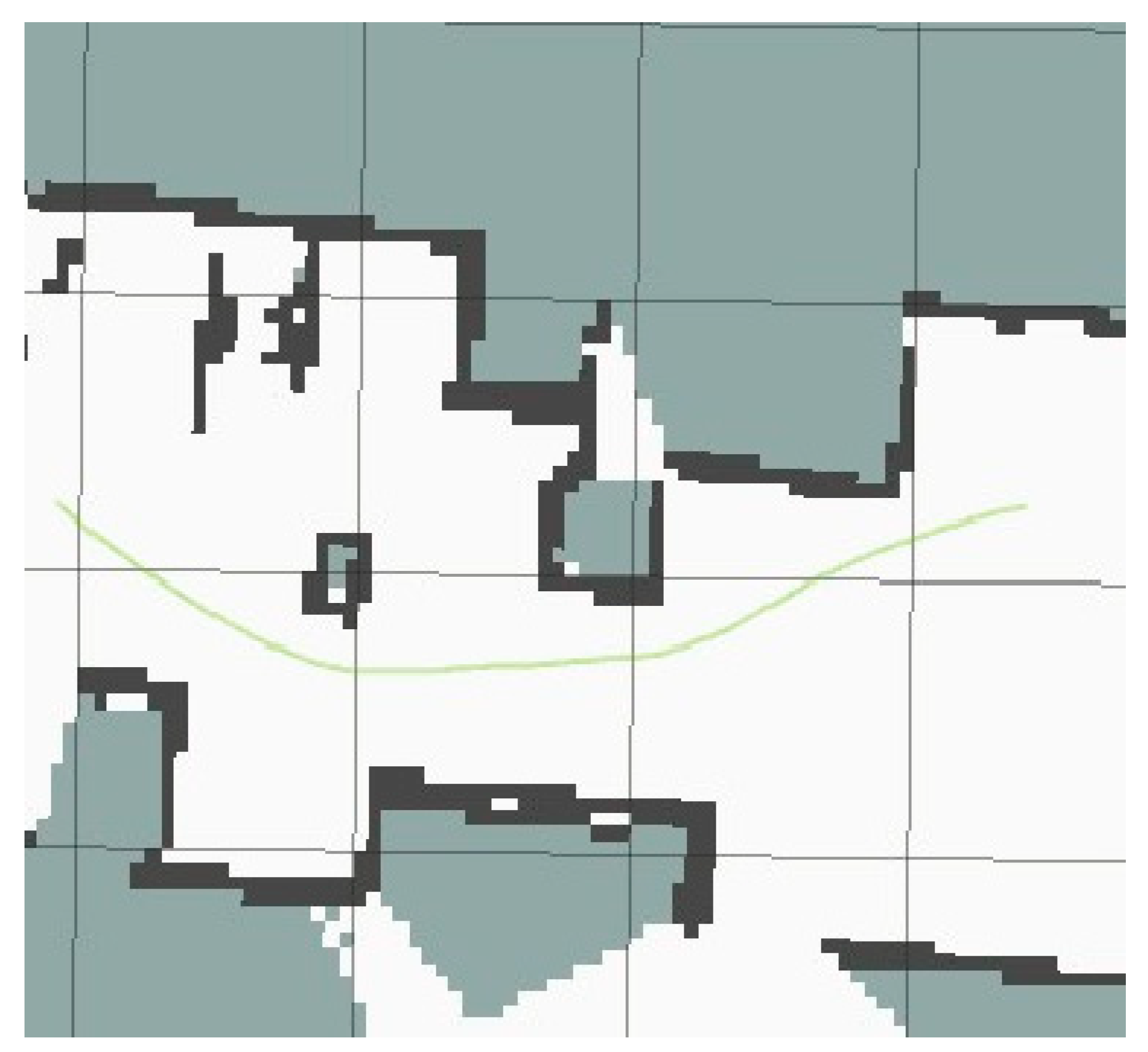
Figure 20 illustrates the path tracking performance and actual trajectory of the AGV in the real-world environment. The experimental results demonstrate that the AGV is capable of stable navigation following the proposed hybrid path planning algorithm. During motion, upon detecting obstacles ahead, the DWA-based local planning module dynamically adjusts both linear and angular velocities based on real-time sensory data, effectively correcting the heading direction to achieve safe and smooth obstacle avoidance. Furthermore, under the cooperative control framework involving the STM32 and Jetson processors, the overall system operates with high stability and timely responsiveness, satisfying the real-time and reliability requirements of industrial AGV applications.
Figure 20.
Experimental results of AGV navigation. The green line denotes the actual trajectory of the AGV, and the dark regions indicate the locations of obstacles.
The experiment results demonstrate that the proposed path planning algorithm not only performs well in simulation environments but also exhibits strong hardware adaptability and real-time computational performance. It can be directly deployed on practical AGV platforms to achieve stable and reliable path planning and dynamic obstacle avoidance in complex environments, demonstrating significant engineering application value.
6. Conclusions and Outlook
This study addresses the critical challenge of real-time obstacle avoidance in the global optimal path planning of automated guided vehicles (AGVs) by proposing a hybrid path planning algorithm that integrates an improved A* algorithm with the Dynamic Window Approach (DWA). The algorithm synergistically harnesses the global path optimization merit of the A* algorithm and the local real-time obstacle avoidance capability of DWA, with two core innovative designs: the A* algorithm is optimized via a global key-point extraction strategy combined with Bresenham’s line algorithm for child node redefinition, and a segment-based fusion mechanism is tailored to realize efficient coordination between the improved global planner and local planner. Comprehensive simulation experiments on grid maps with different scales and complex random obstacle environments, as well as physical validation on an AGV test platform, collectively demonstrate that the proposed algorithm achieves significant enhancements in planning computational efficiency, path geometric smoothness and AGV motion stability. It also ensures high path safety and feasibility in complex scenarios, exhibiting superior comprehensive performance compared with the state-of-the-art hybrid A*-DWA path planning algorithms.
While the proposed algorithm demonstrates promising performance in the tested scenarios, it still has inherent limitations that restrict its broader practical application in complex industrial environments, which are also the core focus of subsequent research. First, the designed global key-point extraction strategy is built on static grid map models, and its effectiveness and adaptive performance have not been verified in dynamic unstructured environments with moving obstacles, which is a key constraint for its application in dynamic industrial logistics scenarios with real-time obstacle changes. Second, the weighting coefficients of the DWA evaluation function are determined by empirical parameter tuning; the absence of an adaptive optimization mechanism for diverse environmental features may result in suboptimal local path planning performance when the algorithm is applied to unstructured environments with varying obstacle distributions and map topologies. Third, the hardware validation is implemented on a small-scale single AGV experimental platform, and the algorithm’s performance in terms of real-time response, path conflict resolution and collaborative navigation in large-scale industrial AGV fleets remains to be further verified, which is a necessary step for its engineering application in large-scale intelligent manufacturing systems.
In response to the aforementioned limitations, three targeted future research directions are proposed to further optimize and extend the proposed algorithm, aiming to enhance its adaptability and practicality in complex industrial scenarios. First, the global key-point extraction strategy will be extended to dynamic grid map frameworks, and a dynamic obstacle prediction and real-time avoidance module will be developed by fusing multi-sensor environmental perception data and spatiotemporal prediction algorithms. This extension is intended to improve the algorithm’s global planning capability and real-time response performance in dynamic environments with moving obstacles. Second, an adaptive weighting coefficient optimization algorithm for the DWA evaluation function will be designed based on deep reinforcement learning or environmental feature recognition models. The algorithm will be trained to automatically adjust the weighting coefficients of the DWA evaluation function according to real-time extracted environmental features, thus realizing adaptive local path planning for diverse unstructured environments. Third, large-scale industrial AGV fleet validation experiments will be conducted in actual intelligent logistics scenarios, and multi-AGV path coordination and conflict resolution mechanisms will be researched based on the proposed hybrid algorithm. This research will explore the algorithm’s scalability and collaborative planning performance in multi-AGV systems and further promote the engineering transformation and application of the proposed algorithm in intelligent manufacturing and automated logistics systems.
Author Contributions
Conceptualization, K.S. and Y.L.; methodology, K.S.; software, K.S.; validation, K.S., Y.L. and Y.F.; formal analysis, K.S.; investigation, K.S.; resources, Y.L.; data curation, K.S.; writing—original draft preparation, K.S.; writing—review and editing, Y.L.; visualization, K.S.; supervision, Y.L.; project administration, Y.L.; funding acquisition, Y.L. All authors have read and agreed to the published version of the manuscript.
Funding
This research received no external funding.
Data Availability Statement
Data are contained within the article.
Conflicts of Interest
The authors declare no conflict of interest.
References
- Qin, H.; Shao, S.; Wang, T.; Yu, X.; Jiang, Y.; Cao, Z. Review of autonomous path planning algorithms for mobile robots. Drones 2023, 7, 211. [Google Scholar] [CrossRef] [Scilit]
- Li, D.; Shi, X.; Dai, M. An improved path planning algorithm based on A* algorithm. In Proceedings of the International Conference on Computer Engineering and Networks; Springer Nature: Singapore, 2023; pp. 187–196. [Google Scholar]
- Ma, Q.; Yang, R.; Lian, T.; Wang, G.; Mu, S. Path planning for mobile robots based on improving Dijkstra algorithm. In Proceedings of the International Conference on Cloud Computing, Performance Computing, and Deep Learning (CCPCDL 2023); SPIE: Bellingham, WA, USA, 2023; pp. 367–372. [Google Scholar]
- Li, Y.; Zhao, J.; Chen, Z.; Xiong, G.; Liu, S. A robot path planning method based on improved genetic algorithm and improved dynamic window approach. Sustainability 2023, 15, 4656. [Google Scholar] [CrossRef] [Scilit]
- Morin, M.; Abi-Zeid, I.; Quimper, C.G. Ant colony optimization for path planning in search and rescue operations. Eur. J. Oper. Res. 2023, 305, 53–63. [Google Scholar] [CrossRef] [Scilit]
- Yu, J.; Gao, Z.; Jiang, M.; Hou, E. Robot path planning based on improved A* algorithm. J. Phys. Conf. Ser. 2023, 6, 012008. [Google Scholar] [CrossRef] [Scilit]
- Zhang, Z.; Wang, S.; Zhou, J. A* algorithm for expanding the number of search directions in path planning. In Proceedings of the 2021 2nd International Seminar on Artificial Intelligence, Networking and Information Technology (AINIT); IEEE: Piscataway, NJ, USA, 2021; pp. 208–211. [Google Scholar]
- Zhao, Z.X.; Xiao, S.D.; Jin, T.S.; Yang, M.L. An improved A* algorithm for directional sampling of map features. Mach. Des. Manuf. 2022, 11, 248–252+257. [Google Scholar]
- Fox, D.; Burgard, W.; Thrun, S. The dynamic window approach to collision avoidance. IEEE Robot. Autom. Mag. 2002, 4, 23–33. [Google Scholar] [CrossRef] [Scilit]
- Wei, L.X.; Zhang, Y.K.; Sun, H.; Hou, S.J. Dynamic path planning of robots based on improved ant colony and DWA algorithms. Control Decis. 2022, 37, 2211–2216. [Google Scholar]
- Liu, Y.; Wang, C.; Wu, H.; Wei, Y. Mobile robot path planning based on kinematically constrained A-star algorithm and DWA fusion algorithm. Mathematics 2023, 11, 4552. [Google Scholar] [CrossRef] [Scilit]
- Liao, T.; Chen, F.; Wu, Y.; Zeng, H.; Ouyang, S.; Guan, J. Research on path planning with the integration of adaptive a-star algorithm and improved dynamic window approach. Electronics 2024, 13, 455. [Google Scholar] [CrossRef] [Scilit]
- Jiang, Z.; Wang, W.; Sun, W.; Da, L. Path planning method for mobile robot based on a hybrid algorithm. J. Intell. Robot. Syst. 2023, 109, 47. [Google Scholar] [CrossRef] [Scilit]
- Han, S.; Wang, L.; Wang, Y.; He, H. A dynamically hybrid path planning for unmanned surface vehicles based on non-uniform Theta* and improved dynamic windows approach. Ocean. Eng. 2022, 257, 111655. [Google Scholar] [CrossRef] [Scilit]
- Yang, W.; Wu, P.; Zhou, X.; Lv, H.; Liu, X.; Zhang, G.; Hou, Z.; Wang, W. Improved artificial potential field and dynamic window method for amphibious robot fish path planning. Appl. Sci. 2021, 11, 2114. [Google Scholar] [CrossRef] [Scilit]
- Yue, W.T.; Su, J.; Gu, Z.M.; Yu, C.Y.; Ge, T. Best grid size of the occupancy grid map and its accuracy. Robot 2020, 42, 199–206. [Google Scholar]
- Velikzhanin, A.; Skarga-Bandurova, I. A Bresenham-based global path planning algorithm on grid maps. In Proceedings of the 2023 13th International Conference on Dependable Systems, Services and Technologies (DESSERT); IEEE: Piscataway, NJ, USA, 2023; pp. 1–8. [Google Scholar]
- Chen, J.; Xu, L.; Chen, J.; Liu, Q. Mobile robot path planning based on improved A* and dynamic window method. Comput. Integr. Manuf. Syst. 2022, 28, 1650–1658. [Google Scholar] [CrossRef]

Disclaimer/Publisher’s Note: The statements, opinions and data contained in all publications are solely those of the individual author(s) and contributor(s) and not of MDPI and/or the editor(s). MDPI and/or the editor(s) disclaim responsibility for any injury to people or property resulting from any ideas, methods, instructions or products referred to in the content. |
© 2026 by the authors. Licensee MDPI, Basel, Switzerland. This article is an open access article distributed under the terms and conditions of the Creative Commons Attribution (CC BY) license.