


Abstract
The constituent elements of source-to-sink systems and their coupling relationships are key controls on the development of sedimentary systems and the spatial distribution of sand bodies. Taking the Paleogene strata in the southern Laizhouwan Sag of the Bohai Bay Basin as a case study, we integrate drilling, logging, core, thin-section, and high-resolution 3D seismic data to quantitatively characterize basement lithology and effective provenance area, drainage-unit subdivision, types and scales of sediment transport pathways, and geometric parameters of depositional fans, within a source-to-sink analytical framework. The results show that: (1) Two distinct provenance types are developed in the southern Laizhouwan Sag, including Proterozoic granitic–gneissic basement and Mesozoic volcanic–clastic basement. These provenance types exhibit pronounced differences in effective source area, vertical relief, and drainage-network configuration across different sequence stages. (2) Two main categories of sediment transport pathways are identified, namely paleo-valleys and fault-controlled troughs. V-shaped, U-shaped, and W-shaped paleo-valleys show systematic morphological transitions along topographic gradients. The width-to-depth ratio of transport channels exerts a significant control on depositional fan scale, with U-shaped valleys exhibiting the highest sediment transport efficiency. Finally, (3) the depositional domain is dominated by near-source fan-delta systems, whose scale shows a strong positive correlation with effective provenance area and transport-channel morphology. Overall, the southern Laizhouwan Sag is characterized by a typical fault-controlled, steep-slope source-to-sink system, in which sedimentary system distribution is jointly governed by effective provenance area, sediment transport pathway geometry, and fault-related slope-break zones. This study provides a quantitative example and methodological reference for source-to-sink system characterization and prediction of favorable sand body distribution in continental rift basins.
1. Introduction
The source-to-sink (S2S) system describes the processes by which clastic materials generated by weathering and erosion in uplifted or denudation areas are transported through sediment-routing systems and ultimately deposited in downstream sedimentary sinks [1,2]. As an integrated and self-contained system, the S2S framework comprises several indispensable components, including source-rock lithology and effective erosional area in the source region; sediment transport pathways such as paleo-valleys, transfer zones, and fault-controlled troughs; as well as depositional geomorphology in the sink area. These elements are tightly coupled and collectively govern the development and architecture of sedimentary systems [3,4,5].
The Bohai Bay region is one of the most important hydrocarbon-producing provinces in China [6,7,8]. Early studies on sand body distribution in the Bohai Bay Basin primarily focused on sediment transport pathways and accommodation space, emphasizing three main controlling mechanisms: channel- and fault-trough-controlled sedimentation, slope-break-controlled sedimentation, and sequence-stratigraphic controls [9,10,11,12]. Paleo-valleys and fault troughs commonly show strong spatial correspondence with depositional bodies, and different channel types exhibit markedly different sediment transport capacities [13,14]: slope-break zones act as convergence areas for sediment-routing systems and exert an important control on sand body distribution [15,16,17], and sequence-stratigraphic concepts, particularly sand enrichment near sequence boundaries, have also played an important role in reservoir prediction. However, with increasing exploration complexity, these single-factor sand-control models have encountered significant limitations in reservoir prediction [18,19,20].
In recent years, increasing attention has been paid to sand body prediction based on the source-to-sink system framework [21,22]. These studies include systematic syntheses of source-to-sink coupling models based on drilling data from China and recent international research advances, applications of S2S coupling models to interpret the development of sedimentary systems [23,24], and quantitative investigations into the relationships among S2S elements and their controls on depositional body development [25,26,27,28]. Although substantial progress has been made in source-to-sink studies over the past decade, most existing work remains largely qualitative, focusing on the matching relationships among S2S elements and their influence on sedimentary systems, whereas fully quantitative evaluations of S2S controls on sedimentary system development are still relatively limited.
Therefore, within the framework of source-to-sink theory for continental rift basins, this study takes the Paleogene strata of the Laizhouwan Sag in the Bohai Bay Basin as a case study. By integrating drilling, logging, core, and 3D seismic data, we investigate the Paleogene source-to-sink system of the Laizhouwan Sag, focusing on identification of provenance lithology, subdivision of drainage systems, characterization of paleo-valley types and scales, and analysis of sedimentary system distribution patterns. In addition, we quantitatively characterize the coupling relationships among different S2S elements, identify the primary controls on sedimentary system distribution in the Laizhouwan Sag, and provide a quantitative reference for sand-control mechanisms in source-to-sink systems of continental rift basins.
2. Geological Setting
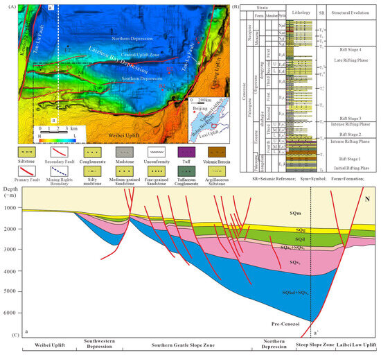
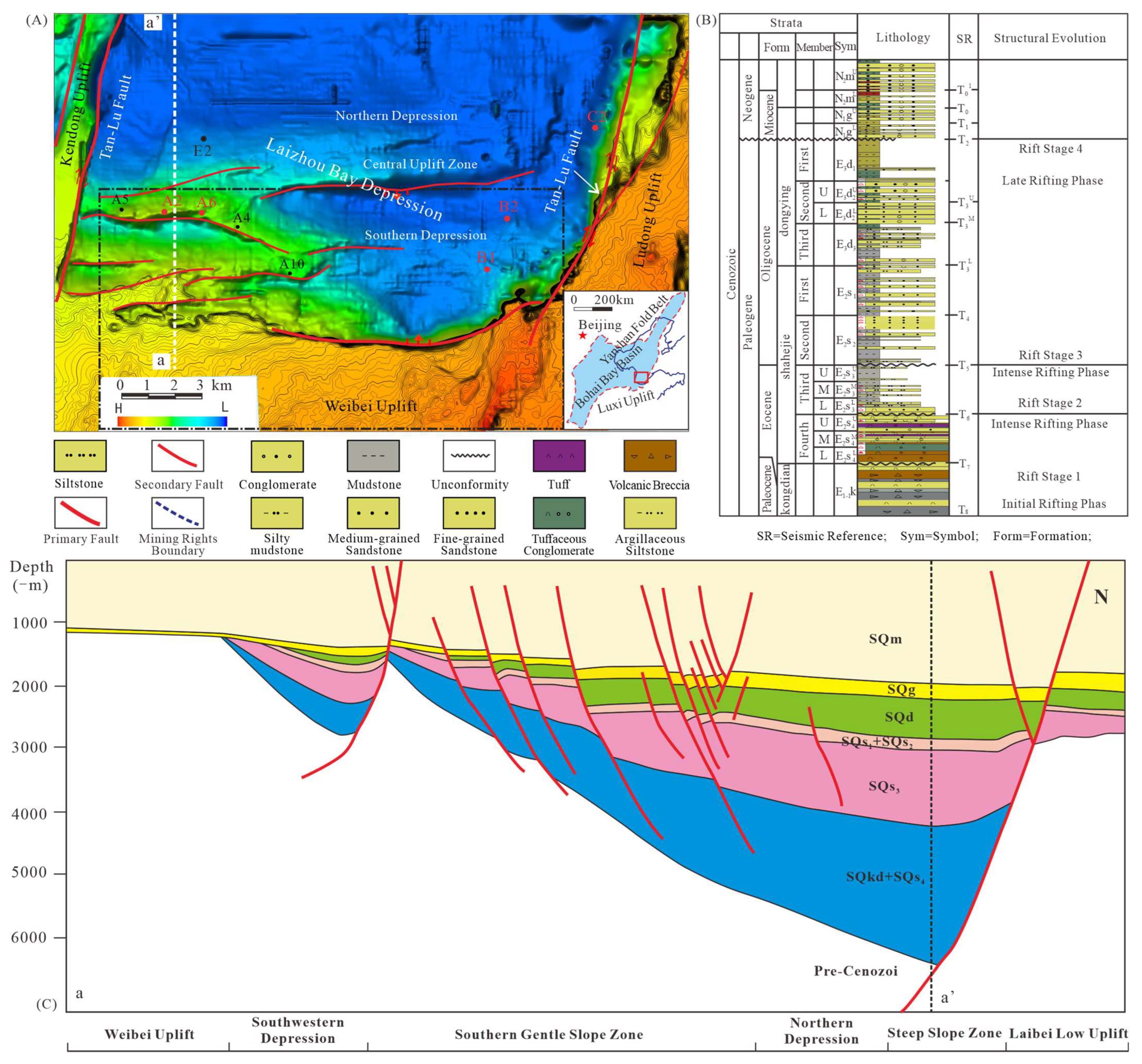
Laizhouwan Sag is located in the southern Bohai Sea, adjacent to the Ludong Uplift in the east, bounded by the Weibei Uplift in the south, the Laixi Slope Belt in the west, and the Laibei Low Uplift in the north [29,30,31]. The eastern and western sides of Laizhouwan Sag are bordered by the eastern and western branches of the Tan-Lu Fault Zone, covering an area of approximately 1200 km2. It is a Cenozoic faulted basin developed on the Mesozoic basement within the North China Plate, subdivided into seven secondary structural units: eastern strike-slip structural belt, western strike-slip structural belt, northern steep-slope belt, northern sag, central structural belt, southern sag, and southern gentle slope belt (Figure 1A). Controlled by continuous activity of the major northern boundary fault, Laizhouwan Sag exhibits a half-graben structure, common during the Cenozoic era [32,33,34,35,36]. In profile, the sag is steep in the north and gentle in the south, with faults in the north transitioning to overlap in the south. It is deeper in the west and shallower in the east (Figure 1C). The Paleogene strata exhibit a structural trend of steepening northward and flattening southward. Neogene strata generally show a monoclinic structure gradually uplifting from north to south (well area A corresponds to sedimentary region A and structural belt A, similarly hereafter).
Figure 1.
Location map of the study area. (A) Location and tectonic unit of the Laizhouwan De-pression; (B) comprehensive histogram of the developed strata in the study area; (C) north–south geological section of the Laizhouwan Depression [Figure 1A for the location of the section].
Drilling reveals that the Paleogene strata primarily consist of the Shahejie and Dongying formations, while the Neogene strata include the Guantao and Minghuazhen formations, along with the Quaternary Pingyuan Formation (Figure 1B). In the Paleogene, Laizhouwan Sag was dominated by fan delta, braided-river delta, and lacustrine deposits [37,38,39].
3. Data and Methods
To characterize the detailed features of the provenance–depositional system in the Laizhouwan Sag, this study is primarily based on the interpretation of an integrated dataset, including newly acquired high-resolution 3D seismic data and multiple well log records. The high-resolution 3D seismic dataset covers the entire study area, with an effective frequency bandwidth of 10–40 Hz and a dominant frequency of approximately 25 Hz. The seismic interpretation grid has a spatial resolution of 4 × 4. Drilling and logging data indicate that the target intervals occur at depths of approximately 3000–3800 m, with P-wave velocities (Vp) ranging from about 2900 to 3500 m/s. Based on the high-quality amplitude–thickness relationship, sandstone bodies as thin as ~9 m (approximately 1/16 of the seismic wavelength, λ = Vp/f) can be detected on horizontal seismic amplitude displays. Therefore, the seismic data are considered sufficient to meet the resolution requirements of this study.
Among the drilled wells, B1 and B2 are located in the eastern depositional area, E2 is situated in the northern depositional area, and A2 and A6 are positioned on the western low uplift, corresponding to the provenance area. Thin-section identification and petrographic analysis were conducted on samples from six wells to determine the lithological characteristics of the provenance basement. The research workflow involves well–seismic calibration to precisely characterize basement lithology, areal distribution, and extent of provenance areas during different depositional stages. Based on reconstructed provenance geomorphology and 3D seismic data, secondary drainage units were delineated in detail. The types, scales (width, depth, width-to-depth ratio, and length), and planform arrangements of sediment transport pathways were analyzed, together with their spatial correspondence to depositional sand bodies. The depositional slope gradients and progradation distances of fan bodies were quantitatively measured. Sedimentary facies were identified based on lithological descriptions from mud logging, well log responses, core observations, and thin-section analyses. Through detailed well–seismic calibration, the seismic facies characteristics of sand-rich depositional bodies were identified and their spatial distribution was mapped. This approach enabled reconstruction of sedimentary system evolution patterns. On this basis, quantitative relationships among the various elements of the source-to-sink system were systematically investigated.
4. Results
During deposition of the Paleogene Shahejie Formation, the southern Laizhouwan Sag functioned as an integrated source-to-sink system. Based on newly acquired drilling data and high-resolution 3D seismic data, we performed a detailed characterization of the pre-Paleogene basement composition, drainage-unit distribution, types and scales of sediment transport systems, and sedimentary development patterns in the southern Laizhouwan Sag. This approach allows evaluation of the configuration and variability of source-to-sink systems along fault-controlled steep slopes within the target intervals, thereby providing a geological basis for predicting favorable reservoir sand bodies in the depositional area.
4.1. Bedrock Types and Provenance Drainage System Subdivision
4.1.1. Bedrock Types and Distribution Characteristics
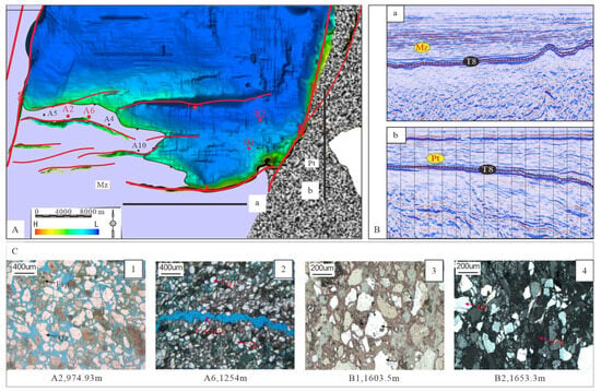
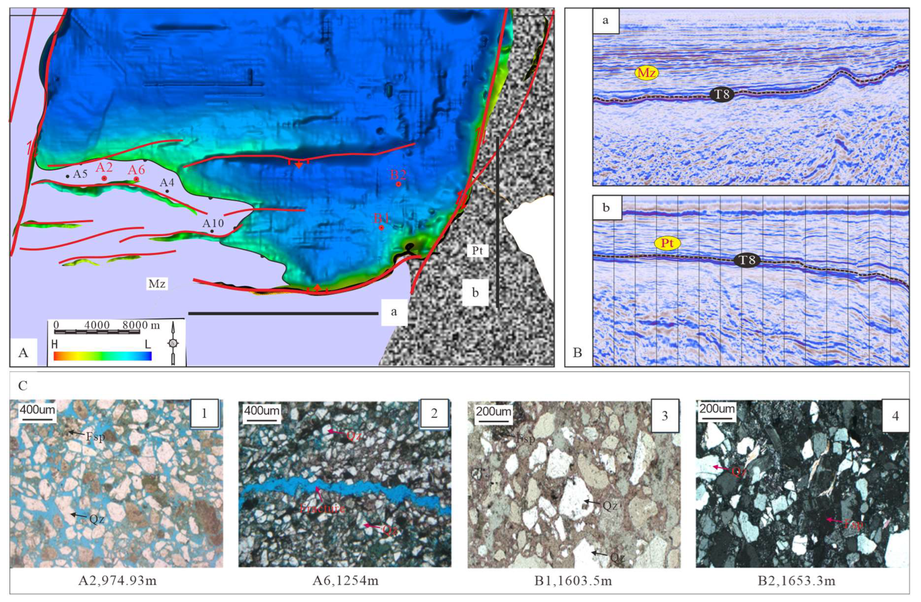
Based on observations of drill cores and cuttings, combined with petrographic thin-section analyses and previous studies of the Bohai Bay Basin, the pre-Paleogene basement lithologies mainly include Proterozoic mixed granites and amphibole gneisses, as well as Mesozoic continental clastic and volcanic successions [40,41,42,43].
Wells A2 and A6 penetrated Mesozoic Cretaceous strata. Core and cuttings thin sections (Figure 2C) indicate that the basement in the southwestern Laizhouwan Sag is dominated by Mesozoic volcanic rocks. As no wells have been drilled directly within the eastern provenance area, nearby wells were selected for microscopic examination of cores and cuttings. Thin-section analyses from wells B1 and B2 show that the eastern provenance area is mainly composed of Proterozoic mixed granites, gneisses, and amphibole gneisses. The southwestern provenance area of the Laizhouwan Sag is characterized by mixed deposits composed of Mesozoic tuffs, volcanic breccias, and terrigenous clastic rocks. Petrographic observations indicate a fracture-related hydrothermal cementation assemblage (A2, 974.93 m; A6, 1254 m), including carbonate minerals, pyrite, gypsum, and chlorite. In contrast, the eastern provenance area exhibits chlorite rim cementation, alkaline dissolution of quartz, locally strong calcite cementation, and fracture development. The dominant lithologies are quartz-lithic sandstones and feldspathic lithic sandstones (B1, 1603.5 m; B2, 1653.3 m). Reservoir space is mainly composed of primary intergranular pores.
Figure 2.
(A): Bedrock zonation map of the provenance areas in the southern Laizhou Bay Sag. (B): Seismic reflection profiles from provenance areas (profile locations shown in Figure 2A). (C): Microscopic identification of core samples from selected wells.
High-resolution 3D seismic sections reveal that the basement in the Laizhouwan area exhibits clear and diagnostic seismic responses [44,45]. Seismic profiles clearly demonstrate pronounced differences in reflection characteristics between the eastern and western basement domains. The western Mesozoic tuffaceous and volcanic breccia units are characterized by seismic reflections of moderate amplitude, moderate continuity, and moderate frequency (Figure 2B). In contrast, the eastern Proterozoic mixed granites display chaotic, low-amplitude, and low-frequency reflections (Figure 2B). The distinct seismic responses of these two basement types allow their boundaries to be readily identified on seismic profiles.
Petrographic observations of sandstone samples from wells B1 and B2 indicate that the reservoir sandstones are mainly quartz-lithic sandstones and feldspathic lithic sandstones. The framework grains consist predominantly of quartz, feldspar, and volcanic lithic fragments derived from the surrounding Mesozoic volcanic–clastic basement. Primary intergranular pores constitute the main reservoir space, whereas secondary dissolution pores occur locally. Cementation is mainly composed of calcite and chlorite.
Because no wells penetrate directly into the eastern provenance area, lithological interpretation is constrained by nearby wells and by seismic reflection characteristics. The chaotic low-amplitude seismic reflection pattern observed in the eastern area is consistent with the response of crystalline basement documented in adjacent wells.
4.1.2. Subdivision and Distribution of Provenance Drainage Systems
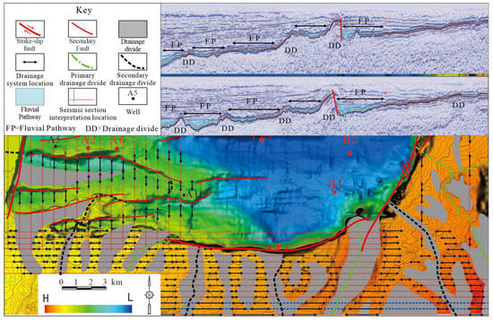
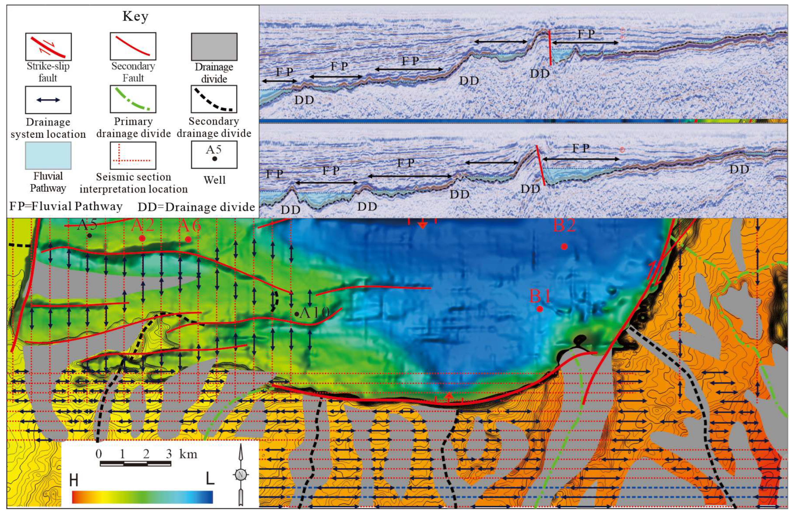
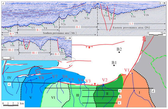
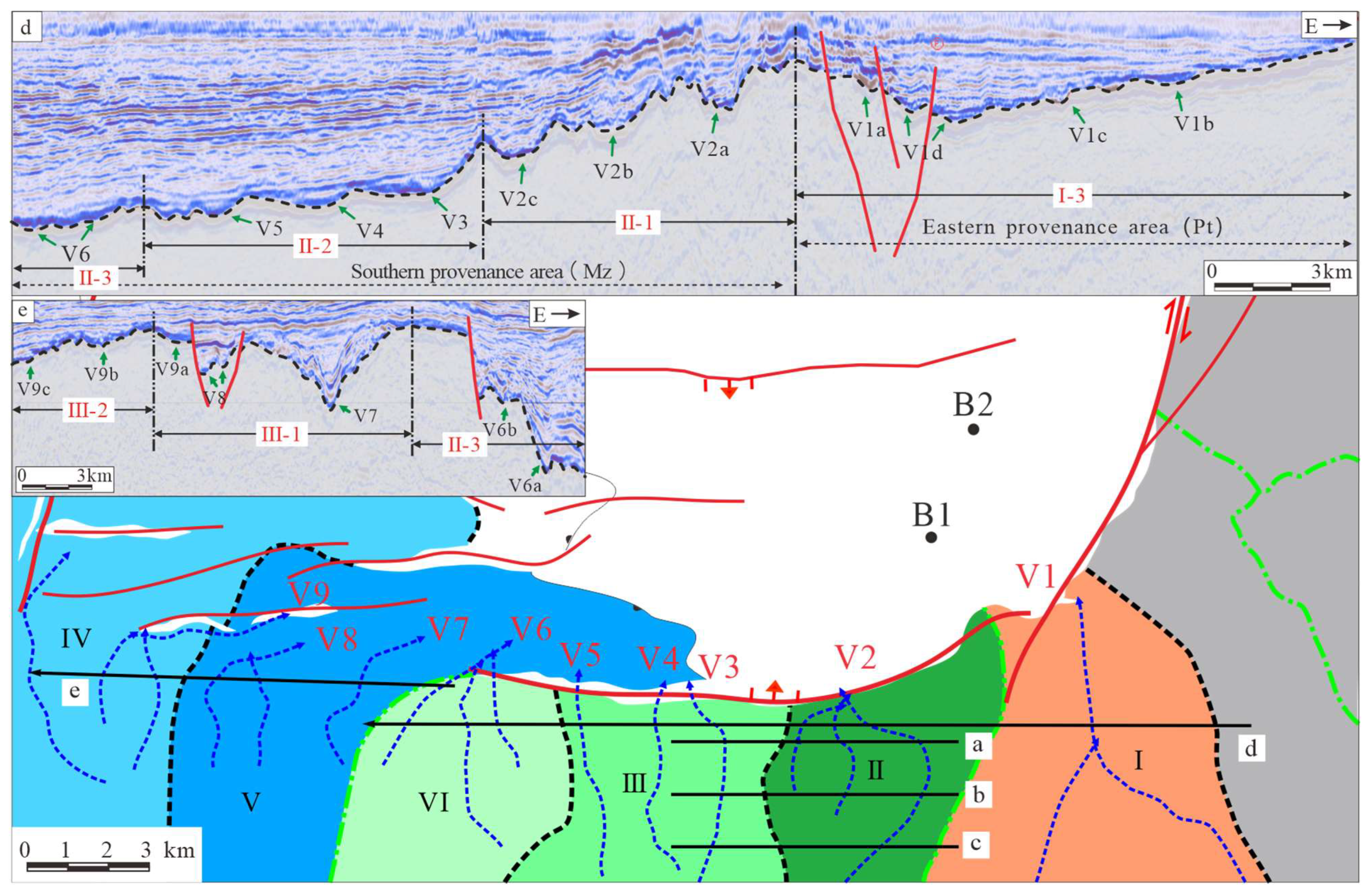
Based on characterization of the pre-Paleogene basement lithologies in the southern Laizhouwan Sag, sedimentary backstripping techniques were applied to reconstruct the Paleogene paleogeographic framework. The reconstructed paleotopography exhibits a pronounced south–steep and north–gentle configuration, indicating significant geomorphic differentiation [46,47]. On the basis of the reconstructed paleogeography, drainage divides and sediment transport pathways were delineated by identifying ridge lines connecting north–south-oriented topographic highs, in combination with a dense grid of seismic profiles (Figure 3). Accordingly, the uplifted area in the study region was subdivided into six provenance-related paleodrainage units from east to west (clockwise), designated as Zones I–IV (Figure 4).
Figure 3.
Seismic-based detailed reconstruction of drainage systems in the southern Bohai Bay Basin. Red dashed lines denote interpreted seismic profiles spaced at 1000 m, black double-headed arrows indicate incised channels, and gray areas mark drainage divides identified from seismic sections.
Figure 4.
Provenance zonation and drainage division in the southern Bohai Bay Basin.
Provenance Zone I in the southern Laizhouwan Sag is characterized by relatively high topography and Proterozoic (Pt) mixed granitic basement. It coincides with a strike-slip fault zone and represents a fault-controlled steep-slope setting, with sediment supplied into the basin from east to west. During deposition of sequences Es4 and Es3, Zone I exhibited a relatively large effective provenance area (~106.4 km2). The vertical relief increased to approximately 122 ms (two-way travel time). The drainage length extended to approximately 0.6 km. Despite its relatively limited vertical relief, sediment supply from Zone I was moderate. Owing to the influence of strike-slip faulting, sediment was mainly transported through fault-controlled troughs in Zone I, which are oriented southeast–northwest.
Provenance Zones II, III, and VI are characterized by lower topography relative to the eastern area, with elevation decreasing progressively from east to west. Drainage systems flow predominantly from south to north into the basin, and the basement lithology mainly comprises Mesozoic (Mz) sandstones, limestones, and tuffaceous basalts. The northern margin of these zones is bounded by basin-margin faults, which extend westward and gradually terminate. The main differences among these zones are reflected in Zones II and III, which correspond to steep-slope belts with short drainage lengths and limited sediment progradation into the basin. During SQs4 deposition, Zone II shows a slight increase in effective provenance area, a vertical relief difference of approximately 30 ms, and little change in drainage length. Zone III exhibits a very limited effective provenance area and short drainage length, indicating relatively weak sediment transport capacity. Zone VI represents a fault-slope transition belt, where drainage patterns are complex due to the combined influence of faulting and topographic relief. This zone is characterized by relatively large vertical relief, an effective provenance area of approximately 40 km2, minor variation in vertical relief through time, and a relatively long drainage length of about 6 km.
Provenance Zones V and IV in the southern Laizhouwan Sag are characterized by relatively low topography and dominantly west-derived sediment supply. The basement lithology mainly consists of Mesozoic (Mz) sandstones and volcanic rocks of Cretaceous and Jurassic age. Zones V and IV correspond to tectonically gentle-slope belts, with relatively large effective provenance areas, widely distributed drainage systems, long progradation distances, and sediment transport predominantly from west to east. During deposition from SQs4L to SQs4U, Zone V exhibits an effective provenance area of approximately 50 km2, a large vertical relief of about 350 ms (two-way travel time), and an increased drainage length of ~14 km. In Zone IV, the effective provenance area increases relatively, vertical relief decreases slightly (~380 ms), and drainage length remains comparatively shorter (~15.2 km). This study quantitatively compiled effective provenance areas for different Paleogene depositional stages in the southern Laizhouwan Sag and its surrounding areas (Table 1 and Table 2). The results indicate that during deposition of the fourth member of the Shahejie Formation, the effective provenance area reached its maximum, accompanied by pronounced topographic relief. In contrast, during deposition of the middle member of the third Shahejie Formation, the effective provenance area was minimal and topographic relief relative to surrounding areas was subdued.
Table 1.
Statistics of the source area parameters SQs4 of Laizhou Bay.
Table 2.
Statistics of the source area parameters SQs3 of Laizhou Bay.
The southern Laizhouwan Sag is mainly underlain by Mesozoic clastic rocks and tuffaceous sandstones, with a south–steep and north–gentle paleotopographic configuration. The southern margin is controlled by boundary faults, forming steep mountainous slopes, whereas the western area exhibits gentler topography with smaller structural relief. Prolonged differential weathering and erosion on the eastern and western sides resulted in the development of various types of paleo-valleys. Based on their geometric characteristics, these paleo-valleys are classified into V-shaped, U-shaped, and composite W-shaped types. In the southern transfer zone, the effective provenance area is limited and transport distances are short; a total of nine paleo-valleys (V1–V9) are identified (Figure 4).
4.2. Analysis of Sediment Transport Channel Characteristics
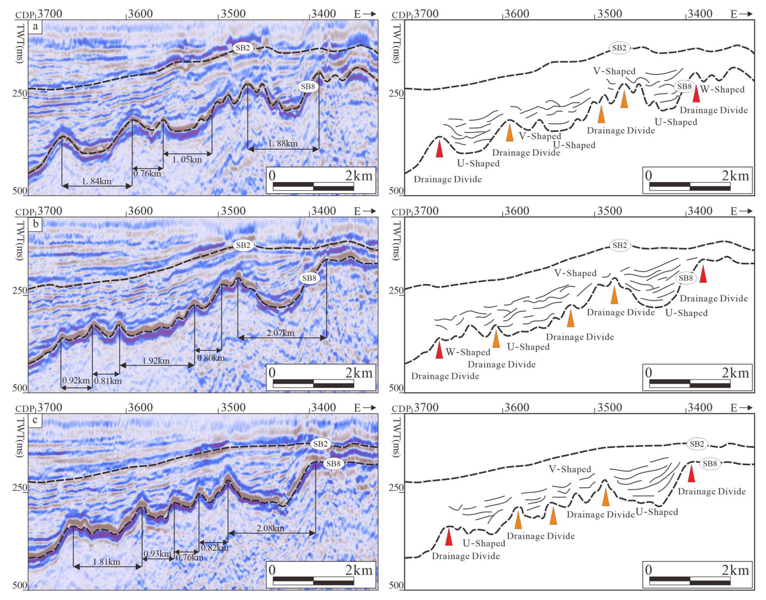
In the southern part of the Laizhou Bay Sag and its surrounding areas, two main types of sediment transport channels were identified: paleo-valleys and fault troughs. The paleo-valleys can be further classified into deep V-shaped, U-shaped, and W-shaped types, which are developed in both steep and gentle slope zones. The fault troughs mainly include single-fault and double-fault types, predominantly distributed along the basin margins and structural transition zones.
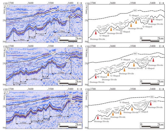
Taking the local provenance area of the Weibei Uplift in the southern Laizhou Bay Sag as an example, the morphology and number of sediment transport channels were precisely characterized using a high-density seismic profile network. Due to long-term differential exposure and erosion, identified sediment transport channels vary across different drainage units, and even within the same drainage unit, different channel types may occur at different positions. Based on external morphology and spatial distribution, the southern provenance area predominantly developed V-shaped, U-shaped, and composite W-shaped paleo-valleys. Seismic profiles perpendicular to paleo-valley orientations (Figure 5) show: ① In elevated areas of the provenance zone, significant elevation gradients lead to the dominance of V-shaped paleo-valleys, characterized by discontinuous seismic reflections and short-axis parallel reflections. ② Moving downstream from higher to lower elevations, river systems converge, transitioning paleo-valley morphology from V-shaped to U-shaped, with increased width and depth, reflected seismically by vertical stacking and lateral migration. ③ At the confluence between provenance and depositional areas, the incision ability of main channels increases but their scale reduces due to water backing effects from depositional basins. Tributary streams experience decreased hydraulic energy, enhancing seismic reflection continuity, and paleo-valleys transition to composite W-shaped forms.
Figure 5.
Types and seismic reflection characteristics of paleo-valleys in the southern Laizhou Bay Basin (Weibei Uplift) (Figure 4).
Based on detailed paleogeomorphic reconstruction, statistical analyses were conducted on paleo-valley types and their geometric parameters, including width, length, width-to-depth ratio, as well as the width, length, and area of the corresponding depositional fans (Table 3). The results indicate that V-shaped valleys are generally narrow and deep, whereas U-shaped valleys are relatively shallow and wide. W-shaped valleys occur in very limited numbers and are therefore not statistically representative. On this basis, the relationship between paleo-valley width-to-depth ratios and the width and length of their associated depositional fans was further evaluated.
Table 3.
Statistics of sand transport channel parameters in the source area of the southern Laizhou Bay.
4.3. Analysis of Depositional Fan Characteristics
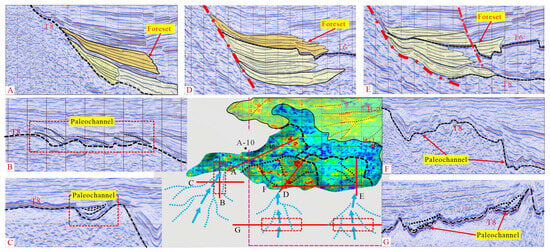
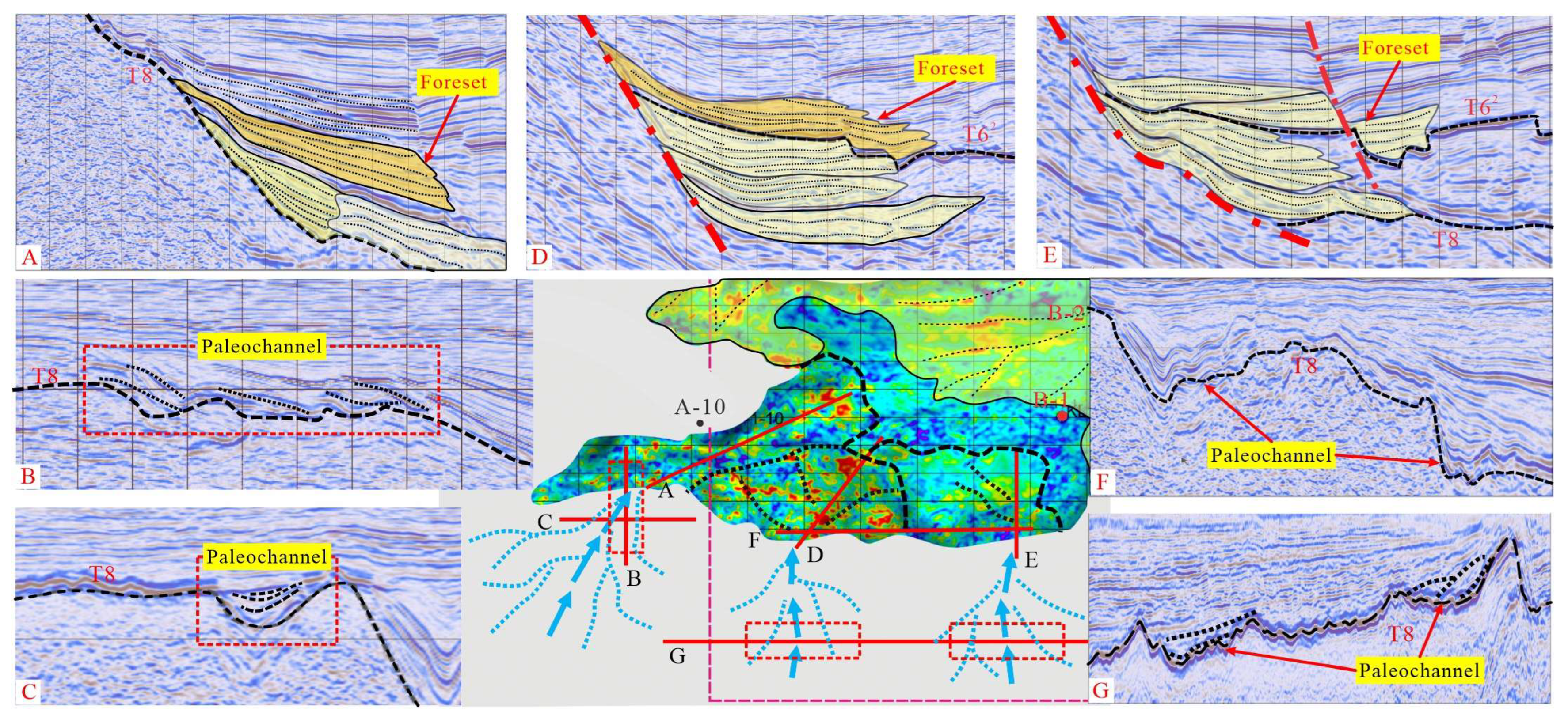
Previous studies have identified the main sedimentary systems developed in the Kongdian and Shahejie formations of the Bohai Bay Basin [41,48,49]. These systems include fan deltas, braided-river deltas, beach-bar systems, and lacustrine deposits. Deltaic systems are distributed along the basin margins and display an overall wedge-shaped geometry, prograding toward the basin center. Along the sediment supply direction, seismic profiles reveal multiple phases of incised channels, with internal architectures characterized by repeated lateral accretion or chaotic infill (Figure 6).
Figure 6.
Comprehensive schematic diagram of the source-to-sink system in the southern Laizhou Bay Sag (section location indicated by red lines).
In the target intervals of the southern study area, distinct deltaic seismic reflection characteristics are identified on slopes based on depositional stacking patterns, seismic reflection attributes, and plan view distribution. Early stage depositional systems are mainly developed on slope belts and are strongly controlled by antecedent paleotopography, exhibiting typical fan-delta characteristics. Clear morphological differences between fan deltas and braided-river deltas are observed on seismic profiles. Fan bodies in the southern area are characterized by short transport distances and proximal accumulation, rather than long-distance sediment delivery. Compared with braided-river delta deposits in the study area, these fan deltas exhibit lower seismic reflection continuity, shorter reflection lengths, and lower dominant frequencies. In addition, fan deltas are associated with smaller effective provenance areas and less developed drainage systems than braided-river delta systems [50,51].
Based on the sediment transport pathways identified in the southern provenance areas, corresponding depositional bodies can be recognized at appropriate positions within the basin. These depositional bodies are characterized by moderate- to high-amplitude, moderately continuous, obliquely progradational seismic reflections, which are diagnostic of deltaic deposits. Accordingly, deltaic deposits were systematically identified within the stratigraphic intervals studied. On seismic profiles, differences between fan deltas and braided-river deltas were analyzed in terms of paleogeographic setting, seismic reflection architecture, planform geometry, and quantitative parameters. RMS attribute slices and seismic facies maps were used to delineate the plan view distribution patterns of the sedimentary systems.
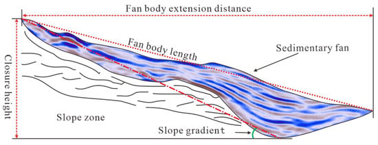
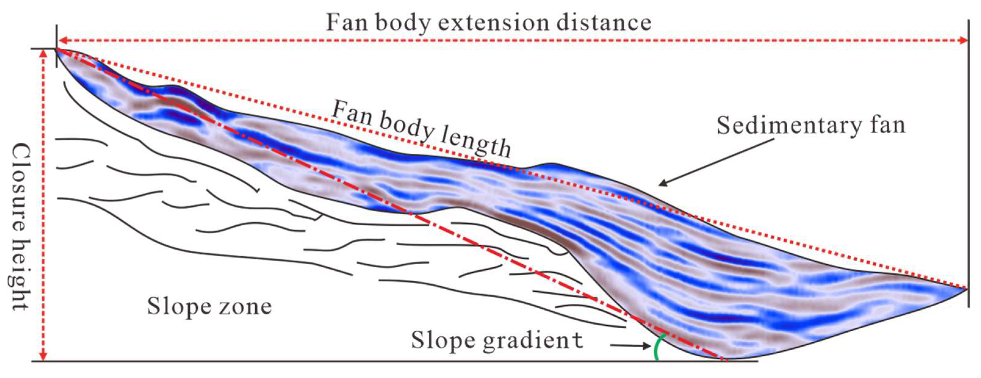
A detailed quantitative analysis of depositional fan bodies was conducted, focusing on parameters such as area, volume, progradation distance, and closure relief (Figure 7). Based on the established distributions of sandstone thickness and sandstone percentage for individual submembers of the third and fourth Shahejie formations, the areas and volumes of fan bodies in the depositional domain were calculated. Fan bodies in the eastern depositional area of the Laizhouwan Sag are generally larger in scale and thicker than those in the western area. Based on spatial variations in fan body thickness patterns and boundary geometries, fan bodies developed in different submembers of the third and fourth Shahejie formations were classified. Seismic interpretation software (Geoframe 4.0.3 and Petrel.2018) was used to calculate the volumes and areas of the main fan bodies within each stratigraphic interval in the depositional area (Table 4).
Figure 7.
Schematic diagram of fan body parameter measurement from seismic profiles.
Table 4.
Statistical table of fan body parameters for the third and fourth members of the Shahejie Formation in the southern Laizhou Bay Sag.
5. Discussion
Variations in the individual components of a source-to-sink system provide key insights into its evolutionary processes. In this study, quantitative statistics were compiled for relevant parameters across different zones and stratigraphic intervals. Sensitivity parameters were identified through correlation analyses, and their intrinsic relationships with depositional fan bodies were evaluated. Finally, an integrated source-to-sink coupling model for the study area was established by synthesizing provenance characteristics, depositional distribution patterns, and their configuration with sediment transport systems.
5.1. Quantitative Parameter Correlation Analysis
5.1.1. Quantitative Analysis of Provenance Area and Fan Bodies
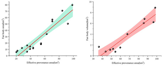
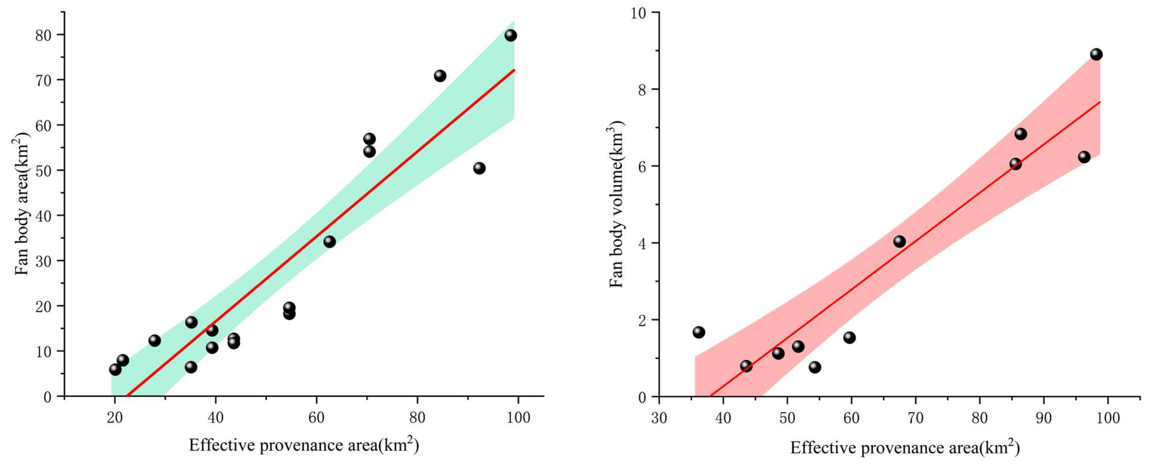
Statistical analyses indicate that from the Kongdian Formation to the third member of the Shahejie Formation, the total effective provenance area in the study area decreases progressively. Correspondingly, the total area of depositional bodies also shows a gradual reduction, exhibiting a clear linear correlation. This relationship suggests that effective provenance area exerts a fundamental control on the scale of depositional fan development. Effective provenance areas and fan body scales within steep-slope belts were further quantified for the fourth and third members of the Shahejie Formation. The results demonstrate that, both at the level of individual stratigraphic intervals and for the entire dataset (Figure 8), increases in effective provenance area are accompanied by increases in fan body area and volume, indicating a strong positive correlation. Larger effective provenance areas are capable of supplying greater volumes of clastic material, resulting in sufficient sediment input and the accumulation of larger sand bodies in the depositional area, thereby increasing fan body area and volume. On this basis, the controlling role of provenance areas on fan body development was further evaluated by integrating basement residual parent-rock types in the Paleogene Laizhouwan Sag with quantitative sedimentary characteristics of sand bodies in the depositional domain.
Figure 8.
Relationship diagram between effective provenance area and quantitative fan body parameters (SQs3 + SQs4).
Quantitative analyses of the relationship between effective provenance area and fan bodies indicate that effective provenance area is the primary control on fan body scale. When combined with basement lithology, it is evident that provenance areas dominated by Mesozoic volcanic and clastic rocks tend to develop well-established sediment transport pathways and extensive drainage systems, resulting in larger effective provenance areas, higher erosion volumes, and greater sediment supply, which in turn correspond to larger fan bodies. In summary, effective provenance area fundamentally controls the spatial scale and distribution of sedimentary systems.
5.1.2. Quantitative Analysis of Sediment Transport Pathways and Fan Bodies
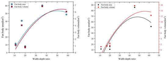
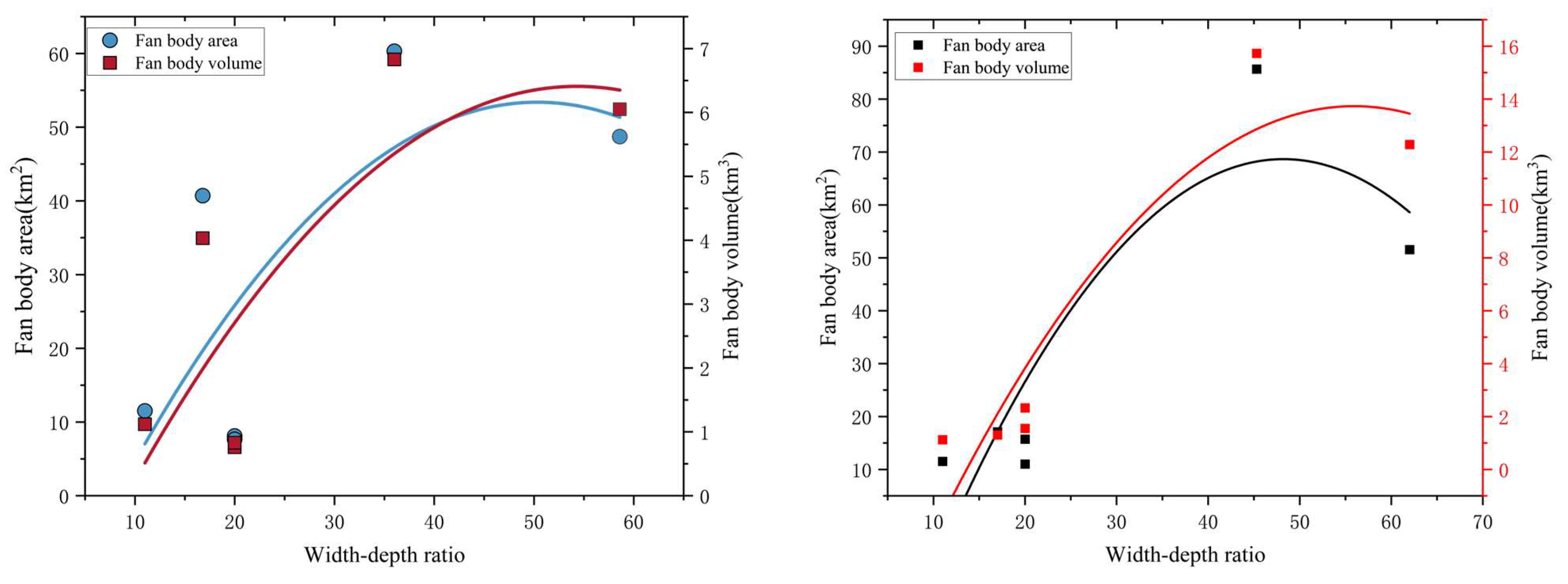
This study focuses specifically on the width-to-depth ratio of sediment transport channels. The results indicate that the relationships between channel width-to-depth ratio and fan body area and volume are better described by a second-order polynomial model, showing stronger correlations than linear fits. Fan body area and volume reach their maximum values when the channel width-to-depth ratio falls within an intermediate range. When the width-to-depth ratio is lower or higher than this optimal range, the area and volume of developed conglomeratic sand bodies decrease. It should be noted that channel parameters were primarily extracted from residual channels preserved at the T8 surface. Accordingly, the analysis is restricted to residual paleo-valley parameters from the lower submember of the fourth Shahejie Formation, the fourth member, and the third member, and their correlations with fan body area and volume within the corresponding stratigraphic intervals. The relationship between paleo-valley width-to-depth ratio and sand body area suggests the existence of an optimal valley geometry (i.e., channel morphology). At this empirical optimum, the sediment supply efficiency of transport channels reaches its maximum (Figure 9). This relationship likely reflects the balance between channel confinement and sediment transport capacity. Considering that V-shaped valleys have small width-to-depth ratios, U-shaped valleys exhibit intermediate ratios, and W-shaped valleys display large ratios, U-shaped valleys are interpreted to have relatively higher sediment transport efficiency. As the paleo-valley width-to-depth ratio increases, the corresponding depositional fans tend to become shorter in length and wider in plan view. This implies that wide and shallow paleo-valleys generate laterally extensive but short, flattened fan bodies with limited progradation toward the lake basin. In contrast, narrow and deep paleo-valleys are associated with narrow, elongated fan bodies with longer progradation distances and stronger basinward advance capacity.
Figure 9.
Relationship diagram between sediment transport pathway parameters and quantitative fan body parameters.
Accordingly, fitting results between channel width-to-depth ratio and fan body parameters indicate the presence of an extremum, which represents the optimal transport condition of sediment transport channels and corresponds to the maximum sediment transport capacity. By statistically comparing the volumes of fan bodies associated with different types of sediment transport channels and integrating the relationships between V-, U-, and W-shaped valleys and their width-to-depth ratios, U-shaped valleys, characterized by intermediate width-to-depth ratios, are interpreted to exhibit the highest sediment transport efficiency compared with other channel morphologies.
5.2. Evolution of Depositional Systems
Guided by source-to-sink theory, sedimentary facies indicators identified from drilling, logging, and seismic data were integrated with detailed seismic sedimentological analysis in key areas to compile third-order sequence–based depositional facies maps for the southern sub-sag. Within the sequence framework, the distribution and development of depositional facies and sedimentary systems were analyzed, and fan body parameters were quantitatively characterized, providing a robust data foundation for source-to-sink analysis.
Fault-related slope-break belts were mainly developed in the southern provenance areas of the Laizhouwan Sag, where sedimentation during the Shahejie Member 4 was strongly controlled by these structural slope breaks. The eastern provenance area (Zone I) is underlain predominantly by Proterozoic granitic basement, whereas the central and western areas are characterized by Mesozoic volcaniclastic basement.
During deposition of the Shahejie Member 4, Zone I was characterized by a relatively large effective provenance area, elevated topography, and pronounced east–west vertical relief, facilitating efficient drainage into the basin. During deposition of the Shahejie Member 3, sediment transport capacity in the eastern area weakened due to combined climatic and tectonic influences, together with a reduction in transport-channel scale. In addition, the southern part of Zone I evolved into a fault-controlled gentle-slope belt with limited vertical relief in the provenance area, further constraining sediment supply. Zone II is also characterized by a fault-controlled steep-slope belt, where well-developed drainage systems resulted in relatively strong sediment transport capacity.
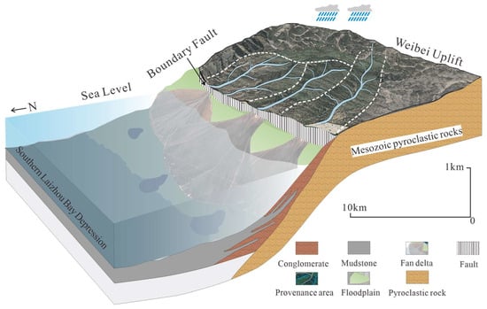
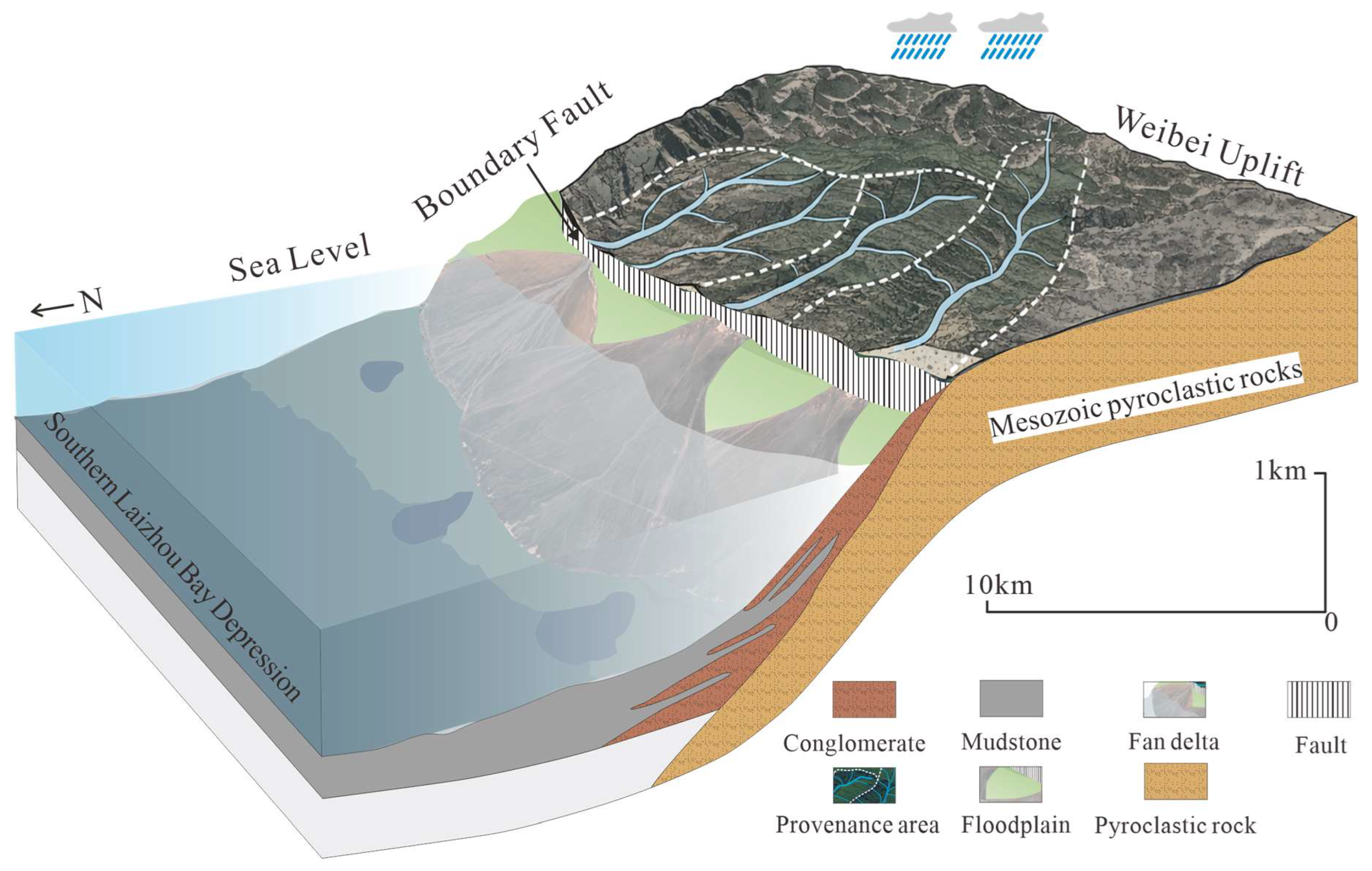
Integrated analysis indicates that a fault-controlled, steep-slope source-to-sink system is developed in the southern Laizhouwan Sag. Within this fault-controlled, steep-slope source-to-sink system, eroded materials from volcaniclastic provenance areas are transported through fault-groove or paleo-valley channels, whose efficiency is regulated by vertical structural constraints. Along the downthrown side of the fault, these processes favor the development of laterally continuous, proximal coarse-grained fan-delta to slump (sub-lacustrine fan) depositional systems. Effective provenance area, vertical relief, and transport-channel scale show positive correlations with the area and volume of depositional fan bodies in the sink region. Overall, the eastern depositional area of the Laizhouwan Sag is characterized by a fault-slope-controlled depositional model comprising granitic provenance, U-shaped sediment transport channels, proximal coarse-grained fan deltas, and lacustrine systems (Figure 10).
Figure 10.
Conceptual depositional model of the fault-controlled steep-slope system in the southern Laizhouwan Sag, Laizhou Bay Depression.
6. Conclusions
This study presents a quantitative source-to-sink analysis of the Paleogene depositional system in the southern Laizhouwan Sag of the Bohai Bay Basin. Based on integrated seismic, drilling, logging, and petrographic data, the relationships between provenance characteristics, sediment transport pathways, and depositional fan development were systematically evaluated. The main conclusions are summarized as follows.
Effective provenance area represents the primary control on depositional fan scale. Quantitative analysis reveals a strong positive correlation between effective provenance area and fan body area and volume. Larger provenance areas are capable of supplying greater volumes of clastic material, resulting in the development of larger depositional fan systems within the basin.
The geometry of sediment transport channels significantly influences sediment transport efficiency. Statistical analysis indicates a nonlinear relationship between the width-to-depth ratio of paleo-valleys and the scale of associated depositional fans. Paleo-valleys with intermediate width-to-depth ratios (commonly represented by U-shaped valleys) exhibit relatively higher sediment transport efficiency compared with narrow V-shaped or wide W-shaped valleys.
A fault-controlled, steep-slope source-to-sink system governs sedimentary architecture in the southern Laizhouwan Sag. In this tectonic setting, effective provenance area, structural relief, and transport-channel geometry collectively control the spatial distribution and scale of depositional fan bodies. Coarse-grained fan-delta systems preferentially develop along fault-related slope-break zones adjacent to the provenance areas.
Overall, this study provides a quantitative framework for understanding sediment routing and depositional processes in continental rift basins. The results also offer valuable insights for predicting the distribution of favorable reservoir sand bodies in fault-controlled lacustrine basins. Future research should further integrate sediment budget analysis, paleoclimate reconstruction, and diagenetic studies to better understand the evolution of source-to-sink systems and their implications for reservoir quality.
Author Contributions
Conceptualization, Y.W., T.Y. and C.Z.; methodology, C.Z. and Y.W.; software, C.Z., Y.W. and Z.S.; validation, C.Z. and Q.C.; formal analysis, C.Z.; investigation, C.Z. and Q.C.; resources, T.Y.; data curation, C.Z. and Y.W.; writing—original draft preparation, C.Z. and Z.S.; writing—review and editing, C.Z., Y.W. and T.Y.; visualization, Q.C.; supervision, Y.W. and S.Z.; project administration, C.Z. and S.Z.; funding acquisition, Y.W. and T.Y. All authors have read and agreed to the published version of the manuscript.
Funding
This research was funded by the National Natural Science Foundation of China (No. 42572144, 42202120).
Institutional Review Board Statement
Not applicable.
Informed Consent Statement
Not applicable.
Data Availability Statement
All data and materials are available on request from the corresponding author. The data are not publicly available due to ongoing research using a part of the data.
Conflicts of Interest
Qin Chen was employed by Cnooc International Limited Exploration Technology Research Institute, Beijing 100028, China. The remaining authors declare that the research was conducted in the absence of any commercial or financial relationships that could be construed as a potential conflict of interest.
References
- Allen, P.A. Time Scales of Tectonic Landscapes and Their Sediment Routing Systems. In Landscape Evolution: Denudation, Climate and Tectonics over Different Time and Space Scales; Geological Society: London, UK, 2008; Volume 296, pp. 7–28. [Google Scholar] [CrossRef] [Scilit]
- Allen, P.A.; Hovius, N. Sediment Supply from Landslide-dominated Catchments: Implications for Basin-margin Fans. Basin Res. 1998, 10, 19–35. [Google Scholar] [CrossRef] [Scilit]
- Allen, P.A. From Landscapes into Geological History. Nature 2008, 451, 274–276. [Google Scholar] [CrossRef] [Scilit]
- Alessandretti, L.; Machado, R.; Warren, L.V.; Assine, M.L.; Lana, C. From Source-to-Sink: The Late Permian SW Gondwana Paleogeography and Sedimentary Dispersion Unraveled by a Multi-Proxy Analysis. J. S. Am. Earth Sci. 2016, 70, 368–382. [Google Scholar] [CrossRef] [Scilit]
- Zeng, Z.; Zhu, H.; Mei, L.; Du, J.; Zeng, H.; Xu, X.; Dong, X. Multilevel Source-to-Sink (S2S) Subdivision and Application of an Ancient Uplift System in South China Sea: Implications for Further Hydrocarbon Exploration. J. Pet. Sci. Eng. 2019, 181, 106220. [Google Scholar] [CrossRef] [Scilit]
- Sømme, T.O.; Jackson, C.A. Source-to-sink Analysis of Ancient Sedimentary Systems Using a Subsurface Case Study from the Møre-Trøndelag Area of Southern Norway: Part 2—Sediment Dispersal and Forcing Mechanisms. Basin Res. 2013, 25, 512–531. [Google Scholar] [CrossRef] [Scilit]
- Sømme, T.O.; Helland-Hansen, W.; Granjeon, D. Impact of Eustatic Amplitude Variations on Shelf Morphology, Sediment Dispersal, and Sequence Stratigraphic Interpretation: Icehouse versus Greenhouse Systems. Geology 2009, 37, 587–590. [Google Scholar] [CrossRef] [Scilit]
- Zhang, B.; Liu, S.; Lin, C.; Wang, Y.; Wang, Z.; Fang, M.; Shen, W. Source-to-Sink System Reconstruction in the Northern Jiaolai Basin, Eastern China, by Multiproxy Provenance Methods and Implications for Exhumation of the Sulu Orogen. Tectonophysics 2019, 754, 18–32. [Google Scholar] [CrossRef] [Scilit]
- Feng, Y.; Jiang, S.; Hu, S.; Li, S.; Lin, C.; Xie, X. Sequence Stratigraphy and Importance of Syndepositional Structural Slope-Break for Architecture of Paleogene Syn-Rift Lacustrine Strata, Bohai Bay Basin, E. China. Mar. Pet. Geol. 2016, 69, 183–204. [Google Scholar] [CrossRef] [Scilit]
- Li, S.; Zhu, H.; Yang, X.; Xu, C. Seismic Geomorphology, Architecture and Genesis of Unusual Confined and Semiconfined Sedimentary Units on the Northern Slope of the Bonan Uplift, Bohai Bay Basin, China. J. Pet. Sci. Eng. 2021, 196, 107696. [Google Scholar] [CrossRef] [Scilit]
- Li, S.; Zhu, H.; Xu, C.; Zeng, H.; Liu, Q.; Yang, X. Seismic-Based Identification and Stage Analysis of Overlapped Compound Sedimentary Units in Rifted Lacustrine Basins: An Example from the Bozhong Sag, Bohai Bay Basin, China. Bulletin 2019, 103, 2521–2543. [Google Scholar] [CrossRef] [Scilit]
- Zhang, W.; Xian, B.; Ji, H.; Zhang, X.; Xiao, Z.; Wang, Z.; Wang, J.; Chen, L.; Lian, H.; Wu, Q.; et al. Magmatic Intrusion Impacts on Source-to-Sink System of Rift Basins: Eocene Lufeng-22 Sub-Sag, Pearl River Mouth Basin, South China Sea. J. Asian Earth Sci. 2022, 240, 105440. [Google Scholar] [CrossRef] [Scilit]
- Bernhardt, A.; Schwanghart, W.; Hebbeln, D.; Stuut, J.-B.W.; Strecker, M.R. Immediate Propagation of Deglacial Environmental Change to Deep-Marine Turbidite Systems along the Chile Convergent Margin. Earth Planet. Sci. Lett. 2017, 473, 190–204. [Google Scholar] [CrossRef] [Scilit]
- Caracciolo, L. Sediment Generation and Sediment Routing Systems from a Quantitative Provenance Analysis Perspective: Review, Application and Future Development. Earth-Sci. Rev. 2020, 209, 103226. [Google Scholar] [CrossRef] [Scilit]
- Nyberg, B.; Helland-Hansen, W.; Gawthorpe, R.; Tillmans, F.; Sandbakken, P. Assessing First-order BQART Estimates for Ancient Source-to-sink Mass Budget Calculations. Basin Res. 2021, 33, 2435–2452. [Google Scholar] [CrossRef] [Scilit]
- Romans, B.W.; Castelltort, S.; Covault, J.A.; Fildani, A.; Walsh, J.P. Environmental Signal Propagation in Sedimentary Systems across Timescales. Earth-Sci. Rev. 2016, 153, 7–29. [Google Scholar] [CrossRef] [Scilit]
- Salles, T.; Husson, L.; Rey, P.; Mallard, C.; Zahirovic, S.; Boggiani, B.H.; Coltice, N.; Arnould, M. Hundred Million Years of Landscape Dynamics from Catchment to Global Scale. Science 2023, 379, 918–923. [Google Scholar] [CrossRef] [Scilit]
- Cloetingh, S.; Maţenco, L.; Bada, G.; Dinu, C.; Mocanu, V. The Evolution of the Carpathians–Pannonian System: Interaction between Neotectonics, Deep Structure, Polyphase Orogeny and Sedimentary Basins in a Source to Sink Natural Laboratory. Tectonophysics 2005, 410, 1–14. [Google Scholar] [CrossRef] [Scilit]
- Anthony, E.J.; Julian, M. Source-to-Sink Sediment Transfers, Environmental Engineering and Hazard Mitigation in the Steep Var River Catchment, French Riviera, Southeastern France. Geomorphology 1999, 31, 337–354. [Google Scholar] [CrossRef] [Scilit]
- Bentley, S.J.; Blum, M.D.; Maloney, J.; Pond, L.; Paulsell, R. The Mississippi River Source-to-Sink System: Perspectives on Tectonic, Climatic, and Anthropogenic Influences, Miocene to Anthropocene. Earth-Sci. Rev. 2016, 153, 139–174. [Google Scholar] [CrossRef] [Scilit]
- Xia, S.; Liu, J.; Liu, Z.; Ye, D.; Chang, Y.; Gao, N.; Li, H.; Liang, X. The Geophysical Identification, Characteristics, and Petroliferous Significance of Sublacustrine Fan Deposits in the Second Member of Dongying Formation in Liaozhong Depression, Bohai Bay Basin. Geol. J. 2018, 53, 692–706. [Google Scholar] [CrossRef] [Scilit]
- Wang, X.; Shao, L.; Eriksson, K.A.; Yan, Z.; Wang, J.; Li, H.; Zhou, R.; Lu, J. Evolution of a Plume-Influenced Source-to-Sink System: An Example from the Coupled Central Emeishan Large Igneous Province and Adjacent Western Yangtze Cratonic Basin in the Late Permian, SW China. Earth-Sci. Rev. 2020, 207, 103224. [Google Scholar] [CrossRef] [Scilit]
- Covault, J.A.; Normark, W.R.; Romans, B.W.; Graham, S.A. Highstand Fans in the California Borderland: The Overlooked Deep-Water Depositional Systems. Geol 2007, 35, 783. [Google Scholar] [CrossRef] [Scilit]
- Dodd, T.J.H.; McCarthy, D.J.; Richards, P.C. A Depositional Model for Deep-lacustrine, Partially Confined, Turbidite Fans: Early Cretaceous, North Falkland Basin. Sedimentology 2019, 66, 53–80. [Google Scholar] [CrossRef] [Scilit]
- Li, W.; Jia, H.; Wu, Z.; Niu, C.; Chen, X. Controls of Strike-Slip Faults on Geomorphology and Sediment Dispersal in the Paleogene Bohai Bay Area—From a Source to Sink Perspective. Mar. Pet. Geol. 2021, 126, 104946. [Google Scholar] [CrossRef] [Scilit]
- Dong, W.; Lin, C.; Eriksson, K.A.; Zhou, X.; Liu, J.; Teng, Y. Depositional Systems and Sequence Architecture of the Oligocene Dongying Formation, Liaozhong Depression, Bohai Bay Basin, Northeast China. Bulletin 2011, 95, 1475–1493. [Google Scholar] [CrossRef] [Scilit]
- Gilmullina, A.; Klausen, T.G.; Doré, A.G.; Rossi, V.M.; Suslova, A.; Eide, C.H. Linking Sediment Supply Variations and Tectonic Evolution in Deep Time, Source-to-Sink Systems—The Triassic Greater Barents Sea Basin. GSA Bull. 2022, 134, 1760–1780. [Google Scholar] [CrossRef] [Scilit]
- Feng, D.; Deng, H.; Zhou, Z.; Gao, X.; Cui, L. Paleotopographic Controls on Facies Development in Various Types of Braid-Delta Depositional Systems in Lacustrine Basins in China. Geosci. Front. 2015, 6, 579–591. [Google Scholar] [CrossRef] [Scilit]
- Cui, J.; Yuan, X.; Wu, S.; Zhang, R.; Jin, S.; Li, Y. Rock Types and Reservoir Characteristics of Shahejie Formation Marl in Shulu Sag, Jizhong Depression, Bohai Bay Basin. J. Earth Sci. 2021, 32, 986–997. [Google Scholar] [CrossRef] [Scilit]
- Li, Z.; Li, F.; Chen, Z.; Lai, X.; Ma, X. Provenance of Late Mesozoic Strata and Tectonic Implications for the Southwestern Ordos Basin, North China: Evidence from Detrital Zircon U−Pb Geochronology and Hf Isotopes. J. Earth Sci. 2022, 33, 373–394. [Google Scholar] [CrossRef] [Scilit]
- Xu, C.; Du, X.; Zhu, H.; Jia, D.; Xu, W.; Lu, H. Source-to-Sink System and Its Sedimentary Records in the Continental Rift Basins: An Example from the Paleogene in the Bohai Sea Area, China. Interpretation 2017, 5, ST35–ST51. [Google Scholar] [CrossRef] [Scilit]
- Fu, C.; Li, S.; Li, S.; Xu, J. Tectonostratigraphic Evolution of a Rift Basin and Corresponding Source-to-Sink Systems: Implications for the Western Bohai Bay Basin, North China. Mar. Pet. Geol. 2022, 139, 105587. [Google Scholar] [CrossRef] [Scilit]
- Liu, H.T.; Yu, H.T.; Sun, Y.; Jiang, W.Y.; Yang, G.D.; Wang, M.W.; Wang, J.W. Formation and Differential Enrichment of Oil and Gas on Multiple Types of Slopes in Rifted Basins: Taking the Bohai Bay Basin as an Example, China. Acta Petrol. Sin. 2022, 38, 2697–2708. [Google Scholar] [CrossRef] [Scilit]
- Xu, S.; Cong, F.; Hao, F.; Xu, C.; Zou, H.; Zhang, X.; Xu, S. Shelf-Edge Trajectory and Sediment Dispersal in a Lacustrine Setting: A Case Study from Qinnan Depression, Bohai Bay Basin, China. Mar. Pet. Geol. 2018, 91, 562–575. [Google Scholar] [CrossRef] [Scilit]
- Zhao, Q.; Zhu, H.; Zhang, X.; Liu, Q.; Qiu, X.; Li, M. Geomorphologic Reconstruction of an Uplift in a Continental Basin with a Source-to-Sink Balance: An Example from the Huizhou-Lufeng Uplift, Pearl River Mouth Basin, South China Sea. Mar. Pet. Geol. 2021, 128, 104984. [Google Scholar] [CrossRef] [Scilit]
- Zhou, X.; Wang, Q.; Feng, C.; Ye, T.; Liu, X.; Hao, Y.; Zhou, L. Formation Conditions and Geological Significance of Large Archean Reservoirs in the Bohai Sea Area. Earth Sci. 2022, 47, 1534. [Google Scholar] [CrossRef] [Scilit]
- Liu, H.; Van Loon, A.J.; Xu, J.; Tian, L.; Du, X.; Zhang, X.; Chen, D. Relationships between Tectonic Activity and Sedimentary Source-to-sink System Parameters in a Lacustrine Rift Basin: A Quantitative Case Study of the Huanghekou Depression (Bohai Bay Basin, E China). Basin Res. 2020, 32, 587–612. [Google Scholar] [CrossRef] [Scilit]
- Liu, Q.; Zhu, X.; Zeng, H.; Li, S. Source-to-Sink Analysis in an Eocene Rifted Lacustrine Basin Margin of Western Shaleitian Uplift Area, Offshore Bohai Bay Basin, Eastern China. Mar. Pet. Geol. 2019, 107, 41–58. [Google Scholar] [CrossRef] [Scilit]
- Xue, Y.; Zhao, M.; Liu, X. Reservoir Characteristics and Controlling Factors of the Metamorphic Buried Hill of Bozhong Sag, Bohai Bay Basin. J. Earth Sci. 2021, 32, 919–926. [Google Scholar] [CrossRef] [Scilit]
- Shi, L.; Jin, Z.; Yan, W.; Zhu, X.; Xu, X.; Peng, B. Influences of Overpressure on Reservoir Compaction and Cementation: A Case from Northwestern Subsag, Bozhong Sag, Bohai Bay Basin, East China. Pet. Explor. Dev. 2015, 42, 339–347. [Google Scholar] [CrossRef] [Scilit]
- Qi, J.; Yang, Q. Cenozoic Structural Deformation and Dynamic Processes of the Bohai Bay Basin Province, China. Mar. Pet. Geol. 2010, 27, 757–771. [Google Scholar] [CrossRef] [Scilit]
- Yang, W.; Jolivet, M.; Dupont-Nivet, G.; Guo, Z.; Zhang, Z.; Wu, C. Source to Sink Relations between the Tian Shan and Junggar Basin (Northwest China) from Late Palaeozoic to Quaternary: Evidence from Detrital U-Pb Zircon Geochronology. Basin Res. 2013, 25, 219–240. [Google Scholar] [CrossRef] [Scilit]
- Yin, J.; Xu, C.; Hao, F.; Wang, Q.; Miao, Q.; Wang, Z.; Zou, H. Controls on Organic Matter Enrichment in Source Rocks of the Shahejie Formation in the Southwestern Bozhong Sag, Bohai Bay Basin, China. Palaeogeogr. Palaeoclimatol. Palaeoecol. 2020, 560, 110026. [Google Scholar] [CrossRef] [Scilit]
- Zhu, H.; Yang, X.; Liu, K.; Zhou, X. Seismic-Based Sediment Provenance Analysis in Continental Lacustrine Rift Basins: An Example from the Bohai Bay Basin, China. Bulletin 2014, 98, 1995–2018. [Google Scholar] [CrossRef] [Scilit]
- Zhu, X.; Li, S.; Liu, Q.; Zhang, Z.; Xu, C.; Du, X.; Li, H.; Shi, W. Source to Sink Studies between the Shaleitian Uplift and Surrounding Sags: Perspectives on the Importance of Hinterland Relief and Catchment Area for Sediment Budget, Western Bohai Bay Basin, China. Interpretation 2017, 5, ST65–ST84. [Google Scholar] [CrossRef] [Scilit]
- Liu, Q.; Zhu, X.; Zhou, Z.; Bao, Y.; Shi, W. Provenance Identification and Source-to-Sink Studies from an Intrabasinal Subaqueous Uplift in the Eocene Western Bohai Bay Basin, Eastern North China. Mar. Pet. Geol. 2023, 149, 106087. [Google Scholar] [CrossRef] [Scilit]
- Prizomwala, S.P.; Bhatt, N.; Basavaiah, N. Provenance Discrimination and Source-to-Sink Studies from a Dryland Fluvial Regime: An Example from Kachchh, Western India. Int. J. Sediment Res. 2014, 29, 99–109. [Google Scholar] [CrossRef] [Scilit]
- Martinsen, O.J.; Sømme, T.O.; Thurmond, J.B.; Helland-Hansen, W.; Lunt, I. Source-to-Sink Systems on Passive Margins: Theory and Practice with an Example from the Norwegian Continental Margin. In Petroleum Geology: From Mature Basins to New Frontiers—Proceedings of the 7th Petroleum Geology Conference; Geological Society: London, UK, 2010; Volume 7, pp. 913–920. [Google Scholar] [CrossRef] [Scilit]
- Wang, L.; Shen, L.; Liu, C.; Chen, K.; Ding, L.; Wang, C. The Late Cretaceous Source-to-Sink System at the Eastern Margin of the Tibetan Plateau: Insights from the Provenance of the Lanping Basin. Geosci. Front. 2021, 12, 101102. [Google Scholar] [CrossRef] [Scilit]
- Zhao, Q.; Zhu, H.; Bao, X.; Peng, G.; Qiu, X.; Liu, Q.; Li, M.; Xiao, Z. Volcanic-controlled basin architecture variation and dynamic sediment filling in the South Lufeng Sag, South China Sea. Mar. Pet. Geol. 2024, 167, 106963. [Google Scholar] [CrossRef] [Scilit]
- Liu, X.; Ge, J.; Qu, H.; Ma, C. Sequence Stratigraphy Driven by Tectonic Subsidence and Astronomical Forcing: A Case Study from the Miocene Pearl River Mouth Basin, South China Sea. Mar. Pet. Geol. 2024, 169, 107074. [Google Scholar] [CrossRef] [Scilit]

Disclaimer/Publisher’s Note: The statements, opinions and data contained in all publications are solely those of the individual author(s) and contributor(s) and not of MDPI and/or the editor(s). MDPI and/or the editor(s) disclaim responsibility for any injury to people or property resulting from any ideas, methods, instructions or products referred to in the content. |
© 2026 by the authors. Licensee MDPI, Basel, Switzerland. This article is an open access article distributed under the terms and conditions of the Creative Commons Attribution (CC BY) license.