


Featured Application
The TDM-Theta* algorithm proposed in this study can be widely applied in intelligent ship navigation systems and shore-based decision platforms. By integrating static obstacle data with dynamic typhoon wave height information, it provides real-time, safe, and efficient route planning for various vessels (such as cargo ships, passenger ships, and research vessels). It is particularly suitable for typhoon seasons or complex terrain sea areas, significantly enhancing navigation safety, emergency response capabilities, and economic efficiency. Furthermore, it offers reliable technical support for unmanned vessel autonomous navigation, maritime simulation training, and fleet coordination scheduling. It demonstrates strong engineering application and promotional value.
Abstract
In complex marine environments, the safety and efficiency of ship navigation face dual challenges from static obstacles, such as shallow waters and islands, and extreme dynamic meteorological threats, such as typhoons. Existing path-planning algorithms often struggle to achieve an optimal balance between computational efficiency and risk-avoidance effectiveness when addressing high-frequency dynamic meteorological changes. To address this limitation, this study proposes a Time-Dynamic Theta* (TDM-Theta*) approach. From an algorithmic perspective, this method extends traditional any-angle path planning by introducing a temporal dimension to the search space. For maritime application, it integrates real-time significant wave height as a spatio-temporal dynamic constraint, thereby dynamically evaluating the actual impact of marine meteorology on ship navigability. Simulation tests were conducted through nine experimental cases designed under three typical navigation scenarios: unrestricted waters, complex terrains, and typhoon transits. The results demonstrate that the TDM-Theta* algorithm not only efficiently generates the shortest paths in statically complex terrains but also achieves a 100% proactive risk avoidance rate within the boundaries of the evaluated extreme weather scenarios with multiple concurrent typhoons, incurring negligible computational overhead and low path costs. This research provides robust theoretical and methodological support for real-time safe route decision-making for intelligent ships in complex and volatile environments.
1. Introduction
Amidst rapid advancements in maritime intelligence, autonomous navigation technology for intelligent ships has garnered extensive attention from both the industrial and academic sectors [1]. However, when ships navigate across oceans, complex topographical factors and volatile meteorological conditions pose significant challenges to route planning. During the route planning process, it is imperative not only to circumvent static hazardous areas—such as prohibited zones, islands, and shallow waters—but also to proactively guard against dynamic threats like typhoons. Consequently, a comprehensive assessment of various risk factors is required to formulate optimal navigation strategies, thereby enhancing the overall safety of ship operations [2,3].
Currently, the methods commonly employed for ship route planning include traditional algorithms, intelligent optimization algorithms, machine learning algorithms, and hybrid algorithms. Traditional algorithms primarily consist of the modified isochrone method, dynamic programming, and graph search algorithms. The isochrone method, initially proposed by James [4], was the first algorithm applied to maritime weather routing. Hagiwara [5] subsequently refined this method for route optimization problems aimed at achieving minimum sailing time and fuel consumption. However, it was noted that while isochrone lengths fluctuate with meteorological factors, the method suffers from the inherent “isochrone loop” drawback. To address this, Roh [6] utilized marine information to estimate fuel consumption and determined economic routes using a modified isochrone approach. Lin et al. [7] proposed a three-dimensional (3D) isochrone method that accounts for variations in weather and water depth, thereby expanding the algorithm’s applicability to scenarios where ships navigate along maximum-weight routes.
Dynamic programming (DP) decomposes the routing problem into several stages for piecewise solutions, involving a multi-level decision optimization process that is frequently utilized in ship route planning. For instance, Zaccone et al. [8] proposed a novel voyage optimization method based on 3D dynamic programming, which incorporates meteorological conditions, ship motion characteristics, and crew comfort to solve for the minimum fuel consumption route and speed profile.
Graph search algorithms, including Dijkstra, A*, and Theta*, are also widely applied in the route optimization of intelligent ships. Pennino et al. [9] developed an adaptive weather routing model based on the Dijkstra algorithm, which selects the optimal performance route by integrating ship performance data with meteorological information. Xue et al. [10] innovatively constructed a tree structure using navigation marks and applied an improved Dijkstra algorithm to design the shortest ship route optimized for economic efficiency. Wu et al. [11] modified the cost function of the traditional A* algorithm by incorporating meteorological conditions and introducing various optimization objectives to achieve multi-objective optimal path solutions. Chen et al. [12] proposed an enhanced A* algorithm that constrains the direction of travel to reduce the number of node searches; simulation experiments demonstrated its capability to plan optimal routes efficiently, yielding a 29.25% improvement in search efficiency. Cui et al. [13,14] achieved the collaborative optimization of ship heading and speed through an improved A* algorithm, enabling ships to safely avoid hazardous heavy-sea areas while reducing fuel consumption. Daniel et al. [15] introduced the Theta* algorithm, which fuses the efficient path-searching capability of the A* algorithm with the intuitiveness of the visibility graph method. By introducing Line-of-Sight (LoS) checks, path searching is no longer restricted to fixed grid directions, allowing for flexible adaptation to various scenarios and the generation of shorter, smoother paths.
Intelligent optimization algorithms have also been progressively applied to the field of route planning following continuous refinements by researchers. These include genetic algorithms, simulated annealing, artificial potential field methods, ant colony optimization, and particle swarm optimization. Wang et al. [16] designed a dual-optimization genetic algorithm for route planning by integrating ship motion characteristics. Building upon the genetic algorithm, Pan et al. [17] introduced a trigonometric selection operator and modified the mutation operator to expand the search scope during the initial stage while gradually narrowing it in later stages, thereby accelerating algorithmic convergence. Wu [18] introduced an additional potential field term around obstacles to assist the algorithm in escaping local optima traps. Cui et al. [19] incorporated the effects of wind and waves into maritime path planning, combining the artificial potential field method with simulated annealing to optimize sailing time and distance while addressing the local minima problem inherent in artificial potential fields. Considering navigation safety, fuel consumption, and transit time, Lin [20] proposed a multi-objective ship weather routing optimization method based on an improved ant colony algorithm, which effectively expands the set of optimal solutions for multi-objective weather routing. Zhang et al. [2] refined the particle swarm optimization algorithm by introducing a new control factor to smooth the trajectory, and adopted concepts from genetic algorithms—such as crossover, recombination, and mutation—to broaden the solution space, achieving the optimal route for the multi-objective optimization of fuel consumption and sailing time. Zhao et al. [21] proposed a multi-criteria ship route optimization method that fuses the rapid convergence of particle swarm optimization with the genetic algorithm’s operators to expand the Pareto optimal set and enhance overall optimization performance.
Machine learning algorithms are increasingly being applied to ship route planning, primarily encompassing Deep Learning (DL), Reinforcement Learning (RL), and Deep Reinforcement Learning (DRL). Zhang et al. [22] proposed a path planning method that integrates deep learning, ray tracing, waiting rules, and the Rapidly-exploring Random Tree (RRT) algorithm. Zhang [23] utilized the RL-based Q-learning algorithm to achieve unmanned surface vehicle (USV) route planning and maneuvering; through reward model training, the system’s self-learning capabilities were enhanced to approximate human operation. Wu et al. [24] employed DRL, using a Dueling Deep Q-Network (Dueling DQN) model to perceive the environment and design the state–action space. Chen et al. [25] proposed a DRL-based route planning method that effectively addresses the sparse reward problem by designing an auxiliary reward function, resulting in the generation of smoother planned routes.
Hybrid algorithms for ship route planning primarily consist of combinations of traditional algorithms, intelligent optimization methods, and machine learning algorithms. Specifically within the maritime field, Zhong et al. [26] proposed an innovative hybrid route planning algorithm that fuses the A* algorithm with the Dynamic Window Approach (DWA). Similarly, Li et al. [27] developed a multi-objective ship route planning method merging A* with the Non-dominated Sorting Genetic Algorithm II (NSGA-II). This approach utilizes the A* algorithm to guide the search direction of NSGA-II, thereby accelerating convergence and generating a uniform Pareto optimal route set.
In summary, the field of ship route planning currently encompasses a diverse array of algorithms. Traditional methods face challenges regarding computational efficiency, while the search directions of Dijkstra and A* algorithms are inherently restricted. Although existing research has attempted to integrate temporal dimensions or meteorological data into A* or Theta* algorithms, most of these approaches treat meteorological factors as static discrete penalty costs or employ large time steps. This makes it difficult to cope with high-frequency, time-varying extreme sea conditions such as typhoons. Furthermore, the existing literature lacks a mechanism for the rigorous formal verification of high-frequency spatio-temporal meteorological constraints while ensuring smooth path expansion at arbitrary angles.
To address these limitations, this paper proposes a Time-Dynamic Theta* (TDM-Theta*) approach. The primary contribution of this study is twofold: algorithmically, it integrates a temporal dimension into the standard Theta* search space; in terms of application, it transforms high-frequency dynamic forecast wave height data into rigorous spatio-temporal visibility constraints for maritime navigation. During the node expansion and Line-of-Sight (LoS) detection phases, TDM-Theta* dynamically evaluates and excludes high-risk meteorological grids within the future spatio-temporal domain based on the Estimated Time of Arrival (ETA). Consequently, while maintaining the advantages of classic Theta*—namely, arbitrary-angle optimization and high computational efficiency—this approach achieves 100% proactive avoidance of dynamic extreme risks.
2. Models and Methods
Currently, the Theta* algorithm holds significant application value in fields such as autonomous driving and Unmanned Aerial Vehicle (UAV) trajectory planning. In open marine environments, the direction-unconstrained nature of Theta* allows for direct connections between any two points, bypassing the limitations of fixed path grids. This capability generates more natural trajectories that closely approximate the true optimal path. Furthermore, compared to meta-heuristic optimization algorithms, Theta* exhibits superior search performance, effectively meeting the requirements for real-time route updates. Consequently, this algorithm possesses immense potential for application within the domain of ship route planning.
2.1. Theta* Algorithm
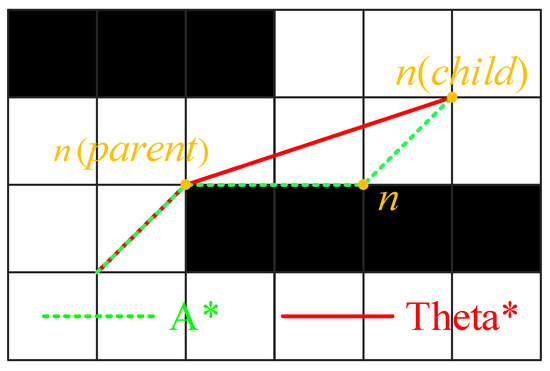
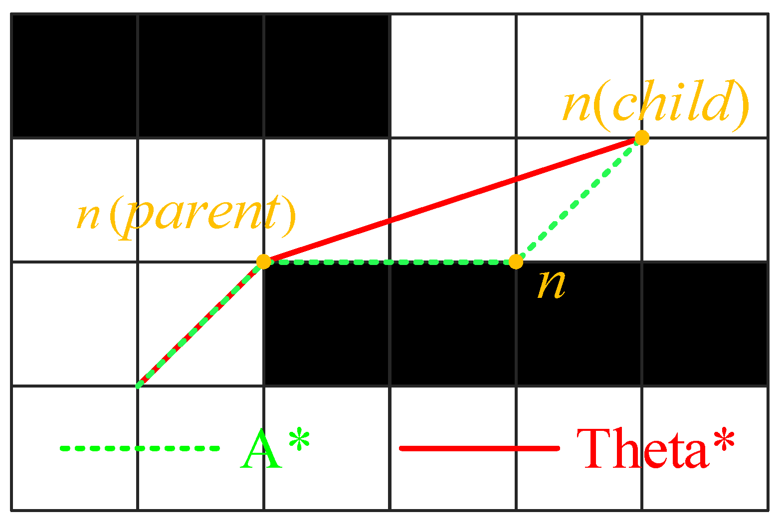
The Theta* algorithm is an enhancement of the A* algorithm, primarily distinguished by its refined parent node selection mechanism. When expanding a child node, the Theta* algorithm evaluates whether the line of sight (LoS) between the child node and the parent of the current node is obstructed. If no obstacles are present, the child node and the current node will share the same parent. Based on this iterative method, the resulting angles and distances between path nodes become more flexible. This approach effectively reduces the total number of nodes and turns, shortens the path length, and achieves smoother path planning. As illustrated in Figure 1, the planning results of the Theta* and A* algorithms are represented by the solid red line and the dashed blue line, respectively. Compared with the A* algorithm, the path direction planned by Theta* is no longer confined to fixed, finite orientations but can be set at arbitrary angles, thereby yielding a more optimal trajectory [28].
Figure 1.
Path Comparison Between A* and Theta*.
As a classic path planning algorithm, Theta* has been widely applied in practical navigation tasks. By performing a discrete decomposition of the search space and employing a cost function to conduct an eight-neighborhood search, the algorithm identifies the shortest path. The cost function is defined as follows:
where f(s) represents the total estimated cost of the path passing through node s; g(s) denotes the actual cumulative cost from the starting node to node s; and h(s) is the heuristic cost from node s to the target node, typically calculated using the Euclidean distance to maintain the any-angle property.
Based on the cost function, the Theta* algorithm selects the node with the minimum cost value for expansion. The expression is as follows:
When the algorithm expands to the desired target point, the shortest route is identified; otherwise, the search fails. During the expansion of a child node s’ from node s, the Theta* algorithm performs an LoS check to determine whether an obstruction exists along the straight line connecting s’ and the parent of the current node, denoted as parent(s). If no obstacles are detected, s’ will directly share the same parent as the current node.
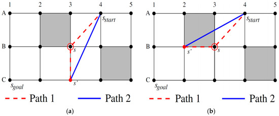
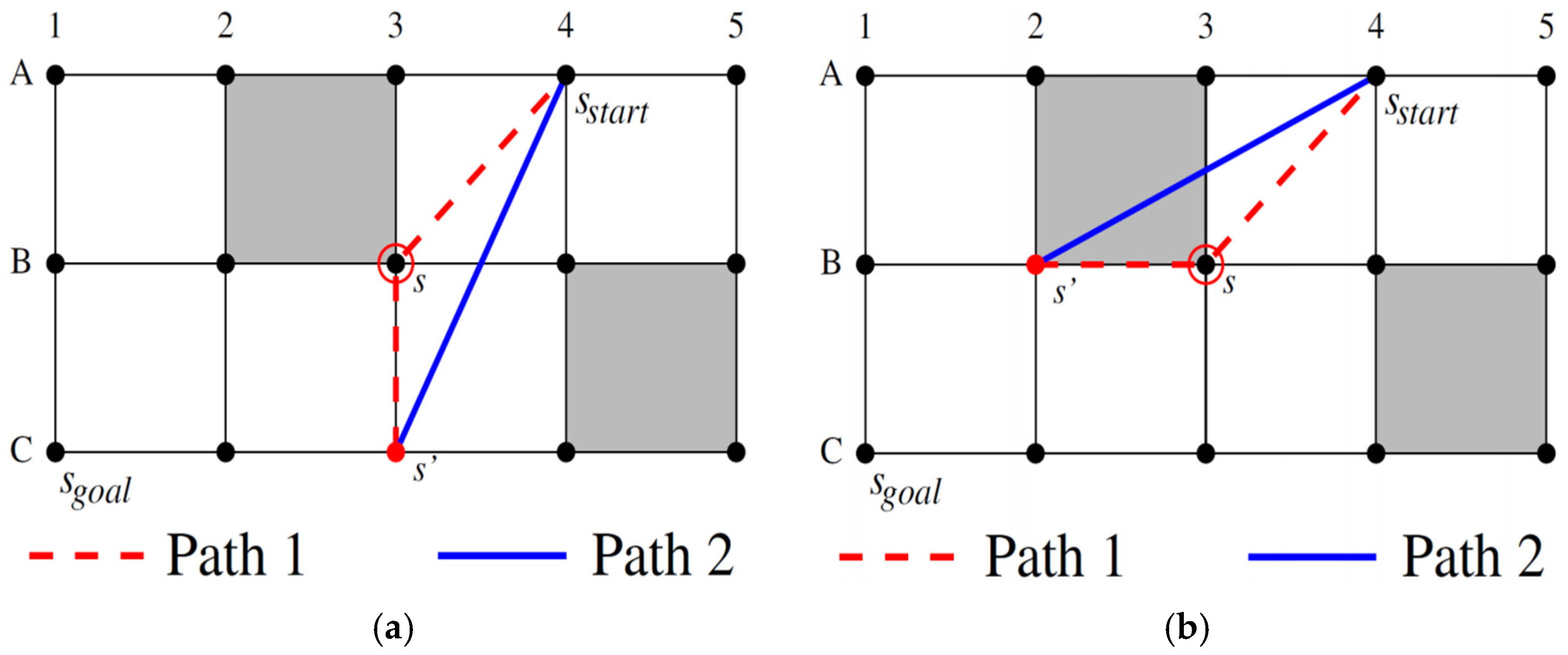
As illustrated in Figure 2, when updating the cumulative cost g(s’) and the parent of neighbor node s’, the Theta* algorithm compares the costs of two distinct path options:
Figure 2.
Theta* Algorithm: Selection of Two Different Paths. (a) Parent node and adjacent node are visible. (b) Parent nodes and adjacent nodes are not visible.
Path 1: The algorithm calculates the path cost g(s) from the starting point to node s, plus the linear distance c(s, s’) from node s to its neighbor s’, resulting in the path cost g(s) + c(s, s’). This corresponds to the red dashed line in Figure 2a, specifically the sequence A4-B3-C3.
Path 2: Alternatively, the algorithm calculates the linear distance c(parent(s), s’) from parent(s) to neighbor s’, obtaining the path cost g(parent(s)) + c(parent(s), s’). This approach enables Theta* to construct paths at arbitrary angles. Path 2 corresponds to the solid blue line in Figure 2a, specifically the direct connection A4-C3.
According to the triangle inequality, the length of Path 2 is less than or equal to that of Path 1. However, while Path 1 is an unobstructed route by default, Path 2 must undergo an LoS check to determine its validity. If parent(s) and s’ are mutually visible, it indicates that Path 2 is unobstructed, and the Theta* algorithm prioritizes Path 2 (Figure 2a). Conversely, if parent(s) and s’ are not visible to each other, the algorithm selects Path 1 (Figure 2b).
Consequently, the paths generated through this iterative method contain arbitrary angles and distances between nodes, which reduces the number of nodes and turns while shortening the overall path length, resulting in a smoother trajectory. Theta* utilizes the Great Circle distance between two points as the step cost and employs this as the criterion for selecting child nodes and determining the optimal path.
2.2. Improved Theta* Algorithm
While the traditional Theta* algorithm is capable of identifying the global shortest route from the port of departure to the destination and effectively circumventing static obstacles (e.g., shallow waters, islands, and prohibited zones), it fails to proactively avoid extreme wave regions that change dynamically over time, such as typhoons. To address these limitations, this paper enhances the traditional Theta* algorithm by incorporating a temporal dimension, proposing a Time-Dynamic Theta* (TDM-Theta*) algorithm that accounts for dynamic environmental data.
First, the virtual obstacle method is employed for environmental map modeling. Shallow waters, islands, prohibited zones, and navigable areas within a specific proximity are treated as static obstacles through which route crossing is strictly forbidden. The visibility determination condition S between the parent node and the current node is defined as:
where x and y denote the longitude and latitude of the current position (°), respectively; dmin represents the minimum permissible sailing depth (m), defined as a positive value; D(x, y) is the actual water depth at the current position (m); and G(x, y) denotes the location information of prohibited zones, where 0 represents a non-prohibited area. When S = 0, it indicates that no static obstacles exist between the current node and its parent, rendering the path navigable.
Secondly, to address the temporal dynamic variations of the sea area and ensure that the ship can effectively avoid adverse maritime conditions in a timely manner, the algorithm integrates real-time forecasted wave height data. The wave height at any given point within the navigation area is obtained from weather forecasts:
where η(x,y,t) represents the significant wave height at position (x, y) and time t; Hx,y,t denotes the high-frequency dynamic meteorological data provided by weather information services.
Based on the safe navigation operating conditions of the ship design, a maximum permissible wave height threshold Fwmax is established. When the forecasted environmental wave height exceeds Fwmax, navigation is prohibited. To ensure the generation of a safe navigable route, the visibility determination condition S between the parent node and the current node is redefined here:
where ti is the Estimated Time of Arrival (ETA) at node i. When S = 0, it indicates that there are no static or dynamic obstacles between the current node and the parent node.
Building upon the standard Theta* algorithm, TDM-Theta* retrieves the wave height at the corresponding grid coordinates. If the wave height exceeds Fwmax, the grid is modeled as a dynamic obstacle. During data retrieval, because meteorological data varies dynamically, it is necessary to calculate the ETA from the starting point to the corresponding grid. The calculation of this ETA involves the aforementioned Path 1 and Path 2 scenarios:
Path 1 ETA: [g(s) + c(s, s’)] ÷ Vessel Economic Speed
Path 2 ETA: [g(parent(s)) + c(parent(s), s’)] ÷ Vessel Economic Speed
When node s expands to child node s’, the TDM-Theta* algorithm performs a dual-layer LoS detection. It evaluates whether the connection between the child node and parent(s) is obstructed by static obstacles and simultaneously checks if this connection traverses any regions where the forecasted wave height at the ETA exceeds the safety threshold. If the path is clear of both physical obstacles and adverse weather, s’ directly shares the parent with the current node. Otherwise, the connection is deemed “invisible,” and the algorithm subsequently evaluates the direct path between s’ and s to establish the appropriate connectivity.
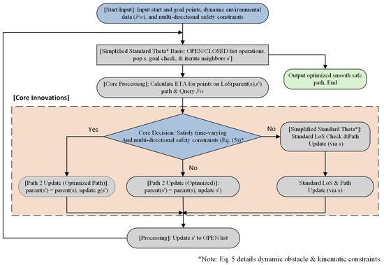
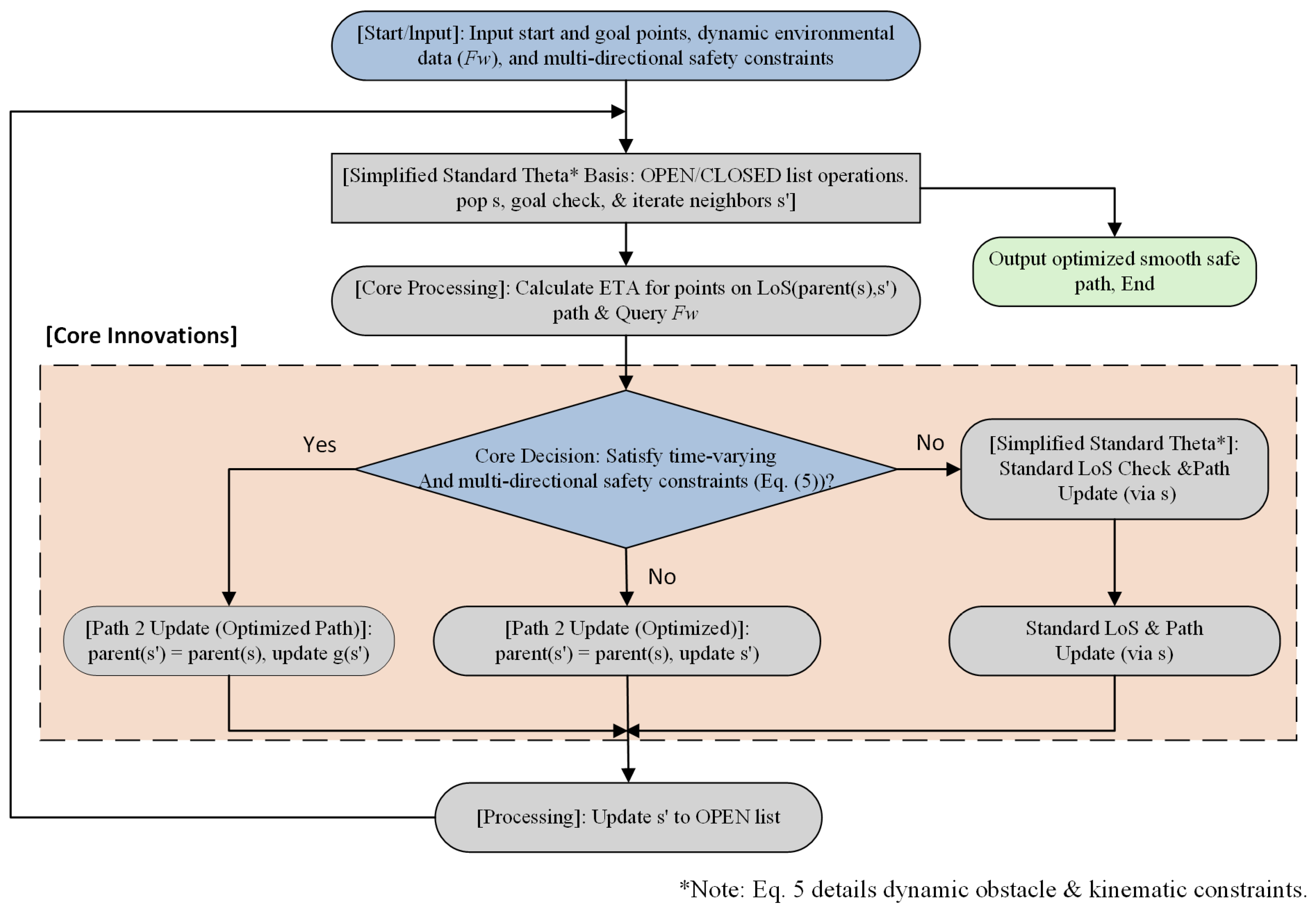
Essentially, the TDM-Theta* algorithm models grids affected by severe weather as spatio-temporal dynamic obstacles. By factoring in the ship’s service speed to determine the wave height at specific spatio-temporal coordinates, it identifies the shortest initial route from the origin to the destination that proactively and entirely bypasses hazardous weather zones.The specific algorithm flowchart is shown in Figure 3.
Figure 3.
Flowchart of the Ship Route Planning Algorithm.
To enhance the physical feasibility of the planned paths, this study introduces ship maneuverability constraints during the initial LoS detection phase. By imposing a threshold limit on the rate of change for the slope of the line connecting nodes, kinematically infeasible sharp-steering nodes are eliminated. This pre-filters candidate paths that violate ship handling characteristics at the geometric planning stage. Furthermore, to address path smoothness requirements, future research will focus on coupling the Maneuvering Modeling Group (MMG) dynamics model with B-spline curve optimization.
2.3. Environmental Map Modeling and Data Sources
To execute the spatio-temporal search of the TDM-Theta* algorithm, this study performed a discretized modeling of the physical marine environment and integrated authoritative databases to obtain simulation input data. The input data encompass static geographical environments and dynamic meteorological environments.
- (1)
- Static Geographical Environment Modeling and Data
To ensure the spatial grid matches the resolution of meteorological forecast data, the grid resolution of the environmental map is uniformly set to 0.25° × 0.25°. Regarding the acquisition of global static environmental data, bathymetric (water depth) data are sourced from the General Bathymetric Chart of the Oceans (GEBCO) grid dataset. Information on island boundaries and specific prohibited zones is extracted from Official Electronic Navigational Charts (ENCs). In the static obstacle determination model, the minimum permissible sailing depth threshold (corresponding to dmin in Equation (3)) is defined as the sum of the target ship’s design draft and a fixed safety margin.
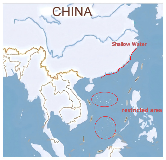
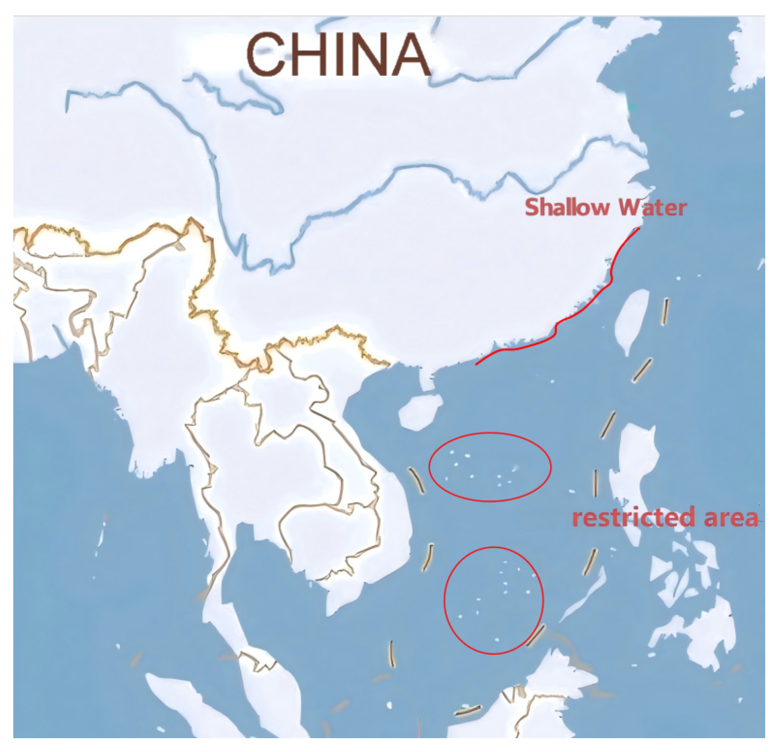
The schematic diagram for the virtual obstacle modeling of the environmental map, constructed based on the aforementioned real geographical data, is shown in Figure 4. The algorithm precisely maps shallow water areas, specific prohibited zones, and island contours as impassable static grids, providing reliable physical boundary constraints for the subsequent global path planning.
Figure 4.
Schematic diagram of virtual obstacle modeling in the environmental map.
- (2)
- Dynamic Meteorological Environment Modeling and Data
Dynamic meteorological data were obtained from the ERA5 global atmospheric reanalysis dataset and a real-time maritime weather forecasting system, providing hourly real-time historical fields of significant wave height (with a spatial resolution also set at 0.25° × 0.25°). Regarding the determination of dynamic obstacles, the wave height threshold (corresponding to Fwmax in Equation (5)) was established with reference to the World Meteorological Organization (WMO) sea state scales and the wind-and-wave resistance standards of conventional ocean-going commercial vessels. In this study, the maximum wave height threshold is set at 3.0 m (representing Sea State 5 and above). When the forecasted significant wave height in a corresponding spatio-temporal grid exceeds this threshold, the area is designated as a dynamic obstacle, and transit is strictly prohibited. The utilization of these open-source standardized datasets ensures high reproducibility and experimental transparency for the algorithm test cases presented in this research.
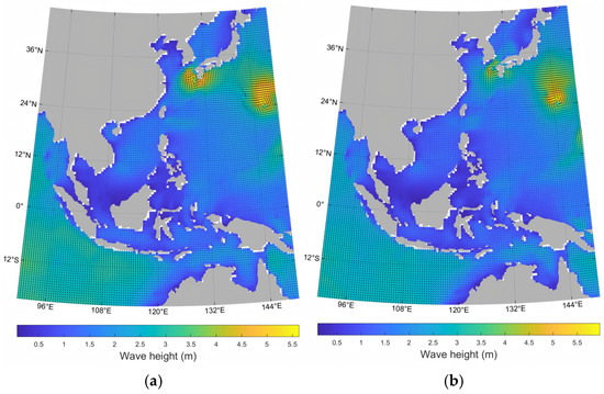
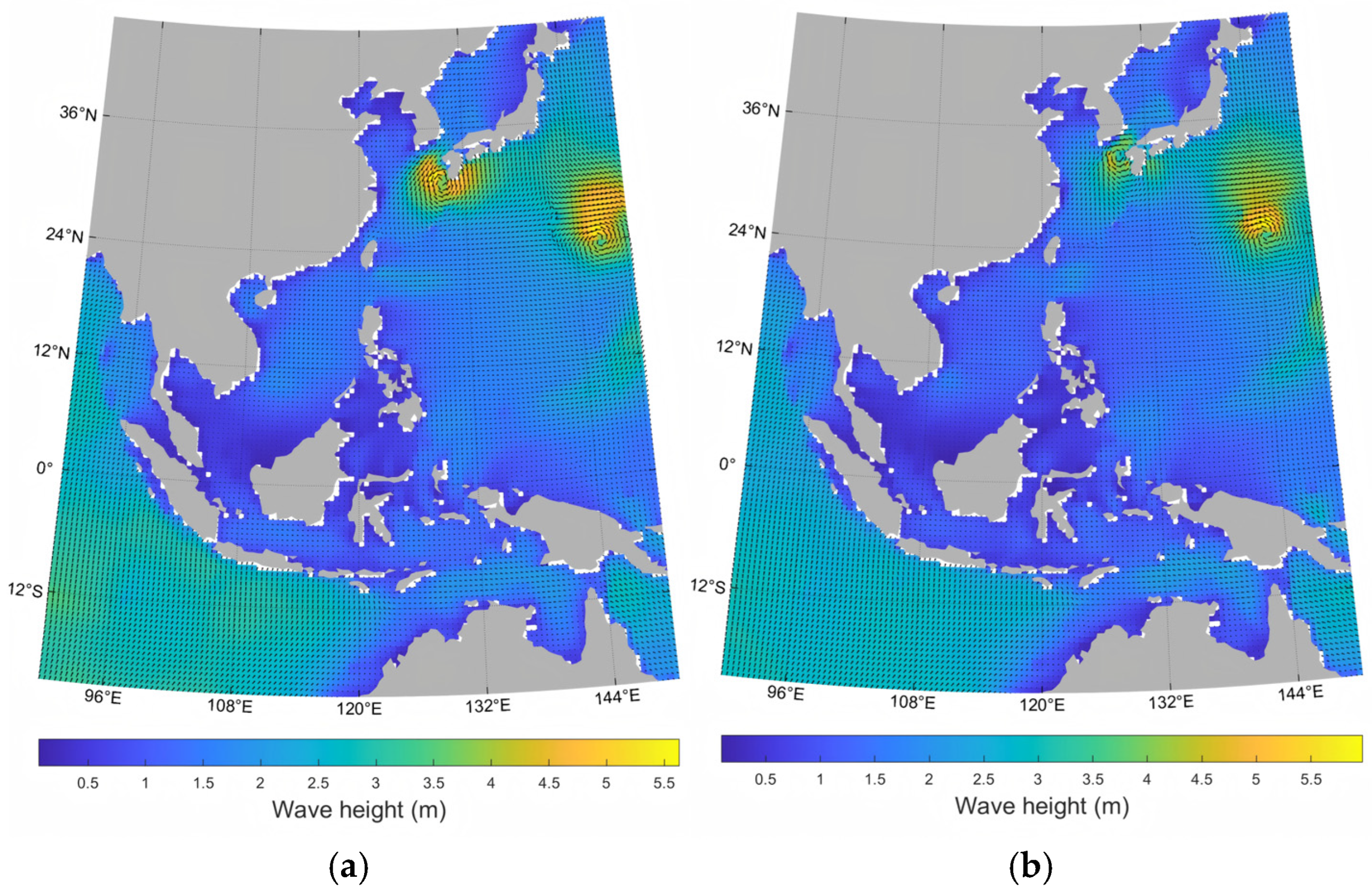
Figure 5a displays the significant wave height map of Typhoon “Saola” (2309) and Typhoon “Damrey” (2310) at 00:00 on August 30, 2023. Figure 5b illustrates the significant wave height map of the aforementioned typhoons at 20:00 on the same day. By comparing the two figures, the impact of typhoons on sea surface wave heights and their temporal evolution can be clearly observed. The regions of extreme sea conditions deemed unnavigable shift in real time, fully demonstrating the necessity and importance of accounting for dynamic marine environments in route planning.
Figure 5.
Significant wave height maps during the occurrence of Typhoon Saola (No. 2309) and Typhoon Damrey (No. 2310): (a) 00:00 on 30 August 2023; (b) 20:00 on 30 August 2023.
3. Case Study
To comprehensively verify the efficiency and effectiveness of the proposed TDM-Theta* algorithm—specifically its performance in typhoon avoidance—this study designed a series of route planning cases covering various environmental conditions. These scenarios evaluate the algorithm’s performance in complex and volatile maritime environments. The specific application scenarios for route planning are configured as follows:
- (1)
- Route Planning under General Sea Conditions: In a standard navigational environment, the ship operates in open waters devoid of static obstacles such as shallow areas, prohibited zones, or islands. Furthermore, the voyage is unaffected by extreme weather like typhoons. This scenario aims to test the algorithm’s fundamental pathfinding capability under nominal conditions.
- (2)
- Route Planning in Complex Topographical Environments: In more challenging navigational settings, numerous islands are distributed around the destination or along the intended direct route. The objective is to plan a safe trajectory that weaves through these islands, assuming no typhoon interference. This scenario tests the algorithm’s path optimization strategy within constrained physical topographies.
- (3)
- Route Planning under Typhoon Influence: This scenario simulates encounters with typhoons during transit and is further subdivided into two parts: first, path planning in open seas when facing single or multiple typhoons and, second, route adjustment when encountering typhoons within complex topographical conditions (e.g., the island-dense regions mentioned above). These cases are designed to comprehensively assess the algorithm’s emergency response and dynamic adjustment capabilities under extreme weather conditions.
Assuming a design speed of 12 knots, nine specific cases were constructed across these three typical scenarios (as shown in Table 1). These cases range from ideal to extreme maritime environments and account for diverse planning requirements, allowing for a systematic evaluation of the TDM-Theta* algorithm’s efficiency, accuracy, and adaptability.
Table 1.
Case Settings.
3.1. Route Planning Under General Conditions
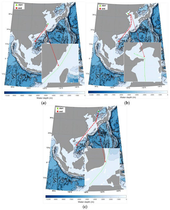
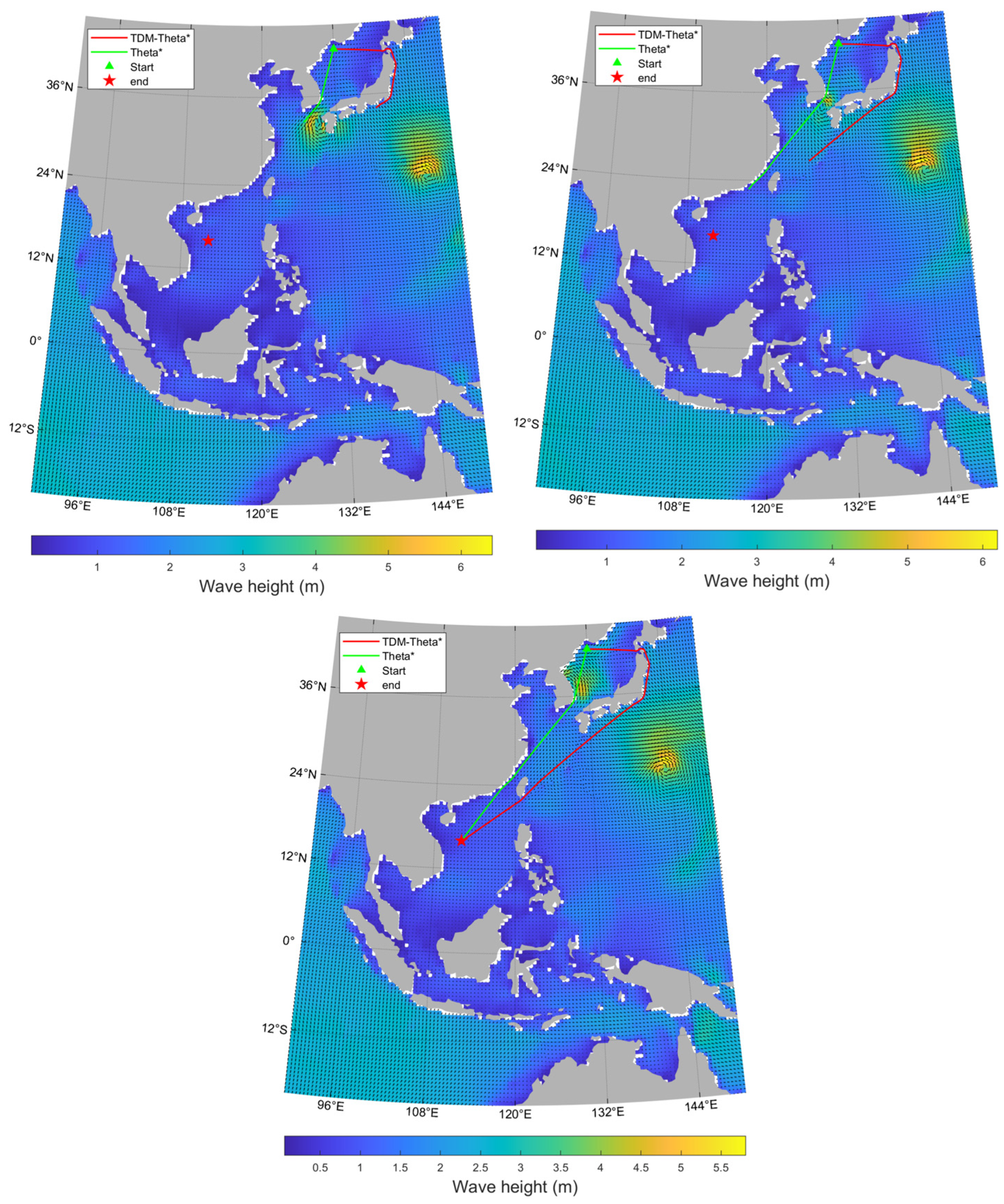
In routine operational environments, cargo and passenger ships typically navigate along fixed routes characterized by open topography and favorable meteorological conditions. To verify the path planning efficiency of the TDM-Theta* algorithm under baseline conditions, this study selected three typical cases for simulation testing: Case 1 (Shanghai to the South China Sea; see Figure 6a), Case 2 (Tianjin to the South China Sea; see Figure 6b), and Case 3 (Japan to the South China Sea; see Figure 6c).
Figure 6.
Route Planning Under Normal Conditions. (a) Voyage from Shanghai to a Target Test Area in the South China Sea. (b) Voyage from Tianjin to a Target Test Area in the South China Sea. (c) Voyage from Japan to a Target Test Area in the South China Sea.
Case 1 (Shanghai to the South China Sea): As shown in Figure 6a, the route follows China’s southeastern coastal waters. Due to the sparse distribution of islands, the route is largely unobstructed, and the marine environment is favorable. The TDM-Theta* algorithm successfully planned the shortest navigation route that approximates a single straight line.
Case 2 (Tianjin to the South China Sea): As shown in Figure 6b, because navigation obstacles exist between Tianjin Port and the target sea area, direct straight-line navigation is not feasible. The route planned by the TDM-Theta* algorithm consists roughly of three straight-line segments: departing from Tianjin Port to the waters off the Shandong Peninsula for a course change, then sailing in a straight line to the waters east of Zhejiang, and finally proceeding directly to the target area.
Case 3 (Japan to the South China Sea): As shown in Figure 6c, the presence of several islands along the transit path prevents straight-line navigation. The TDM-Theta* algorithm generated a route composed of approximately four straight-line segments: from Japan to the waters east of Korea, then following a near-straight trajectory to the waters off the Shandong Peninsula, continuing to the waters east of Zhejiang, and finally reaching the target destination in a straight line.
As shown in Table 2, the average program execution times for the TDM-Theta* algorithm in the aforementioned cases were 1.02 s, 1.39 s, and 1.83 s, respectively. The experimental results demonstrate that under general navigation conditions, the algorithm not only exhibits significant search efficiency but also generates more natural route morphologies compared to the traditional A* algorithm. This establishes a robust performance benchmark for real-time path replanning in complex environments.
Table 2.
Quantitative Performance Evaluation of TDM-Theta* under General Conditions.
3.2. Route Planning in Complex Topographical Environments
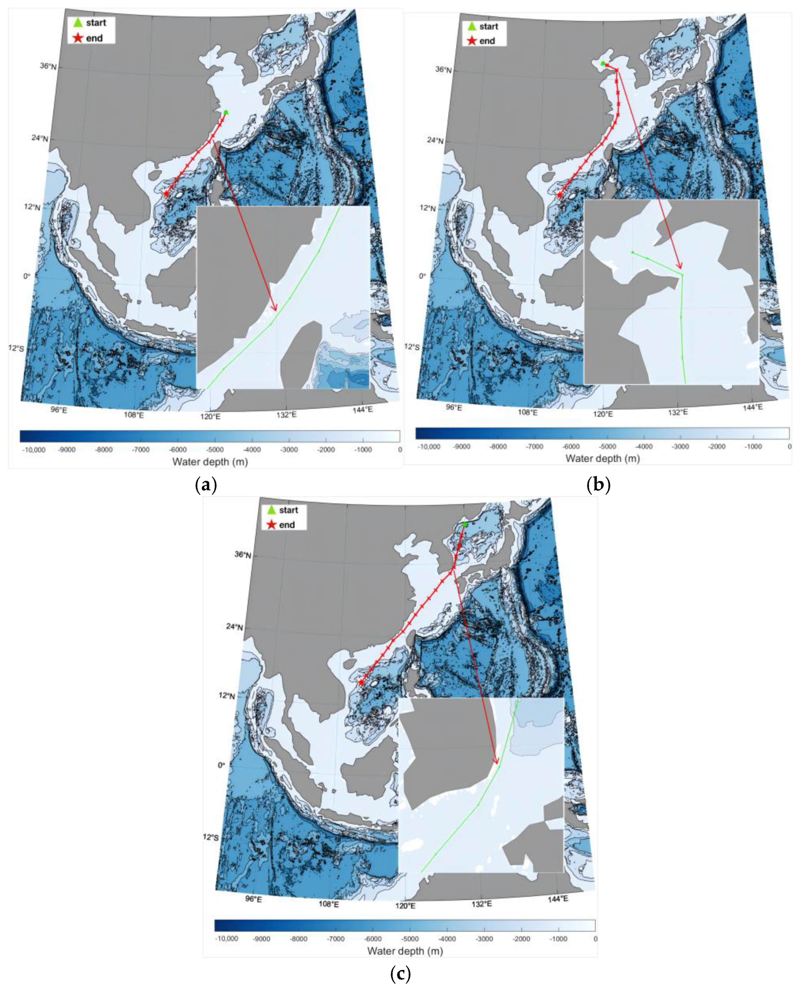
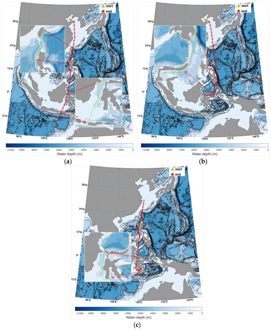
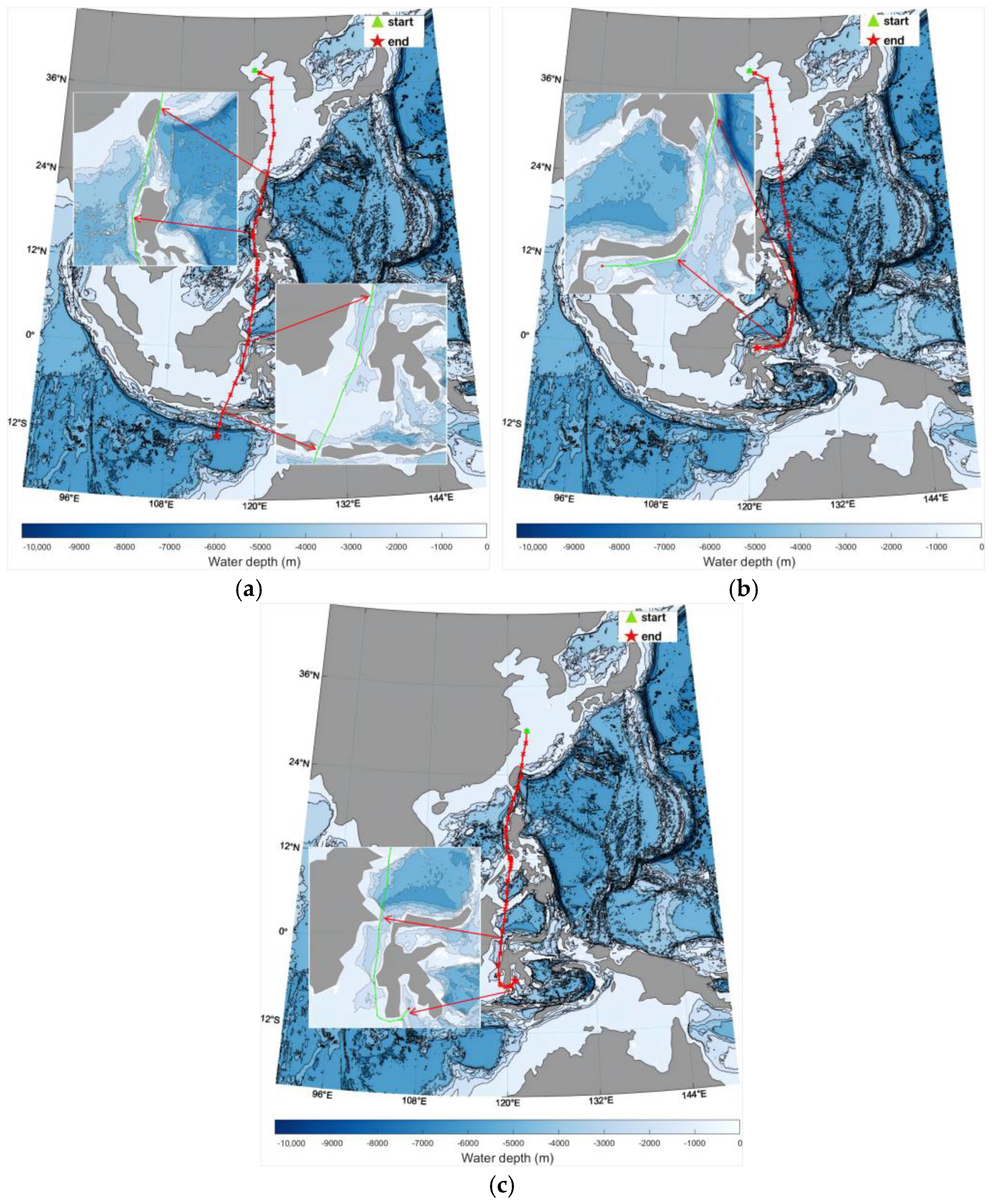
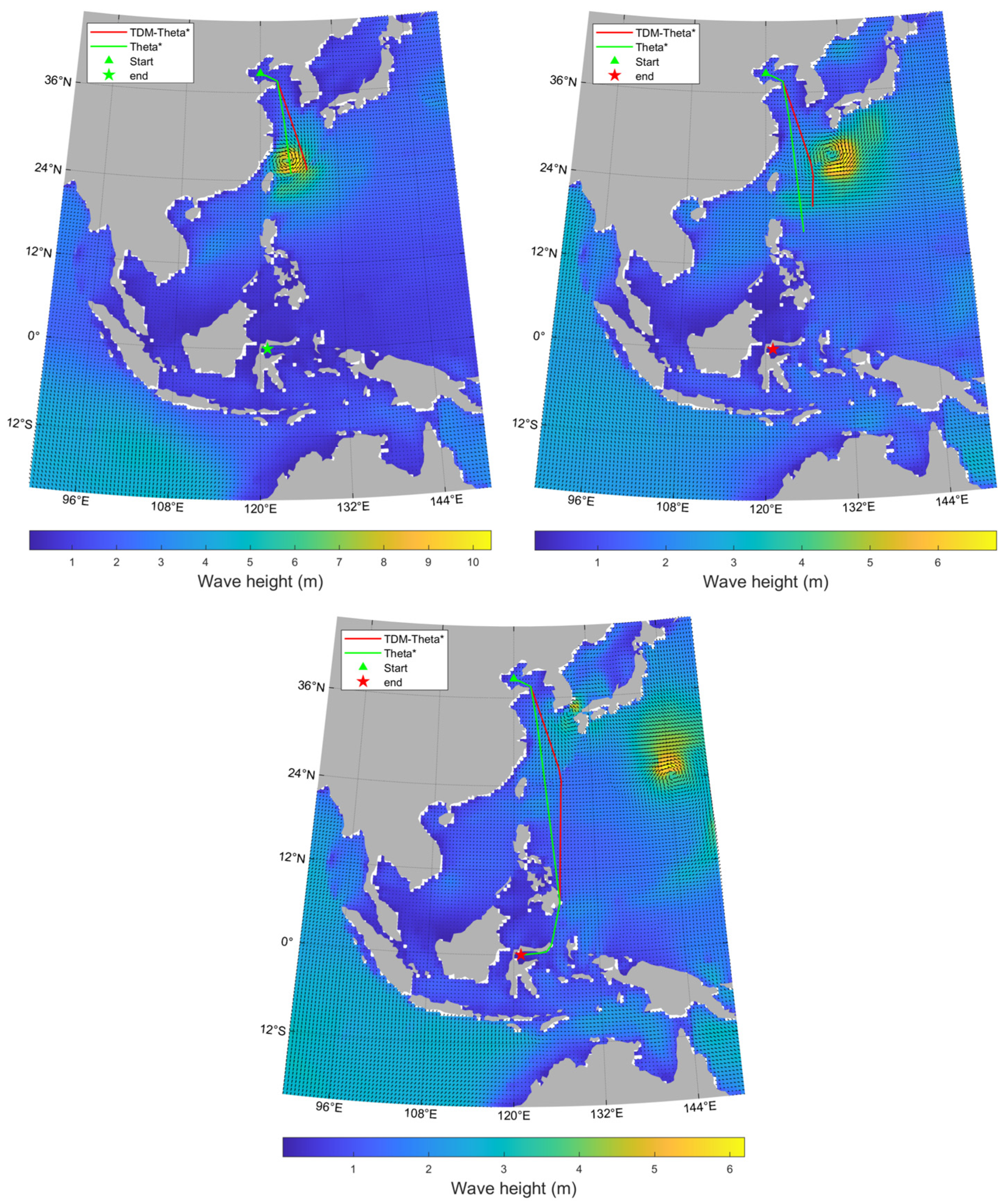
While the routes of conventional commercial vessels are typically highly fixed with favorable navigational conditions, intelligent experimental ships or specialized ocean-going vessels often perform specific missions in areas with high uncertainty. Their route planning frequently involves traversing restricted waters with complex topography. To verify the path optimization capability of the TDM-Theta* algorithm under stringent geometric constraints, this section selects Case 4 (Figure 7a), Case 5 (Figure 7b), and Case 6 (Figure 7c) for simulation analysis.
Figure 7.
Route planning for complex terrain navigation. (a) Tianjin voyage to the eastern Indian Ocean test area. (b) Tianjin voyage to the Tomini Bay test area. (c) Shanghai voyage to the Ponai Bay test area.
Case 4 (Long-distance Route from Tianjin to the Eastern Indian Ocean): As shown in Figure 7a, the enlarged local view demonstrates that when navigating in nearshore restricted waters, the TDM-Theta* algorithm exhibits excellent robustness in static obstacle avoidance. The generated path maintains mileage optimality by staying close to obstacle boundaries while strictly adhering to the preset safety margin, ensuring navigational safety.
Cases 5 and 6 (Extreme Scenarios in Tomini Bay and Bone Bay): These cases simulate extreme scenarios where the destination is surrounded by land on three sides. The results indicate that even in environments with dense islands and limited steering space, the algorithm can intelligently identify topological constraints and plan the shortest safe route.
As shown in Table 3, the program execution times for the aforementioned cases were 2.3 s, 3.12 s, and 2.77 s, respectively. Experimental results demonstrate that the computational overhead of the TDM-Theta* algorithm remains within the same order of magnitude as in unconstrained scenarios. This verifies its computational stability in high-frequency dynamic environments, fully meeting the engineering requirements for real-time path replanning of intelligent ships. In summary, under complex topographical constraints, the TDM-Theta* algorithm balances navigational efficiency with decision-making safety, providing robust pathfinding support for autonomous vessels.
Table 3.
Performance Statistics of TDM-Theta* Algorithm in Complex Topographical Scenarios.
3.3. Route Planning Under Typhoon Influence
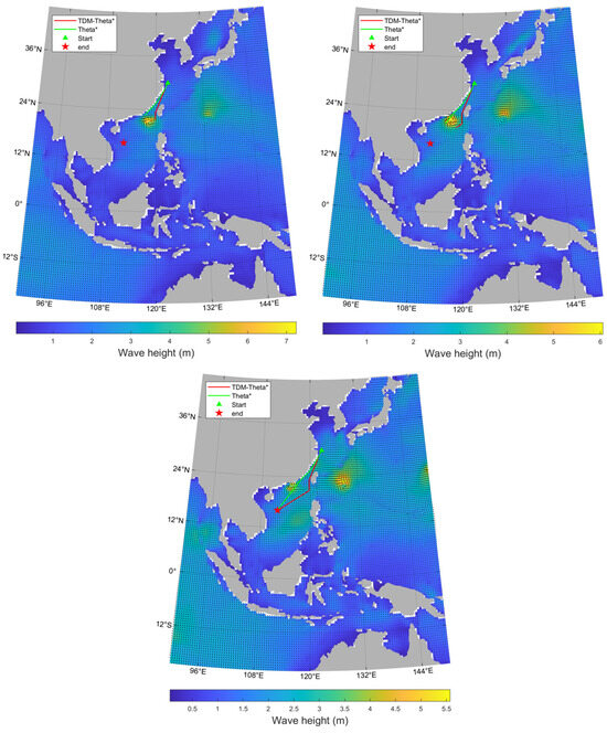
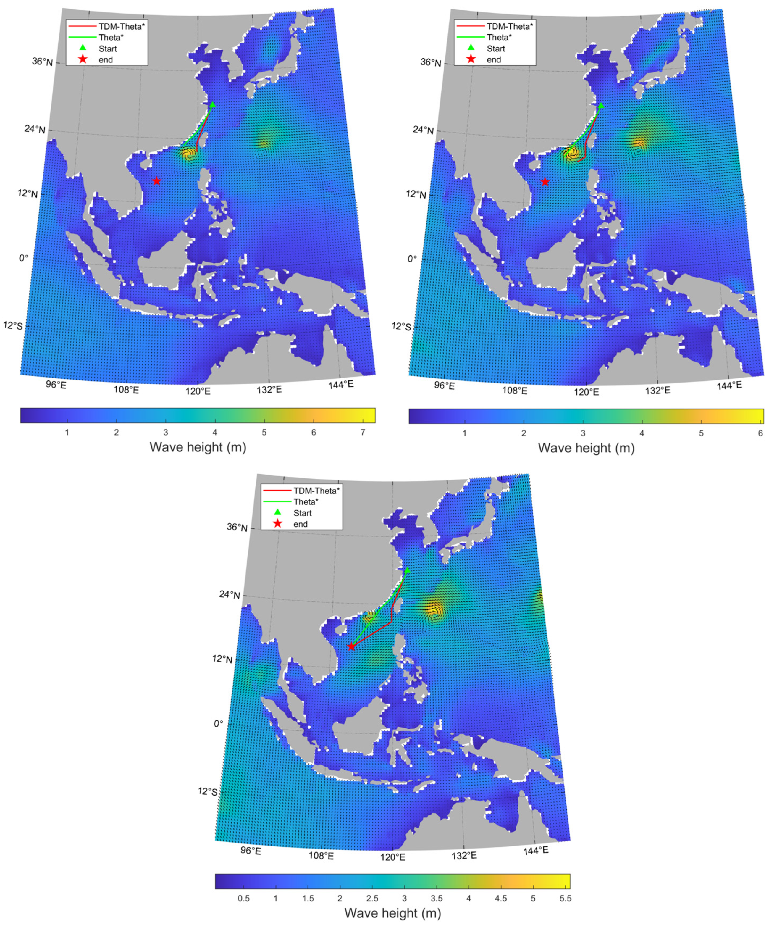
To ensure a ship can navigate safely to its destination when facing typhoons and other severe sea conditions, effective avoidance strategies must be developed. To verify the route planning capability of the TDM-Theta* algorithm under typhoon conditions, three typical navigation cases were selected: Case 7 (Figure 8), Case 8 (Figure 9), and Case 9 (Figure 10).
Figure 8.
Route Planning for Voyages from Shanghai to the South China Sea.
Figure 9.
Route Planning from Japan to the South China Sea.
Figure 10.
Route Planning from Tianjin to Tomini Bay.
Case 7: Route Planning under the Constraints of Typhoon “Saola” (No. 2309)
Route planning from Shanghai to the South China Sea was simulated during the passage of Typhoon “Saola” (as shown in Figure 8 and Table 4). The experimental results indicate the following:
Table 4.
Quantitative Comparison of Algorithm Performance Metrics for Case 7.
Standard Theta* Algorithm: Due to a lack of time-varying meteorological awareness, the standard algorithm planned a route that sailed directly through the high-wave danger zone at the center of the typhoon.
TDM-Theta* Algorithm: This algorithm demonstrated superior dynamic avoidance capabilities. It guided the ship through the Taiwan Strait first; then, after identifying the evolution of the typhoon’s trajectory, it accurately identified a safe spatio-temporal window behind the typhoon to make steering decisions. Ultimately, it navigated toward the destination along an optimal path.
This dynamic adjustment, based on the Estimated Time of Arrival (ETA), achieves an effective balance between navigational safety and path cost.
Case 8: Route Planning under Intertwined Environments of Double Typhoons (“Khanun” and “Lan”)
For the extreme operating conditions where Typhoons “Khanun” and “Lan” occurred concurrently, this study conducted a stress test on the route from the Sea of Japan to the South China Sea (see Figure 9 and Table 5). The route generated by the traditional algorithm failed as it was unable to perceive the dynamic threats near the Tsushima Strait. In contrast, the TDM-Theta* algorithm adopted a phased avoidance strategy:
Table 5.
Quantitative Comparison of Algorithm Performance Metrics for Case 8.
Strategic Rerouting: It first bypassed the threatened Tsushima Strait and redirected the vessel through the Tsugaru Strait.
Geographical Shielding: It then utilized the coastal topography of eastern Japan as a natural barrier to dynamically resist the impact of the typhoons’ peripheral circulation.
Experimental results prove that TDM-Theta* maintains extremely high decision-making robustness even under constraints involving multiple meteorological targets.
Case 9: Route Planning under the Coupled Scenario of Complex Topography and Typhoon “Damrey”
Case 9 further tested the algorithm’s performance under the dual constraints of geographical obstacles (waters east of Taiwan Province) and Typhoon “Damrey” (see Figure 10 and Table 6). During the voyage from Tianjin to Tomini Bay, the straight-line route planned by the standard algorithm was completely blocked by the typhoon’s center.
Table 6.
Quantitative Comparison of Algorithm Performance Metrics for Case 9.
By predicting the movement trajectory of the typhoon, the TDM-Theta* algorithm made an early decision to detour through the waters east of Taiwan Province, ensuring the vessel completed its transit before the typhoon closed the southbound navigation channel. This case fully validates the algorithm’s synergistic ability to handle complex geometric constraints and high-frequency dynamic risks within the joint spatio-temporal dimension.
In summary, the simulation results from Cases 7 to 9 demonstrate that when addressing heterogeneous typhoon scenarios such as “Saola,” “Khanun,” and “Damrey,” the computational overhead of the TDM-Theta* algorithm remains in the same order of magnitude as in scenarios without meteorological constraints. This effectively proves that the introduction of high-frequency dynamic spatio-temporal search logic does not significantly increase computational costs, thereby ensuring excellent real-time engineering performance.
The experimental data fully validates the superior robustness of TDM-Theta* in environments where complex geometric topologies are coupled with extreme dynamic risks. Through precise analysis of the Estimated Time of Arrival (ETA), the algorithm successfully achieves an optimal balance between navigational safety and path cost while maintaining a 100% risk avoidance success rate in the tested typhoon scenarios. This provides robust technical support for the autonomous decision-making of intelligent ships under extreme sea conditions.
3.4. Sensitivity Analysis of Environmental Parameters and Demonstration of Algorithm Robustness
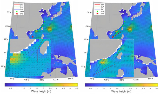
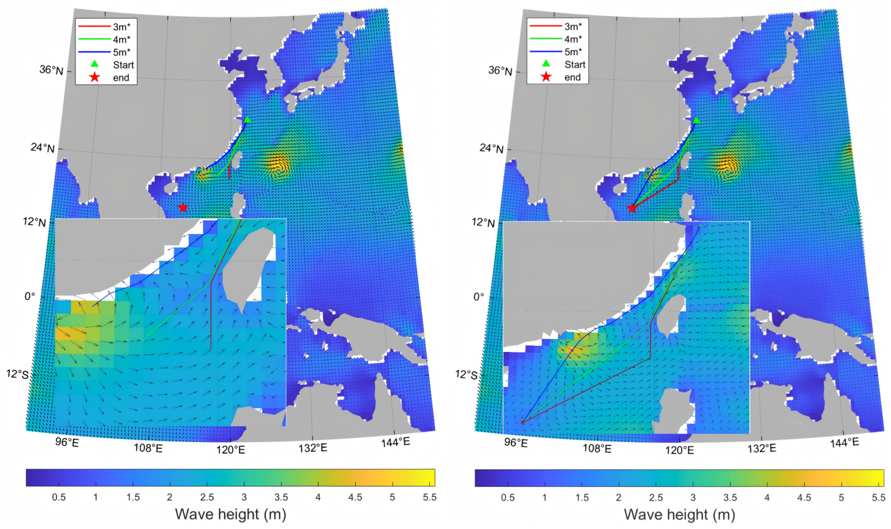
To further verify the resistance of the TDM-Theta* algorithm to uncertainties in environmental parameters, this study conducted a sensitivity analysis on typical scenarios. Using Case 7 as the stress test case, the maximum navigable wave height threshold Fwmax was systematically adjusted while keeping all other experimental conditions consistent.
We set the thresholds to 3.0 m (strict safety standard), 4.0 m (moderate safety standard), and 5.0 m (relaxed safety standard). The quantitative comparison results are shown in Table 7.
Table 7.
Sensitivity Testing Results for Wave Height Thresholds.
As illustrated by the dynamic evolution trajectories in Figure 11, it is evident that the “spatio-temporal avoidance corridor” planned by the TDM-Theta* algorithm possesses significant adaptive scaling characteristics. As the navigable wave height threshold is gradually relaxed from the baseline of 3.0 m to 5.0 m, the spatio-temporal constraints of the navigation window weaken accordingly, causing the generated path mileage to exhibit a monotonic decreasing trend.
Figure 11.
Comparison of Route Sensitivity under Different Wave Height Threshold Constraints.
Under the relatively loose constraint of 4.0 m, the voyage distance is significantly reduced by 5.2% compared to the baseline condition. When the threshold is further relaxed to 5.0 m, the reduction ratio reaches 5.6%, demonstrating the algorithm’s optimization potential in pursuing extreme path efficiency while ensuring safety.
Experimental data further prove that the fluctuation in computational time consistently remains within 20% when responding to environmental parameter interventions of varying intensities. This sensitivity analysis effectively validates the superior robustness of the TDM-Theta* algorithm in handling environmental uncertainties and meteorological forecast errors. It is capable of robustly generating globally optimal paths that meet practical navigational requirements based on real-time risk-preference strategies.
4. Analysis and Discussion
To thoroughly analyze the performance gains of the TDM-Theta* algorithm in extreme environments, this study evaluates the results across three dimensions: path cost, computational efficiency, and risk-avoidance mechanisms, based on the aforementioned simulation cases (summarized in Table 8) and the parameter sensitivity tests in Section 3.4.
Table 8.
Summary of Quantitative Performance Comparison under Typhoon Weather Scenarios.
Synergistic Balance Between Path Cost and Safety: An analysis of Table 8 indicates that under the 3.0 m baseline threshold, the TDM-Theta* algorithm demonstrates a “safety-first” decision logic. Comparative analysis shows that the standard A* algorithm, restricted by its 8-neighbor grid topology, produces a planned path length (3582.4 nm) slightly longer than the standard Theta* algorithm (3543.7 nm), which features any-angle expansion. In single-typhoon scenarios (Cases 7 and 9), TDM-Theta* achieved risk avoidance with only a marginal increase in voyage distance. In Case 8, the 44% increase in mileage was an inevitable decision made after the algorithm identified a “spatio-temporal dead point.” Experiments prove that while A* and standard Theta* yield shorter paths, their risk avoidance success rate is 0%, failing completely in the face of dynamic risks. This validates the necessity of introducing the time dimension for path reconstruction.
Evaluation of Computational Overhead and Engineering Real-time Performance: The TDM-Theta* algorithm exhibits extremely high stability when processing high-frequency dynamic meteorological data. Data from Table 7 shows that while the standard A* algorithm has the shortest execution time (1.42 s) due to its simple logic, it cannot guarantee dynamic safety. In contrast, meta-heuristic algorithms such as Genetic Algorithms (GAs) typically incur computational costs on the scale of minutes, making them unsuitable for real-time decision-making. Following the introduction of ETA-aware searching, the computational time for TDM-Theta* (averaging less than 4 s) increased slightly compared to static algorithms, but this increment is negligible on an oceanic decision-making scale. This proves that the algorithm maintains high-dimensional optimization accuracy while retaining superior search efficiency, offering stronger practical engineering utility.
Validation of the Effectiveness of Spatio-temporal Dynamic Visibility Constraints: A key application-specific contribution of this study lies in transforming real-time meteorological forecasts into rigorous “spatio-temporal dynamic visibility constraints.” Traditional algorithms (like standard Theta*) lack a temporal dimension, leading to planned paths that often suffer from a “spatio-temporal misalignment” with typhoon trajectories, causing the route to fail during actual execution. The essence of TDM-Theta* is the elevation of the traditional static 2D search space into a non-stationary 3D (longitude, latitude, time) spatio-temporal manifold, thereby ensuring the physical safety of the planned route at the fundamental logical level. At the execution level, the algorithm dynamically evaluates the actual risk of each candidate grid at its corresponding future time (Equation (5)) by calculating the Estimated Time of Arrival (ETA) during the search process, eliminating all potential hazards during the node expansion phase. This leap from “static geometric obstacle avoidance” to “4D spatio-temporal optimization” is the mathematical essence of ensuring a 100% risk avoidance rate within the specific simulation environments tested. Through this deep spatio-temporal coupling, the algorithm not only circumvents current danger zones but also achieves collaborative prediction between the ship’s future dynamic trajectory and the evolution of meteorological patterns.
Demonstration of Algorithm Robustness and Parameter Stability: The sensitivity tests in Section 3.4 further confirm that regardless of how safety standards are adjusted (from 3.0 m to 5.0 m), the TDM-Theta* algorithm robustly generates safe paths of the corresponding level with minimal fluctuations in computational cost (less than 20%). This indicates that the algorithm possesses strong tolerance toward meteorological forecast errors or fluctuations in user risk preferences, demonstrating excellent engineering robustness. It can reliably generate globally optimal paths that meet actual navigational needs based on real-time risk-preference strategies.
5. Summary and Future Prospects
5.1. Conclusions
This study proposed and validated a Time-Dynamic Theta* algorithm (TDM-Theta*), effectively addressing the challenging problem of risk-avoidance decision-making for autonomous ships in environments where complex topography is coupled with extreme typhoons. Based on the simulation analysis of nine cases covering general sea areas, complex terrains, and typical heterogeneous typhoon scenarios, the following conclusions are drawn:
High Adaptability to Static and Dynamic Environments: The TDM-Theta* algorithm inherits the path efficiency of traditional any-angle pathfinding and successfully embeds a temporal dimension into the underlying search logic. This enables the synergistic processing of both static geographical obstacles and dynamic, high-frequency meteorological threats.
Comprehensive Risk-Avoidance Capability under Extreme Sea States: In complex stress tests involving concurrent multiple typhoons, TDM-Theta* achieved a 100% risk-avoidance success rate using a 3.0 m baseline safety threshold for the specific scenarios evaluated. By identifying safety windows in advance based on the Estimated Time of Arrival (ETA), the algorithm formally resolves the “spatio-temporal misalignment” failure mechanism inherent in traditional static path planning when facing high-frequency, time-varying meteorological threats.
Computational Stability and Real-time Decision-making Potential: The computational overhead of the algorithm is negligible relative to the safety gains it provides. It meets the engineering timeliness requirements for real-time path replanning, providing robust methodological support for shore-based monitoring and shipborne auxiliary decision-making for intelligent vessels.
5.2. Limitations and Future Work
Although this study demonstrates significant progress in geometric path planning within joint spatio-temporal dimensions, it has not yet been fully coupled with ship kinematic characteristics. Future work will focus on the following:
Integrating Ship Maneuverability Models (MMG): Dynamic constraints, such as turning radii, will be incorporated as hard constraints into the heuristic cost function.
Trajectory Smoothing: B-spline curve optimization will be utilized to further enhance the seaworthiness and navigational feasibility.
Author Contributions
Conceptualization, J.D. and Z.S.; Methodology, J.D., Z.S. and P.Z.; Software, J.D., J.Z., C.C. and R.Q.; Validation, Z.S. and P.Z.; Investigation, J.D.; Resources, Z.S.; Data curation, J.D., Z.S. and P.Z.; Writing—original draft, J.D., C.C. and R.Q.; Writing—review and editing, Z.S.; Visualization, J.D. and C.C.; Supervision, Z.S.; Project administration, J.D.; Funding acquisition, J.Z. All authors have read and agreed to the published version of the manuscript.
Funding
This work was funded by the Basic Research Program of Jiangsu (BK20253037), Key Project of the Jiangsu Provincial Basic Research Program, Research on the Failure Mechanisms of Major Surface Vessel Equipment and Adaptive Deep Transfer Learning Diagnostic Mechanisms.
Institutional Review Board Statement
Not applicable.
Data Availability Statement
The data presented in this study are available on request from the corresponding author.
Conflicts of Interest
The authors declare no conflicts of interest.
Abbreviation
The following abbreviation is used in this manuscript:
| TDM-Theta* | Time-Dynamic Theta* Algorithm |
References
- Borén, C.; Castells-Sanabra, M.; Grifoll, M. Ship emissions reduction using weather ship routing optimisation. Proc. Inst. Mech. Eng. Part M J. Eng. Marit. Environ. 2022, 236, 856–867. [Google Scholar] [CrossRef] [Scilit]
- Zhang, G.; Wang, H.; Zhao, W.; Guan, Z.; Li, P. Application of improved multi-objective ant colony optimization algorithm in ship weather routing. J. Ocean. Univ. China 2021, 20, 45–55. [Google Scholar] [CrossRef] [Scilit]
- Jeong, M.G.; Lee, E.B.; Lee, M.; Jung, J.-Y. Multi-criteria route planning with risk contour map for smart navigation. Ocean Eng. 2019, 172, 72–85. [Google Scholar] [CrossRef] [Scilit]
- James, R.W. Application of wave forecasts to marine navigation. Comp. Biochem. Physiol. Part A Physiol. 1957, 43, 195–205. [Google Scholar]
- Hagiwara, H. Weather Routing of (Sail-Assisted) Motor Vessels. Ph.D. Thesis, Delft University of Technology, Delft, The Netherlands, 1989. [Google Scholar]
- Roh, M.I. Determination of an economical shipping route considering the effects of sea state for lower fuel consumption. Int. J. Nav. Archit. Ocean Eng. 2013, 5, 246–262. [Google Scholar] [CrossRef] [Scilit]
- Lin, Y.H.; Fang, M.C.; Yeung, R.W. The optimization of ship weather-routing algorithm based on the composite influence of multi-dynamic elements. Appl. Ocean Res. 2013, 43, 184–194. [Google Scholar] [CrossRef] [Scilit]
- Zaccone, R.; Ottaviani, E.; Figari, M.; Altosole, M. Ship voyage optimization for safe and energy-efficient navigation: A dynamic programming approach. Ocean Eng. 2018, 153, 215–224. [Google Scholar] [CrossRef] [Scilit]
- Pennino, S.; Gaglione, S.; Innac, A.; Piscopo, V.; Scamardella, A. Development of a new ship adaptive weather routing model based on seakeeping analysis and optimization. J. Mar. Sci. Eng. 2020, 8, 270. [Google Scholar] [CrossRef] [Scilit]
- Xue, H.; Chai, T. Path optimization along buoys based on the shortest path tree with uncertain atmospheric and oceanographic data. Comput. Intell. Neurosci. 2021, 2021, 1–7. [Google Scholar] [CrossRef] [Scilit]
- Wu, G.; Wang, L.; Zheng, J.; Wang, C. Intelligent ship dynamic route planning method considering complex meteorological variations. J. Shanghai Marit. Univ. 2021, 42, 1–6. [Google Scholar] [CrossRef]
- Chen, G.; Wu, T.; Zhou, Z. Research on ship meteorological route based on A-Star algorithm. Math. Probl. Eng. 2021, 2021, 9989731. [Google Scholar] [CrossRef] [Scilit]
- Cui, J.; Li, Y.; Suo, J.; Yang, X. Cooperative optimization method for ship heading and speed based on an improved A* algorithm. J. Dalian Marit. Univ. 2022, 48, 29–37. [Google Scholar] [CrossRef]
- Li, Y.K.; Cui, J.L.; Zhang, X.Y.; Yang, X. A ship route planning method under the sailing time constraint. J. Mar. Sci. Eng. 2023, 11, 1242. [Google Scholar] [CrossRef] [Scilit]
- Daniel, K.; Nash, A.; Koenig, S.; Felner, A. Theta*: Any-angle path planning on grids. J. Artif. Intell. Res. 2010, 39, 533–579. [Google Scholar] [CrossRef] [Scilit]
- Wang, L.P.; Zhang, Z.; Zhu, Q.D.; Ma, S. Ship route planning based on double-cycling genetic algorithm considering ship maneuverability constraint. IEEE Access 2020, 8, 190746–190759. [Google Scholar] [CrossRef] [Scilit]
- Pan, C.; Zhang, Z.; Sun, W.; Shi, J.; Wang, H. Development of ship weather routing system with higher accuracy using SPSS and an improved genetic algorithm. J. Mar. Sci. Technol. 2021, 26, 1324–1339. [Google Scholar] [CrossRef] [Scilit]
- Wu, Z.Y.; Hu, G.; Feng, L.; Wu, J.; Liu, S. Collision avoidance for mobile robots based on artificial potential field and obstacle envelope modelling. Assem. Autom. 2016, 36, 318–332. [Google Scholar] [CrossRef] [Scilit]
- Cui, K.; Zheng, Y.; Chen, G.; Hu, W. Optimized design of ship routes in high-wave conditions. J. Wuhan Univ. Technol. (Transp. Sci. Eng. Ed.) 2022, 46, 356–360. [Google Scholar] [CrossRef]
- Lin, Y.H. The simulation of east-bound transoceanic voyages according to ocean-current sailing based on Particle Swarm Optimization in the weather routing system. Mar. Struct. 2018, 59, 219–236. [Google Scholar] [CrossRef] [Scilit]
- Zhao, W.; Wang, Y.; Zhang, Z.; Wang, H. Multicriteria ship route planning method based on improved particle swarm optimization-genetic algorithm. J. Mar. Sci. Eng. 2021, 9, 357. [Google Scholar] [CrossRef] [Scilit]
- Zhang, L.; Zhang, Y.J.; Li, Y.F. Path planning for indoor mobile robot based on deep learning. Optik 2020, 219, 165096. [Google Scholar] [CrossRef] [Scilit]
- Zhang, D. Research on Intelligent Autonomous Path Planning for Ships Based on Deep Learning; Dalian Maritime University: Dalian, China, 2022. [Google Scholar]
- Wu, X.; Chen, H.L.; Chen, C.G.; Zhong, M.; Xie, S.; Guo, Y.; Fujita, H. The autonomous navigation and obstacle avoidance for USVs with ANOA deep reinforcement learning method. Knowl. Based Syst. 2020, 196, 105201. [Google Scholar] [CrossRef] [Scilit]
- Chen, S. Research on Intelligent Ship Route Planning Based on Deep Reinforcement Learning; Harbin Engineering University: Harbin, China, 2024. [Google Scholar]
- Zhong, X.Y.; Tian, J.; Hu, H.S.; Peng, X. Hybrid path planning based on safe A* algorithm and adaptive window approach for mobile robot in large-scale dynamic environment. J. Intell. Robot. Syst. 2020, 99, 65–77. [Google Scholar] [CrossRef] [Scilit]
- Li, Y.K.; Suo, J.Y.; Yu, D.Y.; Zhang, X.; Yang, F.; Yng, X. A multi-objective planning method for ship weather routes combining A* and NSGA-II. China Ship Res. 2025, 20, 1–8. [Google Scholar] [CrossRef]
- Zhang, F.; Ning, Y.; Zhou, X. Platform route planning based on Markov models and A* algorithm. Firepower Command Control 2018, 43, 135–139. [Google Scholar] [CrossRef]

Disclaimer/Publisher’s Note: The statements, opinions and data contained in all publications are solely those of the individual author(s) and contributor(s) and not of MDPI and/or the editor(s). MDPI and/or the editor(s) disclaim responsibility for any injury to people or property resulting from any ideas, methods, instructions or products referred to in the content. |
© 2026 by the authors. Licensee MDPI, Basel, Switzerland. This article is an open access article distributed under the terms and conditions of the Creative Commons Attribution (CC BY) license.