


Abstract
Radiation-aware navigation is critical for enabling mobile robots to operate safely and reliably in hazardous environments. By accounting for radiation exposure during planning, the cumulative dose experienced by a robot can be reduced, improving system longevity and mission robustness. This paper presents a cost-aware navigation framework that abstracts an occupancy map into a sparse graph, uses radiation intensity to bias where graph nodes are placed, and weights each edge by the line integral of intensity along it, a relative dose proxy, so that each query is an A* search on the graph. The method is evaluated in simulation over 750 trials in five environments against distance-only grid A* and a full-grid planner that minimises the same objective. In trials where the shortest route crosses elevated intensity, the proposed method reduces mean cumulative radiation cost by 28.9% for a 6.7% increase in path length, against 31.5% for the full-grid planner, while each query runs 15–24 times faster; building the graph pays for itself after 4–10 queries on the same map. On ray-traced fields with wall shielding, the reductions are 62.3% and 65.2%. An ablation shows that the reduction comes from the cost-aware edge weights: radiation-aware node placement moves nodes but does not reduce exposure further, and letting node separation grow with intensity shrinks the graph at the cost of higher exposure.
1. Introduction
The nuclear industry faces increasing demand for inspection, maintenance, and decommissioning of both legacy and operational facilities. In the United Kingdom, the Nuclear Decommissioning Authority (NDA) has identified a series of “Grand Challenges”, including the removal of humans from hazardous environments [1]. Many nuclear tasks, such as inspection, survey, and exploration, currently require highly trained operators working in environments that present physical, chemical, and radiological risks [2,3]. These operations are costly, time-intensive, and often rely on single-use protective equipment due to contamination constraints [3].
Robotic systems offer a route to reduce human exposure by enabling remote or autonomous operations in such environments. However, deployment in nuclear settings remains limited by concerns over reliability under harsh operating conditions. While temperature and humidity can often be addressed through conventional engineering design, ionising radiation presents a more fundamental challenge. Radiation exposure can degrade commercial off-the-shelf electronic components, leading to unpredictable failures and reduced operational lifetime [4]. Such failures are particularly problematic in confined environments, where a disabled robot may obstruct access, complicate recovery, or compromise future missions [5,6]. Minimising radiation exposure during navigation is therefore critical for improving both mission reliability and system longevity.
From a planning perspective, radiation can be interpreted as an environmental cost field that should influence navigation behaviour. Conventional approaches typically optimise for geometric distance and incorporate environmental hazards as additive costs during path planning, often through layered cost maps or weighted graph searches [7,8]. However, these methods generally treat environmental cost as an external modifier to a fixed spatial representation. As a result, the underlying navigation structure remains agnostic to hazard distribution, and the full dense representation must be searched for every query.
To address this limitation, this paper proposes a framework for radiation-aware navigation that embeds environmental costs into both the representation and planning stages. Rather than treating radiation as a secondary optimisation criterion, the proposed approach incorporates hazard-related cost directly into the construction of a sparse navigation graph and subsequently into the path planning process. This lets node placement reflect both geometric structure and environmental risk, while the reduced graph can be reused for many queries.
The contributions of this work are as follows:
- Radiation-aware occupancy map abstraction: Our previous geometry-only abstraction [9] is extended by adding a normalised radiation penalty to the node-ranking stage (Equation (2)). Candidate sampling, node separation, edge construction and the line-of-sight test are otherwise those of the geometry-only abstraction, as implemented in the authors’ public reference implementation [10]. The penalty shifts nodes towards lower-intensity positions while keeping nodes in hazardous regions available where they are needed to connect free space. Setting the radiation weight to zero recovers the geometry-only abstraction, which allows the effect of the penalty to be isolated experimentally.
- Radiation-aware path planning: A cost-aware path planning formulation is developed that explicitly minimises both traversal distance and cumulative exposure to the environmental cost field. Edges are weighted by the line integral of the radiation field along the edge, computed once during graph construction, so that each query is a standard A* search on the sparse graph.
- Experimental evaluation: The framework is compared in simulation, over 750 trials in five environments with synthetic fields and a further 750 with ray-traced shielded fields, with distance-only grid A*, a full-grid planner minimising the same objective, the geometry-only abstraction with the same planner (ablation), and a variant whose node separation grows with intensity. The evaluation reports measured per-stage computation times under repeated queries, sensitivity to the weighting parameters, node density across radiation-intensity bands, and connectivity of the resulting graphs.
The results show that planning on the sparse graph achieves almost the same reduction in accumulated radiation cost as full-grid planning (28.9% against 31.5%), with a modest increase in path length, while each query searches 64–68 times fewer elements than the 0.10 m grid and runs 15–24 times faster. The ablation shows that this reduction comes from the cost-aware edge weights rather than from radiation-aware node placement, which is therefore a minor part of the contribution.
The remainder of the paper is structured as follows. Section 2 reviews relevant literature in motion planning, sparse map abstraction, and cost-aware navigation. Section 3 presents the proposed framework. Section 4 describes the experimental setup, and Section 5 evaluates performance. Section 6 discusses the results and limitations, and Section 7 concludes the paper.
2. Related Work
Global path planning is a fundamental problem in mobile robotics, typically defined as the generation of a collision-free path between a start and goal location within a known environment. Occupancy grid maps are commonly used to represent the environment, enabling the application of graph search algorithms such as A* [11] and its variants. These methods are widely adopted due to their completeness and optimality in discrete spaces, as well as their ease of integration into robotic navigation frameworks. Incremental approaches such as D* Lite extend this paradigm to dynamic environments by efficiently replanning as map information changes [12]. Sampling-based methods provide an alternative family of planners for high-dimensional motion-planning problems [13]; however, grid-based and graph-based methods remain particularly relevant when planning over occupancy maps. Current navigation stacks such as Nav2 combine layered costmaps with grid-based, hybrid-A* and state-lattice planners [14,15]. Despite their effectiveness, dense grid-based methods suffer from increasing computational complexity as map resolution and environment size grow, motivating the development of more efficient representations [16].
To address the limitations of dense grid-based planning, a substantial body of work has explored the abstraction of occupancy maps into sparse topological or hybrid representations. Early work by Thrun and Bücken demonstrated that combining metric and topological representations can retain geometric accuracy while significantly improving planning efficiency [17]. Subsequent approaches have focused on extracting navigable graphs from occupancy maps using topological and connectivity-driven graph generation techniques [18]. These representations reduce the search space by encoding only the essential connectivity of free space. More recent approaches, including Topomap and sparse graph-based methods, generate compact free-space representations tailored specifically for efficient planning, demonstrating reduced computational requirements while maintaining useful navigational connectivity [19,20]. In sampling-based planning, sparse roadmap spanners construct compact roadmaps with bounded loss of path quality [21]. Prior work by the authors extends this direction by abstracting occupancy maps into sparse node networks based on geometric free-space properties [9]. None of these abstractions use an environmental cost field when deciding where nodes are placed.
Beyond purely geometric planning, many navigation tasks require optimisation with respect to environmental cost rather than distance alone. Risk-aware and cost-aware planning frameworks extend classical graph search by incorporating scalar cost fields representing hazards, traversability, or uncertainty. These methods enable the planner to minimise cumulative cost exposure along a path rather than simply path length. Examples include multi-objective extensions of A* and graph-based formulations that integrate environmental risk directly into the planning process [7,8]. More recent approaches have further formalised risk-aware navigation by modelling uncertainty and environmental hazards within the planning framework, allowing robots to operate more safely in hazardous or uncertain environments [22,23].
Radiation-aware navigation represents a specific instance of cost-aware planning, where radiation intensity is treated as a spatial hazard to be minimised. Existing approaches typically incorporate radiation into dense layered costmaps, where measurements or interpolated radiation fields are used to bias navigation away from high-intensity regions. West et al. demonstrated that integrating radiation into layered costmaps enables real-time avoidance and significantly reduces accumulated dose during operation [24]. Similarly, radiation-informed navigation strategies have been applied to exploration tasks in nuclear environments, showing that incorporating radiation into planning improves operational safety [25]. Other work has explored integrating radiation information directly into occupancy grid representations for mapping and localisation purposes [26,27]. In the nuclear engineering literature, minimum-dose path planning for personnel and robots has been addressed with sampling-based planners, including grid-based RRT* [28] and its extension to re-planning in dynamic radioactive environments, DL-RRT* [29]; a review of path planning for nuclear decommissioning is given in [30]. However, these approaches remain tied to dense metric representations or continuous-space sampling and do not construct a reusable sparse graph that can serve repeated queries.
Despite these advances, there remains limited work on incorporating environmental hazard information directly into the construction of sparse planning graphs derived from occupancy maps. Existing abstraction methods are primarily driven by geometric properties such as free-space connectivity, while radiation-aware navigation methods typically operate on dense costmap layers. This paper addresses this gap by embedding radiation information directly into occupancy map abstraction, producing a sparse graph whose structure and path cost are jointly influenced by both geometry and radiation exposure.
Finally, robotic deployment in nuclear environments introduces additional constraints related to safety, reliability, and environmental harshness, further motivating the need for efficient and hazard-aware planning methods [2,3,4,5]. Planning in such environments also depends on the map and pose estimates it receives. Recent geometric methods estimate absolute camera pose and velocity from event cameras, whose high dynamic range and temporal resolution suit poorly lit or fast-changing scenes [31], and adjust multi-camera poses efficiently without optimising scene points [32]. The abstraction proposed here operates on the occupancy map that such perception pipelines produce and is independent of how it was built. The method proposed in this work contributes to this objective by enabling radiation-informed navigation within a computationally efficient planning framework.
3. Methodology
This work addresses cost-aware navigation in a bounded environment represented by an occupancy grid map M with cell size , assumed to be provided by an upstream mapping system (for example, lidar or visual SLAM, for which robust camera pose estimation in demanding conditions remains an active topic [31,32]). The objective is to compute a path P between a start node s and goal node t that minimises both traversal distance and exposure to an environmental cost field . The robot is modelled as a disc of radius that follows straight segments between graph nodes. Its footprint is handled conservatively: every cell whose centre lies within of an occupied or unknown cell is marked as blocked, nodes are placed only on unblocked cells, and every edge is checked against the blocked mask. Kinematic constraints are delegated to the local controller (Section 3.5). It is assumed that a spatially registered and known radiation distribution map is available.
Conventional cost-aware planning approaches incorporate environmental cost only during path evaluation over a fixed spatial representation, for example, through layered costmaps or weighted A*. In contrast, the proposed method also uses the environmental cost when deciding where graph nodes are placed.
The proposed method consists of two coupled components: (i) radiation-aware abstraction of the occupancy map into a sparse graph , and (ii) cost-aware path planning over this graph. All steps below are implemented in the authors’ public reference implementation [10], which was used for every result in this paper; parameter values are listed in Section 4.
3.1. Occupancy Map Abstraction
The geometric abstraction follows [9]. Its steps are as follows.
- Map pooling and blocked mask. The occupancy map is pooled from its native resolution to m by taking blocks of cells, with occupied taking precedence over unknown and unknown over free. The blocked mask is then formed as described above with m.
- Free-space support radius. For each unblocked cell c, is the Euclidean distance (in metres) from c to the nearest blocked cell, obtained from the Euclidean distance transform of the blocked mask.
- Candidate sampling. Unblocked cells are subsampled on a regular lattice with a stride of cells (0.20 m; a requested 0.25 m rounded to whole cells), giving candidates, where is the number of unblocked cells.
- Node selection. Candidates are ranked by score, which is in the geometry-only case and Equation (2) in the radiation-aware case, and visited once in descending order. A candidate is accepted if no previously accepted node lies within m of it. There is no separate coverage criterion: every free region wider than receives at least one node.
- Edge construction. All node pairs within a connection radius m are retrieved from a k-d tree. An edge is added if the rasterised segment (Bresenham) crosses no blocked cell in either direction, including both orthogonal neighbours at every diagonal step, so that the segment cannot cut a corner.
- Query insertion. For each query, the start and goal are inserted as additional nodes and connected to every node within that passes the same edge test. The graph itself is reused across queries on the same map and field.
This produces a compact graph that preserves key structural features such as corridors, junctions, and rooms while significantly reducing the search space.
Computational cost of each stage. Pooling and the distance transform cost . Candidate generation and radiation look-ups cost , and ranking costs . In the reference implementation the acceptance test compares each candidate with every accepted node, which costs with . We also implemented the test with a uniform grid of buckets of side , which compares each candidate only with the nodes in the neighbouring buckets. Because any node closer than lies in those buckets, this accepts exactly the same nodes (verified on every graph we compared) in expected time. Edge construction requires a k-d tree build, , neighbour queries, , where is the mean number of nodes within for local node density , and, for each candidate edge, two line-of-sight tests and one radiation line integral, each . The cost of abstraction is therefore
with the all-pairs test; with the spatial hash the term becomes . The cost depends on the candidate count, the connection radius and the local node density, not only on the final number of nodes. Each subsequent query costs with a binary-heap A*, where , plus to insert the start and goal. These bounds show where the cost arises but do not by themselves establish a wall-clock advantage; measured times for each stage are reported in Section 5.5.
3.2. Radiation-Aware Abstraction
The abstraction process is extended to incorporate environmental cost by modifying the node selection criterion. Each candidate node v is assigned a radiation-aware score:
where is the radiation intensity at node v, is a reference length that makes the clearance term dimensionless, is a reference intensity, is a monotonically non-decreasing penalty function with , and is a dimensionless weight. In this work m, relative unit and is linear, so Equation (2) reduces to , and states how many metres of clearance a candidate may give up per relative unit of intensity. Because node selection depends only on the ranking, any other choice of and with linear gives the same graph once is rescaled by . We use , the value of the reference implementation; a saturating penalty and are evaluated in Section 5.2. Setting recovers the geometry-only abstraction of [9].
Because acceptance depends only on the separation , the score decides which candidate in each neighbourhood is accepted first, and therefore where nodes lie, rather than how many nodes a region receives. With , nodes in a corridor or room that is partly irradiated move towards its lower-intensity side, so that edges between them, and hence candidate paths, run through lower-intensity space. Candidates in high-intensity regions are never removed, so environmental cost acts as a soft bias on node placement rather than a hard exclusion. Section 5.2 measures node density in each intensity band and shows that it changes little with (with , density in the highest band falls by 3%).
Hazard-adaptive separation (variant). To make node density itself depend on the hazard, the separation can grow with intensity: with m, and a candidate p is accepted if every accepted node q satisfies . Setting recovers the standard rule; with the separation doubles where . The variant uses the spatial-hash test with buckets of side and is evaluated for in Section 5.3.
Unlike prior approaches that incorporate environmental cost only during path search, this formulation embeds cost directly into graph construction. Consequently, the geometry of the navigation graph reflects both geometric and environmental structure.
3.3. Connectivity and Completeness
Equation (2) re-orders candidates but does not delete free space, so it cannot by itself guarantee that the radiation-aware graph has the same connectivity as the free space it represents, and no formal guarantee is claimed. The reference implementation has no repair step. Instead, connectivity is measured: the connected components of G are computed by breadth-first search in and compared with those of the geometry-only graph and of the free space, and every query reports whether a path was found. Across all 750 trials, the radiation-aware graph had the same number of connected components as the geometry-only graph in 46% of trials, more in 39% and fewer in 15%. In a sample of 24 such trials inspected individually, the additional components were isolated nodes (the largest had 15 nodes), placed in pockets with no other node in line of sight within ; the main components were unaffected. Only 1 of the 750 queries found no path where the grid did, and it failed on both the geometry-only and the radiation-aware graph, so the failure is not caused by the radiation term.
A related concern is that subsampling may lose narrow passages that are geometrically traversable. Passages narrower than about are excluded by design, because the robot cannot traverse them. For wider passages, a necessary condition for representation is that at least one candidate lies inside the passage. A straight passage whose unblocked width is w, in any orientation, contains a lattice point whenever , because every disc of radius contains a point of a square lattice of spacing ; with and m this gives m. The condition is necessary but not sufficient, since the candidate must also be accepted and must have line of sight to nodes on both sides of the passage within . The completeness rate in Section 5 shows how often a path that exists on the grid is missing from the graph in practice.
3.4. Cost-Aware Path Planning
Path planning is performed over the abstract graph using A*. The evaluation function is defined as:
where is the accumulated path cost and is an admissible heuristic.
Environmental cost is incorporated into the true path cost:
where is the Euclidean edge length, controls the trade-off between traversal distance and exposure (, in metres per relative unit of integrated intensity), and is the accumulated radiation cost along the edge. is the line integral of the radiation field along the edge, evaluated with the trapezoidal rule over the m cells that the rasterised segment visits:
Edge costs are computed once during graph construction and stored as edge weights. The same evaluation is used to score the final paths of all planners (Section 4), so the reported costs are directly comparable.
The heuristic is defined as the Euclidean distance to the goal:
which is admissible because and , so every edge costs at least its Euclidean length and the straight-line distance never overestimates the remaining cost.
This formulation corresponds to a multi-objective optimisation over path length and environmental cost, expressed as a scalarised objective. The abstraction stage reduces the size of the search space, while the planning stage computes an optimal path with respect to the combined cost on the constructed graph.
3.5. Path Representation and Feasibility
The planner returns a sequence of graph nodes joined by straight segments, each of which has passed the edge test on the blocked mask, so a disc-shaped robot of radius can follow the path without collision. No smoothing or shortcutting is applied to the paths reported in Section 5, and path lengths are polyline lengths. Heading changes occur only at nodes, and turning-radius and other non-holonomic constraints are not modelled at the global-planning level. In a deployed system, the node sequence would be passed as waypoints to a local controller, for example, a Nav2 controller [14], which handles kinematic feasibility, local smoothing and dynamic obstacles, as is standard for global planners in layered navigation stacks. For robots with large footprints or strong non-holonomic constraints, the straight-line edge test could be replaced by kinematically feasible motion primitives [15], at the cost of more expensive edge construction.
3.6. Integrated Cost-Aware Behaviour
The proposed framework integrates environmental cost at both the representation and planning levels. Radiation-aware abstraction shapes where graph nodes lie, while cost-aware planning explicitly minimises cumulative exposure along feasible paths.
This dual integration produces two emergent behaviours:
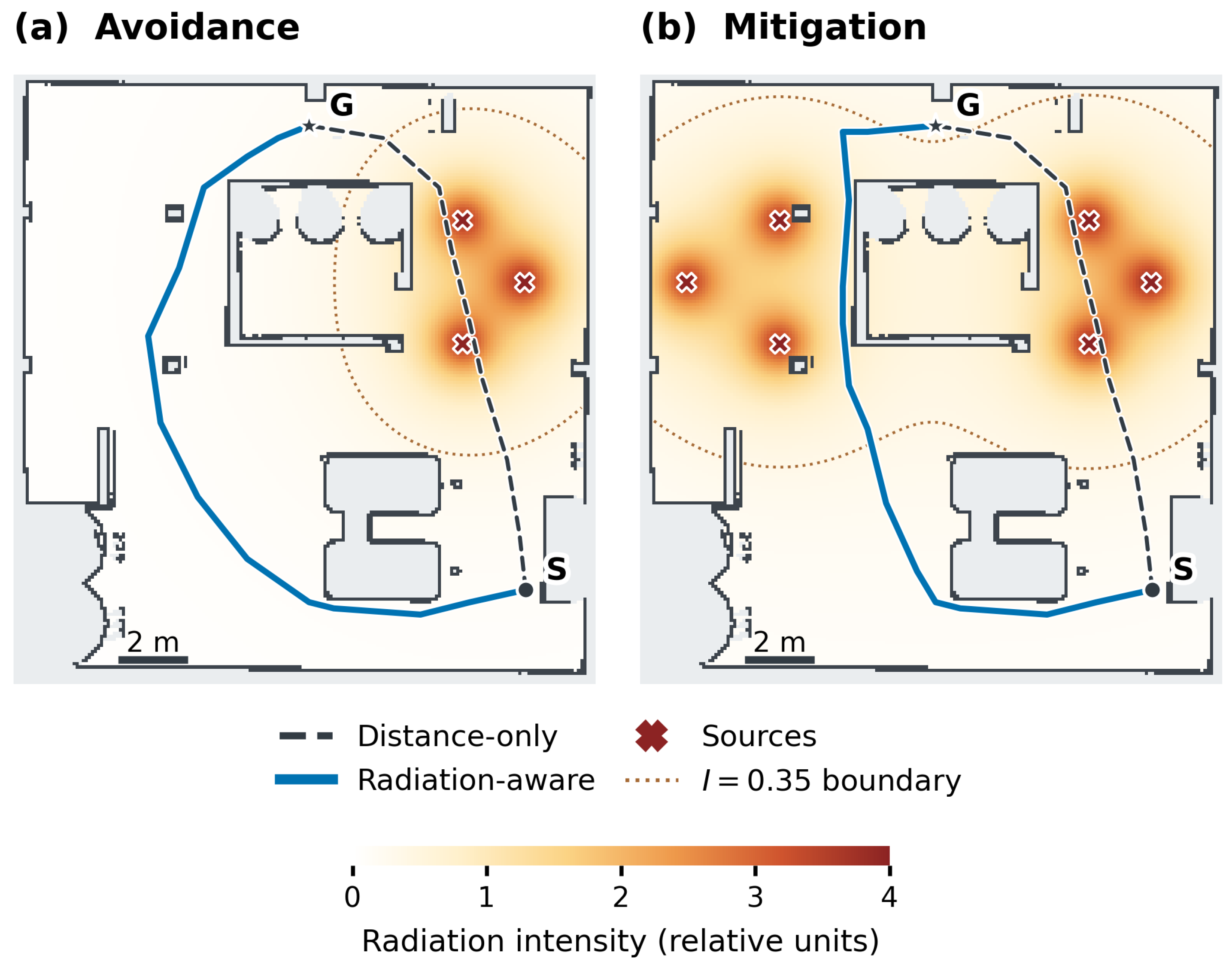
- Avoidance: High-cost regions are bypassed when alternative routes exist, because traversal through them is more expensive.
- Mitigation: When traversal through hazardous regions is unavoidable, the planner minimises exposure by selecting lower-cost subpaths, helped by nodes placed on the lower-intensity side of each region.
The resulting path is optimal with respect to the graph, not with respect to continuous space; the gap is quantified against a full-grid planner with the same objective in Section 5.
4. Experimental Setup
The evaluation was run offline on the occupancy maps of five simulated environments distributed with the reference implementation [10]: the reactor room shown in Section 5, a base environment, a barrel store and two hut layouts (Table 1). All maps were pooled to m; all parameter values are listed in Table 2. All planners were implemented in Python (version 3.13.18, with NumPy 2.5.3 and SciPy 1.18.1) and run single-threaded on one core of an Intel Xeon processor (Intel Corporation, Santa Clara, CA, USA) at 2.3 GHz; Section 5.5 reports the measured times.
Table 1.
Environments. Free cells at native resolution; unblocked cells after pooling to 0.10 m and inflation; mean node count of the radiation-aware graph; trials generated and retained after filtering.
Table 2.
Parameters used in all experiments (values of the reference implementation [10]).
To model environmental cost, a spatial radiation field was generated using a superposition of point sources:
where is the distance to source i and m regularises the singularity at each source. This inverse-square form is a simplified approximation of point-source behaviour [33]. In each trial, n sources (n drawn uniformly from ) were placed uniformly at random on unblocked cells of the largest free-space component, each with strength in relative units, as in the reference implementation. The field was rasterised at map resolution and registered to M. The model neglects attenuation and shielding by walls and equipment, scatter and build-up, and the energy dependence of dose, so the modelled field propagates through walls (see the examples in Section 5). The purpose of this model is not high-fidelity dosimetry, but to provide a spatially varying cost field for evaluating planner behaviour; the implications are discussed in Section 6.
To test the method on more realistic fields, a second set of experiments uses the shielded fields distributed with the reference implementation, one per environment. They were computed by ray tracing from 4–11 fixed sources (strengths 400–2000 in relative units) with a softened inverse-square law, exponential attenuation in air and through walls, and a 3% scattered component, so that walls cast radiation shadows. Because their scale is arbitrary, each field was multiplied by a constant so that its 90th percentile over unblocked cells equals the mean 90th percentile of the synthetic fields in the same environment; this keeps and comparable between the two field models. In each environment, 150 random start–goal pairs were evaluated with the same planners and with the adaptive variant ().
Seven planning configurations were evaluated:
- Distance-only A*: Grid-based A* on the same 0.10 m blocked mask, 8-connected without corner cutting, with radiation costs disabled.
- Full-grid cost-aware A*: The same grid planner minimising the same objective as the proposed method, Equation (4) with , with each step weighted by the trapezoidal dose between adjacent cells. This is the dense-costmap approach of navigation stacks [14,24,34] with the cost term made identical to ours, so that the comparison isolates the effect of the sparse representation.
- Geometry-only abstraction [9] () with distance-only and with cost-aware A* (ablation).
- Radiation-aware abstraction with distance-only A* (, ; ablation).
- Proposed method: Radiation-aware abstraction combined with cost-aware planning on the sparse graph (, ).
- Hazard-adaptive variant: The proposed method with intensity-dependent separation, (Section 3).
The full-grid baseline operates directly on the occupancy grid representation, whereas the proposed method performs planning over a reduced sparse graph. This distinction is important for interpreting both performance and computational efficiency.
In each environment, 150 trials were generated with a fixed random seed per trial, each with a random source configuration and a random start–goal pair (minimum separation 5 m, both in the largest free-space component). The main analysis retains trials in which the distance-only grid path passes through a cell with (the threshold contour drawn in the examples of Section 5), because only these trials test avoidance behaviour: when the shortest path is already low-exposure there is nothing to avoid. This retained 539 of 750 trials. Because filtering can inflate average reductions, results for the unfiltered set are also reported (Table 3). The parameter sweeps in Section 5.2 use the first 40 trials of each environment.
Table 3.
Results over all five environments. Cumulative cost in relative units × m. Reduction and length increase are relative to distance-only grid A* (ratio of means). Completeness is the fraction of start–goal pairs, all connected on the grid, for which the planner returned a path; statistics are over trials where all planners returned a path.
Metrics. The following metrics were recorded:
- total path length, computed as the polyline length of the returned path for all planners;
- cumulative cost, interpreted as a radiation-dose proxy, , evaluated identically for every planner with Equation (5) applied to each segment of the final path;
- computation time for each stage (abstraction sub-stages and per-query search), measured with a monotonic clock, and peak memory allocated during each stage, measured with Python’s tracemalloc;
- completeness, the fraction of start–goal pairs that are connected on the grid and for which the graph query also returns a path;
- node density in bands of radiation intensity (, and ).
For a robot moving at constant speed v through a field whose intensity is proportional to dose rate , the absorbed dose is , so is proportional to dose under the constant-speed assumption. Because the source strengths are in arbitrary units, is a relative dose proxy (relative units × m): percentage reductions are meaningful, but absolute values are not doses in grays. Variations in speed, stopping and turning time are not modelled.
Paired differences between planners were tested with the two-sided Wilcoxon signed-rank test (), since per-trial differences are not assumed to be normally distributed. Summary statistics are reported as mean ± standard deviation and median [interquartile range]. Reductions are reported as , the ratio of means, unless stated otherwise.
5. Results
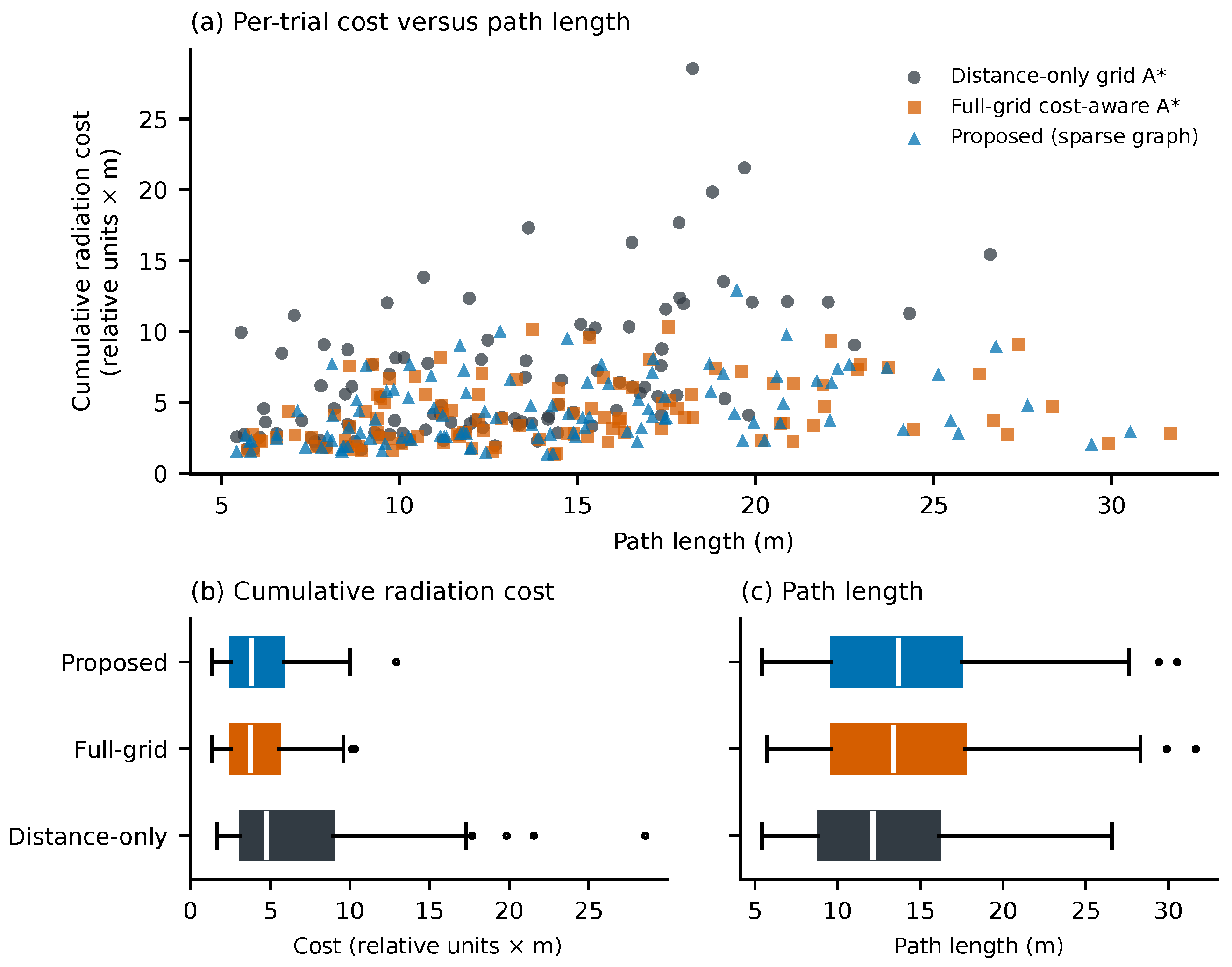
Table 3 summarises the results over all five environments, Table 4 gives them per environment, and Figure 1 shows the per-trial results in the reactor room. The distance-only planner prioritises shortest-path traversal without considering environmental costs, while both the proposed and full-grid cost-aware approaches incorporate cost-aware behaviour.
Table 4.
Results per environment (filtered set). Cost reduction and length increase relative to distance-only grid A*; the last-but-one column is the difference in mean cost between the proposed method and full-grid cost-aware A*.
Figure 1.
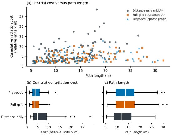
Per-trial results in the reactor room (filtered set, N = 107). (a) Cumulative radiation cost (relative dose proxy) against path length, one marker per trial and planner. (b) Distribution of cumulative cost. (c) Distribution of path length. The proposed method and the full-grid cost-aware planner minimise the same objective; the distance-only planner ignores radiation. In all panels, distance-only grid A* is shown in dark grey, full-grid cost-aware A* in orange and the proposed method in blue; the rows of (c) are in the same order as in (b).
In the filtered set, the distance-only planner accumulates a mean cost of 8.00 relative units × m. The proposed method reduces this to 5.69, a reduction of 28.9% (ratio of means; 22.5% as the mean of per-trial reductions), and the full-grid cost-aware planner to 5.49, a reduction of 31.5%. Both reductions relative to distance-only are significant (Wilcoxon signed-rank, and ). The cost is a longer path: +6.7% for the proposed method and +8.9% for the full-grid planner.
The proposed method and the full-grid planner minimise the same objective, so their difference measures what is lost by planning on the sparse graph. Per trial, the proposed method’s cost differs from the full-grid cost by +0.20 units on average (+3.7% of the mean, ), and its path length by −0.44 m (−2.0%, ). The sparse graph therefore gives up a small part of the achievable reduction (31.5% for the full-grid planner against 28.9%), but its paths are slightly shorter, because edges are straight segments of up to 3 m that are not restricted to the eight grid directions. The graph returned a path for 99.8% of the start–goal pairs, all of which were connected on the grid.
Without filtering, the reductions are smaller (27.7% for the proposed method and 30.1% for the full-grid planner, Table 3), because many randomly drawn routes pass close to no source and leave little to avoid. The size of the reduction therefore depends on how much of the shortest route lies in high-intensity regions, which varies between environments (Table 4).
Two distinct behavioural regimes are observed in Figure 2:
- Avoidance: When feasible, planners route entirely around high-cost regions, resulting in very low accumulated exposure (Figure 2a).
- Mitigation: In constrained environments where avoidance is not possible, planners reduce traversal through high-cost regions, lowering cumulative exposure relative to the baseline (Figure 2b).
Figure 2.
Illustrative radiation-aware planning behaviours on the reactor-room map. Dashed charcoal lines show distance-only routes, planned with on the geometry-only sparse graph () for visual clarity; in the quantitative evaluation the distance-only baseline is grid A* (Section 4). Solid blue lines show routes from the proposed method (, ). (a) Avoidance: the planner bypasses the hotspot via the opposite side of the central structure. (b) Mitigation: with sources on both sides of the central structure, every route from S to G crosses elevated intensity, and the planner selects the corridor with lower intensity rather than the shortest one. S and G denote the start and goal, respectively, marked by black dots. Both panels share the same relative radiation-intensity scale; the dotted contour marks . In these two examples the line-integral cost falls from 19.3 to 2.3 (a) and from 20.6 to 10.7 (b).
5.1. Ablation: Contribution of Radiation-Aware Abstraction
Table 5 isolates the two components by holding everything else fixed. Adding the radiation term to the search ( instead of 0) reduces mean cost by 28.6% on the geometry-only graph and by 28.2% on the radiation-aware graph. Adding the radiation term to node selection ( instead of 0) has no significant effect on cost with the cost-aware search (mean difference −0.2%, ) and changes path length by −0.5% (). With distance-only search, it changes mean cost by −0.8% ().
Table 5.
Ablation over graph and planner settings (filtered set, all environments, mean ± SD; query time is the median, including start/goal insertion).
The exposure reduction therefore comes from the cost-aware edge weights, not from radiation-aware node placement. This is consistent with Section 5.2: the penalty moves nodes but does not thin out high-intensity regions, and with m and m the geometry-only graph already contains enough alternative routes for the cost-aware search to find a low-exposure one. In this formulation the value of the abstraction lies in the reduced search effort at equal exposure (Section 5.5).
5.2. Sensitivity to Weighting Parameters and Node Density
Table 6 reports node density in three intensity bands, mean node count, mean cost and completeness as and are varied with . Node density is almost independent of the radiation term. With the reference setting , density in the highest band falls by 3% (1.47 to 1.42 nodes/m2), density in the middle band rises by 5% and the total node count changes by +0.5%. Even at with the saturating penalty, density in the highest band falls by only 12% while the node count changes by +1.8%: nodes displaced from the most intense cells reappear nearby, at the edges of the irradiated region. The mean cost of the cost-aware query differs by at most 0.6% between any of the ten other settings and , and every query returned a path. In this formulation the choice of and therefore matters little.
Table 6.
Node density (nodes/m2) by intensity band, mean node count, mean cost and path length of the cost-aware query () and completeness, as functions of and (filtered sweep trials, N = 145).
The planning weight controls the trade-off directly. On the radiation-aware graph, increasing from 0 to 2, 6, 18 and 54 changes mean cost from 7.72 to 5.59 to 5.40 to 5.35 to 5.34 and mean path length from 18.88 to 19.69 to 20.38 to 20.86 to 21.23 m (sweep trials, filtered). The full-grid planner follows the same trend (cost 7.79 to 5.42 to 5.24 to 5.18 to 5.16). The value used throughout lies where further increases buy little additional reduction for a growing increase in length.
5.3. Hazard-Adaptive Node Separation
Table 7 evaluates the variant in which the separation grows with intensity, on the same fields and start–goal pairs as Table 3. It does make node density hazard-adaptive: with , density in the highest band falls from 1.43 to 0.58 nodes/m2 and the graph shrinks by 23%; with and it shrinks by 33% and 45%. The smaller graphs are cheaper to build and search, but exposure rises: on the same trials, mean cost increases by 4.2%, 9.9% and 25.2% relative to ( in each case), and completeness falls from 99.8% to 98.5%, 95.4% and 79.2%. Sparser coverage of irradiated regions appears to remove some of the low-exposure detours that the cost-aware search would otherwise use and, at large , disconnects passages. Thinning out hazardous regions therefore trades exposure and completeness for graph size: for minimum exposure the uniform separation () is preferable, and a small () is a reasonable compromise when memory or search time matters more.
Table 7.
Hazard-adaptive node separation with and (filtered set, N = 539, same fields and start–goal pairs as Table 3; is the proposed method). Node density is for the band (nodes/m2); cost, reduction and length are over the trials for which the graph returned a path, and the cost change is paired against on those same trials; reduction is relative to distance-only grid A*.
5.4. Shielded Radiation Fields
Table 8 repeats the comparison on the ray-traced shielded fields. In the expanded hut, no distance-only route reached , so that environment contributes only to the unfiltered set. Over the remaining 428 retained trials, the proposed method reduces mean cumulative cost by 62.3% for a 12.4% longer path, against 65.2% and 15.4% for the full-grid planner (unfiltered, all 750 trials: 60.5% and 63.5%). The reductions are about twice those obtained with the synthetic fields and range from 38–74% between environments: walls create strong contrasts, so a modest detour behind shielding often removes most of the exposure. The conclusions of the previous sections hold on these fields. The radiation term in node selection changes cost by −0.3% relative to the geometry-only graph (). The proposed method’s cost stays within +8.2% of the full-grid cost, completeness is 99.8%, and the adaptive variant with costs +7.1% more exposure than the proposed method.
Table 8.
Results on the ray-traced shielded fields (filtered trials). Cost reduction is relative to distance-only grid A* (ratio of means); length increase is proposed/full grid; completeness is for the proposed graph.
5.5. Computational Cost
Table 9 reports measured times for one radiation field per environment and 100 random queries, all measured in one session. A query on the sparse graph, including insertion of the start and goal, takes 2.1–4.8 ms, against 31–117 ms for full-grid cost-aware A* on the same 0.10 m map, i.e., 15–24 times faster. With the all-pairs acceptance test of the reference implementation, building the graph takes 0.30–4.98 s, dominated by node selection. The spatial-hash test of Section 3.1, which yields identical graphs, makes node selection 5–24 times faster and reduces abstraction to 0.16–1.11 s, now dominated by edge construction. The abstraction is therefore recovered after 4–10 queries on the same map and field (8–44 with the all-pairs test); for a single query the full-grid planner is faster. On the native 0.02 m reactor-room map, which a navigation stack would typically plan on, full-grid cost-aware A* takes 1.30 s per query (mean of 10 queries). Peak memory allocated during a query was 0.02–0.16 MB for the graph and 0.7–2.2 MB for the 0.10 m grid. All times are for unoptimised Python and should be read as relative, not absolute.
Table 9.
Measured computation time (Python, one core of a 2.3 GHz Intel Xeon; one radiation field per environment, 100 random queries, all in one session). Abstraction: median of five builds with the all-pairs acceptance test of the reference implementation and with the spatial-hash test, which yields identical graphs. Query times are means and include start/goal insertion for the graph; speed-up is grid over graph query time. Totals for K queries are proposed (spatial hash, including abstraction)/full-grid cost-aware A*; is the number of queries after which the proposed method is faster in total.
When the radiation field changes but the map does not, the edge weights can be recomputed without repeating node selection, at a cost of ; re-ranking under Equation (2) requires the abstraction to be repeated. Given the ablation result, the geometry-only graph, which does not depend on the field, can be reused unchanged.
5.6. Scalability Analysis
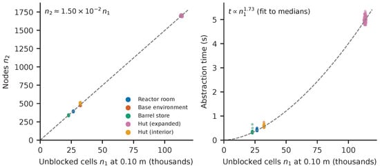
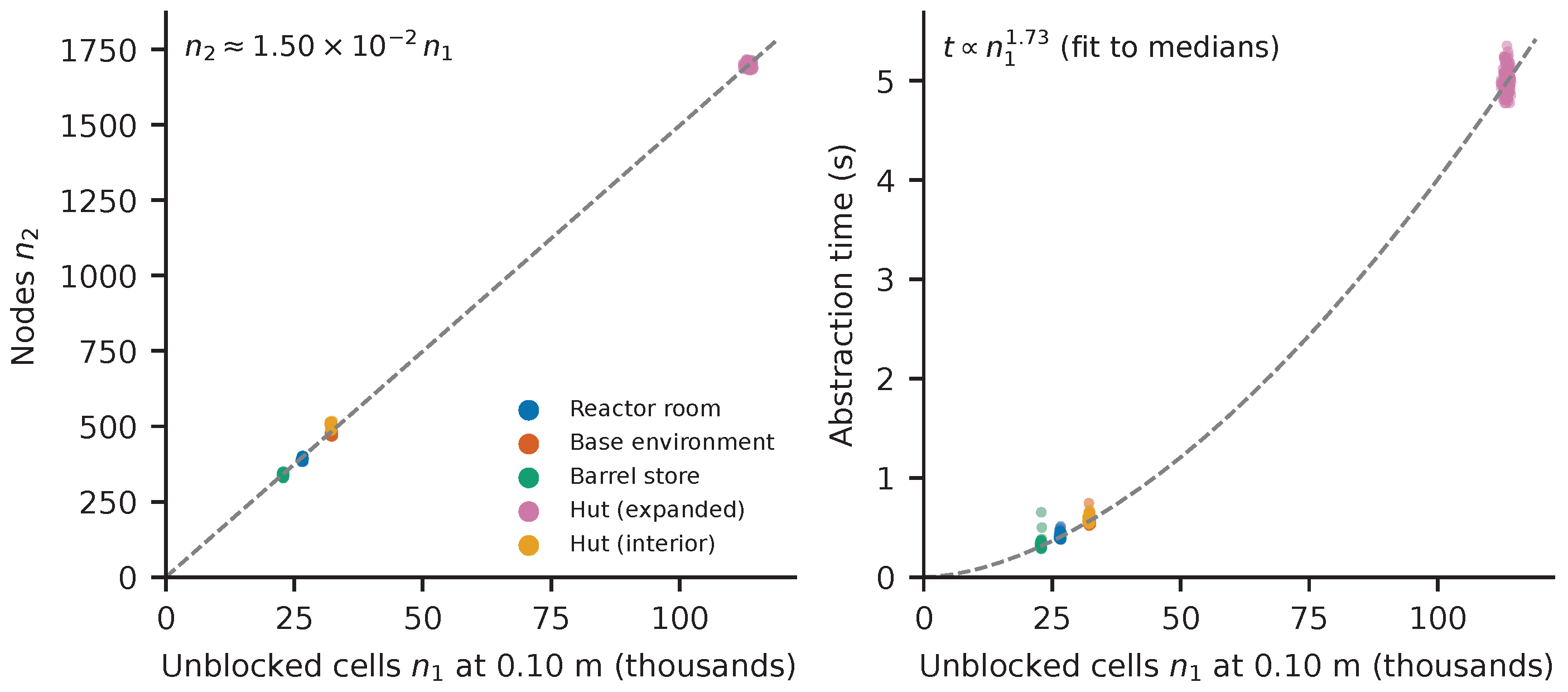
Figure 3 shows node count and abstraction time against the number of unblocked cells for every trial in the five environments. Node count grows approximately linearly with (, about 1.5 nodes per square metre of unblocked space), because the separation fixes the node density in open space; the compression ratio is 64–68. Abstraction time grows faster than linearly, approximately as across the five environments (an indicative fit to five medians), as expected from the selection term in Equation (1). Figure 3 uses the all-pairs test of the reference implementation; with the spatial hash the largest environment takes 1.11 s instead of 4.98 s (Table 9).
Figure 3.
Scalability of the abstraction across the five environments. Left: node count; right: total abstraction time with the all-pairs acceptance test (Python, one 2.3 GHz core). Each point is one trial (one radiation field). Dashed lines: a proportional fit of node count (left) and a power-law fit of time (right) to the five per-environment medians, shown for reference.
6. Discussion
The results show that cost-aware planning on a sparse abstraction of the occupancy map reduces exposure about as much as full-grid planning with the same objective (28.9% against 31.5% in the filtered set), while each query searches a graph with roughly 64–68 times fewer elements and runs 15–24 times faster. The same conclusions hold on ray-traced fields with wall shielding, where the reductions are larger (62.3% against 65.2%). The abstraction costs more than a single grid query, so the approach pays off when many queries are planned on the same map, for example, repeated inspection routes, replanning to many candidate goals during exploration, or evaluating alternative missions.
The ablation gives a clear, partly negative answer to the question of where the benefit comes from. The radiation term in node selection, which motivated this work, changes where nodes lie but does not reduce exposure measurably; the cost-aware edge weights do. In the greedy, fixed-separation selection of the reference implementation the score cannot change how many nodes a region receives. Letting the separation grow with intensity (Section 5.3) does make density hazard-adaptive and shrinks the graph by 23–45%, but it raises exposure and lowers completeness. For minimising exposure, a uniform graph with cost-aware edge weights is the better choice; hazard-adaptive density is useful mainly when graph size is the binding constraint. For practical use, the geometry-only graph has the advantage that it does not depend on the radiation field and need not be rebuilt when the field estimate changes.
The framework is not limited to radiation-specific applications and can be applied to arbitrary spatial cost fields, including traversability, risk, or uncertainty. In this sense, radiation-aware navigation provides a motivating application for a more general class of constraint-aware occupancy-map abstractions.
Limitations
Known cost field. One limitation of the current approach is the assumption of a known cost field. In practical deployments, this information may need to be estimated online from sparse, noisy measurements. Probabilistic field estimates, such as Gaussian-process radiation maps [35], could be used by replacing with a risk-averse value such as the posterior mean plus a multiple of the posterior standard deviation. Updating the field changes only the edge weights (Section 5.5). Future work will investigate integration with such probabilistic field-estimation methods to enable operation in unknown environments.
Radiation model. The regularised inverse-square point-source model neglects shielding, attenuation, scatter and build-up. Real fields have shadows behind walls and equipment, which would create more irregular low-cost corridors and test connectivity and completeness more strongly. Section 5.4 evaluates ray-traced fields with wall attenuation and scatter, which confirm the conclusions; these fields are still simulated, and measured or Gaussian-process estimated fields remain to be evaluated. The absolute size of the exposure reduction depends on the field: it is larger when strong sources lie close to the shortest route.
Footprint and kinematics. Clearance is handled conservatively for a disc-shaped robot (Section 3.5), but turning constraints and non-circular footprints are not modelled at the global level and are delegated to the local controller.
Connectivity. Connectivity of the graph is measured, not guaranteed (Section 3.3), and passages close to the sampling limit may be lost.
Evaluation. The planners were evaluated offline on occupancy maps from simulated environments and timed in Python on a desktop processor, not on embedded hardware or a physical robot. The computational comparison is between implementations of equal (low) optimisation; optimised C++ planners would be faster in absolute terms. The reuse advantage holds only while the map is static.
7. Conclusions
This paper presented a cost-aware navigation framework that integrates environmental cost into both occupancy map abstraction and graph-based path planning. In simulation over five environments, planning on the sparse graph reduced mean cumulative radiation cost by 28.9% relative to distance-only grid A*, for a +6.7% increase in path length, which is within 4% of the cost achieved by a full-grid planner with the same objective. Each query was 15–24 times faster than on the full grid, and the abstraction was recovered after 4–10 queries. On ray-traced fields with wall shielding the reduction was 62.3%, against 65.2% for the full grid. An ablation showed that the reduction comes from the cost-aware edge weights; adding radiation to node selection moved nodes but did not reduce exposure further, and making node separation grow with intensity shrank the graph by up to 45% at the cost of higher exposure and lower completeness.
The proposed approach generalises beyond radiation-aware navigation and provides a practical framework for cost-aware planning in hazardous or constrained environments.
Supplementary Materials
The following supporting information can be downloaded at: https://www.mdpi.com/article/10.3390/app162211428/s1, File S1: evaluation scripts, analysis code and trial-level results for all 750 trials (ZIP archive, with instructions for reproducing every table and figure).
Author Contributions
Conceptualization, D.B., I.C. and P.P.; methodology, D.B., A.W., I.C., M.G. and P.P.; software, D.B.; validation, D.B., I.C. and P.P.; formal analysis, D.B.; investigation, D.B.; resources, D.B., I.C. and P.P.; data curation, D.B., I.C. and P.P.; writing—original draft preparation, D.B., I.C. and P.P.; writing—review and editing, D.B., A.W., I.C., M.G. and P.P.; visualization, D.B.; supervision, A.W., I.C., M.G. and P.P.; project administration, D.B., I.C. and P.P.; funding acquisition, A.W., I.C. and P.P. All authors have read and agreed to the published version of the manuscript.
Funding
This work was part-funded by the EPSRC Energy Programme [grant number EP/W006839/1].
Institutional Review Board Statement
Not applicable.
Informed Consent Statement
Not applicable.
Data Availability Statement
The reference implementation used for all experiments is available at https://github.com/DavidBatty95/OccMapAbstractionROS1Pkg (accessed on 9 November 2026; branch refresh/reproducible-research-demo, commit 19b5253). The evaluation scripts and trial-level results (750 trials, including random seeds, source configurations, start–goal pairs and per-planner metrics) are provided as Supplementary File S1.
Conflicts of Interest
The authors declare no conflicts of interest. The funders had no role in the design of the study; in the collection, analyses, or interpretation of data; in the writing of the manuscript; or in the decision to publish the results.
References
- Nuclear Decommissioning Authority. The NDA’s ‘Grand Challenges’ for Technical Innovation. UK Government Blog. 2020. Available online: https://nda.blog.gov.uk/the-ndas-grand-challenges-for-technical-innovation/ (accessed on 19 May 2026).
- Tsitsimpelis, I.; Taylor, C.J.; Lennox, B.; Joyce, M.J. A Review of Ground-Based Robotic Systems for the Characterization of Nuclear Environments. Prog. Nucl. Energy 2019, 111, 109–124. [Google Scholar] [CrossRef] [Scilit]
- Smith, R.; Cucco, E.; Fairbairn, C. Robotic Development for the Nuclear Environment: Challenges and Strategy. Robotics 2020, 9, 94. [Google Scholar] [CrossRef] [Scilit]
- West, A.; Knapp, J.; Lennox, B.; Walters, S.; Watts, S. Radiation Tolerance of a Small COTS Single Board Computer for Mobile Robots. Nucl. Eng. Technol. 2022, 54, 2198–2203. [Google Scholar] [CrossRef] [Scilit]
- Nagatani, K.; Kiribayashi, S.; Okada, Y.; Tadokoro, S.; Nishimura, T.; Yoshida, T.; Koyanagi, E.; Fukushima, M.; Kawatsuma, S. Emergency Response to the Nuclear Accident at the Fukushima Daiichi Nuclear Power Plants Using Mobile Rescue Robots. J. Field Robot. 2013, 30, 44–63. [Google Scholar] [CrossRef] [Scilit]
- Azpúrua, H.; Saboia, M.; Freitas, G.M.; Clark, L.; Agha-mohammadi, A.-a.; Pessin, G.; Campos, M.F.M. A Survey on the Autonomous Exploration of Confined Subterranean Spaces: Perspectives from Real-World and Industrial Robotic Deployments. Robot. Auton. Syst. 2023, 160, 104304. [Google Scholar] [CrossRef] [Scilit]
- Peng, J.; Huang, Y.; Luo, G. Robot Path Planning Based on Improved A* Algorithm. Cybern. Inf. Technol. 2015, 15, 171–180. [Google Scholar] [CrossRef] [Scilit]
- Vanegas Pérez, I.D.; Montiel, O.; Orozco-Rosas, U. Path Planning by Search Algorithms in Graph-Represented Workspaces. In Studies in Computational Intelligence, Proceedings of the Recent Advances of Hybrid Intelligent Systems Based on Soft Computing; Springer: Cham, Switzerland, 2021; Volume 915, pp. 79–93. [Google Scholar] [CrossRef] [Scilit]
- Batty, D.; Manes, L.; West, A.; Patel, M.; Caliskanelli, I.; Paoletti, P. Occupancy Map Abstraction for Higher Level Mission Planning of Autonomous Robotic Exploration in Hazardous Nuclear Environments. In Proceedings of the Towards Autonomous Robotic Systems, Cambridge, UK, 13–15 September 2023; Lecture Notes in Computer Science; Springer: Cham, Switzerland, 2023; pp. 77–88. [Google Scholar] [CrossRef] [Scilit]
- Batty, D. OccMapAbstractionROS1Pkg: Occupancy-Map Abstraction and Radiation-Aware Planning (Reference Implementation, Branch Refresh/Reproducible-Research-Demo, Commit 19b5253). GitHub Repository. 2026. Available online: https://github.com/DavidBatty95/OccMapAbstractionROS1Pkg (accessed on 9 November 2026).
- Hart, P.E.; Nilsson, N.J.; Raphael, B. A Formal Basis for the Heuristic Determination of Minimum Cost Paths. IEEE Trans. Syst. Sci. Cybern. 1968, 4, 100–107. [Google Scholar] [CrossRef] [Scilit]
- Koenig, S.; Likhachev, M. D* Lite. In Proceedings of the AAAI Conference on Artificial Intelligence, Edmonton, AB, Canada, 28 July–1 August 2002; pp. 476–483. [Google Scholar]
- Orthey, A.; Chamzas, C.; Kavraki, L.E. Sampling-Based Motion Planning: A Comparative Review. Annu. Rev. Control. Robot. Auton. Syst. 2024, 7, 285–310. [Google Scholar] [CrossRef] [Scilit]
- Macenski, S.; Martín, F.; White, R.; Ginés Clavero, J. The Marathon 2: A Navigation System. In Proceedings of the IEEE/RSJ International Conference on Intelligent Robots and Systems, Online, 24 October 2020–24 January 2021. [Google Scholar] [CrossRef] [Scilit]
- Macenski, S.; Booker, M.; Wallace, J.; Fischer, T. Open-Source, Cost-Aware Kinematically Feasible Planning for Mobile and Surface Robotics. arXiv 2024, arXiv:2401.13078. [Google Scholar] [CrossRef] [Scilit]
- Sánchez-Ibáñez, J.R.; Pérez-del Pulgar, C.J.; García-Cerezo, A.J. Path Planning for Autonomous Mobile Robots: A Review. Sensors 2021, 21, 7898. [Google Scholar] [CrossRef] [Scilit]
- Thrun, S.; Bücken, A. Integrating Grid-Based and Topological Maps for Mobile Robot Navigation. In Proceedings of the Thirteenth National Conference on Artificial Intelligence, Portland, OR, USA, 4–8 August 1996; pp. 944–950. [Google Scholar]
- Portugal, D.; Rocha, R.P. Extracting Topological Information from Grid Maps for Robot Navigation. In Proceedings of the 4th International Conference on Agents and Artificial Intelligence, Algarve, Portugal, 6–8 February 2012; pp. 137–143. [Google Scholar] [CrossRef] [Scilit]
- Blöchliger, F.; Fehr, M.; Dymczyk, M.; Schneider, T.; Siegwart, R. Topomap: Topological Mapping and Navigation Based on Visual SLAM Maps. In Proceedings of the IEEE International Conference on Robotics and Automation, Brisbane, Australia, 21–25 May 2018; pp. 3818–3825. [Google Scholar] [CrossRef] [Scilit]
- Oleynikova, H.; Taylor, Z.; Siegwart, R.; Nieto, J. Sparse 3D Topological Graphs for Micro-Aerial Vehicle Planning. In Proceedings of the IEEE/RSJ International Conference on Intelligent Robots and Systems, Madrid, Spain, 1–5 October 2018; pp. 1–9. [Google Scholar] [CrossRef] [Scilit]
- Dobson, A.; Bekris, K.E. Sparse Roadmap Spanners for Asymptotically Near-Optimal Motion Planning. Int. J. Robot. Res. 2014, 33, 18–47. [Google Scholar] [CrossRef] [Scilit]
- David, J.; Bridgwater, T.; West, A.; Lennox, B.; Giuliani, M. Internal State-Based Risk Assessment for Robots in Hazardous Environment. In Proceedings of the Towards Autonomous Robotic Systems; Lecture Notes in Computer Science; Springer: Cham, Switzerland, 2022; pp. 137–152. [Google Scholar] [CrossRef] [Scilit]
- Fan, D.D.; Otsu, K.; Kubo, Y.; Dixit, A.; Burdick, J.; Agha-Mohammadi, A.A. STEP: Stochastic Traversability Evaluation and Planning for Risk-Aware Off-road Navigation. In Proceedings of the Robotics: Science and Systems, Online, 12–16 July 2021. [Google Scholar] [CrossRef] [Scilit]
- West, A.; Wright, T.; Tsitsimpelis, I.; Groves, K.; Joyce, M.J.; Lennox, B. Real-Time Avoidance of Ionising Radiation Using Layered Costmaps for Mobile Robots. Front. Robot. AI 2022, 9, 862067. [Google Scholar] [CrossRef] [Scilit]
- Groves, K.; Hernandez, E.; West, A.; Wright, T.; Lennox, B. Robotic Exploration of an Unknown Nuclear Environment Using Radiation Informed Autonomous Navigation. Robotics 2021, 10, 78. [Google Scholar] [CrossRef] [Scilit]
- Xiao, Y.; Zhang, C.; Luo, J.; Yang, C.; Liu, C. Integrating the Radiation Source Position into a Grid Map of the Environment Using a Mobile Robot. Nucl. Instrum. Methods Phys. Res. Sect. A Accel. Spectrometers Detect. Assoc. Equip. 2020, 976, 164253. [Google Scholar] [CrossRef] [Scilit]
- Abd Rahman, N.A.; Sahari, K.S.M.; Hamid, N.A.; Hou, Y.C. A Coverage Path Planning Approach for Autonomous Radiation Mapping with a Mobile Robot. Int. J. Adv. Robot. Syst. 2022, 19, 17298806221116483. [Google Scholar] [CrossRef] [Scilit]
- Chao, N.; Liu, Y.k.; Xia, H.; Ayodeji, A.; Bai, L. Grid-Based RRT* for Minimum Dose Walking Path-Planning in Complex Radioactive Environments. Ann. Nucl. Energy 2018, 115, 73–82. [Google Scholar] [CrossRef] [Scilit]
- Chao, N.; Liu, Y.k.; Xia, H.; Peng, M.j.; Ayodeji, A. DL-RRT* Algorithm for Least Dose Path Re-Planning in Dynamic Radioactive Environments. Nucl. Eng. Technol. 2019, 51, 825–836. [Google Scholar] [CrossRef] [Scilit]
- Adibeli, J.O.; Liu, Y.k.; Ayodeji, A.; Awodi, N.J. Path Planning in Nuclear Facility Decommissioning: Research Status, Challenges, and Opportunities. Nucl. Eng. Technol. 2021, 53, 3505–3516. [Google Scholar] [CrossRef] [Scilit]
- Liu, Z.; Liang, S.; Guan, B.; Shang, Y.; Yu, Q.; Zhao, J. A Geometric Framework for Absolute Pose and Velocity Estimation with Event Cameras. arXiv 2026, arXiv:2606.09139. [Google Scholar] [CrossRef] [Scilit]
- Liang, S.; Guan, B.; Li, B.; Yu, Q.; Shang, Y. A Pose-Only Geometric Constraint for Multi-Camera Pose Adjustment. IEEE Trans. Pattern Anal. Mach. Intell. 2026, 48, 9354–9371. [Google Scholar] [CrossRef] [Scilit]
- Knoll, G.F. Radiation Detection and Measurement, 4th ed.; Wiley: Hoboken, NJ, USA, 2010. [Google Scholar]
- Marder-Eppstein, E.; Berger, E.; Foote, T.; Gerkey, B.; Konolige, K. The Office Marathon: Robust Navigation in an Indoor Office Environment. In Proceedings of the IEEE International Conference on Robotics and Automation, Anchorage, AK, USA, 3–7 May 2010; pp. 300–307. [Google Scholar] [CrossRef] [Scilit]
- West, A.; Tsitsimpelis, I.; Licata, M.; Jazbec, A.; Snoj, L.; Joyce, M.J.; Lennox, B. Use of Gaussian Process Regression for Radiation Mapping of a Nuclear Reactor with a Mobile Robot. Sci. Rep. 2021, 11, 13975. [Google Scholar] [CrossRef] [Scilit]

Disclaimer/Publisher’s Note: The statements, opinions and data contained in all publications are solely those of the individual author(s) and contributor(s) and not of MDPI and/or the editor(s). MDPI and/or the editor(s) disclaim responsibility for any injury to people or property resulting from any ideas, methods, instructions or products referred to in the content. |
© 2026 by the authors. Licensee MDPI, Basel, Switzerland. This article is an open access article distributed under the terms and conditions of the Creative Commons Attribution (CC BY) license.