


Abstract
This study presents a bibliometric review of Geographic Information Systems (GIS) applications in Industrial Engineering, based on a literature search covering the period 2010–2025. Scopus and Web of Science yielded 2137 initial records, of which 1702 came from Scopus and 435 from Web of Science. After removing duplicates and applying exclusion criteria based on document type, language, and publication period, the final dataset consisted of 247 peer-reviewed journal articles. The analysis was conducted using Bibliometrix 5.3.0 in R 4.6.0, focusing on scientific production, source distribution, authorship patterns, country and institutional contributions, citation impact, and thematic evolution. The results show a sustained increase in scientific production on GIS applications in Industrial Engineering, especially after 2018, with recurring topics related to supply chain management, logistics, facility location, optimization, spatial analysis, sustainability, pollution, and environmental impact. The thematic structure indicates that GIS, supply chain management, and optimization management form the basic themes of the field, while impact appears as a motor theme. Overall, the findings show that GIS has evolved into a strategic tool for operational optimization, sustainable planning, and data-driven industrial decision-making.
1. Introduction
The integration of digital technologies into industrial systems has intensified notably in recent decades [1,2], driving the need for tools capable of managing complex, data-intensive environments [3,4]. In this context, Geographic Information Systems (GIS) have emerged as an effective platform for the capture, analysis, and visualization of spatial information [5,6,7]. Although they were originally developed for cartographic and environmental applications, their use has expanded to other fields, such as logistics, urban planning, infrastructure management, and, more recently, Industrial Engineering [8,9,10]. This evolution reflects the growing importance of the spatial dimension in decision-making processes, especially in systems where location and distribution directly influence efficiency [11,12].
In the field of Industrial Engineering, the optimization of resources and processes constitutes a central objective. Traditionally, many models have been developed without explicitly incorporating spatial variables, which limits their ability to accurately represent certain real-world problems. However, numerous industrial challenges, such as facility location, logistics network design, transport planning, and resource allocation, have an intrinsically spatial nature [13]. In this regard, GIS enables the integration of geographic data with analytical models, facilitating the identification of patterns, the detection of inefficiencies, and support for data-driven decision-making [4,5].
Recent technological development has further strengthened the role of GIS in Industrial Engineering. The increasing availability of geospatial data, together with advances in computational capabilities, has made it possible to address problems with a higher level of detail and precision [4,5,14]. Technologies such as remote sensing, the Internet of Things (IoT), and real-time data acquisition systems generate large volumes of spatial information that, when integrated into GIS platforms, offer new possibilities for analysis and monitoring [15,16,17]. In addition, the combination of GIS with emerging tools, such as artificial intelligence and digital twins, is opening new lines of research focused on predictive analysis and the advanced optimization of industrial systems, in line with the principles of Industry 4.0 [14,18].
Despite this growing relevance, the scientific literature on GIS applications in Industrial Engineering is dispersed across multiple disciplines and fields of knowledge. Studies are frequently published in diverse fields, such as transport, environmental engineering, operations research, and urban studies, which makes it difficult to obtain a comprehensive and structured overview of the state of the art [19].
In this context, bibliometric analysis emerges as an appropriate tool for quantitatively assessing scientific production and revealing structural patterns within a field of study [20,21,22]. This type of analysis makes it possible to examine indicators of productivity, impact, and collaboration, as well as to explore thematic evolution through techniques such as keyword co-occurrence analysis [23,24]. In this way, it is possible not only to describe the development of the field but also to interpret its evolution and identify opportunities for future research [25].
In view of this scenario, the present study aims to conduct a bibliometric review of GIS applications in Industrial Engineering. To this end, data from leading scientific databases are used, analyzing key indicators such as publication trends, citation impact, the most relevant authors and institutions, and collaboration indicators. Likewise, science mapping techniques are applied to identify the main thematic lines and their evolution over time [26].
The main contribution of this study is not limited to the descriptive quantification of publications, authors, sources, and citations. Rather, the study provides a structured interpretation of a fragmented research field by identifying the main conceptual dimensions, thematic transitions, and knowledge gaps in GIS applications in Industrial Engineering. Specifically, it contributes by: (i) organizing dispersed literature into a coherent bibliometric and thematic framework; (ii) identifying the transition from operational applications, such as logistics and facility location, towards sustainability-oriented and digitally integrated approaches; (iii) highlighting critical gaps related to methodological standardization, interoperability, real-time data integration, and validation in real industrial contexts; and (iv) proposing future research directions for the development of GIS-based decision-support systems in industrial planning and management.
2. Materials and Methods
This study is based on a systematic bibliometric approach to analyze scientific production related to the applications of Geographic Information Systems (GIS) in the field of Industrial Engineering during the period 2010–2025. The methodology was designed to ensure the reproducibility of the analysis and the quality of the data used [27,28].
The general methodological framework followed in this study is structured into three main phases. First, scientific documents were collected from the Scopus and Web of Science databases. Second, bibliometric indicators were analyzed, including scientific productivity, impact, collaboration, sources, authors, institutions, and countries. Finally, science mapping techniques were applied to identify thematic evolution, the main research lines, and existing gaps in the field [23,25]. This approach makes it possible to transform an initial set of dispersed information on GIS applications into a structured overview of the study area. More specifically, the workflow involved the following steps: first, the search strategy was applied in Scopus and Web of Science using titles, abstracts, and keywords; second, the records retrieved from both databases were exported and merged in R; third, duplicate records were identified and removed; fourth, the resulting dataset was screened according to document type, language, publication period, and thematic relevance; fifth, the final dataset was processed using Bibliometrix to analyze scientific production, sources, authors, institutions, countries, citations, keywords, and thematic evolution; and finally, the results were interpreted to identify the main research trends, knowledge gaps, and future directions in GIS applications in Industrial Engineering.
Data collection was carried out using the Scopus and Web of Science (WoS) databases, selected for their broad coverage and recognition within the scientific community. The search strategy was defined through combinations of terms related to GIS and its applications in industrial environments, applied to titles, abstracts, and keywords. As a result, an initial set of 2137 records was obtained, of which 1702 came from Scopus and 435 from WoS. To ensure the transparency and reproducibility of the study, the complete search string used in both databases, together with the Boolean operators employed, is presented in Table 1.
Table 1.
Search string used for document retrieval.
The search strategy was designed to balance sensitivity and specificity. Broad Industrial Engineering terms such as “logistics”, “supply chain”, “transport”, “manufacturing”, and “operations research” were included because they represent major application domains in which GIS-based methods are frequently used for spatial analysis, location-allocation problems, network optimization, production planning, distribution systems, and decision support. However, these terms were not used independently, but in combination with GIS-related expressions such as “geographic information system*”, “GIS”, and “geospatial analysis”. This Boolean structure was intended to capture the interdisciplinary nature of GIS applications in Industrial Engineering while reducing the risk of excluding relevant studies located at the intersection of spatial analysis, operational optimization, and industrial decision-making. In addition, the broad initial search was subsequently refined through duplicate removal and screening criteria based on document type, language, publication period, and thematic relevance, ensuring that the final dataset only included peer-reviewed journal articles directly aligned with the scope of the review.
To reinforce the consistency of the document selection process, inter-rater reliability was assessed during the article screening phase. Since five authors participated in the review of the records, the degree of agreement was quantified using Fleiss’ Kappa coefficient [29], which is suitable for assessing agreement among multiple raters in nominal categories. The assessment was performed on a representative random sample of the identified records, independently and blindly reviewed by the five authors using a binary classification of inclusion or exclusion. The values obtained were interpreted according to the scale proposed by Landis and Koch [30], considering an agreement level equal to or greater than 0.61 as acceptable. The inter-rater reliability analysis yielded a Fleiss’ Kappa coefficient of κ = 0.74, which indicates substantial agreement according to the Landis and Koch scale. This result confirms an acceptable level of consistency among the five reviewers during the inclusion and exclusion process and supports the reliability of the final bibliographic dataset. This procedure made it possible to verify the consistency of the screening process, reduce the influence of subjective criteria, and increase methodological traceability in the construction of the final bibliographic dataset.
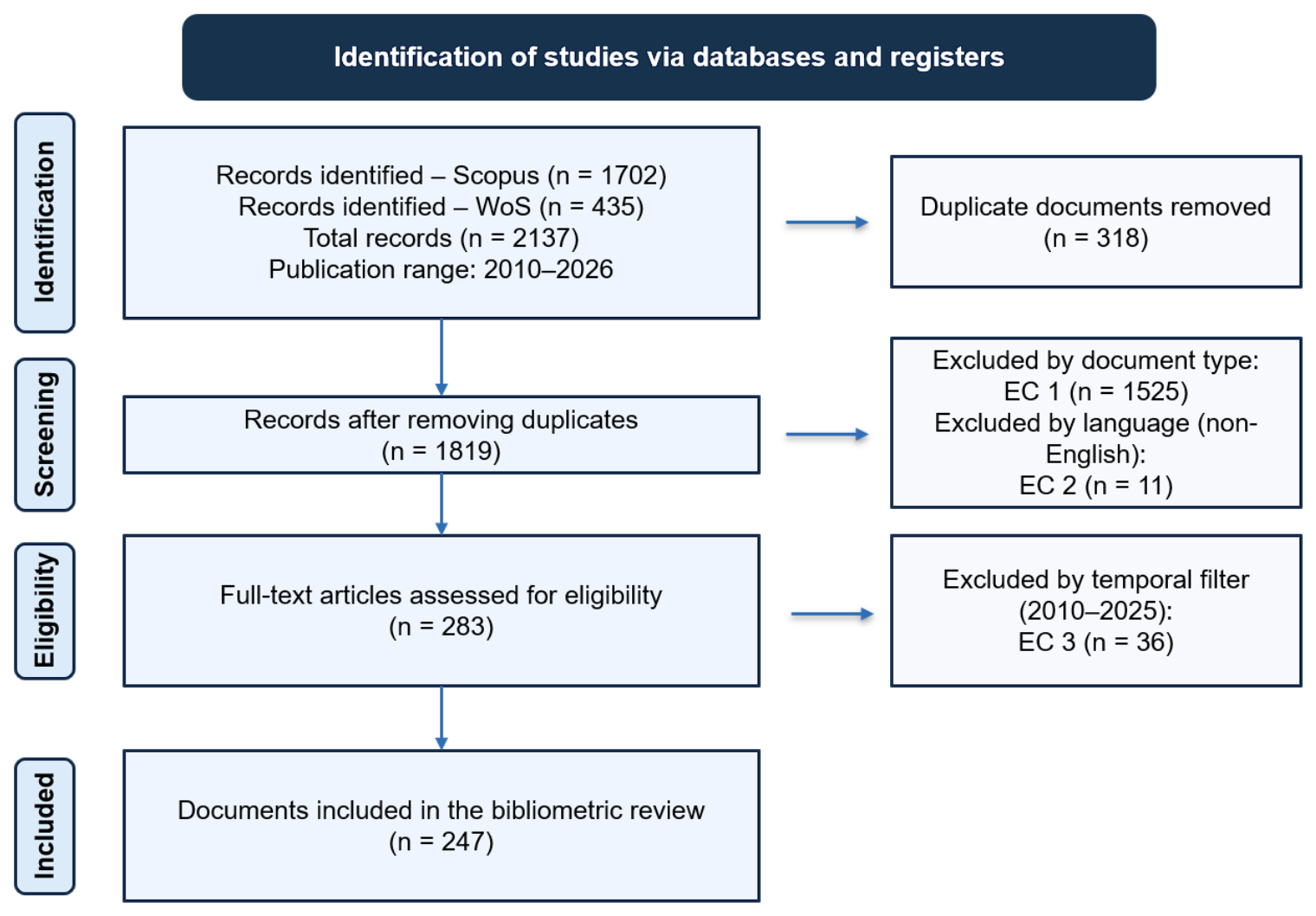
Subsequently, a cleaning and filtering process was carried out to obtain a homogeneous, relevant, and suitable document set for the bibliometric analysis [27,28]. The inclusion criteria were peer-reviewed journal articles, publications written in English, studies published between 2010 and 2025, and documents directly related to GIS applications in Industrial Engineering or closely connected areas such as logistics, supply chain management, transport, manufacturing, facility location, spatial decision-making, and operations research. The exclusion criteria were reviews, conference proceedings, book chapters, editorials, notes, short communications, non-English publications, documents outside the selected time frame, and records not aligned with the thematic scope of the study. The period 2010–2025 was selected because it captures the recent and consolidated development of GIS applications in Industrial Engineering, coinciding with the expansion of geospatial data availability, industrial digitalization, Industry 4.0, IoT, and data-driven decision-support systems. First, duplicate documents resulting from the combination of Scopus and Web of Science were identified and removed, reducing the initial set to 1819 unique records. In the first filtering stage, EC1 was applied by retaining only peer-reviewed journal articles and excluding reviews, conference proceedings, book chapters, editorials, notes, short communications, and other documents that did not correspond to original research articles. After this phase, the dataset was reduced to 294 documents.
In a second stage, the sample was restricted to publications written in English (EC2), with the aim of improving the comparability of the results and ensuring the coherence of the textual analysis of keywords, titles, and abstracts. This criterion reduced the number of documents to 283 articles. Finally, a temporal filter limited to the period 2010–2025 was applied, which was considered appropriate for analyzing the recent and consolidated evolution of GIS applications in Industrial Engineering. As a result, the final dataset used in the bibliometric analysis consisted of 247 articles.
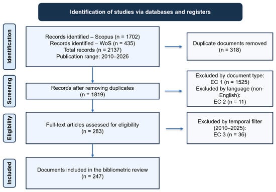
To strengthen methodological transparency and facilitate the traceability of the selection process, the PRISMA 2020 protocol was used as a reference [26,31]. This approach makes it possible to clearly organize the identification, screening, eligibility, and inclusion phases of the analyzed documents [26]. The complete flow of the selection process, from the initial records to the final sample, is represented in Figure 1.
Figure 1.
PRISMA 2020 flow diagram of the document selection process.
Data processing and analysis were performed using the R programming environment, specifically version 4.6.0, through the Bibliometrix package, version 5.3.0. This tool made it possible to carry out the bibliometric processing of the document set in a structured and reproducible manner, including the analysis of scientific production, sources, authors, institutions, countries, citations, keywords, thematic evolution, and strategic maps. The use of a single analytical environment contributed to maintaining methodological coherence among the different indicators and visualizations generated.
To improve reproducibility, the main data processing workflow was specified. The bibliographic records exported from Scopus and Web of Science were imported into R and converted into a bibliographic data frame using Bibliometrix. Both datasets were then merged, and duplicate records were removed by comparing DOI, title, and source information. The resulting dataset was filtered according to the predefined inclusion and exclusion criteria: peer-reviewed journal articles, English language, and publication period 2010–2025. Before analysis, metadata fields such as author keywords, Keywords Plus, source titles, author names, affiliations, and countries were checked and standardized where necessary. The final cleaned dataset was then analyzed using Bibliometrix functions for scientific production, source distribution, author productivity, institutional and country contributions, citation analysis, keyword frequency, thematic evolution, and strategic mapping.
The results were organized into different blocks of bibliometric analysis, including general information on the document set, annual evolution of scientific production, most relevant sources, authors, institutions, countries, and thematic evolution [32]. This organization makes it possible to first present the descriptive indicators of the field and subsequently interpret its conceptual structure and main trends.
Once the data collection, cleaning, and analysis process had been defined, the following section presents the main results obtained. These results are organized according to the analytical structure described above, beginning with the evolution of scientific production and continuing with geographical distribution, the most relevant sources, and the thematic relationships identified in the field of study [25].
3. Results
The final dataset comprised 247 scientific articles published between 2010 and 2025. As shown in Table 2, these studies were distributed across 183 sources, indicating a relatively broad dispersion of scientific production across different journals and publication channels [33,34]. The annual growth rate was 10.19%, indicating a sustained increase in academic interest in GIS applications within the field of Industrial Engineering during the analyzed period [27].
Table 2.
Main bibliometric information of the final dataset.
The average age of the documents was 5.76 years, suggesting that the dataset is mainly composed of recent publications. In addition, the average of 20.74 citations per document reflects a moderate but relevant scientific impact within the study area [28]. These results show that GIS applications in Industrial Engineering constitute an expanding field, with recent scientific production and a growing presence in the international literature.
Regarding the document content, 879 Keywords Plus and 1057 author keywords were identified, highlighting substantial thematic diversity [35]. This terminological breadth reflects the cross-cutting nature of the field, in which areas such as logistics, territorial planning, sustainability, transport, optimization, and resource management converge.
From the authorship perspective, the 247 articles analyzed were written by a total of 1007 authors. Only 13 documents were authored by a single author, while the average number of co-authors per document was 4.4. In addition, the percentage of international co-authorships reached 30.36%. However, this indicator should be interpreted as a general measure of international collaboration rather than as a complete representation of the cooperation structure. Since no country-level or institution-level cooperation network map was included, the present analysis does not identify specific collaboration clusters, central countries, or network density patterns. Future studies could complement this approach with cooperation network mapping and centrality indicators in order to better characterize the structure, intensity, and geographical distribution of international collaboration in GIS applications in Industrial Engineering. These data suggest the collaborative and interdisciplinary nature of research on GIS applications in Industrial Engineering, although a more detailed network analysis would be needed to characterize the specific cooperation structure [36].
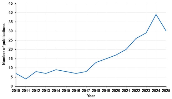
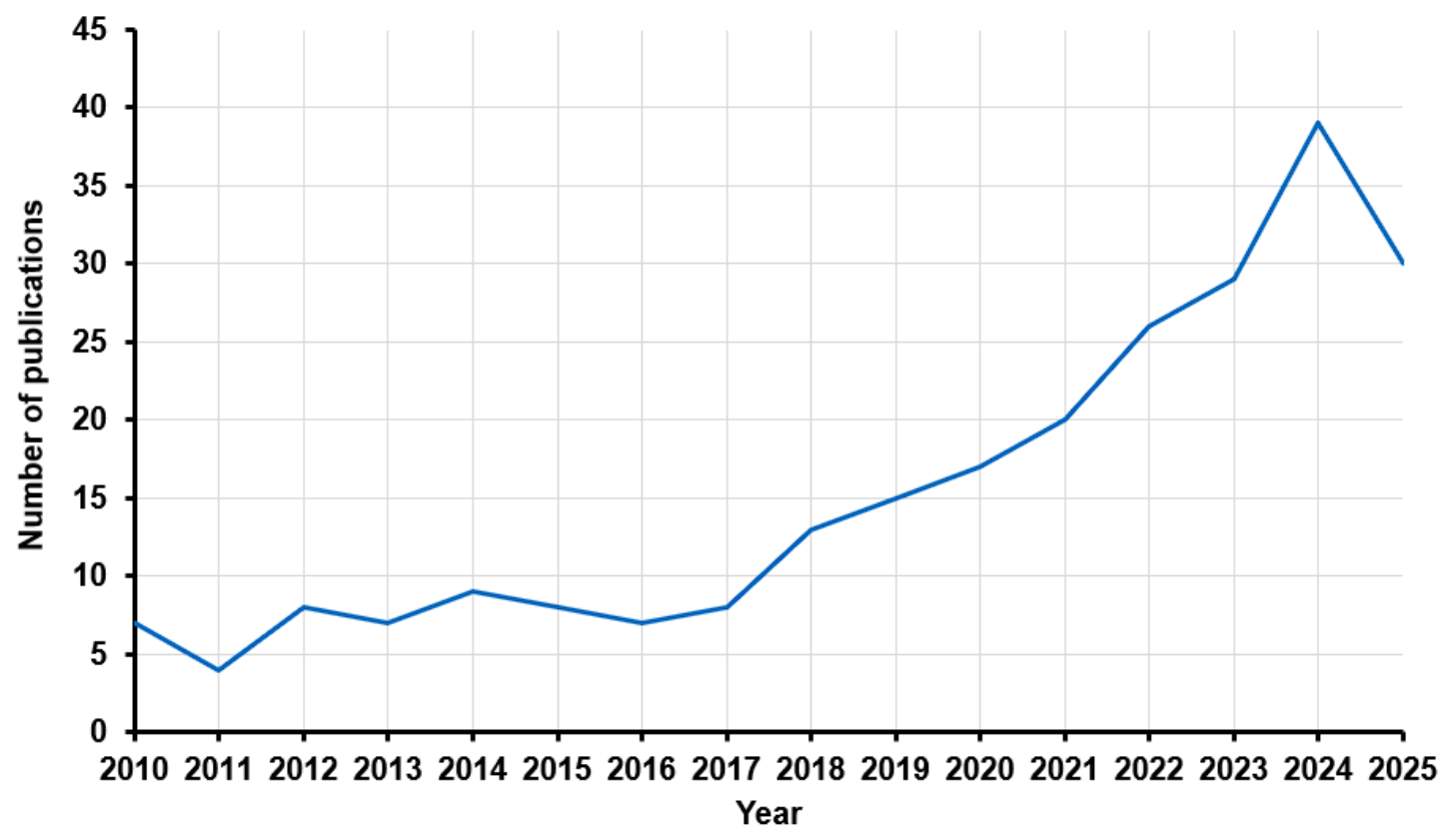
The annual evolution of publications (Figure 2) shows a progressive growth in scientific interest in GIS applications in Industrial Engineering during the period 2010–2025. As can be observed, between 2010 and 2017 production remained relatively stable, with low values and moderate fluctuations, generally between 4 and 9 articles per year. This first stage can be interpreted as an initial consolidation phase, in which GIS applications still appeared in a dispersed manner across different industrial areas.
Figure 2.
Annual scientific production on GIS applications in Industrial Engineering (2010–2025).
From 2018 onwards, a clear change in the trend can be observed, with a progressive increase in the number of publications. Production rose from 13 articles in 2018 to 20 in 2021 and continued to grow until reaching 29 articles in 2023. This increase reflects a greater incorporation of geospatial approaches into problems related to logistics, transport, sustainability, territorial planning, and the optimization of industrial systems. The trend also coincides with the advance of industrial digitalization and the increasing availability of spatial data applied to decision-making.
The year 2024 represents the peak of the analyzed period, with 39 published articles. This peak confirms the timeliness of the topic and its growing relevance within the scientific literature. In 2025, 30 articles were recorded, a figure lower than that of 2024 but still high compared with the first years of the period. This reduction should be interpreted with caution, as it may be influenced by the partial closure of the year or by delays in the indexing of recent publications.
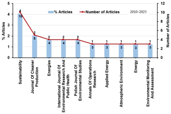
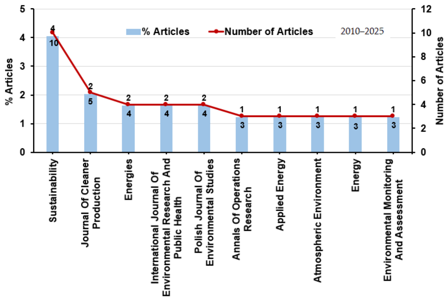
The distribution of articles by source shows that scientific production on GIS applications in Industrial Engineering is dispersed across different journals, without excessive concentration in a single publication. As shown in Figure 3, Sustainability is the journal with the highest number of articles, with 10 documents, representing approximately 4% of the analyzed dataset. It is followed by the Journal of Cleaner Production, with 5 articles, while other sources such as Energies, the International Journal of Environmental Research and Public Health, and the Polish Journal of Environmental Studies include 4 articles each.
Figure 3.
Most relevant sources in GIS applications in Industrial Engineering.
This distribution shows that the use of GIS in Industrial Engineering is strongly linked to research lines related to sustainability, energy, cleaner production, environmental management, and impact assessment. The presence of environmental and energy journals among the most productive sources confirms the cross-cutting nature of the field, where geospatial tools are applied not only to classic industrial problems, but also to challenges associated with resource efficiency, sustainable planning, and decision-making based on spatial data.
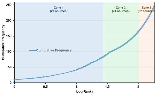
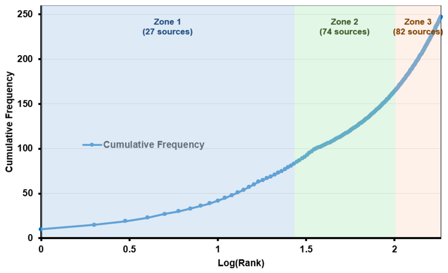
Figure 4 shows the cumulative distribution of sources according to their productivity, represented as a function of the logarithm of rank. The results reveal a clear dispersion of scientific production, as the 247 articles analyzed are distributed across 183 different sources. This situation confirms that research on GIS applications in Industrial Engineering is not concentrated in a small number of journals, but is instead distributed across publications from diverse fields.
Figure 4.
Cumulative distribution of sources by publication frequency.
The figure makes it possible to distinguish three main zones. The first zone groups the 27 sources with the highest relative productivity, which concentrate a significant share of the published documents. The second zone includes 74 sources with an intermediate contribution, while the third zone comprises 82 sources with a more occasional presence in the field. This distribution reflects the cross-cutting and interdisciplinary nature of the area, where studies on GIS are linked to journals on sustainability, energy, transport, territorial planning, the environment, and industrial management.
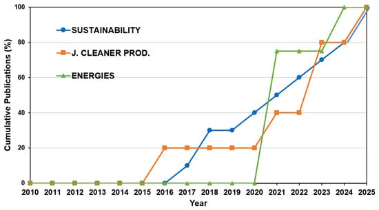
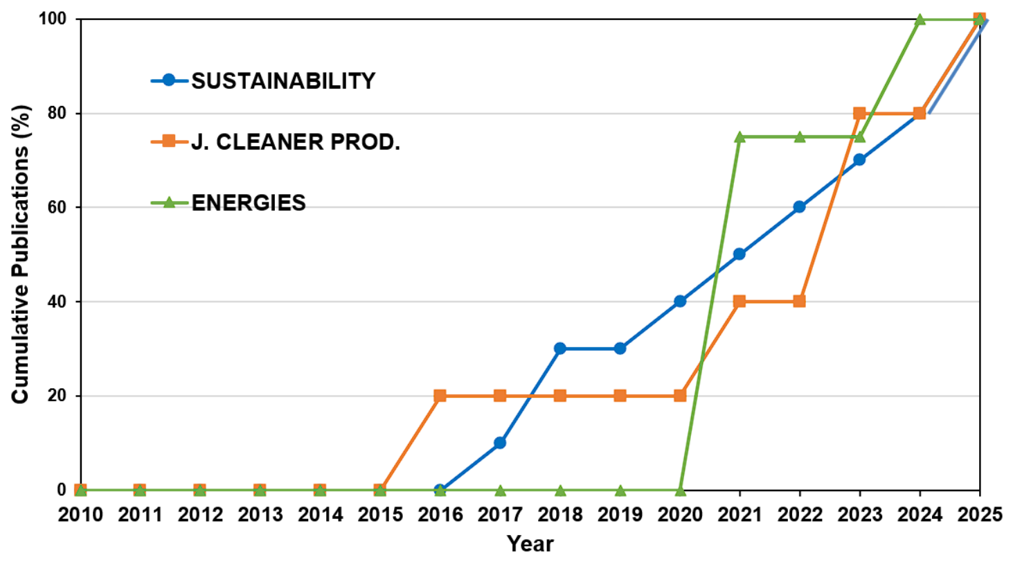
The cumulative evolution of publications in the three most representative sources makes it possible to observe different consolidation patterns within the analyzed field. As shown in Figure 5, Sustainability presents a progressive trajectory from 2017 to 2025, confirming its role as the source with the greatest recent continuity in the study of GIS applications related to Industrial Engineering. The Journal of Cleaner Production shows a later incorporation, although its presence increases especially from 2021 onwards, reinforcing the connection between GIS, cleaner production, and resource efficiency. For its part, Energies concentrates its contribution in the most recent years, suggesting a growing relationship between geospatial approaches, energy planning, and the transition towards more sustainable industrial systems.
Figure 5.
Cumulative publication dynamics of the three leading sources.
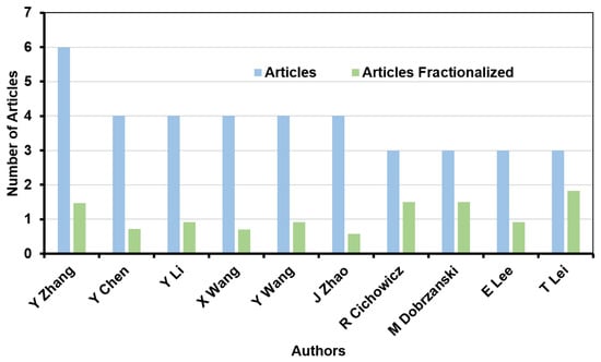
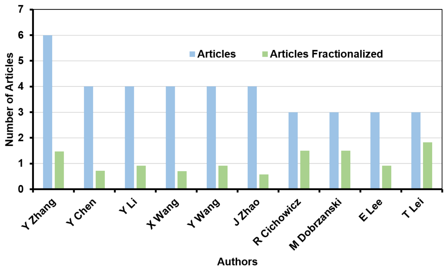
The authorship analysis makes it possible to identify the researchers with the greatest presence within the analyzed document set. As shown in Figure 6, Y. Zhang stands out as the most productive author, with 6 published articles related to GIS applications in Industrial Engineering. This is followed by authors such as Y. Chen, Y. Li, X. Wang, Y. Wang, and J. Zhao, with a production ranging between 4 and 5 documents.
Figure 6.
Most productive authors in GIS applications in Industrial Engineering.
The figure also includes the fractional production indicator, which makes it possible to weight each author’s contribution according to the number of co-authors in each publication. This comparison is relevant because it avoids interpreting productivity solely on the basis of the total number of articles. In this regard, some authors with a lower absolute number of publications show a relatively high fractional contribution, indicating more significant participation in the studies in which they are involved.
Overall, the results show that scientific production in the field does not depend on a single dominant author, but is instead distributed among several researchers with moderate contributions. This situation reinforces the idea of an interdisciplinary and collaborative field, where GIS applications in Industrial Engineering are developed through diverse research teams.
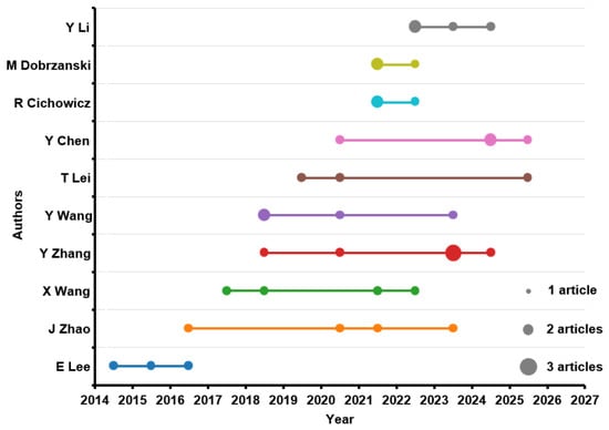
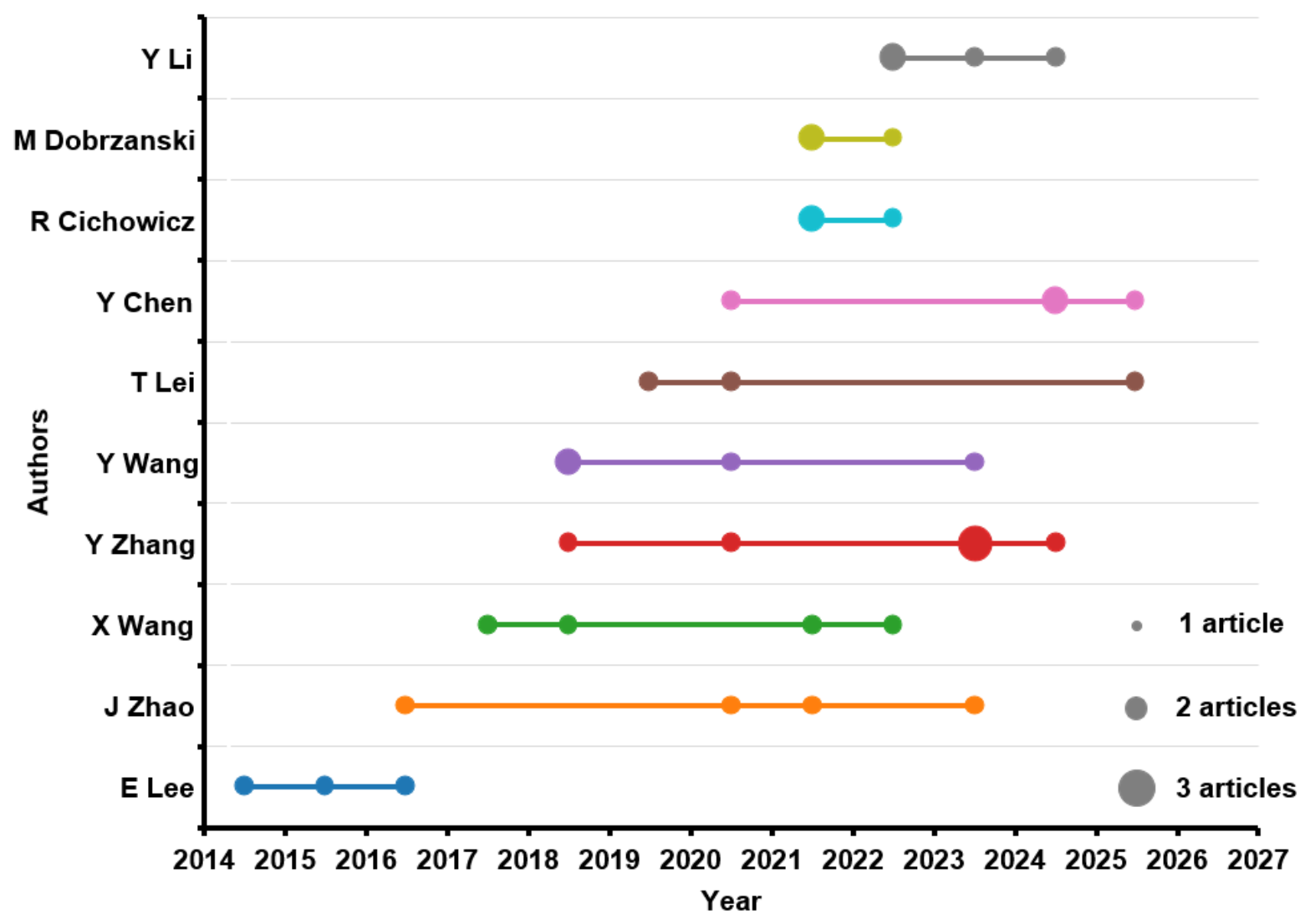
The temporal evolution of the productivity of the main authors makes it possible to identify not only who has contributed most frequently to the field, but also the periods in which their activity has been concentrated. As shown in Figure 7, some authors show early participation, such as E. Lee, with publications between 2014 and 2016, while others show more recent activity, especially from 2018 onwards. This pattern confirms that the field has progressively incorporated new researchers as GIS applications have gained relevance within Industrial Engineering.
Figure 7.
Authors’ production over time.
Authors such as Y. Zhang, Y. Chen, Y. Wang, J. Zhao, and T. Lei show more prolonged trajectories or activity distributed across several years, suggesting a more stable contribution to the development of the field. In particular, the presence of recent publications between 2023 and 2025 indicates that research interest remains active and that GIS applications continue to generate new contributions. The figure reinforces the idea of a dynamic field, with the participation of established authors and the progressive entry of new research groups.
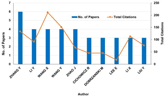
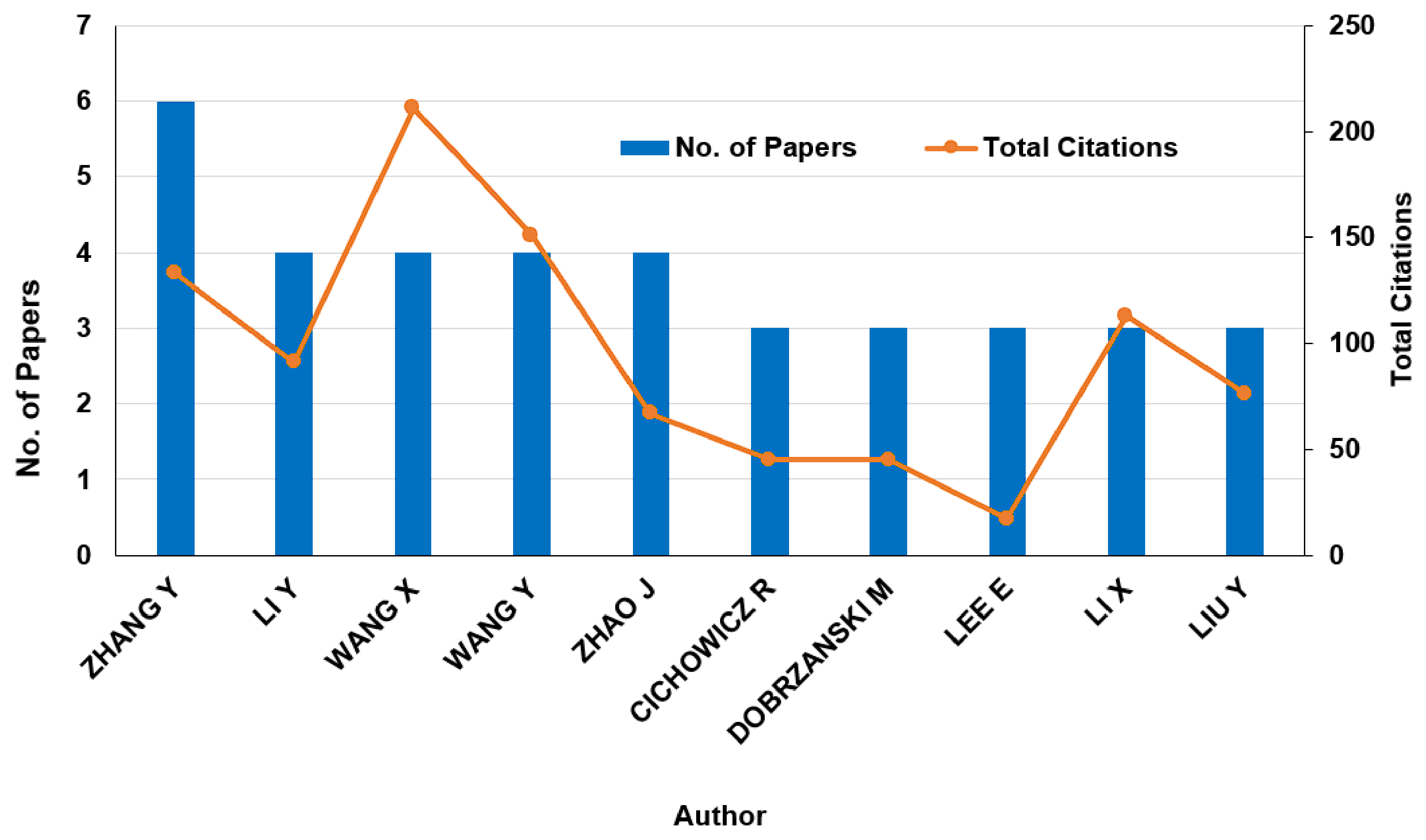
The analysis of authors’ local impact makes it possible to complement scientific productivity with the level of citation achieved within the analyzed document set. As shown in Figure 8, Y. Zhang is the author with the highest number of publications, with 6 documents, but is not the author with the highest citation volume. In this regard, X. Wang stands out for presenting the highest local impact, exceeding 200 citations with 4 published articles.
Figure 8.
Local impact (number of papers and total citations) of the most relevant authors.
Y. Wang, Y. Li, and X. Li are also relevant, combining moderate production with a high number of citations. This result indicates that scientific influence within the field does not depend solely on the number of publications, but also on the ability of certain studies to become relevant references. By contrast, some authors with similar productivity show lower citation levels, revealing differences in the reception and impact of their contributions.
Overall, Figure 8 shows that the field presents a relatively distributed authorship structure, where productivity and impact do not always coincide. This situation reinforces the need to jointly analyze volume and influence indicators in order to obtain a more accurate view of the main actors in research on GIS applications in Industrial Engineering.
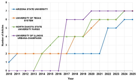
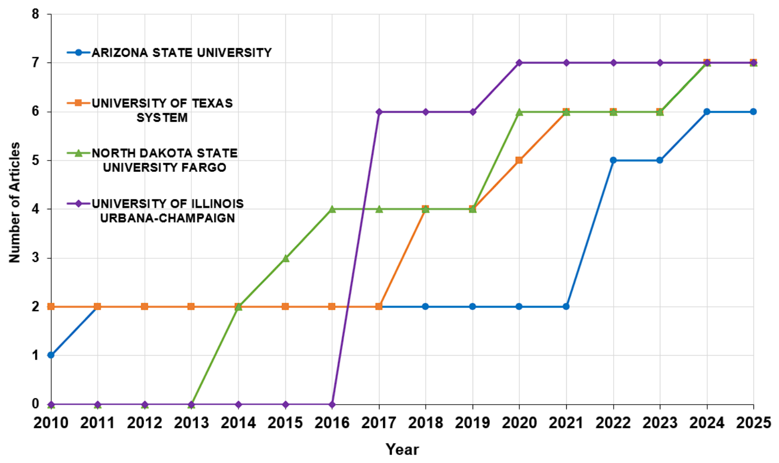
The cumulative evolution of institutional production makes it possible to identify the contribution of the main universities within the analyzed field. As shown in Figure 9, the selected institutions show different trajectories, although with relatively similar final values. The University of Illinois Urbana-Champaign reaches the highest cumulative number, with a notable contribution from 2017 onwards. North Dakota State University, Fargo, shows a more progressive evolution from 2014 onwards, while the University of Texas System maintains an early presence and increases notably between 2019 and 2021. For its part, Arizona State University shows more recent growth, especially from 2022 onwards. Thus, these results indicate that institutional production is not concentrated in a single university, but is distributed among several centers with sustained or emerging contributions.
Figure 9.
Cumulative production of the leading institutions.
The stronger presence of these institutions may be related to their sustained participation in research areas where GIS is commonly applied, such as transport and logistics systems, facility location, supply chain management, spatial decision support, energy planning, and environmental assessment. These thematic areas are consistent with the most frequent keywords and thematic patterns identified in the dataset. However, since no specific institution-keyword cross-analysis was performed, the association between individual institutions and particular research themes should be interpreted cautiously.
It should be noted that this institutional analysis reflects publication productivity rather than academic influence. Although cumulative production makes it possible to identify the institutions with the greatest presence in the analyzed dataset, it does not necessarily indicate higher citation impact or greater scientific influence. Therefore, future studies could complement this analysis with citation-based institutional indicators, such as total citations, average citations per article, or normalized citation impact by affiliation, in order to obtain a more complete assessment of institutional influence in GIS applications in Industrial Engineering.
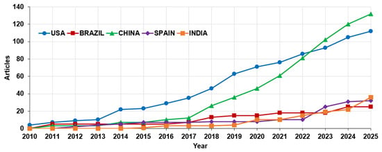
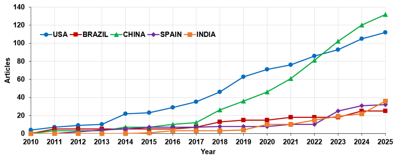
The cumulative evolution of scientific production by country makes it possible to identify the main regions that have contributed to the development of GIS applications in Industrial Engineering. As shown in Figure 10, the United States maintains a prominent position throughout the analyzed period, with sustained growth from 2010 to 2025. This trajectory reflects a consolidated presence in the field and continued participation in research related to spatial planning, transport, sustainability, and geospatial data-based industrial systems.
Figure 10.
Cumulative country production over time. The figure shows publication growth in the most productive countries from 2010 to 2025.
However, the most intense growth corresponds to China, especially from 2017 onwards. Its production increases rapidly and surpasses that of the United States in the final years of the period, reaching the highest cumulative number of articles in 2025. This result highlights the growing weight of Chinese research in the field of geospatial technologies applied to industrial, energy, and territorial problems.
Other countries, such as Spain, India, and Brazil, show a more moderate contribution, although with an upward trend in recent years. Overall, these results confirm that the field presents an increasingly broad international dimension, with an initial strong concentration in the United States and a subsequent expansion towards Asia and Europe.
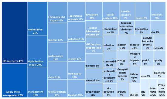
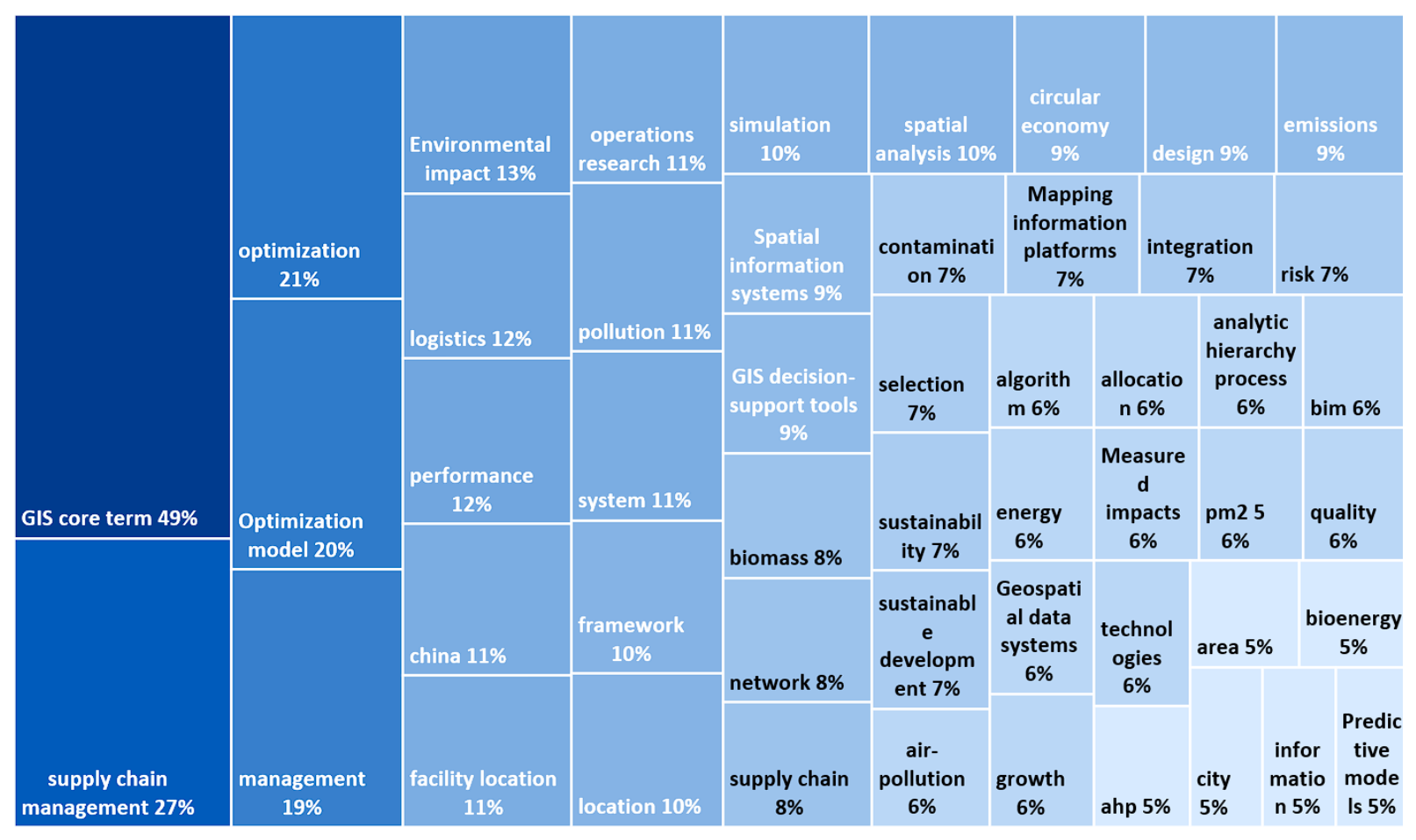
The analysis of the most frequent terms makes it possible to identify the concepts that structure the field of study. As shown in Figure 11, the terms with the highest presence are GIS and supply chain management, which account for the highest percentages within the map. This result confirms that GIS applications in Industrial Engineering are mainly structured around the use of geospatial tools for supply chain management, logistics optimization, and support for spatial decision-making.
Figure 11.
Treemap of the most frequent terms associated with GIS applications in Industrial Engineering.
Terms such as optimization, optimization model, logistics, facility location, spatial analysis, and operations research also stand out, highlighting the strong connection between GIS and classical methods of Industrial Engineering. These concepts show that the spatial dimension is recurrently used to improve location, distribution, resource allocation, and complex system planning processes.
On the other hand, the presence of terms such as sustainability, environmental impact, circular economy, emissions, energy, pollution, and air pollution indicates that a significant part of the literature links GIS applications with environmental and sustainability-related problems. Figure 11 reflects an interdisciplinary field in which industrial optimization, logistics, environmental management, and territorial planning based on geospatial data converge.
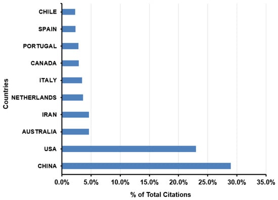
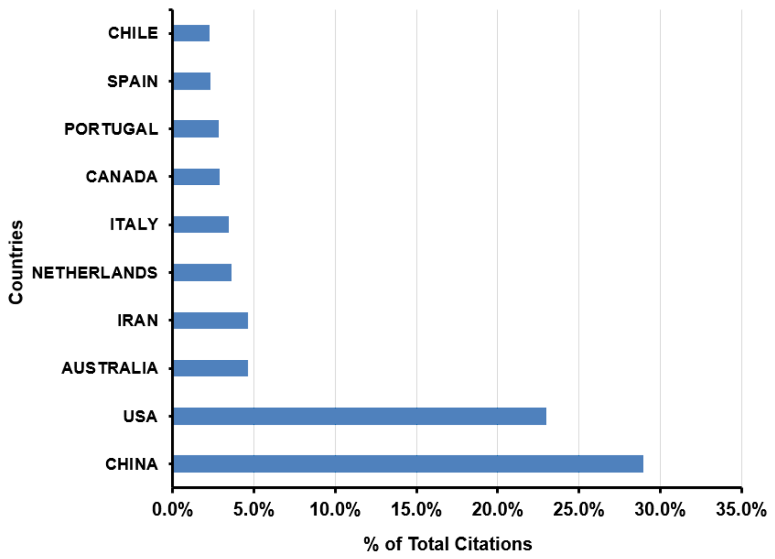
Figure 12 shows the percentage distribution of total citations by country. China accounts for the largest proportion of citations, with nearly 30% of the total, followed by the United States, with around 23%. This result indicates that both countries not only lead scientific production on GIS applications in Industrial Engineering, but also achieve the greatest impact in terms of citations. The remaining countries show considerably lower percentages, all below 5%, suggesting a more moderate and fragmented influence. Overall, these results confirm the dominant role of China and the United States in the international development and scientific visibility of this research field.
Figure 12.
Percentage distribution of total citations by country.
When the country-level results are interpreted together with the most frequent keywords, different thematic orientations can be observed. Research associated with China shows a strong connection with sustainability, environmental impact, pollution, energy planning, and large-scale territorial management, reflecting the use of GIS in rapidly expanding industrial and urban contexts. In the United States, the literature is more closely linked to logistics, transport planning, facility location, supply chain management, and spatial decision-support systems, which reflects a stronger orientation towards operational optimization and infrastructure planning. Other countries, such as Spain, India, and Brazil, show more specific contributions related to renewable energy, environmental assessment, territorial planning, and resource management. These differences suggest that the geographical distribution of publications is not only quantitative, but also reflects different disciplinary preferences and characteristic application scenarios of GIS technology in Industrial Engineering.
The results obtained show that GIS applications in Industrial Engineering constitute an expanding research field, with particularly visible growth from 2018 onwards and a clear intensification in the final years of the analyzed period. Scientific production is distributed across numerous sources, authors, institutions, and countries, confirming the cross-cutting and interdisciplinary nature of the area. In addition, the most frequent terms show that the use of GIS is mainly structured around optimization, logistics, supply chain management, sustainability, energy, and spatial analysis. These findings provide a solid basis for interpreting, in the following section, how the field has conceptually evolved and which research lines can be considered more consolidated or emerging.
4. Discussion
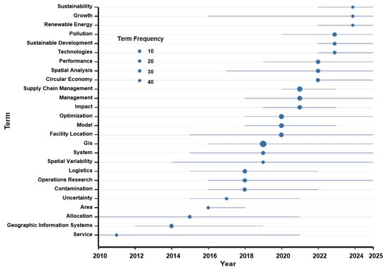
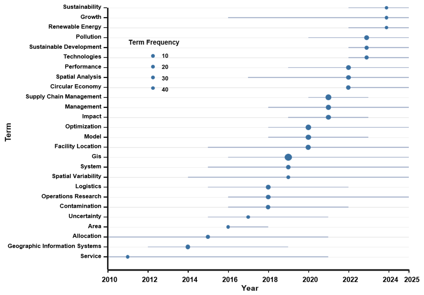
The bibliometric results show that GIS applications in Industrial Engineering have evolved from approaches initially focused on services, resource allocation, location, and logistics management towards a broader research agenda linked to sustainability, growth, renewable energy, and sustainable development [37,38,39]. This thematic transition can be observed in Figure 13, which represents the temporal evolution of the main terms used in the scientific literature. Earlier concepts, such as service, Geographic Information Systems, allocation, and logistics, reflect an initial stage in which GIS were mainly used as tools to support spatial planning and operational optimization [6,8,39]. By contrast, more recent terms, such as sustainability, renewable energy, circular economy, pollution, and sustainable development, show a growing orientation towards environmental, energy-related, and sustainable transition problems [40,41,42].
Figure 13.
Trend topics in GIS applications in Industrial Engineering. The figure shows the evolution of the main terms from 2010 to 2025.
This thematic shift confirms that GIS have ceased to be merely spatial representation tools and have become strategic instruments for analysis, data integration, and decision-making support in complex industrial systems [6,8]. In particular, their application in logistics, facility location, and supply chain management has become consolidated as a central line of the field [37,38], whereas their integration with sustainability, energy, and environmental impact analysis appears as a recent expanding trend [40,42]. This evolution is consistent with the transformation of Industrial Engineering towards more digital, territorial, and resource-efficiency-oriented approaches [43,44]. Compared with previous systematic and bibliometric reviews, the present study provides a more specific view of GIS applications within Industrial Engineering. Previous reviews have addressed GIS-based decision analysis, GeoAI, GIS–BIM integration, environmental impact assessment, and facility location or supply chain management as separate research areas. However, these studies generally focus on individual domains or technologies rather than examining how GIS applications are distributed across the broader field of Industrial Engineering. In this sense, the present results complement previous literature by showing that operational optimization, spatial decision-making, sustainability and environmental impact, and emerging digital integration are not isolated lines, but interrelated dimensions of a fragmented and evolving research field.
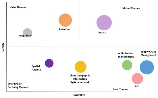
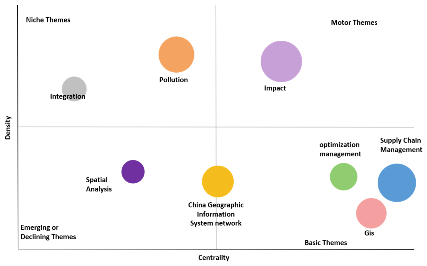
Continuing with the thematic interpretation, the term evolution map is complemented by the strategic analysis represented in Figure 14, which makes it possible to classify the main themes according to their centrality and density [20,45,46]. This representation helps to distinguish between consolidated lines, cross-cutting themes, and areas with lower integration within the field. In the basic themes area, concepts such as GIS, supply chain management, and optimization management appear, confirming that supply chain management, optimization, and the use of geospatial tools constitute the conceptual basis of the research analyzed [6,8,37]. These themes show high centrality, as they are connected to many areas of the field, although they still present room for internal development.
Figure 14.
Strategic thematic map of GIS applications in Industrial Engineering. The figure classifies the main themes into motor, basic, niche, and emerging or declining topics.
On the other hand, impact is located in the motor themes area, indicating a well-developed line that is relevant to the evolution of the field [40]. This result is consistent with the trend observed previously, where concepts related to sustainability, pollution, energy, and sustainable development have gained increasing weight in recent years [41]. By contrast, pollution and integration appear as niche themes, with a higher degree of internal development but a lower connection with the general core of the field. Finally, spatial analysis and the China Geographic Information System network are located in the emerging or declining themes area and should therefore be interpreted with caution [45,46]. They may represent recent lines that are still poorly consolidated, specific approaches associated with particular geographical contexts, or areas that have lost centrality within the analyzed dataset.
Overall, the results obtained show that GIS applications in Industrial Engineering have shifted from a mainly operational and spatial use to a more strategic role within industrial systems [6,8]. The annual evolution of publications confirms sustained growth, especially from 2018 onwards, indicating that the field has gained greater maturity in recent years. This growth is not concentrated in a single journal, author, or institution, but is instead distributed across multiple sources, countries, and research groups [20]. This dispersion should not be interpreted as a weakness, but rather as a sign of the cross-cutting nature of the topic. GIS are applied in logistics, facility location, territorial planning, energy, sustainability, environmental impact, and resource optimization, which explains their presence in journals with diverse profiles [6,37,40].
From a scientific perspective, the results show that the core of the field is structured around several clearly consolidated concepts. Terms such as GIS, supply chain management, optimization, facility location, spatial analysis, and operations research show that the basis of the research remains linked to classical problems in Industrial Engineering [8]. However, the thematic evolution also reveals a progressive expansion towards environmental and energy-related issues [40,41]. The prominent appearance of terms such as sustainability, renewable energy, pollution, circular economy, and impact indicates that GIS is no longer used solely to represent or analyze spatial information, but also to assess environmental consequences, support sustainable decisions, and design more efficient industrial systems. This transition is one of the central findings of the study.
The strategic map reinforces this interpretation by showing a clear separation between basic, motor, niche, and emerging or declining themes. The presence of GIS, supply chain management, and optimization management as basic themes confirms that these elements constitute the main conceptual structure of the field. At the same time, impact appears as a motor theme, suggesting that impact assessment has become a mature and relevant line. For their part, pollution and integration behave as specialized themes, while spatial analysis and the China Geographic Information System network require cautious interpretation, as they may represent recent areas, specific approaches, or lines that are still poorly integrated [47]. In general terms, the results show a consolidating field, with a clear operational basis and a growing orientation towards sustainability, digital integration, and strategic decision-making [37].
The results make it possible to propose a conceptual synthesis of the role of GIS in Industrial Engineering. Based on the joint interpretation of the bibliometric and thematic results, the field can be organized into four major interrelated dimensions: (i) operational optimization; (ii) spatial decision-making; (iii) sustainability and environmental impact; and (iv) emerging digital integration. This classification summarizes the main patterns observed in the previous analyses, where terms such as logistics, facility location, supply chain management, spatial analysis, sustainability, pollution, BIM, and predictive models appear as recurring or expanding elements [44].
Beyond the descriptive bibliometric indicators, the results provide several broader implications and actionable insights for the development of GIS applications in Industrial Engineering. First, the dispersion of publications across numerous sources, authors, institutions, and countries suggests that the field is still fragmented and lacks fully consolidated methodological standards. Therefore, future studies should move towards more reproducible GIS-based frameworks, with clearer reporting of data sources, spatial resolution, analytical models, validation procedures, and decision-making criteria. Second, the thematic evolution shows that the field is shifting from traditional operational applications, such as logistics, facility location, supply chain management, and transport planning, towards sustainability-oriented and digitally integrated approaches. This indicates that future research should not only apply GIS as a mapping or visualization tool, but also as a decision-support platform connected to environmental assessment, resource efficiency, real-time data, artificial intelligence, BIM, and digital twins. Third, the geographical and institutional distribution of the literature reveals opportunities to strengthen international collaboration, especially between highly productive countries and emerging research contexts.
This conceptual synthesis makes it possible to organize GIS applications in Industrial Engineering into four main dimensions. These dimensions integrate both the most consolidated uses of the field and the most recent lines of development, connecting the bibliometric results with possible future research directions:
- Operational optimization: this dimension encompasses the use of GIS in classical Industrial Engineering problems, such as facility location, resource allocation, logistics, route planning, and supply chain management. It represents one of the most consolidated foundations of the field, directly linked to frequent terms such as facility location, logistics, optimization, and supply chain management.
- Spatial decision-making: this dimension reflects the ability of GIS to integrate geographic information, spatial analysis platforms, and decision support systems [5]. Its importance lies in its ability to transform territorial and operational data into useful information for industrial planning, alternative assessment, and the management of complex systems.
- Sustainability and environmental impact: this dimension shows the recent evolution of the field towards environmental and sustainability-related problems. The growing presence of terms such as emissions, pollution, circular economy, and environmental impact confirms that GIS are increasingly used to assess impacts, optimize resources, and support sustainable transition processes [48].
- Emerging digital integration: this dimension groups future opportunities associated with the integration of GIS with BIM, predictive models, digital technologies, artificial intelligence, and geospatial modeling. This line points towards more connected industrial systems capable of integrating spatial data, real-time analysis, and advanced planning tools.
In summary, this synthesis reflects the evolution of GIS from spatial analysis tools to strategic platforms that support the planning, optimization, and sustainability of industrial systems.
These results allow GIS applications in Industrial Engineering to be interpreted as a field in transition from instrumental approaches towards integrated planning and management approaches. In its early stages, the use of GIS appears mainly associated with location, allocation, logistics, and spatial analysis problems. However, the thematic evolution and conceptual synthesis show that these applications have expanded towards more complex dimensions, such as sustainability, impact assessment, energy efficiency, and integration with digital technologies. This evolution reflects a relevant shift: GIS are no longer used solely to represent geographic information, but as analytical tools capable of supporting strategic decisions in industrial systems subject to territorial, environmental, and operational constraints [49].
In addition to the bibliometric indicators, a content-oriented thematic interpretation was incorporated to identify application trends, technical bottlenecks, and the practical effectiveness of GIS technology in Industrial Engineering. The main application trends are related to logistics, supply chain management, facility location, transport planning, sustainability assessment, environmental impact analysis, energy planning, and digital integration with BIM, artificial intelligence, digital twins, IoT, and predictive models. The main technical bottlenecks include data heterogeneity, limited methodological standardization, interoperability difficulties, integration of real-time data, and insufficient validation of GIS-based decision models in real industrial contexts. From a practical perspective, GIS contributes to spatial decision-making, logistics optimization, facility location, environmental assessment, and sustainable industrial planning.
Recent developments in GIS-related digitalization further support these future directions. Current research shows that GIS is increasingly being integrated with digital twins, BIM, IoT sensors, real-time monitoring, and predictive analytics in contexts closely connected with industrial engineering, such as port asset management, logistics, construction production control, and infrastructure management. For example, recent studies on Spanish ports have shown how digital twin and BIM/GIS integration can support asset management, predictive maintenance, operational efficiency, and data-driven decision-making in Industry 4.0 environments [50]. Similarly, case-based research on closed-loop production control has demonstrated the value of integrating BIM, GIS, and IoT sensors for real-time monitoring, process optimization, and production planning [51]. In logistics, agent-based digital twins have been proposed to connect physical transport systems with virtual GIS environments for synchromodal decision-making [52]. These recent contributions indicate that future GIS applications in Industrial Engineering are likely to move towards spatial digital twins, interoperable BIM/GIS platforms, real-time sensor integration, predictive models, and cyber-physical decision-support systems [50,51,52,53].
Based on the bibliometric and thematic findings, several future research directions can be identified. Future studies should develop more standardized and reproducible GIS-based methodologies for Industrial Engineering applications, with clearer reporting of data sources, spatial resolution, analytical models, validation procedures, and decision-making criteria. In addition, GIS applications should be increasingly integrated with real-time industrial data, IoT systems, artificial intelligence, BIM, digital twins, and predictive models in order to support more dynamic and data-driven decision-making processes. Further research is also needed to validate GIS-based models in real industrial contexts, particularly in logistics, facility location, supply chain management, energy planning, environmental impact assessment, and sustainable industrial planning. Finally, stronger international collaboration would help reduce the current fragmentation of the field and promote more integrated research agendas on GIS-supported industrial decision-making.
A relevant limitation of this bibliometric review is related to the selection of the information sources used. The analysis was based exclusively on Scopus and Web of Science, two databases widely recognized for their coverage, metadata quality, and compatibility with bibliometric tools, but this choice may introduce indexing, language, regional, or thematic-area biases. In particular, the exclusion of regional databases such as CNKI may have limited the representation of studies published in specific national or regional contexts. The inclusion of other regional, multidisciplinary, or specialized repositories in future research could broaden the representativeness of the document set and provide a more complete view of GIS applications in Industrial Engineering. Likewise, the restriction to articles written in English and to the period 2010–2025 reinforces the coherence of the analysis, but may exclude relevant contributions published in other languages, formats, or earlier stages.
From a future research perspective, the standardization of GIS methodologies for industrial applications should move in several specific directions. First, studies should report spatial data sources, spatial resolution, temporal coverage, preprocessing procedures, analytical models, validation methods, and decision-making criteria in a more consistent way. Second, GIS-based approaches should improve interoperability with industrial digital systems, including IoT platforms, BIM, digital twins, predictive models, and enterprise decision-support systems, in line with current developments in smart manufacturing and GIS–BIM integration [18,44]. Third, future research should define common validation indicators, such as location accuracy, optimization performance, environmental impact reduction, cost efficiency, scalability, and applicability in real industrial contexts. However, several implementation difficulties remain, including heterogeneous data formats, limited access to industrial data, differences in spatial scales, lack of benchmark datasets, and the complexity of integrating real-time information. A practical implementation path could begin with standardized reporting templates, continue with pilot case studies in logistics, facility location, energy planning, and environmental assessment, and finally move towards validated GIS-based decision-support frameworks for industrial planning and management.
5. Conclusions
This study has analyzed the scientific evolution of Geographic Information Systems (GIS) applications in Industrial Engineering during the period 2010–2025. Based on a final set of 247 articles from Scopus and Web of Science, the results show that this field has experienced sustained growth, especially from 2018 onwards. This evolution suggests that, within the analyzed literature, GIS have gained increasing relevance as tools to support planning, optimization, and decision-making in complex industrial environments.
The bibliometric results show that scientific production is distributed across numerous sources, authors, institutions, and countries. This dispersion reflects the cross-cutting and interdisciplinary nature of the field, as GIS applications are linked to areas such as logistics, supply chain management, facility location, sustainability, energy, transport, territorial planning, and environmental assessment. The presence of journals related to sustainability, cleaner production, energy, and environmental management confirms that the use of GIS in Industrial Engineering has moved beyond purely operational approaches.
From a thematic perspective, the analysis shows that the conceptual core of the field is structured around terms such as GIS, supply chain management, optimization, facility location, logistics, spatial analysis, and operations research. These concepts represent the most consolidated foundations of the research. However, the recent evolution of terms indicates a progressive shift towards issues related to sustainability, renewable energy, circular economy, pollution, emissions, and impact. This transition indicates that GIS are increasingly being discussed not only as spatial analysis tools, but also as platforms for assessing impacts, improving resource efficiency, and supporting more sustainable industrial planning within the analyzed research field.
The four dimensions identified in the discussion are supported by the empirical bibliometric results. Operational optimization is reflected in the frequent presence of terms such as logistics, supply chain management, facility location, optimization, and operations research. Spatial decision-making is supported by the central role of GIS, spatial analysis, and decision-support approaches. Sustainability and environmental impact are supported by the increasing presence of terms such as sustainability, environmental impact, pollution, emissions, circular economy, and energy, as well as by the position of impact as a motor theme in the strategic map. Finally, emerging digital integration is reflected in themes related to integration, BIM, artificial intelligence, digital twins, IoT, predictive models, and real-time decision-support systems. Therefore, the four-dimensional structure is directly connected with the keyword patterns, thematic evolution, and strategic mapping results.
This study contributes to structuring a research field that has so far appeared fragmented across different disciplines. The results make it possible to identify the main trends, actors, and thematic areas, as well as to highlight opportunities for future research. These include the need to develop more standardized GIS methodologies for industrial applications, strengthen international collaboration, improve real-time data integration, and further explore the use of GIS to support sustainable transition processes. Overall, the results suggest that GIS may play an important role in supporting more efficient, data-driven, and sustainability-oriented industrial systems, although further empirical validation is needed to assess their practical effectiveness across different industrial contexts.
Author Contributions
Conceptualization, D.V. and P.F.-A.; methodology, D.V., E.G.-S., P.F.-A. and A.d.B.; software, E.G.-S. and A.d.B.; validation, D.V. and P.F.-A.; formal analysis, E.G.-S. and A.d.B.; investigation, D.V., E.G.-S., J.R.D.-D., P.F.-A., and A.d.B.; resources, D.V., E.G.-S., J.R.D.-D., P.F.-A., and A.d.B.; data curation, E.G.-S.; writing—original draft preparation, D.V., E.G.-S., P.F.-A., and A.d.B.; writing—review and editing, D.V., E.G.-S., J.R.D.-D., P.F.-A., and A.d.B.; visualization, E.G.-S., J.R.D.-D., and P.F.-A.; supervision, D.V. and A.d.B. All authors have read and agreed to the published version of the manuscript.
Funding
This research received no external funding.
Institutional Review Board Statement
Not applicable.
Informed Consent Statement
Not applicable.
Data Availability Statement
The original contributions presented in this study are included in the article; further inquiries can be directed to the corresponding author.
Conflicts of Interest
The authors declare no conflict of interest.
References
- Yaqub, M.Z.; Alsabban, A. Industry-4.0-Enabled Digital Transformation: Prospects, Instruments, Challenges, and Implications for Business Strategies. Sustainability 2023, 15, 8553. [Google Scholar] [CrossRef] [Scilit]
- Ryalat, M.; ElMoaqet, H.; AlFaouri, M. Design of a Smart Factory Based on Cyber-Physical Systems and Internet of Things towards Industry 4.0. Appl. Sci. 2023, 13, 2156. [Google Scholar] [CrossRef] [Scilit]
- Xu, H.; Yu, W.; Griffith, D.; Golmie, N. A Survey on Industrial Internet of Things: A Cyber-Physical Systems Perspective. IEEE Access 2018, 6, 78238–78259. [Google Scholar] [CrossRef] [Scilit] [PubMed]
- Breunig, M.; Bradley, P.E.; Jahn, M.; Kuper, P.; Mazroob, N.; Rösch, N.; Al-Doori, M.; Stefanakis, E.; Jadidi, M. Geospatial Data Management Research: Progress and Future Directions. ISPRS Int. J. Geo-Inf. 2020, 9, 95. [Google Scholar] [CrossRef] [Scilit]
- Li, S.; Dragicevic, S.; Castro, F.A.; Sester, M.; Winter, S.; Coltekin, A.; Pettit, C.; Jiang, B.; Haworth, J.; Stein, A.; et al. Geospatial Big Data Handling Theory and Methods: A Review and Research Challenges. ISPRS J. Photogramm. Remote Sens. 2016, 115, 119–133. [Google Scholar] [CrossRef] [Scilit]
- Malczewski, J. GIS-Based Multicriteria Decision Analysis: A Survey of the Literature. Int. J. Geogr. Inf. Sci. 2006, 20, 703–726. [Google Scholar] [CrossRef] [Scilit]
- Araya, J.D.; Gallego, A.H.; Hernando-Gallego, F.; Velázquez, J. Multi-Criteria Decision-Making (MIVES) and Geographic Information Systems for Evaluating the Sustainability of Tourism Activities Around Costa Rica’s Protected Natural Areas. Earth 2026, 7, 28. [Google Scholar] [CrossRef] [Scilit]
- Goodchild, M.F. Geographical Information Science. Int. J. Geogr. Inf. Syst. 1992, 6, 31–45. [Google Scholar] [CrossRef] [Scilit]
- Saldanha-da-Gama, F. Facility Location in Logistics and Transportation: An Enduring Relationship. Transp. Res. Part E Logist. Transp. Rev. 2022, 166, 102903. [Google Scholar] [CrossRef] [Scilit]
- Keenan, P.B.; Jankowski, P. Spatial Decision Support Systems: Three Decades on. Decis. Support Syst. 2019, 116, 64–76. [Google Scholar] [CrossRef] [Scilit]
- Miller, H.J.; Shaw, S.-L. Geographic Information Systems for Transportation in the 21st Century. Geogr. Compass 2015, 9, 180–189. [Google Scholar] [CrossRef] [Scilit]
- Rikalovic, A.; Cosic, I.; Lazarevic, D. GIS Based Multi-Criteria Analysis for Industrial Site Selection. Procedia Eng. 2014, 69, 1054–1063. [Google Scholar] [CrossRef] [Scilit]
- Rikalovic, A.; Cocic, I. GIS Based Multi-Criteria Decision Analysis for Industrial Site Selection: The State of the Art. J. Appl. Eng. Sci. 2014, 12, 197–206. [Google Scholar] [CrossRef] [Scilit]
- Wen, R.; Li, S. Spatial Decision Support Systems with Automated Machine Learning: A Review. ISPRS Int. J. Geo-Inf. 2023, 12, 12. [Google Scholar] [CrossRef] [Scilit]
- Vinueza-Martinez, J.; Correa-Peralta, M.; Ramirez-Anormaliza, R.; Arias, O.F.; Paredes, D.V. Geographic Information Systems (GISs) Based on WebGIS Architecture: Bibliometric Analysis of the Current Status and Research Trends. Sustainability 2024, 16, 6439. [Google Scholar] [CrossRef] [Scilit]
- Koot, M.; Mes, M.R.K.; Iacob, M.E. A Systematic Literature Review of Supply Chain Decision Making Supported by the Internet of Things and Big Data Analytics. Comput. Ind. Eng. 2021, 154, 107076. [Google Scholar] [CrossRef] [Scilit]
- Safari Bazargani, J.; Sadeghi-Niaraki, A.; Choi, S.-M. A Survey of GIS and IoT Integration: Applications and Architecture. Appl. Sci. 2021, 11, 10365. [Google Scholar] [CrossRef] [Scilit]
- Tao, F.; Qi, Q.; Wang, L.; Nee, A.Y.C. Digital Twins and Cyber-Physical Systems toward Smart Manufacturing and Industry 4.0: Correlation and Comparison. Engineering 2019, 5, 653–661. [Google Scholar] [CrossRef] [Scilit]
- Wang, S.; Huang, X.; Liu, P.; Zhang, M.; Biljecki, F.; Hu, T.; Fu, X.; Liu, L.; Liu, X.; Wang, R.; et al. Mapping the Landscape and Roadmap of Geospatial Artificial Intelligence (GeoAI) in Quantitative Human Geography: An Extensive Systematic Review. Int. J. Appl. Earth Obs. Geoinf. 2024, 128, 103734. [Google Scholar] [CrossRef] [Scilit]
- Aria, M.; Cuccurullo, C. Bibliometrix: An R-Tool for Comprehensive Science Mapping Analysis. J. Informetr. 2017, 11, 959–975. [Google Scholar] [CrossRef] [Scilit]
- Bornmann, L.; Mutz, R. Growth Rates of Modern Science: A Bibliometric Analysis Based on the Number of Publications and Cited References. J. Assoc. Inf. Sci. Technol. 2015, 66, 2215–2222. [Google Scholar] [CrossRef] [Scilit]
- Chen, C. Science Mapping: A Systematic Review of the Literature. J. Data Inf. Sci. 2017, 2, 1–40. [Google Scholar] [CrossRef] [Scilit]
- van Eck, N.J.; Waltman, L. Software Survey: VOSviewer, a Computer Program for Bibliometric Mapping. Scientometrics 2010, 84, 523–538. [Google Scholar] [CrossRef] [Scilit] [PubMed]
- Boyack, K.W.; Klavans, R. Creation of a Highly Detailed, Dynamic, Global Model and Map of Science. J. Assoc. Inf. Sci. Technol. 2014, 65, 670–685. [Google Scholar] [CrossRef] [Scilit]
- Cobo, M.J.; López-Herrera, A.G.; Herrera-Viedma, E.; Herrera, F. Science Mapping Software Tools: Review, Analysis, and Cooperative Study among Tools. J. Am. Soc. Inf. Sci. Technol. 2011, 62, 1382–1402. [Google Scholar] [CrossRef] [Scilit]
- Page, M.J.; McKenzie, J.E.; Bossuyt, P.M.; Boutron, I.; Hoffmann, T.C.; Mulrow, C.D.; Shamseer, L.; Tetzlaff, J.M.; Akl, E.A.; Brennan, S.E.; et al. The PRISMA 2020 Statement: An Updated Guideline for Reporting Systematic Reviews. BMJ 2021, 372, n71. [Google Scholar] [CrossRef] [Scilit] [PubMed]
- Donthu, N.; Kumar, S.; Mukherjee, D.; Pandey, N.; Lim, W.M. How to Conduct a Bibliometric Analysis: An Overview and Guidelines. J. Bus. Res. 2021, 133, 285–296. [Google Scholar] [CrossRef] [Scilit]
- Zupic, I.; Čater, T. Bibliometric Methods in Management and Organization. Organ. Res. Methods 2015, 18, 429–472. [Google Scholar] [CrossRef] [Scilit]
- Fleiss, J.L. Measuring Nominal Scale Agreement among Many Raters. Psychol. Bull. 1971, 76, 378–382. [Google Scholar] [CrossRef] [Scilit]
- Landis, J.R.; Koch, G.G. The Measurement of Observer Agreement for Categorical Data. Biometrics 1977, 33, 159–174. [Google Scholar] [CrossRef] [Scilit]
- Page, M.J.; Moher, D.; Bossuyt, P.M.; Boutron, I.; Hoffmann, T.C.; Mulrow, C.D.; Shamseer, L.; Tetzlaff, J.M.; Akl, E.A.; Brennan, S.E.; et al. PRISMA 2020 Explanation and Elaboration: Updated Guidance and Exemplars for Reporting Systematic Reviews. BMJ 2021, 372, n160. [Google Scholar] [CrossRef] [PubMed]
- Callon, M.; Courtial, J.P.; Turner, W.A.; Bauin, S. From Translations to Problematic Networks: An Introduction to Co-Word Analysis. Soc. Sci. Inf. 1983, 22, 191–235. [Google Scholar] [CrossRef] [Scilit]
- Bradford, S.C. Sources of Information on Specific Subjects. Engineering 1934, 137, 85–86. [Google Scholar]
- Desai, N.; Veras, L.; Gosain, A. Using Bradford’s Law of Scattering to Identify the Core Journals of Pediatric Surgery. J. Surg. Res. 2018, 229, 90–95. [Google Scholar] [CrossRef] [Scilit] [PubMed]
- Zhang, J.; Yu, Q.; Zheng, F.; Long, C.; Lu, Z.; Duan, Z. Comparing Keywords plus of WOS and Author Keywords: A Case Study of Patient Adherence Research. J. Assoc. Inf. Sci. Technol. 2016, 67, 967–972. [Google Scholar] [CrossRef] [Scilit]
- He, Z.-L.; Geng, X.S.; Campbell-Hunt, C. Research Collaboration and Research Output: A Longitudinal Study of 65 Biomedical Scientists in a New Zealand University. Res. Policy 2009, 38, 306–317. [Google Scholar] [CrossRef] [Scilit]
- Melo, M.T.; Nickel, S.; Saldanha-da-Gama, F. Facility Location and Supply Chain Management—A Review. Eur. J. Oper. Res. 2009, 196, 401–412. [Google Scholar] [CrossRef] [Scilit]
- Rikalović, A.; Soares, G.A.; Ignjatić, J. Spatial Analysis of Logistics Center Location: A Comprehensive Approach. Decis. Mak. Appl. Manag. Eng. 2018, 1, 38–50. [Google Scholar] [CrossRef] [Scilit]
- Wolf, G.W. Solving Location-Allocation Problems with Professional Optimization Software. Trans. GIS 2022, 26, 2741–2775. [Google Scholar] [CrossRef] [Scilit]
- Antunes, P.; Santos, R.; Jordão, L. The Application of Geographical Information Systems to Determine Environmental Impact Significance. Environ. Impact Assess. Rev. 2001, 21, 511–535. [Google Scholar] [CrossRef] [Scilit]
- van Haaren, R.; Fthenakis, V. GIS-Based Wind Farm Site Selection Using Spatial Multi-Criteria Analysis (SMCA): Evaluating the Case for New York State. Renew. Sustain. Energy Rev. 2011, 15, 3332–3340. [Google Scholar] [CrossRef] [Scilit]
- Vasileiou, M.; Loukogeorgaki, E.; Vagiona, D.G. GIS-Based Multi-Criteria Decision Analysis for Site Selection of Hybrid Offshore Wind and Wave Energy Systems in Greece. Renew. Sustain. Energy Rev. 2017, 73, 745–757. [Google Scholar] [CrossRef] [Scilit]
- Zheng, P.; Wang, H.; Sang, Z.; Zhong, R.Y.; Liu, Y.; Liu, C.; Mubarok, K.; Yu, S.; Xu, X. Smart Manufacturing Systems for Industry 4.0: Conceptual Framework, Scenarios, and Future Perspectives. Front. Mech. Eng. 2018, 13, 137–150. [Google Scholar] [CrossRef] [Scilit]
- Xia, H.; Liu, Z.; Efremochkina, M.; Liu, X.; Lin, C. Study on City Digital Twin Technologies for Sustainable Smart City Design: A Review and Bibliometric Analysis of Geographic Information System and Building Information Modeling Integration. Sustain. Cities Soc. 2022, 84, 104009. [Google Scholar] [CrossRef] [Scilit]
- Cobo, M.J.; López-Herrera, A.G.; Herrera-Viedma, E.; Herrera, F. An Approach for Detecting, Quantifying, and Visualizing the Evolution of a Research Field: A Practical Application to the Fuzzy Sets Theory Field. J. Informetr. 2011, 5, 146–166. [Google Scholar] [CrossRef] [Scilit]
- Cobo, M.J.; López-Herrera, A.G.; Herrera-Viedma, E.; Herrera, F. SciMAT: A New Science Mapping Analysis Software Tool. J. Am. Soc. Inf. Sci. Technol. 2012, 63, 1609–1630. [Google Scholar] [CrossRef] [Scilit]
- Callon, M.; Courtial, J.-P.; Laville, F. Co-Word Analysis as a Tool for Describing the Network of Interactions between Basic and Technological Research: The Case of Polymer Chemsitry. Scientometrics 1991, 22, 155–205. [Google Scholar] [CrossRef] [Scilit]
- Dong, J.; Liang, X.; Du, B.; Ju, Y.; Wang, Y.; Guo, H. Applications of Geographic Information Systems in Ecological Impact Assessment: A Methods Landscape, Practical Bottlenecks, and Future Pathways. Sustainability 2025, 17, 10358. [Google Scholar] [CrossRef] [Scilit]
- Wang, H.; Pan, Y.; Luo, X. Integration of BIM and GIS in Sustainable Built Environment: A Review and Bibliometric Analysis. Autom. Constr. 2019, 103, 41–52. [Google Scholar] [CrossRef] [Scilit]
- González-Cancelas, N.; Martínez Martínez, P.; Vaca-Cabrero, J.; Camarero-Orive, A. Optimization of Port Asset Management Using Digital Twin and BIM/GIS in the Context of Industry 4.0: A Case Study of Spanish Ports. Processes 2025, 13, 705. [Google Scholar] [CrossRef] [Scilit]
- Valinejadshoubi, M.; Sacks, R.; Valdivieso, F.; Corneau-Gauvin, C.; Kaptué, A. Digital Twin Construction in Practice: A Case Study of Closed-Loop Production Control Integrating BIM, GIS, and IoT Sensors. J. Constr. Eng. Manag. 2025, 151, 05025014. [Google Scholar] [CrossRef] [Scilit]
- Ambra, T.; Macharis, C. Agent-Based Digital Twins (ABM-DT) in Synchromodal Transport and Logistics: The Fusion of Virtual and Pysical Spaces. In Proceedings of the 2020 Winter Simulation Conference (WSC), Orlando, FL, USA, 14–18 December 2020; pp. 159–169. [Google Scholar] [CrossRef] [Scilit]
- Sepasgozar, S.; Shirowzhan, S. (Eds.) Digital Twin Adoption and BIM-GIS Implementation; Taylor & Francis: London, UK, 2024. [Google Scholar] [CrossRef] [Scilit]

Disclaimer/Publisher’s Note: The statements, opinions and data contained in all publications are solely those of the individual author(s) and contributor(s) and not of MDPI and/or the editor(s). MDPI and/or the editor(s) disclaim responsibility for any injury to people or property resulting from any ideas, methods, instructions or products referred to in the content. |
© 2026 by the authors. Licensee MDPI, Basel, Switzerland. This article is an open access article distributed under the terms and conditions of the Creative Commons Attribution (CC BY) license.