


Abstract
Navigational obstacles can impede safe vessel operation and cause secondary accidents, necessitating their rapid removal. To conduct these removal operations efficiently, it is necessary to comprehensively assess the effects of obstacles on both collision and pollution risks. However, comprehensive risk assessments that simultaneously consider both collision and pollution risks are lacking. In this study, a navigational obstacle risk assessment system based on the fuzzy set theory was developed to support the rapid removal of obstacles. The system comprises three main components: (i) a collision risk assessment model utilizing Monte Carlo simulation, (ii) a pollution risk assessment model employing a hazard management structure for sinking vessels, and (iii) a fuzzy set-based evaluation system that integrates risk indices derived from these models to infer the comprehensive risk. The results of the simulation-based case study confirm that the developed system provides reliable risk assessment by comprehensively considering both the collision and pollution risks. The system is sensitive to changes in the risk levels and effectively reflects the realistic conditions, thereby overcoming the limitations of existing research. This demonstrates its potential as a valuable tool for decision-making for rapid removal of navigational obstacles.
1. Introduction
The movements of seafaring vessels are often obstructed by various navigational obstacles, which include objects that have fallen into the water from vessels, known as floating obstacles, as well as vessels that have sunk, run aground, or are in the process of sinking or grounding, referred to as sunken obstacles. Additionally, vessels that are at an imminent risk of sinking or grounding, or for which such outcomes are reasonably foreseeable, are also considered navigational obstacles. This category can be extended further to include objects located on sunken or grounded vessels, as well as parts of vessels that have detached from such sunken or grounded ships [1].
In this study, a collision is defined as the physical impact between a vessel and any of these navigational obstacles, posing significant threats to both navigation safety and environmental protection. Collision risk refers to the likelihood and potential severity of incidents where a vessel comes into physical contact with navigational obstacles. Such collisions can result in vessel damage, loss of human life, and subsequent environmental harm. Pollution risk pertains to the potential ecological hazards and environmental degradation that may arise from the leakage or release of hazardous substances into the marine environment. This pollution typically occurs as a secondary consequence of vessel accidents, especially following collisions with navigational obstacles, and is particularly significant when involving sunken or grounded vessels.
The Korea Maritime Safety Tribunal reports that between 2017 and 2023, there were approximately 2439 entanglement accidents caused by navigational obstacles, averaging 348.4 accidents per year [2]. These accidents have resulted in significant loss of life, pollution, and economic losses. In 1985, Japan reported 23,848 accidents caused by fishing vessels colliding with navigational obstacles, blockage of cooling water intakes, or entangled propellers, which led to economic losses of approximately 4.4 billion yen [3]. A study conducted in the early 1990s in the coastal areas of Southeast Asia found, through field surveys and interviews, that discarded navigational obstacles became entangled in ship propellers, causing crew injuries and equipment damage [4]. In 1993, a 110-t passenger ferry capsized and sank in the waters off the west coast of South Korea when a navigational obstacle became entangled in the vessel’s shaft and propeller, resulting in the deaths of 292 of the 362 passengers on board [5]. Another study found that adverse weather conditions, grounding, collisions, and entanglement in navigational obstacles were among the leading causes of fatalities in fishing boat crews [6]. As these obstacles hinder the safe operation of vessels and contribute to secondary accidents, their prompt removal is critical. To achieve this, it is necessary to assess the hazards posed by the obstacles, considering the magnitude of the risk of collision or pollution [7].
Existing research has assessed the risk of navigational obstacles from two main perspectives. The first is the collision risk, which refers to the risk posed by floating objects falling from ships (including sunken and grounded ships). The second is the pollution risk, which relates to the ecological hazards posed by the sunken and grounded ships. Regarding the first perspective, Lincoln et al. [8] analyzed the link between climate change and navigational obstacles, whereas Haarr et al. [9] conducted a geographical and methodological study on navigational obstacles worldwide. Subsequent studies have focused on specific regions to examine the local conditions [10,11,12,13,14,15]. Topouzelis et al. [16] and Garcia-Garin et al. [17] investigated the optical remote sensing of navigational obstacles, providing insights into various detection methodologies and approaches. Hong et al. [18] calculated the economic losses resulting from warship accidents by investigating the frequency of accidents and the quantity of floating obstacles. Regarding the second perspective, the potential hazards posed by sunken ships were identified, and risk assessment tools were used to manage these risks. In the U.K., the Maritime and Coastguard Agency (MCA) categorizes sunken ships into three risk categories: “High risk: a sunken ship poses a significant risk to humans and the environment and requires further work to reduce the risk”, “Medium risk: a sunken ship poses a low risk to humans and the environment and requires ongoing monitoring”, and “Low risk: the impact of a sunken ship is so minor that no further action is required” [19]. The Scandinavian risk assessment model, developed by Denmark’s National Environmental Research Institute and Sweden’s Chalmers University of Technology, also assesses the risk in three categories: “Unacceptable risk: unacceptable under any circumstances”, “As Low As Reasonably Possible (ALARP) risk: acceptable if the risk level can be reduced from an economic and technical point of view”, and “Acceptable risk: a risk level that is considered acceptable” [19]. The Development of European Guidelines for Potentially Polluting Shipwrecks (DEEPP), developed by Italy, France, and Monaco, assesses the risk of sunken ships based on eleven risk levels. It considers factors such as the “amount of pollutants”, “distance from the coastline or sensitive waters”, and “age of the ship” [20,21]. The National Maritime Research Institute (NMRI), in Tokyo, Japan, developed a hazard model to assess the risk of oil leakage from sunken ships and to make informed decisions on hazard reduction measures [19]. Please refer to Appendix A for a detailed summary of the previous research on collision risk and pollution risk.
This study offers a unique contribution by proposing a comprehensive approach that simultaneously addresses both collision and pollution risks associated with navigational obstacles. Previous research has primarily focused on evaluating these risks separately, limiting the ability to conduct a holistic assessment of the overall risks. For instance, Lincoln et al. [8] and Haarr et al. [9] analyzed navigational obstacles from the perspective of collision risk, focusing on the impacts of climate change and employing geographical and methodological analyses. Similarly, Topouzelis et al. [16] and Garcia-Garin et al. [17] investigated optical remote sensing methods for detecting navigational obstacles, while Hong et al. [18] examined economic losses stemming from warship accidents caused by floating debris. From the perspective of pollution risk, tools and models such as the UK Maritime and Coastguard Agency (MCA)’s three-tier risk classification system, the Scandinavian risk assessment model, the DEEPP project in Europe, and the hazard model developed by Japan’s National Maritime Research Institute (NMRI) primarily focused on managing environmental risks posed by sunken ships. These models evaluated factors such as pollutant quantities, proximity to environmentally sensitive areas, and the age of the ship to categorize and mitigate risks. However, none of these studies considered collision and pollution risks simultaneously, leading to fragmented assessments of the risks posed by navigational obstacles. To address this gap, this study develops a comprehensive model that evaluates both types of risks concurrently. By integrating these two perspectives, this study provides a more holistic framework for understanding and managing the overall risks posed by navigational obstacles. This approach enhances risk assessment and decision-making, bridging the gap in previous research and advancing the field.
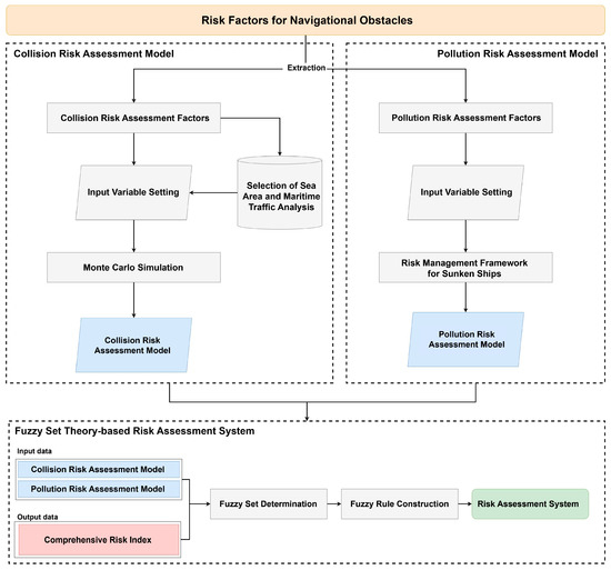
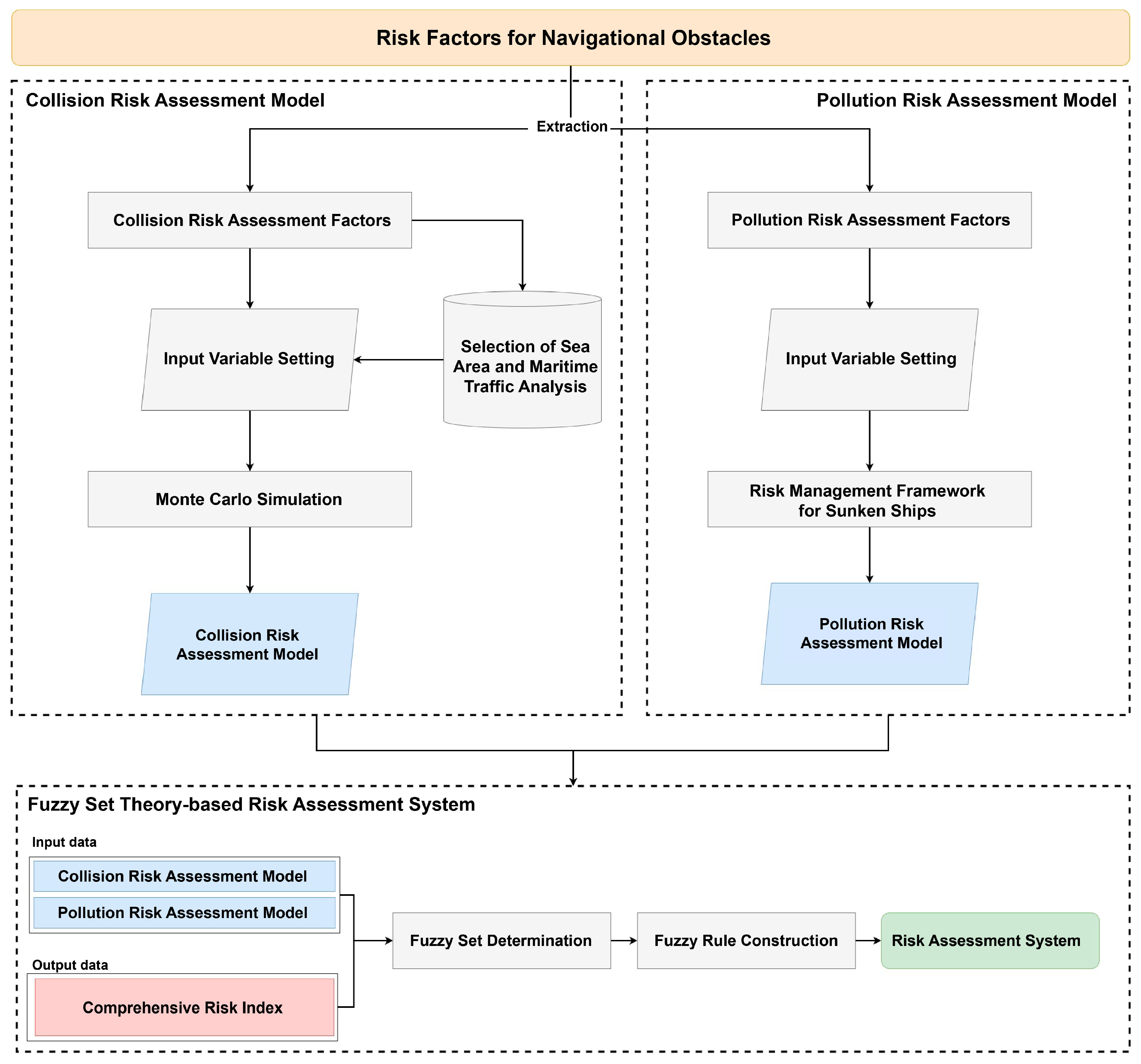
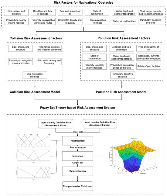
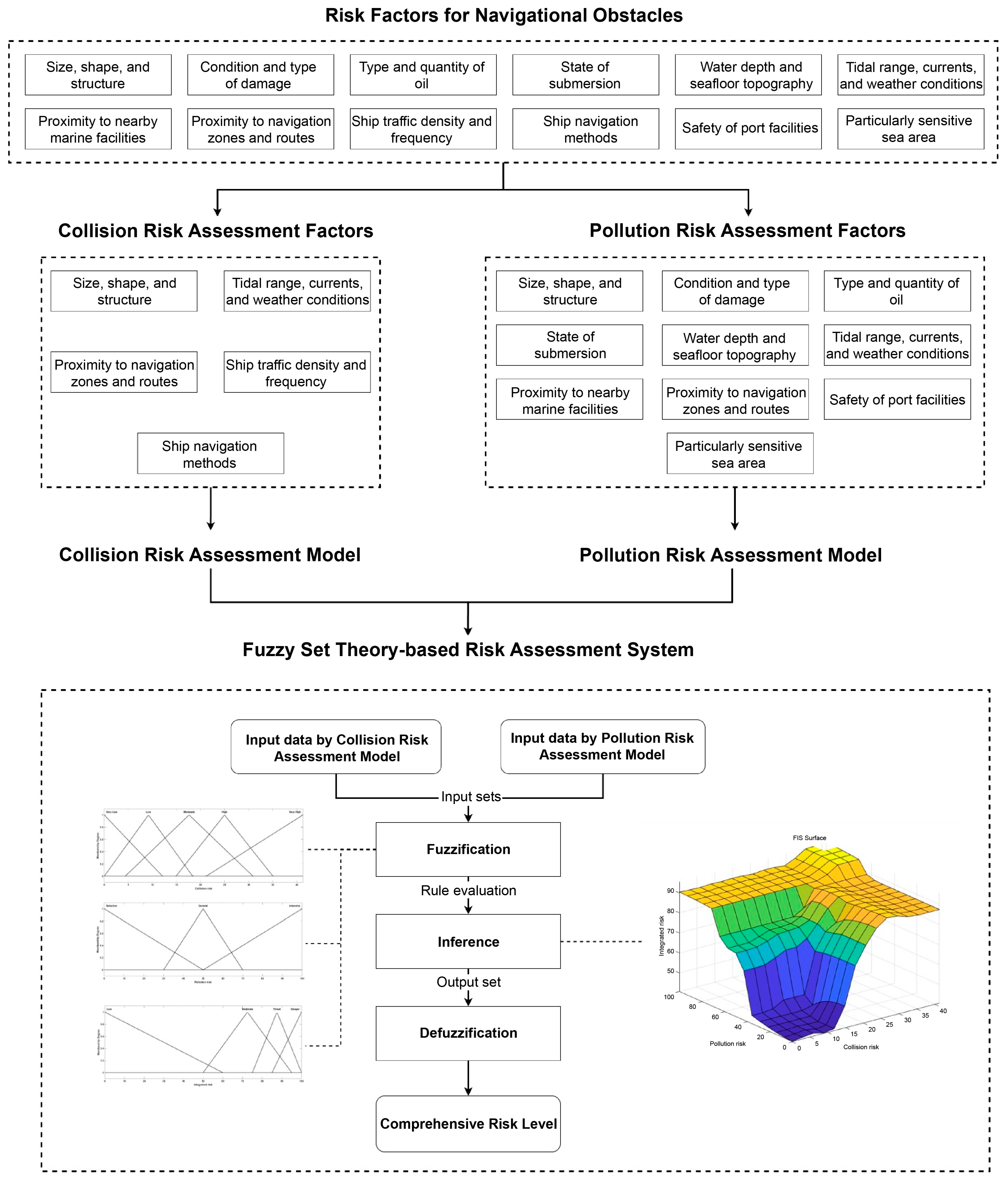
Therefore, this study proposes a fuzzy set theory-based navigational obstacle risk assessment system that simultaneously considers both collision and pollution risks to facilitate the rapid removal of navigational obstacles. Fuzzy set theory is particularly well-suited to this problem due to its ability to handle uncertainty and ambiguity, which are inherent in assessing risks associated with navigational obstacles. Unlike traditional deterministic approaches, fuzzy set theory provides a flexible framework for integrating qualitative information with quantitative data, enabling a more comprehensive evaluation of complex problems involving both collision and pollution risks [22,23,24,25,26,27,28,29]. The study was conducted in three phases. First, a collision risk assessment model was developed using Monte Carlo simulations. Second, a pollution risk assessment model was designed based on a risk management framework for sunken ships. Third, a fuzzy set-based navigational obstacle risk assessment system was created to evaluate the comprehensive risk by integrating the risk indices derived from both the collision and pollution risk assessment models.
The proposed system is expected to address the limitations of previous studies by simultaneously considering both collision and pollution risks. Furthermore, it is anticipated to demonstrate its potential as a practical decision-making tool for the efficient and timely removal of navigational obstacles. The remainder of this paper is organized as follows: Section 2 describes the theoretical background. In Section 3, we present a fuzzy set theory-based navigational obstacle risk assessment system that considers both collision and pollution risks simultaneously. Section 4 evaluates the performance of the model from both the micro- and macro-level perspectives, and Section 5 summarizes the conclusions.
2. Theoretical Background
2.1. Determinants of Navigational Obstacle Hazards
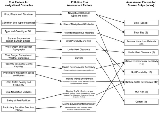
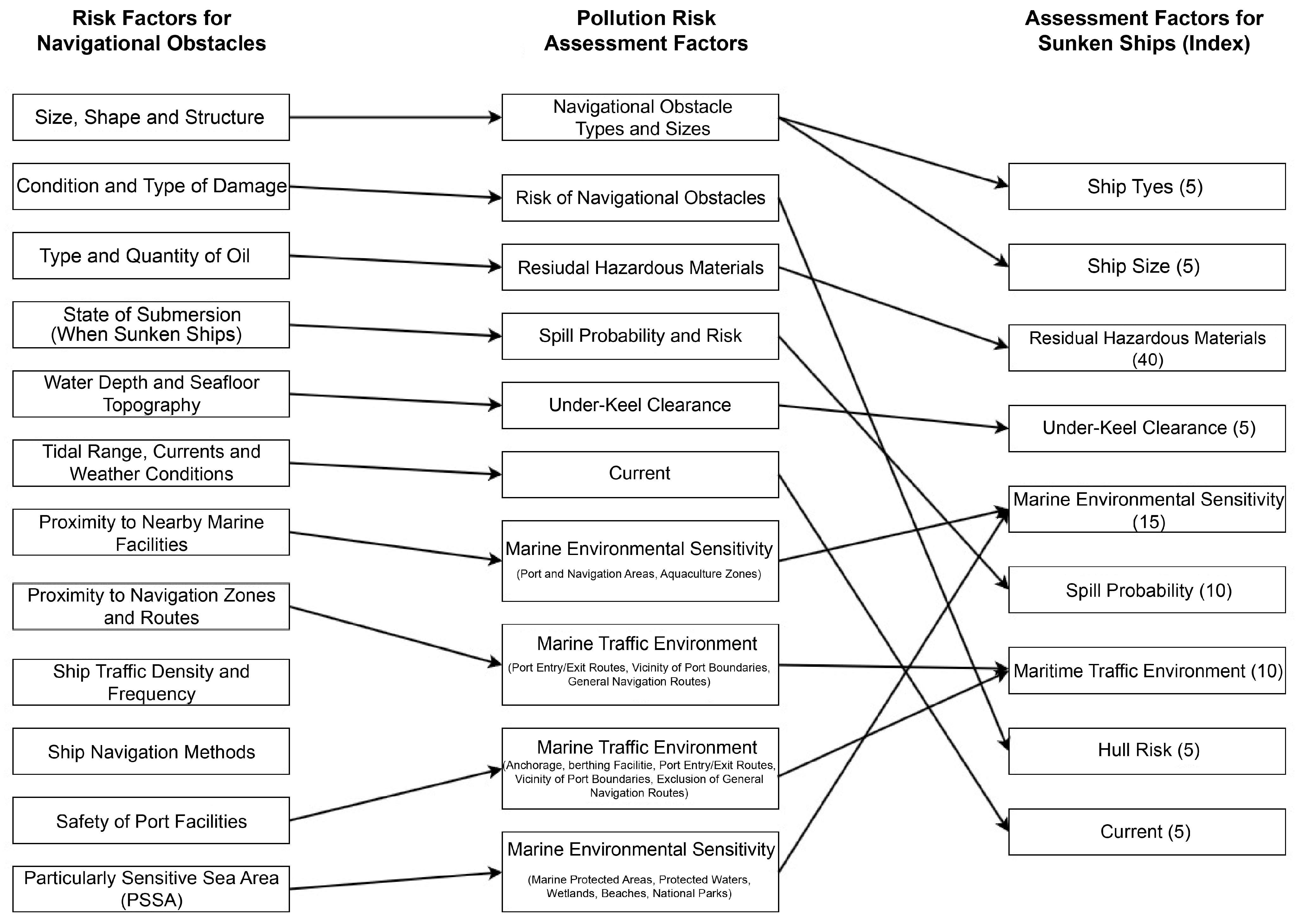
Article 24 of the Enforcement Rules of the Maritime Traffic Safety Act (Assessment of the Danger of Navigational Obstacles) specifies the factors for determining the danger posed by navigational obstacles, which are categorized into twelve classes [30], as follows: (1) size, shape, and structure, (2) condition and type of damage, (3) nature and quantity of cargo onboard the obstacle, including the type and quantity of oil (fuel oil, lubricating oil, etc.), (4) state of submersion (for sunken ships), (5) water depth and seabed topography of the area, (6) hydrographic survey results, including the tidal range, currents, and weather conditions, (7) proximity to nearby marine facilities, (8) proximity to navigation zones and routes used for international ship navigation, (9) ship traffic density and frequency, (10) ship navigation methods, (11) safety of port facilities, and (12) Particularly Sensitive Sea Areas (PSSAs) as designated by the International Maritime Organization (IMO).
2.2. Hazard Management Structure for Sunken Ships
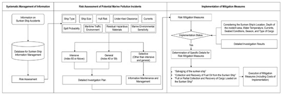
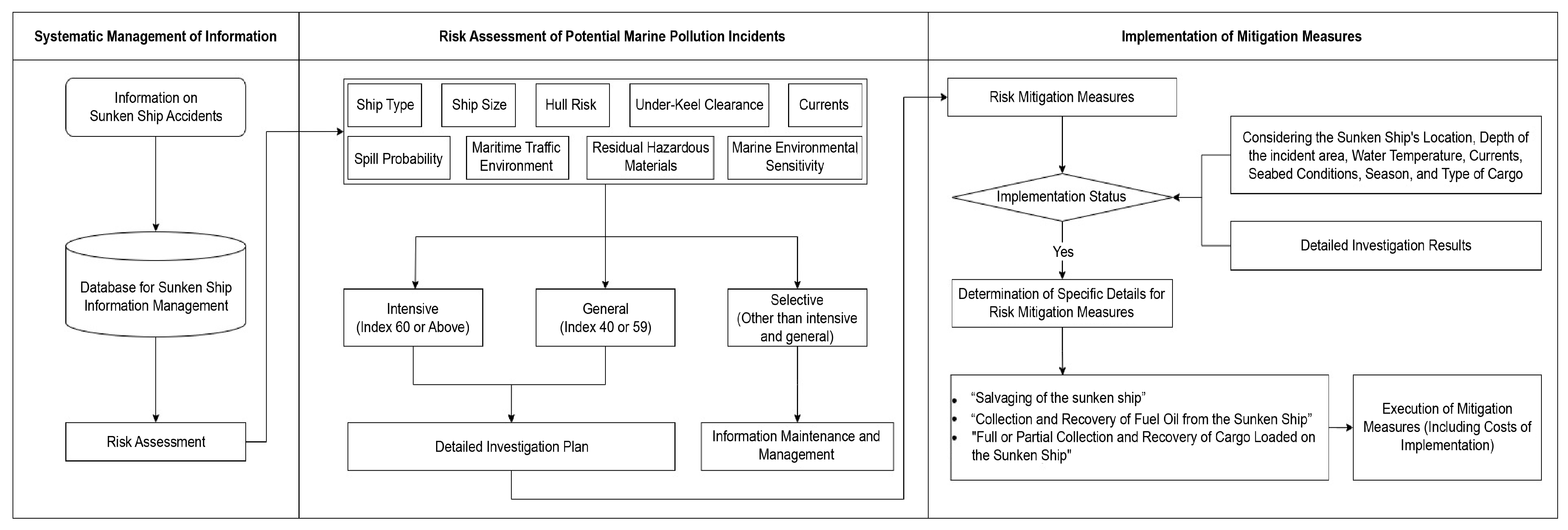
Sunken ships pose a potential risk to the marine environment and safety and require scientific and systematic management. In 2013, the Korean government established Article 83(2) of the Marine Environment Management Act, which provides a legal basis for measures to prevent marine pollution accidents caused by sunken ships. These measures include (1) systematic management of information on sunken ships, (2) risk assessment of the potential for sunken ships to cause marine accidents, and (3) implementation of risk reduction measures for sunken ships.
The Enforcement Regulations [31] for each of the above measures considered in the Marine Environment Management Act stipulate the following:
- Article 47.2 of the Enforcement Rules of the Marine Environment Management Act (Risk Assessment, etc.).
- Article 47.3 of the Enforcement Rules of the Marine Environment Management Act (Implementation of Risk Reduction Measures).
- Article 47.4 of the Enforcement Rules of the Marine Environment Management Act (Calculation and Imposition of Costs for Implementation of Risk Reduction Measures).
- Article 47.5 of the Enforcement Rules of the Marine Environment Management Act (Management of Information on Sunken Ships).
- Sunken Ship Management Regulations (Decree of the Ministry of Oceans and Fisheries).
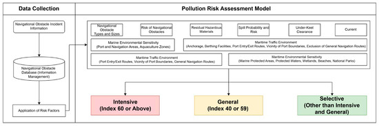
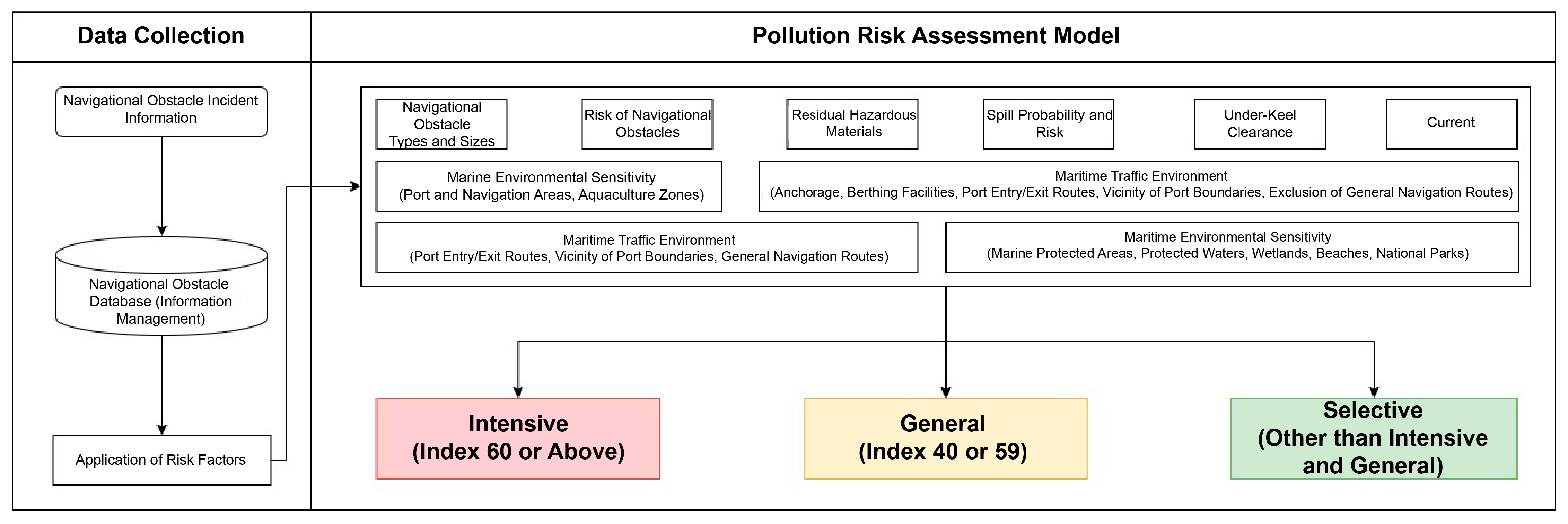
The hazard management system for sunken ships in accordance with the aforementioned enforcement rules and administrative regulations is illustrated in Figure 1.
Figure 1.
Risk management framework for sunken ships.
Sunken ship hazard assessment involves nine factors that comprehensively evaluate the potential hazards, including the likelihood of marine pollution owing to residual oil spills from the hull, the possibility of navigational obstacles, the potential destruction of marine ecosystems and natural environments, and the likelihood of obstacles in major fishing grounds. Table 1 lists each factor and its corresponding risk assessment index, which was calculated by adding the scores for each assessment item. Appendix B details the nine evaluation factors and their assigned evaluation scores.
Table 1.
Assessment factors for sunken ships.
4. Case Study
4.1. Numerical Simulation Results
The fuzzy set theory-based navigational obstacle risk assessment system that considers both collision and pollution risks was applied to both micro- and macro-level case studies to verify its performance. In the micro-level case study, the collision and pollution risks were evaluated for virtual drifting fishing boats, and a comprehensive risk was inferred using the developed system. In the macro-level case study, the comprehensive risk was inferred by adding a random index based on the collision risk level after calculating the pollution risk index for each location using data on the status of sunken ships from the Korea Maritime Environment Corporation [37].
4.1.1. Micro-Level Results
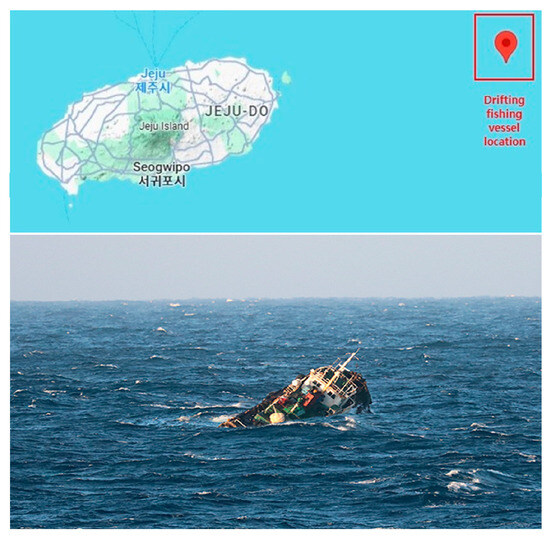
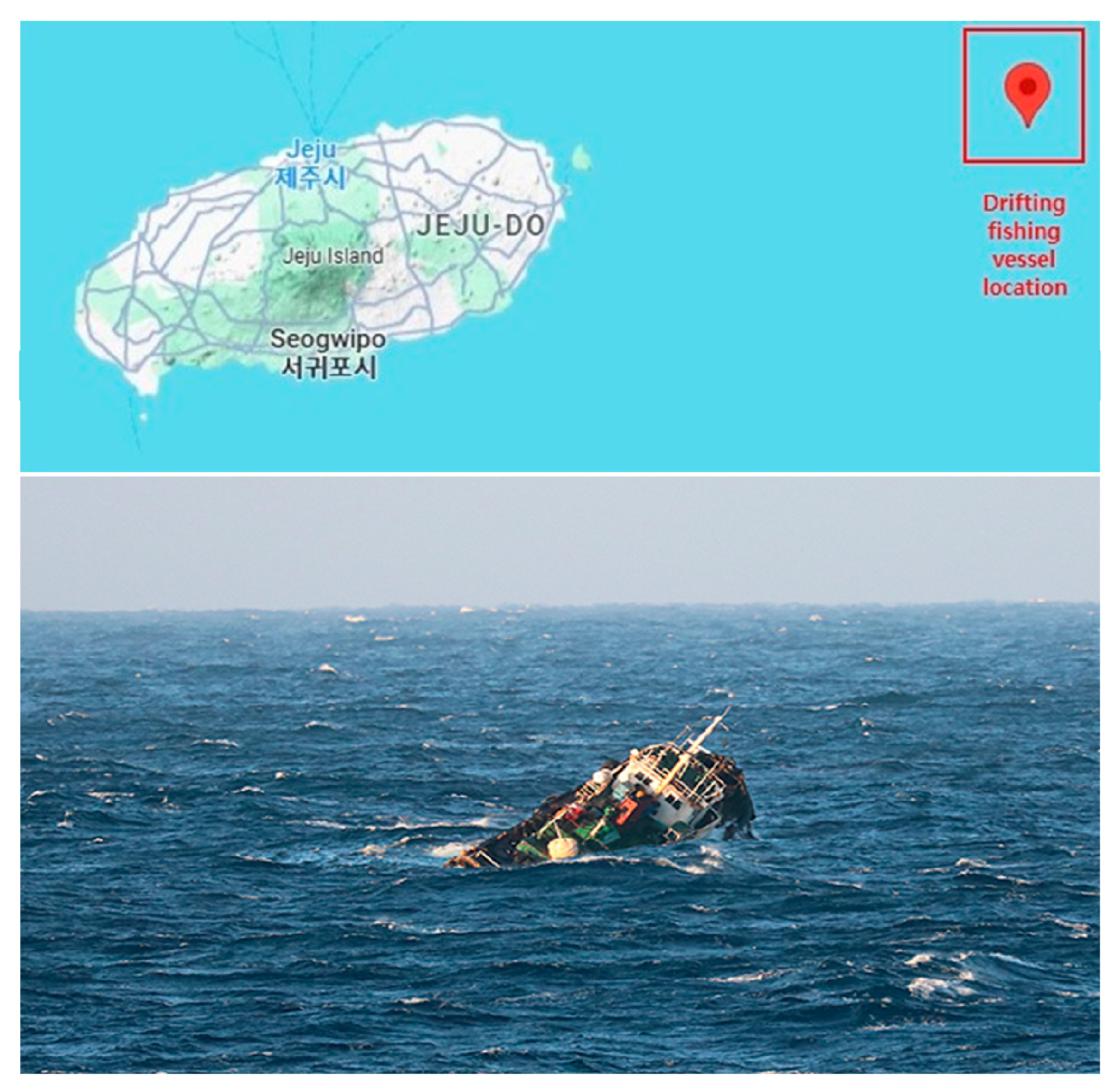
For the micro-level case study, it was assumed that a drifting fishing boat incident occurred on 13 August 2024, at 33° 33 min 01 s N, 127° 39 min 13 s E, approximately 36 nautical miles from Seongsanpo Port on Jeju Island, as illustrated in Figure 14.
Figure 14.
Drifting fishing vessel incident in the micro-level case study.
The data for the five determinants influencing collision risk and the ten determinants influencing pollution risk are summarized in Table 8 and Table 9, respectively.
Table 8.
Collision risk assessment factors in the micro-level case study.
Table 9.
Pollution risk assessment factors for micro-level case study.
The collision risk was evaluated, as shown in Table 10, by applying the data from Table 8 and Table 9. In this process, object size was calculated using the Pythagorean theorem, assuming a ship length of 30 m and width of 5 m. For moving ships, the maximum number of ship passages per hour within the grid at the drift point was considered.
Table 10.
Collision risk assessment in the micro-level case study.
Table 11 presents the results of applying the data in Table 10 to the pollution risk assessment model.
Table 11.
Pollution risk assessment for micro-level case study.
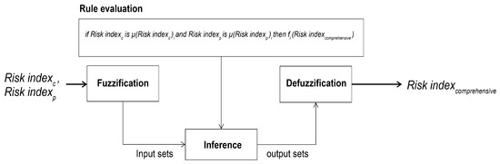
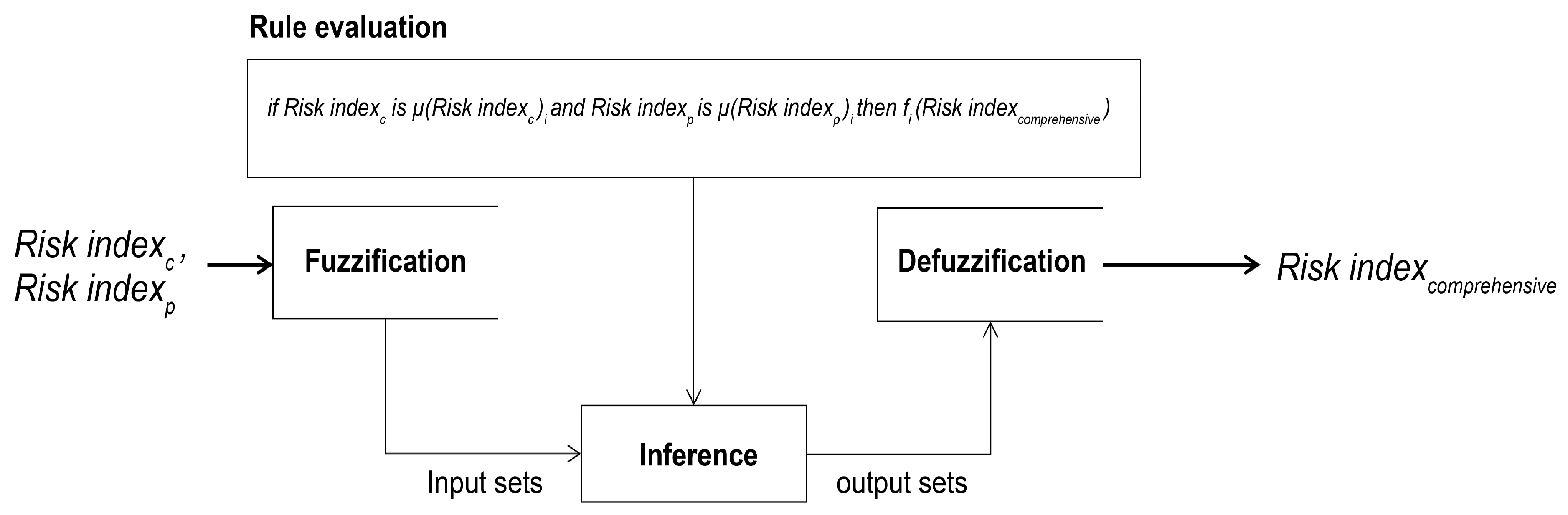
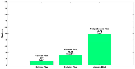
The collision risk index (level) and pollution risk index (level) were calculated as 6.37% (medium) and 16% (selective), respectively. By inputting these values into the fuzzy set theory-based navigational obstacle risk assessment system, the comprehensive risk index (level) was inferred and evaluated as 48.74% (low), as illustrated in Figure 15.
Figure 15.
Fuzzy set theory-based risk assessment in micro-level case study.
4.1.2. Macro-Level Results
The Korea Maritime Environment Corporation systematically manages the information on sunken ships and maintains the status data to assess the potential for marine pollution accidents. These data include the name of the sunken ship, date of sinking, ship type, accident type, depth, hazardous material mass, latitude, and longitude [38]. The data provided on 28 August 2023, were used for the macro-level case study. These included the data of 2287 sunken ships, recorded from 1983 to 2023, which included fishing boats, cargo ships, oil tankers, tugboats, and buoys, with fishing boats accounting for approximately 82% of the total.
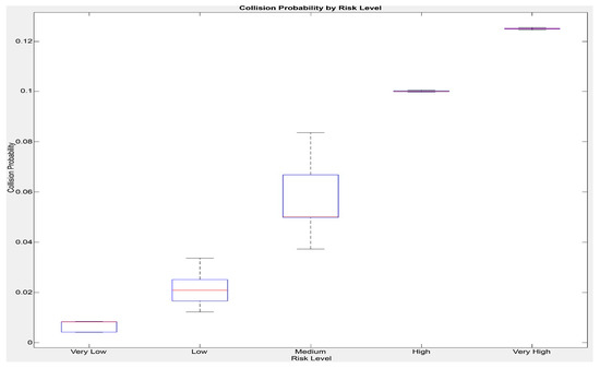
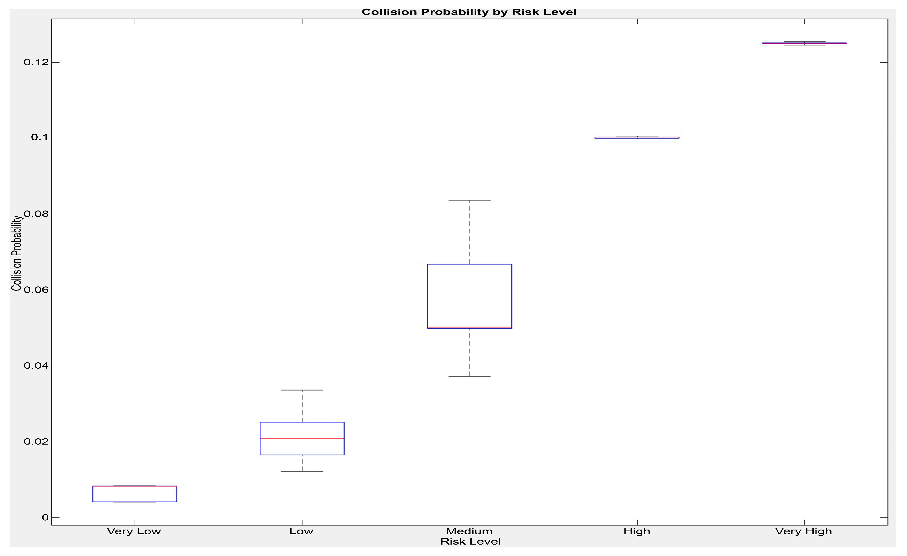
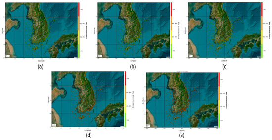
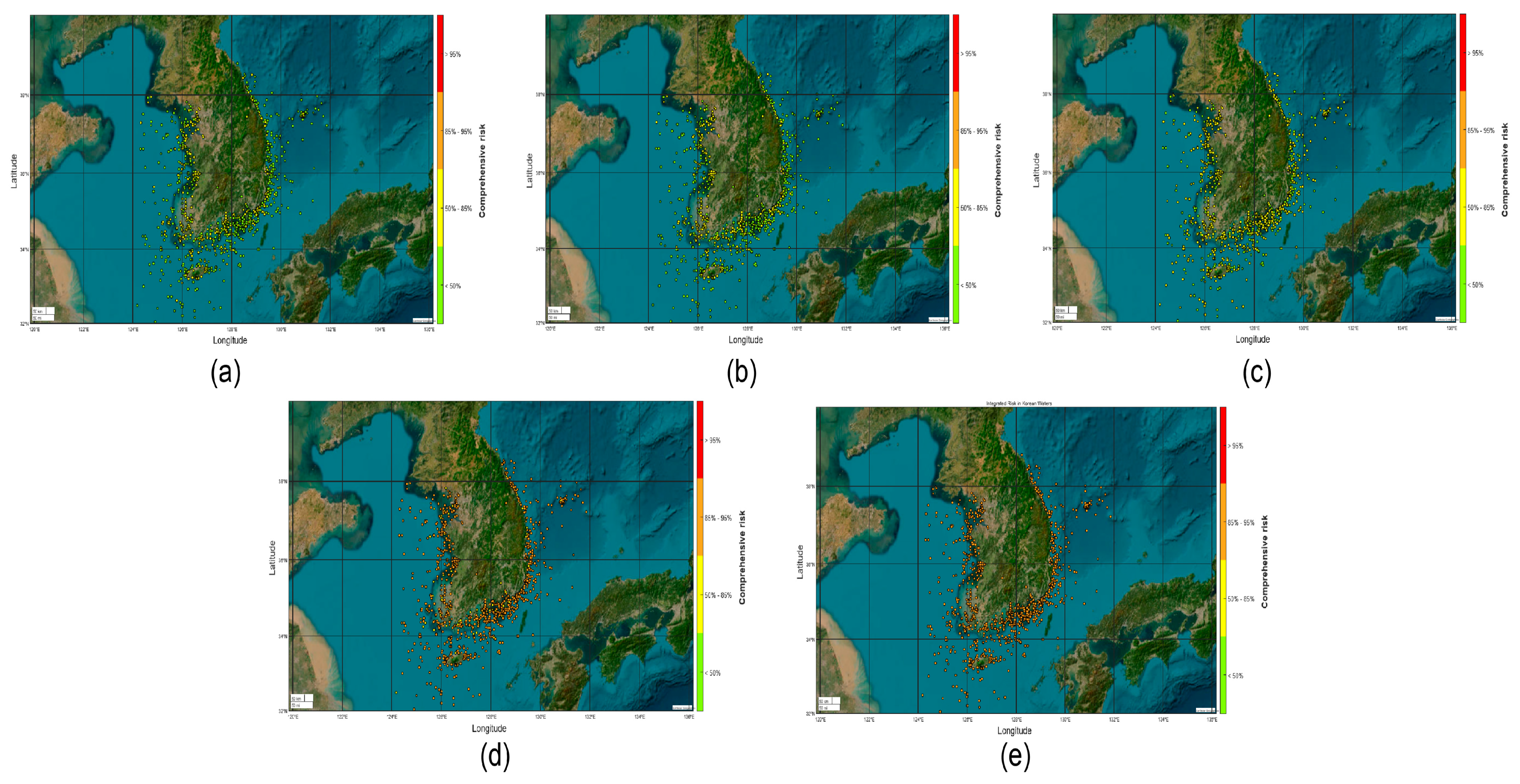
The pollution risk index was calculated by inputting the data into a pollution risk assessment model. However, because the comprehensive risk cannot be inferred using only the pollution risk index, a random index was added based on the collision risk level to calculate the comprehensive risk. Figure 16 shows the distribution of the comprehensive risk at each location for various levels of the collision risk index. The results confirmed that the comprehensive risk level tended to increase with increasing collision risk level.
Figure 16.
Distribution of comprehensive risk by location for (a) very low, (b) low, (c) medium, (d) high, and (e) very high collision risk index.
4.2. Discussion
From the results of the simulation based on the micro- and macro-level case studies, the comprehensive risk was inferred using a fuzzy set theory-based obstacle risk assessment system that simultaneously considers both the collision and pollution risks. This system was designed to infer the comprehensive risk by evaluating both the collision and pollution risks in an integrated manner. Through this approach, the system aims to support decision-making for the prompt removal of navigational obstacles.
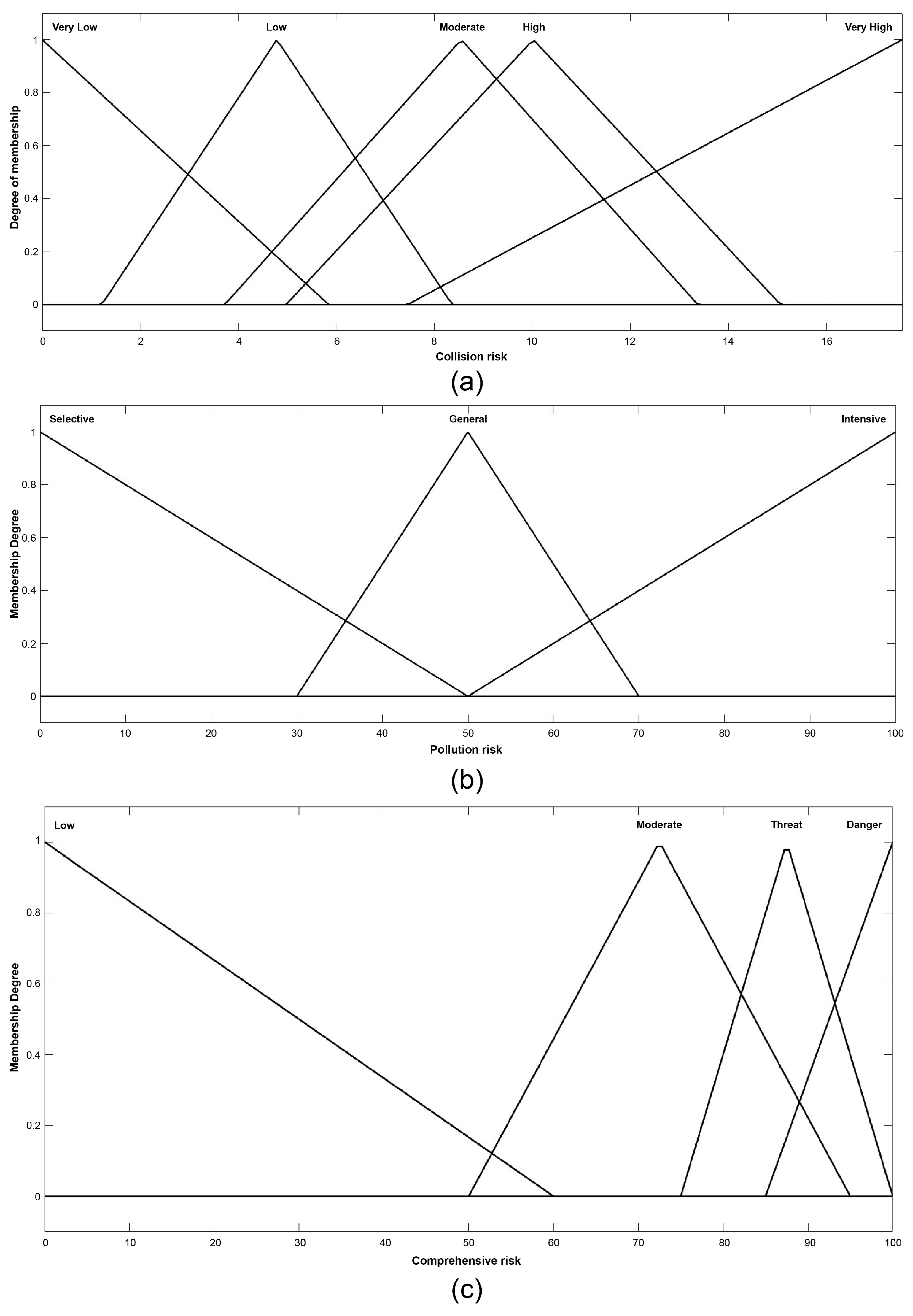
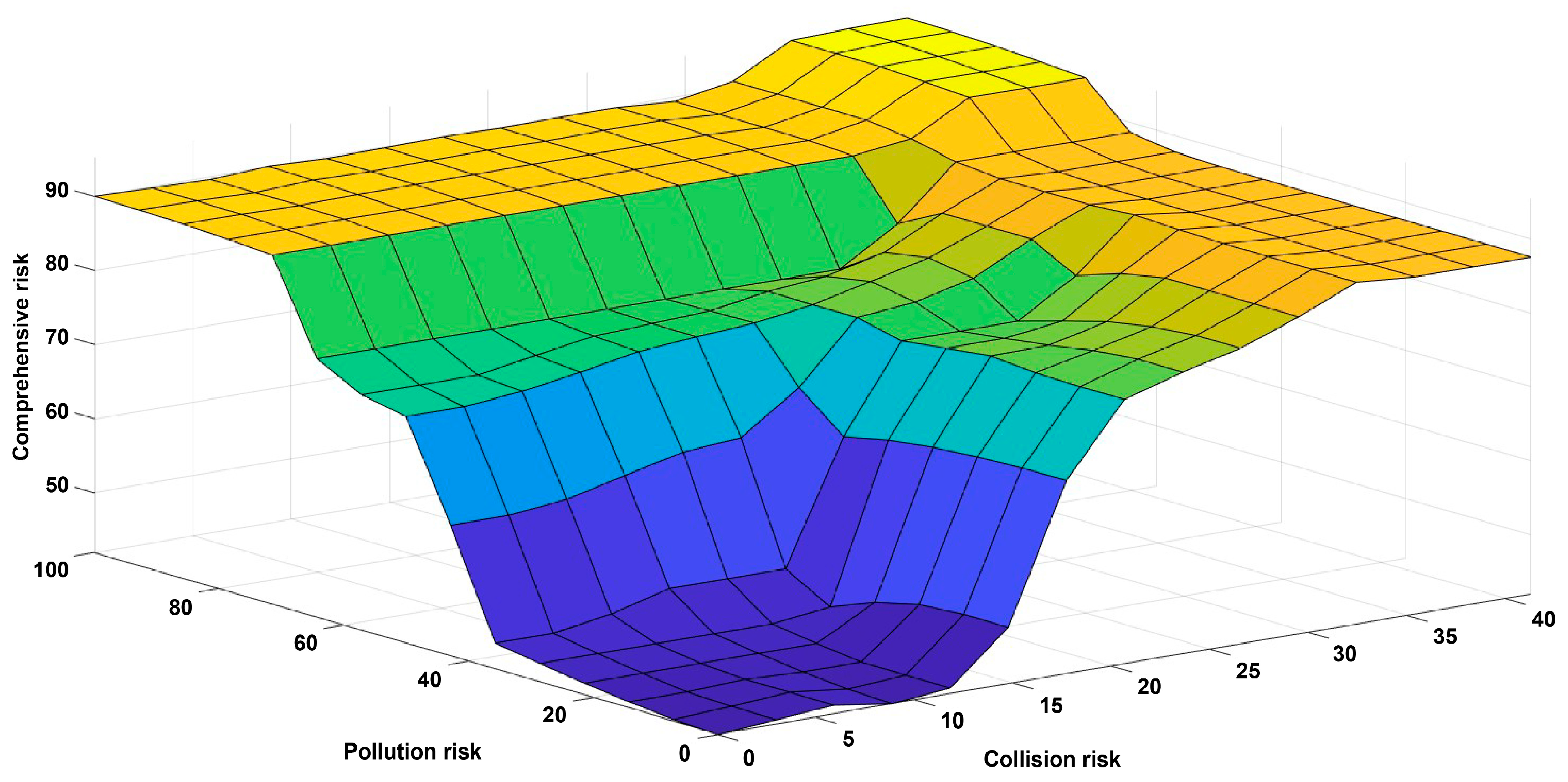
In the micro-level case study, the collision risk index calculated from the collision risk assessment model and the pollution risk index calculated from the pollution risk assessment were input into the developed model. The comprehensive risk was inferred using fuzzy rules by applying 24 AND operations. Because of the nature of the AND operation, the final result is considered true only when all conditions are true, allowing for more accurate results by returning an outcome only when all conditions are satisfied [22]. The models calculated the collision and pollution risks as 6.37% and 16.00%, respectively. When these risk factors were analyzed using the fuzzy rule with AND operations, a low comprehensive risk state of 48.74% was inferred. This indicates that the system can provide reliable risk assessment by comprehensively considering both the collision and pollution risks.
In the macro-level case study, the comprehensive risk was inferred by calculating the pollution risk index for each location using the data on the current status of sunken ships from the Korea Maritime Environment Corporation (Seoul, Republic of Korea) and by adding an arbitrary index according to the collision risk level. In this process, it was confirmed that the comprehensive risk tended to increase as the collision risk level increased. This indicates that collision risk is an important variable for the evaluation of the comprehensive risk. Furthermore, the results suggest that higher levels of the comprehensive risk may require stricter operational measures, such as prioritizing the removal of obstacles in high-risk areas or deploying additional resources for monitoring and response. Additionally, future adaptations of this model could integrate additional factors, such as the economic impact of assessed risks, to enhance its practical applicability. This extension would facilitate the evaluation of how risk levels influence costs and resource allocation, making the model more comprehensive for real-world decision-making.
The reliability of the system was verified by comprehensively evaluating the collision risk index and pollution risk index in various situations and inferring the comprehensive risk index and level. In particular, the developed system not only overcomes the limitations of previous research, which failed to simultaneously consider the collision and pollution risks but also demonstrates its potential as an effective decision-making tool for the prompt removal of navigational obstacles.
5. Conclusions
This study developed a fuzzy set theory-based navigational obstacle risk assessment system that considers both collision and pollution risks, aiming to facilitate the rapid removal of navigational obstacles. The system was designed as a tool to infer the comprehensive risk by integrating the collision and pollution risk assessment models. Through both micro- and macro-level case studies, it was confirmed that the system provides reliable risk assessments, responds sensitively to changes in risk, and effectively reflects realistic site conditions.
Therefore, this system has been shown to overcome the limitations of previous research and serve as a valuable decision-making tool for the rapid removal of navigational obstacles. Furthermore, the system demonstrates the potential for integration with maritime monitoring and response systems to provide real-time risk assessments and generate actionable recommendations for obstacle removal. However, certain limitations should be acknowledged. For example, reliance on static data sources, such as AIS data, may reduce applicability in dynamic or data-sparse environments. Additionally, challenges in implementing the system across different regions with varying maritime conditions and data availability could affect its overall effectiveness.
This study represents an initial step toward the efficient removal of navigational obstacles. Future research will focus on addressing these limitations while leveraging this system to develop specific strategies for determining the timing and methods of obstacle removal.
Author Contributions
Conceptualization, D.L. and H.N.; methodology, D.L. and H.N.; software, D.L.; validation, D.L. and H.N.; formal analysis, D.L.; investigation, D.L.; resources, H.N.; data curation, S.-L.Y.; writing—original draft preparation, D.L.; writing—review and editing, H.N.; visualization, S.-L.Y.; supervision, H.N. All authors have read and agreed to the published version of the manuscript.
Funding
This research was supported by the National Research Foundation of Korea (NRF), funded by the Ministry of Education (MOE) through the “Regional Innovation Strategy (RIS)” (Grant No. 2023RIS-009).
Institutional Review Board Statement
Not applicable.
Informed Consent Statement
Not applicable.
Data Availability Statement
The original contributions presented in this study are included in the article. Further inquiries can be directed to the corresponding author.
Acknowledgments
The authors would like to extend their deep gratitude to Joo Sung Kim of Mokpo National Maritime University for his invaluable assistance throughout the progress of this research.
Conflicts of Interest
Author Sang-Lok Yoo was employed by Future Ocean Information Technology, Inc. The remaining authors declare that the research was conducted in the absence of any commercial or financial relationships that could be construed as a potential conflict of interest.
Abbreviations
The following abbreviations are used in this manuscript:
| AIS | Automatic Identification System |
| ALARP | As Low as Reasonably Possible |
| COG | Course Over Ground |
| DEEPP | Development of European Guidelines for Potentially Polluting |
| FIPA | Fisheries Infrastructure Public Agency |
| IMO | International Maritime Organization |
| KOEM | Korea Marine Environment Management |
| MCA | Maritime and Coastguard Agency |
| MF | Membership function |
| MMSI | Maritime Mobile Service Identity |
| MTIS | Marine Traffic Safety Information System |
| NMRI | National Maritime Research Institute |
| PSSA | Particularly sensitive sea area |
| SOG | Speed Over Ground |
Appendix A
| Risk Perspective | Description | Representative Studies/Models |
| Collision Risk | Relates to the hazards posed by floating objects falling from ships, including those from sunken and grounded vessels. It focuses on physical impacts, economic losses, and overall safety issues. |
|
| Pollution Risk | Pertains to the ecological hazards and environmental risks associated with sunken and grounded vessels, with a focus on pollution management and mitigation strategies. |
|
Appendix B
- (1)
- Ship Types
| Ship Type | Oil Tanker, Hazardous Material Carrier | General Cargo Ship | Tugboats and Work Vessels, Fishing Vessels | Barges and Other Vessels | Unknown |
| Assessment index | 5 | 4 | 3 | 2 | 1 |
- (2)
- Ship Size
| Gross Tonnage | 10,000 t or More | 5000 to Less Than 10,000 t | 3000 to Less Than 5000 t | 1000 to Less Than 3000 t | 500 to Less Than 1000 t | 100 to Less Than 500 t | Less Than 100 t |
| Assessment index | 5 | 4.5 | 4 | 3 | 2 | 1.5 | 1 |
- (3)
- Residual Hazardous Materials
| Residual Quantity Hazardous Materials | 1000 kL or More | 500 to Less Than 1000 kL | 100 to Less Than 500 kL | 50 to Less Than 100 kL | 10 to Less Than 50 kL | Less Than 10 kL | None | |
| Oil | 24° API or below [Heavy fuel oil (HFO)] | 40 | 35 | 20 | 15 | 10 | 5 | 0 |
| 24° to 34° API [Intermediate fuel oil (IFO)] | 32 | 28 | 16 | 12 | 8 | 4 | 0 | |
| 34° to 44° API [Marine diesel oil (MFO)] | 16 | 14 | 8 | 6 | 4 | 2 | 0 | |
| 44° API or above [Marine gas oil (MGO)] | 8 | 7 | 4 | 3 | 2 | 1 | 0 | |
| Hazardous liquid substances | X | 40 | 35 | 20 | 15 | 10 | 5 | 0 |
| Y | 32 | 28 | 16 | 12 | 8 | 4 | 0 | |
| Z | 16 | 14 | 8 | 6 | 4 | 2 | 0 | |
| Other substances | 8 | 7 | 4 | 3 | 2 | 1 | 0 | |
| Radioactive materials | 40 | 0 | ||||||
- (4)
- Clearance over mast
| Clearance over Mast | Less Than 15 m | 15 m to Less Than 20 m | 20 m to Less Than 25 m | 25 m to Less Than 30 m | 30 m or More |
| Assessment index | 5 | 4 | 3 | 2 | 1 |
- (5)
- Marine Environmental Sensitivity
| Distance from Shoreline or Sensitive Area | Less Than 1 Nautical Mile | 1 to Less Than 5 Nautical Miles | 5 to Less Than 12 Nautical Miles | 12 to Less Than 25 Nautical Miles | 25 Nautical Miles or More |
| Assessment index | 15 | 10 | 7 | 4 | 1 |
- (6)
- Spill Probability
- (a)
- Age of Ship Before the Incident
| Ship Age | 20 Years or More | 10 to Less Than 20 Years | 5 to Less Than 10 Years | Less Than 5 Years |
| Assessment index | 4 | 3 | 2 | 1 |
- (b)
- Elapsed time since the incident
| Elapsed Time | 25 Years or More | 20 to Less Than 25 Years | 15 to Less Than 20 Years | 10 to Less Than 15 Years | 5 to Less Than 10 Years | Less Than 5 Years |
| Assessment index | 6 | 5 | 4 | 3 | 2 | 1 |
- (7)
- Maritime Traffic Environment
| Traffic Environment | Port Entry/ Exit Routes | Vicinity of Port Boundaries | Anchorage | General Navigation Routes | Others |
| Assessment index | 10 | 8 | 6 | 4 | 2 |
- (8)
- Hull risk
| Hull Risk (Accident Type) | Sinking Due to Hull Damage from External Forces (e.g., Fire, Explosion, Collision, Grounding, etc.) | Sinking Without Hull Damage (e.g., Flooding, Capsizing, etc.) |
| Assessment index | 5 | 1 |
- (9)
- Currents
| Current Speed | Above 2 Knots | 1 to Less Than 2 Knots | Below 1 Knot |
| Assessment index | 5 | 3 | 1 |
References
- Maritime Traffic Safety Act. Available online: https://law.go.kr/LSW//lsInfoP.do?lsId=014483&ancYnChk=0#0000 (accessed on 11 November 2024).
- Marine Accident Statistics 2023. Available online: https://www.kmst.go.kr/web/board.do?menuIdx=135 (accessed on 11 November 2024).
- Takehama, S. Estimation of damage to fishing vessels caused by marine debris, based on insurance statistics. In Proceedings of the Second International Conference on Marine Debris, Honolulu, Hawaii, 2–7 April 1989. [Google Scholar]
- Nash, A.D. Impacts of marine debris on subsistence fishermen an exploratory study. Mar. Pollut. Bull. 1992, 24, 150–156. [Google Scholar] [CrossRef] [Scilit]
- Cho, D.O. Challenges to marine debris management in Korea. Coast. Manag. 2005, 33, 89–409. [Google Scholar] [CrossRef] [Scilit]
- Byard, R.W. Commercial fishing industry deaths—Forensic issues. J. Forensic Leg. Med. 2013, 20, 129–132. [Google Scholar] [CrossRef] [Scilit]
- Maritime Traffic Safety Act. Available online: https://www.law.go.kr/%EB%B2%95%EB%A0%B9/%ED%95%B4%EC%83%81%EA%B5%90%ED%86%B5%EC%95%88%EC%A0%84%EB%B2%95 (accessed on 11 November 2024).
- Lincoln, S.; Andrews, B.; Birchenough, S.N.R.; Chowdhury, P.; Engelhard, G.H.; Harrod, O.; Pinnegar, J.K.; Townhill, B.L. Marine litter and climate change: Inextricably connected threats to the world’s oceans. Sci. Total Environ. 2022, 837, 155709. [Google Scholar] [CrossRef] [Scilit] [PubMed]
- Haarr, M.L.; Falk-Andersson, J.; Fabres, J. Global marine litter research 2015–2020: Geographical and methodological trends. Sci. Total Environ. 2022, 820, 153162. [Google Scholar] [CrossRef] [Scilit]
- González-Fernández, D.; Hanke, G. Floating marine macro litter in the Black Sea: Toward baselines for large scale assessment. Environ. Pollut. 2020, 309, 119816. [Google Scholar] [CrossRef] [Scilit]
- Chiu, C.C.; Liao, C.P.; Kuo, T.C.; Huang, H.W. Using citizen science to investigate the spatial-temporal distribution of floating marine litter in the waters around Taiwan. Mar. Pollut. Bull. 2020, 157, 111301. [Google Scholar] [CrossRef] [Scilit]
- Pogojeva, M.; Zhdanov, I.; Berezina, A.; Lapenkov, A.; Kosmach, D.; Osadchiev, A.; Hanke, G.; Semiletov, I.; Yakushev, E. Distribution of floating marine macro-litter in relation to oceanographic characteristics in the Russian Arctic Seas. Mar. Pollut. Bull. 2021, 166, 112201. [Google Scholar] [CrossRef] [Scilit] [PubMed]
- Sá, S.; Bastos-Santos, J. Floating marine litter and their risks to cetaceans off Portugal. Mar. Pollut. Bull. 2021, 170, 112603. [Google Scholar] [CrossRef] [Scilit] [PubMed]
- Ruiz, I.; Burgoa, I.; Santos, M.; Basurko, O.C.; García-Barón, I.; Louzao, M.; Beldarrain, B.; Kukul, D.; Valle, C.; Uriarte, A.; et al. First assessment of floating marine litter abundance and distribution in the Bay of Biscay from an integrated ecosystem survey. Mar. Pollut. Bull. 2022, 174, 113266. [Google Scholar] [CrossRef] [Scilit] [PubMed]
- Andrés, M.; Delpey, M.; Ruiz, I.; Declerck, A.; Sarrade, C.; Bergeron, P.; Basurko, O.C. Measuring and comparing solutions for floating marine litter removal: Lessons learned in the south-east coast of the Bay of Biscay from an economic perspective. Mar. Policy 2021, 127, 104450. [Google Scholar] [CrossRef] [Scilit]
- Topouzelis, K.; Papageorgiou, D.; Suaria, G.; Aliani, S. Floating marine litter detection algorithms and techniques using optical remote sensing data: A review. Mar. Pollut. Bull. 2021, 170, 112675. [Google Scholar] [CrossRef] [Scilit] [PubMed]
- Garcia-Garin, O.; Monleón-Getino, T.; López-Brosa, P.; Borrell, A.; Aguilar, A.; Borja-Robalino, R.; Cardona, L.; Vighi, M. Automatic detection and quantification of floating marine macro-litter in aerial images: Introducing a novel deep learning approach connected to a web application in R. Environ. Pollut. 2021, 273, 116490. [Google Scholar] [CrossRef] [Scilit]
- Hong, S.; Lee, J.; Lim, S. Navigational threats by derelict fishing gear to navy ships in the Korean seas. Mar. Pollut. Bull. 2017, 119, 100–105. [Google Scholar] [CrossRef] [Scilit]
- NOAA. Risk Assessment for Potentially Polluting Wrecks in U.S. Waters; National Oceanic and Atmospheric Administration: Silver Spring, MD, USA, 2013. [Google Scholar]
- Alcaro, L. The DEEPP project, PPSWs within the Mediterranean cetacean sanctuary. In Proceedings of the Europe First Adriatic Oil Spill Conference, Opatija, Croatia, 12–14 May 2010. [Google Scholar]
- Alcaro, L.; Amato, E.; Cabioch, F.; Farchi, C.; Gouriou, V.; Wrubl, C. DEEPP Project Development of European Guidelines for Potentially Polluting Shipwrecks; EU DG Environment, Civil Protection Unit: Rome, Italy, 2007. [Google Scholar]
- Zadeh, L.A. The concept of a linguistic variable and its application to approximate reasoning-I. Inf. Sci. 1975, 8, 199–249. [Google Scholar] [CrossRef] [Scilit]
- Ohn, S.W.; Namgung, H. Interval type-2 fuzzy inference system based on closest point of approach for collision avoidance between ships. Appl. Sci. 2020, 10, 3919. [Google Scholar] [CrossRef] [Scilit]
- Namgung, H.; Kim, J.S. Collision risk inference system for maritime autonomous surface ships using COLREGs rules compliant collision avoidance. IEEE Access 2021, 9, 7823–7835. [Google Scholar] [CrossRef] [Scilit]
- Namgung, H.; Jeong, J.-S.; Kim, J.-S.; Kim, K.-I. Inference model of collision risk index based on artificial neural network using ship near-collision data. J. Phys. Conf. Ser. 2019, 1357, 012044. [Google Scholar] [CrossRef] [Scilit]
- Namgung, H.; Ohn, S.-W. Fuzzy inference and sequence model-based collision risk prediction system for stand-on vessel. Sensors 2022, 22, 4983. [Google Scholar] [CrossRef] [Scilit] [PubMed]
- Namgung, H.; Jeong, J.S.; Kim, J.S. Real-time collision risk assessment system based on the fuzzy theory in accordance with collision avoidance rules. In Proceedings of the Joint 11th International Conference on Soft Computing and Intelligent Systems, Hachijo Island, Japan, 5–8 December 2020. [Google Scholar] [CrossRef] [Scilit]
- Zhen, R.; Lv, P.; Shi, Z.; Chen, G. A novel fuzzy multi-factor navigational risk assessment method for ship route optimization in coastal offshore wind farm waters. Ocean Coast. Manag. 2023, 232, 106428. [Google Scholar] [CrossRef] [Scilit]
- Shi, Z.; Zhen, R.; Liu, J. Fuzzy logic-based modeling method for regional multi-ship collision risk assessment considering impacts of ship crossing angle and navigational environment. Ocean Eng. 2022, 259, 111847. [Google Scholar] [CrossRef] [Scilit]
- Enforcement Rules of the Maritime Traffic Safety Act. Available online: https://www.law.go.kr/lsInfoP.do?lsiSeq=260107&efYd=20240726#0000 (accessed on 11 November 2024).
- Enforcement Rules of the Marine Environment Management Act. Available online: https://law.go.kr/%EB%B2%95%EB%A0%B9/%ED%95%B4%EC%96%91%ED%99%98%EA%B2%BD%EA%B4%80%EB%A6%AC%EB%B2%95%EC%8B%9C%ED%96%89%EA%B7%9C%EC%B9%99 (accessed on 11 November 2024).
- Maritime Traffic Safety Information System. Available online: https://mtis.komsa.or.kr/traffic/focst/acdntRisk (accessed on 11 November 2024).
- Ester, M.; Kriegel, H.-P.; Sander, J.; Xu, X. A density-based algorithm for discovering clusters in large spatial databases with noise. In Proceedings of the 2nd International Conference on Knowledge Discovery and Data Mining (KDD’96), Portland, OR, USA, 2–4 August 1996. [Google Scholar]
- Namgung, H.; Kim, J.-S. Regional collision risk prediction system at a collision area considering spatial pattern. J. Mar. Sci. Eng. 2021, 9, 1365. [Google Scholar] [CrossRef] [Scilit]
- Banack, H.R.; Hayes-Larson, E.; Mayeda, E.R. Monte Carlo simulation approaches for quantitative bias analysis: A tutorial. Epidemiol. Rev. 2022, 43, 106–117. [Google Scholar] [CrossRef] [Scilit]
- Bolbot, V.; Gkerekos, C.; Theotokatos, G.; Boulougouris, E. Automatic traffic scenarios generation for autonomous ships collision avoidance system testing. Ocean Eng. 2022, 254, 111309. [Google Scholar] [CrossRef] [Scilit]
- Namgung, H.; Kim, J.-S. Vessel trajectory analysis in designated harbor route considering the influence of external forces. J. Mar. Sci. Eng. 2020, 8, 860. [Google Scholar] [CrossRef] [Scilit]
- Current Status of Ships Sinking at the Korea Maritime Environment Corporation. Available online: https://www.data.go.kr/data/15004149/fileData.do?recommendDataYn=Y (accessed on 11 November 2024).

Disclaimer/Publisher’s Note: The statements, opinions and data contained in all publications are solely those of the individual author(s) and contributor(s) and not of MDPI and/or the editor(s). MDPI and/or the editor(s) disclaim responsibility for any injury to people or property resulting from any ideas, methods, instructions or products referred to in the content. |
© 2025 by the authors. Licensee MDPI, Basel, Switzerland. This article is an open access article distributed under the terms and conditions of the Creative Commons Attribution (CC BY) license (https://creativecommons.org/licenses/by/4.0/).