


Abstract
Watersheds are the units through which land use, climate, and human activity shape water quantity, water quality, and ecosystem health. The Soil and Water Assessment Tool (SWAT) provides a physically based, water-balance-closing simulation of the runoff, sediment, nutrient, water quality, and groundwater processes that underpin watershed environmental assessment, but its skill is bounded by strongly nonlinear, sparsely observed, and out-of-record processes. Machine learning supplies the nonlinear flexibility SWAT lacks, yet offers no guarantee of physical consistency. This review provides a comprehensive synthesis of the body of work coupling the two paradigms, drawing on 167 studies from Web of Science and Scopus. The synthesis is organized along three axes: the environmental processes assessed, the frameworks that join the two models, and the regional distribution of applications. Coupling adds most value for streamflow and other data-rich targets, and least at hydrological extremes and in groundwater, where machine learning increasingly substitutes for missing process knowledge. Integration ranges from parallel benchmarking through error correction and surrogate emulation to physics-informed embedding, with sequential designs dominating practice. Persistent challenges of extremes, non-stationarity, data scarcity, physical consistency, and reproducibility point toward physics-informed, uncertainty-aware, and transferable coupling for watershed environmental modeling and management.
1. Introduction
Watershed hydrology sits at the center of water resource management. The demands placed on it are intensifying as climate change, land use transformation, and population growth alter the quantity, timing, and quality of water at the basin scale [1,2]. A watershed integrates the whole terrestrial water balance—from precipitation, evapotranspiration, infiltration, runoff, and recharge to the transport of sediment and nutrients—into a single, physically connected system. It is at this scale that flood warning, reservoir operation, water allocation, drought management, and non-point-source pollution control must ultimately be resolved [3,4]. Meeting these demands requires models that are simultaneously physically faithful, spatially explicit, and skillful across the full range of conditions a basin experiences. No single modeling paradigm has yet delivered that combination on its own.
For four decades, the process-based paradigm has supplied physical reliability. The Soil and Water Assessment Tool (SWAT) is a semi-distributed, physically based model that partitions a watershed into hydrological response units defined by unique combinations of land use, soil, and slope. It has become the most widely applied of these models, resolving the full water balance from meteorological forcing and land-surface inputs and closing it by mass conservation [5]. Its appeal is structural. It represents the mechanisms that generate flow, it is interpretable in physical terms, and it can be examined for the effect of an intervention that has never been observed. Yet the same structure that guarantees consistency also bounds performance. SWAT is calibrated on a finite historical record, its nutrient and sediment transformation routines are deliberately coarse, its saturated-subsurface representation is simplified and one-directional, and its parameters are anchored to a climate and land surface that projection assumes will change. Where the relationship between drivers and response is strongly nonlinear, where observations are sparse or irregular, or where the target is a quantity the model was never structured to simulate, the process-based approach reaches the limits of what physical structure alone can provide.
The data-driven paradigm supplies precisely the flexibility that the process model lacks. Machine learning methods learn the mapping between drivers and hydrological response directly from data, without committing in advance to a mechanistic form. They range from artificial neural networks (ANNs) and support vector machines (SVMs) through random forests and gradient-boosted trees to recurrent and attention-based deep networks. They excel at nonlinear pattern recognition, they are computationally fast once trained, and they can model quantities such as dissolved oxygen, chlorophyll-a, or aquifer conditions for which a tractable, well-constrained process representation is often lacking [6,7]. Their weaknesses are the mirror image of SWAT’s strengths. They carry no guarantee of physical consistency, they extrapolate poorly beyond the range of their training data, they demand large and high-quality records, and their internal logic is difficult to audit. A learner that reproduces the historical hydrograph faithfully offers no assurance that its predictions respect the water balance or transfer to a changed future.
The complementarity of these two failure modes is the motivation for coupling them. SWAT is strong exactly where machine learning is weak: in physical structure, water balance closure, interpretability, and the capacity to represent unobserved scenarios. Machine learning is strong exactly where SWAT is weak: in nonlinear flexibility, computational speed, and the modeling of quantities beyond the process model’s reach. A well-designed hybrid can, in principle, inherit the strengths of each while offsetting the limitations of both. The integration is realized in several distinct ways: the two models can be run in parallel to benchmark their relative skill, SWAT’s physically grounded fluxes can be fed to a learner that produces the final prediction, a learner can be used to correct the model’s forcing or its residual error, a fast emulator of SWAT can be trained to make many-run optimization tractable, and most tightly, physical constraints or SWAT-derived states can be embedded directly within the learner so that consistency is enforced rather than merely hoped for [8,9,10]. Each design strikes a different balance between physical structure and learned flexibility, and each carries its own characteristic strengths and vulnerabilities.
The volume of work pursuing this integration has grown sharply. The field began with a handful of exploratory studies in the late 2000s and early 2010s that compared a neural network against SWAT on a single basin [11,12]. It has since expanded into a coherent methodology, with annual output rising steeply after 2020 and the majority of the literature published in the last three years alone. Three developments have driven the expansion: the growing availability of long remotely sensed data records, cloud-computing platforms that make basin-scale machine learning practical, and the rapid maturation of deep learning architectures capable of modeling long-range temporal dependence [7,13]. The scope has broadened alongside the volume. Coupled frameworks now span streamflow, water quality, sediment, climate-driven response, prediction in ungauged basins, remotely sensed inputs, land use scenarios, and groundwater [14,15,16,17,18,19], and they have been applied across humid and arid, gauged and ungauged, and natural and heavily regulated catchments on every inhabited continent.
1.1. Related Reviews and Research Gap
Earlier reviews have treated the two paradigms largely in isolation. Syntheses of the SWAT model have documented its development and broad fields of application [20,21], while the growth of machine learning in hydrology and water resources has been surveyed separately. What remains missing is a dedicated synthesis of their integration: no prior review has consolidated the specific and rapidly expanding body of work that couples SWAT with machine learning across watershed environmental processes, which this review provides.
Despite this momentum, the literature remains fragmented in ways that impede cumulative progress. Most studies address a single parameter in a single basin with a bespoke coupling design. The field lacks the shared benchmarks, standardized evaluation protocols, and reporting conventions that would let results be compared across studies [22,23]. Existing reviews tend to fall into two camps. Some survey machine learning in hydrology broadly, without focusing on the specific and instructive case of coupling to a physically based model. Others treat SWAT applications without attending to the data-driven methods increasingly grafted onto them [20]. As a result, the recurring architectures by which the two paradigms are joined, the parameters for which the coupling pays off most and least, and the regional patterns in how and why the methods are adopted have not been drawn together into a single synthesis. The variation in coupling design, target variable, calibration period, and error metric is precisely what makes such a synthesis both difficult and necessary.
1.2. Scope, Aim, and Contributions
This review addresses that gap. It comprehensively assembles and analyses the body of work integrating SWAT and machine learning across watershed environmental processes. It organizes the work along three complementary axes, namely the hydrological parameters assessed, the modeling frameworks that join the two paradigms, and the regional distribution of applications, and it closes with the challenges, future directions, and priority research needs the synthesis reveals. The aim throughout is not to adjudicate between the process-based and data-driven paradigms. It is to characterize how their combination is being designed, where it succeeds, where it remains constrained, and what would be required to move the field from demonstrating that SWAT and machine learning can be combined to ensuring that the combination is physically faithful, honestly uncertain, and operationally useful. The review therefore provides a comprehensive and structured synthesis of the integration over the period during which the coupling matured from isolated comparisons into a coherent methodology. It is intended to serve both hydrologists seeking to situate a new coupled study within the existing body of work and modelers seeking guidance on which framework suits a given parameter, data setting, and management question.
The main contributions of this review are as follows:
- A taxonomy of six integration frameworks, from parallel benchmarking to physics-informed embedding, characterized by their information flow, strengths, and limitations.
- A parameter-by-parameter assessment of where coupling adds value, spanning streamflow, water quality, sediment and nutrients, climate change response, ungauged basin prediction, remotely sensed inputs, land use scenarios, and groundwater.
- An analysis of the regional distribution of applications and the data availability and institutional factors that shape them.
- A synthesis of the cross-cutting challenges that bind current practice: extremes, non-stationarity, data scarcity, physical consistency, and reproducibility.
- A set of priority future directions—physics-informed, uncertainty-aware, and transferable coupling—for watershed environmental modeling and management.
2. Methodology
The synthesis is organized around four questions:
- For which hydrological parameters—streamflow, water quality, sediment, climate-driven response, ungauged basin transfer, remotely sensed inputs, land use scenarios, and groundwater—does coupling SWAT with machine learning add value, and what balance between physical structure and learned correction does each demand?
- What recurring frameworks join the two paradigms, how do they order the flow of information between physical model and learner, and what strengths and vulnerabilities does each entail?
- How is the adoption of these methods distributed across regions, and how do data availability, institutional capacity, and hydrological pressure shape the character of the work in each?
- What challenges persist across the whole body of work, and what directions and priority research needs do they point toward?
The three central sections address the first three questions in turn, and the closing sections address the fourth.
The review is organized into three central sections. The three sections analyze the corpus along its three organizing axes. The first is the set of hydrological parameters assessed through SWAT–machine learning integration and the balance each strikes between physical structure and learned correction. The second is the set of modeling frameworks that join the two paradigms, described in order of increasing integration. The third is the regional distribution of applications, with the data availability, institutional capacity, and hydrological pressures that shape the work in each setting. The concluding sections draw out the challenges and limitations that recur across the whole body of work, and the future directions toward which those limitations point. Reported performance metrics, namely Nash–Sutcliffe efficiency, coefficient of determination, Kling–Gupta efficiency, and percent bias, are drawn throughout from the reviewed studies’ own results, with representative values given where a study reports multiple calibration, validation, or test figures.
This review is based on a comprehensive search of the peer-reviewed literature. The literature search was conducted across two established academic databases, Web of Science and Scopus, which together provide comprehensive and complementary coverage of peer-reviewed hydrological, environmental, and computational research. The search was restricted to peer-reviewed journal articles published in English, and the conceptually equivalent query was executed in each database. The temporal coverage of the retrieved and retained literature spans 2006 to 2025. This window captures the full development of the field, from its earliest neural network applications to the current generation of deep learning and attention-based hybrids.
The combined search returned 566 records. These were merged and de-duplicated using Digital Object Identifiers and normalized titles, which removed 160 records duplicated across the two databases and left 406 unique records for screening. Title-and-abstract screening then removed 82 records: non-research document types such as editorials, errata, and conference material; non-English records; and off-topic records in which the query terms occurred incidentally rather than in a watershed process context. The remaining 324 records were assessed at full text for eligibility. A further 65 were excluded, comprising studies in which SWAT appeared only in the cited references rather than being used in the analysis and studies that employed SWAT without integrating any machine learning method. This process yielded 259 studies that met the inclusion criteria. For the in-depth thematic synthesis, a core set of 167 studies was examined in detail, comprising those that directly instantiate one of the integration architectures of the proposed taxonomy and report a substantive SWAT–machine learning coupling.
The temporal distribution of the literature (Figure 1) reveals that integrated SWAT-machine learning research is a recent and rapidly expanding field. Annual output remained modest, fewer than seven studies per year, throughout the period from 2006 to 2019, after which it rose steeply. The cumulative curve makes the inflection explicit. A clear post-2019 surge marks the transition of SWAT–machine learning coupling from an occasional methodological curiosity to an active research front, with the large majority of studies published from 2020 onward and annual output reaching its maximum in the most recent complete years. This acceleration coincides with the maturation and widespread availability of deep learning frameworks, which lowered the barrier to coupling data-driven models with process-based hydrological simulation.
Figure 1.
Publication trends of integrated SWAT–machine learning studies (2006–2025), showing annual output (bars) and cumulative growth (line). A pronounced post-2019 surge marks the onset of accelerated growth in the field.
The reviewed studies are distributed across a focused set of hydrology and environmental modeling journals (Figure 2). The Journal of Hydrology is by a wide margin the leading outlet. It is followed by Science of the Total Environment, the Journal of Water and Climate Change, and Water, with further contributions from the Journal of Hydrology: Regional Studies, the Journal of Environmental Management, Water Resources Management, and Environmental Modelling & Software. The prominence of the Journal of Hydrology is consistent with its established role as a primary venue for both process-based and data-driven watershed modeling. The concentration of the literature in a small number of specialized journals indicates a coherent and identifiable research community.
Figure 2.
Leading journals publishing integrated SWAT–machine learning research, by number of included studies.
The 167 core studies were analyzed thematically along two complementary dimensions. The first is the integration architecture, which is the structural pattern by which SWAT and the learner are joined. The second is the application domain—the hydrological target of the study—which organizes the synthesis into streamflow simulation, water quality modeling, sediment and erosion, climate change impact, ungauged basin prediction, remote-sensing data assimilation, best management practice and scenario analysis, and groundwater. Each study was coded for its integration architecture, machine learning algorithm, hydrological target, study region, and reported performance. Studies spanning several domains were treated under their dominant application and cross-referenced elsewhere. This two-dimensional structure, architecture and application, frames the remainder of the review.
3. Foundations of SWAT–Machine Learning Integration
As outlined in the Introduction, the value and limits of coupling SWAT with machine learning follow from the largely complementary strengths and weaknesses of its two parents: SWAT’s physical structure and water balance closure are fixed by design and anchored to a calibrated past, while machine learning methods add nonlinear flexibility at the cost of guaranteed physical consistency and a heavy dependence on data.
The Soil and Water Assessment Tool is a semi-distributed, process-based model that resolves the watershed water balance from physical inputs of climate, terrain, soil, and land cover [5]. It partitions a basin into sub-basins and, within them, into hydrological response units, the unique combinations of land use, soil type, and slope on which the water balance is computed, before routing the resulting fluxes through the channel network. Runoff generation rests on the curve number method. Sediment detachment and transport rest on the Modified Universal Soil Loss Equation coupled to that hydrology [24]. The subsurface is represented by a deliberately simplified store: a shallow aquifer that returns baseflow to the stream and a deep aquifer that removes water from the modelled system one-directionally. Remotely sensed land cover, terrain, and soil products supply much of this physical input, and their accuracy conditions the fidelity of the simulation [25]. This architecture gives SWAT its principal strengths: closure of the water balance, physically interpretable parameters, and the capacity to propagate a land use or management change through the whole cascade of runoff, recharge, and sediment yield [20].
The same architecture fixes the model’s limits, and those limits recur throughout the sections that follow. SWAT’s in-stream water quality routines are comparatively simplified; although SWAT and SWAT+ include algal growth and dissolved-oxygen formulations, constituents such as total dissolved solids, dissolved oxygen, and chlorophyll-a are represented only coarsely and are sensitive to model configuration and calibration [6]. Its saturated-subsurface scheme cannot simulate two-way surface water–groundwater exchange or aquifer head without an external groundwater model [26]. And its parameters are calibrated on a historical record, so its skill under altered future forcing is not guaranteed [27]. These are not defects of implementation but consequences of design, and each marks a point at which a data-driven method is later recruited to supply what the process model was never built to provide.
In terms of the data-driven methods used (Figure 3), classical and deep learning algorithms are both well represented across the reviewed literature. Artificial neural networks (ANN) and the multilayer perceptron (MLP) form the most frequently coupled family. They are followed by random forest (RF) and long short-term memory (LSTM) networks, with support vector machines (SVMs) and regression (SVR), gradient-boosting methods including extreme gradient boosting (XGBoost), and a growing group of bidirectional LSTM (BiLSTM), convolutional neural network (CNN), gated-recurrent unit (GRU), Transformer models like temporal fusion transformer (TFT), adaptive neuro-fuzzy inference systems (ANFISs), recurrent neural networks (RNNs), and self-organizing maps or other clustering methods (SOM), alongside a residual group of studies that report machine learning without specifying the algorithm. The co-existence of long-established classical learners with recent sequence-aware and attention-based architectures reflects a field in methodological transition rather than one dominated by a single approach.
Figure 3.
Machine learning methods coupled with SWAT across the reviewed studies (studies may employ more than one method).
The learners paired with SWAT across the reviewed literature fall into a small number of recurring families, and the choice among them tracks the character of the target. A useful axis separates the static learners from the sequence learners. The static learners—namely feed-forward networks, tree ensembles, and support vector methods—map predictors to a response without regard to temporal order. The sequence learners, namely the recurrent and attention-based architectures, model the hydrograph as a process unfolding in time. The former dominate attribution, classification, and spatial mapping. The latter dominate forecasting. Table 1 summarizes the principal families, their characteristic role in the coupled setting, and representative studies drawn from the reviewed corpus.
Table 1.
Principal machine learning families integrated with SWAT in the reviewed literature, with their defining character, characteristic role in the coupled setting, and representative studies.
Feed-forward networks remain the most frequently applied family. They are valued for approximating arbitrary input–output relationships where the mapping matters more than its order [11]. Tree ensembles are preferred wherever the auditability of a variable-importance ranking is itself part of the objective, as in the attribution of hydrological change between climate and human activity [2]. Support vector methods recur as strong performers under data scarcity, particularly in ungauged basin regionalization [17]. Recurrent networks, long short-term memory foremost, dominate streamflow forecasting because the hydrograph is a temporal process in which antecedent moisture and routing lags carry the signal forward [7,31]. The attention-based architectures now entering the field model temporal dependence without recurrence, and they frequently attribute the greater part of their skill to the SWAT-derived features they are supplied [13].
The temporal evolution of these method families (Figure 4) has been very conspicuous. Classical neural networks and classical machine learning methods dominated the earlier part of the period and remain in use. Their share has been increasingly matched and, in recent years, overtaken by deep sequence models and tree ensemble methods, while attention-based Transformer models emerged only in the final years of the record. This trajectory—from shallow neural networks and support vector methods to deep sequence learning—mirrors the broader migration of hydrological modeling toward architectures capable of representing temporal dependence and nonlinearity.
Figure 4.
Adoption of machine learning method families in SWAT–machine learning studies (2015–2025), showing the shift from classical neural network and machine learning methods toward deep sequence models, tree ensembles, and attention-based architectures.
The case for joining the two paradigms rests on a complementarity between their respective strengths and weaknesses. SWAT contributes physical structure, water balance closure, and interpretability. Its representation of strongly nonlinear or sparsely observed processes is coarse; however, its calibration is anchored to the past, and the exhaustive evaluation of management alternatives can be computationally prohibitive. Machine learning contributes nonlinear flexibility, computational speed once trained, and the capacity to model quantities the process model cannot structurally represent. However, it offers no guarantee of physical consistency, it extrapolates poorly beyond its training domain, and it depends on observational records that are precisely scarcest where they are most needed. Each paradigm is strong where the other is weak. The integrated workflow that connects data inputs, the coupled modeling core, and decision support is summarized schematically in Figure 5.
Figure 5.
Integrated SWAT–machine learning framework for watershed modeling. The schematic, prepared by the authors, shows how satellite and field inputs feed a coupled modeling core, in which SWAT resolves the physical water balance and machine learning methods capture nonlinear patterns; the two are joined through the integration framework to generate key hydrological outputs and, ultimately, decision support and management applications.
The productive response is not to choose between them but to couple them, so that physical structure disciplines learned flexibility and learned flexibility extends physical structure [23]. The advantage of doing so is contingent rather than universal. It is greatest where data are abundant enough to train a learner and a physical model is needed to organize them, and where the target quantity is nonlinear, computationally expensive, or beyond SWAT’s native representation. It is most constrained at hydrological extremes, under non-stationarity, and wherever data scarcity limits the physical model and the learner at once. How this complementarity is operationalized, whether through parallel comparison, sequential feature generation, error correction, surrogate emulation, or the embedding of physical constraint within the learner itself [9,10], varies as much as the parameters it is brought to bear on.
4. Parameters Assessed Using SWAT–Machine Learning Integration
Remote sensing and process-based modeling together describe a wide range of parameters. The parameters differ sharply, however, in how readily they yield to a physically based model, to a data-driven learner, or to their coupling. SWAT resolves the full watershed water balance from physical inputs. Machine learning, by contrast, excels wherever the relationship between drivers and response is strongly nonlinear, the observations are sparse or irregular, or the target is a quantity SWAT was never structured to simulate. Direct comparisons confirm this division of labor. In the Fenhe River Basin, data-driven learners matched the process-based SWAT model for streamflow while demanding far less physical input [34]. The range of SWAT applications across hydrological targets also continues to widen, which sustains the demand for learners tuned to each parameter [21]. Table 2 summarizes the parameters, the machine learning methods most often applied to them, and their characteristic role. Figure 6 shows the parameters assessed by the SWAT–machine learning integration framework.
Table 2.
Parameters assessed through SWAT–machine learning integration, with the physical basis of each in SWAT, the machine learning methods most commonly applied, the characteristic role of the learner, typical reported skill, principal limitations, and representative studies.
Figure 6.
Hydrological parameters assessed through SWAT–machine learning integration. The schematic, prepared by the authors, organizes the reviewed targets into surface and subsurface parameters, applied systems and external forcing, and for each summarizes the machine learning methods most commonly applied and the role they play around the central SWAT–machine learning core.
4.1. Streamflow
Streamflow is the central variable of watershed hydrology. It is, by a wide margin, the most common target of SWAT–machine learning integration. It is also the most densely observed hydrological variable, which gives data-driven methods the training records they require. In addition, it integrates the entire basin water balance, and it is the quantity on which flood warning, reservoir operation, and water allocation most directly depend. Where data are abundant and the horizon is short, recurrent and gradient-boosted learners frequently match or exceed SWAT for daily prediction. In the Poyang Lake and Yeongsan basins, for example, an LSTM outperformed both SWAT and a shallow network [7,31]. The advantage is contingent rather than intrinsic. SWAT retains its edge at the monthly scale, in irregular-flow regimes, and wherever water balance closure and interpretability matter [23]. Most work therefore couples the two, feeding SWAT’s simulated fluxes (baseflow, percolation, evapotranspiration) to a learner that produces the final prediction. This design adapts readily to snow- and glacier-fed, reservoir-regulated, and wildfire-affected basins. Recent studies reinforce the pattern. A SWAT-BiLSTM coupling raised daily streamflow skill over the calibrated SWAT model in the Hai River Basin [45], and a Bayesian-model-averaging SWAT-LSTM ensemble further improved runoff prediction by combining the strengths of several coupled learners [46]. Interpretable couplings are also being tuned specifically for the high and low-flow extremes on which SWAT and standalone learners both remain weakest [47].
4.2. Water Quality
Water quality is at once the most needed and the most difficult parameter. The in-stream fate of nitrogen, phosphorus, and algal biomass is governed by strongly nonlinear biogeochemical processes, and these unfold against sparse, temporally irregular monitoring data. SWAT resolves the loading pathways, but its in-stream water quality routines are comparatively simplified; although algal growth and dissolved-oxygen processes are available in SWAT and SWAT+, constituents such as total dissolved solids, dissolved oxygen, and chlorophyll-a are represented only coarsely and are sensitive to model configuration and calibration. Machine learning is therefore enlisted to predict loads and concentrations directly, often at a fraction of SWAT’s parameter burden [6]. It is also used to correct or extend SWAT output while retaining the model’s process backbone. Feeding SWAT’s mechanistic nutrient partitioning to an ANN or LSTM markedly improves nitrate and phosphorus prediction, and an uncalibrated-SWAT-plus-LSTM design can bypass calibration entirely and transfer to untrained sub-basins [14,36]. A parallel use casts the learner as an interpreter that ranks the land use and landscape drivers of nonpoint-source pollution. This interpretive role is now well established. A hybrid physics and machine learning system predicted tributary phosphorus loads more accurately than either component alone [48], and tree-based learners trained on SWAT outputs have mapped watershed health indices for sediments and nutrients at ungauged sites [49]. SWAT-based nutrient load mapping continues to supply the spatially distributed loadings on which such learners are trained [50].
4.3. Sediment and Soil Erosion
Sediment couples the Modified Universal Soil Loss Equation to SWAT’s hydrological engine. However, it is harder to simulate than streamflow because it is driven by episodic, threshold-dependent erosion, routed with complex deposition, and measured through sparse, noisy suspended-load records. Machine learning serves several roles here. It acts as a surrogate that makes sediment-focused optimization tractable, reproducing SWAT’s sediment response almost exactly while cutting run-time by an order of magnitude [8]. It acts as a spatial classifier that maps erosion source areas and fine-sediment deposition risk [15,51]. And it acts as a predictor of sediment-derived fluxes such as riverine organic-carbon export, with sediment yield itself the dominant control [37]. Reported efficiencies are generally lower for sediment than for flow, reflecting the sparser observations. Newer work extends these roles. Coupling SWAT with tree ensembles has isolated the primary controls on non-point-source pollution and sediment generation and quantified their interactions [52], while stand-alone learners have quantified soil erosion across sub-watersheds where suspended-load records are scarce [53]. SWAT itself remains the engine for sub-watershed sediment yield prediction and prioritization that these learners then refine [54].
4.4. Climate-Driven Hydrological Response
Projecting hydrological response to a changing climate exposes a fundamental limitation of process-based simulation. SWAT’s parameters are calibrated on the historical record, yet the future forcing lies outside it, and the global climate model outputs that drive projection are themselves coarse and biased. Machine learning is recruited across the projection chain. It downscales and bias-corrects climate model output [38,55], and it translates projected forcing into runoff [56]. Most distinctively, it attributes observed change between climate and human activity, a problem of nonlinear multi-causal inference in which random forests feature prominently [2,3]. Reported attributions span the full range, from climate-dominant to human-dominant, and studies that compare process-based and data-driven projections directly can disagree even on the sign of future change [27]. This uncertainty is not incidental. It is driven in part by biases among the CMIP6 models that force SWAT, which propagate into divergent runoff projections [57], and by the internal variability of the climate system, which recent work has begun to separate from model and scenario uncertainty in coupled projections [58]. SWAT-based projections of hydrological extremes under emission scenarios show a comparable spread across basins [59].
4.5. Transfer to Ungauged Basins
Prediction in ungauged basins most sharply exposes the complementary strengths of the two paradigms. An ungauged catchment has no discharge against which to calibrate SWAT, while a purely data-driven learner has no local target on which to train. The resolution is to use SWAT for physical structure and machine learning to carry information from a gauged donor to the ungauged target. This transfer is applied at three points. The first regionalizes the flow signal directly [17]. The second couples SWAT’s fluxes to a learner and transfers the trained hybrid to data-scarce sites [39]. The third regionalizes SWAT’s parameters through a learned parameter–descriptor relationship [40]. Support vector methods recur as strong performers, and donor selection—by climatic zone, spatial proximity, and physical similarity—is the pivot on which every approach turns. Machine learning clustering has recently been used to group catchments and regionalize SWAT parameters more objectively [60,61]. Purely data-driven regionalization is advancing in parallel: entity-aware and regional LSTM models now predict continuous streamflow in ungauged basins with skill that can exceed calibrated conceptual models, underscoring both the promise and the competitive pressure these transfer methods face [62].
4.6. Remotely Sensed Inputs
Remote sensing supplies spatially distributed observations of precipitation, land cover, vegetation, evapotranspiration, and terrestrial water storage. It provides them in precisely the data-sparse regions where SWAT is hardest to force. Here, machine learning most often serves the inputs of SWAT rather than its outputs. It evaluates and downscales satellite forcing [41,63], and it classifies land cover, where the choice of map alone can move simulated runoff across a 547–747 mm range [42]. Less commonly, it assimilates remotely sensed states such as Leaf Area Index or GRACE water storage directly into the model [16,64]. Genuine sequential data assimilation remains rare, but it is the most technically advanced use of remote sensing in the parameter set. Multivariate calibration against several remotely sensed variables at once is now being used to constrain SWAT more tightly than a discharge-only fit allows [65], and combining multiple satellite products has been shown to reduce the spatial uncertainty of the calibrated model [66]. Machine learning increasingly generates the satellite-derived states themselves, for example by fusing multi-source imagery into soil moisture fields suitable for assimilation [67].
4.7. Land Use Scenarios and Management
At the scenario stage, SWAT projects how a basin responds to interventions not yet realized. The dominant design couples a land change model to SWAT, so that a projected future land cover drives the hydrological simulation. The land change model is commonly a cellular automata–Markov scheme with a neural network transition component [18,43,68]. A smaller but growing use applies interpretable learners to rank vulnerability and attribute change [69]. A distinct contribution tackles the non-stationarity of model parameters under changing land use through time-varying calibration [44]. Genuine best management practice optimization remains uncommon, represented so far by only a few emulator-based examples such as a Bayesian network surrogate used inside a phosphorus-oriented optimization [70]; it is an emerging opportunity rather than an established body of work. The land change component is itself advancing quickly. Cellular automata models coupled to random forests or patch-generating simulators now project future land cover at high accuracy before it is passed to a hydrological model [71,72]. When these projections drive SWAT, the resulting studies quantify how combined climate and land use change reshapes the flow regime [73].
4.8. Groundwater and Surface Water–Groundwater Exchange
Groundwater is the most structurally demanding parameter, because SWAT is a surface water and soil zone model whose saturated-subsurface representation is deliberately simplified and one-directional [74]. Simulating aquifer levels, recharge, and two-way exchange therefore requires either an explicit groundwater model coupled to SWAT or a data-driven layer that supplies, corrects, or predicts what SWAT’s groundwater routine cannot. Both appear in the literature. They include a coupled SWAT-MODFLOW system with a learned land cover front end [26], an LSTM embedded inside a SWAT-MODFLOW coupling as a runoff corrector [10], SWAT-to-ANN and SWAT-to-random forest predictors of wetland level and recharge [28,75], and a standalone classifier that maps aquifer health from SWAT-derived features [19]. This is the parameter for which machine learning most often substitutes for missing process knowledge rather than merely enhancing accuracy. That substitution is being formalized. Learners are now used to post-correct the groundwater levels that physically based models predict [76], and benchmarking studies report that machine learning models can rival or exceed physics-based and conceptual models for groundwater-level prediction [77]. A growing body of work also applies these methods to assess how climate change will alter recharge and aquifer condition [78].
5. Modeling Frameworks Integrating SWAT and Machine Learning
The ways SWAT and machine learning are joined differ as much as the parameters they address. The framework chosen determines how physical structure and learned flexibility are balanced, where uncertainty enters, and how far the result can be interpreted. Across the reviewed applications a small number of recurring architectures can be distinguished. They range from the simple parallel comparison of a physical and a data-driven model to the embedding of a learner inside a physically based coupling. This framework taxonomy is presented in Figure 7. The distinction matters in practice: coupling deep learning to a physically based model for monthly streamflow can outperform either component used alone [79]; yet, on well-gauged basins, a stand-alone learner and the calibrated SWAT model may reach comparable skill [34]. The framework, not merely the algorithm, therefore governs the outcome. The six frameworks are summarized in Table 3.
Figure 7.
Core integration strategies of the SWAT-ML integration framework taxonomy.
Table 3.
Frameworks for integrating SWAT and machine learning, in order of increasing integration, with the direction of information flow, the role of each component, characteristic strengths and limitations, typical application domains, and representative studies.
The evolution of integration architectures (Figure 8), classified according to the six-type taxonomy, shows a clear pattern. The growth of the field has been driven overwhelmingly by sequential and coupled designs, supported by a substantial and persistent stratum of parallel and benchmarking studies. Pre-processing, residual and error correction, physics-informed, and Transformer-based designs remain comparatively small. They appear, however, with increasing frequency in the most recent years, which marks the methodological frontier of the field. The most recent additions embed physical rules inside the learner [84] and pair coupled models with ensembles that quantify predictive uncertainty [85]. This distribution provides the quantitative foundation for the taxonomy and thematic synthesis that follow.
Figure 8.
Evolution of SWAT–machine learning integration frameworks (2014–2025), classified by the six-type integration taxonomy. Sequential and coupled designs dominate the field’s growth, with pre-processing, residual, physics-informed, and Transformer-based designs emerging as the recent frontier.
5.1. Parallel Benchmarking
The simplest and earliest framework runs SWAT and one or more learners independently on the same basin and compares their skill. It established data-driven models as credible rivals to SWAT for short-term, well-gauged prediction, most consistently for daily streamflow [7,31]. It also exposed the boundaries of that advantage. SWAT holds its own at the monthly scale, in irregular regimes, and in complex hydrogeology, and the learner’s apparent superiority is often an artefact of input construction and experimental design [22,23]. Benchmarking carries no coupling and therefore no transfer of physical information. Its value is diagnostic, showing where each paradigm is strong. Recent head-to-head studies reinforce this diagnostic role. Process-driven SWAT and data-driven learners returned comparable streamflow skill in the Fenhe River Basin [34], while a data-scarce semi-arid comparison found that data-driven models predicted streamflow and reservoir volume more accurately than the physically based model but generalized less transparently [86].
5.2. Sequential Coupling
The dominant framework joins the two in a single pipeline. It is most productive when SWAT is used as a physically grounded feature generator: its simulated fluxes—including baseflow, percolation, evapotranspiration, and groundwater discharge—are supplied alongside meteorological inputs to a learner that produces the final prediction. This design underlies the majority of streamflow, water quality, and groundwater hybrids. It adapts readily across settings, from snow- and glacier-fed basins to reservoir-regulated ones and to catchments undergoing land use change [35,80,87]. Its strength is that SWAT constrains the learner’s inputs with physically meaningful signal. Its limitation is that the constraint acts on the inputs, not the outputs, so the final prediction can still drift outside physical bounds and inherits SWAT’s parametric uncertainty. The design continues to generalize: coupling deep learning to SWAT-derived states improved monthly streamflow prediction across contrasting basins [79], and a SWAT-BiLSTM pipeline raised daily streamflow skill for climate impact assessment [45].
5.3. Forcing and Residual Error Correction
A more targeted framework uses the learner to correct error rather than to generate the signal outright. It either cleans the forcing before it reaches SWAT or learns the residual that remains after calibration. Convolutional and generative adversarial networks bias-correct satellite and climate model precipitation upstream of SWAT [55,81]. Recurrent and ensemble learners, in turn, correct SWAT’s output residual downstream [82,88]. The appeal is conceptual economy, since the physical model carries the bulk of the signal. The limitation is that a correction learned on the historical error structure may not transfer to a changed future. Upstream forcing correction is especially consequential because CMIP6 precipitation biases propagate into divergent runoff projections unless they are removed [57]. On the residual side, ensemble learning both reduces the error left after calibration and yields a calibrated estimate of the remaining uncertainty [85].
5.4. Surrogate Emulation and Optimization
Where a management question demands many thousands of watershed-response evaluations, a learner is trained to emulate SWAT and embedded inside a search or optimization loop. It stands in for the process model so the design space can be explored at acceptable cost. An ANN surrogate reproduced SWAT’s sediment response almost exactly and cut a detention-pond siting exercise from days to hours [8]. A Bayesian network emulator reproduced SWAT’s phosphorus response while cutting computation by 99% inside a best management practice optimization [70]. The framework inverts the usual roles, with the learner serving the process model rather than the reverse. The same logic now drives model calibration: scalable deep learning emulators explore high-dimensional SWAT parameter spaces far faster than repeated process model runs allow [89], and ensembles of fast learners can approximate the response surface while quantifying the uncertainty of the approximation [85].
5.5. Physics-Informed and Embedded Coupling
The most integrated framework embeds physical constraints or SWAT-derived states directly within the learner, rather than merely chaining the two. Precipitation phase and melt index constraints inside an LSTM improve snow-fed prediction while enforcing physical consistency [9]. An LSTM placed inside a SWAT-MODFLOW coupling as a runoff corrector achieves near-MODFLOW groundwater accuracy on far less runoff information [10]. Represented by relatively few studies, this framework embodies the direction the field identifies as most promising: physical consistency enforced within the data-driven model rather than hoped for around it. The wider rainfall runoff literature is converging on the same idea. Hydrologically informed learners that build catchment structure into the network improve generalization [90], embedding process-based rules raises monthly streamflow skill [84], and strictly enforcing mass conservation inside the learner keeps predictions physically admissible, although enforcing strict closure can reduce predictive skill under biased or imperfect data [91].
5.6. Interpretable and Attention-Based Frameworks
Cutting across the coupling frameworks is a pronounced turn toward interpretability and attention. Shapley additive explanations, integrated gradients, and partial-dependence analysis are increasingly used to show which SWAT-derived fluxes drive a coupled prediction [33,83]. Attention-based architectures—including BiLSTM, Transformer, Informer, and the temporal fusion transformer—model long-range temporal dependence and often attribute the majority of predictive power to the SWAT features [13]. This framework improves auditability. In the ungauged and groundwater settings, it allows the physical basis of a transfer to be examined rather than merely trusted. However, attention weights and importance scores reveal what a model attends to, without by themselves establishing a hydrological mechanism. Explainable frameworks are extending this scrutiny to spatially distributed prediction, where attention maps expose where and when a network relies on each driver [92], and interpretable analyses across contrasting flow regimes show that a learner’s attributions shift with the dominant runoff-generating process [93].
6. Case Applications and Regional Insights
The adoption of SWAT–machine learning integration is geographically uneven. It is shaped by data availability, institutional capacity, and the hydrological pressures particular to each region. The reviewed applications concentrate in the large, data-rich river basins of East and South Asia. Substantial bodies of work also appear in Sub-Saharan Africa, North America, the Middle East and Central Asia, and Europe. The character of the work shifts with the setting. Humid, monitored basins host the most elaborate deep learning couplings, whereas data-scarce and arid regions drive the transfer, regionalization, and error correction methods that exist to compensate for missing data. This unevenness reflects both the breadth of SWAT deployment worldwide [21] and the strong regional variation in the resolution and accuracy of the input data on which every coupling depends [94]. Figure 9 maps the global distribution of the reviewed case studies, and Table 4 synthesizes the regional distribution, the frameworks and inputs favored in each, and the data gaps that persist.
Figure 9.
Global distribution of SWAT–machine learning case studies (2006–2025). Shading indicates national study activity and red markers denote major study basins; the labelled basins show the representative catchments in the most active countries. Applications concentrate in the large, data-rich basins of East and South Asia, with substantial secondary clusters in Sub-Saharan Africa, North America, the Middle East and Central Asia, and Europe.
Table 4.
Regional synthesis of SWAT–machine learning applications, with the frameworks and remote-sensing inputs favored in each region, representative basins, characteristic key findings, and the data gaps or challenges that persist.
6.1. East Asia
China is the single most active setting. It accounts for the largest share of the reviewed basins and the most methodologically advanced couplings. Work in the Yellow, Jinsha, Huaihe, and Yangtze-tributary systems spans the full framework range. It includes attention-based streamflow prediction in the Keriya, Sandu, and Mishui [13,33,95]; reservoir-regulation and human impact attribution in the Jinsha and Yellow [4,96]; glacier melt attribution in the Tianshan headwaters [32]; and the embedded SWAT-LSTM-MODFLOW groundwater coupling of the Yongding fan near Beijing [10]. The Korean Peninsula contributes a coherent body of deep learning water quality and streamflow hybrids on the Yeongsan, Hwangryong, and Han [31,36,97]. Abundant monitoring and a large basin scale make the region the proving ground for the most data-intensive frameworks. The most recent Chinese studies continue this trend: process- and data-driven models were benchmarked directly in the Fenhe River Basin [34], a modified SWAT improved runoff simulation in the Jiyun River Basin [98], and SWAT coupled with tree ensembles isolated the primary controls on non-point-source pollution [52].
6.2. South Asia
Indian applications are numerous and diverse. They span the monsoon-driven, seasonally flooded, and Himalayan settings. Snow and glacier-fed streamflow prediction features in the Sutlej and Beas [35,99]. Climate impact and groundwater depletion assessment appear in the semi-arid Chitravathi, Kallada, and Betwa [1,100,101]. Ungauged basin regionalization spans Gujarat and Odisha catchments [17], erosion mapping features in the Kangsabati [15], and GRACE-assimilated groundwater work appears in the Ganga [64]. Coarser soil data and limited field validation are recurring constraints, and participatory, locally calibrated approaches are called for. Newer Indian studies broaden the methodological base. Multiple machine learning models were compared for runoff and sediment yield in a tropical eastern Indian basin [102], SWAT was used to project climate change impacts on streamflow and sediment in the Nagavali and Vamsadhara [103], and integrated SWAT modeling was applied to streamflow across the Godavari [104].
6.3. Sub-Saharan Africa
In Ethiopia and neighboring regions, machine learning compensates for historical deficits in hydrological data. The Upper Blue Nile and Rift Valley basins host land change-coupled scenario modeling and ensemble error correction in the Gilgel Abay, Meki, and Central Rift Valley lakes [26,68,88,105], together with climate impact projection in the Awash [106]. Elsewhere on the continent, land-use-driven recharge assessment appears in Botswana’s Gaborone Dam catchment [107] and GRACE-based groundwater work in Morocco’s Essaouira basin [108]. Low-resolution inputs and a scarcity of station-based calibration data limit confidence in runoff and flood predictions. Recent work shows how machine learning is beginning to close these gaps. Random forest land cover classification on Google Earth Engine was coupled to SWAT+ to project runoff and sediment under future land use in the Gidabo watershed [109], sediment yield and erosion hotspots were mapped from limited data in the Upper Blue Nile [110], and reanalysis precipitation was tested as a substitute for absent gauges in modeling hydrology and phosphorus flux in North Africa [111].
6.4. North America
United States applications favor advanced coupling and interpretability, supported by dense monitoring. They include wildfire impact attribution in the Oregon Cascades [112], physics-informed snow-fed prediction in the West Walker [9], karst-versus-fluvial benchmarking in Kentucky [22], coastal wetland groundwater hybrids in Alabama [28], salinity modeling on the Rio Grande [113], and integrated watershed vulnerability ranking across Alabama [114]. Canadian work includes Gaussian process wetland storage modeling across Alberta basins [115]. Real-time dashboards and advanced AI integration are characteristic, with data governance rather than data scarcity as the limiting factor. This depth of instrumentation supports methods that are difficult elsewhere. Physics and machine learning systems have been combined to predict tributary phosphorus loads [48], scalable deep learning has been used to calibrate watershed models across the country [89], and machine learning ensembles have delivered continental-scale hydrologic predictions with calibrated uncertainty in unmonitored basins [85].
6.5. Middle East and Central Asia
Arid and snow- and glacier-fed basins dominate this region. They drive methods aimed at extremes and data scarcity. Iranian applications include Leaf Area Index (LAI) assimilation in the Simin-Dasht, soft-computing surface water–groundwater exchange in the Astaneh-Kouchesfahan, and climate impact projection in the Saghez and multiple dam watersheds [16,56,116,117]. Flash-flood frequency analysis with AutoML features in arid Oman [118], and glacier- and snow-fed streamflow work spans the Hunza and Manas of the wider Central Asian cryosphere [55,87,119]. Coarse forcing and short observational records make bias correction and uncertainty-aware methods essential. Comparable challenges recur across the wider region. SWAT has been used to quantify the hydrologic response of arid and semi-arid Iraqi basins under a changing climate [120], climate and land use change have been separated in the streamflow of Iran’s Karkheh basin [121], and a data-scarce semi-arid comparison in Türkiye found data-driven models competitive with the physically based SWAT for streamflow and reservoir volume prediction [86].
6.6. Europe
European applications are fewer, but they emphasize process rigor and advanced coupling in well-monitored settings. They include sub-daily hydropeaking reconstruction in the Italian Alps [30], a three-stage sediment deposition cascade in the Austrian Aist [51], karstic recharge prediction in Spain’s Guadalest, interpretable streamflow coupling in the Tagus [75,122], and a knowledge-guided dissolved-oxygen cascade in the Mar Menor lagoon [123]. Dense monitoring supports demanding, physically detailed frameworks, with policy and data-governance considerations shaping operational adoption. This rigor is evident in recent methodological work. Machine learning clustering has been used to regionalize SWAT parameters for ungauged Spanish catchments [60], combined soft and hard calibration has improved streamflow simulation in geologically complex Iberian basins [124], and a modeling cascade has quantified the sediment consequences of forest fire and post-fire management in a Mediterranean catchment [125].
7. Challenges and Limitations
The gains documented across the parameters, frameworks, and regions above are real. They are bounded, however, by a set of difficulties that recur regardless of the target variable or the coupling design. These difficulties follow from the fundamental mismatch between a physically based model calibrated on a historical record and a data-driven learner trained on the same finite, unevenly distributed observations. The most consequential of them concern the reliability of predictions at the hydrological extremes, the treatment of non-stationarity, the quality and scale of the data on which both paradigms depend, the interpretability of the resulting hybrids, and the reproducibility of a fast-moving and methodologically heterogeneous body of work. Each is a subject of active methodological research, from ensemble frameworks that quantify predictive uncertainty [85] to systematic audits of how input-data resolution and accuracy propagate into SWAT-based predictions [94].
7.1. Extremes and the Limits of the Training Record
Peak and low flows remain the least reliably simulated part of the hydrograph for both process-based and data-driven models. Coupling improves average performance more readily than it improves the tails. The reason is structural. Extremes are by definition the sparsest events in the observational record, so a learner has the fewest examples from which to learn them precisely where accuracy matters most for flood warning and drought management. The pattern is visible across settings. In glacier-fed basins, every model underestimated recent record flows [119], and in flood frequency analyses the stationary assumptions of both SWAT’s calibration and the learner’s training break down [126]. Progress is nonetheless being made on the extremes directly. Deep learning rainfall runoff models can predict extreme events beyond the range seen in training when the record is long and regionally pooled [127], and interpretable couplings are being designed explicitly to keep daily dynamics and extreme events reliable at once [47]. Until training data at the extremes can be augmented—whether through longer records, regional pooling, or physically constrained extrapolation—the tails will remain the weakest link in the coupled prediction.
7.2. Non-Stationarity
Non-stationarity undermines both components of the hybrid at once. SWAT’s parameters and the learner’s training data are both anchored to a historical climate and land surface that projection assumes will change. A model that reproduces the past faithfully therefore offers no guarantee of skill under altered future conditions. The problem is sharpest in climate impact work, where process-based and data-driven projections can disagree even on the sign of change [27]. It is also acute in land use change studies, where fixed model parameters become untenable as the catchment itself evolves, a difficulty that time-varying calibration begins to address but does not fully resolve [44]. A learned correction, in particular, is fitted to the historical error structure and may not transfer to a future in which that structure changes character. The uncertainty this introduces is quantifiable but large. Biases among the CMIP6 models that force SWAT translate into divergent runoff projections [57], and the internal variability of the climate system adds a further, irreducible spread that recent work has sought to separate from model and scenario uncertainty [58].
7.3. Data Scarcity, Quality, and Scale Mismatch
The methods that exist to compensate for missing data are themselves constrained by it. Transfer to ungauged basins depends on the availability of a suitable gauged donor, so the very scarcity these methods overcome also bounds them [39]. Remotely sensed inputs, which substitute for absent ground networks, propagate their own errors through the entire simulation. The choice of a land cover map alone can move simulated runoff across a wide range [42], and satellite forcing requires terrain and bias correction before it is usable. Sediment and water quality observations are sparser and noisier still than streamflow, which limits both training and validation, and a persistent mismatch between the scale of remotely sensed observations and the resolution of the model complicates their assimilation. Genuine sequential data assimilation, in which an observation repeatedly updates the model state, remains rare [16]. The scale of the problem is now being documented systematically: a survey of input-data resolution and accuracy shows how strongly these choices govern SWAT skill [94]. Two partial remedies are advancing. Multivariate calibration against several remotely sensed variables constrains the model where discharge records are absent [65], and regional and entity-aware learners transfer information into ungauged basins without a local gauge [62].
7.4. Interpretability and Physical Consistency
The turn toward interpretability has made coupled predictions more auditable, but it has not made them mechanistic. Shapley additive explanations, attention weights, and partial-dependence analyses reveal which features a model attends to. However, they do not by themselves establish a hydrological mechanism, and a high variable importance score is suggestive rather than explanatory. A deeper limitation is that most couplings constrain the learner at its inputs but not its outputs, so a physically grounded feature set does not prevent the final prediction from drifting outside physical bounds. The physics-informed and embedded frameworks that enforce consistency within the learner rather than around it are the most promising response, but they remain represented by relatively few studies [9,10]. The wider field is beginning to close this gap. Strictly enforcing mass conservation inside the learner keeps rainfall runoff predictions physically admissible [91], while attention-based and regime-aware explanations are being used to test whether a model’s attributions are hydrologically plausible rather than merely predictive [92,93].
7.5. Reproducibility and Methodological Fragmentation
The literature is methodologically inconsistent in ways that impede cumulative progress. Benchmarking studies vary so widely in calibration period, evaluation metric, and input construction that head-to-head comparisons rarely transfer between them, and an apparent superiority is often an artefact of experimental design. There are as yet no shared benchmarks for coupled surface water–groundwater learning systems, so bespoke architectures report skill on incommensurable targets, periods, and error measures. Uncertainty compounds along the modeling chain—from forcing through downscaling, bias correction, SWAT parameters, and the learner—yet it is seldom propagated end-to-end, so reported skill often understates true uncertainty. Compounding this, the rapid proliferation of same-year studies from overlapping research groups introduces citation ambiguity that complicates synthesis. The remedy already exists in adjacent fields. Large-sample benchmark datasets with fixed splits and common metrics have made data-driven streamflow studies directly comparable [128], and ensemble protocols that report calibrated uncertainty rather than a single skill score offer a template for honest, reproducible evaluation of coupled models [85].
8. Future Directions
The limitations point, in each case, toward a direction in which the field is beginning to move. The most productive of these directions do not abandon either paradigm. Instead, they tighten the coupling between them, so that physical structure and learned flexibility reinforce rather than merely coexist. Five directions recur as the clearest opportunities. Pursued together, they would move the field from demonstrating that SWAT and machine learning can be combined toward ensuring that the combination is physically faithful, honestly uncertain, and operationally useful. The trajectory is already visible in the newest coupled studies, which embed process-based rules inside the learner [84] and report calibrated predictive uncertainty rather than a single skill score [85]. The principal research gaps, the actions most likely to resolve them, and their relative priority are summarized in Table 5.
Table 5.
Principal research gaps in SWAT–machine learning integration, the recommended actions most likely to resolve them, and their relative priority.
8.1. Physics-Informed and Consistency-Constrained Learning
The single most promising direction is to enforce physical consistency within the data-driven model rather than to hope for it around the coupling. Embedding conservation laws, precipitation phase logic, or SWAT-derived states directly into the learner has already improved snow-fed prediction and groundwater simulation while keeping outputs physically plausible [9,10]. Extending this principle would address the drift problem at its root. It means constraining the learner’s outputs, not only its inputs, and doing so for water balance closure, mass conservation, and monotonic physical relationships. The building blocks already exist in the rainfall runoff literature: hydrologically informed architectures that encode catchment structure [90], models that strictly enforce mass conservation on their outputs [91], and deep networks that predict extreme events while respecting physical limits [127]. Carrying these constructs into SWAT couplings is likely to define the next generation of hybrids.
8.2. Uncertainty-Aware and Probabilistic Coupling
Because uncertainty compounds along the modeling chain, the routine propagation of uncertainty from end to end would materially improve the honesty and decision-relevance of projections. That chain runs through forcing, downscaling, bias correction, SWAT parameters, and the learner. Probabilistic learners, Bayesian coupling, and ensemble frameworks that deliver calibrated confidence intervals rather than point predictions are the natural vehicles. They matter most precisely where the stakes are highest: at the flood and drought extremes and in the data-scarce basins where confidence is currently weakest. Recent work shows both routes maturing. Machine learning ensembles improve predictive skill and quantify its uncertainty at large scale [85], and Bayesian deep learning has been used to attach calibrated uncertainty to probabilistic predictions of aquifer condition [129].
8.3. Multi-Source Data Fusion and Assimilation
The Earth observation record is broad, but its use in coupled modeling remains piecemeal, with most studies drawing on a single sensor or variable. Fusing optical, radar, thermal, and gravimetric observations, and assimilating them sequentially so that each new observation updates the model state, would exploit the complementary strengths of the different products. It would also close the gap between the resolution of the data and the resolution of the model. The interpretable multi-feature couplings now emerging are early signposts toward this fusion [130], and genuine assimilation, while still rare, is the technical frontier [16]. The enabling pieces are arriving quickly. Machine learning already fuses multi-source imagery into consistent soil moisture fields [67], multivariate calibration ingests several remotely sensed variables at once [65], and community roadmaps set out how multi-sensor, multidisciplinary Earth observations can be unlocked for hydrologic science [131].
8.4. Transferability, Foundation Models, and Shared Benchmarks
Advancing from basin-specific hybrids toward models that transfer across catchments would multiply the value of every trained system, particularly for the ungauged and data-scarce settings that motivate much of this work. Large, pre-trained hydrological learners fine-tuned to local conditions, together with donor selection strategies grounded in physical similarity, point in this direction [39]. Purely data-driven hydrology already demonstrates the payoff: regional and entity-aware LSTM models transfer skill into ungauged and transboundary basins [132,133], and careful postprocessing extends a single trained network to global ungauged prediction [134]. Realizing the same gains for SWAT couplings depends on a shared infrastructure the field currently lacks—common benchmark datasets, standardized evaluation protocols, and reporting conventions.
8.5. Operational Decision Support and Explainable Deployment
The ultimate test of these methods is operational, and the distance between a published hybrid and a deployed decision support system remains substantial. Real-time forecasting, reservoir operation, drought early warning, and best management practice optimization are the endpoints that adaptation and management policy require, and the last of these is still largely absent from the coupled literature. Bridging to them depends not only on predictive skill but on explainability sufficient to earn the trust of operators, and on the institutional capacity to sustain such systems. That constraint is felt most acutely in low-income and data-scarce regions where the need is greatest. Early operational prototypes indicate what is achievable: scalable deep learning has been deployed to calibrate watershed models at national scale [89], and ensemble learners now deliver combined streamflow and water quality forecasts intended for management use [135].
9. Conclusions
The integration of the Soil and Water Assessment Tool (SWAT) with machine learning has changed watershed hydrology. Over the past two decades, it has matured from isolated model comparisons into a coherent modeling methodology. This review examined that body of work along three axes: the hydrological parameters it addresses, the frameworks that join the two paradigms, and the regional distribution of applications. The same complementary logic runs through all three. SWAT supplies physical structure, water balance closure, and interpretability, while machine learning supplies nonlinear flexibility, computational speed, and the capacity to model quantities the process model was never built to simulate. The value of the coupling is real, but it is uneven. It is greatest for streamflow and other data-rich targets, where learners fed SWAT-derived fluxes match or exceed the process model. It is most constrained at the hydrological extremes and under non-stationarity, and it shifts from enhancement to substitution in groundwater, where machine learning increasingly supplies process knowledge that SWAT does not contain. Regionally, the most elaborate couplings concentrate in the data-rich basins of East and South Asia, while data-scarce settings drive transfer and error correction methods built to compensate for missing observations. The value of the coupling is unevenly realized across regions and parameters. It is greatest where data are abundant enough to train a learner and a physical model is needed to structure it, and where the target quantity is nonlinear, computationally expensive, or beyond SWAT’s native representation. These conditions are met in the human-regulated basins of East Asia, the snow- and glacier-fed headwaters of South and Central Asia, and the data-scarce aquifers where machine learning substitutes for missing process knowledge. The value is most constrained at hydrological extremes, under non-stationarity, and wherever data scarcity limits both the physical model and the learner at once.
Across frameworks, the field has advanced from parallel benchmarking through sequential flux-feeding, forcing and residual correction, and surrogate emulation to the embedding of physical constraints inside the learner. Sequential designs dominate current practice, and embedded, physically constrained learning is emerging as the most promising frontier. Even so, several limitations persist regardless of the target variable or the coupling design. Prediction at flood and drought extremes remains unreliable, non-stationarity undermines models anchored to a historical record, data scarcity bounds the very methods built to overcome it, physical consistency is enforced at the inputs but rarely at the outputs, and a methodologically fragmented literature without shared benchmarks makes results difficult to compare.
Addressing these gaps will require action on several fronts. Researchers should enforce physical consistency within the learner rather than around it, propagate uncertainty from forcing through to prediction, and fuse and assimilate multi-source Earth observation data instead of relying on a single sensor. Journals and funders should endorse shared benchmark datasets, standardized evaluation protocols, and transparent reporting, so that progress becomes cumulative rather than case-specific. Water management agencies, in turn, should carry the most reliable hybrids from publication into operational forecasting, reservoir operation, drought early warning, and best management practice design, and should build the institutional capacity to sustain them in the low-income and data-scarce regions where the need is greatest.
Author Contributions
Conceptualization, M.N.I. and G.C.; methodology, M.N.I. and G.C.; investigation, M.N.I.; data curation, M.N.I.; formal analysis, M.N.I.; visualization, M.N.I.; writing—original draft preparation, M.N.I.; writing—review and editing, M.N.I. and G.C.; supervision, G.C.; project administration, G.C. All authors have read and agreed to the published version of the manuscript.
Funding
This research was funded by the USDA Forest Service through the Federal Financial Assistance Award (domestic grant number: 24-DG-11083150-705) to Florida A&M University.
Institutional Review Board Statement
Not applicable.
Informed Consent Statement
Not applicable.
Data Availability Statement
No new data were created or analyzed in this study. Data sharing is not applicable to this article.
Acknowledgments
During the preparation of this manuscript, the authors used Claude 3.7 (Anthropic) for language editing and manuscript formatting. The authors have reviewed and edited the output and take full responsibility for the content of this publication.
Conflicts of Interest
The authors declare no conflicts of interest.
References
- Kumar, A.; Singh, R.P.; Dubey, S.K.; Gaurav, K. Streamflow of the Betwa River under the combined effect of LU-LC and climate change. Agriculture 2022, 12, 2005. [Google Scholar] [CrossRef] [Scilit]
- Mahmood, S.; Khan, A.U.; Babur, M.; Ghanim, A.A.J.; Al-Areeq, A.M.; Khan, D.; Najeh, T.; Gamil, Y. Divergent path: Isolating land use and climate change impact on river runoff. Front. Environ. Sci. 2024, 12, 1338512. [Google Scholar] [CrossRef] [Scilit]
- Sempewo, J.I.; Kyeyune, J.; Nyenje, P.M.; Nkwasa, A.; Mugume, S.N.; Tsegaye, S.; Eckart, J. Distinct and combined impacts of future climate and land use change on the flow of River Rwizi in Uganda, East Africa. J. Water Clim. Change 2024, 15, 1667–1692. [Google Scholar] [CrossRef] [Scilit]
- Zhang, Y.; Zhang, Z.X.; Zhang, Q.; Zhang, X.N.; Xu, Y.; Liu, X.Y.; Mao, J.Q.; Xu, C.Y. Cumulative and offsetting effects of streamflow response to climate change and large reservoir group in the Jinsha River Basin, China. J. Hydrol. Reg. Stud. 2025, 60, 102480. [Google Scholar] [CrossRef] [Scilit]
- Arnold, J.G.; Srinivasan, R.; Muttiah, R.S.; Williams, J.R. Large area hydrologic modeling and assessment part I: Model development. J. Am. Water Resour. Assoc. 1998, 34, 73–89. [Google Scholar] [CrossRef] [Scilit]
- Kim, R.J.; Loucks, D.P.; Stedinger, J.R. Artificial neural network models of watershed nutrient loading. Water Resour. Manag. 2012, 26, 2781–2797. [Google Scholar] [CrossRef] [Scilit]
- Fan, H.; Jiang, M.; Xu, L.; Zhu, H.; Cheng, J.; Jiang, J. Comparison of long short term memory networks and the hydrological model in runoff simulation. Water 2020, 12, 175. [Google Scholar] [CrossRef] [Scilit]
- Skardi, M.J.E.; Afshar, A.; Saadatpour, M.; Solis, S.S. Hybrid ACO-ANN-based multi-objective simulation-optimization model for pollutant load control at basin scale. Environ. Model. Assess. 2015, 20, 29–39. [Google Scholar] [CrossRef] [Scilit]
- Maharjan, S.; Li, W.; Thomas, R.; Fazli, S.; Ansari, A.; Morgan, H.; Elgendy, A.; Allali, M.; El-Askary, H. Physics-informed deep learning reveals climate-driven snowpack decline and threatens ecological water availability in a Californian snow-fed catchment. Ecol. Inform. 2025, 89, 103526. [Google Scholar] [CrossRef] [Scilit]
- Lyu, K.; Dong, Y.; Lyu, W.; Zhou, Y.; Wang, S.; Wang, Z.; Cui, W.; Zhang, Y.; Zhang, Q.; Cui, Y. Data-driven and numerical simulation coupling to quantify the impact of ecological water replenishment on surface water-groundwater interactions. J. Hydrol. 2025, 649, 132508. [Google Scholar] [CrossRef] [Scilit]
- Heuvelmans, G.; Muys, B.; Feyen, J. Regionalisation of the parameters of a hydrological model: Comparison of linear regression models with artificial neural nets. J. Hydrol. 2006, 319, 245–265. [Google Scholar] [CrossRef] [Scilit]
- Talebizadeh, M.; Morid, S.; Ayyoubzadeh, S.A.; Ghasemzadeh, M. Uncertainty analysis in sediment load modeling using ANN and SWAT model. Water Resour. Manag. 2010, 24, 1747–1761. [Google Scholar] [CrossRef] [Scilit]
- Cao, C.; Ying, M.M. Comparative study of daily streamflow prediction based on coupling SWAT+ with interpretable machine learning algorithms. Ecol. Inform. 2025, 88, 103406. [Google Scholar] [CrossRef] [Scilit]
- Noori, N.; Kalin, L.; Isik, S. Water quality prediction using SWAT-ANN coupled approach. J. Hydrol. 2020, 590, 125220. [Google Scholar] [CrossRef] [Scilit]
- Mallick, J.; Alqadhi, S.; Talukdar, S.; Sarif, M.N.; Nasrin, T.; Abdo, H.G. Evaluating soil erosion zones in the Kangsabati River basin using a stacking framework and SHAP model: A comparative study of machine learning approaches. Environ. Sci. Eur. 2025, 37, 34. [Google Scholar] [CrossRef] [Scilit]
- Igder, O.M.; Alizadeh, H.; Mojaradi, B.; Bayat, M. Multivariate assimilation of satellite-based leaf area index and ground-based river streamflow for hydrological modelling of irrigated watersheds using SWAT. J. Hydrol. 2022, 610, 128012. [Google Scholar] [CrossRef] [Scilit]
- Singh, L.; Mishra, P.K.; Pingale, S.M.; Khare, D.; Thakur, H.P. Streamflow regionalisation of an ungauged catchment with machine learning approaches. Hydrol. Sci. J. 2022, 67, 886–897. [Google Scholar] [CrossRef] [Scilit]
- Roy, D.; Aithal, B.H.; Dhar, A.; Desai, V.R. Impact of land use/land cover change on future flash flood vulnerability and monsoon runoff in an ungauged Himalayan watershed. J. Hydrol. Eng. 2024, 29, 05024006. [Google Scholar] [CrossRef] [Scilit]
- Bera, A.; Dutta, L.; Pal, S.K.; Kumar, R.; Shukla, P.K.; Alkhuraiji, W.S.; Durin, B.; Zhran, M. A hybrid approach for assessing aquifer health using the SWAT model, tree-based classification, and deep learning algorithms. Water 2025, 17, 1546. [Google Scholar] [CrossRef] [Scilit]
- Gassman, P.W.; Reyes, M.R.; Green, C.H.; Arnold, J.G. The Soil and Water Assessment Tool: Historical development, applications, and future research directions. Trans. ASABE 2007, 50, 1211–1250. [Google Scholar] [CrossRef] [Scilit]
- Janjić, J.; Tadić, L. Fields of Application of SWAT Hydrological Model-A Review. Earth 2023, 4, 331–344. [Google Scholar] [CrossRef] [Scilit]
- Husic, A.; Al-Aamery, N.; Fox, J.F. Simulating hydrologic pathway contributions in fluvial and karst settings: An evaluation of conceptual, physically-based, and deep learning modeling approaches. J. Hydrol. X 2022, 17, 100134. [Google Scholar] [CrossRef] [Scilit]
- Moges, D.M.; Virro, H.; Kmoch, A.; Cibin, R.; Rohith, R.A.N.; Martinez-Salvador, A.; Conesa-Garcia, C.; Uuemaa, E. Streamflow prediction with time-lag-informed random forest and its performance compared to SWAT in diverse catchments. Water 2024, 16, 2805. [Google Scholar] [CrossRef] [Scilit]
- Williams, J.R. Sediment-yield prediction with universal equation using runoff energy factor. In Present and Prospective Technology for Predicting Sediment Yields and Sources; ARS-S-40; USDA Agricultural Research Service: Washington, DC, USA, 1975; pp. 244–252. [Google Scholar]
- Abbaspour, K.C.; Rouholahnejad, E.; Vaghefi, S.; Srinivasan, R.; Yang, H.; Klove, B. A continental-scale hydrology and water quality model for Europe: Calibration and uncertainty of a high-resolution large-scale SWAT model. J. Hydrol. 2015, 524, 733–752. [Google Scholar] [CrossRef] [Scilit]
- Yifru, B.A.; Chung, I.M.; Kim, M.G.; Chang, S.W. Assessing the effect of land use/land cover and climate change on water yield and groundwater recharge in East African Rift Valley using integrated model. J. Hydrol. Reg. Stud. 2021, 37, 100926. [Google Scholar] [CrossRef] [Scilit]
- Song, Y.H.; Chung, E.S.; Shahid, S. Differences in extremes and uncertainties in future runoff simulations using SWAT and LSTM for SSP scenarios. Sci. Total Environ. 2022, 838, 156162. [Google Scholar] [CrossRef] [Scilit] [PubMed]
- Rezaeianzadeh, M.; Kalin, L.; Hantush, M.M. An integrated approach for modeling wetland water level: Application to a headwater wetland in Coastal Alabama, USA. Water 2018, 10, 879. [Google Scholar] [CrossRef] [Scilit]
- Huang, C.; Yang, Z.; Yang, X.; Ma, H.; Yang, Y.; Zhang, J. Attribution analysis of runoff change in a changing environment: A case study of the Dawen River basin. Water 2025, 17, 1538. [Google Scholar] [CrossRef] [Scilit]
- Chiogna, G.; Marcolini, G.; Liu, W.; Perez Ciria, T.; Tuo, Y. Coupling hydrological modeling and support vector regression to model hydropeaking in alpine catchments. Sci. Total Environ. 2018, 633, 220–229. [Google Scholar] [CrossRef] [Scilit] [PubMed]
- Kim, C.; Kim, C.S. Comparison of the performance of a hydrologic model and a deep learning technique for rainfall-runoff analysis. Trop. Cyclone Res. Rev. 2021, 10, 215–222. [Google Scholar] [CrossRef] [Scilit]
- Liang, W.; Duan, W.; Chen, Y.; Fang, G.; Zou, S.; Li, Z.; Qiu, Z.; Lyu, H. Shifted dominant flood drivers of an alpine glacierized catchment in the Tianshan region revealed through interpretable deep learning. npj Clim. Atmos. Sci. 2025, 8, 918. [Google Scholar] [CrossRef] [Scilit]
- Huang, F.; Zhang, X. A new interpretable streamflow prediction approach based on SWAT-BiLSTM and SHAP. Environ. Sci. Pollut. Res. 2024, 31, 23896–23908. [Google Scholar] [CrossRef] [Scilit] [PubMed]
- Jiang, Z.; Lu, B.; Zhou, Z.; Zhao, Y. Comparison of Process-Driven SWAT Model and Data-Driven Machine Learning Techniques in Simulating Streamflow: A Case Study in the Fenhe River Basin. Sustainability 2024, 16, 6074. [Google Scholar] [CrossRef] [Scilit]
- Gogineni, A.; Chintalacheruvu, M.R.; Kale, R.V. Modelling of snow and glacier melt dynamics in a mountainous river basin using integrated SWAT and machine learning approaches. Earth Sci. Inform. 2024, 17, 4315–4337. [Google Scholar] [CrossRef] [Scilit]
- Jeong, D.S.; Jeong, H.; Kim, J.H.; Kim, J.H.; Park, Y. A hybrid approach to improvement of watershed water quality modeling by coupling process-based and deep learning models. Water Environ. Res. 2024, 96, e11079. [Google Scholar] [CrossRef] [Scilit] [PubMed]
- He, Y.H.; Yang, Y.Y.; Xu, D.G.; Wang, Z.R. A prediction model of soil organic carbon into river and its driving mechanism in red soil region. Sci. Rep. 2025, 15, 4889. [Google Scholar] [CrossRef] [Scilit] [PubMed]
- Jin, H.Y.; Chen, X.H.; Zhong, R.D.; Pan, Y.J.; Zhao, T.T.; Liu, Z.Y.; Tu, X.J. Corrected GCM data through CMFD data to analyse future runoff changes in the source region of the Yangtze River, China. Environ. Earth Sci. 2022, 81, 527. [Google Scholar] [CrossRef] [Scilit]
- Chen, S.Y.; Huang, J.L.; Huang, J.C. Improving daily streamflow simulations for data-scarce watersheds using the coupled SWAT-LSTM approach. J. Hydrol. 2023, 622, 129734. [Google Scholar] [CrossRef] [Scilit]
- Wu, H.F.; Zhang, J.Y.; Bao, Z.X.; Wang, G.Q.; Wang, W.S.; Yang, Y.Q.; Wang, J. Runoff modeling in ungauged catchments using machine learning algorithm-based model parameters regionalization methodology. Engineering 2023, 28, 93–104. [Google Scholar] [CrossRef] [Scilit]
- Wang, Q.R.; Huang, J.; Liu, R.M.; Men, C.; Guo, L.J.; Miao, Y.X.; Jiao, L.J.; Wang, Y.F.; Shoaib, M.; Xia, X.H. Sequence-based statistical downscaling and its application to hydrologic simulations based on machine learning and big data. J. Hydrol. 2020, 586, 124875. [Google Scholar] [CrossRef] [Scilit]
- Hanif, F.; Kanae, S.; Farooq, R.; Iqbal, M.R.; Petroselli, A. Impact of satellite-derived land cover resolution using machine learning and hydrological simulations. Remote Sens. 2023, 15, 5338. [Google Scholar] [CrossRef] [Scilit]
- Deng, Z.M.; Zhang, X.; Li, D.; Pan, G.Y. Simulation of land use/land cover change and its effects on the hydrological characteristics of the upper reaches of the Hanjiang Basin. Environ. Earth Sci. 2015, 73, 1119–1132. [Google Scholar] [CrossRef] [Scilit]
- Wang, J.; Bao, Z.X.; Zhang, J.Y.; Wang, G.Q.; Liu, C.S.; Wu, H.F.; Xie, M.M. Time-varying hydrological simulation based on a SWD-SSC method. J. Hydrol. Reg. Stud. 2024, 53, 101808. [Google Scholar] [CrossRef] [Scilit]
- Zhang, X.; Qi, Y.; Liu, F.; Li, H.; Sun, S. Enhancing daily streamflow simulation using the coupled SWAT-BiLSTM approach for climate change impact assessment in Hai-River Basin. Sci. Rep. 2023, 13, 15169. [Google Scholar] [CrossRef] [Scilit] [PubMed]
- Zhao, W.; Hao, Y.; Zhang, Y.; Yu, H.; Li, X. Watershed Runoff Simulation and Prediction Based on BMA Coupled SWAT-LSTM Model. Hydrology 2025, 12, 312. [Google Scholar] [CrossRef] [Scilit]
- Pang, X.; Liu, J.; Jing, H.; Xu, X.; Shen, L.; Yan, X. Coupling Hydrological Model with Interpretable Machine Learning for Reliable Streamflow Modeling: Daily Dynamics and Extreme Events. J. Flood Risk Manag. 2025, 18, e70138. [Google Scholar] [CrossRef] [Scilit]
- Feng Chang, C.; Astitha, M.; Yuan, Y.; Tang, C.; Vlahos, P.; Garcia, V.; Khaira, U. A New Approach to Predict Tributary Phosphorus Loads Using Machine Learning- and Physics-Based Modeling Systems. Artif. Intell. Earth Syst. 2023, 2, e220049. [Google Scholar] [CrossRef] [Scilit] [PubMed]
- Mallya, G.; Hantush, M.M.; Govindaraju, R.S. A Machine Learning Approach to Predict Watershed Health Indices for Sediments and Nutrients at Ungauged Basins. Water 2023, 15, 586. [Google Scholar] [CrossRef] [Scilit] [PubMed]
- Koua, T.J.-J.; Jeong, J.; Alemayehu, T.A.; Dhanesh, Y.; Srinivasan, R. Spatial Distribution of Nutrient Loads Based on Mineral Fertilizers Applied to Crops: Case Study of the Lobo Basin in Côte d’Ivoire (West Africa). Appl. Sci. 2023, 13, 9437. [Google Scholar] [CrossRef] [Scilit]
- Baldan, D.; Mehdi, B.; Feldbacher, E.; Piniewski, M.; Hauer, C.; Hein, T. Assessing multi-scale effects of natural water retention measures on in-stream fine bed material deposits with a modeling cascade. J. Hydrol. 2021, 594, 125702. [Google Scholar] [CrossRef] [Scilit]
- Yin, M.; Wu, Z.; Zhang, Q.; Su, Y.; Hong, Q.; Jia, Q.; Wang, X.; Wang, K.; Cheng, J. Combining SWAT with Machine Learning to Identify Primary Controlling Factors and Their Impacts on Non-Point Source Pollution. Water 2024, 16, 3026. [Google Scholar] [CrossRef] [Scilit]
- Folharini, S.; Vieira, A.; Bento-Gonçalves, A.; Silva, S.; Marques, T.; Novais, J. Soil Erosion Quantification using Machine Learning in Sub-Watersheds of Northern Portugal. Hydrology 2022, 10, 7. [Google Scholar] [CrossRef] [Scilit]
- Panda, C.; Das, D.M.; Raul, S.K.; Sahoo, B.C. Sediment yield prediction and prioritization of sub-watersheds in the Upper Subarnarekha basin (India) using SWAT. Arab. J. Geosci. 2021, 14, 809. [Google Scholar] [CrossRef] [Scilit]
- Su, T.; Liu, Z.; Duan, Q.; Mao, X.; Xu, W. Advancing the reliability of future hydrological projections in a snow-dominated alpine watershed: Integrating uncertainty decomposition and CycleGAN bias correction. Earth’s Future 2025, 13, e2024EF005615. [Google Scholar] [CrossRef] [Scilit]
- Karimizadeh, K.; Yi, J. Modeling hydrological responses of watershed under climate change scenarios using machine learning techniques. Water Resour. Manag. 2023, 37, 5235–5254. [Google Scholar] [CrossRef] [Scilit]
- Tyagi, S.; Sahany, S.; Saraswat, D.; Mishra, S.K.; Dubey, A.; Niyogi, D. Implications of CMIP6 Models-Based Climate Biases and Runoff Sensitivity on Runoff Projection Uncertainties Over Central India. Int. J. Climatol. 2024, 44, 5727–5744. [Google Scholar] [CrossRef] [Scilit]
- Cai, W.; Liu, J.; Zhu, X.; Zhao, X.; Zhang, X. Estimating the Role of Climate Internal Variability and Sources of Uncertainties in Hydrological Climate-Impact Projections. Sustainability 2022, 14, 12201. [Google Scholar] [CrossRef] [Scilit]
- Tefera, G.W.; Ray, R.L. Hydrology and hydrological extremes under climate change scenarios in the Bosque watershed, North-Central Texas, USA. Environ. Sci. Pollut. Res. 2023, 31, 40636–40654. [Google Scholar] [CrossRef] [Scilit] [PubMed]
- Senent-Aparicio, J.; Jimeno-Sáez, P.; Martínez-España, R.; Pérez-Sánchez, J. Novel Approaches for Regionalising SWAT Parameters Based on Machine Learning Clustering for Estimating Streamflow in Ungauged Basins. Water Resour. Manag. 2023, 38, 423–440. [Google Scholar] [CrossRef] [Scilit]
- Hlaing, P.T.; Humphries, U.W.; Waqas, M. Hydrological model parameter regionalization: Runoff estimation using machine learning techniques in the Tha Chin River Basin, Thailand. MethodsX 2024, 13, 102792. [Google Scholar] [CrossRef] [Scilit] [PubMed]
- Arsenault, R.; Martel, J.-L.; Brunet, F.; Brissette, F.; Mai, J. Continuous streamflow prediction in ungauged basins: Long short-term memory neural networks clearly outperform traditional hydrological models. Hydrol. Earth Syst. Sci. 2023, 27, 139–157. [Google Scholar] [CrossRef] [Scilit]
- Ma, D.; Xu, Y.-P.; Gu, H.; Zhu, Q.; Sun, Z.; Xuan, W. Role of satellite and reanalysis precipitation products in streamflow and sediment modeling over a typical alpine and gorge region in Southwest China. Sci. Total Environ. 2019, 685, 934–950. [Google Scholar] [CrossRef] [Scilit] [PubMed]
- Kumar, R.; Gaur, S.; Soni, P.; Maurya, P.; Ohri, A. HRU-based downscaling of GRACE-TWS to quantify the hydrogeological fluxes and specific yield in the Lower Middle Ganga Basin. J. Hydrol. 2024, 639, 131591. [Google Scholar] [CrossRef] [Scilit]
- Dangol, S.; Zhang, X.; Liang, X.-Z.; Anderson, M.; Crow, W.; Lee, S.; Moglen, G.E.; McCarty, G.W. Multivariate Calibration of the SWAT Model Using Remotely Sensed Datasets. Remote Sens. 2023, 15, 2417. [Google Scholar] [CrossRef] [Scilit]
- Lee, S.; Kim, D.; McCarty, G.W.; Anderson, M.; Gao, F.; Lei, F.; Moglen, G.E.; Zhang, X.; Yen, H.; Qi, J.; et al. Spatial calibration and uncertainty reduction of the SWAT model using multiple remotely sensed data. Heliyon 2024, 10, e30923. [Google Scholar] [CrossRef] [Scilit] [PubMed]
- Liu, Q.; Wu, Z.; Cui, N.; Jin, X.; Zhu, S.; Jiang, S.; Zhao, L.; Gong, D. Estimation of Soil Moisture Using Multi-Source Remote Sensing and Machine Learning Algorithms in Farming Land of Northern China. Remote Sens. 2023, 15, 4214. [Google Scholar] [CrossRef] [Scilit]
- Eshetie, A.A.; Wubneh, M.A.; Kifelew, M.S.; Alemu, M.G. Application of artificial neural network (ANN) for investigation of the impact of past and future land use-land cover change on streamflow in the Upper Gilgel Abay watershed, Abay Basin, Ethiopia. Appl. Water Sci. 2023, 13, 209. [Google Scholar] [CrossRef] [Scilit]
- Wang, S.L.; Liu, Y.T.; Wang, W.; Zhao, G.Z.; Liang, H.T. Interpretable machine learning guided by physical mechanisms reveals drivers of runoff under dynamic land use changes. J. Environ. Manag. 2024, 367, 121978. [Google Scholar] [CrossRef] [Scilit] [PubMed]
- Dong, F.F.; Li, J.C.; Dai, C.; Niu, J.; Chen, Y.; Huang, J.C.; Liu, Y. Understanding robustness in multiscale nutrient abatement: Probabilistic simulation-optimization using Bayesian network emulators. J. Clean. Prod. 2022, 378, 134394. [Google Scholar] [CrossRef] [Scilit]
- Liu, H.; Homma, R.; Liu, Q.; Fang, C. Multi-Scenario Prediction of Intra-Urban Land Use Change Using a Cellular Automata-Random Forest Model. ISPRS Int. J. Geo-Inf. 2021, 10, 503. [Google Scholar] [CrossRef] [Scilit]
- Koko, A.F.; Han, Z.; Wu, Y.; Zhang, S.; Ding, N.; Luo, J. Spatiotemporal Analysis and Prediction of Urban Land Use/Land Cover Changes Using a Cellular Automata and Novel Patch-Generating Land Use Simulation Model: A Study of Zhejiang Province, China. Land 2023, 12, 1525. [Google Scholar] [CrossRef] [Scilit]
- Haleem, K.; Khan, A.U.; Ahmad, S.; Khan, M.; Khan, F.A.; Khan, W.; Khan, J. Hydrological impacts of climate and land-use change on flow regime variations in upper Indus basin. J. Water Clim. Change 2021, 13, 758–770. [Google Scholar] [CrossRef] [Scilit]
- Ramesh, R.; Kalin, L.; Hantush, M.; Rezaeianzadeh, M.; Anderson, C. Challenges calibrating hydrology for groundwater-fed wetlands: A headwater wetland case study. Environ. Model. Assess. 2020, 25, 355–371. [Google Scholar] [CrossRef] [Scilit] [PubMed]
- Jodar-Abellan, A.; Pardo, M.A.; Asadollah, S.B.H.S.; Bailey, R.T. Assessing current and future available resources to supply urban water demands using a high-resolution SWAT model coupled with recurrent neural networks in karstic Mediterranean environments. Environ. Sci. Pollut. Res. 2024, 31, 49116–49140. [Google Scholar] [CrossRef] [Scilit] [PubMed]
- Shuai, G.; Zhou, Y.; Shao, J.; Cui, Y.; Zhang, Q.; Jin, C.; Xu, S. Comparison of Multiple Machine Learning Methods for Correcting Groundwater Levels Predicted by Physics-Based Models. Sustainability 2024, 16, 653. [Google Scholar] [CrossRef] [Scilit]
- Wöhling, T.; Delgadillo, A.O.C.; Kraft, M.; Guthke, A. Comparing Physics-Based, Conceptual and Machine-Learning Models to Predict Groundwater Levels by BMA. Groundwater 2025, 63, 484–505. [Google Scholar] [CrossRef] [Scilit] [PubMed]
- Bamal, A.; Uddin, M.G.; Olbert, A.I. Harnessing machine learning for assessing climate change influences on groundwater resources: A comprehensive review. Heliyon 2024, 10, e37073. [Google Scholar] [CrossRef] [Scilit] [PubMed]
- Xu, W.; Chen, J.; Corzo, G.; Xu, C.; Zhang, X.J.; Xiong, L.; Liu, D.; Xia, J. Coupling Deep Learning and Physically Based Hydrological Models for Monthly Streamflow Predictions. Water Resour. Res. 2024, 60, e2023WR035618. [Google Scholar] [CrossRef] [Scilit]
- Ren, C.Q.; Chang, J.X.; Wang, X.B.; Niu, C.; Wang, L.Y.; Zhang, J.H. Coupled SWAT, stationary wavelet transform, and interpretable machine learning to improve watershed streamflow simulation. Water Resour. Manag. 2025, 39, 3483–3498. [Google Scholar] [CrossRef] [Scilit]
- Le, X.H.; Kim, Y.; Binh, D.V.; Jung, S.; Nguyen, D.H.; Lee, G. Improving rainfall-runoff modeling in the Mekong river basin using bias-corrected satellite precipitation products by convolutional neural networks. J. Hydrol. 2024, 630, 130762. [Google Scholar] [CrossRef] [Scilit]
- Mei, Z.Y.; Peng, T.; Chen, L.; Singh, V.P.; Yi, B.; Leng, Z.Y.; Gan, X.X.; Xie, T. Coupling SWAT and LSTM for improving daily streamflow simulation in a humid and semi-humid river basin. Water Resour. Manag. 2025, 39, 397–418. [Google Scholar] [CrossRef] [Scilit]
- Ding, B.B.; Yu, X.X.; Jia, G.D. Exploring the controlling factors of watershed streamflow variability using hydrological and machine learning models. Water Resour. Res. 2025, 61, e2024WR039734. [Google Scholar] [CrossRef] [Scilit]
- Ni, L.; Wang, W.; Wang, D.; Singh, V.P.; Yin, X.; Kang, X.; Tao, Y.; Gu, Z. Improving Monthly Streamflow Prediction by Deep Learning Model with Physics-Based Rules. Hydrol. Process. 2025, 39, e70123. [Google Scholar] [CrossRef] [Scilit]
- Willard, J.D.; Varadharajan, C. Machine Learning Ensembles Can Enhance Hydrologic Predictions and Uncertainty Quantification. J. Geophys. Res. Mach. Learn. Comput. 2025, 2, e2025JH000732. [Google Scholar] [CrossRef] [Scilit]
- Özdoğan-Sarıkoç, G.; Dadaser-Celik, F. Physically based vs. data-driven models for streamflow and reservoir volume prediction at a data-scarce semi-arid basin. Environ. Sci. Pollut. Res. 2024, 31, 39098–39119. [Google Scholar] [CrossRef] [Scilit] [PubMed]
- Liu, J.W.; Zhang, X.Q.; Wu, X.Y.; Yang, Y.; Zheng, Y.P. Impacts of LULC changes on runoff from rivers through a coupled SWAT and BiLSTM model: A case study in Zhanghe River Basin, China. Ecol. Inform. 2024, 84, 102866. [Google Scholar] [CrossRef] [Scilit]
- Gichamo, T.; Nourani, V.; Gokcekus, H.; Gelete, G. Ensemble of artificial intelligence and physically based models for rainfall-runoff modeling in the upper Blue Nile Basin. Hydrol. Res. 2024, 55, 976–1000. [Google Scholar] [CrossRef] [Scilit]
- Mudunuru, M.K.; Son, K.; Jiang, P.; Hammond, G.; Chen, X. Scalable deep learning for watershed model calibration. Front. Earth Sci. 2022, 10, 1026479. [Google Scholar] [CrossRef] [Scilit]
- Herath, H.M.V.V.; Chadalawada, J.; Babovic, V. Hydrologically informed machine learning for rainfall-runoff modelling: Towards distributed modelling. Hydrol. Earth Syst. Sci. 2021, 25, 4373–4401. [Google Scholar] [CrossRef] [Scilit]
- Frame, J.M.; Kratzert, F.; Gupta, H.V.; Ullrich, P.; Nearing, G.S. On strictly enforced mass conservation constraints for modelling the Rainfall-Runoff process. Hydrol. Process. 2023, 37, e14847. [Google Scholar] [CrossRef] [Scilit]
- Longyang, Q.; Choi, S.; Tennant, H.; Hill, D.; Ashmead, N.; Neilson, B.T.; Newell, D.L.; McNamara, J.P.; Xu, T. An Attention-Based Explainable Deep Learning Approach to Spatially Distributed Hydrologic Modeling of a Snow Dominated Mountainous Karst Watershed. Water Resour. Res. 2024, 60, e2024WR037878. [Google Scholar] [CrossRef] [Scilit]
- Anderson, S.; Radić, V. Interpreting Deep Machine Learning for Streamflow Modeling Across Glacial, Nival, and Pluvial Regimes in Southwestern Canada. Front. Water 2022, 4, 934709. [Google Scholar] [CrossRef] [Scilit]
- Rasheed, N.J.; Al-Khafaji, M.S.; Alwan, I.A.; Al-Suwaiyan, M.S.; Doost, Z.H.; Yaseen, Z.M. Survey on the resolution and accuracy of input data validity for SWAT-based hydrological models. Heliyon 2024, 10, e38348. [Google Scholar] [CrossRef] [Scilit] [PubMed]
- Xing, K.; Yang, P.; Liu, S.H.; Zhao, Q.X. A coupled SWAT-LSTM approach for climate-driven runoff dynamics in a snow- and ice-fed arid basin. Sustainability 2025, 17, 10235. [Google Scholar] [CrossRef] [Scilit]
- Wang, L.; Li, Y.; Biswas, A.; Zhao, Y.; Niu, B.; Siddique, K.H.M. Assessing climate change and human impacts on runoff and hydrological droughts in the Yellow River Basin using a machine learning-enhanced hydrological modeling approach. J. Environ. Manag. 2025, 380, 125091. [Google Scholar] [CrossRef] [Scilit] [PubMed]
- Woo, S.; Kim, W.; Jung, C.G.; Lee, J.; Kim, Y.; Kim, S. Spatial analysis of aquatic ecological health under future climate change using extreme gradient boosting tree (XGBoost) and SWAT. Water 2024, 16, 2085. [Google Scholar] [CrossRef] [Scilit]
- Li, Z.; Jian, S.; Gu, R.; Sun, J. Runoff Simulation under the Effects of the Modified Soil Water Assessment Tool (SWAT) Model in the Jiyun River Basin. Water 2023, 15, 2110. [Google Scholar] [CrossRef] [Scilit]
- Raaj, S.; Gupta, V.; Singh, V.; Shukla, D.P. A novel framework for peak flow estimation in the Himalayan river basin by integrating SWAT model with machine learning based approach. Earth Sci. Inform. 2024, 17, 211–226. [Google Scholar] [CrossRef] [Scilit]
- Chandra, N.A.; Sahoo, S.N. Groundwater levels and resiliency mapping under land cover and climate change scenarios: A case study of Chitravathi basin in Southern India. Environ. Monit. Assess. 2023, 195, 1394. [Google Scholar] [CrossRef] [Scilit] [PubMed]
- Beeram, S.N.R.; Shahanas, P.; Pramada, S.K.; Thendiyath, R. Impact of change in land use/land cover and climate variables on groundwater recharge in a tropical river basin. Environ. Dev. Sustain. 2024, 26, 14763–14786. [Google Scholar] [CrossRef] [Scilit]
- Moghaddam Nia, A.; Misra, D.; Kashani, M.H.; Ghafari, M.; Sahoo, M.; Ghodsi, M.; Tahmoures, M.; Taheri, S.; Jaafarzadeh, M.S. Runoff and Sediment Yield Processes in a Tropical Eastern Indian River Basin: A Multiple Machine Learning Approach. Land 2023, 12, 1565. [Google Scholar] [CrossRef] [Scilit]
- Nagireddy, N.R.; Keesara, V.R.; Venkata Rao, G.; Sridhar, V.; Srinivasan, R. Assessment of the Impact of Climate Change on Streamflow and Sediment in the Nagavali and Vamsadhara Watersheds in India. Appl. Sci. 2023, 13, 7554. [Google Scholar] [CrossRef] [Scilit]
- Saraf, P.; Regulwar, D.G. Integrated Hydrological Modeling of the Godavari River Basin in Maharashtra Using the SWAT Model: Streamflow Simulation and Analysis. J. Water Resour. Prot. 2024, 16, 17–26. [Google Scholar] [CrossRef]
- Truneh, L.A.; Matula, S.; Batkova, K. An analysis of the impacts of land use change on the components of the water balance in the Central Rift Valley sub-basins in Ethiopia. Sustain. Water Resour. Manag. 2024, 10, 77. [Google Scholar] [CrossRef] [Scilit]
- Guyasa, A.K.; Zhang, D.R.; Guan, Y.Q.; Niyongabo, A.; Ziyuan, W.; Yang, Y. Climate change impacts on river flow and extreme hydrological events in the Tendaho Catchment, Ethiopia. J. Water Clim. Change 2025, 16, 3243–3274. [Google Scholar] [CrossRef] [Scilit]
- Arsiso, B.K.; Tsidu, G.M. Land use and land cover change modulates hydrological flows and water supply to Gaborone Dam catchment, Botswana. Water 2023, 15, 3364. [Google Scholar] [CrossRef] [Scilit]
- Rafik, A.; Brahim, Y.A.; Amazirh, A.; Ouarani, M.; Bargam, B.; Ouatiki, H.; Bouslihim, Y.; Bouchaou, L.; Chehbouni, A. Groundwater level forecasting in a data-scarce region through remote sensing data downscaling, hydrological modeling, and machine learning: A case study from Morocco. J. Hydrol. Reg. Stud. 2023, 50, 101569. [Google Scholar] [CrossRef] [Scilit]
- Dogiso, D.; Muluneh, A.; Ketema, A. Surface Runoff and Sediment Yield Responses to Land Use and Cover Changes: Implications for Watershed Management in the Gidabo Watershed, Ethiopia. Hydrol. Process. 2025, 39, e70245. [Google Scholar] [CrossRef] [Scilit]
- Abebe, B.K.; Zimale, F.A.; Gelaye, K.K.; Gashaw, T.; Dagnaw, E.G.; Adem, A.A. Application of Hydrological and Sediment Modeling with Limited Data in the Abbay (Upper Blue Nile) Basin, Ethiopia. Hydrology 2022, 9, 167. [Google Scholar] [CrossRef] [Scilit]
- Bouzid, S.; Zettam, A.; Belaidi, N.; Taleb, A. Evaluation of the Performance of Climate Forecast System Reanalysis Precipitation Data for Modeling Hydrology and Phosphorus Flux Using the SWAT Model in a Mediterranean Watershed in Algeria (North Africa): A Case Study of the Tafna River. CLEAN-Soil Air Water 2026, 54, e70180. [Google Scholar] [CrossRef] [Scilit]
- Wampler, K.A.; Bladon, K.D.; Faramarzi, M. Modeling wildfire effects on streamflow in the Cascade Mountains, Oregon, USA. J. Hydrol. 2023, 620, 129585. [Google Scholar] [CrossRef] [Scilit]
- Jung, C.G.; Ahn, S.; Sheng, Z.P.; Ayana, E.K.; Srinivasan, R.; Yeganantham, D. Evaluate river water salinity in a semi-arid agricultural watershed by coupling ensemble machine learning technique with SWAT model. J. Am. Water Resour. Assoc. 2022, 58, 1175–1188. [Google Scholar] [CrossRef] [Scilit]
- Arefin, R.; Frame, J.; Tick, G.R.; Bussan, D.D.; Goodliffe, A.M.; Zhang, Y. SWAT machine learning-integrated modeling for ranking watershed vulnerability to climate variability and land-use change in Alabama, USA, in 1990–2023. Environments 2025, 12, 395. [Google Scholar] [CrossRef] [Scilit]
- Cui, Q.; Ammar, M.E.; Iravani, M.; Kariyeva, J.; Faramarzi, M. Regional wetland water storage changes: The influence of future climate on geographically isolated wetlands. Ecol. Indic. 2021, 120, 106941. [Google Scholar] [CrossRef] [Scilit]
- Rashidi, S.; Mousavi, S.M.; Mahjouri, N. Modeling surface water-groundwater interactions using numerical-soft computing simulation: An integrated approach. Appl. Water Sci. 2025, 16, 43. [Google Scholar] [CrossRef] [Scilit]
- Naderi, M.; Ardeh, F.T.; Abedi, F.; Masoumi, Z. Impact of land-use and climate change on future extreme flows: A study for three dam watersheds in Alborz and Tehran provinces of Iran. Appl. Water Sci. 2025, 15, 49. [Google Scholar] [CrossRef] [Scilit]
- Al-Rawas, G.; Nikoo, M.R.; Janbehsarayi, S.F.M.; Hassani, M.R.; Imani, S.; Niksokhan, M.H.; Nazari, R. Near future flash flood prediction in an arid region under climate change. Sci. Rep. 2024, 14, 25887. [Google Scholar] [CrossRef] [Scilit] [PubMed]
- Kareem, M.G.; Tang, D.S.; Farhan, M.; Khalil, A.U.R.; Abid, H.A.H. Runoff prediction under climatic variability using SWAT and machine learning models: A case study of the Hunza River basin. Theor. Appl. Climatol. 2025, 156, 680. [Google Scholar] [CrossRef] [Scilit]
- Saeed, F.H.; Al-Khafaji, M.S.; Al-Faraj, F. Hydrologic response of arid and semi-arid river basins in Iraq under a changing climate. J. Water Clim. Change 2022, 13, 1225–1240. [Google Scholar] [CrossRef] [Scilit]
- Chegnizadeh, A.; Rabieifar, H.; Ebrahimi, H.; Nayeri, M.Z. Evaluating The hydrological response due to the changes in climate and land use on streamflow in the Karkheh basin, Iran. J. Water Clim. Change 2022, 13, 4054–4068. [Google Scholar] [CrossRef] [Scilit]
- Asadi, S.; Jimeno-Saez, P.; Lopez-Ballesteros, A.; Senent-Aparicio, J. Coupling SWAT+ with LSTM for enhanced and interpretable streamflow estimation in arid and semi-arid watersheds, a case study of the Tagus Headwaters River Basin, Spain. Environ. Model. Softw. 2025, 186, 106360. [Google Scholar] [CrossRef] [Scilit]
- Asadi, S.; Pacheco, J.P.; Ladwig, R.; Lopez-Ballesteros, A.; Mesman, J.P.; Jimeno-Saez, P.; Senent-Aparicio, J. Coupling SWAT+, GOTM-WET, and LSTM to predict daily DO in Mar Menor. Results Eng. 2025, 28, 107907. [Google Scholar] [CrossRef] [Scilit]
- Rodríguez-Castellanos, J.M.; Sánchez-Gómez, A.; Bieger, K.; Martínez-Pérez, S.; Senent-Aparicio, J.; Molina-Navarro, E. Calibrating Streamflow and Hydrological Processes in Geological Regions Using a Combined Soft and Hard Calibration Approach. JAWRA J. Am. Water Resour. Assoc. 2025, 61, e70008. [Google Scholar] [CrossRef] [Scilit]
- De Girolamo, A.M.; Cerdan, O.; Grangeon, T.; Ricci, G.F.; Vandromme, R.; Lo Porto, A. Modelling effects of forest fire and post-fire management in a catchment prone to erosion: Impacts on sediment yield. CATENA 2022, 212, 106080. [Google Scholar] [CrossRef] [Scilit]
- Wang, Y.K.; Zhao, L.; Qin, S.H.; Tao, J.X.; Meng, C.Q.; Wang, D.; Wu, J.C. An improved SWAT snowmelt model and its application in non-stationary spring flood frequency analysis in alpine regions: A case study of the upper Jinsha River basin. J. Hydrol. 2025, 662, 133808. [Google Scholar] [CrossRef] [Scilit]
- Frame, J.M.; Kratzert, F.; Klotz, D.; Gauch, M.; Shalev, G.; Gilon, O.; Qualls, L.M.; Gupta, H.V.; Nearing, G.S. Deep learning rainfall-runoff predictions of extreme events. Hydrol. Earth Syst. Sci. 2022, 26, 3377–3392. [Google Scholar] [CrossRef] [Scilit]
- Demir, I.; Xiang, Z.; Demiray, B.; Sit, M. WaterBench-Iowa: A large-scale benchmark dataset for data-driven streamflow forecasting. Earth Syst. Sci. Data 2022, 14, 5605–5616. [Google Scholar] [CrossRef] [Scilit]
- Mengistu, T.D.; Kim, M.-G.; Chung, I.-M.; Chang, S.W. Bayesian deep learning for probabilistic aquifer vulnerability and uncertainty prediction. Sci. Rep. 2026, 16, 1300. [Google Scholar] [CrossRef] [Scilit] [PubMed]
- Guo, Z.H.; Feng, C.; Yang, L.; Liu, Q. An interpretable coupled model (SWAT-STFT) for multispatial-multistep evapotranspiration prediction in the river basin. Agric. Water Manag. 2025, 318, 109742. [Google Scholar] [CrossRef] [Scilit]
- Durand, M.; Barros, A.; Dozier, J.; Adler, R.; Cooley, S.; Entekhabi, D.; Forman, B.A.; Konings, A.G.; Kustas, W.P.; Lundquist, J.D.; et al. Achieving Breakthroughs in Global Hydrologic Science by Unlocking the Power of Multisensor, Multidisciplinary Earth Observations. AGU Adv. 2021, 2, e2021AV000455. [Google Scholar] [CrossRef] [Scilit]
- Yu, Q.; Jiang, L.; Schneider, R.; Zheng, Y.; Liu, J. Deciphering the Mechanism of Better Predictions of Regional LSTM Models in Ungauged Basins. Water Resour. Res. 2024, 60, e2023WR035876. [Google Scholar] [CrossRef] [Scilit]
- Park, Y.; Liu, X.; Zhu, Y.; Hong, Y. Using Entity-Aware LSTM to Enhance Streamflow Predictions in Transboundary and Large Lake Basins. Hydrology 2025, 12, 261. [Google Scholar] [CrossRef] [Scilit]
- Tang, S.; Sun, F.; Liu, W.; Wang, H.; Feng, Y.; Li, Z. Optimal Postprocessing Strategies with LSTM for Global Streamflow Prediction in Ungauged Basins. Water Resour. Res. 2023, 59, e2022WR034352. [Google Scholar] [CrossRef] [Scilit]
- Farzana, S.Z.; Paudyal, D.R.; Chadalavada, S.; Alam, M.J. Temporal Dynamics and Predictive Modelling of Streamflow and Water Quality Using Advanced Statistical and Ensemble Machine Learning Techniques. Water 2024, 16, 2107. [Google Scholar] [CrossRef] [Scilit]
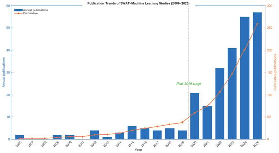
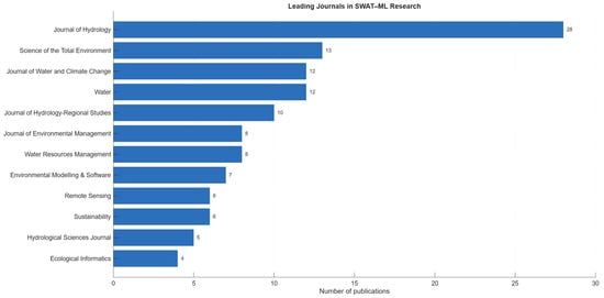
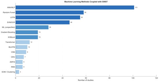
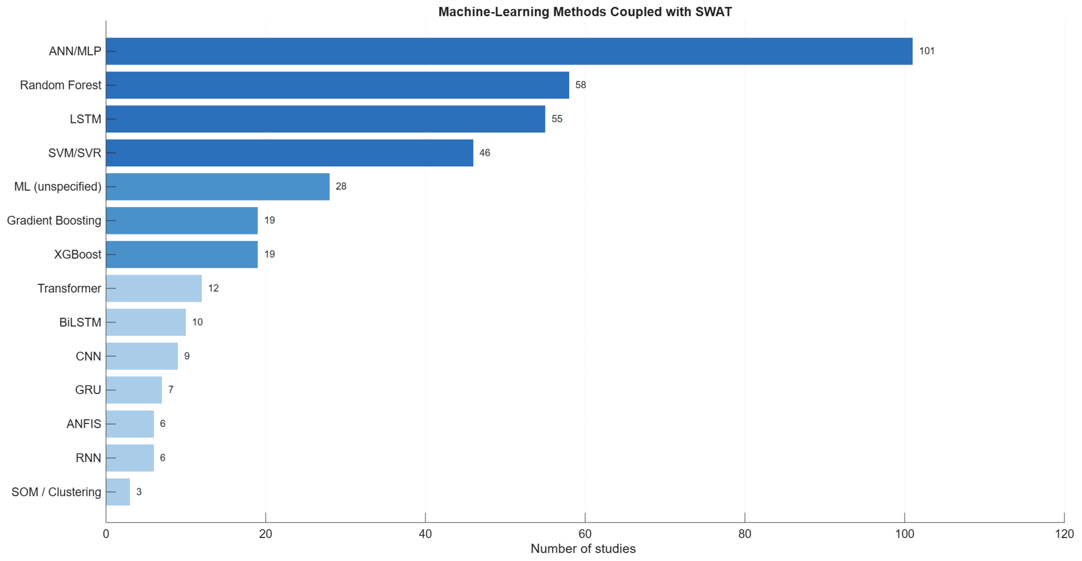
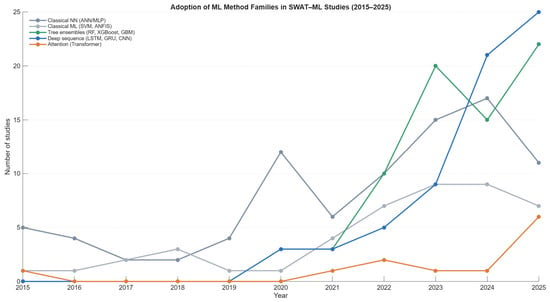
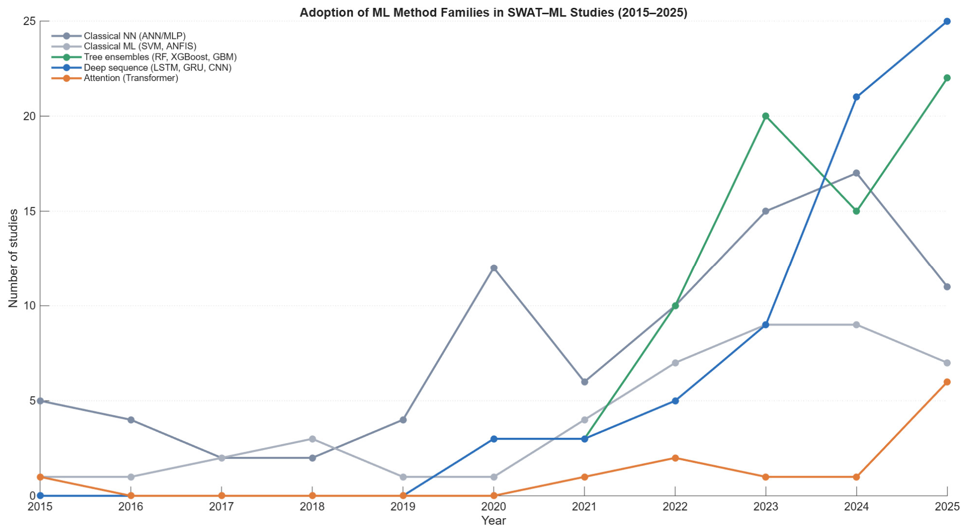
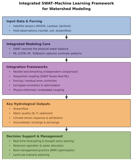
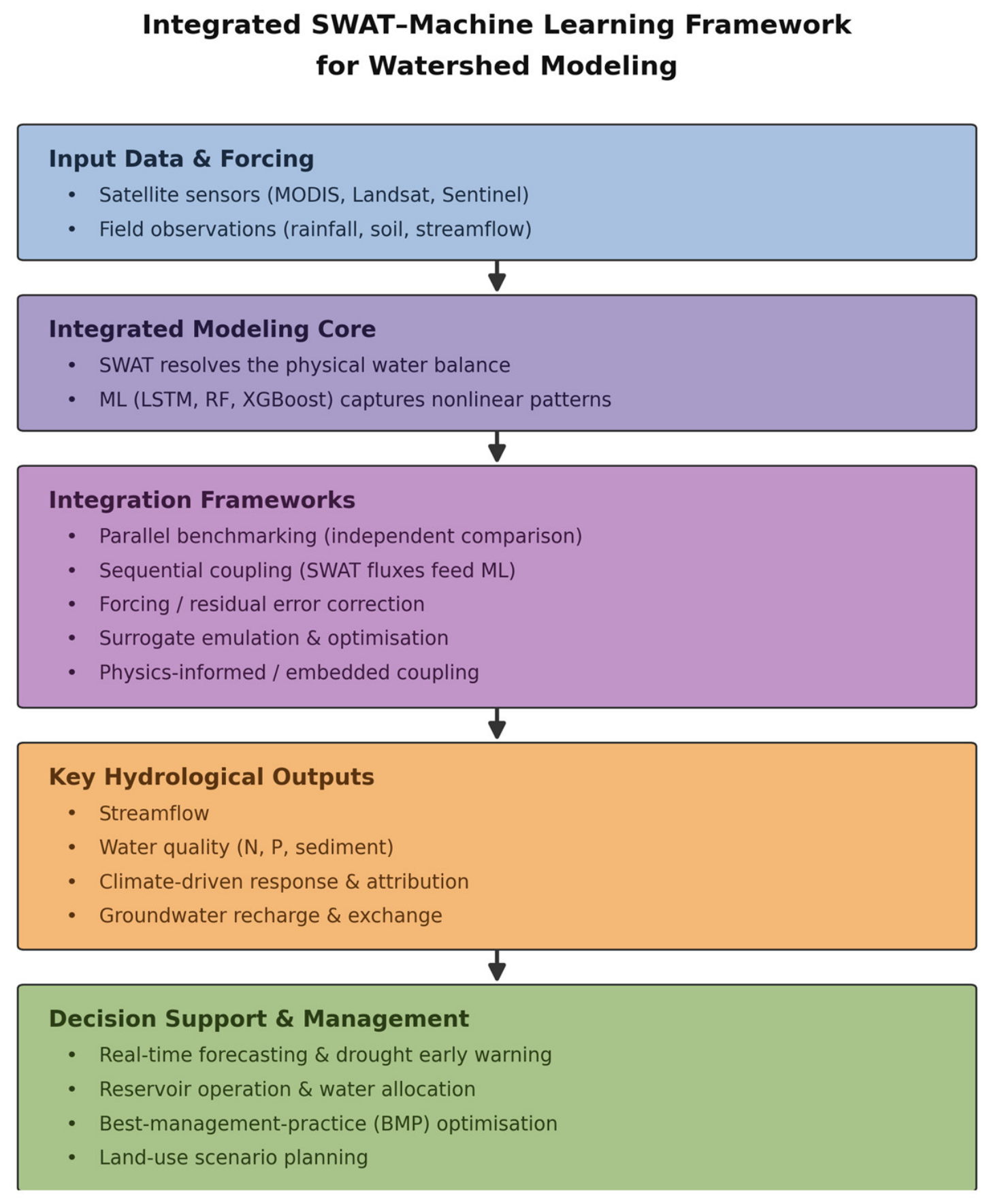
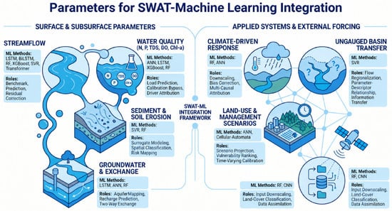
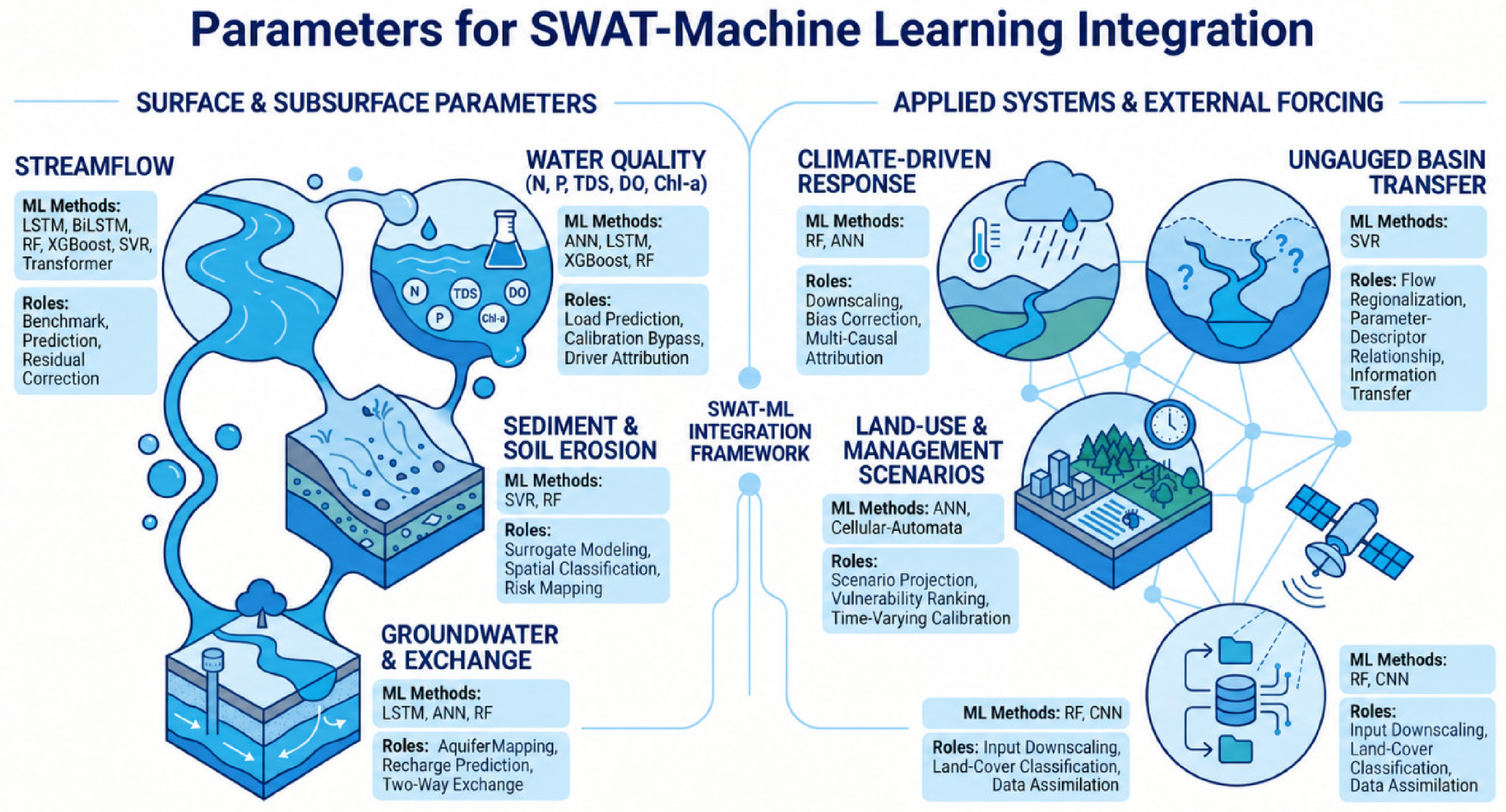
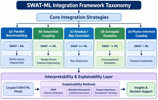
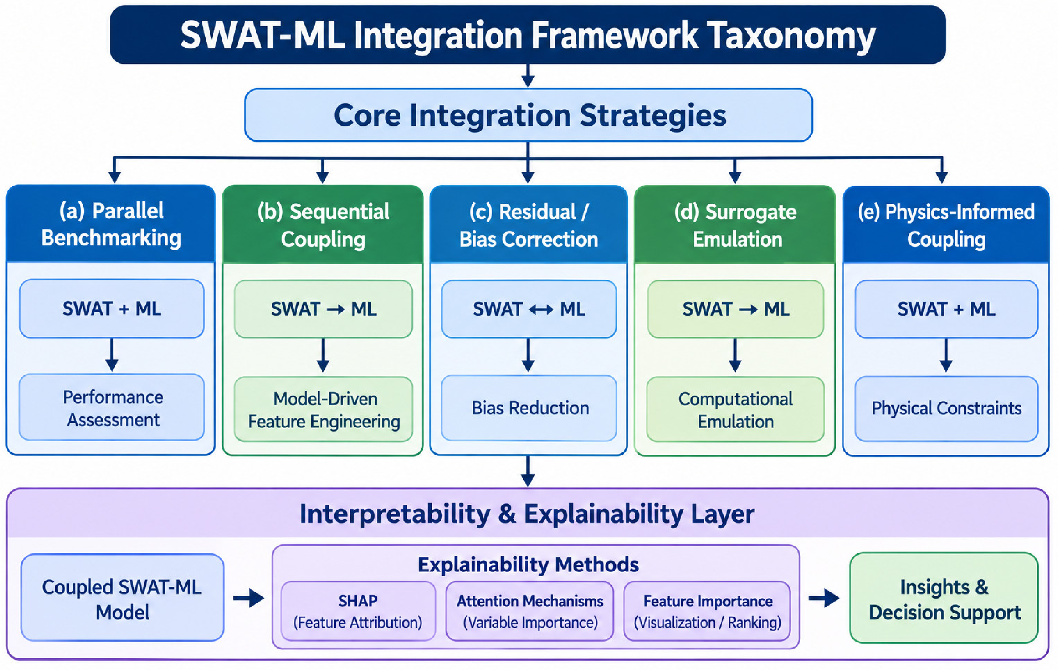
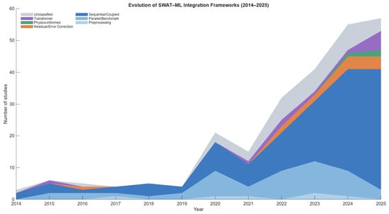
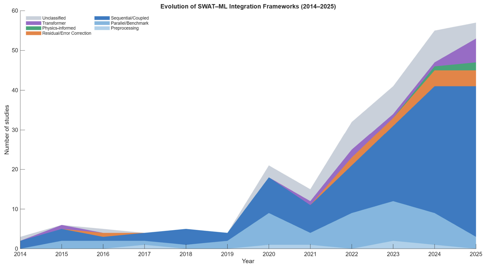
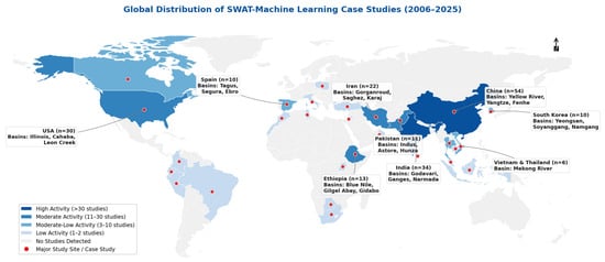
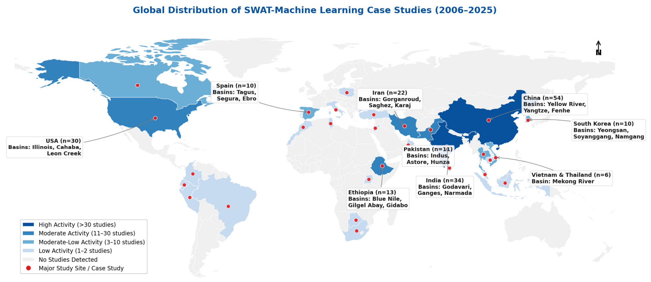

Disclaimer/Publisher’s Note: The statements, opinions and data contained in all publications are solely those of the individual author(s) and contributor(s) and not of MDPI and/or the editor(s). MDPI and/or the editor(s) disclaim responsibility for any injury to people or property resulting from any ideas, methods, instructions or products referred to in the content. |
© 2026 by the authors. Licensee MDPI, Basel, Switzerland. This article is an open access article distributed under the terms and conditions of the Creative Commons Attribution (CC BY) license.