


Abstract
The Erzgebirge, located in Germany (Saxony) and the Czech Republic (Bohemia), is of particular importance for the economic and territorial history of Central Europe, as well as for the development of mining technology and science on a global scale. At the same time, the region’s long history of intensive mining and other industrial activities is an extreme example of human impact on a mountain landscape. This paper summarises approximately 40 years of research across various disciplines, such as mining history, archaeology, geography, botany, and geochemistry, on the regional environmental history of the last millennium. The analysis of this well-developed yet widely scattered knowledge base was carried out in relation to three fundamental research questions, i.e., the impact of the environment on humans, the impact of humans on the environment, and human perceptions of the environment. The results are presented in specific topics, covering rural and mining-driven urban colonisation, the environmental consequences of mining and metallurgy and their impact on water, forest, soil and human health, as well as the effects of war. A summary of the region’s distinctive creative achievements in technology, science, economics, and the arts, resulting from its involvement with mining and the environment, rounds off the picture. This review demonstrates how phases of mining booms have repeatedly alternated with phases of environmental recovery, mostly occurring during economic downturns. Recovery from even the worst environmental disasters in the region to date, intensive uranium mining and widespread forest dieback during the second half of the 20th century, has been successful.
1. Introduction
On and beneath a rather inconspicuous terrain surface of the Erzgebirge (Czech: “Krušné hory”, English: “Ore Mountains”; Figure 1), remarkable things—both tangible and intangible—have unfolded over the centuries. Since 2019, the remains of these are protected by UNESCO as the “Mining Cultural Landscape Erzgebirge/Krušnohoří” World Heritage Site [1,2]. Moreover, the intellectual roots of mining sciences, geosciences, forestry sciences, as well as the concept of sustainability were established here between the 16th and 19th centuries and are part of the global scientific legacy [3,4,5]. This aspect of regional history is thus an accepted and carefully maintained heritage, the centre of regional identity and also shapes parts of the external perception of the Erzgebirge [6,7]. On the other hand, large parts of this landscape are devastated, i.e., heavily impacted by the effects of past mining, metallurgy and other industrial activities. On and below a seemingly idyllic surface lie the partly dangerous traces of almost a millennium of industrial history. The turbulent 20th century, in particular, left strong devastation in the landscape with depopulation, uranium mining and extreme environmental pollution, leading to widespread forest dieback [8,9,10].
Figure 1.
Map of the Erzgebirge and the surrounding area based on a digital elevation model (map background: www.openstreetmap.org, Creative Commons Zero CC0). Clearly visible are the gentle slopes of the mountains towards the north-west in Saxony, the plateau-like crest area along the border, and the steep slopes towards the south-east in Bohemia. Also shown are the main rivers and towns, most of the locations mentioned in the text, as well as the largest reservoirs and the highest tops in the western, central and eastern parts of the mountain range.
At first glance, many of the current features of this landscape seem contradictory and can only be understood in a historical context. For example, when walking across the wide mountain plateaus at ca. 800–1000 m a.s.l. on the Bohemian side, where the landscape is partly open and partly covered with spruce forest, the area appears very natural, harsh and, in a sense, somewhat “Nordic” or “subalpine” (Figure 2). It is difficult to imagine that until the mid-20th century, this scenery was largely a densely populated open landscape dominated by scattered houses amidst pastures, meadows and fields, and before that, in the Middle Ages and Early Modern Period, the area was even a bustling mining and industrial setting [11,12,13,14].
Figure 2.
Example of fundamental change to the landscape on the Bohemian side of the Erzgebirge over the 20th century. The figure shows the area of Hirschenstand/Jelení village, founded in the 16th century, and located in a flat valley on the crest plateau of the western Erzgebirge, at an altitude of ca. 860 m a.s.l. (a) The village in 1927 (© Bayerisches Hauptstaatsarchiv/Rupert Fuchs, 11606). At that time, Hirschenstand had ca. 900 inhabitants and there were large open areas used for agriculture. After 1945, the German population was expelled and the village, except for a few houses, was demolished. (b) The same site in November 2025 (photo: Knut Kaiser). At first glance, there is nothing to suggest that this was once a settlement. However, overgrown foundation walls, embankments and even mine adits tell a different story. (c) The Hirschenstand/Jelení area in an oblique aerial photograph from 2011, looking northwest (© Jiří Jiroušek). Monocultures of spruce dominate the landscape and the open patches are used for grazing at times. This valley is considered the coldest place in the Erzgebirge. The lowest temperature ever recorded in Jelení was −38.6 °C on 6 February 2012. Nevertheless, it was once a lively location.
Generally, the Erzgebirge has a very special signature in terms of the historical anthropogenic impact on a mountain environment, both in Central Europe and globally. Hardly anywhere else has a relatively small and low mountain range been so strongly affected for almost a millennium by rural and urban colonisation, industrial activities, including mining, metallurgy, glass production and other manufacturing, water management, and nearly complete deforestation followed by later widespread reforestation [15,16,17,18]. The toponym itself clearly reflects the historical focus on mining [19]. In Central Europe, in particular, there are several low mountain ranges that were intensively used for mining, partly since prehistoric times. These include the Harz Mountains, the Vosges, the Black Forest, the Upper Palatinate Forest, the Sudetes, the Bohemian-Moravian Highlands or the Slovak Ore Mountains [20,21,22,23,24,25,26]. However, in addition to its tremendous ore wealth, the Erzgebirge also had other favourable aspects that led to its extreme exploitation in the past [27]: relatively simple topography and thus accessibility, belonging to politically, economically and culturally extremely powerful territories, namely the Electorate of Saxony and the Kingdom of Bohemia, rich energy resources in the form of—seemingly infinitely available—wood and water, risk-taking investors, great regional innovation in technologies, administration and early forms of science. And, last but not least, a growing population that was able to intensively exploit its environment over centuries and through periods of depression—thereby fundamentally changing it repeatedly.
A closer look at the environmental history of the Erzgebirge “uplifts” some astonishing and ultimately perhaps hopeful and encouraging facts—to use a metaphor inspired by mining. This can be summarised in terms of “resilience” and “recovery”—hence the latter being included in the title of this paper. Every economic boom in the Erzgebirge and its surroundings was associated with extreme consequences for the environment, in particular, deforestation and pollution of the soil, water and air. During the respective boom phases, it would have been inconceivable for the local population, at least temporarily, that the economic boom on the one hand and the negative environmental consequences on the other could change so soon. In fact, the region’s industrial history and the associated environmental impact were an up-and-down of economic upturn and downturn, and environmental degradation and recovery. Even recovery from the worst environmental disasters in the region to date, uranium mining from the 1940s to the 1990s and forest dieback from the 1960s to the 1990s [8,10,28,29], has been successful, leaving hardly any visible traces—at least at first glance.
The intention of this paper is to present an overview of the current state of research on the truly impressive environmental history of this region over the past millennium. The idea to write such a review at this very moment stems, on the one hand, from the enormous growth in thematic knowledge over the past four decades, particularly with regard to the long-term perspective covering centuries. The timing is now right to gather and examine this knowledge, which is spread across a wide range of disciplines and exists in a veritable “Babylonian” multitude of languages—German, Czech and English—and to summarise it systematically in one single article and one language. On the other hand, the recovery following the most recent period of environmental disaster has now progressed to such an extent that it is worth reflecting on the past before the gloomy details and relationships of this period perhaps fade from our consciousness once again. Generally speaking, a chronologically and thematically complex perspective on the environmental history of the last millennium that is directly linked to the present has so far been lacking in the Erzgebirge, as in other mountain ranges in Central Europe.
Furthermore, given the region’s continuing rich deposits of “critical raw materials” [30,31], the Erzgebirge could see the next “Berggeschrey” (old German term for “mining rush/boom”; [32]) in the very near future. Here too, it is reasonable to systematically consider the consequences of centuries of excessive resource exploitation on the regional environment, to understand both the vulnerability and resilience of this landscape through historical examples, and to take this knowledge into account in responsible decision-making of the present day.
2. Methodological Background and Regional Knowledge Base
Environmental history is a multidisciplinary scientific field with many thematic, spatial and temporal facets, e.g., [33,34,35,36]. In fact, although academically dominated by history (“the mainstream”), other subjects also contribute, such as climate history, agricultural history, historical geography, forest history, and the history of technology (“the tributaries”). Further scientific disciplines, such as ecology and archaeology, have also developed their own discipline-specific approaches to past environments and landscapes, referring to these as historical ecology and environmental archaeology, respectively. Each of these has numerous subfields [37,38]. To clearly state my main academic focus, I am a physical geographer conducting research on landscape and forest history, geoarchaeology, soil science, and geomorphology in the Erzgebirge and beyond.
Following [39], the field of environmental history can be visually conceptualised, in terms of its fundamental research questions, as a ternary plot with three dimensions: “(natural) impact” (How does the environment influence humans?), “use” (How do humans influence the environment?) and “perception” (How do humans understand the environment?). The latter also includes the history of science and ideas as a subtopic, as well as, if the focus is broadened, humans’ creative engagement with landscape, technology, the economy, and the social environment. Consequently, specific topics are scattered across this plot, varying in their affinity to these fundamental questions. All of these topics also play a role in the environmental history of a mining-dominated mountain region over the past millennium, as presented here. Accordingly, this review adopts a very broad methodological approach, drawing on published data and, therein, interpretations from natural archives, physical evidence, documentary sources, early scientific works, monitoring data, and statistics. Overall, therefore, it represents an integrative interdisciplinary approach, presenting the findings in a narrative form.
The chapter structure of this paper follows, on the one hand, many of the common topics dealt with in similar projects focusing on specific landscapes (e.g., [40,41,42]), such as settlement and agriculture (i.e., colonisation), industry (i.e., here primarily mining and metallurgy), waterscapes, forests, soil, and health. However, it also includes aspects that are otherwise rarely addressed from an environmental-historical perspective, such as the effects of war and modern forest dieback, which is a phenomenon specific to the region. The second-to-last chapter in the presented “Theatrum mundi”—metaphorically naming the Erzgebirge as a “small stage”—then leads directly into the present, addressing the consequences of modern climate change that are already becoming apparent.
However, partly given the lack of specific data, it is simply not possible to address all the topics that would actually be desirable from a regional perspective. This concerns changes in biodiversity, for example, due to the intentional or unintentional eradication of animals and plants, the introduction of taxa, or further consequences of land-use practices. Data on the historical climate and its consequences are also insufficient for the Erzgebirge region. In some cases, the focus had to be limited to specific aspects, such as the impact of industrial development. Here, the focus is inevitably on mining and metallurgy. The environmental impacts of other industries in the region during the 19th and 20th centuries, such as textile production and mechanical engineering, or the effects of municipal and infrastructural development, will not be covered.
A remarkable early precursor to the environmental history of the Erzgebirge is the monograph “Das Landschaftsbild des Erzgebirges unter dem Einfluss des Erzbergbaus” from 1941 (“The landscape of the Erzgebirge under the influence of ore mining”; [43]). Focussing primarily on mining and, of course, limited by the state of knowledge at the time, this work deals with regional landscape dynamics from the Middle Ages to the early 20th century, analysing aspects such as natural prerequisites, mining operations, water management, settlement, agriculture, and forestry, as well as population development. The mining periods—that is, the ups and downs of the regional economy and their specific impacts on the landscape—are also outlined here. The long-standing research into regional mining history, which also addresses questions of environmental impact, culminated at the end of the 20th century in monographs on historical mining in the Freiberg Mining District [15] and in the rest of the Saxon Erzgebirge [16].
Political change in the former GDR and ČSSR in 1989/1990 marked the beginning of a period of intensive research and publication on the tremendous environmental consequences of excessive resource exploitation in the second half of the 20th century, including uranium and lignite mining, air, soil and water pollution, and widespread forest dieback. This has been accompanied, to this day, by intensive monitoring programmes involving fields such as geochemistry, forestry, hydrology, soil science, biology, and nature conservation. As environmental data were practically unavailable under the previous socialist regimes, the extent of regional environmental destruction, which was now becoming publicly visible for the first time in decades, came as a shock [44,45,46]. Following the political change, research into the long-term environmental history of the Erzgebirge also intensified [47].
A general characteristic of research in this field is the strong sub-regional perspective, due to the political and language division of the region, i.e., a focus on either Saxony or Bohemia. Consequently, many thematic publications are available “only” in German and Czech. This is mainly due to the long-standing research territories and tasks of academic institutions, such as forest and environmental sciences, as well as the responsibilities of state authorities, particularly with regard to archaeology and the environment. The willingness to adopt a cross-regional perspective has so far been only weakly developed. Although this nationally determined division still exists, it is gradually diminishing as a result of bilateral or multilateral projects. Particularly since the Czech Republic became a member of the EU in 2004, and given the changed framework conditions in many academic disciplines, joint projects and the publication of research outcomes in English are on the rise.
This paper is based on a wide range of publications, most of which are rather recent, i.e., dating from after 1990. Due to space constraints, only the most suitable references from a very large material basis can be cited here. Comparisons with other low mountain ranges in Central Europe similar to the Erzgebirge could only be made to a very limited extent.
3. Regional Settings
The following section outlines some important facts that characterise this landscape, covering both its natural features and its historical and economic development. Further details on aspects such as the development of settlement, mining, waterscapes, forests, and soils are presented in the following chapters.
Identified in early medieval sources as “Miriquidi” (also “Mircwidu”; Old Low German for “dark forest”), the area was referred to as “Böhmerwald”, “Böhmischer Wald or “Böhmisches Gebirge” in the High and Late Middle Ages up to the Early Modern period [19]. It was not until the end of the 16th century that the term “Erzgebirge” emerged, referring to the area’s ore mining character [48]. For centuries, the mountain range has formed a natural border between the territories of Saxony and Bohemia, characterised by dense forests until the High Middle Ages [49,50,51].
The Erzgebirge has a larger Saxon part (3660 km2, 69%) and a smaller Bohemian part (1640 km2, 31%) with a total area of ca. 5300 km2. The around 150 km long and 40–50 km wide mountain range extends from the Elbsandsteingebirge/Labské pískovce in the northeast to the Elstergebirge/Halštrovské hory in the southwest [52] (Figure 1). The Erzgebirge is a Hercynian fault-block structure with a steep and high escarpment in the southeast and a gentle slope in the northwest. Metamorphic rocks (mainly gneiss) dominate, supplemented by plutonites, volcanites and sediments [53,54]. Plateaus with deeply incised and terraced valleys that follow the northern slope of the mountains characterise the area. The crest region, in particular, has wide flat or only gently sloping areas. The highest peaks are the Keilberg/Klínovec (1244 m a.s.l.) and the Fichtelberg (1215 m a.s.l.) in the central part of the range (Figure 1). Periglacial debris layers with a high proportion of loess cover almost the entire Erzgebirge and predominantly form Cambisols, Podzols and wet soils. Extensive peatlands are widespread in the crest area and form raised bogs (i.e., rain-fed mires) and swamp mires.
The Erzgebirge belongs entirely to the Elbe/Labe River catchment, with the mountain crest separating the Mulde from the Eger/Ohře sub-catchments. The Zwickauer Mulde and Freiberger Mulde are the main rivers in the north, while Chemnitz, Zschopau, Flöha, and Weißeritz are the most important tributaries (Figure 1). In the south, by contrast, there are only short streams with steep bed gradients [55]. The mountain range’s hydrological system has been extremely altered by human impact since the Middle Ages, including the construction of a large number of reservoirs (dam lakes). Most of these were built during the 20th century [56].
Due to the mountainous topography, the Erzgebirge shows strong vertical meteorological contrasts as well as horizontal climatic differentiation between a wetter western part and a drier eastern part [55]. Annual average temperatures decrease from 7.9 °C at the edge of the mountains at Chemnitz to 2.9 °C on the Fichtelberg in the interior, whilst average annual precipitation increases from 702 mm to 1121 mm (www.dwd.de), respectively. The crest region has a harsh climate with rather low temperatures, high precipitation, prolonged snow cover, and strong winds.
Until the Middle Ages, the Erzgebirge was covered with native forests, with the exception of peatlands, floodplains along the rivers and small screes [57]. These mixed mountain forests consisted of oak-beech forest (submontane level, ca. 300–500 m a.s.l.), fir-beech-spruce forest (montane level, ca. 500–900 m a.s.l.) and beech-spruce forest as well as spruce forest (high-montane level, ca. 900–1200 m a.s.l. [58]). Currently, spruce monocultures dominate at all altitudinal levels (Figure 2c). Overall, 60% of the land cover on the Saxon side is predominantly open, the largest area being intensively used for agriculture and forestry, and densely populated and industrialised, especially in the stream and river valleys.
The legendary abundance of mineral resources in this region [59] formed the basis of its industrial development from the second half of the 12th century onwards. Initially developing alongside rural colonisation, mining and metallurgy became the dominant economic sector in the 16th century, a development which also triggered the intensive foundation of towns [60]. By around 1538, the Erzgebirge accounted for about 50% of European silver production [61]. Over the last millennium, several ore mining periods can be distinguished in the region, taking into account the exploited mineral resources (primarily silver, tin, iron and uranium, further lead, cobalt, bismuth, copper, and others) and the economic situation [1,16,62]: 1st Period 1168–1450, mainly silver and tin mining with decline in the 14th century; 2nd Period 1450–1620, mainly silver and tin mining; 3rd Period 1620–1750, decline of mining; 4th Period 1750–1850, intensive mining, primarily for silver; 5th Period 1850–1945, decline of mining; 6th Period 1945–1990, uranium and tin mining; 7th Period 1990–1992, decline of mining; 8th Period 2011–present, intensive exploration for mineral deposits, primarily for lithium.
Alongside mining, the textile and woodworking industries developed in the 16th century. In the 19th century, a large-scale textile and mechanical engineering industry emerged, particularly around the edge of the Saxon Erzgebirge [63]. The 19th and 20th centuries were characterised by further industrialisation: hard coal mining on the edge of the Saxon mountains from around 1850 to 1978, uranium mining from 1945 to 1990 in Saxony and Bohemia, and lignite mining on the edge of the Bohemian Erzgebirge from around 1870 to the present day [10,64,65]. The last few decades have been characterised by a strong deindustrialisation. There is currently no considerable ore mining left in the Erzgebirge. Overall, the stages of increasingly intensive early industrial development led to a high population and settlement density as well as a dense infrastructure network, including railway and power supply lines, roads and pipelines, particularly on the Saxon side.
4. Prehistoric and Protohistoric Prelude
Until a few decades ago, it was generally assumed that notable human activity in most low mountain ranges in Central Europe only began during the High Middle Ages, as part of their rural colonisation and deforestation, and often also mining. However, this view has since changed due to the discovery of numerous records of at least local prehistoric activities such as hunting, transport of goods, mining, and livestock grazing in several mountain areas, e.g., [66]. Although evidence from the Late Palaeolithic, Mesolithic and Neolithic periods also exists, e.g., [67], most of the evidence in this region dates to the Bronze and Iron Ages.
This also applies to the Erzgebirge. Only recently, artefacts and ground features were discovered in the western Bohemian part near Horní Blatná, at an elevation of 840 m a.s.l., which indicate Late Neolithic (3600–3100 BC) metabasite quarrying for the production of stone axes [68] (Figure 1). In the eastern Saxon part near Freiberg, at an altitude of 510 m a.s.l., Late Neolithic artefacts dating to around 2800–2200 BC were also found [69]. Geoarchaeological evidence has recently been obtained for the Saxon sites of Schellerhau (740 m a.s.l.) in the eastern Erzgebirge near Altenberg and Sauschwemme (900 m a.s.l.) in the western Erzgebirge near Johanngeorgenstadt, indicating tin placer mining—that is, the exploitation of eluvial and alluvial tin deposits (cassiterite, SnO2) from the Early Bronze Age to the Hallstatt period, i.e., ca. 2000–500 cal BC [70,71] (Figure 1). Prehistoric tin mining in the Erzgebirge was probably of utmost importance for bronze metallurgy in Central Europe, thereby complementing the few other tin deposits in Western Europe, including Cornwall, Devon, Brittany, the Massif Central, and Galicia. Geochemical and palynological evidence of local mining and metallurgy in the Bronze, Early Iron and Roman Ages is also available from the Bohemian Erzgebirge above 850 m a.s.l. [72,73]. However, there are as yet no archaeological sites in the surroundings. Also generally seen, archaeological finds—the common indicator of local prehistoric activity—have so far been rare, although they are not absent from the Erzgebirge. They are concentrated primarily along some river and stream valleys, at lower mountain passes and on the steep south-eastern slopes of the mountains up to almost 700 m a.s.l., and date mainly to the Neolithic, Bronze and Iron Ages. They have primarily been interpreted as evidence of seasonal use, for example, for hunting and transit, rather than as evidence of permanent year-round presence [12,74,75].
A historical feature of the Erzgebirge is mountain-crossing trails (“Böhmische Steige”/Bohemian trails), which are first mentioned in sources of the Early Middle Ages, i.e., in the 9th–10th centuries [13,76]. These trails connected what is now Central Germany with the Bohemian Basin, and were used for various purposes, including the salt trade. It is likely that these transit routes were already in use, at least in part, in prehistory, i.e., from the Neolithic or Bronze Age onwards [75]. They complemented the nearby Elbe/Labe valley, forming the main supra-regional transport corridor. For the Early Middle Ages, there are also only a few finds in the upper Erzgebirge at present. However, these isolated finds, rare Slavic place names at altitudes of up to 600 m a.s.l. and a growing number of radiocarbon dates from geoarchaeological contexts indicate that there was at least some local settlement and economic activity, including mountain-crossing transit during this period [77].
In summary, it is possible to outline the impact of prehistoric and early medieval activities on the environment. Of course, one must take into account the fact that research into the very early settlement of the Erzgebirge is still in its initial stage. Nevertheless, in contrast to the intensively developed prehistoric cultural landscapes of the neighbouring lowlands (e.g., present-day Central Germany [78]) or other mountain ranges (e.g., the Alps [79]), a considerably more localised, i.e., patchy to corridor-like, human impact is already discernible. At the (very small-scale?) sites of Neolithic metabasite quarrying as well as Bronze Age and Iron Age tin mining and metallurgy, local surface mass movements, forest clearing/deforestation and geochemical changes, particularly in the soil, played a role. Along paths, the forest was at least thinned out and soil erosion took place. Remarkably, some of the early transport routes have survived from the Middle Ages to the present day in the form of roads and railway lines. There would have been small seasonal settlements in the mountains up to the higher altitudes, which served as shelter for miners, smelters and travelling people. It is also likely that there were local forms of very extensive agriculture here, at least in the form of grazing horses and livestock.
5. Rural Colonisation: Agriculture Fundamentally Changes the Mountains
Until the beginning of the 12th century, the Erzgebirge was a largely natural forest landscape, though apparently not impenetrable and probably not without very local signs of land use. A few (semi-) permanent settlements and small agricultural plots may have been concentrated in lower-lying areas and along the Bohemian trails. In the second half of the 12th century, as part of the general settlement development in eastern Central Europe at that time, i.e., “Landesausbau” (inland colonisation) and “Deutsche Ostsiedlung” (i.e., medieval German eastward migration [80]), the rural colonisation of the Erzgebirge took place. This was a focused and rapid process, initiated by the Staufer kings and their vassals in the western and central part and by the Margraves of Meissen in the east. From the south, the Bohemian dukes, later kings, also drove forward the colonisation. Various dated castles and villages—mostly in the form of so-called “Waldhufendörfer” (forest villages; Figure 3)—represent this phase. In addition, market places and towns were founded in and around the Erzgebirge (e.g., Zwickau ca. 1150, Freiberg ca. 1170, Chemnitz ca. 1171/74) as well as monasteries (e.g., Chemnitz 1136, Altzella 1162, Zelle/Aue 1173, Ossegg/Osek 1192). The rivers and Bohemian trails served as corridors during colonisation. Settlement apparently took place in a single wave and had reached both sides of the mountain ridge by around 1200 [11,12,13,81,82].
Figure 3.
A characteristic landscape scene in the central Erzgebirge near the mining town of Annaberg-Buchholz in winter (view to the southeast; © Norbert Weichel). The area is densely populated and largely open with a multitude of hedges and small woodlands. In the centre of the image is a typical forest field system that originated in the Middle Ages. The narrow fields, bordered by hedges, run up a slope at right angles to the axis of the forest village (“Waldhufendorf”) of Tannenberg, which lies in a stream valley. In the background, in the centre of the image, is the partially forested Pöhlberg (831 m a.s.l.), with Annaberg-Buchholz at its foot on the right.
The process of colonisation involved the extension and construction of new trails and roads, large-scale deforestation, establishing villages, including churches, the construction of fortifications and functional facilities such as water mills, as well as the ploughing and further shaping of agricultural land. The dense forests gave way to an open countryside, which was particularly pronounced along the valleys. However, there were probably still larger forest areas between the open land during the early colonisation period. Not all settlements established during this period survived, as evidenced by several deserted villages dating from the 14th–15th centuries [62].
Changes in vegetation structure and land use always fundamentally alter a mountain landscape [83]. In the Erzgebirge, the high medieval deforestation followed by ploughing led to numerous environmental effects, such as escalating soil erosion on slopes and corresponding sediment accumulation in stream and river floodplains (valley siltation), the formation of stone walls and terraced fields, changes in the water balance and the meso- and microclimate, as well as changes in fauna and flora due to tree felling, habitat loss, hunting, and the introduction of cultivated plants and domestic animals [18,84,85,86]. In general, the matter and energy balance of the mountains changed suddenly and intensively. This event, characteristic of high medieval landscape change, can be tracked in a multifaceted way through recent geoarchaeological findings. These include records of contemporary forest clearing horizons, floodplain deposits and charcoal hearth sites [87,88,89]. The remaining forests were used for timber extraction and grazing, as well as for numerous glassworks and other forest-based industries, and gradually became smaller [70].
6. Urbanised Mountains: Mining Towns
Mining towns, i.e., urban-industrial settlements endowed by the sovereign with special rights, administrative structures and tax regulations, and, of course, with mining as their main economic focus, are a characteristic feature of the Erzgebirge. Although they also exist in other low mountain ranges in Central Europe, such as the Harz, the Black Forest, the Sudetes, and the Slovak Ore Mountains, nowhere else are there as many as in the Erzgebirge [16,90,91,92]. They, therefore, have a major past and present impact on this landscape. There are 38 known mining towns on the Saxon side, with the main founding phase taking place during the 15th and 16th centuries, when 26 towns were established. The rest are spread across the 12th/13th, the 14th, as well as the 17th and 18th centuries. On the Bohemian side, there are 24 mining towns. Twenty of these were founded in the 16th century and the rest in the 15th and 17th centuries. The altitude of these towns varies depending on the different topography of both sides of the mountains. The average altitude in Saxony is around 500 m a.s.l. and in Bohemia around 700 m a.s.l. The highest town in northern Central Europe, in general, is Gottesgab/Boží Dar on the Bohemian side, located on the mountain crest at 1028 m a.s.l. and designated a mining town in 1546.
Most of the mining towns were founded during the second mining boom in the region, often in topographically exposed locations (e.g., Marienberg in 1523 and Platten/Horní Blatná in 1548; Figure 4). In some cases, Christian saints were the named patrons (e.g., Annaberg, Marienberg, Sankt Joachimsthal/Jáchymov). The most important mining towns in terms of population, and renowned for their scientific, educational and further cultural contributions, were Annaberg (1550: ca. 12,000 inhabitants) and Freiberg (1550: ca. 9200 inhabitants) in Saxony and Sankt Joachimsthal/Jáchymov (1533: ca. 18,000 inhabitants) in Bohemia [93]. However, small mining towns with a few hundred to a thousand inhabitants dominated. The design of early modern mining towns was partly based on the architectural ideal of the Renaissance planned town, encompassing a network of perpendicular streets, i.e., a grid plan [91,92] (Figure 4). The population of the towns fluctuated in response to the economic situation and generally declined by the end of the 20th century at the latest, particularly in Bohemia. Two mining towns were partially or completely demolished in the 20th century for economic reasons: Johanngeorgenstadt (1957/58) and Preßnitz/Přísečnice (1973/74; see Section 12), respectively.
Figure 4.
Examples of mining towns in the Erzgebirge that are almost the same age, but vary in size. (a) Oblique aerial view of Marienberg in Saxony (620 m a.s.l.), founded in 1523 (© Uwe Meinhold). The town is a very early example of a planned Renaissance town in Central Europe. Characteristic features include the rectangular street grid, the dominant but decentrally located main church of St. Marien and the very large market square covering 1.8 ha. Around 1550, Marienberg had around 6000 inhabitants, roughly the same number as today in the immediate urban area (political municipality 2024: ca. 16,000 inhabitants). (b) Oblique aerial view of Platten/Horní Blatná in Bohemia (900 m a.s.l.), founded in 1548 (photo: Karel Kuča, CC BY-ND). The main church of St. Laurentius is located on a market square surrounded by a rectangular street grid. Not all plots of land have been developed. The surrounding rural area borders directly onto the centre of this small town, which had a maximum population of about 3000 in 1900 but only 350 inhabitants remained by 2021.
Together with non-mining towns, villages and scattered agricultural and industrial settlements, including smelting works, hammer mills and grain mills, the Erzgebirge have had an extremely high settlement and population density for a low mountain range since the Middle Ages. Whether the Erzgebirge was actually the most densely populated mountain area in the world until 1947, as stated by Mikšíček [94], can only be considered a hypothesis due to the lack of reliable numbers for the whole area since the Middle Ages. However, studies on population geography prior to World War II do indeed reveal an exceptional settlement and population density [95]. A direct consequence of this urbanisation for the environment since the Middle Ages has been the locally concentrated very high demand for timber and fuel, resulting in deforestation, and urban and industrial pollution originating from mining towns. An intensively used, urban-industrial-agricultural landscape with pollution hotspots and drastically declining wood resources thus becomes apparent [96,97].
7. Under and Above Ground: Environmental Consequences of Mining and Metallurgy
Extensive mining and metallurgy both have a severe environmental impact. This was the case for the Erzgebirge around 500 years ago [98,99] and remains valid worldwide to this day [100,101]. The environmental consequences generally depend on the mineral resources used, the technologies employed and the intensity of production. Mines produce large quantities of waste, as ore accounts for only a minor proportion of the total volume of material extracted. Metal smelting and refining generate gaseous and particulate emissions, wastewater and solid waste. Ultimately, this affects the biosphere, including humans. The environmental consequences are represented in the so-called “metallurgical chain”, including surface and underground landscape changes, deforestation, air and water pollution as well as soil contamination [102].
Medieval ore mining in the Erzgebirge began in 1168 with the discovery of near-surface silver deposits in Freiberg. A total of 6200 t of silver, 82,500 t of tin and 87,000 t of bismuth and cobalt ore were extracted on the Saxon side alone by 1900 [16] (p. 102). Uranium mining in Saxony yielded 86,000 t of uranium between 1946 and 1990 [103]. These enormous production numbers are based on an equally enormous volume of extracted rock and thus underground cavities—which were created by an immense number of miners (e.g., ca. 9000 in Sankt Joachimsthal/Jáchymov in 1533, ca. 7500 in Freiberg in 1850 or ca. 100,000 [!] temporarily in the late 1940s/early 1950s in the western Erzgebirge). By 1900, the total length of the most important adits in the Saxon Erzgebirge amounted to ca. 400 km [15,16,104]. To date, there is no overall estimate of the lengths of the adits and shafts or further cavities in the Erzgebirge. However, impressive levels of detail are available for some mining districts. For example, the 150 km2 large Freiberg district has almost 950 shafts and 400 adits with depths of up to 700 m. The minimum shaft spacing here is 20 to 50 m, resulting in a very dense and, in some cases, currently quite dangerous network of cavities close to the surface [105]. While “normal” mining is already impressive, uranium mining in the Saxon Erzgebirge between 1946 and 1990 eclipsed everything that had gone before in terms of adit and shaft lengths (i.e., more than 4200 km) and shaft depths (i.e., max. 1800 m) as well as extracted rock volume and environmental impacts [106] (see also Section 12 and Section 13).
In addition to the underground cavities, there are some very large mining collapse structures (e.g., the “Pinge” in Altenberg; Figure 5), thousands of very small sinkholes a few metres wide, numerous open-cast mines, mainly for basalt, gravel, quartz, and limestone extraction, and finally thousands of spoil heaps (for the diverse and widespread structures of mine drainage that also still exist, see Section 8). Furthermore, there are large areas devastated by tin placer mining on the land surface, which cover a total of ca. 1200 ha on the Saxon side [107] and ca. 540 ha on the Bohemian side (K. Derner, Most, pers. comm.), totalling ca. 1740 ha. The mining structures generally correspond to the metallurgical facilities, which include stamp mills, smelting furnaces and smelting works. Although their number for the entire area is unknown, local mapping suggests that it is in the range of several hundred to a few thousand, e.g., [16] (pp. 76–83).
Figure 5.
Oblique aerial photograph of the mining collapse structure known as “Pinge” in the mining town of Altenberg in the eastern Erzgebirge (photo: Egbert Kamprath, CC BY-ND). This collapsed system of former underground tin mines is located at an altitude of ca. 750 m a.s.l. The first collapse to reach the surface occurred in 1545, with further collapses occurring until the present day [16]. Currently, the depression has a diameter of 400 m, a depth of 130 m and an area of 12 ha.
Over the centuries, mining and metallurgy have released a number of problematic, often toxic heavy metals into the water, air and soil (e.g., arsenic, lead, cadmium, copper, mercury, uranium, zinc), which remain a “toxic legacy/heritage” [26]. For example, a map of arsenic content in the topsoils of Saxony shows several extensive positive concentration anomalies in the Erzgebirge. The normal concentrations in soils, which are usually well below 20 mgkg−1 (ppm), are locally increased to more than ten times that level [108,109] (Figure 6). These anomalies, e.g., around Freiberg, Marienberg, Ehrenfriedersdorf, and Aue, correspond to historical ore processing and smelting sites. On the Bohemian side, too, local geochemical studies confirm heavy metal accumulation due to historic mining-metallurgical activities, e.g., [89,110]. Even today, old mines and waste heaps continue to release mainly liquid waste products into the environment [111]. Old mines, buildings and waste areas in this region are clearly exposed to the radioactive noble gas radon [112]. These issues are collectively referred to as the “eternal burdens” (“Ewigkeitslasten”) of mining, which will diminish only extremely slowly in the future or partly not at all.
Figure 6.
Map of Saxony showing the arsenic content of the topsoil; [109] modified. The northern parts of Saxony, i.e., the lowland areas, have low content levels, while the Erzgebirge generally has high levels, with extremely high levels in some areas due to past mining and metallurgy, such as around Freiberg, Altenberg, Marienberg, Ehrenfriedersdorf, and Aue (marked). There are also strikingly high arsenic levels in some river valleys, particularly in the River Mulde, east of Leipzig, which are due to long-distance transport from the Erzgebirge.
In the Erzgebirge, stream and river floodplains, ponds and peatlands, i.e., sediment-accumulating sinks, were particularly exposed to centuries of input from production waste in various forms, including heavy metals. The long-range effects of pollution with arsenic, lead, cadmium, uranium, and zinc, among other substances, extend a few hundred kilometres downstream along the Mulde River (Figure 6). Hotspots of element sources included mining and metallurgy centres in the Mulde catchment around Freiberg and Aue-Schlema on the Saxon side [113] and in the Eger/Ohře catchment area around Bleistadt/Oloví, Graslitz/Kraslice and Neudek/Nejdek on the Bohemian side [114]. Although they are actually fixed in the alluvial sediments, these pollutants can be partially reactivated from the sinks, e.g., through erosion during floods or other changes in the floodplains [115].
8. Creating Artificial Waterscapes
A combination of natural factors (specific meteorological conditions, extensive plateaus that collect vast amounts of precipitation and narrow, steeply sloping valleys) and human-induced landscape changes (high proportion of open land, extensive river engineering and intensive settlement of the valleys) has made the Erzgebirge a notorious hotspot for disastrous floods. Reports of destructive flash floods, including fatalities, have been recorded in this area for over 1000 years, typically occurring several times per century [116]. Over the last hundred years, the flood in August 2002 was of an extreme magnitude [117]. Although floods occurred naturally even before the onset of significant human impact in the region, i.e., before the second half of the 12th century, they were likely less intense and, moreover, affected largely uninhabited areas [84].
Over the centuries, the waterscapes of the Erzgebirge have transformed from a natural system to one that is extremely influenced by human activity. Water mills represent the earliest form of complex hydraulic structures in the region, featuring weirs, dammed watercourses/mill ponds, ditches, and water wheels. They were built first—as almost everywhere in northern and eastern Central Europe, e.g., [118,119]—during the high medieval colonisation period. In line with the at times high population density, water mills could also reach high numbers locally, as was the case in 1573 around Annaberg, where there are said to have been 65 mills within just one German mile (ca. 7.5 km) around the town [120]. As many elongated villages—and thus mill sites—were located in the valleys of the Erzgebirge, considerable eco-hydrological impacts along the watercourses are to be expected.
The intensification of silver ore mining at the end of the 15th and beginning of the 16th centuries resulted in severe anthropogenic changes to the waterscapes, comparable only to a few other early mining regions in Europe [121]. The transition to extensive underground mining, with shafts reaching depths of around 200 m, was made possible by new conveying technologies, particularly for water extraction, through the invention of the pump, the reversible waterwheel and the flatrod [15,16]. The energy required was supplied by hundreds of waterwheels distributed across the mountains, both above and within the mines (“water lifting water”). In addition, there were the energy and water demands of a large number of stamp mills, ore washing facilities and smelting works. In total, between the end of the 15th century and the mid-19th century, 280 km of surface water ditches, 29 km of underground water ditches/tunnels (“Röschen”) and 32 ponds/reservoirs were constructed, with the largest pond covering an area of 61 ha [15,16,54]. However, these numbers are only minimum estimates, as many ditches and ponds—particularly the smaller ones—in the Erzgebirge have not yet been systematically recorded. In some cases, water was diverted from one river catchment area to another. Between the 16th and 19th centuries, a highly complex mining water management system (the “Revierwasserlaufanstalt”/Freiberg Mines Water Management System) developed in the Freiberg mining district, which, to the features already mentioned above, also included an aqueduct, a navigation canal and a ship lift in the 17th–18th centuries [15] (pp. 62–72) (Figure 7). The “Rothschönberger Stolln”, a 51 km long and up to ca. 250 m deep water drainage adit built between 1844 and 1882, drained the district underground towards the Elbe River. Together, these features altered the spatial and temporal distribution of water in the landscape, the microclimate and the occurrence of aquatic organisms over the centuries.
Figure 7.
Silver medal from 1690 featuring the contemporary mining landscape along the River Freiberger Mulde near Freiberg (CC BY-SA @; Münzkabinett, Staatliche Museen zu Berlin—Stiftung Preußischer Kulturbesitz, 18207762, Lutz-Jürgen Lübke). The medal was created by the Dresden engraver Martin Heinrich Omeis (1650–1703). Weighing 233 g and measuring 81 mm in diameter, the medal is worth eight times as much as a standard silver taler. Of particular note is the highly detailed and realistic depiction of the mining landscape at the end of the 17th century. The obverse (left) portrays mining water management and conveying equipment. In the centre of the image is the “Altväterbrücke”, an aqueduct built 1680–1715 and partially demolished in 1893, which supplied water to the neighbouring St. Anna mine. It was a key component of the Freiberg Mines Water Management System. The reverse (right) shows the surface and underground facilities of the St. Anna Mine, including the water wheel and the pumping system that was used to lift mine water.
A total of 43 km of ditches and associated technical facilities, such as weirs, were constructed in the Erzgebirge from the 16th century onwards, primarily to transport timber for the timbering of mines and as fuel for both the montane industry and the settlements [16,122]. Many of the natural streams and rivers were used for timber rafting and were structurally altered locally for this purpose. Resembling archaic precursors of modern pipelines, these structures extracted vast quantities of timber from the mountain forests, leaving behind sparsely wooded and open land over large areas.
The industrialisation of the Erzgebirge and its foothills and, in particular, the associated growth of the cities of Zwickau, Chemnitz and Dresden, led to still greater construction work in the mountains beginning at the end of the 19th century. Between 1890 and 1993, a total of 29 dams were built at altitudes of ca. 300–900 m a.s.l. to provide drinking water, industrial water, flood protection, and energy. Twenty of these were built on the Saxon side and nine on the Bohemian side. This resulted, over the course of a century, in a total impounded water volume of ca. 300 million m3 and a reservoir area of ca. 2100 ha [56,123,124]. Saxony, in particular, with its dams in the Erzgebirge, became a veritable “dam state”, and remains the leading region in Germany in terms of the number of reservoirs even today [125]. Long-distance water pipelines connected the mountain reservoirs to industrial and urban water consumers in the densely populated Saxon and Bohemian foothills. The Erzgebirge has functioned as a kind of “water tower” for the surrounding area ever since. Although the mining ponds from the 15th–19th centuries can be regarded as precursors to modern dams, their total volume and surface area—around 8 million m3 and 250 ha, respectively—are considerably smaller than those of their modern equivalents.
The construction of the dams achieved the set economic objectives and also reduced the risk of floods. In general, large-scale aquatic habitats were created where they had previously existed only on a very small scale. However, the construction of dams also led to flooding over large areas and depopulation of mountain valleys, as well as massive construction projects involving unimaginable amounts of material, including rock, soil, concrete, and steel. Added to this are water tunnels, pipelines, roads, and other technical infrastructure. As a hydroecological consequence, there have been multiple disruptions to aquatic connectivity [126]. The most recent phase of construction of large hydraulic structures in the Erzgebirge took place following the devastating flash flood of 2002. As a result, five flood retention (detention) basins were constructed by 2019. These basins are normally dry, but in the event of extreme flooding, they have a combined water storage capacity of ca. 15.4 million m3 and a reservoir area of ca. 184 ha (www.wasserwirtschaft.sachsen.de).
9. Forest Dynamics and the Fate of Silver Fir
The forest area and tree species distribution developed depending on the settlement and land use history of the last ca. 850 years (Figure 8). Three historic periods of forest clearing induced by colonisation and mining can be distinguished for the Erzgebirge: the second half of the 12th to the first half of the 14th century, the late 15th to the mid-16th century, and the second half of the 17th century [49]. This resulted in an increasing proportion of open land, the emergence of secondary forests rich in spruce and a decline in native forest stands until their complete disappearance. According to forest history and pollen records, by the end of the 17th to the mid-18th century, the Erzgebirge was the low mountain range in Central Europe with the smallest forest area, characterised by arable land, grassland, settlement, and industrial areas, as well as by peatlands and widely open pioneer forests [57,127].
Figure 8.
Changes in forest cover in southern Saxony since the early Middle Ages; from [18], based on data from [57]. This reconstruction is based on geobotanical, palynological, archaeological, historical, and onomastic data. The contour of the Erzgebirge on the Saxon side is marked. As late as the early High Middle Ages, the Erzgebirge were almost entirely forested. Large-scale deforestation first took place in the late 12th century. The minimum forest cover was reconstructed for the late 17th to 18th centuries. From the 18th to the 20th century, government measures led to a re-expansion of forest areas across the entire region, in particular, through the establishment of spruce monocultures.
The natural forest at the beginning of the first clearing period, i.e., around 1150/1180, was in the montane ecological zone (ca. 500–900 m a.s.l.), the “Hercynian” mixed mountain forest consisting mainly of beech and fir mixed with spruce and further trees (mainly maple, elm and ash [18]). The long period of anthropogenic impact on the forest, due to the use of trees for timber, mining, fuel supply, and the production of specialised goods such as glass, charcoal, pitch, potash, and resin [70,88,128,129], as well as secondary effects of forest grazing, soil erosion, and the spread of spruce, led to a general decline in the diversity of sites and woody taxa. Currently, a near-natural mixed mountain forest dominated by beech and fir covers only a very small area of the Erzgebirge, i.e., ca. 5% of the total potential area. However, there are still remnants of such near-natural forests. These are mainly located on the southern slopes of the eastern Erzgebirge and in a number of nature reserves along the entire mountain range. However, spruce monocultures dominate at all altitudes.
The fate of the silver fir (Abies alba L.), a shade-loving tree species with high demands on a “healthy” environment, is emblematic of the long-term forest dynamics in the Erzgebirge. Before the first period of clearing, it played a major role in the montane mixed mountain forest together with the beech. Local estimates based on historical, pollen and macro-botanical findings put its share of the forest stands at up to 50%, e.g., [18,130]. The subsequent extreme decline of this tree species can be attributed to the combined effects of overuse of forest stands, nutrient depletion through forest grazing and litter raking, replacement by spruce cultures, clear-cutting and, finally, air pollution. Since the mid-19th century, the widespread death of fir has been observed and linked to sulphur dioxide emissions from the local industry [131]. At the beginning of the 1990s, there were only about 2000 fir trees older than 60 years left in the whole of Saxony, including the Erzgebirge [132]. This extreme historical loss of firs also occurred in a similar form in the neighbouring Sudetes Mountains [133]. Other low mountain ranges in Central Europe that were not as severely affected by smoke damage in the 19th and 20th centuries, such as the Bavarian Forest or the Black Forest, still have larger fir populations today despite immense losses even here, e.g., [134]. To preserve this tree species, a successful long-term restoration project was launched in Saxony, with a main focus on the Erzgebirge. In its western part around Eibenstock alone, firs have been re-established on ca. 2500 ha over the last 35 years, with millions of trees planted for this purpose.
10. Part of the “Black Triangle”: Forest Dieback During the Modern Industrial Boom
It has been reported since antiquity that concentrated industrial air emissions have a negative impact on plants, animals and humans [135]. In areas with metallurgy, in particular, environmental damage caused by smoke emissions was an all-too-common reality. In Saxony, a heartland of early German industrialisation, the effects of air pollution were particularly evident locally. Since the mid-19th century, scientists at the Mining Academy at Freiberg and the Forestry Academy at Tharandt, located in and at the foot of the Erzgebirge, have been investigating the mechanisms and effects of air pollution in this area [136,137]. However, this pioneering generation of environmental researchers could not have imagined that the smoke damage, which was obviously local and also caused financial burdens, would one day increase to such catastrophic proportions in the region only to decrease again later.
During the second half of the 20th century, the main source of industrial air emissions on the edge of the Erzgebirge, particularly in Bohemia, was the burning of lignite for electrical energy production. This led, among other things, to the formation of sulphur dioxide (SO2) with subsequent deposition as “acid rain”, i.e., H2SO3 and H2SO4, in terrestrial ecosystems and surface waters. While SO2 emissions in the North Bohemian lignite mining area were at 300 kilotonnes (kt) per year in the early 1960s, they rose to around 1100 kt per year by the early 1980s [29]. In 1988, total SO2 emissions in Saxony were still 800 kt and in Czechia, with a focus on northern Bohemia, 900 kt [138]. There, lignite-fired power plants, most of which were not equipped with flue gas cleaning technologies, accounted for far over 50% of electricity production in the former Czechoslovakia.
As a result, a triangle zone emerged with the corner points Plauen-Eger/Cheb, Görlitz/Zgorzelec and Glatz/Kłodzko (ca. 350 km west-east distance, ca. 100 km north-south distance), characterised by extreme SO2, NOx and dust emissions, as well as corresponding immissions and manifold environmental damage (e.g., air and water pollution, quarrying and landfilling, waste dumping, health hazards, forest dieback), but also by urban-industrial decline, gloom and desolation. Consequently, in the 1980s, the gloomy term “Black Triangle” was coined for this area, where a total of 6.4 million people were affected by locally catastrophic environmental conditions [8,45]. Nowhere else in Central Europe were the consequences of technologically outdated industrial development, which showed no respect for people and the environment, more pronounced than here. Due to topographic and meteorological effects, several mountainous regions in the area were affected, including the Erzgebirge, Upper Lusatia/Lužické hory, the Western Sudetes (Jizera/Izera Mountains, Giant Mountains) and the Eastern Sudetes (Adler, Kłodzko and Jeseníky Mountains).
The main damage to forests, soils and surface waters was concentrated in the Erzgebirge (Figure 9). At the end of the 1980s, ca. 62,000 ha of spruce forest on both sides of the border had died or been very severely damaged, with the extent of impacted areas increasing from west to east. Throughout the “Black Triangle”, more than 100,000 ha were heavily affected [8,139]. This was caused by complex biogeochemical processes triggered by extreme soil acidification resulting from “acid rain” [138]. The forest dieback led to serious economic and ecological damage. Within a short period of time, enormous quantities of timber had to be processed in an unplanned manner. Important functions of the mountain forests for hydrology, soil protection, erosion control, and biodiversity were severely affected. Long-term forestry, water supply and tourism were severely endangered. And, of course, there were serious emotional-psychological effects: the familiar habitat of the region’s inhabitants and visitors was increasingly being destroyed. People were helplessly exposed to processes affecting the Erzgebirge from outside [46].
Figure 9.
Rapid development of damaged spruce forests in Saxony from the 1960s to the 1990s; based on data from [139]. Zone I represents severe to catastrophic damage, zone II moderate damage and zone III slight damage. The increasing damage to spruce trees was primarily caused by increasing emissions of sulphur dioxide (SO2) from power stations, which led to “acid rain”. By the early 1990s, an area of 282,000 ha in Saxony, i.e., two-thirds of the forest area, showed signs of emission damage. The largest areas of damage zones I and II were found at higher elevations in the Erzgebirge.
With the political change in 1989/1990 and the resulting technical modernisation and the closure of power stations and other emitters in the “Black Triangle”, SO2 and dust emissions in the region were drastically reduced. For example, while SO2-sulphur throughfall (tree stand) deposition in Oberbärenburg in the Eastern Erzgebirge (750 m a.s.l.) was still 104 kgha−1a−1 in 1984–1989, it decreased to 21 kgha−1a−1 in 1999–2001, i.e., to one fifth of the previous value [140]. Ultimately, emission reduction, together with other measures such as liming and tree species conversion, led to a gradual revitalisation of the forests. As early as the 1980s, attempts were made to use non-native conifers considered to be “smoke-resistant”, such as blue spruce, Serbian spruce, contorta pine, and larch, especially in the crest area of the Erzgebirge [141]. These tree species, which are now partly considered problematic in the long term from both an ecological and economic perspective, are being replaced primarily by native mountain forest tree species such as beech, fir, spruce, and sycamore maple. Together with larger pioneer forest stands of silver birch, rowan and alder, the former dead or severely damaged spruce stands have been renaturalised over a large area with mixed stands containing a high proportion of deciduous trees [142]. Overall, tremendous financial and economic efforts in recent decades have succeeded in transforming the “Black Triangle”, an environmental disaster that was believed to be unsolvable for many years, into a positive environmental development in many respects—not least and above all for the benefit of the forests and the local population [143,144].
11. Soils: Seriously Degraded but Slowly Regenerating
Intensive human use of mountain areas, whether through deforestation, agriculture or industry, including mining and metallurgy, inevitably leads to soil degradation, i.e., to a loss or reduction in many soil functions. Soil erosion is the most obvious form of degradation in the mountains after the loss of a protective forest cover [145]. In the Erzgebirge, in particular, soil erosion and complementary colluviation on slopes and siltation in stream and river valleys have been accompanied for centuries by specific further forms of degradation, such as toxic element contamination by solid, liquid and gaseous industrial wastes and extreme drainage of wet organic soils, i.e., peatlands.
Colluvial deposits, which originate mostly from hillwash and the step-by-step downslope translocation of soil matter by ploughing, are found over a very large area in the northern declivity of the Erzgebirge and along the western and eastern rim. Of the total soil landscape area on the Saxon side, i.e., ca. 404,000 ha, colluvial soils make up a share of 11% (ca. 12,000 ha). This corresponds to a huge area of eroded soils in this region, covering an even larger area [85]. Where the eroded materials, mostly silts and sands, reached the stream and river valleys, they filled the floodplains with alluvial deposits, which are often more than a metre thick [89]. These sediments also reached distant sections of rivers connected to the Erzgebirge, such as the Mulde and Eger/Ohře, via fluvial transport [114,126]. In the long term, all of this led to enormous mass movements and drastic changes in the biogeochemical cycles in the Erzgebirge and surroundings. The regional soil cover is, therefore, heavily impacted by human activities.
Deforestation in the Middle Ages and the subsequent centuries of agricultural use led to erosion of topsoil horizons over large areas and, thus, to a loss of organic matter and various elements that had accumulated over a long period of time, including nitrogen and phosphorus. Although intensive industrial agriculture in the 20th and 21st centuries compensated for the loss of nutrients through mineral fertilisation, enabling continuous high production, it also accelerated erosion overall, eutrophicated the landscape and led to the loss of biodiversity in the field structures in the Erzgebirge [146]. Particularly on reforested areas, however, the soils slowly regenerated through an increase in organic content, a decrease in concentration of toxic elements and further processes.
As already described in Section 7, centuries of mining and metallurgy in the Erzgebirge led to widespread contamination of topsoils and sediments (peat, alluvial and reservoir deposits), primarily with heavy metals. It also led to the accumulation of waste sediments and their fluvial input into valleys, as well as to serious surface (landform) changes affecting the soils as well [108,110,147]. The consequences of “acid rain”, including forest dieback, during the modern industrial boom in the 1960s to 1990s were particularly serious for the surface soils in the crest region (see Section 10). Extreme soil acidification (down to pH 3) was countered on the Bohemian side by the use of poor forestry practices, such as the operation of ultra-heavy machinery. Bulldozers pushed the topsoil to a depth of several decimetres over a vast area of ca. 10,000 ha and piled this material into long and low earth walls (windrows), preparing the sites for the subsequent reforestation with “smoke-resistant” tree species [148] (Figure 10). This practice, which was also economically questionable, had serious degrading side-effects [149], including the initiation of extreme soil erosion and compaction, contamination with fuels and lubricants, a negative influence on biodiversity, and carbon and further element losses. It also resulted in a large-scale “amnesia” of the soil cover’s memory through the destruction of cultural and natural relics on the land surface. Another measure, but this time widely beneficial for the soil, is the repeated liming of more than 100,000 ha of forest with a total of more than one million tonnes of dolomite lime since the mid-1980s on both sides of the border. Helicopters and ground equipment were used for this purpose. This counteracted acidification, thereby preventing further extreme loss of nutrients and trace elements [150,151].
Figure 10.
The effects of large-scale forest dieback between the 1960s and 1990s on vegetation and soil (photos by courtesy of the archive of Forestry and Game Management Research Institute, Strnady, Czech Republic). (a) Dead spruce forest on the crest area of the Bohemian Erzgebirge in the 1970s. In total, industrial emissions destroyed forests covering an area of around 62,000 ha on both mountain sides. (b) On the Bohemian side, dead trees and topsoil were removed from an area of ca. 10,000 ha using bulldozers and piled up to form long, low earth walls, i.e., windrows. The area between the walls has largely been reforested with “smoke-resistant” non-native tree species, such as blue spruce, Serbian spruce, contorta pine, and larch.
The widespread rain-fed peatlands (mires) that developed here during the Holocene, partly reaching a thickness of several metres, are particularly characteristic of the cold and damp crest region of the Erzgebirge. At the beginning of the 20th century, their total area was estimated at ca. 10,000 ha [152,153]. All of these peatlands were drained to varying degrees, mainly in the 20th century, with large areas of peat being extracted and some being reforested. On the Saxon side alone, there was a 30% loss of peatlands between the end of the 19th century (ca. 6000 ha) and the beginning of the 21st century (ca. 4200 ha [154]). A very characteristic ecosystem of the Erzgebirge, naturally characterised by extremely wet soils, was on the verge of extinction at the end of the 20th century. The drained peatlands emitted large amounts of greenhouse gases, led to organic pollution of surface waters and lost their special biodiversity [155]. After the political change in 1989/1990, efforts to save them were intensified and large-scale revitalisation projects were carried out on both sides of the border. Several hundred hectares of peatlands in the Erzgebirge have since been rewetted, and peat extraction has now ceased [156].
12. War in the Mountains
At first sight, the Erzgebirge would not be characterised as a typical Central European “war-torn region”. However, war, whether in the past or present, always has an impact on society and the environment, sometimes in extreme ways. This includes increased human and animal mortality and disease, socioeconomic disruption and damaged material basis of life, degraded ecosystem services, including soil and water contamination, and, in the course of post-war activities, long-term alterations in land use and settlement patterns [157]. Since the Middle Ages, the Erzgebirge has also been repeatedly affected by war and its associated environmental consequences. If we include displacement and expulsion as well as the Cold War effects after 1945, this impact has been even more extreme than in any other mountain region in Central Europe except for the Alps [158].
Most regional conflicts and wars since the Middle Ages (e.g., Hussite Wars 1419–1434, German Peasants’ War 1524–1525) tended to have only local, but partly serious consequences. However, the Thirty Years’ War (1618–1648) had a widespread impact. Battles were fought near and in the Erzgebirge (e.g., in Chemnitz 1639 and in Preßnitz/Přísečnice 1641); towns and villages were burned down, and outbreaks of plague, other diseases and famine led to a dramatic reduction in population. Agriculture, trade and manufacturing, including mining, metallurgy and crafts, and society as a whole, fell into ruin for many decades [60].
During World War II (1939–1945), the Saxon cities of Zwickau, Chemnitz and, in particular, Dresden, all located on the edge of the Erzgebirge, were severely damaged by bombing raids towards the end of the war. The interior of the mountains suffered tragic but comparatively minor military damage, such as the destruction of the town centre of Altenberg and the ruin of the St. Wolfgang church in Schneeberg.
One consequence of the last war was that both sides of the Erzgebirge, which later became part of the GDR and the ČSSR, respectively, fell under Soviet influence and communist rule. In the Bohemian Erzgebirge—as in the entire “Sudetenland”—the majority of the native German population was expelled to East and West Germany, mostly between 1945 and 1947. Tens of thousands of people lost their property and their homes [159]. Despite the subsequent immigration of people from other parts of the ČSSR, the population balance here became negative. Many villages disappeared, and the population and number of houses in the mostly small towns declined strongly. Agricultural land use decreased, and the proportion of fallow land and forest increased. On the whole, the cultural landscape changed fundamentally [9,94] (Figure 2).
Finally, in order to develop their atomic bomb programme, the Soviets were forced to cooperate with German and Czech companies from 1946 onwards to exploit the uranium ore resources of the Erzgebirge. The main centres of deep uranium mining were Johanngeorgenstadt (1946–1958; Figure 11) and the Schneeberg-Schlema-Aue-Alberode area (1946–1990) in Saxony, as well as Sankt Joachimsthal/Jáchymov and the surrounding area (1946–1965) in Bohemia. Within a few years, two large-scale mining projects were established, employing a maximum of 130,000 workers (1953) on the German side and 40,000 workers (1954–1958) on the Czech side. By 1965, Czech production had reached a total of 8000 tonnes of uranium concentrate (“yellow cake”). On the German side, a Soviet-German corporation, given the code name “Wismut”, produced a total of 230,000 tonnes of uranium by 1990, including other mining sites in Saxony and Thuringia, making it the world’s third-largest uranium producer [10,160]. The impact on the underground and surface environment is commensurate with these enormous production figures. This includes several thousand kilometres of tunnels and shafts, a maximum shaft depth of 1800 m, at least ca. 570 ha of land devastated by spoil tips, tailings ponds and operational areas [106], extensively contaminated soil, groundwater and watercourses, locally high radon levels in the air, as well as damage to the health of employees, including thousands of victims of the so-called “Schneeberg disease”, a form of lung cancer (see Section 13). The costs of remediation and compensation since 1990 amount to about 6.5 billion euros [161].
Figure 11.
Mining town of Johanngeorgenstadt, located in the western Erzgebirge and shaped by uranium mining in the mid-1950s (photo by courtesy of Frank Vollert, Frisch Glück “Glöckl” Museum Mine). Between 1946 and 1958, intensive and reckless mining took place within the town limits, leaving a profound mark on the townscape. The photo shows, in the foreground, the so-called Mittelstadt (central town), built during this period, with a camp-like layout of residential and functional buildings. The red circle on the left indicates the historic church of Johanngeorgenstadt. The surrounding old town, founded in 1654, was demolished between 1951 and 1957 on the argument of alleged mining damage and was subsequently largely reforested. The red arrows in the centre and on the right mark mining heaps. In the immediate vicinity are the towers and other facilities of the uranium mines. In the background is the forested crest of the Erzgebirge, with an altitude of around 900–1000 m a.s.l.
13. “Sommerfrische”, Plague and Schneeberg Disease: Health and Death in the Mountains
From a Central European perspective today, regional mountains are generally associated with health and well-being, including active recreation and clean air. Spa activities can even alleviate and cure illnesses. This also applies, in one respect, to the Erzgebirge, where the local use of mineral waters for healing purposes has been practised in Warmbad/Wolkenstein since the end of the 15th century. Warmbad is thus the oldest spa in Saxony, whose mineral water resource was discovered as a result of local silver mining [162]. In the second half of the 19th century, regional tourism developed, initially as “Sommerfrische” (summer retreat) for the wealthier people. Especially in summer, they fled from the noisy and heavily polluted industrial centres of the foothills, such as Dresden, Chemnitz or Zwickau, to the clean air zone of the Erzgebirge. However, only certain areas, preferably in the crest area, were actually suitable for recreational purposes, as the deep and narrow valleys were characterised by a high density of industrial and craft sites, as well as transport infrastructure and were, therefore, subject to environmental threats, e.g., [163]. Following a further boom phase in the interwar period of the 1920s and 1930s, this time, including the emerging winter tourism sector, moderate forms of mass tourism developed in the second half of the 20th century under the specific conditions of socialism, particularly in Saxony [164,165].
In other respects, however, the Erzgebirge is also associated with illness, misery and even death. On the one hand, there were the plague outbreaks (“Black Death”) between the 14th and 17th centuries, which repeatedly reached the Saxon mountains. From the mid-14th century onwards, the plague regularly re-emerged, usually several times per century. For instance, a chronicle from Freiberg listed seven outbreaks during the second half of the 16th century and six in the 17th century. The number of victims of these outbreaks ranged between 100 and 1500 out of ca. 12,000 inhabitants [166]. The outbreaks partly caused disastrous circumstances in the Erzgebirge, leading to the desolation of villages and districts (Figure 12) as well as to local abandonment of mines, smelting works and workshops [60]. However, the temporary easing of human pressure on the environment allowed, for example, local reforestation and the cleaning of surface waters to take place [18].
In general, people working and living in mining areas were exposed to many hazards, i.e., physical dangers in and around mines as well as to poisoning by toxic fumes and through the slow intake of heavy metals with food and water [167]. It was not only dramatic outbreaks of infections that claimed many victims in the Erzgebirge over the centuries, but also ordinary mining and metallurgy. Mining accidents caused by collapsing galleries and shafts, underground fires, toxic gas emissions, and water flooding occurred repeatedly between the 12th and 20th centuries. The total number of fatalities and injuries in the Erzgebirge for the entire mining period and area has yet to be estimated. However, in comparison to other historic mining regions in Central Europe [168], it can be assumed that thousands to tens of thousands of people died and were seriously injured over eight centuries. For the Eibenstock mining district, for instance, the third largest of the 16 districts in the Erzgebirge, there are remarkable statistics covering ca. 160 years of fatal mining accidents. According to these statistics, 116 miners died in accidents between 1591 and 1748, the oldest being 71 and the youngest 12 years old [16] (pp. 200–204). As a further example of the extremely hazardous working environment in mines, the total estimate of fatal accidents in the 20th-century uranium mining carried out by Wismut AG in the Erzgebirge and southern Thuringia stands at 772 deaths. Of these, 576 miners died alone in the early phase of uranium mining in the Saxon Erzgebirge between 1946 and 1964 [103]. It is estimated that the number of victims of the Gulag-like uranium mining in St. Joachimsthal/Jáchymov, Bohemian Erzgebirge, which relied primarily on political prisoners, was far higher. Here, between 1949 and 1961, as many as 4500 prisoners are believed to have died in the mines [169].
Of particular concern in the Erzgebirge is the high incidence of silicosis and lung cancer associated with rock dust during ore mining. Lung cancer, also known as “miner’s consumption”, “mountain disease” or “Schneeberg disease”, has been documented in this region since the late 15th century [98]. In the 20th century, it was finally found that the radioactivity of the mine air caused by radon was responsible for lung cancer among the miners [170]. This health problem escalated due to uranium mining by Wismut AG between 1946 and 1990. Consequently, the region experienced a major local epidemic of work-related cancer larger than anywhere else in the world, with ca. 14,000–15,000 cases reported to date [171].
Figure 12.
So-called “Pestbild” (plague painting) dating from 1583 and located in the fortified church of Großrückerswalde in the central Erzgebirge. An extremely rare early document depicting the appearance of a Central German village in the Early Modern period in great detail. (a) Overall view of the panel painting commemorating the 72 victims of a plague outbreak in the village in 1583 (© Deutsche Fotothek/Regine Richter). (b) Details after [172] indicated with red numbers: (1) church, (2) rectory with half-timbered house and outbuildings, (3) grand stone farmhouse with outbuildings, (4) fortified courtyard (noble residence?), (5) half-timbered farmhouse with outbuildings, and (6, 7) angels with black wings and weapons, depicted in various places in the picture, allegorically bring the plague, while the white angels protect against it. (c) Fortified church of Großrückerswalde, dendrochronological dating to 1457/60 [173], with an overhanging wooden attic and a ridge turret (photo: Yvo Bentele, Wikimedia Commons).
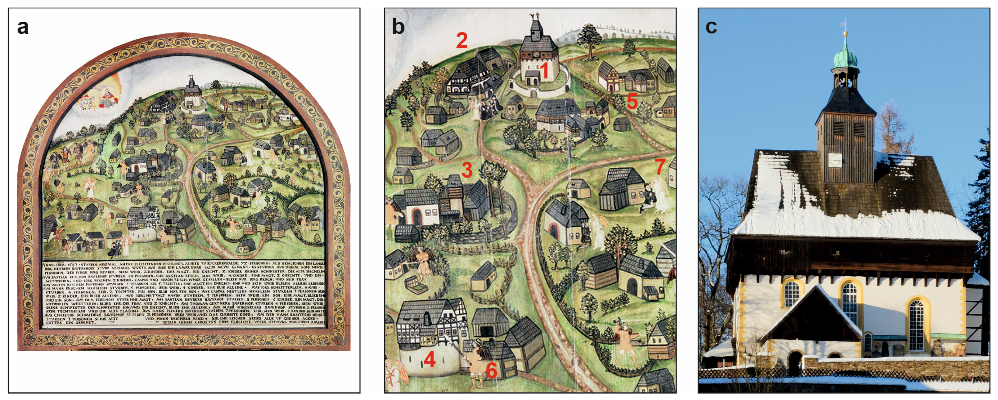
14. Not Only Ore and a Devastated Environment: Impulses for Technology, Science and Art
The preceding chapters have focused primarily on the aspects of “(natural) impact” (How does the environment influence humans?) and “use” (How do humans influence the environment? [39]; see Section 2). What is still lacking is a systematic presentation of human perception and the creative engagement with landscape, technology, the economy, and the social environment (How do humans understand the environment?). In the following, at least in very summarised form, even the particular role of the Erzgebirge as a place of the highest creative achievements over the centuries is to be highlighted. The basis for this was the need for technical and scientific innovations within the region’s prospering mining industry, the resulting economic power, and specific socio-cultural circumstances, such as a large immigrant population and extensive contacts in other regions [174] and, not least, deep religious devotion [175].
Strong political and financial support for local mining along with the resulting influx of people—and with them, skills and new ideas from other parts of Central Europe—led to repeated leaps in technical innovation in the Erzgebirge over the centuries. These made it possible to overcome the natural and technological limitations of a given period—and, not least, to cause a stronger environmental impact than in the preceding era. Examples of European, and in some cases even global, technological firsts include the 16th-century mine waterworks, the boat lift (“Kahnhebehaus”) built in 1788/89 on the Freiberger Mulde river, the 140-m-tall smokestack built in 1888/89 (“Halsbrücker Esse”) to vent flue gases from a smelting works, or the 1800-m-deep shaft reached in a uranium mine in 1986, the deepest mine ever in Europe [15,16,106].
At the same time, sciences, concepts and reflections linked to mining and its environmental consequences developed in the region, being briefly presented here in chronological order. The literary work “Iudicium Iovis…” (“The Tribunal of Jupiter…”) by Paulus Niavis (1460–1517), printed in Leipzig in 1495, is probably the world’s first text to reflect the environmental consequences of mining intensively, using the Erzgebirge as an example [176]. Georgius Agricola (1494–1555), a physician living in St. Joachimsthal/Jáchymov and Chemnitz, is recognised as the founder of modern mining science, geology and mineralogy through his observations and descriptions of mining in the Erzgebirge [177]. In his opus magnum “De re metallica…” (“On the Nature of Metals…”), published posthumously in 1556, he also described in detail for the first time the environmental damages and resource competitions caused by mining and metallurgy [178]. The need to manage the region’s timber resources for mining more efficiently led the Saxon mining official Hans Carl von Carlowitz (1645–1714) to “invent” the concept of sustainability in forestry in 1713 [4]. Founded in Freiberg in 1765 to promote regional industry, the “Bergakademie” (Mining Academy) is the oldest still-existing mining university in the world. It played a leading global role in the development of the geological sciences, metallurgy and chemistry during the 18th and 19th centuries [179]. The “Königlich-Sächsische Forstakademie” (Royal Saxon Academy of Forestry), founded in Tharandt in 1811/1816, played a key role in establishing systematic forestry on a scientific basis. From the mid-19th century onwards, pioneering research into industrial air pollution in the Erzgebirge was also conducted here. However, one lasting practical consequence of the theories developed at that time is age-class forests—that are, spruce monocultures in the Erzgebirge and beyond—which are now regarded as extremely problematic from both an ecological and an economic perspective [180]. Finally, samples of the mineral pitchblende (uraninite, UO2) from Johanngeorgenstadt and Sankt Joachimsthal/Jáchymov played an important role in the development of radiophysics. After Martin Heinrich Klaproth (1743–1817) had discovered the element uranium in the mineral in 1789, Marie Curie (1867–1934) and Pierre Curie (1859–1906) isolated the elements radium and polonium from the same mineral in 1898 and introduced the term “radioactivity” [181].
For about 800 years, the creative energies of the people in the Erzgebirge have also been reflected in works of art and handicraft. An early outstanding example, dating from the first phase of mining, is the late Romanesque “Golden Gate” in the Freiberg Cathedral, built around 1225. This sandstone portal is one of the major works of Central European art in the 13th century [182] (Figure 13). The boom in silver mining in the late 15th and 16th centuries led to the foundation of towns characterised by highly ambitious urban planning and architecture, and to the widespread implementation of a concept that was extremely innovative at the time: the Renaissance planned town, of which Marienberg is a well-known example [92] (Figure 4a). In the larger towns, splendid churches were built in late Gothic style. St. Anna in Annaberg, St. Wolfgang in Schneeberg, St. Mary’s in Freiberg and Marienberg, and St. Joachim and St. Anne’s in Sankt Joachimsthal/Jáchymov are among the most impressive churches of their time in Central Europe [183]. Monumental yet simple in appearance outside, these churches reveal great splendour inside through elaborate architectural features, including complex vaults, colours and furnishings. It is hard to imagine the strong contrast between these churches, erected in a very short span of time, and their surroundings—ultimately a chaotic industrial area and a perpetual building site. The deep religious devotion of the people was also linked to a vibrant tradition of church music, particularly during the 16th to 18th centuries [184]. Famous Central German composers of the Renaissance and Baroque periods were either born in the Erzgebirge or worked there, such as Johann Hermann Schein (1586–1630), Andreas Hammerschmidt (1611–1675) and Johann Schelle (1648–1701). Not least, Gottfried Silbermann (1683–1753), the most famous Central German organ builder of the Baroque period, operated his workshop in Freiberg [185]. Mention must also be made of the well-known—and still highly marketable—folk art from the region. This developed from the late 16th century onwards, but particularly in the 18th/19th centuries during mining crises, when people sought alternative sources of income by intensifying woodworking and textile craft [186].
Figure 13.
The “Golden Gate” at Freiberg Cathedral, built around 1225, is one of the masterpieces of late Romanesque sculpture in Central Europe. It bears witness to the high architectural standards of the town of Freiberg, which was still in its infancy at the time but had begun to prosper from silver mining from 1168 onwards. (a) Current state of the portal on the front wall of the south transept, its secondary location at the cathedral (© Albrecht Holländer Artworks). (b) Reconstruction of the portal’s original polychrome scheme based on scientific research. This was created to mark the portal’s 800th anniversary in 2025 and was displayed as a 1:1 scale photographic replica at its original location in the cathedral tower (© Georg Schütze, www.grafikladen.com, Dresden). This pair of images might also be seen as a metaphor for the somewhat unfamiliar and colourful perspectives that a new analytical approach opens up to a seemingly familiar matter.
Finally, reference should be made to an important financial-economic term originating in the Erzgebirge with global implications. Our “monetary culture”—and thus the state of the world as a whole, including the environment—is currently dominated by the dollar. Etymologically, this term derives from the German word “Thaler” or “Taler” (“Tal” in modern German spelling, meaning valley in English) and originally referred to the “Joachimsthaler”, a silver coin minted since the early 16th century in the Bohemian town of Sankt Joachimsthal/Jáchymov [187]. Through transcontinental trade, these coins and their successors then found their way to North America, and the term first entered the money system there, and later the global one.
15. Final Chapter for Now: Climate Change Strikes
In the past, the relationship between climate and society in the Erzgebirge was primarily reflected in the hardships of life during the “Little Ice Age”. In Central Europe, this period lasted from the late 14th to the mid-19th century, with its main cold phase between 1550 and 1750 [188]. Its climatic disfavour was characterised in the mountains by very long winters, partly heavy (snow) precipitation, partly drought, and a short growing season, temporarily resulting in crop failures, famines, diseases, and poverty [189,190,191]. Periods of socio-economic and general decline, such as the late medieval and early modern plague epidemics, the mining and economic crises of the early 14th and late 16th centuries, or the Thirty Years’ War, were exacerbated at the upper settlement frontier by extreme climatic effects that were difficult to mitigate.
The current gradual shift towards warmer and drier conditions compared with the period before seems at first glance to be more a question for the future than for the past. However, measurable and observable environmental changes that can be clearly attributed to climate change have been taking place already for decades in the Erzgebirge and surroundings. This justifies at least an initial historical perspective. Previous changes have already affected climatic and hydroclimatic parameters such as temperature, heavy rainfall intensity and snow cover, the flow regime of streams and rivers, and the vitality of forest stands [192,193,194,195].
In the Erzgebirge, the annual mean temperature rose by ca. 1 °C between 1991 and 2020 compared with the reference period 1961–1990, accompanied by increases in certain climate parameters (e.g., heat sum, warm periods, hot days) and decreases in others (e.g., cold days, cold spells, days with frost) [195]. Annual precipitation rose slightly during this period, i.e., by less than 10%. Evaporation, droughts, heavy rainfall events and, as a consequence, flooding and soil erosion events also increased. There was a marked decrease in the formation of a long-term continuous snow cover and height. Overall, the trend towards somewhat more extreme meteorological conditions is becoming apparent [196].
The effects of climate change are very clearly visible in the decay of spruce monocultures in the lower altitudes, i.e., ca. 300–500 m a.s.l. Since 2018, some hundred hectares of forest have died and been seriously damaged here as a result of drought linked with abiotic (e.g., storms) and, above all, biotic factors, in particular, bark beetle infestations [197]. Under considerably cooler conditions than today, many of these stands were established for reforestation around 200 years ago, well below the natural range of the spruce [194]. Spruce is now facing an extreme risk of extinction here, just as it is currently dying off across vast areas elsewhere in Central Europe [198].
Of particular concern is the warming trend across all altitudes. With the snow cover becoming thinner, and at times disappearing entirely within the winter months, an important seasonal water reservoir is being reduced, resulting in a deficit during dry spells throughout the growing season. Some of the headwater stream catchments near the mountain crest have experienced declining discharge rates and summer droughts in recent decades [199]. Organisms with higher thermal requirements, including deciduous trees and shrubs, are slowly migrating to higher elevations. This is associated with changes in biocoenoses and habitats, including biodiversity loss [200]. Winter and ski tourism in the Erzgebirge, which remains economically important, also faces considerable challenges. Several ski areas are located below an altitude of 800–900 m a.s.l., which is meanwhile too low for reliably long-term snow formation [201]. Not least, the normal winter environment with plenty of snow has also played a major role in regional identity and external perception—and not just at Christmas [202].
16. Concluding and Further Thoughts
The preceding chapters have shown how profoundly the landscape of the Erzgebirge has been shaped by human impact, particularly by mining-related effects, over the centuries. At times, this has even had catastrophic consequences for both people and the environment, particularly in the 20th century. However, the environmental effects of economic activities can also be detected far beyond the mountains themselves. In the Middle Ages, this included the atmospheric transport of heavy metals originating from metallurgy as far as the Arctic [203]. Further, the anthropogenically intensified transport of materials via the rivers draining the mountains has also reached a remarkable spread since the Middle Ages. It extended as far as the lower reaches of the Mulde and Eger/Ohře rivers and, via the Elbe/Labe, even further into the North Sea basin [204]. In this geochemical context, the Erzgebirge thus at times even caused hemispheric and supra-regional environmental impacts, respectively. During the second half of the 20th century, industrial emissions from the Erzgebirge also contributed to the transboundary transport of certain toxic trace elements in the “Black Triangle”, along with vast quantities of other elements, nitrogen oxides and, above all, sulphur dioxide [205].
Figure 14 serves as a synthesis, summarising regional key findings, locations, creations, and events, thereby enabling the reader to navigate the complex environmental history of the Erzgebirge along a timeline. These features represent a selection. Some interesting and obvious topics, such as the soil erosion rate, the number of mines and smelting works, or fatal work-related injuries, could not be included, as data with sufficient chronological resolution is not available for all aspects. In addition to this figure, Table 1 summarises the major environmental impacts with regard to the topics studied, including information on the differences between Saxony and Bohemia, on persistent environmental legacies and, as examples, on the remaining knowledge gaps. In retrospect, the postulated phases of environmental recovery—which mostly occur in the course of economic downturns—appear very logical, i.e., inevitably inherent in regional development. This long-term cyclical perspective is, of course, a privilege of a systematic environmental historical review.
Figure 14.
A synoptic overview of the environmental history of the Erzgebirge over the last millennium, presented along a timeline. The figure shows selected categories for which quantitative data are available. Note the varying spatial and chronological resolution, which ranges from local records to the entire Erzgebirge, and from a few decades to centuries, respectively. Details on the given mining periods, i.e., their exact dating and characteristics, can be found in Section 3. Further information and sources: (a) Minining periods referring to the Saxon Erzgebirge; modified after [1,16]. (b) Environmental recovering phases referring to the whole Erzgebirge; own concept. (c1–c3) Extraction of silver, tin and uranium referring to the Saxon Erzgebirge; data from [16,103,206]. (d1) Lead accumulation referring to a local record from Kovářská peat bog in the Bohemian Erzgebirge; data from [73]. (e1) Foundation of mining towns referring to the whole Erzgebirge; own calculation based on [1,16]. (f1) Reservoir construction referring to the whole Erzgebirge; own calculation based on [123,124]. (g1–g3) Content of fir, beech and spruce pollen referring to a local record from Mothäuser Heide peat bog in the Saxon Erzgebirge; data after [207]. (h) Particular records, events and creations.
However, what people in the mountains actually perceived as the specific environmental changes of their time is as yet only partially known, and mostly reflected by a scholarly perspective, e.g., [44,98,99,189]. The environmental threats arising from intensified industrial activities—which undoubtedly placed a burden on local daily life, such as air and water pollution or the loss of biological resources—were presumably accepted as simply unchangeable. There was no appeal authority from which anything positive could be expected. For centuries, people’s own survival under circumstances that were uncomfortable in many respects, in other words, a harsh socio-economic perspective, took precedence. Even during the phase of strong environmental degradation in the second half of the 20th century, critical reflection remained the exception [208]. This was due to the largely unsuccessful and, moreover, repressive environmental policies under socialist regimes on both sides of the border [45,46].
For centuries, it was primarily mining and metallurgy, and later the textile and engineering industries, that provided the people of the Erzgebirge with an income and thus a livelihood. The number of people supported by these industries was far greater than that of those who could have lived from agriculture, forestry and other crafts [93]. This is certainly a positive aspect, both economically and in terms of a personal life. Added to this are the magnificent technical, scientific and cultural achievements that would not have been possible without the wealth generated by industry and the engagement with the regional environment. The economic and political power and artistic splendour of Saxony from the 16th to the early 20th century would be inconceivable without its industrial and, ultimately, financial base in the Erzgebirge (Figure 15). On the other hand, the partly catastrophic working and living conditions associated with mining and metallurgy, the high number of work-related fatal injuries and illnesses, and widespread environmental degradation undoubtedly represent negative aspects.
Figure 15.
The splendour of Dresden, the Saxon electoral and royal metropolis, from the 16th to the early 20th century in architecture, art and science would have been unthinkable without the wealth generated in the Erzgebirge, often under very bad conditions for people and the environment: “What is produced in Chemnitz [and thus also in the Erzgebirge!] … is squandered in Leipzig and Dresden.” (Saxon proverb). (a) View of Dresden’s old town from the town hall tower in 1919 (© Deutsche Fotothek/Walter Hahn). Just a few years later, at the end of World War II in 1945, this magnificent Baroque gem was burned to ashes in a firestorm. It was rebuilt in parts during the decades that followed. (b) The “Türk” mine in Zschorlau near Schneeberg in 1923 (© Deutsche Fotothek/Paul Schulz). Mining took place here from 1513 to 1957, initially for silver, and later also for bismuth, cobalt, nickel, and uranium. The image shows the winding house. On the left is an older horse engine and, in the centre, a newer shaft head frame. (c) The industrial site of Muldenhütten on the banks of the River Freiberger Mulde in 1913 (© Deutsche Fotothek/Brück und Sohn). First mentioned in records in the 14th century, it is the oldest smelting site in Germany still in operation. The production buildings and waste heaps extend right up to the river on the left, causing substances to be released directly into the water and sediments. The multitude of smokestacks indicates a high level of air pollution.
It is worth noting that, alongside today’s often highly positive narrative regarding historical mining and its artefacts, there are very early voices expressing concern and even criticism regarding the social and environmental consequences of mining. Thus, at the end of the 15th century, Paulus Niavis wrote, with the silver rush around Schneeberg at that time in mind: “Certainly, the miners are so inflamed by their greed for silver that they are usually willing to take on anything, even the most extreme dangers. They are not satisfied with one mountain, but also plunder the neighbouring ones…” [98,209]. And Georgius Agricola, based on his observations in the Erzgebirge in the mid-16th century, comes to the conclusion that “…it is clear to all that there is greater detriment from mining than the value of the metals which the mining produces.” [99] (Book I). Nevertheless, both authors consider mining to be ultimately unavoidable for the benefit of society, and believe that the negative consequences for people and the environment must be accepted. This dual nature of mining—creating value on the one hand and placing extreme pressure on the environment on the other—continues to shape the Erzgebirge to this day, reflected in both the obvious and the sometimes very hidden traces in the landscape.
Table 1.
Summary of the topics studied on the environmental history of the past millennium in the Erzgebirge.
It is, of course, still unknown what the economic and associated environmental development of the region will be in the near future. The “political environment”, at least in the Saxon Erzgebirge, has already undergone extreme changes, with a far-right populist party dominating recent elections and right-wing groups generally gaining considerable strength [210,211]. This is also a consequence of socio-economic disruptions, i.e., the decline of the regional industrial sector, including mining, the population decline and the ageing of the population in this old industrial peripheral region following 1989/1990 [212,213].
Mining in the Erzgebirge is, for the time being, a thing of the past. It has become a carefully preserved heritage and skilfully staged folklore, forming an important material and intangible base of regional identity and the tourism economy [214]. Whether a new “Berggeschrey”, i.e., mining rush, based on the region’s “critical raw materials” will take place in the future depends on global commodity markets, geostrategic developments and the advancement of new mining techniques [30,31]. Should a new phase of mineral resource exploitation take place, the legal and technological methods of mining and associated processes will be decisive for the environmental impact. Will this take place in accordance with the developed, democratically controlled standards of the present day, or will there be a return to the predatory exploitation practices of the past, as in the Early Modern period or in the second half of the 20th century? Although aimed at major mining investors of the 15th and 16th centuries, such as the Fugger family, the following thought by Cembrzyński [167] (p. 33f.) also applies in the 21st century: “The only ones who never suffered from environmental damage were investors, who lived in rich trading centres, far away from the compromised surroundings of their mines”.
It is reasonable to assume that, in the coming decades, the recovery from the extreme environmental damage of the 20th century will continue to develop positively in the Erzgebirge. This includes the expected end of lignite mining and coal-fired power generation in the immediate foothills of the Bohemian Erzgebirge around 2035. This will lead to a further reduction in industrial emissions in the region. More than a century of extreme local environmental degradation at the foot of the mountains will then come to a “green end” through recultivation and renaturation [215,216]. Deindustrialisation will probably continue overall in the region. However, the extensive pressure on the landscape from continued industrial agriculture is likely to persist. Finally, the expected escalation of climate change in the mid-21st century [196] holds great potential for future extreme environmental change, particularly with regard to soil, water and forests. It remains to be seen how people and nature in the Erzgebirge will adapt to these changes. Hopefully, the knowledge available in the region regarding its repeated environmental tragedies and recoveries will remain alive, helping to inform responsible decision-making in the future.
Funding
This research received no external funding.
Data Availability Statement
The data are available upon reasonable request to the author.
Acknowledgments
My connection with the Erzgebirge goes back quite a long time, now more than 50 years. As a child, in the late 1970s, I saw the famous St. Anna church in the mining town of Annaberg for the first time. At that time, the church was being restored, and the renewed splendour of its interior stood in striking contrast to the slowly declining town and the partially devastated wider surroundings. At the end of the 1980s, as a young man, I witnessed the forest dying on a vast area of the mountain crest and the buildings of the old towns falling into disrepair. Once again in its long history, this landscape was on the brink of ruin—seemingly a hopeless case. This turned out to be a false assumption, thankfully! Then, ten years ago, I started research in the Erzgebirge and an intense interest in its environmental history began. I would like to thank the Czech and German archaeologists Kryštof Derner (Most) and Johann Friedrich Tolksdorf (Thierhaupten), respectively, for inviting me to participate in studies on mining and landscape archaeology. I would also like to thank a large number of scientific colleagues in Germany and the Czech Republic, whom I unfortunately cannot list here in full. I also want to thank my own institution, the GFZ Helmholtz Centre for Geosciences at Potsdam, for giving me the freedom to pursue my research activities. The following persons and institutions have kindly provided me with images: Stefan Bornkampf (Freiberg), Jiří Jiroušek (Kotenčice), Karel Kuča (Praha), Uwe Meinhold (Annaberg-Buchholz), Ingo Müller (Freiberg), Georg Schütze (Dresden), Vít Šrámek (Jíloviště), and Norbert Weichel (Annaberg-Buchholz), as well as the Bayerisches Hauptstaatsarchiv München, Deutsche Fotothek Dresden and Münzkabinett Berlin. Furthermore, I am very grateful to Mary Teresa Lavin-Zimmer (Potsdam) for proofreading. I would like to thank two anonymous reviewers for their helpful comments. Finally, I dedicate this work to the memory of Otfried Wagenbreth (1927–2017) on the occasion of what would have been his 100th birthday. He was a renowned mining historian who made fundamental contributions to our understanding of the mining landscape of the Erzgebirge and to the preservation of its built heritage.
Conflicts of Interest
The author declares no conflicts of interest.
References
- Hrubá, M.; Märc, J. The mining region of Krušnohoří/Erzgebirge on its way to becoming a UNESCO World Heritage Site. Res. Gestae 2020, 11, 123–135. [Google Scholar] [CrossRef] [Scilit]
- Jelen, J. Mining heritage and mining landscape Krušnohoří/Erzgebirge as a part of the UNESCO heritage. Land 2022, 11, 955. [Google Scholar] [CrossRef] [Scilit]
- Agnoletti, M. Man, forestry, and forest landscapes. Trends and perspectives in the evolution of forestry and woodland history research. Schweiz. Z. Forst. 2006, 157, 384–392. [Google Scholar] [CrossRef] [Scilit]
- Grober, U. Sustainability: A Cultural History; Green Books: Totnes/Devon, UK, 2012. [Google Scholar]
- Daly, S. From the Erzgebirge to Potosi: A History of Geology and Mining Since the 1500’s; FriesenPress: Victoria, BC, Canada, 2018. [Google Scholar]
- Löden, S. (Ed.) Montanlandschaft Erzgebirge. Kultur—Symbolik—Identität; Schriften zur sächsischen Geschichte und Volkskunde 7; Leipziger Universitätsverlag: Leipzig, Germany, 2003. [Google Scholar]
- Peselmann, A. Konstituierung Einer Kulturlandschaft. Praktiken des Kulturerbens im Deutsch-Tschechischen Erzgebirge; Göttingen Studies in Cultural Property 14; Universitätsverlag: Göttingen, Germany, 2018. [Google Scholar] [CrossRef] [Scilit]
- Blažková, M. Black Triangle—The most polluted part of Central Europe. In Regional Approaches to Water Pollution in the Environment; Rijtema, P.E., Eliáš, V., Eds.; Springer: Dordrecht, The Netherlands, 1996; pp. 227–249. [Google Scholar]
- Balej, M.; Anděl, J.; Raška, P.; Oršulák, T. Land use changes in northwestern part of the Czech Republic: The effects of displacement of German inhabitants. In Land Use/Cover Changes in Selected Regions in the World—Volume VII; Bičík, I., Himiyama, Y., Feranec, J., Štych, P., Eds.; International Geographical Union Commission on Land Use/Cover Change, Faculty of Science, Charles University in Prague: Prague, Czech Republic, 2012; pp. 49–57. [Google Scholar]
- Albrecht, H. The heritage of uranium mining in the German-Czech ore mountains. Entrep. Hist. 2017, 87, 88–106. [Google Scholar] [CrossRef] [Scilit]
- Billig, G.; Geupel, V. Entwicklung, Form und Datierungen der Siedlungen in der Kammregion des Erzgebirges. Siedlungsforschung. Archäol-Gesch.-Geogr. 1992, 10, 173–193. [Google Scholar]
- Blažek, J.; Černá, E.; Velímský, T. Zur Siedlungsgeschichte der böhmischen Seite des Erzgebirges. Germania 1995, 73, 463–479. [Google Scholar] [CrossRef]
- Kenzler, H. The medieval settlement of the Ore Mountains. The development of the settlement structure. Ruralia 2009, 7, 379–392. [Google Scholar] [CrossRef] [Scilit]
- Hach, O. Atlas der Verschwundenen Dörfer im böhmischen Erzgebirge; Tschirner & Co.: Leipzig, Germany, 2026. [Google Scholar]
- Wagenbreth, O.; Wächtler, E. (Eds.) Der Freiberger Bergbau. Technische Denkmale und Geschichte; Deutscher Verlag für Grundstoffindustrie: Leipzig, Germany, 1988. [Google Scholar]
- Wagenbreth, O.; Wächtler, E. (Eds.) Bergbau im Erzgebirge. Technische Denkmale und Geschichte; Deutscher Verlag für Grundstoffindustrie: Leipzig, Germany, 1990. [Google Scholar]
- Tolksdorf, J.F. (Ed.) Mittelalterlicher Bergbau und Umwelt im Erzgebirge. Eine interdisziplinäre Untersuchung; Veröffentlichungen des Landesamtes für Archäologie Sachsen, 67; Landesamt für Archäologie Sachsen: Dresden, Germany, 2018. [Google Scholar]
- Kaiser, K.; Theuerkauf, M.; Hieke, F. Holocene forest and land-use history of the Erzgebirge, central Europe: A review of palynological data. EG Quatern. Sci. J. 2023, 72, 127–161. [Google Scholar] [CrossRef] [Scilit]
- Hengst, K. Erzgebirge/Krušné hory im Spiegel der Sprache seit etwa 3000 Jahren. „Hercynia silva—Fergunna—Miriquidi—Böhmerwald—Erzgebirge”. In Erzgebirge—Heimat und domov. 8. Deutsch-Tschechischen Begegnungsseminar Gute Nachbarn—Schlechte Nachbarn? Mehnert, E., Ed.; Peter Lang: Frankfurt am Main, Germany, 2006; pp. 71–79. [Google Scholar]
- Raab, T.; Beckmann, S.; Richter, N.; Völkel, J. Reconstruction of floodplain evolution in former mining areas—The Vils River case study. Erde 2005, 136, 47–62. [Google Scholar]
- Ludemann, T. Fuel wood economy of historical mining in the Black Forest (Germany). In Mining in European History and its Impact on Environment and Human Societies, Proceedings for the 1st Mining in European History-Conference of the SFB-HIMAT, 12–15 November 2009; Anreiter, P., Goldenberg, G., Hanke, K., Krause, R., Leitner, W., Mathis, F., Nicolussi, K., Oeggl, K., Pernicka, E., Prast, M., et al., Eds.; Innsbruck University Press: Innsbruck, Austria, 2010; pp. 183–186. [Google Scholar]
- Kúšik, D. History of mining at the territory of Slovakia. Slovak Geol. Mag. 2015, 15, 5–20. [Google Scholar]
- Mariet, A.L.; Walter-Simonnet, A.V.; Gimbert, F.; Cloquet, C.; Bégeot, C. High-temporal resolution landscape changes related to anthropogenic activities over the past millennium in the Vosges Mountains (France). Ambio 2018, 47, 893–907. [Google Scholar] [CrossRef] [Scilit]
- Migoń, P.; Latocha, A. Human impact and geomorphic change through time in the Sudetes, Central Europe. Quat. Int. 2018, 470, 194–206. [Google Scholar] [CrossRef] [Scilit]
- Hrubý, P.; Kaiser, K.; Kočár, P.; Malý, K.; Petr, L. Silver mining and landscape changes in medieval Central Europe: Reconstructing ore processing in a buried fir forest on the Bohemian-Moravian Highlands (Koječín, Czech Republic). Geoarchaeology 2024, 39, 485–507. [Google Scholar] [CrossRef] [Scilit]
- Steingräber, L.F.; Knolle, F.; Kierdorf, H.; Ludolphy, C.; Kierdorf, U. Toxic legacy—Environmental impacts of historic metal mining and metallurgy in the Harz region (Germany) at local, regional and supra-regional levels. Environments 2025, 12, 215. [Google Scholar] [CrossRef] [Scilit]
- Dietrich, R. Untersuchungen zum Frühkapitalismus im Mitteldeutschen Erzbergbau und Metallhandel; Olms: Hildesheim, Germany, 1991. [Google Scholar]
- Schramm, M. Uranium mining and the environment in East and West Germany. In Mining in Central Europe: Perspectives from Environmental History; Uekoetter, F., Ed.; Rachel Carson Center Perspectives 10; Rachel Carson Center for Environment and Society: Munich, Germany, 2012; pp. 71–87. [Google Scholar]
- Kupková, L.; Potůčková, M.; Lhotáková, Z.; Albrechtová, J. Forest cover and disturbance changes, and their driving forces: A case study in the Ore Mountains, Czechia, heavily affected by anthropogenic acidic pollution in the second half of the 20th century. Environ. Res. Lett. 2018, 13, 095008. [Google Scholar] [CrossRef] [Scilit]
- Wittenberg, A.; de Oliveira, D. Critical raw material resource potentials in Europe. Mater. Proc. 2023, 15, 24. [Google Scholar] [CrossRef] [Scilit]
- Ayeh, D.; Rutjes, H. Europe as a reemerging mining frontier? Contested lithium futures in the German Ore Mountains. Globalizations 2025, in press. [Google Scholar] [CrossRef] [Scilit]
- Asmussen, T.; Long, P.O. Introduction: The cultural and material worlds of mining in early modern Europe. Ren. Stud. 2020, 34, 8–30. [Google Scholar] [CrossRef] [Scilit]
- Radkau, J. Nature and Power. A Global History of the Environment; German Historical Institute: Washington, DC, USA; Cambridge University Press: Cambridge, UK, 2008. [Google Scholar]
- McNeill, J.R. The state of the field of environmental history. Annu. Rev. Environ. Resour. 2010, 35, 345–374. [Google Scholar] [CrossRef] [Scilit]
- Hoffmann, R. An Environmental History of Medieval Europe; Cambridge University Press: Cambridge, UK; New York, NY, USA, 2014. [Google Scholar]
- Uekötter, F. The Vortex: An Environmental History of the Modern World; University of Pittsburgh Press: Pittsburgh, PA, USA, 2023. [Google Scholar]
- Branch, N.; Canti, M.; Clark, P.; Turney, C. Environmental Archaeology: Theoretical and Practical Approaches; Routledge: London, UK; New York, NY, USA, 2014. [Google Scholar]
- Decocq, G. Historical Ecology: Learning from the Past to Understand the Present and Forecast the Future of Ecosystems; Wiley: London, UK; Hoboken, NJ, USA, 2022. [Google Scholar] [CrossRef] [Scilit]
- Schuh, M.; Huhtamaa, H. Europäische Umweltgeschichte. In Umwelt Interdisziplinär: Grundlagen—Konzepte—Handlungsfelder; Meier, T., Keppler, F., Mager, U., Platt, U., Reents, F., Eds.; Heidelberg University Publishing: Heidelberg, Germany, 2026; pp. 263–278. [Google Scholar] [CrossRef]
- Brüggemeier, F.J. A nature fit for industry: The environmental history of the Ruhr Basin, 1840–1990. Environ. Hist. Rev. 1994, 18, 35–54. [Google Scholar] [CrossRef] [Scilit]
- Winiwarter, V.; Schmid, M.; Dressel, G. Looking at half a millennium of co-existence: The Danube in Vienna as a socio-natural site. Water Hist. 2013, 5, 101–119. [Google Scholar] [CrossRef] [Scilit]
- Mathieu, J. The Alps: An Environmental History; Polity Press: Cambridge, UK, 2019. [Google Scholar]
- Voppel, K. Das Landschaftsbild des Erzgebirges unter dem Einfluss des Erzbergbaues. Wiss. Veröff. Deut. Mus. Länderkunde N.F. 1941, 9, 1–81. [Google Scholar]
- Beleites, M. Altlast Wismut. Ausnahmezustand, Umweltkatastrophe und das Sanierungsproblem im Deutschen Uranbergbau; Brandes und Apsel: Frankfurt/Main, Germany, 1992. [Google Scholar]
- Moldan, B.; Schnoor, J.L. Czechoslovakia: Examining a critically ill environment. Environ. Sci. Technol. 1992, 26, 14–21. [Google Scholar] [CrossRef] [Scilit]
- Huff, T. Natur und Industrie im Sozialismus. Eine Umweltgeschichte der DDR; Umwelt und Gesellschaft 13; Vandenhoeck & Ruprecht: Göttingen, Germany, 2015. [Google Scholar]
- Tolksdorf, J.F.; Kaiser, K.; Bertuch, M. Stand der Untersuchungen zur Landschaftsgeschichte. In Mittelalterlicher Bergbau und Umwelt im Erzgebirge. Eine Interdisziplinäre Untersuchung; Tolksdorf, J.F., Ed.; Veröffentlichungen des Landesamtes für Archäologie Sachsen 67; Landesamt für Archäologie Sachsen: Dresden, Germany, 2018; pp. 30–33. [Google Scholar]
- Peschel, A.; Wetzel, M. Naturraum Erzgebirge. In Erzgebirge; Schattkowsky, M., Ed.; Kulturlandschaften Sachsens 3; Edition Leipzig: Leipzig, Germany, 2010; pp. 9–26. [Google Scholar]
- Thomasius, H. The influence of mining in the Saxon Erzgebirge on woods and forestry up to the beginning of the 19th century. GeoJournal 1994, 32, 103–125. [Google Scholar] [CrossRef] [Scilit]
- Lauterbach, K. Vom Grenzwald zur Grenzlinie. Zur Entstehung der sächsisch-böhmischen Grenze. Sächsische Heimatblätter 2018, 64, 104–108. [Google Scholar] [CrossRef] [Scilit]
- Šimůnek, R.; Žemlička, J. Landscapes of medieval and early modern era. In Historical Geography in Czechia. Themes and Concepts; Semotanová, E., Chromý, P., Kučera, Z., Eds.; LIT: Wien, Austria; Zürich, Switzerland, 2023; pp. 47–66. [Google Scholar]
- Mannsfeld, K.; Syrbe, R.-U. (Eds.) Naturräume in Sachsen; Forschungen zur Deutschen Landeskunde 257; Deutsche Akademie für Landeskunde: Leipzig, Germany, 2008. [Google Scholar]
- Sebastian, U. Die Geologie des Erzgebirges; Springer Spektrum: Berlin/Heidelberg, Germany, 2013. [Google Scholar]
- Vilimek, V.; Raška, P. The Krušné Hory Mts.—The Longest Mountain Range of the Czech Republic. In Landscapes and Landforms of the Czech Republic; Pánek, T., Hradecký, J., Eds.; World Geomorphological Landscapes, Springer: Berlin/Heidelberg, Germany, 2016; pp. 113–122. [Google Scholar] [CrossRef] [Scilit]
- Bramer, H.; Hendl, M.; Marcinek, J.; Nitz, B.; Ruchholz, K.; Slobodda, S. Physische Geographie. Mecklenburg-Vorpommern, Brandenburg, Sachsen-Anhalt, Sachsen, Thüringen; Hermann Haack: Gotha, Germany, 1991. [Google Scholar]
- Hunger, F.; Werzner, R.; Weißbach, J. 500 Jahre Talsperrenbewirtschaftung in Sachsen. Wasserwirtschaft 2025, 115, 12–17. [Google Scholar] [CrossRef] [Scilit]
- Hempel, W. Die Pflanzenwelt Sachsens von der Späteiszeit bis zur Gegenwart; Weissdorn-Verlag: Jena, Germany, 2009. [Google Scholar]
- Schmidt, P.A.; Hempel, W.; Denner, M.; Döring, N.; Gnüchtel, A.; Walter, B.; Wendel, D. Potentielle Natürliche Vegetation Sachsens mit Karte 1: 200,000; Materialien zu Naturschutz und Landschaftspflege 2002; Sächsisches Landesamt für Umwelt und Geologie: Radebeul, Germany, 2002. [Google Scholar]
- Baumann, L.; Kuschka, E.; Seifert, T. Lagerstätten des Erzgebirges; Enke-Thieme: Stuttgart, Germany, 2000. [Google Scholar]
- Wetzel, M. Das Erzgebirge im Wandel der Geschichte. In Erzgebirge; Schattkowsky, M., Ed.; Kulturlandschaften Sachsens 3; Edition Leipzig: Leipzig, Germany, 2010; pp. 27–72. [Google Scholar]
- Breitenlechner, E.; Hilber, M.; Unterkircher, A. Von der (Über)Nutzung eines ökologischen und sozialen Raumes am Beispiel des Montanreviers Schwaz im 17. Jahrhundert—Eine interdisziplinäre Annäherung. In Natur als Grenzerfahrung. Europäische Perspektiven der Mensch-Natur-Beziehung in Mittelalter und Neuzeit: Ressourcennutzung, Entdeckungen, Naturkatastrophen; Kreye, L., Stühring, C., Zwingelberg, T., Eds.; Universitätsverlag Göttingen: Göttingen, Germany, 2009; pp. 51–78. [Google Scholar]
- Kenzler, H. Spätmittelalterliche Wüstungen im Erzgebirge: Auswirkungen einer Krise auf ländliche Siedlungen und den Bergbau. In Strategien zum Überleben. Umweltkrisen und ihre Bewältigung; Daim, F., Gronenborn, D., Schreg, R., Eds.; Römisch-Germanisches Zentralmuseum Tagungen 11; Römisch-Germanisches Zentralmuseum: Mainz, Germany, 2011; pp. 273–287. [Google Scholar]
- Schäfer, M. Die Wirtschaftslandschaft Erzgebirge. In Erzgebirge; Schattkowsky, M., Ed.; Kulturlandschaften Sachsens 3; Edition Leipzig: Leipzig, Germany, 2010; pp. 73–128. [Google Scholar]
- Harfst, J.; Wirth, P. Zwickau–Lugau–Oelsnitz (Germany)—The long shadow of mining. In Post-Mining Regions in Central Europe. Problems, Potentials, Possibilities; Wirth, P., Černič Mali, B., Fischer, W., Eds.; Oekom: München, Germany, 2012; pp. 118–128. [Google Scholar]
- Hendrychová, M.; Kabrna, M. An analysis of 200-year-long changes in a landscape affected by large-scale surface coal mining: History, present and future. Appl. Geogr. 2016, 74, 151–159. [Google Scholar] [CrossRef] [Scilit]
- Wiezik, M.; Jamrichová, E.; Máliš, F.; Beláňová, E.; Hrivnák, R.; Hájek, M.; Hájková, P. Transformation of West-Carpathian primeval woodlands into high-altitude grasslands from as early as the Bronze Age. Veget. Hist. Archaeobot. 2023, 32, 205–220. [Google Scholar] [CrossRef] [Scilit]
- Valde-Nowak, P. Short settled Neolithic sites in the mountains—Economy or religious practice? Case studies from the Polish Carpathians and German Mid-Mountains. In Economic Archaeology: From Structure to Performance in European Archaeology; Kerig, T., Zimmermann, A., Eds.; Habelt: Bonn, Germany, 2013; pp. 215–225. [Google Scholar]
- Šída, P.; Burgert, P.; Kachlík, V.; Přichystal, A. Before the tin: Prehistoric quarrying in the western part of the Ore Mountains. Poster presentation. In Proceedings of the Konference ArchaeoTin. Archeologie ve Světovém Dědictví—Krajiny Dobývání Cínu/Konferenz ArchaeoTin. Archäologie im Welterbe—Zinnbergbaulandschaften, Teplice, Czech Republic, 9–10 June 2026. [Google Scholar]
- Conrad, M.; Döhlert-Albani, N. Siedlungskeramik des Glockenbecherkomplexes im Osterzgebirge bei Lichtenberg, Lkr. Mittelsachsen. In Steinzeitjägerin trifft auf Bergknappen—Trassenarchäologie an EUGAL und OPAL in Sachsen; Smolnik, R., Ed.; Arbeits- und Forschungsberichte zur sächsischen Bodendenkmalpflege, Beiheft 35; Landesamt für Archäologie Sachsen: Dresden, Germany, 2022; pp. 401–412. [Google Scholar]
- Tolksdorf, J.F.; Schröder, F.; Petr, L.; Herbig, C.; Kaiser, K.; Kočár, P.; Fülling, A.; Heinrich, S.; Hönig, H.; Hemker, C. Evidence for Bronze Age and Medieval tin placer mining in the Erzgebirge mountains, Saxony (Germany). Geoarchaeology 2020, 35, 198–216. [Google Scholar] [CrossRef] [Scilit]
- Schubert, M.; Schröder, F.; Hemker, C. Early placer mining in Saxony. Part 2: Archaeological investigations at the Sauschwemme—New evidence for tin placer mining during the Bronze Age, Hallstatt Period, and High Middle Ages. Metalla 2025, 29, 115–140. [Google Scholar] [CrossRef] [Scilit]
- Veron, A.; Novak, M.; Brizova, E.; Stepanova, M. Environmental imprints of climate changes and anthropogenic activities in the Ore Mountains of Bohemia (Central Europe) since 13 cal. kyr BP. Holocene 2014, 24, 919–931. [Google Scholar] [CrossRef] [Scilit]
- Bohdálková, L.; Bohdálek, P.; Břízová, E.; Pacherová, P.; Kuběna, A.A. Atmospheric metal pollution records in the Kovářská Bog (Czech Republic) as an indicator of anthropogenic activities over the last three millennia. Sci. Total Environ. 2018, 633, 857–874. [Google Scholar] [CrossRef] [Scilit]
- Christl, A.; Simon, K. Nutzung und Besiedlung des sächsischen Erzgebirges und des Vogtlandes bis zur deutschen Ostkolonisation. Germania 1995, 73, 441–462. [Google Scholar]
- Šabatová, K.; Vágner, P.; Augustýnová, M.; Rypka, L.; Blažek, J. Pravěké a raně historické osídlení české části Krušných hor: Archeologické doklady a jejich interpretace. Die ur—Und frühgeschichtliche Besiedlung des tschechischen Erzgebirges: Archäologische Nachweise und ihre Interpretation. In ArchaeoTin. Archäologie im Welterbe—Zinnbergbaulandschaften. Internationale Fachtagung Teplice, 9. bis 10. 5. 2026. ArchaeoTin. Archeologie ve Světovém Dědictví—Krajiny Dobývání Cínu Mezinárodní Konference Teplice, 9. až 10. 5. 2026; Smolnik, R., Lissek, P., Eds.; Arbeits- und Forschungsberichte zur sächsischen Bodendenkmalpflege, Beiheft 39; Landesamt für Archäologie Sachsen: Dresden, Germany, 2026; in press. [Google Scholar]
- Ruttkowski, M. Altstraßen im Erzgebirge. Archäologische Denkmalinventarisation Böhmische Steige. Arb.-Und Forschungsberichte Sächsischen Bodendenkmalpfl. 2002, 44, 264–297. [Google Scholar]
- Straßburger, M. Ein frühmittelalterliches Schwert aus dem Annaberger Ratswald in der Sammlung der Städtischen Museen Annaberg-Buchholz. Beiträge Zur Frühgeschichte Und Zum Mittelalt. Ostthüringens 2024, 14, 39–48. [Google Scholar]
- Miera, J.J. Bronze Age settlement dynamics in a Central European river catchment—The Weiße Elster river (Central Germany). Front. Environ. Archaeol. 2025, 4, 1642403. [Google Scholar] [CrossRef] [Scilit]
- Gilck, F.; Poschlod, P. The origin of alpine farming: A review of archaeological, linguistic and archaeobotanical studies in the Alps. Holocene 2019, 29, 1503–1511. [Google Scholar] [CrossRef] [Scilit]
- Bartlett, R. The making of Europe: Conquest, Colonization, and Cultural Change, 950–1350; Princeton University Press: Princeton, NJ, USA, 1993. [Google Scholar]
- Hoffmann, Y.; Heußner, K.-U. Die Errichtung der romanischen Kirche zu Raschau und der Zeitpunkt der bäuerlichen Kolonisation im oberen Erzgebirge. Sächsische Heimatblätter 2013, 59, 253–261. [Google Scholar]
- Houfková, P.; Horák, H.; Pokorná, A.; Bešta, T.; Pravcová, I.; Novák, J.; Klír, T. The dynamics of a non-forested stand in the Krušné Mts.: The effect of a short-lived medieval village on the local environment. Veg. Hist. Archaeobot. 2019, 28, 607–621. [Google Scholar] [CrossRef] [Scilit]
- Hamilton, L.S. The protective role of mountain forests. GeoJournal 1992, 27, 13–22. [Google Scholar] [CrossRef] [Scilit]
- Reinhardt-Imjela, C.; Imjela, R.; Bölscher, J.; Schulte, A. The impact of late medieval deforestation and 20th century forest decline on extreme flood magnitudes in the Ore Mountains (Southeastern Germany). Quatern. Int. 2018, 475, 42–53. [Google Scholar] [CrossRef] [Scilit]
- Kaiser, K.; Tolksdorf, J.F.; de Boer, A.M.; Herbig, C.; Hieke, F.; Kasprzak, M.; Kočár, P.; Petr, L.; Schubert, M.; Schröder, F.; et al. Colluvial sediments originating from past land-use activities in the Erzgebirge Mountains, Central Europe: Occurrence, properties and historic environmental implications. Archaeol. Anthropol. Sci. 2021, 13, 220. [Google Scholar] [CrossRef] [Scilit]
- Jackovičová, J.; Dolejš, M.; Riezner, J. Spatial determinants of the distribution of lynchets and stone walls in NW Czechia: A broad-scale study. Appl. Geogr. 2023, 158, 103036. [Google Scholar] [CrossRef] [Scilit]
- Kaiser, K.; Hrubý, P.; Tolksdorf, J.F.; Alper, G.; Herbig, C.; Kočár, P.; Petr, L.; Schulz, L.; Heinrich, I. Cut and covered: Subfossil trees in buried soils reflect medieval forest composition and exploitation of the central European uplands. Geoarchaeology 2020, 35, 42–62. [Google Scholar] [CrossRef] [Scilit]
- Cappenberg, K.; Hemker, C. Der Wald der Zukunft in der Vergangenheit verwurzelt. Das ArchaeoForest-Projekt: Untersuchungen und Erkenntnisse zur historischen Vegetationsdynamik und Landschaftsnutzung im Osterzgebirge. Der Anschnitt 2024, 76, 147–171. [Google Scholar]
- Derner, K.; Kaiser, K.; Petr, L.; Kočár, P.; Kočárová, R.; de Boer, A.-M.; Kasprzak, M.; Łopuch, M.; Bohdálek, P.; Crkal, J.; et al. Medieval vegetation dynamics and montane-industrial history of the central Ore Mountains, Czech Republic, as reflected by alluvial geoarchives. Catena 2024, 247, 108520. [Google Scholar] [CrossRef] [Scilit]
- Cembrzyński, P. “Gold rush” or “considered investment”? Origins of mining towns in the medieval Central Europe. Acta Rer. Nat. 2017, 21, 59–72. [Google Scholar]
- Hrubá, M.; Royt, J.; Šimková, T. The Mining Towns of the Bohemian Ore Mountains in the Early Modern Period and Their Impact on Cultural History; Karolinum Press: Prague, Czech Republic, 2023. [Google Scholar]
- Silvestri, M. Cities made of silver. The impact of migration processes and architectural theory on the urban planning of early Modern mining towns. In MOTION: Migrations; Proceedings of the 35th World Congress of Art History, CIHA, São Paulo, Brasil, 17–21 January 2022; Mattos Avolese, C., Ed.; Vasto Edições: São Paulo, Brazil, 2023; pp. 1120–1140. [Google Scholar]
- Blaschke, K. Bevölkerungsgang und Wüstungen in Sachsen während des späten Mittelalters. Jahrbücher Für Natl. Stat. 1962, 174, 414–429. [Google Scholar] [CrossRef] [Scilit]
- Mikšíček, P. Krušné Hory/Das Erzgebirge. In Zmizelé Sudety/Das Verschwundene Sudetenland; Antikomplex, Ed.; Antikomplex: Praha, Czech Republic, 2015; pp. 276–350. [Google Scholar]
- Burgkhardt, J. Das Erzgebirge: Eine Orometrisch-Anthropogeographische Studie; Engelhorn: Stuttgart, Germany, 1888. [Google Scholar]
- Schräber, D. Historische Landschaften im Freiberger Bergrevier; Schriftenreihe Akten und Berichte vom Sächsischen Bergbau 41; Jens-Kugler-Verlag: Kleinvoigtsberg, Germany, 2003. [Google Scholar]
- Schirmer, U. Das spätmittelalterlich-frühneuzeitliche Erzgebirge als Wirtschafts- und Sozialregion (1470–1550). In Das Erzgebirge im 16. Jahrhundert: Gestaltwandel Einer Kulturlandschaft im Reformationszeitalter; Schattkowsky, M., Ed.; Leipziger Universitätsverlag: Leipzig, Germany, 2013; pp. 45–76. [Google Scholar]
- Niavis, P. Iudicium Iovis in Valle Amoenitatis Habitum, ad Quod Mortalis Homo a Terra Tractus Propter Montifodinas in Monte Niveo Aliisque Multis Perfectas ac Demum Parricidii Accusatus; Martin Landsberg: Leipzig, Germany, 1495. [Google Scholar]
- Agricola, G. De re Metallica Libri XII (Vom Bergkwerck XII Bücher); Froben: Basel, Switzerland, 1556. [Google Scholar]
- Dudka, S.; Adriano, D.C. Environmental impacts of metal ore mining and processing: A review. J. Environ. Qual. 1997, 26, 590–602. [Google Scholar] [CrossRef] [Scilit]
- Zalasiewicz, J.; Waters, C.N.; Williams, M. Human bioturbation, and the subterranean landscape of the Anthropocene. Anthropocene 2014, 6, 3–9. [Google Scholar] [CrossRef] [Scilit]
- Goldenberg, G. Frühe Umweltbelastungen durch Bergbau und Hüttenwesen. In Archäologie in Deutschland, Sonderheft: Alter Bergbau in Deutschland; Verlag Herder GmbH: Breisgau, Germany, 1993; pp. 107–113. Available online: https://www.jstor.org/stable/26310363 (accessed on 1 October 2026).
- Wismut GmbH (Ed.) Chronik der Wismut. Mit Erweitertem Sanierungsteil (1998 bis 2010); Wismut GmbH: Chemnitz, Germany, 1999. [Google Scholar]
- Hrabánek, J. Die Geschichte des Bergbaus im böhmischen Erzgebirge. In Rundbrief 2007; Agric.-Forschungszentrum Chemnitz., Ed.; Schloßbergmuseum: Chemnitz, Germany, 2007; pp. 5–41. [Google Scholar]
- Meier, G. Altbergbau in Deutschland. Umfänge—Probleme—Bearbeitung. In 1. Altbergbau-Kolloquium, 8. Bis 9. November 2001, TU Bergakademie Freiberg; Klapperich, H., Meier, G., Sroka, A., Tondern, D., Busch, W., Eds.; Verlag Glückauf GmbH: Essen, Germany, 2001; pp. 5–17. [Google Scholar]
- Hamann, S. Gedanken zum sächsischen Uranbergbau im Gebiet Schneeberg-Schlema. Der Anschnitt 1991, 43, 158–163. [Google Scholar]
- Schröder, F.; Schubert, M.; Hemker, C. Early placer mining in Saxony. Part 1: Methodological principles of archaeological exploration, interpretation and documentation. Metalla 2025, 29, 79–114. [Google Scholar] [CrossRef] [Scilit]
- Rank, G.; Kardel, K.; Pälchen, W.; Weidensdörfer, H. Bodenatlas des Freistaates Sachsen, Teil 3, Bodenmessnetz Raster 4 km x 4 km; Materialien zum Bodenschutz; Sächsisches Landesamt für Umwelt und Geologie: Dresden, Germany, 1999. [Google Scholar]
- Landesamt für Umwelt, Landwirtschaft und Geologie. Geochemische Übersichtskarte des Freistaates Sachsen. Arsen im Oberboden (Stand Februar 2009); Landesamt für Umwelt, Landwirtschaft und Geologie, Referat Bodenkartierung/Geochemie: Dresden, Germany, 2009.
- Hošek, M.; Pavlíková, P.; Šoltýs, M.; Tůmová, Š.; Matys Grygar, T. Distinguishing geogenic load and anthropogenic contribution to soil contamination in mineralised mountain landscape of ore mountains (Czech Republic) using cumulative distribution functions. Land 2024, 13, 218. [Google Scholar] [CrossRef] [Scilit]
- Greif, A.; Klemm, W.; Klemm, K. Influence of arsenic from anthropogenic loaded soils on the mine water quality in the tin district Ehrenfriedersdorf, Erzgebirge (Germany). Eng. Life Sci. 2008, 8, 631–640. [Google Scholar] [CrossRef] [Scilit]
- Dushe, C.; Kümmel, M.; Schulz, H. Investigations of enhanced outdoor radon concentration in Johanngeorgenstadt (Saxony). Health Phys. 2003, 84, 655–663. [Google Scholar] [CrossRef] [Scilit]
- Greif, A. Das Einzugsgebiet der Mulde oberhalb des Muldestausees im Spiegel des erzgebirgischen Bergbaus. Hydrol. Wasserbewirt. 2015, 59, 318–331. [Google Scholar] [CrossRef] [Scilit]
- Matys Grygar, T.; Elznicová, J.; Kiss, T.; Smith, H.G. Using sedimentary archives to reconstruct pollution history and sediment provenance: The Ohře River, Czech Republic. Catena 2016, 144, 109–129. [Google Scholar] [CrossRef] [Scilit]
- Klemm, W.; Greif, A.; Broekaert, J.A.C.; Siemens, V.; Junge, F.W.; van der Veen, A.; Schultze, M.; Duffek, A. A study on arsenic and the heavy metals in the Mulde River system. Acta Hydrochim. Hydrobiol. 2005, 33, 475–491. [Google Scholar] [CrossRef] [Scilit]
- Pohl, R. Historische Hochwasser aus dem Erzgebirge. Dresdner Wasserbaul. Mitt. 2007, 35, 567–588. [Google Scholar]
- Tarolli, M.; Borga, M.; Zoccatelli, D.; Bernhofer, C.; Jatho, N.; Janabi, F.A. Rainfall space-time organization and orographic control on flash flood response: The Weisseritz event of August 13, 2002. J. Hydrol. Eng. 2013, 18, 183–193. [Google Scholar] [CrossRef] [Scilit]
- Kaiser, K.; Keller, N.; Brande, A.; Dalitz, S.; Hensel, N.; Heußner, K.-U.; Kappler, C.; Michas, U.; Müller, J.; Schwalbe, G.; et al. A large-scale medieval dam-lake cascade in central Europe: Water level dynamics of the Havel River, Berlin-Brandenburg region, Germany. Geoarchaeology 2018, 33, 237–259. [Google Scholar] [CrossRef] [Scilit]
- Brykała, D.; Podgórski, Z. Evolution of landscapes influenced by watermills, based on examples from Northern Poland. Landsc. Urban Plan. 2020, 198, 103798. [Google Scholar] [CrossRef] [Scilit]
- Spindler, G. Ältere Wassermühlen des Müllereigewerbes im Erzgebirge und in der Oberlausitz. Ph.D. Thesis, Technische Hochschule Dresden, Dresden, Germany, 1954. [Google Scholar]
- Silvestri, M. Wassermanagement und Wasserlandschaften frühneuzeitlicher Montanregionen: Erzgebirge—Harz—Potosí. In Landschaft: Kultur-, Natur-, Wirtschafts- und Erfahrungsräume; Göttmann, F., Seng, E.-M., Eds.; Reflexe der immateriellen und materiellen Kultur 8; De Gruyter: Berlin, Germany, 2025; pp. 163–196. [Google Scholar]
- Wilsdorf, H.; Herrmann, W.; Löffler, K. Bergbau, Wald, Flöße: Untersuchungen zur Geschichte der Flößerei im Dienste des Montanwesens und zum Montanen Transportproblem; Freiberger Forschungshefte 28; Akademie-Verlag: Berlin, Germany, 1960. [Google Scholar]
- Holečková, M.; Dvořák, O. O řece a Lidech. 50 let Povodí Ohře; Nakladatelství MH: Beroun, Czech Republic, 2016. [Google Scholar]
- Landestalsperrenverwaltung Sachsen. Talsperren in Sachsen; Landestalsperrenverwaltung Sachsen: Pirna, Germany, 2021.
- Speckhann, G.A.; Kreibich, H.; Merz, B. Inventory of dams in Germany. Earth Syst. Sci. Data 2021, 13, 731–740. [Google Scholar] [CrossRef] [Scilit]
- Offermann, M.; Hein, M.; Hegemann, R.; Gödecke, K.; Hegner, L.; Henke, Y.; Schäfer, N.; Shelukhina, H.; Liebscher, E.; Opel, S.; et al. Ecomorphological changes and potential salmon habitat suitability since pre-industrial times in the Mulde River system (Germany). EG Quatern. Sci. J. 2025, 74, 325–354. [Google Scholar] [CrossRef] [Scilit]
- Nožička, J. Proměnylesů a Vývoj Lesního Hospodaření v Krusnohorí do r. 1848 [Die Änderung des Waldbestandes und die Entwicklung der Forstwirtschaft im Erzgebirge bis 1848]; Rozprav y Československé Akademie Včd. Flada Matematických a Přírodních Véd 72 (3); Československá akademie věd: Praha, Czech Republic, 1962. [Google Scholar]
- Tolksdorf, J.F.; Elburg, R.; Schröder, F.; Knapp, H.; Herbig, C.; Westphal, T.; Schneider, B.; Fülling, A.; Hemker, C. Forest exploitation for charcoal production and timber since the 12th century in an intact medieval mining site in the Niederpöbel Valley (Erzgebirge, Eastern Germany). J. Archaeol. Sci. Rep. 2015, 4, 487–500. [Google Scholar] [CrossRef] [Scilit]
- Černá, E. Mittelalterliche Glashütten in Nordwestböhmen; Archeologicky ustav AV CR: Brno, Czech Republic, 2016. [Google Scholar]
- Neubauer, G.; van der Maaten, E.; Hemker, C.; van der Maaten-Theunissen, M. The underground forest: Tracing forest history in the Erzgebirge through the wood finds from the medieval silver mines of Dippoldiswalde. Dendrochronologia 2025, 94, 126429. [Google Scholar] [CrossRef] [Scilit]
- Elling, W. Schädigung, Absterben und Erholung der Weißtanne. LWF Wissen 2004, 45, 33–35. [Google Scholar]
- Sächsisches Staatsministerium für Umwelt und Landwirtschaft. Weißtanne|Abies Alba; Biologische Vielfalt in Sachsen; Staatsbetrieb Sachsenforst: Pirna, Germany, 2011. [Google Scholar]
- Filipiak, M.; Gubański, J.; Jaworek-Jakubska, J.; Napierała-Filipiak, A. The strong position of silver fir (Abies alba Mill.) in fertile variants of beech and oak-hornbeam forests in the light of studies conducted in the Sudetes. Forests 2021, 12, 1203. [Google Scholar] [CrossRef] [Scilit]
- Heurich, M.; Englmaier, K.H. The development of tree species composition in the Rachel–Lusen region of the Bavarian Forest National Park. Silva Gabreta 2010, 16, 165–186. [Google Scholar]
- Andersen, A. “De re metallica”—Ein Beitrag zu einer frühneuzeitlichen Umwelttechnologie? In Georgius Agricola—500 Jahre; Naumann, F., Ed.; Birkhäuser: Basel, Switzerland; Boston, NJ, USA; Berlin, Germany, 1994; pp. 255–266. [Google Scholar]
- Ilger, G.; Fiedler, H.J. Freiberger Hüttenrauschschäden im 19. Jahrhundert und ihre wissenschaftliche Bearbeitung durch die Professoren Reich (Freiberg) und Stöckhardt (Tharandt). I Entwicklung des Freiberger Hüttenwesens und Wirkung seiner Emissionen auf die Umwelt. Wiss. Z. Tech. Univ. Dresd. 1990, 39, 107–113. [Google Scholar]
- Pohl, N.; Deutsch, M. Umweltgeschichte Sachsens. Ausgewählte Text- und Bilddokumente; Sächsische Landeszentrale für politische Bildung: Dresden/Leipzig, Germany, 2013. [Google Scholar]
- Scheithauer, J.; Grunewald, K. Saurer Regen und Waldsterben im ehemaligen Schwarzen Dreieck (Osterzgebirge). In Ökologische Problemräume Deutschlands; Zepp, H., Ed.; Wissenschaftliche Buchgesellschaft: Darmstadt, Germany, 2007; pp. 111–132. [Google Scholar]
- Liebold, E.; Drechsler, M. Schadenszustand und -entwicklung in den SO2-geschädigten Fichtengebieten Sachsens. Allg. Forstzeitschr./AFZ—Der Wald 1991, 10, 492–494. [Google Scholar]
- Zimmermann, F.; Lux, H.; Maenhaut, W.; Matschullat, J.; Plessow, K.; Reuter, F.; Wienhaus, O. A review of air pollution and atmospheric deposition dynamics in southern Saxony, Germany, Central Europe. Atmos. Environ. 2003, 37, 671–691. [Google Scholar] [CrossRef] [Scilit]
- Kluge, H. Nur die Buchen überlebten—Vom Schicksal des Forstreviers Deutscheinsiedel im Erzgebirge. Forst Und Holz 1993, 48, 462–466. [Google Scholar]
- Hammerová, V.; Vacek, S.; Vacek, Z.; Černý, J.; Cukor, J.; Gallo, J.; Kuběnka, M. Forest ecosystem restoration in the Ore Mountains: A review of silvicultural measures addressing environmental degradation. J. For. Sci. 2025, 71, 323–335. [Google Scholar] [CrossRef] [Scilit]
- Fanta, J. Forests in the Krkonoše/Karkonosze National Parks: Their restoration, protection and management in the context of changes ongoing in the Central-European forestry. Opera Corcon. 2013, 50, 23–38. [Google Scholar]
- Kuneš, I.; Podrázský, V.; Baláš, M.; Remeš, J.; Navrátil, P.; Kuc, M.; Smejkal, J.; Bursíková, J.; Paluch, J.G. The history of the Jizera Mts forests in the former heavily polluted area of Central Europe. Anthr. Rev. 2024, 11, 463–487. [Google Scholar] [CrossRef] [Scilit]
- Lal, R.; Blum, W.E.; Valentin, C.; Stewart, B.A. (Eds.) Methods for Assessment of Soil Degradation; CRC Press: Boca Raton, FL, USA, 1998. [Google Scholar]
- Bastian, O.; Syrbe, R.U.; Slavik, J.; Moravec, J.; Louda, J.; Kochan, B.; Kochan, N.; Stutzriemer, S.; Berens, A. Ecosystem services of characteristic biotope types in the Ore Mountains (Germany/Czech Republic). Int. J. Biodivers. Sci. Ecosyst. Serv. Manag. 2017, 13, 51–71. [Google Scholar] [CrossRef] [Scilit][Green Version]
- Beier, T.; Opp, C.; Hahn, J.; Zitzer, N. Sink and source functions for metal(loid)s in sediments and soils of two water reservoirs of the Ore Mountains, Saxony, Germany. Appl. Sci. 2022, 12, 6354. [Google Scholar] [CrossRef] [Scilit]
- Podrázský, V.; Remeš, J.; Ulbrichová, I. Biological and chemical amelioration effects on the localities degraded by bulldozer site preparation in the Ore Mts.—Czech Republic. J. For. Sci. 2003, 49, 141–147. [Google Scholar] [CrossRef] [Scilit]
- Ring, E.; Sikström, U. Environmental impact of mechanical site preparation on mineral soils in Sweden and Finland—A review. Silva Fenn. 2024, 58, 23056. [Google Scholar] [CrossRef] [Scilit]
- Šrámek, V.; Novotný, R.; Fiala, P.; Neudertová-Hellebrandová, K.; Reininger, D.; Samek, T.; Čihák, T.; Fadrhonsová, V. Waldkalkung in der Tschechischen Republik (Vápnění lesů v České Republice); Übersetzung aus dem Tschechischen im Auftrag des Staatsbetriebes Sachsenforst (Juni 2016); Staatsbetriebes Sachsenforst: Pirna, Germany, 2014. [Google Scholar]
- Andreae, H.; Gemballa, R.; Jacob, F. Leitfaden zur Forstlichen Bodenschutzkalkung in Sachsen (Kalkungsleitfaden); Schriftenreihe 31; Staatsbetrieb Sachsenforst: Pirna, Germany, 2020. [Google Scholar]
- Männel, J.G. Die Moore des Erzgebirgs und Ihre Forstwirtschaftliche und Nationalökonomische Bedeutung Mit Besonderer Berücksichtigung des Sächsischen Anteils. Inaugural-Dissertation, Ludwig-Maximilians-Universität München, M. Rieger’sche Universitäts-Buchhandlung, München, Germany, 1896. [Google Scholar]
- Schreiber, H. Die Moore und die Torfgewinnung im Erzgebirge; Arbeiten der Deutschen Sektion des Landeskulturrates für Böhmen 28; Verlag der deutschen Sektion des Landeskulturrates für Böhmen: Prag, Czech Republic, 1921. [Google Scholar]
- Zinke, P. Nutzungsgeschichte, Zustand und Revitalisierung der Moore im Erzgebirge. Telma 2002, 32, 267–280. [Google Scholar] [CrossRef]
- Scheithauer, J.; Grunewald, K. Biogeochemie von Hochmoortorfen und Umweltwandel im Erzgebirge (Mitteleuropa). Telma 2006, 36, 169–188. [Google Scholar] [CrossRef]
- Staatsbetrieb Sachsenforst (Ed.) Moorrevitalisierung im Erzgebirge. Revitalisierung der Moore Zwischen H. Sv. Šebestiána und Satzung—Umsetzungsphase. Revitalizace Rašeliništ’ v Krušných Horách. Revitalizace Rašelinišť Mezi Horou Sv. Šebestiána a Satzung—Realizační Fáze; Staatsbetrieb Sachsenforst: Pirna, Germany, 2014. [Google Scholar]
- Machlis, G.E.; Hanson, T. Warfare ecology. BioScience 2008, 58, 729–736. [Google Scholar] [CrossRef] [Scilit]
- Keller, T. The mountains roar: The Alps during the Great War. Environ. Hist. 2009, 14, 253–274. [Google Scholar] [CrossRef] [Scilit]
- Glassheim, E. Ethnic cleansing, communism, and environmental devastation in Czechoslovakia’s Borderlands, 1945–1989. J. Mod. Hist. 2006, 78, 65–92. [Google Scholar] [CrossRef] [Scilit]
- Karlsch, R.; Zeman, Z.A. Urangeheimnisse. Das Erzgebirge im Brennpunkt der Weltpolitik 1933–1960; Christoph Links: Berlin, Germany, 2002. [Google Scholar]
- Meinrath, A.; Schneider, P.; Meinrath, G. Uranium ores and depleted uranium in the environment, with a reference to uranium in the biosphere from the Erzgebirge/Sachsen, Germany. J. Environ. Radioact. 2003, 64, 175–193. [Google Scholar] [CrossRef] [Scilit]
- Küchler, W. Warmbad, wärmste Heilquelle und ältestes Bad Sachsens. Erzgebirg. Heimatblätter 1994, 5, 18–21. [Google Scholar]
- Andersen, A. Historische Technikfolgenabschätzung am Beispiel des Metallhüttenwesens und der Chemieindustrie 1850–1933; Zeitschrift für Unternehmensgeschichte Beiheft 90; Franz Steiner: Stuttgart, Germany, 1996. [Google Scholar]
- Murdock, C.E. Tourist landscapes and regional identities in Saxony, 1878–1938. Cent. Eur. Hist. 2007, 40, 589–621. [Google Scholar] [CrossRef] [Scilit]
- Moranda, S. The People’s Own Landscape: Nature, Tourism, and Dictatorship in East Germany; University of Michigan Press: Ann Arbor, MI, USA, 2014. [Google Scholar]
- Monecke, S.; Monecke, H.; Monecke, J. Modelling the black death. A historical case study and implications for the epidemiology of bubonic plague. Int. J. Med. Microbiol. 2009, 299, 582–593. [Google Scholar] [CrossRef] [Scilit]
- Cembrzyński, P. The ecology of mining. Human–environmental relations in the Medieval and Early Modern mining in Central Europe. Kwart. Hist. Kult. Mater. 2019, 67, 17–39. [Google Scholar] [CrossRef] [Scilit]
- Kroker, E.; Farrenkopf, M. Grubenunglücke im Deutschsprachigen Raum—Katalog der Bergwerke, Opfer, Ursachen und Quellen; Veröffentlichungen aus dem Deutschen Bergbau-Museum Bochum 79; Deutsches Bergbau-Museum: Bochum, Germany, 1999. [Google Scholar]
- Hignett, K. In sickness and in health: ‘dissonant’ history, heritage, and tourism in the Czech spa town of Jáchymov. J. Tour. Hist. 2026, 18, 47–57. [Google Scholar] [CrossRef] [Scilit]
- Pfeifer, J. Der Schneeberger Lungenkrebs, Auftreten—Beschreibung—Erforschung. Bergknappe 2015, 39, 36–54. [Google Scholar]
- Langård, S. Gregorius Agricola memorial lecture: Lung cancer—A work-related disease for 500 years, as predicted by Agricola. J. Trace Elem. Med. Biol. 2015, 31, 214–218. [Google Scholar] [CrossRef] [Scilit]
- Hammer, M. Häuser und Menschen. Ein erzgebirgisches Bild- und Lesebuch. Altkreise Marienberg und Annaberg; Bauernhäuser, Bauernhöfe, Dörfer in sächsischen Landkreisen 11 (Erzgebirge II); Wiesenhaus-Verlag: Dresden, Germany, 2017. [Google Scholar]
- Hoffmann, Y. Baugeschichtliche Untersuchungen an den Erzgebirgischen Wehrkirchen zu Dörnthal, Großrückerswalde, Lauterbach und Mittelsaida. In Wehrhafte Kirchen und Befestigte Kirchhöfe. Tagung vom 12. bis 14. Oktober 2012 in Meiningen; Höhne, D., Schmitt, R., Eds.; Beier & Beran: Langenweißbach, Germany, 2015; pp. 201–230. [Google Scholar]
- Hemker, C. (Ed.) Bergbau und Mobilität im Mittelalter. Archäologische, Historische und Naturwissenschaftliche Fallstudien zum (über-)regionalen Kultur- und Technologietransfer zwischen Montanrevieren; Veröffentlichungen des Landesamtes für Archäologie Sachsen 73; Landesamt für Archäologie Sachsen: Dresden, Germany, 2020. [Google Scholar]
- Asmussen, T. Spirited metals and the oeconomy of resources in early modern European mining. Earth Sci. Hist. 2020, 39, 371–388. [Google Scholar] [CrossRef] [Scilit]
- Bredekamp, H. Der Mensch als Mörder der Natur: Das “Iudicium Iovis” von Paulus Niavis und die Leibmetaphorik. Vestig. Bibliae 1984, 6, 261–283. [Google Scholar]
- Prescher, H. Dr. Georgius Agricola 1494–1555. A European scientist and humanist from Saxony. GeoJournal 1994, 32, 85–89. Available online: https://www.jstor.org/stable/41146714 (accessed on 1 October 2026).
- Barton, I.F. Georgius Agricola’s De Re Metallica in early modern scholarship. Earth Sci. Hist. 2016, 35, 265–282. Available online: https://www.jstor.org/stable/44075735 (accessed on 1 October 2026). [CrossRef] [Scilit]
- Grabow, G. 250 years of the Bergakademie Freiberg, the world’s oldest mining university. Min. Rep. 2015, 151, 469–473. [Google Scholar]
- Ibisch, P.L. Waldbau als historisches Erbe und Missverständnis. Forum Wiss. 2025, 42, 38–41. [Google Scholar]
- Malley, M.C. Radioactivity: A History of a Mysterious Science; Oxford University Press: New York, NY, USA, 2011. [Google Scholar]
- Magirius, H.; Beyer, K.G. Der Dom zu Freiberg; Union Verlag: Berlin, Germany, 1986. [Google Scholar]
- Bürger, S. Die Annaberger St. Annenkirche. Die Besonderheiten ihrer Architektur als Zeichen für kulturellen Wandel. In Das Erzgebirge im 16. Jahrhundert: Gestaltwandel einer Kulturlandschaft im Reformationszeitalter; Schattkowsky, M., Ed.; Leipziger Universitätsverlag: Leipzig, Germany, 2013; pp. 353–377. [Google Scholar]
- Steude, W. Mitteldeutsche Landschaftsmusikgeschichte: Aufgaben zu ihrer Erforschung zwischen Mittelalter und ausgehendem 17. Jahrhundert. Jahrb. Ständige Konf. Mitteldtsch. Barockmusik 2001, 2, 7–21. [Google Scholar]
- Gress, F.H.; Lange, M. Die Orgeln Gottfried Silbermanns; Sandstein Verlag: Dresden, Germany, 2007. [Google Scholar]
- Schramm, M. The invention and uses of folk art in Germany: Wooden toys from the Erzgebirge Mountains. Folklore 2007, 115, 64–76. [Google Scholar] [CrossRef] [Scilit]
- Vorel, P. The function of the thaler in determining the exchange rates of European currencies in the second half of the 16th century. Pol. Num. News 2022, 10, 283–306. [Google Scholar] [CrossRef] [Scilit]
- Glaser, R.; Riemann, D. A thousand-year record of temperature variations for Germany and Central Europe based on documentary data. J. Quat. Sci. 2009, 24, 437–449. [Google Scholar] [CrossRef] [Scilit]
- Lehmann, C. Historischer Schauplatz derer Natürlichen Merckwürdigkeiten in dem Maißnischen Ober-Erzgebürge; Lankisch: Leipzig, Germany, 1699. [Google Scholar]
- Pfister, C. The “Black Swan” of 1540. Aspects of a European megadrought. In Climatic Change and Cultural Transition in Europe; Leggewie, K., Mauelshagen, F., Eds.; Brill: Leiden, The Netherlands, 2018; pp. 156–196. [Google Scholar] [CrossRef] [Scilit]
- Collet, D. Extreme winters during the 18th century: Entangling climate and culture. In Extremereignis ‘Kältewinter’ im 18. Jahrhundert. Spuren in der zeitgenössischen Literatur, Kultur und Wissenschaft; Axtner-Borsutzky, A., Joana van de Löcht, J., Eds.; Historical Catastrophe Studies/Historische Katastrophenforschung; De Gruyter: Berlin, Germany; Boston, MA, USA, 2025; pp. 17–36. [Google Scholar] [CrossRef] [Scilit]
- Bednářová, E.; Böhm, A.-K.; Feske, N.; Gemballa, R.; Hahn, A.; Hájková, L.; Hanel, M.; Hoy, A.; Krofta, K.; Küchler, W.; et al. Der Klimawandel im Böhmisch-Sächsischen Grenzraum. Změna Klimatu v Česko-Saském Pohraničí; Sächsisches Landesamt für Umwelt, Landwirtschaft und Geologie: Dresden, Germany, 2015.
- Bernhofer, C.; Franke, J.; Fischer, S.; Kirsten, L.; Körner, P.; Kostrowski, D.; Prasse, H.; Schaller, A.; Donix, T. Analyse der Klimaentwicklung in Sachsen; Schriftenreihe des LfULG 3/2015; Sächsisches Landesamt für Umwelt, Landwirtschaft und Geologie (LfULG): Dresden, Germany, 2015. [Google Scholar]
- Sächsisches Staatsministerium für Umwelt und Landwirtschaft (Ed.) Klimawandel in Sachsen—Wir Passen uns an! Sächsisches Staatsministerium für Umwelt und Landwirtschaft (SMUL): Dresden, Germany, 2015.
- LfULG—Sächsisches Landesamt für Umwelt, Landwirtschaft und Geologie (Ed.) Klimaentwicklung Erzgebirgskreis. Kommunaler Klima-Steckbrief; Regionales Klima-Informationssystem (ReKIS), Sächsisches Landesamt für Umwelt, Landwirtschaft und Geologie: Dresden, Germany, 2025.
- Brasseur, G.P.; Jacob, D.; Schuck-Zöller, S. (Eds.) Klimawandel in Deutschland. Entwicklung, Folgen, Risiken und Perspektiven; Springer: Berlin/Heidelberg, Germany, 2024. [Google Scholar] [CrossRef] [Scilit]
- Sächsisches Staatsministerium für Energie, Klimaschutz, Umwelt und Landwirtschaft (SMEKUL) (Ed.) Waldzustandsbericht 2024; Sächsisches Staatsministerium für Energie, Klimaschutz, Umwelt und Landwirtschaft: Dresden, Germany, 2024.
- Schiefer, F.; Schmidtlein, S.; Hartmann, H.; Schnabel, F.; Kattenborn, T. Large-scale remote sensing reveals that tree mortality in Germany appears to be greater than previously expected. Forestry 2025, 98, 535–549. [Google Scholar] [CrossRef] [Scilit]
- Vlach, V.; Matouskova, M.; Ledvinka, O. Impacts of regional climate change on hydrological drought characteristics in headwaters of the Ore Mountains. River Res. Appl. 2021, 37, 919–930. [Google Scholar] [CrossRef] [Scilit]
- Streitberger, M.; Jedicke, E.; Fartmann, T. Auswirkungen des rezenten Klimawandels auf die Biodiversität in Mittelgebirgen—Eine Literaturstudie zu Arten und Lebensräumen. Naturschutz Und Landschaftsplanung 2016, 48, 37–45. [Google Scholar]
- Hoy, A.; Hänsel, S.; Matschullat, J. How can winter tourism adapt to climate change in Saxony’s mountains? Reg. Environ. Chang. 2011, 11, 459–469. [Google Scholar] [CrossRef] [Scilit]
- Friedreich, S. Das “Weihnachtsland” und die Heimat. Zum Wandel der Kulturlandschaft Erzgebirge. In Heimatschichten; Klose, J., Ed.; Springer: Wiesbaden, Germany, 2013; pp. 105–114. [Google Scholar] [CrossRef] [Scilit]
- McConnell, J.R.; Chellman, N.J.; Wilson, A.I.; Stohl, A.; Arienzo, M.M.; Eckhardt, S.; Fritzsche, D.; Kipfstuhl, S.; Opel, T.; Place, P.F.; et al. Pervasive Arctic lead pollution suggests substantial growth in medieval silver production modulated by plague, climate, and conflict. Proc. Natl. Acad. Sci. USA 2019, 116, 14910–14915. [Google Scholar] [CrossRef] [Scilit]
- Boxberg, F.; Asendorf, S.; Bartholomä, A.; Schnetger, B.; de Lange, W.P.; Hebbeln, D. Historical anthropogenic heavy metal input to the south-eastern North Sea. Geo-Mar. Lett. 2020, 40, 135–148. [Google Scholar] [CrossRef] [Scilit]
- Fiałkiewicz-Kozieł, B.; Łokas, E.; Gałka, M.; Kołaczek, P.; De Vleeschouwer, F.; Le Roux, G.; Smieja-Król, B. Influence of transboundary transport of trace elements on mountain peat geochemistry (Sudetes, Central Europe). Quat. Sci. Rev. 2020, 230, 106162. [Google Scholar] [CrossRef] [Scilit]
- Sächsisches Oberbergamt (Ed.) Der Bergbau in Sachsen. Bericht des Sächsischen Oberbergamtes und des Landesamtes für Umwelt und Geologie für das Jahr 2007; Sächsisches Oberbergamt: Freiberg, Germany, 2007. [Google Scholar]
- Theuerkauf, M.; Kaiser, K. Erzgebirge. In Vegetationsgeschichte der Landschaften in Deutschland; Feeser, I., Dörfler, W., Rösch, M., Jahns, S., Wolters, S., Bittmann, F., Eds.; Springer: Berlin/Heidelberg, Germany, 2025; pp. 413–420. [Google Scholar] [CrossRef] [Scilit]
- Wensierski, P. Von Oben Nach Unten Wächst Gar Nichts—Umweltzerstörung und Protest in der DDR; Fischer: Frankfurt/Main, Germany, 1986. [Google Scholar]
- Grober, U. Die Ächtung des Raubbaus und das Paradigma der Gabe. Alte Quellen für ein neues Bewusstsein über den nachhaltigen Umgang mit unseren Ressourcen. In Nachhaltigkeit als Verantwortungsprinzip. Carlowitz Weiterdenken; Sächsische Hans-Carl-von-Carlowitz-Gesellschaft, Ed.; Oekom: München, Germany, 2018; pp. 65–80. [Google Scholar]
- Grunert, J.; Lang, A.-L. Situationsanalyse Rechter und Antidemokratischer Strukturen im Erzgebirgskreis; EFBI Policy Paper 2022–3; Else-Frenkel-Brunswik-Institut: Leipzig, Germany, 2022. [Google Scholar]
- Technische Universität Dresden (Ed.) Erzgebirge Atlas, 3rd ed.; Professur für Urbanismus und Entwerfen, Institut für Städtebau und Regionalplanung; Technische Universität: Dresden, Germany, 2025. [Google Scholar]
- Wießner, R. Altindustrialisierte Gebiete: Peripherien und ländliche Räume. In Nationalatlas Bundesrepublik Deutschland. Band 8: Unternehmen und Märkte; Leibniz-Institut für Länderkunde, Ed.; Springer Spektrum: Heidelberg, Germany; Berlin, Germany, 2004; pp. 112–113. [Google Scholar]
- Graffenberger, M. Das Erzgebirge—Ländlicher Raum zwischen Tradition und Innovation. In Land in Sicht. Ländliche Räume in Deutschland Zwischen Prosperität und Peripherisierung; Krajewski, C., Wiegandt, C.-C., Eds.; Schriftenreihe 10362; Bundeszentrale für politische Bildung: Bonn, Germany, 2020; pp. 377–388. [Google Scholar]
- Vogel, J. Bergbau—Die “Erfindung einer Tradition”. In Contested Futures for Energy Transitions; Zeigermann, U., Lepesant, G., Beer, K., Eds.; PoWiNE Working Paper—Magdeburger politikwissenschaftliche Beiträge zu Nachhaltigkeit in Forschung und Lehre 1; Otto-von-Guericke-Universität: Magdeburg, Germany, 2021; pp. 13–19. [Google Scholar] [CrossRef]
- Chylińska, D.; Kołodziejczyk, K. Degraded landscapes as a tourist attraction and place for leisure and recreation. Tourism 2017, 27, 23–33. [Google Scholar] [CrossRef] [Scilit]
- Nebeská, D.; Trägl, J.; Slavík, J.; Vráblík, P.; Wildová, E. Rekultivierung von Standorten nach dem Bergbau im Erzgebirgsvorland—Erneuerung von Ökosystemleistungen und Potenzial von Energiepflanzen der 2. Generation. In Systemische Nachhaltigkeit. Sektorspezifische und Interdisziplinäre Blickwinkel; Kramer, M., Ed.; Springer: Wiesbaden, Germany, 2025; pp. 259–274. [Google Scholar] [CrossRef] [Scilit]
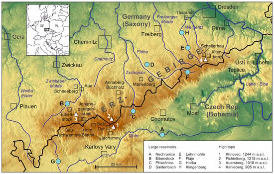
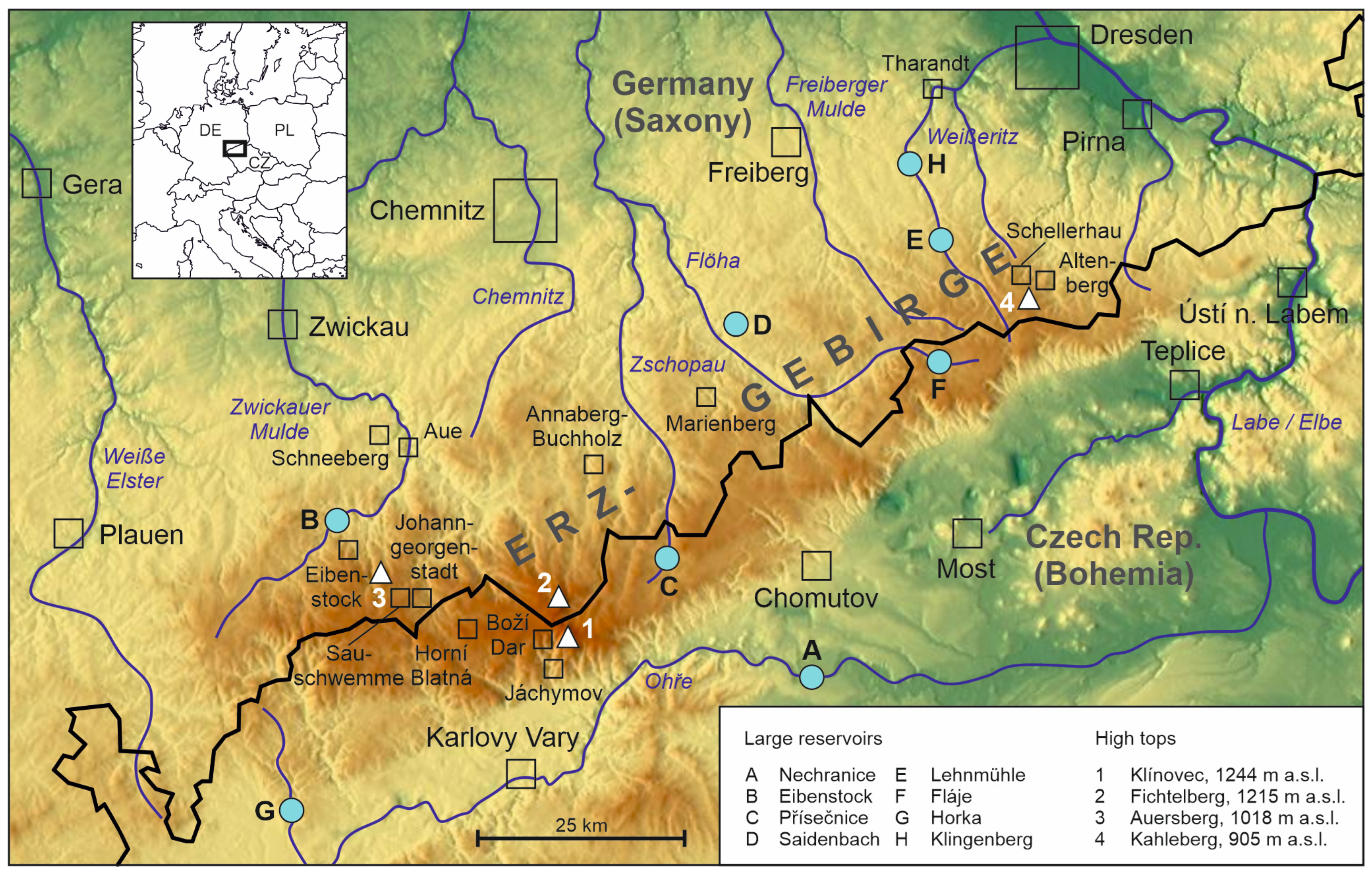
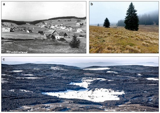
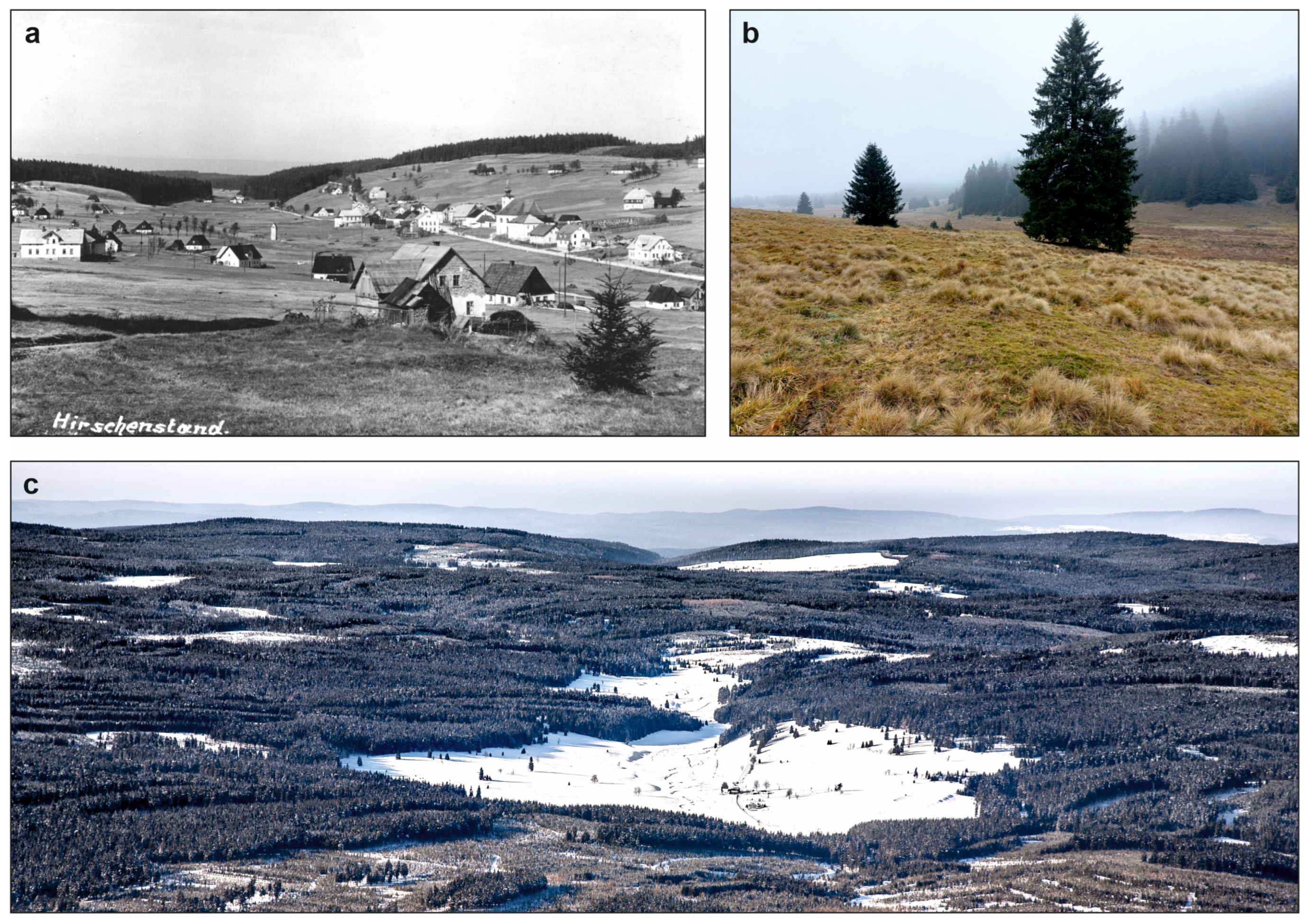
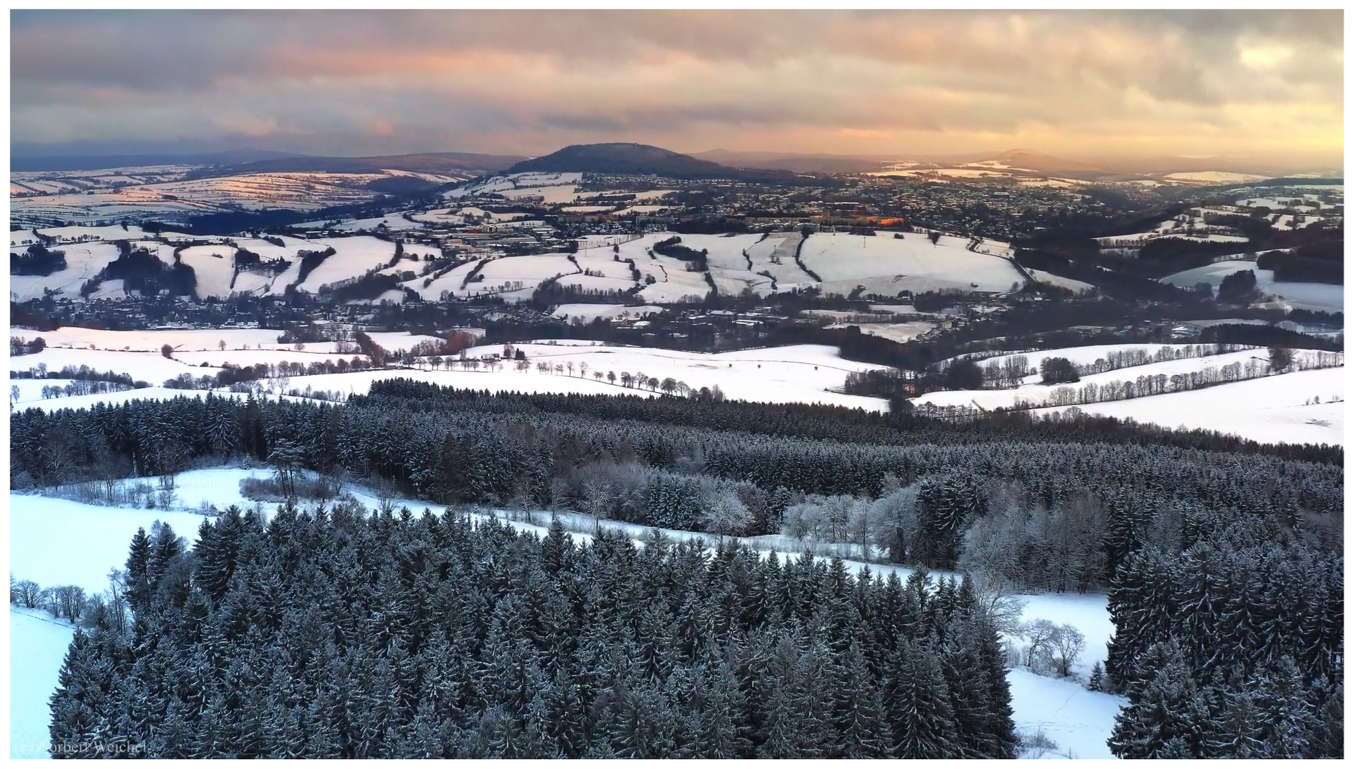
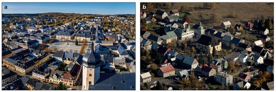
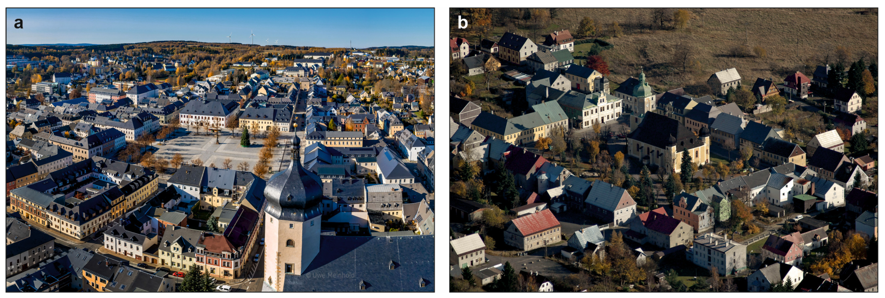
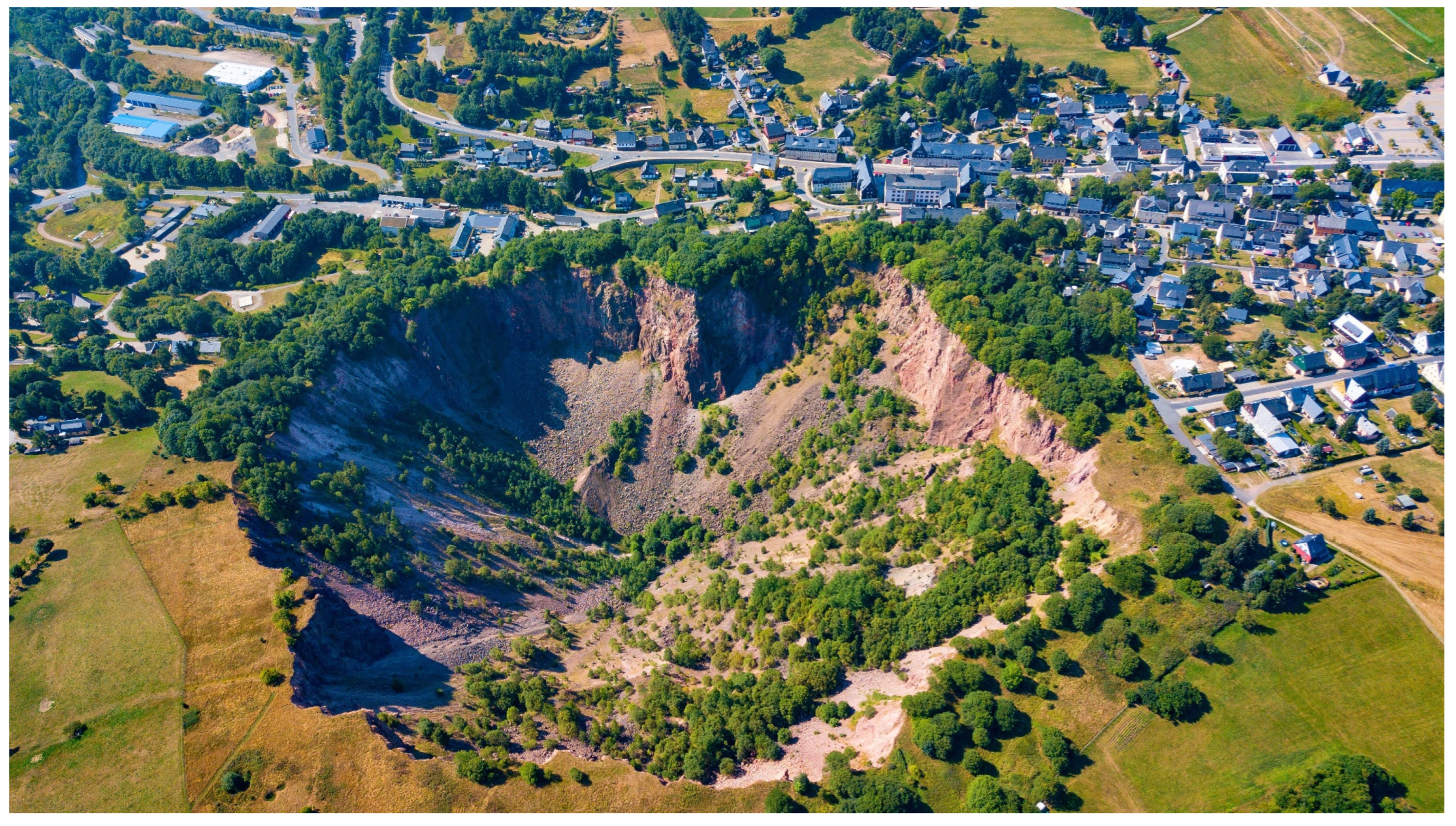
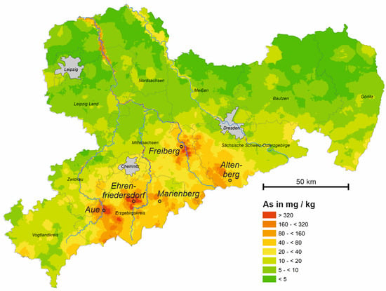
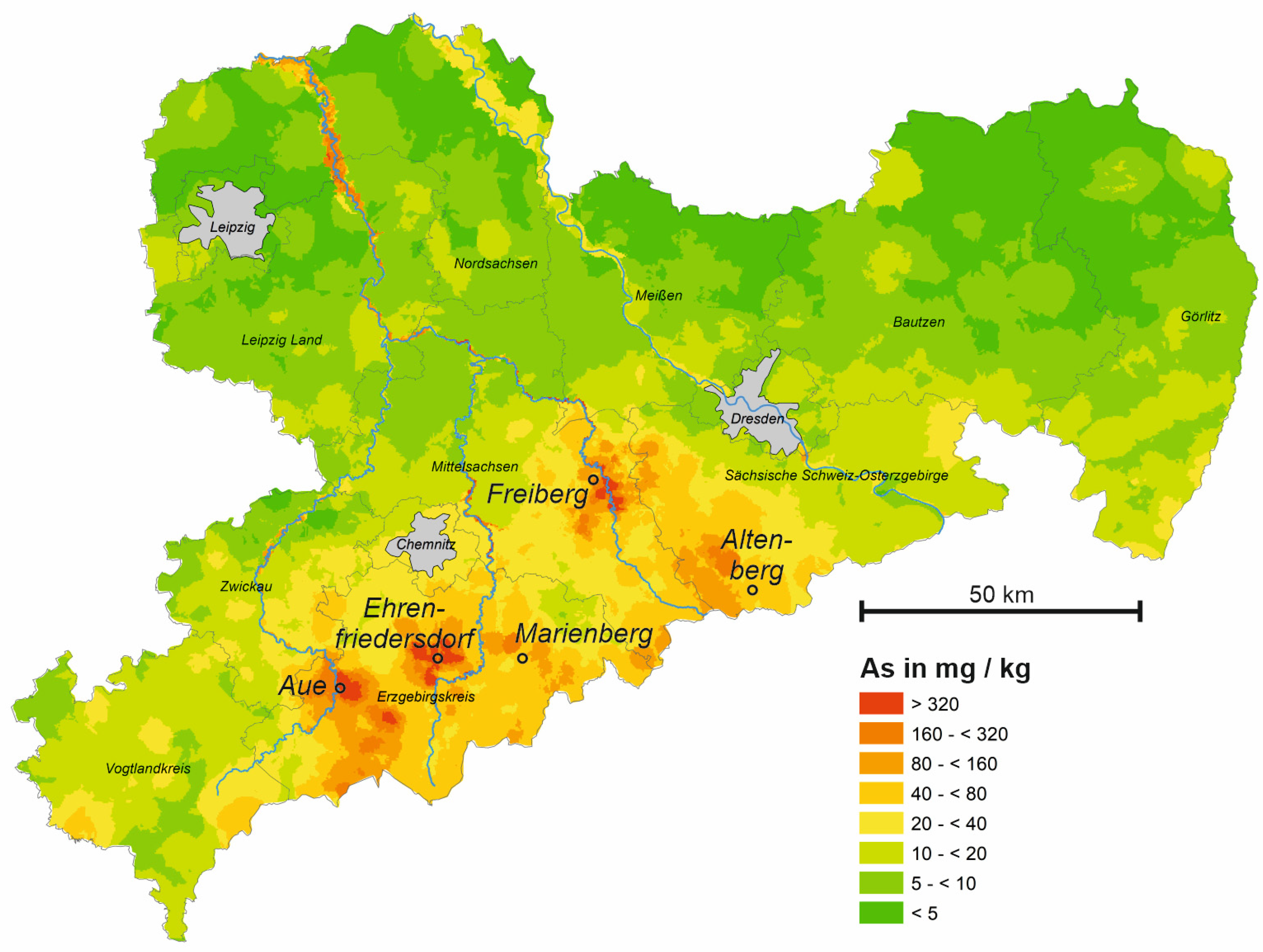
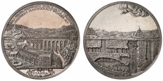
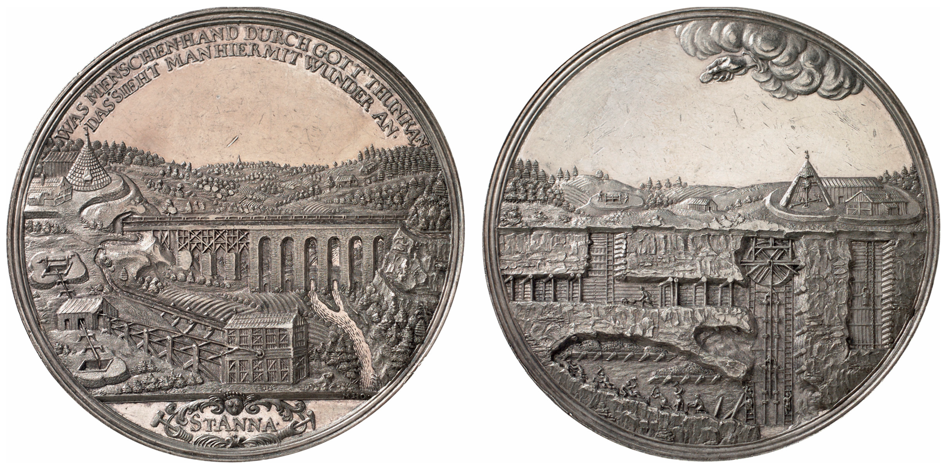
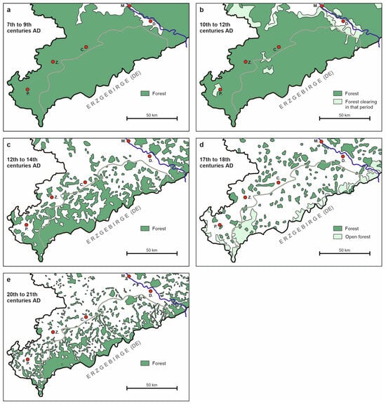
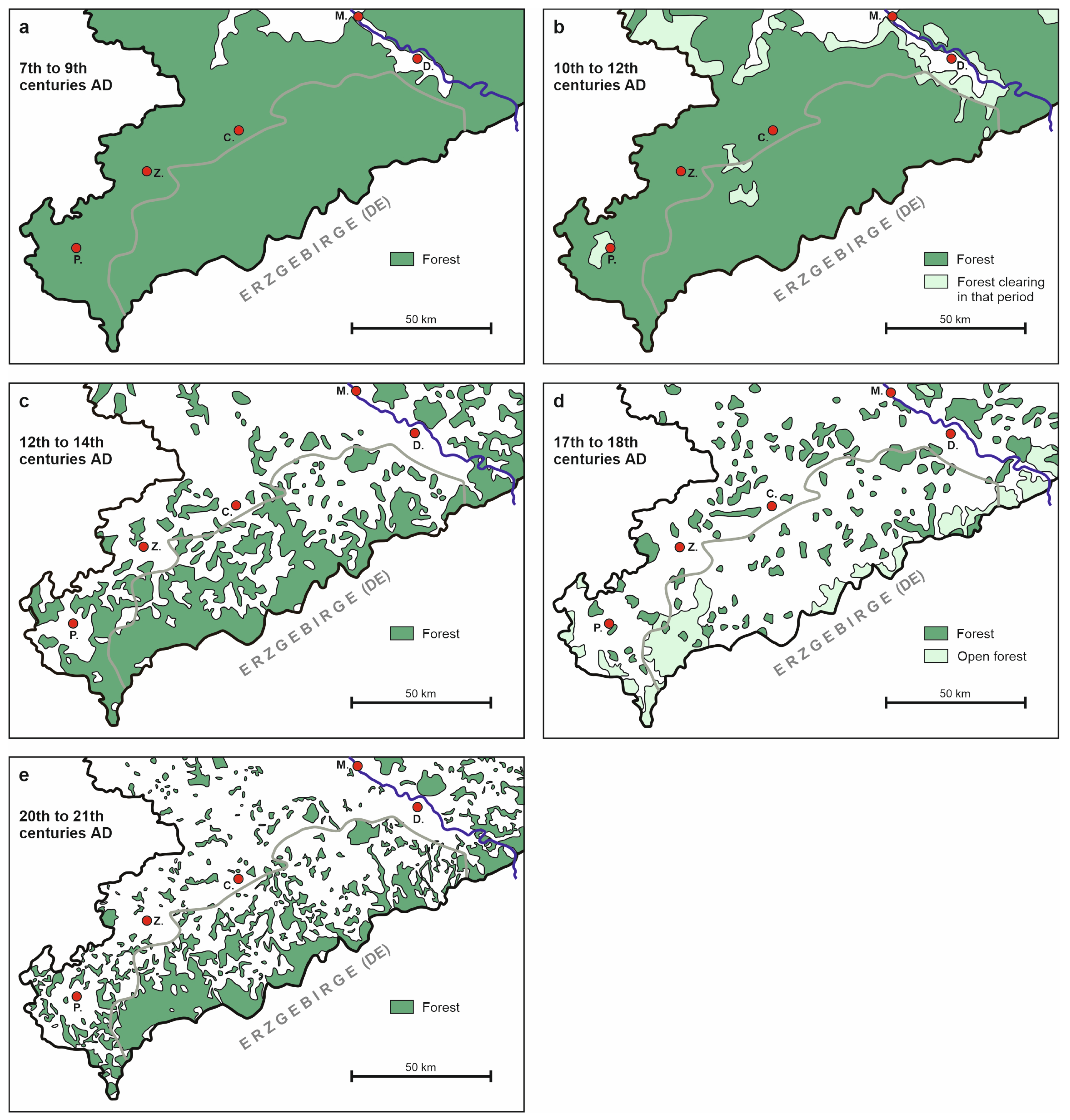
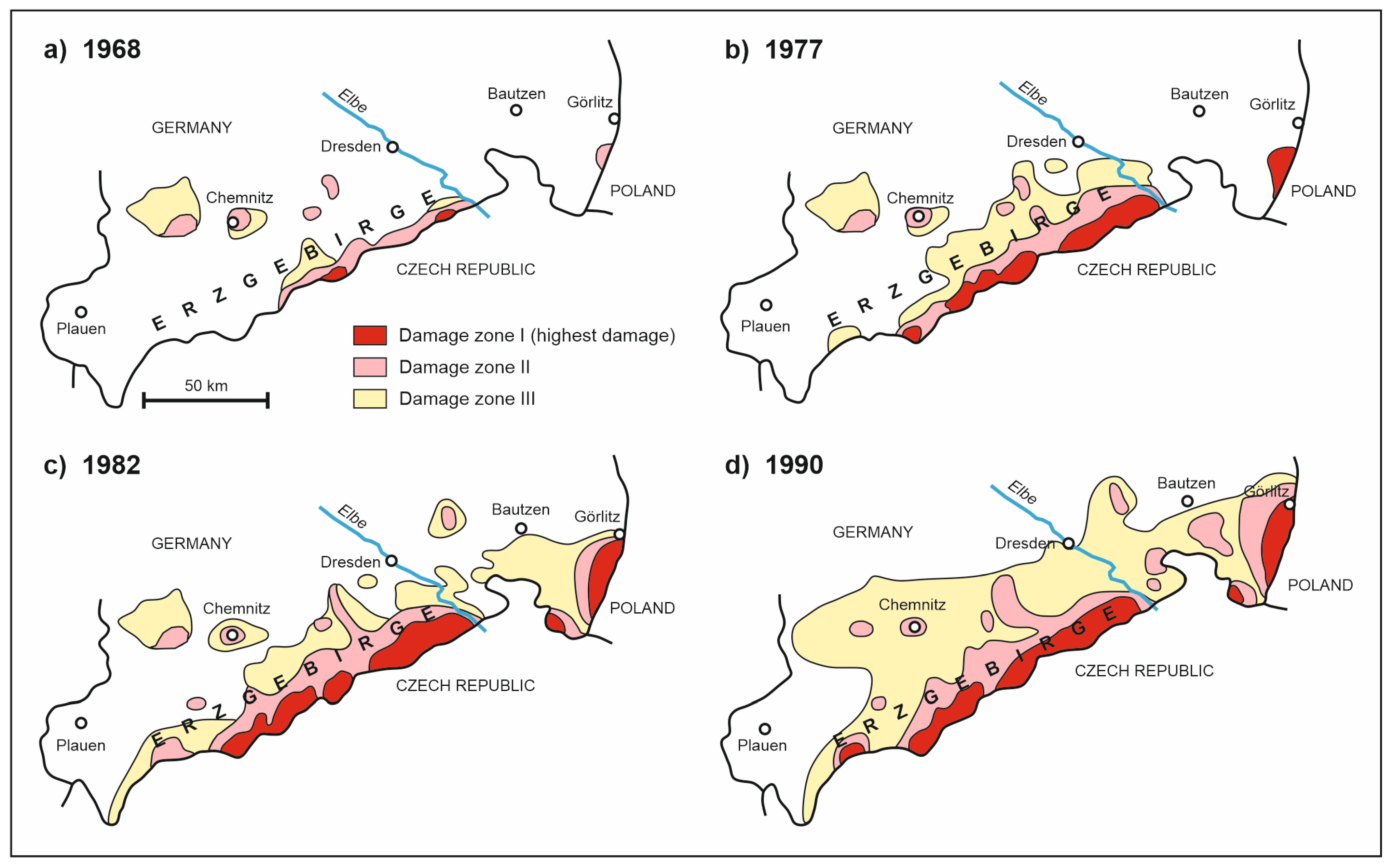
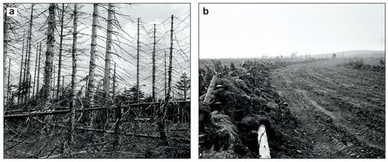
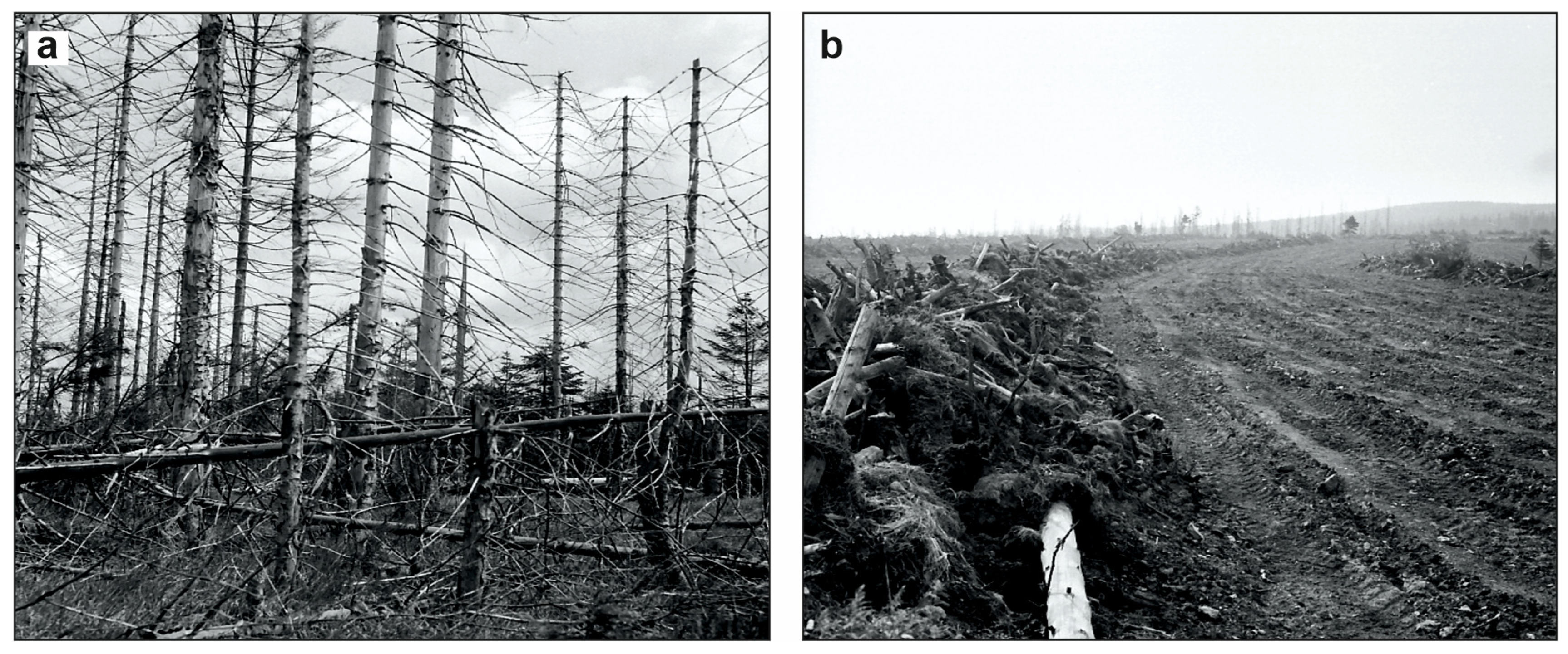
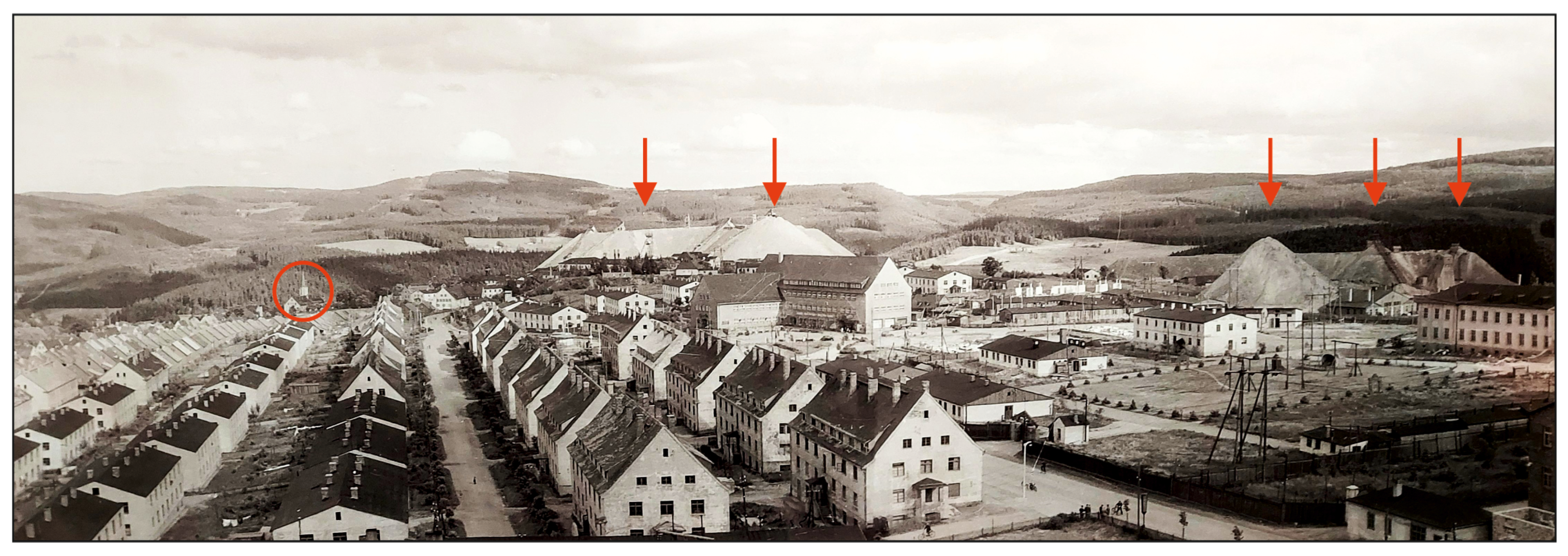
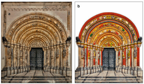
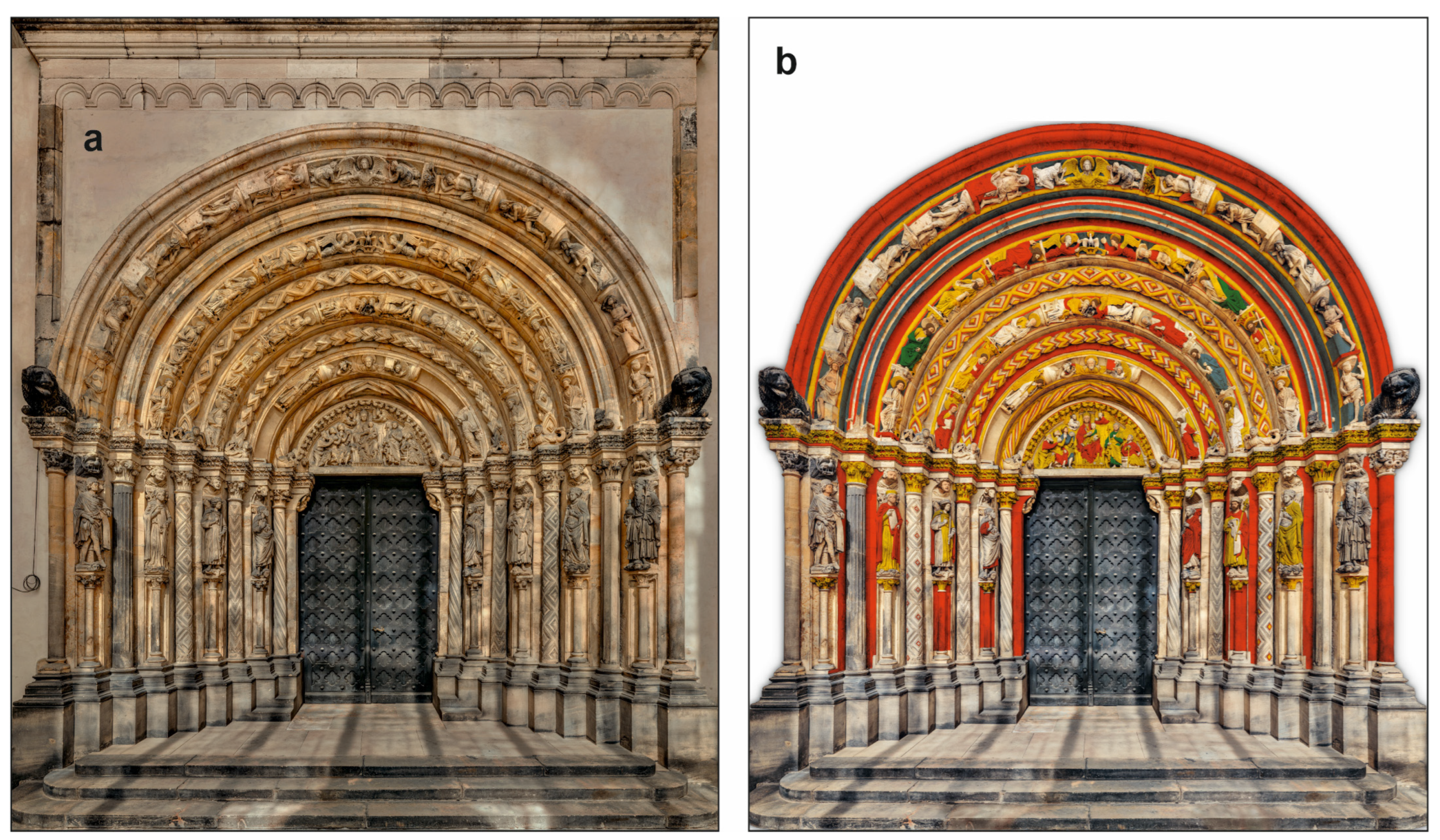
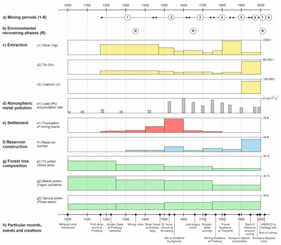
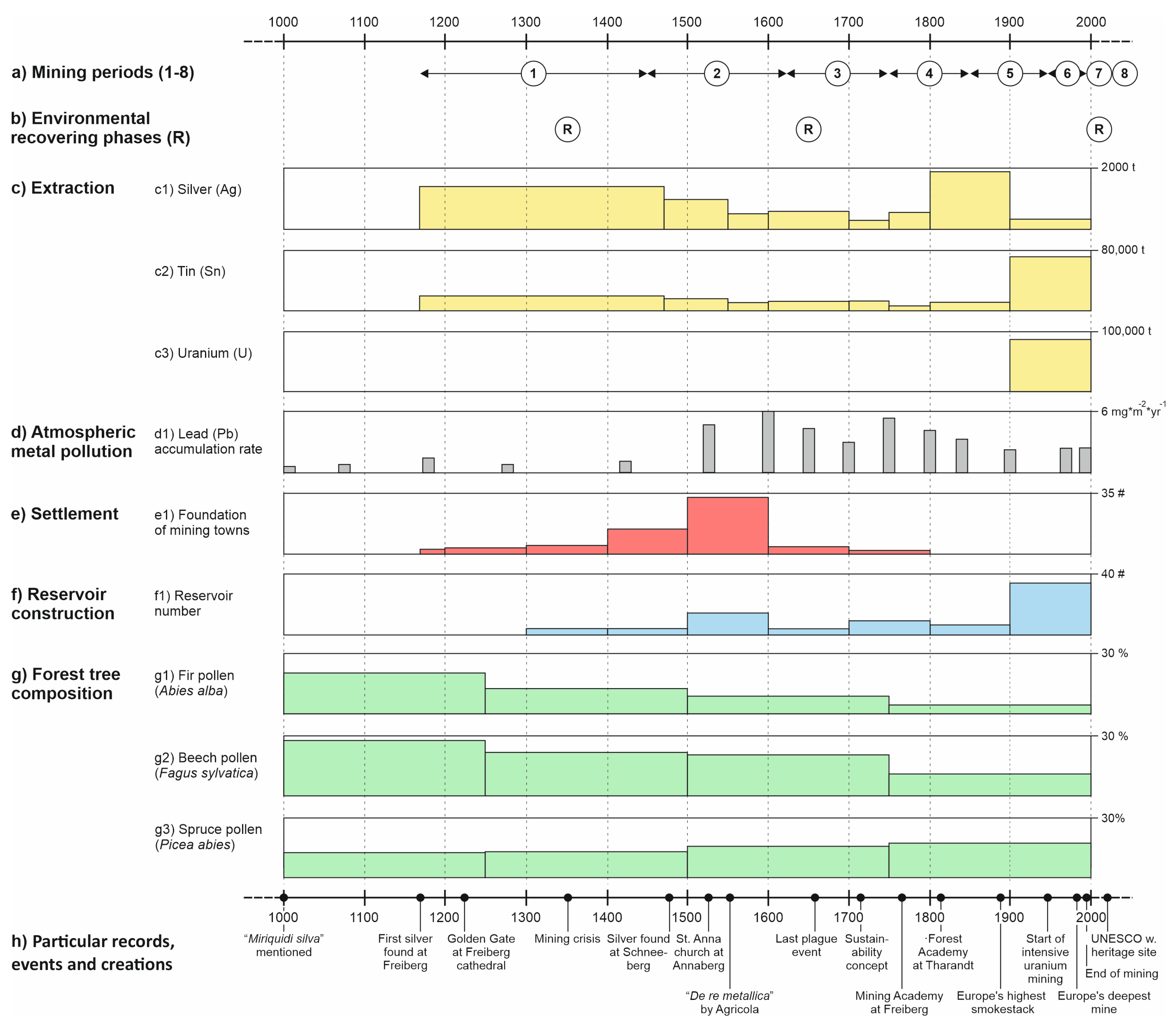
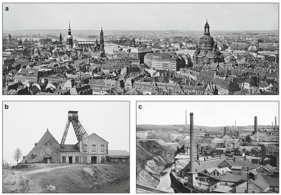
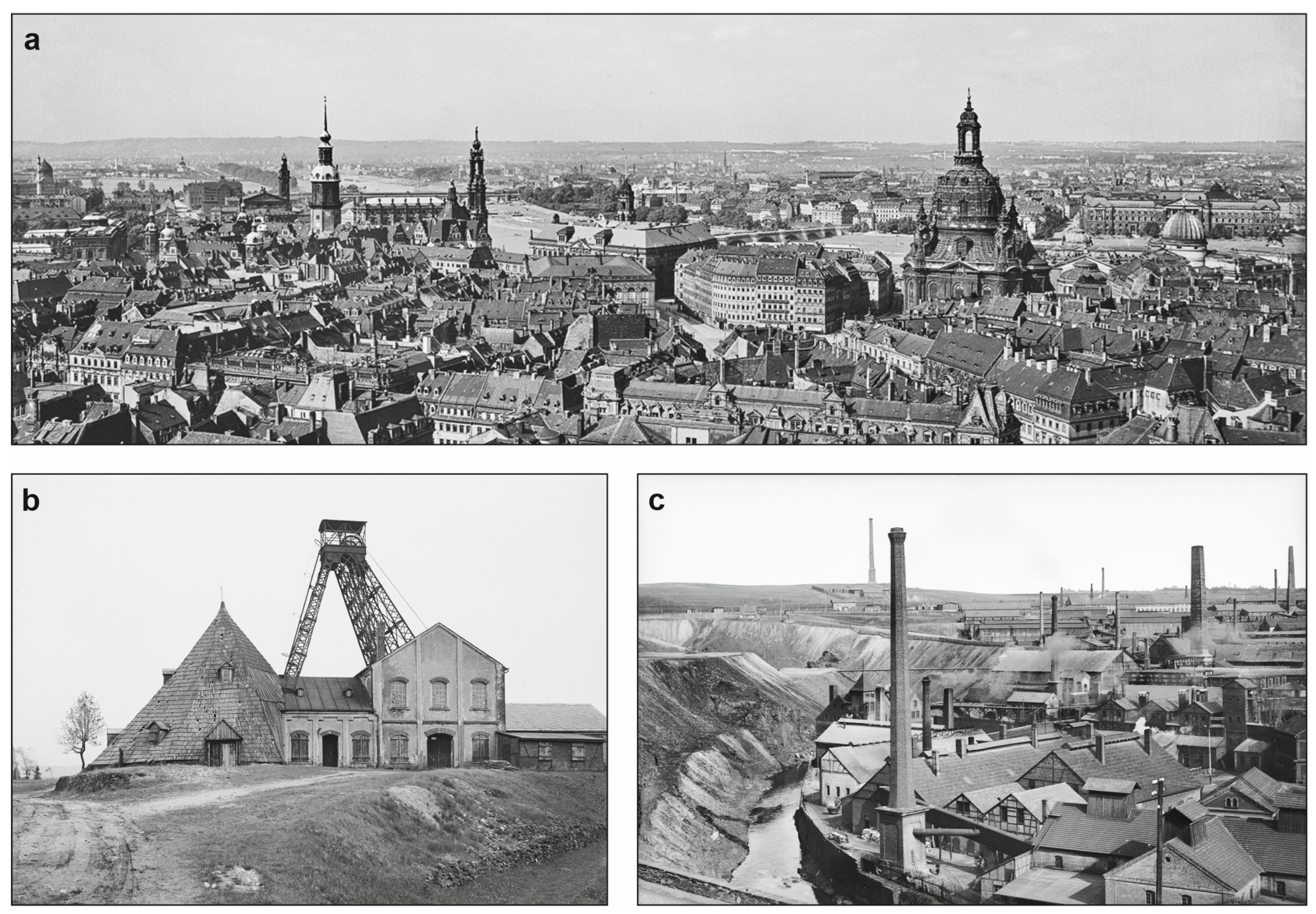
Disclaimer/Publisher’s Note: The statements, opinions and data contained in all publications are solely those of the individual author(s) and contributor(s) and not of MDPI and/or the editor(s). MDPI and/or the editor(s) disclaim responsibility for any injury to people or property resulting from any ideas, methods, instructions or products referred to in the content. |
© 2026 by the author. Licensee MDPI, Basel, Switzerland. This article is an open access article distributed under the terms and conditions of the Creative Commons Attribution (CC BY) license.