You are currently viewing a new version of our website. To view the old version click .

Geosciences, Volume 7, Issue 3

September 2017 - 48 articles

Cover Story: 
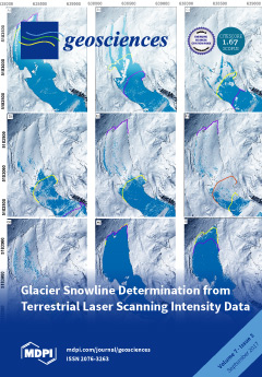
We demonstrate that Terrestrial Laser Scanner (TLS) return signals can be used to accurately map the snow cover extent over a glacier. A rule-based classification, employing intensity, surface roughness and an associated optical image, achieves classification accuracy of 68–100%. Snow cover extent is valuable information for glacier surface energy balance models, which are sensitive to the glacier surface condition; however, as the TLS intensity signal shows no meaningful relationship with surface or bulk snow density, the snow mass remains elusive. View this paper
  • Issues are regarded as officially published after their release is announced to the table of contents alert mailing list .
  • You may sign up for email alerts to receive table of contents of newly released issues.
  • PDF is the official format for papers published in both, html and pdf forms. To view the papers in pdf format, click on the "PDF Full-text" link, and use the free Adobe Reader to open them.

Articles (48)

  • Article
  • Open Access
15 Citations
9,062 Views
18 Pages

Accurate Reconstruction of the Roman Circus in Milan by Georeferencing Heterogeneous Data Sources with GIS

  • Gabriele Guidi,
  • Sara Gonizzi Barsanti,
  • Laura Loredana Micoli and
  • Umair Shafqat Malik

This paper presents the methodological approach and the actual workflow for creating the 3D digital reconstruction in time of the ancient Roman Circus of Milan, which is presently covered completely by the urban fabric of the modern city. The diachro...

  • Review
  • Open Access
5 Citations
5,635 Views
12 Pages

The piezoelectric and seismo-electrokinetic phenomena are manifested by electrical and electromagnetic processes that occur in rocks under the influence of elastic oscillations triggered by shots or mechanical impacts. Differences in piezoelectric pr...

  • Article
  • Open Access
22 Citations
6,609 Views
24 Pages

The objective of flood frequency analysis (FFA) is to associate flood intensity with a probability of exceedance. Many methods are currently employed for this, ranging from statistical distribution fitting to simulation approaches. In many cases the...

  • Article
  • Open Access
11 Citations
5,383 Views
18 Pages

Taking into Account the Role of the Weathering Profile in Determining Hydrodynamic Properties of Hard Rock Aquifers

  • Mahamadou Koïta,
  • Hamma Fabien Yonli,
  • Donissongou Dimitri Soro,
  • Amagana Emmanuel Dara and
  • Jean-Michel Vouillamoz

The present study aims at understanding the role of the structure and the geometry of the weathering profile on the hydrodynamic behavior of hard rock aquifers. We first described 2D geophysical cross sections of weathering profiles realized and vali...

  • Article
  • Open Access
44 Citations
10,634 Views
17 Pages

Multi-temporal synthetic aperture radar interferometry techniques (MT-InSAR) are nowadays a well-developed remote sensing tool for ground stability monitoring of areas afflicted by natural hazards. Its application capability has recently been emphasi...

  • Feature Paper
  • Article
  • Open Access
39 Citations
9,387 Views
33 Pages

Archaeologists often rely on passive airborne optical remote sensing to deliver some of the core data for (European) landscape archaeology projects. Despite the many technological and theoretical evolutions that have characterised this field of archa...

  • Feature Paper
  • Article
  • Open Access
53 Citations
10,175 Views
26 Pages

Ground Motion in Areas of Abandoned Mining: Application of the Intermittent SBAS (ISBAS) to the Northumberland and Durham Coalfield, UK

  • David Gee,
  • Luke Bateson,
  • Andrew Sowter,
  • Stephen Grebby,
  • Alessandro Novellino,
  • Francesca Cigna,
  • Stuart Marsh,
  • Carl Banton and
  • Lee Wyatt

In this paper, we investigate land motion and groundwater level change phenomena using differential interferometric synthetic aperture radar (DInSAR) over the Northumberland and Durham coalfield in the United Kingdom. The study re-visits earlier rese...

  • Article
  • Open Access
6 Citations
5,063 Views
16 Pages

Monitoring gaseous and particulate volcanic emissions with remote observations is of particular importance for climate studies, air quality and natural risk assessment. The concurrent impact of the simultaneous presence of sulphur dioxide (SO2) emiss...

  • Letter
  • Open Access
19 Citations
5,453 Views
7 Pages

Research is needed by global change scientists on how global vegetation biomes respond to ongoing climate warming. To address this issue, we selected study sites with significant climate warming for diverse vegetation biomes, and used global gridded...

  • Article
  • Open Access
8 Citations
12,231 Views
25 Pages

The Bruneau Woodpile: A Miocene Phosphatized Fossil Wood Locality in Southwestern Idaho, USA

  • Mike Viney,
  • George E. Mustoe,
  • Thomas A. Dillhoff and
  • Paul K. Link

The Bruneau Woodpile site has long been popular among fossil collectors; however, the deposit has received scant attention from scientists. Our research reveals that the fossilized wood was deposited ca. 6.85 Ma, within the Chalk Hills Formation, and...

of 5

Get Alerted

Add your email address to receive forthcoming issues of this journal.

XFacebookLinkedIn
Geosciences - ISSN 2076-3263Creative Common CC BY license