


Abstract
The Ijen UNESCO Global Geopark exhibits high geological diversity, recording a transition from Tertiary volcanism to active Quaternary volcanic systems and associated carbonate–karst development; however, geotourism remains predominantly site-based, limiting spatial integration and thematic continuity. This study aims to identify and structure geotrail routes by integrating geological setting, site diversity, and spatial relationships. The methodology applies a sequential framework comprising geological review, site inventory (geosites, biosites, and cultural sites), site characterization, accessibility and clustering analysis, route delineation, and SWOT-based evaluation. The results define five geotrail routes reflecting the geological evolution of the region, with spatial distribution characterized by older volcanic systems in the southern sector, Quaternary volcanism in the northern sector, and carbonate units in the eastern sector. Despite coherent geological relationships among sites, connectivity remains limited due to accessibility constraints and lack of integrated management. SWOT analysis indicates near-balanced internal factors (−0.0047) and externally constrained conditions (−0.5584), placing development in a defensive position. These findings indicate that the main limitation is the lack of spatial and interpretative integration rather than geological diversity. The study provides a systematic framework linking geological evolution to geotrail design to support integrated geotourism development.
1. Introduction
In recent decades, geoparks have emerged as integrated frameworks for the conservation of geological heritage, education, and sustainable regional development, within which geotrails function as key instruments for communicating Earth system processes to the public [1,2]. A geopark typically comprises a collection of sites that are spatially dispersed; therefore, their integration is essential, and one effective approach is through the development of geotrails [3,4,5,6,7]. Geotrails are designed not only to connect geosites spatially, but also to present coherent geological narratives that reflect temporal and genetic relationships among landforms, lithologies, and geological processes, while incorporating non-geological elements such as biosites and cultural sites [8,9,10,11,12,13].
Recent studies indicate a growing emphasis on thematic integration, visitor accessibility, and interpretative quality in geotrail development, reflecting a shift from site-based approaches [3,14,15] toward network-based systems that enhance both geotourism experience and educational value [4,6,7,16,17]. Previous research has identified several key components in geotrail planning, including geoheritage inventory [7,8], site evaluation [4,5], spatial clustering [7,8,18,19], and route optimization [6,9,10,20]. Furthermore, the integration of multiple heritage dimensions (geological, biological, and cultural) has been recognized as essential for developing comprehensive geotourism products [21]. However, persistent challenges remain, particularly related to limited accessibility, weak inter-site connectivity, the absence of integrated management systems, and, critically, the lack of a unifying geological framework that links sites within a coherent evolutionary narrative [21,22,23]. These limitations often result in geosites functioning as isolated destinations, thereby reducing the effectiveness of geotrails as integrated interpretative systems [4,17].
Within this context, the Ijen UNESCO Global Geopark (Ijen UGGp) represents one of the most developed geoparks in Indonesia and a region of high geological diversity. It is characterized by the coexistence of pre-Quaternary volcanic systems in the southern sector, Quaternary volcanic complexes in the northern sector, and carbonate–karst systems in the eastern sector, including the presence of a rare hyperacid crater lake [24,25,26]. The area comprises a wide range of geosites, biosites, and cultural sites, reflecting complex interactions among geological (abiotic), biological (biotic), and cultural (human) components [7,25,26,27,28,29]. Despite this diversity, existing tourism development remains predominantly site-based, with a strong emphasis on individual destinations, particularly iconic volcanic features, rather than their integration into a structured geotrail system. Preliminary analysis of site distribution and geological characteristics [7] indicates that many sites share coherent geological narratives, including relationships between intrusive rocks, volcanic products, and associated mineralization, as well as transitions from marine carbonate deposition to karst development. However, these relationships have not yet been systematically translated into interconnected geotrail routes. In addition, spatial separation among sites and uneven accessibility across the geopark impose constraints on route development and visitor mobility [1,28,30,31,32]. This study addresses these limitations by developing a geotrail identification framework that integrates geological setting analysis, site inventory, spatial clustering, and route evaluation. The approach combines geological parameters with practical considerations, including accessibility and spatial distribution, and incorporates a SWOT-based evaluation to assess internal and external factors influencing geotrail development. By organizing sites into thematic routes based on geological evolution and spatial relationships, this study aims to bridge the gap between site-based inventories and integrated geotrail systems. Accordingly, this study not only identifies geotrail routes within the Ijen UGGp but also explores how geological evolution can function as an organizing principle for integrated and narrative-based geotrail systems.
Geographical and Geological Setting of Ijen UGGp
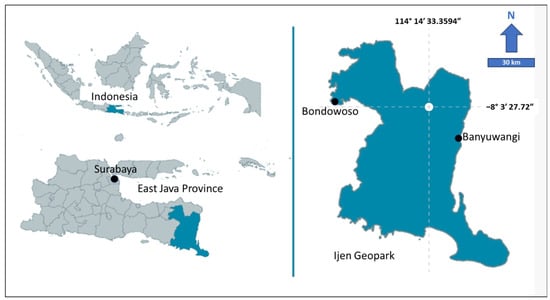
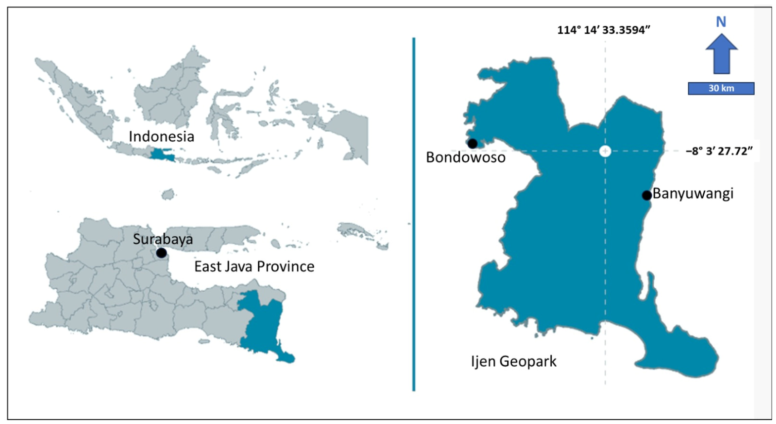
The Ijen UGGp is located in the easternmost part of Java (Figure 1) and forms part of the active volcanic arc generated by the subduction of the Indo-Australian Plate beneath the Eurasian Plate since the Eocene [33,34]. This geodynamic setting has produced a series of physiographic zones, including the Southern Mountains and the Quaternary volcanic chain [34]. Administratively, the geopark extends across the eastern part of East Java Province, covering approximately 4723 km2 within Banyuwangi and Bondowoso Regencies, and is bounded by Situbondo Regency to the north, Bali Island to the east, the Indian Ocean to the south, and Jember Regency to the west [7]. The Ijen UGGp was established in 2018 as a national geopark and was officially designated a UNESCO Global Geopark in 2023, following a multi-stage evaluation process that included geoheritage inventory, management assessment, and community participation. Prior to designation, several challenges were identified, such as fragmented tourism management, uneven accessibility, and limited integration among geological, biological, and cultural heritage components. This study addresses these limitations by developing an integrated geotrail framework. Its position within a coastal and inter-island transition zone has facilitated the development of a diverse socio-cultural landscape, shaped by long-term human mobility and trade interactions [25,28,32].
Figure 1.
Location of Ijen UGGp in Banyuwangi and Bondowoso Regency within the East Java Province, Indonesia.
Geologically, the region preserves two main volcanic phases. The older system corresponds to the Tertiary volcanic arc (Middle Eocene–Early Miocene; ~45–20 Ma), represented by the Meru Betiri–Alas Purwo Complex [24,33,34]. This unit comprises thick sequences of volcanic and volcaniclastic rocks, including lava flows, domes, breccias, and pyroclastic deposits generated by large eruptive events [7,26,33]. The composition of these rocks indicates relatively silicic magmatism influenced by interaction with continental crust [33,35]. A subsequent northward shift in volcanic activity during the Late Miocene (~11.6 Ma) led to the development of the Quaternary volcanic arc, represented by the Ijen Caldera Complex [33,34]. This system was formed through repeated large-scale eruptions producing ignimbrites, pyroclastic deposits, and lava domes, followed by caldera collapse and continued intra-caldera volcanism [34]. The volcanic system remains active, with Kawah Ijen characterized by fumarolic activity and an acidic crater lake [7,24,25]. The transition between these volcanic phases is associated with regional tectonic reorganization, including migration of the volcanic front and the development of structural controls that influence volcanic alignment and deposit distribution [33,34]. The coexistence of Tertiary volcanic remnants in the southern sector and active Quaternary volcanism in the northern sector, together with carbonate–karst systems in the eastern part, provides a continuous geological record within a single region.
2. Materials and Methods
2.1. Site Selection
The sites utilized in this study are summarized in Table 1, comprising a total of 37 locations within the Ijen UGGp. These include 21 geosites (57%), 6 biosites (16%), and 10 cultural sites (27%). In this study, a geosite is defined as a site dominated by geological features, a biosite as a site characterized primarily by biological attributes, and a cultural site as a location where human activities and cultural practices constitute the dominant features. Each site is assigned a code for systematic identification, where “G” denotes geosites, “B” represents biosites, and “C” indicates cultural sites. The coding system used in this study was developed by the author for analytical consistency and route interpretation purposes. Although the official Ijen UGGp dossier contains inventory identifiers, simplified codes were adopted to facilitate spatial clustering and geotrail analysis. Site descriptions are adapted from the official Ijen UGGp dossier and website (ijen-geopark.jatimprov.go.id) and standardized into concise scientific statements. This dataset forms the primary basis for site selection in this research, representing the spatial distribution of geopark features within the study area.
Table 1.
Dataset of Sites in Ijen UGGp with Scientific Descriptions.
2.2. Geotrail Identification
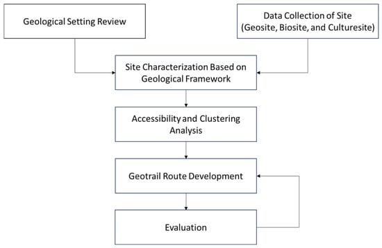
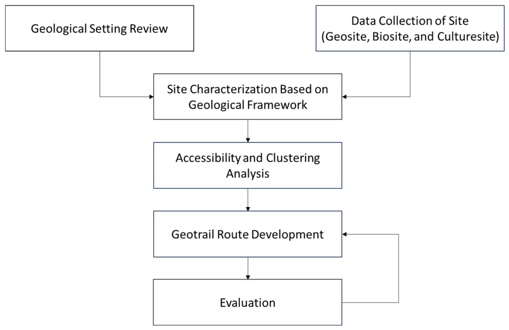
The geotrail identification framework developed in this study follows a sequential workflow that integrates geological analysis, site inventory, spatial assessment, and iterative evaluation (Figure 2). The process begins with a geological setting review and site data collection, including geosites, biosites, and cultural sites. The geological review synthesizes existing information to establish a coherent narrative across the geotrails, while the inventory compiles all relevant locations. Subsequently, the study characterizes each site based on its scientific attributes, particularly geological significance, to ensure adequate representation of geodiversity and to enable comparative assessment. The analysis then evaluates accessibility and spatial relationships, including connectivity, infrastructure, and proximity, in order to group sites into coherent clusters. Clusters were delineated by integrating geological continuity, thematic coherence, spatial proximity, accessibility, and interpretative feasibility. The framework translates these clusters into geotrail routes (the parameters more explained in Table 2). The framework translates these clusters into geotrail routes by integrating spatial proximity, thematic continuity, visitor feasibility, and the connectivity of geological narratives among sites. Finally, the study evaluates the proposed routes using SWOT analysis, to assess feasibility and development potential. This stage remains iterative, allowing for the refinement of clustering and route design as required.
Figure 2.
Methodological framework for geotrail identification.
Table 2.
Parameters considered during the geotrail route development stage.
3. Results
3.1. Site Characteristic
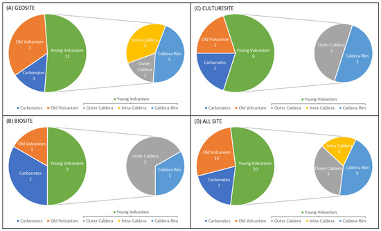
The distribution of sites within the Ijen UGGp reveals three distinct geological domains: old volcanism, young volcanism, and carbonate systems that represented statistically in Figure 3. The southern sector is dominated by old volcanism, expressed through eroded volcanic landforms and reworked deposits that preserve remnants of earlier activity. In contrast, the northern sector is characterized by the prevalence of young volcanism, which accounts for the majority of sites. This dominance reflects the spatial extent and ongoing influence of the Quaternary volcanic system in the Ijen region. Within the young volcanic domain, sites cluster into three geomorphological subgroups: outer-caldera, intra-caldera, and caldera-rim environments. Outer-caldera sites extend across the flanks surrounding the caldera system, intra-caldera sites occupy the depression and associated volcanic features, and caldera-rim sites trace the structural boundary of the caldera. The eastern sector contrasts sharply with these volcanic landscapes, hosting carbonate formations that record shallow marine depositional environments later uplifted during tectonic processes. These carbonate sites highlight a divergent geological history compared to the volcanically dominated regions.
Figure 3.
Pie charts showing the geological group distribution of geosite (A), biosite (B), culture site (C), and all sites (D) in the Ijen UGGp.
Based on categorization (Figure 3), geosites are dominated by young volcanism (11 sites), with old volcanism (7 sites) and carbonates (3 sites) occurring less frequently. Within the young volcanism, caldera-rim (5 sites) and intra-caldera (4 sites) are more common than outer-caldera (2 sites), reflecting the strong presence of structural and internal caldera features. Biosites also show a predominance of young volcanism (3 sites), accompanied by fewer old volcanism (1 site) and carbonates (2 sites) occurrences. The young volcanism is concentrated in outer-caldera (2 sites), with a single caldera-rim, indicating that biosites are more closely associated with peripheral volcanic environments. Culture sites follow a similar pattern, with young volcanism accounting for 6 sites, old volcanism for 2 sites, and carbonate for 2 sites. The volcanic subgroup is evenly divided between outer-caldera (3 sites) and caldera-rim (3 sites), underscoring the cultural significance of both peripheral and structural volcanic features. When all sites are considered together, young volcanism clearly dominates (20 sites), compared to old volcanism (10 sites) and carbonates (7 sites). Within the young volcanism, caldera-rim are most abundant (9 sites), followed by outer-caldera (7 sites) and intra-caldera (4 sites).
The dataset (Figure 3) demonstrates that young volcanism is the dominant geological domain across geosites, biosites, and culture sites, with caldera-rim and outer-caldera environments particularly well represented. This pattern suggests that geotrails should be clustered to emphasize the dynamic Quaternary volcanic system, where rim viewpoints, peripheral landscapes, and intra-caldera features can be integrated into thematic routes. The presence of old volcanism, though less frequent, is consistently recorded, especially in geosites. This provides a basis for trails that interpret the long-term volcanic history of the Ijen region, highlighting eroded landforms and reworked deposits as evidence of ancient activity. Such trails would complement the younger volcanic narratives by offering visitors a diachronic perspective of landscape evolution. The distribution of biosites shows a stronger association with outer-caldera settings, indicating that ecological trails can be designed to connect volcanic flank environments with biodiversity themes. Meanwhile, culture sites are evenly split between caldera-rim and outer-caldera, underscoring the cultural significance of both structural and peripheral volcanic features. This supports the development of heritage-oriented trails that integrate geological and cultural storytelling.
3.2. Accessibility and Clustering
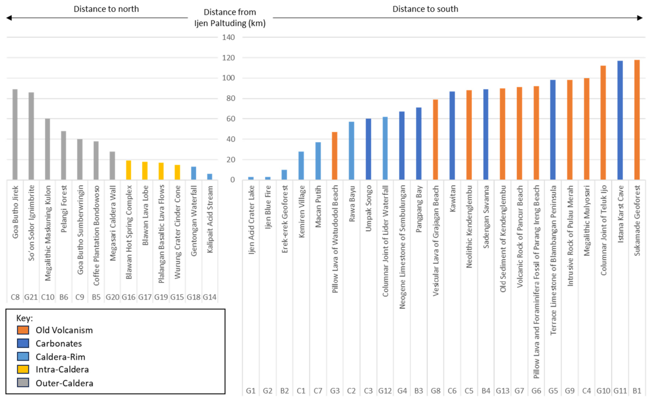
Infrastructure in the study area comprises an extensive road network and a set of supporting services. Road length totals are approximately 299,986 km in Banyuwangi Regency and 146,416 km in Bondowoso Regency. Recorded support facilities include accommodation, environmentally oriented public amenities, potable water supply, information and communication systems, and basic healthcare services; these elements are distributed across the study area and provide the logistical framework for accessing identified sites. Building on the infrastructure inventory, site locations were analyzed relative to Ijen Paltuding (Figure 4) to describe their spatial arrangement. Distances were measured separately to the north and south, and the dataset spans a radial extent with site distances up to ~120 km. This distance visualization preserves geological context while maintaining geographic reference to Paltuding. The accessibility analysis shows a spatial contrast between northern and southern sectors of the Ijen UGGp. Northern routes are relatively compact and dominated by Quaternary volcanic and intra-caldera sites near the Ijen Caldera Complex, whereas southern routes extend over greater distances and include older volcanic, coastal, and carbonate-related sites. This pattern indicates that northern geotrails are more spatially connected, while southern routes require more complex integration and transportation support. The distribution also reflects a north–south geological evolution from older volcanic systems to younger active volcanism.
Figure 4.
Distances of geological and geomorphological sites from Ijen Paltuding, plotted separately for north and south; sites are color-coded by type: gray = outer-caldera (old volcanism), yellow = intra-caldera, orange = caldera-rim, blue = carbonates. The y-axis shows distance from Paltuding in kilometers.
The distance distribution shows systematic differences among geological categories. Caldera-rim and intra-caldera sites are concentrated at relatively short distances from Paltuding, consistent with their structural position within the caldera complex. Carbonate occurrences are more commonly found at intermediate distances and appear as localized lithological units within the volcanic terrain. Old volcanism (outer-caldera) sites are distributed over a wider spatial band and include the farthest-recorded locations in the dataset. These spatial patterns correspond with three defined clusters that differ in geomorphology and elevation. The Bondowoso Cluster (northern sector) encompasses the Ijen Caldera system and post-caldera cones, with elevations of roughly 500–2000 m a.s.l. and landforms such as caldera highlands, cones, lava flows, river valleys, escarpments, and waterfalls. The North Banyuwangi Cluster (central sector) comprises an alignment of Quaternary volcanic edifices (including Mount Raung and adjacent peaks), with elevations of about 500–3000 m a.s.l., and a landscape of steep slopes, fluvial valleys, waterfalls, karst hills in the east, and coastal areas facing the Bali Strait. The South Banyuwangi Cluster (southern sector) is characterized by older volcanic hills and coastal landforms at 0–500 m a.s.l., including coastal plains, rivers, bays, peninsulas, and small offshore islands. Infrastructure and site location data are spatially coincident in many areas: road corridors and service nodes intersect the clusters at multiple points, and the distribution of facilities is recorded for each cluster. The combined dataset therefore documents the geographic spread of geological types, the elevational and geomorphological contrasts among clusters, and the existing transport and service framework that links sites across the geopark.
In addition to accessibility, hazard exposure and visitor safety were considered during route grouping. Several routes are located within active volcanic and coastal environments exposed to volcanic, hydrometeorological, and marine hazards, which influence route feasibility and interpretative planning. To minimize risks along the geotrail network within the Ijen UGGp, the geopark management applies a geotourism-based disaster mitigation approach through hazard mapping, visitor capacity adjustment, and the provision of safety information systems. Routes located in active volcanic and coastal environments are equipped with evacuation signage, hazard interpretation panels, emergency assembly points, and visitation procedures adjusted according to weather conditions and volcanic activity levels. In addition, geotrail development is coordinated with disaster management agencies, local governments, local communities, and tour guides to support preparedness, periodic monitoring, and effective dissemination of risk information. This approach not only improves visitor safety but also strengthens the educational function of the geopark by increasing public understanding of the relationship between geological processes, landscape evolution, and natural hazards within the Ijen region.
3.3. Geotrail Route
3.3.1. Route 1
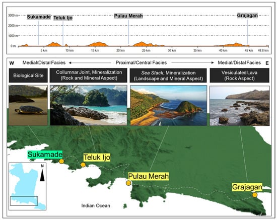
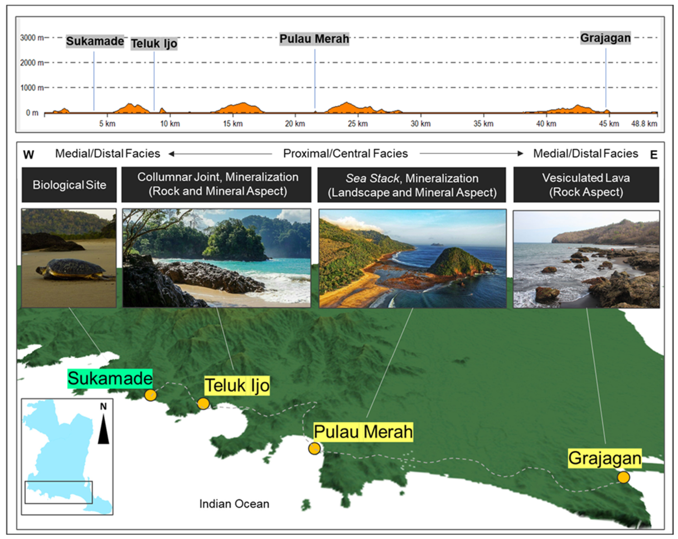
This route incorporates sites listed in the dataset (see Table 1), including Sukamade Geoforest (B1), Teluk Ijo Columnar Joint (G10), Intrusive Rock of Pulau Merah (G9), and Vesicular Lava of Grajagan Beach (G8). The route (Figure 5) extends along the southern coastal sector of the Ijen UGGp from west to east over a distance of approximately ~45 km, characterized by low-relief to moderately undulating topography (<500 m) with localized elevations associated with resistant volcanic units. The spatial distribution of sites reflects a facies transition from medial/distal settings in the western segment (Sukamade–Teluk Ijo), to more proximal/central conditions in the Pulau Merah area and returning to medial/distal conditions toward Grajagan. Geological features along the route include columnar jointing, intrusive rocks, and vesicular lava, representing different expressions of volcanic processes. These units correspond to older volcanic formations exposed along the southern coast and subsequently modified by marine erosion and deposition. The route is dominated by coastal volcanic geomorphology, where erosional landforms (cliffs, sea stacks) and depositional features (beaches) coexist. Additional site components include biological elements, particularly sea turtle nesting habitats in Sukamade, as well as coastal ecosystems that are spatially integrated with the geological features along the transect.
Figure 5.
Geotrail Route 1 along the southern coastal sector of the Ijen UGGp (white dashed line), extending from Sukamade (B1) to Grajagan (G8). The figure presents the longitudinal topographic profile, spatial distribution of key sites (B1, G10, G9, G8), and the associated facies transition from medial/distal to proximal/central and back to medial/distal settings. Representative geological features include columnar joints at Teluk Ijo, intrusive rocks at Pulau Merah, and vesicular lava at Grajagan, reflecting variations in volcanic processes and coastal geomorphology.
Beyond its geological significance, the route demonstrates the interaction between volcanic coastal morphology, marine ecosystems, and maritime cultural activities. Coastal landforms produced by volcanic processes influence shoreline configuration, sediment accumulation, wave dynamics, and the formation of sheltered coastal environments that support marine biodiversity and traditional fishing activities. In areas such as Pulau Merah and Grajagan, local fishing communities utilize bays and coastal zones naturally protected by volcanic headlands and rocky coastlines as small-scale fishing grounds and landing sites. The integration of volcanic geomorphology, coastal biodiversity, sea turtle conservation, and maritime livelihoods allows the route to function as an interpretative corridor linking magmatic evolution, coastal processes, ecosystem adaptation, and socio-economic activities within the southern coastal landscape. Consequently, the route expands the geotrail narrative beyond geological observation by emphasizing how volcanic processes continue to shape present-day ecological systems and maritime cultural landscapes.
3.3.2. Route 2
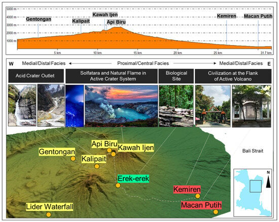
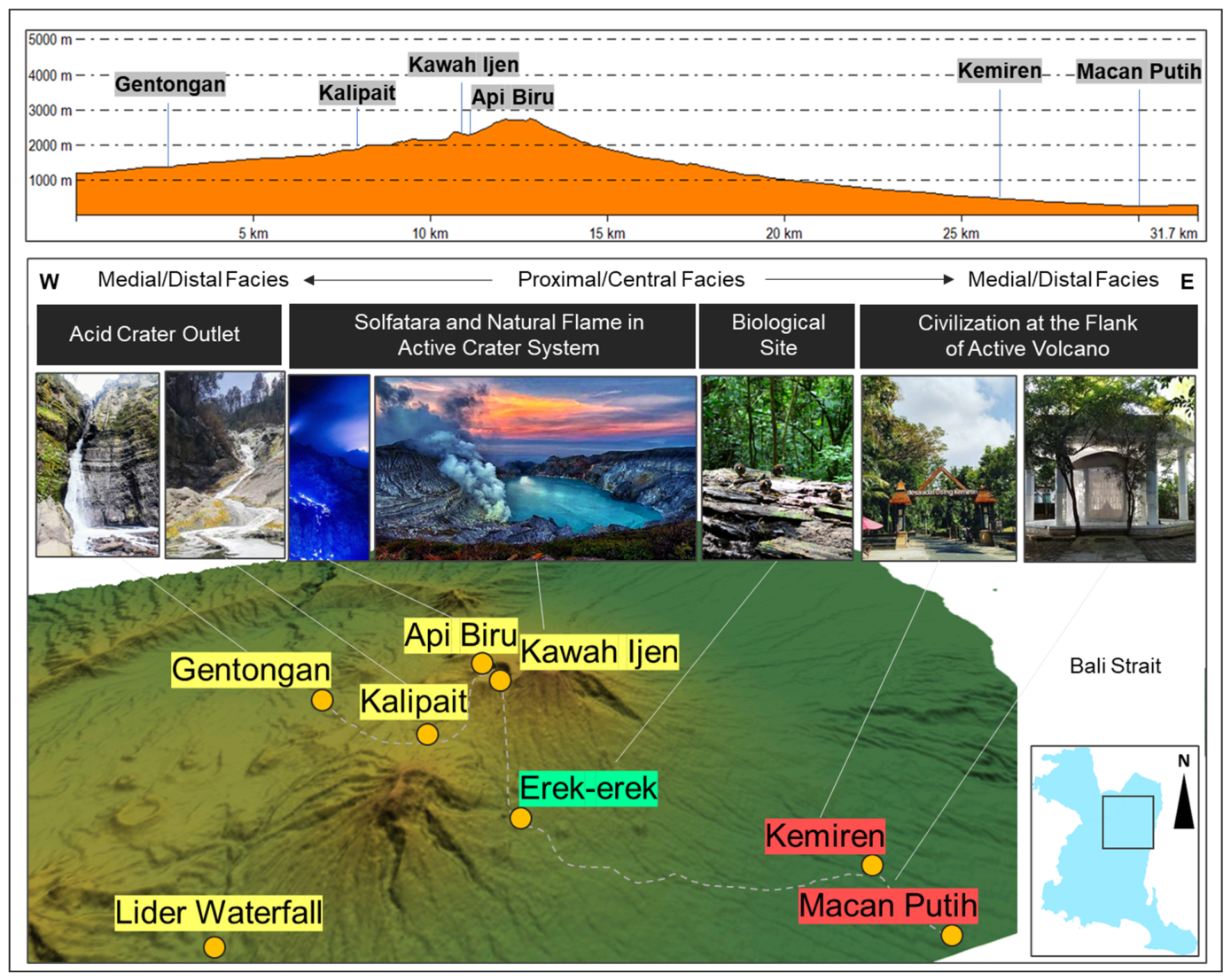
This route incorporates sites listed in the dataset (see Table 1), including Gentongan Waterfall (G18), Kalipait Acid Stream (G14), Erek-erek Geoforest (B2), Kemiren Village (C1), and Ijen Acid Crater Lake and Blue Fire (G1–G2). The route (Figure 6) extends from the lower volcanic slopes toward the summit area of the Ijen volcanic complex, representing an elevational gradient from fluvial–hydrothermal environments to an active crater system. The spatial arrangement of sites reflects a progression from peripheral volcanic features to the central volcanic system. Lower segments (Gentongan–Kalipait) are characterized by fluvial incision and hydrothermal alteration, indicated by acidic stream systems. Intermediate sections (Erek-erek–Kemiren) represent transitional zones combining geomorphological and cultural elements within the volcanic landscape. The upper segment culminates at the Ijen crater, where active volcanic processes are expressed through the acidic crater lake and blue fire phenomena. Geologically, the route is dominated by Quaternary volcanic deposits, including lava flows, pyroclastic materials, and hydrothermal features. The distribution of these features indicates an integrated volcanic system, with surface manifestations controlled by ongoing magmatic and hydrothermal activity. The route thus represents a central volcanic facies, emphasizing intra-caldera processes and active volcanism.
Figure 6.
Geotrail Route 2 (white dashed line) within the Ijen volcanic complex, extending from lower volcanic slopes to the summit crater. The figure illustrates the spatial distribution of key sites (G18, G14, B2, C1, G1–G2) and their relation to the volcanic system, highlighting the transition from fluvial–hydrothermal environments to active intra-caldera features, including the acidic crater lake and blue fire phenomenon.
In addition to its volcanic significance, the route provides an interpretative narrative linking active volcanism with ecological transition zones and long-term human adaptation within the volcanic environment. Hydrothermal manifestations such as Kalipait Acid Stream and the Ijen crater system illustrate the continuity of magmatic activity from the volcanic flank toward the summit area, while Erek-erek Geoforest reflects ecological adaptation on volcanic slopes characterized by humid montane environments. Cultural interpretation is represented by Kemiren Village, where the Osing community preserves traditional settlement patterns, agricultural systems, and local knowledge closely associated with volcanic landscapes and fertile volcanic soils. Consequently, the route functions not only as a representation of active volcanic processes, but also as an integrated narrative of geological activity, biodiversity, and cultural resilience within the Ijen volcanic system.
3.3.3. Route 3
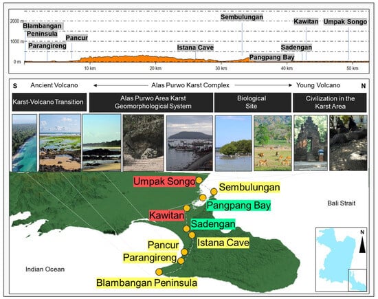
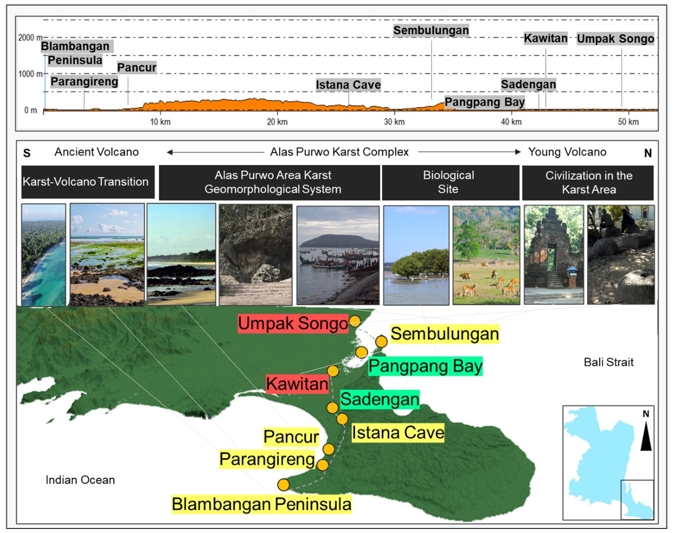
This route incorporates sites listed in the dataset (see Table 1), including Blambangan Peninsula (G5), Pancur Beach volcanic rocks (G7), Parangireng pillow lava and foraminifera (G6), Istana Karst Cave (G11), Sembulungan Neogene limestone (G4), Pangpang Bay (B3), Sadengan Savanna (B4), Kawitan (C6), and Umpak Songo (C3). The route (Figure 7) extends across the Alas Purwo area from the southern coastal sector toward the northern margin, covering a distance of approximately 50 km. The spatial distribution of sites reflects a transition from ancient volcanic settings in the southern segment to a karst-dominated system in the central part, and toward younger volcanic influence in the northern segment. Southern sites (Blambangan Peninsula–Parangireng–Pancur) are characterized by volcanic coastal outcrops, including pillow lava and associated marine deposits, indicating submarine to coastal volcanic processes. The central segment is dominated by the Alas Purwo karst geomorphological system, where limestone units form caves, coastal karst features, and low-relief carbonate landscapes. Northern segments (Sembulungan–Pangpang–Sadengan–Kawitan–Umpak Songo) integrate biological and cultural sites within the karst setting. Geologically, the route documents a transition from volcanic to carbonate systems, with karstification processes overprinting earlier marine and volcanic deposits. The distribution of features indicates a spatial relationship between lithology and geomorphology, where carbonate units control the development of cave systems and coastal landforms, while older units remain exposed along the southern coastline.
Figure 7.
Geotrail Route 3 across the Alas Purwo sector of the Ijen UGGp (white dashed line), extending from the Blambangan Peninsula (G5) to Umpak Songo (C3). The figure shows the longitudinal profile, spatial distribution of key sites (G5, G7, G6, G11, G4, B3, B4, C6, C3), and the transition from ancient volcanic coastal environments to a karst-dominated geomorphological system, integrating geological, biological, and cultural elements.
The route additionally functions as an interpretative transition between volcanic, karst, ecological, and cultural systems within the eastern sector of the Ijen UGGp. The volcanic coastal outcrops record submarine volcanism and marine depositional interaction, while the carbonate segment reflects shallow marine platform development followed by uplift and karstification. These geological transitions are accompanied by distinct ecological environments, including mangrove ecosystems at Pangpang Bay and savanna landscapes at Sadengan, both strongly controlled by lithology, hydrology, and geomorphology. Cultural sites such as Kawitan and Umpak Songo further demonstrate how historical settlement patterns and cultural activities developed in relation to coastal karst environments and natural resource availability. Consequently, the route serves as a multidisciplinary interpretative corridor linking geological evolution, ecological diversity, and cultural landscape development within a single continuous geotrail system.
3.3.4. Route 4
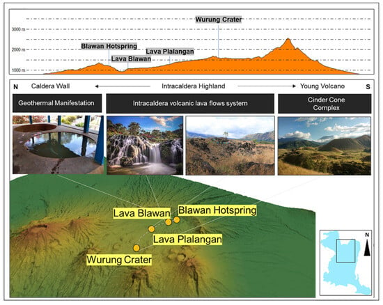
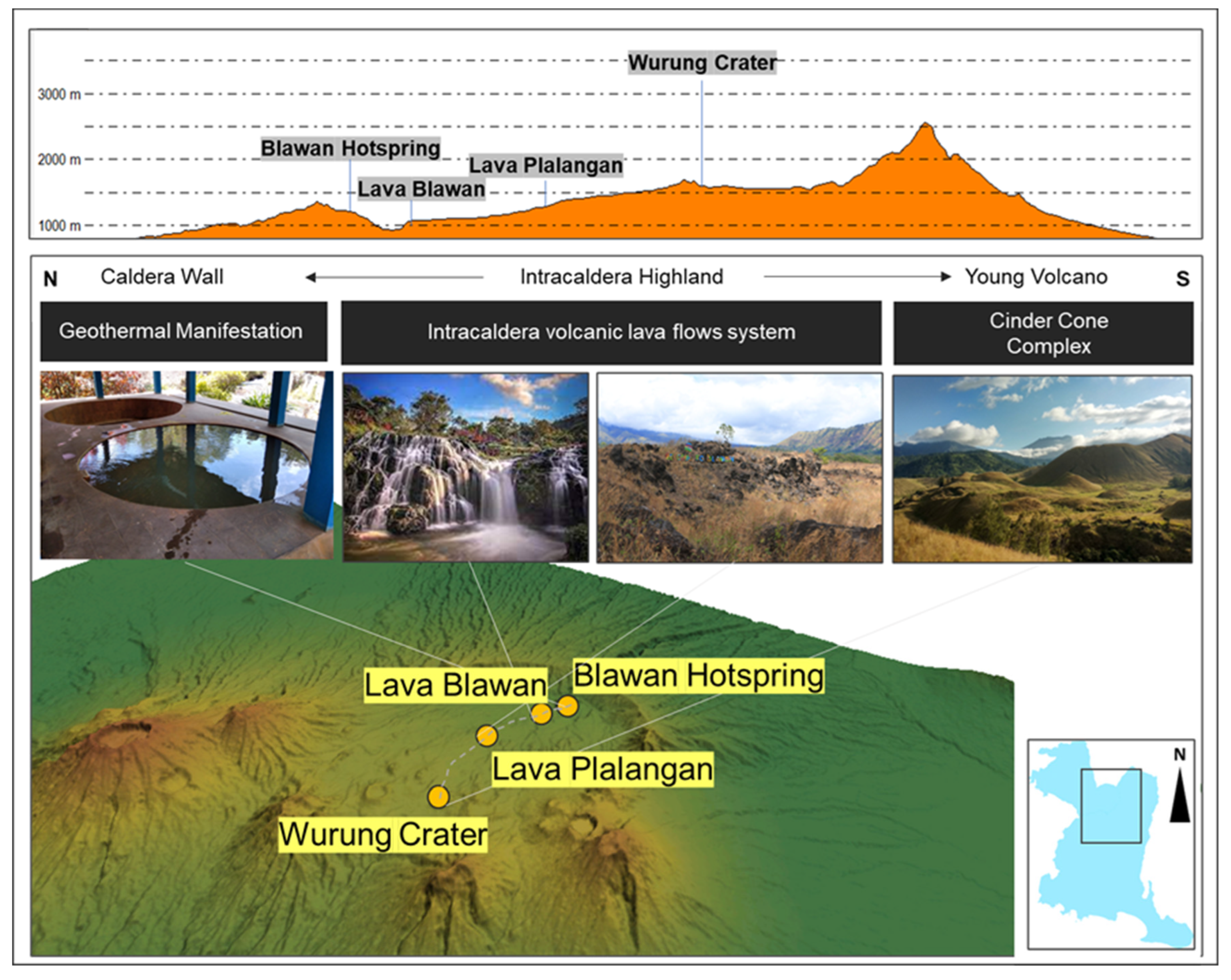
This route incorporates sites listed in the dataset (see Table 1), including Blawan Hot Spring Complex (G16), Blawan Lava Lobe (G17), Plalangan Basaltic Lava Flows (G19), and Wurung Crater Cinder Cone (G15). The route (Figure 8) is located within the intra-caldera highland of the Ijen volcanic complex, extending across the caldera floor from the northern sector toward the southern part. The spatial distribution of sites reflects an intra-caldera volcanic system characterized by geothermal manifestations and successive lava flow emplacement. The northern segment is represented by the Blawan Hot Spring Complex, indicating active hydrothermal processes associated with the caldera system. This is followed by lava flow units at Blawan and Plalangan, which form part of an intra-caldera lava flow system distributed across the caldera floor. The southern segment culminates at Wurung Crater, a cinder cone representing a localized volcanic feature within the caldera environment. Topographically, the route exhibits moderate elevation variation within the caldera highland, generally ranging between approximately 1000 and over 3000 m, with localized high points associated with volcanic structures such as cinder cones. The distribution of features indicates a spatial relationship between geothermal activity, lava emplacement, and monogenetic volcanic features within the caldera system.
Figure 8.
Geotrail Route 4 within the Ijen caldera system (white dashed line), extending across the intra-caldera highland from the Blawan Hot Spring Complex (G16) to Wurung Crater (G15). The figure illustrates the longitudinal topographic profile, spatial distribution of key sites (G16, G17, G19, G15), and the association between geothermal manifestations, intra-caldera lava flows, and cinder cone development within the caldera environment.
Beyond geological interpretation, the route highlights the relationship between volcanic processes, ecological productivity, and human utilization of volcanic landscapes. The geothermal and volcanic environments contribute to the formation of fertile volcanic soils that support agricultural activities and plantation systems in the surrounding highlands, particularly coffee cultivation within the Bondowoso region. The integration of hydrothermal manifestations, lava flow systems, volcanic cones, and agroecosystems demonstrates how active volcanic processes continue to influence land use, local economies, and ecological productivity within the caldera environment. Consequently, the route functions as an interpretative framework connecting volcanism, geothermal activity, landscape evolution, and sustainable utilization of volcanic resources.
3.3.5. Route 5
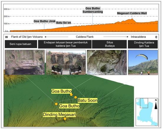
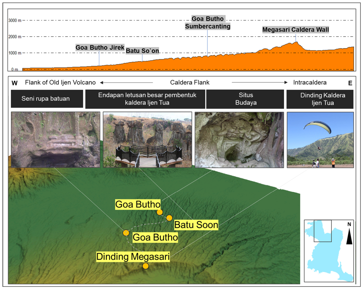
This route incorporates several sites listed in the dataset (see Table 1), including G21 (So’on Solor Ignimbrite), C8 (Goa Butho Jirek), C9 (Goa Butho Sumberwringin), and G20 (Megasari Caldera Wall). The route (Figure 9) is located in the northwestern sector of the Ijen UGGp and follows a west–east transect across the flank of the older Ijen volcanic system toward the caldera boundary. Based on the topographic profile, elevation increases gradually from the western segment toward the central and eastern parts, culminating near the Megasari Caldera Wall. The spatial arrangement of sites reflects a transition from the volcanic flank to the caldera margin and into the intra-caldera zone. The western segment is characterized by volcanic deposits associated with older eruptive phases, while the central segment includes ignimbrite exposures attributed to large-scale explosive eruptions. The eastern segment is marked by the caldera wall morphology, representing the structural boundary of the volcanic system. The distribution of sites indicates a sequence of volcanic features, including pyroclastic deposits (ignimbrite), erosional remnants on volcanic slopes, and steep caldera escarpments. Cultural sites, such as Goa Butho Jirek and Goa Butho Sumberwringin, are situated within volcanic rock outcrops and are spatially associated with geomorphological features along the slope.
Figure 9.
Geotrail Route 5 across the western flank to caldera margin of the Ijen volcanic complex (white dashed line), extending from So’on Solor Ignimbrite (G21) to Megasari Caldera Wall (G20). The figure presents the longitudinal topographic profile, spatial distribution of key sites (G21, C8, C9, C6, G20), and their relation to volcanic deposits, cultural cave sites, and caldera wall.
The route additionally illustrates the relationship between explosive volcanic events and the emergence of cultural landscapes along the caldera margin. The ignimbrite deposits and caldera wall morphology represent evidence of catastrophic eruptions and subsequent volcanic collapse, while the cultural cave sites demonstrate how volcanic landforms were later adapted for ritual, meditation, and spiritual activities. The presence of Kala motifs and archeological elements within volcanic rock outcrops reflects the transformation of geological features into symbolic cultural spaces within local society. Consequently, the route functions as an interpretative connection between volcanic disasters, geomorphological evolution, and the development of sacred cultural landscapes, reinforcing the role of geoheritage as both a natural archive and a repository of cultural memory within the Ijen UGGp.
4. Discussion
4.1. Narrative-Based Geotrails and Geological Storytelling
The proposed geotrail system demonstrates that geological evolution can function as an organizing principle for narrative-based geotrail development within volcanic geoparks. The spatial arrangement of the five routes reflects a transition from older volcanic remnants in the southern sector to younger Quaternary volcanic systems within the northern caldera complex, creating a coherent geological storyline across the Ijen UGGp. This organization transforms spatially separated geosites into interconnected interpretative units that communicate temporal and genetic relationships among volcanic processes, carbonate development, geomorphology, biological features, and cultural elements [3,4,5]. The five routes collectively represent different stages of regional geological evolution. Route 1 preserves remnants of pre-Quaternary volcanism exposed along the southern coastal domain, providing insight into older volcanic systems that may represent the ancestral analog of younger volcanic environments after long-term erosion and coastal modification. Routes 2 and 4 focus on active and intra-caldera volcanic processes associated with the Ijen Caldera Complex, including hydrothermal activity, volcanic morphology, and eruption-related deposits. Route 3 represents the transition between volcanic and carbonate systems, illustrating environmental and depositional changes from volcanism to karst development, whereas Route 5 highlights the relationship between volcanic flank deposits and caldera-forming eruptive processes. Together, these routes create a spatially organized volcanic storytelling framework that links geological age, process, and landscape evolution across the geopark [5,6,7]. The incorporation of biosites and cultural sites within several routes broadens interpretative perspectives by connecting abiotic, biotic, and cultural components into a unified framework. Examples include the association between volcanic coastal geomorphology and sea turtle habitats in Route 1, cultural settlements related to volcanic landscapes in Route 2, and cave-based cultural heritage associated with caldera environments in Route 5. Such integration supports the interpretation of geoparks as multi-domain landscapes where geological processes influence ecological systems and human activities simultaneously [13,16,17].
Previous studies have emphasized that effective geotrails require not only geoheritage inventories, but also thematic coherence, spatial continuity, and interpretative integration to transform dispersed sites into functional geotourism networks [3,4,5,6,9,12,15,18,20]. The results of this study support this perspective by demonstrating that many geosites within the Ijen UGGp already possess strong geological relationships, although these connections have not yet been systematically translated into integrated geotrail structures. For example, Teluk Ijo columnar joints, intrusive rocks at Pulau Merah, and vesicular lava deposits at Grajagan collectively record magmatic intrusion, volcanic effusion, and associated mineralization processes within a shared geological narrative. Consequently, the geotrail framework proposed in this study contributes not only to route organization, but also to the development of narrative-based geological interpretation that strengthens educational value, spatial understanding, and thematic continuity within volcanic geoparks.
4.2. Accessibility, Integration, and Development Constraints
Despite the strong thematic continuity between routes, the operational integration of geotrails within the Ijen UGGp remains limited. This condition reflects the current structure of the geopark, where coherent geological relationships are present but remain constrained by uneven accessibility, fragmented route distribution, and limited management integration [4,5]. Accessibility represents one of the principal constraints affecting route continuity and visitor mobility. The accessibility analysis demonstrates a spatial contrast between northern and southern sectors of the geopark. Northern routes associated with Quaternary volcanic systems form relatively compact clusters around the Ijen Caldera Complex, whereas southern coastal and eastern carbonate routes extend across wider geomorphological domains and require longer travel connections. This spatial configuration reduces practical connectivity between route clusters and complicates the implementation of continuous geotrail systems [9,12,23]. Although the geopark is regionally accessible through land, sea, and air transportation networks, internal mobility within the geopark remains underdeveloped, particularly regarding integrated public transportation linking southern, eastern, central, and northern sectors.
The lack of an integrated management system further limits geotrail optimization. This condition is reflected in inconsistent interpretative facilities, uneven infrastructure quality, and varying guiding capacity among sites. Several locations already provide brochures, interpretative panels, and hazard mitigation information; however, these facilities remain unevenly distributed and lack standardization across routes. Previous studies have similarly identified infrastructure variability, weak stakeholder coordination, and inconsistent interpretation as major limitations in geotrail implementation within geoparks [1,17,32].
External constraints also influence the feasibility of geotrail development. Routes located within active volcanic environments are exposed to volcanic hazards, while coastal and karst sectors remain sensitive to environmental degradation and increasing visitor pressure [3,4,18]. The absence of carrying-capacity assessment and detailed hazard integration within the current framework indicates that future geotrail planning should incorporate risk mitigation and environmental management more explicitly [1,28,30]. Consequently, geotrail development within the Ijen UGGp requires not only thematic geological integration, but also improvements in transportation connectivity, stakeholder coordination, interpretative standardization, and long-term management strategies to enable functional and sustainable route implementation.
4.3. SWOT Analysis, Limitations, and Future Directions
The optimization of the proposed geotrail routes requires evaluation using a SWOT (Strengths, Weaknesses, Opportunities, and Threats) analytical framework [32]. This framework enables the identification of internal (strengths–weaknesses) and external (opportunities–threats) factors influencing geotrail development and supports strategic evaluation of route performance [17,32]. SWOT ratings and weights (Table 3) were assigned qualitatively based on field observations, accessibility, infrastructure conditions, interpretative value, geological continuity, and management aspects of each proposed route. Weights represent the relative importance of each factor, whereas ratings indicate their influence on geotrail development using a four-point scale. The analysis follows the SWOT framework of Rangkuti [36], where strengths and weaknesses are evaluated as internal factors through the IFAS matrix, while opportunities and threats are assessed as external factors through the EFAS matrix. The results indicate that the main strength of the proposed geotrail system lies in the integration of geological narratives across the five thematic routes, whereas the principal weaknesses relate to limited accessibility and lack of inter-route integration. Route 1 documents pre-Quaternary volcanic remnants along the southern coast, Route 2 concentrates on active volcanic features within the caldera system, Route 3 represents the transition from ancient volcanism to karst development, Route 4 highlights intra-caldera volcanic processes, and Route 5 illustrates the relationship between volcanic flank deposits and caldera-forming eruptions. This distribution reflects a spatially organized geological storyline from older southern units to younger northern volcanic systems [7,26], supported by a dataset of 21 geosites.
Table 3.
Internal factor evaluation matrix for geotrail development in the Ijen UGGp, presenting weighted scores of strengths and weaknesses based on geological integration, site diversity, accessibility, and management-related parameters.
Based on the internal factor matrix (Table 3), the strength score (1.9523) is slightly lower than the weakness score (1.9571), resulting in an internal factor value of −0.0047. This near-equilibrium reflects a balanced condition between advantages and constraints within the geotrail system. This result is consistent with the dataset. Strengths such as coherent geological storytelling (S1) and site connectivity (S2) are evident in the arrangement of routes that represent different geological domains, from older volcanic systems (Route 1) to active caldera processes (Routes 2 and 4) and karst development (Route 3), supported by a total of 21 geosites. Thus, the internal factor value, different with external factor (Table 3), quantitatively reflects a system where strong geological representation is constrained by spatial and managerial limitations, indicating the need to maintain strengths while improving integration and accessibility [7,26].
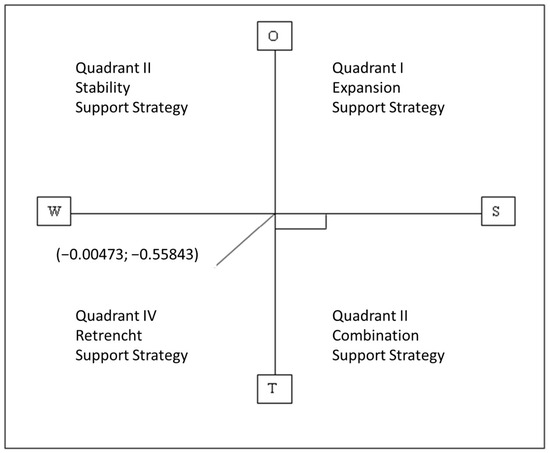
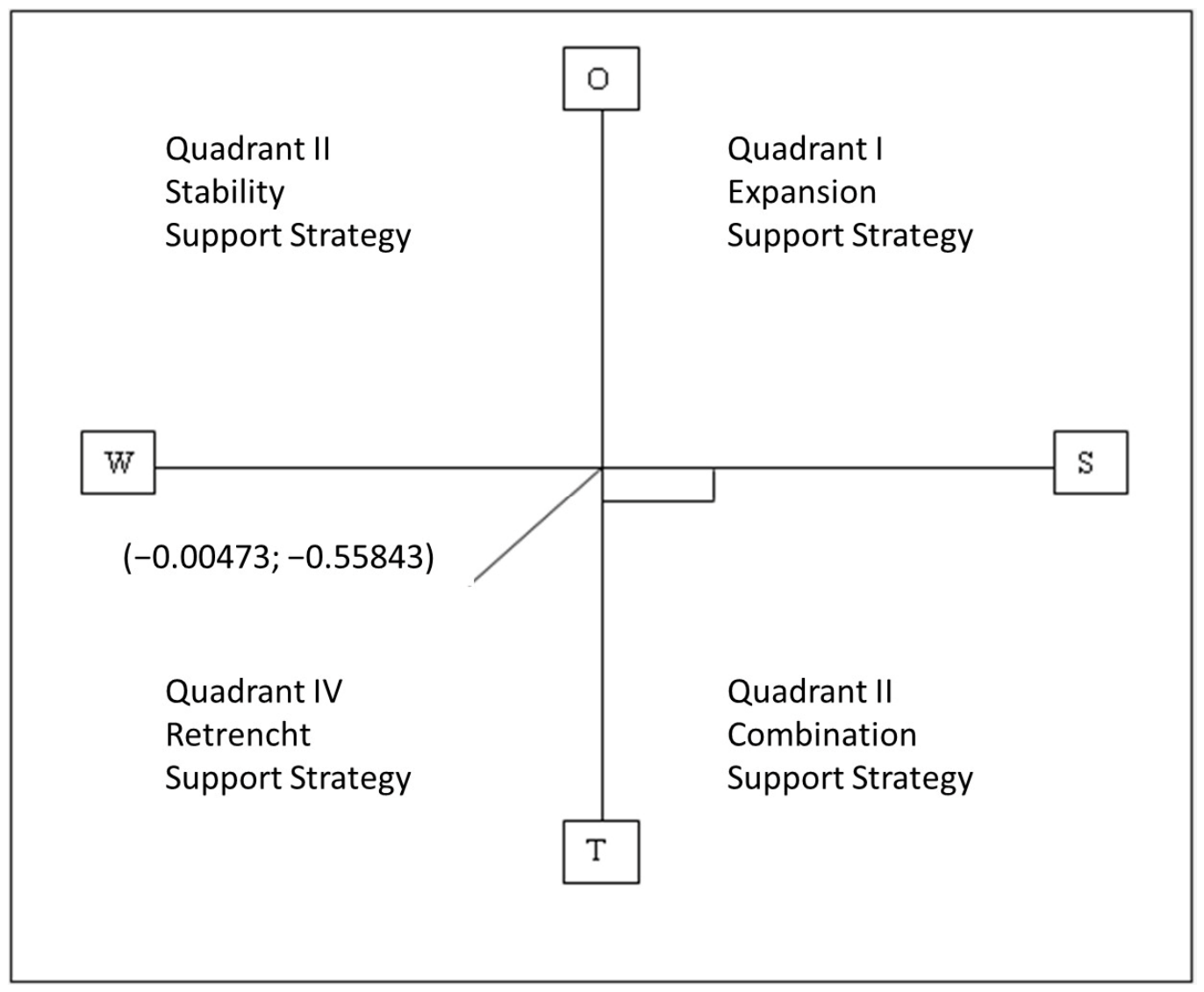
Based on the external factor matrix (Table 4), the opportunity component has a total score of 1.656, whereas the threat component is higher at 2.214, resulting in an external factor value of −0.558. This negative value indicates that external constraints outweigh potential opportunities in the development of geotrails within the Ijen UGGp [7]. This condition is consistent with the dataset, where several routes—particularly those located in active volcanic settings (Routes 2 and 4) and sensitive coastal or karst environments (Routes 1 and 3)—are exposed to natural hazards and environmental pressures, while increasing visitor intensity may further amplify these risks. The resulting internal factor value is −0.0047, while the external factor value is −0.5584. These results indicate that internal conditions are relatively balanced, whereas external factors are more strongly dominated by threats. In this context, the development of geotrails is more directly influenced by internal factors, particularly those related to site integration, accessibility, and management, as reflected in the spatial separation between route clusters and variability in infrastructure [4,5,6]. The strategic position within the grand strategy matrix is determined using the internal factor value (X-axis) and external factor value (Y-axis). The calculated coordinates are X = −0.0047 and Y = −0.5584, indicating the relative position of the geotrail development strategy as shown in Figure 10.
Table 4.
External factor evaluation matrix for geotrail development in the Ijen UGGp, presenting weighted scores of opportunities and threats related to tourism growth, environmental conditions, and regional dynamics.
Figure 10.
Strategic position diagram of geotrail development in the Ijen UGGp based on internal (X-axis) and external (Y-axis) factor values.
Based on the grand strategy matrix, the geotrail development of the Ijen UGGp is positioned in Quadrant IV, indicating a defensive strategic orientation. This position is defined by negative values in both internal (−0.0047) and external (−0.5584) factors, reflecting a condition where weaknesses slightly exceed strengths and threats significantly outweigh opportunities. In this context, a defensive strategy emphasizes minimizing internal weaknesses while avoiding or reducing exposure to external threats [1,7]. This is consistent with the dataset, where limitations such as lack of integration among routes, accessibility constraints, and spatial dispersion are combined with external pressures including hazard exposure in volcanic areas (e.g., Routes 2 and 4) and environmental sensitivity in coastal and karst systems (Routes 1 and 3). Accordingly, strategic actions should focus on improving internal system integration and management capacity, while simultaneously reducing vulnerability to external risks. Based on the analysis of internal factors (strengths and weaknesses) and external factors (opportunities and threats) influencing the development of geotrails in the Ijen UGGp, strategic directions can be formulated using a SWOT matrix approach. Accordingly, several strategic actions are identified: (1) improving accessibility, attractions, and amenities through a pentahelix approach involving government, academia, industry, community, and media; (2) establishing a coordination forum among stakeholders to enhance integration of dispersed sites into coherent geotrail systems; (3) developing regulatory frameworks for land use management in geopark tourism areas to reduce environmental disturbance; and (4) mapping and strengthening human resources as key actors in conservation and disaster mitigation through capacity-building programs.
Previous research has demonstrated that geotrail design requires not only geoheritage inventory but also thematic integration, spatial continuity, and interpretative coherence to transform dispersed sites into functional networks [4,13,17]. In this context, route optimization should prioritize the delineation of geotrails based on shared geological narratives, enabling the development of structured tour packages and facilitating the communication of scientific information in accessible formats [12,13]. This approach aligns with the concept of geotrails as narrative-based systems that integrate abiotic, biotic, and cultural elements within a unified interpretative framework [21]. Several operational constraints identified in this study further support observations reported in the literature. Limited infrastructure, inconsistent accessibility, and the absence of standardized interpretative media are commonly cited as barriers to effective geotrail implementation. In the Ijen UGGp, public facilities that physically and functionally connect sites remain limited, and guiding capacity varies across locations. Site-specific needs have not been systematically assessed, resulting in uneven provision of interpretative materials. Although some sites provide brochures and informational resources, their distribution remains incomplete, and interpretative panels, including hazard mitigation signage, are not consistently implemented.
Accessibility represents a critical limiting factor. While the geopark is regionally accessible through land, sea, and air transport networks, internal mobility remains underdeveloped. The lack of integrated public transportation reduces connectivity between the southern, eastern, central, and northern sectors, thereby constraining the practical implementation of the proposed geotrail network [4,17]. Future research should therefore expand the framework by integrating quantitative spatial approaches, including GIS-based network analysis, visitor flow modeling, and accessibility simulation. Additional studies focusing on visitor perception, interpretative effectiveness, and carrying capacity assessment would also strengthen the operational implementation of geotrails within the Ijen UGGp. Moreover, the conceptual framework developed in this study may be further tested in other volcanic geoparks to evaluate the applicability of geological evolution and narrative continuity as organizing principles for geotrail systems.
5. Conclusions
This study applies a sequential geotrail identification framework consisting of geological setting review, site inventory compilation, site characterization, accessibility and clustering analysis, route delineation, and iterative SWOT-based evaluation to assess geotrail development within the Ijen UGGp. The results demonstrate that the geotrail system can be organized into five thematic routes reflecting the geological evolution of the region, dominated by pre-Quaternary volcanism, Quaternary volcanism, and carbonate–karst development. These themes correspond to the spatial distribution of sites, where younger volcanic systems dominate the northern sector, while older volcanic and carbonate systems occur in the southern and eastern sectors.
The integration of geological continuity, thematic coherence, spatial proximity, and accessibility in the route delineation process indicates that many sites contain interconnected geological narratives, although these relationships remain insufficiently integrated spatially and operationally. The results further show that linking geological features of different ages, particularly between Tertiary and Quaternary systems, is important for maintaining interpretative continuity and supporting visitor movement across routes. However, limited accessibility, uneven infrastructure, and weak connectivity between site clusters remain major constraints affecting route implementation.
The iterative SWOT evaluation indicates that weaknesses slightly exceed strengths, while threats are more dominant than opportunities, reflecting limitations in management integration, accessibility, and operational connectivity. Therefore, future geotrail development should prioritize improved route connectivity, integrated interpretative systems, stakeholder coordination, and supporting infrastructure. Overall, this study demonstrates that the Ijen UGGp possesses a strong geological basis for geotrail development and that the applied framework can support the transformation of site-based inventories into interconnected geotrail systems. The study further demonstrates that geological evolution can serve as a conceptual framework for organizing geotrails into integrated narrative systems that connect geological, biological, and cultural heritage across spatially distributed sites.
Author Contributions
Conceptualization, A. and F.S.N.S.; methodology, A.; validation, A., M.A., Y.R. and N.K.; formal analysis, F.S.N.S.; investigation, A.; resources, M.A.; data curation, A. and F.S.N.S.; writing—original draft preparation, A., M.A., Y.R., N.K. and F.S.N.S.; writing—review and editing, A. and F.S.N.S.; visualization, A. and F.S.N.S.; supervision, M.A., Y.R. and N.K.; project administration, M.A.; funding acquisition, M.A. All authors have read and agreed to the published version of the manuscript.
Funding
This research is funded by the 2026 Research, Community Service, and Innovation (PPMI) grant from the Faculty of Earth Sciences and Technology (FITB), Bandung Institute of Technology (Project ID: FITB.PPMI-1-8-2026).
Data Availability Statement
Data available on request due to restrictions.
Acknowledgments
This research was conducted as part of the first author’s PhD study at Institut Teknologi Bandung (ITB). The authors gratefully acknowledge the support of the Ijen UNESCO Global Geopark Management, along with the Banyuwangi and Bondowoso Governments, whose assistance was invaluable in facilitating this work.
Conflicts of Interest
The authors declare no conflicts of interest.
References
- Suhud, U.; Wolor, C.W.; Sulistyowati, R.; Allan, M.; Hoo, W.C.; Azinuddin, M.; Sihotang, D.S. Geopark tourism: The influence of destination personality, reputation, and preference on tourist visit intentions to Ijen Geopark. Sci. Cult. 2025, 11, 1061–1079. [Google Scholar] [CrossRef]
- Herrera-Franco, G.; Carrión-Mero, P.; Alvarado, N.; Morante-Carballo, F.; Maldonado, A.; Caldevilla, P.; Briones-Bitar, J.; Berrezueta, E. Geosites and Georesources to Foster Geotourism in Communities: Case Study of the Santa Elena Peninsula Geopark Project in Ecuador. Sustainability 2020, 12, 4484. [Google Scholar] [CrossRef] [Scilit]
- Lestari, F.; Medtry Prabowo, Y.D.; Nugraheni, M.D. Geotrails: Blending geotourism and geological discovery at the Bayah Dome Geopark, Indonesia. Geoj. Tour. Geosites 2025, 59, 725–736. [Google Scholar] [CrossRef] [Scilit]
- Chingombe, W. A Framework for Evaluating Geotrails for Education and Geotourism. Afr. J. Hosp. Tour. Leis. 2024, 13, 66–75. [Google Scholar] [CrossRef]
- Alberico, I.; Alessio, G.; Fagnano, M.; Petrosino, P. The Effectiveness of Geotrails to Support Sustainable Development in the Campi Flegrei Active Volcanic Area. Geoheritage 2023, 15, 15. [Google Scholar] [CrossRef] [Scilit]
- Stolz, J.; Megerle, H.E. Geotrails as a Medium for Education and Geotourism: Recommendations for Quality Improvement Based on the Results of a Research Project in the Swabian Alb UNESCO Global Geopark. Land 2022, 11, 1422. [Google Scholar] [CrossRef] [Scilit]
- Abdillah, A. Karakterisasi Geotrail Objek Geologi di Kawasan UNESCO Global Geopark Ijen Jawa Timur. Bachelor’s Thesis, Institut Teknologi Bandung, Bandung, Indonesia, 2023. [Google Scholar]
- Ansori, C.; Kusworo, A.; Mareta, N.; Hastria, D.; Putro, I.N.Y. The True Mother Earth Geotrail, in Kebumen Geopark. In Iop Conference Series Earth and Environmental Science; IOP Publishing: Bristol, UK, 2024. [Google Scholar]
- Palgutová, S.; Štrba, Ľ.; Vravcová, A. Interpretation of geological heritage on nature trails and geotrails in Geopark Banská Štiavnica and their online information availability. Acta Montan. Slovaca 2024, 29, 393–404. [Google Scholar] [CrossRef] [Scilit]
- da Silva, V.B.; Mohr, I.M.; Meucci, M.C.; Hilgert, V.G.; Philipp, R.P.; de Lima, E.F.; Menegat, R.; Rodrigues, A.G.; Michelin, C.R.L. Integration of historical-cultural and geological heritage: Geotrail in the historic center of Porto Alegre, RS. Bol. Parana. Geosci. 2025, 83, 1–10. [Google Scholar] [CrossRef] [Scilit]
- Ang, M.; Anggraini, J.D.; Khairunnisa, S.; Aniqusyita, M.; Syihab, K.H.; Varera, R.P.; Hudaya, M.K.; Septiana, R. Improving Tourism Village Quality through the Development of the Geotrail in Genggelang Village, Rinjani-Lombok UGGp. Area. In Iop Conference Series Earth and Environmental Science; IOP Publishing: Bristol, UK, 2024. [Google Scholar]
- Drápela, E. Using a Geotrail for Teaching Geography: An Example of the Virtual Educational Trail “The Story of Liberec Granite”. Land 2023, 12, 828. [Google Scholar] [CrossRef] [Scilit]
- Guerini, M.; Ferrazza, A.; D’Incà Levis, G. Science, art, and legends in geotourism: A multidisciplinary geotrail approach in Alagna Valsesia, Sesia Val Grande Geopark (NW Italy). Geosci. Commun. 2026, 9, 87–100. [Google Scholar] [CrossRef] [Scilit]
- Pegatariana, I.K.A.; Susilo, A.; Aprilia, F.; Putro, B.H.T.E. Tracing Geological Stories: A Geotrail Study in Purwodadi Village, Tirtoyudo District, Malang Regency. In Iop Conference Series Earth and Environmental Science; IOP Publishing: Bristol, UK, 2024. [Google Scholar]
- Jeon, Y.; Koh, J.G.; Southcott, D. A case study of Geopark activation through Geobranding and Geotrails at the Jeju Island UNESCO Global Geopark, Republic of Korea. Episodes 2022, 46, 211–227. [Google Scholar] [CrossRef] [Scilit]
- Mariotto, F.P.; Bonali, F.L.; Tibaldi, A.; De Beni, E.; Corti, N.; Russo, E.; Fallati, L.; Cantarero, M.; Neri, M. A New Way to Explore Volcanic Areas: QR-Code-Based Virtual Geotrail at Mt. Etna Volcano, Italy. Land 2022, 11, 377. [Google Scholar] [CrossRef] [Scilit]
- Williams, M.A.; Rolls, S.; McHenry, M.T. Optimising geotrail planning by leveraging least-cost path for sustainable geotourism development: A case study on a Tasmanian west coast post-mining landscape. Inf. Technol. Tour. 2025, 27, 477–512. [Google Scholar] [CrossRef] [Scilit]
- Ginting, N.; Rahman, V.N.; Nasution, A.D.; Dewi, N.A. Geotourism development through the public facilities in Geotrail Bakkara, Toba Caldera Geopark. Geoj. Tour. Geosites 2021, 37, 914–920. [Google Scholar] [CrossRef] [Scilit]
- Koswara, A.Y.S.T.M.T.; Zahra, S.A.; Rachma, D.K.A.; Munthe, S.B.; Tifani, D.A.; Fatmala, E.; Novianti, N.F.; Puspitasari, A.H.; Hidayat, T.R.P. JAGOAN: Transportation digitalization innovation through application-based geotrail development to creat a tourism center of excellent in the geopark of Pasuruan district. In IOP Conference Series Earth and Environmental Science; IOP Publishing: Bristol, UK, 2024. [Google Scholar]
- Norrish, L.; Sanders, D.; Dowling, R. Geotourism product development and stakeholder perceptions: A case study of a proposed geotrail in Perth, Western Australia. J. Ecotourism 2014, 13, 52–63. [Google Scholar] [CrossRef] [Scilit]
- Pásková, M.; Zelenka, J.; Ogasawara, T.; Zavala, B.; Astete, I. The ABC Concept—Value Added to the Earth Heritage Interpretation? Geoheritage 2021, 13, 38. [Google Scholar] [CrossRef] [Scilit]
- Tripolitsiotou, F.; Zafeiropoulos, G.; Argyraki, A.; Drinia, H. Applying the Geoeducational Assessment Method (GEOAM) to Urban Geotourism in Athens, Greece: Integrating Geomythology and Geoeducation for Sustainable Development. Geoheritage 2026, 18, 28. [Google Scholar] [CrossRef] [Scilit]
- Gravis, I.; Németh, K.; Twemlow, C.; Németh, B. The Ghosts of Old Volcanoes, a Geoheritage Trail Concept for Eastern Coromandel Peninsula, New Zealand. Geoconserv. Res. 2020, 3, 40–57. [Google Scholar] [CrossRef] [Scilit]
- Sabila, F.S.N. Vulkanostratigrafi dan Petrogenesis Gunung Raung dan Sekitarnya, Kabupaten Jember dan Kabupaten Bondowoso, Provinsi Jawa Timur. Bachelor’s Thesis, Institut Teknologi Bandung, Bandung, Indonesia, 2018. [Google Scholar]
- Sabila, F.S.N.; Abdurrachman, M.; Saepuloh, A.; Kurniawan, I.A.; Baraas, A.; Yudiantoro, D.F.; Kusdaryanto, H. Geology, Archaeology, and Historical Studies of the Late 16th Century Plinian Eruption of Raung Volcano: A Potential Case for Disaster Geotourism in Ijen UNESCO Global Geopark, East Java, Indonesia. Geosciences 2024, 14, 284. [Google Scholar] [CrossRef] [Scilit]
- Permanadewi, S.; Samodra, H.; Irzon, R.; Prabowo, A.; Ansori, C. Quantitative assessment for geosites of the Ijen Geopark in Banyuwangi Regency, East Java, Indonesia. Int. J. Geoheritage Parks 2024, 12, 63–74. [Google Scholar] [CrossRef] [Scilit]
- Siddiq, A.M.; Wimbaningrum, R.; Sulistiyowati, H.; Setiawan, R.; Febrianti, S.D.; Sabila, F.S.N. The diversity of birds in mangrove forest at Biosite Pangpang Bay, Ijen Geopark. Life Sci. Biotechnol. 2023, 1, 52–58. [Google Scholar] [CrossRef] [Scilit]
- Suhud, U.; Allan, M.; Hoo, W.C. Destination sustainability of Ijen Geopark as perceived by tourists: How far its impact on visit intention? Geoj. Tour. Geosites 2025, 58, 146–160. [Google Scholar] [CrossRef] [Scilit]
- Novenda, I.L.; Hakim, L.; Gama, Z.P.; Batoro, J.; Nugroho, S.A. The analysis of habitat characteristics of Anaphalis javanica at Kalipait Waterfall, Ijen Geopark. Bio Web Conf. 2026, 210, 02040. [Google Scholar] [CrossRef] [Scilit]
- Sarwoprasodjo, S.; Kinseng, R.A.; Sunarminto, T.; Mijiarto, J.; Hidayati, R.K.; Syifa, F.A.; Dzar, A.A.; Syah, M.R.A.A.; Muthmainnah, H.S.; Santoso, Z.F. Fostering ecosystem resilience through targeted communication: A cluster analysis of Ijen Geopark Communities. Bio Web Conf. 2025, 175, 04003. [Google Scholar] [CrossRef] [Scilit]
- Sarwoprasodjo, S.; Nurkasanah, A.; Aulia Syifa, F.; Sari, Y. The Visibility Paradox of Conservation Communication in UNESCO Geoparks: Evidence from Social Media Analysis of Ijen Geopark. Stud. Media Commun. 2026, 14, 134–144. [Google Scholar] [CrossRef] [Scilit]
- Sumarmi, S.; Maryani, E.; Rose, R.A.C.; Patiro, S.P.S.; Noviani, R.; Kurniawati, E.; Arinta, D. Community-based tourism (cbt) in the osing community’s local wisdom to support UNESCO Global Geopark Ijen in Kemiren Village, Indonesia. Geoj. Tour. Geosites 2026, 64, 176–189. [Google Scholar] [CrossRef] [Scilit]
- Smyth, H.R.; Hamilton, P.J.; Hall, R.; Kinny, P.D. The deep crust beneath island arcs: Inherited zircons reveal a Gondwana continental fragment beneath East Java, Indonesia. Earth Planet Sci. Lett. 2007, 258, 269–282. [Google Scholar] [CrossRef] [Scilit]
- van Bemmelen, R.W. The Geology of Indonesia; Government Printing Office: The Hague, The Netherlands, 1949.
- Abdurrachman, M.; Widiyantoro, S.; Saepuloh, A.; Kurniawan, I.A. Tracing the Missing Argoland Beneath Java: Evidence from Geochemical Signature and Seismic Tomogram; Springer: Berlin/Heidelberg, Germany, 2019; pp. 37–40. [Google Scholar] [CrossRef] [Scilit]
- Rangkuti, F. SWOT Analysis: Techniques for Analyzing Business Cases; PT Gramedia Pustaka Utama: Jakarta, Indonesia, 2015. [Google Scholar]

Disclaimer/Publisher’s Note: The statements, opinions and data contained in all publications are solely those of the individual author(s) and contributor(s) and not of MDPI and/or the editor(s). MDPI and/or the editor(s) disclaim responsibility for any injury to people or property resulting from any ideas, methods, instructions or products referred to in the content. |
© 2026 by the authors. Licensee MDPI, Basel, Switzerland. This article is an open access article distributed under the terms and conditions of the Creative Commons Attribution (CC BY) license.