


Abstract
Predicting fracture architecture away from wells remains a major challenge in crystalline basement reservoirs because hydrocarbon storage and fluid flow are controlled predominantly by heterogeneous secondary fracture networks. This study evaluates whether an exposed granitoid block can provide a useful structural analogue for a deeply buried fractured-basement reservoir through integration of field fracture mapping at Ke Ga, borehole image and conventional well-log data from Well BH-415 in the Bach Ho field, multi-mineral petrophysical modelling, and seismic attributes in the Cuu Long Basin, offshore Vietnam. Three principal fracture populations were identified at Ke Ga, dominated by a NNE–SSW-oriented set striking approximately 20–30° and representing about 57% of the mapped fractures. The BH-415 basement contains vertically variable NNW–SSE, NNE–SSW, NE–SW, and NW–SE fracture trends associated with contrasting degrees of brecciation, alteration, and secondary pore development. The highest-quality fractured intervals exhibit net secondary porosity of up to approximately 6.6% and net permeability exceeding 1100 mD. Cross-scale comparison reveals partial rather than one-to-one structural correspondence: the dominant NNE–SSW Ke Ga population is compatible with NNE–SSW to NE–SW trends in BH-415, and a NW–SE population occurs in both datasets, whereas other subsurface fracture trends lack clear outcrop equivalents. RAI-derived seismic attributes further show spatial consistency with structurally heterogeneous intervals identified at the well. These results demonstrate that fracture orientation alone is insufficient to predict reservoir quality and that outcrop observations should be used primarily to constrain plausible structural architectures rather than to transfer petrophysical properties directly to the subsurface. The integrated workflow provides a conservative cross-scale framework for characterizing heterogeneous fractured crystalline basement reservoirs and evaluating the applicability of surface structural analogues in subsurface exploration.
1. Introduction
Fractured crystalline basement reservoirs represent an unconventional class of hydrocarbon accumulations in which storage capacity and fluid flow are controlled predominantly by secondary pore systems rather than by primary matrix properties. Unlike conventional clastic reservoirs, crystalline rocks generally possess negligible primary porosity and permeability, and their reservoir performance depends on the development, connectivity, aperture, and spatial organization of natural fractures, breccias, vugs, and weathering-related voids [1,2,3,4,5]. Consequently, predicting the distribution of hydraulically effective fractures remains one of the principal challenges in the exploration and development of basement reservoirs.
The Cuu Long Basin (CLB), offshore southern Vietnam, provides one of the best-known examples of commercial hydrocarbon production from fractured crystalline basement [3,6,7]. Major discoveries, particularly the Bach Ho field, have demonstrated that Mesozoic granitoid basement can form highly productive reservoirs where tectonic deformation, faulting, brecciation, alteration, and weathering have generated interconnected secondary pore networks [1,2,8]. Previous studies have documented the geological evolution of the basin, the petrophysical characteristics of the basement, present-day stress conditions, and the application of borehole imaging and seismic attributes to fracture characterization [8,9]. Nevertheless, substantial uncertainty remains in predicting fracture architecture away from wells because individual fractures occur below conventional seismic resolution and fracture properties vary strongly over relatively short distances.
Borehole image logs provide high-resolution information on fracture orientation, aperture, and distribution at the well scale, whereas conventional petrophysical logs allow fractured intervals to be evaluated in terms of secondary porosity and reservoir quality. Seismic attributes can extend structural interpretation beyond individual wellbores but generally respond to larger-scale discontinuities and fracture-related heterogeneity rather than directly resolving individual fractures [1,9]. Each dataset therefore characterizes a different spatial scale of the fracture system. Integrating these observations into a consistent structural interpretation remains essential for reducing uncertainty in fractured-basement characterization.
Exposed crystalline basement provides an additional source of structural information because fracture networks can be mapped over spatial scales that cannot be observed directly in boreholes. Previous analogue studies show that outcrops can constrain fracture orientation, spacing, clustering, mineralization, and network organization, while also emphasizing that exposure-related processes and sampling geometry can modify the observed fracture population [10,11,12,13]. Accordingly, similarity in fracture orientation alone does not establish direct equivalence between an exposed analogue and a buried reservoir; the transferability of individual fracture attributes must be evaluated explicitly.
This limitation is particularly relevant to the Cuu Long Basin. Granitoid exposures along southeastern Vietnam provide an opportunity to examine regional basement fracture architecture directly, while extensive subsurface datasets are available from producing basement highs offshore. Yet the extent to which structural patterns observed in exposed granitoids correspond to fracture populations identified within deeply buried CLB basement reservoirs has not been sufficiently evaluated through a systematic, multi-scale comparison. Establishing such correspondence—or identifying its limitations—is important because reliable outcrop analogs could provide additional constraints on fracture organization in areas where subsurface data are sparse.
In this study, the Ke Ga granitoid exposure is investigated as a potential structural analogue for fractured crystalline basement in the Bach Ho field. Rather than assuming direct equivalence between surface and subsurface fracture systems, we evaluate whether their dominant structural patterns show correspondence across different observational scales. Field measurements of fracture orientation and density at Ke Ga are compared with fracture characteristics derived from borehole image logs in Well BH-415. Conventional wireline logs and multi-mineral petrophysical modelling are used to evaluate the reservoir significance of the identified fractured intervals, while seismic attributes provide a larger-scale representation of structural heterogeneity around the basement high.
The study therefore addresses three principal questions: (1) what fracture populations characterize the Ke Ga granitoid outcrop and the subsurface basement interval of Well BH-415; (2) to what extent do the dominant fracture orientations and structural patterns observed at the surface correspond to those identified in the subsurface; and (3) how are the subsurface fracture populations related to secondary porosity, permeability, and reservoir quality? We test two explicit claims: first, correspondence in fracture orientation alone is insufficient to establish equivalence in reservoir quality between an exposed granitoid analogue and a deeply buried fractured-basement reservoir; second, outcrop observations are most defensibly used to constrain plausible structural architectures, whereas reservoir significance must be evaluated independently using borehole-image, petrophysical, and seismic information. This framing separates observed geometrical correspondence from hydraulic or genetic equivalence.
2. Geological Setting
2.1. Regional Tectonic and Stratigraphic Setting of the Cuu Long Basin
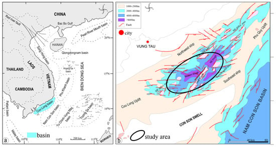
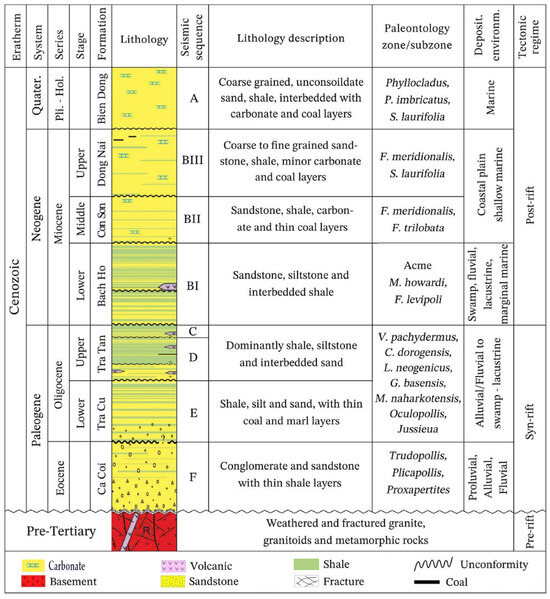
The Cuu Long Basin (CLB) is a Cenozoic rift basin located on the southeastern Vietnamese continental shelf and covers an area of approximately 36,000 km2. It is separated from the Nam Con Son Basin to the southeast by the Con Son Swell and comprises a complex system of basement highs, fault-bounded depressions, horsts, and grabens developed above pre-Cenozoic crystalline basement [1,3]. The structural configuration of the basin reflects a polyphase tectonic evolution involving Paleogene extension, subsequent thermal subsidence, and local structural inversion (Figure 1) [1,2].
Figure 1.
Regional geological setting of the Cuu Long Basin, offshore southern Vietnam; (a) distribution of sedimentary basins on the Vietnamese continental shelf and adjacent areas; and (b) location of the study area within the Cuu Long Basin. Modified from [3] and reproduced with permission from Elsevier.
The pre-Cenozoic basement consists predominantly of Mesozoic granitoids, including granite and granodiorite bodies related to the regional magmatic evolution of southeastern Vietnam [6]. These crystalline rocks were subsequently affected by faulting, brittle deformation, hydrothermal alteration, and subaerial weathering before and during development of the Cenozoic basin. As a result, structurally elevated basement blocks locally contain extensive networks of fractures, breccias, vugs, and altered zones that provide the secondary porosity and permeability required for hydrocarbon storage and flow [8].
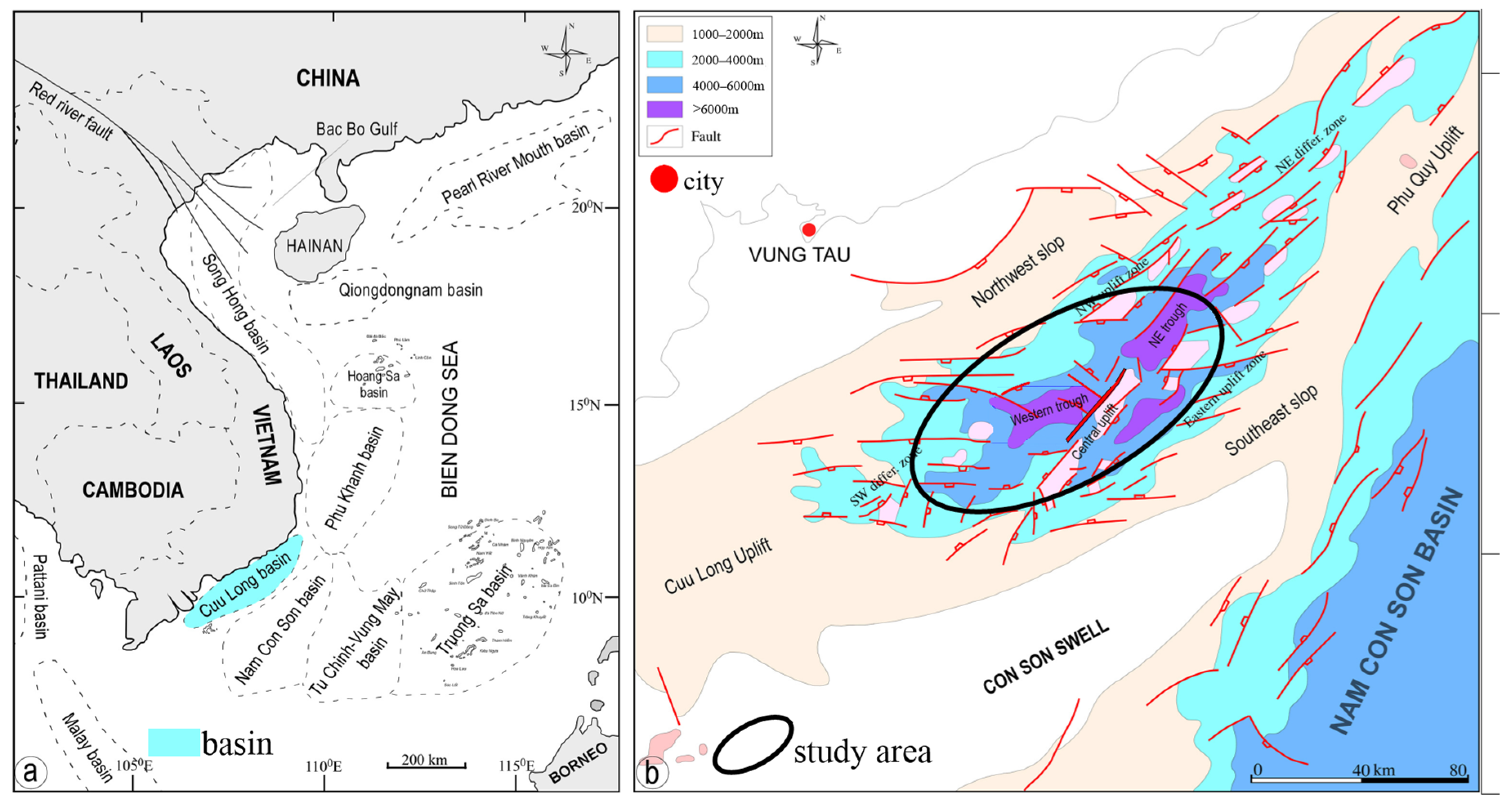
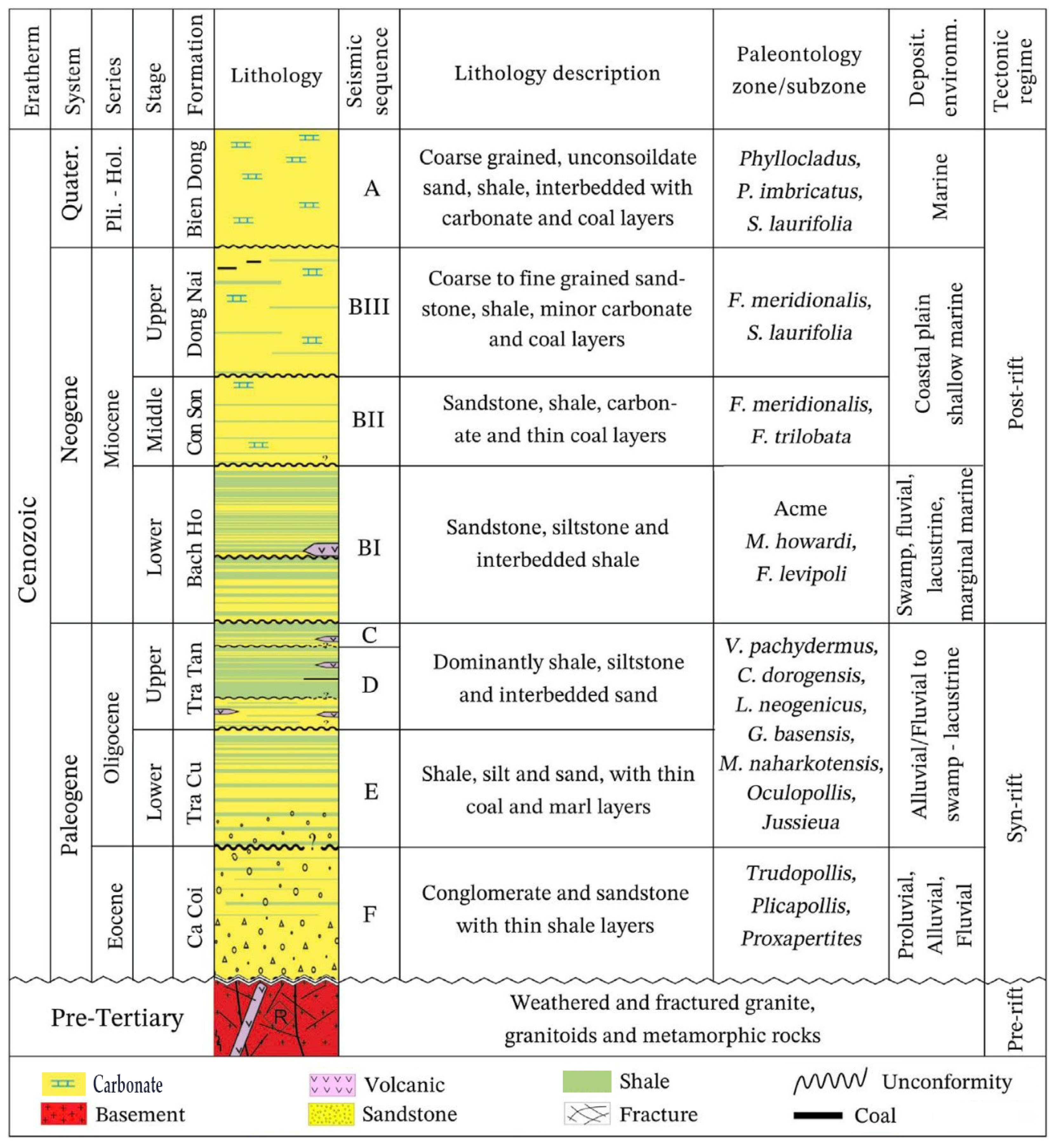
The Cenozoic sedimentary succession records the progressive development of the basin above this irregular basement surface. Oligocene lacustrine successions, particularly organic-rich intervals of the Tra Tan Formation (Figure 2), constitute the principal petroleum source rocks, whereas Miocene mudstone successions provide effective regional seals [1,3,5]. Hydrocarbons generated within the deeper basin depocenters migrated toward adjacent structural highs, including fractured basement blocks, where fault- and fracture-controlled secondary pore systems formed effective reservoirs [1,8].
Figure 2.
Generalized stratigraphic and tectonic framework of the Cuu Long Basin, showing the principal depositional units, major tectonic phases, petroleum-system elements, and the position of the pre-Cenozoic crystalline basement. Modified from [3] and reproduced with permission from Elsevier.
The development and reactivation of basement faults are particularly important for this study because they provide a structural link between regional tectonic deformation and fracture generation within crystalline rocks. Previous investigations of the CLB have documented multiple fault orientations and changes in the regional stress field through time [8,9]. Consequently, fracture populations preserved within both exposed and buried granitoid blocks may contain structural signatures inherited from regional deformation, although subsequent burial, alteration, weathering, and stress modification can significantly modify their present-day expression.
2.2. Bach Ho Fractured Basement Reservoir
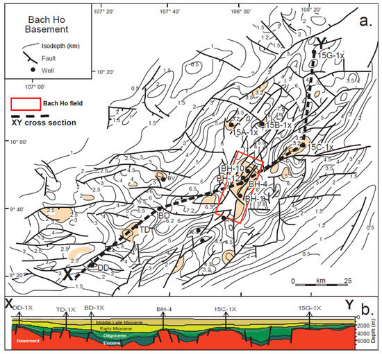
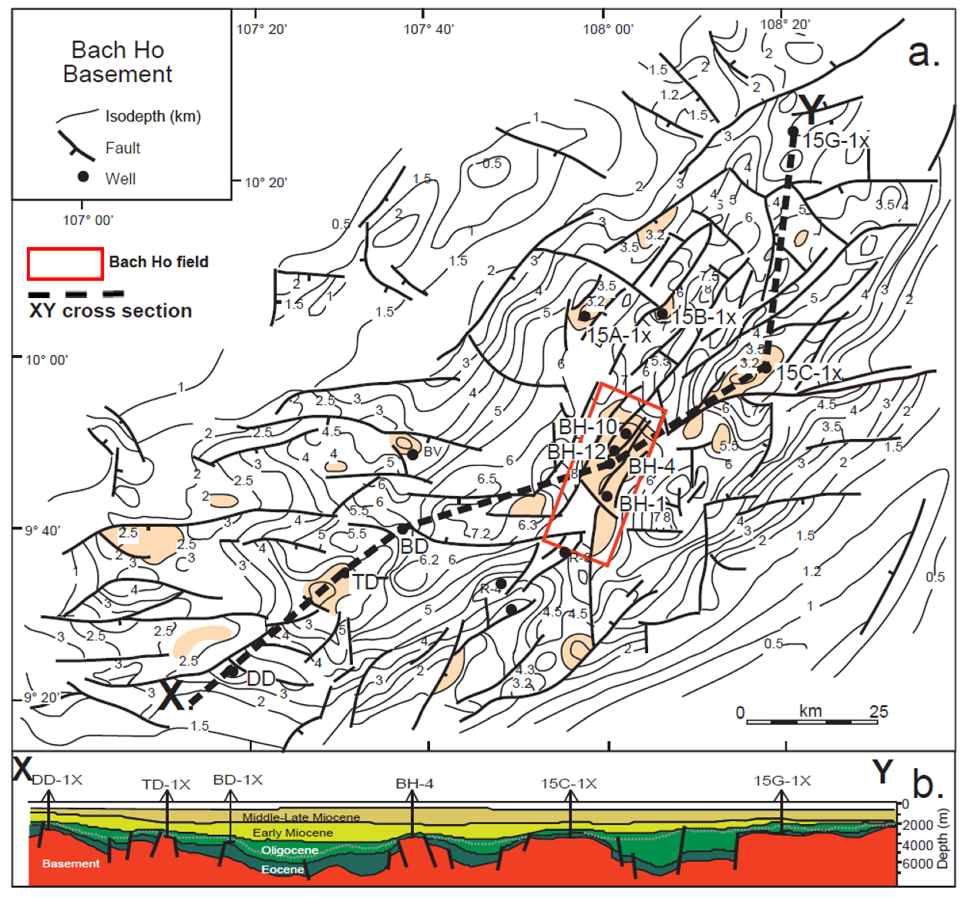
The Bach Ho field is located on one of the major basement highs within the central part of the Cuu Long Basin and represents a well-established example of commercial hydrocarbon production from fractured granitoid basement [2,8]. The reservoir occurs within a structurally elevated crystalline block overlain and laterally surrounded by Cenozoic sedimentary successions. The irregular top-basement morphology and associated fault systems divide the basement into structural compartments and strongly influence the spatial distribution of fractured reservoir intervals (Figure 3).
Figure 3.
Regional structural configuration of the crystalline basement in the Bach Ho area: (a) top-basement structural map showing basement highs and the regional cross-section trace; (b) regional geological cross-section illustrating variations in basement depth. Well labels shown in this regional source figure are retained from the original reference [8] and should not be interpreted as identifiers for Well BH-415, which is the separate well used for detailed borehole analysis in this study. Depths are shown relative to the datum used in the source figure. Modified from [8] and reproduced with permission from Wiley.
The granitoid matrix itself has very limited primary storage capacity. Reservoir quality is therefore controlled predominantly by secondary pore systems generated through tectonic fracturing, brecciation, alteration, and weathering [8]. These processes produce a highly heterogeneous reservoir in which relatively intact granitoid intervals may be juxtaposed over short distances with intensely fractured and brecciated zones. Previous studies have reported effective porosities commonly of only a few percent, whereas permeability can increase substantially where open fractures and interconnected secondary pores are concentrated [8,10].
Fracture connectivity is consequently more important than matrix properties for controlling fluid flow. Productive intervals are commonly associated with fault-related damage zones, open fractures, brecciated granitoids, and locally developed vuggy porosity. Conversely, fresh or weakly fractured crystalline rocks generally exhibit poor reservoir properties despite having similar bulk lithological compositions. This strong spatial heterogeneity also explains why reservoir performance may vary considerably between intervals within the same basement block.
Well BH-415 provides the principal subsurface dataset used in this study. The investigated basement interval extends from approximately 3594 m to 4515 m in depth and includes alternating zones of fractured, altered, brecciated, and relatively fresh granitoid. Borehole image logs and conventional wireline logs provide information on fracture orientation and reservoir properties at the borehole scale, while seismic attributes are used to examine the larger-scale structural expression of fracture-related heterogeneity surrounding the well. The integration of these datasets therefore provides the subsurface reference against which the structural characteristics of the Ke Ga outcrop are evaluated.
3. Materials and Methods
3.1. Study Design and Datasets
A multi-scale workflow was designed to evaluate whether fracture architecture observed in exposed granitoids at Ke Ga shows structural correspondence with fractures identified in the buried crystalline basement of the Bach Ho field. The analysis integrates observations at three complementary spatial scales: (1) outcrop-scale fracture mapping at Ke Ga; (2) borehole-scale fracture and reservoir characterization in Well BH-415; and (3) seismic-scale characterization of structural heterogeneity within the Bach Ho basement high.
The Ke Ga dataset consists of field observations and structural measurements of fractures exposed within the coastal granitoid block. These observations provide information on fracture orientation, relative abundance, density, and the spatial organization of fracture zones.
The subsurface dataset from Well BH-415 includes borehole image data and conventional wireline logs used to identify fractured intervals and evaluate their petrophysical characteristics. Formation Micro-Imager (FMI) data provide information on fracture orientation and apparent aperture, while conventional logs are used to characterize lithology, alteration, secondary porosity, and reservoir quality.
Petrophysical interpretation incorporates a multi-mineral model to account for variations in granitoid mineral composition and to improve estimation of secondary porosity. Seismic attributes derived from the basement interval provide an additional larger-scale constraint on the lateral expression of structurally heterogeneous and potentially fractured zones.
The datasets are integrated sequentially rather than treated as interchangeable measurements. Outcrop data are used to define surface fracture populations, borehole data independently define subsurface fracture populations and reservoir properties, and seismic attributes are used to evaluate the larger-scale expression of the interpreted subsurface fracture zones. Cross-scale comparison is subsequently based primarily on fracture orientation and structural organization.
3.2. Outcrop Fracture Characterization
Structural mapping at the Ke Ga granitoid exposure was used to characterize the geometry and spatial organization of brittle fractures. The original field campaign employed traverses both along structural trends and approximately normal to the principal structural directions. Recorded attributes included fracture strike, dip direction, dip angle, spacing, fracture length, fracture-zone width, observed physical opening (aperture), filling characteristics, qualitative permeability observations, and fracture intensity. The original field protocol targeted approximately 30–100 structural measurements for individual fracture systems where exposure conditions permitted.
Measured fractures were grouped into principal structural populations according to orientation, and their relative abundance was calculated from the mapped observations. Linear fracture intensity (P10; fracture intersections per metre) was evaluated preferentially along measurement directions approximately normal to the corresponding fracture set, reducing orientation-dependent sampling effects in the field design. The reported set percentages are therefore treated as proportions of mapped observations, not as Terzaghi-corrected estimates of true three-dimensional fracture abundance. Formal retrospective Terzaghi correction is not possible for the complete legacy dataset because observation-specific scanline or sampling-plane orientations were not consistently retained for every fracture measurement.
The cross-scale analysis focuses on dominant fracture orientation, relative fracture-set organization, and spatial concentration into fracture corridors. Aperture observations were recorded during the original Ke Ga field campaign, but present-day surface openings were not quantitatively transferred to FMI-derived subsurface apparent apertures or to hydraulic aperture. These quantities are not interchangeable: surface mechanical openings may be modified by exhumation, weathering and stress release, whereas FMI apparent aperture is an indirect image-log estimate with its own uncertainty. Accordingly, aperture is reported descriptively for the outcrop and interpreted conservatively in cross-scale comparison [12,13].
The resulting outcrop fracture populations provide the surface structural dataset used for comparison with the fracture orientations interpreted from Well BH-415.
3.3. Borehole Image and Petrophysical Characterization
Borehole image and conventional wireline data from Well BH-415 were used to characterize the subsurface fracture system and distinguish fractured reservoir intervals from relatively intact basement.
Formation Micro-Imager data were interpreted to identify natural fractures and characterize their orientation and apparent aperture. Fracture orientations were grouped into dominant structural trends for individual basement intervals [14]. Particular attention was given to intervals characterized by brecciation, alteration, vug development, and increased fracture intensity because these features are associated with enhanced secondary pore development in crystalline basement reservoirs [15,16,17,18].
Conventional wireline logs were interpreted jointly with the image data to evaluate the petrophysical expression of fractured intervals. Gamma ray (GR), bulk density (RHOB), neutron porosity (NPHI), sonic transit time (DT), resistivity, and caliper responses were used to differentiate granitoid lithologies and identify intervals affected by fracturing and alteration.
Fractured intervals are generally associated with combinations of borehole enlargement, resistivity reduction related to drilling-fluid invasion, and increases in neutron response and sonic transit time. In contrast, relatively fresh crystalline intervals generally exhibit limited secondary porosity [4,8]. Dense intrusive or heavy-mineral-bearing intervals were differentiated from fractured reservoir zones through their characteristic density and gamma-ray responses.
Based on the integrated image and conventional-log interpretation, the basement section was subdivided into intervals representing different degrees of fracture development and reservoir quality. These intervals form the basis for subsequent quantitative petrophysical evaluation.
3.4. Multi-Mineral Petrophysical Modelling and Quantitative Porosity Calculation
Because the crystalline basement contains variable proportions of quartz, K-feldspar, plagioclase, heavy minerals, and other mineral components, lithological variability can significantly influence conventional log responses. A multi-mineral model was therefore used to estimate mineral fractions and porosity simultaneously [7]. The Maxwell formulation was applied iteratively to resistivity data (Rxo) to obtain an effective estimate of fracture-related porosity [7]. The formulation is an effective-medium approximation and does not explicitly reproduce the geometry, connectivity, or irregular topology of a natural basement-fracture network. Maxwell-derived fracture porosity is therefore interpreted as a petrophysical estimate rather than a geometrically unique representation of individual fractures, and it is evaluated jointly with FMI and conventional-log evidence. Model consistency was assessed by comparing reconstructed and measured GR, RHOB, NPHI, and DT responses. The reconstructed log responses are expressed as linear combinations of mineral and fluid contributions:
GR = GRQxVQuart + GRKxVK+ GRPlaxVPla +GRHeavyxVHeavy + GRAnotherxVAnother
DT = DTQxVQuart + DTKxVK + DTPlaxVPla +DTHeavyxVHeavy + DTAnotherxVAnother + DTfluidx Φ total
NPHI = NPHIQxVQuart + NPHIKxVK + NPHIPlaxVPla + NPHIHeavyxVHeavy + NPHIAnotherxVAnother + NPHIfluidx Φ total
RHOB = RHOBQxVQuart + RHOBKxVK + RHOBPlaxVPla + RHOBHeavyxVHeavy + RHOBAnotherxVAnother + RHOBfluidx Φ total
The volumetric constraint is:
where V represents the volumetric fraction of the corresponding mineral component and Φtotal represents total porosity. Subscripts Q, K, Pla, Heavy, and Other denote quartz, K-feldspar, plagioclase, heavy minerals, and other mineral components, respectively.
1 = VQuart + VK + VPla + VHeavy + VAnother + Φ total
Secondary porosity was represented by separating the rock volume into secondary pore space, primary pore space, and solid matrix [7]:
where V_rock is the total rock volume, V_spor is the volume of secondary porosity, V_ppor is the volume of primary porosity, and V_ma is the volume of the solid matrix.
Vrock = Vspor + Vppor + Vma
The calculated mineral proportions and porosity were evaluated by reconstructing synthetic GR, RHOB, NPHI, and DT responses and comparing them with the measured logs. Agreement between measured and reconstructed curves provides an internal consistency check on the multi-mineral interpretation [7]:
where Φt is total porosity, and Φblock is porosity of solid rock not destroyed or altered
3.5. Seismic Attribute Analysis
Seismic attributes were used to examine the larger-scale structural expression of fracture-related heterogeneity surrounding Well BH-415. The analysis focuses on attribute responses derived from Relative Acoustic Impedance (RAI) [1], for which previous interpretation in the Bach Ho basement indicated sensitivity to structural discontinuities and heterogeneous basement intervals.
In particular, the Gradient Magnitude attribute derived from RAI [9] was compared with the fracture and reservoir intervals identified from the borehole interpretation. The purpose of this analysis was not to resolve individual fractures directly, which is beyond conventional seismic resolution, but to determine whether the larger-scale seismic expression of the basement is spatially consistent with fracture-rich intervals identified at the well.
The seismic results therefore provide an intermediate-to-large-scale structural constraint between the local borehole observations and the broader architecture of the basement high.
3.6. Cross-Scale Comparison of Fracture Architecture
The central analytical step of this study is the comparison between fracture populations observed at the Ke Ga outcrop and those interpreted within the BH-415 basement interval.
Because the surface and subsurface datasets differ in sampling scale, preservation history, and measurement conditions, direct comparison of fracture density or aperture was not considered appropriate. Instead, cross-scale comparison focuses primarily on fracture orientation and structural organization.
For each dataset, fractures were grouped into principal orientation families. Correspondence was evaluated by comparing the dominant strike ranges identified at Ke Ga with the dominant fracture trends observed in the fractured intervals of BH-415. Particular attention was given to whether subsurface fracture populations associated with higher secondary porosity and permeability show orientations compatible with one or more structural families observed at the outcrop.
The comparison was interpreted conservatively. Similar orientation families are considered evidence of structural correspondence, but not by themselves proof that the surface and subsurface fractures are genetically identical. Regional tectonic information and seismic-scale structural patterns are subsequently used in the Discussion to assess whether the observed correspondence is consistent with common regional structural controls.
This framework separates three levels of interpretation:
Observed correspondence: Similarity in fracture orientation between the outcrop and borehole datasets.
Reservoir association: Relationship between subsurface fracture populations and secondary porosity/permeability.
Geological interpretation: Evaluation of whether the observed patterns can reasonably be attributed to regional tectonic controls.
This separation prevents geometrical similarity alone from being interpreted as proof of direct genetic equivalence and provides a more conservative basis for assessing the applicability of Ke Ga as a structural analogue for the Bach Ho fractured basement reservoir.
4. Results
4.1. Fracture Architecture of the Ke Ga Granitoid Outcrop
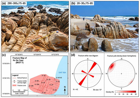
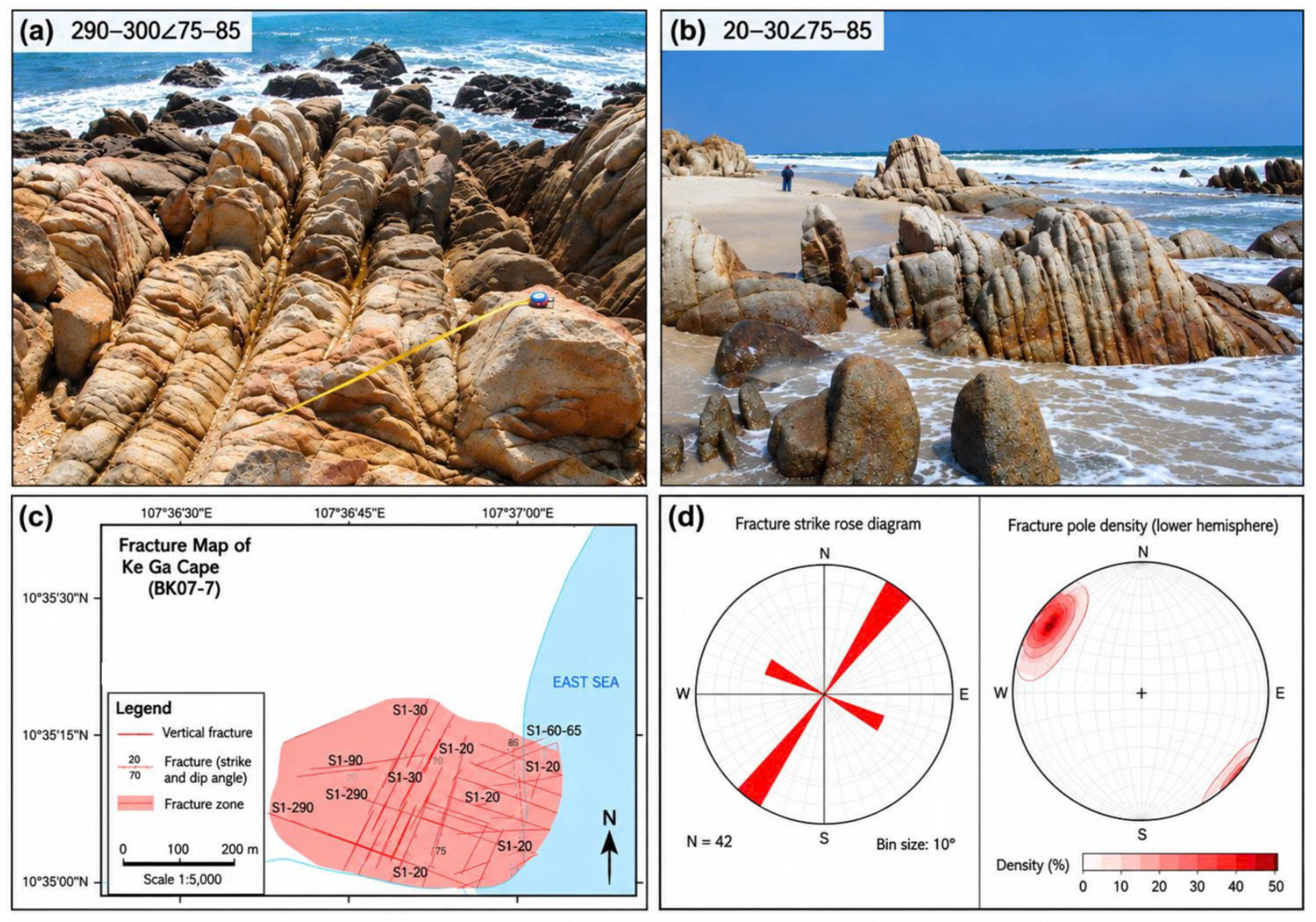
Structural mapping of the Ke Ga granitoid exposure (field station BK07-7; exposure > 500 m long and approximately 250 m wide) identified three principal fracture populations and a subordinate N–S-oriented population (Figure 4; Table 1). The dominant NE–SW to NNE–SSW set strikes approximately 20–30°, dips 70–80° toward the southeast, and represents approximately 57% of the mapped fracture observations. The reported percentage is an observed field proportion and is not a Terzaghi-corrected estimate of true three-dimensional abundance.
Figure 4.
Fracture architecture of the Ke Ga granitoid outcrop (BK07-7): (a) mapped fracture distribution and representative structural observations from the >500 m × ~250 m coastal exposure, together with (b) lower-hemisphere orientation and rose-diagram summaries. (c) The dominant mapped set strikes approximately 20–30°; (d) additional principal populations occur at approximately 290–300° and 60–90°, with a subordinate N–S set. Representative high-intensity corridors reach P10 ≈ 10–15 fractures m−1. Percentages shown are proportions of mapped observations and are not Terzaghi-corrected three-dimensional abundances.
Table 1.
Principal fracture populations identified at the Ke Ga granitoid outcrop.
A second fracture population strikes approximately 290–300° and is steep to vertical, accounting for approximately 29% of mapped observations and locally forming fracture zones approximately 0.7–7 m wide. A third, less abundant E–W to ENE–WSW population accounts for approximately 9% of mapped observations. A subordinate N–S-oriented set dipping approximately 60–70° eastward was also recorded in the original field description.
Fracture intensity is strongly heterogeneous across the exposure. Locally developed fracture corridors reach a linear fracture intensity (P10) of approximately 10–15 fractures m−1, whereas less fractured granitoid domains show substantially wider spacing. The original field record also documents centimetre-scale physical openings in representative fractures (approximately 0.5–3 cm) and locally larger openings (>5–15 cm) along fault-related zones. These values describe present-day surface mechanical openings and are not interpreted as preserved subsurface hydraulic apertures.
Taken together, these observations show that the Ke Ga fracture network is not characterized by a single structural orientation. Instead, it comprises one dominant NNE–SSW-oriented family accompanied by subordinate NW–SE and approximately E–W to ENE–WSW fracture populations. This multi-directional architecture provides the structural reference for comparison with fracture orientations identified in the buried basement of Well BH-415.
4.2. Subsurface Fracture Evaluation (Well BH-415)
Interpretation of the borehole image and conventional-log data identifies marked vertical heterogeneity within the upper investigated basement section of Well BH-415. Five principal intervals between 3594 and 3983 m were classified according to fracture development, alteration, brecciation, secondary porosity, and dominant fracture orientation (Table 2).
Table 2.
Fracture characteristics and reservoir-quality classification of the principal basement intervals in Well BH-415.
Zones 1 and 3 display the strongest combination of fracture development, brecciation, alteration, and secondary pore development. Zone 1 is dominated by an NNW–SSE fracture trend and contains fractures with reported apparent apertures of approximately 1–3 mm. Zone 3 is characterized principally by an NNE–SSW trend, with apparent fracture apertures of approximately 1–2 mm. Secondary porosity in Zone 3 locally reaches approximately 6%.
In contrast, Zone 2 consists predominantly of relatively fresh granite and exhibits substantially poorer reservoir characteristics. Despite having a reported NNW–SSE structural trend, the interval contains very limited open-fracture development and secondary porosity generally below 0.5%. This contrast demonstrates that fracture orientation alone does not determine reservoir quality; fracture openness, intensity, alteration, brecciation, and connectivity are also important.
Zones 4 and 5 show intermediate reservoir characteristics. Zone 4 is dominated by a NE–SW trend and exhibits stronger secondary porosity in its upper brecciated section than in the relatively fresh granite below. Zone 5 is characterized by a more scattered fracture distribution with a dominant NW–SE component and locally enhanced secondary porosity near the top of the interval.
The borehole results therefore identify several subsurface fracture families rather than a single dominant orientation and show that their reservoir significance varies substantially with the degree of fracture development and associated rock modification.
4.3. Lithological and Petrophysical Expression of Fractured Basement
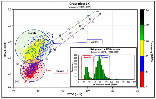
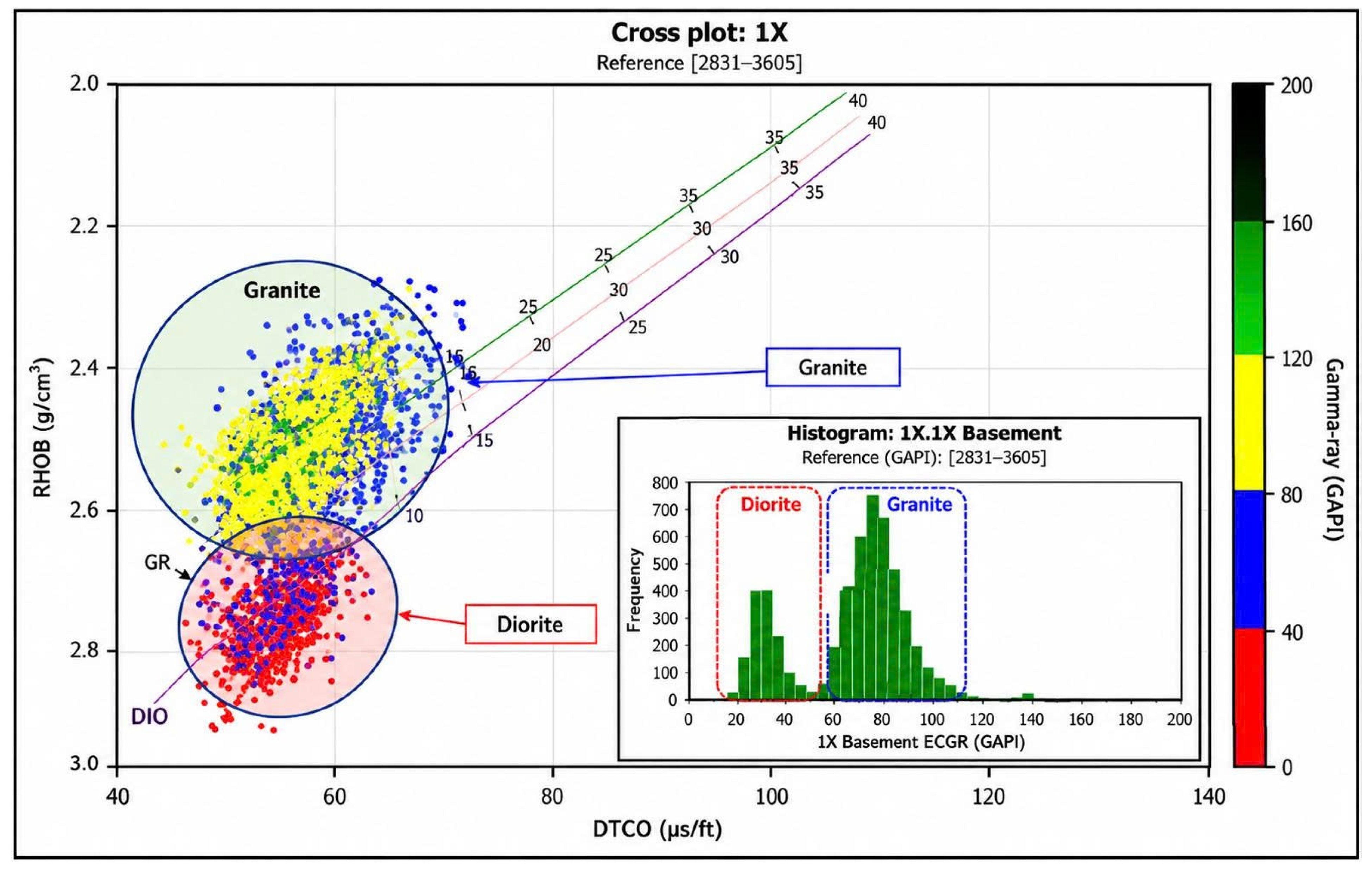
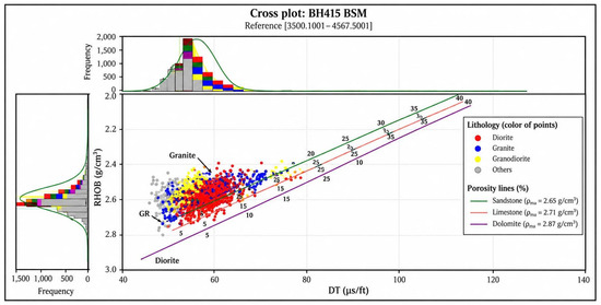
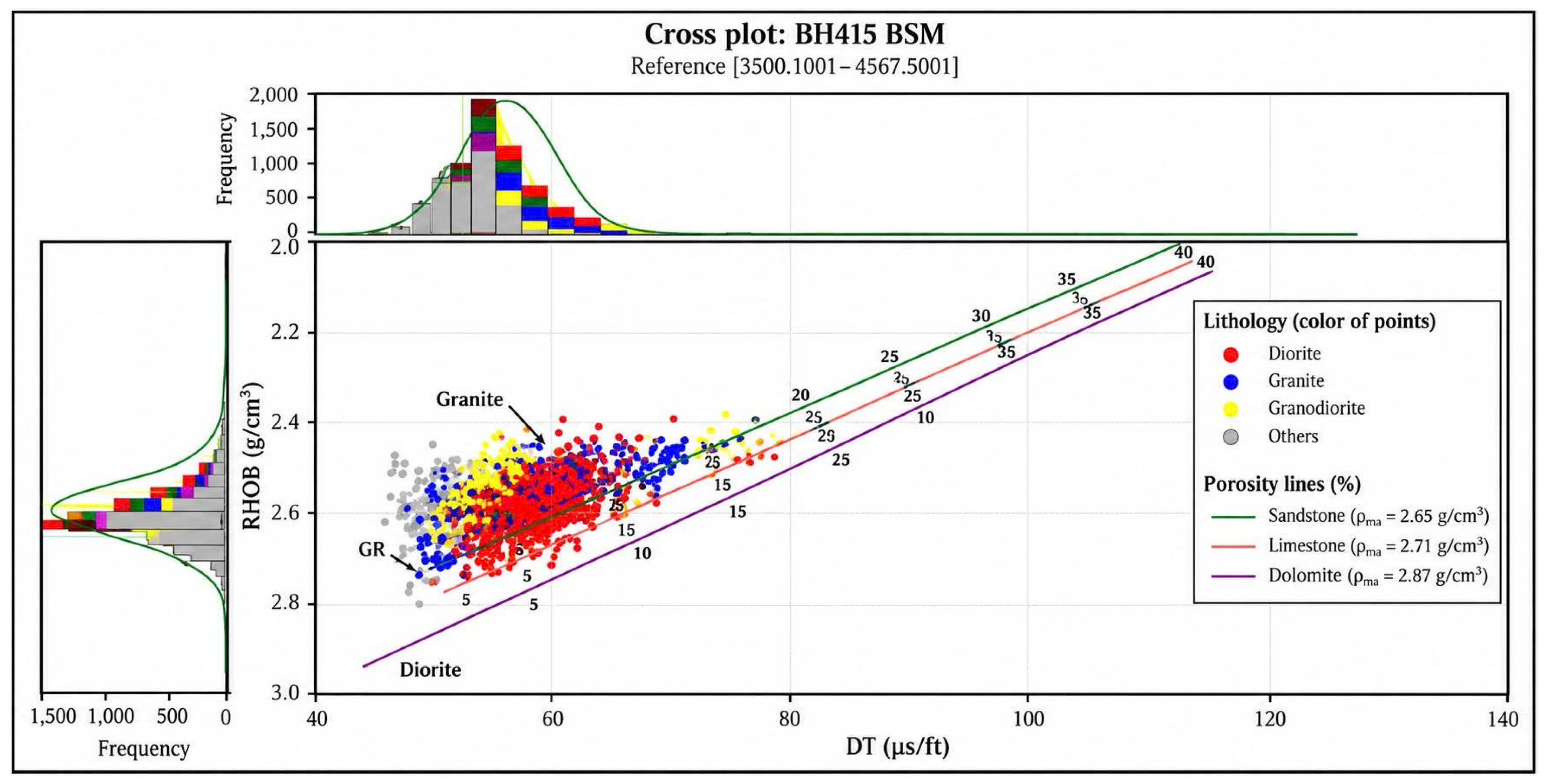
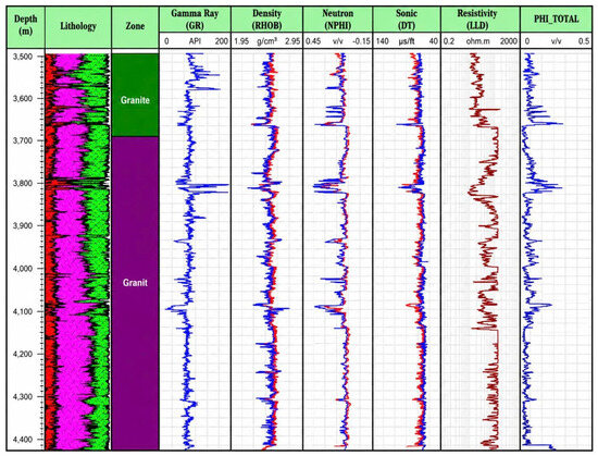
Cross-plot analysis of conventional wireline logs confirms substantial lithological variability within the BH-415 basement interval (Figure 5 and Figure 6). The interpreted granitoid component is generally associated with bulk-density values of approximately 2.4–2.7 g/cm3 and gamma-ray responses of approximately 80–200 GAPI. Higher-density components interpreted as dioritic or heavy-mineral-rich intrusive rocks exhibit bulk-density values of approximately 2.7–2.9 g/cm3 and lower gamma-ray responses of approximately 40–60 GAPI.
Figure 5.
Conventional-log cross-plots used to characterize lithological variability within the crystalline basement of Well BH-415, including relationships among sonic transit time (DT), bulk density (RHOB), and gamma-ray (GR) responses. Modified from [7].
Figure 6.
DT–RHOB cross-plot for the basement interval of Well BH-415, illustrating the petrophysical separation of the principal basement lithological components.
Integration of caliper, resistivity, neutron, and sonic responses provides additional evidence for distinguishing fractured intervals from relatively intact or intrusive basement components. Fractured and brecciated intervals commonly coincide with borehole enlargement and reductions in resistivity, together with increases in neutron response and sonic transit time. These combined responses are consistent with enhanced secondary pore development and drilling-fluid invasion into fractured rock.
The multi-mineral model was evaluated by comparing reconstructed synthetic logs with measured GR, RHOB, NPHI, and DT responses. The reported correlation coefficients are 0.9908 for GR, 0.9477 for NPHI, 0.8835 for DT, and 0.7622 for RHOB (Table 3).
Table 3.
Correlation between measured and reconstructed log responses from the multi-mineral model for Well BH-415.
The strongest agreement occurs for GR and NPHI, whereas RHOB shows the lowest correlation (R = 0.7622). Density is particularly sensitive to local heterogeneity not fully represented by the simplified multi-mineral model. Plausible contributors include caliper-indicated borehole enlargement, alteration and secondary mineral filling, and local variations in dense or heavy-mineral-bearing components. These mechanisms are consistent with the integrated log interpretation but cannot be uniquely separated from the correlation coefficient alone. Accordingly, reconstructed-log agreement is used as an internal consistency check rather than as independent validation of the reservoir model (Figure 7).
Figure 7.
Comparison between measured wireline-log responses and synthetic curves reconstructed using the multi-mineral model for the crystalline basement interval of Well BH-415.
Quantitative interpretation indicates substantial variation in secondary porosity and permeability among basement intervals. Reported net secondary porosity (SPHI-Net) ranges from approximately 1.2% to 6.6%, whereas net permeability ranges from approximately 6.9 to 1158.9 mD (Table 4). The highest values occur within intervals associated with stronger fracture development.
Table 4.
Quantitative petrophysical characteristics of the interpreted basement intervals in Well BH-415.
Quantitative Reservoir Characteristics. Using the Maxwell equation and iterative solution processes, secondary porosity (Φ2) and fracture porosity (Φfr) were calculated [15].
For pure fracture model:
Approximate fracture porosity:
Adjusted fracture porosity:
Φv = Φ2 − Φfr
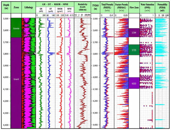
The basement was divided into smaller calculation zones to account for variations in the solid rock block porosity (Φblock) and sonic travel time (DTblock), thereby increasing the precision of the secondary porosity results. Key quantitative findings for Well BH-415 include the following: Fracture Identification: The study identified fracture zones with flow potential (Figure 8).
Figure 8.
Integrated petrophysical interpretation of the fractured crystalline basement in Well BH-415, showing the vertical distribution of lithological, fracture-related, and reservoir-quality parameters.
The interval 3725–3818 m has the highest reported net secondary porosity (~6.6%) and net permeability (~1158.9 mD), consistent with the strong fracture development and brecciation identified independently in Zone 3. The 3594–3659 m interval also exhibits high permeability (~1140.9 mD) and corresponds to the good-quality fractured Zone 1. Conversely, the 3818–3917 m interval has substantially lower reported permeability (~6.9 mD), consistent with its moderate reservoir classification.
These relationships indicate that the borehole-image and petrophysical interpretations are broadly consistent in identifying the principal reservoir-quality intervals, while also demonstrating strong vertical heterogeneity within the crystalline basement.
4.4. Seismic Expression of Basement Heterogeneity
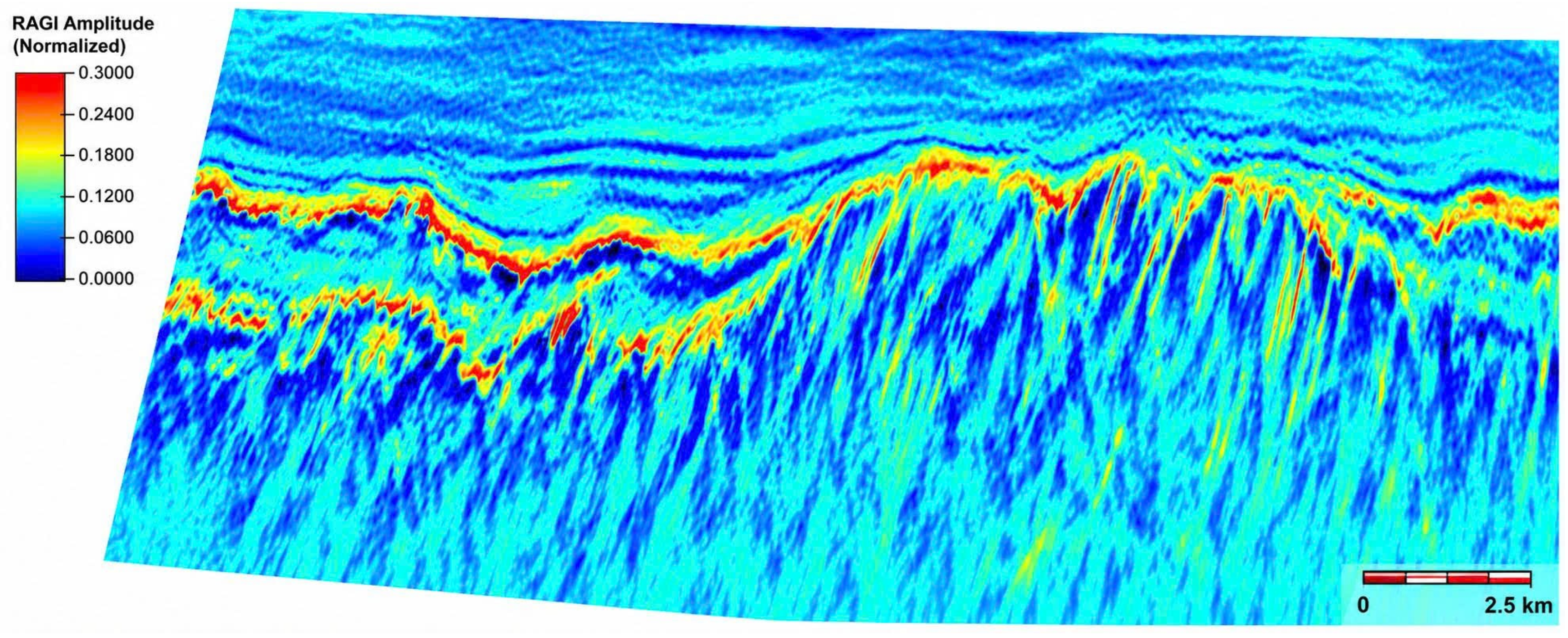
RAI-derived seismic attributes provide a larger-scale view of basement heterogeneity surrounding Well BH-415. The Gradient Magnitude attribute derived from RAI [14] shows spatial correspondence with intervals independently interpreted from the well data as structurally heterogeneous and fracture-rich (Figure 9). Because seismic-attribute anomalies are non-unique responses to lithological changes, fault-related damage, alteration, and fluid effects, the attribute is used only as a proxy for basement heterogeneity or structural discontinuity and not as a direct image of individual fractures.
Figure 9.
Spatial comparison between the RAI-derived Gradient Magnitude attribute and the integrated borehole interpretation at Well BH-415. The attribute is interpreted as a proxy for larger-scale basement heterogeneity/structural discontinuity; it does not directly image individual fractures. The well-based fracture interpretation provides the independent constraint for evaluating spatial correspondence.
The correspondence between the seismic response and the well interpretation supports the use of RAI-derived attributes for extending fracture-related structural interpretation away from the borehole. However, the attribute is interpreted as a proxy for larger-scale basement heterogeneity and structural discontinuity rather than as a direct image of individual fractures.
4.5. Cross-Scale Correspondence Between Outcrop and Subsurface Fracture Systems
Comparison of the Ke Ga and BH-415 datasets reveals both similarities and differences in fracture orientation. The Ke Ga outcrop is dominated by the 20–30° fracture population, with subordinate 290–300° and 60–90° sets. In BH-415, the principal fracture trends vary vertically and include NNW–SSE, NNE–SSW, NE–SW, and NW–SE orientations.
The clearest geometrical correspondence occurs between the dominant NNE–SSW-oriented Ke Ga population and the NNE–SSW to NE–SW fracture trends identified in Zones 3 and 4 of BH-415 (Table 5). Notably, Zone 3 is also one of the highest-quality reservoir intervals, with secondary porosity locally reaching approximately 6% and the highest reported interval-scale permeability.
Table 5.
Qualitative cross-scale comparison between principal fracture orientations at the Ke Ga outcrop and Well BH-415.
A second correspondence is observed between the NW–SE-oriented fracture population at Ke Ga and the dominant NW–SE trend identified in Zone 5. In contrast, the NNW–SSE trend identified in Zones 1 and 2 does not have an obvious one-to-one equivalent among the three principal Ke Ga populations reported in the current dataset.
The comparison therefore does not support a simple one-to-one replication of the Ke Ga fracture network within the Bach Ho basement. Instead, it demonstrates partial structural correspondence between selected fracture families across the surface and subsurface datasets.
Importantly, reservoir quality also cannot be inferred solely from orientation correspondence. Zone 1 is a high-quality reservoir interval despite its NNW–SSE trend lacking an obvious equivalent among the principal Ke Ga fracture sets, whereas Zone 2 shares the same general NNW–SSE trend but exhibits poor reservoir properties. These observations demonstrate that fracture orientation provides only one component of reservoir characterization and must be considered together with fracture intensity, openness, connectivity, brecciation, alteration, and secondary pore development.
At the seismic scale, the correspondence between RAI-derived structural heterogeneity and the well interpretation provides an additional constraint on the spatial organization of the buried fracture system. Collectively, the three datasets indicate that the Ke Ga outcrop preserves fracture orientations relevant to parts of the Bach Ho basement architecture, while also revealing significant differences that must be accounted for when using surface granitoid exposures as analogues for deeply buried fractured reservoirs.
5. Discussion
5.1. Cross-Scale Correspondence of Fracture Architecture
The comparison between the Ke Ga outcrop and Well BH-415 demonstrates that fracture architecture in the exposed and buried granitoids is characterized by both corresponding and non-corresponding structural populations. This distinction is important because it indicates that the Ke Ga exposure should not be regarded as a direct geometrical replica of the Bach Ho basement fracture network.
At Ke Ga, the fracture population is dominated by the 20–30° NNE–SSW-oriented set, which accounts for approximately 57% of the mapped fractures. A comparable NNE–SSW to NE–SW structural trend occurs in Zones 3 and 4 of BH-415. The correspondence is particularly relevant in Zone 3, where strong brecciation, open fractures, and enhanced secondary porosity coincide with one of the highest reservoir-quality intervals identified in the well. A second geometrical similarity occurs between the NW–SE-oriented fracture population at Ke Ga and the NW–SE trend observed in Zone 5.
However, the correspondence is incomplete. The NNW–SSE fracture trend identified in Zones 1 and 2 of BH-415 does not have an obvious equivalent among the three principal fracture populations reported from Ke Ga. Conversely, the subordinate ENE–WSW to E–W population observed at Ke Ga is not clearly represented among the dominant fracture trends reported from the borehole dataset. These mismatches indicate that fracture orientation varies spatially within the regional basement framework and caution against direct transfer of a complete fracture-network model from the outcrop to the subsurface.
The results therefore support partial structural correspondence rather than direct one-to-one equivalence. Such partial correspondence is geologically reasonable because outcrop and subsurface observations represent different locations, spatial scales, preservation histories, and present-day stress conditions. The principal value of the Ke Ga analogue is consequently not that it reproduces every fracture population observed at Bach Ho, but that it provides direct exposure of fracture organizations that are compatible with selected structural trends within the buried basement.
This distinction is important for the use of outcrop analogues in fractured-basement studies. Orientation similarity can provide evidence for regional structural organization, but it does not independently demonstrate common fracture age, identical kinematic origin, or equivalent hydraulic behavior. These properties require additional structural, chronological, geomechanical, or hydrodynamic constraints.
5.2. Tectonic Control on Fracture Development
The occurrence of comparable fracture orientations at Ke Ga and Bach Ho can be interpreted within the broader tectonic evolution of the Cuu Long Basin and southeastern Vietnam. The basin developed through multiple phases of extension, subsidence, fault reactivation, and local inversion, resulting in a structurally complex basement characterized by several fault and fracture orientations [19,20,21,22].
Previous studies have documented changes in regional structural trends and stress conditions within the Cuu Long and Nam Con Son basins [20,21,22]. Such polyphase deformation provides a plausible mechanism for the coexistence of several fracture populations rather than a single uniformly oriented network. The NNE–SSW to NE–SW and NW–SE fracture orientations recognized in both the surface and subsurface datasets may therefore reflect components of this broader regional structural framework.
The strong fracture development observed within brecciated intervals of BH-415 further supports a close association between brittle deformation and reservoir formation. In crystalline rocks with negligible primary matrix porosity, fault-related damage and repeated brittle deformation can generate interconnected fracture networks and brecciated zones capable of providing both storage space and fluid-flow pathways [8]. Structural reactivation may additionally modify existing fractures through reopening, shearing, or mineralization, thereby increasing the complexity of the present-day fracture system.
Nevertheless, the present dataset does not directly determine fracture ages or establish that individual fracture sets at Ke Ga and Bach Ho formed during the same tectonic event. The observed orientation correspondence is consistent with regional tectonic control, but a direct genetic relationship cannot be demonstrated from orientation data alone.
Accordingly, attribution of the observed fracture architecture specifically to the Late Oligocene inversion phase should be regarded as a geological interpretation supported by the regional tectonic literature rather than as a direct result of this study. Establishing a more definitive genetic relationship would require additional evidence such as fracture-filling mineral chronology, fault-slip analysis, paleostress reconstruction, or other independent constraints on fracture timing.
5.3. Linking Borehole-Scale Fractures to Seismic-Scale Heterogeneity
One of the principal challenges in fractured-basement characterization is extrapolating fracture information away from individual wells. Borehole image logs provide detailed structural information but sample only a narrow volume around the wellbore, whereas conventional seismic data generally lack sufficient resolution to image individual fractures directly.
The RAI-derived Gradient Magnitude attribute used in this study provides an intermediate means of examining larger-scale heterogeneity within the basement [23,24]. Its correspondence with the integrated BH-415 interpretation suggests that zones identified as structurally heterogeneous at seismic scale are spatially consistent with fracture-rich intervals identified at the well.
This relationship should nevertheless be interpreted cautiously. Seismic attributes respond to contrasts in acoustic and structural properties and therefore cannot be uniquely attributed to individual open fractures. Attribute anomalies may reflect faults, lithological contrasts, alteration, brecciation, fracture swarms, or combinations of these features. Consequently, the seismic response is better interpreted as a proxy for structural heterogeneity associated with fracture-prone basement rather than as a direct measurement of fracture density.
The principal advantage of integrating the seismic and borehole datasets is therefore scale extension. FMI and petrophysical data establish the presence and reservoir significance of fractures locally, while seismic attributes provide a means of tracing structurally heterogeneous zones beyond the immediate wellbore [25,26,27,28]. This complementary relationship is particularly important in crystalline basement reservoirs, where reservoir properties can vary strongly over relatively short distances.
5.4. Fracture Architecture and Reservoir Quality
The BH-415 results demonstrate that fracture development exerts a first-order control on reservoir quality, but also show that fracture orientation alone is insufficient for predicting productive intervals.
Zones 1 and 3 provide the clearest examples. Both are characterized by strong alteration and brecciation, developed secondary pore systems, and comparatively high reservoir quality. Zone 3 contains secondary porosity locally reaching approximately 6%, while the quantitative petrophysical interpretation yields a net secondary porosity of approximately 6.6% and net permeability of approximately 1158.9 mD for the 3725–3818 m interval. Similarly, the 3594–3659 m interval corresponding to Zone 1 has a reported net permeability of approximately 1140.9 mD.
In contrast, Zone 2 is dominated by relatively fresh granite and exhibits secondary porosity generally below 0.5% in the borehole-image interpretation, despite sharing the same general NNW–SSE fracture trend reported for Zone 1. This contrast is particularly informative because it demonstrates that the presence of a given structural orientation does not necessarily imply effective reservoir development.
Reservoir performance instead depends on the combined effects of fracture intensity, aperture, connectivity, brecciation, alteration, vug development, and mineral filling. Open and interconnected fractures can substantially enhance permeability, whereas isolated or mineral-filled fractures may contribute little to fluid flow. Similarly, brecciation can increase secondary storage capacity where interconnected pore space is preserved, but alteration may either enhance porosity through dissolution or reduce effective permeability through clay or secondary-mineral development.
These observations explain why a structural analogue should not be used to transfer absolute porosity or permeability values from an exposed outcrop to a buried reservoir. The Ke Ga dataset provides information on fracture geometry and organization, whereas reservoir quality must be evaluated independently from subsurface petrophysical and borehole-image data.
The agreement between the high-quality fracture intervals identified from the image-log interpretation and the intervals characterized by enhanced secondary porosity and permeability provides internal support for this integrated interpretation. However, the multi-mineral model should not be considered an independent validation of fracture-controlled permeability. The varying correlations between measured and reconstructed logs, particularly the lower correlation obtained for RHOB, indicate that uncertainty remains in the quantitative petrophysical model.
5.5. Applicability and Limitations of the Ke Ga Outcrop Analogue
The results allow the role of the Ke Ga exposure as an analogue for the Bach Ho basement to be defined more precisely. Ke Ga is most useful as a structural analogue for examining fracture orientation, relative fracture-set organization, and the spatial development of fracture corridors within granitoid rocks. It should not be regarded as a direct petrophysical or hydraulic analogue.
Several limitations constrain transferability of the outcrop observations. First, the two datasets represent geographically separated basement blocks and may have experienced different local fault histories. Second, all fracture attributes—including aperture, length, intensity, connectivity and even apparent set abundance—can be modified or selectively expressed during exhumation, near-surface unloading and weathering [12,13]. Conversely, previous analogue studies show that some fracture attributes and mineralized structures may remain useful guides to subsurface architecture when preservation is demonstrated [11,12,13]. For Ke Ga, the observed centimetre-scale surface openings are therefore reported as field observations but are not treated as quantitative equivalents of FMI apparent aperture or subsurface hydraulic aperture.
Third, the sampling geometries differ. The original Ke Ga campaign used multiple traverse directions, including measurements approximately normal to principal fracture sets, which reduces but does not eliminate orientation-dependent sampling bias. Because observation-specific scanline/sampling-plane orientations were not retained consistently for the complete legacy dataset, rigorous retrospective Terzaghi correction cannot be applied to every mapped fracture. The 57%, 29%, and 9% values are consequently interpreted only as proportions of mapped observations. FMI data, in turn, sample the subsurface network only along the borehole trajectory and carry their own sampling and apparent-aperture uncertainties.
Fourth, fracture orientation correspondence does not demonstrate hydraulic equivalence or common fracture age. Reservoir contribution depends on connectivity, openness, mineral filling, present-day effective stress, damage-zone architecture, and secondary pore preservation. Critically stressed fractures may influence productivity in some reservoirs, but orientation relative to stress alone is not sufficient to explain reservoir quality; the contrasting properties of similarly oriented BH-415 intervals illustrate this point [29]. Systematic mineralogical characterization of fracture fills is not available for the Ke Ga subset used here, and this remains an important target for future outcrop-to-core calibration.
Finally, the current comparison is based principally on one outcrop area and one subsurface well. The resulting structural relationships should therefore be interpreted as a case-study evaluation rather than a basin-wide calibration of outcrop-to-reservoir fracture correspondence.
Despite these limitations, the integrated analysis demonstrates a useful role for exposed granitoid analogues when they are incorporated within a multi-scale framework rather than used independently. Outcrop observations can constrain plausible fracture orientations and network organization; borehole images determine which fracture populations actually occur at reservoir depth; petrophysical data evaluate their reservoir significance; and seismic attributes provide a means of extending structurally heterogeneous zones beyond the well.
5.6. Implications for Fractured Basement Exploration
The results have practical implications for exploration and development of fractured crystalline basement reservoirs in mature basins such as the CLB. The strong vertical heterogeneity observed in BH-415 demonstrates that identifying a basement high alone is insufficient for predicting reservoir quality [28]. Exploration strategies should instead focus on locating structurally damaged basement domains in which fracture development, brecciation, alteration, and secondary pore preservation combine to generate connected reservoir systems.
Outcrop analogues can contribute to this process by constraining plausible fracture architectures before or alongside subsurface interpretation. However, the present results indicate that analogue-based predictions should be treated probabilistically rather than deterministically [22]. A fracture family observed at the surface may be present in the reservoir, but its abundance and hydraulic effectiveness must be independently evaluated.
The integration of structural observations across outcrop, borehole, petrophysical, and seismic scales therefore provides a more defensible exploration framework than reliance on any single dataset. In the Bach Ho case, the approach identifies both structural similarities and important mismatches between the surface and subsurface fracture systems. Recognizing these mismatches is particularly valuable because it defines the limits within which outcrop information can be transferred to reservoir prediction.
More broadly, the results suggest that the principal contribution of outcrop analogues in deeply buried crystalline plays lies in constraining fracture architecture and structural scenarios, rather than directly predicting reservoir properties. This distinction provides a more conservative basis for integrating surface geology into subsurface fracture characterization and reduces the risk of over interpreting geometrical similarity as reservoir equivalence.
6. Conclusions
This study integrates outcrop fracture mapping, borehole image interpretation, conventional well logs, multi-mineral petrophysical modelling, and seismic attributes to evaluate fracture architecture across multiple observational scales in the Cuu Long Basin. The results provide the following main conclusions.
The Ke Ga granitoid outcrop contains three principal fracture populations plus a subordinate N–S set. The dominant NE–SW to NNE–SSW set strikes approximately 20–30° and represents about 57% of mapped observations; NW–SE (290–300°) and E–W to ENE–WSW populations represent approximately 29% and 9%, respectively. Locally, linear fracture intensity reaches approximately 10–15 fractures m−1. These percentages describe mapped observations rather than Terzaghi-corrected three-dimensional fracture abundance.
Well BH-415 contains several vertically variable fracture populations associated with markedly different reservoir properties. Zones 1 and 3 exhibit the strongest combination of fracturing, brecciation, alteration, and secondary pore development. Quantitative interpretation indicates net secondary porosity values of up to approximately 6.6% and interval-scale net permeability exceeding 1100 mD in the highest-quality fractured intervals.
Comparison of the surface and subsurface datasets indicates partial rather than one-to-one structural correspondence. The dominant NNE–SSW fracture population at Ke Ga is geometrically compatible with NNE–SSW to NE–SW trends identified in Zones 3 and 4 of BH-415, while the NW–SE population has a counterpart in Zone 5. However, the NNW–SSE trend observed in Zones 1 and 2 does not have an obvious equivalent among the principal fracture populations reported at Ke Ga. The outcrop therefore captures selected components of the subsurface fracture architecture but does not reproduce the complete reservoir fracture network.
Reservoir quality cannot be predicted from fracture orientation alone. The contrast between Zones 1 and 2, despite their similar general NNW–SSE fracture trends, demonstrates the importance of fracture intensity, aperture, connectivity, brecciation, alteration, and secondary pore preservation in controlling effective reservoir properties.
RAI-derived seismic attributes show spatial consistency with structurally heterogeneous intervals identified from the well data and provide a means of extending fracture-related interpretation beyond the borehole. These attributes should nevertheless be regarded as proxies for larger-scale structural heterogeneity rather than as direct images of individual fractures.
Overall, the Ke Ga granitoid exposure is best considered a structural analogue that constrains plausible fracture orientations and network organization rather than a direct petrophysical or hydraulic analogue for the Bach Ho reservoir. The observed correspondence is consistent with broader regional tectonic controls, although orientation similarity alone cannot establish a common fracture age or genetic origin.
The multi-scale integration of outcrop observations, borehole images, petrophysical data, and seismic attributes provides a conservative framework for fractured-basement characterization. Applied in this manner, surface analogues can reduce uncertainty in structural interpretation while avoiding direct transfer of outcrop fracture properties to deeply buried reservoirs.
Author Contributions
K.X.N.: supervision, methodology, conceptualization, and writing—original draft; T.Q.T.: supervision, methodology, conceptualization, and writing—review & editing; A.V.N., T.N., X.M.H. and T.B.N.: formal analysis, investigation, and visualization. All authors have read and agreed to the published version of the manuscript.
Funding
This research was funded by Vietnam National University Ho Chi Minh City (VNU-HCM) under grant number B2024-20-22.
Data Availability Statement
The subsurface well-log, borehole-image, and seismic datasets used in this study are subject to confidentiality and data-ownership restrictions and therefore cannot be made publicly available. Derived data supporting the findings of this study are provided within the article. Additional information may be available from the corresponding author subject to permission from the data owners.
Conflicts of Interest
The authors declare no conflicts of interest.
References
- Mustaqeem, A.; Baranova, V.; Kieu, N.B.; Tran, V.X.; Nguyen, X.K.; Truong, Q.T.; Gia, B.P. Application of the Gray Level Co-occurrence Matrix (GLCM) Technique for Analyzing Fracture Networks in the Granitic Basement of Cuu Long Basin, Vietnam. J. Jpn. Pet. Inst. 2025, 68, 20–26. [Google Scholar] [CrossRef] [Scilit]
- Bojesen-Koefoed, J.A.; Nytoft, H.P.; Dau, N.T. Petroleum composition in the Cuu Long Basin (Mekong Basin) offshore southern Vietnam. Mar. Pet. Geol. 2009, 26, 899–908. [Google Scholar] [CrossRef] [Scilit]
- Dam, M.H.; Trieu, N.T.; Tham, N.T.; Phuong, B.T.N.; Xuan, T.V. Sequence stratigraphy and petrographic characteristics of Oligocene sediments in the West trough of the Cuu Long Basin, Vietnam. Mar. Pet. Geol. 2023, 155, 106395. [Google Scholar] [CrossRef] [Scilit]
- Bawazer, W.; Lashin, A.; Kinawy, M.M. Characterization of a fractured basement reservoir using high-resolution 3D seismic and logging datasets: A case study of the Sab’atayn Basin, Yemen. PLoS ONE 2018, 13, e0206079. [Google Scholar] [CrossRef] [Scilit] [PubMed]
- Nguyen, H.X.; San, N.T.; Bae, W.; Hoang, C.M. Formation Mechanism and Petroleum System of Tertiary Sedimentary Basins, Offshore Vietnam. Energy Sources Part A Recovery Util. Environ. Eff. 2014, 36, 1634–1649. [Google Scholar] [CrossRef] [Scilit]
- Hennig-Breitfeld, J.; Breitfeld, H.T.; Sang, D.Q.; Vinh, M.K.; Van Long, T.; Thirlwall, M.; Cuong, T.X. Ages and character of igneous rocks of the Da Lat Zone in SE Vietnam and adjacent offshore regions (Cuu Long and Nam Con Son basins). J. Asian Earth Sci. 2021, 218, 104878. [Google Scholar] [CrossRef] [Scilit]
- Kha, N.X.; Son, P.X.; Van Quy, H.; Tuan, N.; Thanh, T.Q.; Xuan, M.H.; Van Xuan, T. Bach ho field geological features identification using well logging data. Bull. Tomsk. Polytech. Univ. Geo Assets Eng. 2023, 334, 35–42. (In Russian) [Google Scholar] [CrossRef] [Scilit]
- Cuong, T.X.; Warren, J.K. Bach ho field, a fractured granitic basement reservoir, Cuu Long Basin, offshore SE Vietnam: A “buried-hill” play. J. Pet. Geol. 2009, 32, 129–156. [Google Scholar] [CrossRef] [Scilit]
- Ngoc, N.H.; Aziz, S.B.; Duc, N.A. The application of seismic attributes for reservoir characterization in Pre-Tertiary fractured basement, Vietnam-Malaysia offshore. Interpretation 2014, 2, SA57–SA66. [Google Scholar] [CrossRef] [Scilit]
- Peacock, D.C.P.; Sanderson, D.J.; Leiss, B. Use of analogue exposures of fractured rock for Enhanced Geothermal Systems. Geosciences 2022, 12, 318. [Google Scholar] [CrossRef] [Scilit]
- Wang, Q.; Laubach, S.E.; Gale, J.F.W.; Ramos, M.J. Quantified fracture (joint) clustering in Archean basement, Wyoming: Application of Normalized Correlation Count method. Pet. Geosci. 2019, 25, 415–428. [Google Scholar] [CrossRef] [Scilit]
- Ukar, E.; Laubach, S.E.; Hooker, J.N. Outcrops as guides to subsurface natural fractures: Example from the Nikanassin Formation tight-gas sandstone, Grande Cache, Alberta Foothills, Canada. Mar. Pet. Geol. 2019, 103, 255–275. [Google Scholar] [CrossRef] [Scilit]
- Laubach, S.E.; Lander, R.H.; Criscenti, L.J.; Anovitz, L.M.; Urai, J.L.; Pollyea, R.M.; Hooker, J.N.; Narr, W.; Evans, M.A.; Kerisit, S.N.; et al. The role of chemistry in fracture pattern development and opportunities to advance interpretations of geological materials. Rev. Geophys. 2019, 57, 1065–1111. [Google Scholar] [CrossRef] [Scilit]
- Kha, N.X.; Xuan, T.V.; Son, P.X.; Quy, H.V.; Thanh, T.Q.; Minh, L.B.; Nhi, N.T.Y. Validity of Geophysical Method to Determine Multi-Mineral Model, Specific Porosity, Permeability of Basement Rock in the Cuu Long Basin, Vietnam. Transylvanian 2019, XXVII, 9229–9238. [Google Scholar]
- Belaidi, A.; Bonter, D.A.; Slightam, C.; Trice, R.C. The Lancaster Field: Progress in opening the UK’s fractured basement play. Geol. Soc. Lond. Pet. Geol. Conf. Ser. 2016, 8, 385–398. [Google Scholar] [CrossRef] [Scilit]
- Zhu, Y.; Yan, Z.; Qin, K.; Li, Z.; Xiong, R.; Sun, K. Lithological and physical characteristics and their controlling factors of the Archaean metamorphic rocks: A case study of the Damintun Sag, in Liaohe depression of Bohai Bay Basin, China. Geoenergy Sci. Eng. 2024, 241, 213088. [Google Scholar] [CrossRef] [Scilit]
- Zhang, Y.; Chen, X.; Chen, J.; Zhang, G.; Li, Z.; Pan, L.; Wang, J.; Ding, Z.; Wang, X.; Yuan, S. Seismic evidence of subduction during assembly of the North China Craton from multimodal dispersion inversion. Tectonophysics 2025, 904, 230715. [Google Scholar] [CrossRef] [Scilit]
- Moradi, M.; Kadkhodaie, A.; Taheri, M.R.; Chenani, A. Estimation of porosity distribution from formation image logs and comparing the results with NMR log analysis: Implications for the heterogeneity analysis of carbonate reservoirs with an example from the Asmari reservoir, southwest Iran. J. Afr. Earth Sci. 2024, 218, 105366. [Google Scholar] [CrossRef] [Scilit]
- Morley, R.J.; Bui, V.D.; Nguyen, T.T.; Kullman, A.; Bird, R.T.; Nguyen, V.K.; Nguyen, H.C. High-resolution Palaeogene sequence stratigraphic framework for the Cuu Long Basin, offshore Vietnam, driven by climate change and tectonics, established from sequence biostratigraphy. Palaeogeogr. Palaeoclimatol. Palaeoecol. 2019, 530, 113–135. [Google Scholar] [CrossRef] [Scilit]
- Binh, N.T.T.; Tokunaga, T.; Son, H.P.; Binh, M.V. Present-day stress and pore pressure fields in the Cuu Long and Nam Con Son Basins, offshore Vietnam. Mar. Pet. Geol. 2007, 24, 607–615. [Google Scholar] [CrossRef] [Scilit]
- Binh, N.T.T.; Tokunaga, T.; Goulty, N.R.; Son, H.P.; Binh, M.V. Stress state in the Cuu Long and Nam Con Son basins, offshore Vietnam. Mar. Pet. Geol. 2011, 28, 973–979. [Google Scholar] [CrossRef] [Scilit]
- Prasad, K.N.D.; Nguyen, D.V.; Le-Huy, M.; Van Tran, K.; Do, T.D.; Pham, L.T.; Rehman, H. Mapping structural geometry and tectonics of the Central continental margin of Vietnam and adjacent areas using an enhanced horizontal gradient of gravity data. Tectonophysics 2025, 905, 230719. [Google Scholar] [CrossRef] [Scilit]
- Tang, W.; Hou, L.; Wu, S.; Wu, K.; Zhong, H.; Hou, M.; Zhang, D.; Ma, C. An FMI image fracture segmentation approach based on a two-stage decoupling strategy. Geoenergy Sci. Eng. 2026, 258, 214319. [Google Scholar] [CrossRef] [Scilit]
- Souza, A.M.; Cruz, M.A.; Braga, P.M.; Piva, R.B.; Dias, R.A.; Siqueira, P.R.; Trevizan, W.A.; de Jesus, C.M.; Bazzarella, C.; Monteiro, R.S.; et al. PATSA-BIL: Pipeline for automated texture and structure analysis of borehole image logs. Expert Syst. Appl. 2025, 278, 127345. [Google Scholar] [CrossRef] [Scilit]
- Bagheri, H.; Mohebian, R. Fracture facies estimation utilizing machine learning algorithm and Formation Micro-Imager (FMI) log. Pet. Res. 2025, 10, 764–781. [Google Scholar] [CrossRef] [Scilit]
- Fan, H.; Shi, J.; Fan, T.; Gao, Z.; Gu, Y.; Gao, Z.; Zhang, T.; Li, Y.; Li, B. Sedimentary microfacies analysis of carbonate formation based on FMI and conventional logs: A case study from the ordovician in the Tahe Oilfield, Tarim Basin, China. J. Pet. Sci. Eng. 2021, 203, 108603. [Google Scholar] [CrossRef] [Scilit]
- Parnell, J.; Baba, M.; Bowden, S.; Muirhead, D. Subsurface biodegradation of crude oil in a fractured basement reservoir, Shropshire, UK. J. Geol. Soc. 2017, 174, 655–666. [Google Scholar] [CrossRef] [Scilit]
- Zhu, W.; Zhou, Z.; Sun, H.; Peng, W.; Zhao, S.; Fu, X.; Feng, K. Status and prospect of hydrocarbon resources in Southeast Asian petroliferous basins. J. Asian Earth Sci. 2026, 295, 106869. [Google Scholar] [CrossRef] [Scilit]
- Fulcher, S.A.; Jordan, T.E.; Laubach, S.E.; Elliott, S.J.; Nogales Herrera, V. Improving borehole fracture characterization using oriented sidewall cores for geothermal assessment—An example in central New York State, USA. Geothermics 2026, 136, 103589. [Google Scholar] [CrossRef] [Scilit]

Disclaimer/Publisher’s Note: The statements, opinions and data contained in all publications are solely those of the individual author(s) and contributor(s) and not of MDPI and/or the editor(s). MDPI and/or the editor(s) disclaim responsibility for any injury to people or property resulting from any ideas, methods, instructions or products referred to in the content. |
© 2026 by the authors. Licensee MDPI, Basel, Switzerland. This article is an open access article distributed under the terms and conditions of the Creative Commons Attribution (CC BY) license.