


Abstract
A framework utilizing Information and Communication Technology (ICT) in tsunami evacuation training is proposed to counteract the adverse effects of evacuation by car despite the evacuation on foot principle during tsunamis. This approach involves tsunami evacuation simulation technology and Kiken Yochi (hazard prediction) training (KYT). The simulator was validated based on the insights acquired from Ishinomaki City residents who lived through the Great East Japan earthquake. Data were collected on safe evacuations in chaotic traffic situations, to create a quiz-like training application for traffic safety education. Training effectiveness was assessed using the simulator and KYT-based application, focusing on Nishio City, which is a projected tsunami target following a potential Nankai Trough earthquake. Most participants experiencing the simulator understood the drawbacks of using cars and were willing to evacuate on foot if a nearby safe place was accessible. However, some participants still opted for car evacuation despite acknowledging the risks. A comprehensive approach is required to achieve a significant reduction in car usage during evacuations. Application-oriented experiments indicated heightened situational awareness and hazard prediction among participants although no statistically significant differences in gaze duration were found. Further research is required to objectively and quantitatively evaluate the application’s impact on traffic safety.
1. Introduction
In 2011, the Great East Japan Earthquake and tsunami struck the Tohoku region, leaving over 22,000 dead or missing and displacing more than 37,000 [1,2]. Timely evacuation is vital for saving lives before the tsunami reaches inland. However, post-disaster surveys showed that over 60% of evacuees used cars [3], causing severe traffic congestion, especially in coastal cities such as Ishinomaki [4]. This led to secondary disasters, as many were trapped in traffic and unable to escape. Thus, car use is generally discouraged in Japan, except for those unable to walk long distances, such as the elderly, people with disabilities, or families with infants [5].
A national survey found that 34% of evacuees believed they would not be able to reach a safe zone without a car, and 20% said shelters were too far on foot [6]. Another study showed that even with greater awareness, nearly 50% would still consider car evacuation in a future Nankai Trough earthquake [7]. These findings reveal a psychological and logistical reliance on cars, posing a key challenge for disaster risk reduction.
Another concern is the heightened risk of traffic accidents involving vehicles and pedestrians during evacuation [8]. Traffic signals may fail, and rules may be violated amid confusion. Although prior studies have modeled pedestrian–vehicle interactions during evacuation [9,10], few address teaching traffic safety in such mixed-mode scenarios.
One promising approach is immersive simulation. Models exist suggesting that capability, opportunity, and motivation are shaped by behavior (COM-B) [11]. Computer-based education can boost intrinsic motivation [12], and immersive technologies such as virtual reality (VR) and augmented reality (AR) further enhance engagement and retention [13,14,15]. Reviews show that VR-based training is effective for disaster education [16]. Previous work using mobile- and VR-based tsunami training has improved awareness and preparedness [17,18,19], and gamification has been noted as a useful strategy to sustain motivation [20].
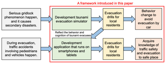
Based on these insights, we propose a tsunami evacuation training framework using information and communication technologies (ICTs) as depicted in Figure 1.
Figure 1.
New tsunami evacuation training framework. Gray-colored cells indicate problems during evacuation on foot and by car. Green-colored cells are solutions to problems during evacuation. The yellow-colored cell is a method for reinforcing the green-colored solution during evacuation, and the red-colored cell indicates the expected result after reinforcing the green-colored solution.
Figure 1 illustrates the structure of the proposed training framework, which consists of a VR-based simulator and a Kiken Yochi (hazard prediction) training (KYT)-based mobile application. The VR simulator allows users to experience evacuation in a traffic-congested urban environment, helping them understand the disadvantages of using cars during a tsunami. The KYT application, on the other hand, supports the learning of hazard recognition through repetitive, gamified scenarios involving pedestrians and vehicles. Combined, these tools aim to enhance both behavioral and cognitive readiness for tsunami evacuation. The framework integrates two main components: a VR-based tsunami evacuation simulator and a KYT-inspired mobile application. The simulator allows users to experience the consequences of car-based evacuations under congested conditions, whereas the application provides interactive training in traffic safety and hazard recognition. Unlike previous systems that focus mostly on user interface evaluation [21,22,23,24,25,26,27,28], this framework emphasizes behavioral and cognitive change.
To address key challenges in tsunami evacuation, the framework targets two issues: (1) secondary disasters due to traffic congestion and (2) lack of awareness in traffic-mixed evacuation conditions. In the simulator, multi-agent traffic modeling is used to reproduce congestion in real time [29]. The KYT-based application was developed using empirical insights from survivors in Ishinomaki City and includes gaze data and expert-verified scenarios to support practical hazard prediction training.
1.1. Pilot Study Sites and Framework Design
To evaluate this framework, two pilot studies were conducted in regions with contrasting disaster profiles.
Ishinomaki City in Miyagi Prefecture was one of the hardest-hit areas during the 2011 tsunami, experiencing widespread inundation, major infrastructure damage, and significant loss of life. Many residents evacuated in panic and confusion. The experience of this city has become a key reference for evacuation behavior in Japan. In this study, we chose Ishinomaki to assess how well the simulator could replicate the urgency and decision-making conditions of real tsunami evacuations.
Nishio City in Aichi Prefecture represents a high-risk area for future tsunamis, given an anticipated Nankai Trough earthquake. The southern coastal region of Nishio City includes low-lying areas vulnerable to flooding; however, it has not experienced a modern tsunami. Projections estimate tsunami arrival in 53 min, inundating approximately one-third of the city [30,31]. Nishio is proactive in disaster preparedness, holding annual citywide drills involving all households and institutions [32]. These efforts make it a suitable site to test ICT-based training tools in communities without direct tsunami experience.
By conducting pilots in both cities, one impacted by past tsunamis and the other preparing for future threats, we aimed to assess behavioral memory and preventive learning. This comparative approach offered useful insights into refining our training tools.
1.2. Objectives and Research Hypotheses
Although the risks associated with car-based evacuation are widely acknowledged, many residents still prefer driving during emergencies. This persistent behavioral gap between awareness and action underscores the need for more effective educational methods.
This study addresses that gap through two complementary interventions:
- A VR tsunami simulator that provides firsthand experience of congestion and delays during vehicle evacuation.
- A KYT-based mobile app that uses quiz-style scenarios and gamified feedback to train users in hazard recognition.
These tools are designed to reinforce each other. The simulator increases awareness and emotional engagement, whereas the app helps users repeatedly practice the correct responses to traffic and evacuation hazards. Together, they aim to improve both behavioral intentions and cognitive preparedness. The two main objectives of this study were as follows:
- To develop and validate a VR tsunami evacuation simulator that helps people understand the risks and alternatives to car evacuation.
- To design and evaluate a KYT-based mobile application that improves hazard detection and evacuation decision-making.
Therefore, we investigated the following hypotheses:
- Hypothesis 1: Simulator training will increase willingness to evacuate on foot, especially when a nearby shelter is available.
- Hypothesis 2: The KYT-based app may enhance participants’ awareness of traffic hazards during evacuation as suggested by their subjective feedback and observable gaze behavior.
The results from both pilot studies offer preliminary evidence for the effectiveness of the proposed ICT-integrated framework and suggest its broader applicability to disaster education programs.
This study utilizes the data obtained from the authors’ previous research [33] to conduct a re-analysis from the perspective of visual behavior during evacuation and determine the effectiveness of the developed application. The prior study [33] focused on analyzing the content of the application, whereas the present study differs significantly in that it discusses the behavioral changes in evacuation actions exhibited by the participants.
The remainder of this paper is organized as follows: Section 2 explains the structure and features of the tsunami evacuation simulator and further explains the pilot study in Ishinomaki City, Miyagi Prefecture, along with data acquisition and KYT-based application development. In addition, Section 2 also explains the experimental procedure in Nishio City, Aichi Prefecture, for evaluating the effect of the KYT-based application. Section 3 describes the results of the experiments in Ishinomaki City and Nishio City. Section 4 details the limitations of the work. Finally, Section 5 presents the conclusions.
2. Materials and Methods
The approach for verifying the efficiency of the proposed framework involved the following processes:
- Simulator development;
- Pilot study in Ishinomaki City to confirm that the simulator is a valuable tool in tsunami evacuation and to obtain data during evacuation;
- Development of KYT-based application based on the obtained data from the pilot study in Ishinomaki City;
- Conduct experiment in Nishio City to verify the effect of the KYT-based application.
This section explains each of these processes in detail.
2.1. Simulator Design and Experimental Setup
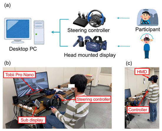
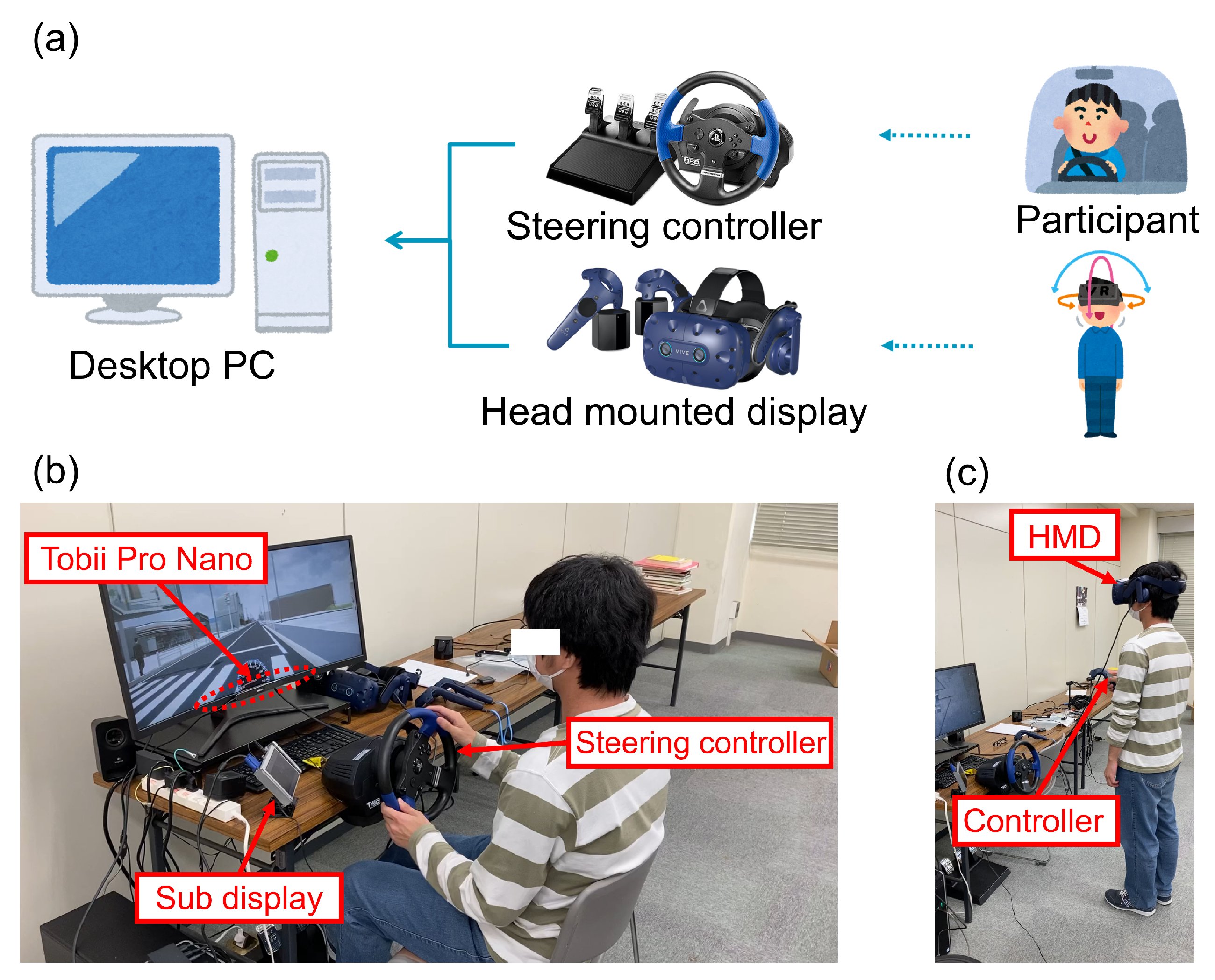
The development of the tsunami evacuation simulator was based on “Sirius”, a simulator platform provided by Misaki Design LLC. (Tokyo, Japan) [34], which consists of a desktop personal computer (PC) (specifications listed in Table 1), steering controller, and a head-mounted display (HMD) as shown in Figure 2a. Sirius adopted Unreal Engine 4 (Epic Games) for real-time computer graphics (CG) rendering and the open-source simulation software Re:sim, which enables multi-agent traffic modeling, developed by Misaki Design LLC., to reproduce the required traffic environment, including the occurrence of traffic congestion and presence of various categories of pedestrian evacuees, such as children, elderly individuals, and wheelchair users. The speed of each walker was set to follow a normal distribution with the mean value calculated based on the findings from the evacuation simulation presented in the Aichi Prefecture Municipal Tsunami Evacuation Planning Guidelines [35,36]. The system was designed to function as either a driving or pedestrian simulator depending on the input detected from the display and devices connected to the system. Figure 2b,c depict the operation of the tsunami evacuation simulator during evacuation by car and on foot, respectively.
Table 1.
PC requirements for running the tsunami evacuation training simulator.
Figure 2.
Overview of the tsunami evacuation simulator. (a) System block diagram, (b) simulator mode for evacuation by car, (c) simulator mode for evacuation on foot.
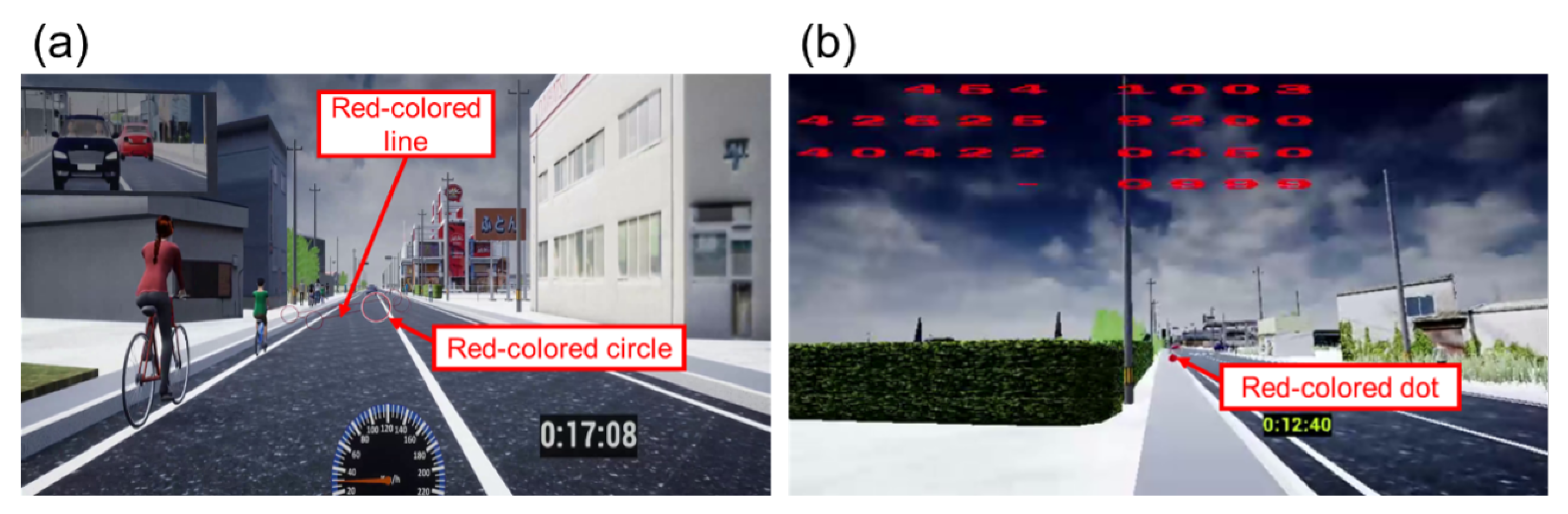
In the driving simulator mode shown in Figure 3a, the participant operated a steering controller connected to a PC while viewing the simulation screen on a monitor. The participant’s eye movements were recorded using an eye-tracking system (Tobii Pro Nano, Tobii AB). Additionally, a sub-display was placed to the left of the participant to show a map of the current location, allowing them to recognize the correct evacuation route. In the pedestrian simulator mode shown in Figure 3b, an HMD (Vive Pro Eye, HTC Corporation) was used both to present the visual simulation and track the participant’s eye movements. The participants could walk in virtual space in the direction they faced by pressing a button on the controller. Measured eye-movement was superimposed onto the rendered CG scene in real time. Examples of the simulated scenes presented to the participant driver and pedestrian are shown in Figure 3a,b, respectively.
Figure 3.
Visual scenes and eye movement tracking using the tsunami evacuation simulator. (a) Driving simulator mode (evacuation by car), (b) pedestrian simulator mode (evacuation on foot). In (a), the red-colored circle indicates the gazing point, and its radius indicates gazing time. The larger the radius of the red-colored circle, the longer the person has gazed at that point. The red-colored line connecting each circle indicates the eye movement trajectory. In (b), the red-colored dot indicates the gazing point. The red numbers represent the location of the participants on a map and are not relevant to the analysis in this paper.
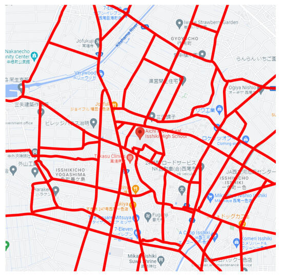
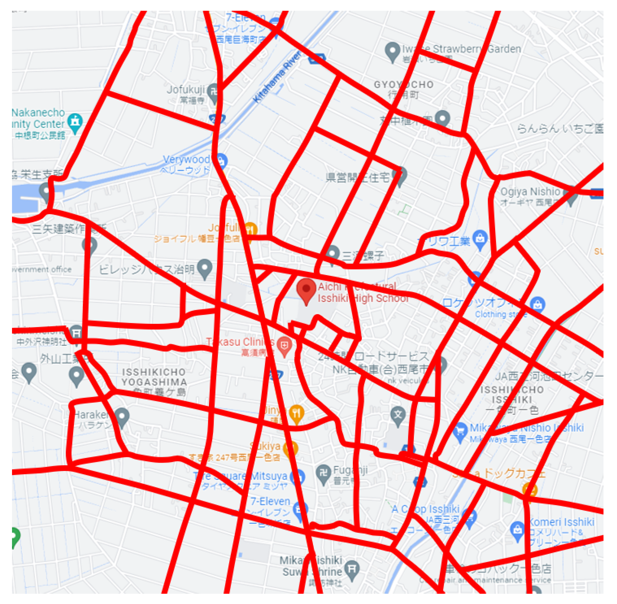
As the main objective of this study was to evaluate the effectiveness of the training methods derived from our framework when applied to the residents of Nishio City, Aichi Prefecture, Japan, a 3 × 3 km2 area centered on Aichi Prefectural Isshiki High School was selected for implementation in the CG database of the simulator. The selected area includes a dense traffic zone where both vehicular and pedestrian flows intersect frequently. This area was judged to be suitable for conducting this study. However, because of the limited processing speed and the need to reduce the load on the CPU and GPU, not all roads and buildings were included in the CG database; only roads marked in red and the buildings or houses situated along them were modeled as evacuation routes as shown in Figure 4.
Figure 4.
Roads of Nishio City reproduced in the tsunami evacuation simulator (map data ©2025 Google) [37].
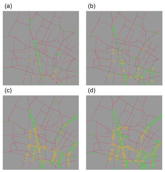
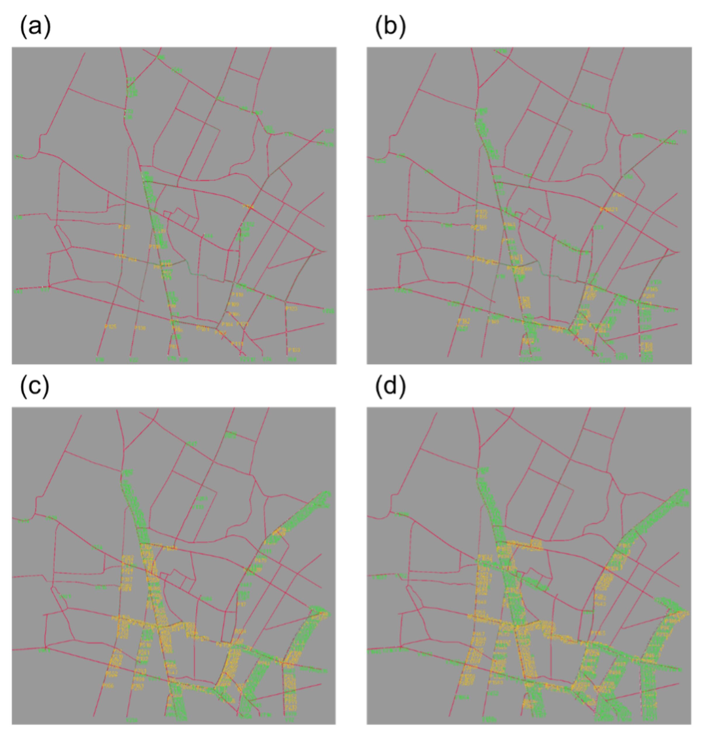
The traffic simulation software, Re:sim, automatically incorporated into the tsunami evacuation simulator, reproduced the heavy traffic using the road network data of the selected area of Nishio city. Figure 5 presents screenshots of the traffic simulated by Re:sim, displaying the exacerbated traffic congestion every 10 min. Note that all vehicles in Figure 5 were evacuated toward the north since the bay is located to the south on the map of Nishio City. The numbers in Figure 5 indicate the ID of the evacuated vehicle.
Figure 5.
Traffic congestion over time as determined by Re:sim in the tsunami evacuation simulator. (a) Just after tsunami, (b) 10 min after tsunami, (c) 20 min after tsunami, and (d) 30 min after tsunami.
2.2. Pilot Study in Ishonomaki City
The tsunami evacuation simulator was evaluated and validated from 14 to 16 June 2021, with the help of the residents of Ishinomaki City, Miyagi Prefecture, who had suffered from the Great East Japan earthquake. The purpose of this test was to evaluate the simulator on the reality of emergencies, to confirm that a simulator is a valuable tool in shaping participants’ attitudes toward not using cars for evacuation, and to obtain data on the behavior of tsunami survivors during evacuation.
Ten residents of Ishinomaki City participated in this testing: four were male, and six were female. Participants were recruited with the cooperation of the Japan Car Sharing Association (in Ishinomaki City), which uses cars collected through donations to create a new mutual aid system. However, most of the participants in the experiment were elderly because of the nature of the region. Despite the efforts of the Japan Car Sharing Association, only ten residents could be recruited for experimental participation. However, as mentioned earlier, considering that the area has a large elderly population and the residents have experienced the Great East Japan Earthquake, we decided that these ten individuals can be regarded as representative residents of Ishinomaki City.
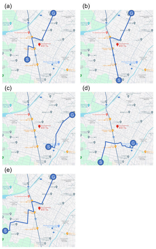
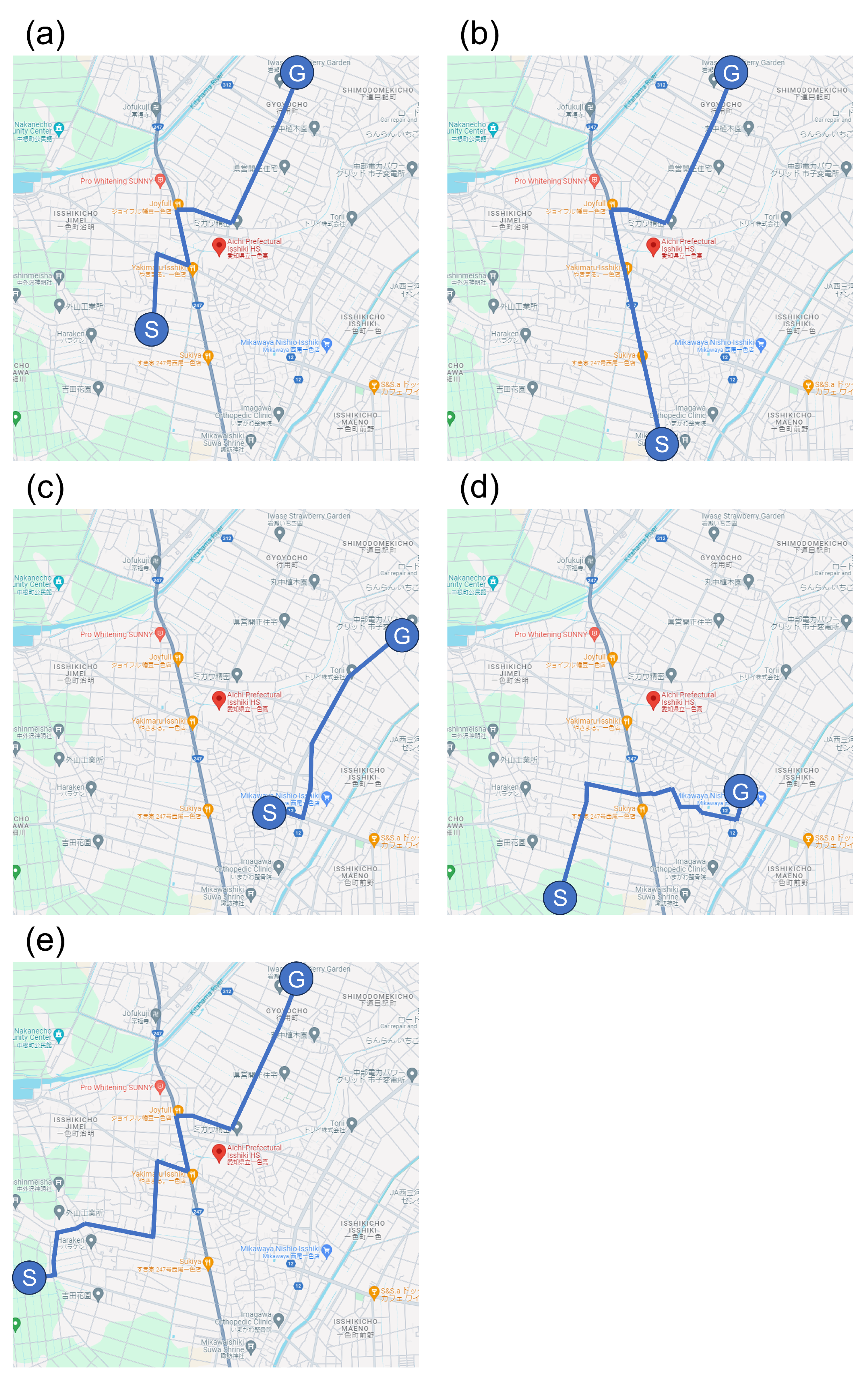
The average and standard deviation of the age of all participants were 68.90 ± 7.40 years; males were 73.75 ± 5.74 years old, and females were 66.67 ± 6.90 years old. Five evacuation routes were prepared as testing scenarios, and 10 participants, divided into five groups, were asked to move to the shelter along the assigned evacuation route. The two persons assigned to each group were evacuated along one of route1 to route5, shown in Figure 6, respectively. In Figure 6, Ⓢ indicates the start point, and Ⓖ indicates the goal point. To eliminate the influence of local knowledge and grasp the general tendency of people with prior evacuation experience to evacuate, maps and evacuation routes of Nishio City were used instead of maps and evacuation routes of Ishinomaki City.
Figure 6.
The routes used in the experiment have Aichi Prefectural Issiki High School at the center of the map. In each route, Ⓢ indicates the start point, and Ⓖ indicates the goal point. (a) Route 1, (b) Route 2, (c) Route 3, (d) Route 4, (e) Route 5. (Map data Ⓒ2025 Google [37].)
The testing took approximately 65 min per participant and was conducted as follows:
- Test explanation and signing of the experimental consent form (approximately 15 min).
- Evacuation by car (two trials, one for data acquisition, approximately 5 min each).Two trials were conducted before the data acquisition phase because the participants had yet to experience the tsunami evacuation simulator; they needed to become familiar with driving in the simulator and operating the steering controller. In addition, this was their first time going around the area of Nishio City as reproduced by the simulator; therefore, they also were required to understand the evacuation route. In the data acquisition phase, participants were instructed to evacuate along the same route as in the trials under the condition that the voice of the emergency broadcast was played to urge participants to evacuate quickly from the tsunami. Here, each participant was instructed to evacuate within 20 min, and the remaining time for evacuation is shown in the lower right corner of the screen in Figure 3a.
- Evacuation on foot (one trial, one data acquisition, approximately 5 min each).Because none of the participants had previously experienced VR, they needed to become familiar with walking in the VR setting. Therefore, a trial was conducted before data acquisition. In the data acquisition phase, as in the case of evacuation by car, participants were instructed to evacuate along the same route as in the trials, under the condition that the voice of the emergency broadcast was played and the time of arrival for tsunami was displayed. Each participant was instructed to evacuate within 20 min, and the remaining time for evacuation is shown in the lower right corner of the screen in Figure 3b.
- Questionnaire.After testing, all participants were asked about their feelings regarding the reality of the tsunami evacuation simulator and their thoughts on using cars for tsunami evacuation. At the current technical level, creating a virtual world that can be recognized as accurate by the participants is impossible, making it difficult to completely reproduce the sense of urgency of an actual tsunami evacuation. Thus, the term “reality” is used for the traffic situation and behavior of the traffic participants specific to this study.
For purposes of comparison and to establish a reference, the same testing described above was conducted from 29 July to 6 August 2021, with the help of students and faculty at Aichi University of Technology who had no experience with tsunami evacuation. Of the 15 participants who took the test, 9 were male, and 6 were female. Three were in their twenties (two males and one female); two were in their thirties (one male and one female); five were in their forties (two males and three females); and five were in their fifties (four males and one female).
Considerations included the experience of one participant possibly influencing the behavior of another and people who had just driven being more likely to pay attention to cars when walking. If initially the participants in a VR environment became VR sick, they were not allowed to participate in the experiment; therefore, they first took part in evacuation by car without VR and then evacuation on foot. By doing so, even if VR sickness occurred, the advantage was that at least, data from car evacuation could be obtained. None of the participants complained about sickness during evacuation by car.
2.3. KYT-Based Application Development
To improve traffic safety knowledge during evacuation, we developed a quiz-like application based on the results of evaluation testing in Ishinomaki City. Questions were created based on the results of the qualitative evaluation described in the previous section, to increase the awareness of participants in paying attention to traffic signals and high-rise buildings during evacuation and evacuation vehicles when crossing the street.
This application has the feature of incorporating KYT. Many companies and schools in Japan conduct Kiken Yochi training that originated in Japan [38] and was first implemented in 1976 [39]. In a typical KYT session, participants are shown an image and asked to identify potential hazards by imagining or visualizing risks, using the image as a prompt. Through group discussions and idea sharing, participants enhance their situational awareness and ability to recognize risks. In this sense, KYT can be viewed as a brainstorming exercise that focuses on hazard identification. KYT has been shown to improve workers’ hazard awareness, promote team-based motivation, facilitate the sharing of risk-related information, and enhance problem-solving skills [40]. Furthermore, it contributes to a reduction in human error and improves overall safety performance [41]. Traditionally, KYT activities have focused on occupational injuries [42,43] and natural disasters such as fires [44], earthquakes [45], and water-related hazards [45]. KYT has not been applied for traffic safety during tsunami evacuation because the domain knowledge required to formulate the necessary questions in KYT is lacking. However, as explained in Section 2.2, we derived the necessary expertise from the testing in Ishinomaki City. Accordingly, we developed a quiz-like KYT-based training application for smartphones and tablet devices (Android OS) for residents of all ages to easily use and train alone, anytime and anywhere. The KYT-based training application was developed using Unreal Engine 4.
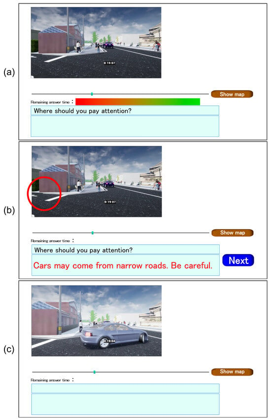
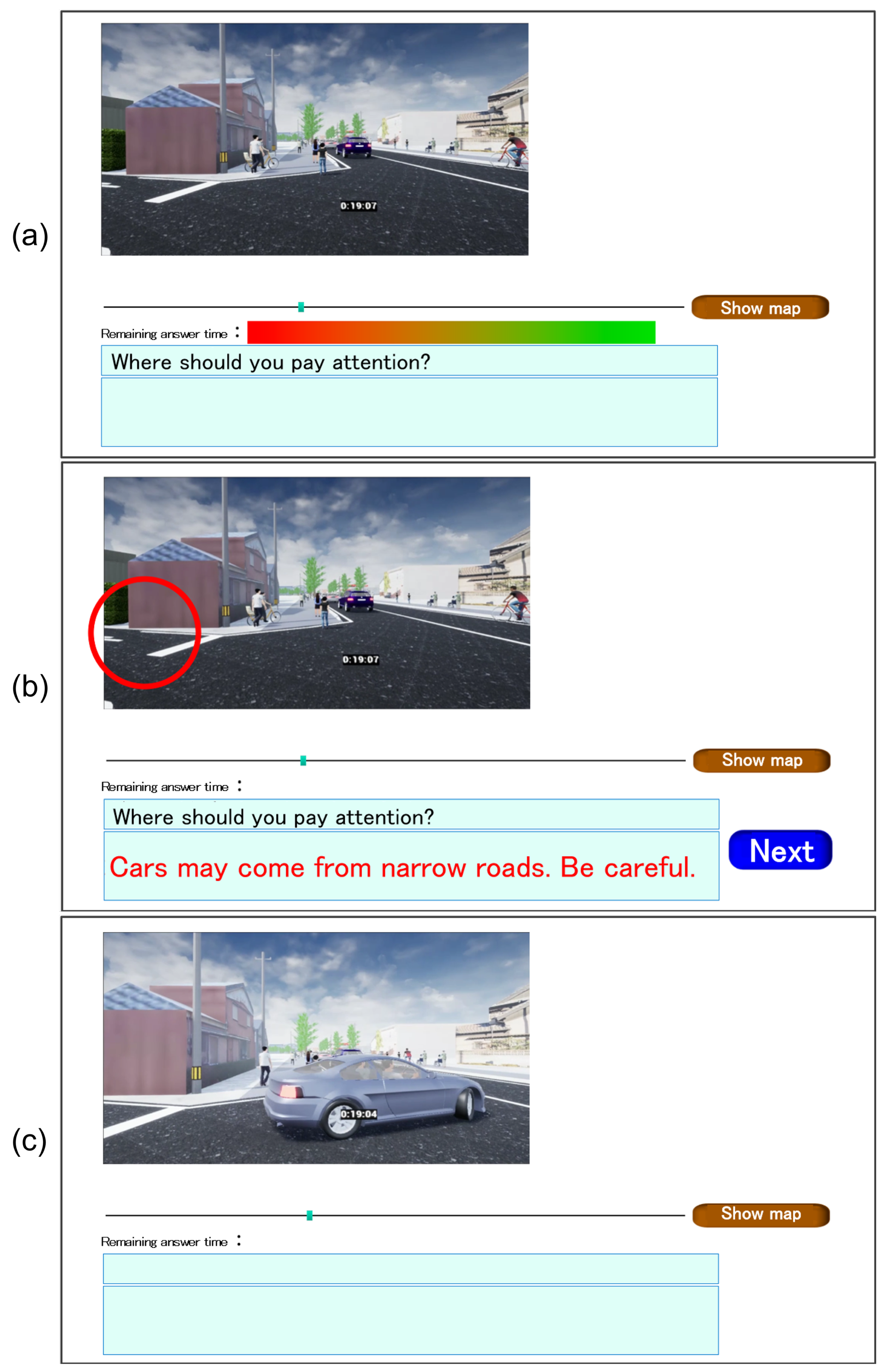
This application plays a CG video instead of a picture, which can also be generated using the tsunami evacuation simulator software. The video pauses at a location requiring the attention of the user because of potential risks. Then a question, such as “Where should you pay attention?” is displayed on the screen to prompt the user to click on the area of interest in the scene suspected of being hazardous. After clicking, a jingle sounds, and empirically, the most significant area is indicated by a red circle. The reason for this is also displayed simultaneously to facilitate the users’ understanding and acceptance. Each training video contained several questions ranging from three to ten. A total of eight videos were prepared for the training sessions. Figure 7 shows an example of the questions and answers provided by the application.
Figure 7.
An example of the KYT-based application for tsunami evacuation training depicting scenarios of cars coming out of alleys during evacuation on foot. Possible scenarios included (a) the question being displayed just before the car comes out, (b) the answer to the question being displayed, and (c) the car coming out after the answer. Note that in the original version, all texts were written in Japanese.
In addition, this KYT-based training application allowed the user to obtain a stamp on the application for each training session, to motivate the user to continue training. Section 3 presents the method of verifying the effectiveness of the app. However, since verifying the effectiveness of the app assumes continuous use for one week, we did not evaluate continuous training but rather maintenance of motivation through the obtained stamps.
2.4. Experimental Procedure in Nishio City
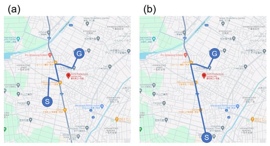
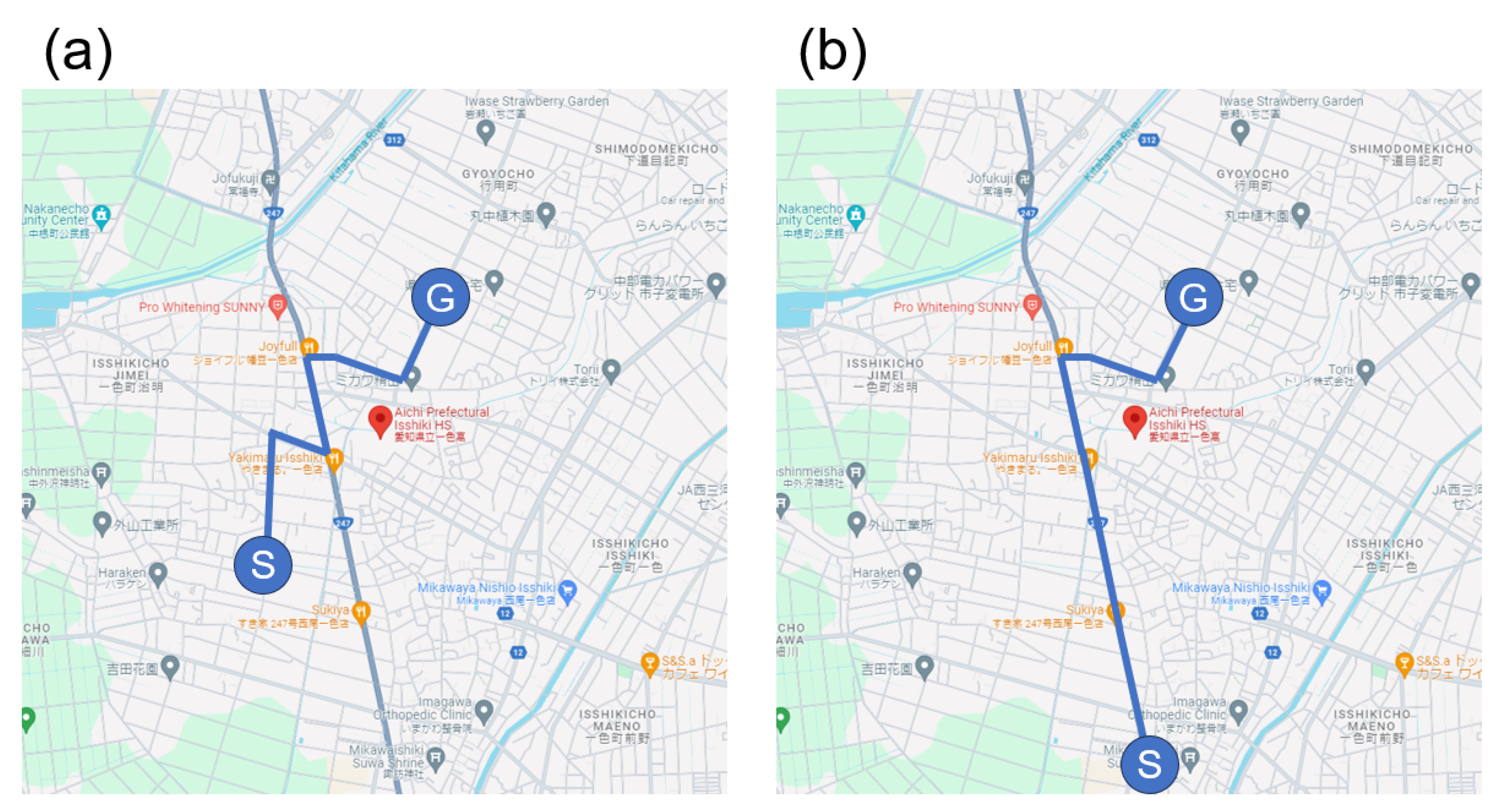
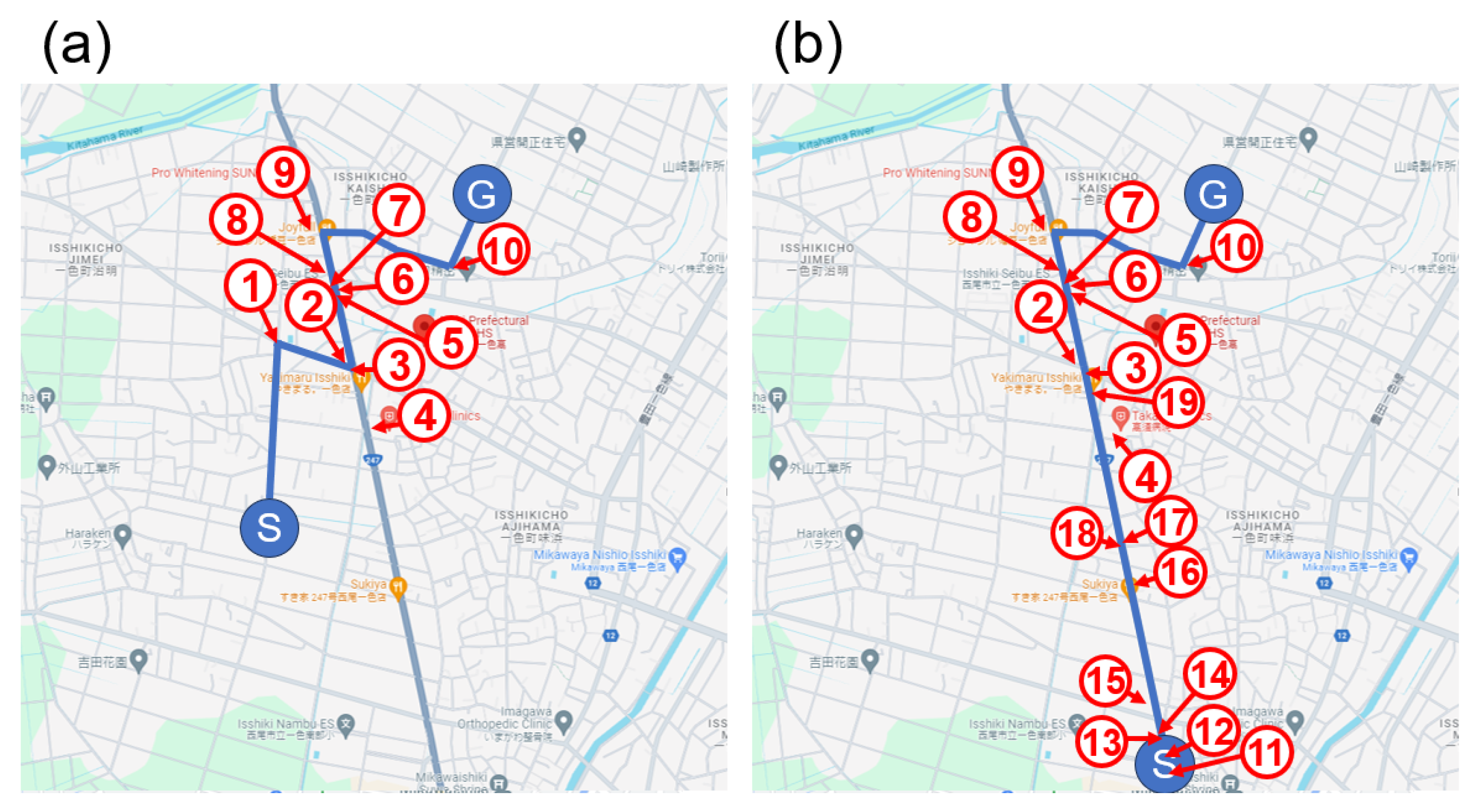
From 21 August to 10 September 2022, an experiment was conducted on 25 participants living in Nishio City, Aichi, Japan, as detailed in Table 2, to verify the effectiveness of the proposed framework for participants who had never experienced a tsunami and train them what to notice and be aware of during evacuation. Each participant’s evacuation route was assigned based on their residential neighborhood as shown in Figure 8. Participants were recruited with the cooperation of the Nishio City Crisis Management Division. To balance the number of participants as well as their age and gender distribution, residents from neighborhood associations located along Route 1 and Route 2 in Figure 8 were selected. In Figure 8, Ⓢ denotes the start point and Ⓖ denotes the goal point. These routes were modified according to the result of the experiment in Ishinomaki City. Route 1 and Route 2 in Figure 8 were selected as the routes with appropriate straight lines and right/left turns.
Table 2.
Age, gender, and evacuation route of each participant. M = male, F = female.
Figure 8.
The routes used for the experiment in Nishio City. Aichi Prefectural Issiki High School is centered in the map. In each route, Ⓢ denotes the start point and Ⓖ denotes the goal point. (a) Route 1, (b) Route 2. (Map data Ⓒ2025 Google [37].)
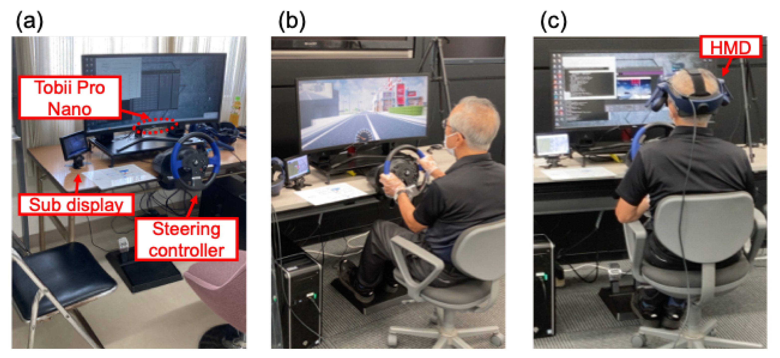
Figure 9 shows the experimental setup and a snapshot of the participants’ evacuation by car and foot during the experiment. The testing procedure was as follows:
- Participants filled an experimental consent form after the experiment was explained. All participants were informed that they could decline to participate, even during the test.
- Participants sat on a chair and adjusted their seating positions to use the simulator.
- The eye tracker (Tobii Pro Nano) was calibrated.
- Participants were instructed on the route to use for evacuation.
- Before data acquisition, the participants drove freely along the indicated route as a trial to familiarize themselves with the driving mode of the simulator.
- Participant data were obtained on evacuation behavior when using cars. Here, each participant was instructed to evacuate within 20 min; the remaining time for evacuation is shown in the lower right corner of the screen in Figure 3a. (Steps 5 and 6 correspond to the “Evacuation by car” experiments conducted in Ishinomaki City as outlined in Section 2.2.)
- After a five min break, the participants wore an HMD connected to the simulator.
- Participants walked freely along the indicated route to familiarize themselves with the operation of the pedestrian mode of the simulator.
- Data were collected on the evacuation behavior of the participants on foot. Here, each participant was instructed to re-evacuate within 20 min, and the remaining time for evacuation is shown in the lower right corner of the screen in Figure 3b. (Steps 8 and 9 correspond to the “Evacuation on foot” experiments conducted in Ishinomaki City as outlined in Section 2.2.)
- Participants were asked to complete a questionnaire on their awareness of tsunami evacuation.
- Participants were taught to use the KYT-based application, choose the device they preferred to use (smartphone or tablet), and take the smartphone or tablet home. The participants were also asked to comment on the application’s usability during or after using the KYT-based application for purposes of improvement.
- Six days after the simulator experience, the participants attempted to acquire knowledge about safe evacuation using the KYT-based application on the selected device.
- Participants then re-experienced the tsunami evacuation simulation. Steps 2–10 of the experimental procedure were repeated.
- Participants completed a questionnaire designed to investigate changes in their awareness of tsunami evacuation owing to the use of the KYT-based application.
Note that considering the impact of VR sickness on the experiment, evacuation by car without VR was conducted first, followed by evacuation on foot. None of the participants complained of sickness during evacuation by car.
Figure 9.
Experimental scenes in Nishio City. (a) Setup of the tsunami evacuation simulator, (b) scene during evacuation by car, (c) scene during evacuation on foot.
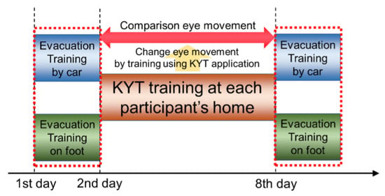
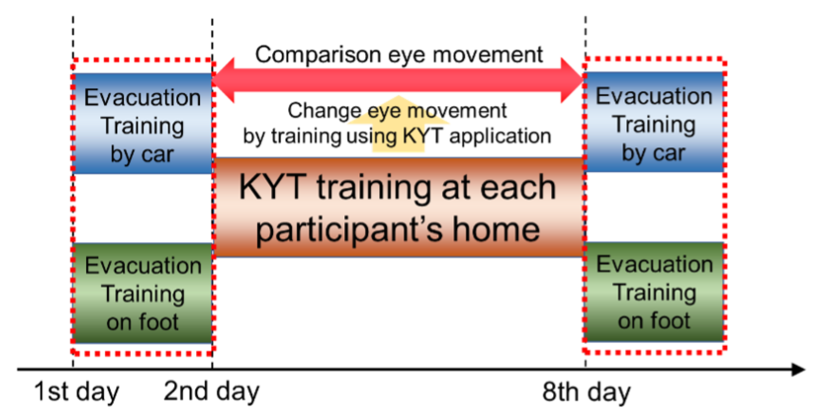
The framework of the experiment is illustrated in Figure 10.
Figure 10.
Analysis framework of the experiment in Nishio City.
In addition to subjective measures such as questionnaires, we gathered objective metrics from eye-tracking data during evacuation, focusing on the number of fixations on target areas like evacuation signs and traffic signals, which the KYT-based application instructed participants to notice. The effects of training were closely analyzed based on changes in gaze behavior since eye-movement data are widely recognized in psychological research as reflecting the underlying cognitive processes during a task [46]. While our previous study mainly relied on subjective evaluations of the KYT application [33], in this study, we could provide more robust evidence for evaluating the effectiveness of the proposed framework beyond participants’ self-reports by including these objective measures.
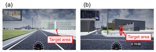
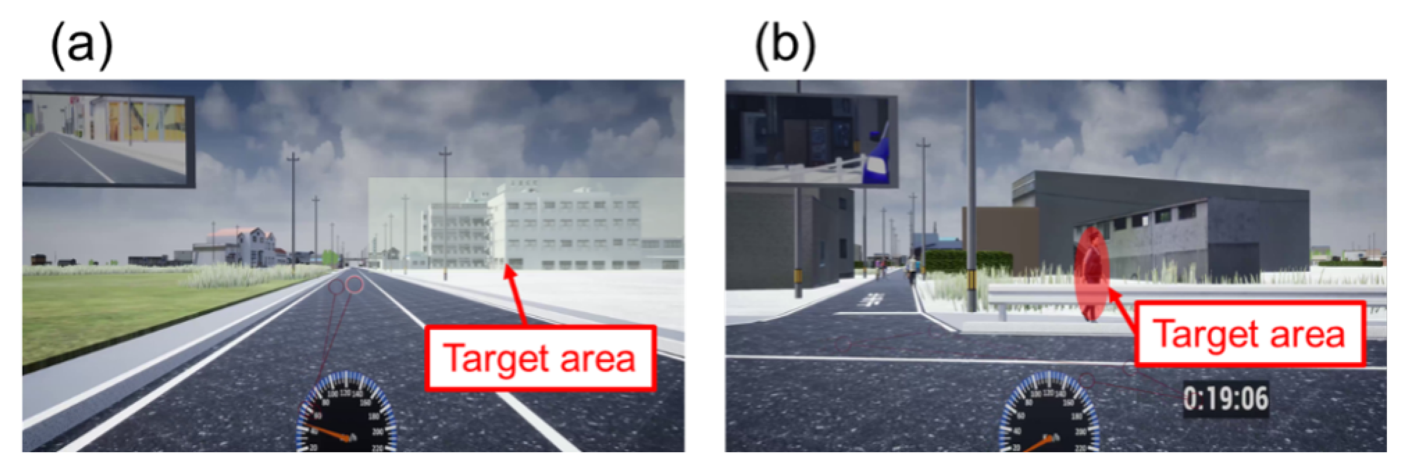
The analysis method for explaining how eye movements can be analyzed differed for evacuation by car and on foot. First, we explain the analysis method for evacuation by car, for which the “Analyze” function of Tobii Pro Lab version 1.110 (Tobii AB) was used. This function can analyze gaze fixation time and number of visits to a target area based on video data that contain gaze data. Here, we measured the number of visits to the target area based on the video data. Using Tobii Pro Lab’s “Analyze” function, for each frame of the video, an area is defined, and the number of times and duration of gazing within that area are calculated. For each case of objects and people, we defined the areas shown in Figure 11. In the case of objects, a square area slightly larger than the size of the object was defined as the area (Figure 11a), whereas in the case of a person, an elliptical area slightly larger than the size of the person was defined as the area (Figure 11b). Strictly speaking, “slightly larger” requires a quantitative definition, but the definition is arbitrary because the size of the object varies depending on where it is during the evacuation. Therefore, we set the first frame and area in which the object appeared, followed by the last frame and area, and the coordinates and size of the area for the frames in between were linearly interpolated. Therefore, the coordinates and sizes of the frames in which the object was present were misaligned, requiring manual adjustments. However, we carefully defined each area to ensure that their sizes were consistent.
Figure 11.
Example of target area definition. (a) Object except police officer (green hatched area), (b) police officer (red hatched area).
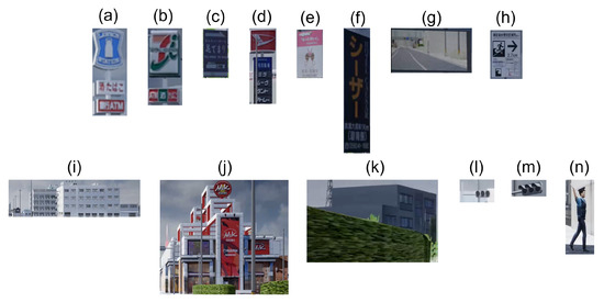
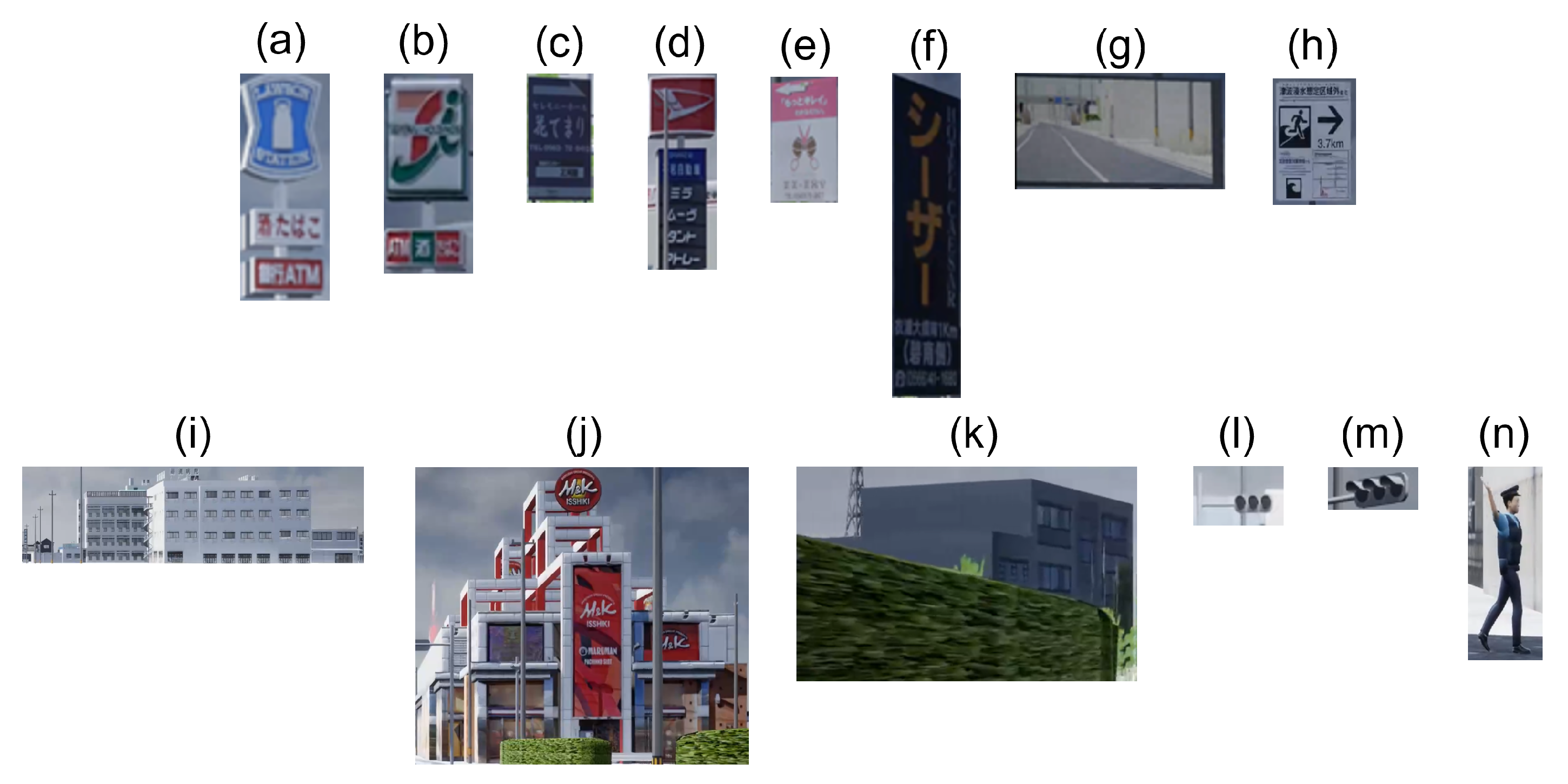
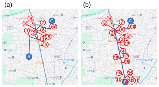
Using eye-movement data obtained during the evacuation, the data on driver or pedestrian gazing at six types of objects—“signboard”, “inner rearview mirror”, “evacuation sign”, “prominent building and emergency refuge”, “traffic sign”, and “police officer guiding the route”—were analyzed. The KYT-based application instructed the participants to pay attention to these six types of objects during driving. The locations of each object are listed in Table 3 and shown in Figure 12. Figure 13 shows the location of the gazing target shown in Table 3.
Figure 12.
Target of gazing point. (a,b) Convenience store sign, (c–f) store sign, (g) inner rearview mirror, (h) evacuation sign, (i–k) prominent building emergency refuge, (l,m) traffic signal, (n) police officer guiding the route.
Figure 13.
Target location of gazing point. The number in this figure corresponds to the number in Table 3. (a) Route 1, (b) Route 2. (Map data Ⓒ2025 Google) [37].
3. Results and Discussion
3.1. Findings from Experiment in Ishinomaki City
The results of the questionnaire administered to the 10 participants are presented in Table 4. The 10 participants from Ishinomaki City are labeled as participants A to J.
Table 4.
Results of questionnaire administered to 10 participants.
As shown in Table 4, some participants said that they were reminded of the actual day of the tsunami, or they seemed upset as if this experiment were a real evacuation. Based on this subjective evaluation, we determined that the situation generated by the tsunami evacuation simulator provided an adequate level of reality for training purposes. Considering the results in Table 4, after experiencing the disadvantages of using cars, participants A, B, D, and G answered that they would decide whether to use cars depending on the situation. The distance to a safe place in the event of a tsunami was the primary factor in their decisions. This implies the importance of shelter locations and informing the public about them. The simulator experience led the participants to choose the proper evacuation method without insisting on evacuation by car. However, participants F and I indicated they would evacuate by car even after the simulator experience. This was based on the belief that a vehicle is a possession, a necessity for life, a comfortable private space, and a thing people cannot give up. There is a report that 7% of those using cars in the Great East Japan earthquake stated that they had evacuated using vehicles because “I tried to protect the car because it was property.” [7]. Changing such a strong opinion on cars may require a different approach than solely experiencing the disadvantages of using cars. This qualitative insight suggests that simulator exposure may enhance situational awareness, supporting the foundation for Hypothesis 1. The eye-movement data were also analyzed, and the following trends were observed in comparing the differences between the results of participants from Ishinomaki City and those of students and faculty at Aichi University of Technology:
- Participants with prior tsunami evacuation experience frequently checked traffic signals to evaluate the situation and determine whether traffic was flowing normally.
- Such experienced participants also tended to look tall or had prominent builds which helped them in orienting themselves toward their destination or identifying alternative safe locations for rapid evacuation.
- While evacuating by car, these participants often failed to notice pedestrians at crosswalks, as their visual attention was more focused on traffic signals, surrounding vehicles, and tall buildings rather than on pedestrians.
These findings suggest that evacuees should check the state of traffic signals to identify whether the current traffic situation is normal and try to find safe places, such as tall or large buildings, during evacuation. In addition, evacuees should pay more attention to other traffic participants to avoid traffic accidents because of focusing on traffic signals or tall or large buildings to save their own lives. Note that we did not conduct any quantitative analysis of the eye-movement data. The objective of the experiment was to extract the behaviors that are characteristic of people who have experienced tsunami evacuation in designing the questions of KYT-based application, and the purpose of the application was to learn which areas to pay attention to, instead of a single specific point. Therefore, a quantitative evaluation was deemed unnecessary.
3.2. Result of Experiment in Nishio City
All participants’ comments are provided in Appendix A. One of the purposes of the simulator experience was to inspire participants to consider proper evacuation methods to save lives during tsunamis. The participants experienced traffic congestion when using cars for evacuation and understood the reasoning for the government-recommended evacuation on foot. Some participants commented that they should know where the evacuation site is and the shorter and safer route to the destination before the tsunami attack; this is the most critical point in promoting evacuation on foot. Through this experiment and participant comments, if a shelter location can be confirmed, the tsunami evacuation simulator is a useful tool for convincing people to move to safe places in sufficient time, even on foot. Notably, as described in Section 3.1, certain people insisted on evacuating using cars even after they understood the disadvantages of using cars. Considering this, to preclude the use of vehicles for evacuation, a more multidisciplinary and comprehensive approach is required, including psychology, law, and life sciences.
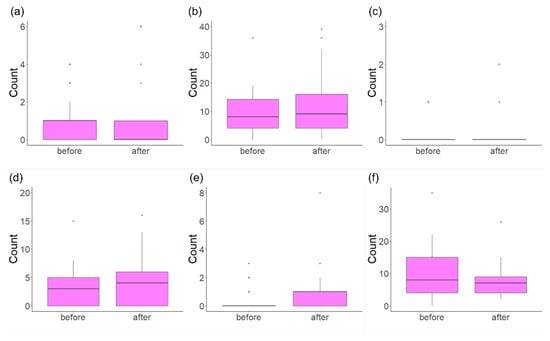
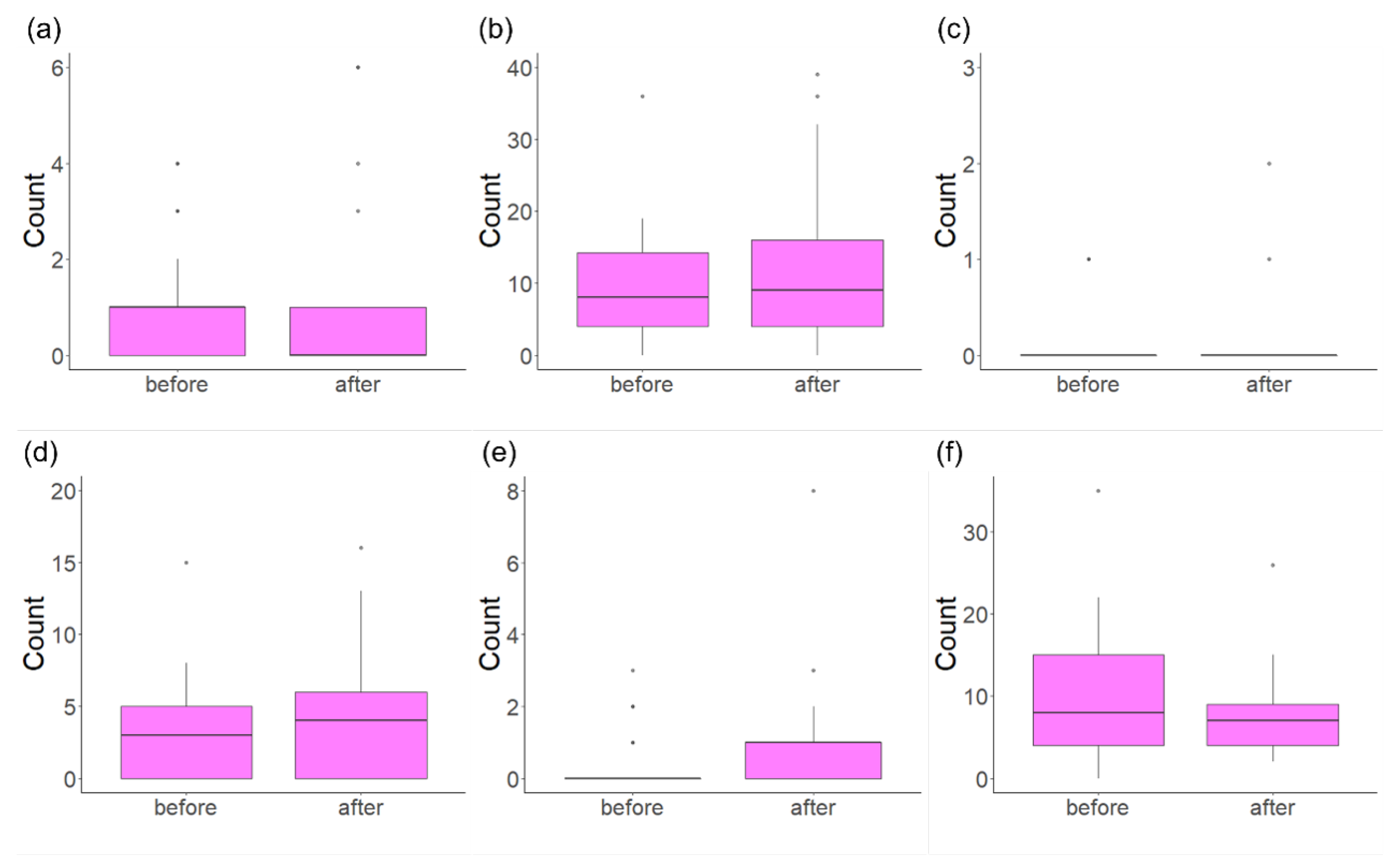
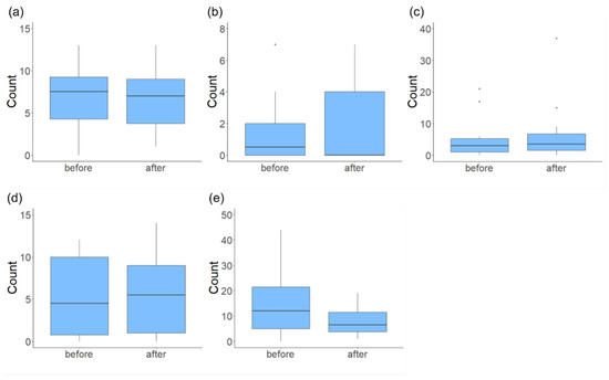
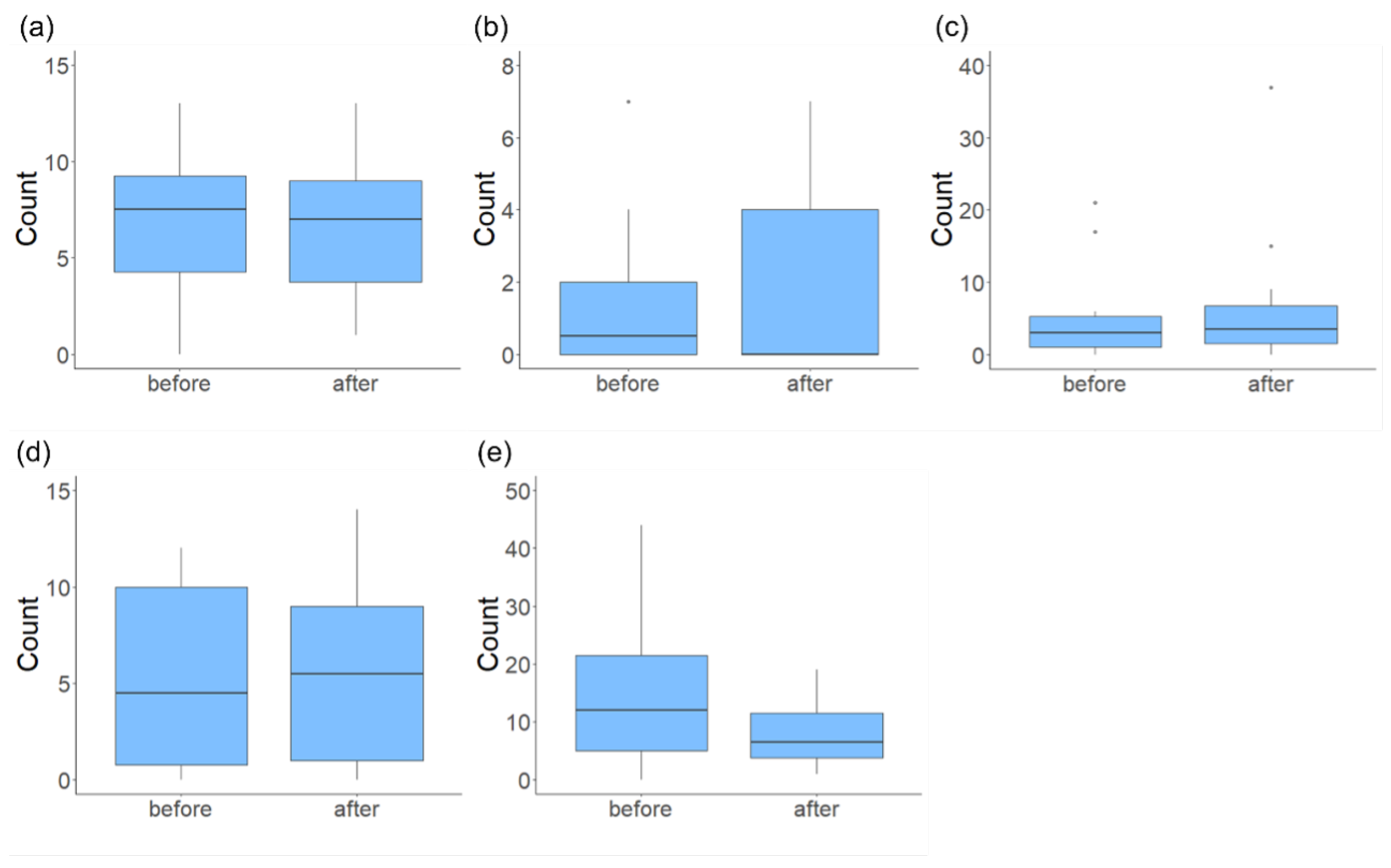
According to comments from the participants, some behavioral changes were perceived by the participants themselves. They became more aware of traffic hazards and their surroundings after training using the KYT-based application. The analysis results of eye-movement for car and foot evacuation are shown in Figure 14 and Figure 15, respectively. The statistical analysis results (Wilcoxon signed-rank sum test) for evacuation by car and on foot are presented in Table 6. The numbers in the table are p-values of the test statistic, and no significant differences were found at a significance level of 0.05, for all targets and evacuation by car as well as on foot. For reference, the arrows in parentheses indicate increasing and decreasing trends in the number of objects gazed at after training with the KYT application.
Figure 14.
Box–whisker plot of the number of times the eye focused on each target area in the first and second experiments using the tsunami evacuation training simulator for evacuation by car. (a) Signboard, (b) inner rearview mirror, (c) evacuation sign, (d) prominent building and emergency refuge, (e) traffic sign, and (f) police officer guiding the route.
Figure 15.
Box–whisker plot of the number of times the eye focused on each target area in the first and second experiments using the tsunami evacuation training simulator for evacuation on foot. (a) Signboard, (b) evacuation sign, (c) prominent building and emergency refuge, (d) traffic sign, and (e) police officer guiding the route.
In addition to statistical testing using the Wilcoxon signed-rank sum test, Cohen’s d and effect size r were also calculated because the sample size was small. The results are shown in Table 5 and Table 6. From Table 5 and Table 6, for evacuation by car, although the difference is not statistically significant (p = 0.0644), the effect size is nearly medium (Cohen’s d = 0.443), suggesting that the KYT application had a small effect on the traffic signal. As for evacuation on foot, although the difference is not statistically significant (p = 0.203), the effect size is large (Cohen’s d = 0.655).
Table 5.
In the tsunami evacuation training simulator for evacuation by car or on foot, the p-value is based on the results of Wilcoxon’s signed rank sum test on the number of times the eye entered each target area in the first and second experiments. The numbers in the table are p-values, and the arrows in parentheses indicate increasing and decreasing trends in the number of eye movements in the area considered for the first and second experiments. The symbol ↑ indicates an increasing trend, and ↓ indicates a decreasing trend after training on KYT application.
The fact that there was no significant difference in gazing time for each object is presumably because the participants were familiar with the road environment, as they lived in areas near the evacuation routes used in the experiment, namely Route 1 and Route 2 in Figure 8. Hence, they did not have to pay much attention to signboards, evacuation signs, prominent buildings, and emergency refuges. Although not statistically significant, the KYT-based application had a modest effect in raising participants’ awareness of traffic signals. In Section 1, we stated the hypothesis that traffic signals may not work properly and that pedestrians and motorists may violate traffic rules in such abnormal situations. The above results suggest that this hypothesis is adequate. No previous study has shown a relationship between the status of traffic signals and eye movement during tsunami evacuation. However, several previous studies have shown that traffic signals affect the evacuation line of sight [46,47]. Although the results differ from those of previous studies in terms of whether the signal is flashing or not, this signal indicates that disaster is happening currently. The eye movement results in this paper seem to follow the findings of the previous studies in the sense that the signal influences evacuation behavior. In contrast, Cohen’s d indicates a notable trend toward decreased gaze time for police officers guiding the route. This may be because the position of the police officer in the simulator was permanently fixed, and all participants knew the role of the police officer in advance and no longer paid attention to the officer.
Table 6.
Cohen’s d of the number of times the eye entered each target area in the first and second experiments using the tsunami evacuation training simulator for evacuation by car and on foot.
Although participants reported increased awareness of traffic hazards after using the KYT-based application, statistical analysis of the eye-movement data revealed no significant differences in fixation time or frequency on the predefined objects. Moreover, Cohen’s d indicated only small effect sizes for most objects, except for traffic signals and police officers during evacuation by car or on foot. These findings suggest that Hypothesis 2 was not fully supported from an objective, quantitative standpoint. However, the subjective reports indicate a perceived improvement in hazard recognition, implying a potential cognitive shift that may not have been captured by the current measurement approach.
Hypothesis 2 stated in Section 1.2 expects improvements in hazard recognition to be reflected in gaze behavior and subjective feedback, and the findings provide only partial support. While subjective reports suggest a heightened awareness, this change was not detected through objective gaze metrics. This discrepancy implies that the application may have influenced cognitive processes or behavioral intentions in ways not captured by the current measurement approach. Future evaluations should consider alternative methods or complementary indicators, such as behavioral tasks or structured interviews, to more fully capture the cognitive effects of training tools such as the KYT-based application.
3.3. Discussion on Behavioral Change and Training Effectiveness
This section discusses how the proposed training framework influenced participants’ behavior and awareness regarding tsunami evacuation. We reflect on the two hypotheses proposed in Section 1.2 and consider the differences between experienced and non-experienced populations.
Hypothesis 1 postulated that simulator training would increase willingness to evacuate on foot. Subjective feedback from both Ishinomaki and Nishio participants supports this claim: several participants mentioned a reconsideration of their default preference for car evacuation after experiencing traffic congestion in the simulator. However, some individuals, particularly in Ishinomaki, remained committed to car evacuation due to personal attachment or perceived necessity. This indicates that while the simulator is effective for some, deeply held beliefs may require complementary approaches such as legal, psychological, or community-based interventions.
Hypothesis 2 addresses the potential of the KYT-based training application to improve hazard recognition. Subjectively, most participants reported heightened awareness of traffic hazards, particularly regarding traffic signals, pedestrian crossings, and obstructed views. Nonetheless, statistical analysis of gaze behavior did not reveal significant changes in fixation frequency or duration for target objects after training. This discrepancy suggests that although the application may have altered cognitive readiness, such changes were not fully captured through eye-tracking metrics alone.
A comparison between Ishinomaki and Nishio participants reveals important contrasts. Experienced individuals tended to use tall buildings and traffic lights as navigational aids, reflecting learned behavior from past disasters. In contrast, the Nishio group demonstrated cognitive shifts through the KYT-based training application, highlighting the potential of the app as a preventive tool in non-affected regions.
These findings affirm the utility of the training framework while also pointing to limitations. Behavioral changes may manifest in ways not fully captured by gaze data alone, necessitating richer evaluation methods such as structured interviews or real-world drills. Future research should integrate multiple data sources to assess both the cognitive and behavioral dimensions of disaster readiness.
4. Limitations of the Work
Several limitations remain regarding the scalability and usability of the proposed framework.
The KYT-based training application was designed based on the results of a pilot study. However, the number of participants of the pilot study was small; therefore, the results may not be totally reliable, although the result seemed to be somewhat reliable from the point of well-known evacuation behavior [48]. In the experiment conducted in Ishinomaki City, recruiting participants was challenging because the area has a large elderly population, and therefore the demographics were biased toward elderly participants. A larger number of participants is required to ensure the reliability of the pilot study even if the cohort of participants can be regarded as representative of Ishinomaki City residents.
The tsunami evacuation simulator provided sufficient realism for training purposes based on subjective evaluations. However, to objectively and quantitatively verify this realism, additional information is required, not only through graphics but also on the movements of vehicles and pedestrians. Once such data are obtained, objective metrics such as presence questionnaires, simulator sickness questionnaire (SSQ) scores, and comparisons of task-completion time with real-world data can serve as effective methods for evaluating the simulator’s realism in an objective and quantitative manner. Future studies will require incorporating these metrics during experiments to assess the simulator’s realism and provide evidence for its applicability in actual disaster evacuation scenarios.
While short-term changes in evacuation preferences were observed after simulator training, some participants still preferred car evacuation due to strong emotional or practical attachments. This study did not include longitudinal follow-up, and thus the sustainability of behavioral change remains unverified. Future research should incorporate follow-up surveys or repeated interventions to evaluate the long-term impact of the training framework.
The simulator, equipped with a steering controller and HMD, is intended for use by municipalities, either by procuring or borrowing the system and installing it in community centers or similar public facilities. Since the system itself is not particularly expensive, it is feasible for a local municipality in terms of cost. However, as the full set of equipment must be assembled, residents need to visit a designated facility such as a community center to use it, which makes casual access difficult. Therefore, in future work, we aim to develop a simplified and more compact version of the system, such as one that can be operated using a laptop or VR-capable smartphone, to potentially allow citizens to conduct evacuation training at home.
Regarding the KYT-based training application, quantitatively assessing participants’ attention to vehicles and pedestrians is difficult, as humans perceive their surroundings through the central visual field (measurable by eye-tracking) and peripheral field. As a result, the statistical analysis in this study captures only part of the app’s effect. Nevertheless, participants’ comments suggest that they became more aware of potential hazards. Further efforts are required to objectively evaluate behavioral changes and their safety impact.
Eye-movement analysis in this study was limited to the specific gaze areas shown in Figure 13, although many other relevant areas exist. A more detailed analysis is required. Additionally, the app’s questions guide participants’ attention; therefore, the content and validity of these questions should be further examined. The definition of target area is rather subjective. Tobii Pro Lab allows the definition of target areas using polygons, making it possible to match the shape of the area to the actual shape of the target. However, considering human peripheral vision, it may not be appropriate to define a fixation only when the gaze point falls strictly within the exact boundaries of the target shape. As the shapes and sizes of targets vary, defining a precise distance from the target for it to be still considered a fixation is extremely difficult. Therefore, this study defined fixations as gazes that fall approximately within the target area. However, to strictly evaluate the eye movement, the target area should be defined considering human peripheral vision.
Finally, the experiments were conducted in just two specific regions, which may limit how well the results apply elsewhere. Therefore, future studies should include larger, long-term trials with more diverse populations to fully confirm the framework’s usability and relevance.
5. Conclusions
This study proposed a tsunami evacuation training framework integrating a VR simulator and a KYT-based mobile app. The framework addresses two persistent issues: reliance on cars during evacuation and poor situational awareness in mixed-traffic settings.
Two hypotheses guided the research. Hypothesis 1 suggested simulator training would increase willingness to evacuate on foot, especially when a nearby shelter was present. In the experiments, many participants recognized the limits of car-based evacuation and were more open to walking if they knew where to go. This qualitatively supports Hypothesis 1. However, some participants still preferred cars for emotional or practical reasons, suggesting that simulations alone may not overcome deep-seated preferences and that additional interventions may be required. Hypothesis 2 proposed that the KYT app would enhance hazard recognition, as seen in gaze behavior and feedback. While participants reported greater awareness of risks, eye-tracking data showed no significant changes in gaze patterns. This suggests that the app may have influenced cognitive or behavioral intentions not captured by gaze metrics. Thus, Hypothesis 2 was only partially supported.
Overall, combining immersive simulation with repeated hazard recognition training, has value. The simulator encourages reflection on evacuation choices, and the KYT app may help maintain attentiveness. Future work should explore other evaluation methods beyond eye tracking and include a broader range of participants to better assess behavioral and cognitive change.
Unlike our previous study [33], which mainly assessed the KYT-based application through participants’ self-reports, the current work adds objective evidence by analyzing eye-tracking data during evacuation simulations. This methodological improvement reinforces the conclusions regarding the effectiveness of the proposed ICT-based tsunami evacuation training framework.
We will try to continue refining this framework, and in collaboration with local governments, extend its use to other types of disaster education beyond tsunamis. For example, by having local governments install the simulator in public facilities such as community centers, residents can experience tsunami evacuation through simulations. In addition, encouraging them to use the KYT-based application at home would allow a comprehensive evacuation training program. We aim to propose and promote the implementation of this integrated approach to disaster preparedness.
Author Contributions
Conceptualization, T.A.; Investigation, T.A., F.O., K.K., T.I., S.U., S.Y. and T.S.; Methodology, T.A., S.Y. and T.S.; Data curation, T.A., F.O., K.K., S.Y. and T.S.; Formal analysis, T.A.; Visualization, T.A.; Resources and Software, J.T.; Writing - original draft, T.A. and J.T.; Writing—review and editing, F.O., K.K., T.I., S.U., S.Y. and T.S.; Supervision, T.A.; Project Administration, T.A.; Funding acquisition, T.A. All authors have read and agreed to the published version of the manuscript.
Funding
This work was supported by JSPS KAKENHI (Grant number 19H01723).
Institutional Review Board Statement
The study was conducted in accordance with the Declaration of Helsinki and was approved by the Review Board for Research Involving Human Subjects of the Aichi University of Technology (No. 01-1) and the Ethics Review Board for Research Involving Human Subjects of Nippon Institute of Technology (#2022-02).
Data Availability Statement
The dataset generated during the current study is not publicly available but is available from the corresponding author upon reasonable request.
Acknowledgments
The authors would like to thank Keita Oda of Misaki Design LLC. for developing the tsunami evacuation simulator and the base of the KYT-based application, Kazumi Sugiura for designing the logo for the KYT-based application and for her assistance with the experiments. The authors would like to thank Yuko Kawai of the Nishio City Crisis Management Division and the Japan Car Sharing Association for their great help in recruiting participants for this experiment; the citizens of Ishinomaki, Miyagi Prefecture and Nishio, Aichi Prefecture for their cooperation in the experiment; and the Japan Car Sharing Association, the Nishio City Crisis Management Division, the Nishio Police Station, and Ishinomaki City Office for their cooperation during the interviews.
Conflicts of Interest
Shintaro Uno was employed by the company Aichi System Corp. Jun Tajima was employed by the Misaki Design LLC. The authors declare no conflicts of interest regarding the work conducted in this paper.
Abbreviations
The following abbreviations are used in this manuscript:
| AR | Augmented reality |
| HMD | Head-mounted display |
| ICT | Information and Communication Technology |
| KYT | Kiken Yochi Training |
| VR | Virtual reality |
Appendix A
Table A1 compares the awareness of the participants before and after the experiences of the tsunami evacuation simulator and is based on the questionnaire administered during the experiment.
Table A1.
The result of question, “What do you think you need to notice considering evacuation from a tsunami?” before and after the experiment on the tsunami evacuation simulator.
References
- Miura, N.; Yasuhara, K.; Kawagoe, S.; Yokoi, H.; Kazama, S. Damage from the Great East Japan earthquake and tsunami—A quick report. Mitig. Adapt. Strateg. Glob. Change 2011, 16, 803–818. [Google Scholar] [CrossRef] [Scilit]
- Fujita, M.; Hamaguchi, N.; Kameyama, Y. Process of recovery from the Great East Japan earthquake which pictures and data. In Spatial Economics for Building Back Better; Springer: Singapore, 2021; pp. 75–98. [Google Scholar]
- Murakami, H.; Takimoto, K.; Pomonis, A. Tsunami evacuation process and human loss distribution in the 2011 Great East Japan earthquake—A case study of Natori city, Miyagi prefecture. In Proceedings of the 15th World Conference on Earthquake Engineering, Lisbon, Portugal, 24–28 September 2012; pp. 1–10. [Google Scholar]
- Hara, Y.; Kuwahara, M. Traffic monitoring immediately after a major natural disaster revealed by probe data—A case in Ishinomaki after the Great East Japan earthquake. Transp. Res. Part A Policy Pract. 2015, 75, 1–15. [Google Scholar] [CrossRef] [Scilit]
- Takabatake, T.; Fujisawa, K.; Esteban, M.; Shibayama, T. Simulated effectiveness of a car evacuation from a tsunami. Int. J. Disaster Risk Reduct. 2020, 47, 101532. [Google Scholar] [CrossRef] [Scilit]
- Cabinet Office, Government of Japan. Measures to Ensure Safe and Secure Evacuation by Car. Cabinet Office, Government of Japan Website. 2012. Available online: https://www.bousai.go.jp/jishin/tsunami/hinan/5/pdf/3.pdf (accessed on 26 May 2025). (In Japanese)
- Sasaki, M.; Ujihara, T.; Abe, H.; Suzuki, R. Intention of car use, its motive and reduction potential by various policies based on the assumption of evacuation from tsunami disaster generated by Nankai Trough earthquake. J. City Plan. Inst. Jpn. 2014, 49, 861–866. (In Japanese) [Google Scholar] [CrossRef] [Scilit]
- Takei, H.; Okumura, M. Risk of being caught by tsunami and traffic accident risk in vehicle–pedestrian mixed evacuation. JSTE J. Traffic Eng. 2018, 4, A_129–A_137. (In Japanese) [Google Scholar]
- Mas, E.; Suppasri, A.; Iwamura, F.; Koshimura, S. Agent-based simulation of the 2011 Great East Japan earthquake/tsunami evacuation: An integrated model of tsunami inundation and evacuation. J. Nat. Disaster Sci. 2012, 34, 41–57. [Google Scholar] [CrossRef] [Scilit]
- Aguilar, L.; Wijerathne, L.; Ichimura, T.; Hori, M. Mixed mode large urban area tsunami evacuation considering car–pedestrian interactions. J. Jpn. Soc. Civ. Eng. Ser. A2 Appl. Mech. 2015, 71, I_633–I_641. [Google Scholar] [CrossRef] [Scilit] [PubMed]
- Learning Guild. Learning Leaders: Julie Dirksen on the Importance of Feedback in Changing Behavior. 2017. Available online: https://www.learningguild.com/articles/2220/learning-leaders-julie-dirksen-on-the-importance-of-feedback-in-changing-behavior/?rd=1 (accessed on 26 May 2025).
- Leeper, M.R. Microcomputers in education: Motivational and social issues. Am. Psychol. 1985, 40, 1–18. [Google Scholar] [CrossRef]
- Learning Guild. VR: A Promising Environment for Behavior Change Training. 2019. Available online: https://www.learningguild.com/articles/vr-a-promising-environment-for-behavior-change-training/?rd=1 (accessed on 26 May 2025).
- Petersen, G.B.; Klingenberg, S.; Mayer, R.E.; Makransky, G. The virtual field trip: Investigating how to optimize immersive virtual learning in climate change education. Br. J. Educ. Technol. 2020, 51, 2009–2115. [Google Scholar] [CrossRef] [Scilit]
- West, R.; Michie, S. A Brief Introduction to the COM-B Model of Behavior and the PRIME Theory of Motivation. Open Peer Rev Qiops. 2020. Available online: https://discovery.ucl.ac.uk/id/eprint/10095640/1/WW04E6.pdf (accessed on 25 May 2025).
- Checa, D.; Bustillo, A. A review of immersive virtual reality serious games to enhance learning and training. Multimed. Tools Appl. 2020, 79, 5501–5527. [Google Scholar] [CrossRef] [Scilit]
- Maruyama, Y.; Sakaki, S. Driving simulator experiment on vehicular evacuation during tsunami. In Proceedings of the 16th World Conference on Earthquake Engineering (16WCEE), Santiago, Chile, 9–13 January 2017; pp. 1–8. [Google Scholar]
- Feng, Z.; Liu, C.; González, V.A.; Lovreglio, R.; Nilsson, D. Prototyping an immersive virtual reality training system for urban-scale evacuation using 360-degree panoramas. IOP Conf. Ser. Earth Environ. Sci. 2020, 1101, 022037. [Google Scholar] [CrossRef] [Scilit]
- Doungutha, C.; Theppituck, T. The development of a virtual reality adventure game to prepare for a tsunami disaster. J. Graph. Eng. Des. 2023, 14, 5–14. [Google Scholar] [CrossRef] [Scilit]
- Fukada, K. Why Social Games Are Addictive—Gamification Changes Customer Satisfaction; SB Creative Corp: Tokyo, Japan, 2012. (In Japanese) [Google Scholar]
- Leelawat, N.; Suppasri, A.; Latcharote, P.; Abe, Y.; Sugiyasu, K.; Imamura, F. Tsunami evacuation experiment using a mobile application: A design science approach. Int. J. Disaster Risk Reduct. 2018, 29, 63–72. [Google Scholar] [CrossRef] [Scilit]
- Sugiyama, T.; Yamori, K. Development and social implementation of the “Nige-Tore” smartphone app for improving tsunami evacuation drills: Synergistic interactions between “commitment” and “contingency”. Jpn. J. Exp. Soc. Psychol. 2019, 58, 135–146. (In Japanese) [Google Scholar] [CrossRef] [Scilit]
- Miyoshi, N.; Mitsuhara, H.; Shishibori, M. Location-based game for learning how to survive tsunami. In Proceedings of the Forum on Information Technology 2020, Sapporo, Japan, 1–3 September 2020; pp. 371–374. (In Japanese) [Google Scholar]
- Yamori, K.; Sugiyama, T. Development and social implementation of smartphone app Nige-Tore for improving tsunami evacuation drills: Synergistic effects between commitment and contingency. Int. J. Disaster Risk Sci. 2020, 11, 751–761. [Google Scholar] [CrossRef] [Scilit]
- Matsuno, Y.; Fukanuma, F.; Tsuruoka, S. Development of flood disaster prevention simulation smartphone application using gamification. In Dynamics of Disasters: Impact, Risk, Resilience, and Solutions; Springer Nature: Cham, Switzerland, 2021; pp. 147–159. [Google Scholar]
- Han, D.C.; Takabatake, T.; Esteban, M.; Shibayama, T. Development of smartphone application to support tsunami evacuation. Coast. Eng. Proc. 2022, 37, 38. [Google Scholar] [CrossRef] [Scilit]
- Han, D.C.; Takabatake, T.; Esteban, M.; Shibayama, T. Development and implementation of a smartphone application for tsunami evacuation. Int. J. Disaster Risk Reduct. 2023, 96, 103915. [Google Scholar] [CrossRef] [Scilit]
- Mitsuhara, H.; Shishibori, M. Tsunami evacuation drill system focusing on mobile devices. Int. J. Interact. Mob. Technol. 2022, 16, 4–20. [Google Scholar] [CrossRef] [Scilit]
- Han, H.; Kim, S.; Choi, J.; Park, H.; Yang, J.H.; Kim, J. Driver’s avoidance characteristics to hazardous situations: A driving simulator study. Transp. Res. Part F 2021, 81, 522–539. [Google Scholar] [CrossRef] [Scilit]
- Hori, T. A statistical model of temporal variation of seismicity in the inner zone of southwest Japan related to the great interplate earthquakes along the Nankai Trough. J. Phys. Earth 1996, 44, 349–356. [Google Scholar] [CrossRef] [Scilit]
- Ministry of Land, Infrastructure, Transport and Tourism Chubu Regional Development Bureau. Earthquake and Tsunami Countermeasures Initiatives in Nishio City. 2013. Available online: https://www.cbr.mlit.go.jp/kensei/machi_seibika/pdf/20130816_shizuoka04_nishio.pdf (accessed on 26 May 2025). (In Japanese)
- Nishio City. 170,000 Citizens Wholehearted Disaster Prevention Drill. 2023. Available online: https://www.city.nishio.aichi.jp/_res/projects/default_project/_page_/001/008/241/202310all2.pdf (accessed on 26 May 2025). (In Japanese)
- Arakawa, T.; Obayashi, F.; Kobayashi, K.; Itamiya, T.; Uno, S.; Yamabe, S.; Suzuki, T. New Tsunami Evacuation Training Methods: A Tsunami Evacuation Training Application. Geosciences 2024, 13, 110. [Google Scholar] [CrossRef] [Scilit]
- Misaki Design LLC. Homepage. 2022. Available online: http://misaki-design.co.jp/ (accessed on 26 May 2025).
- Aichi Prefecture. Aichi Prefecture Municipal Tsunami Evacuation Planning Guidelines. 2020. Available online: https://www.pref.aichi.jp/bousai/thunamihinankeikakusakuteisishin.pdf (accessed on 26 May 2025). (In Japanese)
- Arakawa, T.; Yamabe, S.; Obayashi, F.; Suzuki, T.; Kobayashi, K.; Itamiya, T.; Uno, S.; Tajima, A. Proposal of a Tsunami Evacuation Drill Method Using a Simulator: Verification of the Validity of a Tsunami Evacuation Drill Simulator System. J. Jpn. Soc. Nat. Disaster 2022, 20, 251–261. (In Japanese) [Google Scholar]
- Google. Google Map. 2025. Available online: http://maps.google.co.jp/ (accessed on 26 May 2025).
- Ito, K.; Taguchi, H.; Fujinami, K. Posing questions during experimental operations for safety training in university chemistry experiments. Int. J. Multimed. Ubiquitous Eng. 2014, 9, 51–62. [Google Scholar]
- Noor, A.Y.; Irniza, R.; Emilia, Z.A.; Anita, A.R.; Suriani, I. Kiken Yochi Training (KYT) in reducing accidents at workplaces: A systematic review. Int. J. Public Health 2016, 3, 123–132. [Google Scholar]
- Chen, Q.; Jin, R. Safety4Site commitment to enhance jobsite safety management and performance. J. Constr. Eng. Manag. 2012, 138, 509–519. [Google Scholar] [CrossRef] [Scilit]
- Japan International Center for Occupational Safety and Health. Concept of Zero-Accident Total Participation Campaign. 2013. Available online: https://warp.ndl.go.jp/info:ndljp/pid/13728025/www.jisha.or.jp/international/jicosh/english/osh/outline/index.html (accessed on 26 May 2025).
- Hashida, M.; Kamezaki, R.; Goto, M.; Shirahashi, J. Quantification of hazard prediction ability at hazard prediction training (Kiken-Yochi Training: KYT) by free-response receiver-operating characteristic (FROC) analysis. Radiol. Phys. Technol. 2017, 10, 106–112. [Google Scholar] [CrossRef] [Scilit]
- Ikeda, N.; Kagechika, K.; Maeno, T. The effect of nurses’ training on sensitivity of fall risk prediction (KYT: Kiken Yochi training). Ann. Phys. Rehabil. Med. 2018, 61, e530. [Google Scholar]
- Hidaka, A.; Miyake, A. Selection of suitable safety activities and experience of safety condition establishment. Open J. Saf. Sci. Technol. 2015, 5, 1–9. [Google Scholar] [CrossRef]
- Ministry of Education, Culture, Sports, Science and Technology. Official Educational Safety Materials. 2022. Available online: https://anzenkyouiku.mext.go.jp/todoufuken/data/35yamaguchi/35-03/35-03-1.pdf (accessed on 3 May 2025).
- Ren, G.; Huang, Z.; Cheng, Y.; Zhao, X.; Zhang, Y. An integrated model for evacuation routing and traffic signal optimization with background demand uncertainty. J. Adv. Transp. 2013, 47, 4–27. [Google Scholar] [CrossRef] [Scilit]
- Chen, M.; Chen, L.; Miller-Hooks, E. Traffic signal timing for urban evacuation. J. Urban Plann. Dev. 2007, 133, 30–42. [Google Scholar] [CrossRef] [Scilit]
- NHK. NHK Archives. 2024. Available online: https://www2.nhk.or.jp/archives/articles/?id=C0070066 (accessed on 2 August 2025). (In Japanese)

Disclaimer/Publisher’s Note: The statements, opinions and data contained in all publications are solely those of the individual author(s) and contributor(s) and not of MDPI and/or the editor(s). MDPI and/or the editor(s) disclaim responsibility for any injury to people or property resulting from any ideas, methods, instructions or products referred to in the content. |
© 2025 by the authors. Licensee MDPI, Basel, Switzerland. This article is an open access article distributed under the terms and conditions of the Creative Commons Attribution (CC BY) license (https://creativecommons.org/licenses/by/4.0/).