


Abstract
Housing allocation in factory settlements distinguishes occupational groups, but whether these distinctions correspond to different patterns of domestic access requires examination. This study investigates that relationship across nine housing types at the İskenderun Iron and Steel Factory (İsdemir) settlement in Türkiye. Within this shared institutional setting, vertical organisation and design authorship are considered to contextualise configurational differences that cannot be attributed to occupational allocation alone. One archivally reconstructed plan per type was represented as a justified plan graph (JPG), including a single exterior node, and analysed using connectivity (C), mean depth (MD), integration (i) and control value (CV). Seven types allocated to different occupational groups share a corridor-centred configuration in which the corridor has both the highest integration and the highest control value. Across these seven types, average MD ranges from 2.00 to 2.25 and average i from 1.35 to 1.69. Two types depart from this pattern: in the two-level BD type, allocated to the general manager, the staircase has the highest integration, while the upper-floor corridor has the highest control value. In the later D type, allocated to foremen, the living room has the highest integration, while the entrance corridor has the highest control value. An exterior-node sensitivity check retained the shared pattern, whereas the BD and D peak locations depended partly on the analytical boundary and are therefore conditional findings. The two departures coincide with vertical organisation and design history, limiting explanations based on occupational allocation alone. The study distinguishes institutional differentiation in housing allocation from configurational differentiation within dwellings, showing how a shared access pattern can recur across occupational groups within the same settlement. Examining i and CV together further clarifies whether global topological accessibility and local configurational dependency are concentrated in the same space or distributed across different spaces.
1. Introduction
The allocation of different housing types to occupational groups raises a question about the relationship between institutional hierarchy and domestic space: do differences in allocation correspond to differences in the organisation of access within dwellings? Addressing this question requires comparing how rooms and circulation spaces are connected, alongside the occupational groups to which the dwellings are assigned. Here, “domestic access configuration” refers to the network of direct connections and access routes linking the functional spaces of a dwelling to one another and to the exterior, as represented in the reconstructed plan. It describes the spatial possibilities for movement and separation provided by these connections, rather than how residents actually used or experienced the dwelling. This study examines that relationship across the nine housing types of the İskenderun Iron and Steel Factory (İsdemir) settlement in Türkiye, considering occupational allocation together with vertical organisation and design history. Research on residential configuration has examined access and visibility in relation to privacy [1], while studies combining spatial analysis with resident interviews have shown how privacy requirements can motivate changes to dwelling layouts [2]. These studies establish the relevance of spatial organisation to domestic use, while also indicating why plan-based findings require contextual and user-based evidence before conclusions about lived experience can be drawn.
1.1. Historical Development and Occupational Allocation at İsdemir
Türkiye established iron and steel factories in line with its industrialisation goals, one of the Republic’s founding principles. The Great Depression played a significant role in Türkiye’s implementation of a planned economy and state-supported industrialisation programmes, influenced by German, Italian, and Soviet models. During the Republican era, the financing of industrialisation was largely provided by Sümerbank, established in 1933, and steps were taken to establish industries for the production of goods such as textiles, leather, sugar, cement, and iron and steel, for which raw materials were available [3]. The laying of the foundations of the Karabük Iron and Steel Factory in 1937 marked the first step towards establishing the iron and steel industry. This was followed by the Ereğli Iron and Steel Factory, whose construction began in 1961 and which began operating in 1965. However, existing facilities could not meet the country’s needs, leading to the decision to establish a third iron and steel plant under the First Five-Year Development Plan (1963–1967) [4]. To establish the facility, Türkiye and the USSR signed a Credit and Technical Cooperation Agreement on 25 March 1967, and the İskenderun Iron and Steel Factory was established in 1970. Designed by the Soviet firm Tiajpromexport, the factory complex, along with its social facilities, covers approximately 1700 hectares.
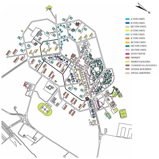
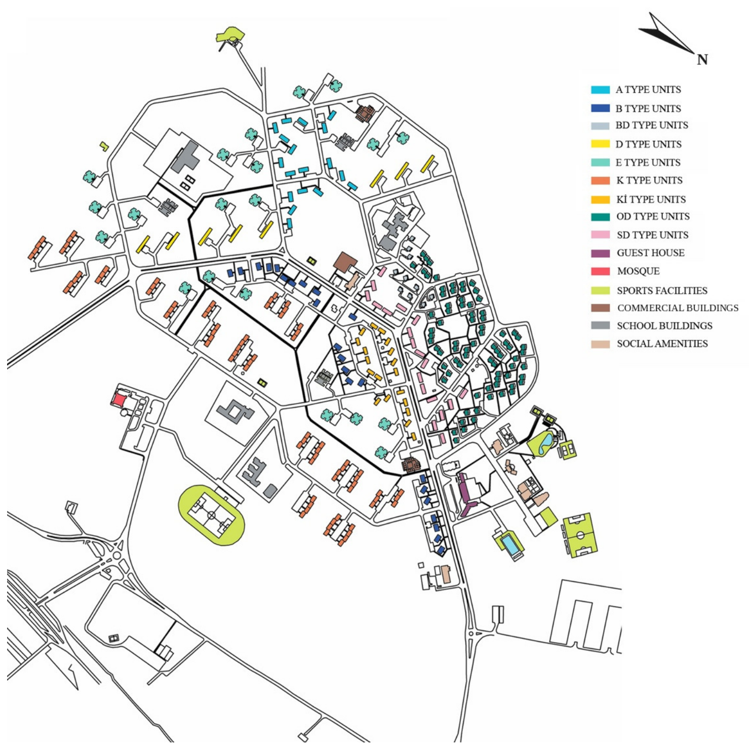
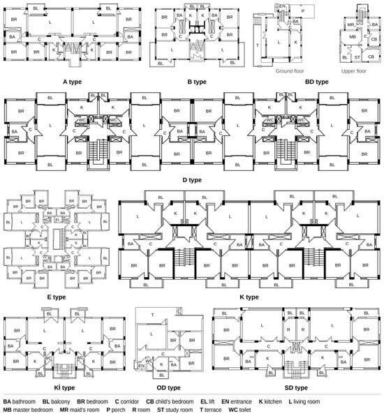
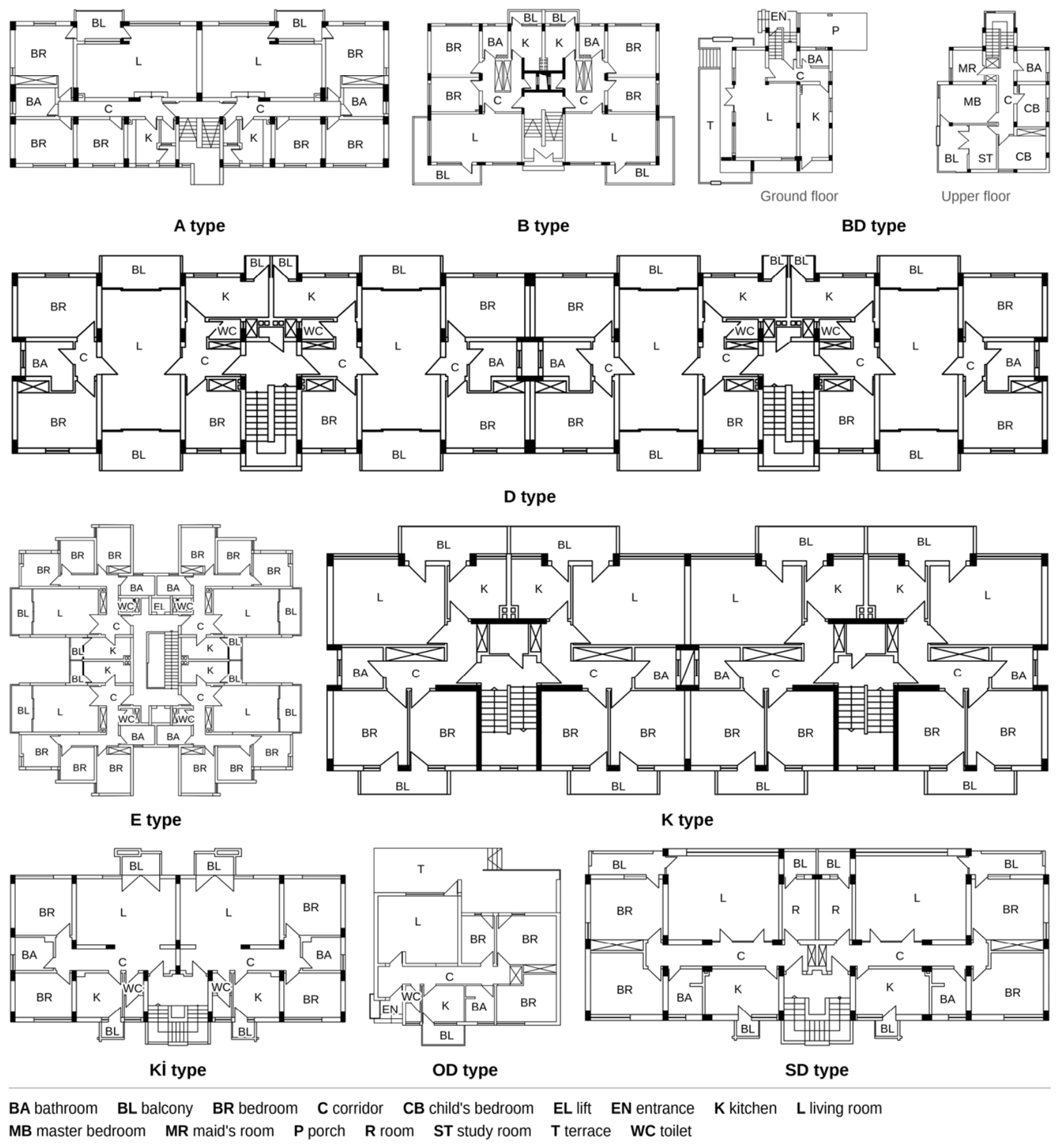
Work on establishing a residential settlement to the south of the factory began promptly. By 1973, the campus already included 392 residential units, a guesthouse, a restaurant, a cinema, a swimming pool, sports facilities, and a primary school [4,5]. By the time the factory formally opened in 1975, the settlement comprised 1814 housing units, a bachelor pavilion with a capacity of 1600 persons, and a comprehensive range of social facilities (Figure 1). Over the course of its development, the settlement came to include nine housing types: BD, OD, SD, A, B, D, E, K and Kİ (Figure 2). The Soviet design firm produced plans for eight of these housing types. In contrast, architect Halil Eryıldız later designed the D-type units in the 1990s to meet the evolving needs of the factory campus and its residential community [6].
Figure 1.
İsdemir Housing Complex Plan.
Figure 2.
İsdemir Housing Types.
Housing types were allocated according to employees’ occupational status. BD-type housing was reserved for the general manager or administrative staff, while OD-type housing was allocated to managers or assistant general managers. SD-type housing was reserved for engineers and chief engineers, and A-type housing for engineers, managerial staff or technical staff. B- and K-type housing units were used by workers, D-type units by foremen, E-type units by engineers, and Kİ-type units by technicians, skilled workers or clerical staff [6]. Units of the same type were clustered in specific areas of the complex. Until the 2023 earthquakes, the housing complex served three generations of employees, forming a residential community that supported the transmission of intergenerational life experiences and spatial memory.
1.2. Post-Earthquake Demolition and the Research Context
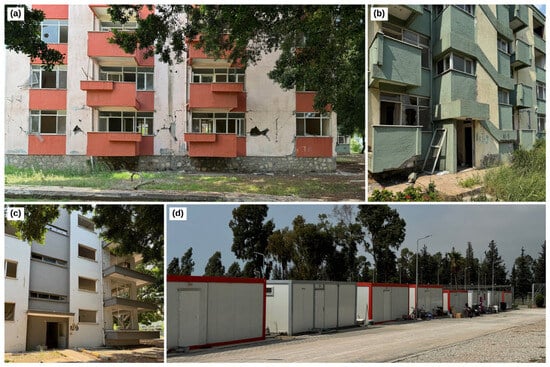
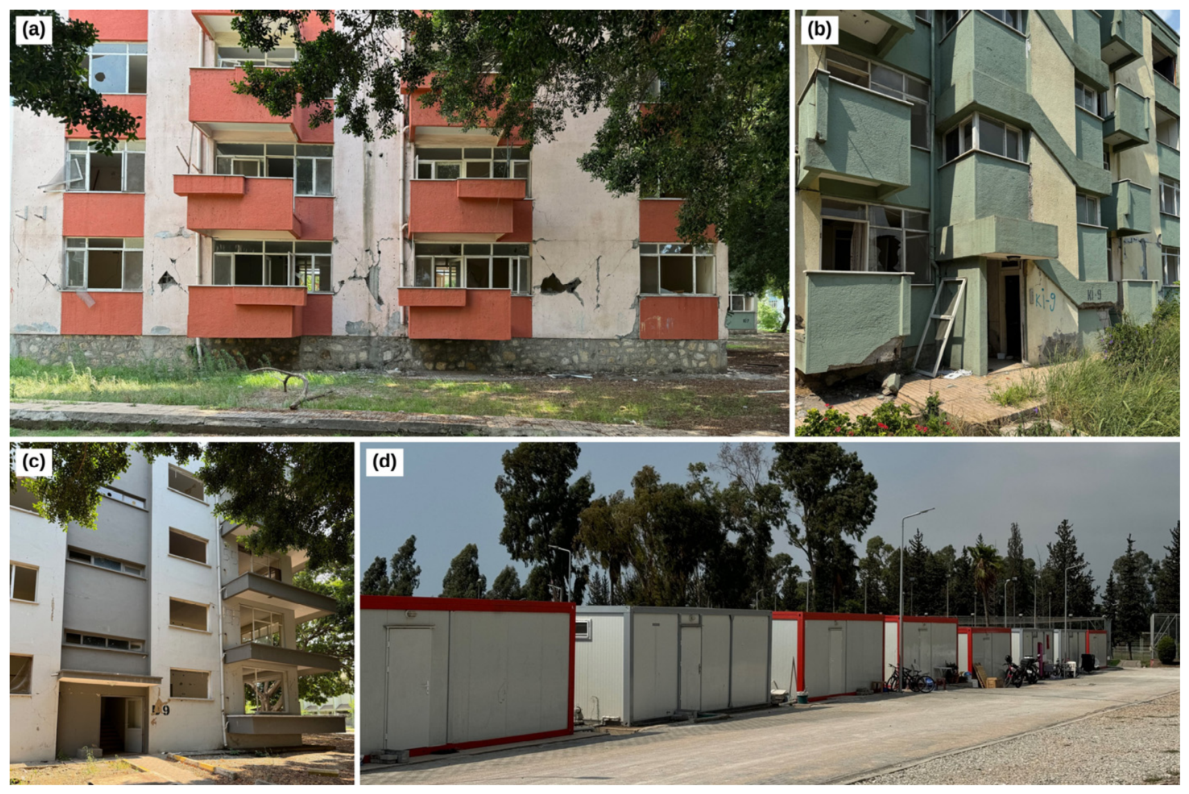
The earthquakes centred in Kahramanmaraş on 6 February 2023 caused widespread destruction across eleven provinces in Türkiye, including Hatay, where the İsdemir settlement is located. Following the earthquakes, factory employees and their families were displaced from their homes and relocated to temporary container housing within the factory campus (Figure 3). Demolition of the residential blocks is ongoing, with institutional decisions to clear the housing settlement and incorporate the land into the industrial zone.
Figure 3.
The settlement after the 6 February 2023 earthquakes: (a,b) the evacuated Kİ type; (c) an evacuated B type apartment block; (d) container housing where residents were relocated. Photographs by the authors, 18 July 2024.
This transformation threatens the built fabric of a residential community that accommodated successive generations of factory employees and their families. It also gives particular relevance to the archival plans as sources for examining the settlement’s domestic spatial organisation. The present study uses these plans to investigate the relationship between occupational allocation and dwelling configuration. The demolition provides the contemporary context for this investigation, while the analysis addresses how institutional distinctions relate to the organisation of access within the housing types.
1.3. Research Problem, Questions and Contribution
Scholarship on Republican-era factory housing in Türkiye has examined its architectural history, spatial organisation and relationship to modernisation. Cengizkan’s [7] collection, Housing at the Factory (Fabrikada Barınmak, in Turkish), documented the spatial histories of settlements at Karabük, Kayseri, Alpullu, Nazilli, Zonguldak and elsewhere. Research on factory campuses has addressed plan and façade typologies, archival plans, urban morphology and the ideological dimensions of state-led modernisation [7,8,9,10,11,12,13,14,15,16,17]. More recent research has applied space syntax to industrial housing in Karabük, examining residential spatial organisation in relation to modernisation and changing ways of living [18].
Building on these historical and quantitative approaches, the present study focuses on the correspondence between occupational allocation and the organisation of access within dwellings. The allocation of different housing types to different occupational groups establishes institutional differentiation, but whether this is accompanied by distinct access configurations requires comparison at the dwelling scale. İsdemir allows this relationship to be examined across nine housing types within a shared institutional setting, while also considering differences in the number of levels within each dwelling and in design authorship. The comparison addresses both recurring spatial patterns across occupational groups and differences in the roles of circulation and living spaces.
The main research question is: what access patterns recur across İsdemir’s housing types, and how can configurational similarities and differences be interpreted alongside occupational allocation, design authorship and vertical organisation? Three questions guide the analysis:
- How do connectivity, mean depth, integration and control value vary across housing types allocated to different occupational groups?
- How do entrances, corridors, staircases and living spaces organise access from the exterior to the interior, and do the most integrated spaces also have the highest local control values?
- How do the configurations of the two-level BD dwelling and the later, locally designed D dwelling compare with those of the seven Soviet-designed single-level types, particularly in the functional locations of the spaces with the highest integration and control value?
To address these questions, the study applies JPG analys is to one archivally reconstructed plan for each of the nine housing types, using DepthmapX(version 0.9.1) to calculate connectivity (C), mean depth (MD), integration (i) and control value (CV). It aims to identify recurring access configurations across occupational groups and to examine whether the spaces with the highest i also have the highest local CV. The comparison is conducted at the dwelling scale, with occupational allocation considered alongside two contextual characteristics. Vertical organisation distinguishes dwellings arranged on one level from the two-level BD type, allowing stair-mediated access and the distribution of functions across floors to be considered. Design authorship distinguishes the eight Soviet-designed types from the later D type by Halil Eryıldız, situating the comparison within the settlement’s design history. These characteristics help qualify interpretations based on occupational allocation. Their independent effects cannot be isolated in this sample; in particular, the later design of the D type cannot be separated from its different authorship.
This study contributes dwelling-scale evidence that different occupational allocations can coexist with a shared organisation of access between functional spaces. Across the nine reconstructed İsdemir plans, it identifies a recurring corridor-centred pattern in seven types and distinct arrangements in BD and D. It thus complements historical accounts of differentiated housing provision by showing that, in this settlement, differences in allocation do not necessarily correspond to distinct internal access patterns. Examining integration and control value together further distinguishes configurations in which global accessibility and local configurational dependency are concentrated in the same space from those in which they occur in different spaces. These findings are interpreted alongside vertical organisation and design history.
2. Literature Review
Industrial Housing as Ideological Space: Company Towns and the Republican Modernisation Project
Lefebvre’s [19] account of the production of space provides a framework for considering industrial housing in relation to the social and institutional processes through which it is produced. Henri Lefebvre’s foundational argument in The Production of Space holds that space is never neutral: social space is a social product, generated through social relations and, in turn, contributing to their reproduction [19]. Lefebvre analyses this production through a triad of spatial practice (perceived space), representations of space (conceived space) and representational spaces (lived space), none of which can be understood in isolation from the others [19]. His concept of representations of space draws attention to the conceptions of planners and administrators, while his critique of the “illusion of transparency” cautions against treating spatial representations as direct and complete accounts of social reality. Occupational allocation and the organisation of factory housing can therefore be examined within this broader context, without assuming that power relations or domestic practices can be read directly from plan geometry. In this study, Lefebvre’s work informs the framing of the relationship between institutional organisation and housing provision; it does not provide the methodological basis for graph analysis. That analysis draws on space syntax [20,21,22] and examines a limited aspect of spatial organisation: the access relationships represented in reconstructed dwelling plans. The two approaches are used at distinct analytical levels, without equating the graph representation with the social production or lived experience of space. Whether occupational distinctions correspond to different domestic access configurations remains an empirical question.
In his analysis of the emergence of modern building types, Thomas Markus [23] develops this argument by examining buildings as social objects whose spatial structures express relationships of power, order, classification and function. His account connects the emergence of building types during industrialisation to the organisation of social relations through space, and his use of access diagrams to show how buildings sort and separate their users provides the most direct link between this body of theory and the dwelling-scale measures used in this study. Factories, schools, hospitals and workers’ housing can therefore be examined as settings in which spatial organisation and access hierarchies contribute to the regulation of movement and interaction.
The company town is one of the clearest architectural manifestations of this logic. Garner [24] defines the company town as a settlement where nearly everything—including homes, stores, schools, and churches—is subordinate to the commercial enterprise that built and owns it, and where, as a result, the dynamics of work relationships within the factory become inseparable from those of home and social life. Crawford’s [25] definitive survey of American company towns documents how, from the late eighteenth century onwards, successive generations of industrial capitalists used the built form of the worker settlement as a spatial technology for managing labour: controlling movement, regulating social interaction and producing a disciplined workforce habituated to the rhythms and values of industrial production. As Crawford notes, the design of company towns is shaped by a constant tension between the employer’s interests in control and the worker’s interests in autonomy. This tension manifests itself in the spatial language of housing typologies, street layouts, and the placement of social institutions [25].
During the early Republican period, this logic took on a distinctive national and ideological dimension that transformed the company town from an administrative tool into a civilisational project. The Republic’s founding ideology rested on the belief that a modern, secular, and rational society could be created through the deliberate transformation of everyday life [26]. As Bozdoğan [26] notes, modern architecture served as both a visible symbol and an instrument of the modernisation agenda, through which the state sought to shape everyday life and its envisioned citizen-subject. Within this broader project, the factory campus was a setting in which these transformative ambitions were particularly concentrated. By combining the economic programme of industrialisation with the social programme of modernisation, it integrated both into a single built environment that simultaneously regulated work, housing, leisure, and social interaction.
Factory settlements—as public spaces where economic production and social transformation are addressed together—can be described as a variant of the company town model specific to Türkiye. Unlike the American company towns Crawford examined, which were essentially tools of labour management serving private capital accumulation, Republican-era factory settlements were environments created by the state to serve a nationalist modernisation project. Established in 1933 as the primary instrument of state-led industrialisation, Sümerbank functioned as a vehicle for social transformation through its factory campuses and housing programmes, equipping residents with the habits, values, and domestic practices that the state identified with modernity [8,11]. Doğan [11] argues that, in the case of Sümerbank, factory housing served as a laboratory of modern life; these spaces were not merely places where the state’s utopia of a modern, secular, and rational society was represented, but where it was actively embodied in the spatial organisation of everyday existence.
The first housing complexes of the Republican era were established amid the early industrialisation efforts of the 1920s and early 1930s, before Sümerbank formalised and systematised the model in 1933. The Alpullu sugar factory settlement, completed in 1926, is the oldest and best-documented example [12]. This was followed by the housing complexes of the 1934 İzmit Paper Factory, the 1935 Bursa Merinos Factory, and the 1937 Nazilli Textile Factory [14,27]. The housing complex of the Karabük Iron and Steel Factory, established in 1937 as Türkiye’s first integrated steel mill, is a key example of industrial housing in the national literature and extended this model to heavy industry on a previously untried scale [16].
The inclusion of Soviet technical expertise in the design of the İsdemir campus—a project undertaken under the 1967 Agreement on Credit and Technical Cooperation and implemented by the company Tiajpromexport—adds a dimension that distinguishes this settlement from its earlier Republican-era counterparts and situates it within the context of industrial modernisation during the Cold War. The Soviet planning principles applied in the USSR’s own industrial settlements from the 1920s onwards shared the fundamental logic of Republican-era housing complexes, including comprehensive social services, standardised housing types, and the spatial subordination of domestic life to the production needs of the industrial enterprise [28]. In this context, İsdemir’s Soviet-designed housing brings Soviet planning expertise into contact with the housing programme of a Turkish state-owned industrial enterprise. This background provides a basis for examining whether housing allocated to different occupational groups follows distinct access configurations or shares recurring spatial patterns. The theoretical framework thus guides an investigation of how occupational allocation relates to domestic spatial organisation, with the settlement’s design history informing the interpretation of the observed similarities and differences.
3. Methodology
Space syntax is a body of theories and methods developed by Hillier and Hanson [20] to examine and quantitatively demonstrate the dynamic relationship between the physical environment and social life [20,29]. The theory examines relationships between spatial configuration and social organisation, including how access arrangements may structure opportunities for movement, encounter and separation [21,29,30]. In the space syntax approach, the relationships among the parts that comprise the whole are defined as a configuration. A change in any single unit alters the configuration as a whole [29]. The configuration within dwellings can shape how intra-family social relationships are structured and the forms of interaction and contact between household members and visitors [21,31]. Three standard computational techniques are used in space syntax analysis: axial line analysis, convex space analysis (including JPG analysis), and visibility graph analysis (VGA) [32,33]. These approaches represent spatial relationships; in the present study, they are used to examine access possibilities without inferring actual household routines, preferences or interactions.
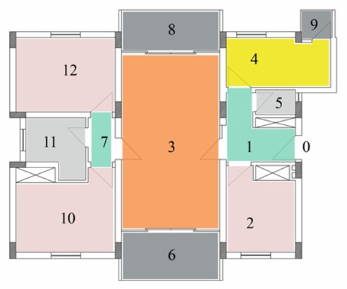
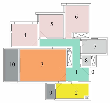
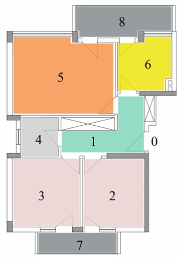
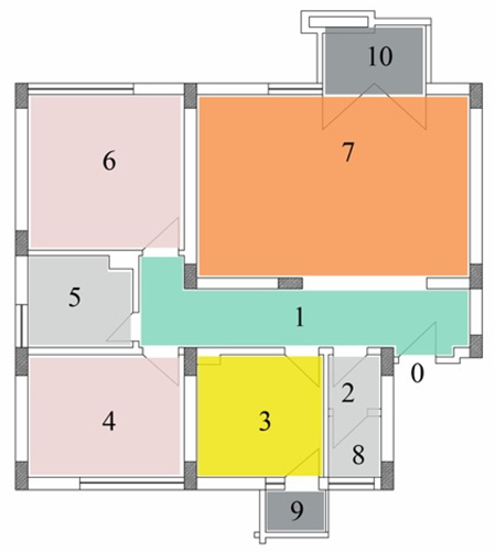
JPG analysis forms the methodological basis of this study, providing a graph representation for examining and comparing topological access configurations within dwellings [21,22,31]. Nodes were defined using functional spatial subdivision rather than strict convex decomposition, following the functional approach discussed by Ostwald [22] and used in housing research by Wu et al. [33]. Spatial continuity and identifiable thresholds guided the delineation of nodes. In the analysed plans, doorways and the transition into a staircase provided such thresholds. Separately enclosed rooms were represented as individual nodes. Bathroom and WC compartments separated by a doorway were also represented separately, including arrangements in which the toilet and washbasin occupied different compartments (see Kİ type). A continuous corridor was retained as a single node when it changed direction without crossing a threshold or changing function; it was not subdivided solely to achieve geometric convexity. Each spatially continuous balcony or terrace was represented as a single node, including where it connected to more than one space. In BD, the staircase connecting the two dwelling levels was represented as one node, distinct from the corridors. The transition from horizontal to vertical circulation was treated as a functional threshold. Links represented direct passage between nodes through doors, openings or stair connections. This coding describes the access relationships represented in the reconstructed plans rather than visibility alone or residents’ actual movement.
JPG analysis is widely used in housing research and in the analysis of building interiors [21,31]. At the building and housing scales, JPG has been applied to the spatial evolution and configuration of traditional dwellings [34,35], the impact of transformations in design approaches on privacy [1], the relationship between the “sofa”—a central element in traditional Turkish homes—and other spaces [36], the search for new models in post-World War II public housing in the Mediterranean basin [37], the socio-spatial effects of spaces added to buildings as extensions [2], and the investigation of the spatial characteristics of Palladian villas with different relationship forms [38].
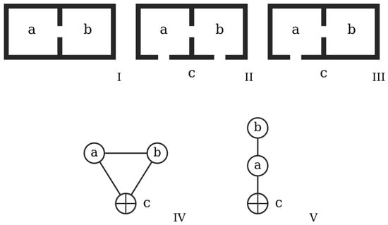
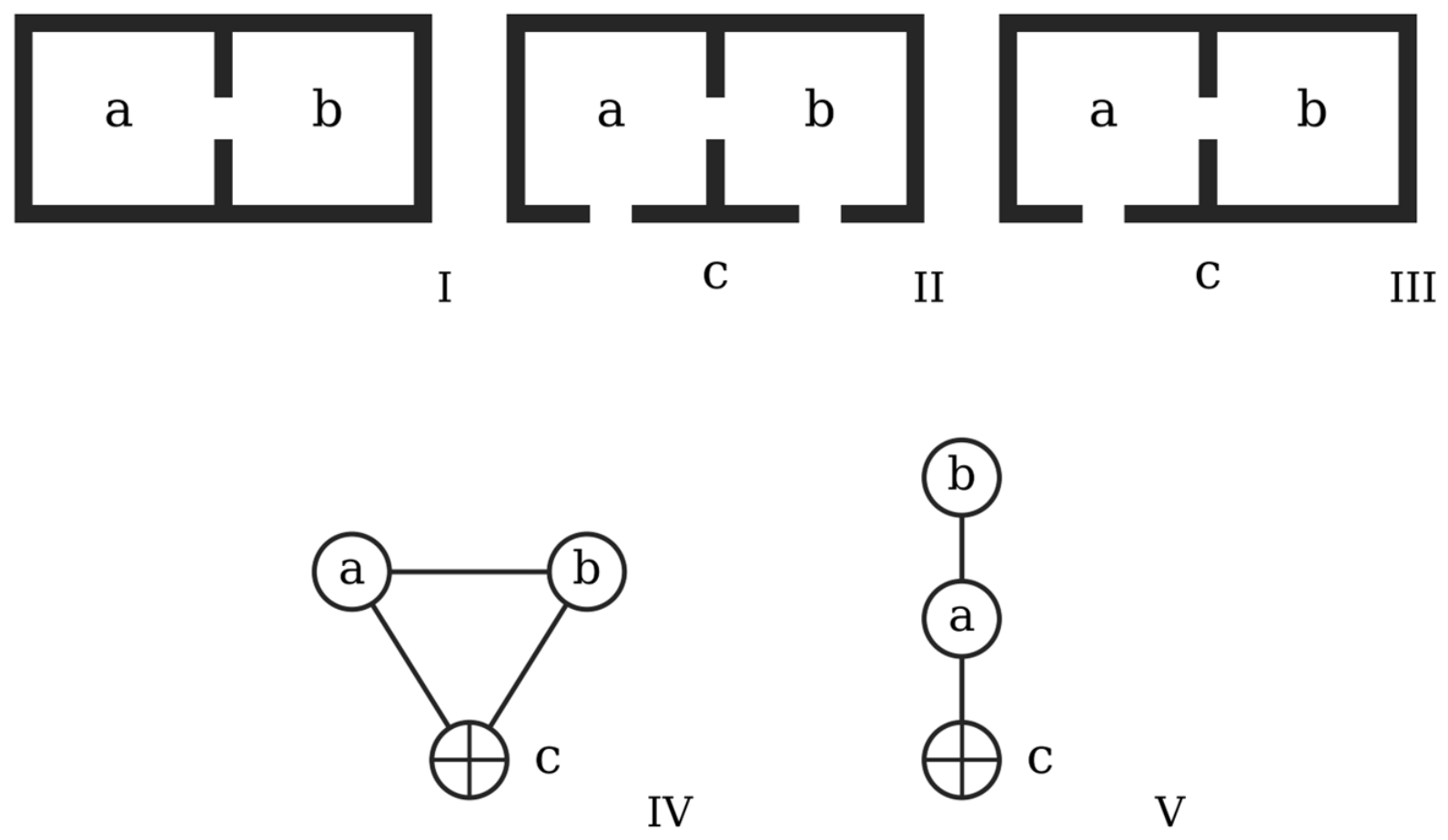
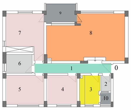
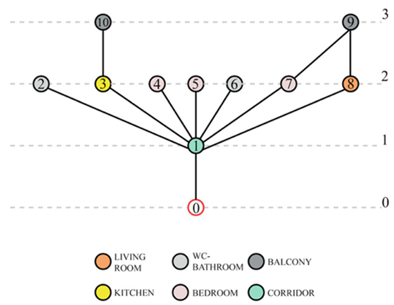
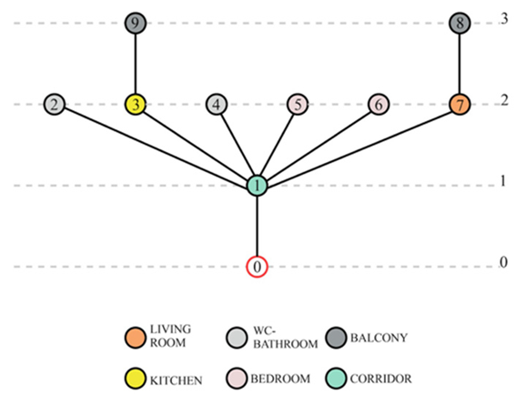
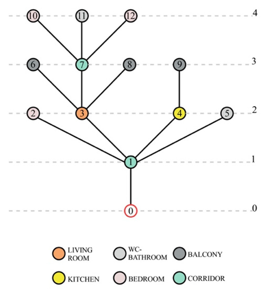
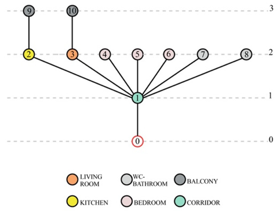
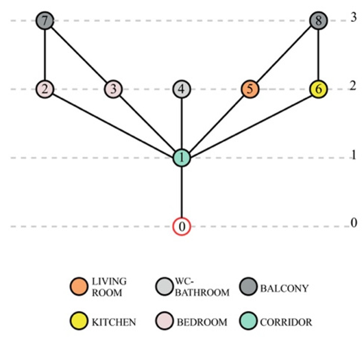
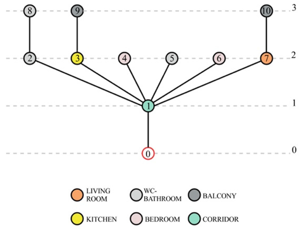
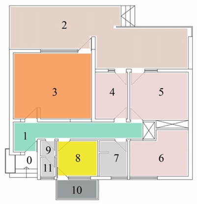
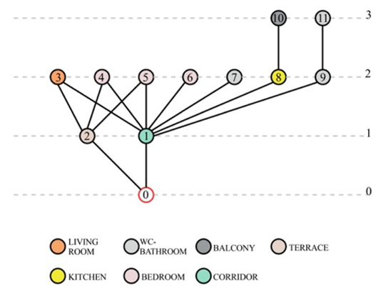
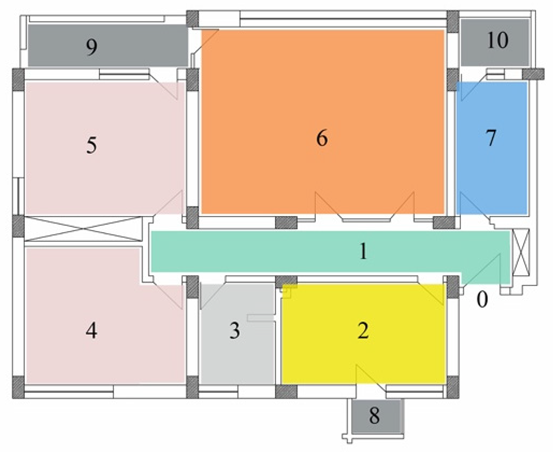
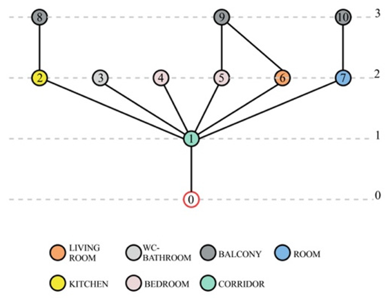
In spatial layout, a map of the built environment is transformed into an appropriate representation of spatial elements and relationships. Two rooms connected by a door are a simple example of these relationships. Specific rules have been developed to convert these elements and relationships into interpretable data [39]. In this context, the graph theory-based “Justified Plan Graph” (JPG) method was developed to analyse the interior spaces of residential buildings and examine their spatial configurations [21,22]. In JPG, spaces are represented by nodes. The links between nodes represent direct connections between spaces. A root space is selected as the reference point for arranging the JPG (Figure 4). Each link represents one topological step, and the depth of a node is the minimum number of steps required to reach it from the root [40]. The root is placed at depth 0, directly connected spaces at depth 1, and the remaining spaces at successive levels according to their shortest paths from the root. Where cycles occur, connected nodes may occupy the same depth level. This representation describes the depth of spaces relative to the selected root. Once a JPG has been generated for a building, its spatial configuration can be analysed [29]. The topological values derived from JPGs enable the analysis of spatial relationships at both the local and global levels.
Figure 4.
Analysis of spatial relationships and their representation using the JPG method [29].
Four syntactic measures were selected to describe local access relationships and global topological position: connectivity (C), mean depth (MD), integration (i), and control value (CV), which have also been used together in housing research [33]. C records direct connections, whereas CV additionally considers the connectivity of neighbouring spaces. MD describes average topological distance to all other nodes, and i expresses integration through the normalisation described below [20,22]. MD and i are therefore mathematically related measures, rather than independent evidence of domestic behaviour. Their joint interpretation considers room functions and access routes. These measures have been widely used in previous studies and validated with quantitative data [31].
Connectivity (C): a static, local indicator that measures the number of other spaces directly adjacent to a node in the system [41]. The formula is as follows:
In the formula, k is the number of adjacent spaces directly connected to space i by a door or passageway. Higher C values indicate more direct access connections. In a dwelling, this helps distinguish spaces connected to several rooms from those with fewer connections, without establishing geometric centrality or global integration.
Mean Depth (MD): the average shortest-path distance from a node to all other nodes in the graph [20]. Although calculated as an average, MD is not normalised for graph size and is influenced by both the number of nodes and their configuration. It is calculated as follows:
In the equations above, TD(a) is the total depth from node a, d is the shortest-path depth from that node, nd is the number of nodes at depth d, x is the greatest depth from node a, and K is the total number of nodes in the graph, including the exterior node. Higher MD values indicate greater average topological distance from the other nodes. Interpretation therefore considers room functions and access routes, while greater depth alone does not establish experienced privacy.
Integration (i): A normalised measure of a node’s global topological accessibility relative to all other nodes in the graph [20,41]. It is derived from MD through relative asymmetry (RA). To account for differences in graph size, RA is divided by Dk, the normalisation value for a diamond-shaped reference graph with K nodes, to obtain real relative asymmetry (RRA) [20,22]. The i measure used here is the reciprocal of RRA, expressed as i = 1/RRA = Dk/RA. These values describe spatial configuration and do not independently establish residents’ experience of privacy. The i value, one of the most widely used syntactic parameters [31], describes global topological accessibility. Higher integration values indicate greater relative ease of access in topological terms, whereas lower values indicate lower topological accessibility and greater segregation [29,32,35]. Here, accessibility concerns connections within the graph rather than physical effort or perceived difficulty.
Control Value (CV): A local measure calculated by summing the reciprocals of the C values of a node’s immediately connected neighbours [20,22]. Each neighbour contributes more when it has fewer connections. For example, a corridor connected to several rooms whose only doorway opens onto that corridor receives a contribution of 1 from each such room. This describes the rooms’ local access dependency on the corridor, rather than the corridor’s occupancy or the social authority of its users. Higher CV values indicate greater local configurational dependency of neighbouring spaces on the node, but do not necessarily identify a compulsory passage or establish global integration. Here, “control” refers to this graph property, rather than to residents’ actual regulation of access or social interactions [22].
Access hierarchy is interpreted by examining these local relationships alongside routes and depth. Whether residents used doors or circulation spaces to regulate encounters and privacy cannot be established from CV alone. Neither high nor low CV is treated as a residential design target: its relevance depends on the function of the space and the access relationships required by its users. Assessing whether those relationships meet household needs requires evidence of use and preferences alongside configurational analysis [2]. In the formula below, Val(b) is the connectivity of node b, and D(a,b) = 1 identifies nodes directly connected to node a.
The number of independent cycles (r) in each connected graph was calculated as r = L − NC + 1, where L is the number of undirected links and NC (Node Count) is the total number of nodes, including the exterior node. The locations and spatial roles of these cycles were identified by examining the graph connections alongside the corresponding floor plans.
The study includes all nine housing types within the İsdemir settlement: A, B, BD, D, E, K, Kİ, OD and SD. Their distribution is shown in the settlement plan (Figure 1). The scope was defined by the complete set of housing types within this institutional setting, rather than by selecting a subset according to occupational allocation or configurational characteristics. The floor plans analysed in this study are as-built drawings of the nine housing types, obtained from the İsdemir archives. The authors redrew all plans to scale in AutoCAD2025, and these digital drawings formed the basis for the graph construction. In addition, a site visit was conducted on 18 July 2024, before demolition. During this visit, the plan configurations of the housing types were verified on site against the archival drawings, including the arrangement of rooms, the positions of doors and the connections to balconies, terraces and the exterior. The settlement was also documented through photographs, which illustrate the post-earthquake state of the housing stock (Figure 3). The analysis is based on the archival as-built configurations; later alterations by residents were not incorporated into the graphs.
The unit of analysis is the reconstructed plan configuration, giving an analytical dataset of nine configurations rather than a sample of individual dwellings from the housing stock. The study covers all nine type categories, but this coverage does not establish the representativeness of each reconstructed configuration for every dwelling assigned to that type. The comparison therefore concerns the access configurations documented in the selected archival material, considered alongside occupational allocation, vertical organisation and design history. Within-type variation and subsequent resident alterations are not assessed. Throughout this study, “single-level” and “two-level” refer to the number of levels occupied by an individual dwelling unit, not to the total number of storeys in the building containing it. The analysed dwellings of types A, B, D, E, K, Kİ, OD and SD occupy a single level, whereas the BD dwelling extends across two levels connected by an internal staircase. The seven Soviet-designed single-level types (A, B, E, K, Kİ, OD and SD) form the principal comparison group, sharing design authorship and vertical organisation while spanning different occupational allocations. BD and D were examined alongside this group as distinct cases: BD introduces a second dwelling level, whereas D is a later design by a different architect. This grouping structures the descriptive comparison without isolating the effects of individual characteristics. Table 1 summarises the occupational allocation, design authorship and number of levels within each dwelling type, providing the context for interpreting the subsequent configurational comparisons. Occupational allocation is treated as a categorical characteristic of the housing types rather than as an ordinal variable. Several types were allocated to more than one occupational category, and the available allocation information does not establish a single ordinal hierarchy across the nine types. The analysis therefore examines whether housing types allocated to different occupational groups share or differ in their access configurations; it does not test a rank-based gradient in the syntactic measures.
Table 1.
Main characteristics of the nine housing types analysed at İsdemir.
Each graph included a single exterior node. Direct connections from the dwelling or its associated external spaces to the exterior were represented as links to this same node, so different exterior access points were combined within a common representation. The exterior node served as the root for the JPG and was included in the node count and the calculation of C, MD, i, CV and independent cycles (r). This representation abstracts exterior access without modelling the distances or route geometry between different exterior access points. C, MD, i, and CV were calculated at the node level using DepthmapX (version 0.9.1), and the JPG diagrams were produced using AGRAPH. The exterior root provided the reference for displaying step depth, while node-level MD and i were calculated in relation to all other nodes in each graph. The analysis drew on the approach described by Al-Sayed et al. [40]. Comparisons considered the distribution of syntactic values and the spaces with the highest i and CV, interpreted alongside room functions, access routes, occupational allocation, the number of levels within each dwelling and design history. Graph-level averages were used as descriptive summaries, while architectural interpretation focused on which functional spaces connected different parts of each dwelling and whether alternative routes were available. Higher integration or control values were not treated as indicators of better residential design, and differences in these measures were not used to infer residents’ wayfinding effort or room-use preferences.
An additional graph-based sensitivity check examined whether the principal findings depended on the inclusion of the exterior node. Adjacency lists were reconstructed from the reported JPGs, and node-level MD and CV were recalculated after removing the exterior node and its incident links. The remaining graphs were connected for eight types. In BD, removing the exterior node isolated the storage space and porch (nodes 2 and 5); the alternative calculation therefore concerned the remaining connected component of 14 nodes. This BD comparison changes the analytical boundary and is not a like-for-like comparison of all original spaces. The comparison focused on the functional locations of the most integrated spaces and those with the highest CV. Within each connected graph, integration rankings were obtained from the inverse ordering of MD, consistent with the stated RRA-based integration formula. This avoids relying on the absolute magnitude of integration across different graphs but does not remove the influence of topology or establish independence from graph size. The check evaluates sensitivity to the exterior representation; it does not test all plausible alternatives to functional spatial subdivision. The complete node and link lists of the nine graphs, with the node-level values of C, MD, i and CV for both the baseline and the alternative graphs, are provided in Table S1, so that the graphs can be reconstructed and the reported measures verified.
4. Results
The İsdemir housing complex (1970–2023) was a pioneering example of the company town model, aiming to combine state-supported industrialisation goals with modern lifestyles as part of Türkiye’s heavy-industry initiatives [4,7]. This study used JPG analysis to compare the internal access configurations of dwelling types allocated to different occupational groups. The C, MD, i, and CV parameters were calculated for each housing type.
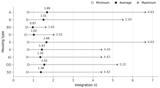
Table 2 summarises the syntactic measures of the nine housing types, calculated for graphs that include the exterior node. NC ranges from 9 in the K type to 17 in the BD type, and average i ranges from 0.97 in BD to 1.69 in A. Two features of this distribution frame the rest of the analysis. First, the seven single-level Soviet-designed dwelling types occupy a narrow band: their average MD values lie between 2.00 (K) and 2.25 (Kİ), and their average i between 1.35 (Kİ) and 1.69 (A). Second, BD (average MD = 3.01; average i = 0.97) and D (average MD = 2.66; average i = 1.02) fall clearly outside this band, and they are the only two types whose maximum i stays below 2.1, whereas the remaining seven reach between 4.42 and 6.63.
Table 2.
Statistics on syntactic indicators for İsdemir housing types.
NC varies across housing types allocated to different occupational groups. BD has the highest NC (17), followed among the Soviet-designed types by OD (12). A, E, SD and Kİ each have 11 nodes, while B has 10 and K has 9. D, allocated to foremen, has 13 nodes, exceeding OD, which was allocated to managers or assistant general managers. These counts describe the number of represented spaces, including the exterior, rather than dwelling floor area. Table 1 shows that node count does not follow dwelling size. D (116 m2) has more nodes than OD (170 m2), while SD (127 m2) and Kİ (89 m2) both have 11 nodes. Floor area ranges from 83 m2 (K) to 206 m2 (BD) across the nine types, and from 83 to 170 m2 across the seven corridor-centred types.
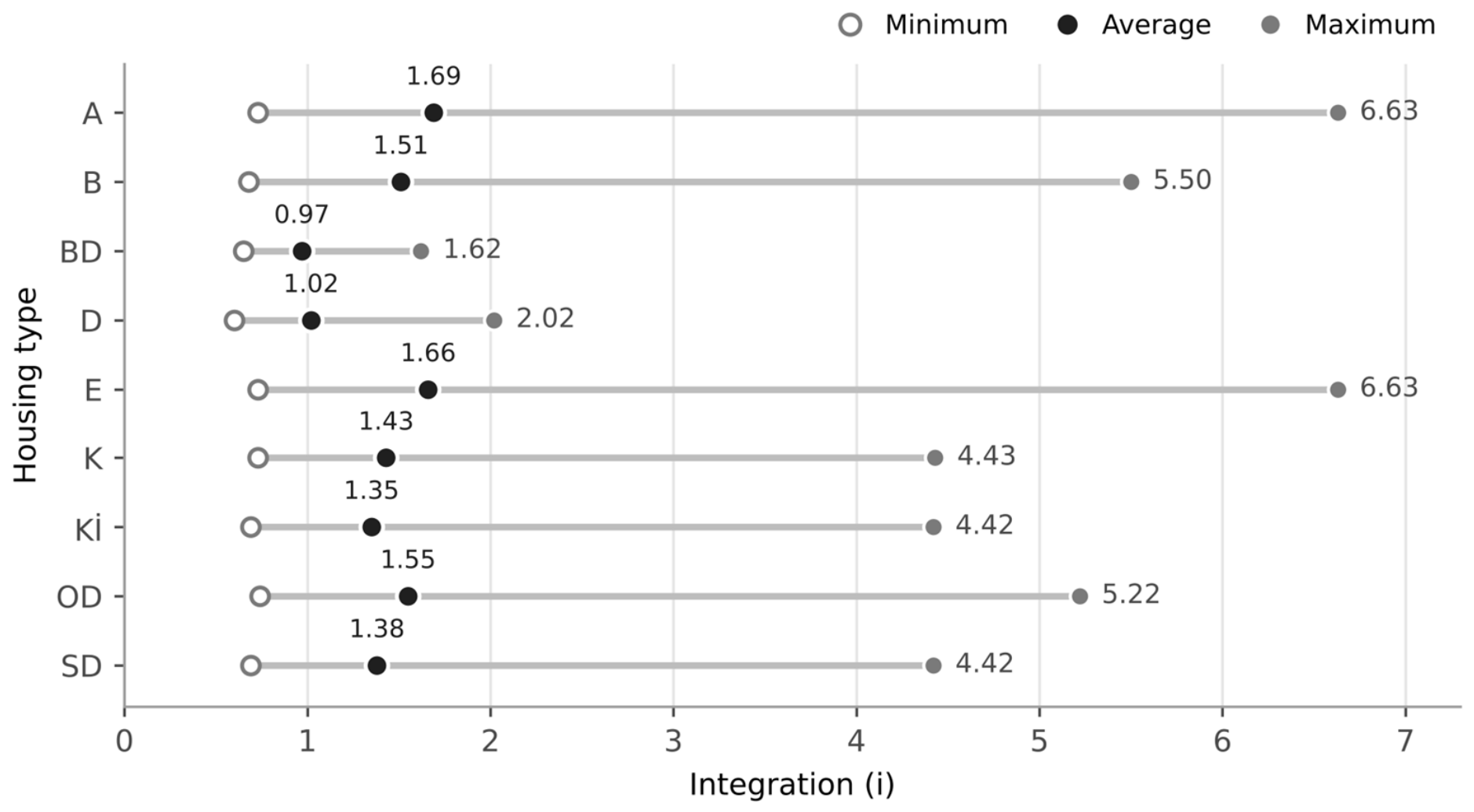
Figure 5 compares the average i values and node-level integration ranges of the nine housing types. The highest maximum i occurs in A and E, both allocated to engineers, at 6.63. These types also have the highest average i values (1.69 and 1.66, respectively). By contrast, BD, allocated to the general manager, has the lowest average i (0.97), the highest average MD (3.01), and the largest NC (17, including the exterior). These measures distinguish BD from the other types by its lower average integration and greater mean topological depth (Table 2 and Table 3).
Figure 5.
Normalised integration (i) values for İsdemir by housing type (min., avg., max.).
Table 3.
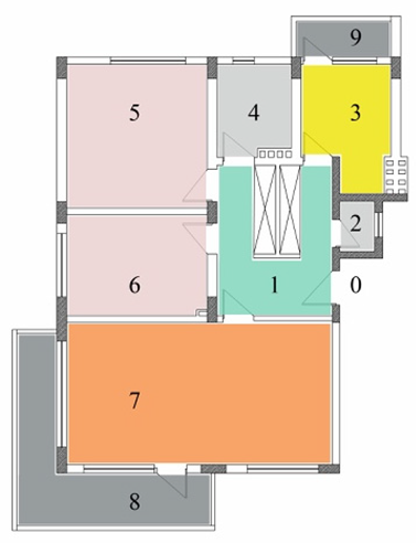
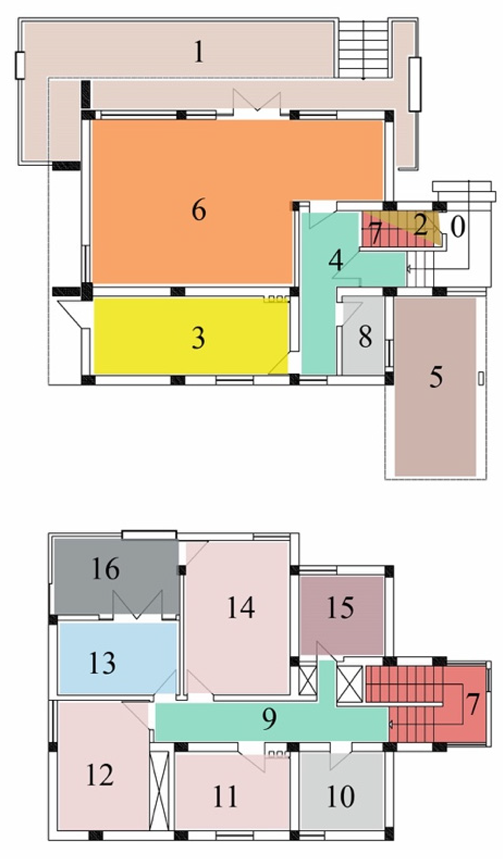
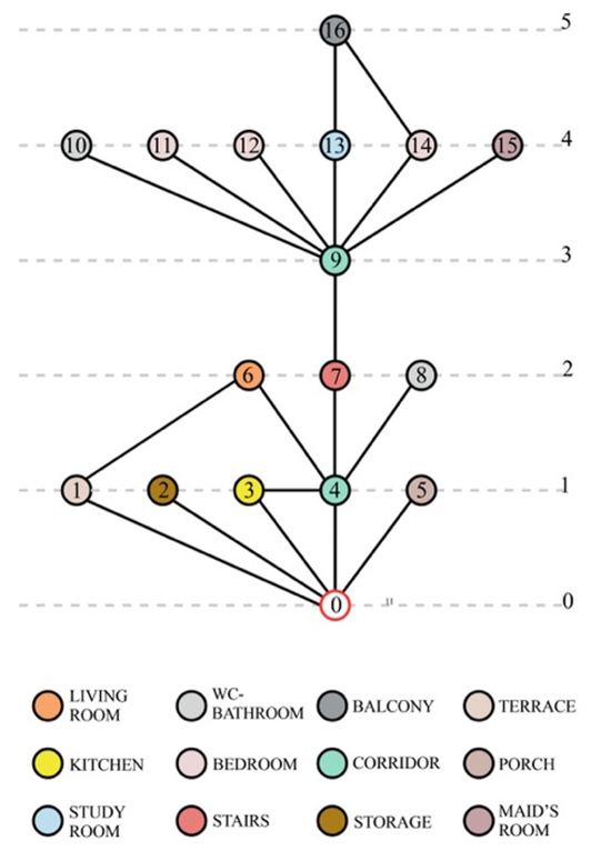
JPG of housing types.
In seven of the nine types (A, B, E, K, Kİ, OD and SD), the corridor has the highest connectivity, control value and integration (Table 4). Its C ranges from 6 (K) to 8 (A, E and OD), its CV from 4 (K) to 7 (E), and its MD, the lowest in each plan, from 1.20 (A and E) to 1.30 (Kİ and SD). Living rooms, bedrooms, and kitchens attach to this corridor rather than to one another. Thus, the corridor combines the highest global topological accessibility with the highest local control value within each of these dwelling graphs. The ratio of maximum to average i is used here as a descriptive comparison of peak integration relative to the graph mean. It ranges from 3.10 to 3.99 across the seven corridor-centred types (E 3.99, A 3.92, B 3.64, OD 3.37, Kİ 3.27, SD 3.20 and K 3.10), compared with 1.98 in D and 1.67 in BD. The highest maximum i values (6.63 in A and E) occur where an eight-connection corridor leaves only two nodes, both balconies, at the third level of depth.
Table 4.
The spaces in the İsdemir housing types that have the highest levels of i and CV.
This corridor dominance is strong but not absolute. Among the seven standard corridor-centred types, A and SD each contain one independent cycle, K contains two, and OD contains three (Table 3). In A, K and SD, these cycles involve balconies shared between adjacent rooms. In OD, they arise from the terrace’s connections to the exterior and to multiple rooms. These connections provide alternative access routes that bypass the corridor for some journeys. B, E and Kİ have tree-like configurations with no independent cycles (r = 0). The D type also has a tree-like configuration, with 13 nodes and 12 links yielding r = 0. The managerial OD type has both the highest mean C (2.33) and the largest number of independent cycles within this group. BD contains three independent cycles (r = 3): two involve ground-level connections to the exterior, while the third links the upper-floor corridor, study, bedroom and balcony. Cycles involving exterior connections occur only in the two detached houses, OD and BD, where ground-level access allows several connections to the exterior. In the apartment types A, K and SD, cycles arise only from balconies shared between rooms. These cycle differences may therefore partly reflect building type rather than occupational allocation.
Similar syntactic profiles occur among corridor-centred housing types allocated to different occupational groups. Kİ, allocated to technicians, skilled workers and clerical staff, and SD, allocated to engineers and chief engineers, have similar i and MD profiles: both have 11 nodes and the same i range (0.69–4.42), while their average MD values are 2.25 and 2.21, respectively. Their cycle structures nevertheless differ: Kİ is tree-like, whereas SD contains one independent cycle. The A and E types, both intended for engineers, share the same NC and the same minimum and maximum i (0.73 and 6.63). The workers’ B type (mean i = 1.51) is more integrated than both SD (1.38) and Kİ (1.35), and the workers’ K type has the lowest average MD of all nine types (2.00). The similarity of SD and Kİ, which were allocated to different occupational groups, indicates that the corridor-centred configuration recurs across these groups. This shared configuration nevertheless accommodates topological differences, including the presence or absence of cycles.
Table 1 helps to explain the differences within the narrow band of average i. The three-bedroom corridor-centred types (A, E and OD) have the highest average i (1.55–1.69) and a corridor with eight connections, whereas the two-bedroom types (B, K, Kİ and SD) range from 1.35 to 1.51 and have a corridor with six or seven connections. Within this group, variation in average i therefore appears to follow the number of rooms opening directly onto the single corridor, rather than a different access logic. Floor area does not follow the same order: SD, the largest two-bedroom type (127 m2), has one of the lowest average i values (1.38).
Across the seven corridor-centred types, a shared access pattern recurs despite differences in occupational allocation. The BD and D types depart from this shared configuration, but their differences also coincide with other characteristics: BD is the only type with a two-level dwelling configuration, while D is a later design by a different architect. These comparisons do not establish occupational allocation as an independent explanation for their distinctive configurations.
The BD type combines the highest NC (17) with the lowest average i (0.97) and the highest average MD (3.01). In the BD type, the lowest node-level MD is 2.12, which falls within the range of average MD values across the seven standard corridor-centred types (2.00–2.25). The highest node-level MD is 3.81, exceeding the maximum MD recorded in any other housing type. The upper-floor corridor holds the highest C (7) and CV (5.5), while the ground-floor corridor has a C of 5. The most integrated space, however, is the stair (i = 1.62), followed by the two corridors (1.54), and the most isolated is the upper-floor balcony (0.65). The staircase connects the ground-floor circulation system to the upper-floor corridor. The upper-floor bedrooms lie at depth 4 from the exterior root, compared with depth 2 for bedrooms directly connected to the entrance corridor in the standard corridor-centred types. In BD, the staircase has the highest integration value, whereas the upper-floor corridor has the highest control value.
BD’s higher average MD should be interpreted alongside its larger graph size (17 nodes) and two-level dwelling configuration. The present comparison does not separate the contribution of graph size from that of the arrangement of connections between spaces. The kitchen and storage connect directly to the exterior node, while the maid’s room is located upstairs and is accessed through the shared staircase and upper-floor corridor. This arrangement differentiates the locations and access depths of service-related spaces within a shared circulation system. Living and sleeping spaces are on different floors, with access to the upper-floor bedrooms via the staircase and upper-floor corridor.
The D type is the only single-level dwelling type in which the highest i value occurs outside the corridor. The living room has the highest i (2.02) and the lowest MD (1.75), whereas the entrance corridor has the highest C (5) and CV (3.75), with an i of 1.81 and an MD of 1.83. The D type has the lowest maximum CV (3.75) and the highest minimum CV (0.20) among the nine housing types. Its highest control values occur in the entrance corridor (3.75), the secondary corridor (3.25), and the living room (2.45). The living room does not touch the exterior: it sits at depth 2, behind the entrance corridor, and its centrality comes from mediating between the entrance sector and a secondary corridor that serves the bedrooms and bathroom of the western wing. Those rooms sit at depth 4 (see Table 3, D Type), the deepest position among the single-level dwelling types. The living room thus functions as a through-space linking two parts of the dwelling, not as a room at the end of a corridor. D has a lower average i (1.02) and a higher average MD (2.66) than any of the seven standard corridor-centred types.
Taken together, Table 4 shows that the highest i and CV values occur in the corridor in seven types and are separated in the two exceptional ones: in BD between the stair and the upper corridor, and in D between the living room and the entrance corridor. Under the baseline representation, the İsdemir settlement thus spans three configurations. The first is a corridor-centred configuration found in seven types, with alternative access routes provided by shared balconies in A, K and SD and by terrace connections in OD. The second is a deep, vertically articulated plan allocated to the general manager. The third is a distributed-control plan centred on the living room, designed in the 1990s by Halil Eryıldız for foremen. These configurations distinguish a recurring corridor-centred pattern from the two-level BD dwelling type and the later, locally designed D type. Across the nine types, the findings reveal configurational differences associated with occupational allocation, vertical organisation and design history, but do not establish the independent contribution of each factor.
An exterior-node sensitivity check was conducted to assess whether the identified functional locations of peak integration and CV depended on the inclusion of the exterior within the analytical boundary (Table 5). The shared corridor-centred pattern was retained in A, B, E, K, Kİ, OD and SD: the corridor remained both the most integrated space and the space with the highest CV. In D, the living room remained the most integrated space, while the highest CV shifted from the entrance corridor to the secondary corridor. BD required a different treatment because its storage space and porch are accessible only from the exterior. Removing the exterior node isolated these two spaces, so the alternative calculation concerned the remaining 14-node connected component. Within this reduced component, the most integrated space shifted from the staircase to the upper-floor corridor, which also retained the highest CV. Thus, the shared corridor pattern in the seven types persists under the tested alternative, whereas the separation of peak integration and CV in BD depends on the analytical boundary. The BD comparison must also be interpreted in light of the exclusion of its two exterior-access-only spaces.
Table 5.
Sensitivity of peak i and CV locations to the exclusion of the exterior node.
5. Discussion
This study examined the extent to which differences in occupational allocation correspond to differences in the access configurations of İsdemir’s nine housing types. The JPG analysis identifies a recurring corridor-centred configuration across seven types allocated to different occupational groups, in which the corridor has both the highest i and the highest CV, alongside two departures represented by BD and D. The first research question concerned how C, MD, i and CV vary according to the types of housing allocated to different occupational groups. Seven of the nine types occupy a narrow band of average MD (2.00–2.25) and average i (1.35–1.69). These ranges describe variation among the analysed graphs; the study does not establish that the differences correspond to perceptible differences in everyday use or residential quality. The shared-pattern interpretation rests principally on the recurrence of the corridor as the space with the highest i and CV, rather than on the proximity of graph averages alone. Similar averages also do not imply identical access arrangements: Kİ and SD have similar integration and mean-depth profiles, yet Kİ is tree-like whereas SD contains a cycle. A and E likewise share the same integration range, yet A contains one independent cycle whereas E is tree-like. Accounts of company towns provide a framework for relating housing provision to institutional hierarchy [24,25]. The İsdemir findings refine this relationship at the dwelling scale: occupationally differentiated allocation coexists with a recurring corridor-centred access configuration. The contribution lies in distinguishing institutional differentiation in housing allocation from configurational differentiation within dwellings, while identifying BD and D as departures from the shared pattern. This recurrence identifies a shared feature of the access organisation represented in the reconstructed plans, although their connections and cycles differ. It does not, by itself, establish common planning intentions or explain the institutional processes through which these configurations were produced.
Table 1 suggests that differences between occupational groups are expressed more clearly in dwelling size and building type than in access configuration. The two largest dwellings, BD (206 m2) and OD (170 m2), are detached houses allocated to the general manager and to managers or assistant general managers, while the smallest, K (83 m2) and Kİ (89 m2), are allocated to workers and to technicians, skilled workers or clerical staff. Between these extremes, the 113–127 m2 range includes dwellings allocated to workers (B), foremen (D) and engineers (A, E and SD), so floor area does not separate all groups. Bedroom count, treated here only as a rough indicator of household capacity in the absence of occupancy data, shows a similar partial correspondence: the types allocated to workers and technicians have two bedrooms, but so does SD, allocated to engineers and chief engineers. The corridor-centred configuration occurs in both two- and three-bedroom types and across floor areas from 83 to 170 m2. The location of housing types within the campus was not assessed and remains an open question. The distinctive configurations of BD and D should also be interpreted alongside their differences in vertical organisation and design authorship, rather than attributed to occupational allocation alone.
The recurrence of corridor-centred organisation across seven housing types is compatible with the shared logic that Castillo [28] identifies in Soviet industrial settlements, namely standardised housing types and the subordination of domestic life to the needs of the enterprise, and with the Republican understanding of factory housing as a laboratory of modern life [11,26]. The plans alone cannot show which of these two traditions produced the standardisation, and the results should be read as consistent with both rather than as evidence for either.
The second question concerned how entrances, corridors, stairs and living spaces organise access, and whether the most integrated spaces also hold the highest CV. In seven types, the corridor has both the highest i and the highest CV, combining global accessibility with a prominent role in local access relations. This arrangement is consistent with the role of circulation spaces in organising domestic access discussed by Hillier and Hanson [20] and Markus [23]. It also offers a point of comparison with Çetin and Beyhan’s [1] findings on corridors and bedroom halls in modernist housing in Isparta. Their study addresses visual privacy, whereas the present analysis examines topological access relationships without measuring visibility or experienced privacy. Shared balconies in A, K and SD, and terrace connections in OD, create cycles that provide alternative access routes between some spaces, so movement between these spaces does not necessarily require passage through the corridor. The architectural significance of these measures depends on room functions and household requirements. An effective residential configuration should therefore be assessed in relation to the access, interaction and separation it supports for its users, rather than through a universal preference for higher integration or control values. In Jordanian public housing, Obeidat et al. [2] combined spatial analysis with resident interviews to identify privacy-related motivations for layout alterations, demonstrating the importance of interpreting configuration alongside users’ accounts. For İsdemir, the graphs identify design questions relevant to everyday use, including whether access to bedrooms requires passage through a living room and whether alternative routes are available. Such arrangements may affect opportunities for encounter or uninterrupted room use, but their desirability depends on household practices and preferences. A corridor’s high integration does not establish its suitability for prolonged occupancy, just as a bedroom’s low integration does not establish satisfactory privacy. Assessing these outcomes would require evidence about dimensions, visibility, acoustic conditions and actual use. The findings therefore inform discussion of residential design without establishing effects on occupants’ quality of life.
The BD and D types add a further distinction to the comparison, as the spaces with the highest integration and control values differ. In BD, the stair is the most integrated space while the upper corridor holds the highest CV, and in D, the living room is the most integrated space while the entrance corridor holds the highest CV. These cases illustrate the distinction between global topological accessibility and local configurational dependency [20,40] and demonstrate the value of examining both properties when comparing dwelling configurations, consistent with their complementary use in housing research [31,33]. BD combines the largest node count with the lowest average i and the highest average MD, while access to its upper-floor bedrooms passes through the staircase and upper-floor corridor. Together with the separation of living and sleeping spaces across floors, this arrangement places the upper-floor bedrooms beyond successive circulation spaces along the access route. It therefore indicates potential for spatial separation, without establishing how household members managed access or experienced privacy. This interpretation rests on room functions and access routes alongside the syntactic measures, rather than on low integration alone.
The third question considers BD and D as analytically distinct cases alongside the seven Soviet-designed single-level types. BD differs in vertical organisation, whereas D extends the comparison to a later design by a different architect. In the baseline graph, D is the only single-level dwelling type in which the highest i occurs outside the corridor: the living room is the most integrated space and has the lowest MD, while the entrance corridor has the highest CV. In this configuration, the route from the entrance corridor to the secondary corridor serving the western bedrooms and bathroom passes through the living room. The configurational distinction therefore concerns the placement of a living space on an access route to other rooms, rather than a higher or lower integration value being inherently preferable. Its integrating role offers a limited comparison with the sofa in traditional Turkish houses [36] and the sofa spaces reported for Yalova houses [34]; this comparison concerns connectivity rather than equivalent patterns of use. The living room lies at depth 2 and the western bedrooms at depth 4, showing how an integrated living space can coexist with deeper access to other rooms.
Table 1 also allows paired comparisons that help to weigh possible explanations, although they cannot formally exclude any of them. D and K are both paired apartment blocks with two dwellings per stair core, and D is close to A and E in floor area (116 m2, compared with 123 and 113 m2) and has the same number of bedrooms (three). Its departure from the corridor-centred pattern is therefore not readily explained by building type, dwelling size or bedroom count alone; it coincides with its later design by a different architect. Similarly, BD and OD are both detached three-bedroom houses, yet only OD retains the corridor-centred pattern. BD’s departure therefore appears more closely associated with its two-level organisation than with the detached building type. Because several characteristics vary together across only nine configurations, these comparisons indicate plausible associations rather than isolated effects.
The sensitivity check distinguishes the recurring corridor pattern from more boundary-dependent features of the exceptional cases. The seven corridor-centred configurations retain their peak locations when the exterior node is excluded. In D, the living room’s integrating role also persists, although the location of the highest CV changes. BD is more sensitive: its staircase has the highest integration in the full graph, but the upper-floor corridor occupies this position in the reduced connected component. The staircase’s integrating role should therefore be understood in relation to the complete model, including exterior access, rather than as an invariant characteristic of BD. Likewise, the location of the highest CV in D depends on whether exterior access is represented. The distinctive peak locations of BD and D are therefore conditional findings under the specified graph representation, whereas the corridor-centred pattern of the seven principal types is robust to this change. Neither this check nor RRA normalisation isolates the effects of node count, vertical organisation and connection structure.
Several limitations should be stated. JPGs describe permeability and do not capture room area, visibility, furniture or how doors were actually used. The results therefore describe the access configurations represented in the archival material rather than observed patterns of inhabitation. The plans were reconstructed from archival sources, and the resulting graphs depend on the rules used to define nodes and links. Decisions such as retaining a continuous corridor as one node, separating sanitary compartments at doorways, representing the BD staircase as one node and combining exterior access points into a single exterior node can affect graph size, syntactic values and cycle structure. NC therefore describes graph size rather than dwelling floor area. The findings apply to the stated functional-space representation; their stability under alternative plausible subdivisions has not been established. The graphs contain between 9 and 17 nodes, which limits direct comparison of unnormalised MD values. The narrow range of average MD among the seven corridor-centred types and the higher value for BD should therefore be interpreted in relation to graph size as well as access configuration. RRA normalisation uses a diamond-shaped reference graph to support comparisons across different graph sizes [20,22], but potential instability in small graphs remains a limitation. The resulting integration values should not be assumed to be unaffected by graph size or spatial subdivision. Accordingly, the reported MD and integration ranges are descriptive comparisons; the interpretation of the shared pattern rests primarily on the functional location of the spaces with the highest i and CV and their access relationships. Each type is represented by one plan, so intra-type variation, including later alterations by residents, is not visible. The analysis is confined to the dwelling scale, and it does not test the relationship between dwelling configuration, type clustering, and the campus street network. Finally, the study includes no resident-based evidence of domestic practices. It therefore cannot establish household routines, room-use preferences, family interactions or experienced privacy; its findings concern the access possibilities and spatial separation represented in the reconstructed plans.
6. Conclusions
The analysis identifies a shared corridor-centred configuration in seven of İsdemir’s nine housing types allocated to different occupational groups. This shared configuration is robust to the exterior-node sensitivity check, which preserved it in all seven types. BD and D depart from this pattern, but their distinctive characteristics are conditional on the specified graph representation. With the exterior node included, the staircase is the most integrated space in BD and the living room in D, and in both types, the spaces with the highest i and CV differ. Without the exterior node, the most integrated space in BD shifts to the upper-floor corridor, in a calculation that also omits two spaces accessible only from the exterior, and the highest CV in D shifts to the secondary corridor. These peak locations should therefore be read as findings under the stated representation rather than as invariant properties of the two housing types. Their differences from the shared pattern cannot be attributed to occupational allocation alone, as the types also differ in the number of levels within each dwelling and in design authorship. Dwelling size and building type differentiate the occupational groups more clearly than access configuration: the largest dwellings are detached houses allocated to the general manager and to managers, while the corridor-centred pattern recurs across floor areas from 83 to 170 m2 and in both two- and three-bedroom types.
The study contributes to industrial housing research by distinguishing institutional differentiation in housing allocation from configurational differentiation within dwellings. It provides quantitative evidence, comparable with recent space syntax work on industrial housing [18], that housing types allocated to different occupational groups can share a recurring access configuration within the same institutional setting. Examining i and CV together further clarifies how global topological accessibility and local configurational dependency coincide or diverge across circulation and living spaces.
The study also has implications for the conservation of modern industrial heritage. International doctrine recognises workers’ housing as part of industrial heritage and calls for thorough recording when industrial sites are altered or lost [42,43], while guidance on twentieth-century heritage recognises significance beyond material fabric, including intangible values and patterns of use [44]. The present analysis contributes a comparative account of access relationships that can inform the assessment of proposed alterations. It identifies the recurring corridor-to-room organisation in seven types, the alternative routes provided by balcony and terrace connections, and the distinct roles of the staircase in BD and the living room in D. Where a dwelling is retained or adapted, these findings can help identify relationships to consider alongside its material fabric: for example, whether closing a balcony connection removes an alternative route, or whether changing a doorway redirects access through a living space. Comparing the existing and proposed access graphs could then show how such interventions change access depth and the locations of the highest integration and control values. These measures would support assessment of changes to a characteristic access pattern, rather than prescribe the preservation of spaces solely because they have high syntactic values. The study does not test a conservation intervention; it identifies configurational features for consideration alongside historical significance, physical condition and contemporary requirements.
Future research could extend the analysis to the settlement scale, examining how dwelling access configurations relate to the clustering of housing types and the campus street network. Comparisons with Karabük, Ereğli and the Sümerbank settlements could use consistent spatial subdivision and graph procedures to investigate whether similar patterns recur across institutional settings. Combining plan analysis with residents’ recollections could help assess how the identified access patterns related to everyday practices and experiences of privacy.
Supplementary Materials
The following supporting information can be downloaded at: https://www.mdpi.com/article/10.3390/buildings16234644/s1, Table S1: Node lists, link lists and node-level syntactic values for the nine housing types.
Author Contributions
Conceptualization, B.G. and B.M.K.; methodology, B.G. and B.M.K.; software, B.G. and B.M.K.; validation, B.G. and B.M.K.; formal analysis, B.G. and B.M.K.; investigation, B.G. and B.M.K.; resources, B.G. and B.M.K.; data curation, B.G. and B.M.K.; writing—original draft preparation, B.G. and B.M.K.; writing—review and editing, B.G. and B.M.K.; visualization, B.G. and B.M.K.; supervision, B.G. and B.M.K.; project administration, B.G. All authors have read and agreed to the published version of the manuscript.
Funding
This research received no external funding.
Data Availability Statement
The original contributions presented in this study are included in the article and its Supplementary Materials. Further inquiries can be directed to the corresponding author.
Acknowledgments
The authors thank the officials of İsdemir for sharing the archival data used in this study. During the preparation of this manuscript, the authors used DeepL and Grammarly for translation and language editing, and Claude (Anthropic, Opus 5.5) for organizing the reference list and improving the visual quality of the figures. The authors have reviewed and edited the output and take full responsibility for the content of this publication.
Conflicts of Interest
The authors declare no conflicts of interest.
Abbreviations
The following abbreviations are used in this manuscript:
| C | Connectivity |
| CV | Control value |
| i | Integration |
| İsdemir | İskenderun Iron and Steel Factory (İskenderun Demir Çelik) |
| JPG | Justified plan graph |
| MD | Mean depth |
| NC | Node count |
| RA | Relative asymmetry |
| RRA | Real relative asymmetry |
| TD | Total depth |
| USSR | Union of Soviet Socialist Republics |
| VGA | Visibility graph analysis |
References
- Çetin, A.; Beyhan, Ş.G. Space Syntax Analysis of Visual Privacy in Residential Buildings Developed Under the Influence of Modernism: A Case Study in Isparta. Nexus Netw. J. 2025, 27, 509–536. [Google Scholar] [CrossRef] [Scilit]
- Obeidat, B.; Abed, A.; Gharaibeh, I. Privacy as a Motivating Factor for Spatial Layout Transformation in Jordanian Public Housing. City Territ. Archit. 2022, 9, 14. [Google Scholar] [CrossRef] [Scilit]
- Bozdoğan, S.; Akcan, E. Turkey: Modern Architectures in History; Reaktion Books: London, UK, 2012. [Google Scholar]
- Polatoğlu, M.G. Türkiye Ağır Sanayisinin Öncü Kuruluşlarından İskenderun Demir-Çelik Fabrikası. Atatürk Üniversitesi Sos. Bilim. Enstitüsü Derg. 2018, 22, 629–647. [Google Scholar]
- Menekşe, N. İskenderun Demir-Çelik Tesisleri 1973; Kalite Matbaası: Ankara, Türkiye, 1973. [Google Scholar]
- Kimyon, D. Assessment of Factory Campus Development in Turkey through an Urban Design Perspective: The Case of Iskenderun Iron and Steel Factory Campus. Master’s Thesis, Middle East Technical University, Ankara, Türkiye, 2013. [Google Scholar]
- Cengizkan, A. Fabrikada Barınmak: Erken Cumhuriyet Döneminde Türkiye’de İşçi Konutları: Yaşam, Mekân ve Kent; Arkadaş: Ankara, Türkiye, 2009. [Google Scholar]
- Asiliskender, B. Modernleşme ve Konut: Cumhuriyet’in Sanayi Yatırımları ile Kayseri’de Mekânsal ve Toplumsal Değişim. Ph.D. Thesis, İstanbul Technical University, İstanbul, Türkiye, 2008. [Google Scholar]
- Asiliskender, B.; Özsoy, A. Cumhuriyet Sonrası Kayseri’de Modernleşme: Mekânsal ve Toplumsal Değişim. İTÜ Dergisi/a 2010, 9, 31–42. [Google Scholar]
- Doğan, H.A. A City Shaped by Modernist Architecture: Sümerbank Textile (Cotton) Printing Factory and Its Worker Settlements. J. Archit. Urban. 2023, 47, 190–201. [Google Scholar] [CrossRef] [Scilit]
- Doğan, H. Industrial Heterotopias and Republican Modernity: Planning the Sümerbank Landscape for Social Ordering in Early Republican Türkiye. Plan. Perspect. 2026, 1–30. [Google Scholar] [CrossRef] [Scilit]
- Durukan Kopuz, A. Alpullu Şeker Fabrikası ve İşçi Konutları. METU J. Fac. Archit. 2018, 35, 29–54. [Google Scholar] [CrossRef] [Scilit]
- İmamoğlu, B. Workers’ Housing Projects by Seyfi Arkan in the Zonguldak Coalfield: A Case of Modernisation in Early Republican Turkey. Master’s Thesis, Middle East Technical University, Ankara, Türkiye, 2003. [Google Scholar]
- Laçinkaya, E. Cumhuriyet Dönemi Modern Endüstri Yerleşkeleri ve Lojman Yapıları Tipoloji Çalışması. Master’s Thesis, Trakya University, Edirne, Türkiye, 2021. [Google Scholar]
- Mülayim, A.; Kaprol, T. İşçi Sınıfı İçin Modern Yaşamın Kodları: Alpullu Şeker Fabrikası. Electron. J. Vocat. Coll. 2016, 6, 25–32. [Google Scholar]
- Onur, B. Endüstri Kenti Karabük’ün Modern Mahallesi Yenişehir’de Konut Tipolojileri. Avrupa Bilim Ve Teknol. Derg. 2021, 23, 666–677. [Google Scholar] [CrossRef] [Scilit]
- Uğurlar, A. Erken Cumhuriyet Dönemi (1923–1940) Sanayileşme ve Modernleşme Projeleri: Şeker Fabrikalarının Sosyo-Ekonomik ve Sosyo-Mekânsal Etkileri. Online J. Art. Des. 2025, 13, 97–126. [Google Scholar]
- Saraçoğlu Gezer, A.M.; Bölükbaşı Ertürk, A.E. Analysis of Modernization Movements in Housing During the Early Republican Period: Karabük, Türkiye. Buildings 2025, 15, 1424. [Google Scholar] [CrossRef] [Scilit]
- Lefebvre, H. The Production of Space; Nicholson-Smith, D., Translator; Blackwell: Oxford, UK, 1991. [Google Scholar]
- Hillier, B.; Hanson, J. The Social Logic of Space; Cambridge University Press: Cambridge, UK, 1984. [Google Scholar]
- Hanson, J. Decoding Homes and Houses; Cambridge University Press: Cambridge, UK, 1999. [Google Scholar]
- Ostwald, M.J. The Mathematics of Spatial Configuration: Revisiting, Revising and Critiquing Justified Plan Graph Theory. Nexus Netw. J. 2011, 13, 445–470. [Google Scholar] [CrossRef] [Scilit]
- Markus, T.A. Buildings and Power: Freedom and Control in the Origin of Modern Building Types; Routledge: London, UK, 1993. [Google Scholar]
- Garner, J.S. The Company Town: Architecture and Society in the Early Industrial Age; Oxford University Press: New York, NY, USA, 1992. [Google Scholar]
- Crawford, M. Building the Workingman’s Paradise: The Design of American Company Towns; Verso: London, UK, 1995. [Google Scholar]
- Bozdoğan, S. Modernism and Nation Building: Turkish Architectural Culture in the Early Republic; University of Washington Press: Seattle, WA, USA, 2001. [Google Scholar]
- Dönmez, G. Cumhuriyet Dönemi İşçi Yerleşkeleri ve Lojman Alanlarının Kente Olan Etkileri: Bursa Örneği. Parad. Ekon. Sosyol. Ve Polit. Derg. 2019, 15, 55–66. [Google Scholar]
- Castillo, G. Stalinist Modern: Constructivism and the Soviet Company Town. In Architectures of Russian Identity, 1500 to the Present; Cracraft, J., Rowland, D., Eds.; Cornell University Press: Ithaca, NY, USA, 2003; pp. 135–149. [Google Scholar]
- Hillier, B. Space Is the Machine: A Configurational Theory of Architecture; Space Syntax: London, UK, 2007. [Google Scholar]
- Kim, Y.O. Spatial Configuration, Spatial Cognition and Spatial Behaviour. Ph.D. Thesis, University of London, London, UK, 1999. [Google Scholar]
- Lee, J.H.; Ostwald, M.J.; Zhou, L. Socio-Spatial Experience in Space Syntax Research: A PRISMA-Compliant Review. Buildings 2023, 13, 644. [Google Scholar] [CrossRef] [Scilit]
- Karasu, B.M.; Ediz, Ö. Investigating Socio-Spatial Effects of Design Interventions with Computational Methods: A Case Study on Bursa Uludağ University Görükle Campus. Urban Des. Int. 2025, 1–23. [Google Scholar] [CrossRef] [Scilit]
- Wu, R.; Lee, J.H.; Ostwald, M.J.; Dawes, M.J. The Evolution of Syntactic and Dimensional Properties in Sydney Social Housing. Open House Int. 2026, 51, 327–344. [Google Scholar] [CrossRef] [Scilit]
- Ayyıldız, S.; Durak, Ş. Space Syntax Analysis of the Spatial Configuration of Yalova Traditional Rural Houses. Nexus Netw. J. 2024, 26, 27–48. [Google Scholar] [CrossRef] [Scilit]
- Şen, E.; Baran, M. Examination of Traditional Residences in Bitlis on the Zeydan District Scale in the Context of Space Syntax Analysis Techniques. SAGE Open 2020, 10, 2158244020919519. [Google Scholar] [CrossRef] [Scilit]
- Altıparmakoğlu Sakarya, G.; Sakarya, K. Sofa as a Spatial Core: Exploring Regional Variations in Traditional Turkish House Plans Through Space Syntax. Nexus Netw. J. 2025, 27, 777–796. [Google Scholar] [CrossRef] [Scilit]
- Gümüş Battal, I. The Habitat Perspective in Post-World War II Mediterranean Housing: A Space Syntax Analysis of Quinta da Malagueira (Portugal) and Carrières Centrales (Morocco). Nexus Netw. J. 2025, 27, 561–579. [Google Scholar] [CrossRef] [Scilit]
- Lee, J.H.; Ostwald, M.J.; Dawes, M.J. Examining Visitor–Inhabitant Relations in Palladian Villas. Nexus Netw. J. 2022, 24, 315–332. [Google Scholar] [CrossRef] [Scilit]
- Peponis, J. The Space Syntax of Intelligible Communities. In Community Wayfinding: Pathways to Understanding; Hunter, R.H., Anderson, L.A., Belza, B.L., Eds.; Springer International Publishing: Cham, Switzerland, 2016; pp. 35–60. [Google Scholar]
- Al_Sayed, K.; Turner, A.; Hillier, B.; Iida, S.; Penn, A. Space Syntax Methodology, 4th ed.; Bartlett School of Architecture, UCL: London, UK, 2014. [Google Scholar]
- Bafna, S. Space Syntax: A Brief Introduction to Its Logic and Analytical Techniques. Environ. Behav. 2003, 35, 17–29. [Google Scholar] [CrossRef] [Scilit]
- TICCIH. The Nizhny Tagil Charter for the Industrial Heritage; The International Committee for the Conservation of the Industrial Heritage: Nizhny Tagil, Russia, 2003. [Google Scholar]
- ICOMOS; TICCIH. Joint ICOMOS–TICCIH Principles for the Conservation of Industrial Heritage Sites, Structures, Areas and Landscapes (The Dublin Principles); ICOMOS: Paris, France, 2011. [Google Scholar]
- ICOMOS International Scientific Committee on Twentieth-Century Heritage. Approaches to the Conservation of Twentieth-Century Cultural Heritage: Madrid–New Delhi Document; ICOMOS: Paris, France, 2017. [Google Scholar]

Disclaimer/Publisher’s Note: The statements, opinions and data contained in all publications are solely those of the individual author(s) and contributor(s) and not of MDPI and/or the editor(s). MDPI and/or the editor(s) disclaim responsibility for any injury to people or property resulting from any ideas, methods, instructions or products referred to in the content. |
© 2026 by the authors. Licensee MDPI, Basel, Switzerland. This article is an open access article distributed under the terms and conditions of the Creative Commons Attribution (CC BY) license.