


Plain Language Summary
Building Information Modeling (BIM) brings geometric, technical and management information together to support the design and use of buildings. Civil engineering facilities for rural constructions pose challenges because their layout and equipment directly influence production processes such as forage drying, livestock housing and crop storage. This narrative review considers how established BIM methods can be adapted to such process-oriented requirements and connected with Geographic Information Systems (GISs) and farm management. A Unified Modeling Language (UML) class diagram is used to describe relationships among the building, functional spaces, equipment, design and management activities. A published solar-barn dryer application illustrates the integration of BIM-derived geometric information with an airflow simulation. The discussion distinguishes this design-stage application from operational Digital Twins and highlights the need for interoperability, sector-specific information models, economic evaluation and validation with field data.
Abstract
Building Information Modeling (BIM) can contribute to the design of rural civil engineering structures beyond geometric design by relating building elements to productive activities and environmental constraints. This narrative review brings together BIM, Geographic Information Systems (GISs), farm management, process simulation, and Digital Twin literature to assess their relevance to agricultural buildings. A conceptual Unified Modeling Language (UML) diagram relates building- and performance assessment-related entities and attributes. Software environments are described in relation to their principal design or coordination functions and potential rural applications. A previously published solar-barn dryer study is discussed as an example of linking a parametric BIM representation with reduced-order airflow-network simulation. The synthesis identifies three principal requirements: representing production processes within building information structures; connecting building-scale data to farm and territorial information; and distinguishing offline design simulation from sensor-informed operational Digital Twins. Key research needs concern interoperable agricultural information models, context-dependent implementation costs, and validation against observations from functioning facilities.
1. BIM Use in Civil Engineering, with Focus on Rural Constructions: State-of-the-Art and Main Challenges
Building Information Modeling (BIM) has become one of the most influential digital methodologies in the architecture, engineering, and construction (AEC) sector, progressively replacing conventional Computer-Aided Design (CAD) workflows with integrated and information-oriented modeling environments [1,2,3]. BIM environments allow the simultaneous management of geometry, materials, technical specifications, construction phases, operational costs, and lifecycle information within a unified digital framework [1,4]. Over the last decade, BIM methodologies have been extensively employed in civil and industrial construction projects for design coordination, clash detection, construction scheduling, facility management, and lifecycle assessment [5,6,7].
The progressive development of BIM technologies has also promoted the integration between digital modeling environments and simulation tools, environmental monitoring systems, Geographic Information Systems (GISs), Internet of Things (IoT) infrastructures, and Artificial Intelligence (AI)-based management platforms [8,9,10]. Consequently, BIM is progressively evolving from a simple design environment into a comprehensive platform for data-driven building management and Digital Twin implementation [9,11,12].
Despite this rapid evolution in the AEC sector, BIM applications within agricultural engineering and rural construction remain extremely limited. Most rural buildings are still designed using conventional CAD methodologies or simplified graphical approaches, while digitalization efforts in agriculture mainly focus on machinery automation, precision farming, environmental sensing, and farm management systems rather than on the buildings themselves [13,14,15]. Consequently, rural constructions are often excluded from integrated digital workflows despite their strong interaction with productive, environmental, and thermodynamic processes.
This limitation is particularly relevant because agricultural buildings substantially differ from conventional civil structures. Rural constructions frequently host complex productive processes, including livestock housing, forage drying, crop storage, biomass handling, ventilation management, and environmental conditioning. Therefore, the functionality and efficiency of these buildings strongly depend on airflow distribution, humidity control, thermal behavior, internal logistics, and operational management [16,17]. In many cases, the productive process itself becomes one of the major design constraints of the building.
In this context, BIM environments may provide significant advantages not only for the geometric representation of agricultural structures but also for the management and simulation of productive processes. BIM applications may support:
- Process-oriented design (e.g., [9]);
- Facility management (e.g., [12,17,18]);
- Environmental monitoring (e.g., [12]);
- Airflow and thermal simulations (e.g., [19]);
- Operational optimization (e.g., [18]);
- Maintenance scheduling (e.g., [17]);
- Digital Twin implementation (e.g., [10]).
These capabilities are particularly relevant for rural constructions characterized by strong interactions between structural systems, environmental forcings, and biological or thermodynamic processes [15,19,20].
BIM-based design coordination, monitoring, GIS integration, and Digital Twin concepts are well represented in the general AEC literature [9,10,15,21]. Their application to agricultural buildings requires consideration of the processes hosted within the facility, including ventilation, drying, animal welfare and crop handling. The available rural examples are therefore discussed below according to the specific design or management problem addressed and the maturity of their implementation.
Furthermore, agricultural buildings often interact with wider territorial systems, environmental constraints, and landscape-scale processes. Consequently, the integration between BIM and GISs may become particularly important for:
- Territorial planning and environmental monitoring (e.g., [22,23]);
- Logistics and energy optimization (e.g., [24,25]);
- Water resource management and contaminant assessment (e.g., [10]);
- Risk assessment and infrastructure management (e.g., [8,26]).
The transition toward Digital Twins may therefore be particularly promising for rural constructions because these infrastructures already rely on extensive environmental monitoring and operational control systems. The integration between BIM models, sensor networks, and real-time operational datasets may enable continuously updated digital representations of agricultural buildings and productive processes [9,10,12].
Despite its potential benefits, integrating BIM with agricultural practices faces several challenges:
- Lack of standardized BIM libraries for agricultural components [27,28].
- Existing BIM software may not fully address unique agricultural needs [10,29].
- Need for increased awareness and education about BIM benefits in agriculture [2,3].
- Initial investment costs, particularly challenging for small-scale farmers [3,30].
- Difficulties in integrating data from various sources and ensuring interoperability between systems [6,22].
These challenges present opportunities for innovation and development in the field of BIM for agricultural applications.
The purpose of this narrative review is to synthesize the relevance of BIM to agricultural buildings and identify the requirements for transitioning from building representation to process-oriented design and, ultimately, sensor-informed operation. The main topics are organized as follows:
- ▪
- BIM for a process-oriented design and facility management (Section 3);
- ▪
- Digital Twins of rural constructions (Section 4);
- ▪
- BIM for the retrofit and monitoring of existing rural buildings (Section 5).
- ▪
- The integration of BIM and Geographic Information Systems (GISs) (Section 6);
- ▪
- BIM as a key tool for Smart Agriculture and Environmental Risk Assessment (Section 7).
Section 2 uses a UML class diagram to organize relationships between BIM tools, agricultural buildings, machinery, functional spaces, design and management activities, and the territorial information represented through GISs.
Scope and Approach of Review
This article adopts a narrative, concept-oriented review approach. This review design is appropriate for integrating heterogeneous foundational, technical, and application-oriented literature in order to develop and discuss a cross-domain conceptual framework, rather than to estimate effects or quantify the prevalence of findings. Narrative reviews commonly use selective and iterative thematic synthesis for this purpose. Similar narrative syntheses have been used in building research to connect heterogeneous evidence and identify conceptual and implementation gaps [16,17]. Its literature base was developed progressively through the authors’ work on building and agricultural information systems, consultation of relevant publications, and exploration of references cited in those publications. The thematic scope includes established BIM methods in architecture, engineering and construction (AEC), BIM–GIS integration, rural-building design, farm information systems, process simulation, facility management and Digital Twins. Foundational AEC publications provide the technical background, while agriculture-related studies and examples are used to identify the specific requirements of rural facilities. The synthesis is organized around three questions:
- Which established BIM capabilities are transferable to rural buildings?
- How do production processes and environmental context affect the information requirements of those buildings?
- What levels of implementation have been demonstrated in design simulation and operational management?
Because the literature was assembled through a narrative rather than a predefined systematic search and screening procedure, the discussion is selective and does not aim to quantify the frequency of themes across all published studies.
A central distinction emerges across these themes. AEC applications have established workflows for information exchange, design coordination, cost estimation and facility management [1,2,3,4,5,6,7,21,28,29,31,32]. In agricultural buildings, such methods must additionally account for the productive function of spaces and equipment: ventilation channels, drying cells, feed-handling systems and storage units influence both building configuration [10,15,17,22,24,32,33] and operational performance [10,15,17,29,31,32,33,34,35]. BIM–GIS links further connect building-level decisions to field locations, terrain and environmental exposure [6,10,22,24]. These issues provide the structure for the thematic discussion that follows.
2. Conceptual Framework to Employ BIM in Rural Constructions
2.1. Development and Interpretation of the Conceptual UML Diagram
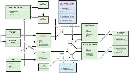
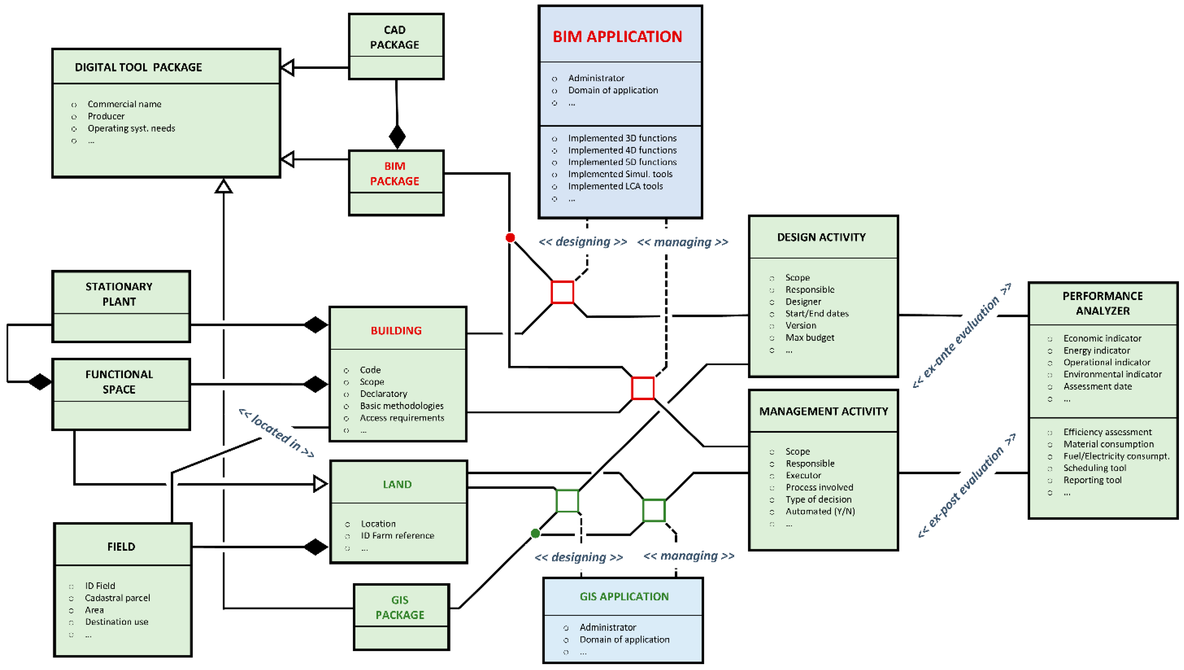
Figure 1 presents a conceptual UML class diagram relating the main resources, digital tools, and activities involved in rural-building applications. For clarity, the proposed classes are grouped into three functional sets: physical and territorial resources (BUILDING, FUNCTIONAL SPACE, STATIONARY PLANT, LAND and FIELD); digital packages and their applications (BIM PACKAGE, GIS PACKAGE, BIM APPLICATION and GIS APPLICATION); and design, management and assessment functions (DESIGN ACTIVITY, MANAGEMENT ACTIVITY and PERFORMANCE ANALYZER). The grouping draws on established BIM, BIM–GIS and agricultural information concepts [1,6,10,22,24,35,36] and is intended to make the information dependencies of process-oriented rural facilities explicit. The diagram is a conceptual representation of these relationships, rather than a formal ontology with specified machine-readable semantics.
Figure 1.
UML diagrams for the proper contextualization, use, and management of BIM in applications related to rural construction. Brief description of the diagram’s objects: classes = rectangles, divided into parts for entities/attributes/methods (if any); solid connection = simple; dashed connection = required; quotation marks = functions; empty circle = attributes; empty triangle = inheritance; solid hollow = composition.
Based on the conceptual model suggested here, a BIM APPLICATION is conceived as a ternary relationship in which a BIM PACKAGE class (i.e., the software package that implements the BIM functionalities) and a BUILDING class—that is, the entity representing the reference structure of the implemented application domain—are always involved. The third class in this ternary relationship implements the application’s objectives and may be represented by (a) a DESIGN ACTIVITY class, which concerns aspects relating to the design procedures of the BUILDING class, or (b) a MANAGEMENT ACTIVITY class, which instead implements aspects of utility management relating to the management of processes taking place within the BUILDING entity (e.g., regulation and control of a drying process), as well as any activity connected with its ordinary and extraordinary maintenance requirements (e.g., periodic checks on the power generators involved).
All entities involved in these activities belong to the BUILDING reference class; for the sake of simplicity, Figure 1 shows only the main classes, referred to as STATIONARY PLANT (e.g., dryers, heaters, and pumping systems) and FUNCTIONAL SPACE—that is, areas of a building reserved for specific functions (e.g., refueling areas, workshops, or product delivery areas)—which in turn may be used to permanently house STATIONARY PLANT entities.
Ultimately, therefore, a BIM APPLICATION supports the design and management of a (rural) building depending on the ternary relationship that conceptually implements it. In Figure 1, the elements of these ternary relationships are shown in red.
It is worth highlighting the close similarities that may exist with a GIS APPLICATION. Indeed, in this case too, the two functionalities (relationships) of <<designing>> and <<managing>> may be present, with analogous ternary relationships (shown in green) in which the GIS PACKAGE and LAND entities replace the corresponding classes seen for BIM, whilst the DESIGN ACTIVITY and MANAGEMENT ACTIVITY classes remain unchanged.
The BIM PACKAGE and GIS PACKAGE classes are specializations of the DIGITAL TOOL PACKAGE; furthermore, a BIM PACKAGE usually also includes three-dimensional graphic design tools represented by the CAD PACKAGE class.
The LAND class (in an agricultural context generally referred to as a collection of FIELD entities) can also be viewed as the parent class of the FUNCTIONAL SPACE entity. This represents a crucial point of potential connection between BIM and GIS applications, together with the <<located in>> relationship between the BUILDING and FIELD classes.
Finally, what typically characterizes any BIM or GIS application is the availability of suitable assessment tools designed to evaluate the performance of the managed resources (BUILDING or LAND). This is implemented by the PERFORMANCE ANALYZER class, which, through the DESIGN ACTIVITY and MANAGEMENT ACTIVITY classes, establishes the relationships of <<ex ante evaluation>> and <<ex post evaluation>>, respectively.
The diagram is distinguished from general BIM information models by its emphasis on the relationship between the rural building and the productive activities undertaken within it. In particular, FUNCTIONAL SPACE and the STATIONARY PLANT connect architectural representation to equipment and production processes, while DESIGN ACTIVITY and MANAGEMENT ACTIVITY distinguish the planning of a facility from its subsequent use. The PERFORMANCE ANALYZER provides a common reference for ex ante and ex post assessments, and LAND and FIELD situate building information within a farm-scale spatial context. Formal BIM ontologies focus on explicit semantic representations and data interoperability [37], whereas the diagram in Figure 1 serves as a high-level explanation of the functional links that agricultural applications would need to implement. Translating these links into a shared data schema and testing interoperability remain separate technical tasks.
2.2. UML Class Diagram to Conceptualize BIM Employment for Rural Construction Design and Facility Management
Figure 1 translates this conceptual organization into a UML class diagram. The model distinguishes software-package classes (DIGITAL TOOL PACKAGE, BIM PACKAGE, CAD PACKAGE and GIS PACKAGE), application classes (BIM APPLICATION and GIS APPLICATION), reference-resource classes (BUILDING, LAND and FIELD), activity classes (DESIGN ACTIVITY and MANAGEMENT ACTIVITY), and the PERFORMANCE ANALYZER. For rural constructions, the STATIONARY PLANT and FUNCTIONAL SPACE explicitly connect the BUILDING representation to the productive processes hosted within it. The shared DESIGN ACTIVITY and MANAGEMENT ACTIVITY classes also provide the conceptual bridge between BIM- and GIS-based workflows.
2.3. Pre-Design Requirements Constraining the DESIGN ACTIVITY
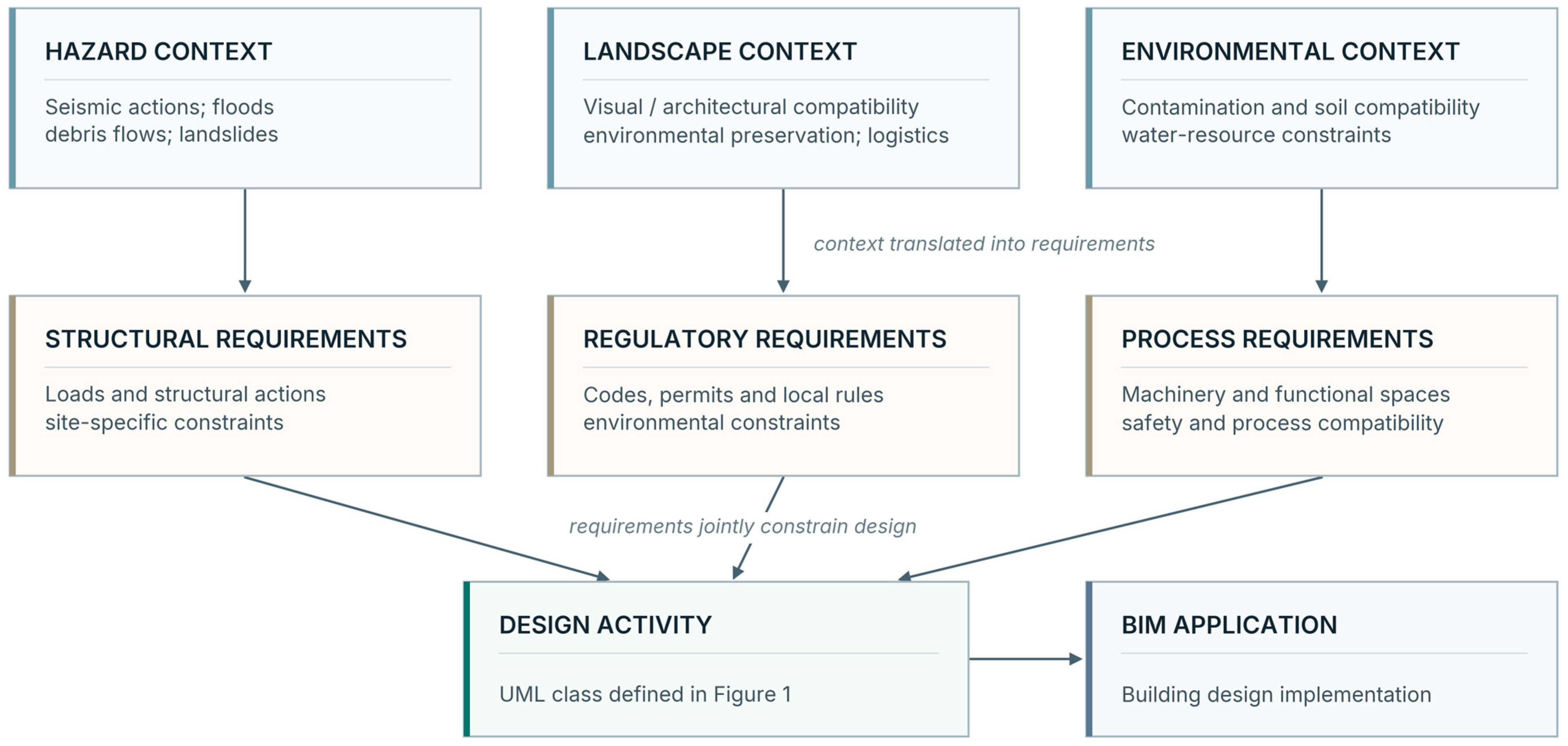
The pre-design stage is represented here as a simple block workflow rather than as a second UML class diagram. Hazard, landscape and environmental contexts inform structural, regulatory and process requirements, which collectively constrain the DESIGN ACTIVITY class defined in Figure 1. This formulation makes explicit that rural-building design is not governed by structural criteria alone: site hazards, planning constraints, functional spaces, stationary plants, safety requirements and process-environment compatibility must be resolved before the BIM APPLICATION is implemented. The following Figure 2 returns all the pre-design inputs constraining the DESIGN ACTIVITY, as defined in Figure 1. Hazard, landscape, and environmental contexts are considered as structural, regulatory, and process requirements before implementation within the BIM APPLICATION.
Figure 2.
Block diagram of the pre-design inputs constraining the DESIGN ACTIVITY class defined in Figure 1. Hazard, landscape, and environmental contexts are translated into structural, regulatory, and process requirements before implementation within the BIM APPLICATION.
3. BIM Software for Process-Oriented Design and Facility Management
Building Information Modeling (BIM) systems originate from conventional Computer-Aided Design (CAD) environments but extend their capabilities through the integration of geometric, technical, operational, and lifecycle information within a unified digital framework [1]. Unlike traditional CAD approaches, BIM systems are object-oriented and data-driven, enabling constructive components to contain not only geometrical attributes but also material properties, operational parameters, maintenance information, and management-related data [2,3].
3.1. BIM Software and Its Facilities
BIM applications incorporate increasing levels of complexity, commonly referred to as BIM “dimensions”, ranging from traditional drafting (2D) and spatial modeling (3D) to construction sequencing (4D) and cost estimation or lifecycle management (5D) [4,5,30]. In conventional architecture, engineering and construction (AEC) applications, these functionalities (see e.g., [6,7]) are mainly employed for:
- Structural design;
- Clash detection;
- Construction scheduling;
- Facility management;
- Lifecycle assessment.
Rural construction introduces additional requirements because the performance of a building is often inseparable from the agricultural process it accommodates. For example, forage drying depends on the arrangement of collectors, fans, ducts and drying cells; livestock buildings require coordination of animal housing and environmental control; and crop storage imposes material-handling and conditioning constraints [10,16,17,29,34]. BIM applications are therefore particularly valuable when functional spaces and stationary equipment are represented alongside the building geometry and can contribute to process-oriented design decisions.
Within this perspective, BIM software may support airflow and thermal simulations, productive workflow organization, machinery allocation, environmental monitoring, operational scheduling, maintenance planning, and facility management integration.
Table 1 provides an illustrative overview of software environments relevant to different components of rural-building projects. Architectural BIM authoring, structural detailing, multidisciplinary model coordination and infrastructure-oriented CAD support distinct tasks; specialized process simulation and operational monitoring can require additional tools. The descriptions summarize the principal orientation of each package and suggest possible applications in rural construction, without implying that the packages were experimentally benchmarked. Specific capabilities depend on the release, license, modules and exchange formats used in an individual project.
Table 1.
Selected software environments and illustrative applications in rural construction. Main functions are summarized from the suppliers’ product documentation cited below; possible rural applications indicate use cases rather than comparative performance ratings. Software documentation is available in the Data and Resource Availability Section.
These complementary functions can be interpreted through the classes in Figure 1. A BIM PACKAGE supports a BIM APPLICATION addressing the BUILDING, whereas DESIGN ACTIVITY and MANAGEMENT ACTIVITY distinguish the principal phases of use. The STATIONARY PLANT and FUNCTIONAL SPACE represent aspects of the productive configuration that are especially relevant to agricultural buildings.
3.2. BIM Throughout the Project Development Process
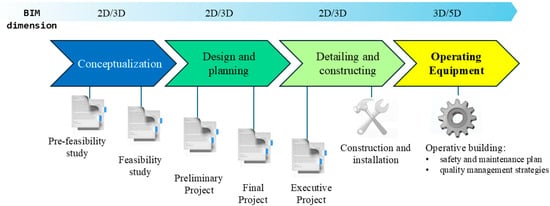
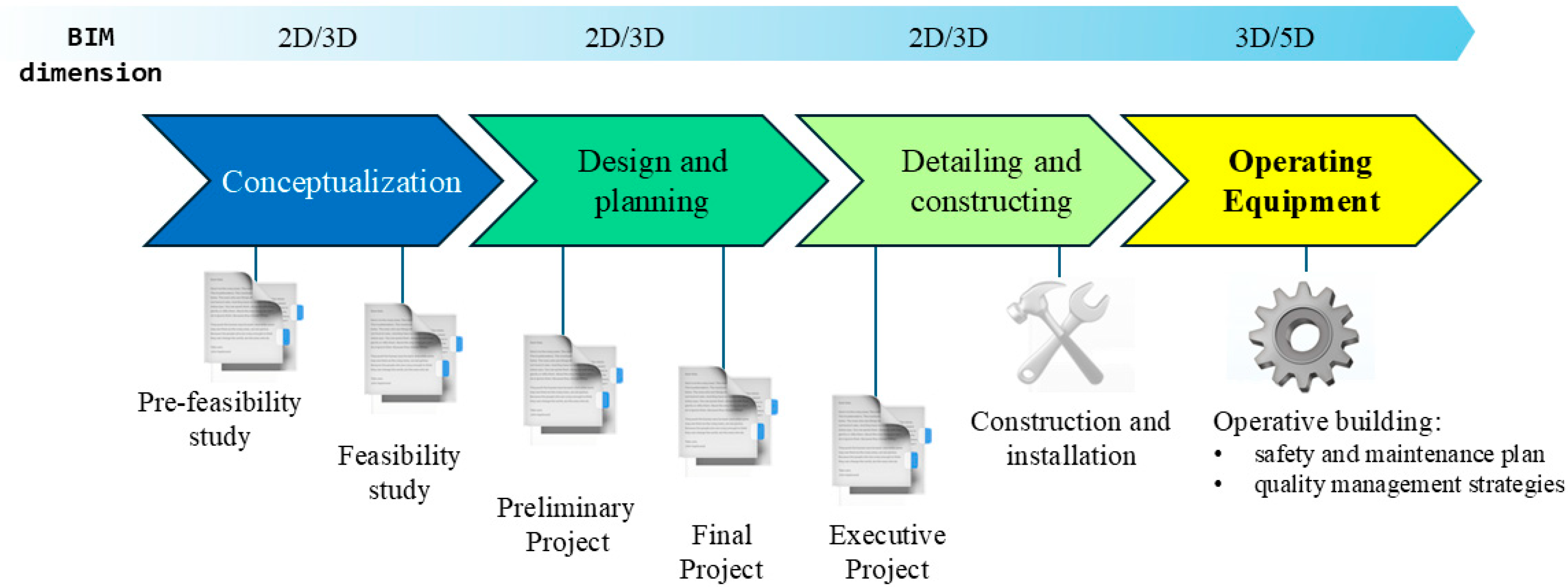
BIM can support successive stages of a rural-building project (Figure 3), from preliminary organization of spaces and equipment to detailed design, construction coordination and facility management [1,2,3,4]. At the feasibility and pre-design stages, relevant activities include:
Figure 3.
BIM for employment at all the design levels, ranging from the design idea to the facility management.
- Preliminary cost estimation and operational simulations (e.g., [30]);
- Structural pre-design and spatial organization (e.g., [3]);
- Environmental Performance Assessment (e.g., [1,4]).
As the project evolves, BIM can combine architectural, structural and technical information in a coordinated model, facilitating the identification of conflicts among building elements and equipment [2,6].
During operation, agricultural buildings may require the management of ventilation systems, storage conditions, machinery use, maintenance activities and energy demand. Information models developed during design may support these tasks when appropriate operational data and procedures are provided.
Connecting these models with environmental sensors, automation systems and maintenance records represents a possible further step toward data-informed facility management [9,15].
This process-oriented hierarchy is particularly important in rural constructions because productive requirements directly affect building organization and environmental performance.
3.3. Ex Ante Performance Evaluation and Process-Oriented Design
Within the UML framework shown in Figure 1, ex ante performance evaluation is represented by the relationship between the PERFORMANCE ANALYZER and DESIGN ACTIVITY. The PERFORMANCE ANALYZER collects economic, energy, operational and environmental indicators, allowing alternative configurations of the BUILDING, its STATIONARY PLANT and its FUNCTIONAL SPACE entities to be assessed before implementation. This relationship emphasizes that environmental analyses and operational simulations should enter the conceptual design workflow rather than being treated as downstream checks.
In agricultural infrastructures, this interaction is particularly relevant because airflow, humidity control, thermal behavior, and operational logistics strongly influence productive efficiency.
The design activity in BIM applications requires a comprehensive ex ante evaluation of building performance through the integration of multiple operational and environmental indicators [39,40]. In rural constructions, this process is particularly important because productive efficiency strongly depends on thermodynamic and environmental conditions. BIM-supported analyses may include:
- Construction cost estimation;
- Energy performance simulations;
- Operational efficiency assessments;
- Environmental impact evaluation;
- Structural pre-design analyses.
Five-dimensional BIM can support quantity take-off, cost estimation and the organization of cost information during project development [4,37,40,41,42,43,44]. Farouk and Rahman [45] distinguish applications for cost estimation from those for cost control in the broader construction literature. For rural facilities, the economic benefit is likely to depend on building complexity, reuse of existing digital infrastructure and the importance of the processes accommodated. Potential reductions in design rework, material waste, energy consumption or maintenance effort must be considered alongside software licensing, model development, staff training, data integration and continuing information-maintenance costs. These factors are particularly relevant to smaller farms, for which a targeted modeling application may be more feasible than a comprehensive digital platform. Ex ante assessments can also inform the organization of:
- Material flows;
- Storage efficiency;
- Productive logistics.
This organization is offered in the UML-based workflow, as in Figure 1. Moreover,
Environmental indicators and lifecycle assessment methodologies may also be integrated within BIM environments to evaluate the ex ante sustainability and environmental impact of agricultural infrastructures [6,46,47,48,49].
The design process must additionally account for structural and environmental forcings (acting on rural buildings, including structural loads, snow and wind actions, seismic loads, or hydrological forcings [42,46,47,48]. These analyses become particularly relevant in mountain agricultural environments, where climatic conditions and topographic constraints significantly affect building design.
3.4. Facility Management and Operational Processes
The MANAGEMENT ACTIVITY class represented in Figure 1 becomes central during the operational phase of a rural BIM application. It links the BIM APPLICATION and BUILDING to the processes carried out within STATIONARY PLANT and FUNCTIONAL SPACE entities, while the PERFORMANCE ANALYZER supports <<ex post evaluation>> of economic, energy, operational and environmental performance. This class-based structure captures the continuous interaction among monitoring, operational control, maintenance scheduling, and productive workflows, transforming BIM from a static design environment into a dynamic management platform for agricultural processes [21]. Within agricultural contexts, BIM-supported facility management may include:
- Environmental monitoring;
- Crop storage supervision;
- Ventilation management;
- Predictive maintenance;
- Machinery scheduling;
- Resource allocation;
- Energy monitoring.
The management workflow typically involves:
- Operational objectives;
- Supervisory control systems;
- Executors and operators;
- Monitoring infrastructures;
- Automated or semi-automated processes.
The integration between BIM environments, IoT systems, and Building Automation Systems enables real-time monitoring and control of agricultural infrastructures [9,50]. Similar approaches are already employed in precision agriculture and smart farming systems [14,15], but their integration with rural buildings remains limited. Recent developments in Artificial Intelligence and Machine Learning [51] may further extend BIM capabilities toward predictive maintenance, anomaly detection, and operational optimization. These integrations may transform BIM from a design environment into a comprehensive operational platform for agricultural infrastructures.
3.5. Ex Post Performance Evaluation of a BIM Project
Ex post performance evaluation is critical in building management [50], particularly in BIM applications. In Figure 1, this function is explicitly represented by the PERFORMANCE ANALYZER class through its <<ex post evaluation>> relationship with MANAGEMENT ACTIVITY. This process assesses indicators after construction and during operation, allowing for a comprehensive, data-driven approach [7]. Key aspects include:
- Energetic efficiency: BIM models integrated with real-time monitoring systems track actual energy consumption, optimizing climate control systems in agricultural settings [52].
- Material consumption: BIM systems monitor resource usage, crucial for profitability and sustainability in agriculture [53].
- Fuel and electricity demand: BIM applications provide detailed energy usage breakdowns, facilitating optimization and renewable energy implementation [20].
- Scheduling and reporting: Automated tools generate regular performance reports, valuable for complex agricultural operations [15].
BIM integration with smart technologies enhances building and process functionality. The use of BIM models and the use of Digital Twins can enable sophisticated simulation and optimization of processes like grain storage for mountain agriculture applications [14]. Predictive maintenance, facilitated by BIM, forecasts potential issues in critical systems, reducing downtime and improving efficiency [13]. The ex post evaluation process supports continuous improvement, adapting to changing climate conditions and agricultural practices [54].
Recent advancements related to safety practices include the work of Hire et al. [55], who proposed a conceptual framework for BIM-based site safety practices, applicable to agricultural buildings. For example, May et al. [56] developed a BIM-based Augmented Reality Defect Management system for construction inspections, as well as other applications, like in Pan et al. [57], Ramos-Hurtado et al. [58], and Mirshokraei et al. [38].
4. BIM Models as a Base for Digital Twins for Rural Constructions
In rural construction, a BIM model may serve as a basis for integrating design information with operational observations, provided that the information exchange and updating procedures are implemented [9,11,15]. A parametric model linked to an offline physics-based simulation supports design analysis; an operational Digital Twin additionally requires a defined relationship with the physical facility through measured data, model updating and assessment of relevant operating conditions. These stages are useful for distinction when evaluating the maturity and practical relevance of published applications.
4.1. Example of Available BIM-Driven Applications for Rural Constructions
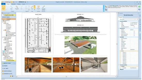
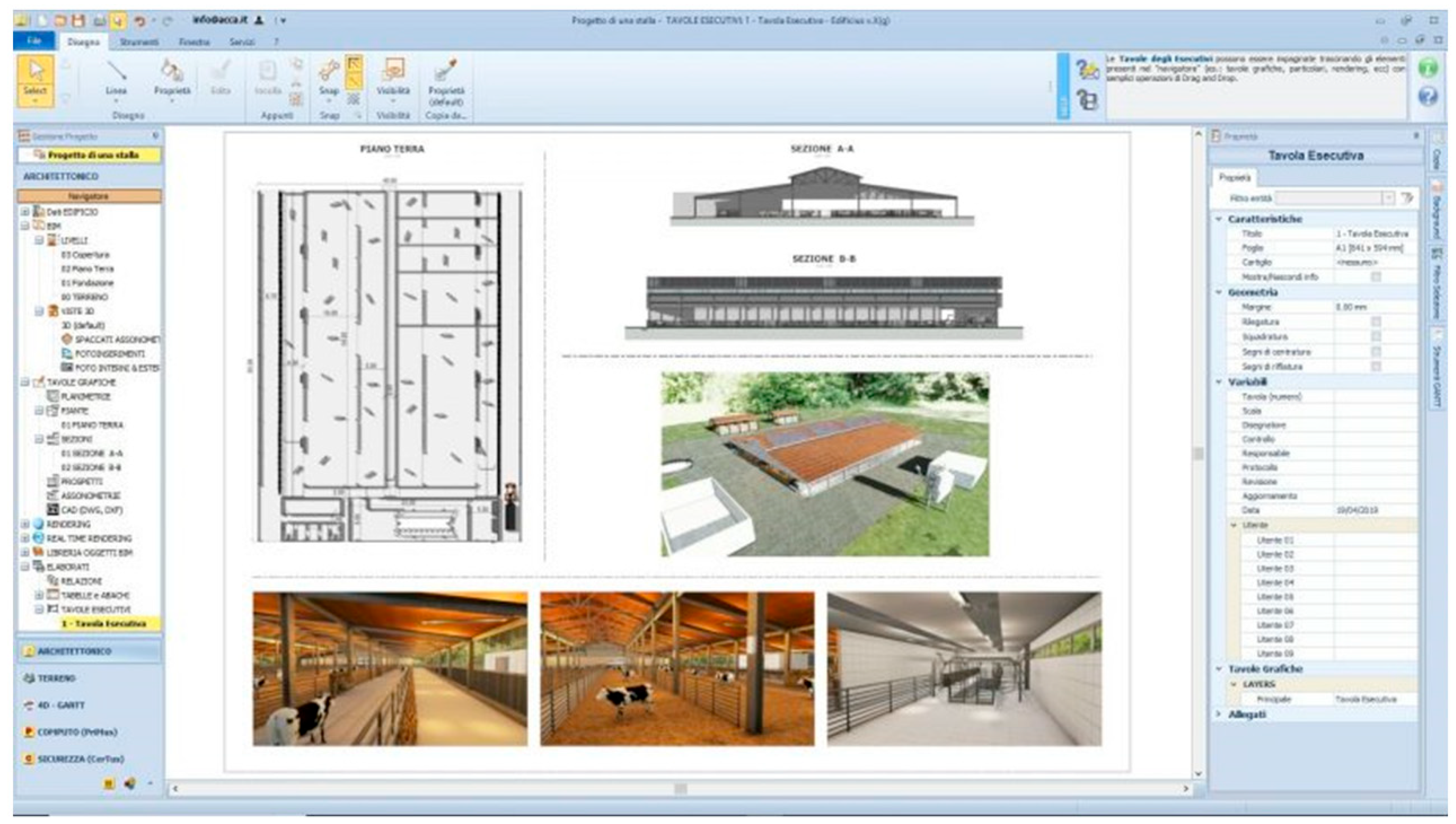
The livestock sector provides one of the few BIM examples in agricultural engineering applications. This example, featured in commercial software documentation [59], showcases the design of various barn types, as reported in Figure 4. While this example primarily focuses on designing spaces for production processes (such as milking parlors and hay barns) rather than the processes themselves, it embeds the ability to incorporate these plant elements into the design. This integration would allow the same model to be utilized during the management phase of the productive processes, and similar applications can be done for a wide variety of agricultural and rural buildings.
Figure 4.
Example of a commercial BIM application in designing a dairy cow stable [58].
The commercial example in Figure 4 illustrates the representation of production spaces and equipment in a building model [59]. The solar-barn design study described in the following section used Autodesk Revit for geometric modeling and a MATLAB 2026.1-based solver for airflow-network calculations [34], illustrating a different, process-oriented use of BIM data.
4.2. Solar-Barn Case Study: BIM-Based Design Simulation
The solar-barn dryer application reported by Schiavo and Mazzetto [34] provides an example of BIM-supported process-oriented design. In that study, alternative arrangements of solar air collectors, fans, ducts, and drying cells were developed in Autodesk Revit and evaluated using a reduced-order airflow-network model. The present section uses this published application to illustrate the relationship between the UML classes of Figure 1 and a specific agricultural production process. The original modeling assumptions, numerical implementation, and design comparisons are presented in [34].
For the solar-barn system, drying cells and ventilation pathways exemplify FUNCTIONAL SPACE entities, whereas fans, air collectors, and other installed equipment correspond to the STATIONARY PLANT. Their layout is defined in DESIGN ACTIVITY and can be related to the PERFORMANCE ANALYZER through an airflow calculation. This interpretation links the published design workflow to the conceptual diagram; integration with operational MANAGEMENT ACTIVITY would require additional data and implementation.
The case highlights a requirement shared by other process-intensive agricultural facilities: building geometry must be connected to the representation of equipment and process variables whenever those variables affect design performance. UML classes provide a common vocabulary for organizing this information across design and, prospectively, management activities.
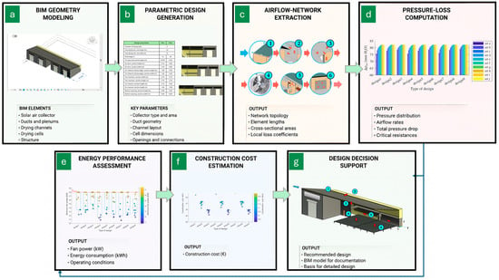
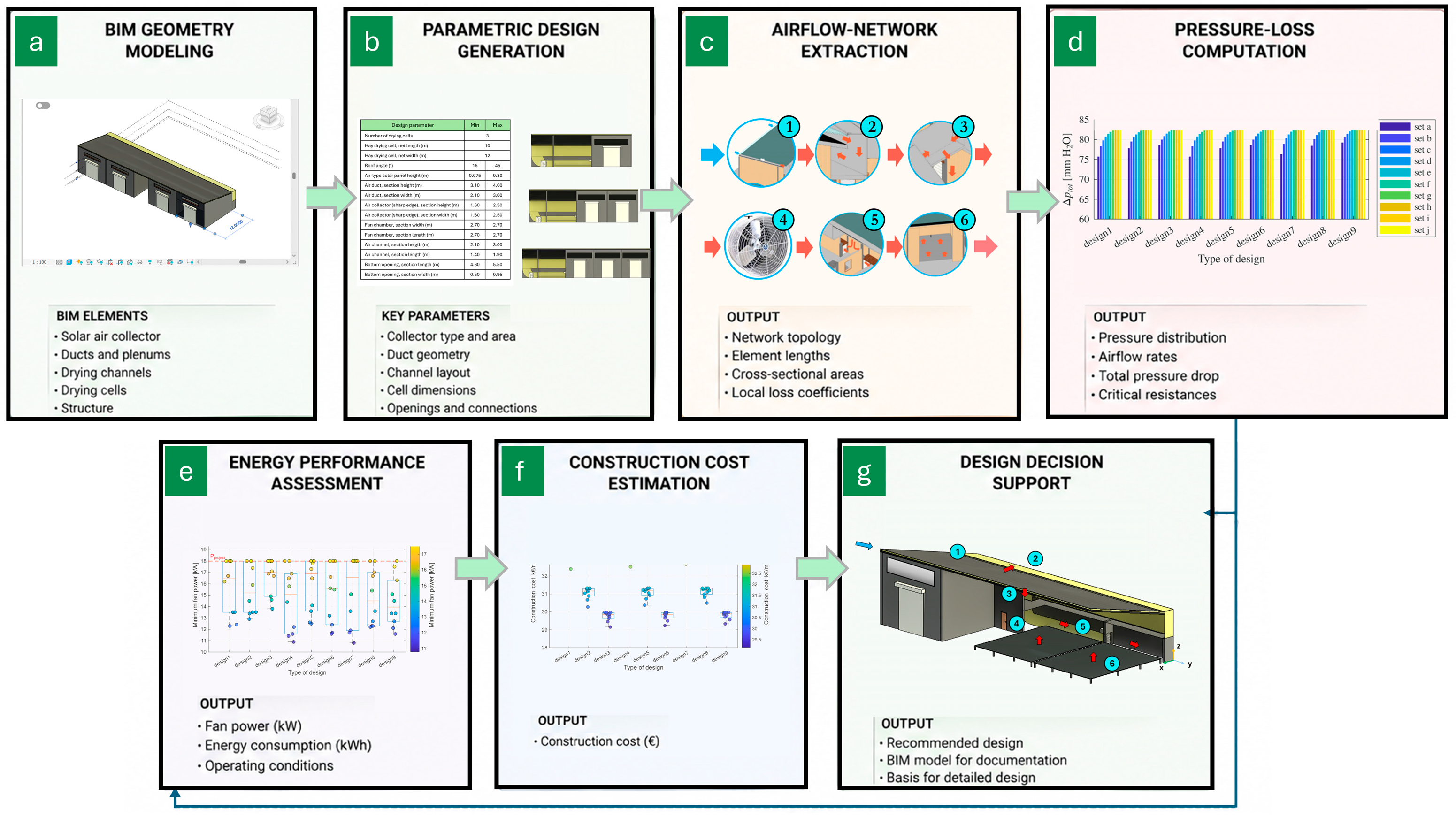
Figure 5 summarizes the design-stage workflow reported in [34], in which BIM geometry and ventilation-network information provide parameters for a reduced-order simulation of airflow and pressure losses. The example illustrates a connection between the BUILDING, FUNCTIONAL SPACE, STATIONARY PLANT, DESIGN ACTIVITY, and PERFORMANCE ANALYZER in the conceptual model.
Figure 5.
BIM-supported design and airflow-simulation workflow for a solar barn dryer, based on the application reported by Schiavo and Mazzetto [34]. Panels illustrate the progression from building geometry and network parameterization to pressure-loss, energy and cost assessment and design comparison. Panel (a): parametric BIM modeling; panel (b): generation of parameters; panel (c): lumped-parametric modeling of major airflow discontibnuities; panel (d): pressure variations at major cross-sections; panel (e,f): energy and cost performance, respectively; panel (g): decision support for best modeling choices.
In the workflow described by Schiavo and Mazzetto [34], the Revit environment defines the geometry and main elements of the ventilation network. Corresponding dimensions, connectivity, and component information are then used to construct the input data for the lumped-parameter model implemented in MATLAB. The solver estimates airflow-network conditions and associated pressure losses for alternative configurations. This is an offline design-analysis procedure; it is not connected to a real-time sensor stream or to automatic updating of the building model.
The principal stages of the previously published workflow are [34]:
- The model geometry is created within a 3D environment (Autodesk Revit), as in Figure 5’s panel a. Each element of the barn dryer, such as the solar air panel, air ducts, channels and collectors, drying cells, and the structure of the building, is designed.
- Key geometric and structural parameters (panel b) are defined and generated as design parameters.
- Geometric dimensions and airflow-network connections represented in the BIM design are used as inputs to the lumped-parameter MATLAB model (panel c).
- Local (i.e., concentrated) and cumulated pressure losses (panel d), as local air velocity, are quantified at each major cross-section of the lumped-parameter network, as well as fan energy requirements (panel e), and preliminary construction costs (panel f).
- Alternative configurations are compared to select arrangements that meet the prescribed process and design criteria (panel g).
The relevance of this case lies in demonstrating how building-information parameters can support an agricultural-process calculation during early design. A transition from such a workflow to operational management would involve connecting the model with measurements, updating relevant parameters and assessing its predictive reliability under actual facility conditions.
5. BIM for the Monitoring and the Retrofit of Existing Rural Buildings
BIM can be used for both designing new structures and adapting existing buildings for functional interventions, such as updating systems and structures. In constrained spaces, like mountainous areas with restrictions, the practice often involves evaluating existing spaces using laser scanners. This process, known as retrofitting, requires additional tools such as point cloud technology and 3D CAD integrated into BIM for custom design solutions. In agricultural engineering, BIM serves two main purposes:
- Requalification or adaptation of existing structures, especially those with historical or landscape value, or when adaptation is more practical than new construction.
- Facilitating and integrating the management of rural building facilities, including IoT and sensor implementation for better automation and control of production processes.
For existing rural buildings, acquisition and monitoring workflows can be mapped onto the same classes shown in Figure 1: survey and reconstruction data update the BUILDING representation within the BIM APPLICATION, while maintenance and operational information are handled through MANAGEMENT ACTIVITY and assessed through the PERFORMANCE ANALYZER. This preserves a common conceptual structure for newly designed and retrofitted rural constructions and facilitates their subsequent evolution toward Digital Twin implementations.
5.1. Applying BIM to Monitor Agricultural-Related Activities
The following examples illustrate where rural buildings intersect with monitoring and process management. Some derive from published monitoring or design studies; they should not all be interpreted as cases of fully implemented BIM-linked Digital Twins [10,15,18,35].
- Rural constructions and farm infrastructure design, optimizing agricultural buildings monitoring ventilation, thermal performances, constructive materials, and animal welfare, and integrating smart technologies and the employment of sensors (see e.g., [18,35]) to pursue sustainable practices [7,10,13,47].
- Irrigation and water management by integrating BIM with GISs and hydrological data for efficient irrigation systems monitoring [10].
- Precision agriculture monitoring by combining BIM, GISs, and remote sensing for accurate field maps and crop management [60] and crop management monitoring by creating detailed field models for optimizing planting and irrigation [15,61].
- Livestock management and facilities monitoring by designing optimal housing facilities considering ventilation, temperature, and waste management [29,62,63].
- Storage and processing facilities monitoring by optimizing the design of silos, processing plants, and distribution centers [15,64].
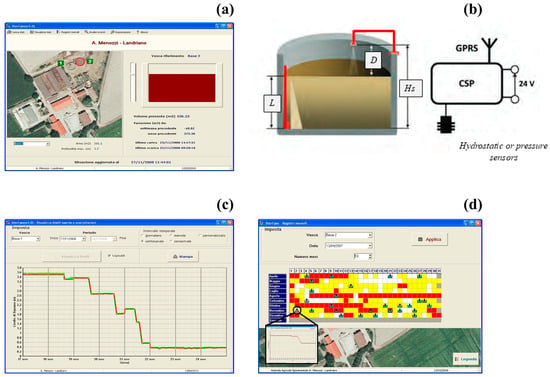
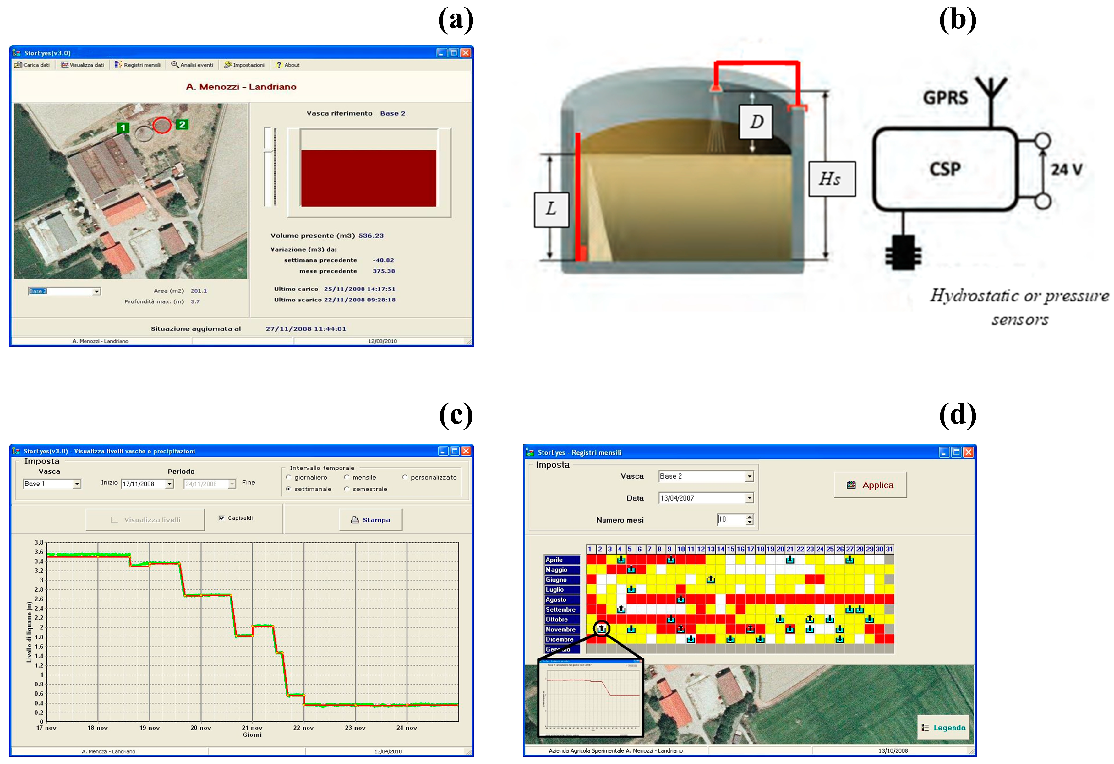
An example of a possible operational application is the integration of a slurry-storage model with level measurements and farm-management information (Figure 6). Related monitoring and remote-control approaches have been reported for slurry-management operations [35]. Linking such observations to storage-volume information could support reporting, scheduling, and the identification of critical conditions. A BIM-based representation would contribute the spatial and technical context, although the full integration is not established by the monitoring example alone.
Figure 6.
Conceptual representation of BIM-supported slurry-storage management informed by monitoring approaches discussed in [34]: (a) storage volume, (b) sensor locations, (c) level information and (d) possible scheduling decisions. Adapted and recalibrated from Ref. [34], with permission from FM, coauthor of the present manuscript and rights holder of the original figure.
5.2. Employing BIM for the Requalification of Existing or Historical Rural Buildings
The use of BIM for existing rural buildings mainly concerns requalification and retrofit interventions, particularly when demolition and reconstruction are not feasible because of historical, landscape, or economic constraints. In these cases, BIM supports the digitalization, redesign, and management of existing structures, enabling the integration of new functions and technologies within traditional rural buildings.
Several studies have explored BIM applications for retrofit and facility management of existing structures [28,52,65]. In agricultural contexts, Cho et al. [10] proposed a Digital Twin system integrating BIM and GISs for water management infrastructures, while Khan et al. [29] introduced the concept of Building Integrated Agriculture Information Modelling (BIAIM).
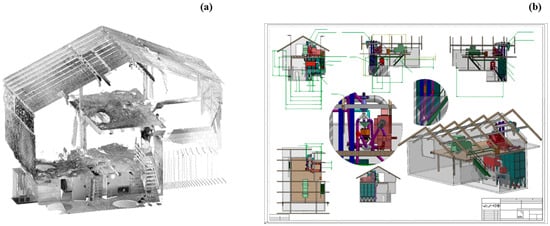
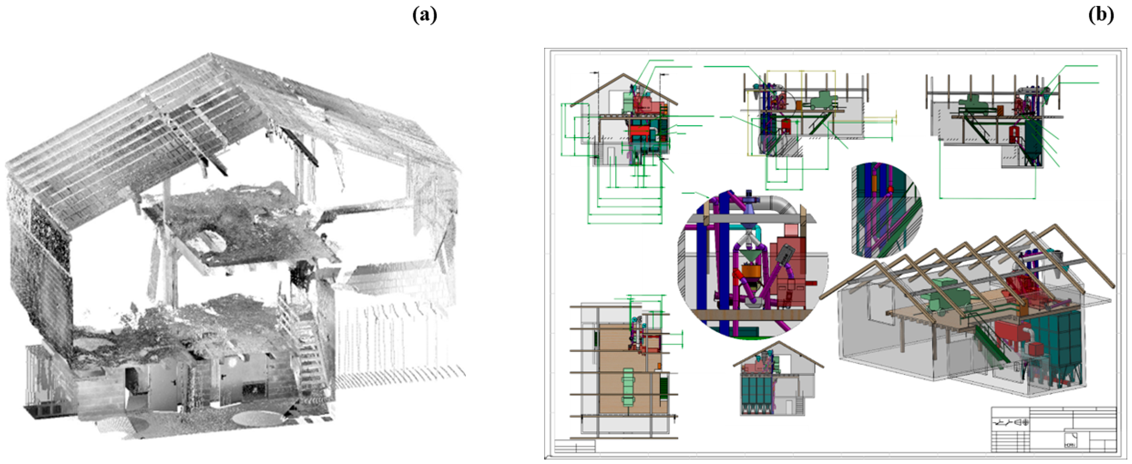
The Brotweg project in South Tyrol provides an example of adapting agricultural infrastructure to grain processing in a mountain-farm context [66]. Figure 7 illustrates the survey of an existing building and the spatial coordination of processing and storage equipment. This type of intervention is relevant to rural retrofit because the dimensions and structural constraints of an existing facility have to be reconciled with the requirements of production machinery and material flows.
Figure 7.
Example associated with the Brotweg rural-building retrofit [64]: (a) survey and digital representation of the existing building; (b) arrangement of processing and storage equipment within the facility. Adapted and recalibrated from Ref. [64], with permission from FM, coauthor of the present manuscript and rights holder of the original figure.
6. The Integration of BIM and Geographic Information Systems (GISs)
Integrating BIM with GISs enables a more comprehensive understanding of rural buildings within their environmental and territorial context, supporting the analysis of logistics, supply chains, and resource flows. The combination of BIM object-oriented models with GIS spatial analysis and georeferencing capabilities represents a major advancement for digital construction and landscape management, particularly for agricultural applications [6,24,67,68].
As outlined by the UML framework in Section 2, a BIM APPLICATION can be connected to a GIS APPLICATION through their shared DESIGN ACTIVITY and MANAGEMENT ACTIVITY classes and through the spatial relationship between the BUILDING and FIELD. The corresponding BIM PACKAGE and GIS PACKAGE are specializations of the DIGITAL TOOL PACKAGE, while LAND and FIELD provide the territorial reference needed to extend building-scale information toward farm-scale management, infrastructure planning, crop and irrigation monitoring, soil and water management, energy optimization and environmental assessment [10,14,60,69].
6.1. BIM Integration of Plant and Functional Spaces
A BIM APPLICATION for rural constructions must consider the interaction among the DESIGN ACTIVITY, STATIONARY PLANT and FUNCTIONAL SPACE classes, as represented in the UML framework of Figure 1. The digital model should integrate:
- Project scope and code requirements;
- Circulation and accessibility;
- Operational workflows;
- Productive spaces;
- Machinery and stationary plants.
This process-oriented organization is particularly relevant for agricultural buildings because productive efficiency strongly depends on spatial configuration and operational logistics [1,3,70]. In mountain agricultural systems, BIM may support the organization of vertical silos, storage areas and compact productive layouts such as micro-processing lines or drying systems [15,69].
Recent studies have further demonstrated BIM applications for space optimization, visualization of indoor and outdoor environments, and energy-related analyses [71,72,73,74,75,76,77].
6.2. GIS-Based Territorial Identification for BIM Projects
Field-related information, including cadastral parcelization, land use, and field identifiers, represents an important component of BIM-GIS integration for agricultural applications. These datasets are commonly retrieved from GIS repositories and support precision agriculture workflows and territorial management [60,78].
The integration between BIM and GISs also facilitates compliance with land-use regulations and cadastral management [8]. Recent studies proposed web-based 3D cadastral visualization systems and legal-space integration workflows for BIM applications [79,80], improving interoperability between territorial information and construction-related datasets.
Additional territorial information may also be integrated into BIM environments to support structural and environmental analyses. Structural forcings such as machinery loads, snow loads, wind actions and hydrological stresses may be incorporated within BIM workflows through integration with environmental and climatic datasets [25,81,82,83]. For the Italian context, these analyses may be compared with the NTC 2018 framework.
Similarly, environmental datasets concerning soil contamination, chemical vulnerability and emerging pollutants may support environmental assessment and sustainable planning strategies [18,84,85,86]. BIM scenario simulations may therefore assist environmental impact analyses, mitigation strategies and stakeholder collaboration [18,60,86].
The integration between BIM and GISs additionally supports hydrogeological and climatic risk assessment. GIS-based hazard maps and hydrological models may be incorporated into BIM workflows to evaluate floods, debris flows, and environmental vulnerability [87,88]. Similar approaches have been applied to flood resilience, drought management, and seismic vulnerability assessment [37,43,44,48].
7. Smart Agriculture and Environmental Risk Assessment
The main significance of combining BIM with farm information and GISs lies in linking three otherwise separate layers: building and equipment representation, productive activity, and territorial/environmental context [6,10,22,24]. In agricultural facilities, relevant observations may concern humidity, airflow, animal housing conditions, slurry levels or storage operations; GISs can add information on fields, access, topography, and environmental exposure. Whether these layers support useful decisions depends on reliable identifiers, agreed data structures, interoperable interfaces and clearly assigned responsibility for maintaining the information. Existing smart-farming and Digital Twin literature motivates these integrations [14,15,51], but conceptual compatibility should not be confused with verified deployment across heterogeneous software systems.
Environmental and territorial conditions introduce another dimension of rural-building design. GIS information on terrain, flooding, slope stability, water resources or nearby contaminant sources can be related to facility locations and land-use decisions [26,79,80,82,83,84,85,86]. For agricultural buildings, these connections are relevant both to siting and to operational management, but their reliability depends on the quality, scale and currency of the underlying geographic and environmental data.
Critical Synthesis: What Transfers, What Is Specific, and What Remains Unverified
The reviewed literature distinguishes between established BIM capabilities and requirements arising from rural production processes. Parametric geometry, design coordination, cost estimation, and asset documentation are widely used in the AEC sector [1,2,3,4,5,6,7,21]. In agriculture, the design of functional spaces and stationary equipment often depends on additional variables such as ventilation airflow, drying conditions, livestock environments and seasonal material handling [10,18,22,29,34,52]. Representing these dependencies is necessary if BIM information is to support decisions about the productive function of the facility rather than merely its geometry.
The maturity of the reported applications also varies. Architectural modeling and coordination can be illustrated through commercial and retrofit examples [59,66], while the solar-barn study [34] provides a design-stage connection between parametric geometry and physical-process simulation. Monitoring approaches such as [35] show how operational data can be collected in agricultural settings. These examples address related components of a future integrated system but do not establish that the complete building–process–sensor information chain has been implemented and evaluated in a single rural facility. Its assessment would require explicit data-exchange arrangements and comparison of model outputs with observations under operating conditions.
A further consideration is the economic and organizational feasibility of adoption. The value of the information model depends on the complexity of the facility, the relevance of its productive processes, the availability of reusable digital components and the resources required for updating and using the model. The literature on construction cost management provides useful methods [4,45], but the balance between initial investment and operating benefits should be evaluated in rural settings with consideration of scale, labor, training, equipment and maintenance requirements [17,28].
8. Conclusions
This review highlights the importance of relating building information to agricultural processes. In the conceptual framework of Figure 1, the FUNCTIONAL SPACE and STATIONARY PLANT associate the BUILDING with the equipment and operations it accommodates, while the DESIGN ACTIVITY, MANAGEMENT ACTIVITY and PERFORMANCE ANALYZER represent complementary information needs across the facility lifecycle. LAND and FIELD extend this perspective to the territorial context of farm operations.
Three main conclusions emerge. First, process-oriented rural BIM requires information on the relationship between building geometry, equipment configuration, and productive constraints, including ventilation, drying, and storage [10,17,27,38]. Second, BIM–GIS and farm-information integration can improve the contextual description of a rural facility, provided that interoperable representations and practical data maintenance are addressed [6,22,24]. Third, BIM-supported offline simulation and sensor-connected operational Digital Twins represent distinct levels of implementation; the latter additionally depends on reliable measurement, data exchange, and validation [9,11,15].
The solar-barn application [34] illustrates the use of BIM-derived design parameters in airflow-network simulation. The slurry management [35] and Brotweg [66] examples complement this perspective by indicating potential monitoring and retrofit requirements. Together, they show how the classes in Figure 1 can organize a discussion of building, process, equipment and landscape information, while also highlighting the gap between conceptual integration and operational implementation.
The economic case for BIM adoption in rural construction remains context-dependent. Benefits may include improved coordination among building and equipment designs, better organization of maintenance information and more systematic comparison of alternative operating configurations. These possibilities need to be assessed against modeling effort, training, software, data-transfer and ongoing update costs, especially for smaller agricultural enterprises [17,30,45].
This study is limited by the selective nature of its narrative literature base, the absence of a controlled comparison of software packages and the conceptual status of the UML framework. The solar-barn example is drawn from published design-stage research rather than new field experimentation, and operational validation of the proposed BIM–GIS–monitoring links remains an open task. Future work should focus on interoperable descriptions of agricultural assets and processes, documented lifecycle costs and field studies that test sensor-informed models against measured facility performance.
9. Data and Resource Availability
The airflow-network modeling and design comparisons referred to in Section 4.2 are reported in Schiavo and Mazzetto [34], with associated Supplementary Materialstherein. This article presents a narrative literature synthesis and conceptual discussion without new computational or field datasets. Software: Software documentation (accessed on 19 October 2026): Autodesk Revit, https://www.autodesk.com/products/revit/overview; Graphisoft Archicad, https://www.graphisoft.com/it-it/plans-and-products/archicad/; Tekla Structures, https://www.tekla.com/; ACCA Edificius, https://www.acca.it/software-progettazione-edilizia; Autodesk Navisworks, https://www.autodesk.com/products/navisworks/overview; Bentley MicroStation, https://www.bentley.com/products/microstation/.
Author Contributions
Conceptualization, M.S. and F.M.; methodology, M.S. and F.M.; formal analysis, M.S.; investigation, M.S. and F.M.; resources, F.M.; data curation, M.S.; writing—original draft preparation, M.S.; writing—review and editing, M.S. and F.M.; visualization, M.S. and F.M.; supervision, M.S. and F.M.; project administration, F.M. All authors have read and agreed to the published version of the manuscript.
Funding
This work has been funded by the European Social Fund Plus, Project code ESF2_f3_0006 CUP: B56F24000090001, Research projects on strategic topics for the South Tyrolean economy carried out by researchers on fixed-term contracts.
Data Availability Statement
No new data were created or analyzed in this study. Data sharing is not applicable to this article.
Conflicts of Interest
The authors declare no conflicts of interest.
References
- Eastman, C.; Teicholz, P.; Sacks, R.; Liston, K. BIM Handbook: A Guide to Building Information Modeling for Owners, Designers, Engineers, Contractors, and Facility Managers, 3rd ed.; Wiley: Hoboken, NJ, USA, 2018. [Google Scholar]
- Azhar, S. Building Information Modeling (BIM): Trends, Benefits, Risks, and Challenges for the AEC Industry. Leadersh. Manag. Eng. 2011, 11, 241–252. [Google Scholar] [CrossRef] [Scilit]
- Bryde, D.; Broquetas, M.; Volm, J.M. The project benefits of Building Information Modelling (BIM). Int. J. Proj. Manag. 2013, 31, 971–980. [Google Scholar] [CrossRef] [Scilit]
- Smith, P. Project cost management with 5D BIM. Procedia-Soc. Behav. Sci. 2016, 226, 193–200. [Google Scholar] [CrossRef] [Scilit]
- Hartmann, T.; Gao, J.; Fischer, M. Areas of Application for 3D and 4D Models on Construction Projects. J. Constr. Eng. Manag. 2008, 134, 776–785. [Google Scholar] [CrossRef] [Scilit]
- Liu, X.; Wang, X.; Wright, G.; Cheng, J.C.P.; Li, X.; Liu, R. A State-of-the-Art Review on the Integration of Building Information Modeling (BIM) and Geographic Information System (GIS). ISPRS Int. J. Geo-Inf. 2017, 6, 53. [Google Scholar] [CrossRef] [Scilit]
- Gerrish, T.; Ruikar, K.; Cook, M.; Johnson, M.; Phillip, M.; Lowry, C. BIM application to building energy performance visualisation and management: Challenges and potential. Energy Build. 2017, 144, 218–228. [Google Scholar] [CrossRef] [Scilit]
- Irizarry, J.; Karan, E.P.; Jalaei, F. Integrating BIM and GIS to improve the visual monitoring of construction supply chain management. Autom. Constr. 2013, 31, 241–254. [Google Scholar] [CrossRef] [Scilit]
- Tao, F.; Qi, Q.; Wang, L.; Nee, A.Y.C. Digital Twins and Cyber–Physical Systems toward Smart Manufacturing and Industry 4.0: Correlation and Comparison. Engineering 2019, 5, 653–661. [Google Scholar] [CrossRef] [Scilit]
- Cho, Y.; Kim, S.; Lim, K.J.; Kim, J.; Bonjung, J.; Yeon, J. Web-based agricultural infrastructure Digital Twin system integrated with GIS and BIM. Comput. Electron. Agric. 2023, 215, 108441. [Google Scholar] [CrossRef] [Scilit]
- Mannino, A.; Dejaco, M.C.; Re Cecconi, F. Building Information Modelling and Internet of Things Integration for Facility Management—Literature Review and Future Needs. Appl. Sci. 2021, 11, 3062. [Google Scholar] [CrossRef] [Scilit]
- Cesco, S.; Sambo, P.; Borin, M.; Basso, B.; Orzes, G.; Mazzetto, F. Smart agriculture and Digital Twins: Applications and challenges in a vision of sustainability. Eur. J. Agron. 2023, 146, 126809. [Google Scholar] [CrossRef] [Scilit]
- Bechar, A.; Vigneault, C. Agricultural robots for field operations: Concepts and components. Biosyst. Eng. 2016, 149, 94–111. [Google Scholar] [CrossRef] [Scilit]
- Wolfert, S.; Ge, L.; Verdouw, C.; Bogaardt, M.J. Big data in smart farming–a review. Agric. Syst. 2017, 153, 69–80. [Google Scholar] [CrossRef] [Scilit]
- Verdouw, C.N.; Tekinerdogan, B.; Beulens, A.; Wolfert, S. Digital Twins in smart farming. Agric. Syst. 2021, 189, 103046. [Google Scholar] [CrossRef] [Scilit]
- Grant, M.J.; Booth, A. A Typology of Reviews: An Analysis of 14 Review Types and Associated Methodologies. Health Info. Libr. J. 2009, 26, 91–108. [Google Scholar] [CrossRef] [Scilit] [PubMed]
- Tirelli, D.; Besana, D. Moving toward Net Zero Carbon Buildings to Face Global Warming: A Narrative Review. Buildings 2023, 13, 684. [Google Scholar] [CrossRef] [Scilit]
- Mazzetto, F.; Gallo, R.; Sacco, P. Reflections and Methodological Proposals to Treat the Concept of “Information Precision” in Smart Agriculture Practices. Sensors 2020, 20, 2847. [Google Scholar] [CrossRef] [Scilit] [PubMed]
- Lu, Y.; Wu, Z.; Chang, R.; Li, Y. Building Information Modeling (BIM) for green buildings: A critical review and future directions. Autom. Constr. 2017, 83, 134–148. [Google Scholar] [CrossRef] [Scilit]
- Carpio, M.; Carrasco, D. Impact of Shape Factor on Energy Demand, CO2 Emissions and Energy Cost of Residential Buildings in Cold Oceanic Climates: Case Study of South Chile. Sustainability 2021, 13, 9491. [Google Scholar] [CrossRef] [Scilit]
- Pishdad-Bozorgi, P.; Gao, X. Planning and developing facility management-enabled building information model (FM-enabled BIM). Autom. Constr. 2018, 87, 22–38. [Google Scholar] [CrossRef] [Scilit]
- Mazzetto, F.; Gallo, R.; Riedl, M.; Sacco, P. Proposal of an ontological approach to design and analyse farm information systems to support Precision Agriculture techniques. IOP Conf. Ser. Earth Environ. Sci. 2019, 275, 012008. [Google Scholar] [CrossRef] [Scilit]
- Zhu, J.; Wei, R.; Yin, M.; Brilakis, I. BG-LoA: A Benchmarking Framework for BIM/GIS Data Integration Based on Meta-Modelling Theory. Int. Arch. Photogramm. Remote Sens. Spat. Inf. Sci. 2024, XLVIII-4-2024, 591–597. [Google Scholar] [CrossRef] [Scilit]
- Kang, T.W.; Hong, C.H. A study on software architecture for effective BIM/GIS-based facility management data integration. Autom. Constr. 2015, 54, 25–38. [Google Scholar] [CrossRef] [Scilit]
- Asgari Siahboomy, M.; Sarvari, H.; Chan, D.W.M.; Nassereddine, H.; Chen, Z. A multi-criteria optimization study for locating industrial warehouses with the integration of BIM and GIS data. Archit. Eng. Des. Manag. 2021, 17, 478–495. [Google Scholar] [CrossRef] [Scilit]
- Yang, Y.; Ng, S.T.; Dao, J.; Zhou, S.; Xu, F.J.; Xu, X.; Zhou, Z. BIM-GIS-DCEs enabled vulnerability assessment of interdependent infrastructures—A case of stormwater drainage-building-road transport nexus in urban flooding. Autom. Constr. 2021, 125, 103626. [Google Scholar] [CrossRef] [Scilit]
- East, E.W. Construction Operations Building Information Exchange (COBIE): Requirements Definition and Pilot Implementation Standard; ERDC/CERL TR-07-30; U.S. Army Engineer Research and Development Center: Champaign, IL, USA, 2007. [Google Scholar]
- Patacas, J.; Dawood, N.; Vukovic, V.; Kassem, M. BIM for facilities management: Evaluating BIM standards in asset register creation and service life. ITcon 2015, 20, 313–331. Available online: https://www.itcon.org/2015/20 (accessed on 2 November 2026).
- Khan, M.A.; Aziz, Z.; Ahmed, V. Building integrated agriculture information modelling (BIAIM): An integrated approach towards urban agriculture. Sustain. Cities Soc. 2018, 37, 594–607. [Google Scholar] [CrossRef] [Scilit]
- Vitasek, S. Using Building Information Modelling (BIM) in construction budget: Benefits and barriers. In Proceedings of the 18th International Scientific Conference Engineering for Rural Development, Jelgava, Letonia, 22–24 May 2019. [Google Scholar] [CrossRef] [Scilit]
- Charef, R.; Alaka, H.; Emmitt, S. Beyond the Third Dimension of BIM: A Systematic Review of Literature and Assessment of Professional Views. J. Build. Eng. 2018, 19, 242–257. [Google Scholar] [CrossRef] [Scilit]
- Gomes, A.M.; Azevedo, G.; Sampaio, A.Z.; Lite, A.S. BIM in Structural Project: Interoperability Analyses and Data Management. Appl. Sci. 2022, 12, 8814. [Google Scholar] [CrossRef] [Scilit]
- Banti, N.; Ciacci, C.; Bazzocchi, F.; Di Naso, V. Enhancing Industrial Buildings’ Performance through Informed Decision Making: A Generative Design for Building-Integrated Photovoltaic and Shading System Optimization. Solar 2024, 4, 401–421. [Google Scholar] [CrossRef] [Scilit]
- Schiavo, M.; Mazzetto, F. A BIM Framework for Rural Construction Design and Early Performance Assessment: Application to Airflow Network Modeling in Solar Barn Dryers. Buildings 2026, 16, 3332. [Google Scholar] [CrossRef] [Scilit]
- Mazzetto, F.; Calcante, A.; Sacco, P.; Salomoni, F.; Landonio, S. Monitoring and remote control of slurry waste distribution activities for a sustainable management of livestock farms. In Proceedings of the Technology and Management to Ensure Sustainable Agriculture, Agro-Systems, Forestry and Safety, Proceedings of the XXXIII CIOSTA-CIGR V Conference 2009, Reggio Calabria, Italy, 17–19 June 2009; DiSTAfA: Reggio Calabria, Italy, 2009; pp. 903–907. [Google Scholar]
- Niknam, M.; Karshenas, S. A shared ontology approach to semantic representation of BIM data. Autom. Constr. 2017, 80, 22–36. [Google Scholar] [CrossRef] [Scilit]
- Tiepolo, M.; Abraiz, M.; Bacci, M.; Baoua, O.; Belcore, E.; Cannella, G.; Fiorillo, E.; Ganora, D.; Housseini, M.I.; Katiellou, G.L.; et al. Flood Damage Risk Mapping Along the River Niger: Ten Benefits of a Participated Approach. Climate 2025, 13, 80. [Google Scholar] [CrossRef] [Scilit]
- Mirshokraei, M.; De Gaetani, C.I.; Migliaccio, F. A Web-Based BIM–AR Quality Management System for Structural Elements. Appl. Sci. 2019, 9, 3984. [Google Scholar] [CrossRef] [Scilit]
- Cavalliere, C.; Habert, G.; Dell’Osso, G.R.; Hollberg, A. Continuous BIM-based assessment of embodied environmental impacts throughout the design process. J. Clean. Prod. 2019, 211, 941–952. [Google Scholar] [CrossRef] [Scilit]
- Tam, V.W.Y.; Zhou, Y.; Shen, L.; Le, K.N. Optimal BIM and LCA integration approach for embodied environmental impact assessment. J. Clean. Prod. 2023, 385, 135605. [Google Scholar] [CrossRef] [Scilit]
- Li, X.; Wu, P.; Shen, G.Q.; Wang, X.; Teng, Y. Mapping the knowledge domains of Building Information Modeling (BIM): A bibliometric approach. Autom. Constr. 2017, 84, 195–206. [Google Scholar] [CrossRef] [Scilit]
- Liao, J.; Kim, H.Y.; Shin, M.H. Quantitative and Qualitative Benefits of Using BIM in Design and Construction Stages for Railway Development. Buildings 2025, 15, 180. [Google Scholar] [CrossRef] [Scilit]
- Abioye, E.A.; Hensel, O.; Esau, T.J.; Elijah, O.; Abidin, M.S.Z.; Ayobami, A.S.; Yerima, O.; Nasirahmadi, A. Precision Irrigation Management Using Machine Learning and Digital Farming Solutions. AgriEngineering 2022, 4, 70–103. [Google Scholar] [CrossRef] [Scilit]
- Wahba, M.; El-Rawy, M.; Al-Arifi, N. Integrating Geographic Information Systems and Hydrometric Analysis for Assessing and Mitigating Building Vulnerability to Flash Flood Risks. Water 2024, 16, 434. [Google Scholar] [CrossRef] [Scilit]
- Farouk, A.M.; Rahman, R.A. Integrated applications of building information modeling in project cost management: A systematic review. J. Eng. Des. Technol. 2025, 23, 287–305. [Google Scholar] [CrossRef] [Scilit]
- Kim, T.; Yoon, Y.; Lee, B.; Ham, N.; Kim, J.-J. Cost–Benefit Analysis of Scan-vs-BIM-Based Quality Management. Buildings 2022, 12, 2052. [Google Scholar] [CrossRef] [Scilit]
- Eleftheriadis, S.; Mumovic, D.; Greening, P. Life cycle energy efficiency in building structures: A review of current developments and future outlooks based on BIM capabilities. Renew. Sustain. Energy Rev. 2017, 67, 811–825. [Google Scholar] [CrossRef] [Scilit]
- Christodoulou, S.E.; Vamvatsikos, D.; Georgiou, C. A BIM-based Framework for Forecasting and Visualizing Seismic Damage, Cost and Time to Repair. Presented at the 8th European Conference on Product and Process Modelling (ECCPM), Cork, Ireland, 14–16 September 2010. [Google Scholar]
- Cheng, B.; Li, J.; Tam, V.W.Y.; Yang, M.; Chen, D. A BIM-LCA Approach for Estimating the Greenhouse Gas Emissions of Large-Scale Public Buildings: A Case Study. Sustainability 2020, 12, 685. [Google Scholar] [CrossRef] [Scilit]
- Moretti, N.; Xie, X.; Merino, J.; Brazauskas, J.; Parlikad, A.K. An openBIM Approach to IoT Integration with Incomplete As-Built Data. Appl. Sci. 2020, 10, 8287. [Google Scholar] [CrossRef] [Scilit]
- Saiz-Rubio, V.; Rovira-Más, F. From Smart Farming towards Agriculture 5.0: A Review on Crop Data Management. Agronomy 2020, 10, 207. [Google Scholar] [CrossRef] [Scilit]
- Chiumenti, R.; Chiumenti, P.; Chiumenti, A. Genio Rurale, Topografia e Costruzioni; RCS Education: Milan, Italy, 2016. [Google Scholar]
- Balafoutis, A.; Beck, B.; Fountas, S.; Vangeyte, J.; Van der Wal, T.; Soto, I.; Gómez-Barbero, M.; Barnes, A.; Eory, V. Precision Agriculture Technologies Positively Contributing to GHG Emissions Mitigation, Farm Productivity, and Economics. Sustainability 2017, 9, 1339. [Google Scholar] [CrossRef] [Scilit]
- Klerkx, L.; Rose, D. Dealing with the game-changing technologies of Agriculture 4.0: How do we manage diversity and responsibility in food system transition pathways? Glob. Food Secur. 2020, 24, 100347. [Google Scholar] [CrossRef] [Scilit]
- Hire, S.; Sandbhor, S.; Ruikar, K. A Conceptual Framework for BIM-Based Site Safety Practice. Buildings 2024, 14, 272. [Google Scholar] [CrossRef] [Scilit]
- May, K.W.; Chandani, K.C.; Ochoa, J.J.; Gu, N.; Walsh, J.; Smith, R.T.; Thomas, B.H. The Identification, Development, and Evaluation of BIM-ARDM: A BIM-Based AR Defect Management System for Construction Inspections. Buildings 2022, 12, 140. [Google Scholar] [CrossRef] [Scilit]
- Pan, N.-H.; Isnaeni, N.N. Integration of Augmented Reality and Building Information Modeling for Enhanced Construction Inspection—A Case Study. Buildings 2024, 14, 612. [Google Scholar] [CrossRef] [Scilit]
- Ramos-Hurtado, J.; Muñoz-La Rivera, F.; Mora-Serrano, J.; Deraemaeker, A.; Valero, I. Proposal for the Deployment of an Augmented Reality Tool for Construction Safety Inspection. Buildings 2022, 12, 500. [Google Scholar] [CrossRef] [Scilit]
- ACCA Software s.p.a. Come Progettare una Stalla con Modello BIM. 2020. Available online: https://biblus.acca.it/progetto-di-una-stalla-guida-completa/ (accessed on 2 November 2026).
- Kamilaris, A.; Kartakoullis, A.; Prenafeta-Boldú, F.X. A Review on the Practice of Big Data Analysis in Agriculture. Comput. Electron. Agric. 2017, 143, 23–37. [Google Scholar] [CrossRef] [Scilit]
- Borkowski, A.S.; Kubrat, A. Integration of Laser Scanning, Digital Photogrammetry and BIM Technology: A Review and Case Studies. Eng 2024, 5, 2395–2409. [Google Scholar] [CrossRef] [Scilit]
- Cesco, S.; Ascoli, D.; Bailoni, L.; Bischetti, G.B.; Buzzini, P.; Cairoli, M.; Celi, L.; Corti, G.; Marchetti, M.; Mugnozza, G.S.; et al. Smart management of emergencies in the agricultural, forestry, and animal production domain: Tackling evolving risks in the climate change era. Int. J. Disaster Risk Reduct. 2024, 114, 105015. [Google Scholar] [CrossRef] [Scilit]
- Singh, T.; Mahmoodian, M.; Wang, S. Enhancing Open BIM Interoperability: Automated Generation of a Structural Model from an Architectural Model. Buildings 2024, 14, 2475. [Google Scholar] [CrossRef] [Scilit]
- Mazzetto, F.; Carabin, G.; Becce, L.; Mandler, A.; Sacco, P. Technological Solutions for Implementing Sustainable Cereal-Based Value-Chains in High Mountain Areas. In AIIA 2022: Biosystems Engineering Towards the Green Deal; Ferro, V., Giordano, G., Orlando, S., Vallone, M., Cascone, G., Porto, S.M.C., Eds.; Lecture Notes in Civil Engineering; Springer: Cham, Switzerland, 2023; Volume 337, pp. 733–741. [Google Scholar] [CrossRef] [Scilit]
- Volk, R.; Stengel, J.; Schultmann, F. Building Information Modeling (BIM) for existing buildings—Literature review and future needs. Autom. Constr. 2014, 38, 109–127. [Google Scholar] [CrossRef] [Scilit]
- Mayr, S.; Holzner, L.; Mazzetto, F. Der Brotweg in Alpiner Landwirtschaft: Neue Mechanische Lösungen für die Getreidewertschöpfungskette in Steilen Berghängen/La Via del Pane in Ambienti Alpini: Nuove Soluzioni Meccanizzate per la Filiera Cerealicola in alta Montagna; FESR 1089 BROTWEG; Libera Università di Bolzano: Bolzano, Italy, 2019. [Google Scholar]
- Song, Y.; Wang, X.; Tan, Y.; Wu, P.; Sutrisna, M.; Cheng, J.C.P.; Hampson, K. Trends and Opportunities of BIM-GIS Integration in the Architecture, Engineering and Construction Industry: A Review from a Spatio-Temporal Statistical Perspective. ISPRS Int. J. Geo-Inf. 2017, 6, 397. [Google Scholar] [CrossRef] [Scilit]
- Azari, P.; Li, S.; Shaker, A.; Sattar, S. Georeferencing Building Information Models for BIM/GIS Integration: A Review of Methods and Tools. ISPRS Int. J. Geo-Inf. 2025, 14, 180. [Google Scholar] [CrossRef] [Scilit]
- Zhao, Z.-D.; Zhao, M.-S.; Lu, H.-L.; Wang, S.-H.; Lu, Y.-Y. Digital Mapping of Soil pH Based on Machine Learning Combined with Feature Selection Methods in East China. Sustainability 2023, 15, 12874. [Google Scholar] [CrossRef] [Scilit]
- Zanni, M.A.; Soetanto, R.; Ruikar, K. Defining the sustainable building design process: Methods for BIM execution planning in the UK. Int. J. Energy Sect. Manag. 2014, 8, 562–587. [Google Scholar] [CrossRef] [Scilit]
- Ivanov, R. An Approach for Developing Indoor Navigation Systems for Visually Impaired People Using Building Information Modeling. J. Ambient Intell. Smart Environ. 2017, 9, 449–467. [Google Scholar] [CrossRef] [Scilit]
- Cantarero Navarro, R.; Rubio Ruiz, A.; Dorado Chaparro, J.; Villanueva Molina, F.J.; Santofimia Romero, M.J.; Villa Alises, D.; Lopez Lopez, J.C. A Proposal for Modeling Indoor–Outdoor Spaces through IndoorGML, Open Location Code and OpenStreetMap. ISPRS Int. J. Geo-Inf. 2020, 9, 169. [Google Scholar] [CrossRef] [Scilit]
- Chen, Q.; Chen, J.; Huang, W. Visualizing Large-Scale Building Information Modeling Models within Indoor and Outdoor Environments Using a Semantics-Based Method. ISPRS Int. J. Geo-Inf. 2021, 10, 756. [Google Scholar] [CrossRef] [Scilit]
- Claridades, A.R.C.; Lee, J. Defining a Model for Integrating Indoor and Outdoor Network Data to Support Seamless Navigation Applications. ISPRS Int. J. Geo-Inf. 2021, 10, 565. [Google Scholar] [CrossRef] [Scilit]
- Cao, Y.; Kamaruzzaman, S.N.; Aziz, N.M. Building Information Modeling (BIM) Capabilities in the Operation and Maintenance Phase of Green Buildings: A Systematic Review. Buildings 2022, 12, 830. [Google Scholar] [CrossRef] [Scilit]
- Kiavarts, H.; Jadidi, M.; Rajabifard, A.; Sohn, G. An explainable & prescriptive solution for space-based energy consumption optimization using BIM data & genetic algorithm. J. Build. Eng. 2024, 92, 109763. [Google Scholar] [CrossRef] [Scilit]
- Attenni, M.; Bianchini, C.; Caldarone, A.; Griffo, M.; Paris, L.; Senatore, L.J.; Rossi, M.L. Integrating Building Information Modeling for Enhanced Efficiency and Sustainability in Public Construction: The Sapienza University Protocol. Heritage 2025, 8, 114. [Google Scholar] [CrossRef] [Scilit]
- Vinueza-Martinez, J.; Correa-Peralta, M.; Ramirez-Anormaliza, R.; Franco Arias, O.; Vera Paredes, D. Geographic Information Systems (GISs) Based on WebGIS Architecture: Bibliometric Analysis of the Current Status and Research Trends. Sustainability 2024, 16, 6439. [Google Scholar] [CrossRef] [Scilit]
- Shojaei, D.; Rajabifard, A.; Kalantari, M.; Bishop, I.D.; Aien, A. Design and Development of a Web-Based 3D Cadastral Visualisation Prototype. Int. J. Digit. Earth 2015, 8, 538–557. [Google Scholar] [CrossRef] [Scilit]
- Ilgar, A.; Kara, A.; Çağdaş, V. Identifying Legal, BIM Data and Visualization Requirements to Form Legal Spaces and Developing a Web-Based 3D Cadastre Prototype: A Case Study of Condominium Building. Land 2024, 13, 1380. [Google Scholar] [CrossRef] [Scilit]
- Khan, M.S.; Park, J.; Seo, J. Geotechnical Property Modeling and Construction Safety Zoning Based on GIS and BIM Integration. Appl. Sci. 2021, 11, 4004. [Google Scholar] [CrossRef] [Scilit]
- Arroyo Gómez, Y.; San José-Alonso, J.F.; San José-Gallego, L.J.; Rey-Hernández, J.M.; Sanz-Tejedor, A.; Rey-Martínez, F.J. Optimizing Energy Efficiency and Sustainability in Winter Climate Control: Innovative Use of Variable Refrigerant Flow (VRF) Systems in University Buildings. Appl. Sci. 2025, 15, 2374. [Google Scholar] [CrossRef] [Scilit]
- Asfandyar, M.; Bazai, N.A.; Chen, H.; Habib, M.; Iqbal, J.; Baig, M.A.; Hasan, M. Enhancing Sustainable Flood Resilience and Energy Efficiency in Residential Structures: Integrating Hydrological Data, BIM, and GIS in Quetta, Pakistan. Sustainability 2025, 17, 2496. [Google Scholar] [CrossRef] [Scilit]
- Silva, V.; Mol, H.G.; Zomer, P.; Tienstra, M.; Ritsema, C.J.; Geissen, V. Pesticide residues in European agricultural soils–A hidden reality unfolded. Sci. Total Environ. 2019, 653, 1532–1545. [Google Scholar] [CrossRef] [Scilit] [PubMed]
- Pérez-Lucas, G.; Navarro, S. How Pharmaceutical Residues Occur, Behave, and Affect the Soil Environment. J. Xenobiot. 2024, 14, 1343–1377. [Google Scholar] [CrossRef] [Scilit] [PubMed]
- Lampridi, M.G.; Sørensen, C.G.; Bochtis, D. Agricultural Sustainability: A Review of Concepts and Methods. Sustainability 2019, 11, 5120. [Google Scholar] [CrossRef] [Scilit]
- Merwade, V.; Cook, A.; Coonrod, J. GIS techniques for creating river terrain models for hydrodynamic modeling and flood inundation mapping. Environ. Model. Soft. 2008, 23, 1300–1311. [Google Scholar] [CrossRef] [Scilit]
- Peña, F.; Nardi, F. Floodplain Terrain Analysis for Coarse Resolution 2D Flood Modeling. Hydrology 2018, 5, 52. [Google Scholar] [CrossRef] [Scilit]

Disclaimer/Publisher’s Note: The statements, opinions and data contained in all publications are solely those of the individual author(s) and contributor(s) and not of MDPI and/or the editor(s). MDPI and/or the editor(s) disclaim responsibility for any injury to people or property resulting from any ideas, methods, instructions or products referred to in the content. |
© 2026 by the authors. Licensee MDPI, Basel, Switzerland. This article is an open access article distributed under the terms and conditions of the Creative Commons Attribution (CC BY) license.