


Abstract
As a distinctive type of historic urban area shaped by complex topography, historic urban areas in mountainous cities have undergone multiple rounds of urban regeneration and social–spatial restructuring amid the continuous influx of capital and the development of the industrial economy. Under these multifaceted influences, the spatial form of historic urban areas in mountainous cities has undergone a series of transformations. To reveal the characteristics and underlying mechanisms of spatial evolution in historic urban areas in mountainous cities, this study has established a research framework tailored to such areas. Selecting the Yuzhong Peninsula Historic District in Chongqing—a typical example of historic urban areas in mountainous cities in China—as the study area, the research employs land transfer matrices, spatial design network analysis (sDNA), spatial overlay and statistical methods to analyse its spatial evolution characteristics across three dimensions: land-use evolution, road network evolution and building renewal. Seven key indicators were selected for historic urban areas in mountainous cities, and the GeoDetector was utilised to investigate the driving forces and interactions among these factors. The results indicate that in the Yuzhong Peninsula Historic District, residential and special-purpose land use has decreased whilst commercial land use has increased; the road network has been continuously improved, leading to increased choice and accessibility; and the proportion of small-scale buildings has decreased whilst that of large-scale buildings has increased. The primary factors influencing spatial evolution are elevation, social and location factors, with the combined interaction of these factors exerting a greater influence than any single factor alone, indicating that topography acts as a significant persistent spatial constraint guiding the spatial evolution of historic urban areas in mountainous cities. Finally, based on the above findings, recommendations are put forward for the sustainable conservation and utilisation of historic urban areas in mountainous cities, covering land-use management, traffic guidance and the typological control of urban architectural fabric.
1. Introduction
The Washington Charter’s adoption in 1987 has raised awareness of the preservation of historic urban areas on a global scale, and there is now widespread agreement that these areas, along with their historical surroundings should be protected [1,2,3,4]. As the primary physical spatial carriers during urban development, historic urban areas are essentially complex social spatial networks formed under the influence of multiple synergistic factors [5]. Endowed with unique historical narratives and cultural significance, these districts preserve the traditional urban morphology and local context, functioning as the vital cultural anchors amidst rapid urban expansion [6]. However, under the pressure of modernisation and globalisation, the historic urban areas in mountainous cities are rapidly changing. Mountainous areas in the city have diverse three-dimensional shapes and structures due to difficult terrain, which creates complex and irregular topography that leads to unique spatial forms, unlike the even horizontal expansion of flatland areas. Due to the rough natural landforms, early builders had to build relatively dense and compact three-dimensional buildings on a small number of suitable sites [7,8]. These special spaces serve as the primary repositories for urban collective memory and have preserved generations of traditional social networks and regional survival strategies. At present, there is a continuous influx of commercial capital and urban-area stock renovation projects that are threatening the deep historical continuity and distinct spatial features of these areas. Large-scale mechanical renewal and standardized construction have significantly altered the original regional pattern. This has led to a severe conflict between modern development concepts guided by economic interests and traditional landscape forms, driving the rapid restructuring of the spatial pattern of mountainous towns [9,10,11].
As a vital component of the city, the historic urban area is undergoing an evolution in its underlying driving logic to adapt to changing times, thereby propelling the restructuring of its spatial form [12,13,14,15]. In mountainous cities, special topographic constraints shaped early settlement patterns. As a result, these historic urban areas naturally form the center of the traditional layout, serving as the birthplace of urban architecture and cultural development [16,17]. During the stock renewal process, relying on their scarce 3D landscapes and unique elevation sightlines, becoming the core focus of capital attention in contemporary urban spatial reorganization [18]. Driven by diverse economic interests, the traditional characteristics of historic urban areas are facing the risk of alteration. At the spatial change level, since the available construction land in historic mountainous urban areas is limited, there is a greater need to improve land use efficiency compared to plain cities. This prompts a large number of traditional small-scale old residential areas that naturally adapt to the terrain to be classified as inefficient land use and demolished, giving way to high-density and large-scale modern high-rise commercial and residential complexes [19,20]. The evolution of regional social structures and demographic profiles has generated new demands for the physical environment and infrastructure, ultimately driving this process of spatial redevelopment and functional transformation. Finally, the original spatial use model has changed, the initially low-cost residential functions with a traditional living atmosphere are gradually being replaced by high-end consumption forms [21]. Functional substitution has changed the physical environment and also altered the original community network over a long period of time. As a result, in this process, social, economic, and cultural transformations catalyze spatial restructuring [22].
Research on the spatial and textural evolution of mountainous cities has been carried out broadly, and exploration of historic urban areas as special composite objects has accumulated a rich body of theory. At present, research in the relevant areas mainly focuses on spatial governance from the perspective of heritage protection, inductive summaries based on traditional urban morphology, and spatial design and construction in the engineering technology field. The first type is spatial governance research on the protection and development of cultural heritage. This type of research aims to preserve the original form of historic urban areas, inherit local cultural characteristics, promote local identity, and carry out adaptive transformations and long-term governance at the policy and social levels [23,24,25,26]. Many scholars have investigated the development and changes in plot division, architectural textures and street networks under the lens of urban morphology and architectural typology for the evolution of urban form. The above studies aim to identify the spatial genes and static evolutionary features of traditional mountainous old towns, providing a useful methodological basis for exploring the spatial generation of mountainous cities [27,28,29]. Classical urban morphology theory indicates that the evolution of urban physical space is essentially a dynamic process interwoven with the replacement of land use functions, the reorganization of road network skeletons, and the transformation of architectural textures [30,31]. The concurrent changes in urban land use, road networks, and building morphology serve as the key physical manifestations of historical urban spatial reconstruction. The final category focuses on engineering technology discussions regarding physical environment renewal and design practices. Targeting the specificities of mountainous environments, several studies rely on engineering methods to explore the topographic adaptability of complex building sites, treatment techniques for 3D elevation differences, and the spatial construction of multilevel transportation skeletons. The goal is to address physical connectivity and spatial optimization issues under the topographic constraints of high-density landforms [32,33,34]. However, within complex mountainous environments, current research is predominantly qualitative and typological, lacking quantitative investigations into morphological evolution and its driving mechanisms [35,36,37,38]. Because most traditional morphological analyses primarily focus on geometric measurements of 2D planar topological features, it remains challenging to incorporate complex landforms as the underlying logic of renewal development and chronological sequencing into a unified measurement model [39,40]. In summary, to explore the spatiotemporal coupling mechanisms of historical mountainous urban areas during their dynamic evolution, it is necessary to integrate 3D built environment characteristics and socioeconomic factors evolution into a unified quantitative framework for systematic analysis.
Therefore, to address the aforementioned limitations of current research and the specific gaps in quantitative multidimensional studies, this study selects the Yuzhong Peninsula in Chongqing as an empirical case. By integrating traditional spatial morphological analysis with Geographic Information Systems (GIS) spatial statistics, spatial design network analysis (sDNA), and the GeoDetector algorithm, this paper constructs a comprehensive research framework to investigate the morphological evolution characteristics and driving mechanisms of mountainous historic urban areas. This research framework is primarily guided by three core questions: (1) What are the processes and characteristics of spatial evolution in the historic urban area of the Yuzhong Peninsula across the three dimensions of land use, buildings, and road networks? (2) What are the primary factors driving this spatial evolution, and how do their single-factor influence rankings and dual-factor interactions affect these morphological changes? (3) How can historic urban areas in mountainous cities be sustainably conserved and utilized through targeted land-use management, traffic guidance, and architectural fabric control?
2. Research Structure
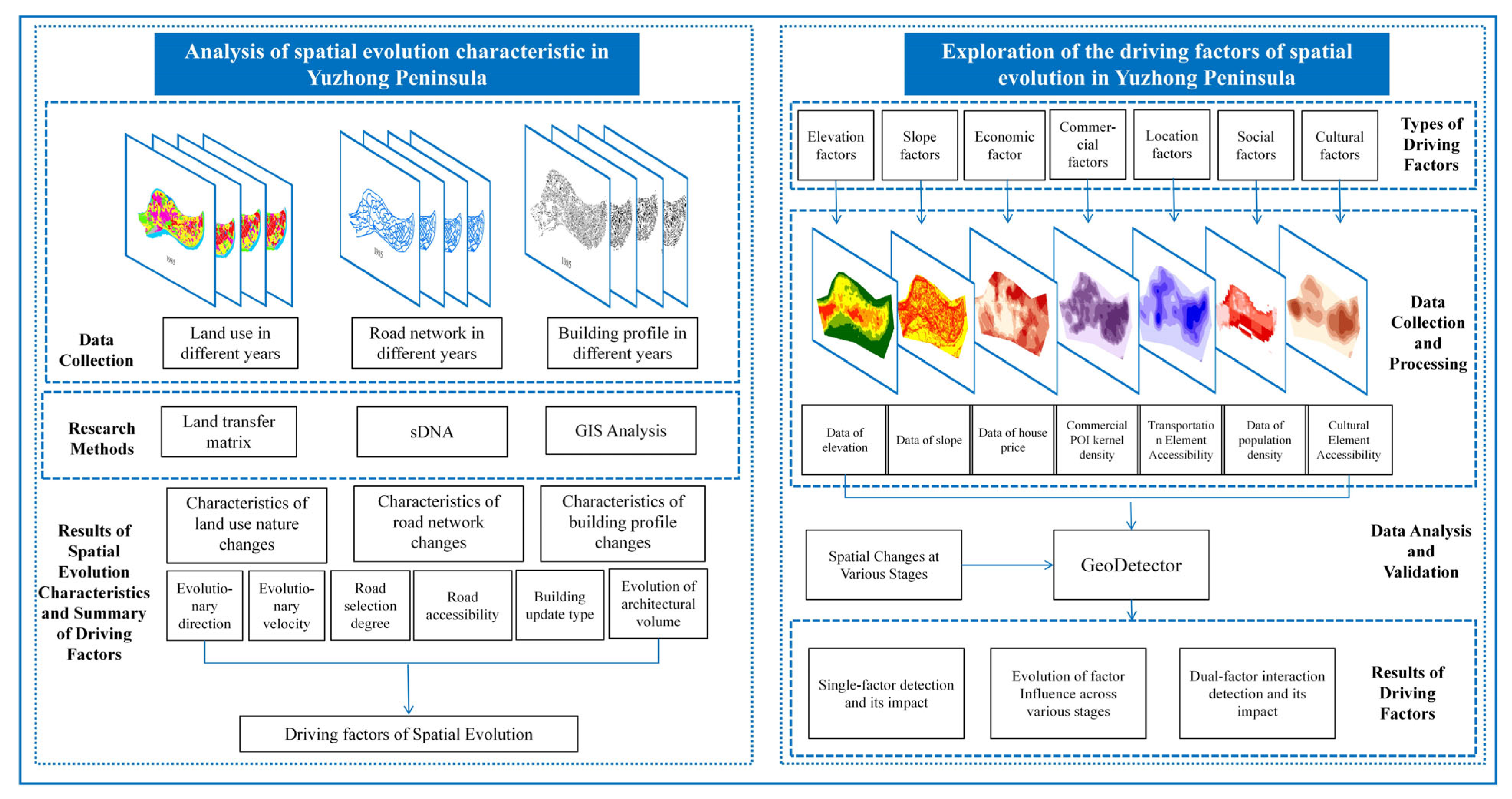
Targeting the core region of the Yuzhong Peninsula, this study develops an analytical framework to analyze spatial evolution mechanisms integrated with 3D topography. The constructed model enables a comprehensive quantitative assessment of land use transitions, road network topological changes, and building morphology renewals. As detailed in Figure 1, the overall methodology is systematically organized into two main sections: an analysis of the spatial evolution characteristics of historic urban areas and an exploration of their driving factors.
Figure 1.
Research framework.
3. Data and Methods
3.1. Overview of Study Area
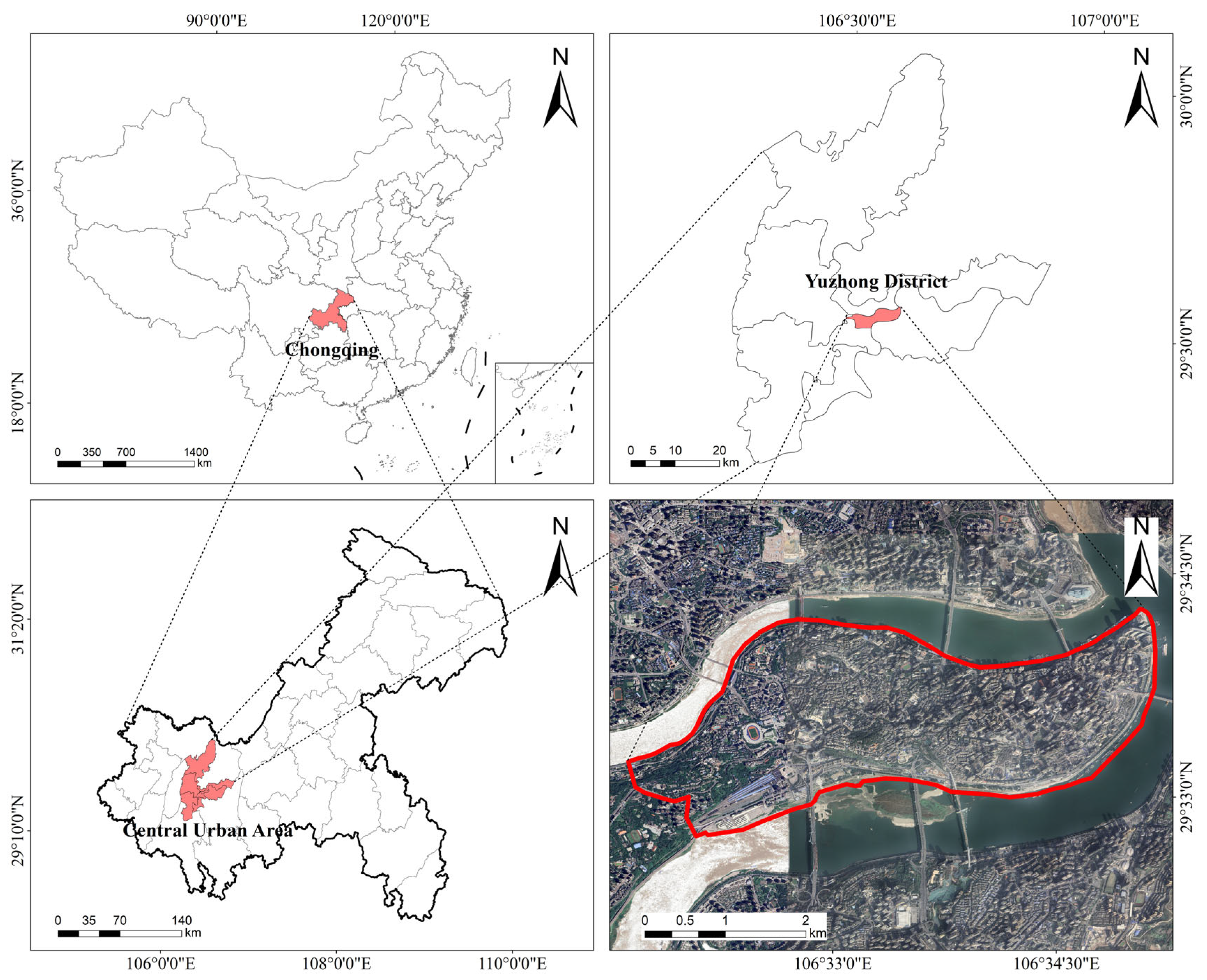
The Yuzhong Peninsula (29°31′ N to 29°34′ N, 106°30′ E to 106°35′ E), with a total area of approximately 10.2 km2, is the historical origin of Chongqing, China. Naturally embraced by the Yangtze River and the Jialing River, this region possesses prominent geographical features such as limited land area and special hilly landforms, presenting a highly overlapping 3D architectural texture under the condition of long-term extreme development adapting to the mountainous terrain. As the mother city and core of Chongqing, this area has a long history of over 3000 years since the establishment of the Ba State, carrying profound historical and cultural connotations and contextual foundations. Serving as a typical case of a high-density historic mountainous urban area, the Yuzhong Peninsula features the overlap of rigid natural topographic constraints and modern high-intensity development, giving it particularity and representativeness in spatial research. However, during the long-term process of economic development, historic urban areas transformation, and market-oriented urban redevelopment, high-intensity functional replacement and physical redevelopment have significantly changed the land use intensity and vertical spatial morphology of the region. This has impacted the authenticity of the historical landscape and threatened the traditional urban texture and original community networks with dissolution. Therefore, deeply studying and clarifying the evolutionary process of the 3D space in this region and its underlying multidimensional synergistic influencing factors holds important strategic significance for effectively protecting historic mountainous urban heritage, continuing the local cultural context, and promoting sustainable urban development (Figure 2).
Figure 2.
Map of the study area.
3.2. Data Resource
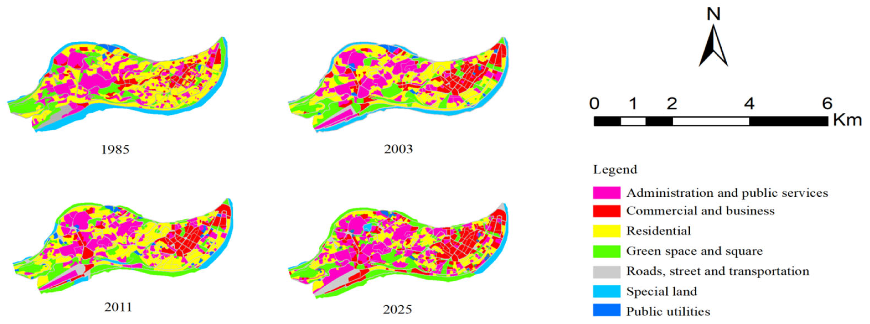
Land-use datasets for the respective study periods (Figure 3) were retrieved from local master plans and regional spatial planning archives made publicly available by the Yuzhong District Planning and Natural Resources Bureau, Chongqing (https://ghzrzyj.cq.gov.cn/zz/yzq/, accessed on 3 June 2026). These materials comprise planning status maps for Yuzhong District, Chongqing, covering the years 1985, 2003, 2011 and 2025. The 2011 edition of the Chinese Land Use Classification Standard was used to classify these maps after they were vectorized using ArcGIS (version 10.8).
Figure 3.
Multi-temporal land-use datasets pertaining to the historic urban area.
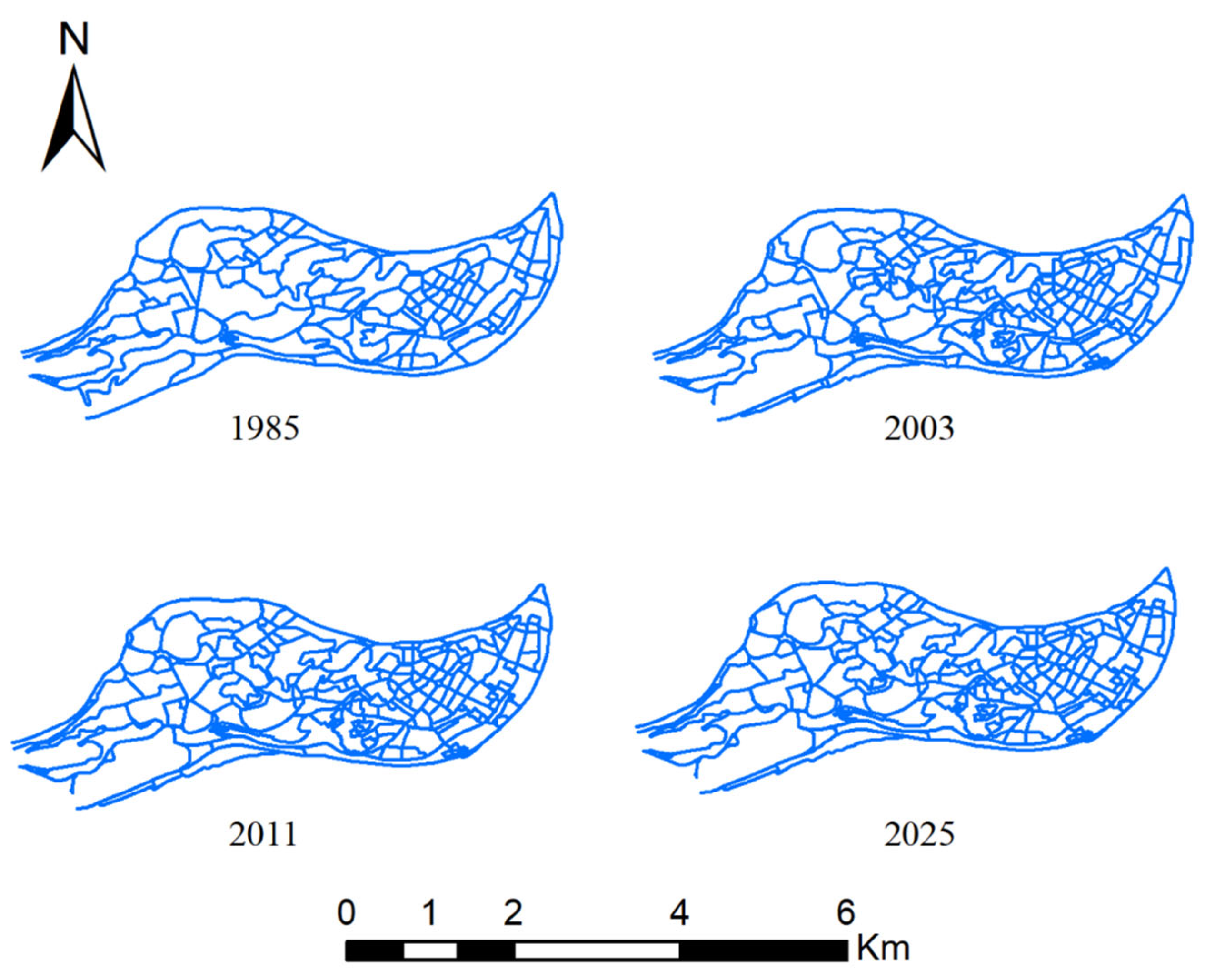
Four versions of the current planning status maps were created according to the road network data (Figure 4) from the Yuzhong District Master Plans of 1985, 2003, 2011 and the latest one for 2025. To obtain the vector data of the road centreline at each stage, ArcGIS software was used to overlay the current situation map with Google satellite images from the same time (https://www.google.cn/intl/zh-CN/earth/, accessed 5 June 2026).
Figure 4.
Multi-temporal transportation network datasets for the historic urban areas.
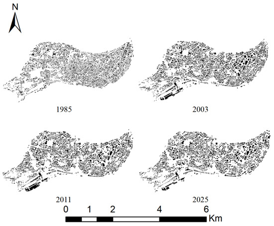
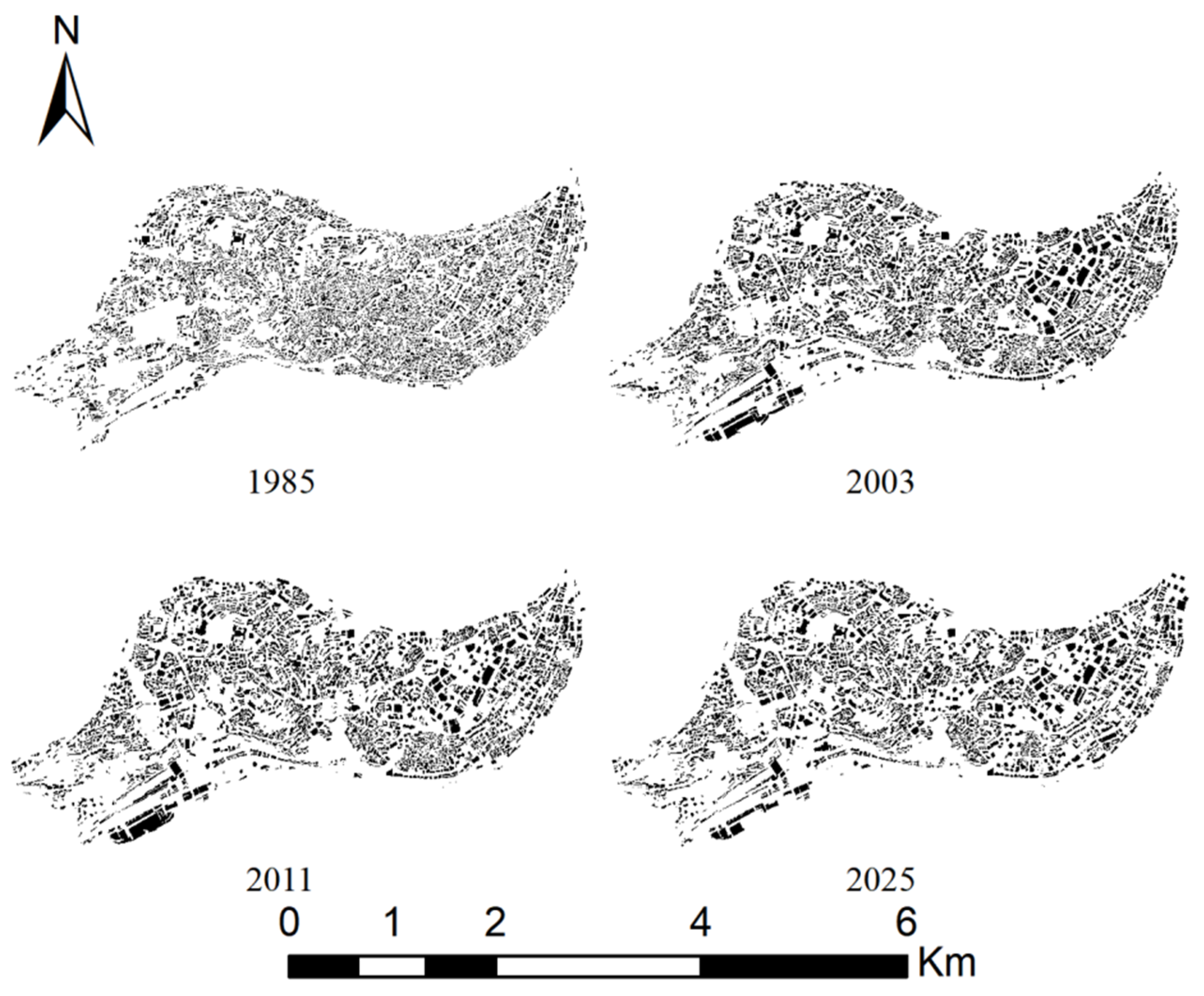
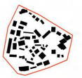
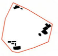
As shown in Figure 5, the building outline data were obtained by identifying and extracting information from the available image data, such as a 1985 Keyhole satellite image from the United States (https://earthexplorer.usgs.gov/, accessed on 30 May 2026) and Google satellite imagery from 2003, 2011 and 2025 (https://www.google.cn/intl/zh-CN/earth/, accessed on 5 June 2026). Building outline data for the region were gathered after the building trends for each year were identified and vectorized.
Figure 5.
Building outline data for the historical urban areas in different years.
The data for the investigation of factors affecting the spatial development of historic urban areas are points of interest (POI) data, Python network data, WorldPop data, and data released by government departments.
To minimize analytical uncertainty derived from historical mapping and manual vectorization, strict quality control procedures were implemented across all four periods. The historical satellite images and planning maps, despite varying original acquisition conditions and resolutions, were georeferenced to a unified spatial coordinate system with a Root Mean Square Error (RMSE) strictly controlled to under 0.5 pixels to ensure high positional accuracy. During the vectorization process, standardized building delineation criteria and a consistent minimum mapping unit of 10 m2 were applied uniformly to all datasets. Furthermore, independent cross-validation procedures, utilizing contemporary historical textual records and localized high-resolution imagery where available, were conducted to verify classification accuracy. Therefore, the observed spatial phenomena stem from the actual evolution of urban form, thereby minimizing the impact of factors such as non-data extraction rules or variations in image quality (Table 1).
Table 1.
Data on the influencing factors and data sources.
3.3. Research Method
3.3.1. Land Transfer Matrix
As a quantitative statistical instrument, the Land Transition Matrix effectively captures long-term spatial reconfigurations and transfers between different land-use types [41,42,43,44]. Therefore, it is introduced in this research to analyze the conversion characteristics of land utilization in the historical urban areas. The specific calculation steps are detailed below:
In this formula, represents the area of Class j land in year i.
To evaluate the pace and extent of temporal land-cover transformations in the study zone, land-use dynamic degree indicators are introduced. These metrics comprise two levels: the single dynamic degree, reflecting changes within an individual land-use class, and the comprehensive dynamic degree, reflecting aggregate shifts across all land-use categories. The mathematical formulations are defined below:
To assess the overall changes across different land-use types, this study quantified the extent of conversion for each type using the magnitude of overall change (), and characterized the rate of change using the single land-use dynamic degree (). Equations (4) and (5) were formulated to execute these numerical estimations:
3.3.2. Spatial Design Network Analysis (sDNA)
Similar to the operations of Space Syntax, the spatial design network analysis (sDNA) [45] model focuses primarily on examining transportation networks through the lens of geometric structure and relational analysis. This method abstracts roads into a network of axial lines and segments the road network based on intersections and road inflection points; additionally, it enables the calculation of closeness and betweenness metrics for roads across different years [46,47]. To evaluate the structural transformation of the street network across the historic urban areas, this approach was implemented in this research.
This method employs the Network Quantity Penalized by Distance (NQPD) approach, which treats distance as a resistance factor and utilizes Equation (6) to measure the accessibility of road segments:
Specifically, x denotes the focal road segment under evaluation; Rx signifies the collection of line segments accessible within the search radius R originating from x; W(y) and d(x, y) represent the weighting value and spatial distance between x and y, respectively; and P(y) indicates the length fraction of segment y contained inside radius R.
Betweenness refers to the probability that a specific road segment lies between other distinct roads and is selected as part of a shortest path. The more frequently a segment serves as a connecting link within shortest paths, the higher its centrality. The relevant calculations are based on the following formulas:
In this formulation, N represents the complete graph of road links across the study region. For any given origin segment y, Ry denotes the subset of reachable links bounded by the analysis radius R. The parameters W(z) and P(z) specify the weighting factor and the length fraction of link z contained within Ry, respectively. Furthermore, OD(y,z,x) quantifies the shortest path traffic assignment connecting origin y and destination x via intermediate link z.
The sDNA calculation was executed utilizing the sDNA software plugin (version 4.1.0) within the ArcGIS environment. The segment-generation rules involved splitting the axial lines at every physical intersection and structural inflection point. A snapping tolerance of 1 m was applied to fix minor digitizing errors and ensure topological connectivity. To maintain network integrity, isolated and disconnected components were excluded from the analysis. To accurately reflect the complex mountainous terrain, 3D structural elements such as bridges, tunnels, and grade-separated intersections were topologically modeled using elevation fields; they were kept disconnected from underlying ground roads unless explicitly linked by ramps or public stairs. The models were run using a 500-m search radius (Radius = 500) to evaluate macro-level spatial accessibility, employing Euclidean distance as the primary distance metric with a uniform weighting scheme applied equally across all network segments.
3.3.3. GeoDetector
GeoDetector is a statistical method used to detect spatial heterogeneity and reveal the driving forces behind changes, facilitating the identification of correlations and similarities between independent and dependent variables within spatial distributions. To assess the explanatory magnitude of individual drivers regarding the spatial transformations of the historic urban areas across distinct stages, this analytical approach was applied [48,49]. In single-factor detection, the q value quantifies the influence of a given variable. The mathematical formulation is specified as follows:
In this specification, L indicates the stratification partition; N and σ quantify the population size and global variance across the region, whereas Nh and σh correspond to these attributes within stratum h. Bounded within [0, 1], a higher q-value indicates greater explanatory power of the covariate on the target phenomenon [50]. By setting the spatial evolution of the heritage urban core as the dependent variable and environmental/socioeconomic drivers as covariates, the GeoDetector model was implemented to uncover both main effects and pairwise factor interactions.
4. Results
4.1. Spatiotemporal Transition Assessment
4.1.1. Dynamics of Land-Utilization Patterns
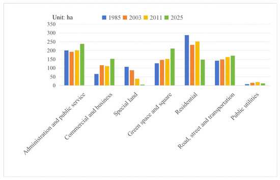
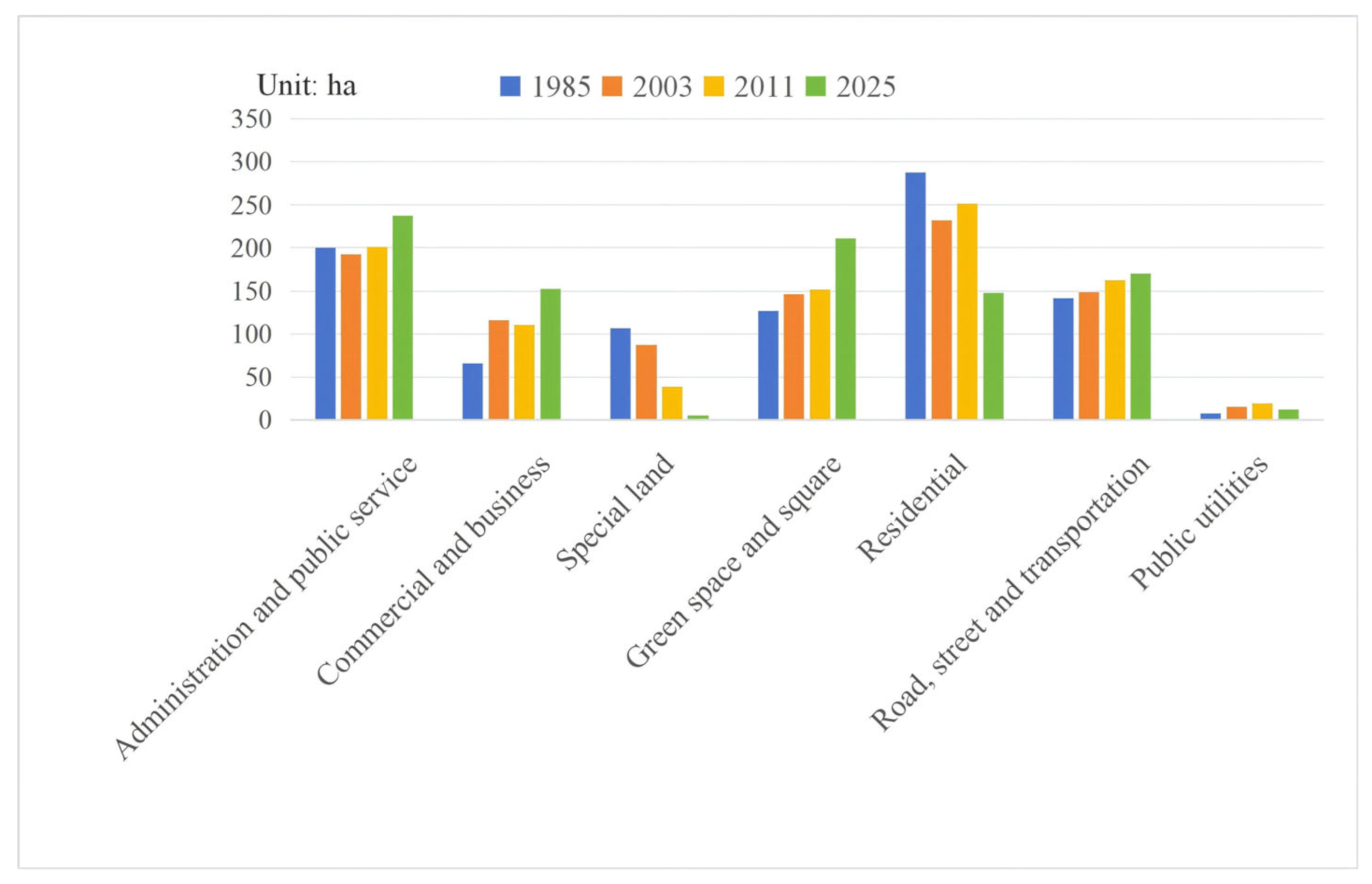
Continuously increasing types primarily include commercial and business, road transportation, and green plaza land. Accompanied by the multicenter expansion of the Jiefangbei Central Business District and the influx of capital, commercial spaces have continued to expand. To cope with the special geographical environment of being an island sandwiched between two rivers, the Yuzhong Peninsula has constructed a high-density 3D transportation network. Coupled with the pursuit of urban landscape value, this has led to a continuous rise in the proportion of transportation and green spaces.
Continuously decreasing types are typified by special purpose land. As one of the historical industrial birthplaces of Chongqing, the peninsula was densely covered with factories and shipping warehouses along the river in its early days. Along with the comprehensive transformation into a commercial and financial center and the implementation of industrial transfer policies, traditional industries and ports have all relocated from core locations, resulting in a continuous decline in this type of land.
Initially stable then increasing types mainly consist of administrative and public service land. Between 1985 and 2011, serving as both municipal and district level government centers, the spatial pattern of this category remained relatively stable. After 2011, as the mother city entered a period of improving livelihood quality, the government increased protective restoration and public resource provision for historical and cultural areas, driving the later growth of such land use. Initially increasing then decreasing types primarily refer to public utility facility land. In the early stage, to support the rapidly expanding urban scale, municipal infrastructure underwent massive surface expansion.
However, in recent years, facing the topographic constraints of extreme land scarcity, the region has vigorously promoted the undergrounding and intensive integration of facilities such as substations and utility tunnels, successfully realizing the replacement of surface space and causing its scale to decline slightly. The special evolution type refers to residential land, which has the largest base and the most substantial succession. Its evolutionary trajectory is nested within the spatial reorganization process of the Yuzhong Peninsula. Early large-scale dilapidated housing transformations cleared out numerous traditional high-density shantytowns adapted to steep slopes, leading to a reduction in residential areas. Midterm real estate development brought a brief area rebound under the influence of policies and the market. Nevertheless, in recent years, associated with urban redevelopment and functional transformation, some old residential lands in areas like Hongyadong and Shibati have been highly transformed into cultural tourism and high-end commercial land. This functional replacement, where original community networks are increasingly replaced by capital space, has resulted in a significant overall downward trend in residential land (Figure 6).
Figure 6.
Temporal distribution of land-use categories within the historic urban areas.
Findings from the land-use transition matrix reveal an accelerating spatial transformation across the Yuzhong Peninsula, with the comprehensive land use dynamic degree climbing from 0.469 between 1985 and 2003 to 0.911 between 2011 and 2025. In terms of the overall change range, commercial land increased the most, with its overall change magnitude reaching 130.938%, while special purpose land decreased the most, with a change magnitude reaching a change magnitude of −95.098%, followed by residential land, which experienced a total decrease of 48.607%. Simultaneously, the large-scale clearance of special purpose land and the expansion of spaces such as commercial and green areas, among which the change magnitude of green space and plaza land also reached 66.405%, indicate that the renewal iteration and functional transfer of internal urban space have exerted a direct impact on these developments. Based on the calculation results of the comprehensive dynamic degree for single land-use types, it can be observed that special purpose land had the fastest overall change speed and showed the most prominent development, reaching a comprehensive dynamic degree of 2.377. At the same time, road streets and transportation land, as well as administrative and public service land, had relatively slow changes. The comprehensive dynamic degrees of these two categories were 0.505 and 0.468 respectively, indicating that their spatial patterns remain relatively the most stable (Table 2).
Table 2.
Land Transition Rate and Dynamic Evolution.
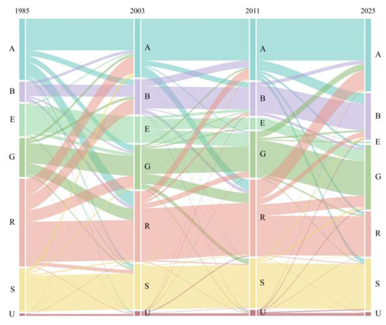
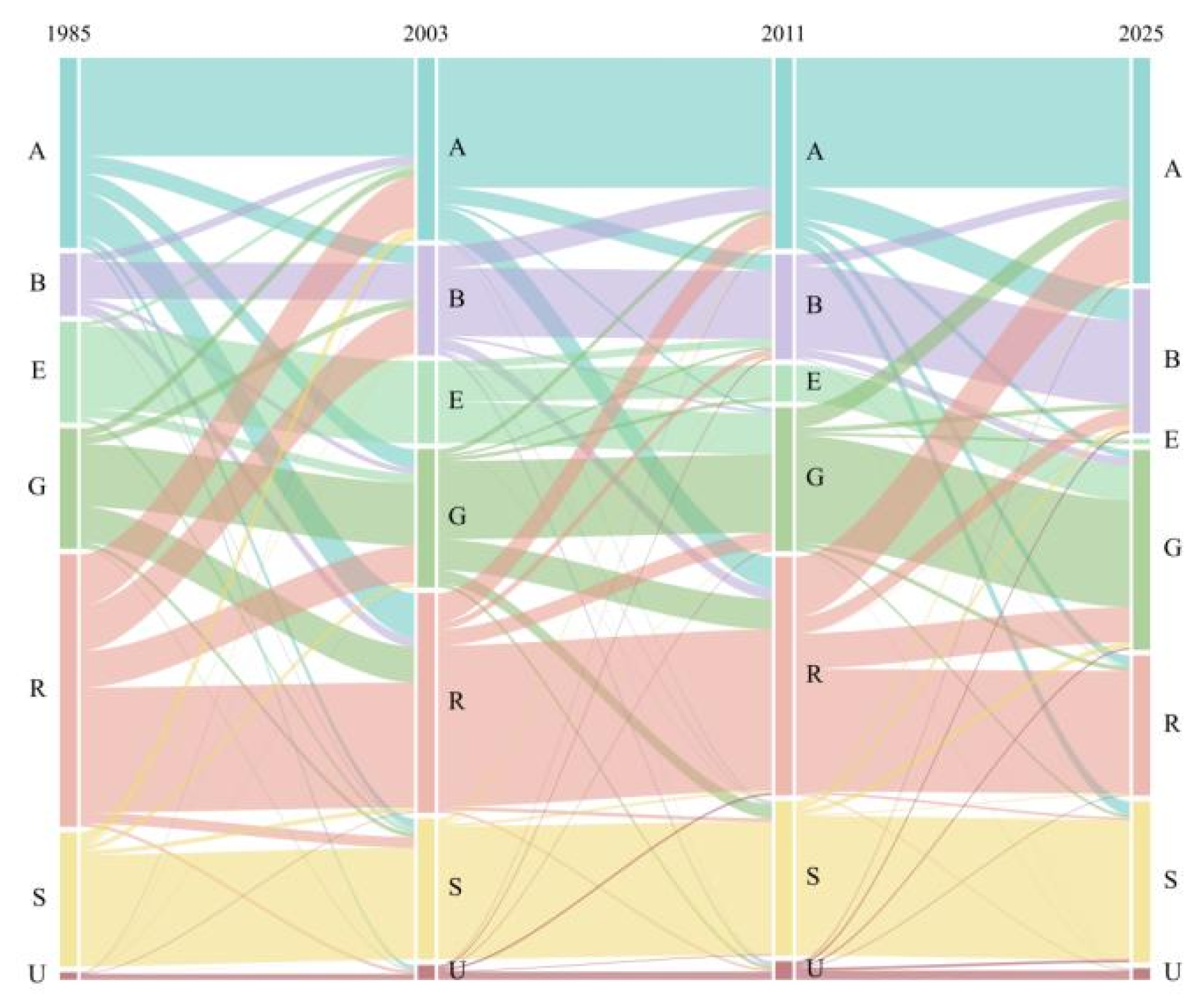
According to the statistical data on land use changes across various stages, the net change area of the land use structure between 1985 and 2003 was 83.48 hectares; between 2003 and 2011, it was 53.12 hectares; and between 2011 and 2025, it increased to 144.54 hectares. Overall, the scale of land use change in the Yuzhong Peninsula has exhibited a continuous and significant upward trend from 1985 to 2025. This indicates that the region has not become rigid like traditional old cities. Instead, it is undergoing a transition from early slow succession to recent large-scale stock renewal, demonstrating that the land use pattern of the Yuzhong Peninsula is currently in a stage of deep optimization and substantial functional reorganization (Figure 7).
Figure 7.
Distribution of land-use category variations: A, administration and public services land; B, commercial and business land; G, green and square land; E, special land; R, residential land; S, road, street, and transportation land; U, public utilities land.
4.1.2. Morphological Traits of Street Network Transformations
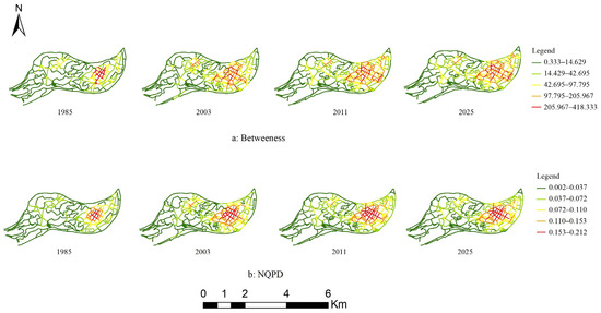
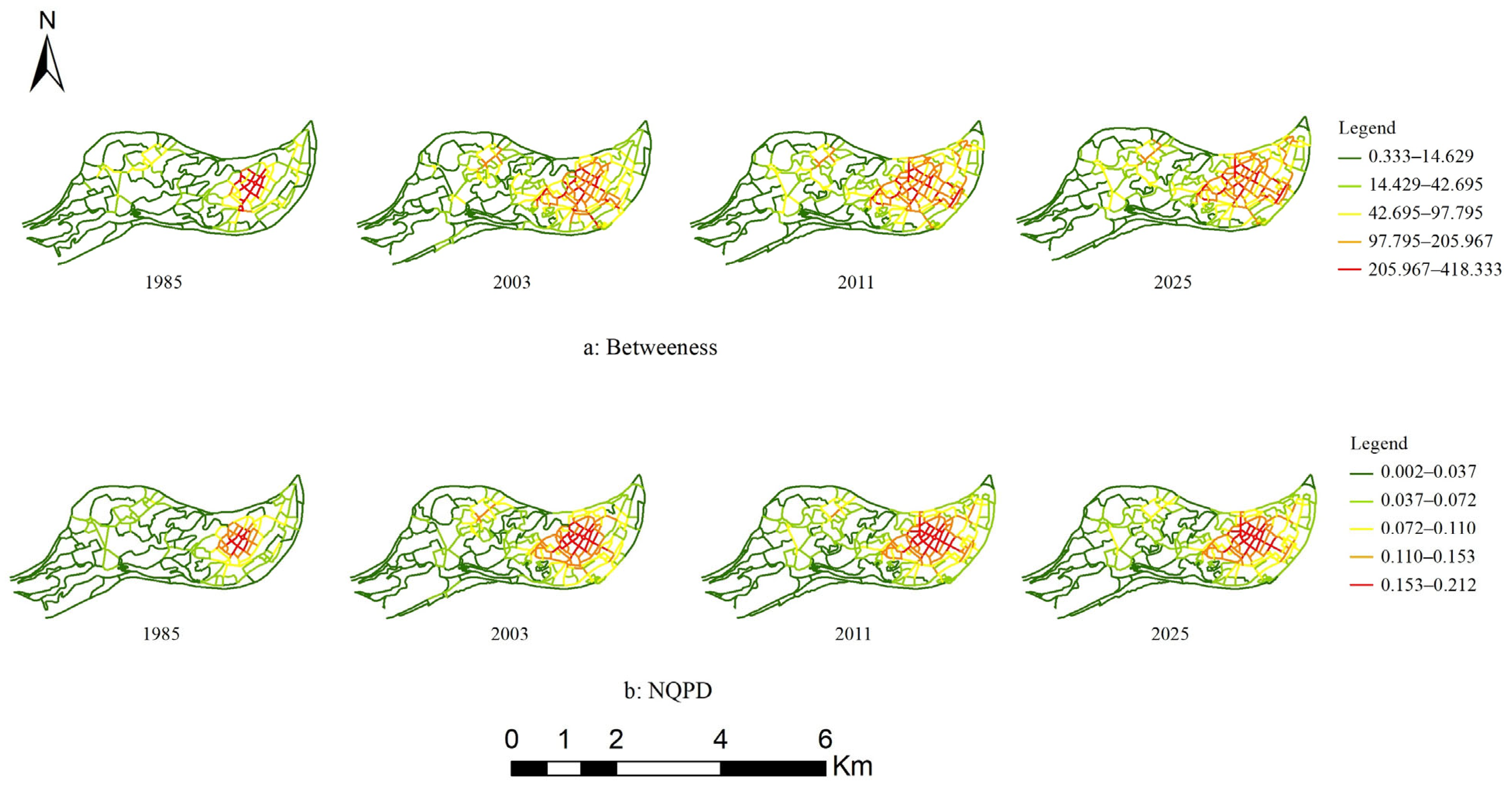
This study utilized the sDNA method to analyze the betweenness centrality and network quantitative path density (NQPD) values of the Yuzhong Peninsula in Chongqing across four periods from 1985 to 2025. The analysis results indicate that between 1985 and 2025, the spatial choice and network accessibility of the road system in the Yuzhong Peninsula exhibited significant phased evolution and core agglomeration characteristics, with overall road network density and traffic efficiency continuously improving. During the historical evolution process, the eastern historical commercial and business district centered on Jiefangbei has consistently served as a dual core for high betweenness and high NQPD values. Its cross shaped road structure and high-density traditional street layout have been maintained and consolidated throughout forty years of urban renewal. With the construction of modern transportation infrastructure and the expansion of multidirectional group connection channels in the central and western areas of Yuzhong Peninsula, the high value road network has gradually expanded westward. The concentration and differentiation of the red line areas with high betweenness centrality in the eastern core area demonstrate that the local degree of road traffic choice remains strong. The main roads bear the primary load of transit and visiting traffic and are thus more likely to be structurally congested. At the same time, the changes in the NQPD values show that the yellow and green areas of the weakly accessible central and western regions have gradually become more uniform warm colours over the years. Based on the research results, the density of the microcirculation and secondary arterial road networks in the peninsula area has been increasing steadily, and the difference in overall proximity and accessibility across the entire region is gradually narrowing. In short, the development of the road network in the Yuzhong Peninsula area has preserved the space-time layout of the old mother city and, at the same time, achieved the goal of improving traffic diversion capacity and regional accessibility through modern network topology optimization (Figure 8 and Table 3).
Figure 8.
Spatial transformations of the transportation network (1985–2025).
Table 3.
Quantitative metrics of the transportation network (1985–2025).
4.1.3. Evolution Characteristics of the Building Profile
Building extensions: This process involves the strategic placement of supplementary architectural units in vacant areas, courtyards, and unused land. Thus, the density of the districts increases while the original structure is retained.
Building demolition: This process involves the targeted removal of selected structures to generate internal open spaces, enhance spatial permeability, and decrease localized structural crowding.
Local reconstruction: Selective demolition and subsequent renovation of the existing buildings. This approach will keep the basic structure and improve the space for living and work.
Integrated redevelopment: The amalgamation of fragmented land parcels or isolated dwellings into a unified cohesive spatial entity. This intervention expands the overall development scale and streamlines complex historical site boundaries (Table 4).
Table 4.
Architectural Transition Modes across Historic Urban Areas.
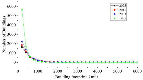
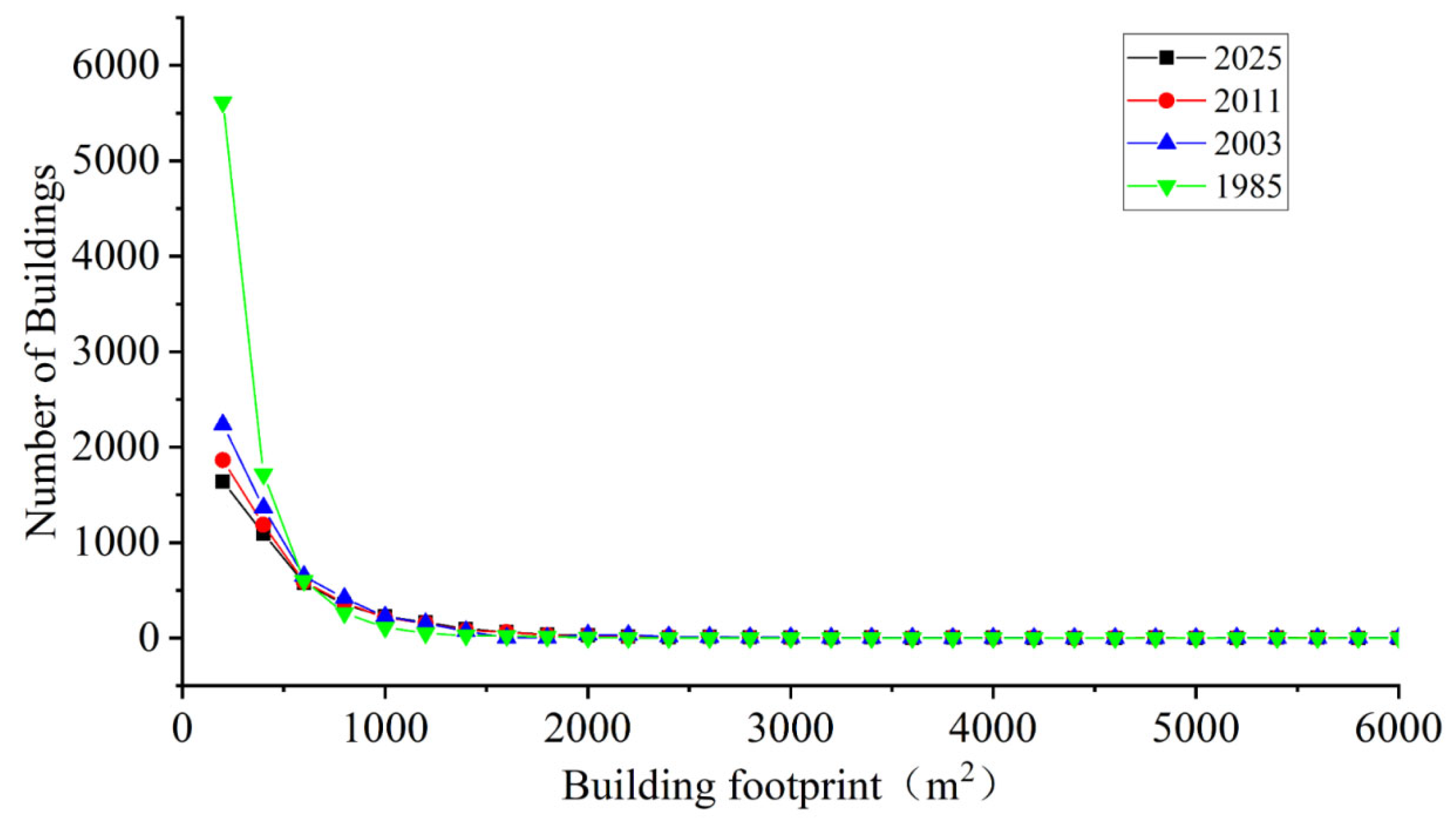
From 1985 to 2025, the average area of the buildings has been increasing steadily; that is to say, it has risen from 210.29 square meters to 473.07 square meters. The largest area showed an increase in the early days and reached a high of 32,117.52 square meters in 2011, after which this value dropped significantly by 2025. This was because of the demolition of a large-scale wholesale market near the Chongqing Railway Station in the Yuzhong District; at that time, it was converted into a parking lot, and as a result, the maximum footprint area of a single building suddenly dropped. The minimum area remained relatively stable. This overall trend is accompanied by a continuous decrease in the total number of buildings, which plummeted by nearly half from 8435 to 4373. It can be concluded that architectural space is gradually shifting towards intensification, and the scale of individual buildings is continuously expanding. According to the analysis of the data, the number of buildings with a footprint area of less than 500 square metres has decreased, and the proportion of larger buildings has been rising gradually. This change reflects the decline of traditional small-scale mountainous architecture and the rise of modern large-scale architectural styles. Furthermore, the standard deviation of building footprint areas during this period showed a trend of initially rising sharply and then slightly falling back. This indicates that the degree of dispersion in building volumes increased significantly in the early stage, and although it decreased somewhat in the later period due to spatial integration, the overall variance in building outlines has become increasingly larger compared to the early period (Figure 9 and Table 5).
Figure 9.
Building Footprint Area across Temporal Phases.
Table 5.
Renewal of the architectural fabric within the historic urban areas.
4.2. Analysis of the Spatial Evolution Driving Factors
4.2.1. Analysis of the Single-Factor Detection and Its Impact
Based on the previous analysis of the characteristics of spatial evolution for the Yuzhong Peninsula in Chongqing, this paper identifies the seven main drivers of its spatial evolution: elevation, slope, economy, commerce, location, society and culture. Then, some data were collected to serve as the independent variables for the above factors, and the changes in land use at different times on the Yuzhong Peninsula were taken as the dependent variable (Y) (Table 6). Then the above data were entered into GeoDetector for analysis. At different times, the elevation factor (X1), slope factor (X2) and land-use change data (Y) for the dependent variable were obtained by overlaying multi-temporal vector data and remote sensing images; at the same time, the data for the economic factor (X3), commercial factor (X4), location factor (X5), social factor (X6) and cultural factor (X7) were mainly constructed from raster data, including POI data from previous years, and spatial accessibility analysis was conducted using Python (version 3.10) and ArcGIS (version 10.8).
Table 6.
Variable Specification and Data Sources for GeoDetector.
To ensure rigorous spatial alignment and statistical validity for the GeoDetector analysis, all covariates and the dependent variable were standardized into a unified spatial unit. The datasets were converted into a consistent 10 m × 10 m raster resolution, matching the precision of the underlying topographic elevation and slope models. Subsequently, a systematic spatial sampling strategy was employed by generating a 50 m × 50 m fishnet grid across the study area. During this sampling process, intersecting points containing no-data values—such as river bodies and unclassified domain boundaries—were systematically excluded to prevent analytical distortion. After this pre-processing, a total of 3784 valid spatial sample points were extracted and inputted into the model (1489 for 1985–2003, 1121 for 2003–2011, and 1174 for 2011–2025).
Several elements impacting spatial evolution were significant at different stages, according to the GeoDetector analysis results. The influence is stronger when the q-value is higher. The Yuzhong Peninsula’s spatial land use evolution was mostly influenced by elevation and location between 1985 and 2003, elevation and social factors between 2003 and 2011, and elevation and location between 2011 and 2025. In the comprehensive ranking, topographic factors acted as the most central persistent spatial constraint, while social factors served as the primary dynamic temporal driver of the peninsula’s spatial evolution throughout the entire study period (Table 7).
Table 7.
Determinants underlying spatial transformations in the historic urban areas.
Comprehensive examination of spatial drivers across the four evolutionary stages reveals that topographic elevation exerts the dominant influence, followed by sociodemographic and locational attributes, and subsequently commercial, cultural, slope, and economic indicators. Notably, property values exhibit a weak correlation with spatial expansion patterns on the Yuzhong Peninsula, suggesting an insignificant spatial steering effect of real estate pricing. With the development of urban renewal and multi-dimensional transportation networks, the impact of commercial factors on the spatial changes in the peninsula has gradually been reflected in the past two stages. This trend indicates that changes in spatial structure are often positively correlated with improvements in commercial accessibility, and this correlation becomes increasingly significant over time. Therefore, optimizing the commercial spatial structure and microcirculation traffic in the peninsula region is an important pathway for driving the evolution of the modern spatial morphology of the peninsula. However, as the economy of the peninsula develops to a certain extent and infrastructure construction gradually becomes complete and saturated, the role of cultural factors in spatial evolution gradually weakens in the later period.
4.2.2. Evaluation of Interactive Impacts Between Factors
The influencing variables on the geographical evolution of the Yuzhong Peninsula from 1985 to 2025 are investigated in this research using Dual-Factor Interaction Detection through the GeoDetector. The findings show that the dual-factor interaction demonstrates both bivariate and nonlinear amplification, indicating that the combined effect of two factors is stronger than the independent effect of any one element. Specifically, the comprehensive influence of the elevation factor combined with other factors is the most significant across all three research stages, consistently occupying the strongest interactive coupling zone at the bottom of the figure. Similarly, the comprehensive impact of locational factors combined with other factors was also relatively significant during the periods from 1985 to 2003 and from 2011 to 2025. However, during the period from 2003 to 2011, the joint action of social and other factors demonstrated a greater interactive influence (Table 8).
Table 8.
Complete dual-factor interaction q-values for the spatial evolution of the Yuzhong Peninsula (1985–2025).
5. Discussion
This study takes the core area of the Yuzhong Peninsula in Chongqing, a typical representative of historical urban areas in mountainous cities in Southwest China, as the research object. Addressing the previously proposed research questions, it constructs a comprehensive research framework aimed at exploring the morphological evolution characteristics, influencing factors, and driving mechanisms of historical urban areas in mountainous cities. At the theoretical level, this study integrates multiple methods including the land-use transition matrix, the spatial design network analysis (sDNA), GeoDetector, and urban morphotypology, thereby expanding the application of quantitative urban morphology to the spatial evolution of historical urban areas in mountainous cities. In terms of practical significance, this study provides an empirical basis and reference for understanding the evolutionary mechanisms of historical urban areas in high-density mountainous cities and developing targeted strategies for their protection and renewal planning.
In historic mountainous urban areas, transformations in physical space and urban function are primarily evidenced by the succession of land utilization frameworks. Research results show that the core area of the Yuzhong Peninsula has experienced a significant reduction in residential and special purpose land over the past forty years, along with a gradual increase in commercial and business, road transportation, and green plaza land. This functional replacement, where original residential functions and old districts are increasingly replaced by capital consumption spaces, may reflect the increasing influence of commercial and market-oriented development on the spatial functions of the historic urban areas. Although some representative historical buildings have been preserved, their surrounding land uses have increasingly shifted toward commercial and cultural-tourism functions. Currently, the practice of protecting historic urban areas in China mainly relies on extensive management in 2D planes, such as delineating core protection areas and construction control zones. However, this two-dimensional zoning approach may not fully capture the vertical and morphological complexity of high-density mountainous historic areas, easily leading to the forced disintegration of original community networks and residential behaviors. Therefore, a more refined management framework could implement differentiated land use management based on the rate and magnitude of land use changes. Taking the Yuzhong Peninsula as an example, policy formulation needs to move beyond universal protection paradigms and establish a land management mechanism constrained by both vertical dimension and functional classification. Specifically, for core areas with high transport accessibility and rapid land-use change like Jiefangbei, the flexible replacement of spatial functions should be allowed. On the other hand, sites and neighborhoods carrying historical memory, as well as native small-scale residential communities with a traditional local character, they should be designated as strictly protected areas. This approach can adapt to the economic development demands of urban stock renewal while effectively mitigating severe disruptions to the historical landscape and community ecology caused by excessive functional replacement. This system should subdivide the land in the historic urban areas into flexible land with alterable uses, land with alterable uses under specific social responsibility conditions, and strictly protected unalterable land. Through this management model combining rigidity and flexibility, it is possible to conform to the economic development demands of urban stock renewal while effectively reducing potential adverse effects on the historical landscape and community ecology caused by excessive functional replacement.
The evolution of road networks and building outlines is the most intuitive physical manifestation of the reconstruction of historic urban areas. Spatial Design Network Analysis (sDNA) indicates that the eastern traditional cross shaped commercial and business district centered on Jiefangbei, serving as the core of high road network accessibility and high betweenness centrality, has been maintained and strengthened under high-density transformations over the past 40 years, bearing the main pressure of transportation and communication for the entire region. In future urban transformations, it is necessary to not only preserve this road morphology that contains the starting trajectory of the mother city but also optimize the layout of microcirculation and secondary arterial road networks facing the mountainous areas. Special steep landforms should be utilized to increase vertical transportation facilities, thereby dispersing the traffic pressure on main roads, enhancing the traffic transfer capacity within the region, and maintaining the original urban spatial texture. On the other hand, the substantial evolution of building outline data shows that the volume of single buildings in the Yuzhong Peninsula is continuously increasing. Small-scale traditional mountainous dwellings and shantytowns with a footprint of less than 500 square meters have experienced a significant drop, marking the rise of modern large-scale commercial complexes. The standard deviation of building footprint areas reached its highest point in 2011 and then fell back in 2025. This indicates that the degree of dispersion in building volumes increased significantly in the early stage due to large-scale redevelopment and investment but in the later stage, with the spatial standardized integration brought by stock renewal, differences in architectural morphology gradually narrowed. In future historic urban areas renovations and renewals, large-scale overall demolition and reconstruction must be strictly controlled, and a set of scientific 3D spatial form guidelines could be formed to maintain the cultural context of the city. Renewals should, as much as possible, integrating newly constructed buildings into the texture of the historic urban areas.
Evaluations exploring the spatial dynamics of mountainous historical areas demonstrate that the elevation factor acts as a persistent spatial constraint rather than a dynamic temporal driver. High q-values for elevation primarily indicate that spatial restructuring is concentrated within specific elevation zones, guided by topographic limitations, rather than elevation directly causing the temporal changes. Specifically, single-factor detection reveals that elevation possesses the strongest explanatory power for spatial evolution, significantly surpassing the influence of the other six factors. This is followed by social and locational factors, while economic and slope factors exhibit the weakest explanatory power. Furthermore, the dual-factor interaction analysis demonstrates that across all stages of evolution, the interaction of elevation with economic, location, social, and cultural factors exert the strongest driving force. The combined effect of elevation coupled with any of these other factors consistently exceeds the independent impact of any single factor alone, exhibiting bivariate and nonlinear enhancement. This implies that in mountainous environments, natural topographic elements and social, economic, and cultural factors are closely coupled, strengthen the driving forces behind spatial evolution. Geomorphological limitations may influence the flow of investment and the reconstruction of spatial value by altering development costs, engineering difficulty, and spatial accessibility, ultimately shaping spatial morphological changes.
Given the dominant roles of topographic constraints, locational advantages, and socioeconomic drivers in shaping spatial evolution, future conservation strategies could be closely aligned with these underlying mechanisms. Specifically, priority should be given to safeguarding the natural landscape patterns, traditional street networks, and historical building textures that are uniquely adapted to the terrain. Furthermore, to mitigate the pressures of spatial restructuring driven by population concentration and market-oriented redevelopment pressures, urban planners could implement concrete strategies to decentralize the core financial and highly concentrated commercial functions within the Yuzhong Peninsula. In addition, this can be achieved by enforcing strict zoning regulations to restrict new large-scale commercial developments, redirecting major financial hubs to emerging polycentric sub-centers, and adaptively reusing existing spaces for cultural and creative industries, and community-oriented amenities.
Although this study has made meaningful discoveries regarding the spatial evolution mechanisms of historic urban areas in high-density mountainous cities, there are still some limitations that need to be addressed in future research. Firstly, in terms of data sources and accuracy matching, the long-span study from 1985 to 2025 crosses different historical periods. Due to objective differences in land use types and remote sensing image surveys across different years, the unified classification standards and coordinate systems for the land use patterns and road vector data of historic urban areas, after undergoing manual vectorization processing, may still exert minor interference on the absolute accuracy of spatial evolution measurements. Secondly, regarding the selection of driving factors, this study focuses on examining dimensions such as topography, economy, commerce, location, society, and culture, and obtained data representing these factors for analysis based on data availability and accuracy. However, in realistic urbanization scenarios, the improvement of government management and public service levels is also an important reason affecting spatial evolution. Furthermore, the interpretation of GeoDetector results could acknowledge the presence of spatial confounding and spatial autocorrelation. In complex mountainous environments, natural and socioeconomic variables are inherently correlated; for instance, areas with a small difference in elevation naturally facilitate higher physical accessibility, which in turn attracts denser populations and commercial concentrations. Consequently, the individual explanatory power of any single factor may be confounded by these multicollinear relationships, as changes in spatial form are shaped by the interwoven network of topography and other factors rather than isolated variables. Yet, the GeoDetector mostly employs methods based on spatiotemporal heterogeneity relationships for factor effect identification, which possesses limitations.
To overcome these methodological limitations, subsequent investigations should prioritize the following key directions. Based on existing research, future studies can improve spatiotemporal granularity through the accurate matching of multisource information such as historical planning documents, old maps, and current open internet big data. Simultaneously, targeting the particularities of various types of cities, dynamic identification can be conducted. By combining qualitative and quantitative research methods like social surveys, questionnaires, and expert interviews, the genuine transitions of spatial deprivation and community attachment among indigenous residents during the gentrification reconstruction process can be comprehensively quantified. Based on the above, all kinds of quantitative analysis methods will be employed to carry out multiple spatial statistics and econometrics, as well as qualitative analysis and simulation tools, and dynamic simulations and scientific predictions can be made about the future spatial morphological evolution and transition trends of historic mountainous urban areas under the influence of various factors. Therefore, it is hoped that a reliable scientific basis for the long-term development of historic urban areas in difficult terrain will be provided in the future.
6. Conclusions
This study takes the core urban area of the Yuzhong Peninsula in Chongqing as the research object to reveal the spatial evolution laws and multidimensional driving mechanisms of historic urban areas in mountainous cities between 1985 and 2025. Regarding land use, the region has experienced significant structural reconfigurations, characterized by a continuous decline in residential and special-purpose land alongside an expansion of commercial, road transportation, and green space. Regarding the road network, overall accessibility and path density metrics have continuously increased, while the historical road network structure centered on Jiefangbei has been substantially preserved. In terms of architectural morphology, the total number of buildings has decreased by 48.2% while the average footprint area has expanded, accompanied by increasing disparities in building volume, marked by a reduction in small-scale buildings with a footprint under 500 square meters and an increase in the proportion of larger-scale buildings.
Analysis of the mechanisms driving spatial evolution reveals that the spatial transformation of the historic urban core is primarily driven by three dimensions: topographic elevation, socio-demographic conditions, and locational accessibility. Furthermore, the influence of interactions between any two factors consistently exceeds that of individual factors. Across all stages of evolution, the interaction of elevation with economic, location, social, and cultural factors exerts the strongest driving force. This indicates the presence of coupled and superimposed driving effects resulting from the interplay between natural topographic constraints and dynamic socio-economic forces during the process of urban spatial restructuring.
Author Contributions
Conceptualization, G.L., Y.G. and X.K.; methodology, G.L. and Y.G.; software and validation, G.L., X.K., W.C. and Y.G.; investigation and resources, G.L.; data curation, G.L., Y.G., W.C. and X.K.; writing—original draft preparation, G.L.; writing—review and editing, G.L. and Y.G.; visualization, X.K. and W.C.; supervision, Y.G.; project administration, Y.G. All authors have read and agreed to the published version of the manuscript.
Funding
This research received no external funding.
Data Availability Statement
The original contributions presented in the study are included in the article; further inquiries can be directed to the corresponding author.
Conflicts of Interest
The authors declare no conflicts of interest.
References
- Zhou, L. Cultural Routes and the Network Construction of World Cultural Heritage Conservation. In Proceedings of the 15th ICOMOS General Assembly and International Symposium: Monuments and Sites in Their Setting—Conserving Cultural Heritage in Changing Townscapes and Landscapes, Xi’an, China, 17–21 October 2005; Available online: https://publ.icomos.org/publicomos/jlbSai?html=Bur&base=technica&ref=41797&file=438.pdf&path=4-29.pdf (accessed on 9 June 2026).
- ICOMOS CIVVIH; ICOMOS-Korea. Urban Heritage and Sustainability, 1st ed.; Avgerinou-Kolonia, S., Hae Un, R.I., Eds.; ICOMOS-Korea: Seoul, Republic of Korea, 2017; pp. 68–71. [Google Scholar]
- Rojas, E. Historic Cities and the Venice Charter: Contributions to the Sustainable Preservation of Urban Heritage. Change Over Time 2014, 4, 196–203. [Google Scholar] [CrossRef] [Scilit]
- Geng, Y.; Ren, Y.; Fu, Z.; Zhang, X.; Lan, J. Spatial Evolution Characteristics and Driving Factors of Historic Urban Areas: A Case Study of Zhangye Historic Centre, China. Buildings 2025, 15, 961. [Google Scholar] [CrossRef] [Scilit]
- Psarra, S. The Role of Spatial Networks in the Historic Urban Landscape: Learning from Venice in the Fifteenth and Sixteenth Centuries. Hist. Environ. Policy Pract. 2018, 9, 249–273. [Google Scholar] [CrossRef] [Scilit]
- Huang, K.; Kang, P.; Zhao, Y. Quantitative Research of Street Interface Morphology in Urban Historic Districts: A Case Study of West Street Historic District, Quanzhou. Herit. Sci. 2024, 12, 226. [Google Scholar] [CrossRef] [Scilit]
- Hough, M. Cities and Natural Process: A Basis for Sustainability, 2nd ed.; Routledge: London, UK, 1995. [Google Scholar]
- Price, M.F.; Byers, A.C.; Friend, D.A.; Kohler, T.; Price, L.W. Mountain Geography: Physical and Human Dimensions; University of California Press: Berkeley, CA, USA, 2013. [Google Scholar]
- He, S. Three Waves of State-led Gentrification in China. Tijdschr. Econ. Soc. Geogr. 2019, 110, 26–34. [Google Scholar] [CrossRef] [Scilit]
- Tian, Q.; Xu, Y.; Yan, S.; Tao, Y.; Wu, X.; Cai, B. Landscape Zoning Strategies for Small Mountainous Towns: Insights from Yuqian Town in China. Sustainability 2025, 17, 6919. [Google Scholar] [CrossRef] [Scilit]
- Shen, D.; Dong, S. Transition of Urban Morphology in the Mountainous Areas Since Early-Modern Times from the Perspective of Urban Historic Landscape—A GIS Tools and Historical Map Translation Approach. Sustainability 2022, 14, 12896. [Google Scholar] [CrossRef] [Scilit]
- Smith, N. New Globalism, New Urbanism: Gentrification as Global Urban Strategy. Antipode 2002, 34, 427–450. [Google Scholar] [CrossRef] [Scilit]
- Chen, Z.; Li, S.; Wu, T.; Zhao, J.; Xu, X.; Xu, H.; You, Z. Urban Morphological Transformation under Historical Accumulation: A Spatio-Temporal Analysis of the Siwenli Lilong Neighborhood. Front. Urban Rural Plan. 2025, 3, 11. [Google Scholar] [CrossRef] [Scilit]
- Liu, S.; Jia, B. Decoding the Volumetric Urban Tissue of High-Density Wan Chai, Hong Kong. Trans. Plan. Urban Res. 2025, 4, 101–122. [Google Scholar] [CrossRef] [Scilit]
- Whitehand, J.W.R. The Making of the Urban Landscape; Institute of British Geographers Special Publication 26; Blackwell: Oxford, UK, 1992. [Google Scholar]
- Bandarin, F.; van Oers, R. The Historic Urban Landscape: Managing Heritage in an Urban Century; Wiley-Blackwell: Chichester, UK, 2012. [Google Scholar]
- Scarpaci, J.L. Plazas and Barrios: Heritage Tourism and Globalization in the Latin American Centro Histórico; University of Arizona Press: Tucson, AZ, USA, 2005. [Google Scholar]
- Logan, C. Historic Capital: Preservation, Race, and Real Estate in Washington, D.C.; University of Minnesota Press: Minneapolis, MN, USA, 2017. [Google Scholar]
- Zukin, S. Naked City: The Death and Life of Authentic Urban Places; Oxford University Press: New York, NY, USA, 2010. [Google Scholar]
- Friedmann, J. Four Theses in the Study of China’s Urbanization. Int. J. Urban Reg. Res. 2006, 30, 440–451. [Google Scholar] [CrossRef] [Scilit]
- Lees, L.; Slater, T.; Wyly, E. Gentrification; Routledge: London, UK, 2008. [Google Scholar]
- Castells, M. The Urban Question: A Marxist Approach; Edward Arnold: London, UK, 1977. [Google Scholar]
- UNESCO. Recommendation on the Historic Urban Landscape (HUL); UNESCO: Paris, France, 2011. [Google Scholar]
- Yarza Pérez, A.J.; Verbakel, E. The Role of Adaptive Reuse in Historic Urban Landscapes towards Cities of Inclusion: The Case of Acre. J. Cult. Herit. Manag. Sustain. Dev. 2025, 15, 306–339. [Google Scholar] [CrossRef] [Scilit]
- Hayden, D. The Power of Place: Urban Landscapes as Public History; MIT Press: Cambridge, MA, USA, 1995. [Google Scholar]
- Plevoets, B.; Van Cleempoel, K. Adaptive Reuse as a Strategy towards Conservation of Cultural Heritage: A Literature Review. In Structural Studies, Repairs and Maintenance of Heritage Architecture XII; Brebbia, C.A., Binda, L., Eds.; WIT Press: Southampton, UK, 2011; Volume 118, pp. 155–164. [Google Scholar] [CrossRef] [Scilit]
- Conzen, M.R.G. Alnwick, Northumberland: A Study in Town-Plan Analysis; Institute of British Geographers: London, UK, 1960. [Google Scholar]
- Kropf, K. Aspects of Urban Form. Urban Morphol. 2009, 13, 105–120. [Google Scholar] [CrossRef] [Scilit]
- Hillier, B.; Hanson, J. The Social Logic of Space; Cambridge University Press: Cambridge, UK, 1984. [Google Scholar]
- Moudon, A.V. Urban Morphology as an Emerging Interdisciplinary Field. Urban Morphol. 1997, 1, 3–10. [Google Scholar] [CrossRef] [Scilit]
- Fleischmann, M.; Feliciotti, A.; Romice, O.; Porta, S. Methodological Foundation of a Numerical Taxonomy of Urban Form. Environ. Plan. B Urban Anal. City Sci. 2021, 48, 293–310. [Google Scholar] [CrossRef]
- Yang, H.; Yang, D.; Jian, Q.; Yu, C. Population–Function Interactions and Spatial Restructuring in a Mountain City: Evidence from Chongqing, China. Sustainability 2026, 18, 7410. [Google Scholar] [CrossRef] [Scilit]
- Pei, S.; Wang, J.; Wang, W. The Impact of Terrain on the Planar Spatial Morphology of Mountain Settlements Studied Using Fractal Dimensions. Appl. Sci. 2025, 15, 3046. [Google Scholar] [CrossRef] [Scilit]
- Blouet, B.W.; Blouet, O.M. World Cities: A Global Geography; Wiley: Hoboken, NJ, USA, 2013. [Google Scholar]
- Batty, M. The New Science of Cities; MIT Press: Cambridge, MA, USA, 2013. [Google Scholar]
- Batty, M.; Longley, P. Fractal Cities: A Geometry of Form and Function; Academic Press: London, UK, 1994. [Google Scholar]
- Putnam, R.D. Bowling Alone: The Collapse and Revival of American Community; Simon & Schuster: New York, NY, USA, 2000. [Google Scholar]
- Soja, E.W. Postmetropolis: Critical Studies of Cities and Regions; Blackwell: Oxford, UK, 2000. [Google Scholar]
- Oliveira, V. Urban Morphology: An Introduction to the Study of the Physical Form of Cities; Springer: Cham, Switzerland, 2016. [Google Scholar]
- Boeing, G. Planarity and Street Network Representation in Urban Form Analysis. Environ. Plan. B Urban Anal. City Sci. 2019, 46, 168–184. [Google Scholar] [CrossRef] [Scilit]
- Chen, W.; Wang, L. Landscape Dynamics in a Poverty-Stricken Mountainous City: Land-Use Change, Urban Growth Patterns, and Forest Fragmentation. Forests 2022, 13, 1756. [Google Scholar] [CrossRef] [Scilit]
- Yang, X.; Liu, X. Carbon Conduction Effect and Temporal-Spatial Difference Caused by Land Type Transfer in Chang-Zhu-Tan Urban Agglomeration from 1995 to 2018. Acta Ecol. Sin. 2022, 42, 338–347. [Google Scholar] [CrossRef] [Scilit]
- Pontius, R.G.; Shusas, E.; McEachern, M. Detecting Important Categorical Land Changes While Accounting for Persistence. Agric. Ecosyst. Environ. 2004, 101, 251–268. [Google Scholar] [CrossRef] [Scilit]
- Pei, W.; Peng, Y.; Fan, K.; Zhang, J.; Chen, Y.; Wang, B.; Chen, L.; Liu, S.; Li, J. The Impact of Land Use on Eco-Environment in the Dianchi Basin. Heliyon 2024, 10, e32085. [Google Scholar] [CrossRef] [Scilit]
- Cooper, C.H.V.; Chiaradia, A.J.F. sDNA: 3-d Spatial Network Analysis for GIS, CAD, Command Line & Python. SoftwareX 2020, 12, 100525. [Google Scholar] [CrossRef] [Scilit]
- Zheng, B.; Tian, F.; Lin, L.; Fan, J. Study on the Morphological Analysis and Evolution of the Street Network in the Historic Urban Area of Changsha City from 1872–2023. Land 2024, 13, 738. [Google Scholar] [CrossRef] [Scilit]
- Mehmood, M.S.; Li, G.; Jin, A.; Rehman, A.; Wijeratne, V.P.I.S.; Zafar, Z.; Khan, A.R.; Khan, F.A. The Spatial Coupling Effect between Urban Street Network’s Centrality and Collection & Delivery Points: A Spatial Design Network Analysis-Based Study. PLoS ONE 2021, 16, e0251093. [Google Scholar] [CrossRef] [Scilit]
- Wang, J.; Li, X.; Christakos, G.; Liao, Y.; Zhang, T.; Gu, X.; Zheng, X. Geographical Detectors-Based Health Risk Assessment and Its Application in the Neural Tube Defects Study of the Heshun Region, China. Int. J. Geogr. Inf. Sci. 2010, 24, 107–127. [Google Scholar] [CrossRef] [Scilit]
- Hu, B.; Wu, T.; Yin, Q.; Wang, J.; Jiang, B.; Luo, J. Calibrating Spatial Stratified Heterogeneity for Heavy-Tailed Distributed Data. Ann. Am. Assoc. Geogr. 2024, 114, 1568–1586. [Google Scholar] [CrossRef] [Scilit]
- Wang, J.F.; Hu, Y. Environmental Health Risk Detection with GeoDetector. Environ. Model. Softw. 2012, 33, 114–115. [Google Scholar] [CrossRef] [Scilit]





Disclaimer/Publisher’s Note: The statements, opinions and data contained in all publications are solely those of the individual author(s) and contributor(s) and not of MDPI and/or the editor(s). MDPI and/or the editor(s) disclaim responsibility for any injury to people or property resulting from any ideas, methods, instructions or products referred to in the content. |
© 2026 by the authors. Licensee MDPI, Basel, Switzerland. This article is an open access article distributed under the terms and conditions of the Creative Commons Attribution (CC BY) license.