


Abstract
Vernacular heritage conservation often separates material fabric, environmental adaptation, and social meaning. This study addresses that separation for one settlement. Socio-environmental heritage is defined here as heritage whose significance resides in the documented interdependence of environmental conditions, material practice, social organisation, and customary governance, rather than in fabric or imagery alone. The single purpose of the article is to develop and demonstrate an evidence-based method for interpreting and conserving Thee Ain Heritage Village in Al-Baha, Saudi Arabia, as such a system. A qualitative architectural case-study design combines a structured literature search, regional comparison, the author’s 2014 field observations and photographs, and published digital-heritage, energy-retrofit, and conservation studies; no human-participant data are analysed. Evidence is organised through three analytical layers—climatic material, socio-spatial, and customary governance—and each evidence–interpretation proposition is classified as directly observed, supported architectural inference, or hypothesis requiring measurement; conservation translation is treated as the output of this sequence rather than as a parallel analytical layer. Coded claim units are documented individually so that every interpretation and implication can be traced to its source, strength, and limitation. The analysis links rocky siting, stone and timber assemblies, thick load-bearing madameek walls, limited openings, vertical domestic hierarchy, controlled thresholds, and the agricultural setting to conservation priorities at landscape, construction, spatial, and adaptation scales. These priorities include compatible repair, retention of wall depth and opening logic, protection of privacy gradients and threshold sequences, and service integration without reducing the village to stone-clad imagery. Unlike previous work centred on digital documentation, energy modelling, or policy-level preservation, the contribution is an evidence-structured method linking architectural observation to bounded interpretation, conservation decisions, and explicit future testing requirements.
1. Introduction
Saudi vernacular architecture is often approached through three dominant perspectives: heritage preservation, regional identity, and climatic adaptation. Each perspective is useful, but each is insufficient on its own. Preservation discourse can reduce buildings to historic fabric; identity discourse can turn architecture into a collection of visual signs; and environmental discourse can isolate passive strategies from the social and customary systems that made them meaningful. This article argues that Saudi vernacular architecture is better understood as a socio-environmental system: a built culture in which climate, material availability, privacy, hospitality, neighbour relations, and local custom were translated into architectural and settlement form [1,2].
The term socio-environmental heritage is used in this article in a specific and bounded sense. It denotes built heritage whose cultural significance resides in the documented interdependence of four domains—environmental conditions, material and constructional practice, socio-spatial organisation, and customary governance—rather than in physical fabric, style, or imagery considered in isolation. In this article, the concept functions as an interpretive stance that directs attention to relationships among these domains and makes the evidentiary status of each claimed relationship explicit. This definition governs the title, the research questions, the analytical framework, and the conclusions of the article.
The argument is particularly relevant to Saudi Arabia because traditional architecture developed across sharply differentiated regions. The central Najdi region is associated with mud construction, inward-facing houses, courtyards, narrow corridors, and limited exterior openings [3]. The Hijazi region is associated with dense multi-storey urbanism, stone construction, rawashin, mashrabiyas, alleyways, and plazas [4]. Eastern/oasis traditions connect clay, stone, gypsum, palm trunks, winding alleys, markets, and mosque-centred spaces [5]. Southern/highland traditions, including Al-Baha and Asir, respond to mountainous topography, stone construction, agricultural terraces, rainfall, verticality, and defensive settlement forms [6,7,8,9,10,11]. These differences do not contradict Islamic architectural culture; they show how spatial principles were localised through climate, material, topography, and urf.
The term urf is central to this article. In Islamic jurisprudential and social usage, urf refers to accepted local custom and practice. In architectural terms, it helps explain why built environments across Islamic societies could share broad spatial concerns while developing distinct local forms. Hakim connects urf to both unity and diversity in traditional Islamic cities: shared meta-principles supported a recognisable spatial culture, while local customs shaped different expressions in building practice, details, thresholds, doors, windows, materials, and domestic organisation [12].
The article also responds to a recurring problem in contemporary Saudi architectural discourse: the tendency to address the loss of urban identity through borrowed or revived images. Al-Naim argues that many Saudi identity debates have focused on reusing traditional images rather than rethinking the relationship between people and the surrounding physical environment [13]. This article therefore asks not only what vernacular architecture looked like, but how it worked: how walls, openings, thresholds, stairs, roofs, courtyards, majlis spaces, and settlement positions negotiated climate, social ethics, and limited material means.
Thee Ain Heritage Village (also transliterated Zee Ain or Dhee Ayn; Arabic: ذي عين) in Al-Baha provides the case through which this argument is developed. The purpose of the article is single and methodological: to develop and demonstrate an evidence-based interpretive method that connects the architectural evidence of Thee Ain to bounded interpretation and to conservation priorities. Two research questions follow from this purpose: (1) which climatic material, socio-spatial, and customary governance attributes and relationships of Thee Ain can be identified from the available field and documentary evidence, and what evidentiary status—direct observation, supported architectural inference, or untested hypothesis—does each carry; and (2) how can the adequately supported findings be translated into conservation priorities without reducing heritage to visual imagery? Because the available evidence is architectural and documentary, the first question focuses on identification and bounded interpretation; measured environmental performance and present-day user experience are reserved for future site monitoring and participant-based research. Thee Ain was selected because it combines a legible settlement–landscape relationship, documented construction and domestic-section evidence, independent HBIM and energy-retrofit research, and current conservation-policy relevance [14,15,16,17,18,19]; these characteristics allow a layered reading to be tested against multiple independent evidence streams within a single settlement.
Existing research has already established the importance of landscape-form integration in southwestern Saudi settlements, digitally documented the geometry and texture of Thee Ain, modelled energy-retrofit scenarios for its potential reuse, evaluated preservation approaches in Al-Baha, and examined vernacular integration in contemporary Saudi urban regeneration [11,14,15,16,17]. Building on these established evidence streams, the present study contributes an evidence-structured conservation method that distinguishes direct observation, literature-supported inference, and untested performance hypotheses, then translates those categories into priorities for landscape, construction, spatial organisation, and contemporary adaptation.
2. Literature Review and Conceptual Background
2.1. Vernacular Architecture, Islamic Spatial Order, and Regulatory Frameworks
Vernacular architecture is understood in the international literature as a built response to social need, climate, material availability, and custom rather than as a style [1,2]. Saudi vernacular architecture cannot therefore be read as a single formal vocabulary: its significance lies in how different regions translated shared socio-spatial concerns—privacy, hospitality, neighbourly conduct, climatic adaptation, material economy, and domestic hierarchy—into different forms [1,2,3,4,5,6,7,8,9,10,11]. Recent framework-oriented scholarship reinforces this systemic reading by deriving contemporary design principles from structured reviews of documented vernacular practice rather than from formal imitation [20]. Regional differentiation is not a contradiction within Islamic architectural culture; it is one of the ways that culture became locally meaningful.
Islamic architecture is often approached through visible formal markers: arches, courtyards, screens, domes, minarets, geometric ornament and inward-facing houses. While these elements matter, a stylistic reading risks reducing Islamic architecture to a vocabulary of recognisable images. Such a reduction is especially problematic for vernacular architecture because it overlooks the social, legal, environmental and customary systems that shaped buildings, neighbourhoods and domestic life.
Radoine’s critique of the madina is central to this shift. He challenges the assumption that the traditional Islamic city was random, chaotic, or merely spontaneous. Instead, its apparent irregularity embodied dynamic urban mechanisms and legal, urban, and social ideals. The madina did not follow the logic of modern planning, but it possessed order through lived practice, local codes, and cumulative use [21]. This provides a useful analytical perspective for Saudi vernacular settlements, whose compactness, thresholds, alleys, elevated positions, and material choices should not be treated as accidental.
Hakim gives this argument a more specific spatial mechanism. In his work on urf, local custom is recognised as a framework of accepted community norms that contributed directly to regional diversity in building activity [12]. Urf therefore helps explain how Islamic architecture could exhibit unity without formal uniformity. Privacy, neighbourly conduct, entry sequence, and public–private thresholds could be shared concerns, while their architectural expression differed among Hofuf, Tunis, Fez, Jeddah, Najd, and Al-Baha.
Traditional codes deepened this relationship. Hakim’s study of Mediterranean and Islamic urban and building codes shows that such codes addressed streets, walls, drainage, doors, windows, openings, heights, overlooking, planting, public edges, and neighbour rights [22]. Their concern was not aesthetic uniformity, but the equitable management of change in compact settlements. Avoidance of harm, protection of privacy, respect for prior conditions, and recognition of local custom were spatial principles.
The concept of generative processes further clarifies the issue. Hakim contrasts dynamic generative processes with static master plans, arguing that traditional environments emerged through rules, customs, and incremental actions rather than fixed blueprints [23]. This distinction is essential to the present article: Saudi vernacular architecture should not be revived as a static image, but interpreted through the generative principles that connected climate, material, privacy, hospitality, and neighbourly responsibility.
Traditional codes of this kind now operate alongside a formal national regulatory framework, and this regulatory context is integral to understanding the constraints and opportunities affecting Thee Ain. The Saudi Existing Building Code (SBC 901) addresses repair, alteration, change in occupancy, and strengthening of existing buildings, while the Saudi Historical Building Code (SBC 902) establishes requirements for the conservation, rehabilitation, reoccupation, and reconstruction of qualified historic properties, including structural, fire-safety, building-service, and historic-material provisions [24,25]. The Law of Antiquities, Museums and Urban Heritage (Royal Decree No. M/3, 1436 AH/2014) governs the classification, registration, protection, and rehabilitation of urban heritage and assigns licensing and inspection powers to the responsible heritage authorities [26]. At the level of design guidance, the Saudi Architecture Characters Map and the Sarawat Mountains architectural design guidelines translate regional architectural character into instruments intended to steer contemporary development, including in the Al-Baha highlands where Thee Ain is located [27,28]. Comparative Gulf research shows why such instruments matter for historic settlements: regeneration driven by urban branding and international recognition can conflict with retention of the relationships that produced heritage significance [29]. For Thee Ain, this statutory, technical, and design-policy environment defines both the protection available to the settlement and the pressures—tourism development, adaptive reuse, service integration, and image-led regeneration—against which the interpretive framework of this article is positioned. Within that environment, the framework functions as a pre-design interpretive procedure that complements statutory compliance, heritage-authority approval, structural diagnosis, and detailed conservation planning by identifying which relationships are sufficiently supported to inform those later processes.
2.2. Saudi Regional Cultures and the Southern Highlands
In Najd, inward mud houses, courtyards, narrow corridors, and limited openings linked family privacy, daily life, and climatic response through domestic form [3]. In the Hijaz, rawashin mediated between dense urban life, daylight, ventilation, and domestic privacy [4]. In the Eastern/oasis region, local materials, courtyard traditions, palm-based resources, and oasis settlement patterns linked architecture to climate and resource economy [5]. These regional traditions provide the comparative background, while the Southern highlands receive particular attention because Thee Ain belongs to this architectural and environmental field [6,7,8,9,10,11].
Southern Saudi architecture, especially in Asir and Al-Baha, is shaped by mountain topography, stone availability, agricultural terraces, rainfall, elevated settlement positions, and verticality. Research on Al-Alkhalaf in Asir showed that domestic space, use patterns, and social norms were interconnected in fortified houses [6]. Abu-Ghazzeh argued that Saudi vernacular education should support an authentic contemporary built environment by examining the cultural logic of traditional settlements rather than imitating their forms [7]. Eben Saleh further described architectural form and landscape in southwestern Saudi settlements as a connected entity shaped by physical, social, economic, and cultural conditions [11].
Subsequent studies have deepened this southern evidence base across two decades. Samir, Klingmann, and Mohamed used architectural survey, expert appraisal, and subjective assessment to identify social, cultural, environmental, and economic values in Asiri vernacular housing [9], and Mohamed, Klingmann, and Samir compared vernacular construction with contemporary concrete-block construction using monitored air-temperature data and complementary subjective and objective assessment [10]. These 2018–2019 studies are foundational rather than recent for this research field; the most recent southern contribution is the cross-cultural analysis by Alqahtany and Al-Gehlani, which identifies the Asir region as a distinctive mountainous, tribal, and agrarian context in which indigenous stone towers form a major component of the cultural landscape [8].
These studies establish that the Southern region is not merely a descriptive backdrop. It has been examined through domestic-space analysis, cultural and landscape interpretation, expert appraisal, multidimensional value assessment, monitored thermal performance, and cross-cultural comparison of stone towers [6,7,8,9,10,11]. The remaining question is how such heterogeneous evidence can be organised transparently for conservation decisions at a specific historic settlement.
2.3. Existing Research on Thee Ain, Methodological Precedents, and the Conservation Gap
Research on Thee Ain has advanced along three principal tracks. Alshawabkeh, Baik, and Fallatah produced a geometrically and texturally detailed Heritage BIM workflow using UAV imagery, terrestrial laser scanning, and sensor fusion [14]. Dehwah, Haredy, and Krarti modelled energy-efficiency and photovoltaic retrofit scenarios for converting the village into a hotel complex [15]. Mohamed evaluated preservation methodologies in Al-Baha, including Thee Ain, within a sustainable heritage-management perspective [16].
At the national scale, Alnaim and Alnaim examined how vernacular principles can be integrated into contemporary Saudi urban regeneration beyond symbolic or aesthetic reference, using comparative cases and mixed methods [17]. This recent study strengthens the argument that vernacular architecture operates through spatial, environmental, social, and governance relationships; however, its scale and empirical design differ from the present single-settlement conservation analysis.
Methodologically, the field offers several established procedures on which the present study builds. Heritage BIM workflows demonstrate how geometric and morphological evidence is produced and validated [14]; retrofit simulation demonstrates how performance scenarios are quantified [15]; policy evaluation demonstrates how management approaches are compared [16]; and mixed-method regeneration research demonstrates how expert and public perceptions are incorporated [17]. Two further precedents are directly relevant to the design of this study. Yang, Chen, and Xi derive a theoretical design framework for contemporary vernacular architecture from a structured scoping review of documented practice, showing how heterogeneous literature can be condensed into an explicit analytical structure [20]. Nguyen, Le, and Tran similarly construct a factor–indicator–variable framework for vernacular values from a comparative literature synthesis and apply it to paired case studies [30]. The layered framework used here follows this synthesis-to-framework procedure, while its conceptual content is drawn from the urf, building-code, and generative-order scholarship discussed in Section 2.1 [12,21,22,23]; the derivation is described in Section 3.4.
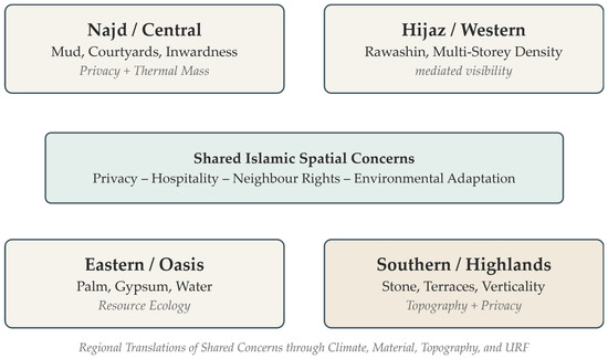
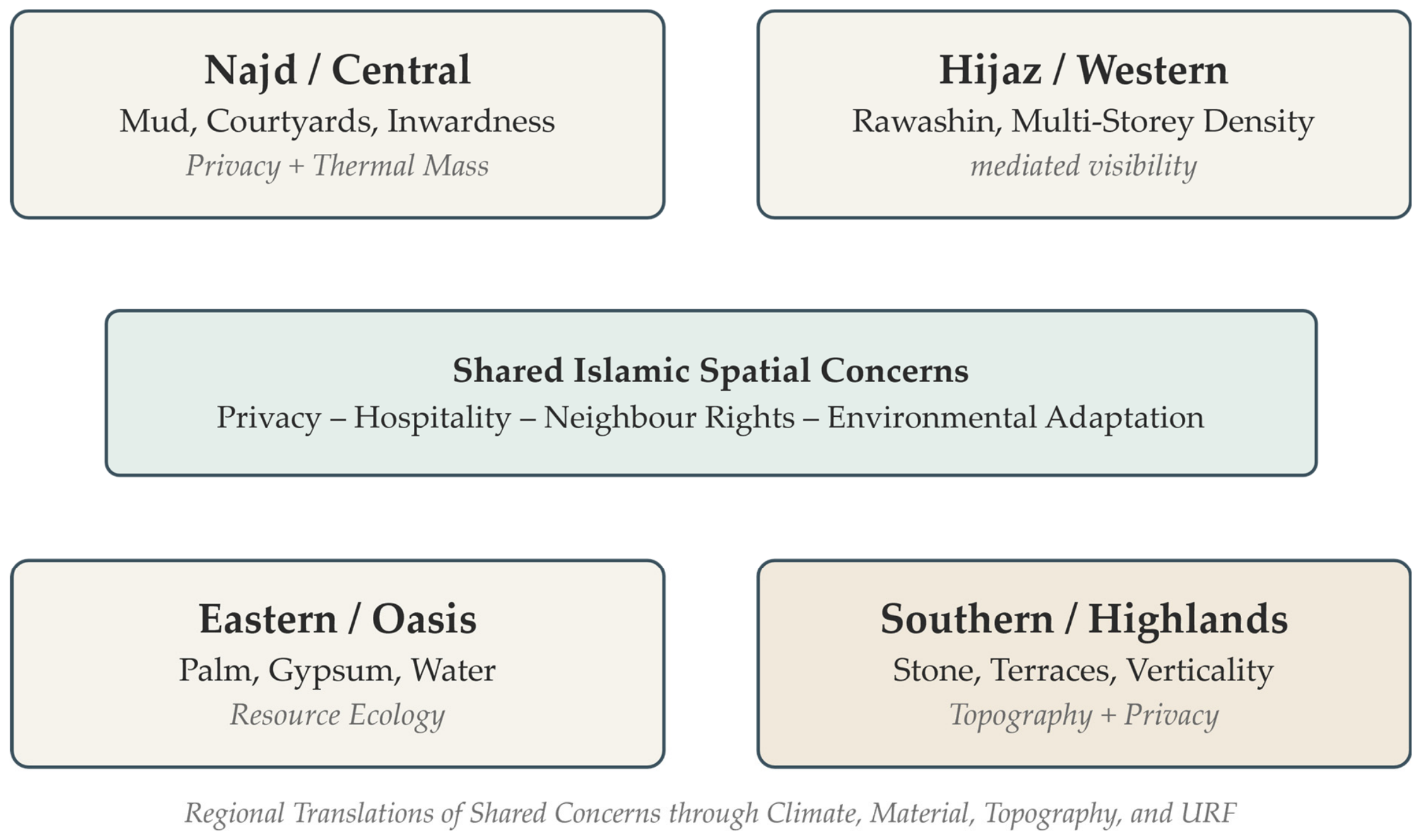
Within the defined search procedure described in Section 3.2, no study was identified that combines Thee Ain’s field-observed material and spatial evidence with an explicit claim-status protocol and a conservation-oriented layered framework. This is the gap addressed here. The framework is designed to sit before detailed intervention design: it identifies which attributes are directly observed, which interpretations are supported by regional scholarship, which performance claims remain untested, and which relationships should be protected while technical assessments proceed. As comparative background for this interpretation, Figure 1 summarises the regional socio-environmental logics of the principal Saudi vernacular cultures; the procedure by which this synthesis and the analytical framework were derived is explained in Section 3.4.
Figure 1.
Regional socio-environmental logics informing the interpretation of Thee Ain (synthesised from [1,2,3,4,5,6,7,8,9,10,11]; derivation described in Section 3.4; figure text enlarged during revision).
Table 1 organises the same regional synthesis into comparative material–environmental, socio-spatial, architectural, and interpretive dimensions.
Table 1.
Comparative regional socio-environmental logics in Saudi vernacular architecture, synthesised from [1,2,3,4,5,6,7,8,9,10,11]; the derivation procedure is described in Section 3.4.
3. Materials and Methods
3.1. Research Design
This study adopts a qualitative architectural case-study design. It combines theoretical analysis of Islamic spatial ethics, urf, and generative urban order with a regional reading of Saudi vernacular cultures and a focused interpretation of Thee Ain Heritage Village. The purpose is analytical rather than statistical: to develop a transparent framework for examining how material conditions, environmental response, social practices, and customary spatial governance become architectural form and conservation significance. The design follows established qualitative and interpretive-historical procedures in architectural research [31].
3.2. Data Sources, Case Material, and Search Procedure
The study uses four source groups. First, peer-reviewed and authoritative literature on Islamic urban order, urf, building codes, vernacular architecture, conservation doctrine, and Saudi urban identity establishes the conceptual frame. Second, established and recent studies on the Southern highlands, Asir, Al-Baha, and Thee Ain provide the regional and case-specific evidence base. Third, author field documentation produced at Thee Ain in 2014 is treated as primary architectural case material. This documentation was produced by the author during a site visit to the village in 2014 and consists of architectural photographs, written site observations, and recorded building characteristics, together with publicly distributed documentary materials issued by the tourism and heritage authorities [18,19]. The field material has not been previously published, in whole or in part; it is archived by the author and is available upon reasonable request, as stated in the Data Availability Statement. The material used is restricted to site observations, architectural photographs, recorded building characteristics, and documentary materials; interview testimony, participant quotations, personal identifiers, and all other human-participant data are excluded.
The literature search was conducted in Scopus, Web of Science Core Collection, and Google Scholar through 23 July 2026. Search strings combined Thee Ain, Zee Ain, Dhee Ain, and Dhi Ayn with Saudi, Southern, Asir, and Al-Baha vernacular architecture; urf; privacy; passive design; built heritage; conservation; digital documentation; and adaptive reuse. Reference lists and citing records were examined through backward and forward snowballing. Peer-reviewed architectural, heritage, environmental, and conservation studies, together with authoritative heritage and policy documents, were included when they provided identifiable evidence concerning material, spatial, climatic, customary, or conservation issues. Sources without a traceable relationship to these analytical domains were excluded. The procedure was structured to establish case-study saturation and traceability rather than to constitute a systematic-review meta-analysis. The search and snowballing procedure follows established guidance for structured literature identification in architectural research [31].
The rationale for selecting Thee Ain is stated in the Introduction. Analytically, the case satisfies four criteria: primary field documentation exists; independent published evidence—digital documentation, retrofit modelling, and preservation evaluation—is available for triangulation [14,15,16]; the settlement is covered by authoritative heritage documentation [18,19]; and it falls within an active national conservation-policy context [27,28]. The evidence is synthesised through the layered analytical framework described in Section 3.4.
3.3. Site and Climatic Context
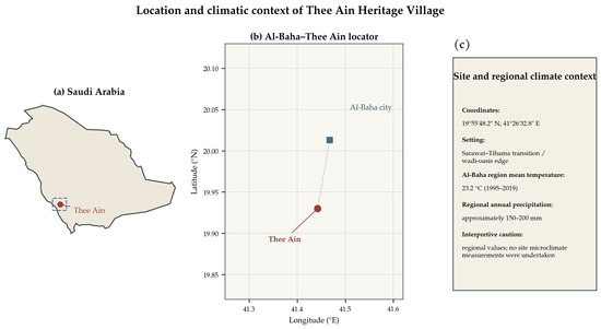
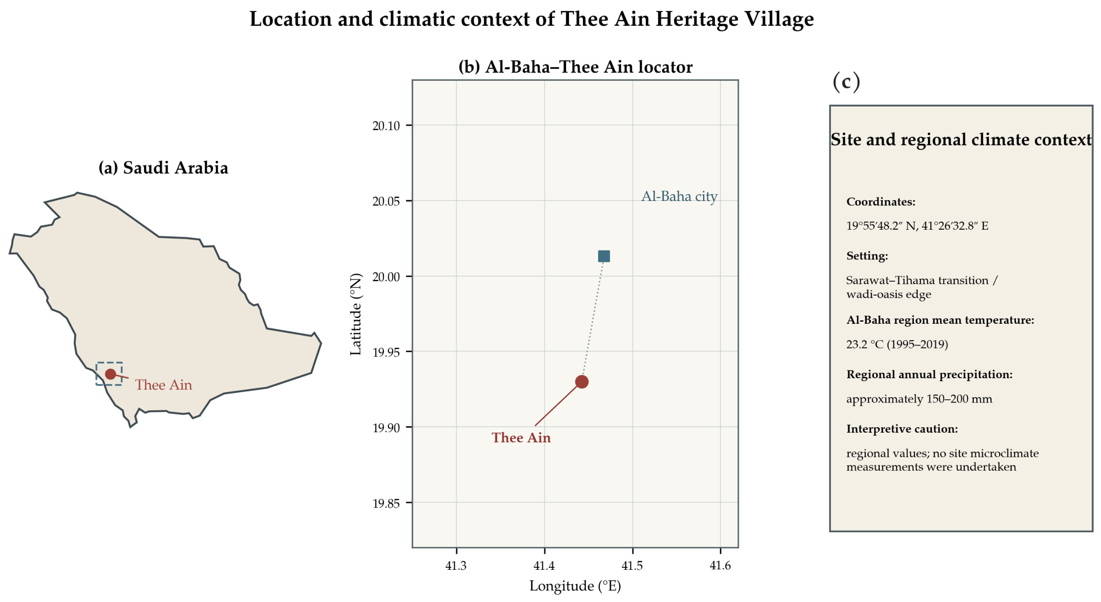
UNESCO identifies the Zee Ain Oasis and Village at 19°55′48.20″ N, 41°26′32.79″ E, within the southwestern Sarawat–Tihama transition [19]. The village occupies a white rocky outcrop above an agricultural and spring-fed setting, approximately 24 km from Al-Baha city [18,19]. Regional climatic records for Al-Baha report a mean temperature of 23.2 °C for 1995–2019 and average annual precipitation of approximately 150–200 mm [32]. These values are regional rather than site-specific. The Sarawat Mountains contain pronounced microclimatic variation associated with altitude, topography, seasonal winds, and proximity to the Red Sea [19]; no microclimate monitoring was undertaken at Thee Ain. Figure 2 therefore provides locator and climatic context only, not measured environmental performance for the village.
Figure 2.
Location and climatic context of Thee Ain Heritage Village: (a) national location of the village within Saudi Arabia; (b) position of Thee Ain relative to Al-Baha city, based on the UNESCO coordinates [18,19]; (c) summary of the regional climatic context, with values from Alghamdi et al. [32]. Climatic values are regional rather than site-specific, and no microclimate measurements were undertaken at the village. The red dot indicates Thee Ain Heritage Village and the blue square indicates Al-Baha city.
3.4. Derivation of the Regional Synthesis and Layered Framework
The comparative regional synthesis was derived in three steps. First, the regional literature identified in Section 2 [1,2,3,4,5,6,7,8,9,10,11] was read for statements concerning four comparative dimensions: material and environmental condition; socio-spatial logic; characteristic architectural expressions; and interpretive significance. Second, statements were grouped by region (Najd/Central, Hijaz/Western, Eastern/Oasis, and Southern/Highland) and condensed into a comparative matrix, retaining only content traceable to the cited sources; the same synthesis was then visualised around the shared spatial concerns identified in the urf and building-code literature [12,22]. Third, the synthesis was checked against the sources, and statements that could not be supported were removed. This literature-to-framework procedure follows the methodological precedents discussed in Section 2.3, in which analytical frameworks for vernacular architecture are constructed from structured reviews and comparative synthesis [20,30].
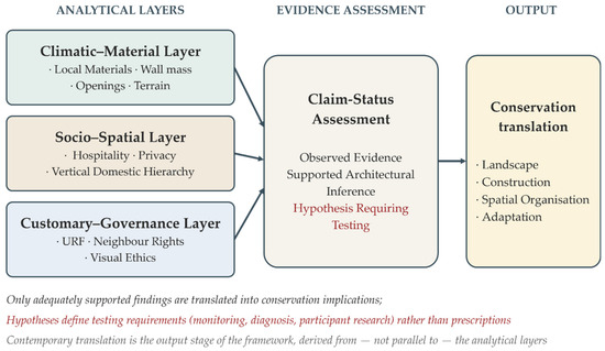
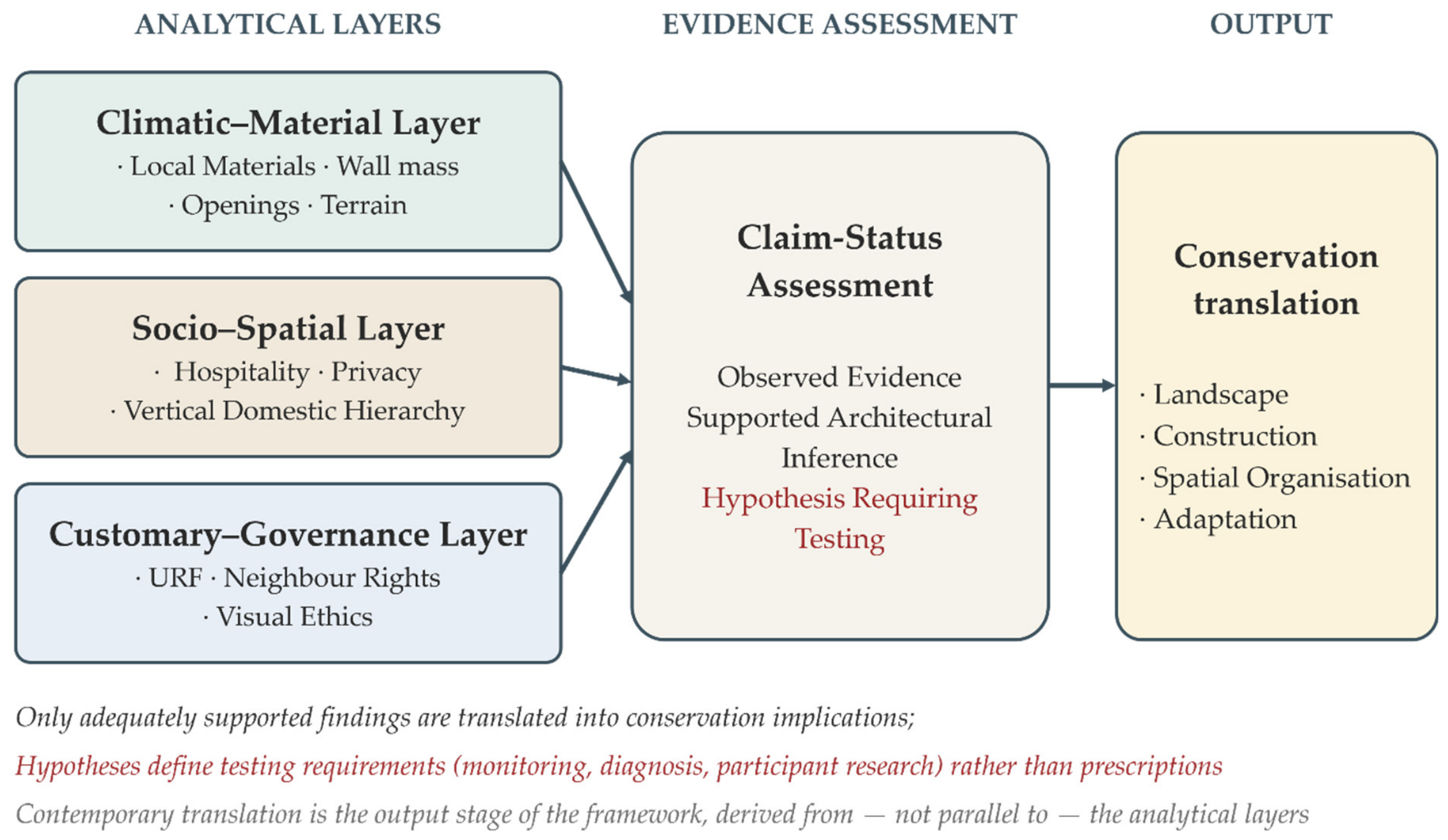
The analytical framework shown in Figure 3 was restructured during revision to make its internal hierarchy explicit. Three layers are analytical: the climatic material, socio-spatial, and customary governance layers, whose conceptual content derives from scholarship on urf, traditional building codes, and generative urban processes [12,21,22,23]. Contemporary translation is not a fourth analytical layer of equal standing; it is the output stage of the framework, in which only adequately supported findings from the three analytical layers—after claim-status assessment—are translated into conservation implications, while untested claims are converted into explicit testing requirements.
Figure 3.
The layered analytical framework: evidence is organised through three analytical layers, assessed through the claim-status protocol, and only then translated into conservation-oriented implications; contemporary translation is the output stage of the framework rather than a parallel analytical layer. The red font identifies claims classified as “Hypothesis Requiring Testing”.
3.5. Analytical Procedure and Claim-Status Criteria
The analysis proceeds in three steps. First, observable attributes—siting, wall construction and depth, roof and ceiling assemblies, opening size and orientation, vertical domestic hierarchy, thresholds, circulation, and settlement–landscape relationships—are extracted from the field material and published documentation. Second, each distinct evidence–interpretation proposition is entered into an evidence matrix and treated as one claim unit. A claim unit is defined by the proposition being assessed rather than solely by the physical element; therefore, an opening may be recorded as observed evidence and separately as an unmeasured environmental-performance hypothesis when the evidentiary boundary is explicit. Each unit is assigned to its primary framework layer and classified as: (a) observed evidence, directly visible or recorded in the case material; (b) supported architectural inference, interpreted through case configuration and relevant scholarship; or (c) performance or social hypothesis, requiring measurement, structural diagnosis, or participant research. Third, the interpretations are checked against regional scholarship and translated into conservation implications.
Assignment to the three status categories followed explicit criteria. A proposition was coded as observed evidence only when the attribute is directly visible in at least one field photograph or is explicitly recorded in the field notes or the cited published documentation. A proposition was coded as supported architectural inference when it is consistent with the observed configuration and is corroborated by at least one cited regional or doctrinal source, but no direct measurement or participant evidence exists. A proposition was coded as a hypothesis requiring further evidence when its verification would require instrumented environmental measurement, structural diagnosis, or participant-based research. Conservation implications were then derived under two rules: an implication may rest only on observed or supported units, and every hypothesis generates a testing requirement rather than a design prescription. These criteria govern the case-evidence matrix and the claim-by-claim record in Appendix A (Table A1).
The evidentiary scope of the case combines architectural observation and documentary interpretation, while calibrated thermal performance, structural condition assessment, and systematic ethnography remain subsequent lines of investigation. Digital documentation of Zee Ain provides an independent geometric and morphological record [14], while energy-retrofit modelling and recent preservation research situate the case within technical and management debates [15,16].
3.6. Conservation Doctrine and Normative Basis
The normative basis on which conservation implications are later derived is stated here, before the analysis, so that doctrine precedes rather than follows the findings. Established conservation doctrine frames intervention through cultural significance, authenticity, credible sources, and continuity of vernacular fabric. The Burra Charter treats conservation as a process guided by cultural significance, while the Nara Document requires authenticity to be assessed in relation to cultural context and credible sources of information [33,34]. The ICOMOS Charter on the Built Vernacular Heritage stresses the continuity of construction systems, materials, setting, skills, and living traditions rather than the preservation of appearance alone [35]. Value-based scholarship likewise cautions that heritage significance is socially produced and institutionally authorised rather than inherent in fabric without interpretation [36,37].
The layered framework is positioned as an operational complement to value-based conservation and authenticity assessment. Its specific contribution is to make the transition between evidence, interpretation, and conservation implication transparent by distinguishing observed attributes, supported inferences, and untested claims. A conservation recommendation is therefore traceable to both the architectural evidence that supports it and the uncertainty that limits it.
3.7. Visual Evidence, Research Integrity, and Use of Generative AI
The visual material consists of author field photographs and original analytical diagrams. Photographs are treated as architectural evidence rather than decorative illustration. Diagrams distinguish observed configuration from interpretive reading, and the tables organise evidence, claim status, and conservation implications rather than assign performance scores. Ethical review and informed consent were not applicable because the study does not analyse human-participant data, interview testimony, personal identifiers, or participant quotations. The evidential boundary is therefore limited to architectural observations, images, documentary sources, and published scholarship.
Generative artificial-intelligence tools were used for editorial assistance only. Specifically, ChatGPT (GPT-5.5 Pro, OpenAI, San Francisco, CA, USA) [38] and Claude Opus 5 (Anthropic, San Francisco, CA, USA) [39] were used to support manuscript organisation, language refinement, and the presentation of selected text and figures, in accordance with MDPI’s guidance on the use of such tools. Neither tool was used to generate or alter field observations, research data, measurements, or empirical findings. The author reviewed and verified the final manuscript and remains fully responsible for its content.
4. Results
4.1. Thee Ain: Settlement, Material, and Spatial Evidence
Thee Ain Heritage Village provides a focused case for interpreting Saudi vernacular architecture as a socio-environmental system. The 2014 field documentation describes the settlement as located southwest of Al-Baha on a white rocky outcrop and surrounded by palm, banana, kadi, and seasonal cultivation. Published inventories are inconsistent: the field documentation records 52 houses, the HBIM study describes 49 residences, and the 2015 UNESCO Tentative List entry reports 312 houses and one mosque [14,18]. Because the discrepancy cannot be resolved from the available sources, building count is excluded from the analytical variables. Age attributions vary similarly. The 2015 Tentative List is internally inconsistent, pairing the end of the 10th century AH with the 8th century CE; the former corresponds broadly to the 16th century CE. The field documentation records an approximate age of 400 years, while the later Sarawat Mountains serial nomination associates the documented regional tradition with the late 17th century [18,19]. A precise construction date is therefore not used as an analytical variable. Both UNESCO records identify the integration of vernacular architecture, rocky terrain, agriculture, and water systems as central to the site’s heritage significance [18,19].
Recent digital documentation strengthens the case evidence. Alshawabkeh, Baik, and Fallatah used sensor fusion, UAV photogrammetry, terrestrial laser scanning, and texture mapping to produce an as-built Heritage BIM representation of Zee Ain [14]. Their work provides an independent geometric and morphological record of the settlement. The present study draws on that published documentation to contextualise field-observed relationships among massing, topography, materials, and settlement form.
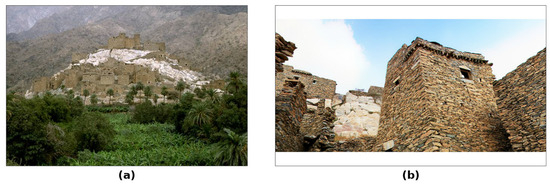
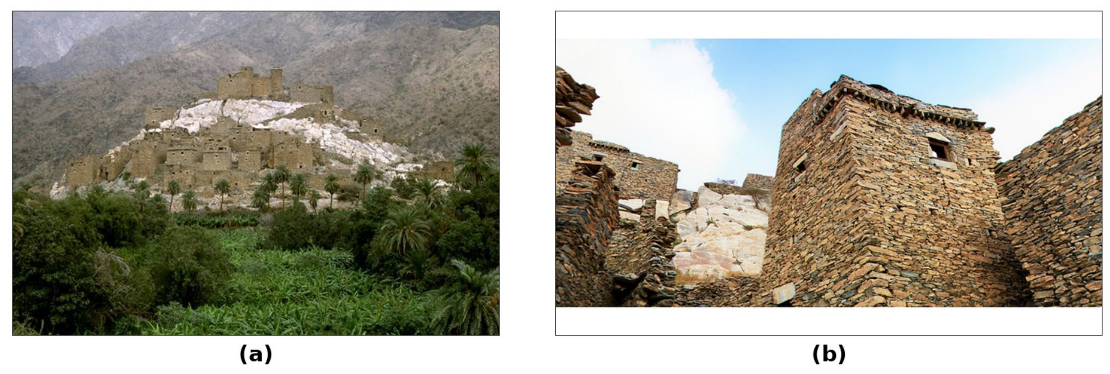
The first analytical finding concerns siting. The village is anchored to a white rocky outcrop that functions as a foundation, visual landmark, and elevated platform with potential defensive value (Figure 4a). The compact settlement mass appears continuous with the terrain, while the surrounding agricultural land links habitation to water, cultivation, and livelihood. This house–rock–farm relationship accords with wider research on architectural form and landscape in southwestern Saudi settlements and with the heritage attributes identified in the UNESCO nominations [11,18,19].
Figure 4.
Thee Ain as field-documented architectural evidence: (a) the village on its white rocky outcrop within the agricultural setting; (b) stone massing and stepped movement through the settlement. Source: Author field documentation, 2014.
The second finding concerns the construction system. The 2014 field documentation records black stone, quartz, juniper, palm fronds, and other local timber (Figure 4b). It describes a load-bearing wall system known locally as madameek, with reported wall widths of approximately 70–100 cm and vertical dimensions of approximately 230–260 cm, together with roof and ceiling assemblies involving sider wood, zafer columns, salat stones, and mud layers. The HBIM study independently reports medamik bearing wall thicknesses of approximately 0.7–0.9 m, partially corroborating the field-recorded wall depth [14]. These terms and dimensions document a local construction lexicon and material sequence; they do not, without testing, establish current structural or thermal performance.
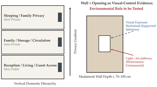
The third finding concerns the domestic section. The field documentation places reception or living functions on lower floors and sleeping spaces on upper floors, explicitly associating this distribution with increased privacy. The section therefore indicates a vertical privacy gradient: hospitality occupies the more accessible lower level, while sleeping and family withdrawal are located above. In this case, privacy is organised through section as well as through openings and thresholds (Figure 5).
Figure 5.
Analytical section and wall–opening logic: observed reception-below/sleeping-above configuration, interpreted privacy gradient, and madameek wall depth as a possible contributor to indoor environmental conditions; thermal performance is not measured in this study (figure text enlarged during revision).
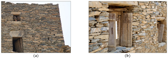
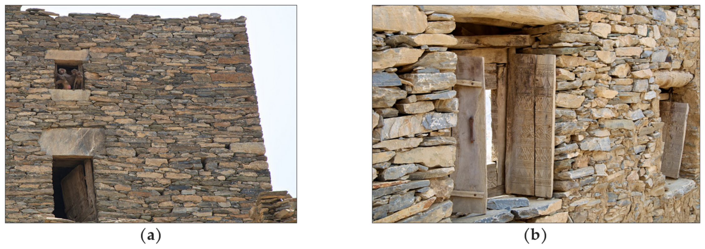
Openings reinforce the same logic. The field documentation records a limited east-facing door/window arrangement (Figure 6a,b) and relates it to air movement, room temperature, and daylight. The arrangement may also reduce visual exposure, although this socio-spatial function is an architectural inference rather than a reported occupant response. The need to admit air and light without creating unrestricted visibility is consistent with Hakim’s account of Islamic urban codes, in which door and window placement were central to privacy and neighbourly equilibrium [22].
Figure 6.
Openings and thresholds as customary governance evidence: (a) limited door and window openings in a load-bearing madameek wall; (b) threshold and timber joinery detail. Source: Author field documentation, 2014.
Table 2 consolidates the observed attributes, their claim status, and the corresponding conservation implications. The criteria used for status assignment and for deriving each implication are stated in Section 3.5, and each entry is cross-referenced to the claim units of Appendix A.
Table 2.
Case-evidence matrix applying the layered framework to Thee Ain (author field documentation, 2014; contextualised with [14,15,16,18,19,22]). Claim-unit numbers refer to Appendix A (Table A1); status-assignment criteria are given in Section 3.5.
4.2. Claim-Status Distribution and Traceability
The case matrix was coded at the level of distinct claim units, and the primary function of the coding is traceability rather than enumeration: each unit records a single evidence–interpretation proposition together with its source, strength, limitation, and conservation relevance, so that every statement in the analysis can be audited against Appendix A (Table A1). Twenty units were recorded: twelve directly observed propositions, four supported architectural inferences, and four hypotheses requiring environmental measurement or participant evidence. A claim unit represents a unique evidence–interpretation proposition; a physical feature was not counted twice within the same status category. Units relevant to more than one layer were assigned to their primary analytical layer. Table 3 summarises the distribution.
Table 3.
Descriptive distribution of claim status across the analytical layers of the framework.
The counts are descriptive rather than statistical, and no analytical weight is placed on the numbers themselves. Their value is to make the evidentiary balance auditable: the climatic material layer contains the largest body of direct evidence but also two untested environmental-performance claims, whereas the socio-spatial and customary governance layers rely more heavily on bounded inference. The contemporary-translation stage is not counted as case evidence because it is the interpretive and conservation-oriented output derived from the preceding layers.
4.3. Application of the Layered Framework
The article applies the layered interpretive model summarised in Table 4 for reading Saudi vernacular architecture as a socio-environmental system. The model functions as a relational interpretive procedure: it examines how architectural form, social practice, and environmental adaptation operate together, then uses claim status to determine how confidently those relationships can be translated into conservation implications.
Table 4.
The layered framework for vernacular interpretation and conservation-oriented translation, developed from [12,21,22,23]. The first three rows are analytical layers; the final row is the translation stage, i.e., the output of the framework (Section 3.4).
The climatic material layer concerns wall thickness, thermal mass, local material sourcing, roof assemblies, limited openings, courtyards, shaded routes, rawashin, and the relationship between material and terrain. The socio-spatial layer concerns majlis spaces, public–private gradation, family zoning, vertical domestic hierarchy, guest access, and threshold sequences. The customary governance layer concerns urf, neighbour rights, visual privacy, avoidance of harm, door/window positioning, and respect for existing conditions. The contemporary-translation stage concerns how inherited principles may remain operative without becoming decorative pastiche [23]; as established in Section 3.4, it is the output of the three analytical layers rather than a parallel dimension.
The model is relevant to contemporary Saudi policy discourse provided that regional identity is not reduced to style. The Saudi Architecture Characters Map and the Sarawat Mountains architectural design guidelines represent a current national effort to translate regional architectural character into contemporary development [27,28]. The framework adds a critical qualification: regional character should be interpreted through material, spatial, environmental, and social relationships, not only through visual language.
Thee Ain can be read through the three analytical layers and the translation stage. At the climatic material layer, stone construction, madameek walls, local timber, and limited openings provide observed evidence of material economy and enclosure, while climatic moderation remains a hypothesis requiring measurement [14,15]. At the socio-spatial layer, documented lower reception/living spaces and upper sleeping spaces support an interpretation of vertical domestic hierarchy. At the customary governance layer, controlled openings and the inferred privacy gradient are consistent with visual restraint and domestic ethics, but no occupant testimony is claimed. At the contemporary-translation stage, the settlement demonstrates why stone, mass, verticality, and agricultural setting should not be reduced to scenic heritage imagery.
The model is also explicitly anti-essentialist. Radoine challenges essentialist readings of the madina, while Hakim shows how local custom produced diversity within shared principles [12,21]. Accordingly, the model asks what a form does before asking what it resembles.
5. Discussion
5.1. Socio-Spatial and Material Interpretation
In the Thee Ain evidence, privacy operates as more than concealment: it is a spatial ethic through which domestic life, hospitality, neighbour relations, and environmental exposure are organised. Hakim’s analysis of Islamic urban and building codes identifies doors, windows, heights, openings, and visual corridors as mechanisms through which intrusion and harm could be limited [22]. In Thee Ain, the documented lower reception/living level and upper sleeping level support a bounded interpretation of vertical privacy and managed hospitality, consistent with research on Asiri fortified houses [6]. Present-day occupant experience is positioned as a subject for participant-based testing alongside this architectural reading.
Material ecology similarly extends beyond visual identity. Stone, quartz, juniper, palm components, wall depth, and roof assemblies connect local availability, craft, repair, enclosure, and a possible role in indoor environmental conditions. Regional thermal monitoring and Thee Ain retrofit modelling demonstrate why measured environmental analysis is relevant [10,15]; the present case uses those studies to frame thermal performance as a testable line of investigation. The architectural evidence supports preservation of constructional depth and material sequence while future monitoring can quantify thermal magnitude.
The analytical value of the socio-environmental reading lies in the overlap of these domains. A limited opening can be directly observed, visual restraint can be supported as an architectural inference, and daylight or airflow performance can remain unmeasured. Separating these propositions according to claim status keeps the conservation logic proportionate to the evidence and makes the inferential path transparent.
Alternative explanations are part of the claim-status discipline. The vertical section could reflect defensive priorities, the scarcity of buildable ground on the rocky outcrop, or the structural economy of stacking, in addition to a privacy ethic; the limited openings could follow from the structural behaviour of madameek masonry, which restricts large spans, as much as from visual restraint; and the east-facing arrangement could respond to slope, access, or valley winds as well as to daylight management. These explanations are compatible rather than mutually exclusive, and the current evidence does not discriminate among them. The framework therefore records the privacy and environmental readings at the level warranted by the evidence and directs competing explanations to the testing programme set out in the Conclusions.
5.2. From Heritage Image to Conservation Mechanism
Within this case, the analysis reads Thee Ain’s vernacular elements as relational architectural mechanisms rather than isolated visual motifs. Heritage-as-image occurs when stone cladding, screens, arches, decorative doors, or earth-coloured surfaces are used mainly to signal cultural recognition while their material, spatial, environmental, and social relationships are lost. Smith’s critique of authorised heritage discourse and AlSayyad’s analysis of the ‘real’, hyperreal, and virtual dimensions of tradition help explain how inherited forms can be detached from the processes that produced their meaning [36,40].
In Saudi Arabia, Al-Naim identifies a comparable tendency to answer identity loss through borrowed physical elements rather than renewed relationships between people and their environments [13]. More recent urban-regeneration research likewise argues for integration of vernacular principles beyond symbolic reference [17], and comparative Gulf studies document how branding-led regeneration can detach historic settlements from the relationships that produced their significance [29]. Applied to Thee Ain, a load-bearing stone wall carries constructional depth and material knowledge beyond the visual effect of stone veneer; a controlled opening organises visibility and enclosure beyond the image of an applied screen; and a socially organised reception sequence embeds hospitality and privacy in circulation rather than in decorative heritage styling.
The distinction between symbol and mechanism is therefore central. A symbol communicates recognition; a mechanism organises observable relationships. Thee Ain resists reduction to façade because its significance lies in the interdependence of rocky siting, compact massing, constructional depth, opening restraint, vertical hierarchy, thresholds, and agriculture. Reproducing the village’s stone appearance without those relationships would preserve visual reference while displacing the underlying knowledge system.
Contemporary translation must also consider how inherited spatial and material configurations are perceived and appraised by users. Human-centred built-environment research indicates that materiality, enclosure, layout, environmental legibility, thresholds, and perceived control may shape affective and cognitive appraisal, spatial behaviour, comfort, and perceived safety; these responses remain culturally and contextually moderated [41]. Accordingly, claims concerning current user experience are positioned as hypotheses for participant-based or post-occupancy testing, allowing the architectural interpretation to remain evidence-based while extending the framework toward contemporary use.
5.3. Relational Heritage Significance and the Architectural Contribution of the Framework
The principal architectural contribution of this study is to shift the unit of conservation attention from isolated forms to evidence-supported relationships among material construction, spatial organisation, thresholds, customary governance, topography, and the agricultural landscape. In Thee Ain, these relationships form a coherent heritage system: rocky siting and compact massing connect the settlement to its terrain; wall depth and local material assemblies connect construction to material economy and repair logic; vertical domestic organisation and threshold sequences structure hospitality and privacy; controlled openings regulate enclosure and visibility; and the spring-fed agricultural setting connects the village to its productive landscape [11,14,16,18,19]. The framework makes these interdependencies explicit and traceable rather than treating each attribute as an independent heritage feature.
This relational reading changes the way conservation priorities are formulated. The central question is not only which buildings, materials, or motifs should be retained, but which relationships must remain legible and materially supported after repair, adaptation, and service integration. A stone veneer may reproduce visual character while erasing load-bearing depth and constructional knowledge; enlarged or repositioned openings may preserve a stylistic vocabulary while disrupting visual restraint and threshold logic; altered circulation may retain individual rooms while weakening the vertical privacy gradient; and tourism infrastructure may leave buildings intact while severing the relationship between settlement, water, agriculture, and landscape. Conservation therefore becomes the protection of relational integrity across landscape, construction, spatial, and adaptation scales.
Digital documentation, energy modelling, policy evaluation, and mixed-method research remain complementary evidence streams [14,15,16,17]. Their value lies respectively in geometric recording, performance testing, governance assessment, and contemporary user or stakeholder evidence. The contribution of the present framework is to identify, before intervention selection, which material, spatial, customary, and landscape relationships constitute supported heritage significance and therefore require protection, testing, or careful negotiation. In this sense, the claim-status protocol supports a larger architectural objective: preserving the relationships through which vernacular heritage operates as a connected socio-environmental system.
5.4. Conservation-Oriented Translation of Thee Ain
The framework translates the interpretation of Thee Ain into four linked conservation priorities. At the settlement–landscape scale, conservation should protect the visual and functional relationships among the white rocky outcrop, compact village massing, paths, water systems, and agricultural setting rather than treat individual houses as isolated objects [11,16,18,19]. At the construction scale, repair decisions should prioritise compatible stone, mortar, timber, and roof assemblies; retain the depth and load-bearing logic of walls; and avoid thin visual replicas that preserve appearance while erasing constructional knowledge. Energy-upgrade options should be evaluated against these heritage relationships as well as against predicted savings [15].
At the spatial scale, conservation should retain the vertical privacy gradient, controlled threshold sequences, limited-opening logic, and relationships among reception, circulation, and family domains. At the adaptation scale, services, safety measures, visitor facilities, and accessibility improvements should minimise disruption to these spatial and material relationships and, where feasible, remain reversible and legible as contemporary interventions. These priorities function as pre-design conservation criteria that structure subsequent material diagnosis, structural assessment, environmental monitoring, and intervention design.
5.5. Limitations, Strengths of the Claim-Status Protocol, and Transferability
The study is limited by its single-case design, the 2014 date of the field documentation, discrepancies among field-recorded and published building inventories and age attributions, and the absence of calibrated thermal measurements, structural testing, systematic occupancy observation, or human-participant evidence. Building count and construction date are therefore excluded from the analytical framework. Regional climate values are used only for context and do not substitute for site microclimate monitoring. In addition, conservation works have been undertaken at the site by the Saudi authorities since its 2015 tentative listing [19]; the analysis therefore concerns the settlement as documented in 2014 and the interpretive framework derived from it, rather than the village’s present post-intervention condition.
The claim-unit coding was conducted by a single author and is intended as a traceability device rather than a statistically validated classification. This is both the strength and the principal limitation of the protocol: it makes the inferential chain auditable at the level of individual propositions, but the identification and granularity of the units, and their assignment to layers and status categories, reflect single-coder judgement and should therefore be tested through independent coding and comparative cases.
More broadly, the framework is transferable as an analytical sequence rather than as a universal catalogue of forms. Its application to another Saudi vernacular settlement is appropriate when four conditions are met: primary architectural documentation of the settlement exists; regional scholarship is available to support bounded inference; the claim-status coding can be performed—ideally independently—for the new case; and evidence concerning local custom and governance can be identified. Where these conditions are incomplete, the framework clarifies the evidentiary gaps that must be addressed; each layer can then be populated with locally specific evidence through appropriate archival, material, environmental, and community-based research.
6. Conclusions
This study shows that the architectural significance of Thee Ain is most clearly understood as relational rather than object-based. Its heritage value resides in the connections among rocky siting, compact massing, local material assemblies, constructional depth, controlled openings, vertical domestic organisation, threshold sequences, customary spatial governance, and the spring-fed agricultural landscape. The evidence-based layered framework makes these relationships explicit, establishes the evidentiary standing of each interpretation, and translates adequately supported relationships into conservation priorities.
Applied to Thee Ain, the framework identified twenty distinct claim units—twelve direct observations, four supported architectural inferences, and four hypotheses requiring further investigation—each documented individually in Appendix A. The significance of this classification lies in traceability: it distinguishes relationships that can already support conservation priorities from those that require environmental, structural, or participant-based testing before stronger claims are made.
The practical implication is that conservation should protect relational integrity rather than reproduce vernacular appearance alone. Landscape continuity, compatible material repair, wall depth and constructional assemblies, opening logic, privacy gradients, threshold sequences, and the relationship between settlement, water, agriculture, and landscape should be treated as connected conservation concerns. This relational perspective provides a case-based contribution to Saudi vernacular conservation by linking architectural significance directly to the relationships that intervention must retain, test, or carefully negotiate.
Within the case and the regional scholarship engaged here, urf emerges as a mechanism through which shared Islamic spatial concerns became regionally specific. Privacy, hospitality, avoidance of harm, and neighbourly responsibility did not produce a uniform Saudi style; they were localised through climate, topography, craft, material resources, and social practice [12,22,23].
Future research should test and refine the framework through site-specific environmental monitoring, structural and material diagnosis, HBIM, space-syntax and visibility analysis, independent claim-status coding, comparative settlement studies, and ethically designed community-based research. Post-occupancy evaluation, behavioural observation, participant interviews, and controlled virtual-reality testing could additionally examine how residents and visitors perceive material authenticity, threshold sequences, spatial legibility, privacy gradients, environmental comfort, and adaptation interventions [41]. For Thee Ain, these methods can clarify which inferred mechanisms remain operative after conservation and tourism interventions and how contemporary use can be accommodated without displacing the relationships that constitute the village’s heritage significance.
Funding
This research received no external funding.
Data Availability Statement
The field photographs and architectural observation records supporting the findings of this study have not been previously published and are available from the corresponding author upon reasonable request. All published documentary and scholarly sources used in the analysis are cited in the reference list.
Acknowledgments
The author acknowledges the non-financial institutional support of the Deanship of Graduate Studies and Scientific Research at Princess Nourah Bint Abdulrahman University. ChatGPT (GPT-5.5 Pro, OpenAI, San Francisco, CA, USA) [38] and Claude Opus 5 (Anthropic, San Francisco, CA, USA) [39] were used for editorial assistance with manuscript organisation, language refinement, and the presentation of selected text and figures, as also declared in Section 3.7. The author reviewed and verified the final content and takes full responsibility for the publication. Neither tool was used to generate or alter field observations, research data, measurements, or empirical findings.
Conflicts of Interest
The author declares no conflicts of interest.
Appendix A
Table A1 enumerates the twenty claim units used to produce the descriptive distribution reported in Table 3, together with the primary evidence source and the conservation relevance or limitation of each unit; the two final columns were added during revision to foreground traceability (Section 4.2).
Table A1.
Claim units used in the evidence-status coding of Thee Ain, with primary evidence sources and conservation relevance.
References
- Rapoport, A. House Form and Culture; Prentice-Hall: Englewood Cliffs, NJ, USA, 1969. [Google Scholar]
- Oliver, P. Built to Meet Needs: Cultural Issues in Vernacular Architecture; Architectural Press: Amsterdam, The Netherlands, 2006. [Google Scholar]
- Alnaim, M.M. The typology of courtyard space in Najdi architecture, Saudi Arabia: A response to human needs, culture, and the environment. J. Asian Archit. Build. Eng. 2024, 23, 91–110. [Google Scholar] [CrossRef] [Scilit]
- Alawad, A. Using the architectural style of heritage buildings as a tool to avoid health risks—An analytical study of Rowshan in traditional houses in the city of Jeddah. Procedia Environ. Sci. 2017, 37, 604–613. [Google Scholar] [CrossRef] [Scilit]
- Attia, M.K. Sustainability in Saudi vernacular built environment: The case of Al-Ahsa. In Vernacular Architecture: Towards a Sustainable Future; Mileto, C., Vegas, F., García Soriano, L., Cristini, V., Eds.; CRC Press: London, UK, 2015; pp. 87–92. [Google Scholar] [CrossRef] [Scilit]
- Abu-Ghazzeh, T.M. Domestic buildings and the use of space: Al-Alkhalaf fortified houses—Saudi Arabia. Vernac. Archit. 1995, 26, 1–17. [Google Scholar] [CrossRef]
- Abu-Ghazzeh, T.M. Vernacular architecture education in the Islamic society of Saudi Arabia: Towards the development of an authentic contemporary built environment. Habitat Int. 1997, 21, 229–253. [Google Scholar] [CrossRef] [Scilit]
- Alqahtany, H.M.; Al-Gehlani, W.A.G. Indigenous (stone) towers in remote regions: Cross-cultural perspective—Asir Region of Saudi Arabia, the Caucasus and Sichuan of China. J. Cult. Herit. Manag. Sustain. Dev. 2025, 15, 559–596. [Google Scholar] [CrossRef] [Scilit]
- Samir, H.; Klingmann, A.; Mohamed, M. Examining the potential values of vernacular houses in the Asir Region of Saudi Arabia. WIT Trans. Built Environ. 2018, 177, 27–38. [Google Scholar] [CrossRef] [Scilit]
- Mohamed, M.; Klingmann, A.; Samir, H. Examining the thermal performance of vernacular houses in Asir Region of Saudi Arabia. Alex. Eng. J. 2019, 58, 419–428. [Google Scholar] [CrossRef] [Scilit]
- Eben Saleh, M.A. The architectural form and landscape as a harmonic entity in the vernacular settlements of Southwestern Saudi Arabia. Habitat Int. 2000, 24, 455–473. [Google Scholar] [CrossRef] [Scilit]
- Hakim, B.S. The ‘Urf’ and its role in diversifying the architecture of traditional Islamic cities. J. Archit. Plan. Res. 1994, 11, 108–127. [Google Scholar]
- Al-Naim, M.A. Conservatism versus modernism: Hesitant urban identity in Saudi Arabia. In Architecture and Urbanism in the Middle East; Viewpoints Special Edition; Middle East Institute: Washington, DC, USA, 2009; pp. 29–33. [Google Scholar]
- Alshawabkeh, Y.; Baik, A.; Fallatah, A. As-textured as-built BIM using sensor fusion: Zee Ain Historical Village as a case study. Remote Sens. 2021, 13, 5135. [Google Scholar] [CrossRef] [Scilit]
- Dehwah, A.H.A.; Haredy, A.; Krarti, M. Retrofit analysis of historical buildings to net-zero energy: Case study of the Ain village, Saudi Arabia. Energy Build. 2022, 258, 111826. [Google Scholar] [CrossRef] [Scilit]
- Mohamed, M. Sustainable heritage preservation methodologies adopted at Al-Baha Region in Saudi Arabia. Bāb J. FSMVU Fac. Archit. Des. 2025, 6, 68–97. [Google Scholar] [CrossRef] [Scilit]
- Alnaim, M.M.; Alnaim, M.A. Integrating vernacular architecture into contemporary urban regeneration: Heritage, identity and modernization in Saudi cities. Land 2026, 15, 494. [Google Scholar] [CrossRef] [Scilit]
- UNESCO World Heritage Centre. Zee Ain Heritage Village in Al-Baha Region. Available online: https://whc.unesco.org/en/tentativelists/6031/ (accessed on 23 July 2026).
- UNESCO World Heritage Centre. The Rural Cultural Landscapes of Sarawat Mountains. Available online: https://whc.unesco.org/en/tentativelists/6640/ (accessed on 23 July 2026).
- Yang, N.; Chen, B.; Xi, J. A Theoretical Design Framework of Contemporary Vernacular Architecture Based on a Scoping Review of the Best Practices Worldwide. Buildings 2024, 14, 3525. [Google Scholar] [CrossRef] [Scilit]
- Radoine, H. Planning paradigm in the madina: Order in randomness. Plan. Perspect. 2011, 26, 527–549. [Google Scholar] [CrossRef] [Scilit]
- Hakim, B.S. Mediterranean urban and building codes: Origins, content, impact, and lessons. Urban Des. Int. 2008, 13, 21–40. [Google Scholar] [CrossRef] [Scilit]
- Hakim, B.S. Generative processes for revitalizing historic towns or heritage districts. Urban Des. Int. 2007, 12, 87–99. [Google Scholar] [CrossRef] [Scilit]
- SBC 901; The Saudi Existing Building Code. Saudi Building Code National Committee: Riyadh, Saudi Arabia, 2024.
- SBC 902; The Saudi Historical Building Code. Saudi Building Code National Committee: Riyadh, Saudi Arabia, 2024.
- Bureau of Experts at the Council of Ministers. Law of Antiquities, Museums and Urban Heritage. Available online: https://laws.boe.gov.sa/BoeLaws/Laws/SearchDetails/?Id=a7d4493b-7c03-4c2d-b3c6-a9a700f275cd (accessed on 17 August 2026).
- Saudi Press Agency. HRH the Crown Prince Launches the Saudi Architecture Characters Map to Celebrate the Kingdom’s Architectural Heritage. Available online: https://www.spa.gov.sa/w2282653 (accessed on 23 July 2026).
- Architecture and Design Commission. Sarawat Mountains Architecture: Architectural Design Guidelines. Saudi Architecture Platform. Available online: https://architsaudi.dasc.gov.sa/sarawat-mountains-architecture (accessed on 23 July 2026).
- Hanif, S.; Boussaa, D. Branding historic cities through urban regeneration: The paradigm of Gulf’orification. J. Asian Archit. Build. Eng. 2026, 1–25. [Google Scholar] [CrossRef] [Scilit]
- Nguyen, H.V.; Le, M.H.; Tran, N.P.M.A. Vernacular Values as a Framework for Contemporary Architectural Design: Insights from Vietnam. ISVS e-J. 2026, 13, 27–51. [Google Scholar] [CrossRef] [Scilit]
- Groat, L.N.; Wang, D. Architectural Research Methods, 2nd ed.; Wiley: Hoboken, NJ, USA, 2013. [Google Scholar]
- Alghamdi, A.G.; Aly, A.A.; Majrashi, M.A.; Ibrahim, H.M. Impact of climate change on hydrochemical properties and quality of groundwater for domestic and irrigation purposes in arid environment: A case study of Al-Baha region, Saudi Arabia. Environ. Earth Sci. 2023, 82, 39. [Google Scholar] [CrossRef] [Scilit]
- Australia ICOMOS. The Burra Charter: The Australia ICOMOS Charter for Places of Cultural Significance; Australia ICOMOS: Burwood, Australia, 2013; Available online: https://australia.icomos.org/publications/burra-charter-practice-notes/ (accessed on 23 July 2026).
- ICOMOS. The Nara Document on Authenticity; ICOMOS: Paris, France, 1994; Available online: https://landscapes.icomos.org/1994-the-nara-document-on-authenticity/ (accessed on 23 July 2026).
- ICOMOS. Charter on the Built Vernacular Heritage; ICOMOS: Paris, France, 1999; Available online: https://www.icomos.org/charters-and-doctrinal-texts/ (accessed on 23 July 2026).
- Smith, L. Uses of Heritage; Routledge: Abingdon, UK, 2006. [Google Scholar]
- Pendlebury, J. Conservation values, the authorised heritage discourse and the conservation-planning assemblage. Int. J. Herit. Stud. 2013, 19, 709–727. [Google Scholar] [CrossRef] [Scilit]
- OpenAI. ChatGPT (GPT-5.5 Pro) [Large Language Model]; OpenAI: San Francisco, CA, USA, 2026; Available online: https://chatgpt.com/ (accessed on 13 August 2026).
- Anthropic. Claude Opus 5 [Large Language Model]; Anthropic: San Francisco, CA, USA, 2026; Available online: https://claude.ai/ (accessed on 13 August 2026).
- AlSayyad, N. Traditions: The “Real”, the Hyper, and the Virtual in the Built Environment; Routledge: London, UK, 2014. [Google Scholar]
- Bokhari, I.A. Bounded, Affective, and Heuristic Decision-Making in Interior Built Environments: A Narrative Review and Conceptual Framework for Human-Centered Building Design. Buildings 2026, 16, 2494. [Google Scholar] [CrossRef] [Scilit]

Disclaimer/Publisher’s Note: The statements, opinions and data contained in all publications are solely those of the individual author(s) and contributor(s) and not of MDPI and/or the editor(s). MDPI and/or the editor(s) disclaim responsibility for any injury to people or property resulting from any ideas, methods, instructions or products referred to in the content. |
© 2026 by the author. Licensee MDPI, Basel, Switzerland. This article is an open access article distributed under the terms and conditions of the Creative Commons Attribution (CC BY) license.