


Abstract
The Late Triassic Bolila Formation in the central Qiangtang Basin is a typical carbonate buildup deposited during a regional transgression in the eastern Tethyan realm. Understanding its sedimentary evolution and reservoir-forming mechanisms is crucial for hydrocarbon exploration. This study integrates petrology, detrital zircon U-Pb geochronology, carbon-oxygen isotopes, and reservoir property analysis of the Quemudongda section. The results show: (1) detrital zircon dating provides a maximum depositional age of 225.7–235.7 Ma (Carnian–Norian), correcting the previous Jurassic misassignment on the 1:250,000 geological map. Carbon-oxygen isotopes (average δ13C = +3.2‰, δ18O = −11.1‰) are consistent with the global Carnian–Norian positive δ13C excursion. (2) The section reveals a platform-margin reef (hexactinellid and calcareous sponges) and slump breccia (seven layers) association, representing a steep-rimmed carbonate platform margin. The sedimentary evolution comprises three stages: reef initiation, reef flourishing with frequent slumping, and reef decline with dolomitization. (3) Reservoirs are mainly breccia and reef dolostones, with intergranular, intercrystalline, and fracture-related pores. Porosity averages 2.8% (0.8%–7.2%), permeability averages 0.35 mD (0.001–8.5 mD), defining a low-porosity, ultra-low-permeability fracture-pore reservoir. Breccia dolostone has better properties (porosity 3.71%, permeability 2.412 mD). (4) Reservoir formation is controlled by sedimentation (platform-margin facies), diagenesis (dolomitization generates pores, but high-temperature recrystallization causes densification), and tectonics (microfractures enhance permeability). High-quality reservoirs occur where breccia dolostone and fractures overlap. (5) The Bolila reef-shoal complex and the overlying Bagong Formation source rocks form a “lower reservoir—upper source” assemblage, representing a new exploration target in the Tuonamu area. The breccia dolostone–fracture overlap zone is the core “sweet spot”.
1. Introduction
As the youngest and highest continental plateau on Earth, the Qinghai–Tibet Plateau has profoundly influenced climate dynamics and resource distribution across East Asia and beyond, attracting sustained global geoscientific interest [1,2]. Located in the hinterland of this plateau, the Qiangtang Basin is bounded by the Hoh Xil–Jinshajiang suture zone to the north and the Bangong Co–Nujiang suture zone to the south. It represents the largest Mesozoic marine sedimentary basin in the northern Tethyan–Himalayan tectonic domain. The formation and evolution of this basin are intimately linked to the closure of the Paleo-Tethys Ocean and the subsequent opening of the Neo-Tethys Ocean [3,4,5]. Regional syntheses have recognized multiple Tethyan Ocean basins and their accretionary histories [6]. The basin hosts a thick succession of Triassic–Jurassic marine strata, making it not only a pivotal area for understanding Tethyan tectonic evolution but also a key strategic frontier for onshore hydrocarbon exploration in China [7,8,9]. The complex pre-Cenozoic evolution of the Tibetan Plateau involved multiple phases of terrane accretion, continental rifting, and basin formation [10].
Among the marine strata in the Qiangtang Basin, the Upper Triassic Bolila Formation and the Middle Jurassic Buqu Formation are the two most representative carbonate successions. The Bolila Formation, deposited during the Carnian–Norian stages of the Late Triassic, records a major regional transgression. Its lithology is dominated by carbonate platform limestones and bioclastic limestones, with local reef development, representing the last large-scale carbonate buildup on the northern margin of the Qiangtang block prior to the closure of the Paleo-Tethys Ocean [11,12,13]. Moreover, the Bolila Formation exhibits considerable hydrocarbon exploration potential due to the presence of platform-margin reef-shoal dolomitized reservoirs [14,15]. Recent studies have highlighted the importance of Late Triassic tectono-sedimentary processes in controlling the distribution of reef-shoal reservoirs in the Qiangtang Basin [16]. However, harsh natural conditions, poor outcrop continuity, complex structural deformation, and inherent limitations of biostratigraphic studies have led to long-standing controversies regarding the stratigraphic division and age assignment of key units in this region [13,17]. Consequently, the sedimentary evolution model and reservoir-forming mechanisms of this formation remain poorly understood. The Carnian Pluvial Episode (CPE) was a major climatic perturbation that significantly influenced shallow-water carbonate production across the Tethyan region [18].
As an important potential reservoir in the Qiangtang Basin, the Bolila Formation poses several key scientific questions concerning its sedimentary evolution and reservoir formation: (1) What is the precise depositional age of the Bolila Formation, and how can a robust chronostratigraphic framework be established to resolve regional stratigraphic controversies? (2) What sedimentary system does the Bolila Formation represent? Integrated studies of the Late Triassic–Jurassic tectono-sedimentary evolution have revealed significant spatial and temporal variations in depositional systems across the Qiangtang Basin [19], and how did the platform-margin reef-shoal system respond to the Late Triassic transgression? (3) What are the formation mechanisms and principal controlling factors of the Bolila Formation reservoirs, and how do dolomitization, dissolution, and fractures contribute to reservoir quality? Addressing these questions is of great scientific significance for reconstructing the Late Triassic paleogeographic framework of the Qiangtang Basin and evaluating its hydrocarbon potential. The Carnian Pluvial Episode (CPE) was marked by multiple negative carbon-isotope excursions and profound climatic changes that affected carbonate production across Tethys [20].
This study focuses on the Quemudongda section in the Tuonamu area, which is located in the central part of the North Qiangtang Depression. This section exhibits a complete stratigraphic succession, making it an ideal candidate for investigating the sedimentary evolution and reservoir-forming effects of the Bolila Formation. The following work is systematically carried out: (1) detailed sedimentary facies analysis and microfacies identification to reconstruct the depositional model; (2) detrital zircon U-Pb dating and carbon-oxygen isotope analysis to precisely constrain the depositional age and reconstruct the paleo-marine environment; and (3) reservoir petrology and physical property analysis to reveal pore types, diagenetic processes, and their control on reservoir quality. By integrating these analyses, this study aims to elucidate the sedimentary evolution pattern and reservoir-forming effects of the Bolila Formation, thereby providing a scientific basis for hydrocarbon exploration in the Qiangtang Basin.
2. Regional Geological Setting
The Qiangtang Basin, covering an area of approximately 18 × 104 km2 in the north-central part of the Qinghai–Tibet Plateau, represents the largest Mesozoic marine sedimentary basin on the plateau [3,21]. It is bounded to the north by the Hoh Xil–Jinshajiang suture zone and to the south by the Bangong Co–Nujiang suture zone (Figure 1a), which mark the closure of the Paleo-Tethys and Meso-Tethys oceans, respectively. These sutures collectively underpin the key tectonic role of the Qiangtang Basin in the evolution of the Tethyan realm [1,2,19]. The Mesozoic Qiangtang Basin experienced a complex interplay of Tethyan subduction, continental collision, and intracontinental deformation [22]. The opening of the Bangong-Nujiang Tethyan Ocean during the Late Triassic is evidenced by ocean island remnants and rift-related volcanic rocks [23]. Based on basement nature and sedimentary cover characteristics, the basin can be divided from north to south into three second-order tectonic units: the North Qiangtang Depression, the Central Uplift, and the South Qiangtang Depression [11,24]. The Central Uplift, which strikes nearly east–west, exposes Precambrian metamorphic basement and Paleozoic low-grade metamorphic rocks, and serves as a major tectonic divider between the northern and southern parts of the basin [25]. The study area, the Quemudongda section, is located in the central part of the North Qiangtang Depression, a position that is highly representative for recording Late Triassic sedimentary responses.
Figure 1.
(a) Tectonic framework of the Qiangtang Basin and location of the study area. The map shows the North Qiangtang Depression, Central Uplift, South Qiangtang Depression, main suture zones, and the study area (red square). (b) Simplified geological map of the study area, and the location of Quemudongda outcrop marked by a star, and Que‘er Cake outcrop marked by a triangle.
The Late Triassic was a critical transitional period in the evolution of the Qiangtang Basin. Under the combined influence of the closure of the Paleo-Tethys Ocean and the opening of the Neo-Tethys Ocean, the basin underwent a fundamental tectonic regime shift: the northern Qiangtang area gradually rose from a foreland basin to a subaerial setting, whereas the southern Qiangtang area shifted from continental to marine sedimentation, resulting in a “paleogeographic inversion” [5,26]. This transition not only controlled the distribution of Late Triassic sedimentary facies but also directly influenced the development and distribution of hydrocarbon source rocks and reservoirs. During the Carnian–Norian stages of the Late Triassic, the Qiangtang block was situated at a low latitude on the northern margin of the Paleo-Tethys Ocean. A warm and humid climate, coupled with regional transgression, gave rise to extensive carbonate platforms [11,15]. In the North Qiangtang Depression, the Bolila Formation was deposited as a typical carbonate buildup, and the high-energy platform-margin facies provided favorable conditions for the growth of reefs and shoals [14].
The Late Triassic strata are well developed in the Qiangtang Basin but exhibit marked differences between the northern and southern parts. In the North Qiangtang Depression, the Upper Triassic succession is divided, from bottom to top, into the Jiapila, Bolila, and Bagong Formation, recording a complete transgressive-regressive sedimentary cycle [13]. The Bolila Formation was originally named by the Third Regional Geological Survey Team of Sichuan Province in 1974 from Bolila Mountain in Chagyab County, Tibet, and was originally defined as a set of dark gray to deep gray, medium to thin-bedded carbonate rocks intercalated with calcareous mudstones [13]. In the eastern part of the North Qiangtang Depression, the Bolila Formation is dominated by carbonate platform facies, whereas along the northern margin of the Central Uplift, it exhibits typical platform-margin reef–slump breccia associations [14].
During the Carnian–Norian stages, the lithofacies paleogeography of the North Qiangtang Depression was characterized by a “platform–slope–basin” differentiation [27,28]. The inner platform was dominated by open-platform limestones and restricted-platform dolostones, with weak hydrodynamic conditions. The high-energy platform margin developed reefs and shoals, which constitute the main fairway for high-quality carbonate reservoirs, characterized by well-developed primary porosity and later susceptibility to dolomitization and dissolution. The platform-margin slope zone contains slump breccias and turbidites, recording instability events along the platform margin. The basin facies mainly consist of dark mudstones, shales, and siliceous rocks, representing potential source rock intervals. The Quemudongda section is located in the platform-margin facies belt, and its symbiotic association of reefs and slump breccias provides an ideal opportunity to study the platform-margin depositional system, reservoir development, and source-reservoir-seal configurations. The lithofacies paleogeography of the Late Triassic Qiangtang Basin shows a clear “platform–slope–basin” differentiation [28]. Global sea-level fluctuations during the Carnian Pluvial Episode are known to have significantly impacted carbonate platform development [29].
The Quemudongda section is situated in the Tuonamu area of Shuanghu County, in the central part of the North Qiangtang Depression. Its geographic coordinates are: starting point 33°12′20″ N, 89°30′58″ E; ending point 33°13′05″ N, 89°29′58″ E. The section is approximately 1000 m long and exposes a continuous stratigraphic succession, with the Bolila Formation exceeding 265 m in thickness. The lithology consists mainly of reef limestones and grainstones, interbedded with multiple breccia layers. The underlying Jiapila Formation is composed of purplish red clastic rocks, with which the Bolila Formation is in conformable contact. The overlying Bagong Formation consists of dark gray mudstones, also in conformable contact, indicating a complete stratigraphic sequence. On the 1:250,000 regional geological map, this succession was erroneously assigned to the Middle Jurassic Buqu Formation. However, its distinctive lithological association (reef development and multiple slump breccia layers) differs significantly from the typical stable platform-margin limestones of the Buqu Formation, suggesting a different depositional setting and age, which calls for high-precision geochronological and integrated stratigraphic investigation.
Before this study, the 1:250,000 regional geological survey assigned this succession to the Middle Jurassic Buqu Formation based on reconnaissance mapping and remote sensing, without detailed sedimentological or petrological analysis. No systematic section measurement or sampling had been conducted on the Quemudongda section prior to this work.
Regionally, the Que’erchaka area near the section has already been confirmed to contain the Upper Triassic Bolila Formation, consisting of gray, medium to thick-bedded limestones and bioclastic limestones [30], providing an important reference for regional stratigraphic correlation. In addition, drilling data from well QK-1 have revealed a complete Upper Triassic succession in the hinterland of the North Qiangtang Depression, offering subsurface evidence for the regional correlation of the Bolila Formation [15,31]. This study focuses on the Quemudongda section and integrates stratigraphic correlation along a north–south transect based on the regional seismic grid, aiming to resolve the age controversy of this problematic succession and to unravel its sedimentary evolution and reservoir-forming effects.
3. Materials and Methods
3.1. Fieldwork and Sample Collection
This study focuses on the Quemudongda section. Two north–south transects along the regional seismic grid were deployed for stratigraphic correlation to ensure systematic and regionally representative sampling.
Section measurement: The Quemudongda section was measured in detail at a scale of 1:200. Lithology, sedimentary structures, and fossil assemblages were systematically documented, and rock specimens and oriented samples were collected layer by layer. The total measured thickness is 362.5 m, encompassing 19 natural layers.
Detrital zircon samples: To obtain a maximum depositional age constraint for the carbonate succession (detrital zircon ages provide only a maximum age, as they indicate the age of the source material, not the exact depositional age), we collected clastic rock samples from below and above the carbonate strata. The basal sample (layer 0) is grayish-green fine-grained lithic sandstone, and the top sample (layer 19) is grayish-yellow medium-grained quartz sandstone. Approximately 5 kg of fresh rock was collected from each sample for zircon separation. It should be noted that detrital zircons were not obtained from the carbonate rocks themselves but from siliciclastic interbeds immediately below and above the carbonate succession. This approach is standard for dating carbonate-dominated sequences that lack volcanic ash layers [32].
Carbon and oxygen isotope samples: In the carbonate succession of the Quemudongda section, 28 fresh carbonate samples were systematically collected at intervals of 2–5 m. Sampling avoided weathered surfaces, calcite veins, and later tectonic fractures to preserve original sedimentary signatures. In addition, 15 samples were collected from the Que’erchaka section (Bolila Formation) for regional correlation. All samples were examined by thin-section petrography to confirm lithology and the degree of diagenetic alteration.
Sedimentary facies samples: Typical sedimentary structures, fossils, and special lithological intervals were photographed and sampled in detail. Reef limestones and slump breccias were the main targets, and more than 50 thin sections were prepared for microscopic observation.
3.2. Detrital Zircon U–Pb Dating
Detrital zircons are zircon grains derived from the weathering and erosion of older rocks and transported into the sedimentary basin. The youngest group of concordant detrital zircon ages provides a maximum depositional age constraint for the host sedimentary rock [32], i.e., the sedimentary rock cannot be older than the youngest detrital zircon population. Statistical robustness in detrital zircon U-Pb age interpretation is essential for constraining maximum depositional ages [33].
Zircon separation and mounting: Clastic rock samples were crushed, panned, and subjected to heavy-liquid and magnetic separation. Zircon grains with euhedral to subhedral shapes, free of visible cracks and inclusions, were handpicked under a binocular microscope. They were mounted together with the reference zircon 91500 in an epoxy resin disk and polished to expose the grain cores.
Cathodoluminescence (CL) imaging: CL imaging was performed at Wuhan Sample Solution Analytical Technology Co., Ltd. (Wuhan, China), using a scanning electron microscope equipped with a CL detector to examine zircon internal structures and to select suitable analytical spots. CL images clearly display oscillatory zoning, indicating a magmatic origin.
LA-ICP-MS U–Pb dating: Zircon U–Pb isotopic analyses were also carried out at Wuhan Sample Solution Analytical Technology Co., Ltd. (Wuhan, China) using laser ablation-inductively coupled plasma-mass spectrometry (LA-ICP-MS, Wuhan Sample Solution Analytical Technology Co., Ltd., Wuhan, China). A laser spot size of 32 μm and a repetition rate of 5 Hz were used. The standard zircon 91500 served as the external calibrator for isotopic fractionation, and the standard zircon GJ-1 was used as a quality control monitor. Data reduction was performed with ICP-MS-DataCal software (v12.0), and common lead correction followed the method of [34]. Age calculation and concordia diagram plotting were conducted using Isoplot/Ex (v4.15) [35].
Age interpretation principle: The youngest group of concordant zircon ages was used to constrain the maximum depositional age of the strata [32]. Because the depositional age of a clastic rock must be younger than the crystallization age of the youngest detrital zircon, this youngest age peak provides a lower limit for the depositional age.
3.3. Carbon and Oxygen Isotope Analysis
Sample preparation: Carbonate samples were cut and cleaned. Under a microscope, areas free of calcite veins and recrystallization were drilled with a micro-drill to obtain approximately 50 mg of powder. Drilling was performed at low speed and low pressure to avoid thermal decomposition.
The analyzed carbonate samples represent the main lithologies of the Bolila Formation, including reef limestone, grainstone, micritic limestone, and dolostone (both reef dolostone and breccia dolostone).
High-resolution carbon-isotope stratigraphy has become a powerful tool for global correlation of Triassic successions [36]. Carbon and oxygen isotope chemostratigraphy of Triassic carbonates has been widely applied for global correlation and paleoenvironmental reconstruction [37].
Isotope measurement: Carbon and oxygen isotope analyses were performed at the State Key Laboratory of Oil and Gas Reservoir Geology and Exploitation, Chengdu University of Technology (Chengdu, China), using a MultiPrep system coupled to a MAT-253 isotope ratio mass spectrometer (State Key Laboratory of Oil and Gas Reservoir Geology and Exploitation, Chengdu University of Technology, Chengdu, China). Approximately 200 μg of sample powder was reacted with 100% orthophosphoric acid at 70 °C for 90 min, and the released CO2 gas was collected and measured. Results are reported relative to the VPDB standard, with analytical precision better than 0.1‰.
Quality control: Internal laboratory standards and the international standard NBS-19 [38] were included in each batch of analyses. Long-term reproducibility is better than ±0.1‰ for δ13C and ±0.2‰ for δ18O.
Data interpretation: The carbon and oxygen isotopic compositions of carbonates are controlled by multiple factors, including depositional age, paleo-oceanic environment, and diagenesis. This study used multi-section correlation to identify regional age-specific signatures and combined petrographic observations to evaluate the influence of diagenesis [39,40].
4. Results
4.1. Sedimentary Facies Types and Characteristics
The Quemudongda section is continuously exposed, with a total measured thickness of 362.5 m divided into 19 natural layers. The Bolila Formation in this section is dominated by carbonate deposits, consisting mainly of reef limestones, grainstones, and breccias.
The Bolila Formation in the Quemudongda section is dominated by carbonate deposits, with two main sedimentary facies: reef facies and slump breccia facies. These two facies alternate and are intimately associated, forming a typical steep-rimmed platform-margin depositional association (Figure 2).
Figure 2.
Integrated stratigraphic column of the Bolila Formation (Quemudongda section), including lithology, sedimentary structures, facies, and δ13C, porosity/permeability data.
4.1.1. Reef Facies
The reef facies is the dominant sedimentary facies of the Bolila Formation, accounting for approximately 75% of the total thickness of the section. Lithologically, it consists mainly of light to dark gray reef limestone and grainstone, with local development of reef dolostone. The biogenic content generally exceeds 50% and can reach up to 80% locally. The reef-building organisms are dominated by hexactinellid and calcareous sponges, with subordinate, sporadic corals and minor sponge-algal binding reefs. The sponges are 1–5 cm in diameter and 2–10 cm high and are well preserved, forming a well-developed sponge framework that provided the material basis for primary porosity in the reservoir.
Diagenetic modification: reef limestones in beds 4, 6, 8–11, and 17 have been significantly dolomitized, forming sponge-reef dolostone. Microscopic observations show that the dolomite crystals are subhedral to euhedral, 0.1–0.5 mm in size, occurring as patches or selectively replacing the biological framework. Vugs 0.5–5 mm in diameter are developed within the rock and show good connectivity, constituting potential reservoir space.
4.1.2. Slump Breccia Facies
The slump breccia facies is symbiotic with the reef facies and directly records platform-margin slope instability. It consists of seven layers, each 1.5–8 m thick, with a total thickness of approximately 32 m, accounting for 9% of the total thickness of the section. Based on lithology, it can be subdivided into limestone breccia (two layers in the lower-middle part) and dolomite breccia (five layers in the upper part). The clasts are angular to subangular, 2 mm to 30 cm in diameter, poorly sorted, and composed mainly of reef limestone clasts; sponge and coral fragments are visible within the clasts. The matrix consists of micrite and sparry calcite; in some layers, the matrix has been completely dolomitized.
Dolomitic breccias exhibit well-developed intra-clast dissolution pores, inter-clast dissolution pores, and dolomite intercrystalline pores. These pore features are identified in thin sections under a petrographic microscope. In the field, dolomitized breccias are recognized by their light gray color, angular clasts, and vuggy texture. Their pore connectivity is better than that of limestone breccias, and their physical properties are superior, making them the main carrier of high-quality reservoirs in the Bolila Formation.
4.2. Detrital Zircon U–Pb Geochronology
To precisely constrain the depositional age of the Bolila Formation, detrital zircon U–Pb dating was performed on clastic rock samples from the base (sample QMD-01) and the top (sample QMD-02) of the section.
Basal sample (QMD-01): The zircons are mostly euhedral to subhedral and show clear oscillatory zoning in CL images. Except for three grains, their Th/U ratios range from 0.22 to 1.59, indicating a magmatic origin. A total of 86 zircon grains were analyzed, yielding 76 concordant ages (concordance >90%). The age spectrum (Figure 3a) shows two main age populations at 300–400 Ma (peak ~350 Ma) and 600–800 Ma (peak ~700 Ma), with minor peaks at 1800–2000 Ma and >2500 Ma. The weighted mean age of the youngest zircon group is 242.6 ± 3.3 Ma (n = 6, MSWD = 1.3), and the youngest single-grain age is 235.7 ± 2.5 Ma (Figure 3b). This youngest single-grain age constrains the maximum depositional age of the Bolila Formation to no older than the early Carnian (Late Triassic).
Figure 3.
Detrital zircon U–Pb ages of the basal sample (QMD-01) obtained by LA-ICP-MS. (a) Combined U–Pb age histogram (blue bars) and relative probability density curve (red line) (N = 54, concordance ≥ 90%). (b) U–Pb concordia diagram (blue solid curve) with analytical error ellipses (2σ, black and blue ellipses). The top-left inset shows CL images of representative zircon grains, where red circles indicate the locations of laser ablation analytical spots with corresponding ages. The bottom-right inset displays the weighted mean age plot for the six youngest concordant zircons, where red vertical bars represent individual analytical errors (1σ) and the green horizontal line indicates the calculated weighted mean age (242.6 ± 3.3 Ma, MSWD = 1.3, n = 6).
Top sample (QMD-02): The zircon characteristics are similar to those of the basal sample, with Th/U ratios ranging from 0.14 to 2.57 (except for four grains). A total of 92 zircon grains were analyzed, yielding 83 concordant ages. The age spectrum (Figure 4a) shows age populations mainly at 300–500 Ma (peak ~430 Ma) and 1800–2000 Ma. The weighted mean age of the youngest zircon group is 225.7 ± 3.4 Ma (n = 5, MSWD = 1.9) (Figure 4b), which constrains the minimum depositional age of the top of the Bolila Formation to the Norian (Late Triassic).
Figure 4.
Detrital zircon U–Pb ages of the top sample (QMD-02) obtained by LA-ICP-MS. (a) Combined U–Pb age histogram (blue bars) and relative probability density curve (red line) (N = 52, concordance ≥ 90%). (b) U–Pb concordia diagram (blue solid curve) with analytical error ellipses (2σ, black and blue ellipses). The top-left inset shows CL images of representative zircon grains, where red circles indicate the locations of laser ablation analytical spots with corresponding ages. The bottom-right inset displays the weighted mean age plot for the six youngest concordant zircons, where red vertical bars represent individual analytical errors (1σ) and the green horizontal line indicates the calculated weighted mean age ((225.7 ± 3.4 Ma, MSWD = 1.9, n = 5).
The basal sample contains a single young grain (235.7 Ma) that is significantly younger than the weighted mean of the youngest group (242.6 Ma). Following the principle that the maximum depositional age cannot be older than the youngest concordant grain, we used the youngest single-grain age for the basal sample. In contrast, the five youngest grains in the top sample are tightly clustered (MSWD = 1.9), and no single grain is significantly younger than the others. Therefore, we used the weighted mean age (225.7 ± 3.4 Ma) for the top sample. This differentiated approach follows standard detrital zircon geochronology practice [32].
Integrating the two dating results, the depositional age of the Bolila Formation is constrained to 225.7–235.7 Ma, corresponding to the Carnian–Norian stages of the Late Triassic. This provides a high-precision chronostratigraphic framework for subsequent sedimentary evolution analysis and regional stratigraphic correlation.
Although carbonate rocks are potentially rich in fossils, macrofossil preservation in the Quemudongda section is poor. The reef-building sponges and corals are recrystallized, and diagnostic conodonts or ammonoids were not recovered despite systematic sampling. Therefore, we turned to detrital zircon geochronology as a complementary approach. Regional biostratigraphic data (see Section 5.1.3) independently support the Carnian–Norian age.
4.3. Carbon and Oxygen Isotope Characteristics
To reconstruct the paleo-marine environment during deposition of the Bolila Formation, 28 carbonate samples from the Quemudongda section and 15 from the Que’erchaka section were analyzed for carbon and oxygen isotopes. Samples showing obvious recrystallization or calcite veins were excluded based on thin-section inspection prior to analysis.
Quemudongda section: δ13C ranges from +1.3‰ to +4.0‰, with a mean of +3.2‰ (median +3.1‰, standard deviation 0.6‰), indicating a stable positive shift. δ18O ranges from −14.3‰ to −7.0‰, with a mean of −11.1‰ (median −11.3‰, standard deviation 1.5‰), showing a strong negative shift. There is no significant correlation between δ13C and δ18O (R2 = 0.006, correlation coefficient r = −0.078, Figure 5a), suggesting limited diagenetic alteration [40].
Figure 5.
Carbon and oxygen isotope characteristics of the Bolila Formation carbonates and comparison with the Middle Jurassic Buqu Formation. (a) Cross-plot of δ13C vs. δ18O for the Quemudongda section, where the black dashed line represents the linear regression trendline (R2 = 0.006). (b) Comparison of isotopic data from the Bolila Formation (Quemudongda and Que’ercaka sections, red symbols), with the Buqu Formation collected from the Amugangri, Xiongdiquan, and Chibuzhangco sections (blue symbols), The blue and red dashed loops outline the distinct isotopic fields for the Buqu Formation and Bolila Formation, respectively.
Que’erchaka section: δ13C averages +2.7‰, and δ18O averages −11.5‰. The carbon-oxygen isotopic distributions of the two sections show similar characteristics (Figure 5b), indicating that they were deposited in the same paleo-ocean environment and reflecting regional uniformity in paleo-ocean chemical conditions in the central Qiangtang Basin during the Carnian–Norian.
Comparison with the Middle Jurassic Buqu Formation: We also analyzed carbonate samples from the Buqu Formation collected from the Amugangri, Xiongdiquan, and Chibuzhangco sections. As shown in Figure 5b, the Buqu Formation samples (light blue ellipse) have δ13C values < 2.8‰ and δ18O values > −9‰, whereas the Bolila Formation samples (purple ellipse) exhibit δ13C > 2.5‰ and δ18O < −9‰. The two clusters are separated by a clear boundary (dashed line at δ13C = 3.8‰). This distinct “high-positive δ13C and strongly negative δ18O” signature of the Bolila Formation serves as an important geochemical identifier for this formation.
4.4. Reservoir Properties and Pore Types
The reservoir characteristics of the Bolila Formation are described based on petrological, cast thin-section, and conventional physical property analyses.
4.4.1. Reservoir Rock Types and Distribution
The reservoir rocks of the Bolila Formation are mainly carbonates, including reef dolostone, breccia dolostone, reef limestone, breccia limestone, and grainstone. Reef dolostone and breccia dolostone are the main reservoir rock types, with a cumulative potential reservoir thickness of about 265 m. Microscopic characteristics are as follows:
Dolostone: medium to coarse crystalline texture, well-developed intercrystalline pores; locally exhibits selective replacement of biological frameworks (Figure 6a).
Figure 6.
Microscopic characteristics of reservoir rock types of the Bolila Formation. (a) Dolostone; (b) breccia limestone; (c) grainstone; (d) bioclastic limestone.
Breccia limestone: clast size > 2 mm, with dissolution fissures along clast margins; matrix is mainly micrite (Figure 6b).
Grainstone: grain size 0.3–2 mm, cemented by sparry calcite; primary pores are mostly filled (Figure 6c).
Bioclastic limestone: contains bivalve and gastropod fragments; cavities are filled with micrite, resulting in poorly developed reservoir space (Figure 6d).
According to the Chinese industry standard for carbonate reservoir evaluation (SY/T 6285-2011 [41]), reservoirs are classified into four categories based on porosity (φ) and permeability (K): Class I (good reservoir): φ > 12%, K > 10 mD; Class II (moderate): φ = 6%–12%, K = 1–10 mD; Class III (poor): φ = 2%–6%, K = 0.1–1 mD; Non-reservoir: φ < 2%, K < 0.1 mD. The following reservoir evaluation uses this classification.
The porosity and permeability data for different lithologies are summarized in Table 1. According to the modified SY/T 6285-2011 classification, breccia dolostone (Bed 4) exhibits the best reservoir quality (Class II), with an average porosity of 3.71% and an average permeability of 2.412 mD. Reef dolostone samples from Bed 10 show moderate reservoir quality (Class II–III), characterized by lower permeability (mean 1.019 mD). Reef dolostone samples from Bed 17 display the poorest reservoir quality (Class III), with the lowest permeability (mean 0.1342 mD). These results indicate that brecciation and fracturing are critical for enhancing reservoir connectivity.
Table 1.
Porosity and permeability of different lithologies in the Bolila Formation.
4.4.2. Pore Types and Characteristics
Six main pore types are identified from cast thin sections (Figure 7). Among them, intergranular dissolution pores, intercrystalline pores, and fracture-related dissolution pores contribute most to reservoir quality:
Figure 7.
Microscopic characteristics of pore types in the Bolila Formation reservoirs (cast thin sections, blue epoxy indicates pores, plane-polarized light). (a) Intergranular dissolution pores (arrow). (b) Stylolite (arrow). (c) Intragranular dissolution pores and intergranular dissolution pores (arrow). (d) Intercrystalline pores and intercrystalline dissolution pores (arrows). (e) Fracture-related dissolution pores (arrow). (f) Pressure-dissolution stylolite (arrow).
Intergranular dissolution pores (Figure 7a): formed by dissolution of intergranular cements, irregular shape, pore size 0.01–1.6 mm, good connectivity; one of the main effective pore types.
Stylolites (Figure 7b): zigzag or wavy, 0.01–0.25 mm wide, often filled with organic matter or bitumen; mostly ineffective pores.
Intercrystalline pores and intercrystalline dissolution pores (Figure 7c,d): developed in dolostone, consist of pores between dolomite crystals and their dissolution-enlarged equivalents; angular to polygonal, pore size 0.02–0.1 mm, moderate to good connectivity.
Fracture-related dissolution pores (Figure 7e): formed by dissolution along tectonic fractures, variable pore size, good connectivity, and can significantly improve permeability.
Pressure-dissolution stylolite (Figure 7f): formed within grains, pore size <0.01 mm, poor connectivity.
4.4.3. Porosity and Permeability Characteristics
Conventional physical property tests were performed on 22 representative reservoir samples:
Porosity: ranges from 0.8% to 7.2%, with an average of 2.8%; within this range, 2%–4% accounts for 47.4%, <2% for 31.6%, and >4% for 21.0%, indicating generally low porosity (Figure 8a).
Figure 8.
Frequency distribution histograms of (a) porosity (n = 22) and (b) permeability (n = 22) for the Bolila Formation carbonate reservoirs. Porosity bins: 2%; permeability bins: 0.25 mD (linear scale).
Permeability: ranges from 0.001 to 8.5 mD, spanning four orders of magnitude; within this range, <0.25 mD accounts for 42.1%, 0.25–1 mD for 26.3%, and >1 mD for 31.6%, indicating overall ultra-low permeability with locally relatively high-permeability intervals (Figure 8b).
Physical properties vary significantly with lithology: breccia dolostone (bed 4, n = 8) has an average porosity of 3.71% and an average permeability of 2.412 mD, representing the best reservoir quality (Class II); reef dolostone (beds 10 and 17, n = 10) has an average porosity of 2.01%–3.31% and an average permeability of 0.134–1.019 mD. The correlation between porosity and permeability is very weak (R2 = 0.19) (Figure 9), indicating that the reservoir is a fracture-pore dual-media reservoir, with permeability mainly controlled by fractures and dissolution vugs rather than by matrix pores.
Figure 9.
Cross-plot of porosity versus permeability for 22 core samples from the Bolila Formation. The low coefficient of determination (R2 = 0.19) is noted in the text.
5. Discussion
5.1. Stratigraphic Age Constraints and Regional Correlation
Integrating detrital zircon U–Pb geochronology, carbon-oxygen isotopes, and regional biostratigraphic data, the depositional age of the Bolila Formation is refined, correcting previous stratigraphic miscorrelations and establishing a temporal framework for sedimentary evolution analysis.
5.1.1. Zircon U–Pb Geochronological Constraints
The youngest single-grain age of 235.7 ± 2.5 Ma from the basal sample and the youngest weighted mean age of 225.7 ± 3.4 Ma from the top clastic sample constrain the maximum depositional age of the Bolila Formation in the Quemudongda section to 225.7–235.7 Ma. The depositional age of the Bolila Formation is therefore inferred to be the Carnian–Norian (Late Triassic) [42].
It is noteworthy that the weighted mean age of the youngest zircon group from the basal sample is 242.6 ± 3.3 Ma (n = 6), slightly older than the traditional base of the Upper Triassic (ca. 237 Ma). This age peak coincides temporally with the final closure of the Paleo-Tethys Ocean along the Hoh Xil–Jinshajiang suture. Besides representing a possible late Ladinian magmatic event in the source area, this age population could also include recycled arc-derived zircons that were eroded from older arc-related rocks formed during the subduction stage of the Paleo-Tethys. Such recycling would be consistent with the multi-peak age spectrum of the Bolila Formation and the absence of unimodal arc-derived peaks. However, these zircons are euhedral to subhedral, display oscillatory zoning, and have high Th/U ratios (>0.3), indicating a magmatic origin and suggesting that they were not extensively recycled. Thus, we interpret them as primary magmatic products of a late Ladinian extensional event rather than recycled detritus from older arc sequences. Future Hf isotopic analyses could further constrain their provenance.
The five youngest concordant zircons from the top sample yield individual ages of 232.8 Ma, 239.6 Ma, 234.2 Ma, 209.5 Ma, and 208.2 Ma. All five grains show clear oscillatory zoning and high Th/U ratios (0.61–0.82), indicating a magmatic origin. If the youngest single-grain age (208.2 Ma) were used as the maximum depositional age constraint, the Bolila Formation could be as young as the Rhaetian. If the weighted mean age (225.7 ± 3.4 Ma, n = 5, MSWD = 1.9) is used instead, it falls within the Norian. Considering the independent biostratigraphic evidence (see Section 5.1.3), which clearly indicates the presence of Carnian–Norian bivalves and corals in the Bolila Formation and the absence of any Rhaetian index fossils, we adopt the weighted mean age of 225.7 ± 3.4 Ma as the more reasonable maximum depositional age constraint for the top interval. The young ages of 209.5 Ma and 208.2 Ma likely record a Rhaetian magmatic event in the source area but do not imply that carbonate deposition persisted into the Rhaetian.
In summary, detrital zircon U–Pb dating provides maximum depositional age constraints, not the exact depositional age of the carbonate succession. The source area records multiple magmatic events (Middle Triassic Ladinian at ~242 Ma, Late Triassic Norian at ~225 Ma, and Rhaetian at ~208 Ma), but the actual depositional age of the Bolila Formation must be determined by integrating independent biostratigraphic evidence. The regional occurrence of Carnian–Norian bivalves and corals, together with the absence of any Rhaetian index fossils in the Bolila Formation, consistently supports a Carnian–Norian (Late Triassic) depositional age.
5.1.2. Carbon and Oxygen Isotope Evidence
- (1)
- Assessment of diagenetic alteration
The reliability of carbonate carbon and oxygen isotope data depends on the degree of post-depositional diagenetic alteration. We evaluated this using the following criteria:
Petrographic screening. All samples were examined in thin section prior to analysis. Samples showing significant recrystallization, calcite veins, or dolomite veins were excluded. The selected samples are micritic to microcrystalline limestones with well-preserved original textures, including bioclasts, peloids, and stromatolitic structures, indicating that they have not been severely altered.
δ13C–δ18O covariance. A strong positive correlation between δ13C and δ18O is commonly interpreted as evidence of diagenetic alteration [40]. As shown in Figure 5a, the Bolila Formation samples show no significant linear correlation between δ13C and δ18O (R2 = 0.006, correlation coefficient r = −0.078), suggesting that diagenetic overprinting is limited.
Consistency with global secular trends. The δ13C values of the Bolila Formation (+1.3‰ to +4.0‰, mean +3.2‰) are consistent with the well-documented Carnian–Norian positive δ13C excursion observed in unaltered sections worldwide [26,43]. If significant diagenetic alteration had occurred, this global signal would likely have been disturbed.
Based on these lines of evidence, we conclude that the isotopic data are suitable for paleoenvironmental reconstruction and stratigraphic correlation.
- (2)
- Paleoenvironmental significance of positive δ13C shifts
The mean δ13C value of the Bolila Formation is +3.2‰, significantly higher than the background of normal marine carbonates (ca. 0‰ to +2‰), consistent with the global Late Triassic Carnian–Norian positive δ13C excursion [44,45]. This positive shift is interpreted as a combined response to increased terrestrial nutrient input, enhanced marine primary productivity, and accelerated organic carbon burial during the Carnian Pluvial Event (CPE) [26,43,46]. The stable positive δ13C values (71% of samples in the range +2.8‰ to +3.5‰) indicate that the marine carbon cycle remained relatively stable during deposition of the Bolila Formation, sustaining high productivity.
- (3)
- Paleoclimatic implications of negative δ18O shifts
The strongly negative δ18O values (mean −11.1‰) are far lower than the typical background of normal marine limestones (–5‰ to 0‰). These values suggest elevated paleotemperatures and/or freshwater input, consistent with the global Carnian–Norian greenhouse climate and the Carnian Pluvial Event. Quantitative paleotemperature reconstruction is not attempted here due to the uncertainty in diagenetic alteration and the lack of independent constraints on seawater δ18O. Instead, we interpret the δ18O data as indicative of warm climatic conditions, in agreement with the global hyperthermal regime during the Carnian–Norian [45,47]. The regional occurrence of deltaic coal-bearing clastic rocks in Carnian strata on the northern margin of the Qiangtang Basin [15,17] further supports enhanced terrigenous input and freshwater influence.
- (4)
- Global correlation and stratigraphic discrimination
The positive δ13C excursion in the Quemudongda section can be well correlated with Carnian records from the Dolomites (Italy) [43], the Lunz section (Austria) [48], and the Nanpanjiang Basin (South China) [26], indicating the global nature of this carbon-isotope event.
Notably, the “high-positive δ13C and strongly negative δ18O” signature of the Bolila Formation contrasts sharply with that of the Middle Jurassic Buqu Formation (δ13C +1‰ to +3‰, δ18O −8‰ to −3‰) [49,50], providing an effective geochemical tool for distinguishing these two key carbonate units in the Qiangtang Basin and for regional stratigraphic calibration.
In summary, the carbon and oxygen isotope characteristics of the Bolila Formation record a stable shallow-marine environment under a global warm and humid climate during the Carnian–Norian. The interpretation of a high-energy platform-margin setting is based on sedimentary facies (reef and shoal deposits), not on isotope data.
5.1.3. Regional Biostratigraphic Verification
Although fossil preservation in the carbonate succession of the studied Quemudongda section is poor, which prevented direct high-resolution biostratigraphic dating, abundant regional biostratigraphic data provide independent constraints on the age assignment of the Bolila Formation.
In the Quemo Co area, the lower part of the Bolila Formation yields typical Carnian bivalve assemblages, including Halobia convexa and H. yunnanensis [51]. These taxa are endemic to the Carnian of southwestern China and are widely reported from the Upper Triassic Carnian strata in eastern Tibet, western Sichuan, and Yunnan. On the northern margin of the Central Uplift and in the South Qiangtang Terrane, Norian corals (e.g., Volzeia degeensis, Montlivaltia spp.) and bivalve assemblages (e.g., the Indopecten–Palaeocardita assemblage zone) have been recognized in the Bolila Formation [27,52]. In addition, Norian conodonts of the genus Metapolygnathus have been reported from the Riganpeicuo Formation in the South Qiangtang Terrane [52]. To date, no Rhaetian index fossils (e.g., Rhaetian ammonoids or conodonts) have been found in the Bolila Formation or its correlative strata in the Qiangtang Basin.
Collectively, these biostratigraphic data independently constrain the depositional age of the Bolila Formation to the Carnian–Norian, which is highly consistent with the weighted mean detrital zircon ages (225.7–235.7 Ma). This independent evidence further supports the reassignment of the Quemudongda section to the Upper Triassic Bolila Formation (rather than the Middle Jurassic Buqu Formation as previously mapped) and provides a key basis for excluding the Rhaetian single-grain zircon age (208.2 Ma) as having sedimentary significance.
5.2. Sedimentary Evolution Characteristics and Model of the Bolila Formation
Based on sedimentary facies, carbon-oxygen isotopes, and geochronology, combined with the regional tectonic setting, the sedimentary evolution of the Bolila Formation (Carnian–Norian, Late Triassic) is systematically reconstructed, and the sedimentary facies associations and regional paleogeographic implications are clarified.
5.2.1. Sedimentary Facies Associations and Depositional Environments
The Quemudongda section exhibits a complete sedimentary succession of “reef facies—slump breccia facies—lime mudstone/mudstone facies”. The close association of reef and slump breccia facies is a hallmark of steep-rimmed carbonate platform margins [53,54].
Reef facies: Developed on the high-energy platform margin, where strong wave action, ample sunlight, and good nutrient supply offered an ideal niche for reef-building sponges. The reef is dominated by hexactinellid and calcareous sponges, forming a wave-resistant sponge framework. Corals occur as sporadic patches, reflecting local environmental fluctuations; binding reefs are minor and have limited influence on the overall depositional pattern. The vertical stacking of the reef facies indicates episodic reef growth, closely linked to sea-level changes and sedimentation rates.
Slump breccia facies: Closely associated with the reef facies, this facies consists of seven layers, each 1.5–8 m thick, with a total thickness of about 32 m. The clasts are angular to subangular, 2 mm to 30 cm in diameter, very poorly sorted, and composed mainly of reef limestone clasts containing sponge and coral fragments. The matrix is micrite and sparry calcite; in some layers, the matrix is completely dolomitized. These features indicate a proximal, rapidly deposited product with short transport distances and high accumulation rates. The seven slump breccia layers record multiple episodic slope-failure events, which may have been triggered by: (1) storm-induced gravity flows; (2) seismic shocks from syn-sedimentary faulting; or (3) oversteepening of the slope due to excessive reef progradation [55,56].
Regional lateral differentiation: Based on 1:250,000 regional geological survey data and our new field measurements, the Bolila Formation exhibits significant lateral lithological zonation in the study area and adjacent regions, reflecting the control of paleogeography on sedimentary facies:
Eastern and western platform-margin belts (e.g., Quemudongda, Juhuashan): dominated by reef limestone and dolostone. Reef limestone has a cumulative thickness of 80–120 m and contains coral, stromatoporoid, and algal reef fossils. Dolostone is mostly medium- to fine-crystalline, locally with patchy structures, indicating a high-energy, salinity-fluctuating shallow platform-margin environment.
Central Que’erchaka area: dominated by alternating grainstone and dolostone. Grainstone is 60–90 m thick, with skeletal, oolitic, and bioclast grains accounting for 65%–80%, well sorted and rounded, with cross-bedding, parallel bedding, and tidal bedding, indicating a high-energy shallow-platform shoal environment.
Jiang’aidarina and Juhuashan areas: dominated by shallow-shelf micritic limestone and lime mudstone, with a total thickness of 200–250 m. The rocks are fine-grained (grain size < 0.01 mm) and dense, with horizontal bedding and bioturbation structures; organic matter content is 0.8%–1.5%, with occasional planktonic foraminifera and radiolaria, indicating a low-energy, stable shelf environment.
This lateral differentiation shows that the paleogeography during deposition of the Bolila Formation was characterized by a complete “inner platform—platform margin—platform-margin slope—shelf” facies tract, providing spatial constraints for establishing the sedimentary evolution model.
5.2.2. Sedimentary Evolution Model
During the Carnian–Norian, the Qiangtang block was located at a low latitude on the northern margin of the Paleo-Tethys Ocean, with a warm and humid climate [11,15]. Caused by regional transgression associated with the expansion of the Bangong Co–Nujiang oceanic basin, a broad carbonate platform developed in the North Qiangtang Depression. The Quemudongda section is situated on the platform-margin slope break, forming a paleogeographic pattern of “shallow-water inner platform to the south, and slope-basin to the north”. Based on the vertical facies succession, geochronology, and sea-level curves, the sedimentary evolution of the Bolila Formation is divided into three stages:
- Stage I: Early transgression, reef initiation (broadly corresponding to the early Carnian)
Sea level was relatively low, and deposition began on the platform margin. The water was shallow, with moderate wave action. Sponges and other reef builders started to form small patch reefs on the high-energy platform margin; the reefs were thin and limited in extent. The slope was gentle, and slumping events were few. This stage is characterized by reef limestone and fore-reef grainstone, with primary pores developed, but a large-scale reef framework had not yet formed.
- Stage II: Peak transgression, reef flourishing (broadly corresponding to the late Carnian—early Norian)
Sea level rose rapidly to its highest stand. The platform margin had suitable water depths (ca. 20–50 m) and ample nutrient supply, allowing the sponge reefs to enter a phase of rapid growth. The reefs grew upward and seaward, forming a thick framework, and the fore-reef slope became progressively steeper. As the slope steepened, periodic failure occurred under gravity, storms, or syn-sedimentary faulting, producing multiple slump breccia layers (seven in total). This stage represents the main phase of reef construction in the Bolila Formation and the period of most frequent slope failures.
- Stage III: Regression, reef decline, and dolomitization (broadly corresponding to the late Norian)
Sea level gradually fell, the water became shallower, reef growth slowed, and slumping events decreased. Some reefs were exposed or shallowly buried and underwent penecontemporaneous to shallow-burial dolomitization, forming reef dolostone and breccia dolostone. Primary pores were partly modified, and intercrystalline pores developed, laying a foundation for later reservoir formation. At the end of this stage, regression continued, and the carbonate platform was replaced by clastic deposits (Bagong Formation), marking the termination of carbonate sedimentation in the Bolila Formation.
This evolution is well correlated with global Carnian sea-level curves [57,58] and the climatic fluctuations of the CPE. The peak transgression of Stage II coincides with the main phase of the CPE (~232–228 Ma), when increased global rainfall and enhanced terrigenous input may have promoted nutrient supply and reef flourishing [26,43].
The absolute age ranges of the stages are inferred from detrital zircon ages (basal ~235.7 Ma, top ~225.7 Ma) and biostratigraphic constraints; they are not internally dated with high precision. The transition from the Triassic to Jurassic in the eastern Tethyan region was marked by episodic volcanism and aridification, which may have contributed to the end-Triassic biotic crisis [59].
5.2.3. Regional Paleogeographic Implications
The recognition of the platform-margin facies belt in the Quemudongda section has important implications for reconstructing the Late Triassic paleogeography of the Qiangtang Basin.
Redefinition of the platform-margin position: The 1:250,000 geological map placed the area around the Quemudongda section within a Jurassic stable inner-platform facies, and accordingly, the Late Triassic paleogeographic map assigned this area to an inner-platform setting. This study demonstrates that this area is actually a Late Triassic platform-margin facies belt, implying that the platform margin in the South Qiangtang Depression should be shifted 20–30 km northward. The revised paleogeographic framework is “inner platform (Que’erchaka)—platform margin (Quemudongda)—platform-margin slope—shelf (Jiang’aidarina, Juhuashan)”.
Spatial configuration of platform-basin facies belts: Combined with regional geological data [27,28], the South Qiangtang Depression exhibits a clear platform–slope–basin differentiation during the Late Triassic: the inner platform (Que’erchaka) contains open-platform limestones; the platform margin (Quemudongda) features reef-slump breccia associations; and to the north, this passes into slope-basin dark mudstones and siliceous rocks. This paleogeographic framework provides a valuable basis for facies analysis and hydrocarbon exploration deployment.
Recognition of the Central Uplift as a source area: The abundant Paleozoic (300–500 Ma) and Paleoproterozoic (1800–2000 Ma) ages in the basal Bolila Formation indicate a provenance mainly from the Central Uplift, suggesting that the Central Uplift was already an important source area during the Late Triassic [17,60]. This supports the view that the Central Uplift had emerged as positive relief in the early Late Triassic, supplying clastic material to the basins on both sides.
Comparison with global typical platform margins: The reef-slump breccia association in the Quemudongda section is comparable to that in the Upper Triassic Dachstein reefs of the Alps [54] and the Permian Guadalupe Mountains reef complex of North America [55], indicating that the sedimentary dynamics along the Late Triassic platform margin of the Qiangtang Basin were similar to those of other classic steep-rimmed carbonate platforms, further supporting the interpretation of a low-latitude, warm-water setting for the Qiangtang block at that time.
In summary, the sedimentary evolution of the Bolila Formation was controlled by regional sea-level changes and tectonic subsidence, resulting in a complete “reef construction—slope slumping—dolomitic alteration” depositional-diagenetic sequence that provided favorable material and space for subsequent reservoir development.
5.3. Reservoir-Forming Effects and Controlling Factors
Combining reservoir petrology, pore types, and diagenetic characteristics, the reservoir-forming process, main controlling factors, and distribution of high-quality reservoirs in the Bolila Formation are analyzed, and a “sedimentation-diagenesis-tectonics” triple-play reservoir-forming model is established.
5.3.1. Impact of Dolomitization on Reservoir Quality
Dolostones in the Bolila Formation are mainly finely to medium-crystalline and display xenotopic (anhedral) crystal contacts, rather than the euhedral–subhedral, sucrosic texture commonly associated with classic dolomitization. Microscopic observations show irregular, zigzag to stylolitic crystal boundaries that have strongly compressed or even eliminated primary intercrystalline pores. This feature is the direct cause of the generally low matrix porosity (average < 4%) in these dolostones.
The xenotopic texture is interpreted as a result of recrystallization [61,62]. During recrystallization, dolomite crystals coarsen, and their boundaries become anhedral, destroying earlier intercrystalline porosity. Supporting evidence includes:
Oxygen isotope shift: The xenotopic dolomite (Rd4) has significantly lower δ18O values (mean −7.36‰, as low as −8.22‰) compared to the early, fabric-retentive dolomite (Rd1, mean −3.81‰) and the fine-grained euhedral dolomite (Rd2, mean −4.33‰). Such negative shifts are consistent with recrystallization at elevated temperatures [63,64].
Regional thermal background: The Qiangtang Basin experienced elevated heat flow during the Mesozoic due to the opening of the Neo-Tethys and Yanshanian magmatism [4,15]. Burial temperatures of the Late Triassic strata may have reached 80–120 °C during the Jurassic–Cretaceous deep burial, sufficient to trigger dolomite recrystallization.
Diagenetic mass transfer between sandstone-mudstone interbeds and burial recrystallization are critical processes controlling carbonate reservoir quality [65].
No direct fluid inclusion homogenization temperatures or cathodoluminescence images are available for the xenotopic dolomite in this study. Therefore, the recrystallization temperature cannot be quantitatively determined. The interpretation of recrystallization is based on textural and isotopic evidence, and future work (fluid inclusion microthermometry, CL imaging) is needed to better constrain the thermal history.
Despite recrystallization, dolomitization still made three constructive contributions to reservoir quality: (1) increased brittleness—dolostone is mechanically more brittle than limestone, promoting fracturing; (2) selective dissolution—dolomite crystal boundaries are susceptible to dissolution, generating intercrystalline dissolution pores; (3) residual volume-shrinkage pores—although most intercrystalline pores were lost during recrystallization, a small number remain. However, the overall effect of recrystallization was density-increasing (porosity reduction), and the dolostones in the study area are generally tight. Thus, recrystallization is a significant contributing factor to matrix densification, but not necessarily the primary or sole factor.
5.3.2. Contribution of Fractures to Reservoir Quality
The porosity-permeability correlation in the Bolila Formation reservoirs is very weak (R2 = 0.19), and some low-porosity samples exhibit relatively high permeability (e.g., breccia dolostone reaching 6.31 mD), indicating that microfracture networks are the primary control on permeability [66]. Three main types of fractures are identified:
Transgranular microfractures: cut through dolomite crystals, generally 0.005–0.02 mm wide, laterally extensive, good connectivity.
Grain-boundary fractures: developed along grain margins, often associated with dissolution, forming fracture-related dissolution pores.
Opened stylolites: some pressure-dissolution stylolites were opened by later tectonic activity, with apertures of 0.01–0.25 mm, and can act as fluid conduits.
These microfractures contribute little to pore volume (typically <1%), but as preferred fluid pathways, they can dramatically increase permeability (following the “cubic law”), creating a “low porosity—relatively high permeability” anomalous property combination. Fracture development is related to the following tectonic events: (1) the mildly extensional to structurally relaxed setting during the Late Triassic–Early Jurassic, which generated extensional microfractures; (2) polyphase tectonic compression during the Yanshanian and Himalayan orogenies, which opened earlier fractures and created new shear fractures [52,67]. In naturally fractured carbonate reservoirs, fracture networks are the primary controls on permeability [68]. Therefore, fracture-development zones are critical for forming high-quality reservoirs.
5.3.3. Integrated Analysis of Controlling Factors
Reservoir development in the Bolila Formation is controlled by the interplay of sedimentation, diagenesis, and tectonics, summarized as “sedimentary facies control material foundation, diagenesis controls pore evolution, tectonics controls permeability”.
- (1)
- Sedimentary facies—material foundation for reservoir formation
The high-energy platform-margin facies belt (reef, slump breccia, and shoal facies) is the most favorable for high-quality reservoirs. These facies have the following characteristics: ① rock types dominated by grainstones, reef limestones, and breccias, with grain-supported fabrics that resist compaction, and well-developed primary intergranular and intraskeletal pores [69]; ② high depositional energy resulting in low micrite content, favoring preservation of primary pores; ③ high-energy settings facilitate circulation of later diagenetic fluids and dolomitization/dissolution. In contrast, low-energy inner-platform micritic limestones have scarce primary pores and generally poor physical properties (porosity mostly <1.5%, permeability <0.01 mD) and are unlikely to form effective reservoirs.
- (2)
- Diagenesis—key control on pore evolution
The interplay of constructive and destructive diagenetic processes determines final reservoir properties:
Constructive diagenesis: ① dolomitization—generates intercrystalline pores and increases brittleness; ② dissolution—selective dissolution along intergranular pores, intercrystalline pores, and fractures produces intergranular dissolution pores, intercrystalline dissolution pores, and fracture-related dissolution pores, effectively enlarging reservoir space; ③ fracturing—creates microfracture networks that significantly enhance permeability.
Destructive diagenesis: ① xenotopic recrystallization—severely compresses intercrystalline pores, densifying the matrix; ② calcite cementation—fills primary and dissolution pores, reducing porosity and permeability; ③ mechanical compaction and pressure dissolution—cause grains to contact along lines or become interlocked, eliminating primary pores.
- (3)
- Tectonics—engine for permeability enhancement
During the Late Triassic, the North Qiangtang Basin was in a post-collisional, mildly extensional to structurally relaxed stage [5]. This stable tectonic setting provided accommodation space for the development of a thick, widespread carbonate platform and favorable conditions for dolomitization. Moreover, episodic tectonic activity had a dual effect: ① it triggered platform-margin slope failures, forming slump breccias whose inter-clast pores and intra-clast fractures provided initial reservoir space; ② it produced syn-depositional and later tectonic fractures that became preferred fluid pathways. Polyphase Yanshanian and Himalayan compression further opened and extended earlier fractures, enhancing the fracture network.
High-quality reservoir development: Reservoirs of the Bolila Formation are generally low-porosity, ultra-low-permeability fracture-pore type. High-quality reservoirs (Class I, permeability >0.25 mD) require the following conditions: ① location in the platform-margin facies belt (reef, slump breccia, shoal); ② dolomitization and dissolution, developing intercrystalline and dissolution pores; ③ location in a fracture-development zone where microfracture networks connect isolated pores. All three conditions are necessary; the breccia dolostone–fracture overlap zone is the core area for high-quality reservoir development.
In summary, the reservoir-forming effect of the Bolila Formation can be summarized as: the high-energy platform-margin facies provided primary pores and a compaction-resistant rock framework; dolomitization and dissolution modified and enlarged the pore space; tectonic fractures enhanced permeability; their combination produced a “low porosity—relatively high permeability” fracture-pore reservoir. This understanding provides a theoretical basis for carbonate reservoir evaluation and hydrocarbon exploration deployment in the Qiangtang Basin.
5.4. Tectono-Sedimentary Evolution and Hydrocarbon Exploration Significance
Integrating regional tectonic setting, sedimentary evolution, and reservoir-forming effects, the hydrocarbon exploration value of the Bolila Formation is clarified, achieving a logical closure from “sedimentary evolution—reservoir formation—hydrocarbon exploration”.
5.4.1. Tectonic Control on Sedimentation and Reservoir Formation
Detrital zircon age spectra provide important constraints on the tectonic setting during deposition of the Bolila Formation. Both the basal and top samples from the Quemudongda section show multi-peak age spectra with peaks mainly at 300–500 Ma (Early Paleozoic), 600–800 Ma (Neoproterozoic), and 1800–2000 Ma (Paleoproterozoic), lacking the unimodal arc-derived zircon ages of the Early–Middle Triassic (250–240 Ma). This contrasts sharply with the unimodal arc-derived age spectra commonly observed in the Early–Middle Triassic foreland basin stage of the North Qiangtang area [60], indicating that the Paleo-Tethys Ocean had already closed before deposition of the Bolila Formation, and the North Qiangtang area was no longer affected by arc magmatism related to subduction of the Hoh Xil–Jinshajiang Ocean [26,31].
During the Carnian–Norian, the North Qiangtang Basin was in a post-collisional, mildly extensional to structurally relaxed stage [5]. This tectonic background had multiple effects on the sedimentation-reservoir process of the Bolila Formation:
Stable development of the carbonate platform: Mild extension allowed stable subsidence of the basin basement, providing accommodation for a thick, widespread carbonate platform, and the high-energy platform-margin facies belt could be sustained.
Favorable conditions for dolomitization: Mild extension facilitated seawater circulation and reflux of brines, providing hydrodynamical conditions for dolomitization.
Initial development of a fracture system: The mildly extensional stress field generated extensional microfractures, laying a foundation for later fracture networks.
In addition, regional tectonic studies indicate that the Bangong Co–Nujiang Ocean was still in an initial rift stage during deposition of the Bolila Formation and had not opened or expanded into the South Qiangtang area [19,67]; therefore, it did not significantly affect the depositional environment of the study area. The North Qiangtang Depression, where the study area is located, was mainly characterized by carbonate platform sedimentation under an intracontinental mildly extensional setting.
5.4.2. Source-Reservoir-Seal Assemblage Characteristics
Based on sedimentary facies analysis and regional stratigraphic correlation, the Bolila Formation possesses a favorable source-reservoir-seal configuration:
- (1)
- Reservoir: The platform-margin reef-shoal dolomitized reservoir of the Bolila Formation is the main reservoir unit. Reservoir space consists mainly of intercrystalline pores, dissolution pores, and microfractures. Although matrix porosity is generally low (average 2.8%), permeability in fracture-development zones can reach several millidarcies, providing some storage capacity. High-quality reservoirs are mainly distributed in the breccia dolostone–fracture overlap zone on the platform margin.
- (2)
- Source rock: The Upper Triassic Bagong Formation, deposited in slope-basin facies, contains thick black shales that are the most important source rocks in the region [70]. Previous studies show that the Bagong Formation shales have TOC contents of 0.5%–3.6%, organic matter types II1–II2, and thermal maturity in the mature to highly mature stage (Ro = 1.0%–1.5%), indicating good hydrocarbon-generation potential [31]. The Bolila Formation reservoir is directly overlain by the Bagong Formation source rocks, so hydrocarbons generated in the source rocks can migrate downward into the underlying Bolila reservoir, forming a “source-above-reservoir” accumulation. In addition to the Upper Triassic source rocks, Barremian marine black shales in the Qiangtang Basin also exhibit significant organic matter accumulation, further expanding the regional hydrocarbon potential [71].
- (3)
- Seal: The thick mudstones in the middle-upper part of the Bagong Formation (cumulative thickness 200–500 m) are laterally continuous and dense, serving as a regional seal that can effectively trap hydrocarbons. In addition, the thick gypsum-salt rocks (>350 m) of the Quemo Co Formation (J1–2q) provide another excellent regional seal [31].
Thus, the Bolila–Bagong succession forms a complete “lower reservoir—upper source—upper seal” source-reservoir-seal assemblage, with excellent hydrocarbon accumulation conditions. The platform-margin facies belt in the North Qiangtang Depression is adjacent to the Bagong source kitchen and is a favorable target for regional hydrocarbon exploration.
5.4.3. Implications for Hydrocarbon Exploration
The platform-margin dolomitized reef-shoal bodies of the Bolila Formation represent a new exploration target in the Qiangtang Basin, with the following advantages:
New reservoir type: The platform-margin reef-shoal reservoir of the Bolila Formation is distinct from the previously emphasized Middle Jurassic Buqu Formation dolostone, expanding the exploration portfolio.
Clear accumulation model: The “source-above-reservoir” configuration (Bagong source above Bolila reservoir) is favorable for downward hydrocarbon charge and accumulation.
Clear “sweet spot” indicators: The breccia dolostone–fracture overlap zone is the core area for high-quality reservoir development and has recognizable geophysical signatures. In the Tuonamu area, the breccia dolostone–fracture overlap zone occurs predominantly in the upper part of the Bolila Formation (within the five dolomitic breccia layers, each 1.5–8 m thick), with a laterally continuous extent of approximately 15–20 km along the platform-margin trend (as interpreted from seismic profiles and surface mapping). The total vertical thickness of this overlap zone is estimated to be 20–30 m, comprising stacked dolomitized breccia intervals that are pervasively fractured. These quantitative constraints serve as a direct guide for seismic targeting and well placement.
Based on the results of this study, the following exploration recommendations are proposed:
Seismic deployment: Deploy high-resolution 2D seismic lines along the platform-margin trend (NWW–SEE) in the Tuonamu area, focusing on identifying the spatial distribution of the platform-margin facies belt, the geometry of breccia dolostone bodies, and the seismic responses of fracture-development zones (e.g., amplitude anomalies, coherence attributes).
Target selection: Prioritize areas where platform-margin breccia dolostone and faults/fracture zones overlap as drilling targets for wildcat wells. It is suggested to drill a parameter well in the platform-margin belt north of the Quemudongda section to verify the presence of effective reservoirs.
Comprehensive evaluation: It is recommended that the Bolila Formation be included as a key exploration target in the Qiangtang Basin, alongside the Middle Jurassic Buqu Formation, with systematic reservoir evaluation and accumulation condition studies.
Regional expansion: The platform-margin facies belt in the North Qiangtang Depression extends for several hundred kilometers east–west. In addition to the Tuonamu area, the platform-margin belt along the Juhuashan–Changshe Mountain–Tuonamu Bandaohu trend also has good exploration potential, and regional platform-margin tracing and reservoir prediction should be carried out.
6. Conclusions
- (1)
- Stratigraphic age: Detrital zircon U–Pb dating provides a maximum depositional age constraint of the Bolila Formation to 225.7–235.7 Ma, corresponding to the Carnian–Norian stages of the Late Triassic, thereby correcting its erroneous Jurassic assignment on the 1:250,000 geological map. The carbon and oxygen isotope compositions (average δ13C = +3.2‰, average δ18O = −11.1‰) are consistent with the global Carnian–Norian positive δ13C excursion, providing independent evidence for this age assignment.
- (2)
- Sedimentary evolution: The Quemudongda section reveals a symbiotic association of platform-margin reef facies and slump breccia facies within the Bolila Formation, representing a steep-rimmed carbonate platform margin. The reef is dominated by a hexactinellid and calcareous sponge framework. Seven layers of slump breccia record multiple episodic slope-failure events. The sedimentary evolution comprises three stages: early Carnian (reef initiation), late Carnian–early Norian (reef flourishing with frequent slumping), and late Norian (reef decline and dolomitization), which responded to the Late Triassic regional transgression and produced a paleogeographic pattern of “inner platform—platform margin—slope—basin”.
- (3)
- Reservoir characteristics: The reservoirs of the Bolila Formation consist mainly of breccia dolostone and reef dolostone. Pore types include intergranular dissolution pores, intercrystalline pores, and fracture-related dissolution pores. Porosity ranges from 0.8% to 7.2% (average 2.8%), and permeability from 0.001 to 8.5 mD, defining a low-porosity, ultra-low-permeability fracture-pore reservoir. Breccia dolostone exhibits significantly better physical properties (average porosity 3.71%, average permeability 2.412 mD) than reef dolostone and is the main carrier of high-quality reservoirs.
- (4)
- Reservoir-forming mechanism: Sedimentary facies control primary pore development; the high-energy platform-margin facies belt provided the material foundation for reservoir formation. Dolomitization generated intercrystalline pores, but xenotopic textures (likely resulting from recrystallization) led to matrix densification; the temperature conditions of recrystallization remain to be constrained by future work. Microfractures are the key to enhancing permeability, creating a “low porosity—relatively high permeability” characteristic. High-quality reservoirs develop in the breccia dolostone–fracture overlap zone on the platform margin, controlled by the interplay of sedimentation, diagenesis, and tectonics.
- (5)
- Exploration significance: The platform-margin reef-shoal complex of the Bolila Formation, together with the overlying Bagong Formation source rocks, forms a “lower reservoir—upper source” source-reservoir-seal assemblage, representing a new exploration target in the Qiangtang Basin. The breccia dolostone–fracture overlap zone is the core area for “sweet spot” reservoir development. In the Tuonamu area, this zone is ~15–20 km long and 20–30 m thick, comprising five dolomitized breccia layers. We recommend deploying seismic surveys along the platform-margin trend to provide a basis for risk-prone well placement.
Author Contributions
Conceptualization, S.X.; methodology, S.X. and H.Y.; software, R.C.; validation, W.Z.; formal analysis, S.X.; investigation, S.X. and Q.H.; resources, W.Z.; data curation, W.S. and Q.H.; writing—original draft preparation, S.X.; writing—review and editing, S.X. and H.Y.; visualization, K.Z.; supervision, S.Z.; project administration, W.S.; funding acquisition, W.Z. and S.Z. All authors have read and agreed to the published version of the manuscript.
Funding
This research was funded by Triassic Lithofacies Paleogeography Survey of the Qiangtang Basin, grant number DD202602210405, Deep Earth Probe and Mineral Resources Exploration-National Science and Technology Major Project, grant number 2025ZD1005400, Key Special Project for Research, Development and Achievement Transformation of Tibet Autonomous Region (Grant XZ202502ZY008), and Natural Science Foundation of Sichuan Province (2026NSFSC0251).
Data Availability Statement
Restrictions apply to the availability of these data due to privacy.
Acknowledgments
We gratefully acknowledge the support from Sinopec Southwest Exploration Branch through the project “Survey and Research on Tectono-stratigraphic Transect Sections and Shallow Petroleum Geological Drilling in the Tuonamu Block”.
Conflicts of Interest
The authors declare that the research was conducted in the absence of any commercial or financial relationships that could be construed as a potential conflict of interest.
Abbreviations
The following abbreviations are used in this manuscript:
| CDUT | Chengdu University of Technology |
| LA-ICP-MS | Laser Ablation-Inductively Coupled Plasma-Mass Spectrometry |
| CL | Cathodoluminescence |
| VPDB | Vienna Pee Dee Belemnite |
| CPE | Carnian Pluvial Event |
| TOC | Total Organic Carbon |
| Ro | Vitrinite Reflectance |
References
- Yin, A.; Harrison, T.M. Geologic Evolution of the Himalayan-Tibetan Orogen. Annu. Rev. Earth Planet. Sci. 2000, 28, 211–280. [Google Scholar] [CrossRef] [Scilit]
- Kapp, P.; DeCelles, P.G. Mesozoic–Cenozoic geological evolution of the Himalayan-Tibetan orogen and working tectonic hypotheses. Am. J. Sci. 2019, 319, 159–254. [Google Scholar] [CrossRef] [Scilit]
- Wang, J.; Tan, F.; Li, Y.; Li, Y.; Chen, M.; Wang, C.; Guo, Z.; Wang, X.; Du, B.; Zhu, Z. The Potential of the Oil and Gas Resources in Major Sedimentary Basins on the Qinghai-Xizang Plateau; Geological Publishing House: Beijing, China, 2004. [Google Scholar]
- Wang, J.; Fu, X.; Wei, H.; Shen, L.; Wang, Z.; Li, K. Late Triassic basin inversion of the Qiangtang Basin in northern Tibet: Implications for the closure of the Paleo-Tethys and expansion of the Neo-Tethys. J. Asian Earth Sci. 2022, 227, 105119. [Google Scholar] [CrossRef] [Scilit]
- Wang, J.; Fu, X. Sedimentary evolution of the Qiangtang Basin. Geol. China 2018, 45, 237–259. (In Chinese) [Google Scholar]
- Metcalfe, I. Multiple Tethyan ocean basins and orogenic belts in Asia. Gondwana Res. 2021, 100, 87–130. [Google Scholar] [CrossRef] [Scilit]
- Wang, Z.; Wang, J.; Fu, X.; Zhan, W.; Armstrong-Altrin, J.; Yu, F.; Feng, X.; Song, C.; Zeng, S. Geochemistry of the Upper Triassic black mudstones in the Qiangtang Basin, Tibet: Implications for paleoenvironment, provenance, and tectonic setting. J. Asian Earth Sci. 2018, 160, 118–135. [Google Scholar] [CrossRef] [Scilit]
- Fu, X.; Wang, J.; Song, C.; Liu, Z. Petroleum geological achievements and exploration significance of the first scientific drilling well in the Qiangtang Basin. Sediment. Geol. Tethyan Geol. 2020, 40, 15–25. (In Chinese) [Google Scholar]
- Peng, Q.; Du, B.; Yue, M.; Peng, J.; Li, P.; Liu, Z.; Liu, H.; Liu, X. Characteristics of the Coal-Associated Shale and Its Paleoenvironmental Analysis of the Upper Triassic Tumengela Formation in the Central Part of the Qiangtang Basin. ACS Omega 2026, 11, 12183–12198. [Google Scholar] [CrossRef] [Scilit] [PubMed]
- Zhu, D.; Zhao, Z.D.; Niu, Y.; Dilek, Y.; Mo, X. The origin and pre-Cenozoic evolution of the Tibetan Plateau. Gondwana Res. 2013, 23, 1429–1454. [Google Scholar] [CrossRef] [Scilit]
- Wang, C.; Yi, H.; Li, Y.; Shi, H.; Lin, J.; Zhu, L.; Li, X. Geological Evolution and Hydrocarbon Prospect Evaluation of the Qiangtang Basin, Tibet; Geological Publishing House: Beijing, China, 2001. [Google Scholar]
- Liu, X.; Zhang, Q.; Shi, W.; Ge, T.; Song, L. Mineralogical Characteristics of Carbonate Rocks of the Upper Triassic Bolila Formation in the Eastern Part of the North Qiangtang Basin. Rock Miner. Anal. 2024, 43, 440–448. (In Chinese) [Google Scholar]
- Zhan, W.; Wang, Z.; Sun, W.; Zeng, S.; Xie, S.; Hou, Q.; Li, L. The redefinition and cor-relation of the Upper Triassic lithostratigraphic framework in the Qiangtang Basin, Tibet Plateau. East China Geol. 2025, 46, 191–221. (In Chinese) [Google Scholar]
- Liu, Z.; Yang, P.; Zhang, G.; Fan, Z.; Han, J.; Tan, F.; Zhan, W.; Zeng, S.; Wei, H.; He, L.; et al. Sedimentary model and its implications for oil and gas exploration of Upper Triassic in Northern Qiangtang Depression. Sediment. Geol. Tethyan Geol. 2022, 42, 465–480. (In Chinese) [Google Scholar]
- Fu, X.; Wang, J.; Wen, H.; Wang, Z.; Zeng, S.; Song, C.; Chen, W.; Wan, Y. A possible link between the Carnian Pluvial Event, global carbon-cycle perturbation, and volcanism: New data from the Qinghai-Tibet Plateau. Glob. Planet. Change 2020, 194, 103300. [Google Scholar] [CrossRef] [Scilit]
- Zou, Y.; Wei, H.; Mansour, A.; Wen, Y.; Fu, X. Carbonate platform demise across the Triassic-Jurassic transition in the Qiangtang Basin, Tibetan Plateau. Front. Mar. Sci. 2025, 12, 1674649. [Google Scholar] [CrossRef] [Scilit]
- Wang, J.; Ding, J.; Wang, C.; Tan, F.; Chen, M.; Hu, P.; Li, Y.; Gao, R.; Fang, H. Investigation and Evaluation of Strategic Areas for Oil and Gas Resources in the Qinghai-Tibet Plateau; Geological Publishing House: Beijing, China, 2009. [Google Scholar]
- Jin, X.; Gianolla, P.; Shi, Z.; Franceschi, M.; Caggiati, M.; Du, Y.; Preto, N. Synchronized changes in shallow water carbonate production during the Carnian Pluvial Episode (Late Triassic) throughout Tethys. Glob. Planet. Change 2020, 184, 103035. [Google Scholar] [CrossRef] [Scilit]
- Ma, A.; Hu, X.; Garzanti, E.; Boudagher-Fadel, M.; Xue, W.; Han, Z.; Wang, P. Paleogeographic and tectonic evolution of Mesozoic Qiangtang basins (Tibet). Tectonophysics 2023, 862, 229957. [Google Scholar] [CrossRef] [Scilit]
- Dal Corso, J.; Gianolla, P.; Rigo, M.; Franceschi, M.; Roghi, G.; Mietto, P.; Manfrin, S.; Raucsik, B.; Budai, T.; Jenkyns, H.C.; et al. Multiple negative carbon-isotope excursions during the Carnian Pluvial Episode (Late Triassic). Earth-Sci. Rev. 2018, 185, 732–750. [Google Scholar] [CrossRef] [Scilit]
- Zhao, Z.; Li, Y.; Ye, H.; Zhang, Y. Tectonic Characteristics and Basin Evolution of the Tibet Plateau; Science Press: Beijing, China, 2001. [Google Scholar]
- Liu, D.; Shi, R.; Ding, L.; Huang, Q.; Zhang, X.; Yue, Y.; Zhang, L. Zircon U–Pb age and Hf isotopic compositions of Mesozoic granitoids in southern Qiangtang, Tibet: Implications for the subduction of the Bangong–Nujiang Tethyan Ocean. Gondwana Res. 2017, 41, 157–172. [Google Scholar] [CrossRef] [Scilit]
- Fan, J.; Li, C.; Xie, C.; Liu, Y. Depositional environment and provenance of the upper permian–lower Triassic Tianquanshan Formation, northern Tibet: Implications for the Palaeozoic evolution of the Southern Qiangtang, Lhasa, and Himalayan terranes in the Tibetan Plateau. Int. Geol. Rev. 2016, 58, 228–245. [Google Scholar] [CrossRef] [Scilit]
- Li, C.; Cheng, L.; Yu, J.; Zhai, Q.; Huang, X.; Dong, Y. Regional Geological Report (1:250,000) for Mayigangri Sheet; China University of Geosciences Press: Wuhan, China, 2010. [Google Scholar]
- Wang, C.; Zhao, X.; Liu, Z.; Lippert, P.; Graham, S.; Coe, R.; Yi, H.; Zhu, L.; Liu, S.; Li, Y. Constraints on the early uplift history of the Tibetan Plateau. Proc. Natl. Acad. Sci. USA 2008, 105, 4987–4992. [Google Scholar] [CrossRef] [Scilit]
- Sun, Y.; Wignall, P.; Joachimski, M.; Bond, D.; Grasby, S.; Lai, X.; Wang, L.; Zhang, Z.; Sun, S. Climate warming, euxinia and carbon isotope perturbations during the Carnian (Triassic) Crisis in South China. Earth Planet. Sci. Lett. 2016, 444, 88–100. [Google Scholar] [CrossRef] [Scilit]
- Zhu, T.; Feng, X.; Wang, X.; Zhou, M. Late Triassic tectonic-paleogeography of the Qiangtang area, Qinghai-Tibet Plateau. Sediment. Geol. Tethyan Geol. 2010, 30, 1–10. (In Chinese) [Google Scholar]
- Zhan, W.; Tan, F. Lithofacies paleogeography and source rocks of the Late Triassic in the Qiangtang Basin. Acta Sedimentol. Sin. 2020, 38, 876–885. (In Chinese) [Google Scholar]
- Jin, X.; Franceschi, M.; Martini, R.; Preto, N.; Gianolla, P.; Rigo, M.; Caggiati, M.; Du, Y. Eustatic sea-level fall and global fluctuations in carbonate production during the Carnian Pluvial Episode. Earth Planet. Sci. Lett. 2022, 594, 117698. [Google Scholar] [CrossRef] [Scilit]
- Zhu, T.; Dong, H.; Feng, X.; Wang, X.; Zhou, M. Regional Geological Report (1:250,000) for Tu Co; China University of Geosciences Press: Wuhan, China, 2010. [Google Scholar]
- Wang, J.; Wang, Z.; Fu, X.; Song, C.; Feng, X.; Zeng, S.; Wei, H.; Li, K. New discovery of the first scientific drilling well (QK-1) in the Qiangtang Basin, Qinghai-Tibet Plateau. Chin. Sci. Bull. 2022, 67, 321–328. (In Chinese) [Google Scholar]
- Dickinson, W.R.; Gehrels, G.E. Use of U-Pb ages of detrital zircons to infer maximum depositional ages of strata: A test against a Colorado Plateau Mesozoic database. Earth Planet. Sci. Lett. 2009, 288, 115–125. [Google Scholar] [CrossRef] [Scilit]
- Spencer, C.J.; Kirkland, C.L.; Taylor, R.J.M. Strategies towards statistically robust interpretations of in situ U-Pb zircon geochronology. Geosci. Front. 2016, 7, 581–589. [Google Scholar] [CrossRef] [Scilit]
- Andersen, T. Correction of common lead in U-Pb analyses that do not report 204Pb. Chem. Geol. 2002, 192, 59–79. [Google Scholar] [CrossRef] [Scilit]
- Ludwig, K.R. Isoplot/Ex 3.00: A Geochronological Toolkit for Microsoft Excel; Berkeley Geochronology Center: Berkeley, CA, USA, 2003. [Google Scholar]
- Zhang, L.; Orchard, M.J.; Brayard, A.; Algeo, T.J.; Zhao, L.; Chen, Z.; Lyu, Z. The Smithian/Spathian boundary (late Early Triassic): A review of ammonoid, conodont, and carbon-isotopic criteria. Earth-Sci. Rev. 2019, 195, 7–36. [Google Scholar] [CrossRef] [Scilit]
- Liu, C.; Jiang, T.; Yang, Y.; Ma, J. Temporal and spatial variations of high-resolution strontium, carbon, and oxygen isotopic chemostratigraphy at the end-Permian crisis boundary in South China. Gondwana Res. 2023, 113, 89–101. [Google Scholar] [CrossRef] [Scilit]
- IAEA. Reference Sheet for NBS 19 (TS-Limestone); International Atomic Energy Agency: Vienna, Austria, 2007. [Google Scholar]
- Huang, X.; Li, D.; Zhang, X.; Xu, Y.; Sun, L.; Li, M.; Shen, Y. High resolution C-isotopic data from microbialites in the aftermath of the end-Permian mass extinction in South China. Front. Earth Sci. 2022, 10, 914432. [Google Scholar] [CrossRef] [Scilit]
- Kaufman, A.J.; Knoll, A.H. Neoproterozoic variations in the C-isotopic composition of seawater: Stratigraphic and biogeochemical implications. Precambrian Res. 1995, 73, 27–49. [Google Scholar] [CrossRef] [Scilit]
- SY/T 6285-2011; Specification for Carbonate Reservoir Evaluation. National Energy Administration of China: Beijing, China, 2011.
- Cohen, K.M.; Finney, S.C.; Gibbard, P.L.; Fan, J.-X. The ICS International Chronostratigraphic Chart. Episodes 2013, 36, 199–204. [Google Scholar] [CrossRef] [Scilit] [PubMed]
- Dal Corso, J.; Mietto, P.; Newton, R.J.; Pancost, R.D.; Preto, N.; Roghi, G.; Wignall, P.B. Discovery of a major negative δ13C spike in the Carnian (Late Triassic) linked to the eruption of Wrangellia flood basalts. Geology 2012, 40, 79–82. [Google Scholar] [CrossRef] [Scilit]
- Korte, C.; Kozur, H.W. Carbon-isotope stratigraphy across the Permian–Triassic boundary: A review. J. Asian Earth Sci. 2010, 39, 215–235. [Google Scholar] [CrossRef] [Scilit]
- Trotter, J.A.; Williams, I.S.; Nicora, A.; Mazza, M.; Rigo, M. Long-term cycles of Triassic climate change: A new δ18O record from conodont apatite. Earth Planet. Sci. Lett. 2015, 415, 165–174. [Google Scholar] [CrossRef] [Scilit]
- Dal Corso, J.; Gianolla, P.; Newton, R.J.; Franceschi, M.; Roghi, G.; Caggiati, M.; Raucsik, B.; Budai, T.; Haas, J.; Preto, N. Carbon isotope records reveal synchronicity between carbon cycle perturbation and the “Carnian Pluvial Event” in the Tethys realm (Late Triassic). Glob. Planet. Change 2015, 127, 79–90. [Google Scholar] [CrossRef] [Scilit]
- Sun, Y.; Joachimski, M.M.; Wignall, P.B.; Yan, C.; Chen, Y.; Jiang, H.; Wang, L.; Lai, X. Lethally hot temperatures during the Early Triassic greenhouse. Science 2012, 338, 366–370. [Google Scholar] [CrossRef] [Scilit] [PubMed]
- Mueller, S.; Krystyn, L.; Kürschner, W.M. Climate variability during the Carnian Pluvial Phase—A quantitative palynological study of the Carnian sedimentary succession at Lunz am See, Northern Calcareous Alps, Austria. Palaeogeogr. Palaeoclimatol. Palaeoecol. 2016, 441, 198–211. [Google Scholar] [CrossRef] [Scilit]
- Wan, Y.; Wang, J.; Fu, X.; Wang, D. Geochemical tracing of dolomite reservoir-forming fluids in the Middle Jurassic Buqu Formation, South Qiangtang Depression. Oil Gas Geol. 2020, 41, 189–200. (In Chinese) [Google Scholar]
- Wan, Y.; Lin, J.; Zhao, Z.; Wang, Z. Origin of the dolomite in the Buqu Formation (Mid-Jurassic) in the south depression of the Qiangtang Basin, Tibet: Evidence from petrographic and geochemical constraints. Front. Earth Sci. 2022, 10, 944701. [Google Scholar] [CrossRef] [Scilit]
- Sha, J.G. Middle and Late Triassic Bivalves from Yushu Area, Qinghai; Nanjing University Press: Nanjing, China, 1990. [Google Scholar]
- Tang, C.; Yao, H.; Duan, Q.; Zhao, X. Sedimentary Characteristic of the Late Triassic Stratain the Central Qiangtang Basin. Geol. Rev. 2008, 54, 16–25. (In Chinese) [Google Scholar]
- Read, J.F. Carbonate platform facies models. AAPG Bull. 1985, 69, 1–21. [Google Scholar] [CrossRef] [Scilit]
- Flügel, E. Microfacies of Carbonate Rocks: Analysis, Interpretation and Application, 2nd ed.; Springer: Berlin/Heidelberg, Germany, 2010. [Google Scholar]
- Mullins, H.T.; Cook, H.E. Carbonate apron models: Alternatives to the submarine fan model for paleoenvironmental analysis and hydrocarbon exploration. Sediment. Geol. 1986, 48, 37–79. [Google Scholar] [CrossRef] [Scilit]
- Spence, G.H.; Tucker, M.E. Genesis of limestone megabreccias and their significance in carbonate sequence stratigraphy: A review. Sediment. Geol. 1997, 112, 163–194. [Google Scholar] [CrossRef] [Scilit]
- Haq, B.U.; Hardenbol, J.; Vail, P.R. Chronology of fluctuating sea levels since the Triassic. Science 1987, 235, 1156–1167. [Google Scholar] [CrossRef] [Scilit] [PubMed]
- Miller, K.G.; Kominz, M.A.; Browning, J.V.; Wright, J.D.; Mountain, G.S.; Katz, M.E.; Sugarman, P.J.; Cramer, B.S.; Christie-Blick, N.; Pekar, S.F. The Phanerozoic record of global sea-level change. Science 2005, 310, 1293–1298. [Google Scholar] [CrossRef] [Scilit]
- Zeng, S.; Wang, J.; Zeng, Y.; Song, C.; Wang, D.; Zhan, W.; Sun, W. Episodic volcanic eruption and arid climate during the Triassic-Jurassic transition in the Qiangtang Basin, eastern Tethys: A possible linkage with the end-Triassic biotic crises. J. Asian Earth Sci. 2022, 237, 105345. [Google Scholar] [CrossRef] [Scilit]
- Cawood, P.A.; Hawkesworth, C.J.; Dhuime, B. Detrital zircon record and tectonic setting. Geology 2012, 40, 875–878. [Google Scholar] [CrossRef] [Scilit]
- Zenger, D.H. Burial dolomitization in the Lost Burro Formation (Devonian), east-central California, and the significance of late diagenetic dolomitization. Geology 1983, 11, 519–522. [Google Scholar] [CrossRef] [Scilit]
- Mazzullo, S.J.; Harris, P.M. Mesogenetic dissolution: Its role in porosity development in carbonate reservoirs. AAPG Bull. 1992, 76, 607–620. [Google Scholar] [CrossRef] [Scilit]
- Tinker, S.W. Shelf-to-basin facies distributions and sequence stratigraphy of a steep-rimmed carbonate margin: Capitan depositional system, McKittrick Canyon, New Mexico and Texas. J. Sediment. Res. 1998, 68, 1146–1174. [Google Scholar] [CrossRef] [Scilit]
- Machel, H.G. Concepts and models of dolomitization: A critical reappraisal. Geol. Soc. Lond. Spec. Publ. 2004, 235, 7–63. [Google Scholar] [CrossRef] [Scilit]
- Wang, J.; Cao, Y.C.; Liu, K.Y.; Wang, X.T.; Xiao, J.; Xie, N. Mass transfer between mudstone-sandstone interbeds during diagenesis as revealed from carbonate cements in the Eocene beach-bar sandstones, Bohai Bay Basin. Mar. Pet. Geol. 2019, 110, 21–34. [Google Scholar] [CrossRef] [Scilit]
- Nelson, R.A. Geologic Analysis of Naturally Fractured Reservoirs, 2nd ed.; Gulf Professional Publishing: Houston, TX, USA, 2001. [Google Scholar]
- Zhang, J.; Sinclair, H.D.; Li, Y.; Wang, C.; Persano, C.; Qian, X.; Han, Z.; Yao, X.; Duan, Y. Subsidence and exhumation of the Mesozoic Qiangtang Basin: Implications for the growth of the Tibetan Plateau. Basin Res. 2019, 31, 754–781. [Google Scholar] [CrossRef] [Scilit]
- Guerriero, V.; Mazzoli, S.; Iannace, A.; Vitale, S.; Carravetta, A.; Strauss, C. A permeability model for naturally fractured carbonate reservoirs. Mar. Pet. Geol. 2013, 40, 115–134. [Google Scholar] [CrossRef] [Scilit]
- Sibley, D.F.; Gregg, J.M. Classification of dolomite rock textures. J. Sediment. Res. 1987, 57, 967–975. [Google Scholar] [CrossRef] [Scilit]
- Wang, Z.; Wang, J.; Yu, F.; Fu, X.; Chen, W.; Zhan, W.; Song, C. Geochemical characteristics of Upper Triassic black mudstones in the Eastern Qiangtang Basin, Tibet: Implications for petroleum potential and depositional environment. J. Pet. Sci. Eng. 2021, 207, 109180. [Google Scholar] [CrossRef] [Scilit]
- Zeng, S.; Wang, J.; Fu, X.; Sun, W.; Zhan, W. Organic matter accumulation in Barremian marine black shales of the Qiangtang Basin, China. Int. J. Coal Geol. 2025, 311, 104887. [Google Scholar] [CrossRef] [Scilit]
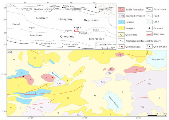
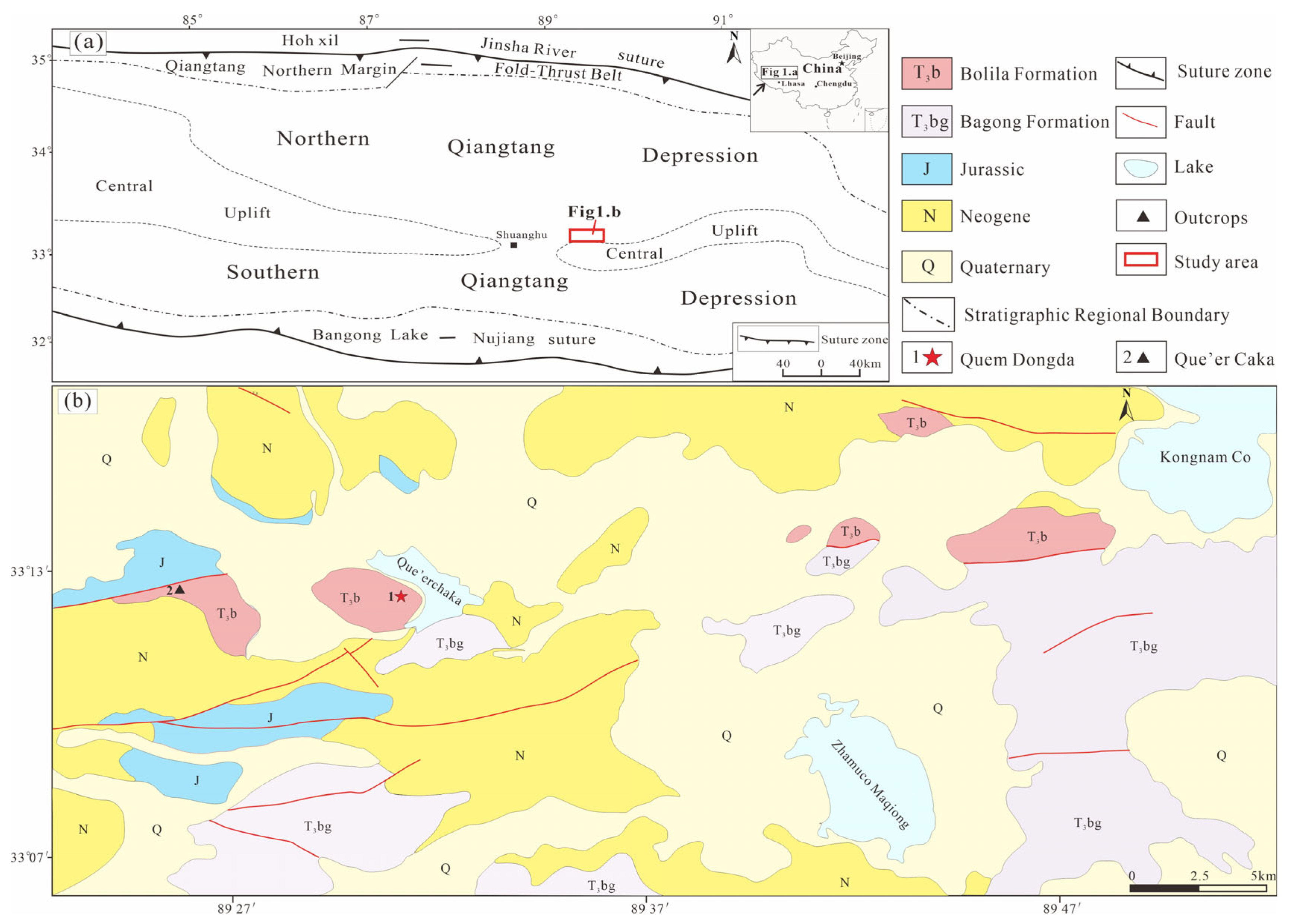
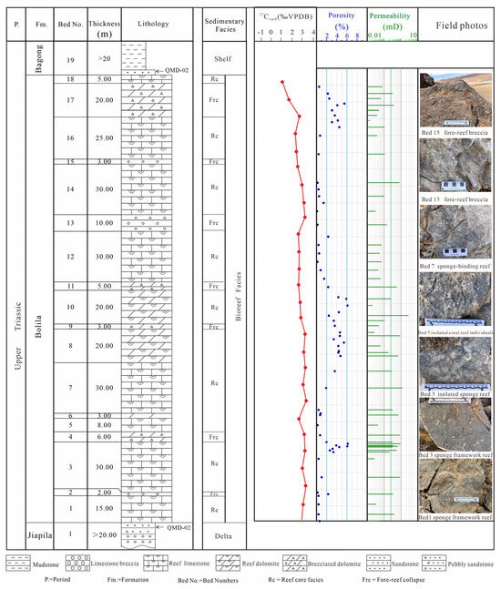
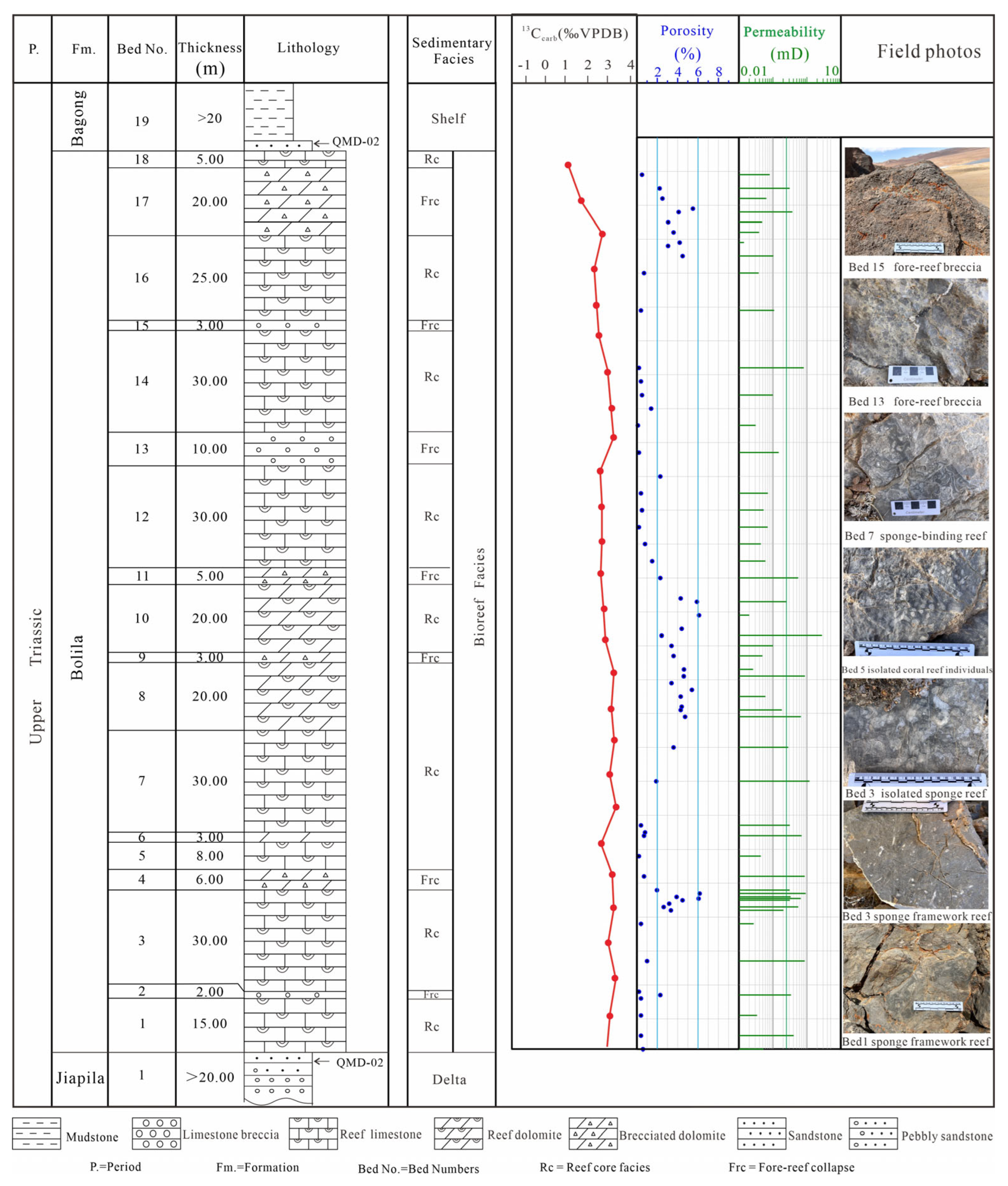
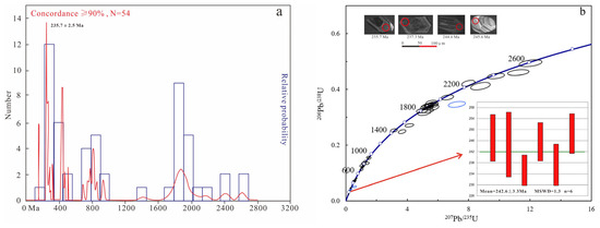
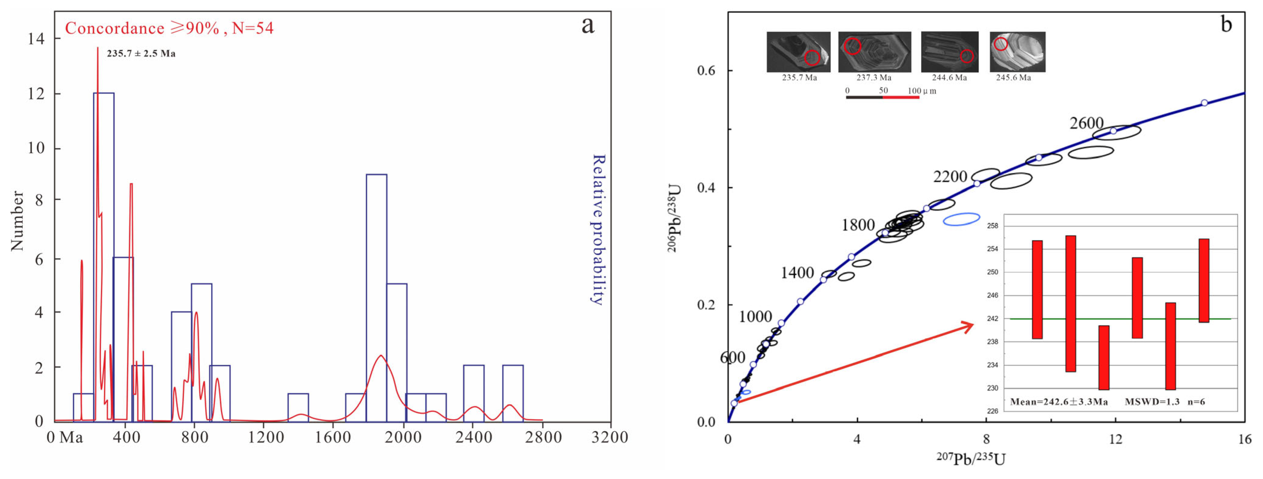
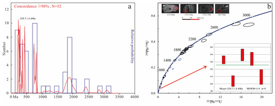
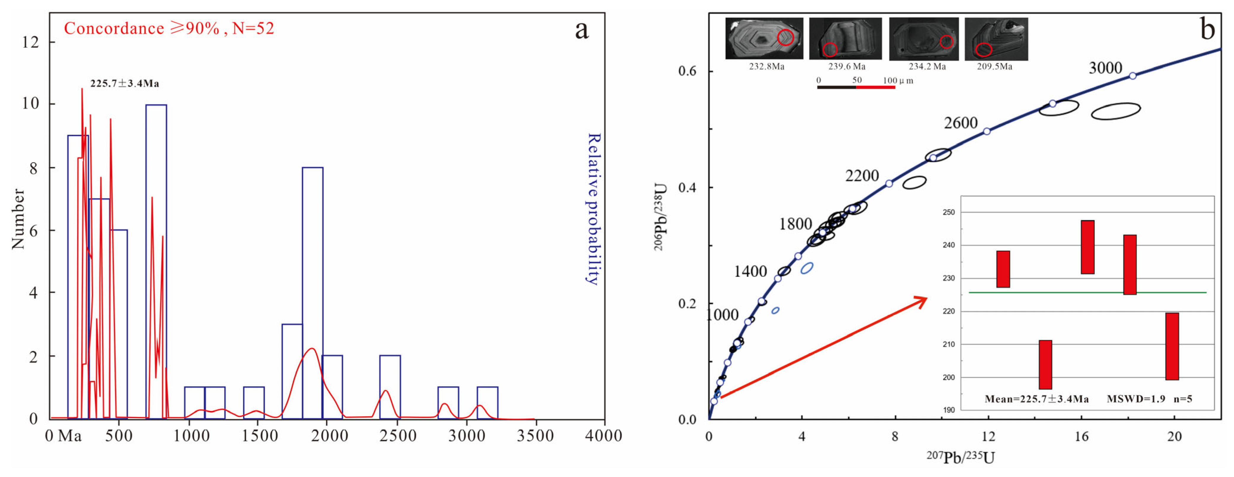
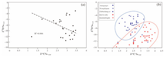
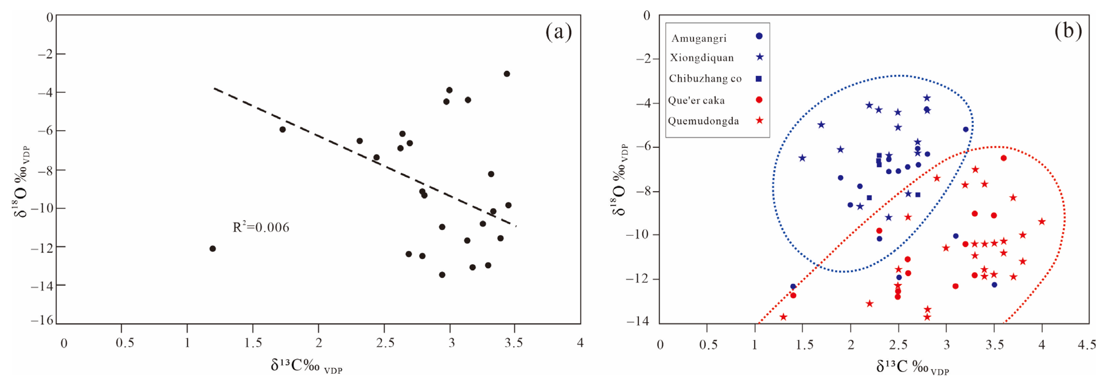
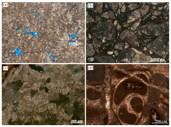
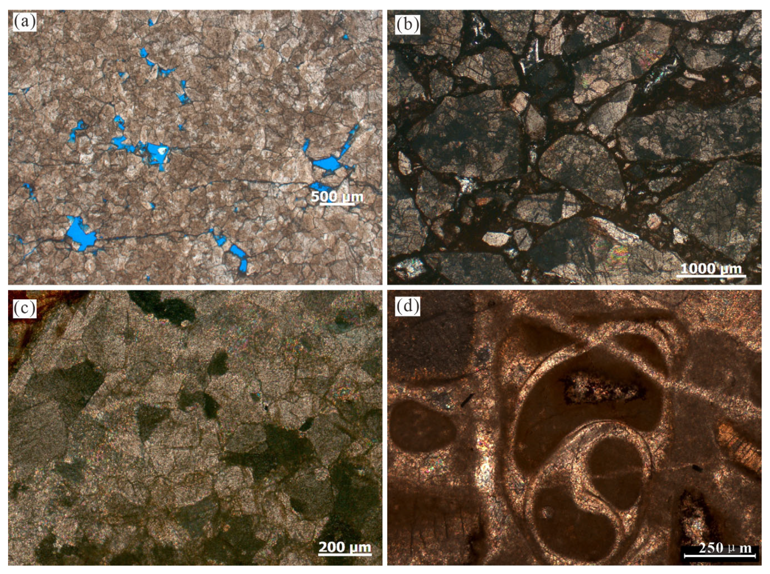
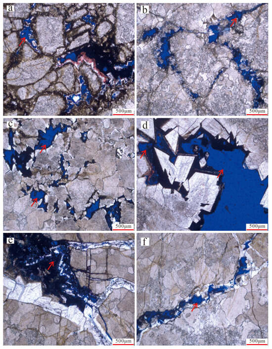
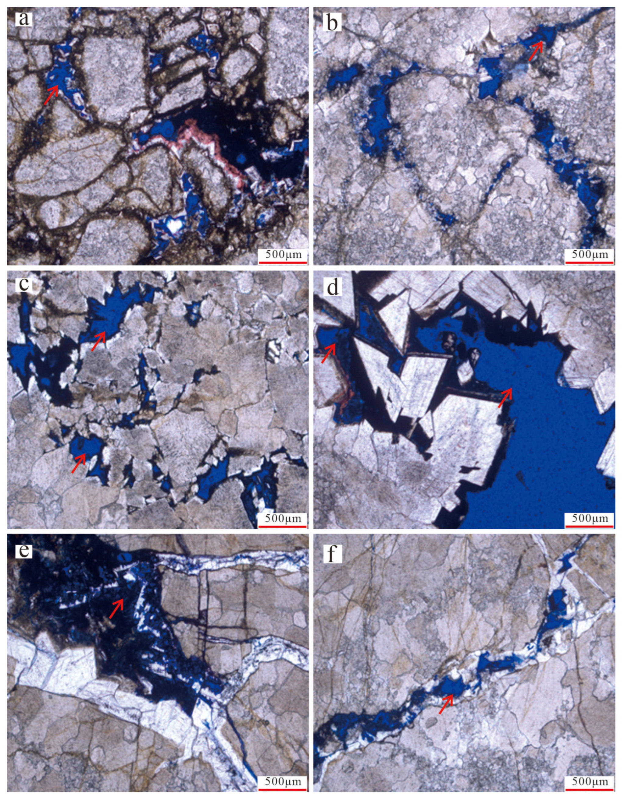
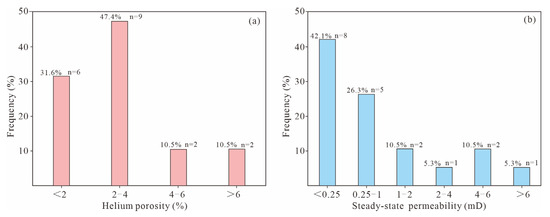
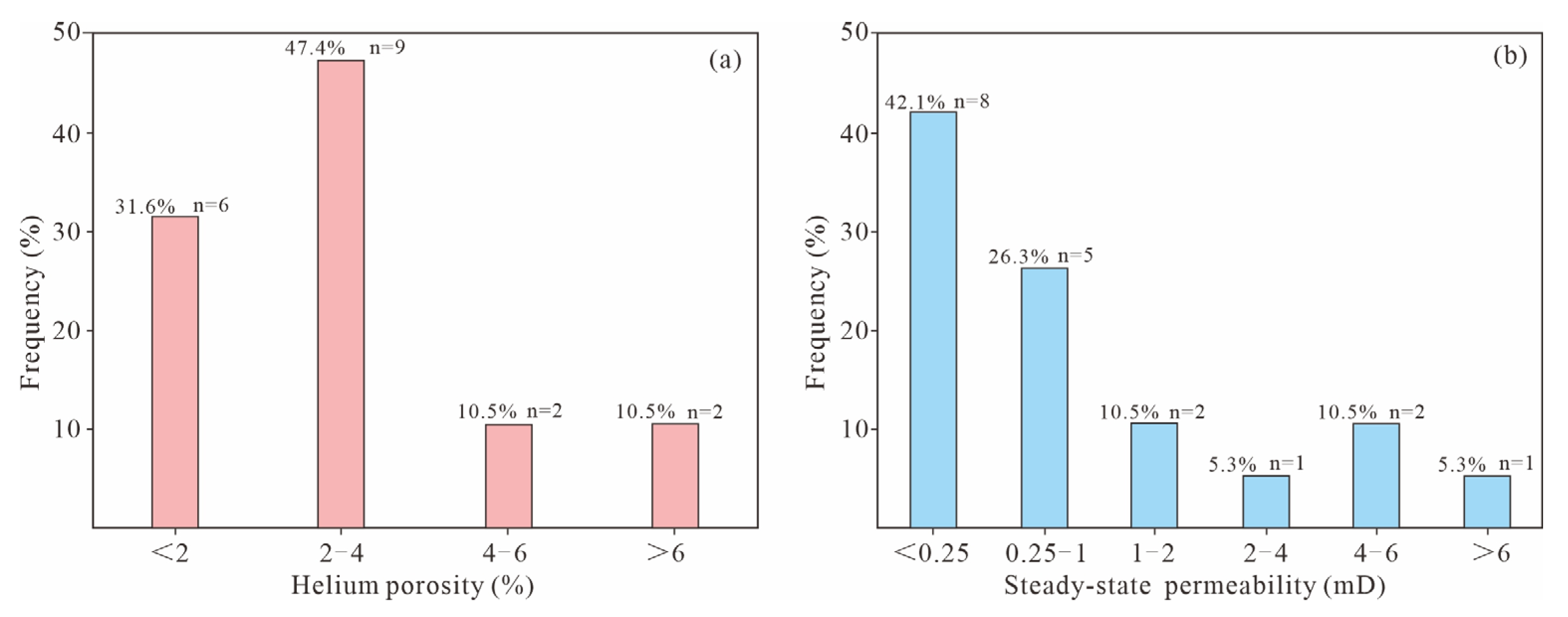
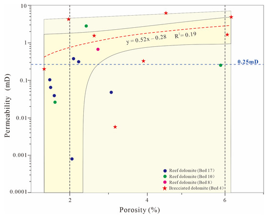
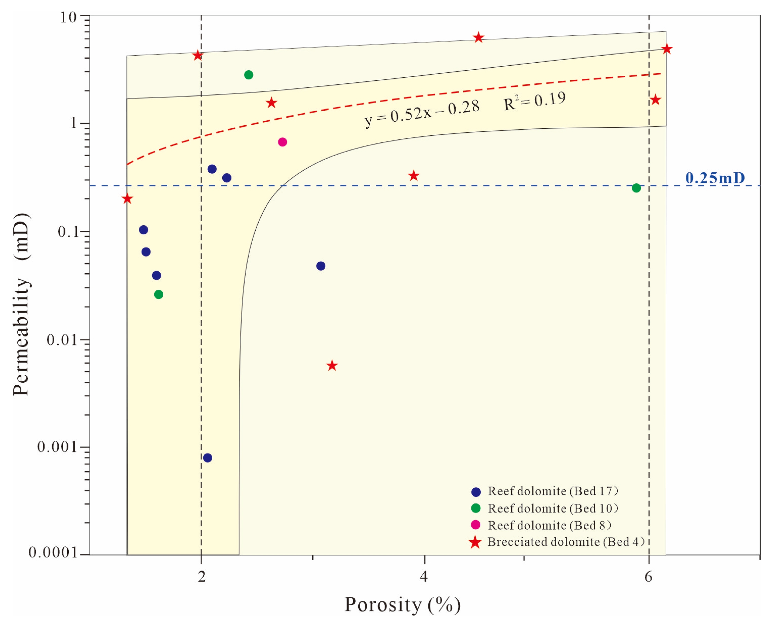

Disclaimer/Publisher’s Note: The statements, opinions and data contained in all publications are solely those of the individual author(s) and contributor(s) and not of MDPI and/or the editor(s). MDPI and/or the editor(s) disclaim responsibility for any injury to people or property resulting from any ideas, methods, instructions or products referred to in the content. |
© 2026 by the authors. Licensee MDPI, Basel, Switzerland. This article is an open access article distributed under the terms and conditions of the Creative Commons Attribution (CC BY) license.