


Abstract
This study investigates four rock–soil profiles developed from Proterozoic intermediate–acid rocks in the Maoniushan area of Xichang, Sichuan Province. Through systematic geochemical analysis of major and trace elements and X-ray diffraction analysis of clay minerals, we aim to clarify the dominant controlling factors and environmental response mechanisms of chemical weathering under similar lithological and soil-forming age conditions. The results indicate the following: (1) Major element geochemistry shows that the Chemical Index of Alteration (CIA) of all profiles ranges from 61 to 74, while Na/K ratios and A-CN-K diagrams collectively reveal that the profiles are in a transitional stage from weak weathering (Ca and Na depletion) to moderate weathering (K depletion), with the weathering intensity ranking in the order TP1711 > TP1709 > TP1714 ≈ TP2801. (2) Trace elements exhibit significant differences among profiles: Cu, Zn, and Pb are significantly leached relative to Al2O3 in the TP1711 profile, whereas most trace elements are enriched in the TP1714, TP1709, and TP2801 profiles. Variations in ∑LREE/∑HREE ratios further support differences in the weathering stages of the profiles. (3) The clay mineral assemblages are dominated by illite, chlorite, and vermiculite. The TP1714 profile lacks vermiculite and has the highest illite content (54–60%), reflecting a relatively cold and dry local microclimate. In contrast, the other profiles show widespread vermiculite development, accompanied by minor kaolinite, indicating moderate weathering intensity under warm and humid climatic conditions. This study confirms that under similar lithological and soil-forming age conditions, the microclimatic differentiation induced by altitude variation is the key external controlling factor leading to spatial differences in the chemical weathering intensity of granite–soil profiles in the Maoniushan area.
1. Introduction
Soil is a near-surface natural medium formed by rock weathering products (parent materials). The composition and variation characteristics of minerals and elements in the soil are important indicators reflecting soil development, soil-forming processes, and evolution [1,2,3]. In the process of soil formation and development, the composition of minerals and elements is affected by factors such as rock (parent material), geographical conditions, human activities, and climatic conditions, which makes the Earth’s chemical elements in soil show complexity and diversity [4,5,6,7,8]. The geochemical behavior of elements on the surface (such as occurrence state, migration process, and deposition characteristics) is closely related to the chemical weathering processes. Some scholars have shown that the changes in the climate environment controls the chemical weathering process [9,10,11,12,13]. Therefore, the migration and variation of soil chemical elements can reflect the chemical weathering characteristics and climate environment characteristics in the process of weathering and soil formation [14,15,16,17]. In recent years, some scholars have paid great attention to horizontal changes in element content [18,19,20,21] and the vertical change characteristics of elements in soil [22,23,24,25,26,27].
The hinterland of the Daliang Mountains, Xichang, is an important ecological resource base in the middle and upper reaches of the Yangtze River in China. Liu et al. [28,29] believed that geological construction was the material basis of soil, generally controlling the plane zoning of soil through an ecological geological survey in the region. While geographical factors such as altitude control the vertical zoning of soil and are based on geological construction, a systematic division of soil parent material units and soil geological units in Xichang City was proposed, which provided some ideas for soil and ecological geological surveys in the middle–high mountain area. Zhang et al. [30] studied the physical and chemical characteristics and main control factors of soil parent materials in the Maoniushan area and discussed the relationship between the physical and chemical properties of soil and the underlying geological formation and environmental factors [31]. Through the data analysis and nutrient element content evaluation of the same soil with different parent materials, they determined that the migration of nutrient elements between rocks, parent material, and soil is inherited, and that the geological background directly restricts the physical and chemical properties of soil parent materials.
In this paper, four granite–soil vertical profiles developed from Proterozoic intermediate–acid magmatic rocks in the Maoniushan area were investigated. The chemical weathering intensity of rock and soil in the profile at different altitudes is studied by the elemental geochemistry method, the migration and enrichment laws of elements in rock and soil are explored, and the formation environment of soil is discussed.
2. Study Area
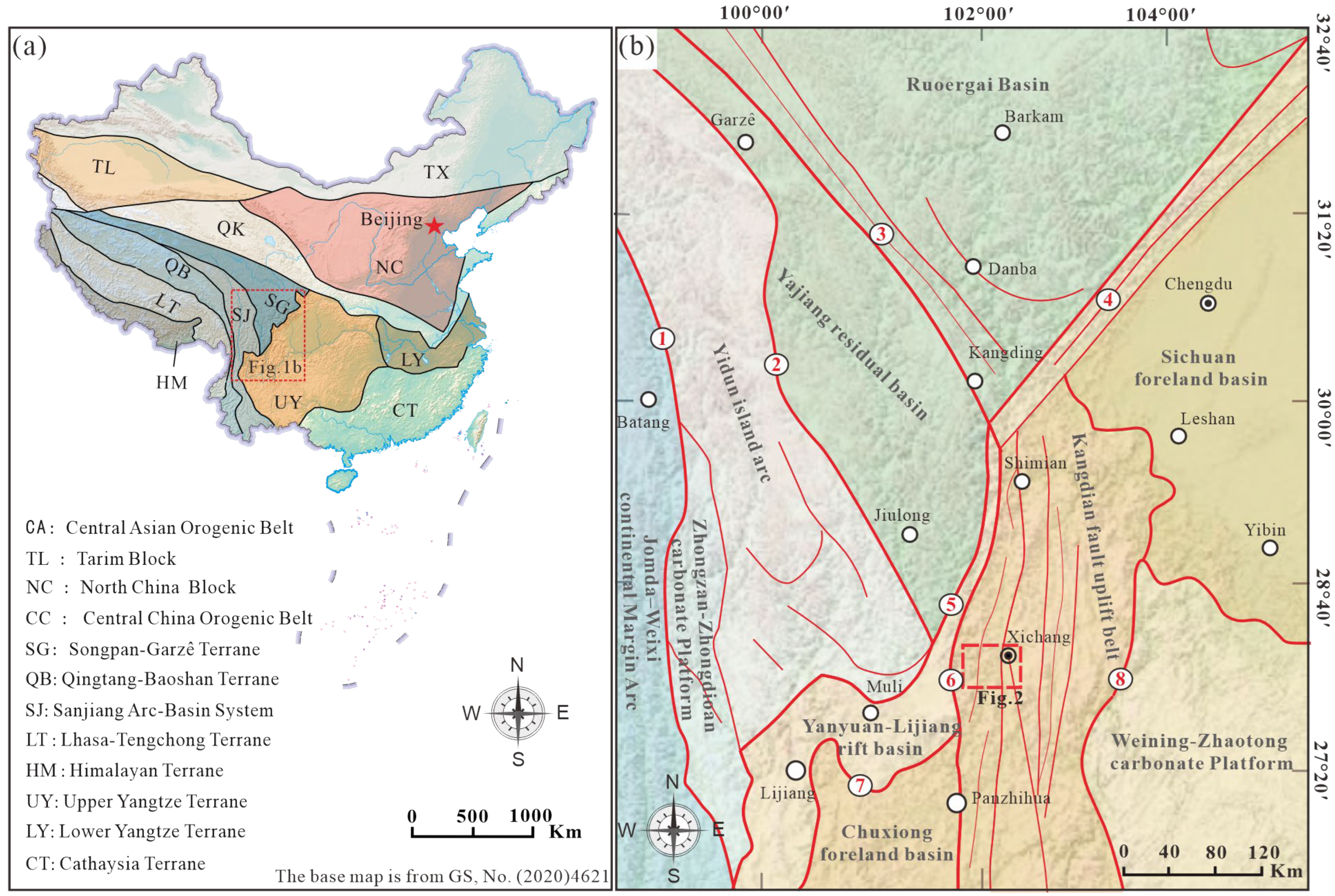
The Maoniushan area is located in the eastern part of Xichang in southwestern Sichuan Province, located in the central and northern parts of the Kangdian fault uplift belt on the western margin of the Upper Yangtze Terrane (Figure 1). The fault structure is developed in the region, with strong river cutting. The area is characterized by high mountains and deeply incised valleys, with significant elevation differences. The altitude of the study area is between 1500 m and 3500 m. The climate type is subtropical plateau monsoon, and the average precipitation is about 1000 mm.
Figure 1.
(a) Tectonic sketch map of China; (b) Tectonic sketch map of western Yangtze block. ①—Jinshajiang Ophiolitic Mélange Zone; ②—Garzê–Litang Ophiolitic Mélange Zone; ③—Xianshuihe Fault Zone; ④—Longmenshan Fault Zone; ⑤—Xiaojinhe Fault Zone; ⑥—Maoniushan–Lüzhijiang Fault Zone; ⑦—Jinhe–Qinghe Fault Zone; ⑧—Daliangshan–Xiaojiang Fault Zone.
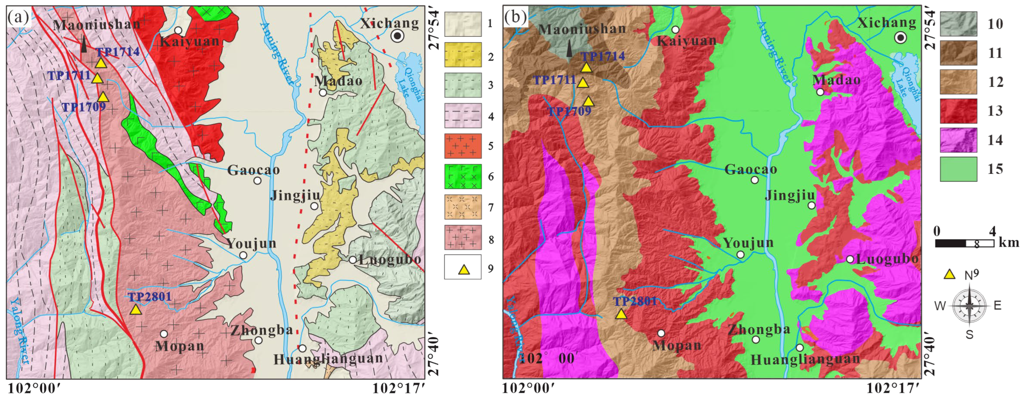
Based on the different types of pedogenic rocks, the study area is divided into 10 types of geological formation units [32], mainly including (1) Quaternary continental loose accumulation, (2) Neogene–Quaternary continental clastic rocks, (3) Jurassic–Cretaceous continental clastic rocks, (4) Triassic continental clastic rocks, (5) Triassic intermediate–acid rocks, (6) Permian basic–ultrabasic rocks, (7) Proterozoic intermediate–acid rocks, and (8) Proterozoic pyroclastic rocks (Figure 2a). The profiles investigated in this study were from Proterozoic intermediate–acid rock formations, and the position of the profiles is shown in Figure 2b.
Figure 2.
(a) Geological formation units and profile location map of the study area; (b) soil types and profile location in the study area. 1. Quaternary continental loose accumulation formation; 2. Neogene–Quaternary continental clastic rock formation; 3. Jurassic–Cretaceous continental clastic rock formation; 4. Triassic continental clastic rock formation; 5. Triassic intermediate–acid rock formation; 6. Permian basic–ultrabasic rock formation; 7. Proterozoic pyroclastic rock formation; 8. Proterozoic intermediate–acid rock formation; 9. profile location; 10. alpine meadow soil; 11. brown soil; 12. yellow-brown soil; 13. red soil; 14. purple soil; 15. paddy soil.
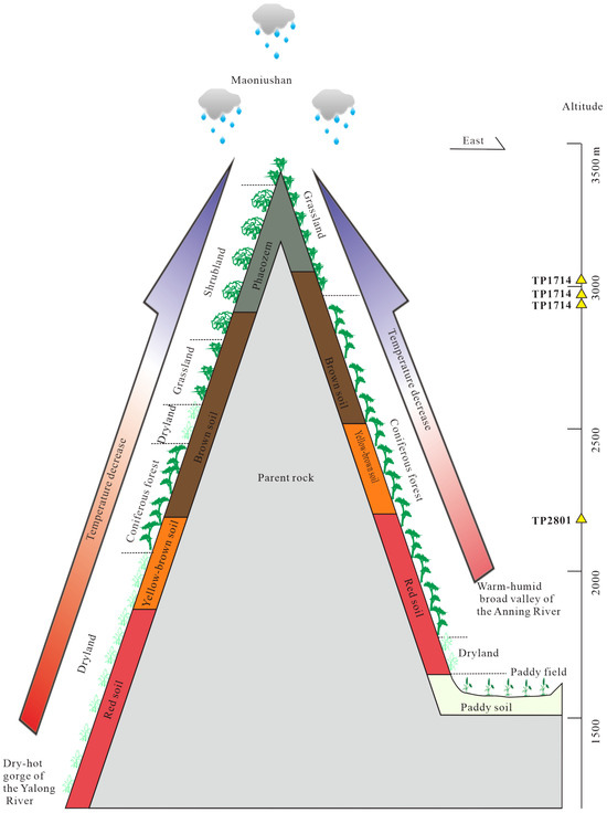
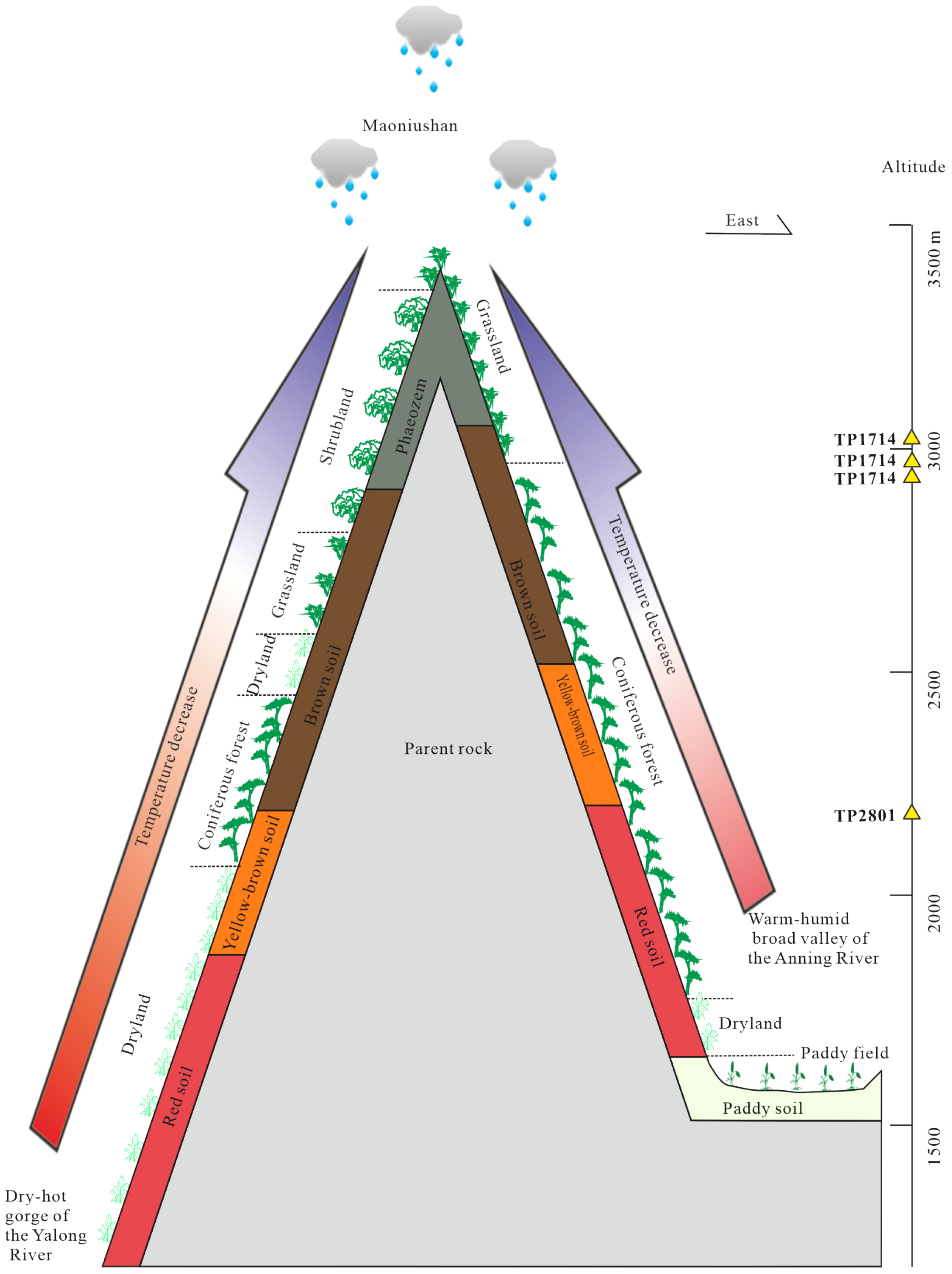
According to the Soil Records of Liangshan compiled by the Agricultural and Rural Bureau of Liangshan Yi Autonomous Prefecture, this region exhibits a diverse distribution of soil types. Predominant soils include purplish soil (Primarosols), red soil (Ferralisols), yellow soil (Ferralisols), and paddy soil (Anthrosols). Additionally, yellow-brown soil (Alfisol), brown soil (Alfisol), and alpine meadow soil Alpine soils) are present. Spatially, paddy soil dominates the low-lying central areas such as the Anning River Valley and Qionghai Basin. Purplish soils are primarily found in the eastern fold mountains, while red soil and yellow soil characterize the western foothills of Maoniushan. Brown soil and yellow-brown soil are distributed from the foothills to the ridges, and alpine meadow soils occupy the uppermost zones (Figure 2b and Figure 3).
Figure 3.
Soil and vegetation zonation in the Maoniushan are.
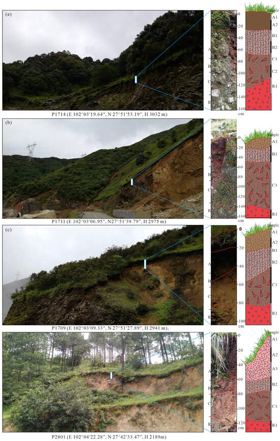
The soil profiles investigated in this study are classified as red soil, yellow-brown soil, and brown soil (Figure 2b, Figure 3 and Figure 4). Red soil, categorized as hydrous–hot Ferralisols, develop in tropical and subtropical regions through desilication and ferralitization processes, forming acidic soils. The minerals in the soil are represented by kaolinite and hematite. Yellow-brown soils, classified as udic–warm Alfisol, retain characteristics of brown soils while incorporating pedogenic processes typical of yellow soils. Their key attributes are summarized below. Transitional Nature: They represent a pedogenic transition between temperate brown soils (or cinnamon soils) and subtropical yellow soils to red soils. Acidity: The soil solution exhibits acidic to slightly acidic reactions. Heavy Texture: Intensive clay illuviation results in dense soil structure with poor permeability. Initial Allitization: Incipient weathering processes show weak aluminization, signaling the progression toward southern soil types. Brown soil belongs to the udic–thermic Alfisols, which develop under temperate humid climates in deciduous broadleaf forests and coniferous–broadleaf mixed forests. These soils are in the stage of silication and exhibit clay illuviation features, with pronounced leaching processes where carbonates and soluble salts are leached out, and clay particles accumulate in Horizon B. Primary minerals undergo further weathering and decomposition, forming secondary clay minerals dominated by hydromica and vermiculite, accompanied by montmorillonite and kaolinite. Red soils are primarily distributed at the base of mountains such as Maoniushan, Maoniushan, Lu Mountain, and Luoji Mountain along the Anning River Valley. The main parent rocks include the Quaternary continental loose accumulation formation, Neogene-Quaternary continental clastic formation, Triassic continental clastic formation, Triassic intermediate–acid formation, Permian basic–ultrabasic formation, Proterozoic pyroclastic formation, and Proterozoic intermediate–acid formation. Brown and yellow-brown soils are mainly found in the high mountain areas of the northwestern part of the study region.
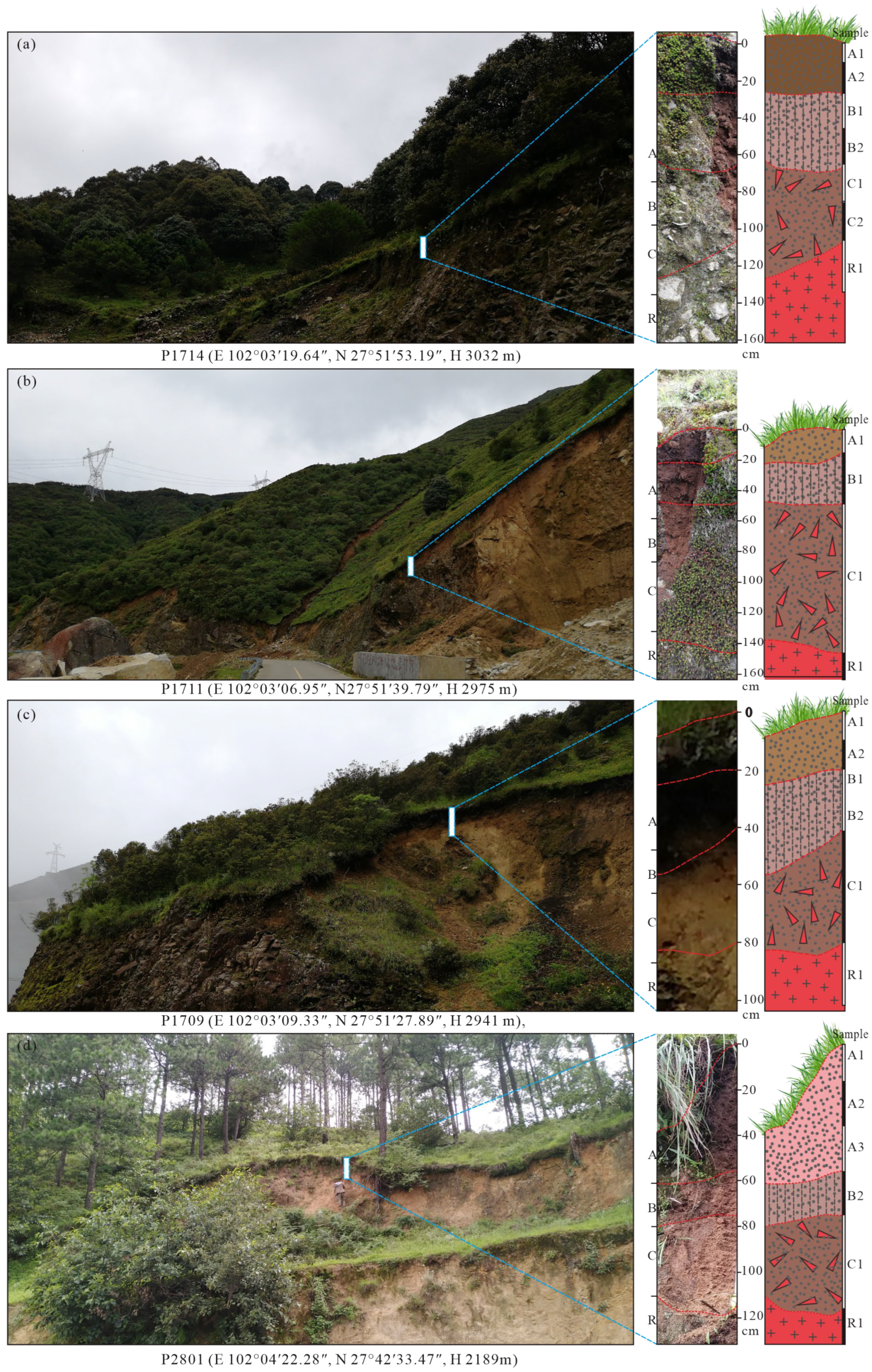
Figure 4.
Sampling diagram and stratification diagram of profiles in Maoniushan. (a) TP1714 Granite-Brown Soil Profile; (b) P1711 Granite-Brown Soil Profile; (c)-P1709 Granite-Brown Soil Profile; (d) P2801 Granite-Brown Soil Profile.
3. Sample Collection and Testing Methods
3.1. Sampling Description
Based on geological fieldwork, four granite–soil profiles of the Maoniushan area in Xichang were selected. GPS was used to locate the profiles before sampling. The position of the profiles is shown in Figure 1, assigned the numbers TP1714 (E 102°03′19.64″, N 27°51′53.19″, H 3032 m), TP1711 (E 102°03′06.95″, N27°51′39.79″, H 2975 m), TP1709 (E 102°03′09.33″, N 27°51′27.89″, H 2941 m), and TP2801 (E 102°04′22.28″, N 27°42′33.47″, H 2189 m) (Figure 4). A total of 22 samples of humus horizon (Horizon A), illuvial horizon (Horizon B), parent material horizon (Horizon C), and rock horizon (Horizon R) were collected according to the natural occurrence horizons of the soil After sampling, the samples were sealed and stored in a self-sealing bag after emptying the air and sent to the laboratory. The soil samples were prepared by natural air drying. After grinding with an automatic grinder, the samples were screened by nylon mesh vibration screening, and the samples were packed after sorting. The sampling positions of samples in different horizons are shown in Figure 2. The soil, parent material, rock characteristics, and sample number of the four profiles are described in detail as follows:
In the TP1714 profile, the soil type is brown soil, the parent material is Precambrian acid rock weathering, the rock is light gray coarse–medium-grained granodiorite, and the profile elevation is 3032 m. Humus horizon (Horizon A) thickness: 0 ~ 25 cm, illuvial horizon (Horizon B): 25 ~ 65 cm, parent material horizon (Horizon C): 65 ~ 115 cm, and rock horizon (Horizon R): ≥115 cm. A total of 7 samples were collected, including 2 samples from Horizon A, 2 samples from Horizon B, 2 samples from Horizon C, and 1 sample from Horizon R.
In the TP1711 profile, the soil type is yellow-brown soil, and the parent material is Precambrian acid rock weathering. The rock is light gray coarse-grained granodiorite. The altitude of the profile is 2975 m. Humus horizon (Horizon A) thickness: 0 ~ 15 cm, illuvial Horizon (Horizon B) thickness: 15 ~ 45 cm, parent material horizon (Horizon C) thickness: 45 ~ 145 cm, and rock horizon (Horizon R) thickness: ≥145 cm. A total of 4 samples were collected, including 1 sample from Horizon A, 1 sample from Horizon B, 1 sample from Horizon C, and 1 sample from Horizon R.
In the TP1709 profile, the soil type is red soil, the parent material is Precambrian acid rock weathering, the rock is light gray granodiorite, and the profile elevation is 2941 m. The thickness of the humus horizon (Horizon A) is 0 ~ 20 cm, that of the illuvial Horizon (Horizon B) is 20 ~ 40 cm, that of the parent material horizon (Horizon C) is 40 ~ 80 cm, and that of the rock horizon (Horizon R) was ≥100 cm. A total of 5 samples were collected, including 2 samples from Horizon A, 1 sample from Horizon B, 1 sample from Horizon C, and 1 sample from Horizon R.
In the TP2801 profile, the soil type is red soil, the parent material is Precambrian acid rock weathering, the rock is light gray granodiorite, and the profile elevation is 2189 m. Humus horizon (Horizon A) thickness: 0 ~ 55 cm, illuvial horizon (Horizon B) thickness: 55 ~ 75 cm, parent material horizon (Horizon C) thickness: 75 ~ 115 cm, and rock horizon (Horizon R) thickness: ≥110 cm. A total of 6 samples were collected, including 3 samples from Horizon A, 1 sample from Horizon B, 1 sample from Horizon C, and 1 sample from Horizon R.
3.2. Analytical Methods
All rock samples (collected from Horizon R) and soil samples (collected from Horizons A, B, and C) were analyzed for their contents of major elements (SiO2, Al2O3, Fe2O3T, CaO, MgO, K2O, Na2O, TiO2, P2O5, MnO, and LOI), trace elements (Rb, Ba, Th, U, Nb, Sr, Zr, Hf, Cu, Zn, B, Ni, Pb, As, Cr, and Hg), and rare earth elements (La, Ce, Pr, Nd, Sm, Eu, Gd, Tb, Dy, Ho, Er, Tm, Yb, Lu, Y). Additionally, all soil samples (collected from Horizons A, B, or C) were subjected to analyses of rock-forming mineral composition (quartz, potassium feldspar, plagioclase, pyrite, calcite, hematite, and dolomite) and clay mineral composition (illite, kaolinite, vermiculite, chlorite, smectite, mixed illite/smectite, and mixed chlorite/smectite).
The analytical work was completed at the Key Laboratory of Sedimentary Basins and Oil & Gas Resources, Ministry of Natural Resources, Chengdu Center of China Geological Survey. Major element analysis was performed using X-ray fluorescence spectroscopy (XRF) with a PANalytical X’pert pro MPD spectrometer (X’Pert PRO, Instrument Manufacturer: PANalytical, Almelo, The Netherlands), employing fused glass beads for sample preparation. Trace element and rare earth element analyses were conducted by inductively coupled plasma mass spectrometry (ICP-MS) using a Thermo Scientific iCAP Q instrument (Element2, Thermo Fisher Scientific, Waltham, MA, USA). For sample decomposition, rock samples (R horizon) were digested using a high-pressure closed digestion method. Approximately 50 mg of powdered sample (200 mesh) was placed in a PTFE digestion vessel, moistened with a few drops of ultrapure water, and then 1 mL HNO3 and 2 mL HF were added. The vessel was sealed in a stainless steel bomb and heated in an oven at 190 °C for 48 h to ensure complete dissolution of refractory minerals. Soil and parent material samples (Horizons A, B, and C) were decomposed using a microwave digestion system. About 50 mg of powdered sample was weighed into a microwave digestion vessel, and 5 mL HNO3, 2 mL HF, and 1 mL H2O2 were added. The vessels were sealed and subjected to a microwave digestion program (ramp to 180 °C in 10 min, hold for 20 min, then ramp to 200 °C in 5 min, hold for 20 min). After cooling, both rock and soil digestion solutions were transferred to Teflon beakers and heated on a hotplate at 150 °C to evaporate to near dryness to remove residual HF. The residue was then re-dissolved in 2 mL of 50% (v/v) HNO3 and diluted to 50 mL with ultrapure water in volumetric flasks. Sample solutions for ICP-MS were prepared gravimetrically, with precise calculation of internal standard concentrations and dilution factors. International reference materials including W-2a, BHVO-2, and BCR-2 were used for quality control, and the same digestion procedures were applied to these reference materials. The precision and accuracy for major element analysis were better than 5%, while for trace elements they were generally better than 10%.
Rock-forming and clay mineral composition analyses were carried out using X-ray powder diffraction (XRD). The procedure involved placing dried, 200-mesh samples into a 500 mL tall-form beaker, adding approximately 400 mL of ultrapure water, and stirring to dissolve. The mixture was then placed in an ultrasonic oscillator to fully disperse the clay particles. After standing for 4 h, the upper suspension was extracted, placed in centrifuge tubes, and centrifuged. The resulting clay particles were smeared onto glass slides and air-dried to produce uniform, smooth naturally oriented mounts. Subsequently, the tested natural oriented mounts were placed in a desiccator saturated with ethylene glycol and maintained at approximately 60 °C in an oven for over 8 h to prepare ethylene glycol (EG)-saturated mounts. For the preparation of heat-treated mounts, samples were heated at 450–550 °C for 2.5 h and allowed to cool naturally. The analytical precision for the XRD measurements was 4%.
4. Results
4.1. Characteristics of Soil Mineral Composition
Mineral composition analysis reveals similarities and differences among the soil of the profiles (Table 1 and Table 2). The minerals in the four profiles are mainly silicate minerals such as quartz, potash feldspar, plagioclase, and clay minerals, and lack carbonate minerals such as dolomite and calcite, which is related to their development in the Proterozoic intermediate–acid rock formations. The differences in mineral composition are mainly reflected in the abundance of plagioclase in the soils of the TP1714 and TP1709 profiles, with TP1714 being free of pyrite. In contrast, plagioclase is relatively absent in the soils of the TP1711 and TP2801 profiles. In addition, the difference is also reflected in the content of mineral components; for instance, the quartz content does not vary significantly among the four profiles. The content of clay minerals in TP1711 is 23% ~ 24%, in TP1714 it is 13% ~ 18%, in TP1709 it is 14% ~ 25%, and in TP2801 it is 6% ~ 13%. The content characteristics and vertical distribution of elements in the soil are mainly affected by rock, altitude, topography, climate, and human activities. The mineral and element composition of rock directly affect the mineral and element composition of soil and further affect the physical and chemical properties and fertility of the soil [33,34]. Within the same rock formation (Proterozoic intermediate–acid rock formation), differences in the mineral composition and content of soils across various profiles may arise from variations in local climate and environmental conditions associated with altitude changes, thereby influencing the intensity and processes of weathering.
Table 1.
Composition and content of minerals in the soil, Maoniushan area.
Table 2.
Composition and content of clay minerals in Maoniushan area.
Table 2 shows that the clay minerals in the profile of the study area are mainly illite, vermiculite, and chlorite, and there are also small amounts of kaolinite and mixed illite–montmorillonite. Among the four profiles, the TP1714 profile exhibits the highest illite content, while, unlike the other three profiles, it is completely lacking in vermiculite. The TP1714 profile is located at a significantly higher elevation than the other profiles, resulting in a local microclimate characterized by lower temperatures and relatively low humidity. Such cold and arid conditions favor the crystallization and stability of illite, while inhibiting the formation of vermiculite. This pattern aligns with the soil type distribution observed in the study area, where TP1714 develops into brown soil of alpine origin, whereas the other profiles are characterized by yellow-brown soils and red soils. Except for TP1714, the chlorite content in the clay mineral composition of the other three profiles is low; the kaolinite content in all four profiles is relatively low, with the TP1714 profile containing no kaolinite.
4.2. Content Characteristics of Major and Trace Elements
The contents of major and trace elements in the rock and soil of the study profiles are shown in Table 3 and Table 4. It can be seen from the data that the standard deviation of major and trace elements in the four profiles is very low, which shows that the variation in main and trace elements in the profile is low and the overall distribution of elements is uniform [35]. Loss on Ignition (LOI) refers to the percentage of mass lost by a sample after ignition at high temperature (typically 950–1000 °C). It is primarily used to characterize the content of volatile components such as organic matter, carbonates, and hydrated minerals. Table 3 shows that unlike the LOI values of rock samples (sampled from Horizon R) (0.10%–3.54%), the LOI of soil samples (collected from Horizons A, B, and C) is significantly higher. Furthermore, LOI exhibits a trend of A > B > C > R, indicating an increase in organic matter content during weathering and soil formation processes. The major components of the soil (Horizons A, B, and C) in four profiles are SiO2, Al2O3, and Fe2O3T, and the total content of these three major elements ranges from 77.44% to 89.01% across the profiles.
Table 3.
The major element content (%) in profiles of the Maoniushan area.
Table 4.
The trace element content (ppm) in profiles in the Maoniushan area.
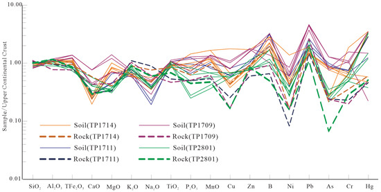
Compared with the average chemical composition of the continental crust (UCC), other elements are close to the UCC, except CaO, Na2O, and P2O5 of the major elements and Cu, B, Ni, Pb, and As of the trace elements. This indicates that the chemical composition of soil in the Maoniushan area was similar to that of the UCC [35]. The major elements MgO and P2O5 and trace element Hg show obvious regional differentiation. The values of the four profiles may be related to the elevation difference of the profile (Figure 4).
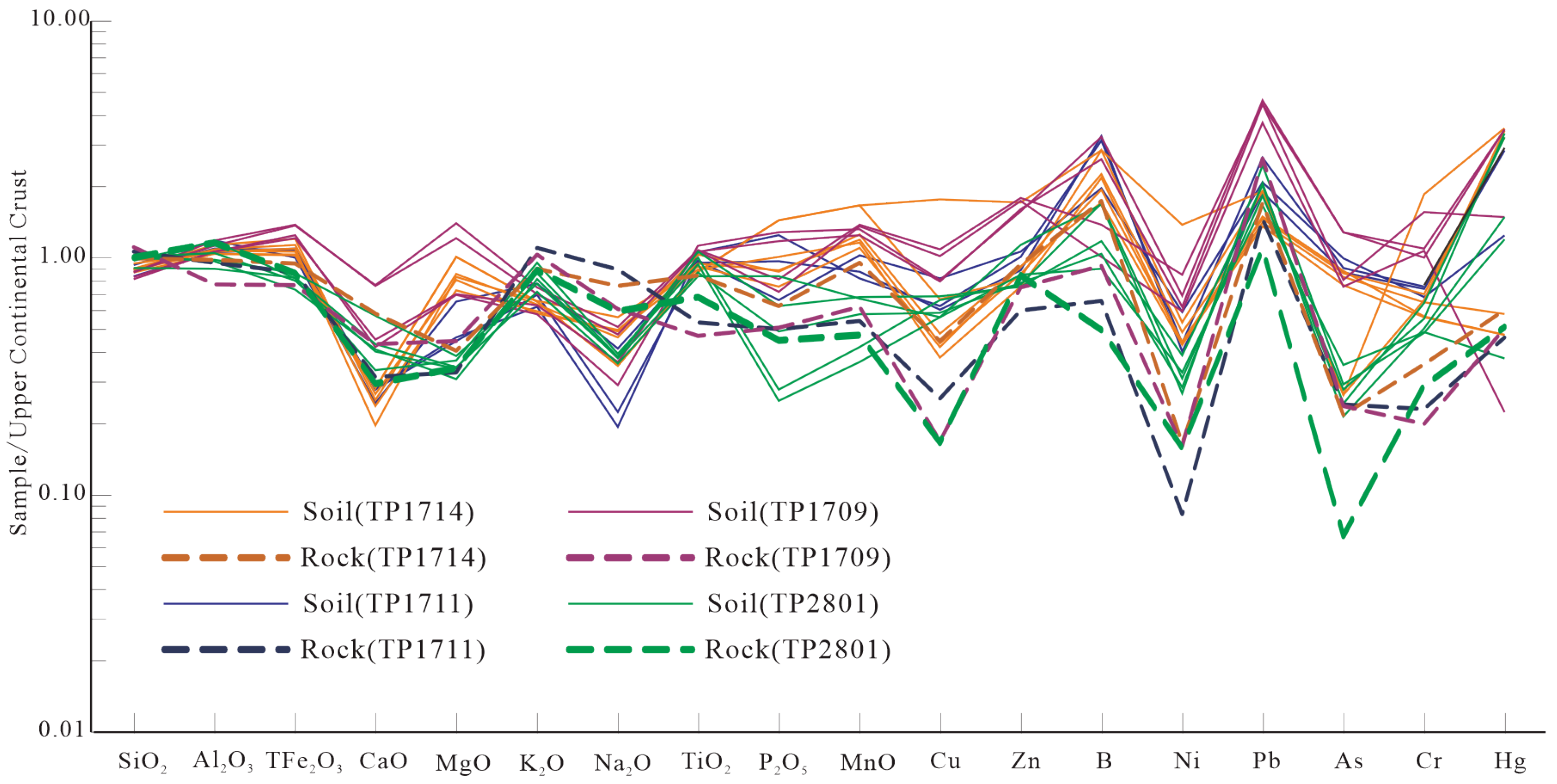
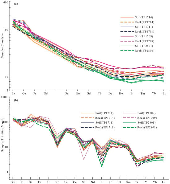
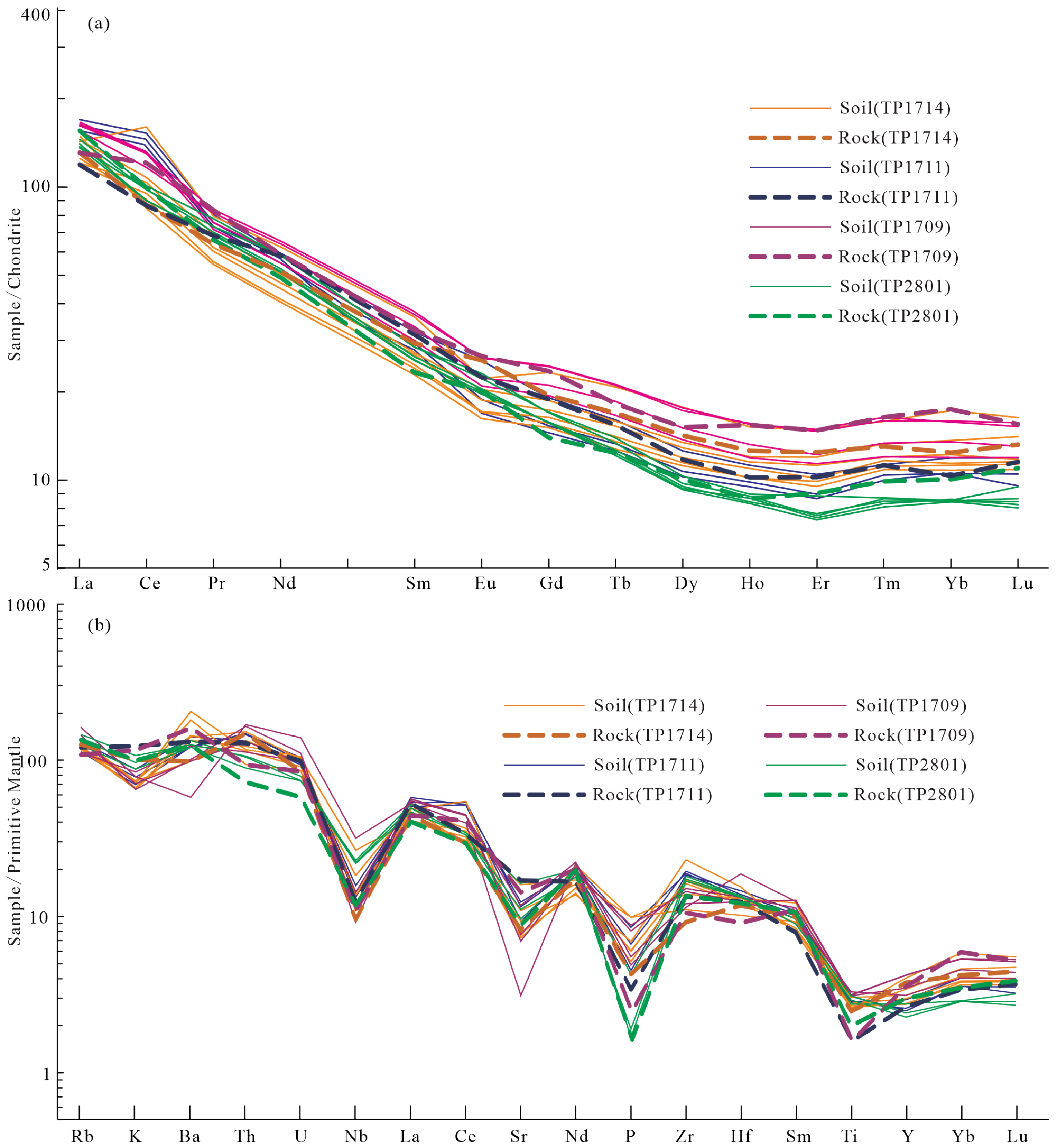
Overall, the chondrite-normalized rare earth element (REE) distribution patterns of all four studied profiles exhibit a distinct right-leaning trend (Table 4 and Table 5). The slope gradually decreases from lanthanum (La) to europium (Eu), indicating that light rare earth elements (LREE) tend to become enriched during chemical weathering and pedogenesis, while the heavy rare earth element (HREE) segment remains relatively flat, clearly demonstrating LREE enrichment with no significant europium (Eu) anomaly observed. In the primitive mantle-normalized trace element spider diagram (Figure 5), all four profiles show a consistent trend of enrichment of large-ion lithophile elements relative to high-field-strength elements. In both the chondrite-normalized REE patterns and the primitive mantle-normalized trace element spider diagrams (Figure 6), the normalized curves of rare earth and trace elements across different horizons in all four profiles closely resemble those of the parent rock horizon, indicating clear inheritance. At the same time, rare earth elements in all horizons have undergone some degree of differentiation.
Table 5.
The REE content (ppm) in profiles in the Maoniushan area.
Figure 5.
UCC-normalized pattern of major and trace elements (The average value of the Upper Continental Crust (UCC) is cited from references [36,37]).
Figure 6.
Chondrite-normalized REE (a) and primitive mantle-normalized multi-element spider (b) diagrams. (The rare earth element (REE) data are normalized to chondritic values [38], and the trace element data are normalized to primitive mantle values [39]).
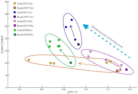
Zr and REEs are relatively stable in terms of their environmental geochemical behavior. Due to differences in stability, LREEs and HREEs also behave somewhat differently during weathering. Therefore, the ∑REE/Zr and ∑LREE/∑HREE ratios are commonly used to assess the degree of REE migration and differentiation during weathering and pedogenesis. In Figure 7, the ∑REE/Zr and ∑LREE/∑HREE ratios are relatively scattered for TP1714. In contrast, these ratios are more clustered for TP1711, TP1709, and TP2801 with clearly distinct groupings. TP1714 overall has the lowest ∑LREE/∑HREE ratios but scattered ∑REE/Zr ratios. The soil horizon of TP1711 shows the highest ∑LREE/∑HREE ratios, while TP1709 and TP2801 are generally similar, with significant overlap.
Figure 7.
Plot of ∑REE/Zr ratio versus ∑LREE/∑HREE ratio for representative profiles.
This phenomenon suggests that during the weathering of silicate rocks, heavy metal elements are preferentially leached and mobilized, while the leaching and migration rate of LREEs is slower than that of HREEs. Besides the previously mentioned reason that HREEs more readily form heavy silicates and organic complexes leading to preferential dissolution and migration, this is also related to the topography and climatic conditions of the profiles, which place them at different stages of chemical weathering. This simultaneously explains why different profiles exhibit varying ∑LREE/∑HREE ratios (Figure 7).
5. Discussion
5.1. Chemical Weathering Intensity
5.1.1. CIA and Na/K
The chemical alteration index (CIA) is widely used to reflect the degree of chemical weathering, and its essence is to reflect the degree of feldspar weathering into clay minerals. Alkali metal elements are usually leached out from feldspar in the form of ions and participate in the formation of clay minerals. The mole fraction of Al2O3, the main component of weathering products, changes with the weathering intensity [36]. Nesbitt and Young [40,41] proposed the CIA, which can reflect chemical weathering intensity, and its model formula is as follows:
The oxides in the formula are molar ratios, and CaO* is the molar content of silicate minerals, excluding CaO content in carbonate and phosphate minerals. Since CaO and Na2O in silicate usually exist in the mole ratio of 1: 1, when the mole of CaO is greater than Na2O, the molecular mole of CaO* is equal to that of Na2O, and when the mole of CaO is less than Na2O, mCaO * = mCaO.
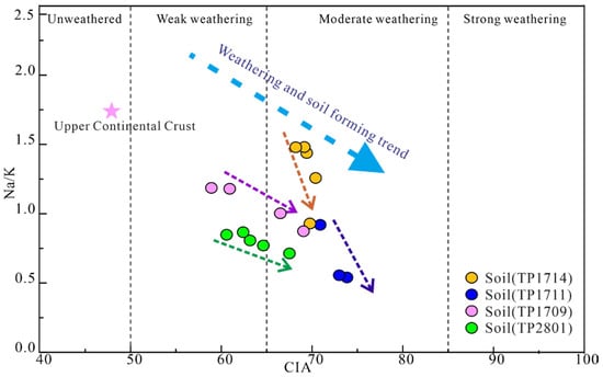
The higher the CIA is, the stronger the degree of chemical weathering is. For example, the CIA of unweathered feldspar is 50, illite is 75, and montmorillonite is 85, while chlorite and kaolinite are close to 100. The CIA value of the four profiles (Table 3) is much higher than that of the UCC (47.92) in the profiles studied in the Maoniushan area. In addition, different CIA values can indicate different climatic conditions. A higher CIA indicates that the climate is warm and humid, and the weathering degree is higher. Conversely, a lower CIA indicates that the climate is cold and dry, and the weathering degree is low [36]. A CIA between 50 and 65 reflects a weak weathering degree under cold and dry climate conditions, and between 65 and 85 it reflects a moderate weathering degree under warm and humid climate conditions; when greater than 85, it reflects a strong chemical weathering degree under hot and humid tropical and subtropical conditions [42]. According to the CIA scatter plot (Figure 8), the average of the UCC is regarded as unweathered. The points of the four profiles are concentrated in the range of 61 ~ 72, reflecting that the current chemical weathering environment of the soil profiles is warm and humid in the study area, while the chemical weathering intensity shows a medium-to-weak weathering degree.
Figure 8.
Dispersion diagram of CIA and Na/K molar ratio in profiles of Maoniushan area.
The Na/K ratio (molecular molar ratio) is another chemical indicator of plagioclase weathering degree, which can be used to indicate the degree of chemical differentiation of soil sediments [35]. K mainly exists in potassium feldspar and Na mainly exists in plagioclase. The weathering leaching rate of plagioclase is much higher than that of potassium feldspar, so the weathering degree of the soil profile is inversely proportional to the Na/K ratio [43]. The weathering intensity ranking based on Na/K ratios is not entirely consistent with that based on CIA means, and the overall weathering intensity can be judged in Figure 8. The data points of Maoniushan profiles are relatively concentrated, and their weathering intensity can be ranked as TP1711 > TP1709 ≈ TP2801 > TP1714.
Overall, the strongest overall weathering intensity among the four profiles can be determined as TP1711 and TP1714, which are located at higher altitudes. The weathering intensity of TP2801 is similar to TP1709. The profiles developed from granite have different chemical weathering intensities. It is inferred that the main reason for this difference is related to different altitudes. Under the specific climatic and environmental conditions in the Maoniushan area, altitude directly affects the local temperature, rainfall, and other microclimate of the profiles, resulting in obvious vertical zoning of soil and vegetation, which indirectly affects the chemical weathering intensity.
5.1.2. A-CN-K Diagram
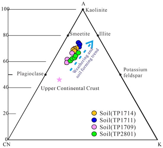
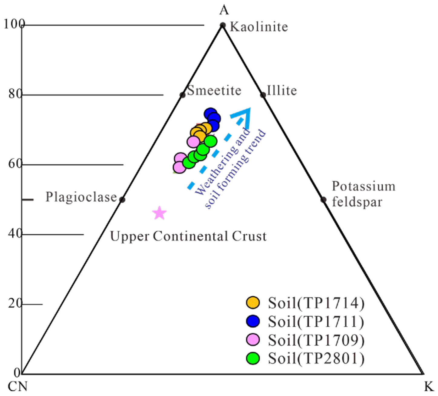
The A-CN-K (Al2O3 vs. CaO*+Na2O vs. K2O) triangular model diagram proposed by Nesbitt and Young [44] can predict continental chemical weathering trends, which can reflect chemical weathering trends and changes in major minerals during chemical weathering. The weathering product of UCC is continental shale. The transformation of UCC into continental shale represents a typical continental weathering trend, which is parallel to the A-CN line. From the A-CN-K three-terminal diagram of profiles in the Maoniushan area (Figure 9), it can be seen that the data of the four profiles are distributed above the K-feldspar and plagioclase baseline, and all the data are far from the K-terminal parallel to the A-CN line. This shows that its composition comes from the extensive upper crust, and plagioclase is first weathered, resulting in a large loss of Ca and Na, while potassium feldspar is relatively stable. The loss of Ca and Na in the profiles of the Maoniushan area from strong to weak can be ranked as TP1711 > TP1709 ≈ TP2801 ≈ TP1714. According to the activity difference among elements, the chemical weathering process can be divided into three stages. The early stages of weathering are the de-Ca and de-Na stages, the middle stage is the de-K stage, and the late stages are the de-Si and Al-rich stage [45]. Therefore, it can be judged that the soil profile of the Maoniushan area is in the de-Ca and de-Na stages in the primary stage of chemical weathering.
Figure 9.
A–CN–K ternary diagram of the Maoniushan area (arrow indicating weathering trend); A = Al2O3; CN = CaO + Na2O; K = K2O.
5.2. Element Migration and Differentiation Characteristics During Weathering
5.2.1. Migration Characteristics of Major Elements
In the process of chemical weathering, the absolute content of a single element in the rock cannot reflect the real element’s geochemical behavior. Weathering soil formation effects change the chemical composition of substances, and leaching makes the soluble elements in the soil leach out of the soil, resulting in the relative enrichment of stable elements, which may distort the understanding of the real characteristics of element migration and enrichment [46]. To eliminate these distortions, element change rates are often used to reflect element migration and enrichment [47]. By selecting a stable element (Al, Ti, K, etc.) as a reference, the change rates of other elements in the sample can be calculated. The calculation formula is as follows:
Element Migration/Enrichment Percentage (Δ) = [(Xs/Is)/(Xp/Ip) − 1] × 100%
In the formula, Xs and Is represent the contents of element X and reference element I in the sample, respectively. Xp and Ip are the contents of the above elements in the parent material, Δ < 0 indicates migration of element X relative to the reference element, whereas Δ > 0 indicates enrichment [48,49]. The Maoniushan area profiles selected in this study are divided according to their natural occurrence. The samples at the bottom of the parent material horizon are selected as the weathering parent material, and the stable element Al is selected as the reference element to calculate the change rate of the element content in the profiles.
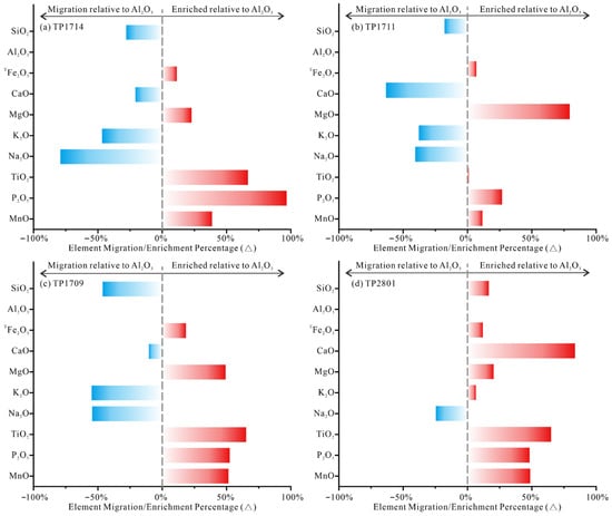
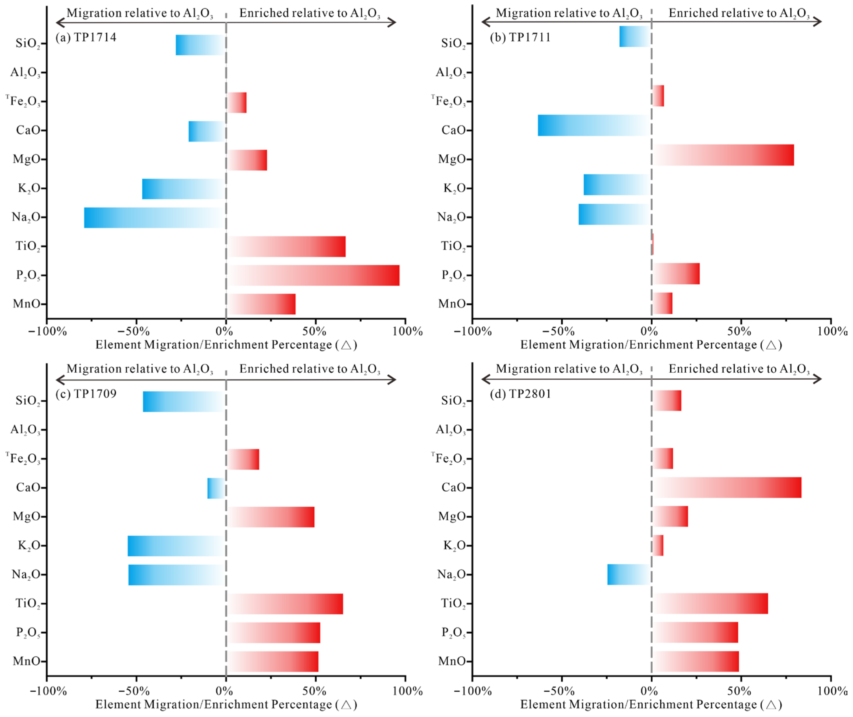
The element migration/enrichment percentage (Δ) of the main element relative to the stable element Al in the soil profiles of the Maoniushan area is shown in Figure 10.
Figure 10.
Major element migration/enrichment percentage (Δ) in the soil profiles (a) TP1714 (b) P1711 (c) P1709 (d) P2801 of the Maoniushan area.The calculation method is provided in Formula (2). Xs and Is represent the average contents of the target elements (SiO2, Fe2O3T, CaO, MgO, K2O, Na2O, TiO2, P2O5, and MnO) and the reference element (Al2O3) in the soil horizon, respectively, while Xp and Ip denote the contents of the aforementioned elements in the parent rock.
In the major elements of the TP1714, TP1711, and TP1709 profiles, the Δ values of SiO2, CaO, K2O, and Na2O are less than 0, while those of Fe2O3T, MgO, TiO2, P2O5, and MnO are greater than 0. This indicates that SiO2, CaO, K2O, and Na2O have migrated relative to Al2O3, whereas Fe2O3T, MgO, TiO2, P2O5, and MnO are enriched relative to Al2O3. The activity and migration capacity sequences of the major elements during chemical differentiation are as follows: TP1714: Na2O > K2O > SiO2 > CaO > Al2O3 > Fe2O3T > MgO > MnO > TiO2 > P2O5; TP1711: CaO > Na2O > K2O > SiO2 > Al2O3 > TiO2 > Fe2O3T > MnO > P2O5 > MgO; TP1709: K2O > Na2O > SiO2 > CaO > Al2O3 > Fe2O3T > MgO > MnO > P2O5> TiO2. In the major elements of the TP2801 profile, only the Δ value of Na2O is less than 0 (indicating that all other elements are enriched relative to Al). Based on the relative magnitudes of the Δ values, the activity and migration capacity sequence of the major elements during the chemical differentiation process of the TP2801 soil profile can be derived as Na2O > Al2O3 > K2O > Fe2O3T > SiO2 > MgO > MnO > P2O5 > TiO2 > CaO, and its degree of weathering is weaker than the other profiles (TP1714, TP1711, and TP1709).
According to the three-stage theory of chemical weathering [43], the profiles are all in a transitional phase from the weak weathering stage (Ca–Na depletion stage) to the moderate weathering stage (K–Si depletion stage).
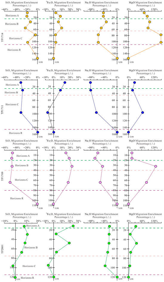
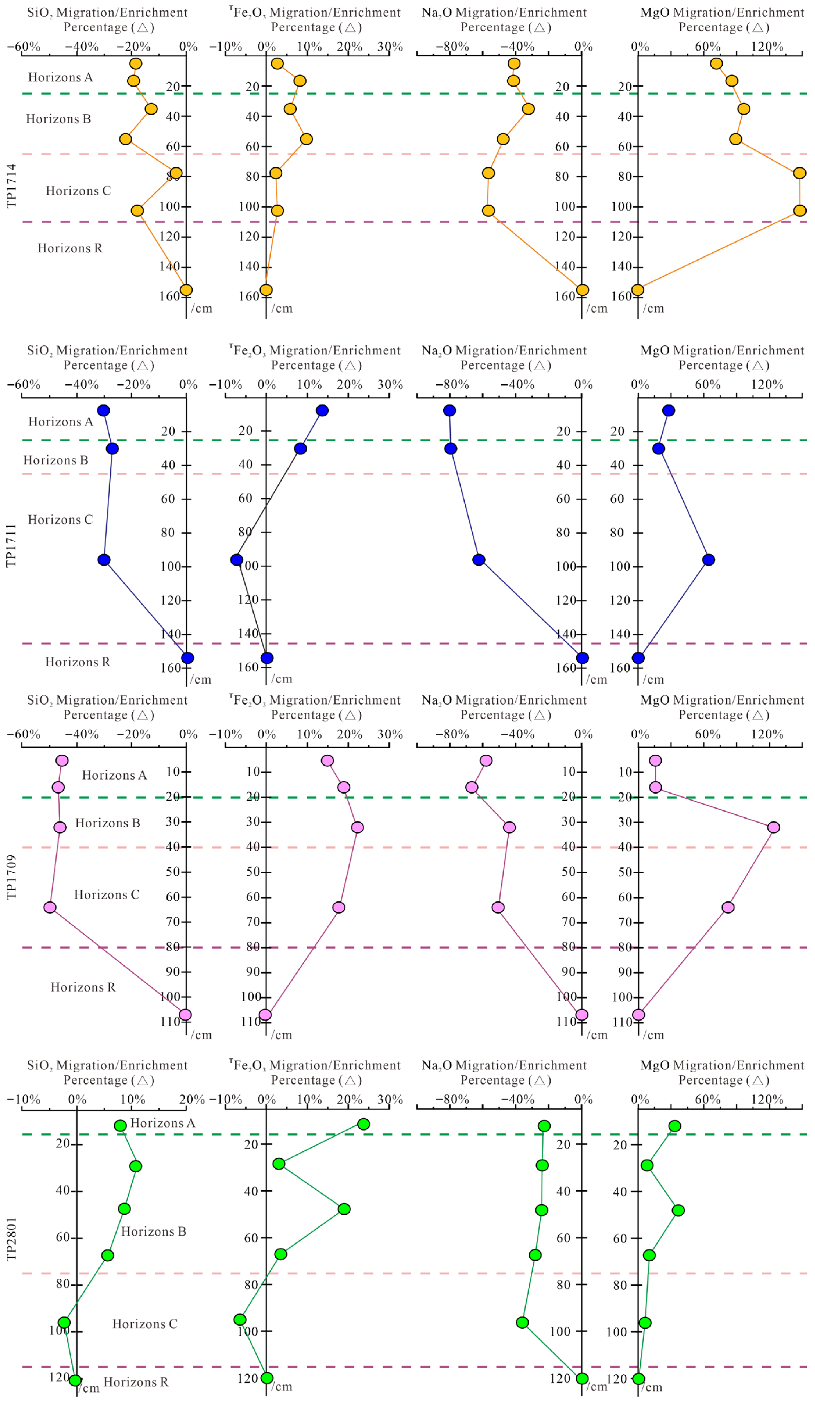
The four representative elements—the stable elements SiO2, and Fe2O3T, along with the active elements Na2O and MgO—were selected to investigate their vertical migration/enrichment patterns relative to Al2O3 along the soil profiles, as well as their indicative significance. The vertical variations in the migration/enrichment percentage (Δ) of these four elements relative to Al are shown in Figure 11.
Figure 11.
Element migration/enrichment percentage (Δ) of soil samples at different depths in the Maoniushan area. The calculation method is provided in Formula (2). Xs and Is represent the contents of the target elements and the reference element (Al2O3) in samples from different depths, respectively, while Xp and Ip denote the contents of the aforementioned elements in the parent rock.
The four profiles exhibit similar migration/enrichment patterns: compared to Al2O3, both MgO and Fe2O3T show varying degrees of enrichment, while Na2O and SiO2 display different extents of migration. Vertically, the intensity of element migration/enrichment in the soil (Horizons A and B) is generally higher than that in the parent material (Horizon C). In terms of elemental comparison, Na2O and MgO show greater migration/enrichment than SiO2 and Fe2O3T. Cross-profile comparison indicates that due to its relatively weaker weathering degree, the overall migration/enrichment extent of elements in TP2801 and TP1714 is lower than in the other two profiles.
In summary, the changing characteristics of element mobility in the profiles of the Maoniushan area can explain two problems. First, the weathering and leaching of the illuvial horizons have the strongest influence. At this time, a large number of active elements in the profile are decomposed and migrated, and some inert elements also undergo migration and accumulation. In addition, the migration and enrichment of elements and chemical weathering rate are directly related to climatic conditions. A warm and humid climate is conducive to the migration and enrichment of elements and the degree of chemical weathering is strong. Therefore, it can be judged that the study profile has experienced dry-and-cold to warm-and-humid climate change during the development of rock into soil.
5.2.2. Migration and Distribution Characteristics of Trace Elements
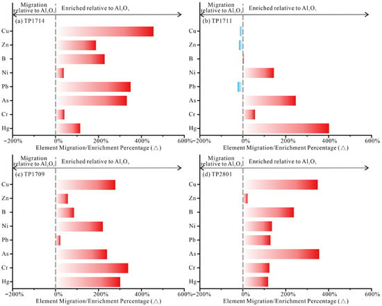
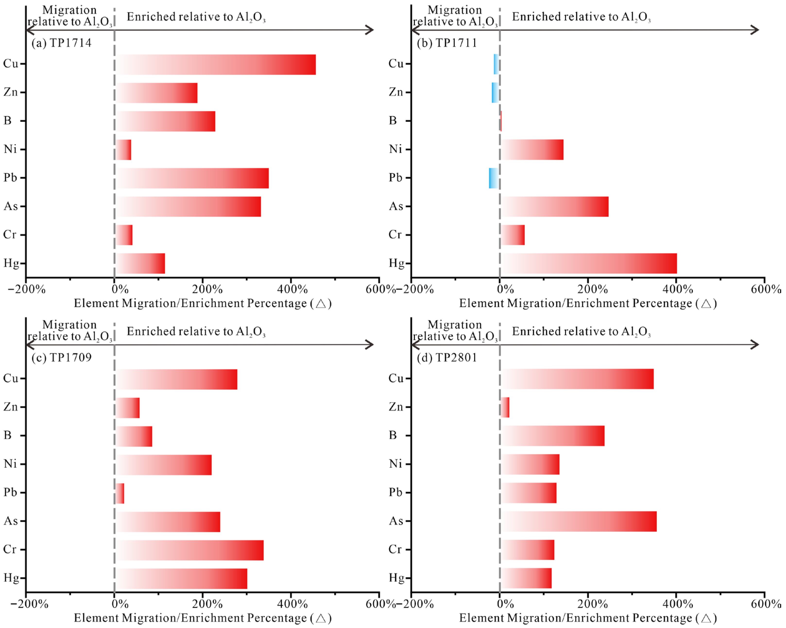
The calculation results of the migration/enrichment percentage (Δ) for trace elements are presented in Figure 12.
Figure 12.
Trace element migration/enrichment percentages (Δ) in the Maoniushan area. (a) TP1714; (b) TP1711; (c) TP1709; (d) 2801.
In profile TP1711, the Δ values of Cu, Zn, and Pb are all below zero, indicating migration of these trace elements relative to Al2O3. Previous studies [50] have shown that biological activities, particularly plant growth, can absorb certain trace elements (e.g., Cu, Zn, Pb, etc.) during weathering and pedogenesis, leading to their accumulation in the surface soil layer. For the remaining trace elements in TP1711, all Δ values exceed zero, suggesting that except for Cu, Zn, and Pb, most elements did not undergo significant migration but rather experienced deposition and enrichment. In contrast, most trace elements in the TP1714, TP1709, and TP2801 profiles exhibit enrichment (Δ > 0), although some elements, such as Rb, Sr, and Pb in certain profiles, still show depletion. In general, trace elements such as Cu, Zn, B, Ni, Pb, As, Cr, and Hg exhibit predominant enrichment relative to Al2O3 during the weathering of bedrock into soil. This phenomenon is attributed to the adsorption effects of clay minerals and organic matter. The ample rainfall, high clay content, and substantial organic matter accumulation driven by vegetation in the Maoniushan area are likely the primary reasons for the widespread enrichment and retention of trace elements in these soil profiles.
5.3. Influence Factors of Chemical Weathering Intensity
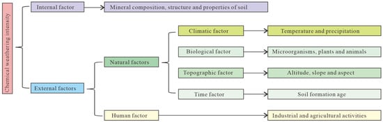
The factors affecting soil chemical weathering intensity and rate can be summarized into two aspects [51,52]. One is the internal factors, mainly the composition, structure, and properties of minerals in the soil. Generally speaking, different mineral compositions and properties of soil have different weathering resistance. The second is external factors, mainly including climate, biology, terrain, and time [34,53]. With the development of the economy and society, researchers have also included human factors such as agriculture and industrial activities in the factors affecting soil weathering (Figure 13) [54,55]. White [51] discussed the influence of mineral types, surface area, and crystallinity on mineral weathering in detail. This study mainly discusses and extracts the main external factors that affect the chemical weathering intensity and rate of four profiles with the same rock and the same soil-forming time in the Maoniushan. The external factors affecting soil weathering rate often interact and are difficult to distinguish [56,57].
Figure 13.
Influencing factors of chemical weathering intensity.
According to the actual situation based on field reconnaissance and sample collection, the soil parent materials of the profiles in the Maoniushan area are all Precambrian acid rock weathering materials, with the same soil rock and soil-forming time. In addition, the four profiles are almost not affected by industry and agriculture, so the influence of human factors on soil weathering is excluded. The biggest difference among the four profiles is the elevation in topographic factors. The highest elevation among the four profiles is 3032 m, while the lowest is 2189 m, resulting in an elevation difference of approximately 900 m. The change in elevation will inevitably lead to a change in the local climate, although all four profiles are derived from the same rock formation, their spatial distribution and microclimatic environments exhibit distinct differentiation. The TP1714, TP1711, and TP1709 profiles are all located near the main peak of Maoniushan within a similar local microclimate zone, and their rock–soil profile characteristics show considerable consistency. In contrast, the TP2801 profile is situated relatively farther away under significantly different microclimatic conditions, resulting in notable differences in weathering intensity and pedogenic processes.
The climate of the study area is subtropical and tropical monsoon, coupled with the climate characteristics of “one mountain divided into four seasons, ten miles different days” in Xichang of southwest Sichuan Province. Climate change will affect local temperature and precipitation, and temperature and precipitation will directly affect the chemical weathering intensity [58], topographic factors (elevation), and climatic conditions (temperature, precipitation).
In terms of soil type, the brown soil in TP1714 and yellow-brown soil in TP1711 and TP 1709 have stronger weathering environments than the red soil in the TP2801. Brown soil, classified as udic–thermic Alfisol, and yellow-brown soil, categorized as udic–warm Alfisol, are primarily distributed under humid forest–steppe or meadow–steppe vegetation. Their characteristic climatic conditions feature abundant precipitation and distinct seasons, ensuring sufficient annual water infiltration and leaching processes. In contrast, red soils are classified as hydrous–hot Ferralisols, products of intense weathering and ferralitization. Their formation necessitates perpetually hot–humid tropical/subtropical climates and prolonged pedogenesis (typically requiring hundreds of thousands to millions of years). In summary, under identical bedrock lithology and pedogenic age, variations in chemical weathering intensity and rate among the profiles are primarily governed by the combined influence of climatic conditions and topographic factors.
5.4. Reference of Mineral Composition to Weathering Degree and Environment
The mineral composition of soil directly affects its physical and chemical properties of soil. As an important component of minerals in the soil, clay minerals have a certain indication of the soil formation environment. The composition characteristics of soil clay minerals are determined by the parent materials, but they can only be formed under certain climatic, environmental, and biological conditions. Various clay minerals will evolve to different degrees under different environmental conditions, which makes the types and combination characteristics of clay minerals different. The climate environment of the formation period can be deduced according to the content and combination characteristics of clay minerals [59].
Illite is relatively stable, but is usually higher in arid and semi-arid areas in soil content, mainly due to potassium primary silicate aluminate minerals under strong physical weathering, weak alkaline, and weak leaching [59,60]; the crystallinity of illite is higher in dry and cold climate conditions, and lower in hot and humid conditions [61,62]. The content of vermiculite in clay minerals in the TP1711, TP1709, and TP2801 profiles in the study area is relatively high. Vermiculite mostly occurs in the further dipotassium of mica and illite, which is formed under slightly acidic conditions and the leaching of K and Mg ions, mainly distributed in the soil with good drainage in temperate and subtropical regions, and can also be transformed from montmorillonite or chlorite [63,64]. TP1714 does not contain vermiculite, and its illite content is the highest, so it can be judged that the weathering of TP1714 has not yet reached the degree of potassium removal from illite. However, vermiculite is also commonly found in soils with weak weathering, which is a sign of medium weathering intensity [59]. Kaolinite is mainly formed by feldspar leaching under an acidic medium under high-temperature and rainy weather conditions [63], which can also be converted from montmorillonite, a highly weathered mineral. Its presence reflects the climatic characteristic of damp heat and can be used as an indicator mineral for tropical and subtropical soils. The TP1714 profile also lacks kaolinite, confirming its weakest weathering intensity, while the kaolinite content in TP2801 is slightly higher than that in TP1714. Accordingly, these two profiles (TP1714 and TP2801) were overall in a transitional stage from weak to moderate weathering. Montmorillonite has a relatively high content in the soil of temperate semi-humid areas. It can be formed by illite dipotassium or chlorite magnesium, transformed from vermiculite, or directly differentiated from primary aluminosilicate minerals in the case of sufficient water, while chlorite is generally formed in a dry climate [65].
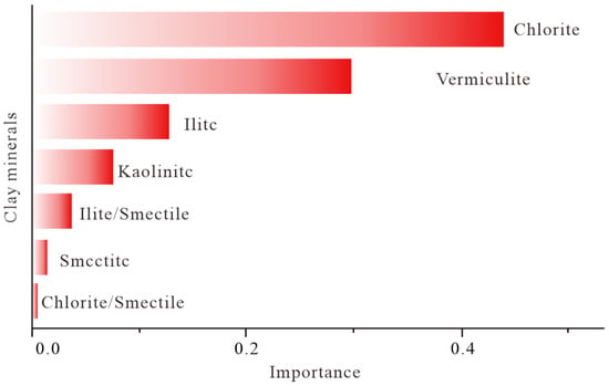
The random forest model was used to analyze the importance of different clay minerals to the weathering strength of several ancient intermediate–acid magmatic rock profiles in the study area (Figure 14). Random forest importance ranking can perform certain noise interference on each feature, and calculate the result error after interference. The greater the interference of the feature, the more important it is to the interpretation object.
Figure 14.
Random forest-based importance ranking of clay minerals to weathering degree.
The results show that chlorite is the most important, followed by vermiculite and illite. Among them, chlorite is formed during the weathering process of magnesia–iron minerals in granite. It appears in the early stage of soil formation. After a long period of weathering, chlorite will be transformed into vermiculite under warm and humid climate conditions. Therefore, the weathering degree of granite profile can be inferred by the content of chlorite and vermiculite. The Maoniushan area is located in a subtropical/tropical monsoon climate zone, with abundant precipitation and slightly acidic soil; an environment is conducive to chemical weathering soil. Combined with the mineral composition in the soil of the study profile (Table 1 and Table 2), the illite content of TP1711, TP1709 and TP2801 is similar. Illite is the primary weathering product and primary mineral of mudstone, and its existence conforms to the weathering soil environment of the study profile. The chemical weathering degree of these three profiles is moderate, so there are large amounts of vermiculite weathered from chlorite, and there is a certain amount of chlorite in the mineral composition, indicating that they have undergone initial weathering in the dry climate. There is no vermiculite in the TP1714 profile, and the content of illite and chlorite is 50%, so the weathering intensity is weak. This result is consistent with the judgment in the previous analysis. As a representative clay mineral in South China soil, kaolinite is present in small amounts in the TP1711, TP1709 and TP2801 profiles, which is mainly formed by feldspar leaching under the action of an acidic medium. The TP2801 profile exhibits extremely low kaolinite content, indicating that, after excluding the weakly weathered TP1714, it has the second lowest weathering intensity in Maniushan.
In summary, the soils developed from Proterozoic intermediate–acid rocks in the Maoniushan area are predominantly in a transitional phase from the weak weathering stage of chemical weathering to the moderate weathering stage, while the weathering degree of the TP1714 and TP2801 profiles is relatively weaker.
6. Conclusions
- (1)
- The chemical weathering intensity of granite–soil profiles exhibits significant spatial variation, with the overall system transitioning from weak to moderate weathering stages. The Chemical Index of Alteration (CIA) for all profiles ranges from 61 to 74. Combined with Na/K ratios and A-CN-K ternary diagrams, the weathering process is identified as being in an early stage characterized by significant depletion of Ca and Na, evolving toward an intermediate stage where K begins to be depleted. The weathering intensity sequence is TP1711 > TP1709 > TP1714 ≈ TP2801, indicating that the degree of weathering is markedly controlled by local environmental conditions.
- (2)
- Major and trace elements exhibit systematic migration and enrichment patterns during weathering and pedogenesis. Among the major elements, SiO2, CaO, K2O, and Na2O are depleted to varying degrees relative to the inert component Al2O3, while Fe2O3, MgO, TiO2, P2O5, and MnO show relative enrichment. For trace elements, Cu, Zn, and Pb are significantly depleted in the TP1711 profile, whereas most trace elements are relatively enriched in the other profiles, likely due to adsorption by clay minerals and accumulation of organic matter. Differences in rare earth element fractionation patterns (∑LREE/∑HREE) further corroborate that the profiles are at different stages of chemical weathering.
- (3)
- The characteristics of clay mineral assemblages effectively record the degree of weathering and indicate paleoclimatic conditions. The clay minerals in the profiles are dominated by illite, chlorite, and vermiculite. The TP1714 profile lacks vermiculite and has the highest illite content (54–60%), reflecting a relatively cold and dry microclimate and weaker chemical weathering intensity. In the other profiles, widespread development of vermiculite accompanied by minor kaolinite indicates moderate weathering intensity under warm and humid climatic conditions.
- (4)
- Microclimatic differentiation is the key external controlling factor leading to spatial variation in chemical weathering intensity. Given similar lithology and comparable pedogenic age, differences in microclimatic conditions—such as temperature and precipitation induced by altitude variation—constitute the primary external driver for the spatial heterogeneity in chemical weathering intensity of granite–soil profiles in the study area. This understanding provides an important basis for further elucidating the environmental response mechanisms of soil formation processes and weathering in mid- to high-altitude mountainous regions.
Author Contributions
Conceptualization, H.L.; methodology, T.L.; software, J.W.; validation, W.S. and H.L.; formal analysis, H.L. and H.Y.; investigation, H.Y. and J.Z.; resources, H.L.; data curation, H.Y.; writing—original draft preparation, Q.X.; writing—review and editing, H.L.; visualization, H.L.; supervision, H.L.; project administration, H.L.; funding acquisition, H.C. All authors have read and agreed to the published version of the manuscript.
Funding
This research was funded by the China Geological Survey Project “Ecological Geological Survey and Comprehensive Evaluation of Soil Erosion Areas in the Upper Reaches of the Yangtze River” (Grant No. DD20221776), as well as several commercial geological exploration projects: the Jiajihe Xiaodongzi Lead-Zinc and Fluorite Mine Exploration Project in Butuo County, Sichuan Province; the Liangfenggang Quartzite Reconnaissance Project in Huili City, Sichuan Province; and the Jianshe Geothermal (Therapeutic Thermal Mineral Water) Detailed Exploration Project in Mianning County, Sichuan Province.
Data Availability Statement
All research data are included in the article.
Acknowledgments
We extend our sincere gratitude to Yuan Ouyang, Hanxiao Huang, Fu Li, Jinghua Zhang, Jian Yang, Tengjiao Zhang an Fawei Tang from Chengdu Center, China Geological Survey (Geosciences Innovation Center of Southwest China); Yinbing Zhao from Chengdu University of Technology; Dengkui Wen, Jian Zeng, and Qian Hou from the No. 8 Geological Brigade of the Sichuan Bureau of Geology and Mineral Exploration and Development; and Wei Zhang, Hengxuan Liu, and Lin Chen from the No. 9 Geological Brigade of the Sichuan Bureau of Geology and Mineral Exploration and Development.
Conflicts of Interest
Huai Yu is employed by No. 9 Geological Brigade of Sichuan Bureau of Geology and Mineral Exploration and Development, Qiliang Xiao employed by is No. 8 Geological Brigade of Sichuan Bureau of Geology and Mineral Exploration and Development. The paper reflects the views of the scientists and not the companies.
References
- Wilson, M.A.; Burt, R.; Indorante, S.J.; Jenkins, A.B.; Chiaretti, J.V.; Ulmer, M.G.; Scheyer, J.M. Geochemistry in the modern soil survey program. Environ. Monit. Assess. 2008, 139, 151–171. [Google Scholar] [CrossRef] [Scilit] [PubMed]
- Slessarev, E.W.; Chadwick, O.A.; Sokol, N.W.; Nuccio, E.E.; Pett-Ridge, J. Rock weathering controls the potential for soil carbon storage at a continental scale. Biogeochemistry 2022, 157, 1–13. [Google Scholar] [CrossRef] [Scilit]
- Zhang, C.; Zhao, Y.B.; Ouyang, Y.; Ni, Z.Y.; Liu, H.; Li, T. Influence of Geological Environment on Vegetation Coverage in the Eastern Edge of Qinghai-Tibet Plateau: A case study of Mianning. Geol. Tethyan Geol. 2023, 43, 604–614. [Google Scholar] [CrossRef]
- Huggett, R.J. Soil chronosequences, soil development, and soil evolution:a critical review. Catena 1998, 32, 155–172. [Google Scholar] [CrossRef] [Scilit]
- Lin, H.S.; Wheeler, D.; Bell, J.; Zhang, W.; Shen, J.J. Assessment of soil spatial variability at multiple scales. Ecol. Model. 2005, 182, 271–290. [Google Scholar] [CrossRef]
- Zhao, Y.B.; Ni, Z.Y.; Ouyang, Y.; Yuan, C.D.; Chen, X.Y.; Wang, D.; Liu, J.J.; Liu, H. Research progress of eco-geological environment carrying capacity. Sediment. Geol. Tethyan Geol. 2022, 42, 529–541. [Google Scholar] [CrossRef]
- Chen, Q.H.; Su, N.Y.; Yang, C.F.; Yang, S.Y. Fractionation of rare earth elements in the weathering processes of granodiorite and basalt. Bulletin of Mineralogy. Petrol. Geochem. 2024, 43, 829–842. [Google Scholar] [CrossRef] [Scilit]
- Sistani, N.; Moeinaddini, M.; Ali-Taleshi, M.S.; Khorasani, N.; Hamidian, A.H.; Azimi, Y.R. Source identification of heavy metal pollution nearby Kerman steel industries. J. Nat. Environ. 2017, 70, 627–641. [Google Scholar]
- Cao, Y.S.; Xiao, B.; Jing, Z. Soil weathering and pedogenesis effect of biocrusts in the Chinese Loess Plateau. Sci. Soil Water Conserv. 2023, 21, 1–12. [Google Scholar] [CrossRef]
- Feng, Z.B.; Fu, J.; Nie, F.J.; Li, M.G.; Zhang, B.C.; Yang, S.Q.; Sheng, Z.N.; Huang, H. Geochemical Characteristics and Influencing Factors of Uranium and Thorium in the Sediments of Ganjiang Delta, Poyang Lake, Jiangxi Province. J. East China Univ. Technol. Nat. Sci. 2023, 46, 150–156. [Google Scholar] [CrossRef]
- Luo, Z.B.; Fan, J.; Shao, M.A. Progresses of weathered bedrock ecohydrology in the Earth’s critical zone. Chin. Sci. Bull. 2022, 67, 3311–3323. [Google Scholar] [CrossRef] [Scilit]
- Dahms, D.; Favilli, F.; Krebs, R.; Egli, M. Soil weathering and accumulation rates of oxalate-extractable phases derived from alpine chronosequences of up to 1 Ma in age. Geomorphology 2012, 151, 99–113. [Google Scholar] [CrossRef] [Scilit]
- Dellinger, M.; Bouchez, J.; Gaillardet, J.; Faure, L.; Moureau, J. Tracing weathering regimes using the lithium isotope composition of detrital sediments. Geology 2017, 45, 411–414. [Google Scholar] [CrossRef] [Scilit]
- Heidari, A.; Osat, M.; Konyushkova, M. Geochemical indices as efficient tools for assessing the soil weathering status in relation to soil taxonomic classes. Catena 2022, 208, 47–53. [Google Scholar] [CrossRef] [Scilit]
- Luo, M.; Fang, D.D.; Li, C.S.; Liu, Z.X.; Zhang, Y.H.; Fan, M.; Dong, J.H. Ecogeochemical Characteristics and Source Analysis of Heavy Metal Elements in Southern Yudu, Jiangxi Province. J. East China Univ. Technol. Nat. Sci. 2024, 47, 45–54. [Google Scholar] [CrossRef]
- Fedo, C.M.; Nesbitt, H.W.; Young, G.M. Unraveling the effects of potassium metasomatism in sedimentary rocks and paleosols, with implications for paleoweathering conditions and provenance. Geology 1995, 23, 921–924. [Google Scholar] [CrossRef] [Scilit]
- Luo, M.; Fang, D.; Li, C.; Liu, Z.; Zhang, Y.; Fan, M.; Dong, J. Source identification and geochemical evaluation of heavy metal and metalloid pollution in surface soil under different land-use types. Sediment. Geol. Tethyan Geol. 2025, 45, 671–683. [Google Scholar] [CrossRef]
- Li, T.; Li, Y.G.; Liu, H.; Li, S.M.; Ouyanmg, Y.; Li, C.; Zhang, K.; Li, J.; Zhang, J.H.; Zhang, T.J. Chemical weathering intensity and geochemical characteristics of Cretaceous terrigenous clastic rock-purple soil profiles in the Pushi area, Xichang. Geol. J. 2022, 57, 3587–3600. [Google Scholar] [CrossRef] [Scilit]
- Li, T.; Liu, X.N.; Liu, H.; Zhang, T.J.; Li, Y.G.; Li, S.M.; Wang, X.; Ouyang, Y.; Zhang, J.H. Geochemistry of rare earth elements of purple soil layers in the Middle-Lower Cretaceous Xiaoba Formation, Pushi area, Xichang. Sediment. Geol. Tethyan Geol. 2023, 43, 829–843. [Google Scholar]
- Sistani, N.; Moeinaddini, M.; Khorasani, N.; Hamidian, A.H.; Ali-Taleshi, M.S.; Azimi Yancheshmeh, R. Heavy metal pollution in soils nearby Kerman steel industry: Metal richness and degree of contamination assessment. Iran. J. Health Environ. 2017, 10, 75–86. [Google Scholar]
- Desyatkin, R.V.; Lessovaia, S.N.; Okoneshnikova, M.V.; Ivanova, A.Z. Cryosols from Tundra and Taiga Zones of Yakutia: Properties, Clay Mineralogy, and Problems of Classification. Eurasian Soil Sci. 2021, 54, 1783–1794. [Google Scholar] [CrossRef] [Scilit]
- Tian, H.; Qiao, J.; Zhu, Y.; Jia, X.; Shao, M.A. Vertical distribution of soil available phosphorus and soil available potassium in the critical zone on the Loess Plateau, China. Sci. Rep. 2021, 11, 3159. [Google Scholar] [CrossRef] [Scilit]
- Yang, L.; Zhang, A.; Wang, Y.; Zou, Y.J.; Wang, H. Distribution Characteristics of Selenium and Related Elements of Upland Rice in Xinfeng County, Jiangxi Province. J. East China Univ. Technol. Nat. Sci. 2024, 47, 55–63. [Google Scholar] [CrossRef]
- Liu, H.; Huang, H.X.; Ouyang, Y.; Li, W.C.; Zhang, J.H.; Zhang, T.J. Discussion on the eco-geo-environment effects of Neotectonic activities: A case study of Xichang City in western Yangtze block. Geol. Surv. China 2021, 8, 63–77. [Google Scholar] [CrossRef]
- Zhou, Z.K.; Cai, T.T.; Chen, K.; Lu, B.Y.; Su, Z.W.; Zhang, Y.S. Screening of Uranium-tolerant Phosphate-solubilizing Fungi for Remediation of Uranium-contaminated Soil. J. East China Univ. Technol. Nat. Sci. 2025, 48, 455–463. [Google Scholar] [CrossRef]
- Zhang, Z.J.; Liu, H.; Ouyang, Y. Elemental inheritance evaluation for geochemical elements in soil of the Daliangshan, China. Geochem. Explor. Environ. Anal. 2022, 22, geochem2022-010. [Google Scholar] [CrossRef] [Scilit]
- Wu, J.Y.; Liu, H.; Li, T.; Ouyang, Y.; Zhang, J.H.; Zhang, T.J.; Huang, Y.; Gao, W.L. Measuring Ecological Vulnerability Status of Chongqing Using Deep Learning Algorithms. Environ. Sci. Pollut. Res. 2023, 30, 86365–86379. [Google Scholar] [CrossRef] [Scilit]
- Liu, H.; Huang, H.X.; Yuan, O.; Zhang, J.; Zhang, T.; Fu, L.; Xiao, Q.; Jian, Z.; Qian, H.; Wen, D.; et al. Soil’s geologic investigation in Daliangshan, Xichang, Sichuan. Sediment. Geol. Tethyan Geol. 2020, 40, 91–105. [Google Scholar] [CrossRef]
- Ouyang, Y.; Liu, H.; Zhang, J.H.; Tang, F.W.; Zhang, T.J.; Huang, Y.; Huang, H.X.; Li, F.; Chen, M.H.; Song, W.J. Exploration Techniques and Methods of the Eco−Geological Survey in Mountainous Region, Southwest China. Northwest. Geol. 2023, 2023, 218–242. [Google Scholar] [CrossRef]
- Zhang, T.J.; Liu, H.; Ouyang, Y.; Huang, H.; Zhang, J.; Li, F.; Xiao, Q.; Zeng, J.; Hou, Q.; Wen, D.; et al. A preliminary discussion on the physicaland chemical characteristics and main controlling factors of soil and parent materialinthe middle and high mountain area–Take Xichang as an example. Sediment. Geol. Tethyan Geol. 2020, 40, 106–114. [Google Scholar] [CrossRef]
- Li, T.; Li, Y.G.; Liu, H.; Wang, J.B.; Li, K.Z.; Huang, Y.; Wang, Z.Y.; Xiang, H.X.; Wei, M.Q. Spatial distribution and ecological risk assessment of heavy metal elements in rock-soil in the mountainous areas of Southwest China: A case study of Xichang. Geol. J. 2023, 58, 3866–3888. [Google Scholar] [CrossRef] [Scilit]
- Li, T.; Liu, X.N.; Liu, H. Study on Spatial Distribution Characteristics of Soil Nutrient Elements Based on Geological Construction—Take Daliangshan Region as an Example. Saf. Environ. Eng. 2021, 28, 127–137. [Google Scholar]
- Yan, H.Z.; Zhou, G.H.; Sun, B.B.; He, L.; Liu, Y.; Hou, S. Geochemical characteristics of the bayberry producing area in Longhai, Fujian. Geol. China 2018, 45, 1155–1166. [Google Scholar] [CrossRef]
- Jenny, H. Factors of Soil Formation; McGraw-Hill Book Company, Inc.: New York, MY, USA, 1941; pp. 52–80. Available online: https://books.google.com/books (accessed on 5 March 2026).
- Chen, Y.Y.; Li, X.S.; Han, Z.Y.; Yang, S.; Wang, Y.; Yang, D. Chemical weathering intensity and element migration features of the Xiashu loess profile in Zhenjiang, Jiangsu Province. J. Geogr. Sci. 2008, 18, 341–352. [Google Scholar] [CrossRef] [Scilit]
- Taylor, S.R.; McLennan, S.M. The Continental Crust: Its Composition and Evolution; Blackwell Scientific Publications: Oxford, UK, 1985. [Google Scholar]
- Rudnick, R.L.; Gao, S. Composition of the continental crust. In Treatise on Geochemistry, Volume 3: The Crust; Rudnick, R.L., Ed.; Elsevier: Oxford, UK, 2003; pp. 1–64. [Google Scholar]
- Boynton, W.V. Cosmochemistry of the rare earth elements: Meteorite studies. In Rare Earth Element Geochemistry; Henderson, P., Ed.; Elsevier: Amsterdam, The Netherlands, 1984; pp. 63–114. [Google Scholar]
- Sun, S.S.; McDonough, W.F. Chemical and isotopic systematics of oceanic basalts: Implications for mantle composition and processes. In Magmatism in the Ocean Basins; Saunders, A.D., Norry, M.J., Eds.; Geological Society: London, UK, 1989; Volume 42, pp. 313–345. [Google Scholar]
- Zhang, T.J.; Liu, H.; Ouyang, Y.; Zhang, J.H.; Zhang, Z.J.; Li, T. Ecological environment function of different geological formations: A case study of Xichang area. Geol. Sur. China 2021, 8, 35–49. [Google Scholar] [CrossRef]
- Nesbitt, H.W.; Young, G.M. Early proterozoic climates and plate motions inferrde from major element chemistry of lutites. Nature 1982, 299, 715–717. [Google Scholar] [CrossRef] [Scilit]
- Perri, F. Chemical weathering of crystalline rocks in contrasting climatic conditions using geochemical proxies: An overview. Palaeogeogr. Palaeoclimatol. Palaeoecol. 2020, 556, 109873. [Google Scholar] [CrossRef] [Scilit]
- White, A.F.; Bullen, T.D.; Schulz, M.S.; Blum, A.E.; Huntington, T.G.; Peters, N.E. Differential rates of feldspar weathering in granitic regoliths. Geochim. Cosmochim. Acta 2001, 65, 847–869. [Google Scholar] [CrossRef] [Scilit]
- Nesbitt, H.W.; Young, G.M. Prediction of some weathering trends of plutonic and volcanic rocks based on thermodynamic and kinetic considerations. Geochim. Cosmochim. Acta 1984, 48, 1523–1534. [Google Scholar] [CrossRef] [Scilit]
- Nesbitt, H.W.; Markovics, G.; Price, R.C. Chemical processes affecting alkalis and alkaline earths during continental weathering. Geochem. Cosmochim. Acta 1980, 44, 1659–1666. [Google Scholar] [CrossRef] [Scilit]
- Brimhall, G.H.; Lewis, C.J.; Ford, C.; Bratt, J.; Taylor, G.; Warin, O. Quantitative geochemical approach to pedogenesis: Importance of parent material reduction, volumetric expansion, and eolian influx in lateritization. Geoderma 1991, 51, 51–91. [Google Scholar] [CrossRef] [Scilit]
- Nesbitt, H.W. Mobility and fractionation of rare earth elements during weathering of a granodiorite. Nature 1979, 279, 206–210. [Google Scholar] [CrossRef] [Scilit]
- Babechuk, M.G.; Widdowson, M.; Kamber, B.S. Quantifying chemical weathering intensity and trace element release from two contrasting basalt profiles, Deccan Traps, India Chem. Chem. Geol. 2014, 363, 56–75. [Google Scholar] [CrossRef] [Scilit]
- Braun, J.J.; Marechal, J.C.; Riotte, J.; Boeglin, J.-L.; Bedimo, J.-P.B.; Ngoupayou, J.R.N.; Nyeck, B.; Robain, H.; Sekhar, M.; Audry, S.; et al. Elemental weathering fluxes and saprolite production rate in a Central African lateritic terrain (Nsimi, South Cameroon). Geochim. Cosmochim. Acta 2012, 99, 243–270. [Google Scholar] [CrossRef] [Scilit]
- Czarnecki, S.; Düring, R.A. Influence of long-term mineral fertilization on metal contents and properties of soil samples taken from different locations in Hesse, Germany. Soil 2015, 2015, 23–33. [Google Scholar] [CrossRef] [Scilit]
- White, A.F. Quantitative Approaches to Characterizing Natural Chemical Weathering Rates; Springer: New York, NY, USA, 2008; pp. 512–531. [Google Scholar] [CrossRef] [Scilit]
- Zhu, L.; Wang, J.; Yu, R.; Li, F.; You, Y.; Lu, H. A review on the application of lithium isotopes in continental weathering research and progress. Prog. Geogr. 2025, 44, 211–225. [Google Scholar] [CrossRef] [Scilit]
- Zhou, X.N.; Cao, Y.T.; Ji, Y. Element geochemical characteristics of weathering crust profiles of the Wenchuan section in the upper arid valley of the Minjiang River. Geophys. Geochem. Explor. 2024, 48, 597–608. [Google Scholar] [CrossRef]
- Li, G.; Li, G.K. Fossil organic carbon weathering: A nexus in global biogeochemical cycles. Sci. China Earth Sci. 2024, 67, 2068–2072. [Google Scholar] [CrossRef] [Scilit]
- Zhang, Y.; Wang, J.; Qu, Y.; Zhu, C.; Jin, Z. Mobility of rhenium and selenium during chemical weathering and their implication for petrogenic organic carbon oxidation. Sci. China Earth Sci. 2024, 67, 740–750. [Google Scholar] [CrossRef] [Scilit]
- Lu, C.; Deng, L.; Cui, R.; Wang, X.; Zhou, T.; Liu, G. Effects of Alder and Cypress on Weathering and Nutrient Characteristics of Purple Soil in Hilly Area of Central Sichuan Province. Bull. Soil Water Conserv. 2021, 41, 34–42. [Google Scholar] [CrossRef]
- Yi, Z.; Liu, H.; Tian, Z.; Guo, Y.; Liu, H.; Zhang, J.; Wu, Z.; Su, Y.; Luo, H.; Chen, H. Assessment of Eco-Geological Vulnerability Using Multiple Machine Learning Models: A Case Study of the Three Gorges Reservoir Area, China. Sustainability 2026, 18, 1758. [Google Scholar] [CrossRef] [Scilit]
- Ohmura, A. Enhanced temperature variability in high-altitude climate change. Theor. Appl. Climatol. 2012, 110, 499–508. [Google Scholar] [CrossRef] [Scilit]
- Lyu, H.; Lu, H.; Wang, Y.; Zhang, H.; Wang, Y.; Wang, K.; Lai, W.; Liu, Z.; Li, Y.; Ji, J. East Asian paleoclimate change in the Weihe Basin (central China) since the middle Eocene revealed by clay mineral analysis. Sci. China Earth Sci. 2021, 64, 1285–1304. [Google Scholar] [CrossRef] [Scilit]
- Lu, C.; Xia, G.Q.; Chen, Y.; Wu, J.X.; Bao, W.C.; Fan, Q.S.; Shi, Z.; Hao, X.W. Late Eocene-Early Oligocene clay mineral characteristics and paleoclimate significance in Lunpola Basin, Tibet. Sediment. Geol. Tethyan Geol. 2023, 43, 565–579. [Google Scholar] [CrossRef]
- Betard, F.; Caner, L.; Gunnell, Y.; Bourgeon, G. Illite neoformation in plagioclase during weathering: Evidence from semi-arid Northeast Brazil. Geoderma 2009, 152, 53–62. [Google Scholar] [CrossRef] [Scilit]
- Sun, Y.; Li, Y.L.; Zhang, C.Q.; Qin, X.; Shen, J.; He, H.; Pan, Y. Weathering of Chlorite Illite Deposits in the Hyperarid Qaidam Basin: Implications to Post-Depositional Alteration on Martian Clay Minerals. Front. Astron. Space Sci. 2022, 9, 875547. [Google Scholar] [CrossRef] [Scilit]
- Guinoiseau, D.; Fekiacova, Z.; Allard, T.; Druhan, J.L.; Balan, E.; Bouchez, J. Tropical Weathering History Recorded in the Silicon Isotopes of Lateritic Weathering Profiles. Geophys. Res. Lett. 2021, 48, e2021GL092957. [Google Scholar] [CrossRef] [Scilit]
- Jeong, G.Y. Formation of Vermicular Kaolinite from Halloysite Aggregates in the Weathering of Plagioclase. Clays Clay Miner. 1998, 46, 270–279. [Google Scholar] [CrossRef] [Scilit]
- Vanderaveroet, P. Miocene to pleistocene clay mineral sedimentation on the New Jersey shelf. Ocean. Acta 2000, 23, 25–36. [Google Scholar] [CrossRef] [Scilit]

Disclaimer/Publisher’s Note: The statements, opinions and data contained in all publications are solely those of the individual author(s) and contributor(s) and not of MDPI and/or the editor(s). MDPI and/or the editor(s) disclaim responsibility for any injury to people or property resulting from any ideas, methods, instructions or products referred to in the content. |
© 2026 by the authors. Licensee MDPI, Basel, Switzerland. This article is an open access article distributed under the terms and conditions of the Creative Commons Attribution (CC BY) license.