


Abstract
This review systematically examines major research advances in AUV path planning over recent years, covering several mainstream methodologies: sample-based path planning (e.g., PRM and RRT along with their asymptotically optimal variants, suitable for high-dimensional space exploration), graph-search-based path planning (e.g., A-series and D-series algorithms, achieving global optimization and dynamic replanning through environmental modeling), optimization-based approaches (including artificial potential field (APF), nonlinear programming (NLP), and model predictive control (MPC), designed to satisfy stringent dynamic constraints on AUV motion), swarm intelligence-based planning methods (such as genetic algorithms and ant colony optimization), and learning-based intelligent methods (such as deep reinforcement learning (DRL) for real-time decision-making in unknown and dynamic environments). Through in-depth analysis of these methods’ principles, improvement strategies, and AUV path planning contexts, this review highlights current research trends toward hybrid cooperative planning, dynamic environmental adaptability, and high-precision trajectory optimization. Finally, the paper outlines future directions for AUV path planning, emphasizing multi-AUV collaboration and higher-level intelligent decision-making as key research priorities.
1. Introduction and Background
1.1. Background on AUV Development
The Autonomous Underwater Vehicle (AUV) stands as a pivotal platform for both marine exploration and various underwater operational tasks. These systems are characterized by several key advantages, including their high maneuverability, enhanced autonomy, and inherently lower operational costs compared to manned systems. Consequently, the development of AUV technology has become a primary focus for both international marine research initiatives and global military power modernization efforts.
1.1.1. Applications of AUVs in Military and Civil Domains
The utility of Autonomous Underwater Vehicles spans across both military and civil domains, underscoring their diverse operational significance. In the military domain, AUVs hold crucial strategic value, primarily supporting Intelligence, Surveillance, and Reconnaissance operations. These tasks involve collecting underwater intelligence and performing high-resolution seabed mapping, activities which inherently demand exceptional stealth and extended endurance capabilities. Furthermore, AUVs are vital for Anti-Submarine Warfare, acting as unmanned platforms to search for, identify, and track underwater threats, and for Mine Countermeasures [1], specifically conducting the detection, classification, and neutralization of explosive ordnance. The applications in the civil domain are equally expansive. AUVs are indispensable for marine science research, facilitating the long-term monitoring and collection of deep-sea biological [2], geological, and hydrographic data such as temperature, salinity, and depth measurements [3]. Moreover, they are crucial for resource exploration and development, assisting with complex engineering operations like oil and gas pipeline inspection, deep-sea mineral resource surveying, and subsea cable laying [4]. Lastly, AUVs play a key role in Search and Rescue and salvage operations, providing critical underwater target localization and search capabilities following accidents or disasters.
1.1.2. Technological Development History and Status
The technical evolution of Autonomous Underwater Vehicles can be traced back to the 1960s [5], progressing from rudimentary Remotely Operated Vehicles to the contemporary generation of highly autonomous and intelligent AUV systems. The core trends currently driving AUV technology development are multifaceted [6]. Firstly, achieving Extended Endurance and Greater Depths is a major focus, necessitating the adoption of advanced energy systems, such as fuel cells or closed-cycle engines, alongside high-pressure resistant materials. These innovations enable AUVs to conduct long-duration operations across the global ocean and in deep-sea environments [7]. Secondly, a push toward Enhanced Intelligence and Higher Autonomy emphasizes breakthrough developments in complex decision-making, adaptive navigation, and sophisticated path planning techniques. These advancements allow AUVs to execute missions independently within dynamic and often unknown underwater settings. Thirdly, Collaborative Operations and Formation Control represent a growing area [8]. This involves the development of robust techniques for inter-AUV information sharing, cooperative collision avoidance, and dynamic task allocation, all aimed at significantly boosting overall mission efficiency and system robustness [9,10,11,12,13,14]. Furthermore, recent studies have explored K-connected hierarchical topology control [15], edge-weighted formation control with stochastic collision avoidance [16], and distributed event-driven optimal control for networked vehicles under long transmission delays [14].
1.2. AUV Path Planning Problem Formulation
Path Planning serves as the cornerstone of the autonomous navigation system for Autonomous Underwater Vehicles. Its core mission is to compute an efficient trajectory from a starting point to an endpoint, successfully satisfying the AUV’s complex kinematic and dynamic constraints while simultaneously optimizing a specific objective function, such as minimizing total travel time or energy consumption [17]. From a mathematical perspective, this process is abstracted as a constrained optimization problem. The dynamic constraints ensure that the path is hydrodynamically realizable under fluid mechanics equations, whereas state and control constraints define physical limitations like the AUV’s maximum speed, minimum turning radius, and safe distance from environmental hazards. Path planning strategies and scope are conventionally categorized based on environmental information and calculation timing [18]. Firstly, based on information completeness, planning is divided into Global Path Planning, which relies on a complete, a priori environmental map obtained before the mission starts, and Local Path Planning, which operates with partial or real-time sensor data to react to unforeseen changes during navigation; while global planners can generate optimal and smooth trajectories in known environments, they exhibit poor adaptability when faced with dynamic obstacles or map inaccuracies. Conversely, local planners offer high reactivity but are prone to becoming trapped in local minima—particularly in cluttered underwater scenarios with narrow passages or strong currents. This fundamental trade-off between global optimality and local reactivity constitutes one of the core challenges in AUV path planning. This is an offline computation designed to achieve a globally optimal solution but exhibits poor adaptability to unforeseen events. In contrast, Local Path Planning relies only on real-time sensor data for online corrections, possessing strong adaptivity but prone to local minima traps. Secondly, based on the temporal characteristics of the environment, planning is categorized into Static Environment Planning, where environmental elements such as obstacle positions are constant over time, and Dynamic Environment Planning, which requires the algorithm to have time-variant prediction capabilities to handle moving obstacles or ocean current changes. Finally, according to the dimensionality considered, 2D Plane Planning is typically simplified to horizontal motion, while 3D Space Planning must simultaneously account for longitude, latitude, and depth. Although 3D planning significantly increases complexity, it affords the AUV greater flexibility to utilize the underwater environment [19], for instance, by altering depth to evade obstacles.
1.3. Unique Characteristics and Challenges of the Underwater Environment
The three-dimensional and large-scale spatial characteristics of the underwater environment introduce fundamental challenges for AUV path planning. Critically, the absence of GPS signals underwater necessitates reliance on acoustic positioning systems (e.g., LBL, USBL), which suffer from limited accuracy, high latency, and susceptibility to multipath effects; this leads to significant navigation uncertainty and error accumulation over time, directly degrading path tracking fidelity and replanning reliability. Ocean currents directly compromise the AUV’s actual navigation efficiency and trajectory accuracy, compelling planning algorithms to integrate detailed hydrological models for optimal route synthesis. Furthermore, localized phenomena such as vortices demand that the AUV possesses rapid local perception and avoidance capabilities for effective response. Hydrographic gradient areas like the thermocline additionally impact the vehicle’s buoyancy control and acoustic sensing performance [20]. Sensor limitations present another significant difficulty for underwater navigation. Acoustic sensors, such as sonar systems, frequently provide information that is sparse, imprecise, and subject to latency because sound wave propagation is heavily influenced by environmental factors and high noise levels [21]. Simultaneously, the rapid attenuation of light and water turbidity severely restrict the effective range of optical sensors, constraining adequate long-distance environmental perception. A third crucial challenge lies in the strict energy constraints. Given the finite onboard energy capacity, simply pursuing the shortest path is insufficient; path planning must shift toward calculating low-energy consumption routes [22]. This necessitates minimizing the propulsive and steering power consumption by effectively utilizing or avoiding adverse currents to maximize the vehicle’s operational endurance. Finally, the complex dynamic constraints and motion characteristics make underwater path tracking significantly more difficult than for other platforms. The AUV’s equations of motion involve intricate, highly non-linear, and strongly coupled fluid dynamics [23]. This complexity mandates that the planned trajectory must be dynamically feasible under the vehicle’s actual thrust and rudder inputs, strictly adhering to kinematic limits like maximum speed and minimum turning radius. From the perspective of symmetry, AUV path planning presents a compelling duality. On the ond hand, the vehicle’s design and kinematic constraints often exhibit geometric symmetry, and multi-AUV cooperative systems frequently strive to maintain symmetric formation topologies to maximize sensing coverage and communication stability. On the other hand, the underwater environment introduces significant asymmetry; specifically, ocean currents create an anisotropic cost field where the energy expenditure for traversing from point A to B differs from B to A (breaking the symmetry of the travel cost matrix). Consequently, advanced path planning algorithms must reconcile the desire for symmetric, smooth trajectories with the necessity of exploiting these environmental asymmetries to achieve energy-optimal navigation. Figure 1 shows the architecture of the main AUV path planning methods.
Figure 1.
Architectural Diagram of Main AUV Path Planning Methods.
2. Methodologies for Sampling-Based Motion Planning
Sampling-Based Path Planning (SBP) algorithms are recognized as effective methodologies for addressing pathfinding challenges in high-dimensional and intricate Configuration Spaces (C-Spaces). The fundamental principle underpinning these approaches involves the implicit representation of the Free Space through the process of randomly sampling and subsequently interconnecting these sample points within the C-Space, enabling the computation of a valid trajectory using graph search techniques [24]. Their principal benefits stem from their inherent characteristic of Probabilistic Completeness and their demonstrated efficacy in managing complex kinematic and environmental constraints. This chapter will primarily provide a comprehensive review focused on two pioneering classical algorithms—the Probabilistic Roadmap (PRM) and the Rapidly-exploring Random Tree (RRT)—alongside their subsequent enhancements and specialized applications for Autonomous Underwater Vehicle (AUV) path planning [25].
2.1. Probabilistic Roadmaps (PRM)
The Probabilistic Roadmap (PRM) is recognized as one of the early and seminal sampling-based algorithms designed for global path planning. This methodology decouples the overall planning task into two distinct, sequential phases: 1. Learning/Construction Phase: This involves the stochastic generation of a substantial number of nodes within the Free Space to serve as vertices of the roadmap. Subsequently, the algorithm attempts to establish edges by connecting each node to its nearest neighbors. Crucially, each proposed connection must first satisfy a local collision-free check, ultimately yielding an undirected graph or roadmap. 2. Query/Search Phase: During this phase, both the start and goal configurations are integrated into the existing roadmap by establishing connections to their closest valid nodes. The final path is then retrieved by deploying a standard graph search algorithm (such as Dijkstra’s or A*) on the constructed roadmap. The primary merits of PRM reside in its inherent characteristic of probabilistic completeness and the resulting high query efficiency achieved because the roadmap, once constructed, can be reused for numerous subsequent pathfinding requests. Nevertheless, the conventional PRM approach is subject to several limitations, specifically its tendency to generate suboptimal paths, its poor robustness in environments characterized by narrow passages, and the significant computational overhead associated with the initial roadmap construction phase. Arifi and Jarray [26] proposed a path planner predicated on the Probabilistic Roadmap Star (PRM*) algorithm for the navigation of an Autonomous Underwater Vehicle (AUV) within challenging three-dimensional (3D) environments. They introduced an enhanced version of the foundational PRM algorithm, namely PRM*, with the objective of improving the capacity for node specification, edge construction, and subsequent graph creation. The PRM* algorithm leverages the property of Asymptotic Optimality, which guarantees that as the number of samples increases and computation time is extended, the resulting path quality converges toward the theoretical optimum. Chowdhury and Schwartz [27] introduced a novel local path replanner utilizing an enhanced variant of the global planning algorithm, PRM-A*. The core concept of this methodology is the segregation of the planning task into two components: global planning (which addresses static obstacles and defines the path prior to execution) and local replanning (which handles dynamic/moving obstacles and computes the path in real-time during runtime). This framework demonstrates that the PRM algorithm is not restricted solely to global planning; by integrating the A* search heuristic and a local replanning strategy, its efficacy can be significantly augmented for navigating dynamic environments and achieving real-time obstacle avoidance.
2.2. Rapidly-Exploring Random Trees (RRT)
The central mechanism of the RRT algorithm involves a repetitive process: a random point is sampled in the configuration space; the nearest node within the existing tree is identified; and a new node is then incrementally extended from this nearest node toward the sampled point [28]. This characteristic combination of stochasticity and targeted expansion grants RRT a robust capacity for exploration, making it highly effective for systems operating in high-dimensional spaces and those subject to non-holonomic constraints. Heo et al. [29] explicitly affirmed that RRT is a stochastically-sampled data structure capable of effectively accommodating the non-holonomic constraints (such as turning radius limits) inherent in systems like Autonomous Underwater Vehicles (AUVs). Their study applied RRT to the local path planning for AUVs, simultaneously integrating the A* algorithm to identify the shortest trajectory within the tree structure generated by RRT.
2.2.1. Asymptotically Optimal RRT (RRT*) and Path Optimization
Due to its inherent stochastic nature, paths generated by the basic RRT algorithm are often jagged (or non-smooth), rendering them unsuitable for direct implementation in systems requiring smooth control (such as AUVs). Consequently, researchers have shifted their focus toward the Asymptotically Optimal RRT (RRT*) algorithm and its subsequent variants. RRT* introduces two pivotal optimization steps into the standard RRT expansion process: 1. Choose Parent: Upon the creation of a new node, the algorithm searches within a defined neighborhood radius to identify and connect to a parent node that yields a lower path cost back to the root, thereby achieving local path optimization. 2. Rewiring: Following the insertion of the new node, the algorithm examines other nodes within its proximity. If connecting these neighboring nodes to the newly added node results in a reduced total path cost to the root, their parent pointers are updated. This process continuously refines the path cost across the entire tree, leading to convergence toward the optimal solution. Yu et al. [30] addressed the jagged and non-smooth nature of paths generated by the basic RRT approach in AUV path planning by proposing the Smooth-RRT algorithm, thereby fulfilling the practical control requirements of AUVs. This methodology employs a two-phase optimization framework. Initially, during the RRT tree extension phase, the algorithm incorporates a convergence factor to bias sampling towards the goal and an angular factor to restrict the maximum turning angle, which collectively enhances both search efficiency and path feasibility while satisfying motion constraints. Subsequently, in the path retrieval phase, a greedy algorithm is utilized for post-processing path smoothing. This is achieved by eliminating redundant vertices and reconnecting the remaining nodes with straight-line segments that still adhere to the angular constraints. The ultimate outcome is an optimized path that is shorter, significantly smoother, and better suited for AUV motion control systems. Xuezhi Wang, Simon Williams, et al. [31] proposed an RRT* (Asymptotically Optimal Rapidly-exploring Random Tree)-based trajectory scheduling algorithm to tackle the dual challenge faced by AUVs during recovery operations: planning a course back to a moving recovery vessel while simultaneously relying solely on Angles-Only Measurements for target localization. The key innovation of this algorithm lies in the extension of the RRT* framework: it integrates an Information Theoretic Cost—typically derived from the Fisher Information Matrix (FIM)—into the RRT* optimization criterion. This adaptation dictates that the AUV’s planned trajectory not only seeks the shortest path (the traditional advantage of RRT*) but, critically, must execute maneuvers that enhance target localization, aiming to maximize observability and minimize target localization error. In this manner, the AUV effectively achieves the synchronous accomplishment of both localization and navigation, thereby solving the complex trajectory optimization problem under the constraints of a dynamic target and low-information sensors. Xie and Wang et al. [32] proposed an AUV path planning approach based on the improved Artificial Potential Field-RRT* (APF-RRT*) algorithm. This method aims to mitigate two common issues in conventional planning: the AUV’s susceptibility to local optima traps and overall planning inefficiency. The central tenet of this methodology is the integration of the Attractive and Repulsive Potential Functions from the Artificial Potential Field (APF) algorithm into the RRT* framework: The Attractive Potential Function is employed to steer the RRT* sampling procedure, resulting in more effective convergence toward the target configuration. Conversely, the Repulsive Potential Function serves to guide RRT* expansion away from obstacles, thereby incorporating obstacle avoidance intelligence directly into the sampling and extension phases. Through this combination, the approach successfully prevents the AUV from becoming trapped in local minima while simultaneously preserving the asymptotic optimality property of RRT*. Furthermore, the authors also account for the influence of water currents and dynamic obstacles on AUV motion. Cui, Li, and Yan et al. [33] proposed an adaptive path planning algorithm based on the Multidimensional RRT* (M-RRT*) to address the challenge of multi-AUV systems performing scalar field sampling and environmental sensing within a region of interest. This research extends the RRT* framework to handle the joint path planning problem for multi-agent (Multi-AUV) systems, with a core emphasis on maximizing information gain. The methodology defines a measurable model, composed of multiple basis functions, to represent the scalar field. Accordingly, the optimization criterion for path planning utilizes Mutual Information (MI) within the M-RRT* algorithm. The AUV sampling locations are determined by maximizing the mutual information between the scalar field model and the collected observations, with the explicit goal of enhancing the quality of future samples and the accuracy of environmental estimation. Furthermore, the approach incorporates a Selective Basis Function Kalman Filter for model estimation, thereby providing an efficient, collaborative path planning strategy suitable for environmental surveying, monitoring, and search tasks.
2.2.2. Other RRT Variant Methods
To overcome the limitations of the conventional RRT algorithm, such as path sub-optimality, the neglect of physical constraints, and low search efficiency, researchers have developed a suite of advanced variants based on the RRT* framework: Bi-directional RRT (Bi-RRT) significantly enhances search convergence speed in open or sparsely cluttered environments by synchronously constructing two RRT trees from the start and goal states and facilitating their connection in the intervening space. This strategy accelerates the discovery of a feasible solution by reducing the respective exploration spaces [34]. Kinodynamic-RRT* is pivotal for systems subject to non-holonomic and dynamic constraints. It integrates the AUV’s differential motion model and control inputs directly into the tree’s Steer function, ensuring that every connection segment in the tree represents a physically executable AUV trajectory. The algorithm’s objective is to find an optimal spatio-temporal trajectory that not only avoids obstacles but adheres to all physical constraints, thereby substantially boosting path practicality [35]. Informed RRT* dramatically improves the convergence rate of RRT*. Upon finding the initial feasible solution, it introduces a Hyperellipsoid to serve as a heuristic sampling region. This ellipsoid is defined by the cost of the current best path and contracts as the path is continuously refined, directing subsequent random samples to the effective region most likely to yield a superior solution. This approach avoids sampling large volumes of unnecessary space, significantly enhancing the algorithm’s efficiency [36]. Anytime-RRT* prioritizes the balance between real-time performance and path quality. Falling under the “Anytime” planning paradigm, it can quickly return an initial feasible trajectory within a limited time budget and subsequently persistently execute RRT*’s rewiring and optimization procedures using the remaining computational resources. This capability offers a robust solution for AUV missions with strict time constraints, such as dynamic obstacle avoidance and emergency replanning, ensuring both mission success and the asymptotic optimality of the final path [37]. Collectively, these variants underscore the high plasticity of the RRT framework and demonstrate how targeted modifications enable it to efficiently address the diverse challenges encountered by AUVs in complex underwater environments. Table 1 summarizes and compares the sample-based AUV path planning methods mentioned in this section.
Table 1.
Comparative Summary of Sample-Based Path Planning Algorithms for AUVs.
3. Methodologies for Graph Search-Based Path Planning
Graph Search-Based Path Planning (GSBP) algorithms have long held a central position in research concerning Autonomous Underwater Vehicle (AUV) navigation due to its strong interpretability, robust performance against local minima, and highly mature algorithmic theoretical framework. As its name suggests, these approach models the underwater environment as a graph consisting of feasible and forbidden regions. The task of the Autonomous Underwater Vehicle (AUV) is to find a path that passes only through the feasible regions while completely avoiding the forbidden ones [38]. This chapter This chapter focuses primarily on comprehensively elaborating the current mainstream environmental modeling methods, the traditional graph search algorithms based on these models, and the optimal control methods derived from their extensions.
3.1. Environmental Modelling Methods
A suitable environmental model is an essential prerequisite for all graph search–based path planning algorithms, as it can significantly reduce subsequent computational effort in planning and render environmental variables clearer and more interpretable [39]. The underwater environment, characterized by ocean currents, diverse random and complex obstacles, and varying terrain, exhibits far greater uncertainty and dynamism compared with terrestrial environments. These factors pose significant challenges for accurate and efficient environmental modeling. The following sections present several commonly used environmental modeling methods.
3.1.1. Roadmap Methods
The Roadmap Method builds a sparse graph structure by selecting a series of representative points within the feasible space and connecting them through valid edges. Among this type, the more prominent methods are the visibility graph and Voronoi diagram. The core idea of the visibility graph method is to treat the vertices of each obstacle in the environment, along with the vehicle’s start and goal positions, as the points of a graph. If the straight line connecting any two points does not intersect any obstacles, it is considered an edge. Each edge is then assigned a weight based on the Euclidean distance between the two points, resulting in a graph structure constrained by visibility [40]. Its advantage lies in its ability to convincingly find the globally shortest path in a geometric sense. However, the resulting path often runs very close to obstacle boundaries, lacking sufficient safety margins. Moreover, in environments with numerous or dynamic obstacles, the method tends to exhibit limited robustness and often struggles to produce effective results efficiently. The Voronoi Diagram divides the environment into several regions, where each point within a region is closer—in terms of Euclidean distance—to a specific obstacle or feature point (considered as a point) than to any other point. This implies that the points located on the boundaries between regions are equidistant from two or more points; these boundary lines form the Voronoi edges, and the intersections of multiple edges form the Voronoi vertices. Together, they constitute the Voronoi diagram, which represents a sparse skeletal network of the environment. The main advantage of this method lies in its emphasis on maintaining maximal clearance from obstacles, causing the resulting paths to naturally stay far from them and thus providing a high safety margin. It is particularly suitable for unknown or dynamic environments. However, it is sensitive to the geometric complexity of obstacles, and its pursuit of safety often comes at the cost of increased path length [41].
3.1.2. Cell Decomposition Methods
Cell Decomposition Methods represent a classical approach to environmental modelling. This technique involves partitioning a spatial domain into numerous small cells, identifying internally traversable sub-cells, and constructing a graph structure by connecting adjacent cells. Based on differing partitioning methodologies, these methods are categorized into Exact Cell Decomposition and Approximate Cell Decomposition. Exact Cell Decomposition first determines the feasible space for the AUV and then divides it into a series of disjoint, discrete, and computationally manageable cells based on specific partitioning criteria. The two most common types are Trapezoidal Decomposition and Convex Decomposition. In Trapezoidal Decomposition, rays are projected vertically from each vertex of the obstacles until they intersect other obstacles or the environment boundary, thereby partitioning the entire feasible space into several trapezoidal regions. This method produces regular and finite cells with a clear structure, but it is applicable only to two-dimensional spaces. To address the issue of high-dimensional extension, Convex Decomposition divides the free space into a set of convex polygonal cells. Since the concept of convexity can be generalized to any dimensional space, this method can be applied to higher-dimensional environments. Moreover, because a straight path can often be found within a convex cell, it enables locally optimal path planning. However, this advantage comes at the cost of increased computational complexity during the decomposition process [42]. The core concept of Approximate Cell Decomposition is to represent the environment approximately using regular grid cells rather than performing an exact geometric partition based on obstacle boundaries. Each cell is labeled as either feasible or infeasible according to its properties, and a path search graph is then constructed based on the connectivity between these cells. According to different partitioning strategies, this method can be classified into Uniform Grid Decomposition and Adaptive Hierarchical Decomposition. In Uniform Grid Decomposition, the environment is divided into equally sized rectangular cells, whose feasibility is determined through sensor data or environmental models. This method is simple, easy to implement, and allows convenient updates, but it suffers from high storage costs in complex environments. Adaptive Hierarchical Decomposition, on the other hand, recursively divides the environment (the root point) into four equally sized square subregions—this process is known as Quadtree Decomposition. By applying different resolutions in different areas, it effectively balances computational efficiency and spatial accuracy. When this approach is extended to three-dimensional space, each cubic point is further divided into eight subcubes, forming an Octree Decomposition, which is particularly suitable for underwater task execution [43]. Considering the influence of underwater obstacles, ocean currents, and topography, the Multi-layer Grid Representation for Underwater Environments builds upon Approximate Cell Decomposition by overlaying multiple environmental attribute layers onto each cell rather than applying a simple feasible/unfeasible label [44]. These layers are then fused into a composite cost, forming a multidimensional cost map.
3.2. Traditional Graph Search Algorithms
Traditional graph search algorithms typically rely on the environment modelling approaches outlined previously to search for optimal paths within constructed graph or grid environments, thereby achieving global planning.
3.2.1. Dijkstra Algorithm
The core principle of Dijkstra’s algorithm is to progressively expand the path from the point with the lowest current cost to discover the shortest route. The following calculations will be performed using the visibility map method as an example. The core principle of Dijkstra’s algorithm is to progressively expand the path from the point with the lowest current cost to discover the shortest route. The following calculations will be performed using the visibility map method as an example. Each edge has a non-negative cost , Construct a distance set dist, the values corresponding to the starting point and the point are defined as:
Starting from the origin, if an adjacent point of the current point is found to satisfy:
Update the value of this adjacent point in the set:
Record the preceding point and repeat this step until all points have been visited. Determine the globally optimal path based on the distance set. In graph or grid environments where edge weights are non-negative, this method can reliably find global shortest paths from the starting point to all points [45]. Its time complexity depends on the number of points and the number of edges in the graph. When employing the most common binary heap to store point costs, its time complexity can be expressed as:
3.2.2. Variants and Extensions of A* Algorithm
The A* algorithm is a representative heuristic algorithm developed from Dijkstra’s algorithm. Its principle primarily involves introducing a heuristic function , which together with the original distance cost function forms a composite cost function . This can be expressed as follows:
The role of the heuristic function is to guide the search process, thereby reducing unnecessary point expansion and enhancing the efficiency of the search path. Common forms of heuristic functions include Euclidean Distance, Manhattan Distance, Diagonal Distance, and Energy-based forms [46]. Building upon this foundation, researchers have proposed various improvement methods, including the Jump Point Search algorithm, the Hybrid A* algorithm, and the Theta* algorithm. The Jump Point Search algorithm enhances search efficiency by skipping redundant intermediate points through sequential jumps in the same direction, performing expansion only at designated jump points [47]. The Hybrid A* algorithm simultaneously considers both the position and orientation of the mobile platform during path search, incorporating its kinematic constraints into path planning to generate executable, smooth trajectories. It is widely employed in fields such as autonomous driving and unmanned aerial vehicle control [48]. The Theta* algorithm achieves any-angle path planning by establishing Line-of-Sight Connections between points. If the parent point of a point’s parent can connect directly to the current point, a direct link is formed without requiring a detour [49]. This approach identifies smoother paths that approximate geometric optimality. In practical AUV underwater operations, environmental factors must often be taken into account, and the A* algorithm is consequently refined to better suit complex marine environments. By introducing a flow-constrained cost function, the edge weights can be computed to account for the velocity and direction of ocean currents, which can be expressed as follows:
Here, . denotes the distance between two points, represents the angle between the AUV and the ocean current direction, denotes the energy consumption term, and is the weighting coefficient. Furthermore, an Artificial Potential Field (APF) may be integrated by constructing a Threat Potential Field to impose penalty costs when the AUV approaches hazardous zones [50].
3.2.3. D* Algorithm
As the complexity of underwater operational environments increases, the computational overhead associated with the A* algorithm’s frequent replanning in response to environmental changes becomes increasingly pronounced. To address this issue, Stentz proposed the D* (Dynamic A*) algorithm, which updates only the cost points within affected regions when external conditions change, thereby significantly enhancing planning efficiency [51]. The D* Lite algorithm is a streamlined refinement of the D* algorithm. Through Incremental Heuristic Search (IHC), it performs an A*-like search during the initial environment construction, generating the optimal path from the starting point to the destination. Subsequently, two key values are introduced: the currently known shortest path cost and the point’s ideal estimated cost (i.e., the minimum expected cost inferred from adjacent points). When these values differ, point updates employ a priority queue to incrementally update the path [52]. This approach is simple to implement and computationally efficient, rendering it widely adopted. The D* series algorithms demonstrate adaptability to dynamic environments by eliminating the need for repeated global searches during environmental changes. This aligns with the requirements for AUVs undertaking complex underwater missions. Both in simulations and actual sea trials, path planners based on D* Lite have exhibited excellent adaptability to dynamic environments.
3.3. Optimal Control Extensions
Optimal control methods establish relationships between system states and inputs to achieve optimal performance metrics while satisfying constraints. Their strong continuity compensates for the shortcomings of traditional graph search algorithms, enabling their extension to continuous state spaces to obtain optimal trajectories that satisfy dynamic constraints.
3.3.1. Bellman Equation and Dynamic Programming
The Bellman Equation establishes a recursive relationship between global optimality and local optimality in path planning problems. In continuous spaces, the Bellman Equation can be expressed as:
where denotes the optimal cost function for state x, represents the local cost of executing the operation, and is the state transition equation of the system. It is readily apparent that the cost function of A* mentioned earlier is in fact the discrete-space formulation of the Bellman Equation. This reveals that the point update rule in graph search embodies the Bellman optimality principle within discrete spaces, while the Bellman Equation serves as the bridge connecting discrete graph search with optimal control methods.
3.3.2. Dynamic Programming
Building upon the theoretical foundations of Bellman’s equation, Dynamic Programming was proposed to solve global optimization problems. It decomposes complex global problems into a series of locally optimal subproblems, thereby progressively approximating the global optimum. This approach can be expressed as:
Here, denotes the minimum total cost from the current state to the target state, represents the cost incurred by taking action from state , and denotes the state transition equation [53]. Therefore, provided the cost at the endpoint is known (typically set directly to zero), the optimal value function for all states can be derived backwards to obtain the globally optimal path.
3.3.3. Optimization-Based Path Planning Methods
The Fast Marching method is essentially a numerical approach for solving the Eikonal equation:
Here, denotes the time from the starting point to state, while represents the propagation speed (i.e., the reciprocal of the overall cost). This method can be simply approximated as executing the A* algorithm in a continuous space, with computational complexity being merely (where N is the number of points) [54]. Consequently, it is frequently employed in trajectory planning based on ocean current velocity fields. Table 2 summarizes and compares the graph-search-based AUV path planning methods mentioned in this section.
Table 2.
Comparative Summary of Graph-Search-Based Path Planning Algorithms for AUVs.
4. Optimization-Based Path Planning Methods
Optimization-driven path planning methodologies approach the Autonomous Underwater Vehicle (AUV) trajectory search problem by formally transforming it into a tractable mathematical optimization problem. These methods necessitate the construction of a clear objective function alongside relevant constraint conditions, allowing the optimal or near-optimal path to be solved using established optimization theory and control frameworks. This chapter will provide a detailed exposition of several core techniques and their modifications for underwater path planning. Key methodologies to be reviewed include the Artificial Potential Field (APF) method, classical aoptimization theory, dedicated trajectory optimization techniques, and the robust control framework known as Model Predictive Control (MPC), all of which represent significant paradigms in achieving superior navigational performance.
4.1. Artificial Potential Field (APF) Method
The Artificial Potential Field (APF) methodology is a well-established technique for real-time obstacle avoidance, originally introduced by Khatib in 1986 [55]. The fundamental concept of APF involves abstracting the Autonomous Underwater Vehicle’s (AUV) operational space into a virtual potential field. Within this field, the target destination exerts an attractive force on the AUV, whereas obstacles generate a repulsive force. The resulting motion trajectory of the AUV is then guided by the resultant vector field, which is the superposition of these attractive and repulsive forces.
4.1.1. Formal Definition of the Potential Field
The Attractive Potential Field () is designed specifically to draw the Autonomous Underwater Vehicle (AUV) toward the designated target point, . The gradient of this field, , points directly toward the destination, defining the attractive force vector [56]. The conventional formulation for the attractive potential function is defined as follows:
The term is defined as the attractive gain coefficient, a parameter that controls the magnitude of the attractive force. The function denotes the Euclidean distance between the AUV’s current position, X, and the goal location, . The Repulsive Potential Field () is specifically formulated to ensure the Autonomous Underwater Vehicle (AUV) is pushed away from any obstacles, designated as . This repulsive field is conditional, becoming active only when the AUV’s proximity to an obstacle falls below a predetermined influence radius () [57]. The widely utilized form for the repulsive potential function is piecewise and defined as follows:
In this formulation, signifies the Euclidean distance between the AUV’s current position (X) and the obstacle (). The term is the repulsive gain coefficient, a crucial tuning factor that dictates the strength of the obstacle’s influence on the vehicle’s trajectory. The Resultant Force Calculation and Path Generation forms the final stage of the APF process. The Total Potential Field is defined as the linear superposition of the previously defined attractive and repulsive components:
Consequently, the instantaneous motion direction of the AUV is mathematically determined by the negative gradient of this total potential field. The resulting total force vector is formulated as the sum of the individual attractive and repulsive force vectors, derived from the gradients of their respective potential fields:
The AUV then continuously tracks the direction of this resultant force, traversing the virtual field until the goal location is successfully reached [58].
4.1.2. Local Minima Issues and Proposed Resolution Strategies
The most critical drawback of the Artificial Potential Field (APF) method is its inherent susceptibility to being trapped in local minima, a state where the total force vector is zero () at a non-goal position (), leading to the Autonomous Underwater Vehicle (AUV) becoming stalled. Several strategies have been developed to counteract this pervasive issue. One approach is the Random Perturbation Method, which involves administering a or velocity disturbance to the AUV upon detection of a local minimum, effectively forcing the vehicle to escape the current potential field trap [59]. A second strategy, the Virtual Target Method, addresses the issue by establishing a temporary, virtual goal point in the vicinity of the local minimum, thereby guiding the AUV around the trap; navigation then reverts to the original goal once the critical area is successfully exited. Furthermore, a substantial body of research focuses on Improved Potential Field Functions [60]. This includes modifying the repulsive function so that the repulsive force is not solely dependent on the distance to the obstacle but is also related to the AUV’s distance to the ultimate goal, ensuring obstacles near the target are handled more effectively. Similarly, improving the attractive function involves employing a linear attractive function when close to the goal and a non-linear function when far from the goal, a technique specifically designed to mitigate the problematic oscillation behavior that frequently occurs near the target destination.
4.2. Optimization Theory Methods
Classical optimization theory methodologies treat the path planning problem by precisely formulating it as a mathematical programming model. This highly structured approach dictates that the optimal solution, which rigorously satisfies a set of predefined constraints, is obtained through the direct application and subsequent solution of the generated mathematical model.
4.2.1. Nonlinear Programming (NLP) for Trajectory Generation
When either the objective function or the constraint set incorporates nonlinear terms—such as velocity squared in an energy consumption model or curvature limitations from turning angle constraints—the path planning problem must be rigorously modeled as a Nonlinear Programming (NLP) problem [61]. The general formulation of this problem is defined as minimizing an objective function subject to a set of constraints:
In this formulation, represents the nonlinear objective function, are the inequality constraints (e.g., collision avoidance requirements and velocity bounds), and are the equality constraints (e.g., the AUV’s differential kinematic model). Due to the inherent computational complexity associated with NLP problems, they typically necessitate the use of iterative numerical techniques, such as Sequential Quadratic Programming (SQP) or Interior Point Methods, for robust and accurate solution [62].
4.2.2. Mixed-Integer Nonlinear Optimization (MINLP)
In certain path planning scenarios, several decision variables necessitate discrete representations; this could include binary choices such as whether or not to visit a specific acoustic beacon point on a pre-planned route, or the selection among distinct propulsion modes. When such discrete variables are introduced, the path planning challenge is formally elevated to a Mixed-Integer Nonlinear Programming (MINLP) problem [63]. The computational complexity associated with solving MINLP is significantly greater than that of pure Nonlinear Programming (NLP). Consequently, specialized algorithms are typically required for robust solution, including techniques like Branch and Bound or the Generalized Benders Decomposition [64]. This class of optimization methodology provides a precise mechanism for effectively handling the intricate coupling between discrete decision variables and continuous path variables.
4.2.3. Convex Optimization Methods
Convex Optimization represents the most desirable mathematical model within path planning due to its fundamental theoretical guarantee: any locally optimal solution is also unequivocally the global optimal solution. This inherent property is coupled with the availability of highly efficient and reliable solution algorithms. In practical Autonomous Underwater Vehicle (AUV) path planning applications, problems frequently contain non-convex elements, such as collision avoidance constraints [65]. These non-convex problems must typically undergo a convexification process, often involving techniques like variable relaxation or linearization. The reformulated problem is thereby transformed into a solvable convex form, such as Quadratic Programming (QP) or Second-Order Cone Programming (SOCP) [66,67]. This critical transformation significantly enhances both the real-time performance and the reliability of the resulting path planning solution.
4.3. Trajectory Optimization
Trajectory Optimization extends beyond merely determining a sequence of discrete path waypoints; it fundamentally conceptualizes the path as a continuous function that evolves over time. The primary objective is to optimize the time evolution of the Autonomous Underwater Vehicle’s (AUV’s) control inputs and state variables, thereby generating a smooth, dynamically feasible trajectory. This comprehensive approach ensures that the resulting motion plan rigorously respects the vehicle’s inherent physical limitations and dynamic constraints throughout the entire mission duration.
Trajectory Representation and Smoothing Techniques
To effectively guarantee the dynamic feasibility of the generated path, trajectories must be accurately parametrized using specific continuous functions. Spline Curves, such as B-splines and Bézier curves, are frequently employed due to their advantages, including inherent continuity and desirable local adjustability [68]. The optimization process focuses on adjusting the position of their Control Points, a strategy which ensures that the path curvature, directly correlating to the AUV’s turning angles, strictly adheres to operational constraints, thereby enforcing smoothness [69]. A high-fidelity objective function is often the Minimum Snap Trajectory, where “Snap” is defined as the fourth derivative of position with respect to time, or the derivative of jerk [70]. This optimization aims to minimize the integral of the squared fourth derivative, formulated as:
Minimizing this metric yields trajectories that are maximally smooth and feature lower energy consumption during dynamic changes, making them widely adopted in AUV and unmanned aerial vehicle systems requiring extreme maneuverability and smoothness. Conversely, the Time-Optimal Trajectory seeks to complete the mission in the shortest possible duration while adhering to constraints on the AUV’s maximum velocity, acceleration, and curvature. Solving this typically involves complex, non-linear control problems that require transformation into a numerical optimization problem using powerful tools like Pontryagin’s Minimum Principle or Direct Methods.
4.4. Model Predictive Control (MPC) Framework
The Model Predictive Control (MPC) framework represents a highly effective model-based optimization control strategy. It is exceptionally well-suited for addressing critical challenges in Autonomous Underwater Vehicle (AUV) operation, particularly those involving trajectory tracking and localized obstacle avoidance within dynamic operational environments and under the influence of complex, interacting constraints.
4.4.1. Receding Horizon Optimization Strategy
The fundamental process driving Model Predictive Control (MPC) is the Receding Horizon Optimization strategy, which cyclically repeats four key steps. The initial step is Prediction: at the current time step k, the AUV’s established kinematic or dynamic model is employed to forecast the system’s state evolution over a future interval of time steps, where is the prediction horizon. This is followed by Optimization: within this prediction horizon, an open-loop optimal control problem is solved online [71]. This procedure yields an optimal control input sequence (e.g., thrust and rudder angle) that minimizes the objective function, , which typically aggregates tracking error and energy consumption. The optimization is constrained by the control horizon , where :
Subsequently, during the Implementation phase, only the first element of the resulting optimal control sequence, , is physically applied to the AUV [72]. Finally, in the Repeat step, the entire process is iteratively executed at the next time instant, , using updated state measurements to perform a fresh optimization, a mechanism which effectively facilitates continuous adaptability and robustness against disturbances.
4.4.2. Constraint Handling
The Model Predictive Control (MPC) framework possesses an inherent and powerful capability for systematic constraints management, a feature that is absolutely crucial for robust AUV path planning. All operational limitations are directly incorporated into the optimization problem. State Constraints are explicitly included in the constraint set, covering physical limitations such as the AUV’s velocity bounds, maximum turning angle (curvature) limits, and depth restrictions. Similarly, Input Constraints are handled, encompassing actuator limits like maximum thruster force and rudder deflection angles. Most importantly for navigation, Obstacle Constraints (both static and dynamic) are modeled as prediction-horizon inequality constraints, for example, , which ensures the entire forecasted trajectory maintains a minimum safety distance () [73]. MPC guarantees effective collision avoidance either by introducing a penalty term for constraint violation within the objective function or by treating these limitations as strict hard constraints in the optimization formulation.
4.4.3. Ensuring Real-Time Feasibility and Efficiency
Given that Model Predictive Control (MPC) mandates the online and real-time solution of complex optimization problems, ensuring its timeliness is a primary engineering challenge for practical application. To guarantee computational efficiency, several key strategies are employed. Firstly, reducing model complexity is vital, often by utilizing a simplified AUV kinematic model rather than a higher-fidelity dynamic model; this technique significantly minimizes the computational load required for the prediction steps. Secondly, the deployment of highly efficient solvers is essential, which includes leveraging specialized, fast optimization solvers designed specifically for MPC, or exploiting the parallel processing capabilities of GPUs to accelerate the solution process. Lastly, to handle the inherent complexity of the prediction horizon, Convexification and Linearization techniques are employed to transform the problem into a rapidly solvable form, such as a Linear Time-Varying MPC (LTV-MPC) or a structurally simplified convex optimization problem, thereby ensuring real-time feasibility [74]. Table 3 summarizes and compares the optimization-based AUV path planning methods.
Table 3.
Comparative Summary of Optimization-Based Path Planning Approaches for AUVs.
5. Swarm Intelligence-Inspired Path Planning Algorithms
Swarm Intelligence (SI) algorithms originate from the emulation of collective behaviors observed in natural biological swarms, such as those of insects, flocks of birds, and schools of fish. The central tenet of SI is that complex, intelligent macro-behavior can emerge through simple cooperation and information exchange among the individual agents within the group. In the domain of Autonomous Underwater Vehicle (AUV) path planning, conventional methodologies frequently encounter significant hurdles due to the inherent complexity, dynamism, and uncertainty of the marine environment. SI algorithms offer a highly promising alternative solution for AUV trajectory generation in unknown or dynamic settings, owing to their intrinsic parallelism, enhanced robustness, distributed nature, and formidable capacity to solve complex, high-dimensional optimization problems. This chapter is therefore dedicated to reviewing several predominant categories of swarm intelligence algorithms, alongside their specific applications and methodological refinements within the context of AUV path planning.
5.1. The Genetic Algorithm (GA)
The Autonomous Underwater Vehicle (AUV) path planning problem is commonly conceptualized as a multi-objective optimization task, for which the Genetic Algorithm (GA) constitutes a highly potent solution paradigm owing to its intrinsic global exploration strength. The successful deployment of GA fundamentally relies on three pivotal components: the chromosome encoding scheme, the rigorous design of the fitness function, and the strategic application of genetic operators. Path representation is governed by the chosen encoding strategy: Real-value encoding is dominant in continuous operational spaces, as it allows for a direct mapping to continuous environmental coordinates, such as latitude, longitude, and depth; this contrasts with binary encoding, which is constrained by its limited precision in approximating continuous variables [75]. The fitness function is paramount, serving as the exclusive metric for assessing solution quality and representing the formalization of the underlying constrained optimization model. Specifically for AUV navigation, the fitness value is typically calculated as a composite consideration of: minimizing path metrics (such as total trajectory length); quantifying resource depletion (by coupling navigational parameters like speed, turn rate, and depth adjustments to battery endurance); and enforcing safety constraints through penalty terms that significantly degrade fitness for near-misses or intrusions into restricted areas [76]. Once the fitness values are assigned, the iterative optimization process of the GA is meticulously driven by a suite of genetic operators. Selection—often employing mechanisms like the roulette wheel or tournament selection—probabilistically biases the retention of high-fitness parental individuals, thereby ensuring the propagation of superior genetic material. Crossover functions as the primary exploration mechanism, simulating gene recombination to generate new regions of the solution space; for real-value encoding, methods such as arithmetic or discrete recombination are commonly adopted, which is critical for enhancing global search efficiency. Lastly, Mutation, achieved through minor stochastic perturbations to the individual’s gene values, is essential for preserving the population’s genetic diversity and effectively mitigating the algorithm’s propensity for premature convergence to a local optimum. The algorithm proceeds with successive cycles of these operations, iteratively searching the solution space until a predefined convergence criterion (e.g., maximum generation count or a fitness threshold) is satisfied, ultimately furnishing the optimal or near-optimal path solution characterized by the highest attained fitness [77].
Here, L denotes path length, E represents path energy consumption, is the obstacle penalty term, and is the weight coefficient.
5.2. Particle Swarm Optimization (PSO)
The Particle Swarm Optimization (PSO) algorithm represents a prominent collective intelligence-based optimization technique that models the social behavior observed in natural phenomena, such as the foraging of bird flocks or the schooling of fish, to facilitate the efficient search for global optima within complex solution spaces through inter-individual information sharing. In the context of Autonomous Underwater Vehicle (AUV) path planning, PSO iteratively converges toward the optimal trajectory by adjusting the velocity and position of each particle, which effectively represents a candidate path. A particle in the PSO paradigm embodies a potential solution, or a path awaiting evaluation [78]. Its Position () vector directly encodes the path’s geometric characteristics, typically consisting of a sequence of continuous waypoint coordinates (e.g., longitude, latitude, and depth), similar to the real-value encoding utilized in the Genetic Algorithm (GA). The Velocity () vector is the critical parameter that governs the particle’s movement, dictating both the direction and the step size taken in the search domain. Fitness assessment in PSO draws from the same multi-objective criteria as the GA, focusing on path length minimization, energy consumption reduction, and collision avoidance safety. The calculated fitness value at the current position is instrumental in guiding the particle’s subsequent motion [79]. The iterative core of PSO centers on the continuous updating of particle position and velocity, a process that is fundamentally dependent on both the agent’s historical memory and real-time social interaction across the swarm. Specifically, this guidance is provided by two key pieces of information: the Personal Best position , which is the best-known position a particle has individually attained in its history, and the Global Best position (), which represents the best position discovered by the entire swarm. During each iteration, the velocity and position of every particle are mathematically updated according to the following formulas:
In this framework, is defined as the inertia weight, a critical parameter that modulates the influence of the previous velocity, thereby balancing the algorithm’s capacity for global exploration against local exploitation. Furthermore, and are the learning factors (also known as acceleration coefficients), which fundamentally control the driving force exerted by the individual’s best historical experience and the collective swarm’s best experience, respectively, [80]. Finally, and are independent random variables uniformly drawn from the interval [0, 1], which introduces necessary stochasticity into the search process to effectively prevent deterministic convergence.
5.3. Ant Colony Optimization (ACO) for Optimal Path Planning
The Ant Colony Optimization (ACO) algorithm is a meta-heuristic technique conceptually derived from the path-finding behavior exhibited by real ants during foraging. The mechanism relies upon the accumulation and subsequent evaporation of pheromone trails to facilitate indirect communication and probabilistic path selection among individual agents, thereby enabling the discovery of optimal trajectories.
5.3.1. Fundamental Principles and Operational Mechanisms
Individual ants deposit pheromones along the routes they traverse, where the concentration of this deposited substance serves as a direct indicator of the path’s quality or desirability. In the application of this paradigm to AUV path planning, the pheromone trails () are typically defined either on the nodes or along the edges of a discretized environmental grid map [81]. Ants then probabilistically determine their next node selection based on a synergistic consideration of two factors: the local pheromone intensity () and the available heuristic information (), which is conventionally set as the inverse of the path length between the current node i and the next potential node j. The selection process is mathematically guided by the following probabilistic transition rule:
Within this probabilistic model, the exponent coefficients and play a crucial role in regulating the influence exerted by the pheromone concentration () and the heuristic information (), respectively. Specifically, and determine the relative weighting of the collective historical knowledge versus the greedy local desirability during the path selection process. Following the conclusion of each iterative cycle, the Pheromone Update process is executed, which fundamentally consists of two concurrent procedures: evaporation and deposition. This mechanism is formalized by the following equation, which dictates the new pheromone level on an edge :
In this formula, the first term, , models the evaporation effect, ensuring that less-frequently traversed paths gradually lose desirability over time. represents the pheromone evaporation coefficient (), a parameter critical for preventing premature convergence and facilitating the exploration of new regions. The second term, , aggregates the pheromone deposition from all m ants, where specifically denotes the quantity of pheromone released by ant k onto the edge . This collective deposition reinforces the trails of higher-quality paths discovered during the iteration [82].
5.3.2. Advanced Variants and Modifications of ACO
To address the inherent limitations of the standard Ant Colony Optimization (ACO) algorithm, such as the frequent generation of excessive waypoints and the lack of path smoothness around turning points, numerous methodological enhancements have been developed. Prominent among these advanced techniques are the Cutting Operator and the Difference Operator. Specifically, the cutting operator serves to prune redundant intermediate nodes, while the difference operator is engineered to effectively smooth acute turning angles. These two operators collectively ensure superior path quality and markedly reduce computational complexity. A second major improvement involves Hybrid Ant Colony Optimization Algorithms, which strategically merge ACO’s powerful path construction ability with established local search algorithms, including or Dijkstra. Under this hybrid architecture, ACO quickly generates an approximate global optimal route, allowing the subsequent local search module to execute a fine-grained optimization for trajectory refinement [83]. Finally, Energy-Oriented Ant Colony Algorithms integrate the AUV’s specific energy consumption model directly into the optimization core. This critical integration is achieved through the modification of either the heuristic information () or the pheromone deposition quantity (), thereby biasing the ants’ path selection towards segments with lower energetic demands. This process facilitates the successful realization of energy-efficient path planning.
5.4. The Firefly Algorithm (FA)
The Firefly Algorithm (FA) is an optimization heuristic that models the sophisticated social dynamics of fireflies, specifically their mutual attraction and characteristic flashing behavior. The algorithm’s core mechanism is centered on two fundamental concepts: brightness, which is directly proportional to the solution’s fitness, and attractiveness, which is inversely proportional to the distance between two fireflies. Consequently, a firefly exhibiting greater brightness possesses a commensurately stronger attractive power. The FA is noted for its favorable characteristics, including a minimal number of algorithmic parameters and ease of implementation [84]. Due to the integration of stochastic movement in the search process and a robust inter-individual attraction mechanism, the algorithm performs particularly well in multi-modal optimization problems. When applied to Autonomous Underwater Vehicle (AUV) path planning, the Firefly Algorithm has demonstrated efficacy in various tasks, notably including the optimization of waypoint sequences and the crucial process of turning angle smoothing.
5.5. Biogeography-Based Optimization (BBO)
Biogeography-Based Optimization (BBO) draws inspiration from the ecological concepts of species migration and habitat suitability found in the field of biogeography. Solutions exhibiting a high Habitat Suitability Index (HSI), which directly correlates with superior fitness, tend to migrate species outward, effectively serving as information emitters. Conversely, solutions with a low HSI are prone to receiving species, functioning as information assimilators. The Migration Model is the central operation of BBO, using a probabilistic mechanism to facilitate the robust sharing and propagation of information across the entire solution space. To enhance performance, the BBO-DE Hybrid Algorithm has been introduced, which synergistically combines BBO’s species migration mechanism with the differentiating mutation operator of Differential Evolution (DE) to boost population diversity and improve localized search capability [85]. Furthermore, in the context of AUV path planning, a Two-Level Retreat Planning strategy has been successfully employed, where BBO is first utilized to conduct an initial, global search for the optimal path, and this is then coupled with a retreat mechanism to handle real-time obstacle avoidance and subsequent localized path optimization.
5.6. Emerging Swarm Intelligence Algorithms
In addition to the previously discussed methodologies, several novel swarm intelligence algorithms have recently gained traction for AUV path planning. The Grey Wolf Optimization (GWO) algorithm simulates the hierarchical leadership structure and coordinated hunting behavior observed in grey wolf packs. GWO utilizes the positions of the top three wolves (, , and ) to mathematically guide the movement of the remaining population, a feature that results in rapid convergence, a minimal number of control parameters, and particular suitability for fast path searching in complex three-dimensional spaces [86]. The Whale Optimization Algorithm (WOA) is inspired by the unique bubble-net feeding strategy of humpback whales. Its characteristic mechanisms, specifically the shrinking encircling and spiral updating phases, endow it with highly efficient exploitation capabilities within the solution landscape [87]. Furthermore, the Bat Algorithm (BA) is predicated on the echolocation behavior of microbats; this algorithm employs adaptive adjustments of pulse frequency and loudness during the search process, enabling a dynamic and self-regulating balance between global exploration and local exploitation [87]. Finally, the Flower Pollination Algorithm (FPA) models the biological process of pollen transfer in plants, strategically combining global cross-pollination with localized self-pollination [88]. This blend of exploration and exploitation mechanisms has demonstrated significant potential in tackling complex constrained path planning problems for AUVs. Table 4 summarizes and compares the swarm intelligence-inspired AUV path planning algorithms.
Table 4.
Comparative Summary of Swarm Intelligence Algorithms for AUV Path Planning.
6. Learning-Based Path Planning Methods
6.1. Deep Reinforcement Learning for Collision Avoidance and Path Planning
Reinforcement Learning (RL), with strengths of high exploration and real-time autonomous decision-making, introduces a fresh perspective for addressing marine vehicle collision avoidance and path planning issues. In [89], Che et al. proposed a neural network architecture and semi-Markov decision process model of the DRL to avoid the collision with an unmanned surface vehicle. In [90], with tailored design of state and action spaces and a dueling deep Q network, a DRL method was proposed for the navigation and obstacle avoidance of unmanned surface vessels. Combining the strengths of Twin Delayed Deep Deterministic policy gradient (TD3) and APF, Li et al. [91] proposed an obstacle avoidance path planning algorithm for AUV in a 3-dimensional marine environments. The algorithm generates highly smooth paths and is suitable for dynamic obstacle scenes. Chu et al. [92] addresses UUV obstacle avoidance path planning by proposing an improved TD3-based algorithm. The algorithm introduces a mean function and an action storage mechanism to suppress boundary actions and reduce hyperparameter tuning. Tang [93] employed Twin-Delayed Deep Deterministic Policy Gradient (TD3) to address the obstacle avoidance problem in an unknown underwater environment within a constrained detection range. Improved interaction method enhances the convergence speed and stability. Zhang et al. [94] proposed a real-time obstacle avoidance path planning method for unmanned surface vehicles by improving IQN in reef environments. The study enhanced the balance between safety and efficiency. However, modeling reefs as circles in simulation lacks environmental realism. Xu et al. [95] proposed an efficient reinforcement learning algorithm based on knowledge transfer to address the challenges of low sample utilization efficiency and difficulties in obtaining effective data in autonomous surface vessel path planning. The superior performance verified through both simulations and real-ship experiments.
6.2. RL-Assisted Underwater Path Planning Under Ocean Current Disturbance
In complex ocean currents, the path planning of AUVs faces severe challenges. Strong current interference not only significantly increases the energy consumption of aircraft, but also poses a threat to their navigation efficiency and safety. Therefore, it is crucial to study energy-saving path planning methods that resist current interference. Scholars have conducted extensive research on these issues. For underactuated AUVs, Chu et al. [96] developed a Double Deep Q-Network (DDQN)-based path planning algorithm. It utilizes deep neural networks for state feature extraction and a customized reward function that incorporates ocean current data to counteract flow disturbances. Yang et al. [97] proposed UP4O, a path planning method for AUVs in complex underwater environments. By integrating obstacle features with global state information and expanding the action space, UP4O effectively adapts to ocean currents and plans time-saving, collision-free paths across various terrains. Thereafter, Yang et al. [98] developed a path planning algorithm that integrated prioritized experience replay with N-step DQN. The algorithm featured an experience screening mechanism specifically designed to mitigate training instability caused by dynamic obstacles. To enhance simulation authenticity, Xi et al. [99] incorporated high-resolution oceanographic data from the Regional Ocean Modeling System (ROMS) into the state inputs. Additionally, a specifically designed reward function was implemented to minimize both mission duration and energy expenditure. Subsequently, information compression and mutual information theory were subsequently employed by Xi et al. [100], which enhanced the path planning algorithm’s generalization and robustness within dynamic flow fields. Wen et al. [101] integrated Large Language Models with reinforcement learning for AUV decision-making. By constructing a high-fidelity ocean environment and leveraging LLaMA for dynamic decision support, the proposed PPAE method achieves safe path planning, significantly improving decision accuracy and robustness in tests. Zhang et al. [102] proposes an HMER-SAC algorithm for AUV path planning in complex marine environments. By integrating hierarchical reinforcement learning with a mixed experience replay strategy, the method efficiently generates executable paths and demonstrates superior training efficiency, stability, and overall performance. Gao et al. [103] proposes an enhanced MADDPG algorithm for multi-USV cooperative path planning. It constructs a local observation space, employs a hybrid sampling strategy, and designs a novel Critic network, significantly improving training efficiency and scalability across various scenarios. Wang et al. [104] proposed a continual reinforcement learning path planning method to address the adaptability issue of path planning algorithms in different flow fields, significantly improving the algorithm’s generalization. Lu et al. [105] proposed a safe path planning method based on constraint reinforcement learning, starting from the safety of AUV path planning. Rigorous theoretical proof ensures the improvement of optimality. Wang et al. [106] proposed the I2S method to address inaccurate environmental modeling and limited perception in AUV path planning. It constructs a credible ocean model using double Gaussian functions and real terrain, enhances perception through an information-interdependent module, and employs a dynamic reward function to intelligently utilize ocean currents. Table 5 summarizes and compares the learning-based AUV path planning methods.
Table 5.
Comparative Summary of Learning-Based Path Planning Algorithms for AUVs.
7. Hybrid and Synergistic Planning Methodologies
The objective of this chapter is to thoroughly survey the hybrid and cooperative planning techniques employed in AUV pathfinding, which have been developed to tackle the complexities of dynamic and constrained underwater settings. It is recognized that relying on a sole planning paradigm falls short when striving to simultaneously achieve global path optimality, satisfy kinematic/dynamic restrictions, enable prompt reaction times, and support effective multi-agent teamwork. Therefore, the thrust of current research concentrates on hybrid architectures that merge the benefits of various algorithms, and collaborative planning methods designed to maximize the efficiency and robustness of multi-AUV deployments.
7.1. The Hierarchical Global–Local Planning Paradigm
The Global–Local Planning Framework, frequently referred to as a Hierarchical Planning Architecture, stands as the preeminent methodology for reconciling the inherent tension between global path optimality and local reactivity in AUV navigation tasks. This paradigm systematically decomposes the intricate planning problem into two distinct strata: the upper layer is tasked with determining the long-range, macro-scale optimal trajectory, whereas the lower layer concentrates exclusively on short-range, real-time obstacle avoidance and stringent constraint satisfaction [107]. The principal merit of this architecture lies in its capacity to decouple the computational burden associated with planning from the temporal scales at which decisions must be executed.
7.1.1. The Constituent Levels of Hierarchical Planning
The hierarchical architecture is conventionally composed of a Global Planner operating at the upper echelon and one or several Local Planners situated at the subordinate level. The Global Planner executes over a significantly broader temporal horizon (e.g., intervals ranging from several seconds to minutes). Leveraging a priori environmental maps or sparse sensing data, its primary mandate is to ascertain the macroscopic, low-resolution route spanning from the designated start point to the final destination [108]. The principal objective function optimized by this layer is typically associated with long-term cost metrics, such as total path length minimization and energy expenditure reduction. Conversely, the Local Planners function on a real-time operational basis. They refine the macroscopic trajectory by processing instantaneous sensor feedback from the AUV (e.g., sonar, vision systems), undertaking dynamic collision avoidance maneuvers, and ensuring accurate trajectory tracking, thereby guaranteeing that every segment of the computed path rigorously adheres to the vehicle’s kinematic and dynamic constraints [109].
7.1.2. Global Planner Selection
The Global Planning Module is primarily responsible for the determination of the initial path and the establishment of the long-term navigational baseline. A*/Dijkstra Algorithms: These are particularly effective in static environments characterized by grid-based or explicitly defined nodal structures. However, their efficiency and applicability deteriorate rapidly when confronted with high-dimensional continuous state spaces or when the integration of stringent dynamic constraints is mandated. RRT*/PRM* Algorithms: As sampling-based methodologies, these algorithms are well-suited for navigation in high-dimensional or complex constraint spaces, exhibiting the capacity to converge toward an asymptotically optimal solution. They are commonly deployed to generate a sparse, yet feasible, sequence of waypoints. Nonlinear Optimization (NLP): This approach facilitates the direct generation of an optimal time-space trajectory that inherently satisfies differential dynamic constraints. This is achieved by minimizing a composite cost function, which penalizes both path non-smoothness and constraint violations.
7.1.3. Local Planner Selection
The local planner component necessitates both high real-time performance and swift responsiveness to dynamic environmental changes. The selection among various available methodologies typically involves a trade-off analysis across computational cost, trajectory quality, and constraint adherence. Comparative Analysis of Local Planning Techniques Artificial Potential Field (APF): This method is characterized by its computational simplicity and speed, making it highly suitable for reactive obstacle avoidance. However, its inherent vulnerability to local minima traps represents a primary implementation challenge, as it can lead to the Autonomous Underwater Vehicle (AUV) halting prematurely in non-target locations. Dynamic Window Approach (DWA): DWA achieves local path generation by searching and evaluating potential trajectories within the AUV’s achievable velocity space. A significant advantage is its capacity to explicitly incorporate the AUV’s velocity and acceleration constraints. Consequently, DWA is effective for navigating smoothly and rapidly through immediate, dynamic obstacles. Model Predictive Control (MPC): MPC leverages the precise dynamic model of the AUV to generate an optimal control sequence over a finite prediction horizon via receding horizon optimization. MPC offers inherent foresight, allowing it to effectively manage both kinematic and dynamic constraints, positioning it as an ideal candidate for producing high-fidelity, executable trajectories. Nevertheless, this superior performance is counterbalanced by substantial computational overhead.
7.1.4. Information Exchange Mechanism
The success of a layered planning architecture is contingent upon an efficient coupling mechanism between global and local planners, with the protocol governing replanning invocation being paramount. Communication Flow Analysis: Top-Down Goal Propagation: The global planner’s directive involves transmitting a discrete set of waypoints or intermediate task specifications to the subordinate local planner. The local planner is then tasked with stitching together these specified points, integrating trajectory parametrization/smoothing and local collision avoidance concurrently [110]. Bottom-Up Interruption Signal (Replanning Initiation): The continuous environmental scrutiny performed by the local planning entity necessitates the relay of a mandatory obstruction alert to the global planner, thereby enforcing a complete recalculation of the overarching trajectory whenever any of the following conditions are met: this includes instances of persistent local goal unreachability, where the local planner is incapable of determining a collision-free path to its assigned sub-goal across a sequence of planning epochs; the encounter with inescapable static or transient obstacles that intersect the pre-established global trajectory; or when the AUV’s current positional displacement from the global path trajectory exceeds its designated tolerance boundary, indicating significant trajectory drift excursion [111].
7.2. Multi-Algorithm Fusion
The strategy of multi-algorithm fusion is fundamentally designed to harness the intrinsic advantages of disparate algorithms across specific operational scenarios. This approach seeks to achieve complementary performance enhancement through their organic integration, thereby mitigating the inherent challenges—specifically concerning efficiency, optimality, and robustness—that single-algorithm methodologies are often incapable of overcoming.
7.2.1. Integration of Classical and Intelligent Algorithms
Integrating classical methods (like A* or RRT) and intelligent methods (like GA or PSO) is an effective way to balance the need for global optimality with real-time responsiveness. Classical algorithms efficiently provide feasible paths but may yield sub-optimal results in complex conditions. Conversely, intelligent algorithms excel at global search and handle non-linear objectives (e.g., energy consumption) but are computationally expensive. This fusion commonly adopts a hierarchical two-stage planning structure. The intelligent algorithm is used in the slower, offline phase to generate a globally optimal baseline path by minimizing high-level mission costs. The classical or heuristic algorithm (e.g., APF or local MPC) then handles the faster, online phase, using real-time sensor data to avoid unexpected obstacles, smooth the trajectory, and ensure dynamic feasibility within the globally planned corridor [112]. Alternatively, a guided search approach uses the output of the intelligent algorithm to refine the classical one. For instance, PSO can direct the RRT’s sampling process to focus on high-potential search regions, significantly improving the efficiency of the RRT’s global exploration.
7.2.2. Multi-Objective Optimization Fusion
AUV path planning is intrinsically a trade-off problem, where objectives such as minimizing distance, maximizing safety, and reducing energy consumption often conflict. Multi-Objective Optimization (MOO), frequently implemented through Multi-Objective Evolutionary Algorithms (MOEAs) like NSGA-II, fuses these disparate performance metrics into a single process [113]. Instead of outputting a single “best” solution, MOO identifies a set of Pareto optimal solutions, paths where no single objective can be improved without compromising another. This collection of non-dominated solutions forms the Pareto front, which visualizes the fundamental trade-offs between objectives (e.g., the relationship between Mission Time and Energy Budget). The primary value of MOO fusion lies in its flexibility: the mission controller is provided with the entire Pareto set and can dynamically select the most appropriate path, for example, choosing a slightly longer but significantly lower-energy route when the battery level is low, thereby enhancing mission autonomy and adaptability [114].
7.3. Multi-AUV Cooperative Planning
Multi-AUV cooperative planning is directed toward orchestrating the motion of multiple autonomous underwater vehicles in concert to efficiently execute large-scale and intricate missions that would be infeasible for a single AUV. Crucially, the domain of underwater cooperative planning is perpetually confronted by formidable technical hurdles, primarily stemming from low-bandwidth and high-latency acoustic communication limitations.
7.3.1. Centralized and Distributed
The architectural choice for cooperative planning is generally segregated into centralized and distributed paradigms, each presenting distinct trade-offs in the context of the underwater environment. The primary merit of centralized planning resides in its capacity for global coordination and optimality, as all planning decisions are derived from a unified state representation. However, this model mandates a reliable, high-bandwidth communication link to aggregate all requisite information at a central processing unit. Within the subsea domain, where acoustic communication constraints prevail, the real-time performance (real-time property) of centralized planning is often compromised, resulting in poor system robustness [115]. In the distributed approach, each AUV operates autonomously by conducting its planning independently, relying solely on neighbor-to-neighbor communication to exchange essential local or conflict-related data. Distributed planning offers inherent advantages in robustness and scalability, establishing it as the predominant trend for complex underwater cooperative missions [116]. The pivotal challenge in this paradigm lies in determining how to achieve global near-optimality through localized interactions while simultaneously guaranteeing collision-free execution.
7.3.2. Conflict Avoidance and Resolution
To effectively preclude collisions among Autonomous Underwater Vehicles, the requisite methodologies are generally categorized into two main philosophies: decoupled planning and coupled planning. Path reservation strategies exemplify the decoupled, or typically centralized, approach: each AUV initially computes its individual optimal trajectory, and subsequently, collision-free spatiotemporal regions are reserved for these trajectories, often utilizing techniques such as spatiotemporal searching or the allocation of time-block reservations [117]. Conversely, reactive collision avoidance embodies the coupled, and often distributed or decentralized, planning paradigm: AUVs utilize instantaneous local sensor data to perceive and predict the motion vectors of neighboring agents [11]. They dynamically modulate their own velocity and heading—employing methods like the Velocity Obstacle (VO) method or Artificial Potential Fields (APF)—to guarantee collision avoidance during direct, local interaction phases.
7.3.3. AUV Formation Control
Formation control is implemented to ensure that a team of multi-AUVs maintains a predefined relative geometric configuration throughout mission execution. This rigorous maintenance is crucial for optimizing the collective sensor coverage, guaranteeing robust inter-vehicle communication links, and executing specialized maneuvers. The methodologies for achieving this objective are typically categorized into three main paradigms. The Leader–Follower approach is straightforward to implement, yet it suffers from high susceptibility to leader failure and a strong dependency on the leader’s trajectory accuracy. Alternatively, the Behavior-Based method defines a set of elemental control behaviors (e.g., goal seeking, obstacle avoidance, formation keeping), utilizing mechanisms such as weighted summation or priority arbitration to drive the AUVs’ motion. This decentralized approach is favored for its superior robustness and applicability in dynamic, unpredicted scenarios. Lastly, the Virtual Structure paradigm conceptualizes the formation as a rigid structure constrained by either a virtual force field or a predefined geometric entity. In this strategy, the AUVs are tasked with tracking designated points on this virtual structure, which significantly enhances the overall integrity and rigidity of the formation geometry. Table 6 summarizes and compares the hybrid AUV path planning methods in this section.
Table 6.
Comparative Summary of Hybrid Path Planning Approaches for AUVs.
8. Conclusions
This review has culminated in a systematic examination of major research advances in AUV path planning over recent years, critically synthesizing several mainstream methodologies. Specifically, we have analyzed sample-based path planning (e.g., PRM and RRT along with their asymptotically optimal variants, suitable for high-dimensional space exploration) and graph-search-based path planning (e.g., A-series and D-series algorithms, achieving global optimization and dynamic replanning through environmental modeling). Furthermore, the study assessed optimization-based approaches (including artificial potential field (APF), nonlinear programming (NLP), and model predictive control (MPC), designed to satisfy stringent dynamic constraints on AUV motion), alongside swarm intelligence-based planning methods (such as genetic algorithms and ant colony optimization) and learning-based intelligent methods (such as deep reinforcement learning (DRL) for real-time decision-making in unknown and dynamic environments).
Current research has significantly enhanced the performance of AUV path planning:
- 1.
- Trajectory smoothness and feasibility: Approximate optimal RRT* algorithms, hybrid A*, and Kinodynamic-RRT* methods have been widely adopted, ensuring the executability of planned paths under stringent incomplete and dynamic constraints.
- 2.
- Dynamic Environmental Adaptability: D*-based algorithms enable rapid local replanning during environmental changes, while deep reinforcement learning (DRL) methods effectively integrate ocean current information through customized reward functions to generate interference-resistant and energy-efficient paths.
- 3.
- Cooperative and Hierarchical Strategies: Researchers widely recognize that a single planning paradigm struggles to simultaneously satisfy global optimization, real-time requirements, and dynamic constraints. Consequently, hybrid hierarchical architectures have become mainstream, combining global planning (e.g., RRT*) with local reactive obstacle avoidance (e.g., APF or DWA/MPC).
Despite significant progress in this field, future research must deepen exploration in the following key directions:
- 1.
- High-Precision Environmental Data Fusion and Energy-Efficient Path Planning: High-resolution real-time ocean data models—such as ocean currents and temperature-salinity gradients—must be more effectively integrated into planning algorithms to achieve truly energy-optimized paths, rather than merely geometrically shortest routes.
- 2.
- Enhanced Autonomy and Decision Intelligence: Deep reinforcement learning still faces challenges such as low sample efficiency and poor training stability. Future development should focus on higher-level, more generalizable intelligent decision systems, such as decision-support solutions incorporating large language models (LLMs), to improve AUV adaptability in completely unknown and unstructured environments.
- 3.
- Robust Multi-AUV Cooperative Planning: Cooperative mission planning must address robust information exchange among multiple agents, real-time collision avoidance, and dynamic task allocation to maximize cluster mission efficiency and system robustness.
- 4.
- Real-Time Computational Efficiency Optimization: The high computational overhead of complex optimization algorithms (e.g., MPC or MINLP) hinders their widespread adoption. Future efforts must further optimize these algorithms to enable efficient, real-time path and control sequence generation within the limited onboard computational resources of AUVs.
Author Contributions
Conceptualization, R.N.; Methodology, R.N., J.W. and Q.L.; writing—original Draft, R.N.; Formal analysis, J.W. and D.Q.; Writing—Review & Editing, D.Q., Z.H., Q.L. and C.Z.; Supervision, Z.H., Q.L. and C.Z. All authors have read and agreed to the published version of the manuscript.
Funding
This research received no external funding.
Data Availability Statement
The data presented in this study are available within the article.
Conflicts of Interest
The authors declare no conflict of interest.
References
- Hagen, P.E.; Størkersen, N.; Vestgård, K.; Kartvedt, P.; Sten, G. Operational military use of the HUGIN AUV in Norway. Proc. UDT Eur. 2003, 2003, 123–130. [Google Scholar]
- Sagala, F.; Bambang, R.T. Development of sea glider autonomous underwater vehicle platform for marine exploration and monitoring. Indian J. Mar. Sci. 2011, 40, 287. [Google Scholar]
- Ramos, P.; Cruz, N.; Matos, A.; Neves, M.V.; Pereira, F.L. Monitoring an ocean outfall using an AUV. In MTS/IEEE Oceans 2001. An Ocean Odyssey. Conference Proceedings (IEEE Cat. No. 01CH37295); IEEE: New York, NY, USA, 2001; Volume 3, pp. 2009–2014. [Google Scholar]
- Yu, C.; Xiang, X.; Lapierre, L.; Zhang, Q. Robust magnetic tracking of subsea cable by AUV in the presence of sensor noise and ocean currents. IEEE J. Ocean. Eng. 2017, 43, 311–322. [Google Scholar] [CrossRef] [Scilit]
- Blidberg, D.R. The development of autonomous underwater vehicles (AUV); a brief summary. IEEE Icra. 2001, 4, 122–129. [Google Scholar]
- Sahoo, S.K.; Choudhury, B.B.; Dhal, P.R. Exploring the role of robotics in maritime technology: Innovations, challenges, and future prospects. Spectr. Mech. Eng. Oper. Res. 2024, 1, 159–176. [Google Scholar] [CrossRef] [Scilit]
- Xu, J.; Irigoien, X.; Alouini, M.S. State-of-the-Art Underwater Vehicles and Technologies Enabling Smart Ocean: Survey and Classifications. arXiv 2024, arXiv:2412.18667. [Google Scholar]
- Guo, J.; Li, D.; He, B. Intelligent collaborative navigation and control for AUV tracking. IEEE Trans. Ind. Inform. 2020, 17, 1732–1741. [Google Scholar] [CrossRef] [Scilit]
- Huang, B.; Song, Y.; Zhu, C.; Miao, J.; Zhu, C. Safety-Enhanced Formation Maneuver Control for Electric Vehicle with Edge-Weighted Topology and Reinforcement Learning Strategy. IEEE Trans. Aerosp. Electron. Syst. 2025, 61, 14716–14731. [Google Scholar] [CrossRef] [Scilit]
- Su, Z.; Huang, B.; Miao, J.; Wang, W.; Lin, X. Configurable Performance-Communication Trade-Off for Quaternion-Based AUVs: A Partitioned Hybrid Event-Triggered Approach. IEEE Trans. Veh. Technol. 2025, 75, 1882–1898. [Google Scholar] [CrossRef] [Scilit]
- Xing, X.; Zhang, Z.; Li, J.; Li, P.; Zhou, B. Noncooperative Game-Based Formation Control for Internet of Autonomous Underwater Vehicles With Hybrid-Dynamic Event-Driven Communications. IEEE Internet Things J. 2025, 12, 38993–39007. [Google Scholar] [CrossRef] [Scilit]
- Fu, J.; Li, Y.; Liao, Y.; Zhang, K.; Zhu, H.; Xu, S. Mission-Driven Trajectory Homotopy to Explore Dynamic Coverage of USV–UAV System. IEEE Trans. Syst. Man Cybern. Syst. 2025, 55, 8877–8888. [Google Scholar] [CrossRef] [Scilit]
- Yang, Z.; Fu, J.; Sun, Y.; Li, Y. A Pseudo-Trajectory Homotopy Method for UMVs Information Collection IoT System With an Underwater Communication Constraint. IEEE Internet Things J. 2025, 12, 43255–43267. [Google Scholar] [CrossRef] [Scilit]
- Li, J.; Zhou, B.; Huang, B.; Huang, W. Distributed Event-Driven Optimal Control for Networked Unmanned Surface Vehicles with Long Transmission Delays: A Memory-based Estimation and Communication Assignment Approach. IEEE Internet Things J. 2026, 13, 4247–4260. [Google Scholar] [CrossRef] [Scilit]
- Zhu, C.; Wang, W.; Zhang, Z.; Song, Y.; Huang, B. K-Connected Hierarchical Topology Self-Organization Control for Networked Marine Surface Vehicles. IEEE Trans. Autom. Sci. Eng. 2026, 23, 1732–1745. [Google Scholar] [CrossRef] [Scilit]
- Zhu, C.; Song, Y.; Huang, B. Edge Weighted-based Formation Control for Unmanned Surface Vehicles: Stochastic Collision Avoidance with Parameterized Convergence Time. IEEE/CAA J. Autom. Sin. 2025, early access. [Google Scholar] [CrossRef]
- Zeng, Z.; Lian, L.; Sammut, K.; He, F.; Tang, Y.; Lammas, A. A survey on path planning for persistent autonomy of autonomous underwater vehicles. Ocean. Eng. 2015, 110, 303–313. [Google Scholar] [CrossRef] [Scilit]
- Wang, D. Autonomous Underwater Vehicle (AUV) Path Planning and Adaptive on-Board Routing for Adaptive Rapid Environmental Assessment. Ph.D. Thesis, Massachusetts Institute of Technology, Cambridge, MA, USA, 2007. [Google Scholar]
- Vidal, E.; Palomeras, N.; Carreras, M. Online 3D underwater exploration and coverage. In 2018 IEEE/OES Autonomous Underwater Vehicle Workshop (AUV); IEEE: New York, NY, USA, 2018; pp. 1–5. [Google Scholar]
- Fernandes, V.H.; Domingues Rodrigues, D.; Ayres Neto, A.; Guimarães Barbosa, L. Modeling positional uncertainty for hydrographic surveys with AUV. J. Surv. Eng. 2018, 145, 04018014. [Google Scholar] [CrossRef] [Scilit]
- Yan, J.; Yang, X.; Luo, X.; Chen, C. Energy-efficient data collection over AUV-assisted underwater acoustic sensor network. IEEE Syst. J. 2018, 12, 3519–3530. [Google Scholar] [CrossRef] [Scilit]
- Ramesh, C.; Gopalakrishna, K. Evaluating Energy-Efficient AUV Path Planning and Data Collection: Insights from a Novel Benchmark Study in UWSNs. Eng. Technol. Appl. Sci. Res. 2025, 15, 26396–26402. [Google Scholar] [CrossRef] [Scilit]
- Santhakumar, M.; Asokan, T. Coupled, non-linear control system design for autonomous underwater vehicle (AUV). In 2008 10th International Conference on Control, Automation, Robotics and Vision; IEEE: New York, NY, USA, 2008; pp. 2309–2313. [Google Scholar]
- Willners, J.S.; Toohey, L.; Petillot, Y. Sampling-based path planning for cooperative autonomous maritime vehicles to reduce uncertainty in range-only localization. IEEE Robot. Autom. Lett. 2019, 4, 3987–3994. [Google Scholar] [CrossRef] [Scilit]
- Caldwell, C.V.; Dunlap, D.D.; Collins, E.G. Motion planning for an autonomous underwater vehicle via sampling based model predictive control. In OCEANS 2010 MTS/IEEE SEATTLE; IEEE: New York, NY, USA, 2010; pp. 1–6. [Google Scholar]
- Arifi, A.; Jarray, R.; Bouallègue, S. Path Planning for Autonomous Underwater Vehicles in Complex Environments Based on a PRM* Algorithm. In 2025 IEEE 22nd International Multi-Conference on Systems, Signals & Devices (SSD); IEEE: New York, NY, USA, 2025; pp. 952–957. [Google Scholar]
- Chowdhury, M.I.; Schwartz, D.G. Uuv on-board path replanning using prm-a. In Global Oceans 2020: Singapore–US Gulf Coast; IEEE: New York, NY, USA, 2020; pp. 1–8. [Google Scholar]
- Hwang, J.; Bose, N.; Fan, S. AUV adaptive sampling methods: A review. Appl. Sci. 2019, 9, 3145. [Google Scholar] [CrossRef] [Scilit]
- Heo, Y.J.; Chung, W.K. RRT-based path planning with kinematic constraints of AUV in underwater structured environment. In 2013 10th International Conference on Ubiquitous Robots and Ambient Intelligence (URAI); IEEE: New York, NY, USA, 2013; pp. 523–525. [Google Scholar]
- Yu, L.; Wei, Z.; Wang, Z.; Hu, Y.; Wang, H. Path optimization of AUV based on smooth-RRT algorithm. In 2017 IEEE International Conference on Mechatronics and Automation (ICMA); IEEE: New York, NY, USA, 2017; pp. 1498–1502. [Google Scholar]
- Wang, X.; Williams, S.; Angley, D.; Gilliam, C.; Jackson, T.; Ellem, R.; Bessell, A.; Moran, B. RRT* Trajectory Scheduling Using Angles-Only Measurements for AUV Recovery. In 2019 22th International Conference on Information Fusion (FUSION); IEEE: New York, NY, USA, 2019; pp. 1–6. [Google Scholar]
- Xie, C.; Wang, Y.; Liu, Y.; Li, Z.; Zhu, J.; Qin, J. An AUV path planning method based on improved APF-RRT. In 2023 IEEE International Conference on Mechatronics and Automation (ICMA); IEEE: New York, NY, USA, 2023; pp. 1190–1195. [Google Scholar]
- Cui, R.; Li, Y.; Yan, W. Mutual information-based multi-AUV path planning for scalar field sampling using multidimensional RRT. IEEE Trans. Syst. Man, Cybern. Syst. 2015, 46, 993–1004. [Google Scholar] [CrossRef] [Scilit]
- Zhang, Z.; Wu, H.; Zhou, H.; Song, Y.; Chen, Y.; He, K.; Gao, J. Recovery path planning for autonomous underwater vehicles using constrained bi-rrt*-smart algorithms. In OCEANS 2023-Limerick; IEEE: New York, NY, USA, 2023; pp. 1–6. [Google Scholar]
- Webb, D.J.; Van Den Berg, J. Kinodynamic RRT*: Asymptotically optimal motion planning for robots with linear dynamics. In 2013 IEEE International Conference on Robotics and Automation; IEEE: New York, NY, USA, 2013; pp. 5054–5061. [Google Scholar]
- Zhao, E.; Cheng, T.; Wang, S.; Lin, X. Underwater 3D Path Planning for AUV in Ocean Currents Based on Improved Informed RRT* Algorithm. J. Intell. Robot. Syst. 2025, 111, 116. [Google Scholar] [CrossRef] [Scilit]
- Hernández, E.; Carreras, M.; Ridao, P. A path planning algorithm for an AUV guided with homotopy classes. In Proceedings of the International Conference on Automated Planning and Scheduling; AAAI Press: Washington, DC, USA, 2011; Volume 21, pp. 82–89. [Google Scholar]
- Alvarez, A.; Caiti, A.; Onken, R. Evolutionary path planning for autonomous underwater vehicles in a variable ocean. IEEE J. Ocean. Eng. 2004, 29, 418–429. [Google Scholar] [CrossRef] [Scilit]
- Guo, Y.; Liu, H.; Fan, X.; Lyu, W. Research Progress of Path Planning Methods for Autonomous Underwater Vehicle. Math. Probl. Eng. 2021, 2021, 8847863. [Google Scholar] [CrossRef] [Scilit]
- Cheng, J.C.P.; Chen, K.; Wong, P.K.-Y.; Chen, W.; Li, C.T. Graph-based network generation and CCTV processing techniques for fire evacuation. Build. Res. Inf. 2021, 49, 179–196. [Google Scholar] [CrossRef] [Scilit]
- Niu, H.; Savvaris, A.; Tsourdos, A.; Ji, Z. Voronoi-Visibility Roadmap-based Path Planning Algorithm for Unmanned Surface Vehicles. J. Navig. 2019, 72, 850–874. [Google Scholar] [CrossRef] [Scilit]
- Choset, H.; Lynch, K.M.; Hutchinson, S.; Kantor, G.A.; Burgard, W. Principles of Robot Motion: Theory, Algorithms, and Implementations; MIT Press: Cambridge, MA, USA, 2005. [Google Scholar]
- Yahja, A.; Stentz, A.; Singh, S.; Brumitt, B.L. Framed-quadtree path planning for mobile robots operating in sparse environments. In 1998 IEEE International Conference on Robotics and Automation (Cat. No. 98CH36146); IEEE: New York, NY, USA, 1998; Volume 1, pp. 650–655. [Google Scholar]
- Petres, C.; Pailhas, Y.; Patron, P.; Petillot, Y.; Evans, J.; Lane, D. Path planning for autonomous underwater vehicles. IEEE Trans. Robot. 2007, 23, 331–341. [Google Scholar] [CrossRef] [Scilit]
- Singh, Y.; Sharma, S.; Sutton, R.; Hatton, D.; Khan, A. Feasibility study of a constrained Dijkstra approach for optimal path planning of an unmanned surface vehicle in a dynamic maritime environment. In 2018 IEEE International Conference on Autonomous Robot Systems and Competitions (ICARSC); IEEE: New York, NY, USA, 2018; pp. 117–122. [Google Scholar]
- Hart, P.E.; Nilsson, N.J.; Raphael, B. A formal basis for the heuristic determination of minimum cost paths. IEEE Trans. Syst. Sci. Cybern. 1968, 4, 100–107. [Google Scholar] [CrossRef] [Scilit]
- Harabor, D.; Grastien, A. Improving jump point search. In Proceedings of the International Conference on Automated Planning and Scheduling; NICTA: Kensington, Australia, 2014; Volume 24, pp. 128–135. [Google Scholar] [CrossRef] [Scilit]
- Dolgov, D.; Thrun, S.; Montemerlo, M.; Diebel, J. Practical search techniques in path planning for autonomous driving. Eng. Comput. Sci. 2008, 1001, 18–80. [Google Scholar]
- Daniel, K.; Nash, A.; Koenig, S.; Felner, A. Theta*: Any-angle path planning on grids. J. Artif. Intell. Res. 2010, 39, 533–579. [Google Scholar] [CrossRef] [Scilit]
- Yang, C.; Pan, J.; Wei, K.; Lu, M.; Jia, S. A novel unmanned surface vehicle path-planning algorithm based on A* and artificial potential field in ocean currents. J. Mar. Sci. Eng. 2024, 12, 285. [Google Scholar] [CrossRef] [Scilit]
- Stentz, A. Optimal and efficient path planning for partially-known environments. In Proceedings of the 1994 IEEE International Conference on Robotics and Automation; IEEE: New York, NY, USA, 1994; pp. 3310–3317. [Google Scholar]
- Koenig, S.; Likhachev, M. D* lite. In Eighteenth National Conference on Artificial Intelligence; AAAI Press: Washington, DC, USA, 2002; pp. 476–483. [Google Scholar]
- Bellman, R. Dynamic programming. Science 1966, 153, 34–37. [Google Scholar] [CrossRef] [Scilit]
- Garrido, S.; Alvarez, D.; Moreno, L.E. Marine applications of the fast marching method. Front. Robot. AI 2020, 7, 2. [Google Scholar] [CrossRef] [Scilit]
- Khatib, O. Real-time obstacle avoidance for manipulators and mobile robots. Int. J. Robot. Res. 1986, 5, 90–98. [Google Scholar] [CrossRef] [Scilit]
- Barraqu, J.; Latombe, J.C. Robot motion planning: A distributed representation approach. Int. J. Robot. Res. 1991, 10, 628–649. [Google Scholar] [CrossRef] [Scilit]
- Koren, Y. The vector field histogram-fast obstacle avoidance for mobile robots. IEEE Trans. Robot. Autom. 1991, 7, 278–288. [Google Scholar] [CrossRef] [Scilit]
- Agirrebeitia, J.; Avilés, R.; de Bustos, I.F.; Ajuria, G. A new APF strategy for path planning in environments with obstacles. Mech. Mach. Theory 2005, 40, 645–658. [Google Scholar] [CrossRef] [Scilit]
- Byrne, S.; Naeem, W.; Ferguson, S. Improved APF strategies for dual-arm local motion planning. Trans. Inst. Meas. Control 2015, 37, 73–90. [Google Scholar] [CrossRef] [Scilit]
- Fan, X.; Guo, Y.; Liu, H.; Wei, B.; Lyu, W. Improved artificial potential field method applied for AUV path planning. Math. Probl. Eng. 2020, 2020, 6523158. [Google Scholar] [CrossRef] [Scilit]
- Lapierre, L.; Jouvencel, B. Robust nonlinear path-following control of an AUV. IEEE J. Ocean. Eng. 2008, 33, 89–102. [Google Scholar] [CrossRef] [Scilit]
- Shen, C.; Shi, Y. Distributed implementation of nonlinear model predictive control forAUV trajectory tracking. Automatica 2020, 115, 108863. [Google Scholar] [CrossRef] [Scilit]
- Yilmaz, N.K.; Evangelinos, C.; Lermusiaux, P.F.J.; Patrikalakis, N.M. Path planning of autonomous underwater vehicles for adaptive sampling using mixed integer linear programming. IEEE J. Ocean. Eng. 2009, 33, 522–537. [Google Scholar] [CrossRef] [Scilit]
- Malekahmadi, A.; Alinaghian, M.; Hejazi, S.R. An accelerated Benders decomposition algorithm for integrated seaside operations planning with berthing preemption. Oper. Res. 2025, 25, 61. [Google Scholar] [CrossRef] [Scilit]
- Liu, M.-Y.; Li, W.-B.; Pei, X. Convex optimization algorithms for cooperative localization in autonomous underwater vehicles. Acta Autom. Sin. 2010, 36, 704–710. [Google Scholar] [CrossRef] [Scilit]
- Rethfeldt, C.; Jeinsch, T. Combined Actuator Allocation for Underwater Vehicles with Variable Buoyancy Systems Using QP-Based Optimization. In OCEANS 2024-Halifax; IEEE: New York, NY, USA, 2024; pp. 1–7. [Google Scholar]
- Foroozandeh, Z.; de Pinho, M.R.; Shamsi, M. On numerical methods for singular optimal control problems: An application to an AUV problem. Discret. Contin. Dyn. Syst.-B 2019, 24, 2219–2235. [Google Scholar] [CrossRef] [Scilit]
- Tran, N.H.; Nguyen, A.D.; Nguyen, T.N. A genetic algorithm application in planning path using B-spline model for autonomous underwater vehicle (AUV). Appl. Mech. Mater. 2020, 902, 54–64. [Google Scholar] [CrossRef] [Scilit]
- Zeng, Z.; Sammut, K.; He, F.; Lammas, A. Efficient path evaluation for AUVs using adaptive B-spline approximation. In 2012 Oceans; IEEE: New York, NY, USA, 2012; pp. 1–8. [Google Scholar]
- Wu, L.F.; Lane, J.; Kiefer, N.; Dolas, A.; Özkahraman, Ö.; Folkesson, J.; Stenius, I.; Rastgaar, M.; Mahmoudian, N. Airborne Underwater Vehicle Recovery System: Eagle-Inspired Trajectory Generation and Control for UAV-Assisted Recovery of AUVs. IEEE Access 2025, 13, 149087–149099. [Google Scholar] [CrossRef] [Scilit]
- Shen, C.; Shi, Y.; Buckham, B. Path-following control of an AUV using multi-objective model predictive control. In 2016 American Control Conference (ACC); IEEE: New York, NY, USA, 2016; pp. 4507–4512. [Google Scholar]
- Wang, W.; Yan, J.; Wang, H.; Ge, H.; Zhu, Z.; Yang, G. Adaptive MPC trajectory tracking for AUV based on Laguerre function. Ocean. Eng. 2022, 261, 111870. [Google Scholar] [CrossRef] [Scilit]
- Wei, H.; Shi, Y. MPC-based motion planning and control enables smarter and safer autonomous marine vehicles: Perspectives and a tutorial survey. IEEE/CAA J. Autom. Sin. 2022, 10, 8–24. [Google Scholar]
- Marafioti, G. Enhanced Model Predictive Control: Dual Control Approach and State Estimation Issues; Norges Teknisk-Naturvitenskapelige Universitet: Trondheim, Norway, 2010. [Google Scholar]
- Wang, H.-J.; Bian, X.-Q.; Zhao, J.; Ding, F.-G.; Xia, G.-Q. A GA path planner based on domain knowledge for AUV. In Oceans’ 04 MTS/IEEE Techno-Ocean’04 (IEEE Cat. No. 04CH37600); IEEE: New York, NY, USA, 2004; Volume 3, pp. 1570–1573. [Google Scholar]
- Chang, Z.; Tang, Z.; Cai, H.; Shi, X.C.; Bian, X.Q. GA path planning for AUV to avoid moving obstacles based on forward looking sonar. In 2005 International Conference on Machine Learning and Cybernetics; IEEE: New York, NY, USA, 2005; Volume 3, pp. 1498–1502. [Google Scholar]
- Tanakitkorn, K.; Wilson, P.A.; Turnock, S.R.; Phillips, A.B. Grid-based GA path planning with improved cost function for an over-actuated hover-capable AUV. In 2014 IEEE/OES Autonomous Underwater Vehicles (AUV); IEEE: New York, NY, USA, 2014; pp. 1–8. [Google Scholar]
- Yan, Z.; Li, J.; Wu, Y.; Zhang, G. A real-time path planning algorithm for AUV in unknown underwater environment based on combining PSO and waypoint guidance. Sensors 2018, 19, 20. [Google Scholar] [CrossRef] [Scilit] [PubMed]
- Mousavian, S.H.; Koofigar, H.R. Identification-based robust motion control of an AUV: Optimized by particle swarm optimization algorithm. J. Intell. Robot. Syst. 2017, 85, 331–352. [Google Scholar] [CrossRef] [Scilit]
- Herlambang, T.; Rahmalia, D.; Yulianto, T. Particle swarm optimization (pso) and ant colony optimization (aco) for optimizing pid parameters on autonomous underwater vehicle (auv) control system. In Journal of Physics: Conference Series; IOP Publishing: Bristol, UK, 2019; Volume 1211, p. 012039. [Google Scholar]
- Yu, X.; Chen, W.N.; Hu, X.M.; Gu, T.; Yuan, H.; Zhou, Y.; Zhang, J. Path planning in multiple-AUV systems for difficult target traveling missions: A hybrid metaheuristic approach. IEEE Trans. Cogn. Dev. Syst. 2019, 12, 561–574. [Google Scholar] [CrossRef] [Scilit]
- Wang, H.; Xiong, W. Research on global path planning based on ant colony optimization for AUV. J. Mar. Sci. Appl. 2009, 8, 58–64. [Google Scholar] [CrossRef] [Scilit]
- Sui, F.; Tang, X.; Dong, Z.; Gan, X.; Luo, P.; Sun, J. ACO+ PSO+ A*: A bi-layer hybrid algorithm for multi-task path planning of an AUV. Comput. Ind. Eng. 2023, 175, 108905. [Google Scholar] [CrossRef] [Scilit]
- Zhou, W.; Zhu, D.; Yan, X. The Tracking control of Autonomous Underwater Vehicle Based on FA-Model Predictive Control. In 2021 2nd International Conference on Artificial Intelligence and Computer Engineering (ICAICE); IEEE: New York, NY, USA, 2021; pp. 435–439. [Google Scholar]
- Zadeh, S.M.; Powers, D.M.W.; Sammut, K.; Yazdani, A.M. Biogeography-based combinatorial strategy for efficient autonomous underwater vehicle motion planning and task-time management. J. Mar. Sci. Appl. 2016, 15, 463–477. [Google Scholar] [CrossRef] [Scilit]
- Panda, M.; Das, B.; Pati, B. Global path planning for multiple AUVs using GWO. Arch. Control Sci. 2020, 30, 77–100. [Google Scholar] [CrossRef] [Scilit]
- Yan, Z.; Zhang, J.; Yang, Z.; Tang, J. Two-dimensional optimal path planning for autonomous underwater vehicle using a whale optimization algorithm. Concurr. Comput. Pract. Exp. 2021, 33, e6140. [Google Scholar] [CrossRef] [Scilit]
- Zhou, Y.; Wang, R. An improved flower pollination algorithm for optimal unmanned undersea vehicle path planning problem. Int. J. Pattern Recognit. Artif. Intell. 2016, 30, 1659010. [Google Scholar] [CrossRef] [Scilit]
- Che, G.; Yu, Z. Neural-network estimators-based fault-tolerant tracking control for AUV via ADP with rudders faults and ocean current disturbance. Neurocomputing 2020, 411, 442–454. [Google Scholar] [CrossRef] [Scilit]
- Carlucho, I.; Paula, M.D.; Wang, S.; Petillot, Y.; Acosta, G.G. Adaptive low-level control of autonomous underwater vehicles using deep reinforcement learning. Robot. Auton. Syst. 2018, 107, 71–86. [Google Scholar] [CrossRef] [Scilit]
- Li, X.; Yu, S. Obstacle avoidance path planning for auvs in a three dimensional unknown environment based on the c-apf-td3 algorithm. Ocean. Eng. 2025, 315, 119886. [Google Scholar] [CrossRef] [Scilit]
- Chu, Z.; Wang, Y.; Zhu, D. Local 2-D path planning of unmanned underwater vehicles in continuous action space based on the twin-delayed deep deterministic policy gradient. IEEE Trans. Syst. Man, Cybern. Syst. 2024, 54, 2775–2785. [Google Scholar] [CrossRef] [Scilit]
- Tang, Z.; Cao, X.; Zhou, Z.; Zhang, Z.; Xu, C.; Dou, J. Path planning of autonomous underwater vehicle in unknown environment based on improved deep reinforcement learning. Ocean Eng. 2024, 301, 429–438. [Google Scholar] [CrossRef] [Scilit]
- Zhang, D.; Wang, Y.; Chen, Y.; Liu, J.; Zhou, X.; Peng, Y.; Xie, S. Path planning of the unmanned surface vehicle in island and reef environments with time-varying vortices. Ocean Eng. 2025, 320, 120231. [Google Scholar] [CrossRef] [Scilit]
- Xu, X.; Liu, X.; Zhao, Y.; Chen, Q.; Zhu, D. Efficient Dynamic Path Planning Algorithm for ASVs Based on Transfer Reinforcement Learning. IEEE Trans. Intell. Transp. Syst. 2025, 26, 19270–19280. [Google Scholar] [CrossRef] [Scilit]
- Chu, Z.; Wang, F.; Lei, T.; Luo, C. Path planning based on deep reinforcement learning for autonomous underwater vehicles under ocean current disturbance. IEEE Trans. Intell. Veh. 2022, 8, 108–120. [Google Scholar] [CrossRef] [Scilit]
- Yang, J.; Huo, J.; Xi, M.; He, J.; Li, Z.; Song, H.H. A time-saving path planning scheme for autonomous underwater vehicles with complex underwater conditions. IEEE Internet Things J. 2022, 10, 1001–1013. [Google Scholar] [CrossRef] [Scilit]
- Yang, J.; Ni, J.; Xi, M.; Wen, J.; Li, Y. Intelligent path planning of underwater robot based on reinforcement learning. IEEE Trans. Autom. Sci. Eng. 2023, 20, 1983–1996. [Google Scholar] [CrossRef] [Scilit]
- Xi, M.; Yang, J.; Wen, J.; Liu, H.; Li, Y. Comprehensive ocean information-enabled auv path planning via reinforcement learning. IEEE Internet Things J. 2022, 9, 17440–17451. [Google Scholar] [CrossRef] [Scilit]
- Xi, M.; Yang, J.; Wen, J.; Li, Z.; Lu, W.; Gao, X. An information-assisted deep reinforcement learning path planning scheme for dynamic and unknown underwater environment. IEEE Trans. Neural Netw. Learn. Syst. 2023, 36, 1–12. [Google Scholar] [CrossRef] [Scilit]
- Wen, J.; Li, Z.; Xi, M.; He, J. A LLM-Assisted AUV 3D Path Planning Scheme under Ocean Current Interference via Reinforcement Learning. IEEE Internet Things J. 2025, 12, 39185–39196. [Google Scholar] [CrossRef] [Scilit]
- Zhang, A.; Wang, W.; Bi, W.; Huang, Z. A path planning method based on deep reinforcement learning for AUV in complex marine environment. Ocean. Eng. 2024, 313, 119354. [Google Scholar] [CrossRef] [Scilit]
- Gao, Q.; Li, S.; Ji, Y.; Liu, J.; Song, Y. Scalable path planning algorithm for multi-unmanned surface vehicles based on multi-agent deep deterministic policy gradient. Ocean. Eng. 2025, 320, 120243. [Google Scholar] [CrossRef] [Scilit]
- Wang, Z.; Yang, W.; Bai, G.; Lu, H.; Qin, H.; Sui, Y. Different-Flow-Field Adaptability-Oriented AUV Path Planning: A Continual Distributional Soft Actor-Critic Method. IEEE Internet Things J. 2025, 12, 48085–48102. [Google Scholar] [CrossRef] [Scilit]
- Lu, H.; Wang, Z.; Bai, G.; Qin, H.; Yang, W. Autonomous Underwater Vehicle Safety Path Planning Method Based on Constraint Reinforcement Learning. IEEE Trans. Veh. Technol. 2025. [Google Scholar] [CrossRef] [Scilit]
- Wang, Z.; Wen, J.; Xi, M.; Yang, J.; Cao, L.; Xiao, S. An Information-Interdependence Deep Reinforcement Learning Path Planning Scheme for AUV With Ocean Currents Utilization. IEEE Trans. Veh. Technol. 2025. [Google Scholar] [CrossRef] [Scilit]
- MahmoudZadeh, S.; Powers, D.M.W.; Sammut, K.; Atyabi, A.; Yazdani, A. A hierarchal planning framework for AUV mission management in a spatiotemporal varying ocean. Comput. Electr. Eng. 2018, 67, 741–760. [Google Scholar] [CrossRef] [Scilit]
- Wang, Y.; Liu, K.; Geng, L.; Zhang, S. Knowledge hierarchy-based dynamic multi-objective optimization method for AUV path planning in cooperative search missions. Ocean. Eng. 2024, 312, 119267. [Google Scholar] [CrossRef] [Scilit]
- Crespi, V.; Galstyan, A.; Lerman, K. Top-down vs. bottom-up methodologies in multi-agent system design. Auton. Robot. 2008, 24, 303–313. [Google Scholar] [CrossRef] [Scilit]
- Zeng, Z.; Sammut, K.; Lammas, A.; He, F.; Tang, Y. Efficient path re-planning for AUVs operating in spatiotemporal currents. J. Intell. Robot. Syst. 2015, 79, 135–153. [Google Scholar] [CrossRef] [Scilit]
- Xiong, Y.; Pan, L.; Xiao, M.; Xiao, H. Motion control and path optimization of intelligent AUV using fuzzy adaptive PID and improved genetic algorithm. Math. Biosci. Eng. 2023, 20, 9208–9245. [Google Scholar] [CrossRef] [Scilit]
- Vasudev, K.L.; Sharma, R.; Bhattacharyya, S.K. A multi-objective optimization design framework integrated with CFD for the design of AUVs. Methods Oceanogr. 2014, 10, 138–165. [Google Scholar] [CrossRef] [Scilit]
- Yan, Z.; Liu, W.; Xing, W.; Herrera-Viedma, E. A multi-objective mission planning method for AUV target search. J. Mar. Sci. Eng. 2023, 11, 144. [Google Scholar] [CrossRef] [Scilit]
- Zhang, Y.; Wang, Q.; Shen, Y.; Wang, T.; Dai, N.; He, B. Multi-AUV cooperative search method based on dynamic optimal coverage. Ocean. Eng. 2023, 288, 116168. [Google Scholar] [CrossRef] [Scilit]
- Zhang, J.; Liu, M.; Zhang, S.; Zheng, R.; Dong, S. Multi-AUV adaptive path planning and cooperative sampling for ocean scalar field estimation. IEEE Trans. Instrum. Meas. 2022, 71, 1–14. [Google Scholar] [CrossRef] [Scilit]
- Zhang, Y.; Chen, J.; Timmons, E.; Reeves, M.; Williams, B. State-Temporal Decoupling of Multi-Agent Plans under Limited Communication. In Proceedings of the AAAI Conference; AAAI Press: Washington, DC, USA, 2021. [Google Scholar]
- Youakim, D.; Dornbush, A.; Likhachev, M.; Ridao, P. Motion planning for an underwater mobile manipulator by exploiting loose coupling. In 2018 IEEE/RSJ International Conference on Intelligent Robots and Systems (IROS); IEEE: New York, NY, USA, 2018; Volume 11, pp. 7164–7171. [Google Scholar]
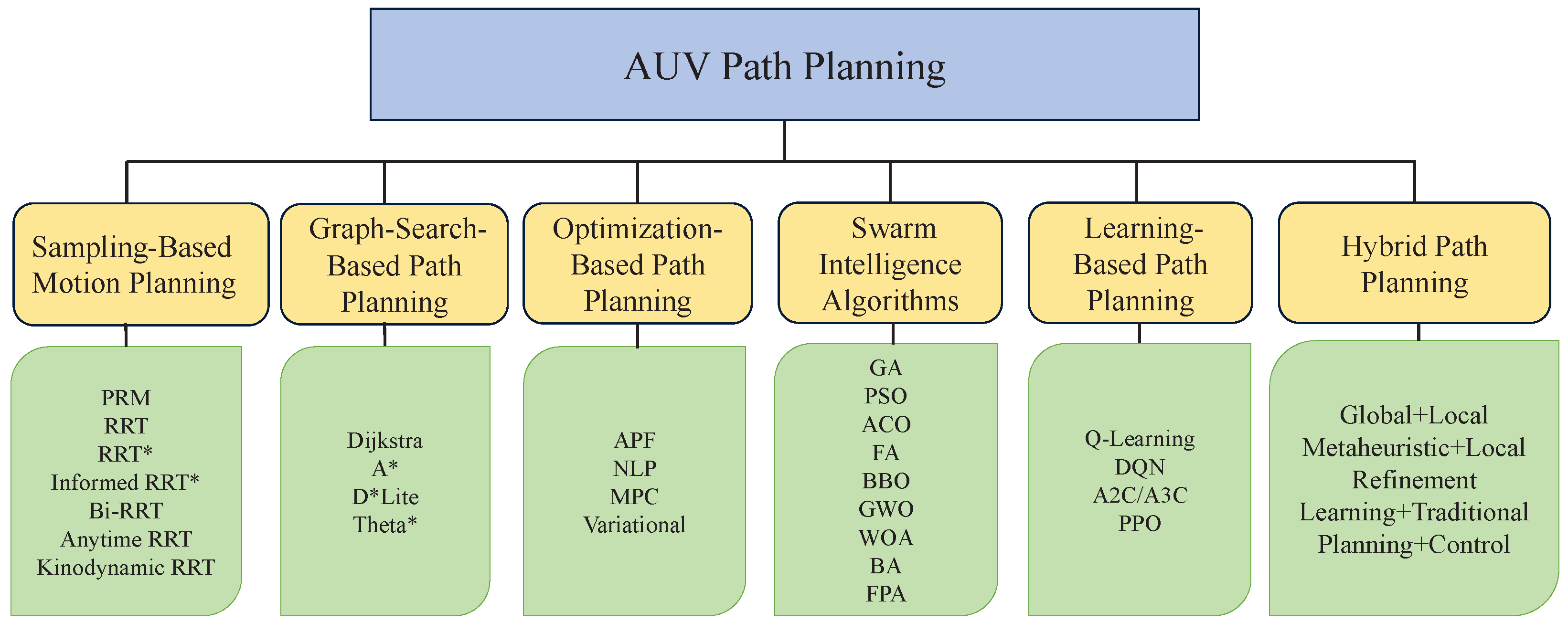

Disclaimer/Publisher’s Note: The statements, opinions and data contained in all publications are solely those of the individual author(s) and contributor(s) and not of MDPI and/or the editor(s). MDPI and/or the editor(s) disclaim responsibility for any injury to people or property resulting from any ideas, methods, instructions or products referred to in the content. |
© 2026 by the authors. Licensee MDPI, Basel, Switzerland. This article is an open access article distributed under the terms and conditions of the Creative Commons Attribution (CC BY) license.