


Abstract
The decline of industrial activity across Europe has produced extensive brownfield landscapes that today constitute both a challenge and a strategic opportunity for urban regeneration and the promotion of new sustainable urbanisation models. In Portugal, the regeneration of urban brownfields could play an important role in addressing current housing pressures and socio-economic and territorial imbalances. In this context, the present study adopts a qualitative approach, supported by descriptive spatial analysis, drawing on a benchmark study of 27 urban brownfield regeneration projects in European cities, complemented by the results of two European research projects, to identify key principles and strategies guiding these interventions. A systematic synthesis of benchmark findings is used to derive a set of urban brownfield regeneration guidelines. These guidelines are subsequently applied to two selected brownfield sites in Abrantes, a Portuguese municipality characterised by an industrial past, following their identification and spatial analysis through GIS and in situ observation. The results demonstrate that urban brownfield regeneration can contribute to addressing housing needs, reducing pressure on undeveloped land, optimising existing infrastructure, strengthening local urban dynamics, and enhancing climate change adaptation. As industrial decline continues to reshape European territories, the study contributes to ongoing debates on decision-making and sustainable urban planning by providing a transferable set of regeneration guidelines and demonstrating their application in a specific territorial context.
1. Introduction
Urban brownfields are previously developed sites that have become vacant, underused, or abandoned [1] following the cessation of former industrial, commercial, military, port, or other activities [2,3]. Among them, industrial brownfields, the focus of this study, are often overlooked parts of cities where an industrial past has left vacant buildings, abandoned infrastructure, and fences restricting access. These brownfields characterise landscapes of post-industrial societies, especially in European and North American cities, where globalisation and deindustrialisation processes [4] have created a legacy of vacant, derelict or contaminated sites [5]. Many are near urban areas, offering significant development potential as strategic spaces that can promote compact urban development, limit urban sprawl, and respond to growing housing pressures in several European countries [6,7]. Interestingly, the challenges and opportunities associated with industrial brownfields vary across urban contexts, including between small- and medium-sized cities and larger metropolitan areas. Small- and medium-sized cities, particularly those in peripheral regions, may face declining economic activity, high environmental remediation costs, and limited institutional, technical, and financial capacity to implement brownfields regeneration projects [8]. In contrast, metropolises and large cities can benefit from more comprehensive regeneration policies, stronger development demand and investment potential, although regeneration outcomes still depend on site location, accessibility, planning regulations, and demand for specific land uses [9,10]. These differences suggest that brownfield regeneration strategies vary by spatial scale, local urban development conditions and socio-economic contexts, and governance structures and policy frameworks. The latter are especially important because policies drive urban planning interventions toward desired patterns [11]. In this context, brownfields in Europe have been central to the evolution of integrated urban regeneration policies, from the Leipzig Charter of 2007 [12], promoting the coordination of economic, social and environmental objectives and the more efficient use of existing urban areas, to the New Leipzig Charter of 2020 [13] that explicitly advocates the renewal and complex regeneration of existing urban areas, including brownfield redevelopment, as a means of reducing land take and soil sealing. A broad body of recent literature indicates that urban brownfield redevelopment could address territorial dynamics reshaping natural, economic, and social systems in the context of sustainable urban development and environmental protection [14,15,16,17]. Their proximity to transport networks, economic activities, and residential areas [18,19] makes them pivotal in shaping patterns of urban expansion, land valuation, and demographic change [18,20,21].
The housing crisis currently affecting Europe [22] reinforces the importance of integrating urban brownfield regeneration into governance [23] and urban planning strategies to effectively address the needs of a growing urban population [24]. This tension highlights a new role for urban brownfields as a strategic priority for governments, by focusing on restructuring and optimising the existing built environment to support compact, efficient, and resilient urban forms aligned with sustainable development principles [25,26].
Urban brownfields thus emerge as areas with immense potential for development along with associated challenges and opportunities [27]. Challenges arise because, as noted by Rey et al. [28], brownfields generally become privileged sites for urban voids or present uncertainties related to soil contamination, leading to common negative perceptions. Opportunities arise from their considerable presence in post-industrial cities and their strategic locations, characterised by proximity to urban centres, good accessibility, and existing infrastructure, which create favourable conditions for urban regeneration processes [18,29]. The value of their regeneration lies in multiple strategic benefits: from mitigating climate change [30] and environmental risks [31], eliminating obsolete urban voids [32], and increasing the housing supply [33] to strengthening local economic vitality [34].
Within this discourse, Portugal is a relevant case study for examining the potential for urban brownfield regeneration, as the country faces two critical problems: a housing crisis and industrial decline. From 2015 to 2024, Portugal experienced the largest rise in house prices across Europe, with an increase of 124.4% [35]. This escalation results from the cumulative effect of five major interdependent drivers: touristification [36], digital nomadism [37], real estate speculation, gentrification [38], and immigration [39]. These drivers, which occurred almost entirely in parallel, converged to a catastrophic increase in housing demand in a context where supply remained practically stagnant. These dynamics have intensified socio-spatial inequalities and restricted housing access for many people, creating an urgent need for public policies and urban planning strategies that enhance housing opportunities and foster more balanced, sustainable city models [40,41].
In parallel, Europe’s industrial decline [42] has also affected Portugal, leading to gradual deindustrialisation, a process driven by the transition from manufacturing to service-based urban economies and the relocation of industrial production to countries with lower labour costs [43,44]. This transformation has contributed to an increasing number of brownfield sites [17,45], making their regeneration a valuable contribution to addressing the housing crisis and promoting multifunctional, compact urban forms [18,46]. Indeed, the structural characteristics of many industrial buildings enhance their adaptability to new uses [47,48], but successful regeneration depends on coordinated governance, territorial planning and stakeholder engagement [27].
Although urban brownfield regeneration is widely recognised as a central challenge, its potential to generate new urban hubs in medium-sized cities in Portugal remains underexplored. To fill this gap, the present study offers a comprehensive approach to urban brownfield regeneration within an integrated urban planning framework that promotes more compact, resilient, and sustainable urban models.
To address this, the study adopts a primarily qualitative approach, supported by descriptive spatial analysis. First, a benchmark study identifies European planning and research projects focused on brownfield regeneration. Second, an exploratory spatial analysis conducted using Geographic Information Systems (GISs) characterises urban brownfields in a Portuguese municipality, complemented by on-site observation. This case study demonstrates how brownfield regeneration can serve as a strategic response to the housing crisis while contributing to sustainable urban development. The novelty and relevance of the study are twofold. Conceptually, it offers an important discussion of urban brownfield regeneration, with the specific objective of transforming these sites into new hubs. Methodologically, it offers a replicable, scalable approach for identifying and analysing them in urban areas, informing decision-making at the local level.
This study aims to answer the following two research questions (RQs):
RQ1: Which approaches to brownfield regeneration have been implemented in former industrial areas across Europe, and what lessons can be drawn from these experiences?
RQ2: How can these lessons inform strategies for transforming brownfields in post-industrial municipalities into multifunctional urban hubs that address contemporary urban challenges?
To address these questions, the paper is organised as follows: Section 2 describes the methodology used. Section 3 presents the results, structured in three stages: first, the benchmark study of European urban brownfield regeneration cases and the systematic synthesis of a set of urban brownfield regeneration guidelines; second, the identification, characterisation, and spatial analysis of two brownfields in the municipality of Abrantes; and third, the practical application and testing of the derived guidelines in this case study. Section 4 discusses the key findings, and Section 5 concludes with the main takeaways.
2. Materials and Methods
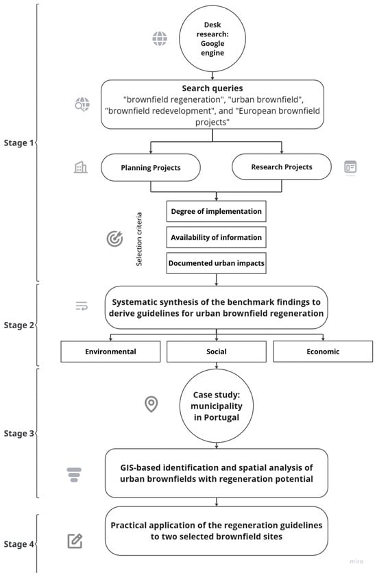
The present study adopts a primarily qualitative approach, supported by descriptive spatial analysis, including GIS-based mapping and the calculation of brownfield attributes, and is structured into four main stages (Figure 1):
Figure 1.
Methodology.
Stage 1—Qualitative benchmark study of European urban brownfield regeneration projects;
Stage 2—Systematic synthesis of the benchmark findings into guidelines for urban brownfield regeneration;
Stage 3—GIS-based spatial analysis of urban brownfields with potential for functional regeneration within the Abrantes municipality in Portugal (case study);
Stage 4—Practical application of the guidelines to two selected brownfield sites in the municipality and validation.
The European benchmark study was conducted through an exploratory desk research approach, using Google search engine queries that combined terms such as “brownfield regeneration”, “urban brownfield”, “brownfield redevelopment”, and “European brownfield projects”. The objective was to identify illustrative examples of urban brownfield regeneration in Europe and examine the approaches adopted to transform former industrial areas into multifunctional urban spaces.
Cases were selected according to three main criteria: (i) the regeneration project concerned a former brownfield site in an urban context; (ii) the project was implemented or ongoing, or had sufficiently documented proposals to allow its regeneration approach to be characterised; and (iii) the project involved or planned a mix of urban functions, with particular attention to residential uses and their integration with other activities and public spaces. The selection also sought to encompass cities with different geographical locations, urban scales and economic contexts, allowing a range of regeneration approaches to be explored.
The exploratory spatial analysis was conducted in a GIS using the 2023 Land Use and Cover [49] to quantify deactivated industrial areas in the municipality of Abrantes. Urban brownfields were identified based on the presence of former industrial units that are currently deactivated and abandoned, as mapped in the land-use and cover data. The identification and analysis of their potential for regeneration focused on the city of Abrantes. These areas were selected because they contain the largest number of industrial areas in the municipality, have higher population density, and bring together most economic activities, services, collective equipment, and infrastructure. The identification of urban brownfields, derived from the GIS analysis, was subsequently validated through on-site observation, which served as a methodological validation instrument.
The field visits confirmed and corroborated the brownfields identified through GIS analysis and qualitatively assessed relevant characteristics, such as the conservation state of existing structures, the presence of infrastructure, and the broader urban context of each site, which ensured the consistency and reliability of the results and the adequacy of the analysed regeneration examples.
The practical application of the guidelines to the urban regeneration models was developed in AutoCAD(Autodesk® AutoCAD® 2027), where the spatial organisation, building configurations, land uses, public spaces, and green infrastructure were defined. The resulting plans were then used as the basis for AI-assisted visualisation. ChatGPT’s image-generation capabilities were employed to enhance the visual representation of the proposals, including the architectural character, vegetation, materials, and human-scale elements. The AI-generated visualisations were used exclusively as representational outputs and did not modify the underlying spatial structure, land-use allocation, or design principles established in the AutoCAD models.
3. Results
The following section presents the results of the European benchmark and the analysis of the case study in the municipality of Abrantes, Portugal.
3.1. Benchmark Study on European Urban Brownfields Regeneration
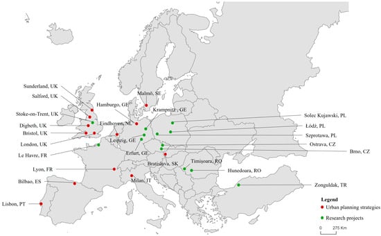
The benchmarking study includes 27 brownfield regeneration projects in Europe (Figure 2). The selected brownfield regeneration projects (Table 1) include examples in various European cities: Bristol, Salford, Digbeth, Sunderland, London (United Kingdom), Malmö (Sweden), Hamburg (Germany), Eindhoven (Netherlands), Bratislava (Slovakia), Lyon (France), Milan (Italy), Bilbao (Spain) and Lisbon (Portugal). The higher geographical concentration of projects in the United Kingdom reflects its historical role as the world’s leading industrial power during the 18th and 19th centuries, which resulted in an intense deindustrialisation process, a large stock of abandoned brownfields, and, consequently, a rich body of brownfield regeneration experience and documentation [50].
Figure 2.
Mapping of project locations included in the benchmark study on brownfield regeneration in Europe|Source: Geographical Information System of the Commission (GISCO).
Table 1.
Benchmark results of brownfield regeneration projects in Europe.
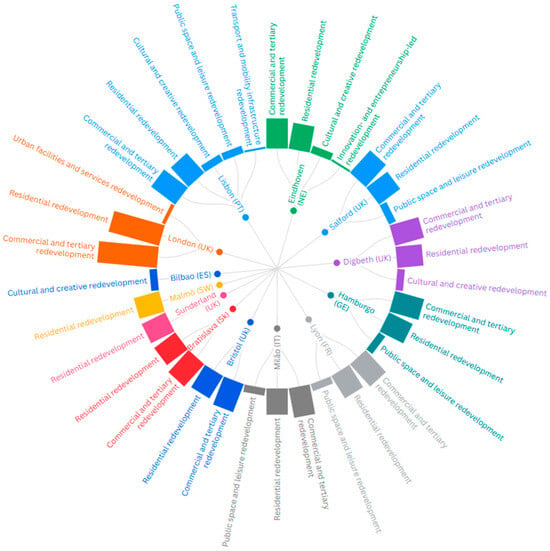
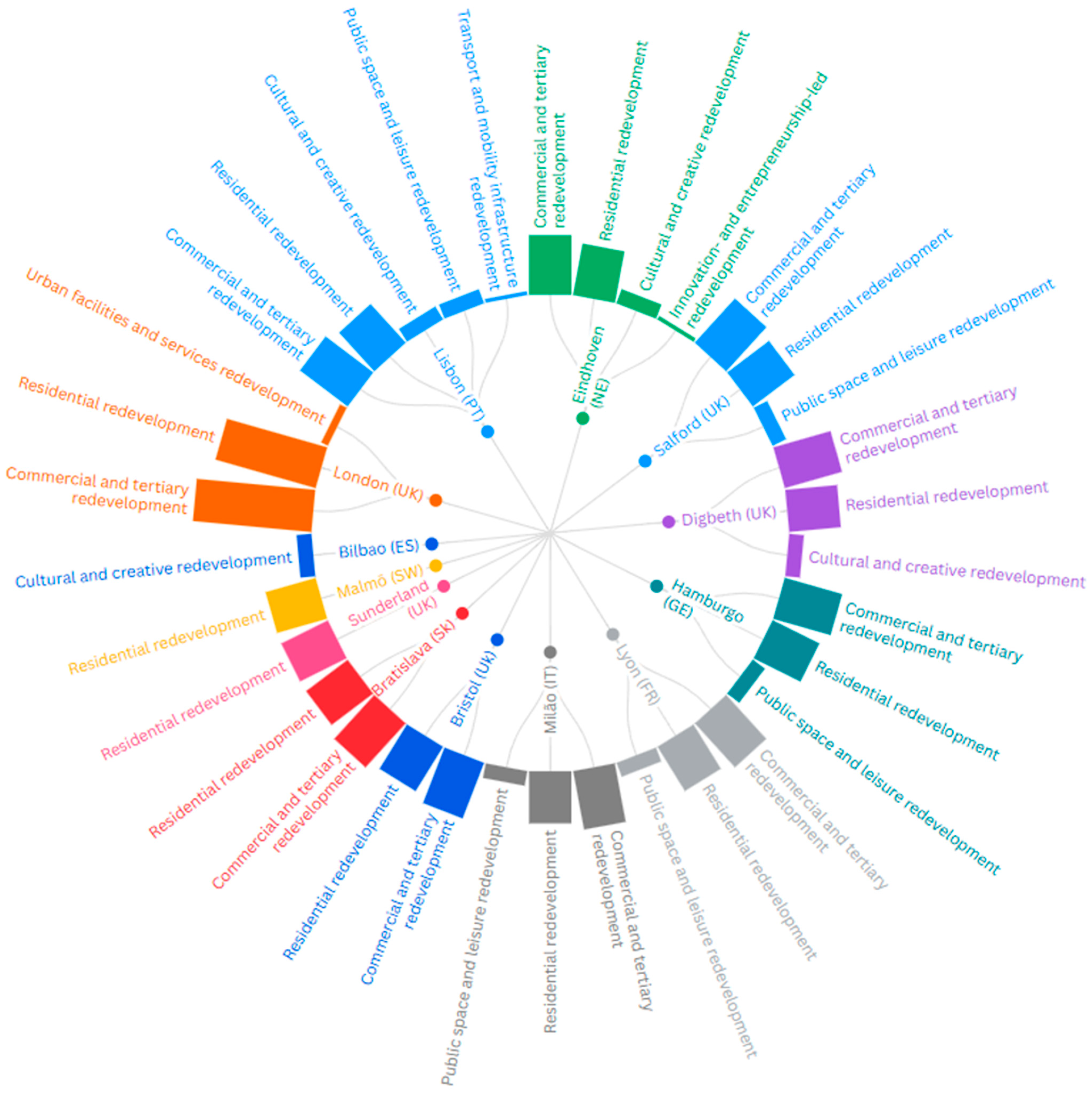
The benchmark study enabled the identification of the main urban brownfield regeneration strategies adopted in existing planning projects. Figure 3 was developed from the project descriptions in Table 1, with each project classified by the uses and functions implemented through urban brownfield regeneration. For cities with more than one regeneration project, the corresponding categories were aggregated to provide a single representation. Multiple categories were assigned to most of the analysed examples, reflecting the prevalence of multifunctional regeneration models in European brownfield regeneration. The figure illustrates that European urban brownfield regeneration projects are predominantly characterised by residential-led redevelopment strategies, the most common type of intervention. This predominance reflects a deliberate choice, given the scope of the article, which seeks to highlight the potential of these areas as a strategic opportunity for the creation of residential areas, with the aim of addressing housing shortages, reducing pressure on natural land, optimising existing infrastructure, and strengthening local urban dynamics. In turn, commercial and tertiary-led regeneration also emerges as a complementary strategy, often combined with residential functions, underscoring the prevalence of mixed-use redevelopment models. In parallel, public space and leisure redevelopment assume a significant role, contributing to urban attractiveness, environmental quality, and social integration. Less recurrent, though still relevant, are cultural and creative-led redevelopment strategies, particularly evident in projects such as Bilbao and Digbeth, where cultural facilities and creative industries act as catalysts for urban transformation. More specific strategies, including innovation and entrepreneurship, transport infrastructure, and redevelopment of urban facilities and services, appear less frequently, reflecting more targeted or context-specific regeneration approaches. Overall, the results demonstrate that urban brownfield regeneration in Europe is largely based on multifunctional strategies that combine residential, commercial, cultural, creative centres, strategic infrastructure and public space functions within integrated urban development processes.
Figure 3.
Urban brownfield regeneration strategies identified in the European benchmark study.
The benchmark analysis also included European research projects on urban brownfield regeneration (Table 2). Results identified the TIMBRE-Tailored Improvement of Brownfield Regeneration in Europe [66] and 3S RECIPE-Smart Shrinkage Solutions-Fostering Resilient Cities in Inner Peripheries of Europe research projects that are related to brownfield regeneration. The TIMBRE project case studies, located in Hunedoara (Romania), Szprotawa, Solec Kujawski (Poland), Ostrava, Brno (Czechia), Krampnitz, Leipzig and Erfurt (Germany), focus on adaptive reuse strategies and planning tools applied to large contaminated industrial areas. Meanwhile, case studies from the 3S RECIPE project in Le Havre (France), Łódź (Poland), Timișoara (Romania), Stoke-on-Trent (United Kingdom), and Zonguldak (Turkey) address brownfield regeneration processes in cities marked by strong deindustrialisation.
Table 2.
Benchmark results of research projects on brownfield regeneration in Europe.
The analysis of the two projects confirms a strong tendency toward multifunctional redevelopment models that integrate residential, commercial, cultural, recreational, and green spaces. Housing emerged as one of the most frequent land uses, reinforcing the role of urban brownfield regeneration. The analysis also shows that many cities prioritise reusing existing infrastructure, promoting compact urban development, and creating new urban hubs that strengthen local economic and social dynamics.
3.2. Systematic Synthesis of Guidelines for Urban Brownfield Regeneration
A systematic synthesis of the benchmark permits the identification of guidelines to support brownfield regeneration (Table 3). The benchmark findings show that brownfield regeneration has evolved beyond the simple rehabilitation of obsolete industrial areas toward creating new urban models whose functions redefine the role of previously abandoned spaces.
Table 3.
Matrix of Guidelines for Brownfield Regeneration, according to environmental, social and economic dimensions.
The urban planning strategies identified illustrate different yet complementary paths to brownfield regeneration. The intervention in the Temple Quarter neighbourhood in Bristol combines housing, leisure, business and commerce, a new university campus, employment opportunities, and transportation improvements, thereby reinforcing the city’s accessibility and economic competitiveness. In turn, Valette Square (Salford) and King’s Cross Central (London) transform former industrial areas into mixed-use neighbourhoods, integrating housing, commerce, offices, services and, in the case of King’s Cross Central, also educational facilities. Digbeth (Warwick Bar) expands on this multifunctional model by combining housing, commercial space, creative industries, leisure areas, and canal access, while Riverside Sunderland (Sunderland) demonstrates how brownfield regeneration can support the creation of a new low-carbon neighbourhood centred on sustainable residential development.
Similar approaches can be seen in other projects. The intervention at Battersea Power Station (London) preserves the industrial heritage while introducing residential and commercial uses, while Bo01 (Malmö) favours residential development through sustainable urban regeneration in a former port-industrial area. In turn, HafenCity (Hamburg), Danube Waterfront (Bratislava), La Confluence (Lyon), Porta Nuova (Milan), and Parque das Nações (Lisbon) adopt multifunctional regeneration models that integrate housing, commerce, offices, services, green spaces, and leisure areas. In Strijp-S (Eindhoven), regeneration combines residential uses with restaurant areas, leisure facilities, cultural activities, and startup ecosystems, reinforcing innovation and the creative economy as pillars of urban transformation. In contrast, Abandoibarra exemplifies how the Guggenheim Museum served as a catalyst for a new urban centrality, enabling the regeneration of a former industrial area and strengthening Bilbao’s economic, social, and territorial dynamism.
Together, these examples provide a framework of guidelines that, by identifying adaptation and reuse strategies used to regenerate degraded areas, can serve as inspiration and be replicated in other contexts. In this regard, the following matrix systematises the regeneration guidelines derived from the European benchmark, organising them by environmental, social, and economic dimensions and outlining their anticipated benefits. The matrix is subsequently applied to the two case-study sites.
3.3. Case Study: Brownfields in the Municipality of Abrantes (Portugal)
The Municipality of Abrantes, located in Portugal in the Oeste e Vale do Tejo (NUTS II) region and the Médio Tejo (NUTS III) sub-region, has a territorial area of 713,46 km2 and serves as the case study for analysing the potential for urban brownfield regeneration. In the Portuguese administrative system, the municipality of Abrantes comprises several civil parishes (freguesias), whereas the Abrantes city refers to the more restricted urban area.
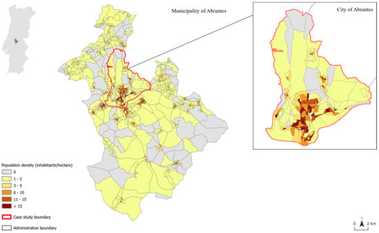
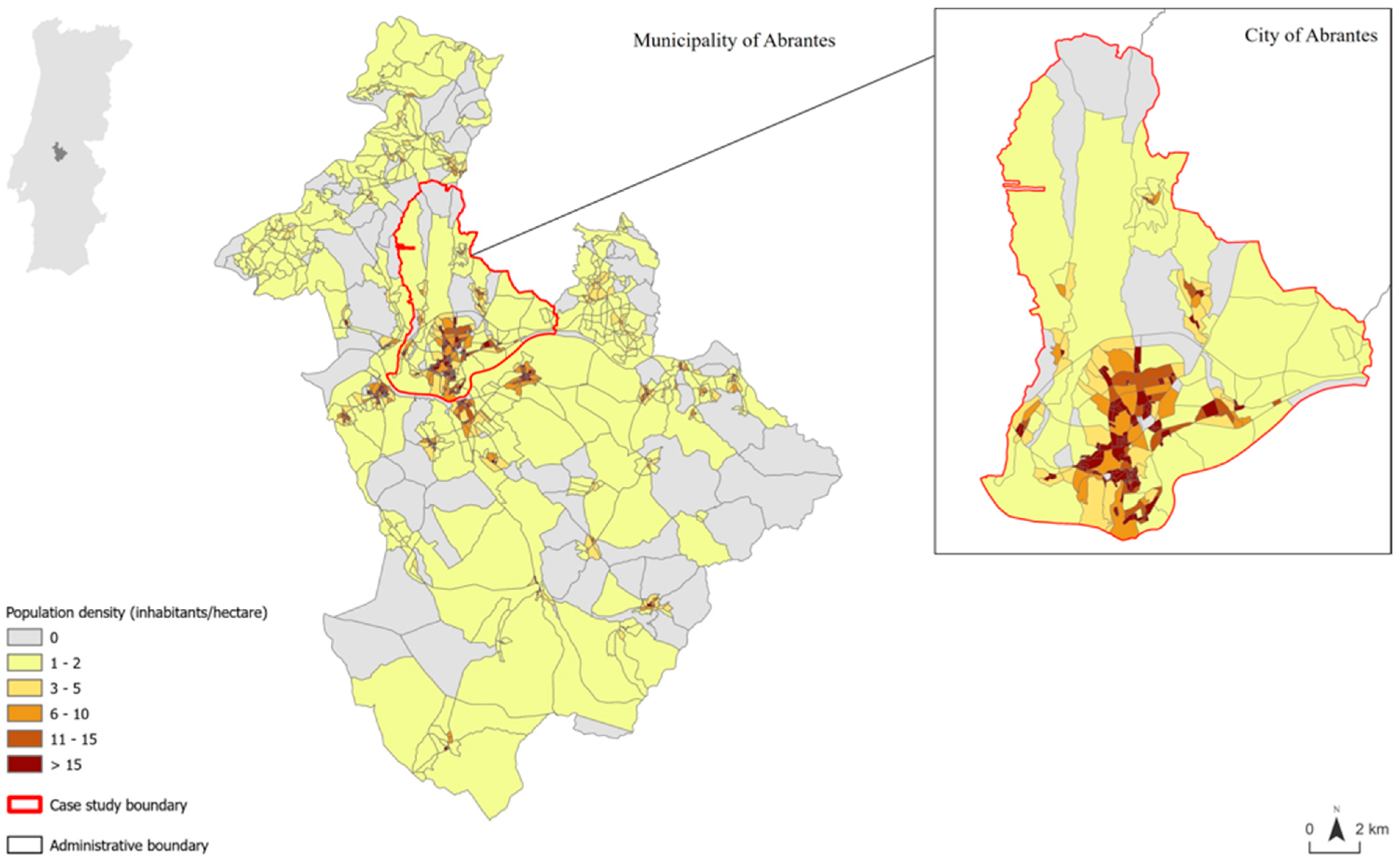
In 2021, the Municipality of Abrantes had a population of 34,329 inhabitants, representing approximately 16% of the Médio Tejo population [87]. The population is heterogeneously distributed throughout the territory, with an apparent dichotomy between rural areas, characterised by very low population densities (0–2 inhabitants/hectare), and the urban core, where the highest densities are concentrated. This pattern reflects demographic and functional polarisation, characterised by the concentration of economic activities, public services, collective equipment, and infrastructure in the urban core, alongside the scarcity of services and opportunities in surrounding rural areas. These centralisation dynamics contribute to the pressure on the consolidated urban fabric, including obsolete or underutilised industrial areas. The city of Abrantes, which constitutes the urban case-study area, had a population of 16.123 inhabitants in 2021 [87] and comprises the statistical subsections with the highest population densities, exceeding 15 inhabitants/hectare (Figure 4).
Figure 4.
Population density by statistical subsection in the Municipality of Abrantes|Source: National Institute of Statistics, Geographical Database for Referencing Information, 2021.
Regarding local housing demand, although the municipality of Abrantes has experienced a population decline of approximately 20% since the early 2000s, the foreign resident population increased by 96% between 2001 and 2023 [88]. This suggests that, despite the overall demographic decline, new patterns of housing demand are emerging alongside changes in the municipality’s migratory profile. These dynamics may contribute to increasing pressure on the local housing market, reflected in a 53.3% increase in house prices between 2015 and 2026 [89], compared with cumulative consumer price inflation of approximately 25% in Portugal between 2015 and 2025. Meanwhile, housing supply in the municipality remained practically stagnant. Although these pressures remain more contained than those observed in metropolitan areas, they indicate that housing affordability and supply are becoming increasingly relevant challenges for medium-sized cities such as Abrantes.
Abrantes’ location on the Tagus River has historically shaped its economy, favouring small production units linked to river trade and regional supply. The river served as a “highway” for moving goods, connecting Abrantes to the country’s capital, Paço de Arcos, Trafaria, Belém, and Lisbon, and contributing to the municipality’s economic and industrial dynamism [90].
Throughout the twentieth century, Abrantes underwent a more consolidated industrialisation process, marked by the installation of larger-scale industrial units in Alferrarede, Rossio, and Tramagal, with particular relevance to metallurgy and the manufacturing and chemical industry, in accordance with the dominant trends of Portuguese industrialisation at the time [91].
Currently, the municipality has three industrial zones: North and South Industrial Zone, Pego Industrial Zone and Tramagal Industrial Zone, which host companies in the ceramics, metalworking, construction and other manufacturing sectors, and a Science and Technology Park (Tagusvalley) that was created to support companies in the region and promote innovation strategies, reinforcing the capacity to create value in the local and regional economy [92].
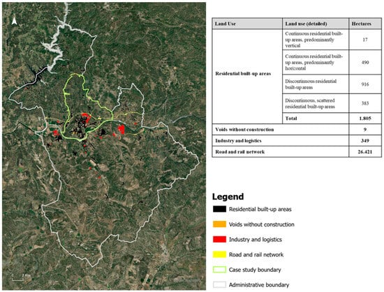
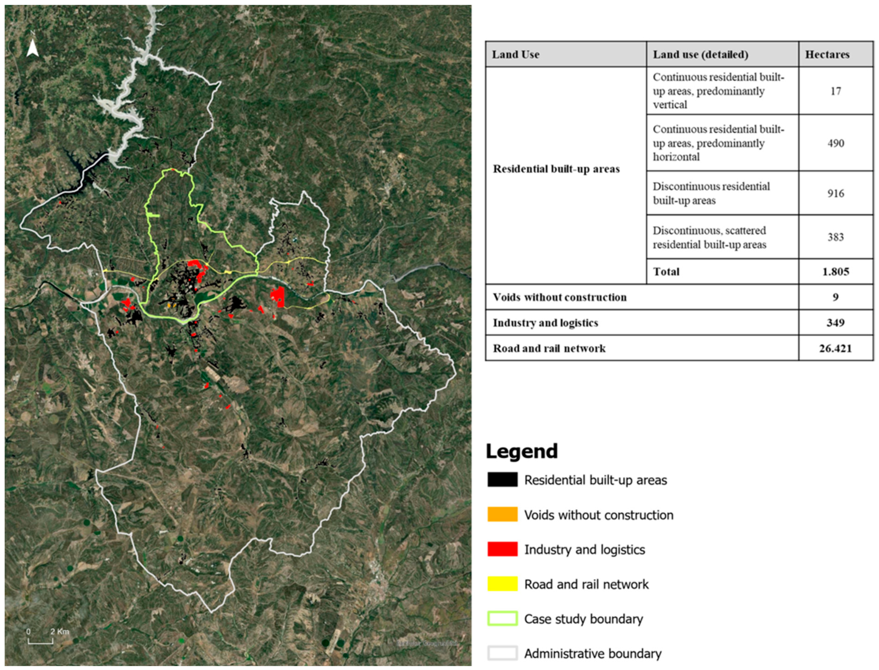
According to the Land Use and Cover [49], 34 industrial and logistics areas are identified across the municipality of Abrantes, reflecting their importance in the territory’s spatial and economic organisation. The territorial characterisation reveals a pattern of land occupation marked by low urban compactness and fragmented residential development, with the highest concentration in the city of Abrantes. Industrial and logistics activities are strongly dependent on road and rail networks, which play a structuring role in the municipality’s functional organisation. Despite their limited extent, undeveloped spaces can play a significant role in strengthening urban continuity by enabling infill development and promoting the more efficient use of existing urban land (Figure 5).
Figure 5.
Spatial analyses and quantification (in hectares) of the residential built-up areas, voids without construction, industrial and logistics areas, and road and rail network in the Municipality of Abrantes|Source: Adapted from DGT, 2023.
3.4. Spatial Analysis of Brownfields in the Municipality of Abrantes
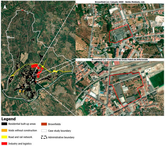
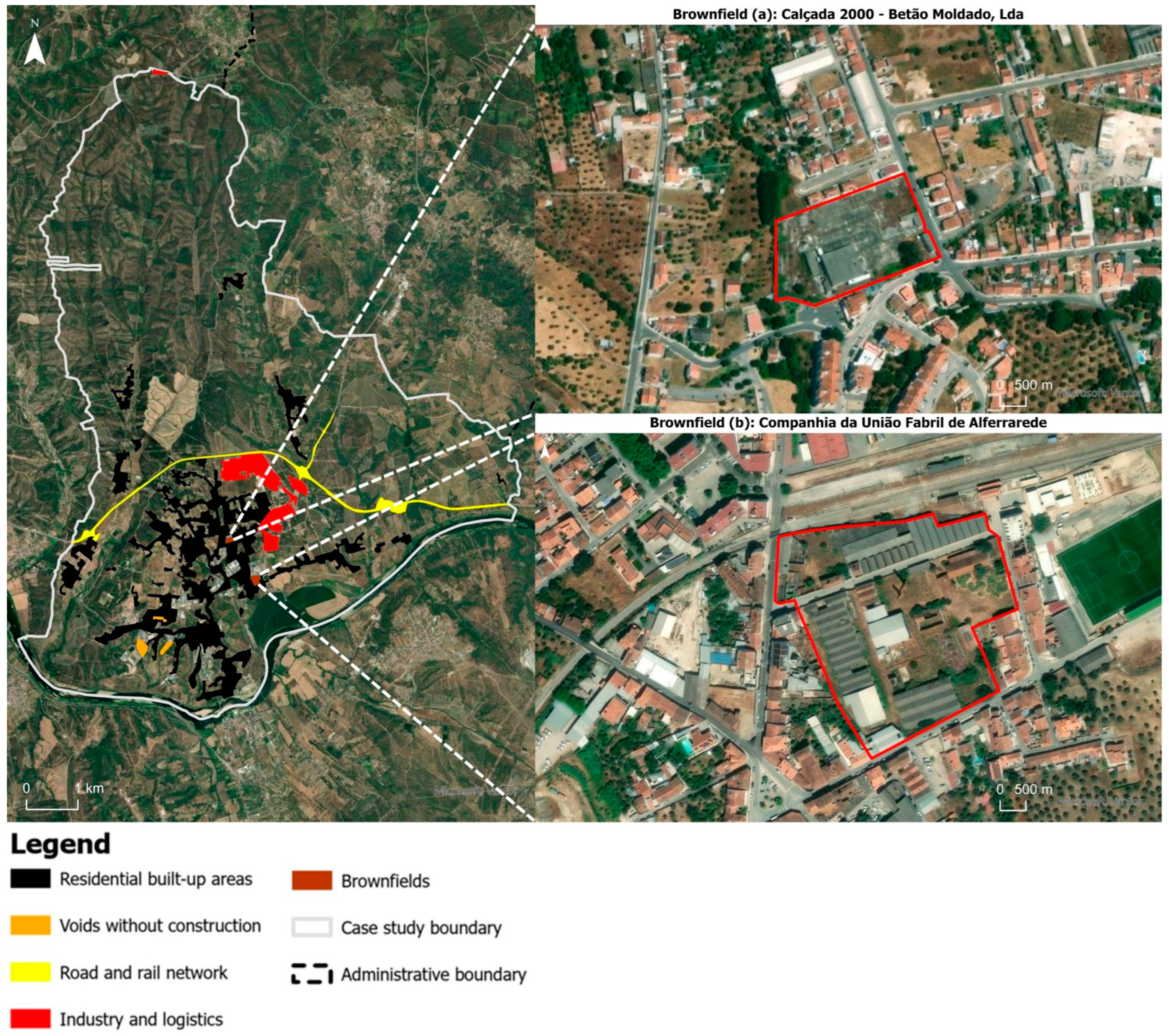
Of the six industrial areas identified in the city of Abrantes, two (33%) are currently deactivated and abandoned (Figure 6).
Figure 6.
Spatial analyses of the city of Abrantes with delimitation brownfield (a): Calçada 2000Betão Moldado, Lda.; and brownfield (b) Companhia da União Fabril de Alferrarede|Source: Adapted from DGT, 2023.
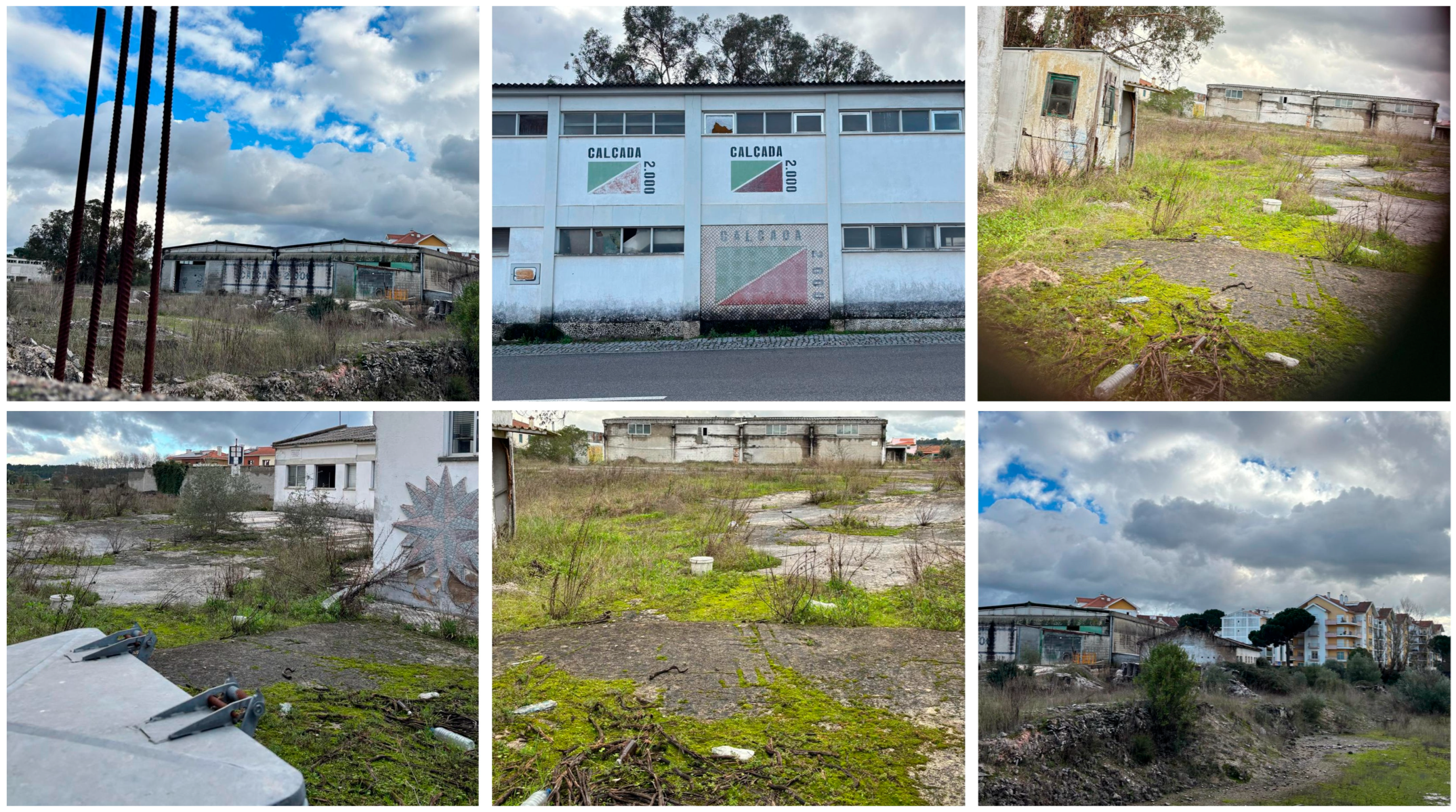
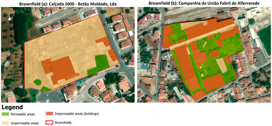
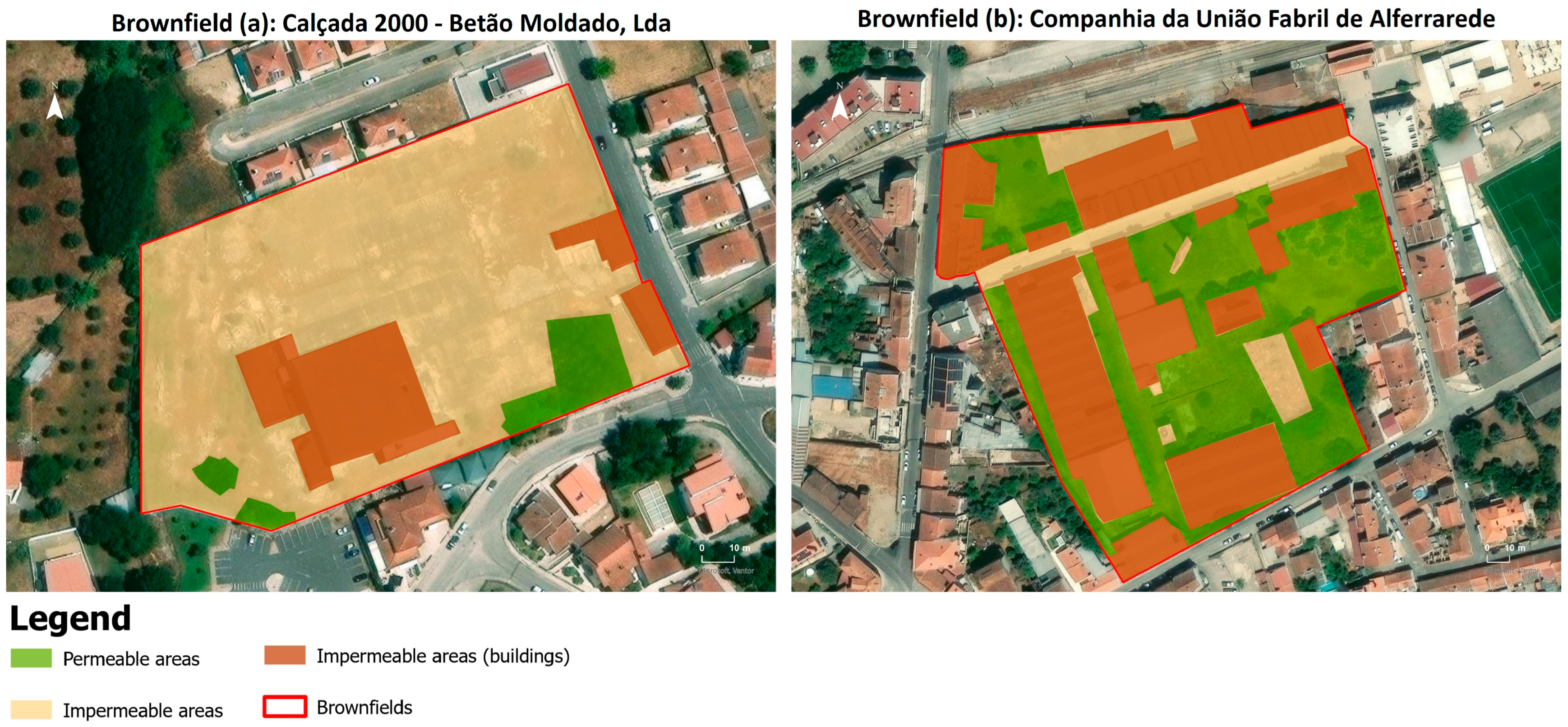
The urban brownfield (a) corresponds to the former factory of Calçada 2000–Betão Moldado, Lda., established in 1995 and dedicated to producing refractory ceramic products. This area occupies a total of 14.601 m2, of which 97,297 m2 (6%) corresponds to permeabilised areas—i.e., surfaces that allow water to infiltrate into the soil—and 13.600 m2 (93%) to waterproofed locals, associated with the presence of buildings, pavements and other surfaces that prevent water from infiltrating the soil. Of this impermeable area, 2.315 m2 corresponds specifically to building footprints. Based on on-site observation, this brownfield presents moderate degradation, evidenced by broken windows and the spontaneous growth of vegetation through the cement pavement, a visible indicator of prolonged disuse and the gradual reclamation of the space by nature. It was not possible to determine the exact date of the factory’s closure, but it is estimated to have occurred at the beginning of the twenty-first century (Figure 7).
Figure 7.
Current status of the industrial complex of the Calçada 2000-Betão Moldado, Lda., Abrantes|Photo by Romão, 2025.
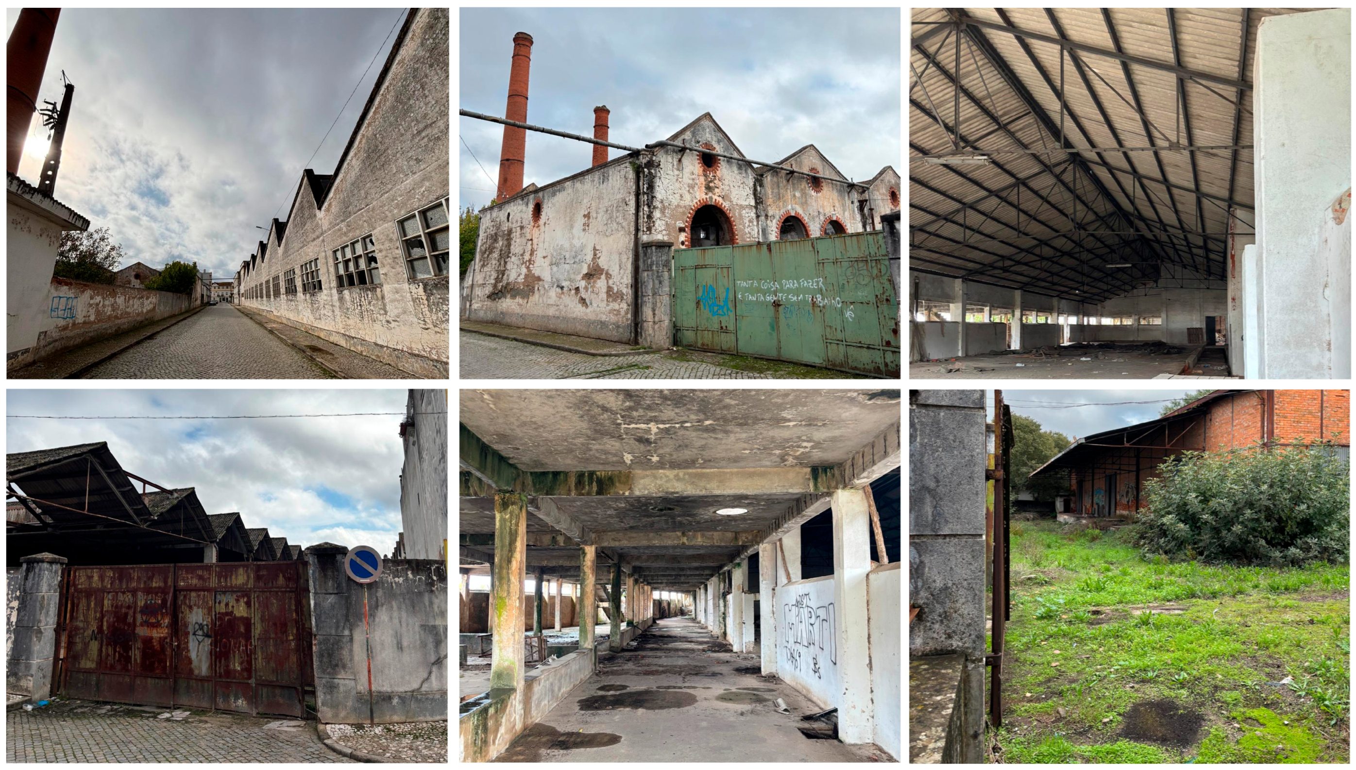
In turn, brownfield (b) corresponds to the former industrial complex of Companhia União Fabril, located in Alferrarede. This industrial complex dates to 1907, when an olive oil extraction unit was acquired; the activity was later maintained and expanded. Later, the complex evolved into the Nitrogen Factory Union, a chemical-sector enterprise that played a significant role in the local economy. This industrial unit stood out as one of the most important industries in the region, employing approximately 200 workers and recognised as one of the most modern factories of the Companhia da União Fabril in the Iberian Peninsula [93], and it ceased operations at the end of the 1980s. Currently, this area totals 28.541 m2, of which 12.066 m2 (42%) is permeable, and 16.500 m2 (58%) is waterproofed. Of this total, 13.025 m2 is occupied by existing buildings, underscoring the site’s extensive built-up area. This brownfield is in a more advanced state of disrepair, with broken windows, several partially collapsed roofs, and signs of vandalism in the interiors of some buildings. Unlike the previous brownfield, the ground surface is composed of bare soil with spontaneous vegetation, which further reflects the degree of abandonment (Figure 8).
Figure 8.
Current status of the industrial complex of the Companhia da União Fabril de Alferrarede, Abrantes|Photo by Romão, 2025.
Together, the two brownfields cover an area of 43.142 m2 (4.3 hectares), of which 13.039 m2 (30%) is permeable, and 30.100 m2 (70%) is impermeable. In turn, the predominance of sealed surfaces and the considerable extent of underutilised built-up areas (15.34 m2) highlight these areas as strategic spaces for urban regeneration (Figure 9).
Figure 9.
Identification of permeable and impermeable areas of the brownfields under study. Source: Adapted from DGT, 2023.
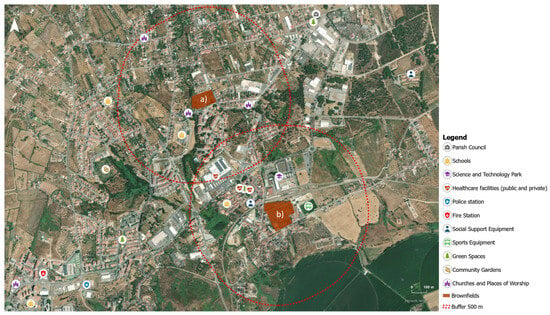
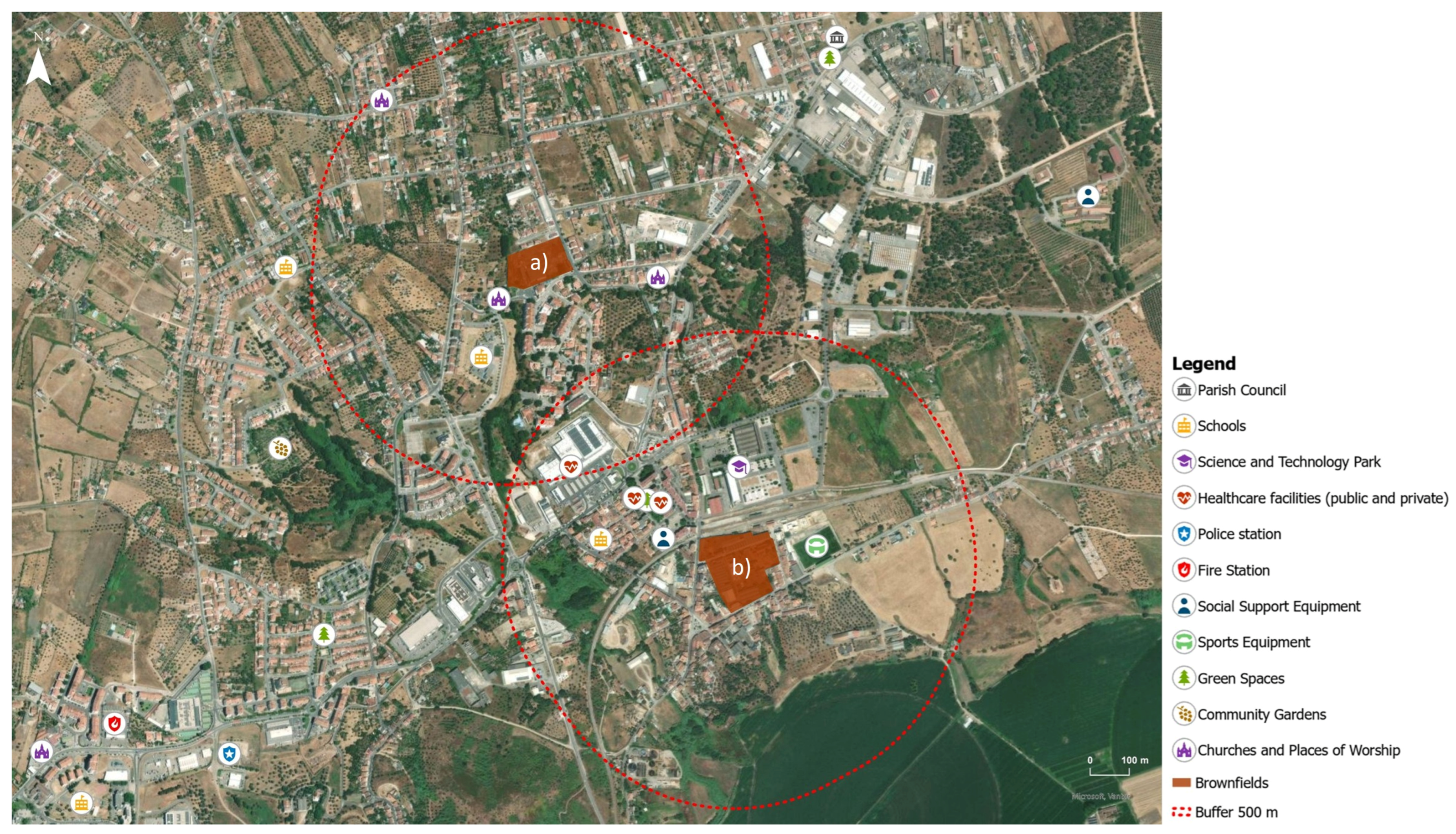
A 500-m area of influence was defined around each brownfield, adopting the distance often used in urban accessibility studies [94], to assess proximity to collective facilities and key urban infrastructure (Figure 10).
Figure 10.
Areas of influence of brownfields (a) and (b), defined by 500-m buffers, and the location of collective facilities. Source: Adapted from DGT, 2023.
The analysis of the areas of influence reveals a high degree of urban centrality, evidenced by the overlap between the two catchment areas and the presence of a diversified set of collective facilities, including educational establishments, healthcare facilities (public and private), social support equipment, sports facilities, religious facilities and green spaces, as well as strategic transport infrastructure, namely the railway station.
3.5. Practical Application of the Guidelines in the Municipality of Abrantes
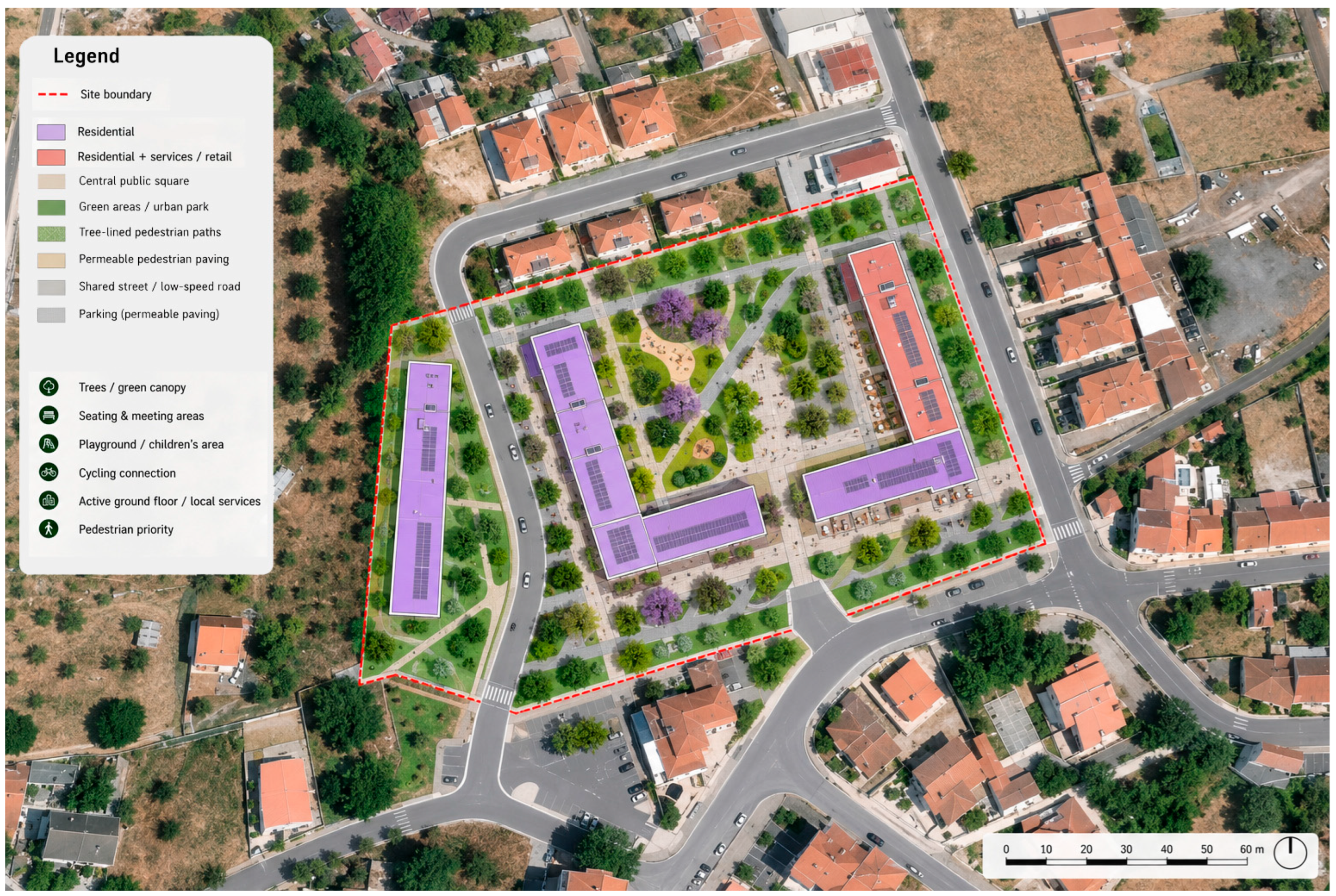
The spatial analysis identified and characterised the two brownfields, Calçada 2000 and CUF, providing a basis for testing the identified guidelines in a real-world context. From an urban planning perspective, the two sites call for different regeneration approaches, reflecting their distinct spatial, environmental, and heritage characteristics. For the Calçada 2000 brownfield, the lack of significant cultural or heritage value allows complete demolition of the existing buildings, creating an opportunity to introduce a new compact, multifunctional neighbourhood that responds to the needs of the surrounding urban context (Figure 11).
Figure 11.
Urban regeneration proposal for the Calçada 2000 brownfield.
The urban regeneration proposal for Calçada 2000 demonstrates the potential of this brownfield site to contribute to the revitalisation of the surrounding area. It proposes a new urban model based on mixed-use buildings accommodating residential, retail, and service functions. Buildings of up to six storeys are arranged compactly to optimise land use while releasing space for public and green areas. Introducing these functions reinforces the surrounding urban fabric, currently characterised by low-density, predominantly residential development, while providing opportunities for leisure, commerce, recreation, and housing. Photovoltaic systems installed on building roofs, combined with energy-efficiency measures, can contribute to reducing energy consumption and associated CO2 emissions. The salmon-coloured building could accommodate affordable housing, thereby promoting social inclusion and housing accessibility. This regeneration model exemplifies how to address all domains identified in the proposed guidelines, demonstrating that the redevelopment of brownfield land can simultaneously support urban consolidation, environmental sustainability, the energy transition, and social inclusion.
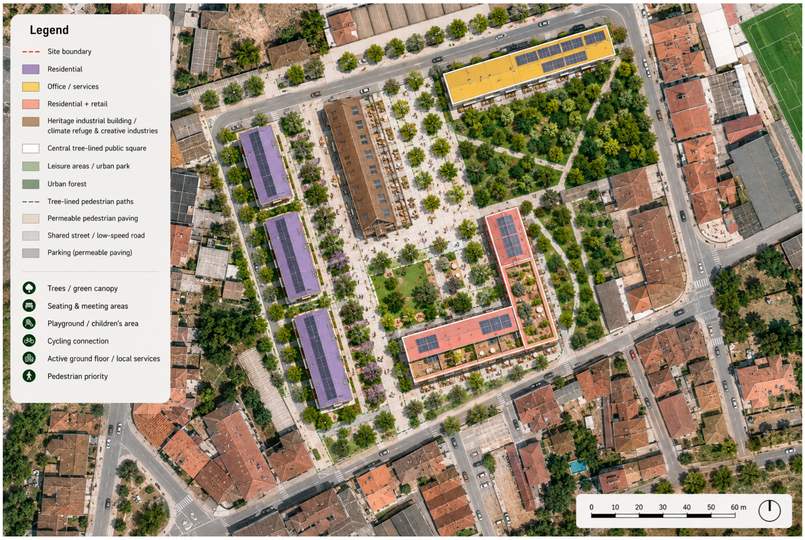
In contrast, the CUF brownfield contains valuable examples of industrial architecture that could be conserved and adaptively reused for new functions. Its existing green areas should also be retained and strengthened, both for their ecological functions and as components of a new network of public and recreational spaces. Similar to the Calçada 2000, this area has significant potential to promote an urban regeneration model that combines mixed-use development with a strong green and public-space structure (Figure 12).
Figure 12.
Urban regeneration proposal for the CUF brownfield.
This proposed regeneration model places multifunctional uses, greening and the adaptive reuse of existing industrial heritage at the centre. As such, it combines residential buildings with office and service functions, as well as mixed residential and retail uses, creating a diversified programme that supports everyday activities and strengthens the connection between the regenerated site and the surrounding neighbourhood. The existing heritage industrial building is conserved as a key element of the intervention transforming it into a climate refuge and a hub for creative industries, thereby preserving the site’s industrial identity while introducing new social, cultural, and economic functions. A network of pedestrian paths and leisure areas creates a continuous public realm and prioritises walking and outdoor activities. On the eastern side of the site, the green structure is reinforced by creating small urban forests that provide shade, improve thermal comfort, support biodiversity, and contribute to climate adaptation. The combination of larger green areas, tree-lined pedestrian routes, permeable surfaces, and public spaces establishes a more resilient landscape structure while reducing the environmental impacts associated with conventional urban development.
This regeneration model shows how a brownfield site can move beyond simply redeveloping vacant land by integrating urban consolidation, heritage preservation, social and economic diversification, green infrastructure, climate adaptation, and energy transition into a coherent spatial strategy. In this sense, the proposal addresses the different domains identified in the proposed guidelines while placing particular emphasis on the relationship between urban regeneration, ecological resilience, and the reuse of existing industrial assets. Together, these two urban regeneration proposals exemplify the considerable potential of brownfield areas to foster new urban models while complementing and strengthening the existing city. At the same time, their application to two distinct brownfield contexts illustrates the practical applicability of the proposed guidelines and demonstrates their capacity to inform spatial strategies that integrate urban, environmental, social, economic, and energy-related objectives.
4. Discussion
This study highlights brownfield regeneration as a strategic opportunity to address contemporary urban challenges, including housing shortages and affordability, deindustrialisation, urban fragmentation and sprawl, environmental degradation, climate change, and socio-spatial inequalities. By promoting multifunctional land use, adaptive reuse, and the integration of green infrastructure into the existing urban fabric, brownfield regeneration can also support more compact, accessible, and resilient urban environments, while creating opportunities to preserve industrial heritage and strengthen local urban vitality.
The European benchmark suggests that certain cross-cutting principles recur across brownfield regeneration projects implemented or underway in cities of different sizes and economic contexts. These include functional diversity, integration into the existing urban fabric, reuse of existing infrastructure, and the combination of residential uses with economic, cultural, and ecological functions. The matrix of guidelines systematises these principles into three complementary dimensions (environmental, social, and economic) that together provide a framework for understanding how a brownfield can be transformed into a new urban hub. In the environmental sphere, guidelines such as prior soil decontamination, the integration of nature-based solutions, and the introduction of efficiency strategies and renewable energy production reduce the intervention’s impacts and strengthen the capacity to adapt to climate change. In the social and economic sphere, functional diversity and the reuse of existing infrastructure support the creation of new urban centres. Based on the findings of this study, new urban hubs can be understood as regenerated brownfield areas transformed into multifunctional spaces that integrate different uses and activities, including housing, commerce, services, public and green spaces, leisure, and economic activities, while strengthening their connections with the surrounding urban fabric and existing infrastructure. In this sense, the concept reflects the potential of brownfield regeneration to transform obsolete and underused areas into multifunctional urban nodes that reinforce local urban functions and contribute to new social and economic dynamics. This perspective reinforces the need to approach brownfield regeneration not as an isolated intervention, but as a systemic component of urban development, in which environmental, social, and economic dimensions are considered together and related to the characteristics of the surrounding urban structure.
The exploratory case study of Abrantes empirically illustrates the potential for applying these principles in medium-sized cities. GIS analysis identified two brownfields located in consolidated urban areas, both served by existing infrastructure and surrounded by essential services, transport networks, and economic activities. Their spatial characteristics align with the conditions observed in European cases, suggesting that these locations bring together the fundamental attributes needed to support the planning of new urban hubs.
The proximity of these brownfields to schools, health units, green spaces, and public transport further reinforces their potential to contribute to walkable, mixed-use urban environments aligned with the principles of the compact city and the 15-minute city model [95].
The application of the guidelines to Calçada 2000 and CUF largely confirmed this transferability to a medium-sized city, given that both locations met the spatial preconditions identified in the benchmark study. However, testing the guidelines in two locations with distinct typologies also showed that their application is not uniform. In Calçada 2000, the absence of significant heritage value made it possible to apply guidelines relating to compact multifunctional development and affordable housing through the demolition and construction of new buildings. In contrast, at CUF, the existing industrial architectural value and green areas required that guidelines relating to heritage and green infrastructure assume particular importance in the regeneration strategy. This suggests that the matrix of guidelines should be weighted according to the site’s specific characteristics.
However, this study has some limitations, namely the fact that the spatial analysis was not designed to capture the risks of soil contamination, which were estimated qualitatively based on the literature. As demonstrated by the TIMBRE project case studies discussed in Section 3.1, environmental contamination is one of the main structural barriers to brownfield regeneration and can affect the viability of planned urban redevelopment strategies. In fact, brownfields and their surroundings are frequently characterised by soil and groundwater contamination [96,97], with heavy metal pollution among the most pressing concerns in abandoned industrial areas [98,99,100]. A preliminary, literature-based qualitative risk screening of the two brownfields suggests contamination risks that should be considered in future regeneration interventions. Calçada 2000, a former ceramics factory, likely presents heavy metal contamination (including lead, cadmium, chromium, and zinc) associated with the raw materials and enamel compounds used in production [101,102], with localised and moderate risk. CUF, a former chemical unit, presents a potentially more complex risk profile, with possible soil and groundwater contamination by volatile organic compounds, chlorinated solvents, and other persistent chemicals [103,104]. In both cases, soil characterisation studies and appropriate decontamination measures are essential prerequisites for any regeneration strategy aimed at safeguarding environmental quality and public health [105,106].
Regarding municipal constraints, neither location presents significant regulatory restrictions, given that Calçada 2000 is located at the interface between consolidated urban land and planned expansion areas, while CUF is on consolidated urban land with mixed residential and tertiary zoning. No relevant restrictions associated with the National Agricultural Reserve or the National Ecological Reserve were identified. Protected heritage sites or areas subject to flooding, the small area of high forest fire risk identified in Calçada 2000 and the planned pedestrian widening affecting a limited portion of CUF should not compromise the benefit of the redevelopment potential.
Regarding land ownership, the panorama is different. Calçada 2000 corresponds to a single private property, historically associated with an industrial company. CUF, by contrast, reflects a more fragmented situation resulting from successive changes in ownership after deindustrialisation: the Municipality of Abrantes acquired part of the old facilities to install Tagusvalley Park, while the remaining lots, including the area delimited in this study, remain privately owned. This contrast illustrates that governance complexity, not just spatial or environmental conditions, will determine how well the tested guidelines can be translated into an effective regeneration project.
Finally, housing-related guidelines remain relevant given the current demographic profile of the municipality of Abrantes (Section 3.3), as overall population decline, growth in the resident foreign population, and the consequent rise in housing prices point to emerging housing demand. This confirms that the guidance on affordable housing, tested through the proposed use for the Calçada 2000 building, is not exclusive to large cities and is also relevant, albeit on a smaller scale, in medium-sized municipalities such as Abrantes.
Results show that urban brownfield regeneration can serve as a powerful instrument for addressing housing pressures, enhancing urban resilience, and promoting multifunctional urban forms. The guidelines derived from the European benchmark are largely transferable to a medium-sized Portuguese city, but their effective application depends on adaptation to the heritage, environmental and property conditions of each location, as well as integrated planning, intersectoral cooperation and the involvement of the parties involved, to avoid distribution processes, preserve local identity and ensure that the benefits of regeneration are distributed equitably [107]. These elements are essential to transforming brownfields into strategic assets that can reshape urban dynamics and sustain more sustainable future territories.
5. Conclusions
This study addressed two research questions on the approaches used in European brownfield regeneration projects and the potential application of the lessons learned to former industrial sites in medium-sized municipalities. Regarding RQ1, the European benchmark identified a range of approaches to regenerating former industrial areas, highlighting multifunctionality, adaptive reuse, the integration of green infrastructure, heritage preservation, and the diversification of urban functions as relevant principles. These lessons were synthesised into a matrix of regeneration guidelines organised around environmental, social, and economic dimensions. The benchmark provides an exploratory overview of regeneration approaches rather than a systematic evaluation of the environmental, social, and economic performance of the projects analysed.
Regarding RQ2, applying these guidelines to the former industrial sites of Calçada 2000 and CUF in Abrantes illustrates how lessons from European experience can inform context-sensitive regeneration strategies. Although both sites offer opportunities to improve the use of underutilised urban land and strengthen connections with the surrounding urban fabric, their distinct characteristics call for different priorities. At Calçada 2000, the absence of significant industrial heritage value supports an approach focused on compact, multifunctional development and housing provision. At CUF, the industrial architectural heritage and existing green areas favour an approach that prioritises heritage preservation and integrates green infrastructure. These proposals demonstrate how the guidelines can orient interventions according to the specific characteristics of each site, rather than prescribing a uniform regeneration model.
The main novel contribution is thus connecting an exploratory European benchmark with a structured set of regeneration guidelines and applying them to two former industrial sites in a medium-sized Portuguese municipality. This approach provides a framework to inform preliminary planning decisions and identify site-specific regeneration opportunities. Ultimately, brownfields should be recognised as strategic territorial resources, whose regeneration can reduce pressure on natural areas, expand the housing supply, revitalise local economies, and support the emergence of new urban hubs. The regeneration proposals developed for Calçada 2000 and CUF illustrate this potential by integrating urban consolidation, heritage preservation, social and economic diversification, green infrastructure, and climate adaptation into a coherent spatial strategy, demonstrating the guidelines’ applicability across distinct territorial contexts and intervention domains. By proposing a replicable methodological framework, from the synthesis of references to the extraction of guidelines and their application to a case study, this study contributes to ongoing debates on sustainable urban planning and offers practical guidelines for policymakers, planners, and researchers seeking to optimise the existing built environment and promote more sustainable urban futures.
Nevertheless, the study has limitations. Analysing the guidelines in relation to territorial conditions revealed limitations that spatial analysis alone could not identify. Soil contamination, land fragmentation, and municipal regulatory conditions were identified as factors that shape and, in some cases, restrict the feasibility of implementing the suggested guidelines. In this sense, effective regeneration requires socio-economic and environmental characterisation, including analysis of landownership, integrated governance, adequate financing mechanisms, and stakeholder involvement, to ensure regeneration processes are viable, inclusive, and capable of creating lasting urban value.
Future research could build on this framework by applying standardised evaluation criteria to a wider range of European projects and by examining how institutional, financial, environmental, and social conditions influence regeneration outcomes. Further assessment of local needs and stakeholder perspectives would also help determine how proposed interventions can deliver socially inclusive and environmentally sustainable benefits.
Author Contributions
Conceptualisation, F.P., B.R. and M.A.; methodology, F.P., B.R. and M.A.; validation, F.P. and M.A.; formal analysis, B.R.; investigation, F.P., B.R. and M.A.; data curation, B.R.; writing—original draft preparation, F.P. and B.R.; writing—review and editing, F.P. and M.A.; visualisation, B.R. and F.P.; supervision, F.P. and M.A. All authors have read and agreed to the published version of the manuscript.
Funding
This research received no external funding.
Data Availability Statement
The original contributions presented in the study are included in the article. Further inquiries can be directed to the first author and corresponding author.
Acknowledgments
The authors thank the Abrantes City Council for providing the DWG files of the two brownfield sites, which formed the basis for developing the urban regeneration proposals in AutoCAD (Autodesk® AutoCAD® 2027). During the preparation of this manuscript, the authors used ChatGPT (GPT 5.6 Luna, OpenAI) to generate AI-assisted visualisations of the urban regeneration proposals for Calçada 2000 and CUF. The authors have reviewed and edited the output and take full responsibility for the content of this publication.
Conflicts of Interest
The authors declare no conflicts of interest.
References
- Breathnach, P. Greenfield Development. In International Encyclopedia of Human Geography; Kitchin, R., Thrift, N., Eds.; Elsevier: Oxford, UK, 2009; pp. 639–643. [Google Scholar] [CrossRef] [Scilit]
- Alker, S.; Joy, V.; Roberts, P.; Smith, N. The Definition of Brownfield. J. Environ. Plan. Manag. 2000, 43, 49–69. [Google Scholar] [CrossRef] [Scilit]
- Nathanail, C.P. Sustainable Brownfield Regeneration. In Dealing with Contaminated Sites: From Theory towards Practical Application; Swartjes, F.A., Ed.; Springer: Dordrecht, The Netherlands, 2011; pp. 1079–1104. [Google Scholar] [CrossRef] [Scilit]
- Gospodini, A. Portraying, classifying and understanding the emerging landscapes in the post-industrial city. Cities 2006, 23, 311–330. [Google Scholar] [CrossRef] [Scilit]
- Page, G.W.; Berger, R.S. Characteristics and land use of contaminated brownfield properties in voluntary cleanup agreement programs. Land Use Policy 2006, 23, 551–559. [Google Scholar] [CrossRef] [Scilit]
- Loures, L.; Panagopoulos, T.; Burley, J.B. Assessing user preferences on post-industrial redevelopment. Environ. Plan. B Plan. Des. 2016, 43, 871–892. [Google Scholar] [CrossRef] [Scilit]
- Martinat, S.; Navratil, J.; Hollander, J.B.; Trojan, J.; Klapka, P.; Klusacek, P.; Kalok, D. Re-reuse of regenerated brownfields: Lessons from an Eastern European post-industrial city. J. Clean. Prod. 2018, 188, 536–545. [Google Scholar] [CrossRef] [Scilit]
- Krošelj, M.; Pipan, T.; Marot, N. Are EU policies for brownfield redevelopment sufficient? A case study of Alpine industrial landscapes in the context of small and medium-sized towns. Urbani Izziv 2022, 33, 93–104. [Google Scholar] [CrossRef] [Scilit]
- Frantál, B.; Greer-Wootten, B.; Klusáček, P.; Krejčí, T.; Kunc, J.; Martinát, S. Exploring spatial patterns of urban brownfields regeneration: The case of Brno, Czech Republic. Cities 2015, 44, 9–18. [Google Scholar] [CrossRef] [Scilit]
- Carra, M.; Caselli, B.; Rossetti, S.; Zazzi, M. Widespread Urban Regeneration of Existing Residential Areas in European Medium-Sized Cities—A Framework to Locate Redevelopment Interventions. Sustainability 2023, 15, 13162. [Google Scholar] [CrossRef] [Scilit]
- Davoudi, S.; Sturzaker, J. Urban form, policy packaging and sustainable urban metabolism. Resour. Conserv. Recycl. 2017, 120, 55–64. [Google Scholar] [CrossRef] [Scilit]
- European Ministers Responsible for Urban Development. Leipzig Charter on Sustainable European Cities. 2007. Available online: https://www.bundesumweltministerium.de/fileadmin/Daten_BMU/Download_PDF/Nationale_Stadtentwicklung/leipzig_charta_en_bf.pdf (accessed on 10 October 2026).
- European Ministers responsible for Urban Matters. The New Leipzig Charter: The Transformative Power of Cities for the Common Good; German Presidency of the Council of the European Union: Leipzig, Germany, 2020. [Google Scholar]
- Grochová, L.I.; Rozmahel, P.; Litzman, M. Beyond permanent urban redevelopment: The unintended consequences of temporary brownfield use. disP-Plan. Rev. 2026, 62, 4–19. [Google Scholar] [CrossRef] [Scilit]
- Afsoosbiria, H.; Kubečková, D. From Brownfields to Low-Carbon Cities: A Methodological Framework for the Sustainable Renovation of Industrial Buildings and Their Envelopes. Buildings 2026, 16, 1662. [Google Scholar] [CrossRef] [Scilit]
- Wang, H.; Zhou, W.; Peng, S.; Zheng, X.; Fu, Q.; Zhou, T. Optimizing urban brownfields regreening solutions through a multi-objective planning model to balance ecosystem services supply, demands and costs. Landsc. Ecol. 2026, 41, 42. [Google Scholar] [CrossRef] [Scilit]
- Öngel, F.S.; Gonçalves, J.; Silva, F.N. da Industrial Relocation and Urban Restructuring: Between Decline and Global Connectivity in Setúbal. Urban Sci. 2025, 9, 167. [Google Scholar] [CrossRef] [Scilit]
- Qiu, R.; Xu, W.; Zhang, J. The transformation of urban industrial land use: A quantitative method. J. Urban Manag. 2015, 4, 40–52. [Google Scholar] [CrossRef] [Scilit]
- De Toni, A.; Morello, E. Sustainable regeneration of industrial areas through enterprise engagement in collaborative design. J. Clean. Prod. 2025, 494, 144936. [Google Scholar] [CrossRef] [Scilit]
- Angel, S.; Sheppard, S.C.; Civco, D.L.; Buckley, R.; Chabaeva, A.; Gitlin, L.; Kraley, A.; Parent, J.; Perlin, M. The Dynamics of Global Urban Expansion; Transport and Urban Development Department, The World Bank: Washington, DC, USA, 2006. [Google Scholar]
- Hudalah, D.; Viantari, D.; Firman, T.; Woltjer, J. Industrial Land Development and Manufacturing Deconcentration in Greater Jakarta. Urban Geogr. 2013, 34, 950–971. [Google Scholar] [CrossRef] [Scilit]
- van der Linden, M.J. When finance drives house prices: A policy agenda for affordable housing in Europe. Financ. Space 2026, 3, 2629895. [Google Scholar] [CrossRef] [Scilit]
- Flynn, L.B.; Montalbano, G. A turn towards post-neoliberalism? Housing policy paradigm crisis in Europe. West Eur. Politics 2026, 49, 187–216. [Google Scholar] [CrossRef] [Scilit]
- Berra-Sandin, M. Planning for housing: Urban plans and housing supply goals in large European metropolises. Urban Res. Pract. 2025, 19, 333–343. [Google Scholar] [CrossRef] [Scilit]
- Zhang, Y.; Zhong, Y.; Zhang, G. The correlation mechanism and transmission path of green regeneration of urban industrial brownfields from the perspective of social-ecological system resilience. Ecol. Indic. 2025, 177, 113753. [Google Scholar] [CrossRef] [Scilit]
- Wang, H.; Zhao, Y.; Gao, X.; Gao, B. Collaborative decision-making for urban regeneration: A literature review and bibliometric analysis. Land Use Policy 2021, 107, 105479. [Google Scholar] [CrossRef] [Scilit]
- Rizzo, E.; Pesce, M.; Pizzol, L.; Alexandrescu, F.M.; Giubilato, E.; Critto, A.; Marcomini, A.; Bartke, S. Brownfield regeneration in Europe: Identifying stakeholder perceptions, concerns, attitudes and information needs. Land Use Policy 2015, 48, 437–453. [Google Scholar] [CrossRef] [Scilit]
- Rey, E.; Laprise, M.; Lufkin, S. Urban Brownfield Regeneration Projects: Complexities and Issues. In Neighbourhoods in Transition: Brownfield Regeneration in European Metropolitan Areas; Rey, E., Laprise, M., Lufkin, S., Eds.; Springer International Publishing: Cham, Switzerland, 2022; pp. 65–76. [Google Scholar] [CrossRef] [Scilit]
- Yount, K.R. What Are Brownfields? Finding a Conceptual Definition. Environ. Pract. 2003, 5, 25–33. [Google Scholar] [CrossRef] [Scilit]
- Wan, Y.; Chen, S.; Liu, J.; Jin, L. Brownfield-related studies in the context of climate change: A comprehensive review and future prospects. Heliyon 2024, 10, e25784. [Google Scholar] [CrossRef] [Scilit]
- Hou, D.; Al-Tabbaa, A.; O’Connor, D.; Hu, Q.; Zhu, Y.-G.; Wang, L.; Kirkwood, N.; Ok, Y.S.; Tsang, D.C.W.; Bolan, N.S.; et al. Sustainable remediation and redevelopment of brownfield sites. Nat. Rev. Earth Environ. 2023, 4, 271–286. [Google Scholar] [CrossRef] [Scilit]
- Martínez Cuaresma, M.A.; Riveros Noa, A.R.; Vargas Febres, C.G. Voids and Architectural Regeneration: Systematic Review of Applied Approaches. Urban Sci. 2025, 9, 344. [Google Scholar] [CrossRef] [Scilit]
- Mehdipour, A.; Kellett, J.; Palazzo, E.; Larbi, M. Policy integration for brownfield regeneration: An analytical tool. Sustain. Horiz. 2024, 10, 100085. [Google Scholar] [CrossRef] [Scilit]
- Sessa, M.R.; Russo, A.; Sica, F. Opinion paper on green deal for the urban regeneration of industrial brownfield land in Europe. Land Use Policy 2022, 119, 106198. [Google Scholar] [CrossRef] [Scilit]
- Eurostat House Price Index (2015 = 100)-Annual Data 2025. Available online: https://ec.europa.eu/eurostat/databrowser/product/page/PRC_HPI_A (accessed on 10 October 2026).
- Tulumello, S.; Allegretti, G. Articulating urban change in Southern Europe: Gentrification, touristification and financialisation in Mouraria, Lisbon. Eur. Urban Reg. Stud. 2021, 28, 111–132. [Google Scholar] [CrossRef] [Scilit]
- Gaspar, S.; Hannonen, O. Macro level geoarbitrage and digital nomad policymaking in Portugal. Tour. Geogr. 2026, 28, 122–140. [Google Scholar] [CrossRef] [Scilit]
- Lestegás, I. Lisbon After the Crisis: From Credit-fuelled Suburbanization to Tourist-driven Gentrification. Int. J. Urban Reg. Res. 2019, 43, 705–723. [Google Scholar] [CrossRef] [Scilit]
- Viegas, S.L.; Santinho, C. Forced migrants, refugees and housing in Portugal: Public policies and everyday practices. In Refugee Housing in Europe; Edward Elgar Publishing: Northampton, MA, USA, 2026; pp. 140–159. [Google Scholar]
- Mendes, L. Transnational gentrification and the housing market during pandemic times, Lisbon style. Urban Geogr. 2021, 42, 1003–1010. [Google Scholar] [CrossRef] [Scilit]
- Silva, J.P.; Carvalheiro, R.; Torres, E.; Santos, C.J.; Ribeiro, A.I. Health impacts of direct displacement in a context of housing crisis and transnational gentrification: Findings from Porto, Portugal. Soc. Sci. Med. 2025, 384, 118525. [Google Scholar] [CrossRef] [Scilit]
- Heikkonen, H.; Listl, N.; Reuter, A. Mapping the Impact of Industrial Decline on European Regions; Publications Office of the European Union: Luxembourg; European Commission: Brussels, Belgium, 2025. [Google Scholar]
- van Neuss, L. Globalization and deindustrialization in advanced countries. Struct. Change Econ. Dyn. 2018, 45, 49–63. [Google Scholar] [CrossRef] [Scilit]
- Sleuwaegen, L.; Pennings, E. International relocation of production: Where do firms go? Scott. J. Political Econ. 2006, 53, 430–446. [Google Scholar] [CrossRef] [Scilit]
- Fonseca, F.; Ramos, R.A.R. Vacant Industrial Buildings in Portugal: A Case Study from Four Municipalities. Plan. Pract. Res. 2019, 34, 239–254. [Google Scholar] [CrossRef] [Scilit]
- Castro, D. 80 Regeneration of Industrial Spaces: From Industrial Space to City Regeneration; Department of Urbanism and Ordenació del Territori, Universitat Politècnica de Catalunya: Barcelona, Spain, 2013; pp. 463–470. [Google Scholar] [CrossRef] [Scilit]
- Pulles, K.; Conti, I.A.M.; Kleijn, M.B.d.; Kusters, B.; Rous, T.; Havinga, L.C.; Ikiz Kaya, D. Emerging strategies for regeneration of historic urban sites: A systematic literature review. City Cult. Soc. 2023, 35, 100539. [Google Scholar] [CrossRef] [Scilit]
- Madgin, R. Reconceptualising the historic urban environment: Conservation and regeneration in Castlefield, Manchester, 1960–2009. Plan. Perspect. 2010, 25, 29–48. [Google Scholar] [CrossRef] [Scilit]
- Directorate General of the Territory (DGT). Land Use and Cover; Directorate General of the Territory (DGT): Lisboa, Portugal, 2023. [Google Scholar]
- Allen, R.C. The British Industrial Revolution in Global Perspective; Cambridge University Press: Cambridge, UK, 2009. [Google Scholar] [CrossRef] [Scilit]
- Homes England. Homes England Strategic Plan 2023 to 2028; Homes England: London, UK, 2023. [Google Scholar]
- Bristol City Council; Homes England; Network Rail; West of England Combined Authority. Bristol Temple Quarter: A Vision for the Future; Bristol City Council: Bristol, UK, 2022; Available online: https://www.bristoltemplequarter.com/wp-content/uploads/2025/01/TQ-Updated-Vision-2022-Dec-28.pdf (accessed on 10 October 2026).
- Homes England. Homes England Strategic Plan 2025 to 2030; Homes England: London, UK, 2025. [Google Scholar]
- Battersea Power Station. WilkinsonEyre n.d. Available online: https://wilkinsoneyre.com/projects/battersea-power-station (accessed on 9 January 2026).
- About the Redevelopment of the King’s Cross Area of London. King’s Cross n.d. Available online: https://www.kingscross.co.uk/about-the-development (accessed on 9 January 2026).
- Bo01, Malmö, Sweden|Urban Green-blue Grids. Urban Green-Blue Grids for Resilient Cities n.d. Available online: https://urbangreenbluegrids.com/projects/bo01-city-of-tomorrow-malmo-sweden/? (accessed on 9 January 2026).
- About HafenCity. Hafen City n.d. Available online: https://www.hafencity.com/en/overview/about-hafencity (accessed on 9 January 2026).
- Housing Plan Strijp/S4|Discover the Homes in Strijp-S 2026. Available online: https://strijp-s4.nl/en/living/plan (accessed on 9 January 2026).
- Ivanièka, K.; Špirková, D. Brownfield Regeneration in Slovakia. World Real Estate J. (Swiat Nieruchom.) 2013, 42–47. [Google Scholar] [CrossRef] [Scilit]
- Lyon Confluence Mixed-Use Quarter/David Chipperfield Architects. ArchDaily 2024. Available online: https://www.archdaily.com/1024956/lyon-confluence-mixed-use-quarter-david-chipperfield-architects (accessed on 9 January 2026).
- Porta Nuova, Milan. LAND 2025. Available online: https://www.landsrl.com/en/work/porta-nuova-milan/ (accessed on 9 January 2026).
- Coima-Milan’s Porta Nuova Regeneration Project Sets New Global Benchmark for Health and Sustainability. COIMA 2022. Available online: https://coima.com/en/media/press-releases/milans-porta-nuova-regeneration-project-sets-new-global-benchmark-for-health-and-sustainability/?%20https://edificioseenergia.pt/noticias/porta-nuova-1910/ (accessed on 9 January 2026).
- Marenić, Z.B.; Andrašević, M. Regeneration of Brownfield Area and Redundant Technical Culture Buildings to Symbols of Contemporary City. S. East Eur. J. Archit. Des. 2016, 2016, 1–9. [Google Scholar] [CrossRef] [Scilit]
- Lorente, J.P. Reviewing the “Bilbao effect” inside and beyond the Guggenheim: Its coming of age in sprawling cultural landscapes. Curator Mus. J. 2024, 67, 365–379. [Google Scholar] [CrossRef] [Scilit]
- Garrido, F.M.F.; Ferreira, R.R.; Abranja, N. Expo 98 enquanto fator de renovação urbana e impacto para o turismo. Tour. Hosp. Int. J. 2023, 11, 75–110. [Google Scholar] [CrossRef]
- TIMBRE Consortium. TIMBRE-An Integrated Framework of Methods, Technologies, Tools and Policies for Improvement of Brownfield Regeneration in Europe; Helmholtz-Zentrum für Umweltforschung GmbH–UFZ: Leipzig, Germany, 2014. [Google Scholar]
- Dubeaux, S.; Cunningham-Sabot, E.; Mykhnenko, V. 3S RECIPE–Smart Shrinkage Solutions: Le Havre (FR) Policy Brief #1. Resilient Urban Economy & Municipal Finance; Zenodo: Geneve, Switzerland, 2020. [Google Scholar] [CrossRef]
- Ogrodowczyk, A.; Pielesiak, I.; Marcinczak, S.; Mykhnenko, V. 3S RECIPE–Smart Shrinkage Solutions: Lodz (PL) Policy Brief #1. Resilient Urban Economy & Municipal Finance; Zenodo: Geneve, Switzerland, 2020. [Google Scholar] [CrossRef]
- Nadolu, B.; Dincă, M.; Lucheş, D.; Raceanu, C.; Mykhnenko, V. 3S RECIPE–Smart Shrinkage Solutions: Timisoara (RO) Policy Brief #2. Compact Connected City; Zenodo: Geneve, Switzerland, 2020. [Google Scholar] [CrossRef]
- Mykhnenko, V.; Badyina, A. 3S RECIPE–Smart Shrinkage Solutions: Stoke-on-Trent (UK) Policy Brief #4. Liveability; Zenodo: Geneve, Switzerland, 2020. [Google Scholar]
- Mykhnenko, V.; Özatağan, G.; Eraydin, A. 3S RECIPE–Smart Shrinkage Solutions: Zonguldak (TR) Policy Brief #3. Liveability; Zenodo: Geneve, Switzerland, 2021. [Google Scholar] [CrossRef]
- Cundy, A.B.; Bardos, R.P.; Puschenreiter, M.; Mench, M.; Bert, V.; Friesl-Hanl, W.; Müller, I.; Li, X.N.; Weyens, N.; Witters, N.; et al. Brownfields to green fields: Realising wider benefits from practical contaminant phytomanagement strategies. J. Environ. Manag. 2016, 184, 67–77. [Google Scholar] [CrossRef] [Scilit]
- Jones, S.; Bardos, R.P.; Kidd, P.S.; Mench, M.; de Leij, F.; Hutchings, T.; Cundy, A.; Joyce, C.; Soja, G.; Friesl-Hanl, W.; et al. Biochar and compost amendments enhance copper immobilisation and support plant growth in contaminated soils. J. Environ. Manag. 2016, 171, 101–112. [Google Scholar] [CrossRef] [Scilit]
- Liang, Y.; Cao, X.; Zhao, L.; Arellano, E. Biochar- and phosphate-induced immobilization of heavy metals in contaminated soil and water: Implication on simultaneous remediation of contaminated soil and groundwater. Environ. Sci. Pollut. Res. 2014, 21, 4665–4674. [Google Scholar] [CrossRef] [Scilit]
- Loures, L.; Vaz, E. Exploring expert perception towards brownfield redevelopment benefits according to their typology. Habitat Int. 2018, 72, 66–76. [Google Scholar] [CrossRef] [Scilit]
- Song, Y.; Kirkwood, N.; Maksimović, Č.; Zheng, X.; O’Connor, D.; Jin, Y.; Hou, D. Nature based solutions for contaminated land remediation and brownfield redevelopment in cities: A review. Sci. Total Environ. 2019, 663, 568–579. [Google Scholar] [CrossRef] [Scilit]
- Cundy, A.B.; Bardos, R.P.; Church, A.; Puschenreiter, M.; Friesl-Hanl, W.; Müller, I.; Neu, S.; Mench, M.; Witters, N.; Vangronsveld, J. Developing principles of sustainability and stakeholder engagement for “gentle” remediation approaches: The European context. J. Environ. Manag. 2013, 129, 283–291. [Google Scholar] [CrossRef] [Scilit]
- Lord, R. Green waste for greening brownfields: Using compost to establish energy crops on previously developed land. In British Land Reclamation Society 8th International Conference; British Land Reclamation Society: Pontypridd, UK, 2010; pp. 262–269. [Google Scholar]
- Kabisch, N.; Korn, H.; Stadler, J.; Bonn, A. Nature-Based Solutions to Climate Change Adaptation in Urban Areas—Linkages Between Science, Policy and Practice. In Nature-Based Solutions to Climate Change Adaptation in Urban Areas: Linkages between Science, Policy and Practice; Kabisch, N., Korn, H., Stadler, J., Bonn, A., Eds.; Springer International Publishing: Cham, Switzerland, 2017; pp. 1–11. [Google Scholar] [CrossRef] [Scilit]
- USEPA. From Brown to Green: Restoring Ecosystems on Former Brownfields; USEPA: Washington, DC, USA, 2010.
- Beesley, L. Carbon storage and fluxes in existing and newly created urban soils. J. Environ. Manag. 2012, 104, 158–165. [Google Scholar] [CrossRef] [Scilit]
- De Sousa, C.A. Measuring the Public Costs and Benefits of Brownfield versus Greenfield Development in the Greater Toronto Area. Environ. Plan. B Plan. Des. 2002, 29, 251–280. [Google Scholar] [CrossRef] [Scilit]
- De Sousa, C.A. Brownfields Redevelopment and the Quest for Sustainability; Elsevier: Amsterdam, The Netherlands, 2008; Volume 3. [Google Scholar] [CrossRef] [Scilit]
- Faivre, N.; Fritz, M.; Freitas, T.; de Boissezon, B.; Vandewoestijne, S. Nature-Based Solutions in the EU: Innovating with nature to address social, economic and environmental challenges. Environ. Res. 2017, 159, 509–518. [Google Scholar] [CrossRef] [Scilit]
- O’Brien, E.A. Trees and Woodlands: Nature’s Health Service; Forest Research: Farnham, UK, 2005. [Google Scholar]
- Mitchell, R.J.; Richardson, E.A.; Shortt, N.K.; Pearce, J.R. Neighborhood Environments and Socioeconomic Inequalities in Mental Well-Being. Am. J. Prev. Med. 2015, 49, 80–84. [Google Scholar] [CrossRef] [Scilit]
- National Institute of Statistics Resident population (Number) by place of residence (at the time of the 2021 Census), Sex, Age group and Nationality (Country); Decennial 2021. Available online: https://www.ine.pt/xportal/xmain?xpid=INE&xpgid=ine_indicadores&indOcorrCod=0014632&contexto=bd&selTab=tab2 (accessed on 15 December 2025).
- National Institute of Statistics Foreign Population with Legal Resident Status (No.) by Place of Residence (NUTS-2024) and Nationality; Annual 2023. Available online: https://www.ine.pt/xportal/xmain?xpid=INE&xpgid=ine_indicadores&indOcorrCod=0013219&contexto=bd&selTab=tab2 (accessed on 7 July 2026).
- Idealista Evolution of House Prices for Sale in Abrantes. 2026. Available online: https://www.idealista.pt/media/relatorios-preco-habitacao/venda/santarem-provincias/abrantes/ (accessed on 10 October 2026).
- Corda, C. The Lime Industry in the Municipality of Abrantes. Zahara Abrantes: Center for Local History Studies 2007. pp. 39–43. Available online: https://wikitejo.mediotejo.pt/index.php/medicina-engenharia-tecnicas/construcao-civil/materiais-de-construcao/534-a-industria-da-cal-no-concelho-de-abrantes (accessed on 10 October 2026).
- Fonseca, P. Metalúrgica Duarte Ferreira, 1879-1997: A History in Constant Metamorphosis; Abrantes City Council: Abrantes, Portugal, 2017. [Google Scholar]
- Abrantes City Council Our Business Installation Solutions 2025. Available online: https://www.cm-abrantes.pt/#/pagina?id=212&temp=30 (accessed on 22 December 2025).
- Pedro, S. Our Industrial Heritage. The CUF Group–Companhia União Fabril, in Abrantes; Center for Local History Studies: Abrantes, Portugal, 2013; pp. 3–10. [Google Scholar]
- Israel, F.; Otero, G.; Soza-Parra, J.; Broitman, D. 15-minute city, proximity, and urban segregation in Latin-American cities: The case of Santiago de Chile. Transp. Res. Part A Policy Pract. 2026, 204, 104789. [Google Scholar] [CrossRef] [Scilit]
- Moreno, C. Direito à Cidade: Da “Cidade-Mundo” à “Cidade dos 15 Minutos. Edições 70. 2024. Available online: https://hal.science/hal-04392762 (accessed on 10 October 2026).
- Li, F.; Qiu, Z.; Zhang, J.; Liu, W.; Liu, C.; Zeng, G. Investigation, Pollution Mapping and Simulative Leakage Health Risk Assessment for Heavy Metals and Metalloids in Groundwater from a Typical Brownfield, Middle China. Int. J. Environ. Res. Public Health 2017, 14, 768. [Google Scholar] [CrossRef] [Scilit]
- Yang, H.; Huang, X.; Thompson, J.R.; Flower, R.J. Soil Pollution: Urban Brownfields. Science 2014, 344, 691–692. [Google Scholar] [CrossRef] [Scilit]
- Chen, T.-B.; Zheng, Y.-M.; Lei, M.; Huang, Z.-C.; Wu, H.-T.; Chen, H.; Fan, K.-K.; Yu, K.; Wu, X.; Tian, Q.-Z. Assessment of heavy metal pollution in surface soils of urban parks in Beijing, China. Chemosphere 2005, 60, 542–551. [Google Scholar] [CrossRef] [Scilit]
- Jennings, A.A.; Cox, A.N.; Hise, S.J.; Petersen, E.J. Heavy Metal Contamination in the Brownfield Soils of Cleveland. Soil Sediment Contam. An. Int. J. 2002, 11, 719–750. [Google Scholar] [CrossRef] [Scilit]
- Solgi, E.; Abbas, E.-S.; Alireza, R.-B.; Hadipour, M. Soil contamination of metals in the three industrial estates, Arak, Iran. Bull. Environ. Contam. Toxicol. 2012, 88, 634–638. [Google Scholar] [CrossRef] [Scilit]
- Navarro, M.C.; Pérez-Sirvent, C.; Martínez-Sánchez, M.J.; Vidal, J.; Tovar, P.J.; Bech, J. Abandoned mine sites as a source of contamination by heavy metals: A case study in a semi-arid zone. J. Geochem. Explor. 2008, 96, 183–193. [Google Scholar] [CrossRef] [Scilit]
- Saha, J.K.; Selladurai, R.; Coumar, M.V.; Dotaniya, M.L.; Kundu, S.; Patra, A.K. Soil Pollution-An Emerging Threat to Agriculture; Springer: Singapore, 2017; Volume 10. [Google Scholar] [CrossRef] [Scilit]
- Buczynska, A.J.; Krata, A.; Stranger, M.; Locateli Godoi, A.F.; Kontozova-Deutsch, V.; Bencs, L.; Naveau, I.; Roekens, E.; Van Grieken, R. Atmospheric BTEX-concentrations in an area with intensive street traffic. Atmos. Environ. 2009, 43, 311–318. [Google Scholar] [CrossRef] [Scilit]
- Wang, W.; Dack, S.; Mudway, I.; Walder, H.; Davies, B.; Kamanyire, R.; Fecht, D. Brownfield land and health: A systematic review of the literature. PLoS ONE 2023, 18, e0289470. [Google Scholar] [CrossRef] [Scilit]
- Seillier, R.; Paran, F.; Pauget, B.; Challaye, C.; Peuble, S.; Gallice, F.; Riquier, J.; Bouillot, B.; Faure, O. Rethinking soil contamination assessment for urban brownfield management: From total hazard to bioavailability. Chemosphere 2025, 393, 144769. [Google Scholar] [CrossRef] [Scilit]
- Peng, X.; Cui, Y.; Cao, W.; Wu, Z.; Xia, M.; Xu, L. Remediation technologies and risk assessment of soil contaminated with heavy metals. IOP Conf. Ser. Earth Environ. Sci. 2021, 781, 032057. [Google Scholar] [CrossRef] [Scilit]
- He, D.; Zainol, R.; Azali, N.S. A systematic literature review of brownfield sustainability: Dimensions, indicators, and stakeholders. Heliyon 2024, 10, e38998. [Google Scholar] [CrossRef] [Scilit]

Disclaimer/Publisher’s Note: The statements, opinions and data contained in all publications are solely those of the individual author(s) and contributor(s) and not of MDPI and/or the editor(s). MDPI and/or the editor(s) disclaim responsibility for any injury to people or property resulting from any ideas, methods, instructions or products referred to in the content. |
© 2026 by the authors. Licensee MDPI, Basel, Switzerland. This article is an open access article distributed under the terms and conditions of the Creative Commons Attribution (CC BY) license.