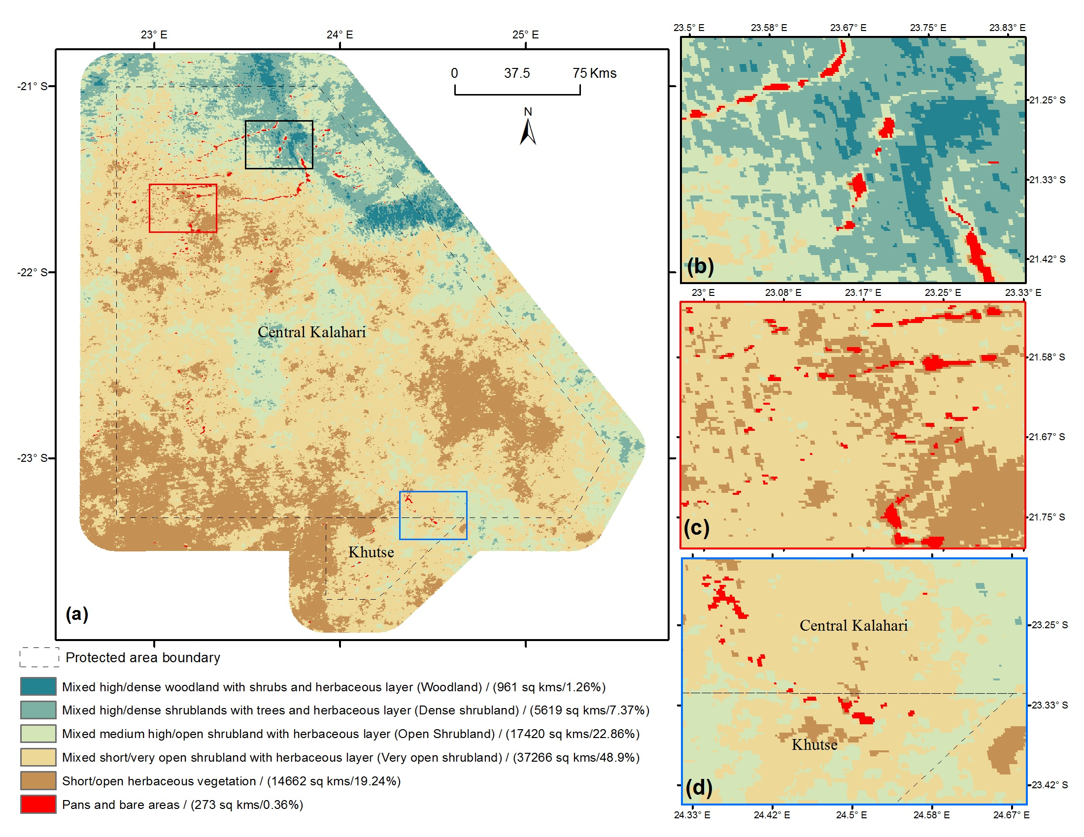
Mapping Vegetation Morphology Types in Southern Africa Savanna Using MODIS Time-Series Metrics: A Case Study of Central Kalahari, Botswana

Abstract
1. Introduction
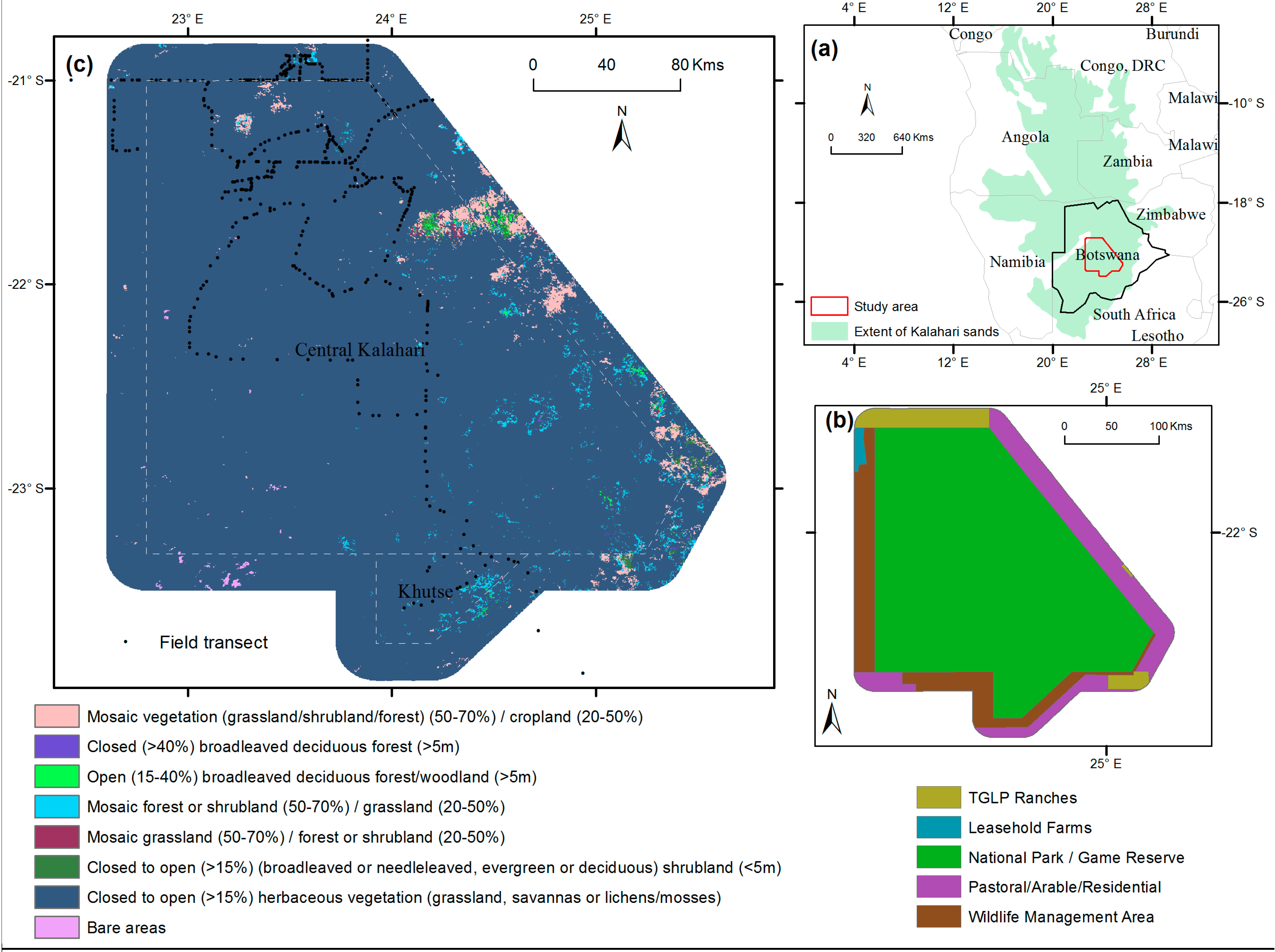
2. Study Area
3. Data and Methods
3.1. Field Data Processing and Development of Vegetation Morphology Class
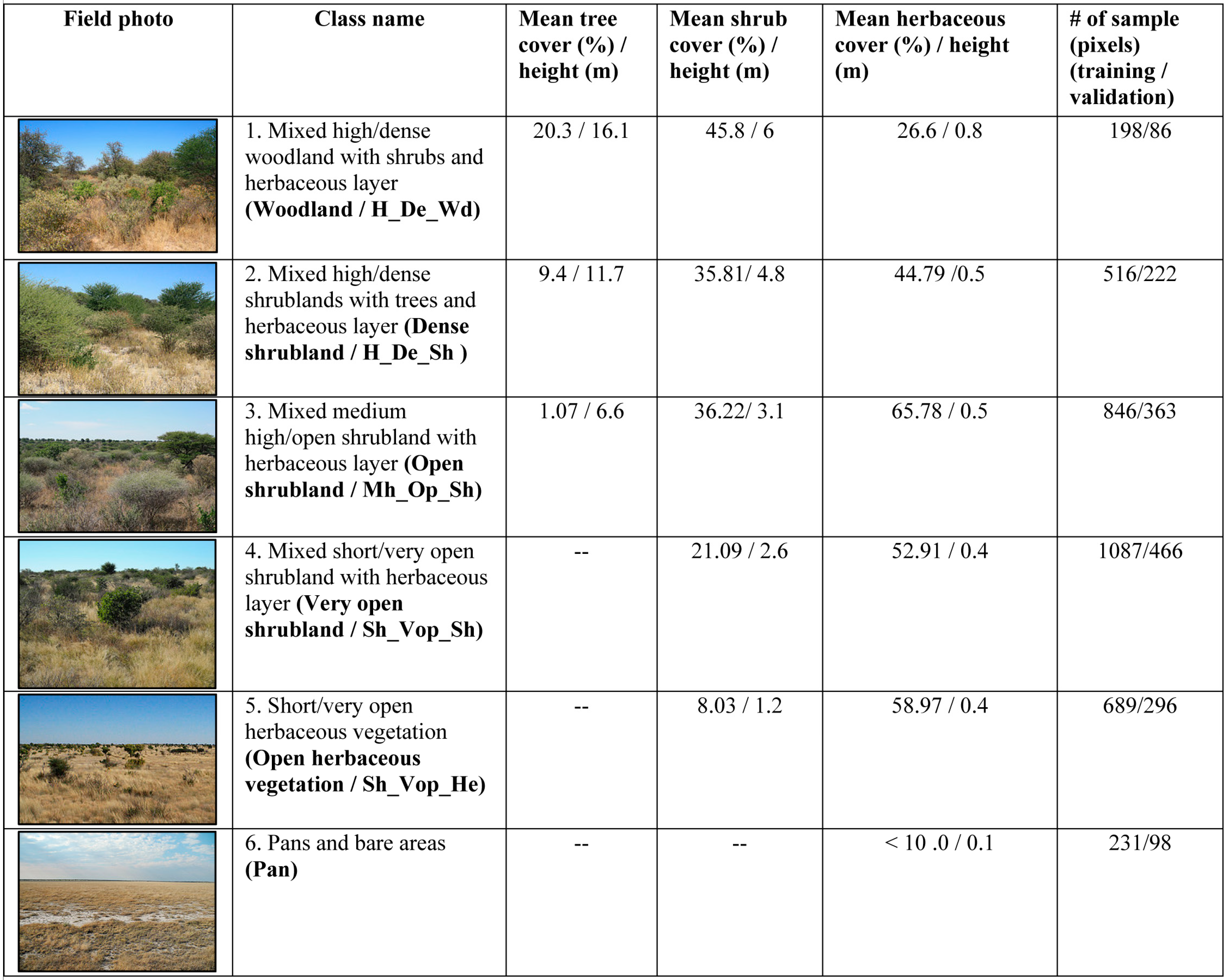
3.2. Remotely Sensed Data and Pre-Processing
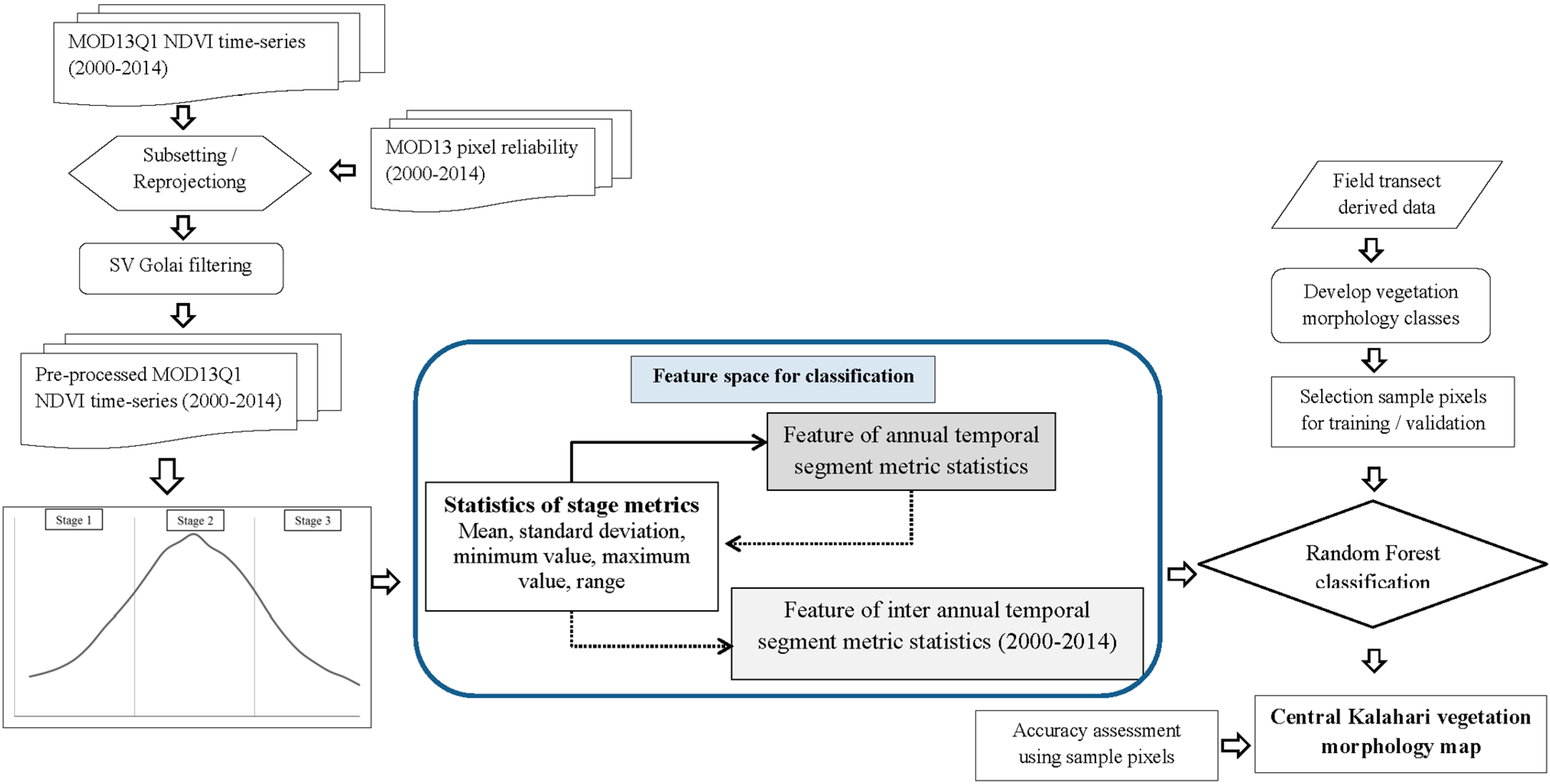
3.3. Calculating Time-Series Metrics, Separability Analysis and Random Forest Classification
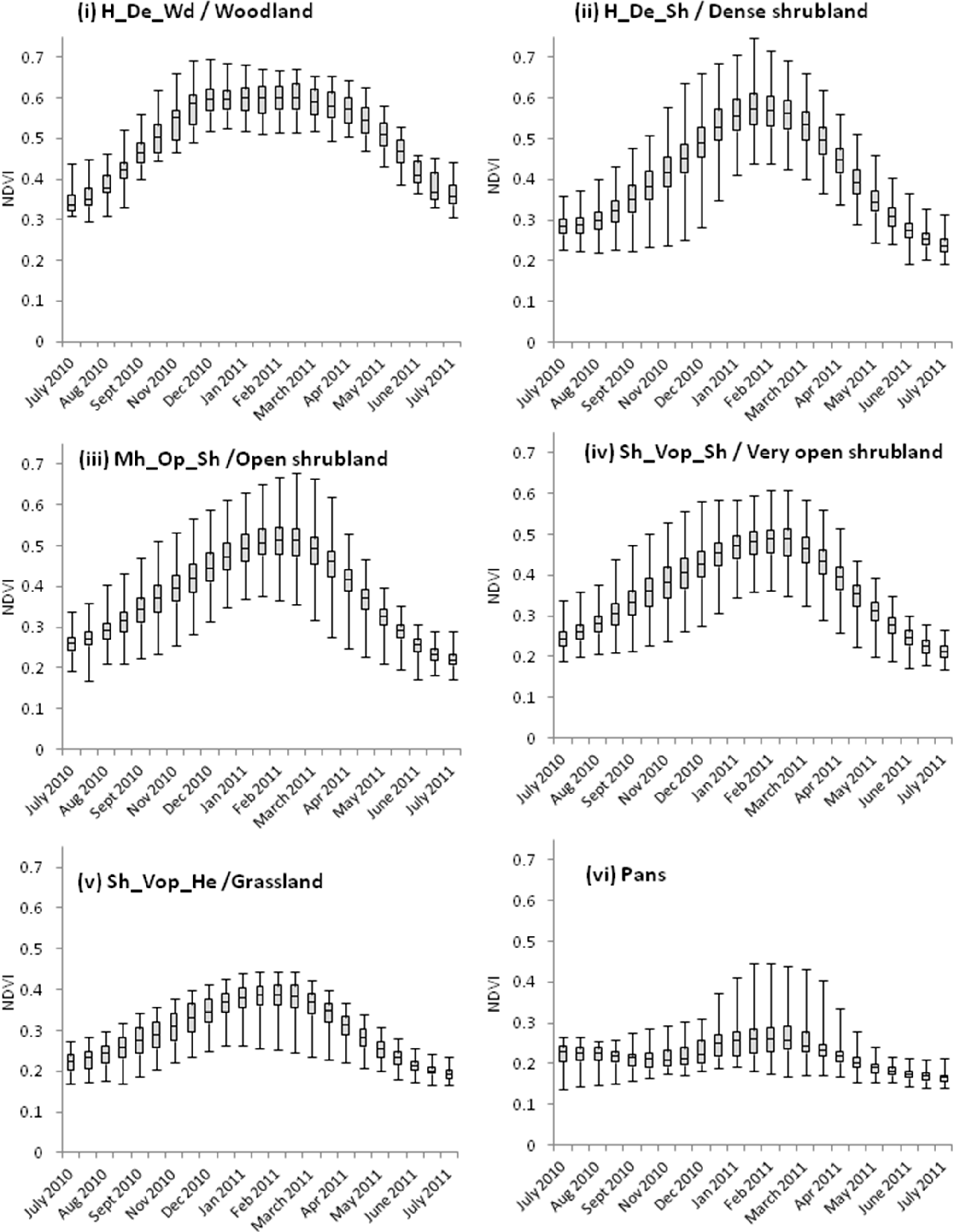
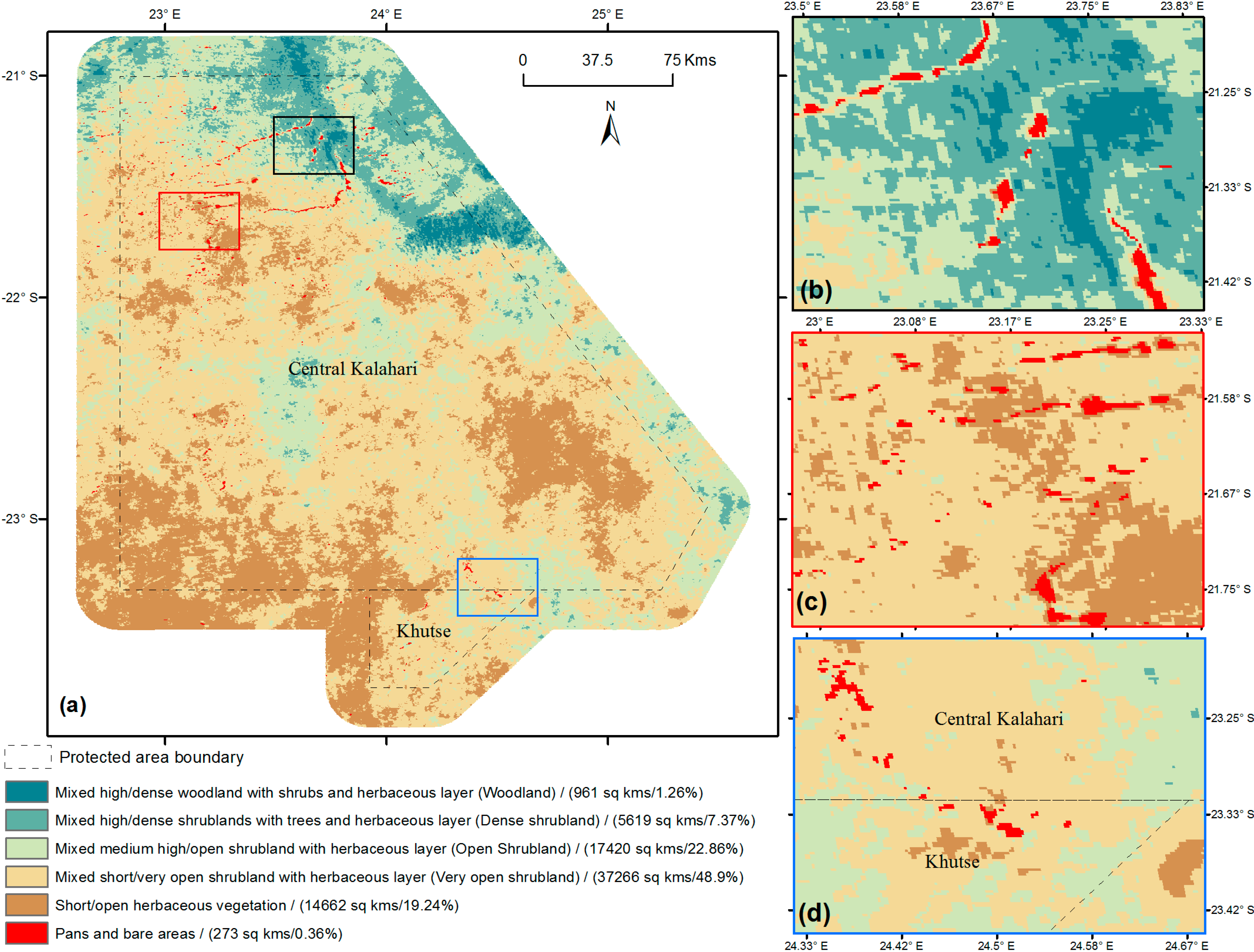
4. Results and Discussion

| H_De_Wd (Woodland) | H_De_Sh (Dense Shrubland) | Mh_Op_Sh (Open Shrubland) | Sh_Vop_Sh (Very Open Shrubland) | Sh_Vop_He (Very Open Herbaceous Vegetation) | Pans | |
|---|---|---|---|---|---|---|
| H_De_Wd (Woodland) | -- | 1.88 | 1.91 | 1.99 | 1.99 | 1.99 |
| H_De_Sh (Dense shrubland) | -- | 1.86 | 1.88 | 1.99 | 1.99 | |
| Mh_Op_Sh (Open shrubland) | -- | 1.91 | 1.95 | 1.99 | ||
| Sh_Vop_Sh (Very open shrubland) | -- | 1.92 | 1.99 | |||
| Sh_Vop_He (Very open herbaceous vegetation) | -- | 1.96 | ||||
| Pans | -- |
| Class Name | H_De_Wd (Woodland) | H_De_Sh (Dense Shrubland) | Mh_Op_Sh (Open Shrubland) | Sh_Vop_Sh (Very Open Shrubland) | Sh_Vop_He (Very Open Herbaceous Vegetation) | Pans | Producer’s Accuracy (%) |
|---|---|---|---|---|---|---|---|
| H_De_Wd (Woodland) | 79 | 4 | 3 | - | - | - | 91.86 |
| H_De_Sh (Dense shrubland) | 14 | 201 | 5 | 2 | - | - | 90.54 |
| Mh_Op_Sh (Open shrubland) | 1 | 14 | 336 | 10 | 2 | - | 92.56 |
| Sh_Vop_Sh (Very open shrubland) | - | 22 | 10 | 429 | 5 | - | 92.06 |
| Sh_Vop_He (Very open herbaceous vegetation) | - | - | 8 | 17 | 268 | 3 | 90.54 |
| Pans | - | - | - | - | 3 | 94 | 95.91 |
| User’s accuracy (%) | 84.04 | 83.4 | 92.81 | 93.66 | 95.37 | 96.9 |
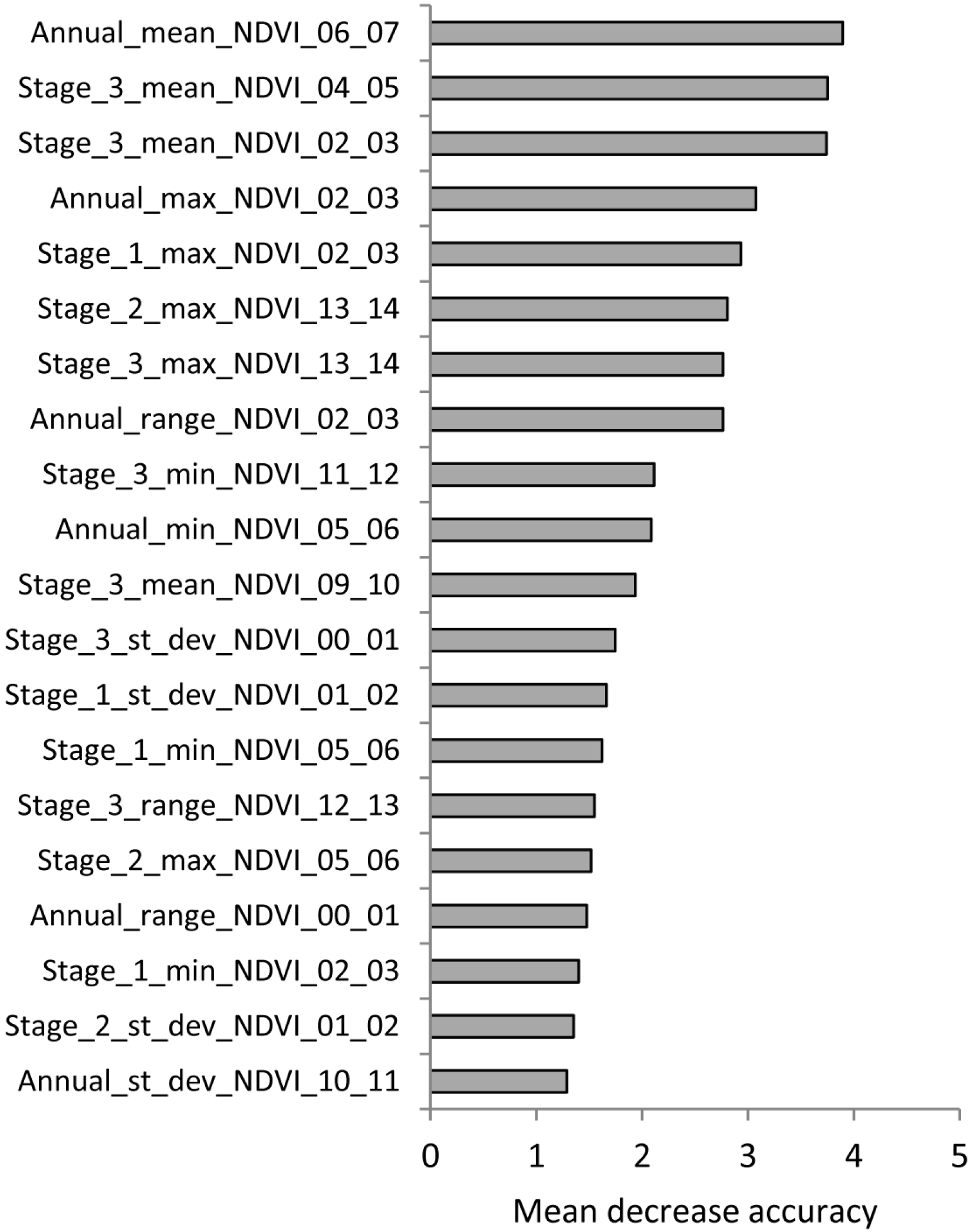
5. Summary
Acknowledgments
Author Contributions
Conflicts of Interest
References
- Balmford, A.; Moore, J.L.; Brooks, T.; Burgess, N.; Hansen, L.A.; Williams, P.; Rahbek, C. Conservation conflicts across africa. Science 2001, 291, 2616–2619. [Google Scholar] [CrossRef] [PubMed]
- Von Richter, W. The status of wildlife conservation in botswana. Koedoe 2014, 20, 143. [Google Scholar]
- Thomas, D.S.G.; Twyman, C. Good or bad rangeland? Hybrid knowledge, science, and local understandings of vegetation dynamics in the Kalahari. Land Degrad. Dev. 2004, 15, 215–231. [Google Scholar] [CrossRef]
- Winterbach, H.E.; Winterbach, C.W.; Somers, M.J. Landscape suitability in botswana for the conservation of its six large African carnivores. PLoS One 2014, 9, e100202. [Google Scholar] [CrossRef] [PubMed]
- Dougill, A.J.; Thomas, D.S.G.; Heathwaite, A.L. Environmental change in the kalahari: Integrated land degradation studies for nonequilibrium dryland environments. Ann. Assoc. Am. Geog. 1999, 89, 420–442. [Google Scholar] [CrossRef]
- Ferguson, K.; Hanks, J. The effects of protected area and veterinary fencing on wildlife conservation in southern Africa. PARKS 2012, 18, 49. [Google Scholar]
- Deaprtment of Wildlife and National Park (DWNP), Government of Botswana. Central Kalahari and Kutse Game Reserve Management Plan; DWNP: Gaborone, Botswana, 2003.
- Kesch, K.M.; Bauer, D.T.; Loveridge, A.J. Undermining game fences: Who is digging holes in Kalahari sands? Afr. J. Ecol. 2014, 52, 144–150. [Google Scholar] [CrossRef]
- Vanderpost, C.; Ringrose, S.; Matheson, W.; Arntzen, J. Satellite based long-term assessment of rangeland condition in semi-arid areas: An example from Botswana. J. Arid Environ. 2011, 75, 383–389. [Google Scholar] [CrossRef]
- Ringrose, S.; Matheson, W.; Wolski, P.; Huntsman-Mapila, P. Vegetation cover trends along the Botswana Kalahari transect. J. Arid Environ. 2003, 54, 297–317. [Google Scholar] [CrossRef]
- Moleele, N.; Ringrose, S.; Matheson, W.; Vanderpost, C. More woody plants? The status of bush encroachment in Botswana’S grazing areas. J. Environ. Manag. 2002, 64, 3–11. [Google Scholar] [CrossRef]
- Solomon, S.D.; Qin, M.; Manning, Z.; Chen, M.; Marquis, K.B.; Averyt, M.; Tignor, H.L. Climate Change: The Physical Science Basis, Contribution of Working Group I to the Fourth Assessment Report of the Intergovernmental Panel on Climate Change; Cambridge Univeristy Press: Cambridge, UK, 2007. [Google Scholar]
- Thomas, D.S.G.; Knight, M.; Wiggs, G.F.S. Remobilization of southern African desert dune systems by Twenty-First Century global warming. Nature 2005, 435, 1218–1221. [Google Scholar] [CrossRef] [PubMed]
- Scholes, R.J.; Walker, B.H. Cambridge Studies in Applied Ecology and Resource Management—An African Savanna: Synthesis of the Nylsvley Study; Cambridge University Press: Cambridge, UK, 1993. [Google Scholar]
- Van Rooyen, N.; Bezuidenhout, D.; Theron, G.K.; Bothma, J.D.P. Monitoring of the vegetation around artificial watering points (windmills) in the Kalahari Gemsbok National Park. Koedoe 1990, 33, 63–88. [Google Scholar] [CrossRef]
- Loarie, S.R.; Tambling, C.J.; Asner, G.P. Lion hunting behaviour and vegetation structure in an African savanna. Anim. Behav. 2013, 85, 899–906. [Google Scholar] [CrossRef]
- Pettorelli, N.; Laurance, W.F.; O’Brien, T.G.; Wegmann, M.; Nagendra, H.; Turner, W. Satellite remote sensing for applied ecologists: Opportunities and challenges. J. Appl. Ecol. 2014, 51, 839–848. [Google Scholar] [CrossRef]
- Huttich, C.; Gessner, U.; Herold, M.; Strohbach, B.J.; Schmidt, M.; Keil, M.; Dech, S. On the suitability of MODIS time series metrics to map vegetation types in dry savanna ecosystems: A case study in the Kalahari of Ne Namibia. Remote Sens. 2009, 1, 620–643. [Google Scholar] [CrossRef]
- Thomas, D.S.G. Sand, grass, thorns, and ... cattle: The modern Kalahari environment. In Sustainable Livelihoods in Kalahari. Environments: Contributions to Global Debates; Sporton, D., Thomas, D.S.G., Eds.; Oxford University Press: Oxford, UK, 2002; pp. 39–66. [Google Scholar]
- Mishra, N.B. Characterizing Ecosystem Structural and Functional Properties in the Central Kalahari Using Multi-Scale Remote Sensing. Docter’s Thesis, University of Texas, Austin, TX, USA, 2014. [Google Scholar]
- Ringrose, S.; Jellema, A.; Huntsman-Mapila, P.; Baker, L.; Brubaker, K. Use of remotely sensed data in the analysis of soil-vegetation changes along a drying gradient peripheral to the Okavango Delta, Botswana. Int. J. Remote Sens. 2005, 26, 4293–4319. [Google Scholar] [CrossRef]
- Mishra, N.B.; Crews, K.A. Mapping vegetation morphology types in a dry savanna ecosystem: Integrating hierarchical object-based image analysis with random forest. Int. J. Remote Sens. 2014, 35, 1175–1198. [Google Scholar] [CrossRef]
- Bontemps, S.; Defourny, P.; Bogaert, E.V.; Arino, O.; Kalogirou, V.; Perez, J.R. Globcover 2009-Products Description and Validation Report. 2011. Available online: http://dup.esrin.esa.int/files/p68/GLOBCOVER2009_Validation_Report_2.2.pdf (accessed on 3 September 2014).
- Hill, M.J.; Román, M.O.; Schaaf, C.B. Dynamics of vegetation indices in tropical and subtropical savannas defined by ecoregions and moderate resolution imaging spectroradiometer (MODIS) land cover. Geocarto Int. 2012, 27, 153–191. [Google Scholar] [CrossRef]
- Wu, J.; Marceau, D. Modeling complex ecological systems: An introduction. Ecol. Model. 2002, 153, 1–6. [Google Scholar] [CrossRef]
- Elmore, A.J.; Mustard, J.F.; Manning, S.J.; Lobell, D.B. Quantifying vegetation change in semiarid environments: Precision and accuracy of spectral mixture analysis and the normalized difference vegetation index. Remote Sens. Environ. 2000, 73, 87–102. [Google Scholar] [CrossRef]
- Jensen, J.R. Remote Sensing of the Environment: An Earth Resource Perspective 2/e; Pearson Education India: Chennai, India, 2009. [Google Scholar]
- De Fries, R.; Hansen, M.; Townshend, J.; Sohlberg, R. Global land cover classifications at 8 km spatial resolution: The use of training data derived from Landsat imagery in decision tree classifiers. Int. J. Remote Sens. 1998, 19, 3141–3168. [Google Scholar] [CrossRef]
- Hansen, M.; DeFries, R.; Townshend, J.; Carroll, M.; Dimiceli, C.; Sohlberg, R. Global percent tree cover at a spatial resolution of 500 m: First results of the MODIS vegetation continuous fields algorithm. Earth Interact. 2003, 7, 1–15. [Google Scholar] [CrossRef]
- Jacquin, A.; Sheeren, D.; Lacombe, J.-P. Vegetation cover degradation assessment in madagascar savanna based on trend analysis of MODIS NDVI time series. Int. J. Appl. Earth Observ. Geoinf. 2010, 12, S3–S10. [Google Scholar] [CrossRef]
- Okin, G.S.; Roberts, D.A. Remote sensing in arid regions: Challenges and opportunities. In Manual of Remote Sensing—Volume 4, Remote Sensing for Natural Resource Management and Environmental Monitoring, 3rd ed.; Ustin, S., Ed.; John Wiley & Sons, Inc.: New York, NY, USA, 2004; pp. 111–146. [Google Scholar]
- Colditz, R.; Schmidt, M.; Conrad, C.; Hansen, M.; Dech, S. Land cover classification with coarse spatial resolution data to derive continuous and discrete maps for complex regions. Remote Sens. Environ. 2011, 115, 3264–3275. [Google Scholar] [CrossRef]
- Friedl, M.; Zhang, X.; Strahler, A. Characterizing global land cover type and seasonal land cover dynamics at moderate spatial resolution with MODIS data. In Land Remote Sensing and Global Environmental Change; Springer: Berlin, Germany, 2011; pp. 709–724. [Google Scholar]
- Clark, M.L.; Aide, T.M.; Grau, H.R.; Riner, G. A scalable approach to mapping annual land cover at 250 m using MODIS time series data: A case study in the dry chaco ecoregion of South America. Remote Sens. Environ. 2010, 114, 2816–2832. [Google Scholar] [CrossRef]
- Klein, I.; Gessner, U.; Kuenzer, C. Regional land cover mapping and change detection in central asia using MODIS time-series. Appl. Geogr. 2012, 35, 219–234. [Google Scholar] [CrossRef]
- Ghimire, B.; Rogan, J.; Galiano, V.R.; Panday, P.; Neeti, N. An evaluation of bagging, boosting, and random forests for land-cover classification in Cape Cod, Massachusetts, USA. GISci. Remote Sens. 2012, 49, 623–643. [Google Scholar] [CrossRef]
- Waske, B.; Benediktsson, J.A.; Sveinsson, J.R. Chapter 18 Random forest classification of remote sensing data. In Signal Image Processing for Remote Sensing; CRC Press: Boca Raton, FL, USA, 2012; pp. 365–374. [Google Scholar]
- Verikas, A.; Gelzinis, A.; Bacauskiene, M. Mining data with random forests: A survey and results of new tests. Pattern Recognit. 2011, 44, 330–349. [Google Scholar] [CrossRef]
- Mendelsohn, J.; El Obeid, S. Okavango River: The Flow of A Lifeline; Struik Publishers: Cape Town, South Africa, 2004. [Google Scholar]
- Scholes, R.J.; Dowty, P.R.; Caylor, K.; Parsons, D.A.B.; Frost, P.G.H.; Shugart, H.H. Trends in savanna structure and composition along an aridity gradient in the Kalahari. J. Veg. Sci. 2002, 13, 419–428. [Google Scholar] [CrossRef]
- Makhabu, S.W.; Marotsi, B.; Perkins, J. Vegetation gradients around artificial water points in the central Kalahari game reserve of Botswana. Afr. J. Ecol. 2002, 40, 103–109. [Google Scholar] [CrossRef]
- Thomas, D.S.G.; Shaw, P.A. The Kalahari Environment; Cambridge University Press: Cambridge, UK, 1991. [Google Scholar]
- Fagan, W.F. Connectivity, fragmentation, and extinction risk in dendritic metapopulations. Ecology 2002, 83, 3243–3249. [Google Scholar] [CrossRef]
- Mishra, N.B.; Crews, K.A. Estimating fractional land cover in semi-arid central kalahari: The impact of mapping method (spectral unmixing versus object based image analysis) and vegetation morphology. Geocarto Int. 2014, 29, 860–877. [Google Scholar] [CrossRef]
- Thompson, M. Standard land-cover classification scheme for remote-sensing applications in South Africa. South. Afr. J. Sci. 1996, 29, 36–42. [Google Scholar]
- Groffman, P.M.; Tiedje, T.M.; Mokma, D.L.; Simkins, S. Regional-scale analysis of denitrification in north temperate forest soils. Landsc. Ecol. 1992, 7, 45–53. [Google Scholar] [CrossRef]
- Huete, A.; Didan, K.; Miura, T.; Rodriguez, E.P.; Gao, X.; Ferreira, L.G. Overview of the radiometric and biophysical performance of the MODIS vegetation indices. Remote Sens. Environ. 2002, 83, 195–213. [Google Scholar] [CrossRef]
- Jonsson, P.; Eklundh, L. Timesat—A program for analyzing time-series of satellite sensor data. Comput. Geosci. 2004, 30, 833–845. [Google Scholar] [CrossRef]
- Laliberte, A.; Browning, D.; Rango, A. A comparison of three feature selection methods for object-based classification of sub-decimeter resolution UltraCam-l imagery. Int. J. Appl. Earth Observ. Geoinf. 2012, 15, 70–78. [Google Scholar] [CrossRef]
- Friedl, M.A.; Brodley, C.E. Decision tree classification of land cover from remotely sensed data. Remote Sens. Environ. 1997, 61, 399–409. [Google Scholar] [CrossRef]
- Breiman, L. Random forests. Mach. Learn. 2001, 45, 5–32. [Google Scholar] [CrossRef]
- Liaw, A.; Weiener, M. Classification and regression by randomforest. R News 2002, 2, 18–22. [Google Scholar]
- Levick, S.R.; Asner, G.P.; Kennedy-Bowdoin, T.; Knapp, D.E. The relative influence of fire and herbivory on savanna three-dimensional vegetation structure. Biol. Conserv. 2009, 142, 1693–1700. [Google Scholar] [CrossRef]
- Sankaran, M.; Ratnam, J.; Hanan, N. Woody cover in African savannas: The role of resources, fire and herbivory. Glob. Ecol. Biogeogr. 2008, 17, 236–245. [Google Scholar] [CrossRef]
- Vanacker, V.; Linderman, M.; Lupo, F.; Flasse, S.; Lambin, E. Impact of short-term rainfall fluctuation on interannual land cover change in Sub-Saharan Africa. Glob. Ecol. Biogeogr. 2005, 14, 123–135. [Google Scholar] [CrossRef]
- Archibald, S.; Scholes, R. Leaf green-up in a semi-arid African savanna-separating tree and grass responses to environmental cues. J. Veg. Sci. 2007, 18, 583–594. [Google Scholar]
- Gessner, U.; Machwitz, M.; Conrad, C.; Dech, S. Estimating the fractional cover of growth forms and bare surface in savannas. A multi-resolution approach based on regression tree ensembles. Remote Sens. Environ. 2013, 129, 90–102. [Google Scholar] [CrossRef]
- Mishra, N.B.; Crews, K.A.; Okin, G.S. Relating spatial patterns of fractional land cover to savanna vegetation morphology using multi-scale remote sensing in the central Kalahari. Int. J. Remote Sens. 2014, 35, 2082–2104. [Google Scholar] [CrossRef]
- Guerschman, J.P.; Hill, M.J.; Renzullo, L.J.; Barrett, D.J.; Marks, A.S.; Botha, E.J. Estimating fractional cover of photosynthetic vegetation, non-photosynthetic vegetation and bare soil in the Australian tropical savanna region upscaling the EO-1 hyperion and MODIS sensors. Remote Sens. Environ. 2009, 113, 928–945. [Google Scholar] [CrossRef]
© 2015 by the authors; licensee MDPI, Basel, Switzerland. This article is an open access article distributed under the terms and conditions of the Creative Commons Attribution license (http://creativecommons.org/licenses/by/4.0/).
Share and Cite
Mishra, N.B.; Crews, K.A.; Miller, J.A.; Meyer, T. Mapping Vegetation Morphology Types in Southern Africa Savanna Using MODIS Time-Series Metrics: A Case Study of Central Kalahari, Botswana. Land 2015, 4, 197-215. https://doi.org/10.3390/land4010197
Mishra NB, Crews KA, Miller JA, Meyer T. Mapping Vegetation Morphology Types in Southern Africa Savanna Using MODIS Time-Series Metrics: A Case Study of Central Kalahari, Botswana. Land. 2015; 4(1):197-215. https://doi.org/10.3390/land4010197
Chicago/Turabian StyleMishra, Niti B., Kelley A. Crews, Jennifer A. Miller, and Thoralf Meyer. 2015. "Mapping Vegetation Morphology Types in Southern Africa Savanna Using MODIS Time-Series Metrics: A Case Study of Central Kalahari, Botswana" Land 4, no. 1: 197-215. https://doi.org/10.3390/land4010197
APA StyleMishra, N. B., Crews, K. A., Miller, J. A., & Meyer, T. (2015). Mapping Vegetation Morphology Types in Southern Africa Savanna Using MODIS Time-Series Metrics: A Case Study of Central Kalahari, Botswana. Land, 4(1), 197-215. https://doi.org/10.3390/land4010197