


Abstract
The increasing availability of geospatial data and the rapid development of geospatial artificial intelligence (GeoAI) create new opportunities for modernizing cadastral and land administration systems. However, integrating probabilistic GeoAI outputs into systems structured according to the Land Administration Domain Model (LADM) remains conceptually, semantically and institutionally challenging. ISO 19152 provides standardized structures for land-administration objects, sources and lifecycle information, while ISO 19157 supports the description and evaluation of geographic data quality. A distinct issue nevertheless arises before these mechanisms can support authoritative cadastral information: the status and institutional treatment of model-dependent spatial observations. Using a conceptual framework-development approach based on a critical and integrative literature synthesis, this article proposes an AI-ready LADM framework organized into six interdependent layers: geospatial data acquisition, GeoAI inference, uncertainty representation, semantic mediation, candidate integration, and legal validation with feedback. The framework introduces external, non-authoritative candidate-evidence constructs that preserve source provenance, model information, uncertainty, possible LADM relevance and review history before any institutionally authorized cadastral action. It translates these constructs into a proposed procedural structure comprising source classification, uncertainty and risk assessment, conceptual semantic-mapping rules, validation procedures, audit trails and institutional roles. The contribution is domain-specific rather than a general claim about human oversight of AI. It distinguishes technical detection, candidate cadastral relevance and legally recognized cadastral status, while treating semantic mediation as one component of the broader process of epistemic translation. Scenario-based analysis illustrates the framework’s internal logic, but its effectiveness, usability and legal–institutional feasibility remain subject to subsequent expert assessment and jurisdiction-specific empirical evaluation.
1. Introduction
Land administration systems do not merely organize spatial data; they structure legally meaningful relationships among people, rights, restrictions, responsibilities and spatial units. The Land Administration Domain Model (LADM) provides a standardized conceptual framework for representing these relationships across heterogeneous jurisdictions and institutional settings [1,2,3]. Its applications include country profiles, sustainable-development indicators, cadastral modernization, interoperability, 3D cadastre and integrated spatial governance [1,2,3,4,5,6,7,8].
At the same time, urban growth, complex property configurations, digital-twin initiatives and the increasing availability of remotely sensed data are creating demand for more responsive cadastral monitoring and updating. GeoAI contributes large-scale image analysis, object detection, segmentation, classification and predictive spatial analysis using satellite, UAV, LiDAR and other geospatial data [9,10,11].
The resulting integration problem is not only technical. LADM structures land-administration information that has acquired recognized semantic and institutional status, whereas GeoAI generates probabilistic and model-dependent observations of physical space. Although LADM can be extended and profiled for different domains, existing research does not fully explain how external AI-derived observations should be represented and assessed before their possible use in authoritative cadastral processes [1,2,3,7,8,9,10,11,12]. The literature identifies several major strengths of GeoAI: large-scale analytics, automation, high accuracy, sensitivity to subtle spatial change, tolerance of noisy data and rapid technological advancement [9,10,11].
The article addresses this integration as a problem of epistemic translation between two different modes of producing land information. This formulation does not present human or institutional oversight as a novel principle. Its domain-specific contribution concerns the controlled transition from probabilistic observations of physical space to candidate cadastral information and, where the applicable requirements are satisfied, to authoritative LADM-based information. Within this broader process, semantic mediation assigns a provisional relationship between an AI-derived observation and a possible LADM concept, while epistemic translation also encompasses provenance, uncertainty, evidentiary assessment, institutional responsibility and legal validation [1,9,12]. This distinction is visible across the literature: LADM studies emphasize semantic modeling, legal–spatial representation and institutional interoperability, while GeoAI and AI–cadastre studies emphasize automated detection, classification, segmentation, prediction and map enrichment [1,2,3,9,10,11,12,13,14,15,16].
LADM provides standardized concepts for parties, RRRs, BAUnits, spatial units and sources and includes mechanisms for lifecycle management and historical states [1,2,3]. The gap addressed here is therefore not the absence of provenance, versioning or geographic data-quality mechanisms. It concerns the pre-authoritative status of model-dependent GeoAI observations that may possess source metadata, confidence information and quality indicators without yet corresponding to a legally or institutionally recognized cadastral object.
GeoAI and LADM consequently perform complementary functions. GeoAI supports detection, classification, change identification and spatial inference, while LADM structures land-administration information that has acquired the required semantic and institutional status [4,5,6,7,8,9,10,11,12,13,14,15,16,17,18,19,20,21,22]. Their integration requires an intermediate candidate-evidence mechanism that can preserve possible cadastral relevance without assigning premature legal authority. The novelty of the proposal lies in structuring this pre-authoritative transition rather than in introducing new source, versioning or geographic data-quality mechanisms.
The aim of this article is to develop a conceptual framework for governing the integration of GeoAI-derived spatial evidence into LADM-based land administration through semantic, evidentiary and institutional mediation. Although object classes, semantic rules and workflow representations are used to make the proposal operationally explicit, the central question is not one of software optimization. It concerns the conditions under which AI-derived observations may legitimately influence cadastral records and land-related decisions. These conditions have direct implications for tenure security, legal certainty, institutional accountability, access to land information, procedural fairness, participation, contestability and the distribution of risks arising from erroneous or incomplete cadastral information. The technical representations formalize these policy-relevant safeguards by separating observation from legal recognition, preserving provenance and uncertainty and assigning institutional responsibility for authoritative cadastral action.
The article addresses three research questions:
- •
- RQ1. How does the existing literature conceptualize LADM, GeoAI and AI-enabled cadastral systems?
- •
- RQ2. What conceptual gap prevents direct integration between probabilistic GeoAI outputs and authoritative LADM information?
- •
- RQ3. What type of semantic, evidentiary and institutional mediation framework is required for AI-derived spatial information to become relevant to LADM-based cadastral processes?
To answer these questions, the article distinguishes semantic mediation from the broader process of epistemic translation and proposes a candidate-evidence layer separating GeoAI observations from authoritative LADM information. The framework combines provenance, uncertainty representation, provisional semantic correspondence and institutionally accountable validation. Its conceptual architecture and scenario-based assessment are presented in Section 3 and Section 4, followed by a discussion of land-policy, ethical and institutional implications.
2. Theoretical Framework: LADM, GeoAI and the Need for Semantic Mediation
The theoretical framework is organized into six closely related but analytically distinct subsections. Section 2.1 and Section 2.2 establish the different conceptual foundations of LADM and GeoAI. Section 2.3 and Section 2.4 examine two separate gaps arising from their integration: the semantic gap between physically detected and legally recognized objects and the uncertainty gap between probabilistic model outputs and the evidentiary requirements of cadastral systems. Section 2.5 addresses technical, semantic and epistemic interoperability, while Section 2.6 examines explainability and institutionally authorized legal validation. Although these issues interact within the proposed framework, they are presented separately because they concern different analytical objects, requirements and decision stages.
2.1. LADM
LADM should be understood primarily as a legal-semantic model for structuring land administration information, rather than as a computational model for automated inference. The model is used to formalize land administration concepts, create national profiles, support data exchange, structure cadastral modernization and connect land administration to broader sustainability frameworks [1,2,3].
The current LADM standardization framework should be understood in its broader ISO context. ISO 19152 provides the conceptual structure for land-administration information, including parties, basic administrative units, rights, restrictions and responsibilities, spatial units, sources and versioned objects. ISO 19152-1:2024 defines the generic conceptual model and provides a basis for national and regional profiles. The revised LADM framework is organized as a multi-part standard intended to support different but connected land-administration domains and implementation requirements.
ISO 19157 addresses a complementary dimension. It provides general principles for describing, evaluating and reporting the quality of geographic data, including completeness, logical consistency, positional accuracy, temporal quality and thematic accuracy. In cadastral applications, ISO 19152 can structure the objects, sources and legally relevant relationships represented by the land administration system, while ISO 19157-aligned mechanisms can support the assessment and documentation of the quality of the geographic data, measurements and derived geometries used by that system.
The two standards are therefore complementary rather than alternative. ISO 19152 addresses the conceptual organization of land-administration information, while ISO 19157 addresses geographic data quality. Neither function is replaced by the proposed candidate-evidence framework. Instead, the framework addresses a different stage: the interval during which an external GeoAI-derived observation may possess source metadata and data-quality information but has not yet acquired authoritative cadastral status.
Source references establish where information originated, while data-quality information describes its technical characteristics and limitations. Neither mechanism independently determines whether a detected feature corresponds to a legally recognized SpatialUnit, BAUnit, RRR or cadastral boundary. The novelty claimed in this article therefore does not concern source representation, lifecycle management, historical versions or geographic data quality, which are already addressed within the LADM and related ISO ecosystem. Nor does it concern semantic alignment as a general interoperability technique.
The specific contribution is a land-administration-oriented pre-authoritative pathway that integrates model provenance, object-level uncertainty, consequence-related risk, provisional semantic relevance, evidentiary assessment and institutional disposition. This pathway preserves the distinction among model-derived observation, provisional cadastral interpretation and institutionally authorized information. It complements existing LADM and ISO mechanisms by preventing a technically reliable or semantically plausible GeoAI output from acquiring authoritative cadastral status without the evidence, competence and procedure required by the relevant land-administration system.
In the context of this article, semantic mediation refers to the interpretive operation through which an AI-derived observation is assigned a possible correspondence with a land-administration concept. It addresses whether a detected feature may be relevant to an LADM category such as a SpatialUnit, BAUnit, boundary representation, source or RRR-related issue. Semantic mediation does not establish that the correspondence is legally valid and does not authorize the creation or modification of an authoritative cadastral object. Its outcome is a provisional semantic relation that remains subject to evidentiary and institutional assessment. Unlike conventional semantic alignment, which primarily establishes correspondence among heterogeneous concepts or schemas, the proposed mediation step also assigns candidate status, preserves uncertainty and provenance and identifies the evidence and institutional pathway required before the correspondence may support cadastral action.
Epistemic translation is the broader process through which GeoAI-derived spatial information is transformed in status, context and authority as it moves from probabilistic observation toward possible institutional use. It includes, but is not limited to, semantic mediation. Epistemic translation also requires the preservation of source provenance, the representation of model and object uncertainty, the assessment of evidentiary sufficiency, the identification of institutional responsibility, legal and procedural review, and the recording of the final disposition. Semantic mediation is therefore an interpretive component of the broader epistemic translation process.
LADM reduces institutional heterogeneity through standardized concepts, relationships and classes, but it does not determine whether an externally detected feature has legal significance. GeoAI models identify spatial patterns, while LADM structures institutionally recognized land-administration meaning. Their integration therefore requires an intermediate mechanism that can relate probabilistic observations to possible cadastral concepts without assigning premature legal status [1,2,3,4,7,8,16,23].
2.2. GeoAI
GeoAI is best understood as a form of probabilistic spatial inference. It applies artificial intelligence, machine learning and deep learning to geospatial problem solving, especially through large-scale image analysis, object detection, land-cover mapping and predictive spatial analytics [9,10,11].
The key difference between GeoAI and LADM is that GeoAI does not begin from legally defined entities. It begins from data. GeoAI models infer spatial patterns from spectral, geometric, temporal, textual or sensor-derived signals. In cadastral contexts, this includes visible boundary detection, parcel delineation, cadastral map enrichment, error-pattern recognition and 3D point-cloud interpretation [12,13,14,15,16,17,18,19,20,21].
The same logic applies to fully convolutional networks for cadastral boundary detection. These models can outperform some traditional approaches where boundaries are visible, but they also expose the semantic gap between low-level visual cues and high-level cadastral boundary concepts [20]. GeoAI outputs remain probabilistic and model-dependent. Their cadastral interpretation is subject to the physical-to-legal distinction examined in Section 2.3.
The proposed epistemic translation pathway proceeds from GeoAI observation through uncertainty representation, semantic mediation and evidentiary and legal validation to an institutionally authorized LADM update. Semantic mediation is therefore one stage within the broader epistemic translation process.
2.3. The Semantic Gap Between Detected Objects and Legal Objects
The central theoretical problem in LADM–GeoAI integration is the semantic gap between detected spatial objects and legally meaningful land administration objects. AI systems can identify visible features, classify land cover, detect parcel-like structures, segment buildings or recognize changes in cadastral maps, but legal objects require more than geometry. A cadastral object is embedded in rights, restrictions, responsibilities, institutional sources, procedures and authoritative validation [1,8,12].
This semantic gap is clearly visible in cadastral boundary extraction studies. Machine-driven extraction can identify components of cadastral boundaries, but automatic approaches may underperform human interpretation, especially in urban settings where legal–spatial interpretation is complex [13]. Deep learning approaches similarly demonstrate that cadastral boundaries are not equivalent to visual edges because the high-level cadastral boundary concept cannot be fully reduced to low-level image cues [18,19,20].
The gap is not only technical. It is conceptual. A visual boundary may correspond to a fence, wall, hedge, ditch, road, cultivation edge or informal occupation marker. Only some of these may correspond to legal boundaries, and even then, their legal meaning depends on survey records, registry entries, title documents, administrative decisions and jurisdiction-specific rules [7,8,13,18,19,20].
The same reasoning applies to building detection and 3D cadastre. Automated 3D modeling from UAV-LiDAR can generate valuable physical representations and improve parcel geometry, but physical structures must still be interpreted in relation to rights, legal spaces and administrative units [16]. BIM/IFC and GIS models can support the sourcing and visualization of 3D legal spaces, but technical geometry must be translated through legal requirements before it becomes usable in land registry contexts [4,7]. These studies support a central theoretical proposition: legal meaning is not contained in geometry alone. Geometry may provide evidence, but cadastral meaning results from semantic, evidentiary and institutional interpretation. This proposition underpins both semantic mediation and epistemic translation, which operate at different analytical levels.
Semantic mediation assigns a provisional conceptual correspondence between a detected object and an LADM concept. Epistemic translation encompasses the broader change in informational and institutional status, including provenance, uncertainty, evidentiary comparison, review and authorized disposition. A detected fence may therefore be mapped as candidate boundary evidence without completing the broader translation process or establishing a legal boundary.
2.4. The Uncertainty Gap: From Confidence Scores to Legal Certainty
The second theoretical problem is the uncertainty gap. GeoAI outputs are often expressed through probabilities, thresholds, confidence scores, segmentation masks, precision, recall, F1-scores or spatial error distributions. LADM-based systems, by contrast, require legally meaningful states for parties, rights, restrictions, responsibilities, administrative units and spatial units [1,12].
The uncertainty gap is evident in automated boundary detection and cadastral updating. Threshold selection changes the balance between precision and recall, while predicted boundaries may overlap only partially with existing cadastral geometry [19,21]. Cadastral maps also accumulate uncertainty through surveys, subdivisions, amalgamations, positional adjustments and successive updates [22].
Clustering and other automated methods can identify systematic error patterns, but their outputs remain context-dependent and require interpretation before cadastral correction [15]. GeoAI therefore adds model-dependent uncertainty to the technical and historical uncertainty already present in cadastral data. In LADM–GeoAI integration, uncertainty must therefore be explicitly modeled. A future AI-ready LADM framework cannot simply add AI outputs as ordinary cadastral objects. It must distinguish between detected spatial evidence, candidate cadastral objects, validated legal objects and authoritative registry objects.
2.5. The Interoperability Gap: Data Exchange
The third theoretical problem is the interoperability gap. Existing LADM research addresses structured data exchange and institutional interoperability through country profiles and land-data frameworks [2,3,23]. AI-ready interoperability, however, also requires mediation between different information models: legally structured land-administration concepts and probabilistic GeoAI outputs. Conventional data exchange does not determine whether a detected feature should be interpreted as a SpatialUnit, BAUnit, source, legal space or contextual evidence [2,3,8].
Ontology-based integration and semantic-web technologies can support this mediation by relating heterogeneous evidence to formal domain concepts [24,25]. The proposed framework builds on these established approaches but assigns them a narrower and institutionally constrained role. Ontology-based correspondence may identify possible conceptual relevance, but it does not establish evidentiary sufficiency, legal admissibility or authoritative status. The resulting interoperability problem has two levels: conventional interoperability enables structured data exchange, while epistemic interoperability relates uncertain spatial evidence to possible legal-semantic categories. The latter remains underdeveloped and is the focus of the proposed framework.
2.6. Explainability and the Legal Validation Problem
A fourth theoretical issue is explainability. AI-supported cadastral processes may affect land rights, property values, planning restrictions, taxation and dispute resolution and must therefore remain understandable, auditable and institutionally reviewable [12,26]. A cadastral authority should be able to reconstruct the data, model, confidence level, supporting spatial evidence and relevant legal sources behind a candidate observation. The legal-validation layer must consequently provide an explicit interface between probabilistic outputs, survey evidence, legal documents, administrative procedures and institutional responsibility. Explainability is not merely a technical or usability requirement; it supports evidentiary assessment, reason-giving, reviewability and administrative trust.
The legal status of an AI-assisted cadastral decision must be distinguished from the status of the AI output used during its preparation. An AI-derived observation, confidence score, semantic classification or candidate object is not an administrative decision and does not acquire legal authority merely because it is processed within a public institution. It constitutes preparatory or evidentiary information whose relevance must be assessed under the applicable cadastral and administrative procedure.
The legally consequential act remains the decision adopted or authorized by the competent institution. That institution retains responsibility for verifying the relevant facts, assessing the admissibility and sufficiency of the evidence, applying the governing legal rules, providing reasons where required and ensuring access to the applicable review or appeal mechanisms. Institutional responsibility cannot be transferred to the GeoAI model, the software provider or the technical reviewer. Accordingly, the legal validation layer does not convert AI output into legal truth. It determines whether and how AI-derived candidate evidence may be considered within an authorized administrative process. A candidate may support the initiation of a review, prioritization of field verification or comparison with existing records, but it should not independently establish, modify or extinguish a right, restriction, responsibility, boundary or registered legal status.
Where an AI-derived candidate contributes materially to an adverse or legally consequential decision, the decision record should identify the information used, its source and uncertainty, the role played by the AI output, the additional evidence considered, the responsible decision maker and the legal basis for the outcome. The affected person should be able to understand and contest the factual and legal basis of the decision through the procedures available in the relevant jurisdiction.
2.7. Toward the Concept of an AI-Ready LADM
The preceding subsections identify six complementary components of the theoretical problem: the legal-semantic structure of LADM, the probabilistic inferential logic of GeoAI, the semantic gap between physical and legal objects, the uncertainty gap between confidence and evidentiary sufficiency, the requirements of epistemic interoperability, and the need for explainable institutional validation. Section 2.7 brings these components together in the concept of an AI-ready LADM.
The concept of an AI-ready LADM does not mean replacing LADM with AI. It means extending the LADM ecosystem so that it can interact with AI outputs without compromising legal certainty, semantic clarity or institutional accountability. The existing research already shows that LADM can be extended toward SDG formalization, country profiles, 3D cadastre, low-altitude airspace modeling, BIM/GIS integration and data exchange frameworks [1,2,3,4,5,6,7,8].
At the same time, AI and GeoAI can support cadastral boundary extraction, land-boundary revision, smart cadastral map enrichment, cadastral error-pattern detection, 3D cadastral automation and broader GIS automation [9,10,11,12,13,14,15,16,17,18,19,20,21]. However, these two research streams must be connected through a new conceptual architecture.
An AI-ready LADM framework should be guided by four theoretical principles:
- AI outputs are evidentiary, not authoritative. Boundary predictions, object detections, point-cloud segmentations and change-detection outputs should be treated as candidate evidence rather than legal facts [13,18,19,20,21,27];
- Semantic mediation is mandatory. AI-derived spatial objects must be mapped to LADM concepts through ontology-based or rule-based interpretation before they can become candidate cadastral entities [8,24,25];
- Uncertainty must be explicitly represented. Confidence scores, thresholds, error clusters and model-performance metrics must be stored and evaluated before legal validation [15,19,21,22];
- Legal validation remains indispensable. The final transformation from candidate cadastral object to authoritative cadastral record must remain institutionally controlled, explainable and auditable [1,2,3,8,26].
In response to RQ1, the literature presents three complementary orientations. LADM research emphasizes standardized legal-semantic modeling, institutional interoperability, country profiles, 3D legal spaces and the representation of parties, BAUnits, RRRs, spatial units and sources. GeoAI research emphasizes probabilistic spatial inference through classification, detection, segmentation, change analysis and prediction. AI-enabled cadastral research connects these orientations through boundary detection, map enrichment, parcel-change identification, quality assessment and 3D modeling.
These studies demonstrate growing technical and geometric capacity but devote less attention to the pre-authoritative evidentiary status of AI-derived outputs, their provisional relationship with LADM concepts and their institutionally accountable progression toward authoritative cadastral use. The literature therefore indicates complementarity rather than substitution. GeoAI contributes inferential capacity. LADM contributes standardized legal-semantic structure, and the remaining gap concerns governance of the transition between them.
3. Proposed AI-Ready LADM Framework
3.1. Rationale for an AI-Ready LADM Framework
This section presents the conceptual architecture and procedural logic of the proposed AI-ready LADM framework. The classes, classifications, rules and workflow stages are design propositions derived from the conceptual gaps identified in Section 2 [8,13,15,18,19,20,21,22,26]. These gaps are reflected in research on cadastral boundary extraction, legal–physical modeling in 3D cadastre, spatial adjustment, cadastral error clustering and geospatial XAI [8,13,15,18,19,20,21,22,26].
The literature synthesis followed a concept-oriented and integrative approach rather than a systematic-review or bibliometric-review protocol. Publications were examined for their contribution to the principal dimensions of the research problem: LADM-based legal-semantic modeling; GeoAI-supported cadastral detection and updating; uncertainty and geographic data quality; semantic interoperability; legal and institutional validation; and governance implications.
The analytical process comprised three stages. First, the literature was used to distinguish the respective functions and limitations of LADM and GeoAI. Second, recurring issues were grouped into three conceptual gaps: the semantic gap between detected features and legal–administrative entities, the uncertainty gap between probabilistic outputs and cadastral evidence, and the validation gap between computational inference and institutional authority. Third, these gaps were translated into framework requirements concerning candidate status, provenance, uncertainty, semantic mediation, evidentiary assessment, institutional responsibility and auditability.
The proposed framework should therefore be understood as an analytically grounded conceptual construction whose internal coherence and operational testability are examined in this study, while its effectiveness, institutional usability and legal feasibility remain subject to expert and empirical evaluation. The framework is assessed through scenario-based conceptual analysis using the five criteria defined below. This assessment examines internal coherence and operational testability rather than empirical effectiveness. The framework’s classes and rules represent evidentiary, governance and land-policy requirements rather than executable software specifications or a universal database implementation.
The scenario is evaluated against five analytical criteria:
- Status separation: whether the framework maintains a clear distinction between an AI-derived observation, a candidate cadastral interpretation and authoritative LADM information;
- Traceability: whether the source, model, uncertainty and processing history of the candidate can be reconstructed;
- Evidentiary completeness: whether the framework identifies the technical, cadastral, administrative and legal evidence relevant to the decision;
- Institutional accountability: whether responsibility for technical review, legal assessment and final authorization is allocated explicitly;
- Outcome differentiation: whether the framework supports outcomes other than binary acceptance or rejection, including correction, additional evidence, field verification and contested status.
3.2. General Architecture of the Proposed Framework
As illustrated in Figure 1, the proposed framework is organized around three core functions:
Figure 1.
Six-layer architecture of the proposed AI-ready LADM framework.
- Candidate evidence generation and documentation. This function covers the acquisition of geospatial data, GeoAI inference and the recording of each output together with its source, model information, spatial properties and uncertainty;
- Semantic and evidentiary assessment. This function evaluates whether an AI-derived observation has plausible cadastral relevance, identifies its possible relationship to an LADM concept and compares it with the technical, administrative and legal evidence required for further consideration;
- Institutionally authorized disposition. This function assigns the candidate to the competent institutional procedure and records whether it is accepted, corrected, rejected, retained for additional evidence or referred to field verification or dispute resolution.
Figure 1 presents these three functions through six interdependent layers: data acquisition, GeoAI inference, uncertainty documentation, semantic mediation, candidate LADM alignment, and legal–institutional validation with feedback. The six layers provide a functional decomposition of the framework and may be combined or adapted according to the institutional and technical context. Their separation in the conceptual framework is intended to preserve the distinction among evidence generation, semantic and evidentiary assessment, and institutionally authorized disposition.
The framework’s classifications address different analytical questions. The six layers locate information within the process. Candidate categories indicate possible cadastral relevance. Uncertainty classes describe evidentiary limitations. Risk categories describe the potential consequences of use, and transformation stages record procedural and institutional status. No layer, candidate category, uncertainty class or risk category has been removed or merged. The revision instead condenses their presentation and clarifies that they are analytical distinctions rather than mandatory software modules.
These dimensions are related but not interchangeable. A technically reliable detection may remain legally or socially high risk, while a moderately uncertain output may still support a low-risk quality-control task.
The framework is therefore a conceptual reference architecture rather than a mandatory software schema. Its classifications may be implemented through attributes, linked records, workflow states, classes or jurisdiction-specific profiles, provided that provenance, uncertainty, risk, candidate meaning and validation status remain distinguishable [1,9,12,24,25,26].
Semantic mediation and epistemic translation operate at different analytical levels. The Semantic Translation Layer relates candidate observations provisionally to possible LADM concepts, whereas epistemic translation describes the complete pathway across the architecture, from source acquisition and GeoAI inference to uncertainty representation, semantic mediation, candidate integration and legal–institutional validation.
3.3. Layer Specification
The data-acquisition layer includes observational and authoritative sources relevant to cadastral interpretation. Observational sources include satellite, aerial and UAV imagery, LiDAR point clouds and BIM/IFC models. Authoritative sources include cadastral and registry records, survey plans, legal documents and approved administrative decisions [1,2,3,4,7,8,16,18,19,20].
Each source should be accompanied by metadata describing the origin, acquisition date, spatial resolution, positional accuracy, sensor or document type, processing history, jurisdictional relevance and legal status. This distinction and metadata are necessary because physical observation and legal authority have different evidentiary functions in the subsequent validation process [21,22].
The GeoAI inference layer transforms geospatial data into candidate outputs, including detected boundaries, parcel segments, building footprints, land-use classes, changes, 3D components and spatial-error patterns [9,10,11,12,13,14,15,16,17,18,19,20,21]. The model family depends on the task and may include convolutional networks for boundary detection, machine-learning classifiers for map enrichment and point-cloud methods for 3D modeling [14,16,17,18,19,20,21]. All outputs remain explicitly labeled as AI-derived candidates rather than cadastral facts.
The third layer addresses one of the central weaknesses of direct LADM–GeoAI integration: the absence of explicit uncertainty handling. GeoAI outputs typically include or imply uncertainty through confidence scores, thresholds, probability maps, precision, recall, F1-scores, segmentation masks or spatial error distributions. LADM-based land administration systems, however, usually require legally stable representations of parties, rights, restrictions, responsibilities, spatial units and administrative units [1,12].
The uncertainty layer should store both model-level uncertainty and object-level uncertainty. Model-level uncertainty refers to the general performance of a model, such as accuracy, precision, recall, F1-score or transferability across regions. Object-level uncertainty refers to the reliability of a specific detected boundary, building segment, parcel change or 3D object component [15,19,21,22].
Uncertainty should not be treated only as a statistical quality metric; it should be treated as a governance-relevant attribute. For instance, an AI-detected boundary with high precision but low recall may be useful for identifying candidate boundary segments but insufficient for complete cadastral update [19,21]. Similarly, clustering-based cadastral map improvement can identify systematic error zones, but institutional rules are required to determine how such zones should affect cadastral renewal [15].
The proposed candidate constructs form an external, non-authoritative conceptual package rather than normative ISO 19152 classes or a completed conformant application schema. Its generic evidence container, AI_CandidateObservation, preserves the source, model information, geometry and uncertainty of a GeoAI-derived observation before any authoritative cadastral use [15,18,19,20,21,22]. Candidate constructs may refer provisionally to LADM information but do not inherit its legal status or enter the authoritative dataset through semantic association alone.
The candidate terminology used in the framework operates at several conceptual levels and should not be interpreted as a single hierarchy of equivalent classes. AI_CandidateObservation represents the initial non-authoritative evidence container in which a GeoAI-derived output, its source, model information, geometry and uncertainty are recorded.
AI_CandidateSpatialUnit, AI_CandidateBAUnit and AI_CandidateRRR represent possible semantic target categories assigned after interpretation of the observation. They indicate that the candidate may be relevant to a SpatialUnit, BAUnit or RRR-related assessment, but they do not establish that an authoritative LADM object exists or should be modified.
AI_CandidateBoundaryEvidence, AI_CandidateCadastralMutation, AI_Candidate3DSpatialObject, AI_CandidateRestrictionIssue and AI_CandidateQualityIssue represent application-specific candidate categories. These terms describe the type of issue or use case identified through the GeoAI-supported workflow. Their function is analytical. They indicate the type of cadastral assessment, evidence and institutional participation that may be required.
AI_CandidateLADMEntity describes a workflow state reached when an AI-derived observation has undergone provisional semantic interpretation and has been related to one or more possible LADM concepts. It does not define an additional authoritative cadastral class and does not imply that the candidate has acquired legal status.
Accordingly, the candidate terminology distinguishes the initial evidence container, possible semantic targets, application-specific categories and procedural status. These distinctions preserve the separation between AI-derived evidence, provisional cadastral relevance and authoritative LADM information [1,2,3,8,15,18,19,20,21,22].
The semantic translation layer performs four main tasks:
- classification of AI-derived objects into candidate cadastral categories;
- mapping of candidate objects to possible LADM concepts without assigning legal status;
- association of each candidate with the spatial, technical, administrative and legal evidence required for its assessment;
- assignment of the candidate to a structured validation pathway that identifies the competent reviewer, applicable decision criteria and possible outcomes.
The distinct output of this layer is not merely a semantic match. It is a non-authoritative candidate record that combines the proposed LADM relevance with source provenance, uncertainty, required evidence, responsible review pathway and legal status.
The layer does more than flag ambiguity for generic human review. It distinguishes technical detection, cadastral plausibility and legal recognition. Technical detection depends on model and spatial-quality evidence. Cadastral plausibility requires comparison with existing geometry and related cadastral information, and legal recognition depends on the applicable documentary, administrative and institutional procedure.
Semantic translation is therefore a conceptual and procedural component of epistemic translation. Its output is an interpreted candidate with provisional cadastral relevance, not a legally validated object.
Consistent with Section 2.3, semantic mapping assigns possible cadastral relevance without establishing legal status. A detected boundary, building or parcel change may therefore be represented as candidate evidence without modifying an authoritative cadastral object [7,8,13,16,18,19,20].
The semantic translation layer may use ontology-based and rule-based mechanisms to propose candidate correspondences between GeoAI-derived observations and LADM concepts [24,25]. Ontology-based geodata integration can mediate between heterogeneous data sources and formal domain concepts, while semantic web technologies can support querying, reasoning and cross-domain integration [24,25]. The rules provide a conceptual representation of the mediation process through five elements: the observed feature, source and quality conditions, provisional semantic category, non-authoritative legal status and required validation pathway. They are illustrative decision rules rather than executable software instructions or a complete computational ontology. The following non-executable examples illustrate how a detected boundary line or LiDAR-derived building segment could be represented provisionally as candidate evidence:
- IF AI output = detected boundary line
- AND source = UAV imagery
- AND confidenceScore ≥ T_model
- AND spatialConsistency ≥ T_spatial
- AND sourceQuality ≥ T_source
- THEN candidateSemanticType = CandidateBoundaryEvidence
- IF AI output = building segment from LiDAR
- AND object intersects registered parcel
- AND height/footprint properties satisfy 3D object criteria
- THEN candidateSemanticType = Candidate3DPhysicalObject
- LINK TO possible SpatialUnit or BAUnit
T_model represents the model-performance threshold calibrated for the specific detection task. T_spatial represents the positional or overlap tolerance applicable to the cadastral context, and T_source represents the minimum source-quality requirement. Satisfying these parameters permits the creation of candidate evidence only and does not authorize legal recognition or modification of an authoritative cadastral record.
Candidate3DPhysicalObject and AI_Candidate3DSpatialObject refer to different stages of interpretation. Candidate3DPhysicalObject denotes a detected physical geometry derived from LiDAR, BIM or another 3D source. AI_Candidate3DSpatialObject denotes the subsequent candidate interpretation that the detected physical object may be relevant to a cadastral spatial object. Neither term establishes a legally recognized 3D SpatialUnit.
AI_CandidateSpatialUnit and AI_CandidateBAUnit are included as higher-level semantic candidate categories. The operational scenarios in Section 4 and Section 5 use more specific candidate terms, such as boundary evidence, cadastral mutation and 3D spatial objects, because they describe the observable issue that initiates the workflow. These operational candidates may subsequently be assessed for possible relevance to an AI_CandidateSpatialUnit or AI_CandidateBAUnit, but such semantic progression is not automatic.
Figure 2 provides a conceptual representation of the candidate-object buffer and its potential relevance to LADM information. The relationships are provisional and referential rather than formal mappings or legal transformations. The figure does not prescribe inheritance, multiplicities or a normative ISO 19152 extension, which remain dependent upon the future application schema and jurisdictional profile.
Figure 2.
Conceptual representation of AI-derived candidate objects and their potential LADM relevance.
In 3D contexts, automated workflows can generate physical models and improve spatial accuracy, but the relationship between physical structures and legal 3D rights still requires LADM-based interpretation [7,8,16].
The final layer determines whether and how candidate LADM-linked information may be considered within an authoritative cadastral procedure. It includes institutional review, comparison with legal documents and survey evidence, conflict analysis, assessment of procedural compliance, identification of affected interests, reasoned disposition and final authorization by the competent authority.
The outcome of this layer is not necessarily the transformation of the candidate into an authoritative object. The competent institution may accept the candidate for the legally prescribed update procedure, correct it, reject it, request additional evidence, require field verification or classify it as contested. Only a decision adopted through the applicable legal and administrative procedure may create or modify authoritative LADM information.
The framework therefore adopts an institution-in-the-loop model rather than relying on generic human oversight. Institutional participation means that legal competence, responsibility, evidentiary requirements, procedural safeguards and review mechanisms are assigned to identifiable authorities and roles [1,2,3,8,26].
The legal validation layer should answer the following questions:
- Is the AI-derived candidate supported by reliable spatial evidence?
- Is the candidate consistent with existing cadastral records?
- Is the candidate supported or contradicted by legal documents or survey plans?
- Is the uncertainty level acceptable for administrative action?
- Has an authorized institution approved the transformation into an authoritative record?
- Does the competent institution have a clear legal basis and authority to use the AI-derived information for the intended purpose?
- Has the role of the AI-derived candidate in the decision been documented and distinguished from the additional technical and legal evidence?
- Have potentially affected parties been notified or given an opportunity to provide evidence where required by the applicable procedure?
- Can the factual basis, reasoning and institutional responsibility for the decision be reconstructed and reviewed?
- Is an appropriate administrative, judicial or other legally prescribed contestation mechanism available?
The framework also includes a feedback loop. Once a candidate object is validated, rejected, corrected or classified as uncertain, that outcome can be returned to the GeoAI system as training or evaluation data. This feedback mechanism supports the continuous improvement of AI models while preserving institutional control over authoritative cadastral updates [14,16,19,26].
3.4. Workflow of the Proposed Framework
The proposed framework is expressed through the following staged conceptual workflow:
Step 1: Acquire geospatial and legal data;
Step 2: Run GeoAI inference models;
Step 3: Store AI outputs as candidate observations;
Step 4: Attach uncertainty metrics and source metadata;
Step 5: Translate candidate observations into LADM-linked candidate entities;
Step 6: Compare candidates with existing cadastral and legal records;
Step 7: Submit candidates for legal/institutional validation;
Step 8: Approve, reject, revise or flag candidates;
Step 9: Update authoritative LADM-compliant database only after validation;
Step 10: Feed validated/rejected cases back to GeoAI model training.
This workflow is designed to preserve both GeoAI efficiency and cadastral legal certainty. It uses GeoAI for detection, acceleration, enrichment and quality improvement, while maintaining LADM as the legal-semantic backbone of land administration [1,9,12,16,24,25,26].
4. Conceptual and Procedural Specification of the Proposed AI-Ready LADM Framework
4.1. From Conceptual Architecture to a Proposed Land Administration Workflow
This section specifies how the conceptual framework may be translated into a proposed workflow comprising source classifications, candidate-evidence constructs, uncertainty and risk assessment, semantic mapping, validation pathways, audit requirements and institutional roles. These elements indicate how public authority, evidentiary thresholds, affected interests, contestability and institutional accountability could be represented within an AI-supported cadastral process.
The section also uses simulated scenarios to examine whether the framework preserves the distinction between physical observation and legal status, maintains traceability, identifies relevant evidence and institutional responsibilities and supports differentiated outcomes. The scenarios assess internal coherence rather than empirical performance or jurisdiction-specific feasibility.
The recent literature on cadastral trends shows that contemporary cadastral systems are moving toward multi-purpose, 3D, disaster-responsive, fit-for-purpose and technically integrated models, with LADM repeatedly identified as a central conceptual framework for modern cadastral development [28,29,30].
Accordingly, the proposed workflow is described through the following procedures:
- source classification and metadata control;
- GeoAI candidate generation;
- uncertainty and data-quality assessment;
- semantic mapping to candidate LADM entities;
- legal-institutional validation;
- feedback, auditability and model improvement.
4.1.1. Source Classification and Metadata Control
The proposed workflow distinguishes four source classes with different evidentiary functions. ObservationalSource includes satellite, aerial and UAV imagery [13,18,19,20,21]. TechnicalModelSource includes LiDAR, BIM/IFC, 3D models and digital-twin representations [4,7,16,17,31,32]. AdministrativeSource includes cadastral, municipal, valuation, land-use and planning datasets [1,2,3,6,14], and LegalAuthoritativeSource includes registry records, title documents, survey plans, legal decisions and approved cadastral mutations [1,2,3,8].
Each source should be documented through metadata concerning origin, temporal status, quality, institutional responsibility and legal admissibility [33,34,35]. The admissibilityLevel attribute distinguishes contextual, technical, administrative, legal and authoritative evidence and prevents physical visibility or technical detail from being treated automatically as legal validity.
Each source should therefore be stored with structured metadata, as in Figure 3. The admissibilityLevel attribute is particularly important because it defines whether a source may be used as contextual, technical, administrative, or legal evidence, or as an authoritative source. For example, UAV imagery may be classified as technical evidence for boundary review, while a registered survey plan may be classified as legal evidence. A crowdsourced boundary indication may be useful as contextual evidence but should require additional quality control before entering formal cadastral processes [35]. This prevents the framework from confusing spatial visibility with legal validity.
Figure 3.
Data source class and source metadata.
4.1.2. GeoAI Candidate Generation Workflow
The operational rule remains strict. GeoAI outputs must not be written directly into authoritative LADM classes and every AI output should first be stored as an AI_CandidateObservation, as in Figure 4. For graphical readability, there were used shortened labels for selected candidate categories. CandidateBoundaryEvidence, CandidatePhysicalObject and CandidatePartyOrRRRReference are graphical abbreviations used within the candidate-generation workflow and do not define constructs separate from the AI-derived candidate terminology described in Section 3.3. This structure ensures that AI outputs are stored as interpretable evidence, not as legal facts, being consistent with studies showing that AI-detected visible boundaries may accelerate cadastral mapping and revision but remain preliminary until technically and legally verified [13,18,19,20,21]. It is also consistent with cadastral map enrichment research, where automated parcel change detection supports map updating but still requires expert review and quality control before integration into authoritative cadastral datasets [14,22]. CandidatePartyOrRRRReference does not imply that GeoAI can identify a legal party or establish an RRR. It denotes only candidate evidence that may require subsequent comparison with party- or RRR-related authoritative information.
Figure 4.
GeoAI candidate generation.
4.1.3. Data Quality, Uncertainty and Risk Classification
The third operational stage concerns uncertainty and data-quality assessment. Consistent with Section 2.3, these measures qualify candidate evidence without determining legal status. Relevant quality indicators depend on the application. Boundary detection may be evaluated through precision, recall, F1-score, intersection over union, boundary overlap, positional deviation, fragmentation and topological consistency [18,19,20,21]. Cadastral-map enrichment additionally requires parcel-matching accuracy, change-detection accuracy, transformation residuals, geometric displacement and adjacency consistency [14,22]. For 3D cadastre and digital-twin applications, relevant measures include point-cloud classification and building-segmentation accuracy, model completeness, horizontal and vertical accuracy, volumetric consistency and physical-to-legal correspondence [4,7,16,17,31,32]. The framework does not propose an alternative to established geographic data-quality standards or jurisdiction-specific cadastral accuracy requirements. Where applicable, the quality of source data, measurements and derived geometries should be described and assessed using ISO 19157-aligned concepts and the technical standards adopted by the relevant jurisdiction. These indicators must be interpreted in relation to the intended cadastral use. Aggregate accuracy may conceal missed boundary segments, while a geometrically detailed 3D model may still lack legal correspondence.
Data quality, candidate uncertainty and institutional risk nevertheless perform different functions. Data-quality information describes the characteristics of the dataset or derived result, such as completeness, positional accuracy, logical consistency, temporal quality or thematic accuracy. Candidate uncertainty describes the model-dependent reliability or ambiguity of a particular GeoAI observation. Risk classification describes the potential legal, administrative, economic or social consequences of relying on that observation for a specified cadastral purpose.
A GeoAI-derived geometry may therefore satisfy the applicable technical quality requirements while remaining non-authoritative. Compliance with a quality or model-performance threshold may justify candidate creation or technical review, but it cannot independently establish legal meaning or authorize the modification of an authoritative cadastral record.
The framework uses five uncertainty classes: U1 candidates may proceed with limited additional review; U2 candidates require cross-checking; U3 candidates require manual review or additional evidence; U4 candidates require field verification or authoritative documentary support; and U5 candidates should not support cadastral action but may be retained for model evaluation. Each class is linked to a separate risk category reflecting the potential consequences of use.
The relationship is not necessarily linear. A technically reliable candidate may remain high-risk when it concerns a disputed boundary, informal settlement, restriction or registered right, while a more uncertain candidate may support a low-risk quality-control task, as illustrated in Figure 5. This risk classification is relevant because cadastral data quality affects not only technical map accuracy, but also investment security, construction processes, transaction reliability, administrative efficiency and institutional trust [33,34]. Poor cadastral quality can generate delays, additional surveying costs, legal disputes and reduced confidence in land administration systems [33].
Figure 5.
Uncertainty classes and risk category.
4.1.4. Semantic Mapping to Candidate LADM Entities
Semantic mapping relates AI_CandidateObservation objects provisionally to possible LADM concepts without assigning legal authority. The rules below are conceptual decision representations rather than executable specifications. They expose the evidence and safeguards required before candidate creation and distinguish technical criteria from institutional authorization [24,25].
The thresholds in the semantic mapping rules are task-specific conceptual parameters rather than universal values. Model-performance thresholds assess the reliability of GeoAI outputs using measures such as precision, recall, F1-score or intersection over union. Spatial-consistency thresholds consider positional deviation, overlap, topology, source resolution and applicable cadastral tolerances. Institutional-action thresholds additionally consider candidate type, source admissibility, uncertainty, risk, legal evidence and the consequences of error.
Calibration should define the use case, use representative reference data, evaluate alternative thresholds, select an operating point based on false-positive and false-negative consequences, involve expert review and be reassessed when models or data sources change. Technical threshold satisfaction permits candidate creation or prioritization only, not legal recognition.
Boundary evidence mapping and validation pathway:
- IF observationType= DetectedBoundaryFeature
- AND sourceClass = ObservationalSource
- AND modelQualityMetrics satisfy the technical detection threshold
- THEN create AI_CandidateBoundaryEvidence
- WITH legalStatus = “Undetermined”
- AND initiate the following staged assessment:
- Stage A assesses whether the physical feature has been detected reliably using confidence, geometric consistency, image quality and positional uncertainty. Stage B evaluates cadastral plausibility through comparison with registered coordinates, parcel topology, adjoining geometry and survey information. Stage C compares the candidate with the authoritative survey, registry and legal sources and identifies whether field verification, party notification or dispute resolution is required. Stage D records the competent institution’s disposition: confirmation, correction, rejection, additional evidence, field verification or contested status.
- High confidence or geometric overlap may justify candidate creation and prioritization, but only the applicable evidentiary and institutional procedure can determine the legally recognized boundary [1,2,3,8,13,18,19,20,21,22].
Rule for parcel mutation mapping:
- IF observationType = DetectedParcelChange
- AND modelQualityMetrics≥ minimumStandard
- AND detectedGeometry differs from existing cadastral geometry
- THEN create AI_CandidateCadastralMutation
- WITH uncertaintyClass assigned
- AND require authoritative source comparison
The rule initiates review of a possible mutation; legal change requires confirmation through survey, registry or administrative evidence [1,2,3,14,22].
Rule for 3D object mapping:
- IF observationType = Detected3DObject
- AND sourceType = LiDAR OR BIM
- AND object intersects existing parcel/building unit
- THEN create AI_Candidate3DSpatialObject
- LINK TO possible SpatialUnit or BAUnit
- WITH legalStatus = “Not validated”
The rule preserves the distinction between a detected physical object and a legally recognized 3D SpatialUnit or BAUnit [4,7,8,16,17,31,32].
Rule for restriction or land-use conflict mapping:
- IF observationType = DetectedLandUseConflict
- AND detectedLandUse differs from registered restriction or planning condition
- THEN create AI_CandidateRestrictionIssue
- WITH required administrative/legal review
The rule identifies a possible regulatory conflict for administrative or legal review and does not establish a violation [28,29,30].
4.1.5. Candidate-to-LADM Transformation Logic
The following stages do not duplicate the candidate-object or uncertainty classifications. They represent changes in procedural status rather than changes in object type or technical confidence. An object may retain the same candidate type and uncertainty class while progressing through technical review, legal validation and institutional authorization. The staged pathway is therefore required to document who reviewed the candidate, which evidence was considered, what issues remain unresolved and whether the candidate has acquired any authoritative status (Figure 6, Figure 7, Figure 8, Figure 9 and Figure 10).
After semantic mapping, the system must determine whether a candidate can progress toward formal LADM integration. The proposed transformation pathway has five stages:
- AI_CandidateObservation
- AI_CandidateLADMEntity
- TechnicallyReviewedCandidate
- LegallyValidatedCandidate
- AuthoritativeLADMObject
Stage 1 records the candidate observation, geometry, source, model and uncertainty. Stage 2 assigns possible LADM relevance without authoritative effect. Stage 3 documents technical assessment of accuracy, topology and consistency. Stage 4 records comparison with legal and administrative sources. Stage 5 permits representation within the authoritative LADM environment only after completion of the applicable institutional procedure. Existing LADM source, lifecycle and versioning mechanisms then document the authorized outcome, while the candidate record preserves the preceding model, uncertainty, evidence and review history [1,2,3,8,15,22,31,34].
4.2. Validation Matrix
For boundary candidates, the validation matrix organizes a reasoned comparison among technical detection evidence, cadastral consistency and legal–administrative authority. GeoAI confidence and geometric continuity concern physical detection. Registered coordinates, parcel topology and existing geometry concern cadastral consistency, and survey plans, registry records, title documents and approved mutations concern legal authority. The admissibility and weight of these sources remain jurisdiction-specific.
Where the candidate agrees with authoritative evidence and creates no conflict, it may support the legally prescribed confirmation or correction procedure. Where it conflicts with authoritative records, it may indicate occupation discrepancy, outdated geometry, survey error, undocumented change or dispute, requiring rejection, correction, field verification, additional documentation or adjudication. This is important because AI-supported land administration must remain transparent, auditable, and legally accountable [26,36,37].
Candidates concerning informal settlements, customary tenure or incompletely documented interests require an additional social and procedural safeguard assessment. A difference between physical conditions and formal records must not independently trigger an adverse outcome because it may reflect informality, outdated records, customary interests, pending regularization or dispute. The relevant safeguards include notice, participatory evidence, contestability and documented proportionality.
For legally consequential candidates, the validation matrix should distinguish between the technical recommendation and the administrative decision. The technical reviewer may determine that a candidate satisfies defined geometric or data-quality criteria, and the legal reviewer may determine that specified documentary evidence supports a particular interpretation. Neither assessment independently creates an authoritative cadastral effect. The competent authority must adopt or authorize the final administrative disposition under the applicable procedure.
The validation record should therefore include the candidate information, technical findings, legal and administrative sources, unresolved conflicts, persons or interests potentially affected, the recommendation made, the identity or institutional role of the final decision maker, the legal basis of the decision and the available review mechanism. This structure preserves responsibility and prevents an institutional decision from being attributed implicitly to an AI model or automated workflow.
Figure 6.
Candidate boundary.
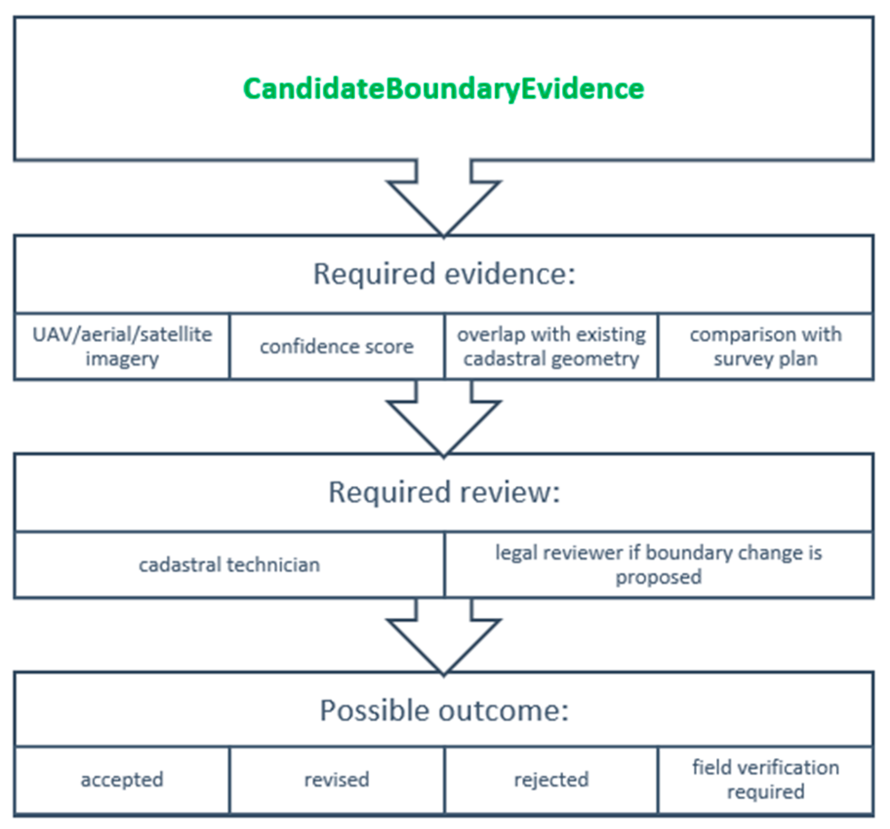
Figure 7.
Candidate 3D spatial object.
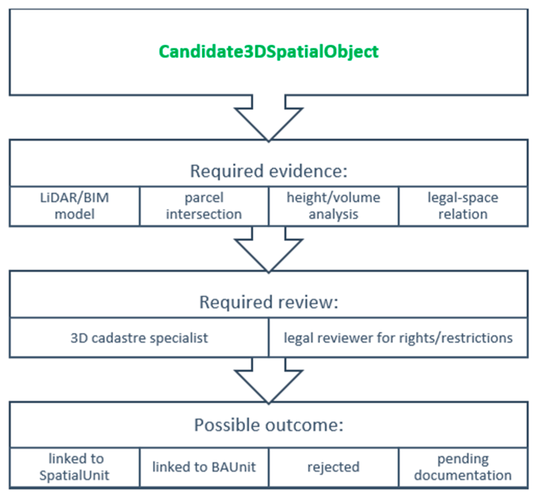
Figure 8.
Candidate cadastral mutation.
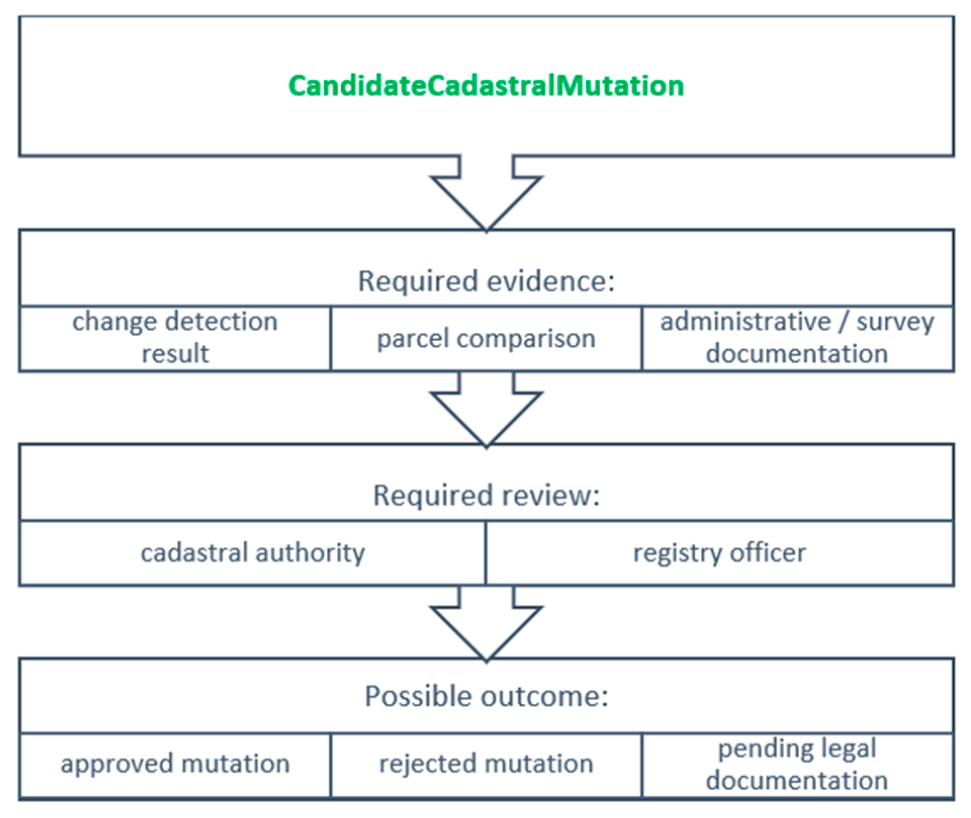
Figure 9.
Candidate quality issue.
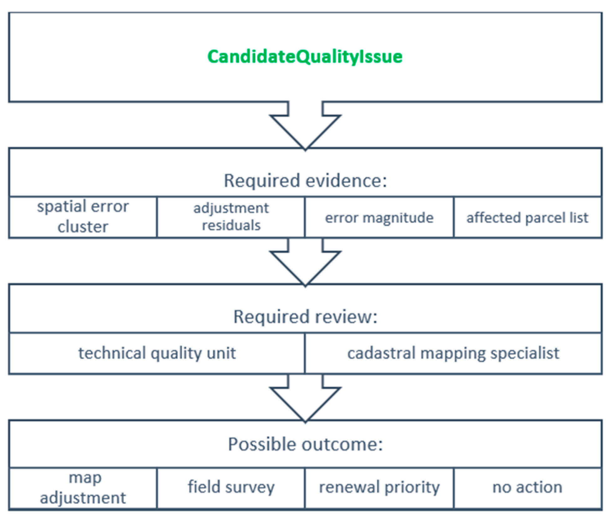
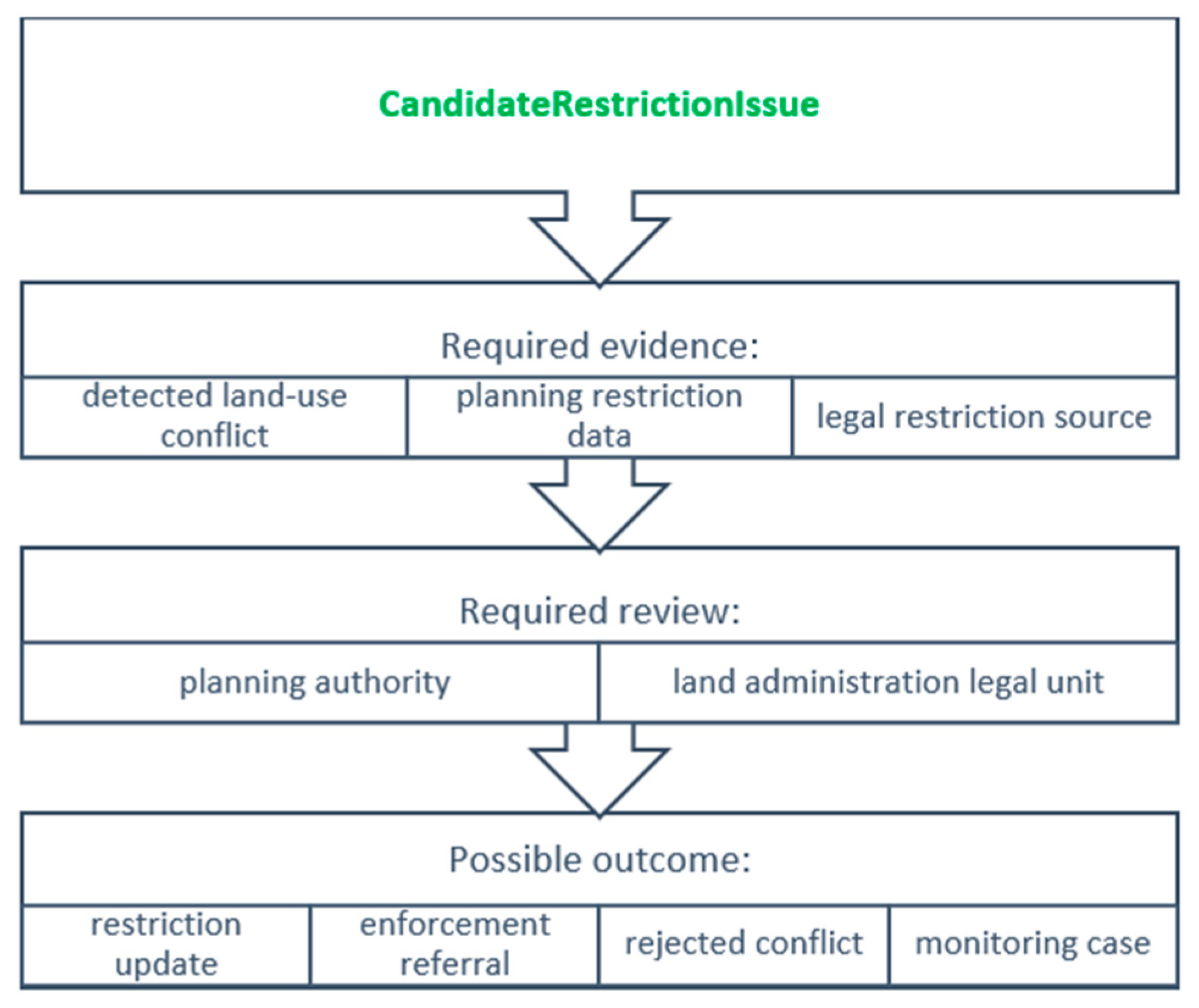
Figure 10.
Candidate restriction issue.
4.3. Auditability, Transparency and Governance
The audit mechanism in Figure 11 traces each candidate through its source, processing, validation and decision history. This supports transparency, explainability and institutional accountability in systems affecting legally protected interests [26,36,37,38,39]. The framework does not depend on blockchain but adopts the broader governance principle that cadastral transformations should remain traceable, verifiable and reviewable.
Figure 11.
Proposed audit trail.
4.4. Feedback Mechanism for GeoAI Improvement
After a candidate is accepted, rejected, corrected or referred for field verification, the documented outcome may be returned to the GeoAI environment for model evaluation and improvement. This feedback is relevant because model performance varies with boundary visibility, image resolution, training data, settlement morphology, sensor quality and geographic transferability [13,16,17,18,19,20,21]. Repeated rejection, uncertainty or conflict may also reveal model bias, insufficient training data, poor cadastral quality or outdated records [15,22,33,34].
4.5. Worked Hypothetical Examples and Operational Scenarios
The following simulated scenarios examine the framework’s internal logic, including candidate status, provenance, uncertainty, evidence, institutional roles and differentiated outcomes. They are conceptual stress tests rather than empirical case studies and do not establish effectiveness, legal defensibility or jurisdiction-specific feasibility.
Scenario 1: Structured assessment of a detected fence line
The following hypothetical scenario illustrates the decision logic. A GeoAI model detects a continuous fence line in recent UAV imagery with a high confidence score. At the technical stage, the system records the image source, acquisition date, model version, confidence score, continuity of the detected feature and positional uncertainty. Because the feature satisfies the technical detection criteria, it is stored as an AI_CandidateBoundaryEvidence object. This status confirms only the reliable detection of a physical feature.
At the cadastral plausibility stage, the candidate is compared with registered coordinates, parcel topology, adjoining cadastral units, previous orthophotos and available survey documentation. Three alternative situations may arise. First, if the fence coincides within the accepted tolerance with authoritative survey evidence and does not create conflict with adjoining parcels, the candidate may support confirmation or technical correction through the applicable cadastral procedure. Second, if the fence differs from the registered boundary but the legal and survey documents consistently support the registered geometry, the candidate should be classified as an occupation or land-use discrepancy rather than as a legal boundary change. Third, if the cadastral record is incomplete, the survey sources conflict, or the affected parties contest the location, the candidate should be referred for field verification, notification, and, where required, participatory determination or formal adjudication.
The example demonstrates that neither high model confidence nor the physical visibility of the fence determines the legal boundary. The applicable cadastral and legal procedure determines whether the detected feature confirms an existing boundary, indicates an occupation or record-quality discrepancy, or requires dispute resolution [1,2,3,8,13,18,19,20,21,22]. The candidate record would preserve the source image, acquisition and model information, geometry, confidence, positional uncertainty, distance from the registered boundary, related parcels, survey and registry evidence, identified conflicts, responsible reviewers and institutional disposition. This record illustrates how the framework preserves traceability across technical detection, evidentiary assessment and institutional disposition.
Scenario 2: Informal settlement mapping for service planning and tenure regularization
A GeoAI model identifies building footprints and settlement expansion in an area with incomplete cadastral coverage. The outputs are stored as AI_CandidateObservation objects with source, model, temporal and uncertainty metadata. The candidates are not classified as illegal constructions or unauthorized occupations because the imagery does not establish legal status.
The intended purpose of the analysis is recorded as public-service planning and participatory tenure assessment. The candidate information is compared with existing cadastral records, municipal information and available administrative documentation. Field verification and community participation are used to identify occupation patterns, access routes, shared spaces, possible customary or collective interests and discrepancies between physical occupation and the formal record.
If the information indicates a possible pathway toward regularization or improved service provision, it may support the relevant administrative process. If an authority subsequently proposes using the same data for demolition, eviction or punitive enforcement, the change of purpose requires separate legal authorization, ethical review, notice to affected persons, access to the evidence and an opportunity to contest the proposed use. The GeoAI output must not serve as the sole evidentiary basis for adverse action.
This scenario demonstrates that the candidate-object structure can support both inclusion and institutional control, but its effect depends on governance. Preserving a non-authoritative status prevents the detection itself from determining the legal characterization or treatment of the occupants.
The same framework logic extends to additional applications. Cadastral-map enrichment may generate AI_CandidateCadastralMutation objects requiring comparison with survey, registry and administrative evidence [14,22]. LiDAR or BIM processing may generate AI_Candidate3DSpatialObject objects that remain distinct from legally recognized SpatialUnits or BAUnits [4,7,8,16,17,31,32]. Error-pattern detection may generate AI_CandidateQualityIssue objects supporting targeted survey or map adjustment [15,22,33,34]. Digital-twin and valuation applications may similarly use candidate information for monitoring, simulation or appraisal, provided that model-derived inputs remain separate from authoritative cadastral and valuation decisions [31,32,40,41].
The operational model connects candidate evidence, uncertainty and risk assessment, semantic interpretation, institutional validation and auditability. It makes the framework procedurally explicit by specifying how GeoAI-derived information may remain traceable and non-authoritative until the applicable evidentiary and institutional requirements have been satisfied. The model remains subject to subsequent empirical and expert evaluation.
5. Discussion
5.1. Reframing GeoAI–LADM Integration as a Governance Problem
GeoAI–LADM integration is fundamentally a problem of evidentiary and institutional governance. GeoAI produces probabilistic spatial evidence, while LADM structures legally meaningful land-administration information. Semantic mediation identifies possible relevance to an LADM concept, whereas epistemic translation governs the broader transition from observation through evidentiary assessment to institutionally authorized disposition [1,9,12].
This position is consistent with broader debates in fit-for-purpose land administration. Fit-for-purpose land administration emphasizes scalable, affordable and context-sensitive approaches for securing land rights, especially where conventional cadastral systems are too slow, expensive or expertise-dependent [40]. However, the fit-for-purpose logic also implies that technical flexibility must be balanced with the need for institutional reliability, legal clarity and socially acceptable procedures [40,41,42]. In this sense, AI-ready LADM should not be framed as a replacement for formal land administration, but as a controlled augmentation of cadastral workflows.
The proposed framework contributes to this debate by defining GeoAI outputs as candidate evidence, not as immediately authoritative cadastral objects. This distinction is essential because cadastral systems are not simply spatial databases; they are legal infrastructures that support tenure security, land markets, taxation, valuation, planning and dispute resolution [1,2,3,28,29].
The main question is therefore not whether GeoAI should be used in land administration. The more important question is which institutional architecture can allow GeoAI to support cadastral modernization without undermining legal accountability. The AI-ready LADM framework answers this question by separating observation, inference, uncertainty, semantic interpretation and legal validation into distinct stages.
This question is directly relevant to land policy because cadastral information influences the allocation, recognition and exercise of interests in land. Decisions about which observations become visible to institutions, which sources are treated as authoritative, which uncertainty levels are accepted and which actors may approve a cadastral change are not merely technical choices. They shape access to formal recognition, the security of registered and unregistered interests, the distribution of administrative burdens and the capacity of affected persons to participate in or contest land-related decisions.
The framework therefore treats technological design as an expression of institutional policy. A system that permits the direct insertion of AI-derived objects into authoritative records adopts a different policy position from a system that preserves candidate status, requires multiple forms of evidence, documents uncertainty and provides a contestable validation pathway. The proposed architecture makes these policy choices explicit and open to institutional and scholarly evaluation.
5.2. Implications for Fit-for-Purpose Land Administration
The first major implication concerns fit-for-purpose land administration. Fit-for-purpose approaches seek to provide tenure security at scale by using flexible, participatory and context-sensitive spatial, legal and institutional frameworks [40,41,42]. Their relevance to AI-ready LADM is significant because GeoAI can reduce the cost and time of data acquisition, boundary detection, map revision and cadastral updating [12,13,14,18,19,20,21].
A particularly important application of the LADM–GeoAI approach concerns informal settlements and other contexts in which occupation, possession, customary interests or socially recognized tenure are not adequately represented in formal cadastral registers. In these settings, GeoAI can support the preliminary identification of building footprints, occupation patterns, settlement expansion, infrastructure deficits and temporal changes. Such information may be valuable for participatory enumeration, public-service planning, disaster-risk reduction, infrastructure provision and gradual tenure regularization. However, improved technical visibility is not inherently beneficial. The same information may also be used for surveillance, selective enforcement, demolition, displacement or eviction, particularly where occupants lack formally registered rights or effective access to administrative and judicial remedies.
The physical detection of a building or occupation pattern does not establish that the occupation is unlawful, that no legally or socially relevant tenure interest exists, or that an adverse administrative measure is justified. Informal settlements may contain heterogeneous situations, including long-term possession, customary or collective tenure, tolerated occupation, pending regularization claims, rental arrangements, disputed public or private ownership and households with no realistic access to formal registration procedures. A GeoAI model cannot distinguish among these legal and social situations from geometry or imagery alone. Treating detected occupation as evidence of illegality would therefore reproduce the same conceptual error that the framework seeks to prevent in relation to cadastral boundaries: the direct conversion of a physical observation into a legal conclusion.
For this reason, GeoAI-derived information concerning informal settlements should remain classified as non-authoritative candidate evidence and should not independently trigger eviction, demolition, withdrawal of services, taxation penalties or adverse modification of tenure status. Any use with potentially adverse consequences should require purpose limitation, verification against legal and administrative sources, field investigation, participation of affected communities, notice to affected persons, an opportunity to correct or contest the information, and review by the legally competent authority. Where formal documentation is incomplete, the validation process should also consider socially legitimate and jurisdictionally relevant forms of evidence, including community records, participatory mapping, testimony, evidence of long-term occupation and documentation of customary or collective interests.
The candidate-object structure is particularly relevant in this context because it preserves the provisional status, provenance and uncertainty of AI-derived observations. It allows a detected building or occupation pattern to support further inquiry without assigning a legal status or producing an immediate adverse effect. However, this protective function is not guaranteed by the data model alone. It depends on institutional rules governing access, purpose, evidentiary use, participation, contestability and accountability. The framework should therefore be understood not only as a mechanism for accelerating cadastral documentation, but also as a safeguard against the premature legal classification of vulnerable occupants on the basis of remotely sensed evidence.
However, the use of GeoAI in fit-for-purpose environments must be approached carefully. Fit-for-purpose does not mean legally weak, technically careless or procedurally opaque. Rather, it means that land administration systems should be designed according to purpose, context, available resources and social legitimacy [40,41,42]. In this light, GeoAI can support fit-for-purpose land administration only if its outputs are embedded within validation procedures that are appropriate to the legal and institutional environment.
For example, in areas with incomplete cadastral coverage, GeoAI could support first-stage boundary identification from UAV imagery or satellite data. Yet, such detected boundaries should remain provisional until confirmed through local participation, field verification or institutional review [18,19,20,21,40,41,42]. Similarly, in urban renewal contexts, GeoAI could identify changed parcels, informal extensions or building footprints, but these outputs should trigger cadastral review rather than automatically modify legal records [13,14,22].
This suggests that AI-ready LADM can function as a fit-for-purpose acceleration mechanism. It can accelerate data capture and preliminary interpretation while preserving legal safeguards. The framework therefore aligns with fit-for-purpose principles by allowing flexibility in data acquisition and automation, but it also adds an explicit legal-semantic control mechanism that prevents automation from replacing authority [1,2,3,12,40,41,42].
5.3. Implications for Smart Cadastre and Digital Land Administration
The second implication concerns smart cadastre and digital land administration. The literature on cadastral innovation shows that cadastre has evolved from a parcel-based registration system toward a technologically integrated field shaped by geospatial information, standardization, digitalization and smart land management policies [43]. This evolution is also visible in research on 3D digital cadastral data lifecycle management, where BIM, ETL processes, databases and visualization environments are used to support the transition from fragmented 2D cadastral datasets to more integrated 3D digital systems [44].
The proposed AI-ready LADM framework extends this smart cadastre trajectory by introducing GeoAI as a structured component of land administration workflows. However, it does not treat smart cadastre as mere automation. A cadastre is not “smart” simply because it uses AI, BIM, LiDAR, digital twins or machine learning. It becomes smart only when digital tools improve institutional performance, legal reliability, transparency and responsiveness.
In this sense, the proposed framework defines smart cadastre as a hybrid system combining standardized legal semantics, probabilistic spatial intelligence, uncertainty representation, institutional validation, auditability and feedback-based improvement.
This formulation avoids two extremes. The first extreme is technological determinism, where AI is assumed to solve cadastral problems simply by improving detection accuracy. The second extreme is institutional conservatism, where cadastral systems reject AI because probabilistic outputs do not fit traditional legal models. The AI-ready LADM framework provides a middle path. GeoAI can generate candidates, but LADM and cadastral institutions govern how those candidates become legal information.
The framework also supports the transition from static cadastral databases to dynamic cadastral infrastructures. Existing cadastral systems often update slowly and episodically, while urban and environmental change occurs continuously [14,22,28,29]. GeoAI can support continuous monitoring, but LADM ensures that monitoring does not become uncontrolled legal mutation. Therefore, the AI-ready LADM should be understood as an architecture for controlled dynamism. I t allows cadastral systems to become more responsive without abandoning legal certainty.
5.4. Implications for 3D Cadastre, Public Law Restrictions and Complex Spatial Rights
The third implication concerns 3D cadastre and complex spatial rights. Modern urban environments increasingly contain vertically stratified ownership, overlapping infrastructure, underground utilities, public law restrictions, airspace regulation and volumetric legal spaces [4,5,6,7,8,16,31,32]. These conditions create a strong need for land administration systems capable of representing legal spaces in three dimensions.
Public law restrictions are particularly relevant because they often affect land use in ways that are not adequately represented in conventional 2D cadastral systems [45]. Restrictions related to archaeological protection, underground infrastructures, environmental regulation, utilities, UAV operation or urban development may operate in 3D space and overlap with private rights [45]. This makes the distinction between physical spatial objects and legal regulatory objects even more important.
GeoAI may support this domain by detecting buildings, infrastructure, land-use change, encroachments or spatial conflicts. However, AI detection does not determine the legal effect of public law restrictions. A detected structure may be physically present but legally unauthorized. A land-use change may be visible but not legally registered. A 3D object may intersect a restricted space but still require a legal interpretation to determine whether a violation, limitation or administrative action exists.
The approach allows GeoAI to support the identification of potential legal–spatial issues without directly creating legal consequences. In 3D cadastre and public law restriction contexts, this distinction is essential. AI can detect spatial relations; legal institutions must determine rights, restrictions and responsibilities [8,16,45].
5.5. Ethical Implications: GeoAI, Fairness, Privacy and Accountability
The fourth implication concerns ethics. GeoAI raises ethical issues that are particularly serious in land administration because cadastral information affects property rights, tenure security, taxation, valuation, access to services, planning constraints and legal disputes. Ethical GeoAI frameworks emphasize issues such as geo-privacy, data provenance, spatial fairness, bias, transparency, auditability, accountability, human oversight, public benefit and lifecycle governance [46]. These concerns are highly relevant to an AI-ready LADM system.
Ethical concerns arise at multiple points in the proposed framework. At the data acquisition stage, satellite imagery, UAV imagery, sensor data and street-level data may raise privacy and surveillance concerns. At the model inference stage, AI models may produce biased outputs if trained on data that underrepresent informal settlements, rural boundaries, customary tenure or complex urban morphologies [13,18,19,20,21,46]. At the semantic translation stage, errors may disproportionately affect groups whose land rights are already insecure or poorly documented. At the legal validation stage, institutional decisions may amplify or correct AI-derived bias depending on governance quality.
The broader ethics of AI and geographic information technologies also stress that geographic information can disempower individuals or groups if used without attention to fairness, autonomy, privacy, consent and social justice [47]. In land administration, this matters because cadastral decisions may alter legal rights, trigger enforcement, affect taxation or expose vulnerable occupants to risk. Therefore, AI-ready LADM must include not only technical validation, but also ethical safeguards.
For informal settlements and other vulnerable contexts, the ethical safeguards discussed in Section 5.2 should be applied throughout the data lifecycle. Ethical review should examine purpose, foreseeable adverse uses, unequal error impacts, recognized forms of evidence and the affected community’s ability to participate in and contest consequential decisions.
For this reason, the framework should include an Ethical Review Checklist, operating in parallel with technical and legal validation, to ensure that AI-supported decisions are also assessed from an ethical perspective, as illustrated in Figure 12.
Figure 12.
Ethical checklist.
This checklist aligns with the view that trustworthiness in AI involves accuracy, reliability, transparency, explainability, fairness and accountability [48]. In cadastral applications, these dimensions are not optional ethical ideals; they are essential conditions for legitimate land administration.
5.6. Institutional Implications: From Human-in-the-Loop to Institution-in-the-Loop
The fifth implication concerns institutional design. Although many AI governance discussions refer to a “human-in-the-loop” as a safeguard, this formulation is insufficiently precise for land administration. Cadastral systems require not only human oversight but also an institution-in-the-loop approach, in which specific institutional actors are assigned clearly defined responsibilities throughout AI-supported cadastral processing. Accordingly, the framework introduces differentiated institutional roles, as illustrated in Figure 13.
Figure 13.
Institutional roles.
The institution-in-the-loop concept also clarifies the legal status of AI-assisted administrative action. The presence of a human operator does not, by itself, establish legality or accountability. The reviewer must act within an institution that has defined competence, access to the relevant evidence, procedural obligations and responsibility for the resulting decision. A nominal human approval that merely endorses an automated recommendation without meaningful examination would not satisfy the institutional function proposed in this framework.
Meaningful institutional review requires the capacity to question the model output, consult contradictory evidence, request additional information, depart from the automated recommendation and provide reasons for the final disposition. The institution must also preserve a record that allows the decision to be reviewed independently.
This institutional structure is necessary because AI-derived cadastral candidates may have different consequences. A detected boundary may require technical review. A candidate RRR may require legal review. A detected public law restriction issue may require planning authority review. A cadastral quality issue may require technical map correction. A possible unauthorized land-use change may require administrative investigation [1,2,3,8,14,26,45].
The need for institutional coordination also aligns with broader research on spatial data infrastructures and smart governance. Integrated SDIs, IoT, geospatial platforms, cloud infrastructure and AI analytics can improve real-time monitoring, prediction, visualization and automation, but they also raise challenges around interoperability, institutional barriers, data protection and unequal access [49]. AI-ready LADM therefore requires institutional interoperability, not only technical interoperability.
The governance model should specify who may create, review, correct, approve, reject or contest candidate evidence; how affected persons are notified and may submit alternative evidence; which authority addresses allegations of bias or misuse; and how decisions and model updates are documented.
For candidates concerning informal settlements or vulnerable occupants, the institutional process should separate supportive uses from enforcement uses. Information generated for service planning, risk reduction or regularization should not be transferred automatically to eviction, demolition or punitive enforcement workflows. Any such change of purpose should require explicit legal authorization, ethical review and procedural safeguards for affected persons.
Without such institutional design, AI-ready LADM would risk becoming a technical prototype rather than a legally usable land administration system.
5.7. Data Governance and FAIR-Oriented Cadastral AI
The sixth implication concerns data governance. AI-ready land administration depends on high-quality, reusable, interoperable and well-documented data. Poor data quality does not simply reduce model performance; it undermines trust, reproducibility, accountability and administrative reliability [33,34,50]. In AI contexts, data quality must be addressed across the full lifecycle: collection, preprocessing, labeling, inference, validation, updating and archiving.
The FAIR principles—findability, accessibility, interoperability and reusability—are relevant here because GeoAI and LADM integration depends on consistent metadata, transparent data provenance, interoperable schemas and reusable validation records [50]. For cadastral systems, FAIR-oriented governance should include:
- •
- source-level metadata;
- •
- model-level metadata;
- •
- candidate-object metadata;
- •
- validation metadata;
- •
- legal-source metadata;
- •
- versioning metadata;
- •
- audit-trail metadata.
This requirement reinforces the importance of the AI_CandidateObservation object introduced in Section 3 and operationalized in Section 4. The object functions not only as a technical buffer, but also as a data-governance artifact. It records what was detected, by which model, from which source, with what confidence, under which uncertainty class and with what validation outcome.
Such structured governance is necessary because AI-ready cadastre requires reproducibility. If a boundary candidate is accepted, the institution must be able to reconstruct why. If a candidate is rejected, the system must preserve the reason. If a model is retrained, the system must preserve the link between prior decisions and future model versions. Therefore, AI-ready LADM should include not only cadastral objects, but also lifecycle documentation for AI-derived evidence [26,46,48,50].
5.8. Research Design for Future Expert and Empirical Evaluation
The framework has not yet been evaluated through jurisdiction-specific implementation using real cadastral data and institutional procedures. The scenario-based analysis assesses internal coherence and operational testability but cannot establish effectiveness, usability, legal feasibility, transferability or resource requirements.
Subsequent evaluation should combine structured expert assessment with jurisdiction-specific empirical implementation. Expert assessment should examine conceptual clarity, evidentiary completeness, institutional responsibilities, auditability and procedural feasibility. Empirical case studies should then instantiate the framework using real GeoAI outputs, authoritative cadastral and legal sources and participating institutional actors.
Expert assessment may involve cadastral surveyors, land-registration specialists, land-administration researchers, legal practitioners, GIS specialists and public-sector decision makers. Evaluation criteria should include:
- •
- conceptual clarity and completeness;
- •
- adequacy of evidentiary and uncertainty requirements;
- •
- clarity of institutional responsibilities;
- •
- auditability and contestability;
- •
- procedural and implementation feasibility.
Design 1: Boundary detection to candidate LADM object
A GeoAI model detects visible boundaries from UAV imagery. The outputs are recorded provisionally as AI_CandidateObservation objects, classified by uncertainty and assessed for possible representation as AI_CandidateBoundaryEvidence.
The model-performance indicators are:
- •
- precision, recall and F1-score;
- •
- positional accuracy or boundary displacement;
- •
- completeness and continuity of detected features.
The framework-performance indicators are:
- •
- completeness of provenance and uncertainty records;
- •
- consistency of candidate classification;
- •
- percentage of candidates accepted, rejected or requiring additional evidence;
- •
- frequency of field verification;
- •
- inter-reviewer agreement;
- •
- average review and validation time;
- •
- completeness of the audit trail;
- •
- compliance of the final disposition with the applicable procedure.
The empirical unit of analysis should be the individual boundary candidate rather than the complete image or model output. Each candidate should be traced from its source and model prediction through technical assessment, semantic classification, comparison with cadastral and legal evidence and final institutional disposition. The study should involve qualified cadastral and legal reviewers and, where required by the jurisdiction, field verification or the participation of the affected parties.
Framework performance should be assessed separately from GeoAI model performance. Model precision, recall and positional accuracy indicate whether physical features are detected reliably. Framework-level indicators should measure whether provenance and uncertainty are documented completely, whether reviewers can apply the proposed classifications consistently, whether the evidence supporting each outcome is traceable, how frequently candidates require additional information and whether the final disposition complies with the applicable cadastral procedure.
A comparative design could also assess the proposed framework against an existing manual or less structured review process. Relevant outcomes would include review time, inter-reviewer agreement, proportion of unresolved candidates, completeness of the audit trail, frequency of field verification and number of candidates incorrectly treated as legally authoritative.
This design builds on cadastral boundary extraction and revision studies [18,19,20,21].
Additional empirical designs may examine cadastral-map enrichment, 3D cadastre and governance. These studies should assess the confirmation of detected parcel changes against authoritative documentation [14,22], the physical-to-legal correspondence of LiDAR- or BIM-derived candidates [4,7,8,16,17,31,32,44], and the completeness, explainability and contestability of candidate audit trails [26,36,37,46,47,48,49,50].
6. Conclusions
This article developed a land-administration-oriented framework for preserving and evaluating GeoAI-derived spatial evidence before its possible association with authoritative LADM information. Its contribution does not lie in restating the general need for human oversight, but in distinguishing technical detection, candidate cadastral relevance and legally recognized cadastral status and in specifying the provenance, uncertainty, evidence and institutional responsibility required during the transition between them.
The framework distinguishes semantic mediation from the broader process of epistemic translation. Semantic mediation assigns a provisional relationship between an observation and a possible LADM concept, whereas epistemic translation encompasses the complete evidentiary and institutional pathway from probabilistic observation to authorized disposition. This staged logic prevents model confidence, geometric correspondence or automated classification from being treated independently as legal cadastral determination.
Operationally, the framework combines source classification, candidate evidence, uncertainty and risk assessment, semantic mapping, validation pathways, auditability and differentiated institutional roles. It complements rather than replaces the source, lifecycle and versioning mechanisms available through ISO 19152 and the geographic data-quality framework provided by ISO 19157. Its value lies in enabling GeoAI to generate and prioritize evidence while the LADM and competent institutions preserve semantic order, procedural accountability and legal authority.
The framework also highlights the land-policy consequences of technical design. Decisions concerning candidate status, source admissibility, uncertainty thresholds, review responsibility and authorization affect tenure security, procedural fairness and the protection of registered, informal or disputed interests. The land-policy relevance of the framework therefore lies in making explicit how evidence, authority, responsibility and procedural safeguards are represented in AI-supported cadastral processes. The framework remains conceptual and requires subsequent expert assessment and jurisdiction-specific empirical implementation before conclusions can be drawn regarding its practical performance and transferability.
7. Limitations and Future Research Directions
The principal limitation of this study is the absence of jurisdiction-specific empirical implementation. The proposed framework has not been evaluated using real GeoAI outputs, authoritative cadastral and legal information or participating institutional actors. Scenario-based analysis supports conceptual coherence and operational testability but does not establish effectiveness, usability, legal feasibility, resource requirements or transferability.
Implementation is necessarily context-dependent. Land-administration systems differ in legal categories, evidentiary rules, institutional responsibilities, cadastral coverage, data quality and technical capacity. Where reliable sources or institutional safeguards are unavailable, GeoAI-derived candidates should remain non-authoritative and should support only proportionate uses such as monitoring, quality assessment or field-survey prioritization. Limited data availability must not be treated as confirmation of an AI-derived candidate or as justification for reduced validation standards.
The framework also remains conceptual in its technical formalization. The proposed thresholds require empirical calibration using representative data, defined use cases and jurisdiction-specific accuracy requirements. Similarly, the candidate constructs are not presented as a normative ISO 19152 extension, conformance claim or completed UML application schema. Formal integration requires the subsequent definition of the applicable ISO 19152 part, implementation mechanism, constraints and jurisdictional profile. The proposed framework depends on the availability of reliable source data. If imagery is outdated, cadastral maps are inaccurate, legal documents are incomplete or training data are biased, AI-derived candidates may reproduce or amplify existing errors [13,15,18,19,20,21,22,33,34,51].
Legal and ethical outcomes cannot be guaranteed through technical design alone. Semantic mapping indicates possible cadastral relevance but cannot determine legal status independently of authoritative evidence and competent institutional procedure. This limitation is particularly important for disputed boundaries, customary or informal tenure, public-law restrictions and vulnerable communities, where participation, notice, contestability and independent review may be required.
Future work should operationalize these requirements through expert assessment and complete jurisdiction-specific case studies. A Romanian application using relevant ANCPI structures may provide one such case, provided that it includes real GeoAI outputs, authoritative records, competent reviewers and documented institutional outcomes.
Author Contributions
Conceptualization, A.C.B., G.B., L.N.-L. and O.E.; methodology, A.C.B., G.B., L.N.-L. and O.E.; investigation, A.C.B. and G.B.; resources, A.C.B. and G.B.; writing—original draft preparation, A.C.B. and G.B.; writing—review and editing, A.C.B., G.B., L.N.-L. and O.E.; visualization, A.C.B., G.B., L.N.-L. and O.E.; supervision, A.C.B. and G.B. All authors have read and agreed to the published version of the manuscript.
Funding
This research received FCS UTCB funding for publication.
Data Availability Statement
No new data were created or analyzed in this study. Data sharing is not applicable to this article.
Acknowledgments
This study was conducted within the Geodetic Engineering Measurements and Spatial Data Infrastructures Research Centre, Faculty of Geodesy, Technical University of Civil Engineering Bucharest. During the preparation of this manuscript, the authors used Research Assistant and Microsoft Copilot 2.20260917.24.0 as AI-assisted tools to support literature summarization and language refinement.
Conflicts of Interest
The authors declare no conflicts of interest.
Abbreviations
The following abbreviations are used in this manuscript:
| AI | Artificial Intelligence |
| BAUnit | Basic Administrative Unit |
| BIM | Building Information Modeling |
| ETL | Extract, Transform, Load |
| FAIR | Findable, Accessible, Interoperable, and Reusable |
| F1-score | Harmonic Mean of Precision and Recall |
| FCN | Fully Convolutional Network |
| GDPR | General Data Protection Regulation |
| GeoAI | Geospatial Artificial Intelligence |
| GIS | Geographic Information System |
| IFC | Industry Foundation Classes |
| ISO | International Organization for Standardization |
| LADM | Land Administration Domain Model |
| LiDAR | Light Detection and Ranging |
| ML | Machine Learning |
| RRR | Rights, Restrictions, and Responsibilities |
| SDG | Sustainable Development Goal |
| SDI | Spatial Data Infrastructure |
| UAV | Unmanned Aerial Vehicle |
| XAI | Explainable Artificial Intelligence |
References
- Chen, M.; van Oosterom, P.; Kalogianni, E.; Dijkstra, P.; Lemmen, C. Bridging Sustainable Development Goals and Land Administration: The Role of the ISO 19152 Land Administration Domain Model in SDG Indicator Formalization. Land 2024, 13, 491. [Google Scholar] [CrossRef] [Scilit]
- Ahsan, M.S.; Hussain, E.; Lemmen, C.; Chipofya, M.C.; Zevenbergen, J.; Atif, S.; Morales, J.; Koeva, M.; Ali, Z. Applying the Land Administration Domain Model (LADM) for Integrated, Standardized, and Sustainable Development of Cadastre Country Profile for Pakistan. Land 2024, 13, 883. [Google Scholar] [CrossRef] [Scilit]
- Okembo, C.; Morales, J.; Lemmen, C.; Zevenbergen, J.; Kuria, D. A Land Administration Data Exchange and Interoperability Framework for Kenya and Its Significance to the Sustainable Development Goals. Land 2024, 13, 435. [Google Scholar] [CrossRef] [Scilit]
- Sun, J.; Mi, S.; Olsson, P.-O.; Paulsson, J.; Harrie, L. Utilizing BIM and GIS for Representation and Visualization of 3D Cadastre. ISPRS Int. J. Geo-Inf. 2019, 8, 503. [Google Scholar] [CrossRef] [Scilit]
- Shahidinejad, J.; Kalantari, M.; Rajabifard, A. 3D Cadastral Database Systems—A Systematic Literature Review. ISPRS Int. J. Geo-Inf. 2024, 13, 30. [Google Scholar] [CrossRef] [Scilit]
- Li, C.; Zhao, Z.; Chen, Y.; Zhu, W.; Qiu, J.; Jiang, S.; Guo, R. Modeling the Urban Low-Altitude Traffic Space Based on the Land Administration Domain Model—Case Studies in Shenzhen, China. Land 2024, 13, 2062. [Google Scholar] [CrossRef] [Scilit]
- Oldfield, J.; van Oosterom, P.; Beetz, J.; Krijnen, T.F. Working with Open BIM Standards to Source Legal Spaces for a 3D Cadastre. ISPRS Int. J. Geo-Inf. 2017, 6, 351. [Google Scholar] [CrossRef] [Scilit]
- Kalogianni, E.; Dimopoulou, E.; Quak, W.; Germann, M.; Jenni, L.; van Oosterom, P. INTERLIS Language for Modelling Legal 3D Spaces and Physical 3D Objects by Including Formalized Implementable Constraints and Meaningful Code Lists. ISPRS Int. J. Geo-Inf. 2017, 6, 319. [Google Scholar] [CrossRef] [Scilit]
- Li, W.; Hsu, C.-Y. GeoAI for Large-Scale Image Analysis and Machine Vision: Recent Progress of Artificial Intelligence in Geography. ISPRS Int. J. Geo-Inf. 2022, 11, 385. [Google Scholar] [CrossRef] [Scilit]
- Choi, Y. GeoAI: Integration of Artificial Intelligence, Machine Learning, and Deep Learning with GIS. Appl. Sci. 2023, 13, 3895. [Google Scholar] [CrossRef] [Scilit]
- Zheng, W.; Li, K.; Liu, X. GeoAI for Land Use Observations, Analysis, and Forecasting. Land 2025, 14, 2058. [Google Scholar] [CrossRef] [Scilit]
- Chen, J.; Nazeer, M.; Lee, B.S.; Wong, M.S. Artificial Intelligence in Cadastre: A Systematic Review of Methods, Applications, and Trends. Land 2026, 15, 411. [Google Scholar] [CrossRef] [Scilit]
- Nyandwi, E.; Koeva, M.; Kohli, D.; Bennett, R. Comparing Human Versus Machine-Driven Cadastral Boundary Feature Extraction. Remote Sens. 2019, 11, 1662. [Google Scholar] [CrossRef] [Scilit]
- Hajiheidari, A.; Delavar, M.R.; Rajabifard, A. Smart Urban Cadastral Map Enrichment—A Machine Learning Method. ISPRS Int. J. Geo-Inf. 2024, 13, 80. [Google Scholar] [CrossRef] [Scilit]
- Vantas, K.; Mirkopoulou, V. Towards Automated Cadastral Map Improvement: A Clustering Approach for Error Pattern Recognition. Geomatics 2025, 5, 16. [Google Scholar] [CrossRef] [Scilit]
- Widyastuti, R.; Suwardhi, D.; Meilano, I.; Hernandi, A.; Firdaus, J. Automating Three-Dimensional Cadastral Models of 3D Rights and Buildings Based on the LADM Framework. ISPRS Int. J. Geo-Inf. 2025, 14, 293. [Google Scholar] [CrossRef] [Scilit]
- Widyastuti, R.; Suwardhi, D.; Meilano, I.; Hernandi, A.; Putri, N.S.E.; Saptari, A.Y.; Sudarman. Performance Analysis of Random Forest Algorithm in Automatic Building Segmentation with Limited Data. ISPRS Int. J. Geo-Inf. 2024, 13, 235. [Google Scholar] [CrossRef] [Scilit]
- Crommelinck, S.; Koeva, M.; Yang, M.Y.; Vosselman, G. Application of Deep Learning for Delineation of Visible Cadastral Boundaries from Remote Sensing Imagery. Remote Sens. 2019, 11, 2505. [Google Scholar] [CrossRef] [Scilit]
- Fetai, B.; Račič, M.; Lisec, A. Deep Learning for Detection of Visible Land Boundaries from UAV Imagery. Remote Sens. 2021, 13, 2077. [Google Scholar] [CrossRef] [Scilit]
- Xia, X.; Persello, C.; Koeva, M. Deep Fully Convolutional Networks for Cadastral Boundary Detection from UAV Images. Remote Sens. 2019, 11, 1725. [Google Scholar] [CrossRef] [Scilit]
- Fetai, B.; Grigillo, D.; Lisec, A. Revising Cadastral Data on Land Boundaries Using Deep Learning in Image-Based Mapping. ISPRS Int. J. Geo-Inf. 2022, 11, 298. [Google Scholar] [CrossRef] [Scilit]
- Pullar, D.; Donaldson, S. Accuracy Issues for Spatial Update of Digital Cadastral Maps. ISPRS Int. J. Geo-Inf. 2022, 11, 221. [Google Scholar] [CrossRef] [Scilit]
- Lemmen, C.; van Oosterom, P.; Kara, A.; Kalogianni, E. The Land Administration Domain Model: An Overview; FIG Publication No. 84; International Federation of Surveyors (FIG): Copenhagen, Denmark, 2025; Available online: https://www.fig.net/resources/publications/figpub/pub84/Figpub84.pdf (accessed on 31 July 2026).
- Ding, L.; Xiao, G.; Calvanese, D.; Meng, L. A Framework Uniting Ontology-Based Geodata Integration and Geovisual Analytics. ISPRS Int. J. Geo-Inf. 2020, 9, 474. [Google Scholar] [CrossRef] [Scilit]
- Ranatunga, S.; Ødegård, R.S.; Jetlund, K.; Onstein, E. Use of Semantic Web Technologies to Enhance the Integration and Interoperability of Environmental Geospatial Data: A Framework Based on Ontology-Based Data Access. ISPRS Int. J. Geo-Inf. 2025, 14, 52. [Google Scholar] [CrossRef] [Scilit]
- Roussel, C.; Böhm, K. Geospatial XAI: A Review. ISPRS Int. J. Geo-Inf. 2023, 12, 355. [Google Scholar] [CrossRef] [Scilit]
- Sofianopoulos, S.; Faka, A.; Chalkias, C. SDI-Enabled Smart Governance: A Review (2015–2025) of IoT, AI and Geospatial Technologies—Applications and Challenges. Land 2025, 14, 1399. [Google Scholar] [CrossRef] [Scilit]
- Uşak, B.; Çağdaş, V.; Kara, A. Current Cadastral Trends—A Literature Review of the Last Decade. Land 2024, 13, 2100. [Google Scholar] [CrossRef] [Scilit]
- Potsiou, C.; Navratil, G. Perspectives on Cadastre and Land Management in Support of Sustainable Real Estate Markets. Land 2024, 13, 573. [Google Scholar] [CrossRef] [Scilit]
- Xu, Z.; Zhuo, Y.; Liao, R.; Wu, C.; Wu, Y.; Li, G. LADM-Based Model for Natural Resource Administration in China. ISPRS Int. J. Geo-Inf. 2019, 8, 456. [Google Scholar] [CrossRef] [Scilit]
- Shojaei, D.; Olfat, H.; Rajabifard, A.; Briffa, M. Design and Development of a 3D Digital Cadastre Visualization Prototype. ISPRS Int. J. Geo-Inf. 2018, 7, 384. [Google Scholar] [CrossRef] [Scilit]
- Andritsou, D.; Alexiou, C.; Potsiou, C. BIM, 3D Cadastral Data and AI for Weather Conditions Simulation and Energy Consumption Monitoring. Land 2024, 13, 880. [Google Scholar] [CrossRef] [Scilit]
- Kwartnik-Pruc, A.; Front-Dąbrowska, T. The Impact of Cadastral Data Quality on Risks in Construction Investment Processes. Land 2026, 15, 929. [Google Scholar] [CrossRef] [Scilit]
- Kavadas, I.; Tsoulos, L. An Integrated Environment for Monitoring and Documenting Quality in Map Composition Utilizing Cadastral Data. ISPRS Int. J. Geo-Inf. 2022, 11, 348. [Google Scholar] [CrossRef] [Scilit]
- Apostolopoulos, K.; Potsiou, C. How to Improve Quality of Crowdsourced Cadastral Surveys. Land 2022, 11, 1642. [Google Scholar] [CrossRef] [Scilit]
- Ameyaw, P.D.; de Vries, W.T. Transparency of Land Administration and the Role of Blockchain Technology, a Four-Dimensional Framework Analysis from the Ghanaian Land Perspective. Land 2020, 9, 491. [Google Scholar] [CrossRef] [Scilit]
- Racetin, I.; Kilić Pamuković, J.; Zrinjski, M.; Peko, M. Blockchain-Based Land Management for Sustainable Development. Sustainability 2022, 14, 10649. [Google Scholar] [CrossRef] [Scilit]
- Badea, G.; Badea, A.; Vasilca, D. Blockchain, Property Registration and Cadastre. In Proceedings of the 19th International Multidisciplinary Scientific GeoConference SGEM 2019; International Multidisciplinary Scientific GeoConference-SGEM; Book 2.2; STEF92 Technology: Sofia, Bulgaria, 2019; Volume 19, pp. 741–748. [Google Scholar] [CrossRef] [Scilit]
- Badea, A.C.; Badea, G. Blockchain-Based Cadastral Records: Research Developments and Implementation Feasibility in Romania. Land 2026, 15, 1365. [Google Scholar] [CrossRef] [Scilit]
- Adade, D.; de Vries, W.T. Digital Twin for Active Stakeholder Participation in Land-Use Planning. Land 2023, 12, 538. [Google Scholar] [CrossRef] [Scilit]
- Buuveibaatar, M.; Lee, K.; Lee, W. Developing an LADM Valuation Information Model for Mongolia. Land 2023, 12, 893. [Google Scholar] [CrossRef] [Scilit]
- Enemark, S.; McLaren, R.; Lemmen, C. Fit-for-Purpose Land Administration—Providing Secure Land Rights at Scale. Land 2021, 10, 972. [Google Scholar] [CrossRef] [Scilit]
- Chigbu, U.E.; Bendzko, T.; Mabakeng, M.R.; Kuusaana, E.D.; Tutu, D.O. Fit-for-Purpose Land Administration from Theory to Practice: Three Demonstrative Case Studies of Local Land Administration Initiatives in Africa. Land 2021, 10, 476. [Google Scholar] [CrossRef] [Scilit]
- Metaferia, M.T.; Bennett, R.M.; Alemie, B.K.; Koeva, M. Fit-for-Purpose Land Administration and the Framework for Effective Land Administration: Synthesis of Contemporary Experiences. Land 2023, 12, 58. [Google Scholar] [CrossRef] [Scilit]
- Choi, H.O. An Evolutionary Approach to Technology Innovation of Cadastre for Smart Land Management Policy. Land 2020, 9, 50. [Google Scholar] [CrossRef] [Scilit]
- Olfat, H.; Atazadeh, B.; Badiee, F.; Chen, Y.; Shojaei, D.; Rajabifard, A. A Proposal for Streamlining 3D Digital Cadastral Data Lifecycle. Land 2021, 10, 642. [Google Scholar] [CrossRef] [Scilit]
- Kitsakis, D.; Kalogianni, E.; Dimopoulou, E. Public Law Restrictions in the Context of 3D Land Administration—Review on Legal and Technical Approaches. Land 2022, 11, 88. [Google Scholar] [CrossRef] [Scilit]
- Yoo, S. An Operational Ethical Framework for GeoAI: A PRISMA-Based Systematic Review of International Policy and Scholarly Literature. ISPRS Int. J. Geo-Inf. 2026, 15, 51. [Google Scholar] [CrossRef] [Scilit]
- Oluoch, I. Crossing Boundaries: The Ethics of AI and Geographic Information Technologies. ISPRS Int. J. Geo-Inf. 2024, 13, 87. [Google Scholar] [CrossRef] [Scilit]
- Paolanti, M.; Tiribelli, S.; Giovanola, B.; Mancini, A.; Frontoni, E.; Pierdicca, R. Ethical Framework to Assess and Quantify the Trustworthiness of Artificial Intelligence Techniques: Application Case in Remote Sensing. Remote Sens. 2024, 16, 4529. [Google Scholar] [CrossRef] [Scilit]
- Guillen-Aguinaga, M.; Aguinaga-Ontoso, E.; Guillen-Aguinaga, L.; Guillen-Grima, F.; Aguinaga-Ontoso, I. Data Quality in the Age of AI: A Review of Governance, Ethics, and the FAIR Principles. Data 2025, 10, 201. [Google Scholar] [CrossRef] [Scilit]
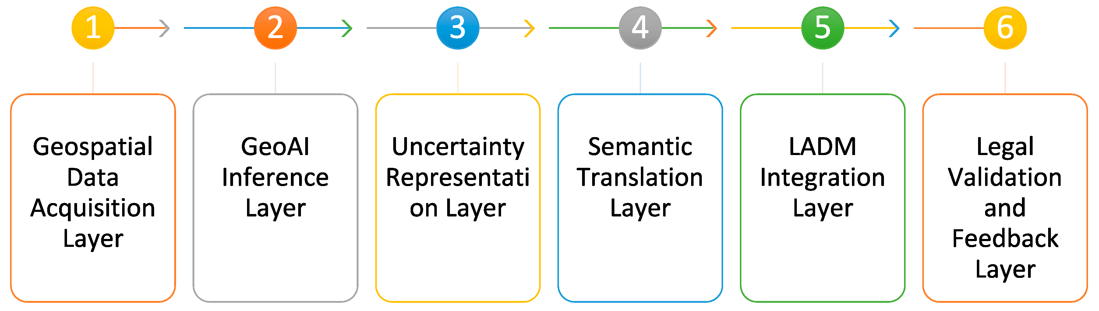
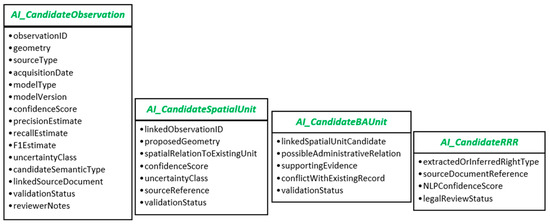
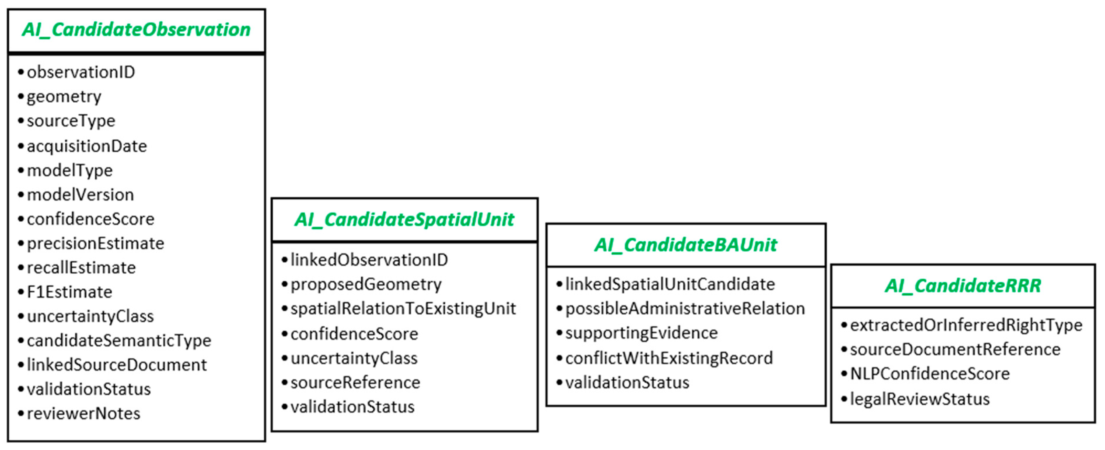
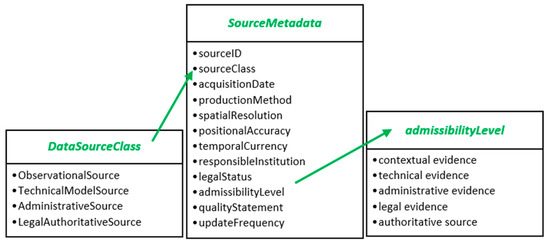
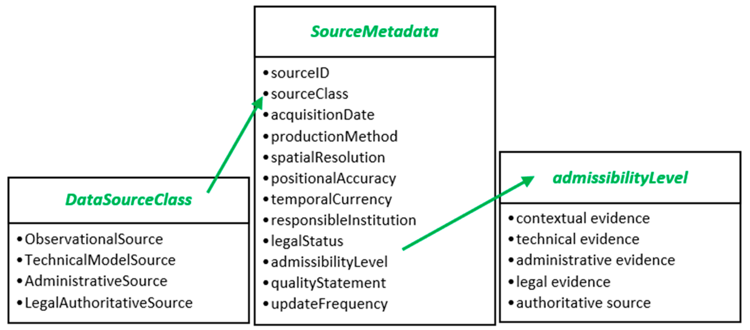
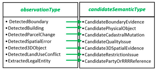
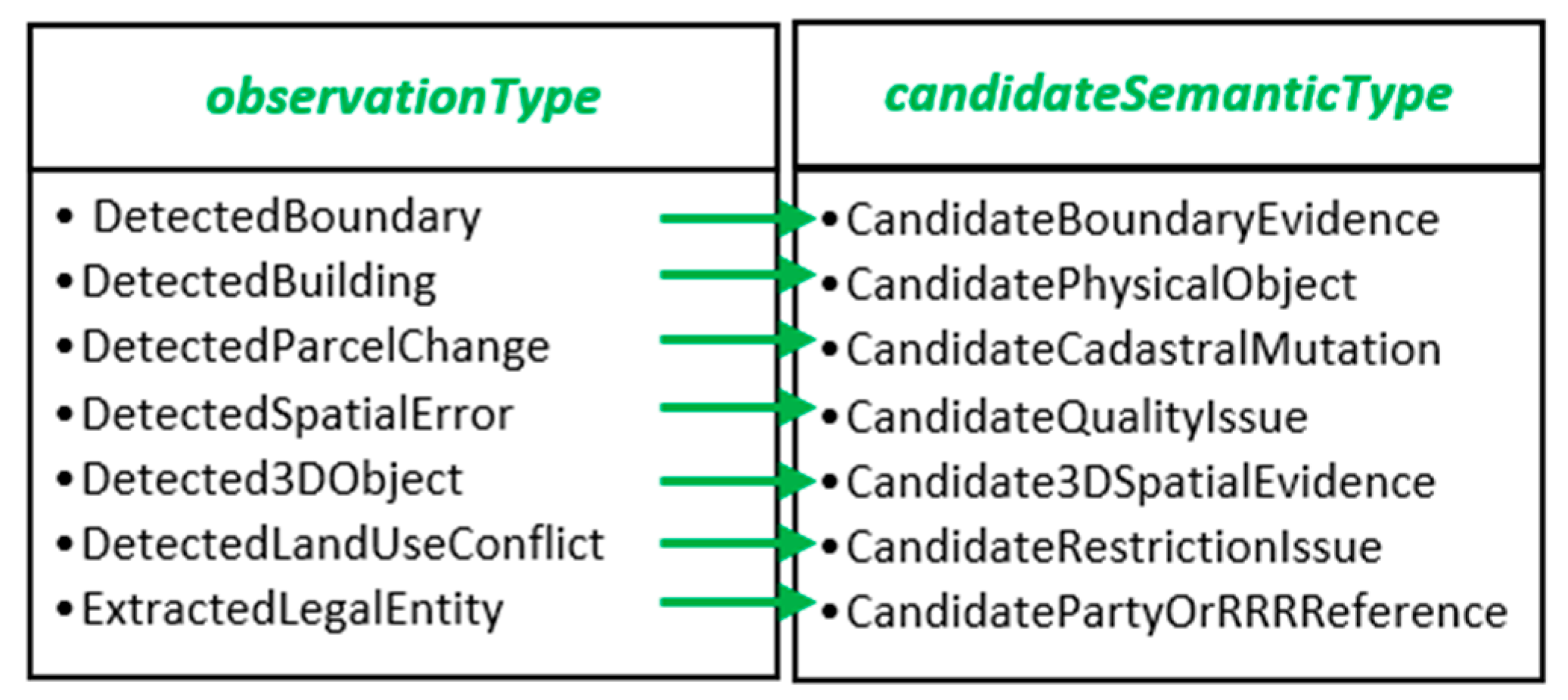
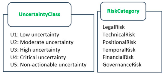
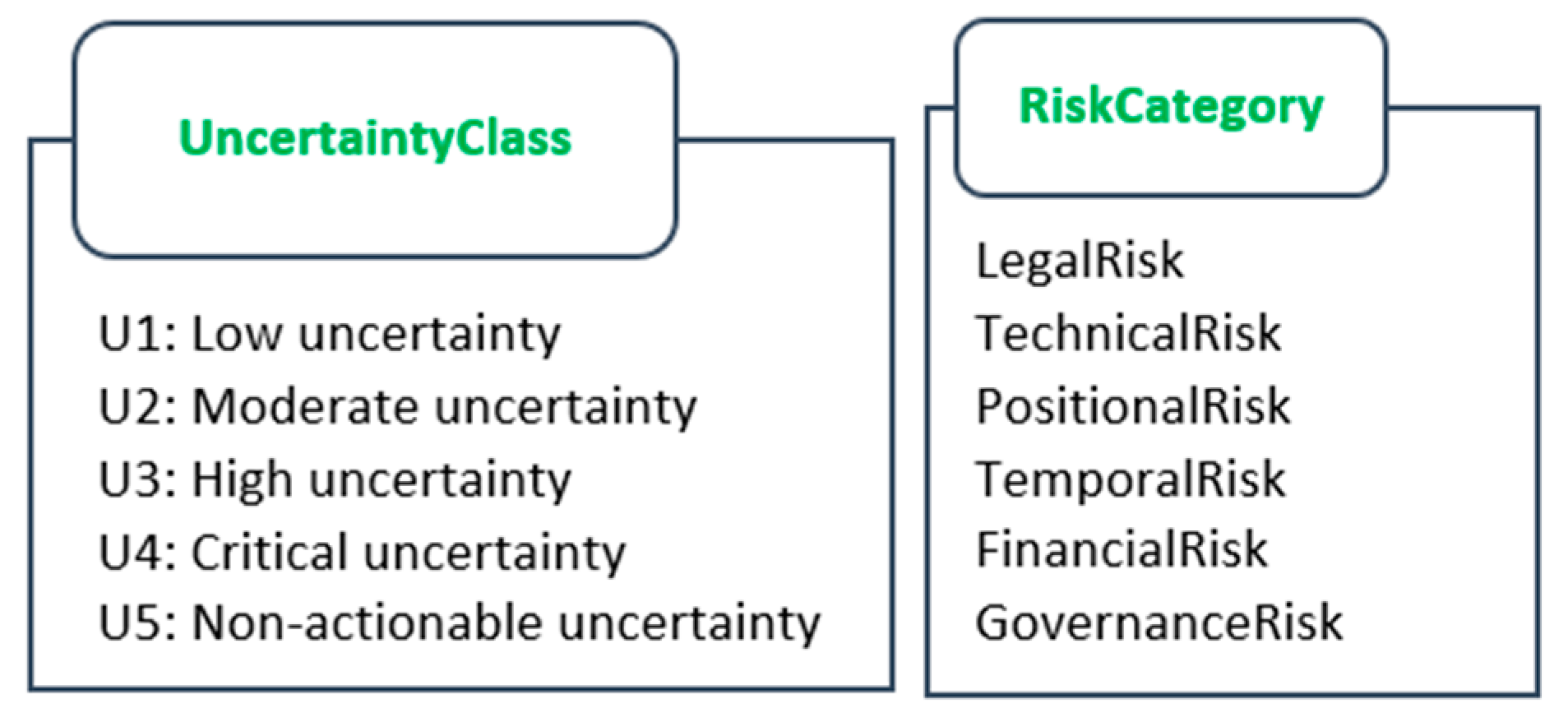
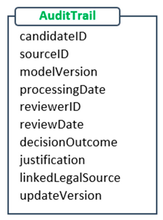
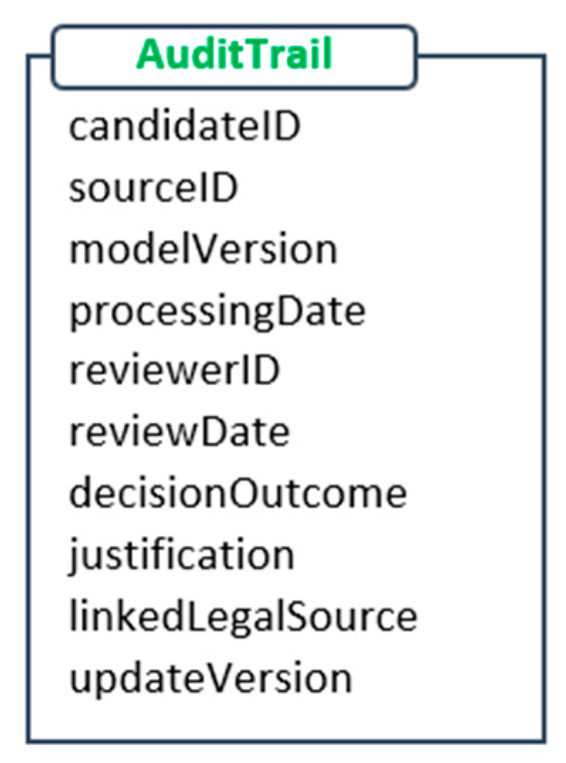
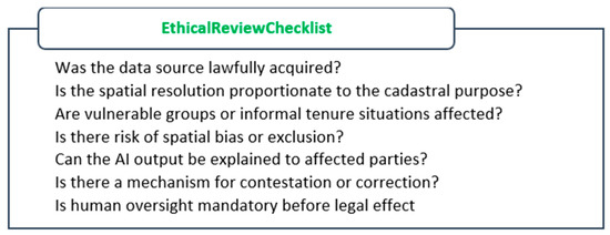
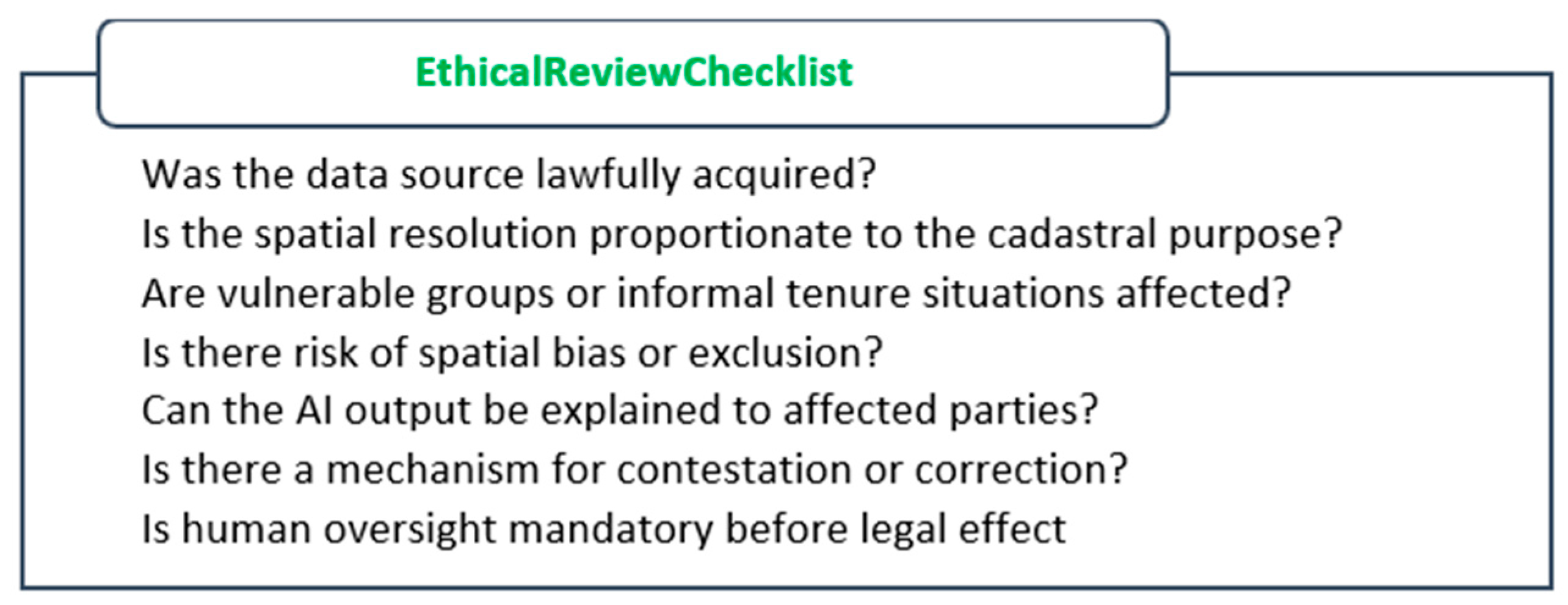
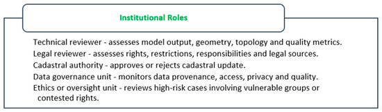
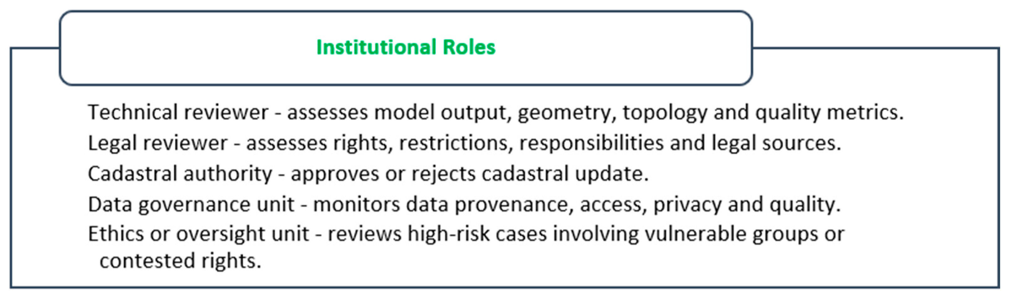
Disclaimer/Publisher’s Note: The statements, opinions and data contained in all publications are solely those of the individual author(s) and contributor(s) and not of MDPI and/or the editor(s). MDPI and/or the editor(s) disclaim responsibility for any injury to people or property resulting from any ideas, methods, instructions or products referred to in the content. |
© 2026 by the authors. Licensee MDPI, Basel, Switzerland. This article is an open access article distributed under the terms and conditions of the Creative Commons Attribution (CC BY) license.