


Abstract
Urban sustainability governance has long been dominated by growth-oriented metrics that measure aggregate improvement without establishing whether neighborhoods provide enough for all residents without continuous territorial expansion or resource-intensive redevelopment. Drawing on the post-growth planning, sufficiency theory, spatial justice, land governance, and the adaptive planning literature, this paper proposes a Spatial Sufficiency Multifunctionality Framework (SSMF). SSMF is a provisional conceptual framework requiring empirical validation and aiming to reorient neighborhood land assessment from growth optimization to sufficiency thresholds. The framework organizes planning around five interconnected dimensions: social sufficiency, economic resilience without growth dependence, ecological resilience, spatial governance and land-use sufficiency, and institutional and participatory capacity. Each is operationalized through illustrative indicators, thresholds, and linked governance instruments. SSMF asks whether per-capita land use remains within ecological capacities and whether access to services, green space, and affordable space is equitably distributed. The framework is developed through a systematic scoping review of the literature on urban sustainability, land governance, and post-growth planning, and provides a diagnostic logic and a menu of governance instruments. By shifting the evaluative focus from “more” to “enough, equity distributed within neighborhood capacities,” SSMF offers a provisional architecture for understanding post-growth principles at the neighborhood scale.
1. Introduction
Urban land governance is shaped by the expectation of continuous economic and spatial growth [1,2,3]. Planning systems, zoning regimes, land-use models, financial instruments, and infrastructure investment strategies commonly assume rising populations, expanding consumption, increasing land values, and a continuing demand for new constructions [4,5,6]. Even when cities adopt sustainability agendas, the operational instruments governing urban land allocation frequently continue to assume growth as the default condition [1,7,8]. Consequently, land is framed less as a finite socio-ecological resource and more as a platform for absorbing additional development pressures [9,10]. This growth orientation is increasingly difficult to defend. Urban expansion has frequently exceeded actual demographic growth, resulting in extensive soil sealing, ecological fragmentation, infrastructure lock-in, and increased mobility distances [11,12,13]. At the same time, everyday services are distributed unevenly across neighborhoods and social groups. Therefore, spatial inequalities persist within cities, including access to public transport [14,15], green space [16,17], health care [18,19], schools [20,21], and affordable housing [22,23].
The ecological and social consequences of land-use decisions are, therefore, not incidental outcomes of planning; they are actively produced through the regulatory and institutional arrangements that determine which land is protected, reused, intensified, or converted [24,25]. Post-growth planning reacts to this problem by questioning the assumption that growth is the central organizing principle of urban policy [4,5,6,26]. This does not mean rejecting development. It simply requires clarifying what forms of change are appropriate, for whom they are intended, and what ecological and social boundaries they must respect [27,28,29]. The issue is particularly important for land governance because land-use systems are slow to change, spatially path-dependent, and rooted in institutional structures. Once land is converted, infrastructure extended, or development rights granted, cities can become locked into carbon-intensive and socially unequal patterns for decades [27,30].
This paper moves beyond the growth conversation, from normative vision to provisional framework knowledge, by developing spatial sufficiency as a framework for evaluating neighborhood sustainability, while empirical validation is identified as a necessary next step. Existing neighborhood-scale planning concepts (e.g., smart growth, compact city, 15 min city, etc.) prioritize density, efficiency, and economic performance, but often stop short of asking “is this enough?” for all residents. As a result, they typically do not evaluate whether people’s basic needs are met equitably within the existing urban footprint, without relying on additional land consumption. The central gap is, therefore, the absence of a sufficiency lens. Sufficiency—ensuring that everyone has access to their fair share of essential services, green space, and safe housing, while preventing consumption that exceeds ecological capacities—is increasingly recognized as a core principle of post-growth urban planning [31,32,33]. In neighborhood contexts, this requires ensuring sufficient proximity to everyday services, access to adequate and affordable space, and the maintenance of resilient local ecologies without relying on continued territorial growth.
The paper’s central question is, therefore, “how to rethink neighborhood sustainability assessment so it measures equity, resilience, and adaptive capacity without depending on continuous territorial expansion or growth-oriented redevelopment.” This research expands upon the existing literature by examining four specific areas. First, it conceptualizes spatial sufficiency as a post-growth planning principle. Second, it integrates sufficiency with urban multifunctionality and spatial justice. Third, it proposes the Spatial Sufficiency Multifunctionality Framework (SSMF) as a diagnostic tool. Fourth, it links sufficiency assessment to land-governance instruments.
SSMF framework was developed through a systematic scoping review and thematic analysis of the urban sustainability, land governance, and post-growth planning literature, following established guidelines for conceptual framework development by Gilson et al. [34]. In addition, the literature identification, dimension and indicator selection, threshold derivation, decision rules determination, and governance instrument mapping are detailed in Section 4, Section 5, Section 6 and Section 7.
2. Conceptual Framework
2.1. From Sustainable Development to Post-Growth Planning
Sustainable development has provided an important policy language for integrating environmental protection, social inclusion, and economic development [35]. In urban planning, it has supported compact city strategies, public transport investment, energy efficiency, green infrastructure, resilience agendas, and global monitoring through SDG 11 and related frameworks [35,36]. However, sustainable development is often implemented in ways that are based on continued economic growth, assuming that growth can proceed if it becomes cleaner, denser, or more efficient [6,26]. Traditional sustainability (e.g., SDGs, resilience) envisions “greening” urban growth—lowering emissions per person or adding parks—but usually assumes growth will continue. This raises concerns about the policy’s success in terms of growth: more development, more consumption, higher land values, more infrastructure, and greater mobility.
The post-growth and degrowth literature challenges this assumption by arguing that well-being, ecological stability, and social justice cannot depend indefinitely on rising material output [5,6,37,38]. The critique is not limited to gross domestic product (GDP); post-growth planning questions the assumption that sustainability can be achieved through continuous economic growth [39]. From this perspective, a main question of planning, therefore, becomes how to organize urban life so that needs can be met within ecological capacity [40,41,42,43]. In post-growth and degrowth research, sufficiency is introduced as a key principle: meeting well-being needs while keeping consumption and production without ecological loss [31,33,41]. Sufficiency involves ensuring access to basic requirements—such as housing, healthcare, food, and mobility—for all, while placing upper limits on resource use where it is excessive [32].
In urban contexts, this suggests redistributing space and amenities so that underserved neighborhoods gain access to essential services, while areas already facing high development pressure do not continue to expand [44,45]. Importantly, sufficiency aims to guarantee adequate living standards for all while reducing overconsumption, consistent with Raworth’s “social foundation” and “ecological ceiling” framework [40]. Sufficiency approaches also emphasize that sustainability may require setting limits rather than just improving efficiency. Efficiency-based strategies often lead to rebound effects, where gains are offset by increased overall consumption [46]. Post-growth planning, therefore, focuses on what is “enough,” a shift noted in planning debates that move beyond eco-modernization [47,48].
2.2. Land Governance and the Growth Paradigm
Urban land governance refers to the rules, institutions, ownership structures, planning instruments, and political processes through which land is allocated, valued, developed, protected, and transformed [49,50,51]. It includes zoning, development control, land-use plans, infrastructure finance, public land management, property taxation, land-value capture, land banking, participatory planning, and tenure arrangements [52,53]. These instruments are not neutral. They shape who can access land-based benefits, who is exposed to environmental burdens, and whose needs are recognized in planning decisions.
In many growth-oriented planning systems, land governance tends to emphasize development capacity, investment attraction, monetized land value, and the accommodation of projected demand [54,55]. Lamker and Terfrüchte [4] found that sustainable land-use plans often contain growth assumptions that make achieving net-zero land take and repurposing land difficult without new political instruments. Sustainability instruments, therefore, can become aligned with these priorities when compact development, regeneration, or green infrastructure are primarily used to increase land values or strengthen urban competitiveness [44,56]. Land-value capture shows this complexity. While it can redirect publicly generated land value toward social objectives, its design may also prioritize expanding monetized development value, thereby supporting growth-dependent planning logics [52,55,57].
A post-growth approach to land governance, therefore, requires a different hierarchy of objectives and shifts to prioritize the equitable redistribution of existing space. Public policy should first assess whether existing land, buildings, and infrastructure can meet needs through reuse, redistribution, repair, and ecological capacity. New development should be evaluated against clear sufficiency criteria: Does it address unmet needs? Does it reduce or increase land consumption? Does it improve access for underserved groups? Does it protect ecological capacity? Does it prevent displacement? Within this perspective, land governance becomes a tool for redistribution, repair, and adaptation, not a mechanism for organizing growth. Our framework responds to these questions by explicitly linking indicators to governance tools, so that decisions about new development are judged against measurable outcomes of sufficiency and equity.
2.3. Neighborhood Multifunctionality, Proximity, and Everyday Access
The neighborhood is a main operational scale in urban land governance, specifically post-growth planning, because it is the spatial scale at which land-use decisions directly shape everyday living conditions [58,59]. It captures the spatial conditions through which everyday needs can be satisfied with lower resource consumption, reduced mobility demand, and limited pressure for territorial expansion [60,61]. Core planning models such as proximity-based planning (e.g., the 15 min city), the Neighborhood Unit, mixed-use development, and Transit-Oriented Development are fundamentally operationalized at this scale, making neighborhoods particularly relevant for assessing how urban land systems translate into social, economic, and environmental outcomes [62,63,64]. From the perspective of post-growth planning, proximity to essential services, public facilities, green spaces, and local economic activities can reduce dependence on growth-oriented infrastructure systems while strengthening social and ecological resilience [41,65,66].
Within this context, urban multifunctionality provides an important lens for understanding neighborhood sustainability. Multifunctional neighborhoods integrate residential, economic, social, civic, and ecological functions within a relatively compact spatial structure, reducing dependence on long-distance travel while supporting diverse everyday needs [67,68,69,70]. Multifunctionality has been associated with improved accessibility, more efficient use of urban land, stronger local resilience, and enhanced opportunities for social interaction and service provision [66,69,71]. As a result, it offers a beneficial framework for examining how urban form and land-use patterns contribute to sustainable, resilient urban development.
However, multifunctionality alone does not guarantee sustainability under post-growth conditions. Many conventional assessments operationalize multifunctionality through indicators such as density, diversity, connectivity, or economic performance metrics that implicitly reproduce growth-oriented, efficiency-driven planning paradigms without addressing post-growth sustainability concerns [72,73,74]. Thus, a post-growth perspective shifts attention from optimization and expansion toward sufficiency and equitable provision [75]. The central question is, therefore, whether neighborhoods provide sufficient access to essential services and social infrastructure, considering ecological capacity and adaptive potential for diverse populations within existing land and resources. Assessing multifunctionality through the lens of spatial sufficiency, therefore, enables a more equitable and ecologically fundamental understanding of neighborhood sustainability and its role in post-growth urban land governance.
2.4. Spatial Justice and Redistribution
Spatial sufficiency is inherently a question of spatial justice. Post-growth urbanism questions the belief that ongoing economic expansion, urban development, or increasing aggregate provision is the path to solving social and environmental challenges [61,75]. Instead, it shifts attention toward the distribution of existing land-based resources, services, opportunities, and environmental benefits. A city may have high levels of accessibility, green infrastructure, or public investment on average, while substantial inequalities persist between neighborhoods and social groups [76,77]. The critical question, therefore, is how to ensure that all residents have sufficient access to the conditions required for a dignified and sustainable life [37,40,78,79].
From a spatial sufficiency perspective, urban inequalities are not only social outcomes but representations of uneven land-use decisions and territorial resource allocation, reflecting how planning institutions distribute space, infrastructure, and environmental benefits across different groups [80,81]. Access to housing, public transport, healthcare, schools, green space, public facilities, and safe public environments is shaped by the spatial organization of cities and by the institutions governing land development, investment, and infrastructure provision. Consequently, neighborhood sustainability must be assessed through distributional justice, sufficient access, and land-based benefits and opportunities allocated across urban space for all [78,80,82].
Redistribution, therefore, becomes a central function of post-growth urban land governance. Planning institutions must actively redistribute access, opportunities, and land resources using regulatory, financial, and spatial tools. This may include directing services and infrastructure toward underserved areas, protecting affordable housing and workspaces, capturing land value for public purposes, promoting adaptive reuse of underutilized land and buildings, and ensuring that ecological improvements do not result in displacement or exclusion [5,61,75]. Spatial justice thus provides the normative foundation for spatial sufficiency, while redistribution serves as the governance mechanism through which sufficiency can be achieved in practice.
3. Limitations of Existing Neighborhood Sustainability Assessment
3.1. Growth-Compatible Monitoring
Neighborhood sustainability assessment tools alongside SDG-based and broader urban sustainability frameworks have successfully translated high-level policy goals into measurable, comparable indicators. SDG 11 and the related monitoring mechanisms led by UN-Habitat, including the City Prosperity Index and the Global Urban Monitoring Framework, have brought global recognition to the urban dimension of sustainable development and allow cities to align local planning with international commitments [35,36]. Established tools such as Leadership in Energy and Environmental Design for Neighborhood Development (administered by the U.S. Green Building Council) and the Building Research Establishment Environmental Assessment Method for Communities (developed by the Building Research Establishment in the UK) have furthered this translational work by operationalizing multidimensional sustainability criteria at the district scale, enabling communication and policy learning across planning departments and political boundaries [62,83]. The strengths of these frameworks include their structured, multidimensional architecture, their policy relevance through indicator-based target-setting, and their capacity to support comparability across cities and neighborhoods.
Nevertheless, existing frameworks remain largely oriented toward a logic of improvement and growth-compatible monitoring, which limits their adequacy for post-growth planning paradigms that prioritize sufficiency, ecological capacities, and equitable distribution. Five interrelated limitations stand out. First, despite the centrality of land use to urban metabolism, existing assessment systems give insufficient systematic emphasis to land-use intensity, land take, and spatial configuration in relation to ecological ceilings; metrics typically reward compactness or mixed use without examining overall land consumption at the neighborhood scale [6,84]. Second, vacancy and adaptive reuse of the existing building stock receive limited attention; most tools focus on new construction and fail to assess the potential of underutilized buildings, vacant land, or circular material flows to deliver housing and services without additional resource use [85]. Third, the frameworks show a weak connection to land governance, incorporating indicators related to land tenure, public land management, or community control over land-use decisions, which are important for guiding land toward equitable and ecologically bounded outcomes [49,86]. Therefore, a new assessment framework is necessary to move beyond incremental improvement and sufficiency, and to embed land governance and reuse needs at the core of neighborhood sustainability evaluation.
3.2. The Problem of Optimization-Oriented Metrics
A common limitation of conventional assessment frameworks is their reliance on an optimization-oriented logic: the assumption that more density, higher efficiency, greater accessibility, increased investment, or improved competitiveness are inherently desirable and reflective of progress. In such approaches, indicators are typically structured to reward continuous growth without establishing upper boundaries or sufficient conditions. For example, a neighborhood may be evaluated favorably for maximizing transit-oriented density or increasing the share of residents near public transport. At the same time, the assessment remains silent on whether the resulting intensification worsens displacement, reduces open space, or raises exposure to heat stress [87,88]. Similarly, accessibility metrics often aim for aggregate reductions in travel time or improvements in connectivity, but increased network efficiency can raise land values and development pressure, weakening affordability and inclusion [89]. Green infrastructure scores may rise even when new amenities promote green gentrification, displacing the communities they were designed to benefit [88]. This optimization-without-thresholds paradigm considers sustainability as an exercise in better growth, overlooking the possibility that not all intensification is socially just, not all density is sufficient, and not all efficiency gains reduce resource dependence [90].
A sufficiency-oriented alternative asks whether a neighborhood meets a defined adequacy level for all residents, whether disparities remain within acceptable bounds, and whether biophysical capacities are respected [40,41]. Such a logic is already present in sufficientarian approaches to transport planning, which identify minimum levels of accessibility to essential destinations instead of aggregate travel efficiency as the fundamental test of a just mobility system [89,91]. Extending this principle to the broader neighborhood scale would shift attention from optimizing land values, productivity, or investment flows to ensuring that land use, housing, infrastructure, and service provision remain within land and material budgets while securing equitable access for all.
3.3. Missing Land-Governance Dimensions
Existing urban frameworks tend to view land as a passive spatial container rather than an institutionally mediated resource. While land-use mix, density, green space provision, or access to amenities are measured, they rarely examine the governance arrangements that determine who owns land, who controls redevelopment, who captures the increments in land value, and who is displaced by change [52,92]. Vacant or underused land may be registered as development potential without distinguishing between temporary community use or opportunities for adaptive reuse. Public land is often viewed as a financial asset rather than a strategic resource for securing sufficiency and equity [93]. These frameworks thus produce a picture of spatial performance that is separated from the politics of land, leaving unexamined the institutional capacities, tenure regimes, and governance tools that shape whether land serves collective needs or private accumulation.
This exclusion is consequential for post-growth planning. Land governance is the area in which decisions about urban expansion, redevelopment intensity, ecological protection, and social displacement are made, and a sustainability assessment that disregards it cannot adequately guide sufficiency-oriented transitions [44]. A framework capable of supporting post-growth objectives must, therefore, incorporate land-governance indicators that move beyond conventional optimization metrics.
4. Framework Development Methodology
4.1. Literature Identification and Screening
The Spatial Sufficiency Multifunctionality Framework (SSMF) was developed through a scoping review of the peer-reviewed and policy literature on urban sustainability, land governance, and post-growth planning. The review followed the methodology proposed by Arksey and O’Malley [94] and subsequently refined by Levac et al. [95], which is appropriate for developing conceptual frameworks from diverse bodies of the literature. The approach was purposive and iterative, focusing on identifying key concepts, dimensions, indicators, and governance instruments from the literature.
Search strategy: A search was conducted on Web of Science, Scopus, and Google Scholar using the following search strings:
Web of Science Core Collection: TS = (“sufficiency” OR “post-growth” OR “degrowth” OR “enoughness”) AND TS = (“urban planning” OR “land governance” OR “neighborhood sustainability” OR “urban land use” OR “spatial planning”); Scopus: TITLE-ABS-KEY ((“sufficiency” OR “post-growth” OR “degrowth” OR “enoughness”) AND (“urban planning” OR “land governance” OR “neighborhood sustainability” OR “urban land use” OR “spatial planning”)); and Google Scholar: (“sufficiency” OR “post-growth” OR “degrowth” OR “enoughness”) AND (“urban planning” OR “land governance” OR “neighborhood sustainability” OR “urban land use” OR “spatial planning”). The search was limited to English-language publications from 2000 to 2026. The initial search yielded 24,306 records—a large collection reflecting the breadth of the sustainability literature, but not all directly relevant to neighborhood-scale land governance. Therefore, a purposive screening strategy was employed.
Purposive screening strategy: Instead of screening all 24,306 records, which would be impractical for a conceptual paper, a multi-stage purposive approach was used:
- (i)
- Deduplication: Search results were imported into Mendeley Desktop (Version 2.148.0) for duplication reduction and reference management;
- (ii)
- Thematic refinement: The search was refined to focus on the literature most directly relevant to land-use governance and neighborhood-scale assessment. Then, additional filters was applied to narrow the literature: (a) categories (Urban Studies, Planning and Development, Geography, Environmental Studies, Public Administration), which reduced the corpus to 4812 records, and (b) key terms in titles (e.g., “neighborhood,” “land use,” “governance,” “sufficiency,” “thresholds”), which further reduced the corpus to 1247 records;
- (iii)
- Citation-based identification: A set of foundational works through prior knowledge of the field was identified;
- (iv)
- Conceptual relevance screening: Titles and abstracts of 1247 records from the refined search and the 143 records from citation tracking (total: 1390) were screened for conceptual relevance to neighborhood-scale land governance and sufficiency principles. Records that focused on (a) national or global scales without neighborhood translation (412 records); (b) purely technical or engineering aspects without governance implications (287 records); and (c) specific case studies without generalizable insights for framework development (398 records) were excluded. This covered 293 records for full-text initial screening review;
- (v)
- Full-text initial screening review: the full text of the 293 records was screened. The most common reasons for exclusion at this stage were: (a) insufficient operational detail for indicator development; (b) lack of governance instrument specification; and (c) duplication of concepts already covered by more comprehensive sources. The final synthesis included 59 peer-reviewed articles, 12 book chapters, 8 institutional reports, and 3 monographs, a total of 82 sources that directly informed the framework’s dimensions, indicators, thresholds, and governance instruments;
Thematic Analysis: The 82 included sources were analyzed thematically following the six-phase procedure of Braun and Clarke [96]: (1) familiarization with the texts; (2) initial coding of concepts related to dimensions, indicators, thresholds, and instruments; (3) grouping codes into potential themes; (4) reviewing themes against the data; (5) defining and naming themes; and (6) producing the final synthesis. The five sufficiency dimensions emerged from this analysis, with three alternative dimensions considered and rejected.
4.2. Dimension and Indicator Selection
Five sufficiency dimensions, including social sufficiency, economic resilience without growth dependence, ecological resilience, spatial governance and land-use sufficiency, and institutional and participatory capacity, were defined from an iterative thematic analysis of the included literature based on (a) frequency of appearance in the literature, (b) relevance to neighborhood-scale land decisions, and (c) potential for operationalization through measurable indicators. Three alternative dimensions were considered but ultimately excluded. (i) Cultural vitality is recognized important for neighborhood well-being [97], but cultural indicators are too context-specific and difficult to standardize across diverse neighborhoods. However, cultural dimensions are addressed as cross-cutting considerations within the social and institutional dimensions of SSMF. (ii) Technological infrastructure including digital connectivity and smart city infrastructure are increasingly relevant, but they are best considered as enabling conditions, not just standalone sufficiency dimensions. SSMF institutional dimension captures data transparency and participatory platforms, which are the most governance-relevant aspects of technology. (iii) Health is a fundamental concern, but it is best understood as an outcome of the five sufficiency dimensions. SSMF considered access to services (social), affordable housing (economic), green space (ecological), and walkable neighborhoods (spatial), all of which contribute to health, so that a separate health dimension would create redundancy.
Indicators for each dimension were selected based on four criteria: (a) measurability with available or readily collectible data, (b) policy relevance and sensitivity to governance intervention at the neighborhood scale, (c) clarity and interpretability for non-specialist audiences, and (d) applicability across diverse urban contexts.
4.3. Threshold Derivation and Governance Instrument Identification
Sufficiency thresholds were derived from three sources: (i) empirical evidence: thresholds based on scientific research linking specific levels of provision to health, ecological, or social outcomes; (ii) planning standards: thresholds derived from established planning practices and policy targets; and (iii) normative suggestions: thresholds based on guiding principles of universal access, equity, and reuse before expansion. These are presented as normative proposals to be democratically calibrated in practice.
Governance instruments were identified through a systematic review of urban planning interventions and land-use policy evaluations. Instruments were selected based on (a) documented effectiveness in similar contexts, (b) legal feasibility, and (c) alignment with post-growth principles. The final set of instruments represents a synthesis of the most recommended and evaluated policy instruments in the reviewed literature. However, SSMF is presented as a provisional conceptual framework requiring empirical validation. The framework provides a structured diagnostic logic and a menu of governance instruments, but its practical effectiveness requires testing.
5. Spatial Sufficiency Multifunctionality Framework
5.1. Framework Logic and Conceptual Architecture
SSMF examines neighborhood sustainability based on sufficiency, equity, adaptivity, and low-expansion urban capacity. Spatial sufficiency shifts attention from maximizing urban growth and performance to ensuring that urban land systems provide sufficiency and support human well-being within social and environmental boundaries [42,98]. Unlike conventional assessment tools that aggregate indicators into composite indices, SSMF is diagnostic. SSMF identifies where sufficiency is lacking, who is affected, what urban capacities exist, and which governance instruments are needed.
Spatial sufficiency is a multidimensional concept. Building on established sustainability frameworks while applying post-growth perspectives, this paper conceptualizes SSMF through the five interconnected dimensions presented in Figure 1.
Figure 1.
Conceptual architecture of SSMF.
SSMF provides a structured assessment matrix with dual purposes: (1) to diagnose whether a neighborhood provides adequate services, livelihoods, and environmental quality for all residents without expansion and (2) to inform what governance changes are needed to correct inadequacies.
Multifunctionality is a central but often ambiguously defined concept in urban sustainability discourse [99]. The concept of multifunctionality in SSMF draws on longer-established urban design principles of mixed use and variety [100], extending these ideas by incorporating ecological capacities, governance instruments, and equity safeguards. Within SSMF, multifunctionality is examined through three specific mechanisms: (i) integrated diagnosis, in which each neighborhood is assessed simultaneously across all five dimensions, where the diagnostic output is not a single score but a multidimensional profile showing which dimensions are sufficient and which require intervention; (ii) synergy identification to diagnose and map potential synergies and trade-offs between dimensions to guide instrument selection; and (iii) policy integration, addressing multiple dimensions through selected governance instruments.
5.2. Five Interconnected Dimensions of SSMF
5.2.1. Social Sufficiency
Social sufficiency, as conceptualized within SSMF, shifts the evaluative focus from aggregate service provision to equitable, universal access to essential infrastructure and socially acceptable consumption boundaries [42,101]. A socially sufficient neighborhood is one in which every resident—regardless of income, age, mobility, or ethnicity—can reach the services required for daily life without excessive time, cost, or safety barriers. This orientation directly challenges conventional sustainability indicators, such as SDG indicator 11.2.1 (proportion of population with convenient access to public transport), which are often reported as city-wide averages. Such averages can hide deep spatial inequalities: a city may meet its SDG target while some neighborhoods remain transit deserts [91,102].
SSMF, therefore, operationalizes social sufficiency through three interconnected evaluative subdimensions: walking-distance access to daily services, public transport coverage, and housing adequacy.
Walking-distance access to daily services is measured by the percentage of a neighborhood’s population that resides within a comfortable walking radius (typically 800 m or a 10 min walk) of a grocery store, primary care clinic, primary school, pharmacy, and a basic financial service (e.g., bank or ATM). The aspirational goal of universal access is 100% of households. However, recognizing practical data and implementation constraints, SSMF considers a provisional sufficiency threshold of ≥90%, with the remaining 10% flagged for targeted intervention (e.g., mobile services, new facility siting, or transit improvements). This set of “daily anchors” follows the proximity planning literature but goes further by requiring universal coverage. The sufficiency threshold requires that every household lie within this radius, rather than relying on improvements to aggregate indicators [103,104]. Where such thresholds are not met, SSMF identifies specific underserved sub-areas—often low-income or minority neighborhoods—as priority zones for public facility redistribution or mixed-use zoning reforms.
Public transport coverage is evaluated through two complementary indicators: the share of residents living within 500 m of a frequent transit stop (bus, tram, or rail), and the share of essential destinations reachable within a 30 min door-to-door trip using only public transport. While SDG indicator 11.2.1 captures the former, SSMF integrates the latter because physical proximity to a stop does not necessarily translate into functional access to employment, healthcare, or education. Under a sufficiency-based logic, both indicators must exceed 80 percent in all neighborhoods, accompanied by explicit equity audits comparing access across income quintiles and ethnic groups. A post-growth land governance could respond by targeted improvements to transit service, mobility-justice ordinances, and strategic use of public land to locate transit hubs in underserved areas [36,105,106,107].
Housing adequacy—often overlooked in land-use efficiency frameworks—is integrated into social sufficiency as a prerequisite for neighborhood stability. SSMF adopts a modified version of the widely used rent-burden indicator: the share of households spending less than 30% of income on housing costs is considered minimally adequate, but the framework’s sufficiency threshold is more ambitious. Drawing on the concept of “decent housing as a social floor” [90,108,109,110], SSMF targets ensuring that no household spends more than 30% on rent, ideally less than 15% for low-income households, recognizing that excessive housing costs shift spending away from food, health, and mobility. Data sources for monitoring include housing surveys, rental registries, and census microdata. Where high rent burdens are identified, instruments such as inclusionary zoning, rent stabilization, community land trusts (CLT), and the conversion of public or vacant land into permanently affordable housing can help land governance.
What distinguishes SSMF’s social dimension from sustainability monitoring is its rejection of average-city-based targets and its explicit logic of spatial justice. SSMF measures whether every neighborhood and every social group meet a pre-defined minimum. This is an important difference; a city that builds three new supermarkets in already well-served areas may increase its average access score without reducing the service desert. Under SSMF, such a pattern would show sufficiency failure because the gap still exists.
5.2.2. Economic Resilience Without Growth Dependence
SSMF’s economic dimension departs sharply from conventional economic development indicators, which prioritize growth, land value, and competitiveness. Economic resilience, as framed here, refers to a neighborhood’s capacity to support everyday livelihoods, essential services, and local economic functions without depending on continuous physical expansion, long-distance commuting, or experimental redevelopment. This is a sufficiency-oriented concept. It asks, “Are local economic functions sufficient to meet residents’ needs, and are they organized in ways that do not force expansion?” Four subdimensions operationalize this concept: local service diversity; affordable workspaces; housing–service–work proximity; and the reuse of vacant commercial spaces.
Local service diversity is assessed through the number and type of essential retail and service establishments per 1000 residents, with special attention to repair, reuse, care, food, and community economies [111]. Unlike a simple business count, the sufficiency logic asks whether a neighborhood has enough functional diversity to reduce long-distance dependency—for example, a grocery store, a pharmacy, a café, a repair shop, a childcare facility, and a community meeting space. The threshold is context-specific and normative. No neighborhood should be a “monofunctional dormitory”, where all non-sleeping needs require a car trip.
Affordable workspaces are assessed through the share of commercial floor area leased at rates accessible to local small businesses, non-profit organizations, and care providers. Rising commercial rents—widely documented as a driver of neighborhood restructuring—can displace essential community-serving establishments (such as family clinics or hardware stores) and replace them with higher-return uses (such as bank branches or luxury retail), thereby weakening everyday sufficiency [112,113,114,115]. SSMF, therefore, proposes a sufficiency threshold whereby at least 15% of neighborhood commercial space is reserved for socially necessary uses at below-market rents, implemented through commercial CLTs, public acquisition, or non-displacement covenants. Data sources for monitoring this indicator could include property tax records, business registries, and field surveys.
Housing–service–work proximity is evaluated through the neighborhood-level jobs–housing ratio and the share of residents who can reach their workplace within a 30 min transit or bicycle commute. Although the regional jobs–housing balance is widely used in planning practice, SSMF disaggregates this metric to the neighborhood scale because city-wide averages can hide localized mismatches between where people live and where employment is located. From a sufficiency perspective, a neighborhood in which most residents must commute long distances—even if jobs exist elsewhere in the city—cannot be considered economically sufficient, as such patterns create transport emissions, time poverty, and increase infrastructure costs [116,117]. It is important to note a potential limitation regarding the jobs–housing balance indicator. While a balanced ratio between 0.5 and 1.5 is a useful proxy for local economic resilience [118], it does not by itself indicate whether the available jobs match residents’ skills, wages, schedules, or accessibility needs [119]. SSMF, therefore, uses jobs–housing balance as a screening indicator—a first-pass measure that signals potential gaps requiring further investigation. Where the ratio falls outside the 0.5–1.5 range, planners should examine supplementary contextual evidence through: (a) the share of local jobs paying a living wage, (b) residents’ commuting patterns and access to employment, and (c) qualitative information from community organizations about employment barriers. Where the ratio is balanced, it is a positive signal but not conclusive evidence of economic sufficiency.
The most distinctive indicator in this dimension is the reuse of vacant commercial spaces, which captures underused shops, offices, and light industrial spaces. Conventional economic analysis examines vacancy as a market failure to be eliminated through new development. Throughout the SSMF framework, vacancy rates are defined as follows: functional vacancy (3–5%) represents normal market turnover and does not require intervention; moderate vacancy (5–8%) requires monitoring (initial signs of disinvestment and a potential resource for adaptive reuse [120,121]); and high vacancy (>10%) signals either structural decline or speculative holding and requires governance intervention [122,123]. The sufficiency response is not automatically to fill vacancies with market-rate uses but to ask: what social functions are missing? Therefore, land governance could take advantage of instruments such as vacancy taxes, time-limited use permits for temporary community projects, municipal land banking, and adaptive reuse grants that prioritize affordable housing, makerspaces, cafes, and cultural venues [124,125].
What is unique to SSMF’s economic dimension, compared to SDG 8 (Decent Work and Economic Growth) or the New Urban Agenda, is its explicit separation of local economic health from land-use expansion. A neighborhood can be economically resilient under SSMF. At the same time, its GDP remains stable or even declines, provided that essential functions are maintained, work-commute distances are short, and rent increases displace no one. This reframing aligns with post-growth and degrowth scholarship, which argues that prosperity without growth requires reducing the throughput of land, energy, and materials while improving distribution [37,40,90].
5.2.3. Ecological Resilience
Ecological resilience in SSMF goes beyond the conventional framing of “greenness” as an unqualified good. It evaluates whether neighborhoods actively repair environmental conditions (e.g., improving cooling, permeability, biodiversity, and stormwater absorption) while simultaneously preventing the displacement of vulnerable residents through green gentrification. This dual direction is largely absent from SDG indicator 11.7.1 (average share of built-up area that is public open space), which reports a single urban average without a distributional or displacement lens. SSMF assesses ecological resilience through four complementary subdimensions: green space access, tree canopy cover, impervious surface ratio, and heat exposure.
Green space access is measured as square meters of publicly accessible green space per resident and as the percentage of residents within a 300 m walking distance of any green space (including pocket parks, community gardens, and greenways). The World Health Organization recommends a minimum of 9 m2 of green space per person as a general guideline [126]. The SSMF adapts this by requiring that no neighborhood fall below 9 m2 per capita and that at least 90% of residents have access to green space within 300 m. Data sources for monitoring this indicator could include park GIS layers, satellite imagery, and land-cover datasets such as Trends.Earth. Where deficits exist, governance could respond by converting vacant lots to pocket parks, green roof mandates for new construction, and the establishment of green infrastructure priority zones [88,121,127].
Tree canopy cover—measured as the percentage of land area shaded by trees during the growing season—is assessed against a sufficiency threshold of at least 30% canopy cover in residential neighborhoods, recognizing that canopy provides cooling, stormwater interception, and biodiversity benefits [128]. Low-income neighborhoods and communities of color often have significantly lower canopy cover due to historic redlining and disinvestment [128,129]. The SSMF, therefore, requires an equity check: canopy cover in the lowest-quartile neighborhood (by income) must be at least 80% of the city-wide average.
The impervious surface ratio (percentage of land covered by roads, parking lots, buildings, and other non-porous surfaces) is a proxy for stormwater runoff, urban heat island intensity, and habitat fragmentation [130,131]. Sufficiency thresholds should be set locally based on hydrological and climatic conditions, but a general guideline is that impervious surfaces should not exceed 30–40% in residential neighborhoods [132].
Heat exposure is assessed using either the air temperature or the land-surface temperature (LST) measured by satellite remote sensing. From a sufficiency perspective, the 2 °C threshold applies to air temperature exposure, following epidemiological research linking specific air temperature increases to morbidity and mortality [133,134]. Where air temperature data are unavailable, LST can be used as a proxy, but with the understanding that LST typically exceeds air temperature by several degrees and that the relationship varies with land cover, time of day, and season [135]. The SSMF recommends using the highest-resolution air temperature data available, and where only LST is available, applying a locally calibrated conversion factor. Periods of extreme heat should also activate cooling-access measures, particularly for vulnerable populations [128,136]. Responses such as cool pavement programs, green roofs, and the strategic placement of shade trees and cooling centers in high-heat-exposure areas can help land governance support ecological resilience [129,137,138].
The most distinctive—and theoretically novel—element of SSMF’s ecological dimension is its inseparable aspect of green investment and anti-displacement management. A growing body of the literature documents that new parks, waterfront restoration, and urban greening programs often raise nearby land values and accelerate gentrification, displacing the low-income and minority residents who would most benefit from environmental improvements [44,48,88]. The SSMF, therefore, requires that any ecological resilience intervention be accompanied by a displacement risk assessment and, where risk is present, safeguards such as rent control, CLTs, inclusionary zoning, or tenant right-of-first-return are applicable for land governance [139]. A neighborhood that gains new parks but loses its residents to rising rents is not, under SSMF, considered ecologically sufficient. Notably, this direct coupling of ecology and housing justice is absent from the SDGs and from most municipal green plans.
5.2.4. Spatial Governance and Land-Use Sufficiency
Land-use sufficiency is the analytical core of SSMF. It asks a simple question: can a neighborhood meet its social, economic, and ecological needs using existing land and buildings, or is it structurally dependent on converting new lands for every increment of development? Conventional land-use efficiency indicators, notably SDG indicator 11.3.1 (the ratio of the land consumption rate to the population growth rate), measure efficiency as a ratio but do not establish an absolute sufficiency target. A city can show improving land-use efficiency (a declining ratio) while still consuming vast amounts of new land each year [132]. SSMF instead adopts fine thresholds and reuse-first principles. Four illustrative subdimensions operationalize land-use sufficiency: per capita land consumption, expansion dependency, vacancy and underuse rates, and infill capacity.
Per-capita land consumption—calculated as the total urbanized land area divided by population—provides a baseline indicator of land-use efficiency. While the appropriate sufficiency threshold is context-dependent, SSMF aligns with the European Union’s commitment to “no net land take by 2050” and with the emerging literature on compact-city limits, which emphasizes minimizing land conversion while maintaining adequate living standards [140,141]. In dense European cities, per capita land consumption below 0.03 ha (300 m2) is feasible. In lower-density North American or Australian contexts, the threshold will be higher but should still trend downward over time. The key point is that a threshold exists. Beyond that point, additional land consumption is considered ecologically excessive, regardless of population growth.
Expansion dependency refers to the share of new development, measured by floor area or land area, that occurs on previously undeveloped greenfield lands [142]. A high expansion–dependency ratio indicates continued outward land conversion, while a lower ratio reflects more efficient use of existing urban land. SSMF proposes a sufficiency threshold that at least 80% of all new developments should occur on already urbanized land, with a long-term target of 100% (net zero land take). Cities that rely on greenfield expansion to accommodate population growth or economic activity are identified as expansion-dependent and are directed toward infill-first policies, such as urban growth boundaries, greenbelt protection, and development permit systems that require developers to exhaust infill options before converting greenfields [143].
Vacancy and underuse rates are measured separately for residential, commercial, and industrial land. However, SSMF interprets vacancy as a complex social and institutional phenomenon. Vacancy can be hypothetical (land held for future value rise), temporary (between tenancies), partial (underused floors in otherwise occupied buildings), or hidden (vacant units within occupied structures) [144,145]. SSMF suggests that the vacancy rates for residential lands should not exceed 8%.
Infill capacity is a forward-looking indicator: the amount of land (in hectares or floor area) that could accommodate new development without expanding the urban infrastructure footprint, given current zoning, ownership patterns, and physical constraints [146,147]. SSMF’s infill-first principle is a long-term aspirational goal and does not suggest the demolition of occupied buildings or displacement of residents. Adaptive reuse is prioritized over demolition, and infill is sought on vacant or underused land before greenfield conversion. Where demolition is proposed, a justification is required indicating structural unsafety, functional disuse, or net sufficiency gains without displacement—safeguarding embodied energy, heritage, and affordable housing against losses that would weaken other dimensions.
While SSMF focuses primarily on land as the core spatial resource, land-use decisions have intensive implications for energy consumption, material flow, and greenhouse gas emissions [148]. The framework, therefore, considers supplementary indicators that capture these resource dimensions, including embodied carbon, construction and demolition waste, and infrastructure capacity utilization. Embodied carbon is measured as the share of new development that occurs through adaptive reuse or retrofit of existing buildings versus demolition and new construction. Adaptive reuse can preserve 40–70% of a building’s embodied carbon [124,149]. A sufficiency threshold might require that at least 60% of new floor area be delivered through reuse or retrofit. Construction and demolition waste is measured as tons of waste produced per capita or per unit of new development [150]. Sufficiency logic requires waste minimization through deconstruction, not demolition, and material recycling. Infrastructure capacity utilization refers to the share of existing water, energy, and transport infrastructure operating below 80% capacity. Where infrastructure is underutilized, sufficiency directs development to these areas before expanding infrastructure networks [151]. These indicators are illustrative and should be adapted to local data availability. A full integration of material flow accounting is beyond the current scope and is identified as a direction for future research.
What distinguishes SSMF’s spatial dimension from SDG 11.3.1 and similar indicators is its rejection of growth-efficiency as a substitute for sufficiency. A city can improve its land-use efficiency ratio while still converting ecologically valuable farmland or forests, simply because its population is also growing. SSMF’s thresholds (e.g., no net land take, maximum per capita land consumption) close this policy gap. Moreover, the framework explicitly links land-use diagnosis to redistributive instruments. Land-value capture, when used, should fund infill and affordable housing [92,152]. This is a deliberate departure from conventional land-value capture models that finance more growth.
5.2.5. Institutional and Participatory Capacity
The final dimension of SSMF recognizes that no set of indicators, however well-designed, can ensure sufficiency without institutions capable of acting on evidence, coordinating across policy domains, and involving residents in land-use decisions. Institutional capacity is often the weakest link in sustainability governance. Many cities have adopted ambitious climate or equity plans but lack the administrative structures, legal mandates, or political will to implement them [153]. SSMF, therefore, supports institutional and participatory capacity as a prerequisite for all other dimensions of sufficiency. Three subdimensions are particularly relevant, including transparency and open data, participatory planning mechanisms, and anti-displacement and tenure protections. These are measured through a combination of process indicators and outcome checks.
Transparency and open data are assessed by the public availability of land-use, vacancy, ownership, and planning permit data in machine-readable, geospatially referenced formats [154,155]. Many cities collect such data but do not make it accessible to community groups, researchers, or even other departments. SSMF proposes a sufficiency threshold: all core land-use datasets (parcel boundaries, zoning, land ownership (public), vacancy status, development permits, and environmental hazard layers) must be available through an open portal updated at least quarterly. This goes beyond SDG indicator 11.3.2 (proportion of cities with a direct participation structure) by specifying what data must be open, not just that some participation exists. Land governance can leverage tools such as open-data licenses, public dashboards showing neighborhood sufficiency scores, and legal requirements that planning decisions be accompanied by publicly accessible evidence.
Participatory planning mechanisms are evaluated through the existence, scope, and legal power of community-led planning bodies [156,157]. The sufficiency logic distinguishes between token consultation (e.g., a public comment period with no obligation to respond) and meaningful participation, in which community councils have co-decision-making rights over zoning changes, public land disposition, and infrastructure investment. SSMF draws on the literature on “radical planning” and “just city” frameworks that call for participatory, justice-oriented approaches capable of confronting top–down power structures and advancing equitable urban change [78,158,159]. Monitoring is conducted through the number of neighborhoods with legally empowered land councils, the percentage of planning decisions that have participatory budgeting, and the share of planning board seats held by residents of low-income or historically excluded communities.
Anti-displacement and tenure protections are the most specific expression of institutional capacity [160,161]. Even when social, economic, and ecological indicators appear adequate, a neighborhood lacking legal protections against tenant displacement, unaffordable rent increases, and speculative property investment cannot be considered sufficiently governed. SSMF, therefore, requires that municipalities adopt protections: rent stabilization, community right of first refusal for publicly owned land, and tenant opportunity to purchase. These are not only policy preferences; they are necessary conditions for sufficiency because they enable long-term residency and community stability [162].
What is unique to SSMF’s institutional dimension, compared to SDG 16 (Peace, Justice and Strong Institutions) or the New Urban Agenda’s call for participatory planning, is its specific focus on land governance as a site of democratic accountability. General institutional indicators (e.g., corruption perceptions, rule of law indices) are too coarse to guide neighborhood-scale action [25,78,154]. SSMF instead diagnoses whether residents have the data, voice, and legal power to shape land-use decisions that directly affect their lives. Without this dimension, the framework would risk becoming a technocratic exercise, measuring gaps but lacking a theory for how to close them.
Here, it is important to clarify SSMF’s intellectual contribution and to distinguish its definition and dimension from related concepts that appear in the urban sustainability and equity literature.
Accessibility: While SSMF uses accessibility as a main social indicator, it goes beyond accessibility by adding minimum thresholds (not just improvement) and equity (not just average). A city can improve average accessibility while leaving service deserts intact [91,102]. SSMF requires that no neighborhood fall below the threshold.
Spatial justice: SSMF shares spatial justice’s concern with the distribution of benefits and burdens across space [78,79]. However, SSMF adds ecological capacity and land-use sufficiency as explicit dimensions, whereas spatial justice frameworks often focus primarily on social equity without specifying environmental ceilings.
Resilience: Resilience thinking emphasizes a system’s capacity to absorb disturbance and reorganize [163]. SSMF shares this concern but adds thresholds. Resilience asks “how much disturbance can a system absorb?” Sufficiency asks “What is enough for human flourishing within ecological capacities?” SSMF also explicitly addresses justice, which is often undertheorized in resilience frameworks.
Multifunctionality: This is specifically described from the point of view of the landscape, aiming to design green infrastructure that simultaneously provides ecological, production, and cultural benefits [99]. As operationalized above, SSMF goes beyond simply listing multiple functions by requiring integrated diagnosis, the identification of synergies, and policy integration.
Compactness: A compact city supports higher density and reduced sprawl [164]. SSMF combines compactness with limits: compactness can be pursued indefinitely; SSMF sets a cap on per capita land consumption and requires that reuse and infill be exhausted before expansion.
Proximity planning: The 15 min city and proximity planning frameworks focus on walkable access to services [63]. SSMF uses proximity metrics but adds governance instruments (how to achieve proximity) and anti-displacement safeguards (how to ensure proximity does not price out existing residents). Figure 2 provides a visual synthesis of these conceptual relationships.
Figure 2.
Conceptual positioning of SSMF in relation to existing urban frameworks.
5.3. Neighborhood Definition and Scale
SSMF is designed to operate at the neighborhood scale, but “neighborhood” is not a self-evident category. Definitions vary across cities, planning systems, and data contexts. SSMF recommends that (where data permit), for diagnostic purposes, neighborhoods be defined as functional catchments around service centers or transit nodes, reflecting the “15-min city” and Transit-Oriented Development planning logics [63,104,165] and, for governance implementation, neighborhoods be defined as administrative units. A functional catchment is the area within a 10–15-min walk (approximately 800–1200 m) of a concentration of daily services. However, the framework recognizes that, in practice, neighborhood definitions depend on data availability and local governance structures. Where data are limited, grid cell analysis can provide a consistent basis for cross-neighborhood comparison.
Table 1 presents five sufficiency dimensions, data sources, analytical scale, sufficiency logic, and governance relevance (Supplementary Table S1 provides an expanded illustrative indicator protocol with definitions, units, calculation methods, thresholds, and decision rules for each indicator). The matrix is designed for adaptation. Indicators should be selected based on the planning problem and local context, but the logic remains consistent: identify minimum access standards, equity thresholds, ecological resilience, and land-use sufficiency criteria.
Table 1.
SSMF dimensions, illustrative indicators’ thresholds, data sources, and governance use.
6. From Indicators to Sufficiency Thresholds
6.1. The Conceptual Shift from Optimization to Thresholds
Conventional sustainability indicators typically track progress along a continuum of improvement without specifying a meaningful endpoint. Metrics such as higher percentages of access to services, greater green space per capita, or more efficient land use are almost always interpreted as positive trends, even when distribution remains inequitable or when ecological limits have already been exceeded [166]. Land-use efficiency—measured as the ratio of land consumption to population growth (SDG indicator 11.3.1)—can appear to improve even as absolute land take continues, so long as the population grows at an equal or faster rate [132]. Viewed through a post-growth lens, this “more is better” logic becomes problematic because it obscures both biophysical thresholds and questions of justice.
SSMF replaces this optimization logic with threshold logic. A threshold can be understood as an explicit, evidence-informed, and democratically negotiated benchmark that defines what means enough. From the sustainability and justice lens, thresholds serve two interrelated functions. First, they establish a social floor below which no individual or community should fall, ensuring universal access to essential conditions such as mobility, nutrition, health, housing, and green space [40]. Second, they define an ecological ceiling beyond which resource consumption becomes unsustainable, whether measured through land conversion, impervious surface expansion, or carbon emissions [27]. Planning then shifts from indefinitely improving the average indicators to ensuring that all neighborhoods operate within the framework’s lower and upper bounds.
6.2. A Typology of Sufficiency Thresholds
As discussed, the SSMF thresholds were derived from three sources: the empirical evidence, planning standards, and normative considerations summarized in Table 2. For the normative thresholds, SSMF does not claim empirical validation. These values are proposals derived from the framework’s guiding principles and should be democratically calibrated in practice through participatory processes.
Table 2.
Typology of SSMF thresholds.
SSMF requires that no socially vulnerable group fall below a certain percentage (e.g., 80%) of the city-wide average for any sufficiency indicator. This equity threshold is a normative sufficiency standard drawn from distributional justice theory, as this disparity forms a sufficiency gap requiring targeted intervention [44,102,174]. This is a stronger requirement than only measuring the Gini coefficient or reporting disparities descriptively; it sets a normative level for equity.
Extensive empirical research shows that once the impervious surface exceeds roughly 30–40%, watershed functions deteriorate rapidly, leading to increased flooding, degraded water quality, and loss of aquatic habitat [130,175,176,177]. These thresholds, therefore, provide a scientifically defensible upper limit on land-cover change beyond which ecological impacts become unavoidable.
Heat exposure thresholds are grounded in biophysical and epidemiological research. Studies of the urban heat island effect and heat-related morbidity consistently show that even modest temperature increases significantly increase health risks, particularly for older adults, low-income households, and other vulnerable groups [178,179]. Evidence from urban-climate and public-health research shows that localized air temperature elevations of 2 °C or more are associated with higher rates of heat stress, increased cooling-energy demand, and disproportionate exposure burdens in disadvantaged neighborhoods [136,170,180].
The 30% tree canopy cover target is based on contemporary urban-forestry research and derives from the widely adopted “3-30-300” rule, which establishes a minimum neighborhood-scale canopy threshold needed to secure human health, thermal-comfort, and environmental benefits [168,181]. Empirical studies show that achieving at least 30% tree-canopy cover at the neighborhood level is associated with reduced heat exposure, improved mental and physical health outcomes, and enhanced ecosystem services [182,183].
6.3. Contextual Calibration and the Problem of Universality
A central methodological challenge is that thresholds cannot be universal constants. A minimum access distance of 800 m is plausible in a compact European city, where higher densities and mixed-use urban form support short walking distances. However, such a threshold may be unrealistic in low-density, automobile-dependent North American suburbs, where land-use separation and near-universal car ownership substantially increase average travel distances [184,185,186]. A green-space threshold of 9 m2 per capita is recommended by the World Health Organization [126]. It may be appropriate for temperate climates but could be lower in dense tropical cities, where vertical greening and air-conditioned public spaces substitute for ground-level parks. SSMF, therefore, insists on context-sensitive calibration and follows an iterative, participatory process that draws on both scientific evidence and local knowledge. Figure 3 illustrates how SSMF thresholds are contextually calibrated through an iterative process combining local conditions, scientific evidence, legal standards, participatory discussions, spatial testing, and formal adoption. This process ensures that thresholds remain scientifically defensible, legally compliant, locally relevant, and adaptable over time.
Figure 3.
Decision flow for contextual calibration of sufficiency thresholds in SSMF.
This approach distinguishes SSMF from conventional indicator frameworks that rely mainly on technical expertise. Thresholds are developed through a shared process of discussion and negotiation. At the same time, they are not simply the outcome of political preference. Evidence on ecological limits, health impacts, and mobility patterns places real constraints on what counts as a defensible threshold. The result is a set of standards that are both scientifically credible and democratically grounded.
6.4. Sufficiency as Raising the Floor, Not Lowering Standards
A persistent misunderstanding of sufficiency is that it supports doing less for everyone [26,90]. This interpretation is dangerous, as it can be used to justify cutting services for marginalized communities. SSMF rejects any reading of sufficiency as sacrifice. Instead, sufficiency thresholds raise the floor for those who have too little, while lowering the ceiling for those who consume excessively. In other words, meeting a minimum access threshold may require more public investment in underserved neighborhoods—new transit lines, clinics, or grocery stores. Meeting an equity threshold may require redistributive policies that transfer resources from high-consumption neighborhoods to low-consumption ones. However, sufficiency refers to “less” in limiting greenfield land conversion, speculative vacancy, and per capita resource footprints that already far exceed ecological thresholds. Figure 4 visualizes this asymmetric logic. The social floor (minimum access thresholds) rises over time for underserved communities, while the ecological ceiling (limits thresholds) declines for high-consumption activities. Sufficiency is achieved when all neighborhoods operate between the two.
Figure 4.
Asymmetric threshold logic of SSMF.
Unlike conventional indicator systems that report deviations from a target, the SSMF requires that, when an indicator falls below its minimum threshold or exceeds its maximum limit, a corresponding governance instrument must be activated. This design directly addresses a persistent critique of sustainability indicator frameworks, namely that they generate extensive data but lack mechanisms to translate measurement into policy change [153].
6.5. Decision Rules for Sufficiency Determination
A neighborhood’s sufficiency status is assessed through patterns across multiple indicators and dimensions. SSMF employs the following decision rules:
- (i)
- No compensation between dimensions: A neighborhood that fails a minimum access threshold in social sufficiency cannot compensate with high ecological performance. Each dimension represents a non-negotiable foundation for human flourishing and ecological integrity. This “no compensation” rule follows the logic of Raworth’s [40] Doughnut Economics, where exceeding the ecological capacities does not compensate for falling below the social foundation;
- (ii)
- Traffic-light system for individual indicators: Each indicator is assessed against its threshold and assigned a color as green (threshold is met; continue monitoring), amber (threshold is not met but is within 10% of the threshold value or threshold met but with a declining trend; requires a compensatory plan with specified timeline), and red (threshold is failed; immediate governance action required). In terms of combinations within dimensions, it is important to note that indicators within a dimension are not aggregated into a single score. Instead, the traffic-light system provides a transparent profile of performance across all indicators in that dimension, indicating which specific aspects require intervention to avoid the masking of trade-offs. A dimension is considered sufficient when all its constituent indicators are green. A dimension is considered insufficient if any constituent indicator is amber or red;
- (iii)
- Priority assignment: Red indicators take priority over amber indicators, which take priority over green indicators. Where multiple red indicators exist, priority is assigned based on (a) severity of gap, (b) vulnerability of affected population, and (c) feasibility of intervention;
- (iv)
- Absolute vs. relative thresholds: Minimum access thresholds and ecological limits are absolute and must be met without exception. Equity and land-use targets may have phase-in periods with short-term benchmarks, recognizing that structural change takes time;
- (v)
- Overall neighborhood sufficiency: A neighborhood is considered sufficiency-governed when all five dimensions are sufficient. If any dimension is insufficient, the neighborhood requires targeted intervention. In addition, a neighborhood sufficiency report is required and should include (a) the traffic-light status of each indicator; (b) the overall sufficiency status of each dimension; (c) a justification for any amber or red assessments; and (d) a proposed action plan with timelines.
6.6. Cross-Context Comparability and Calibration Protocols
A main concern is that locally calibrated thresholds may weaken cross-city comparability. SSMF addresses this through four mechanisms:
- (i)
- Functional neighborhood definition: As discussed, using consistent functional catchments (e.g., 800 m service catchments) enables a more meaningful comparison than using arbitrary administrative boundaries;
- (ii)
- Threshold reporting standards: Cities are required to report not only whether a threshold is met but also the justification for their chosen threshold (e.g., “based on WHO guidelines,” “calibrated through participatory workshops,” “adjusted for tropical climate”). This transparency enables meaningful comparison and learning;
- (iii)
- Core reference thresholds: SSMF proposes a set of thresholds that cities are encouraged to adopt as a common baseline. Local adjustments are reported separately, with justification;
- (iv)
- Relative equity indicators. Indicators such as the ratio of access between highest- and lowest-income quintiles, or the share of neighborhoods meeting thresholds, are comparable across cities, regardless of absolute threshold values.
6.7. Safeguards Against Threshold Reduction
A central challenge of participatory threshold calibration is that democratically negotiated thresholds may fall below scientifically defensible ecological or social standards [187]. SSMF integrates three types of safeguards, including scientific guardrails, legal minimum standards, and independent review (Figure 5).
Figure 5.
Safeguards (“Guardrail”) architecture for threshold calibration in SSMF.
Scientific guardrails provide non-negotiable ecological ceilings grounded in biophysical evidence from Earth system science, operationalized through frameworks such as planetary boundaries [37,41]. These guardrails reflect the absolute sustainability principle that human activities must remain within the finite limits of the planet’s life-support systems. Legal minimum standards, by contrast, define non-negotiable social foundations derived from international human rights law and constitutional obligations, including the right to adequate housing, food, and a healthy environment [35,36]. Between these boundaries is the participatory calibration space, where communities and stakeholders may democratically explore locally appropriate thresholds, provided that they remain within scientifically and legally acceptable limits. Independent scientific review supports transparency, accountability, and science–policy integration. Together, these three safeguards ensure that SSMF threshold calibration remains both democratically legitimate and scientifically robust.
7. Governance and Planning Applications
7.1. Planning Beyond Expansion
Applying the SSMF shifts planning from growth management to sufficiency governance. Instead of using new land development as the default response to housing, service, or infrastructure needs, planners first ask whether existing buildings, vacant parcels, public land, brownfields, or underused infrastructure can address those needs. In addition, this orientation is not anti-development. It distinguishes between necessary development—affordable housing in a high-cost area, a clinic in a service desert, a green retrofit in a heat-exposed neighborhood—and avoidable expansion that consumes farmland, forests, or wetlands for speculative or low-density projects. A sufficiency-based plan, therefore, prioritizes reuse, repair, infill, public land activation, and ecological resilience before any greenfield conversion is considered [149,188].
Figure 6 presents SSMF as an iterative planning cycle. It assess sufficiency gaps (by dimension), map distribution (by identifying which neighborhoods/populations fall below thresholds), identify reuse and infill capacity (vacant land, underused buildings, brownfields, public land), select governance instruments (zoning, taxes, public acquisition, CLTs, etc.), implement actions (with equity screening and participatory monitoring), and evaluate justice and ecological outcomes. The cycle is iterative because interventions can create new trade-offs. Greening may create displacement risk. Infill may reduce open space. Adaptive reuse may commercialize community assets. Participatory feedback is, therefore, built into the framework.
Figure 6.
An iterative planning cycle of SSMF.
7.2. Linking Sufficiency Diagnosis to Governance Instruments
SSMF is designed as a diagnostic-to-action framework. Identifying a sufficiency gap, whether social, economic, ecological, spatial, or institutional, must lead directly to a plausible set of governance interventions. Table 3 provides a systematic mapping from each dimension’s typical gap to illustrative policy instruments. The table shows the type of translation SSMF requires. Therefore, the choice of instrument depends on local legal, financial, and political contexts.
Table 3.
From spatial sufficiency diagnosis to planning instruments.
7.3. Implications for SDG Monitoring and Urban Frameworks
SSMF deepens and localizes existing sustainability monitoring systems. The Sustainable Development Goals, particularly SDG 11 (Sustainable Cities and Communities), provide an essential policy anchor [36]. A city may achieve SDG 11.2.1 (convenient access to public transport) for 80% of its population, while some neighborhoods—often low-income or minority—remain transit deserts. Similarly, indicator 11.3.1 (land-use efficiency) is reported as a ratio without an absolute ceiling; a city can show improving efficiency while continuing to consume new land each year [132]. Likewise, SDG 11.7.1 (public space as a proportion of city area) provides no information on whether green space is equitably distributed or whether new parks displace vulnerable residents. In addition, there is no globally agreed-upon definition of “convenient”.
SSMF advances assessment by adding three elements to conventional monitoring: thresholds, distribution, and governance pathways. It replaces open-ended improvement targets with calibrated thresholds that define what is “enough.” SSMF requires distributional reporting in city-wide averages and at the neighborhood level, with equity-stratified data, so that disparities are made visible. Also, it provides governance instruments and pathways to move to the post-growth planning ideals. In this way, SSMF upgrades SDG monitoring into a prospective, action-oriented governance tool.
Other post-growth and degrowth frameworks have proposed sufficiency thresholds, most notably Raworth’s Doughnut Economics [40], which combines a social foundation with an ecological ceiling at the global scale, and Hickel’s “less is more” agenda [90] for high-income nations. However, these frameworks largely operate at the national or planetary level. They provide powerful normative guidance but lack the spatial resolution and institutional specificity required for neighborhood-scale land-use planning. Therefore, SSMF is distinctive in operationalizing sufficiency at the neighborhood scale and in providing detailed understandings important for translating abstract thresholds into planning actions. So, it is useful to locate SSMF systematically relative to existing frameworks that address aspects of urban sustainability and land governance (Table 4).
Table 4.
Comparison of SSMF with established neighborhood sustainability assessment and land-governance frameworks.
7.4. Cross-Scale Governance: Neighborhood, City, and Region
A neighborhood-level framework cannot operate in isolation. A municipality that applies strict infill targets may displace development pressure to adjacent suburbs unless regional coordination exists [143]. Similarly, a neighborhood that aims to increase local food production through urban agriculture depends on regional food systems and land availability. SSMF, therefore, emphasizes multi-level governance alignment, with distinct actors and responsibilities.
At the neighborhood scale, residents, community organizations, and local planners play a central role in shaping place-based interventions, such as participatory threshold-setting, CLTs, and small-scale reuse or green-infrastructure projects, reflecting the importance of local knowledge and collective management [191,192]. At the municipal level, city councils and planning departments can adopt regulatory and financial tools, including urban growth boundaries, inclusionary zoning, public land banking, vacancy taxation, and open land-data systems to guide land use toward more equitable and resource-efficient outcomes [144,193]. At the metropolitan or regional scale, regional governments, transit authorities, and land commissions shape broader spatial patterns through growth compacts, metropolitan open-space systems, transit-oriented development corridors, and region-wide affordable-housing mandates, all of which help align land use with mobility and environmental objectives [194,195]. Finally, at the national and global levels, governments and international bodies such as the EU and UN establish enabling frameworks—ranging from legal provisions for CLTs to funding for brownfield redevelopment, SDG reporting systems, and national climate targets such as net-zero land take—that define the overall boundaries and forces for local and regional action [167,196]. Together, these multi-level actions create a coherent governance architecture capable of supporting sufficiency-oriented urban development.
SSMF proposes that each city adopting the framework establish a cross-scale sufficiency protocol that specifies how neighborhood diagnoses inform municipal budgets and regional plans, and how regional constraints (e.g., a metropolitan growth boundary) enable neighborhood-level action. This protocol should be legally valid and subject to periodic review. Such an approach is consistent with emerging “multilevel governance” scholarship on urban sustainability [197,198]. (Supplementary Table S2 maps each SSMF indicator to its primary scale of measurement and its scale of governance effect. The table distinguishes between indicators that are measured at the neighborhood level and institutional indicators that are measured at higher scales.)
7.5. From Diagnosis to Action: A Synthetic Example
To illustrate the full SSMF cycle, consider a hypothetical post-industrial neighborhood with the following characteristics: a residential vacancy rate of 12%, commercial vacancy of 15%, green space access of 4 m2 per capita, and a low-income population at risk of displacement. Figure 7 presents a schematic diagnostic map of this neighborhood, visualizing the spatial distribution of sufficiency gaps. The map illustrates five diagnostic layers: (a) service “white spots” beyond 800 m walking catchments around grocery stores, clinics, and schools; (b) green space deficits, with areas falling below the 9 m2 per capita threshold shaded in amber; (c) vacancy hotspots, with parcels color-coded by vacancy duration (short-term, long-term, derelict); (d) heat-vulnerable areas exceeding the 2 °C differential threshold; and (e) potential intervention sites identified by the framework—suitable locations for new parks, infill development, and adaptive reuse projects. The map shows how SSMF’s indicators translate into spatially explicit diagnosis and action (it is an illustrative map, not based on empirical data).
Figure 7.
Schematic SSMF diagnostic map for a hypothetical neighborhood.
SSMF diagnosis (steps 1–2 of the planning cycle, Figure 6) identifies gaps across the economic, ecological, and spatial dimensions and assesses reuse capacity. The map visualizes gaps, including service deserts (Layer 1); green space deficits (Layer 2); vacancy hotspots (Layer 3); and heat vulnerability (Layer 4), and it shows the proposed intervention sites in relation to the identified gaps (Layer 5). Step 3 of the planning cycle (Figure 6) selects instruments: a vacancy tax on commercial properties, a public land bank to acquire the warehouses, an adaptive reuse grant program for affordable housing, a community clinic, and a green retrofit of the brownfield into a park with a CLT to prevent gentrification. Step 4 implements these actions through a neighborhood-scale development corporation with participatory oversight. Step 5 evaluates outcomes after a set period (e.g., 2 years). The cycle then iterates (step 6) to address any remaining gaps.
This example is deliberately stylized to represent SSMF’s diagnostic and action logic. The outcomes described (e.g., vacancy reduction, green space improvement) are assumptions for illustration. Actual outcomes would depend on local implementation, monitoring, and iterative adjustment. The schematic map shows what an SSMF diagnosis would look like visually, a main feature for urban planning practice, which is spatial and visual. The SSMF does not guarantee success, since political and financial constraints always apply, but it provides a transparent, repeatable process for aligning land-use governance with post-growth values.
8. Contributions, Limitations, and Future Research
8.1. Theoretical Contribution
This paper contributes to urban theory by proposing sustainability at the neighborhood scale. I challenge the long-standing assumption that environmental improvement and social equity can be achieved through growth-compatible planning. Instead, I emphasized sufficiency—the question of “how much is enough, and who has it?”—as a normative view for land-use governance. In doing so, the paper aligns with socio-ecological thinking, which posits that sustainability requires not only efficiency (doing things right) but also sufficiency (doing the right amount) [90,111]. Efficiency without sufficiency risks rebound effects, where gains in resource productivity are offset by increased consumption. Focusing only on sufficiency, by contrast, can demand reductions that are more restrictive than necessary. Sustainable resource use, therefore, requires combining both principles: efficiency to lower the material intensity of services and sufficiency to keep total demand within ecological limits [46,148,199]. Thus, SSMF integrates both by establishing thresholds that define ‘enough’ and using governance instruments to meet those thresholds with minimal resource use.
By integrating the concept of sufficiency with the well-established idea of multifunctional neighborhoods, the framework bridges ethical discourse, centered on justice and ecological capacities, which could be accompanied by utilizing spatial analysis. The previous post-growth literature has often remained at the level of macroeconomic or global indicators [37,40]. SSMF translates these high-level principles into spatially explicit, neighborhood-scale diagnostics and policy pathways. This theoretical integration is novel. It shows that sufficiency is not an abstract ethical position but a practical organizing principle for zoning, public investment, and participatory planning. In addition, the contribution is the development of a conceptual–provisional framework requiring empirical validation and testing.
8.2. Methodological Contribution
Methodologically, SSMF offers a structured framework that integrates quantitative indicators with qualitative governance mechanisms. This integration is a design feature, not a completed empirical mixed-methods study. The framework moves beyond composite indices. Although composite indicators are useful for comparing cities or visualizing broad trade-offs, they often conceal internal disparities and distributional injustices [200]. A city may achieve a high score on a general “sustainability index,” but still contain neighborhoods with inadequate basic services or areas facing green gentrification [44,201]. By establishing assessments based on explicit thresholds and local qualitative insights, SSMF provides a more transparent and place-sensitive basis for evaluating urban sustainability. SSMF avoids this by requiring context-specific thresholds and by linking each indicator directly to a governance lever. The framework does not produce a single score; it produces a diagnosis of where and for whom sufficiency is lacking.
This design makes SSMF operationalizable with diverse data sources: GIS layers of amenities and land cover, administrative records on rents and vacancies, household surveys, and participatory mapping. Cities with limited data can start with a subset of indicators and expand over time. The framework can guide open-data planning dashboards that show residents and officials, for each neighborhood, precisely where sufficiency gaps exist—for instance, a map of “areas lacking a grocery store within 800 m” or “vacancy hotspots exceeding 10%.” The indicator matrix was designed for local adaptation; different cities can select, add, or recalibrate indicators according to their own contexts. Moreover, the approach invites participatory threshold-setting, engaging communities in deliberating what “enough” means locally—how large a park is needed, what forms acceptable crowding in housing, or how close a transit stop should be. This participatory dimension distinguishes SSMF from top–down indicator frameworks that are set without local legitimacy.
8.3. Planning and Governance Contribution
On a practical level, SSMF can help planning practice by directly linking metrics to policy instruments. A planner who identifies high infill capacity—many vacant lots or underused buildings—can justify an infill-by-right zoning ordinance, a public land bank, or a CLT. Another planner who diagnoses green gentrification risk is not left to wonder what to do; the framework directs them to couple greening investments with proposed anti-displacement measures such as rent control, right-to-return covenants, or inclusionary zoning. In this way, sufficiency diagnostics become the first step in an iterative planning cycle: measure against thresholds, identify shortages and excesses, reform policy instruments, and remeasure (SSMF’s logic cycle).
SSMF is adaptable to multiple governance scales and planning products. It can inform municipal master plans, inform sustainability criteria for development permits, guide the allocation of public budgets (e.g., prioritizing funds for neighborhoods that fail sufficiency thresholds), and even shape legal reforms. For local governments seeking to operationalize post-growth principles, the framework offers a flexible, adaptable starting point.
8.4. Limitations and SSMF Suggestions
Several limitations should be acknowledged:
- (i)
- The framework remains conceptual; empirical testing across diverse urban contexts is needed. Proposed thresholds (e.g., for green space, vacancy, or jobs-housing balance) are inherently political. Identifying what constitutes “enough” park area involves trade-offs among density, public health, and land costs, and may face pressure from development interests. There is a risk of technocracy if experts set thresholds without inclusive deliberation. SSMF mitigates this risk by insisting on participatory calibration, but it cannot be eliminated entirely;
- (ii)
- Data constraints may limit the use of some indicators. Vacancy rates, for example, are not systematically tracked in many municipalities; ownership data may be indefinite; informal uses and hidden vacancies are difficult to measure. SSMF should be implemented incrementally, beginning with indicators for which reliable data exist and expanding as monitoring systems improve. In many countries particularly in the Global South and parts of Central and parts of Central and Eastern Europe cadastral data digitization remains incomplete, and systematic monitoring of vacancy, rents, and land ownership is limited. SSMF can be adapted to such contexts through alternative data sources, proxy indicators, phased implementation, capacity-building partnerships, and participatory data collection;
- (iii)
- A common misunderstanding needs to be corrected. Sufficiency is not the same as austerity. As argued, SSMF raises the floor for underserved groups while lowering the ceiling for excessive resource consumption. It demands more public investment in service-poor neighborhoods, not less. The social sufficiency dimension is explicitly redistributive;
- (iv)
- Planning contexts vary widely across legal and cultural systems. Instruments that are effective and lawful in one country—such as vacancy taxes or urban growth boundaries—may be politically infeasible in another. SSMF is not a one-size-fits-all prescription; it provides a diagnostic logic of possible instruments from which local actors can select those that are appropriate and lawful in their context. So, adaptation is not a weakness but a necessity;
- (v)
- A significant challenge to implementing SSMF is the political economy of land. Real estate developers and landowners typically resist policies that limit land conversions. Relatedly, “Not In My Back Yard” (NIMBY) opposition from existing residents can arise against infill development, density increases, and affordable housing. Both forms of resistance may challenge the SSMF’s technical soundness. The framework’s participatory and transparent design, including community involvement in threshold setting, may reduce such opposition by building local ownership of sufficiency goals. However, the provisional and diagnostic nature of the framework means it is a tool for structuring debate and justification, not a guarantee of political feasibility.
8.5. Future Research
Future work should pilot SSMF through empirical case studies. One priority is to develop GIS-based indicator maps for a real neighborhood or group of neighborhoods, ideally in partnership with a municipal planning department. Such pilots would refine the proposed thresholds, test data availability, and show practical challenges in linking diagnosis to policy. Comparative studies across cities with different growth dynamics—growing, stable, and shrinking—could identify how sufficiency challenges differ across these contexts. A shrinking city may struggle with high vacancy rates and maintenance costs, while a growing city may face pressure to expand into greenfield areas and engage in green gentrification. SSMF would need to be calibrated accordingly.
Research should also explore how to integrate sufficiency into formal planning tools. For example, thresholds could be embedded in zoning codes (e.g., no new greenfield development until infill capacity is exhausted), in land-value capture formulas (e.g., capturing value from upzoning to fund CLTs), or in environmental impact assessment regulations (e.g., requiring displacement risk analysis for new parks). Another key area is political economy: understanding the institutional, financial, and political barriers to implementing sufficiency-led planning and building coalitions that bring together environmental groups, housing justice movements, labor unions, and community organizations. Finally, combining SSMF with scenario modeling (e.g., low-growth land-use simulations or agent-based models) could display the long-term impacts of sufficiency-oriented pathways compared to conventional growth-oriented ones. Such modeling would help planners and policymakers visualize trade-offs and build evidence for effective change.
SSMF is presented as a provisional conceptual framework requiring empirical validation. I propose a three-phase validation protocol. The first phase, a diagnostic pilot, would apply SSMF indicators to two or three neighborhoods in a single city using GIS mapping, existing data, and participatory workshops to examine feasibility and identify data gaps over a six- to twelve-month period. The second phase, participatory calibration, would involve residents, planners, and experts in deliberative workshops and spatial analysis to establish locally legitimate thresholds, documenting the trade-offs involved over approximately twelve to eighteen months. The third phase, intervention and evaluation, would implement selected governance instruments and monitor outcomes through before-and-after evaluation and mixed methods, measuring changes in indicators and tracking displacement over twenty-four to thirty-six months. This protocol is designed to be flexible and adaptable to local contexts, with the diagnostic pilot identified as the immediate priority.
9. Conclusions
Urban sustainability must be understood in relation to both ecological capacities and social justice. For decades, the dominant planning paradigm has assumed that environmental and social improvements can be achieved through continued growth—simply making cities more efficient, denser, or “greener” within the same expansionist logic. This paper has argued otherwise. By reframing neighborhood assessment around spatial sufficiency, the focus will shift from “better growth” to “enough for all” while accounting for ecological and social considerations.
The Spatial Sufficiency Multifunctionality Framework provides a provisional architecture as a starting point, requiring empirical testing for this shift. It captures the multifaceted nature of sufficiency—social, economic, ecological, spatial, and institutional—and ties each aspect to practical indicators, transparent thresholds, and actionable governance instruments. The framework does not offer a single composite score; it offers a diagnosis. It tells planners, citizens, and policymakers not only where a neighborhood stands but also what must be done to bring it into sufficiency: which vacant lots to activate, which service deserts to fill, which green investments to couple with anti-displacement measures, which zoning reforms to enact. Future empirical testing through GIS-based case studies, participatory threshold calibration, and before-and-after evaluations will examine its practical effectiveness.
Supplementary Materials
The following supporting information can be downloaded at: https://www.mdpi.com/article/10.3390/land15081527/s1. Table S1: Expanded illustrative indicator protocol for SSMF application. Table S2. Cross-scale mapping of SSMF indicators.
Funding
This research received no external funding.
Data Availability Statement
The original contributions presented in this study are included in the article/Supplementary Materials. Further inquiries can be directed to the author.
Acknowledgments
Thank you to the editor and anonymized reviewers for the constructive feedback on the paper; it has greatly improved the manuscript.
Conflicts of Interest
The author declares no conflicts of interest.
References
- Sager, T. Neo-liberal urban planning policies: A literature survey 1990–2010. Prog. Plan. 2011, 76, 147–199. [Google Scholar] [CrossRef] [Scilit]
- Harvey, D. A Brief History of Neoliberalism; Oxford University Press: Oxford, UK, 2005. [Google Scholar] [CrossRef] [Scilit]
- Scott, A.J. Global City-Regions Trends, Theory, Policy; Oxford University Press: Oxford, UK, 2001. [Google Scholar] [CrossRef] [Scilit]
- Lamker, C.; Terfrüchte, T. Post—Growth Ambitions and Growth—Based Realities in Sustainable Land—Use Planning. Urban Plan. 2024, 9, 1–16. [Google Scholar] [CrossRef] [Scilit]
- Durrant, D.; Lamker, C.; Rydin, Y. The Potential of Post-Growth Planning: Re-Tooling the Planning Profession for Moving beyond Growth. Plan. Theory Pract. 2023, 24, 287–295. [Google Scholar] [CrossRef] [Scilit]
- Schmid, B. What about the City? Towards an Urban Post-Growth Research Agenda. Sustainability 2022, 14, 11926. [Google Scholar] [CrossRef] [Scilit]
- Molotch, H. The City as a Growth Machine: Toward a Political Economy of Place. Am. J. Sociol. 1976, 82, 309–332. [Google Scholar] [CrossRef] [Scilit] [PubMed]
- While, A.; Jonas, A.E.G.; Gibbs, D. The environment and the entrepreneurial city: Searching for the urban ‘sustainability fix’ in Manchester and Leeds. Int. J. Urban Reg. Res. 2004, 28, 549–569. [Google Scholar] [CrossRef] [Scilit]
- Haberl, H. Competition for land: A sociometabolic perspective. Ecol. Econ. 2015, 119, 424–431. [Google Scholar] [CrossRef] [Scilit]
- Haberl, H.; Erb, K.-H. Chapter 13: Land as a Planetary Boundary: A Socioecological Perspective; Edward Elgar Publishing: Cheltenham, UK, 2017. [Google Scholar] [CrossRef] [Scilit]
- Seto, K.C.; Güneralp, B.; Hutyra, L.R. Global forecasts of urban expansion to 2030 and direct impacts on biodiversity and carbon pools. Proc. Natl. Acad. Sci. USA 2012, 109, 16083–16088. [Google Scholar] [CrossRef] [Scilit] [PubMed]
- Mozaffaree Pour, N.; Karasov, O.; Burdun, I.; Oja, T. Simulation of land use/land cover changes and urban expansion in Estonia by a hybrid ANN-CA-MCA model and utilizing spectral-textural indices. Environ. Monit. Assess. 2022, 194, 584. [Google Scholar] [CrossRef] [Scilit] [PubMed]
- Seto, K.C.; Fragkias, M.; Güneralp, B.; Reilly, M.K. A Meta-Analysis of Global Urban Land Expansion. PLoS ONE 2011, 6, e23777. [Google Scholar] [CrossRef] [Scilit] [PubMed]
- Mozaffaree Pour, N.; Partanen, J. Planning for the urban future: Two-level spatial analysis to discover 15-Minute City potential in urban area and expansion in Tallinn, Estonia. J. Comput. Soc. Sci. 2024, 7, 777–807. [Google Scholar] [CrossRef] [Scilit]
- Abdi, M.H.; Vanoutrive, T. The city of ‘minutes’: Mapping trends and focus areas across the globe. J. Urban Mobil. 2026, 9, 100186. [Google Scholar] [CrossRef] [Scilit]
- Rojas-Rueda, D.; Morales-Zamora, E. Equitable Urban Planning: Harnessing the Power of Comprehensive Plans. Curr. Environ. Health Rep. 2023, 10, 125–136. [Google Scholar] [CrossRef] [Scilit] [PubMed]
- Semenzato, P.; Costa, A.; Campagnaro, T. Accessibility to urban parks: Comparing GIS based measures in the city of Padova (Italy). Urban For. Urban Green. 2023, 82, 127896. [Google Scholar] [CrossRef] [Scilit]
- Gligorić, K.; Kamath, C.; Weiss, D.J.; Bavadekar, S.; Liu, Y.; Shekel, T.; Schulman, K.; Gabrilovich, E. Revealed versus potential spatial accessibility of healthcare and changing patterns during the COVID-19 pandemic. Commun. Med. 2023, 3, 157. [Google Scholar] [CrossRef] [Scilit] [PubMed]
- Edward, J.; Biddle, D.J. Using geographic information systems (GIS) to examine barriers to healthcare access for hispanic and latino immigrants in the U.S. South. J. Racial Ethn. Health Disparities 2017, 4, 297–307. [Google Scholar] [CrossRef] [Scilit] [PubMed]
- Yang, Y.; Qian, Y.; Zeng, J.; Wei, X.; Yang, M. Walkability Measurement of 15-Minute Community Life Circle in Shanghai. Land 2023, 12, 153. [Google Scholar] [CrossRef] [Scilit]
- Diab, E.; Lam, J.W.-L.; Cherchi, E. Understanding the determinants of people’s perception of whether they reside in 15-minute neighborhoods: Evidence from a university population in Canada. Transp. Res. Part A Policy Pract. 2026, 207, 104960. [Google Scholar] [CrossRef] [Scilit]
- Villar-Abeijón, P.; Miralles-Guasch, C.; Marquet, O. The impact of proximity to amenities on housing affordability: Insights from Mediterranean 15-minute cities. Cities 2026, 172, 106859. [Google Scholar] [CrossRef] [Scilit]
- Tammaru, T.; Sevtsuk, A.; Witlox, F. Towards an equity-centred model of sustainable mobility: Integrating inequality and segregation challenges in the green mobility transition. J. Transp. Geogr. 2023, 112, 103686. [Google Scholar] [CrossRef] [Scilit]
- Purcell, M. Recapturing Democracy Neoliberalization and the Struggle for Alternative Urban Futures; Routledge: Abingdon, UK, 2008. [Google Scholar] [CrossRef] [Scilit]
- Ostrom, E. A General Framework for Analyzing Sustainability of Social-Ecological Systems. Science 2009, 325, 419–422. [Google Scholar] [CrossRef] [Scilit] [PubMed]
- Hickel, J.; Kallis, G. Is Green Growth Possible? New Polit. Econ. 2020, 25, 469–486. [Google Scholar] [CrossRef] [Scilit]
- Rockström, J.; Steffen, W.; Noone, K.; Persson, Å.; Chapin, F.S.; Lambin, E.F.; Lenton, T.M.; Scheffer, M.; Folke, C.; Schellnhuber, H.J.; et al. A safe operating space for humanity. Nature 2009, 461, 472–475. [Google Scholar] [CrossRef] [Scilit] [PubMed]
- Agyeman, J.; Bullard, R.D.; Evans, B. Exploring the Nexus: Bringing Together Sustainability, Environmental Justice and Equity. Space Polity 2002, 6, 77–90. [Google Scholar] [CrossRef] [Scilit]
- Dyer, G.M.C.; Khomenko, S.; Adlakha, D.; Anenberg, S.; Behnisch, M.; Boeing, G.; Esperon-Rodriguez, M.; Gasparrini, A.; Khreis, H.; Kondo, M.C.; et al. Exploring the nexus of urban form, transport, environment and health in large-scale urban studies: A state-of-the-art scoping review. Environ. Res. 2024, 257. [Google Scholar] [CrossRef] [Scilit] [PubMed]
- Seto, K.C.; Churkina, G.; Hsu, A.; Keller, M.; Newman, P.W.G.; Qin, B.; Ramaswami, A. From Low- to Net-Zero Carbon Cities: The Next Global Agenda. Annu. Rev. Environ. Resour. 2021, 46, 377–415. [Google Scholar] [CrossRef] [Scilit]
- Creutzig, F.; Niamir, L.; Bai, X.; Callaghan, M.; Cullen, J.; Díaz-José, J.; Figueroa, M.; Grubler, A.; Lamb, W.F.; Leip, A.; et al. Demand-side solutions to climate change mitigation consistent with high levels of well-being. Nat. Clim. Change 2022, 12, 36–46. [Google Scholar] [CrossRef] [Scilit]
- Wiedmann, T.; Lenzen, M.; Keyßer, L.T.; Steinberger, J.K. Scientists’ warning on affluence. Nat. Commun. 2020, 11, 3107. [Google Scholar] [CrossRef] [Scilit] [PubMed]
- Fanning, A.L.; O’Neill, D.W. The Wellbeing–Consumption paradox: Happiness, health, income, and carbon emissions in growing versus non-growing economies. J. Clean. Prod. 2019, 212, 810–821. [Google Scholar] [CrossRef] [Scilit]
- Gilson, L.; Hanson, K.; Sheikh, K.; Agyepong, I.A.; Ssengooba, F.; Bennett, S. Building the field of health policy and systems research: Social science matters. PLoS Med. 2011, 8, e1001079. [Google Scholar] [CrossRef] [Scilit] [PubMed]
- United Nations. Transforming Our World: The 2030 Agenda for Sustainable Development; United Nations: New York, NY, USA, 2015; Available online: https://sdgs.un.org/publications/transforming-our-world-2030-agenda-sustainable-development-17981 (accessed on 20 January 2026).
- UN-Habitat. The Global Urban Monitoring Framework: A Guide for Urban Monitoring of SDGs and NUA and Other Urban-Related Thematic or Local, National and Global Framework; no. March; United Nations Human Settlements Programme: Nairobi, Kenya, 2022; Available online: https://unhabitat.org/sites/default/files/2022/08/the_global_urban_monitoring_framework_metadata.pdf (accessed on 12 February 2026).
- Kallis, G.; Hickel, J.; O’Neill, D.W.; Jackson, T.; Victor, P.A.; Raworth, K.; Schor, J.B.; Steinberger, J.K.; Ürge-Vorsatz, D. Post-growth: The science of wellbeing within planetary boundaries. Lancet Planet. Health 2025, 9, e62–e78. [Google Scholar] [CrossRef] [Scilit] [PubMed]
- Toikka, A.; Ruuska, T.; Wiman, L.; Heikkurinen, P. Degrowth and postgrowth: A systematic literature review of growth-critical science. Ecol. Econ. 2026, 240, 108830. [Google Scholar] [CrossRef] [Scilit]
- Savini, F.; Ferreira, A.; von Schönfeld, K. Post-Growth Planning Cities Beyond the Market Economy; Routledge: Abingdon, UK, 2022. [Google Scholar]
- Raworth, K. Doughnut Economics: Seven Ways to Think Like a 21st-Century Economist; Chelsea Green Publishing: London, UK, 2017. [Google Scholar]
- O’Neill, D.W.; Fanning, A.L.; Lamb, W.F.; Steinberger, J.K. A good life for all within planetary boundaries. Nat. Sustain. 2018, 1, 88–95. [Google Scholar] [CrossRef] [Scilit]
- Princen, T. The Logic of Sufficiency; MIT Press: Cambridge, MA, USA, 2005. [Google Scholar]
- Järv, H.; Shkaruba, A.; Likhacheva, O.; Kireyeu, V.; Ward, R.; Sepp, K. A tale of two protected areas: “value and nature conservation” in comparable national parks in Estonia and Russia. Land 2021, 10, 274. [Google Scholar] [CrossRef] [Scilit]
- Anguelovski, I.; Connolly, J.J.T.; Pearsall, H.; Shokry, G.; Checker, M.; Maantay, J.; Gould, K.; Lewis, T.; Maroko, A.; Roberts, J.T. Why green “climate gentrification” threatens poor and vulnerable populations. Proc. Natl. Acad. Sci. USA 2019, 116, 26139–26143. [Google Scholar] [CrossRef] [Scilit]
- Feitosa, F.O.; Wolf, J.H.; Lourenço Marques, J. Operationalizing spatial justice in urban planning: Bridging theory with practice. Urban Res. Pract. 2024, 17, 720–736. [Google Scholar] [CrossRef] [Scilit]
- Brockway, P.E.; Sorrell, S.; Semieniuk, G.; Heun, M.K.; Court, V. Energy efficiency and economy-wide rebound effects: A review of the evidence and its implications. Renew. Sustain. Energy Rev. 2021, 141, 110781. [Google Scholar] [CrossRef] [Scilit]
- Xue, J. Urban planning and degrowth: A missing dialogue. Local Environ. 2022, 27, 404–422. [Google Scholar] [CrossRef] [Scilit]
- Rigolon, A. Green gentrification or ‘just green enough’: Do park location, size and function affect whether a place gentrifies or not? Urban Stud. 2019, 57, 402–420. [Google Scholar] [CrossRef] [Scilit]
- Udessa, F. Urban land governance: Towards a conceptual framework. J. Geogr. Reg. Plan. 2024, 17, 46–62. [Google Scholar] [CrossRef]
- Krawchenko, T.; Tomaney, J. The Governance of Land Use: A Conceptual Framework. Land 2023, 12, 608. [Google Scholar] [CrossRef] [Scilit]
- Bidandi, F.; Williams, J.J. Understanding urban land, politics, and planning: A critical appraisal of Kampala’s urban sprawl. Cities 2020, 106, 102858. [Google Scholar] [CrossRef] [Scilit]
- Alterman, R. Land-Use Regulations and Property Values: The ‘Windfalls Capture’ Idea Revisited; Oxford University Press: Oxford, UK, 2011. [Google Scholar] [CrossRef] [Scilit]
- OECD. Global Compendium of Land Value Capture Policies; OECD Publishing: Paris, France, 2022. [Google Scholar] [CrossRef] [Scilit]
- Hsing, Y. The Great Urban Transformation: Politics of Land and Property in China; Oxford University Press: Oxford, UK, 2010. [Google Scholar] [CrossRef] [Scilit]
- Pierri, F.M.; Anseeuw, W.; Campolina, A. Land tenure for resilient and inclusive rural transformation. Glob. Food Secur. 2025, 44, 100835. [Google Scholar] [CrossRef] [Scilit]
- Rydin, Y. The Future of Planning: Beyond Growth Dependence; Policy Press: Bristol, UK, 2013. [Google Scholar] [CrossRef] [Scilit]
- Eliška, V.; Thomas, H.; Rachelle, A. Land value capture: Dynamics and diversity of instruments and strategies. Town Plan. Rev. 2023, 94, 116–123. [Google Scholar] [CrossRef] [Scilit]
- Damurski, Ł. Laying the Foundations: Paradigms of Neighborhood Governance Versus Current Trends in Urban Development. In The Foundations of Multi-channel Neighborhood Governance; Damurski, Ł., Ed.; Springer Nature: Cham, Switzerland, 2025; pp. 11–44. [Google Scholar] [CrossRef] [Scilit]
- Riera Pérez, M.G.; Laprise, M.; Rey, E. Fostering sustainable urban renewal at the neighborhood scale with a spatial decision support system. Sustain. Cities Soc. 2018, 38, 440–451. [Google Scholar] [CrossRef] [Scilit]
- Widmer, H.; Schneider, F. Neighbourhoods as the basic module of the global commons. In Housing for Degrowth; Routledge: Abingdon, UK, 2018; pp. 156–170. [Google Scholar]
- Varvarousis, A.; Kallis, G.; Kaika, M. Transitioning to Post-Growth Cities. J. City Clim. Policy Econ. 2025, 4, 229–243. [Google Scholar] [CrossRef] [Scilit]
- Sharifi, A.; Murayama, A. A critical review of seven selected neighborhood sustainability assessment tools. Environ. Impact Assess. Rev. 2013, 38, 73–87. [Google Scholar] [CrossRef] [Scilit]
- Moreno, C.; Allam, Z.; Chabaud, D.; Gall, C.; Pratlong, F. Introducing the “15-minute city”: Sustainability, resilience and place identity in future post-pandemic cities. Smart Cities 2021, 4, 93–111. [Google Scholar] [CrossRef] [Scilit]
- Talen, E. Neighborhood; Oxford University Press: Oxford, UK, 2019. [Google Scholar]
- Van Eynde, R.; Dillman, K.J.; Vogel, J.; O’Neill, D.W. What is required for a post-growth model? Ecol. Econ. 2026, 243, 108928. [Google Scholar] [CrossRef] [Scilit]
- Ahern, J. From fail-safe to safe-to-fail: Sustainability and resilience in the new urban world. Landsc. Urban Plan. 2011, 100, 341–343. [Google Scholar] [CrossRef] [Scilit]
- Rodenburg, C.A.; Nijkamp, P. Multifunctional Land Use in the City: A Typological Overview. Built Environ. 2004, 30, 274–288. [Google Scholar] [CrossRef] [Scilit]
- Pérez-Soba, M.; Petit, S.; Jones, L.; Bertrand, N.; Briquel, V.; Omodei-Zorini, L.; Contini, C.; Helming, K.; Farrington, J.H.; Mossello, M.T.; et al. Land use functions—A multifunctionality approach to assess the impact of land use changes on land use sustainability. In Sustainability Impact Assessment of Land Use Changes; Helming, K., Pérez-Soba, M., Tabbush, P., Eds.; Springer: Berlin/Heidelberg, Germany, 2008; pp. 375–404. [Google Scholar] [CrossRef] [Scilit]
- Meurs, L. The Planning of Multifunctional Land Use; Radboud University: Nijmegen, The Netherlands, 2020. [Google Scholar]
- Albright, M.G.; Vickery, C.; Bower, R.; Quinn, J.E. Patterns of land use change, land governance, and the supply of ecosystem services in a multifunctional landscape: A case study from Upstate SC, USA. J. Land Use Sci. 2023, 18, 284–295. [Google Scholar] [CrossRef] [Scilit]
- Wolański, M. The Potential Role of Railway Stations and Public Transport Nodes in the Development of “15-Minute Cities”. Infrastructures 2023, 8, 141. [Google Scholar] [CrossRef] [Scilit]
- Schröder, P.; Lemille, A.; Desmond, P. Making the circular economy work for human development. Resour. Conserv. Recycl. 2020, 156, 104686. [Google Scholar] [CrossRef] [Scilit]
- Davoudi, S.; Shaw, K.; Haider, L.J.; Quinlan, A.E.; Peterson, G.D.; Wilkinson, C.; Fünfgeld, H.; McEvoy, D.; Porter, L.; Davoudi, S. Resilience: A Bridging Concept or a Dead End? Plan. Theory Pract. 2012, 13, 299–333. [Google Scholar] [CrossRef] [Scilit]
- Purvis, B.; Mao, Y.; Robinson, D. Three pillars of sustainability: In search of conceptual origins. Sustain. Sci. 2019, 14, 681–695. [Google Scholar] [CrossRef] [Scilit]
- Slameršak, A.; Fisch-Romito, V.; Hickel, J.; Kikstra, J.S.; Millward Hopkins, J.; Oswald, Y.; Steinberger, J. Principles for a post-growth scenario of ambitious mitigation and high human well-being. Nat. Clim. Change 2026, 16, 405–415. [Google Scholar] [CrossRef] [Scilit]
- Nicoletti, L.; Sirenko, M.; Verma, T. Disadvantaged communities have lower access to urban infrastructure. Environ. Plan. B Urban Anal. City Sci. 2023, 50, 831–849. [Google Scholar] [CrossRef] [Scilit]
- Martin, A.J.F.; Conway, T.M. Using the Gini Index to quantify urban green inequality: A systematic review and recommended reporting standards. Landsc. Urban Plan. 2025, 254, 105231. [Google Scholar] [CrossRef] [Scilit]
- Fainstein, S.S. The just city. Int. J. Urban Sci. 2014, 18, 1–18. [Google Scholar] [CrossRef] [Scilit]
- Soja, E.W. Seeking spatial justice. Contemp. Polit. Theory 2013, 12, e16–e18. [Google Scholar] [CrossRef] [Scilit][Green Version]
- Harvey, D. The Right to the City. New Left Rev. 2008, II, 23–40. [Google Scholar] [CrossRef] [Scilit]
- Soja, E.W. The City and Spatial Justice. Spatial Justice. 2009. Available online: http://www.jssj.org/ (accessed on 18 February 2025).
- Marquet, O.; Anguelovski, I.; Nello-Deakin, S.; Honey-Rosés, J. Decoding the 15-Minute City Debate: Conspiracies, Backlash, and Dissent in Planning for Proximity. J. Am. Plan. Assoc. 2024, 91, 117–125. [Google Scholar] [CrossRef] [Scilit]
- Haapio, A. Towards sustainable urban communities. Environ. Impact Assess. Rev. 2012, 32, 165–169. [Google Scholar] [CrossRef] [Scilit]
- Berardi, U. Sustainability Assessment in the Construction Sector: Rating Systems and Rated Buildings. Sustain. Dev. 2012, 20, 411–424. [Google Scholar] [CrossRef] [Scilit]
- Ghisellini, P.; Cialani, C.; Ulgiati, S. A review on circular economy: The expected transition to a balanced interplay of environmental and economic systems. J. Clean. Prod. 2016, 114, 11–32. [Google Scholar] [CrossRef] [Scilit]
- Gerber, J.-D.; Hartmann, T.; Hengstermann, A. Instruments of Land Policy Dealing with Scarcity of Land; Routledge: Abingdon, UK, 2018. [Google Scholar]
- Anguelovski, I.; Connolly, J.J.T.; Garcia-Lamarca, M.; Cole, H.; Pearsall, H. New scholarly pathways on green gentrification: What does the urban ‘green turn’ mean and where is it going? Prog. Hum. Geogr. 2019, 43, 1064–1086. [Google Scholar] [CrossRef] [Scilit]
- Wolch, J.R.; Byrne, J.; Newell, J.P. Urban green space, public health, and environmental justice: The challenge of making cities ‘just green enough’. Landsc. Urban Plan. 2014, 125, 234–244. [Google Scholar] [CrossRef] [Scilit]
- Martens, K. Transport Justice Designing Fair Transportation Systems; Routledge: Abingdon, UK, 2017. [Google Scholar]
- Hickel, J. Less is More: How Degrowth Will Save the World; William Heinemann: London, UK, 2020. [Google Scholar]
- Pereira, R.H.M.; Schwanen, T.; Banister, D. Distributive justice and equity in transportation. Transp. Rev. 2017, 37, 170–191. [Google Scholar] [CrossRef] [Scilit]
- Muñoz Gielen, D.; van der Krabben, E. Public Infrastructure, Private Finance Developer Obligations and Responsibilities; Routledge: Abingdon, UK, 2019. [Google Scholar]
- Artioli, F. Sale of public land as a financing instrument. The unspoken political choices and distributional effects of land-based solutions. Land Use Policy 2021, 104, 105199. [Google Scholar] [CrossRef] [Scilit]
- Arksey, H.; O’Malley, L. Scoping studies: Towards a methodological framework. Int. J. Soc. Res. Methodol. 2005, 8, 19–32. [Google Scholar] [CrossRef] [Scilit]
- Levac, D.; Colquhoun, H.; O’Brien, K.K. Scoping studies: Advancing the methodology. Implement. Sci. 2010, 5, 69. [Google Scholar] [CrossRef] [Scilit] [PubMed]
- Braun, V.; Clarke, V. Using thematic analysis in psychology. Qual. Res. Psychol. 2006, 3, 77–101. [Google Scholar] [CrossRef] [Scilit]
- Florida, R. The Rise of the Creative Class: And How It’s Transforming Work, Leisure, Community and Everyday Life. Can. Public Policy/Anal. Polit. 2003, 29, 378–379. [Google Scholar] [CrossRef] [Scilit]
- Kallis, G. Limits: Why Malthus Was Wrong and Why Environmentalists Should Care; Stanford Briefs: Redwood City, CA, USA, 2019. [Google Scholar]
- Taylor Lovell, S.; Taylor, J.R. Supplying urban ecosystem services through multifunctional green infrastructure in the United States. Landsc. Ecol. 2013, 28, 1447–1463. [Google Scholar] [CrossRef] [Scilit]
- McGlynn, S.; Smith, G.; Alcock, A.; Murrain, P. Responsive Environments, 1st ed.; Routledge: Abingdon, UK, 1985. [Google Scholar] [CrossRef] [Scilit]
- Fuchs, D.; Sahakian, M.; Gumbert, T.; Di Giulio, A.; Maniates, M.; Lorek, S.; Graf, A. Consumption Corridors Living a Good Life Within Sustainable Limits; Routledge: Abingdon, UK, 2021. [Google Scholar]
- Lucas, K. Transport and social exclusion: Where are we now? Transp. Policy 2012, 20, 105–113. [Google Scholar] [CrossRef] [Scilit]
- Weng, M.; Ding, N.; Li, J.; Jin, X.; Xiao, H.; He, Z.; Su, S. The 15-minute walkable neighborhoods: Measurement, social inequalities and implications for building healthy communities in urban China. J. Transp. Health 2019, 13, 259–273. [Google Scholar] [CrossRef] [Scilit]
- Allam, Z.; Bibri, S.E.; Chabaud, D.; Moreno, C. The Theoretical, Practical, and Technological Foundations of the 15-Minute City Model: Proximity and Its Environmental, Social and Economic Benefits for Sustainability. Energies 2022, 15, 6042. [Google Scholar] [CrossRef] [Scilit]
- Geurs, K.T.; van Wee, B. Accessibility evaluation of land-use and transport strategies: Review and research directions. J. Transp. Geogr. 2004, 12, 127–140. [Google Scholar] [CrossRef] [Scilit]
- Cheung, N. Mobility Justice: The Politics of Movement in an Age of Extremes. AAG Rev. Books 2020, 8, 138–139. [Google Scholar] [CrossRef] [Scilit]
- van Wee, B. Accessibility and equity: A conceptual framework and research agenda. J. Transp. Geogr. 2022, 104, 103421. [Google Scholar] [CrossRef] [Scilit]
- Stone, M.E. What is housing affordability? The case for the residual income approach. Hous. Policy Debate 2006, 17, 151–184. [Google Scholar] [CrossRef] [Scilit]
- Andrews, D.; Caldera Sánchez, A.; Johansson, Å. Housing Markets and Structural Policies in OECD Countries. OECD Econ. Dep. Work. Pap. 2011, 85, 1–84. [Google Scholar] [CrossRef]
- OECD. Brick by Brick: Building Better Housing Policies; OECD Publishing: Paris, France, 2021. [Google Scholar] [CrossRef] [Scilit]
- Khmara, Y.; Kronenberg, J. Degrowth in the context of sustainability transitions: In search of a common ground. J. Clean. Prod. 2020, 267, 122072. [Google Scholar] [CrossRef] [Scilit]
- Zukin, S.; Kasinitz, P.; Chen, X. Global Cities, Local Streets Everyday Diversity from New York to Shanghai; Routledge: Abingdon, UK, 2015. [Google Scholar]
- Chapple, K.; Loukaitou-Sideris, A. Transit-Oriented Displacement or Community Dividends?: Understanding the Effects of Smarter Growth on Communities; MIT Press: Cambridge, MA, USA, 2019. [Google Scholar]
- Choi, M.; Van Zandt, S.; Matarrita-Cascante, D. Can community land trusts slow gentrification? J. Urban Aff. 2018, 40, 394–411. [Google Scholar] [CrossRef] [Scilit]
- Lowe, J.S.; Prochaska, N.; Keating, W.D. Bringing permanent affordable housing and community control to scale: The potential of community land trust and land bank collaboration. Cities 2022, 126, 103718. [Google Scholar] [CrossRef] [Scilit]
- Cervero, R.; Duncan, M. Which Reduces Vehicle Travel More: Jobs-Housing Balance or Retail-Housing Mixing? J. Am. Plan. Assoc. 2006, 72, 475–490. [Google Scholar] [CrossRef] [Scilit]
- Ewing, R.; Hamidi, S. Compactness versus Sprawl: A Review of Recent Evidence from the United States. J. Plan. Lit. 2015, 30, 413–432. [Google Scholar] [CrossRef] [Scilit]
- Frank, L.D.; Pivo, G. Impacts of mixed use and density on utilization of three modes of travel: Single-occupant vehicle, transit, and walking. Transp. Res. Rec. 1994, 1466, 44–52. [Google Scholar]
- Houston, D.S. Methods to Test the Spatial Mismatch Hypothesis. Econ. Geogr. 2005, 81, 407–434. [Google Scholar] [CrossRef] [Scilit]
- Salvati, L.; Konaxis, I. Vacant Land, from Urban Design to Environmental Decline. In Vacant Land: Urban Design, Economic Expansion, and Environmental Consequences; Salvati, L., Konaxis, I., Eds.; Springer Nature: Singapore, 2026; pp. 1–15. [Google Scholar] [CrossRef] [Scilit]
- Naghibi, M.; Faizi, M.; Yazdani, H.; Ekhlassi, A. From empty to empowering: Leveraging vacant land for urban socio-ecological resilience. Front. Archit. Res. 2025, 14, 1076–1089. [Google Scholar] [CrossRef] [Scilit]
- Zhu, R.; Newman, G. Vacant Land Regeneration: Novel Strategies for Maximizing Local Impact, 1st ed.; Routledge: Abingdon, UK, 2026. [Google Scholar] [CrossRef] [Scilit]
- Hochstenbach, C. Spatializing the intergenerational transmission of inequalities: Parental wealth, residential segregation, and urban inequality. Environ. Plan. A Econ. Sp. 2018, 50, 689–708. [Google Scholar] [CrossRef] [Scilit]
- Armstrong, G.; Wilkinson, S.; Cilliers, E.J. A framework for sustainable adaptive reuse: Understanding vacancy and underuse in existing urban buildings. Front. Sustain. Cities 2023, 5, 1–14. [Google Scholar] [CrossRef] [Scilit]
- Prokop, A.; Wikiera, M.; Bukowy, W.; Forsman, F.; Szopi, M. Adaptive Reuse of Urban Structures as a Driver of Sustainable Development Goals: A Systematic Literature Review. Sustainability 2025, 17, 4963. [Google Scholar] [CrossRef] [Scilit]
- WHO. Urban Green Space Interventions and Health: A Review of Impacts and Effectiveness; WHO: Geneva, Switzerland, 2017. [Google Scholar]
- Gavrilidis, A.A.; Niță, M.R.; Onose, D.A.; Badiu, D.L.; Năstase, I.I. Methodological framework for urban sprawl control through sustainable planning of urban green infrastructure. Ecol. Indic. 2019, 96, 67–78. [Google Scholar] [CrossRef] [Scilit]
- Hoffman, J.S.; Shandas, V.; Pendleton, N. The Effects of Historical Housing Policies on Resident Exposure to Intra-Urban Heat: A Study of 108 US Urban Areas. Climate 2020, 8, 12. [Google Scholar] [CrossRef] [Scilit]
- Locke, D.H.; Hall, B.; Grove, J.M.; Pickett, S.T.A.; Ogden, L.A.; Aoki, C.; Boone, C.G.; O’Neil-Dunne, J.P.M. Residential housing segregation and urban tree canopy in 37 US Cities. npj Urban Sustain. 2021, 1, 15. [Google Scholar] [CrossRef] [Scilit]
- Arnold, C.L.; Gibbons, C.J. Impervious Surface Coverage: The Emergence of a Key Environmental Indicator. J. Am. Plan. Assoc. 1996, 62, 243–258. [Google Scholar] [CrossRef] [Scilit]
- Li, X.; Zhou, Y.; Asrar, G.R.; Imhoff, M.; Li, X. The surface urban heat island response to urban expansion: A panel analysis for the conterminous United States. Sci. Total Environ. 2017, 605–606, 426–435. [Google Scholar] [CrossRef] [Scilit] [PubMed]
- Marquard, E.; Bartke, S.; Gifreu i Font, J.; Humer, A.; Jonkman, A.; Jürgenson, E.; Marot, N.; Poelmans, L.; Repe, B.; Rybski, R.; et al. Land Consumption and Land Take: Enhancing Conceptual Clarity for Evaluating Spatial Governance in the EU Context. Sustainability 2020, 12, 8269. [Google Scholar] [CrossRef] [Scilit]
- Wu, Y.; Wen, B.; Gasparrini, A.; Armstrong, B.; Sera, F.; Lavigne, E.; Li, S.; Guo, Y.; Overcenco, A.; Urban, A.; et al. Temperature frequency and mortality: Assessing adaptation to local temperature. Environ. Int. 2024, 187, 108691. [Google Scholar] [CrossRef] [Scilit] [PubMed]
- Bouchama, A.; Mündel, T.; Laitano, O. Beyond heatwaves: A nuanced view of temperature-related mortality. Temperature 2024, 11, 190–202. [Google Scholar] [CrossRef] [Scilit]
- Li, Z.-L.; Tang, B.-H.; Wu, H.; Ren, H.; Yan, G.; Wan, Z.; Trigo, I.F.; Sobrino, J.A. Satellite-derived land surface temperature: Current status and perspectives. Remote Sens. Environ. 2013, 131, 14–37. [Google Scholar] [CrossRef] [Scilit]
- Voelkel, J.; Hellman, D.; Sakuma, R.; Shandas, V. Assessing Vulnerability to Urban Heat: A Study of Disproportionate Heat Exposure and Access to Refuge by Socio-Demographic Status in Portland, Oregon. Int. J. Environ. Res. Public Health 2018, 15, 640. [Google Scholar] [CrossRef] [Scilit] [PubMed]
- García-Melgar, P.; Montero-Gutiérrez, P.; del Carmen Guerrero Delgado, M.; Narváez, A.C.; Ramos, J.S.; Domínguez, S.Á. Mitigating urban heat pains through nature-based cool pavement in extremely hot climates. Energy Build. 2025, 343, 115945. [Google Scholar] [CrossRef] [Scilit]
- Snep, R.P.H.; Voeten, J.G.W.F.; Mol, G.; Van Hattum, T. Nature Based Solutions for Urban Resilience: A Distinction Between No-Tech, Low-Tech and High-Tech Solutions. Front. Environ. Sci. 2020, 8, 599060. [Google Scholar] [CrossRef] [Scilit]
- Gould, K.; Lewis, T. Green Gentrification Urban Sustainability and the Struggle for Environmental Justice; Routledge: Abingdon, UK, 2016. [Google Scholar]
- European Commission. Roadmap to a Resource Efficient Europe: No Net Land Take By 2050; European Commission: Brussels, Belgium, 2021. [Google Scholar]
- Neuman, M. The Compact City Fallacy. J. Plan. Educ. Res. 2005, 25, 11–26. [Google Scholar] [CrossRef] [Scilit]
- Pavolová, H.; Bakalár, T.; Tokarčík, A.; Kozáková, Ľ.; Pastyrčák, T. An Economic Analysis of Brownfield and Greenfield Industrial Parks Investment Projects: A Case Study of Eastern Slovakia. Int. J. Environ. Res. Public Health 2021, 18, 3472. [Google Scholar] [CrossRef] [Scilit] [PubMed]
- Beatley, T. Green Urbanism: Learning from European Cities; Island Press: Washington, DC, USA, 2012. [Google Scholar]
- Mallach, A. The Empty House Next Door: Understanding and Reducing Vacancy and Hypervacancy in the United States; Lincoln Institute of Land Policy: Cambridge, MA, USA, 2018. [Google Scholar]
- Weber, R. From Boom to Bubble How Finance Built the New Chicago; University of Chicago Press: Chicago, IL, USA, 2015. [Google Scholar]
- Bertaud, A. Order without Design: How Markets Shape Cities; MIT Press: Cambridge, MA, USA, 2018. [Google Scholar]
- Haaland, C.; van den Bosch, C.K. Challenges and strategies for urban green-space planning in cities undergoing densification: A review. Urban For. Urban Green. 2015, 14, 760–771. [Google Scholar] [CrossRef] [Scilit]
- Haberl, H.; Wiedenhofer, D.; Virag, D.; Kalt, G.; Plank, B.; Brockway, P.; Fishman, T.; Hausknost, D.; Krausmann, F.; Leon-Gruchalski, B.; et al. A systematic review of the evidence on decoupling of GDP, resource use and GHG emissions, part II: Synthesizing the insights. Environ. Res. Lett. 2020, 15, 065003. [Google Scholar] [CrossRef] [Scilit]
- Bullen, P.A.; Love, P.E.D. The rhetoric of adaptive reuse or reality of demolition: Views from the field. Cities 2010, 27, 215–224. [Google Scholar] [CrossRef] [Scilit]
- Kibert, C.J. Sustainable Construction: Green Building Design and Delivery, 5th ed.; Wiley: Hoboken, NJ, USA, 2022. [Google Scholar]
- Newman, P.; Kenworthy, J. Sustainability and Cities: Overcoming Automobile Dependence; Island Press: Washington, DC, USA, 1999. [Google Scholar]
- Perez-Moreno, O. Urban inequality and the social function of land value capture: The credibility thesis, financing tools and planning in Latin America. Land Use Policy 2024, 146, 107285. [Google Scholar] [CrossRef] [Scilit]
- Bai, X.; Dawson, R.J.; Ürge-Vorsatz, D.; Delgado, G.C.; Barau, A.S.; Dhakal, S.; Dodman, D.; Leonardsen, L.; Masson-Delmotte, V.; Roberts, D.C.; et al. Six research priorities for cities and climate change. Nature 2018, 555, 23–25. [Google Scholar] [CrossRef] [Scilit] [PubMed]
- Kitchin, R. The real-time city? Big data and smart urbanism. GeoJournal 2014, 79, 1–14. [Google Scholar] [CrossRef] [Scilit]
- Janssen, M.; Charalabidis, Y.; Zuiderwijk, A. Benefits, Adoption Barriers and Myths of Open Data and Open Government. Inf. Syst. Manag. 2012, 29, 258–268. [Google Scholar] [CrossRef] [Scilit]
- Iwaniec, D.M.; Cook, E.M.; Davidson, M.J.; Berbés-Blázquez, M.; Georgescu, M.; Krayenhoff, E.S.; Middel, A.; Sampson, D.A.; Grimm, N.B. The co-production of sustainable future scenarios. Landsc. Urban Plan. 2020, 197, 103744. [Google Scholar] [CrossRef] [Scilit]
- Verweij, P.; Cormont, A.; van Eupen, M.; Winograd, M.; Hardoy, J. Participatory Modeling With QUICKScan to Shape Sustainable Urban Development. Front. Environ. Sci. 2020, 8, 550799. [Google Scholar] [CrossRef] [Scilit]
- Sevilla-Buitrago, Á. What is radical planning history? Plan. Perspect. 2025, 40, 833–841. [Google Scholar] [CrossRef] [Scilit]
- Alvandipour, N. Realizing Just Cities: A Scoping Review of Practical Implications (2000–2021). J. Am. Plan. Assoc. 2025, 91, 586–607. [Google Scholar] [CrossRef] [Scilit]
- Baumgartner, J.; Rodriguez, J.; Berkhout, F.; Doyle, Y.; Ezzati, M.; Owuso, G.; Quayyum, Z.; Solomon, B.; Winters, M.; Adamkiewicz, G.; et al. Synthesizing the links between secure housing tenure and health for more equitable cities. Wellcome Open Res. 2022, 7, 18. [Google Scholar] [CrossRef] [Scilit] [PubMed]
- Serrano, N.; Realmuto, L.; Graff, K.A.; Hirsch, J.A.; Andress, L.; Sami, M.; Rose, K.; Smith, A.; Irani, K.; McMahon, J.; et al. Healthy Community Design, Anti-displacement, and Equity Strategies in the USA: A Scoping Review. J. Urban Health 2023, 100, 151–180. [Google Scholar] [CrossRef] [Scilit] [PubMed]
- Zuk, M.; Bierbaum, A.H.; Chapple, K.; Gorska, K.; Loukaitou-Sideris, A. Gentrification, Displacement, and the Role of Public Investment. J. Plan. Lit. 2018, 33, 31–44. [Google Scholar] [CrossRef] [Scilit]
- Meerow, S.; Newell, J.P.; Stults, M. Defining urban resilience: A review. Landsc. Urban Plan. 2016, 147, 38–49. [Google Scholar] [CrossRef] [Scilit]
- Grodach, C.; Limb, M. Compact City Reset: Towards Alternatives to Market-driven Density. Urban Policy Res. 2020, 38, 287–290. [Google Scholar] [CrossRef] [Scilit]
- Carlton, I. Histories of Transit-Oriented Development: Perspectives on the Development of the TOD Concept. 2009. Available online: https://escholarship.org/uc/item/7wm9t8r6 (accessed on 23 October 2024).
- Koch, F.; Krellenberg, K. How to Contextualize SDG 11? Looking at Indicators for Sustainable Urban Development in Germany. ISPRS Int. J. Geo-Inf. 2018, 7, 464. [Google Scholar] [CrossRef] [Scilit]
- UN-Habitat; WHO. Integrating Health in Urban and Territorial Planning: A Sourcebook. 2020. Available online: https://unhabitat.org/sites/default/files/2020/05/1-final_highres_20002_integrating_health_in_urban_and_territorial_planning_a_sourcebook.pdf (accessed on 9 February 2026).
- Konijnendijk, C.C. Evidence-based guidelines for greener, healthier, more resilient neighbourhoods: Introducing the 3–30–300 rule. J. For. Res. 2023, 34, 821–830. [Google Scholar] [CrossRef] [Scilit] [PubMed]
- Schueler, T. The importance of imperviousness. Watershed Prot. Tech. 1994, 1, 100–101. [Google Scholar]
- Hondula, D.M.; Balling, R.C.; Vanos, J.K.; Georgescu, M. Rising Temperatures, Human Health, and the Role of Adaptation. Curr. Clim. Change Rep. 2015, 1, 144–154. [Google Scholar] [CrossRef] [Scilit]
- Stacy, C.; Hodge, T.R.; Komarek, T.M.; Davis, C.; Stern, A.; Noble, O.; Morales-Burnett, J.; Rogin, A. Rent control and the supply of affordable housing. J. Hous. Econ. 2025, 68, 102063. [Google Scholar] [CrossRef] [Scilit]
- Kholodilin, K.A. Rent control effects through the lens of empirical research: An almost complete review of the literature. J. Hous. Econ. 2024, 63, 101983. [Google Scholar] [CrossRef] [Scilit]
- European Environment Agency (EEA); Ivits, E.; Tóth, G.; Gregor, M.; Milego Agràs, R.; Fons Esteve, J.; Marín, A.I.; Schröder, C.; Mancosu, E. Land Take and Land Degradation in Functional Urban Areas; European Environmental Agency Report: Copenhagen, Denmark, 2022. [Google Scholar]
- Allen Andrew, A.A. Threshold considerations in fair allocation of health resources: Justice beyond scarcity. Bioethics 2007, 21, 426–438. [Google Scholar] [CrossRef] [Scilit] [PubMed]
- Cuffney, T.F.; Brightbill, R.A.; May, J.T.; Waite, I.R. Responses of benthic macroinvertebrates to environmental changes associated with urbanization in nine metropolitan areas. Ecol. Appl. 2010, 20, 1384–1401. [Google Scholar] [CrossRef] [Scilit] [PubMed]
- Shi, X.; Mao, D.; Song, K.; Xiang, H.; Li, S.; Wang, Z. Effects of landscape changes on water quality: A global meta-analysis. Water Res. 2024, 260, 121946. [Google Scholar] [CrossRef] [Scilit] [PubMed]
- Walsh, C.; Roy, A.; Feminella, J.; Cottingham, P.; Groffman, P.; Morgan, R. The urban stream syndrome: Current knowledge and the search for a cure. J. North Am. Benthol. Soc. 2005, 24, 706–723. [Google Scholar] [CrossRef]
- Zou, J.; Zhong, G.; Wang, L.L.; Katal, A.; Gaur, A.; Yan, S.; Albettar, M.; Marey, A. Urban heatwaves and mortality: A socioeconomic and environmental study using a novel building heat vulnerability index. Cities 2026, 169, 106558. [Google Scholar] [CrossRef] [Scilit]
- Masselot, P.; Mistry, M.; Vanoli, J.; Schneider, R.; Iungman, T.; Garcia-Leon, D.; Ciscar, J.-C.; Feyen, L.; Orru, H.; Urban, A.; et al. Excess mortality attributed to heat and cold: A health impact assessment study in 854 cities in Europe. Lancet Planet. Health 2023, 7, e271–e281. [Google Scholar] [CrossRef] [Scilit] [PubMed]
- Zhao, L.; Oleson, K.; Bou-Zeid, E.; Krayenhoff, E.S.; Bray, A.; Zhu, Q.; Zheng, Z.; Chen, C.; Oppenheimer, M. Global multi-model projections of local urban climates. Nat. Clim. Change 2021, 11, 152–157. [Google Scholar] [CrossRef] [Scilit]
- Norton, B.A.; Coutts, A.M.; Livesley, S.J.; Harris, R.J.; Hunter, A.M.; Williams, N.S.G. Planning for cooler cities: A framework to prioritise green infrastructure to mitigate high temperatures in urban landscapes. Landsc. Urban Plan. 2015, 134, 127–138. [Google Scholar] [CrossRef] [Scilit]
- Wu, Y.-C.; Lu, C.-L.; Lin, T.-P. Evaluating the effectiveness of tree canopy and building shade in urban heat mitigation using solar radiation transmittance. Urban Clim. 2025, 62, 102522. [Google Scholar] [CrossRef] [Scilit]
- Lahoti, S.A.; Thomas, M.; Pimpalshende, P.; Dhyani, S.; Sahle, M.; Kumar, P.; Saito, O. 3-30-300 Benchmark: An Evaluation of Tree Visibility, Canopy Cover, and Green Space Access in Nagpur, India. Urban Sci. 2025, 9, 120. [Google Scholar] [CrossRef] [Scilit]
- Alawadi, K.; Abdelghani, R.; Daghash, F. The minute city model in suburbs: A critical analysis of accessibility in the gulf cooperation council. City Environ. Interact. 2026, 29, 100315. [Google Scholar] [CrossRef] [Scilit]
- Ewing, R.; Cervero, R. Travel and the Built Environment. J. Am. Plan. Assoc. 2010, 76, 265–294. [Google Scholar] [CrossRef] [Scilit]
- Wang, H.; Tsoi, K.H.; Loo, B.P.Y. An assessment framework for 15-minute Cities: Progress worldwide and the impact of urban form. Transp. Res. Part A Policy Pract. 2025, 199, 104583. [Google Scholar] [CrossRef] [Scilit]
- Cash, D.W.; Clark, W.C.; Alcock, F.; Dickson, N.M.; Eckley, N.; Guston, D.H.; Jäger, J.; Mitchell, R.B. Knowledge systems for sustainable development. Proc. Natl. Acad. Sci. USA 2003, 100, 8086–8091. [Google Scholar] [CrossRef] [Scilit] [PubMed]
- Zhang, Y.; Sattar, S.; Cook, D.T.; Johnson, K.J.; Fung, J.F. Systematic Review of Embodied Carbon Assessment and Reduction in Building Life Cycles; NIST Special Publication: Gaithersburg, MD, USA, 2024. [Google Scholar] [CrossRef] [Scilit]
- U.S. Green Building Council LEED Reference Guide for Neighborhood Development, 4th ed.; US Green Building Council: Washington, DC, USA, 2014.
- BREEAM Team. BREEAM Communities Technical Manual: SD202-1.0.2012; Building Research Establishment: Watford, UK, 2015. [Google Scholar]
- Angotti, T. New York for Sale; The MIT Press: Cambridge, MA, USA, 2008. [Google Scholar]
- Foster, S.R.; Iaione, C. The City as a Commons. 2016. Available online: https://yalelawandpolicy.org/sites/default/files/YLPR/foster_iaione_final_copy3.pdf (accessed on 21 March 2026).
- Nelson, A.; FAICP; Dawkins, C. Urban Containment in the United States: Regional and Metropolitan Growth Management; American Planning Association: Chicago, IL, ISA, 2004. [Google Scholar]
- Moore-Cherry, N.; Kayanan, C.M.; Tomaney, J.; Pike, A. Governing the Metropolis: An International Review of Metropolitanisation, Metropolitan Governance and the Relationship with Sustainable Land Management. Land 2022, 11, 761. [Google Scholar] [CrossRef] [Scilit]
- da Cruz, N.F.; Oh, D.Y.; Choumar, N.B. The metropolitan scale. Cities 2020, 100, 102644. [Google Scholar] [CrossRef] [Scilit]
- European Commission. Consultative Guidelines for Sustainable Urban Developlent Cooperation: New Perspectives for Urban Development; European Commission: Brussels, Belgium, 2011; p. 262. Available online: http://capacity4dev.ec.europa.eu/public-urban-development/document/consultative-guidelines-sustainable-urban-development-cooperation (accessed on 15 February 2026).
- Trein, P. Multilevel Governance. In Encyclopedia of Public Policy; van Gerven, M., Allison, C.R., Schubert, K., Eds.; Springer International Publishing: Cham, Switzerland, 2023; pp. 1–5. [Google Scholar] [CrossRef] [Scilit]
- Sajida. Three decades of multilevel governance research: A scientometric and conceptual mapping in the social sciences. Soc. Sci. Humanit. Open 2025, 12, 101745. [Google Scholar] [CrossRef] [Scilit]
- Sorrell, S. Jevons’ Paradox revisited: The evidence for backfire from improved energy efficiency. Energy Policy 2009, 37, 1456–1469. [Google Scholar] [CrossRef] [Scilit]
- Decancq, K.; Lugo, M.A. Weights in Multidimensional Indices of Wellbeing: An Overview. Econom. Rev. 2013, 32, 7–34. [Google Scholar] [CrossRef] [Scilit]
- Anguelovski, I. From Toxic Sites to Parks as (Green) LULUs? New Challenges of Inequity, Privilege, Gentrification, and Exclusion for Urban Environmental Justice. J. Plan. Lit. 2016, 31, 23–36. [Google Scholar] [CrossRef] [Scilit]
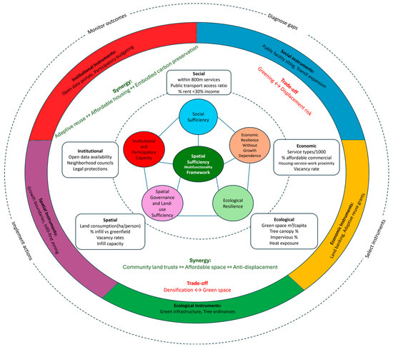
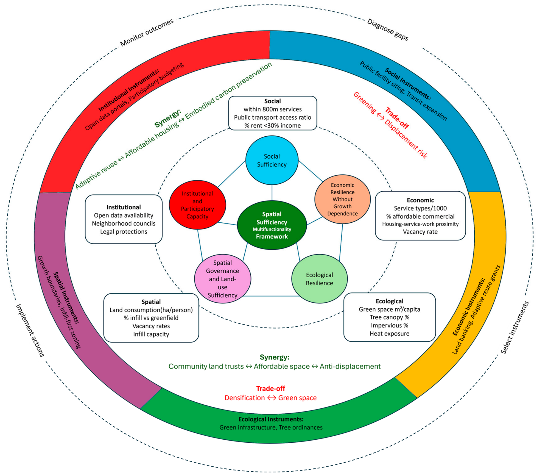
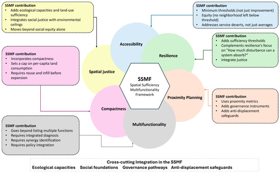
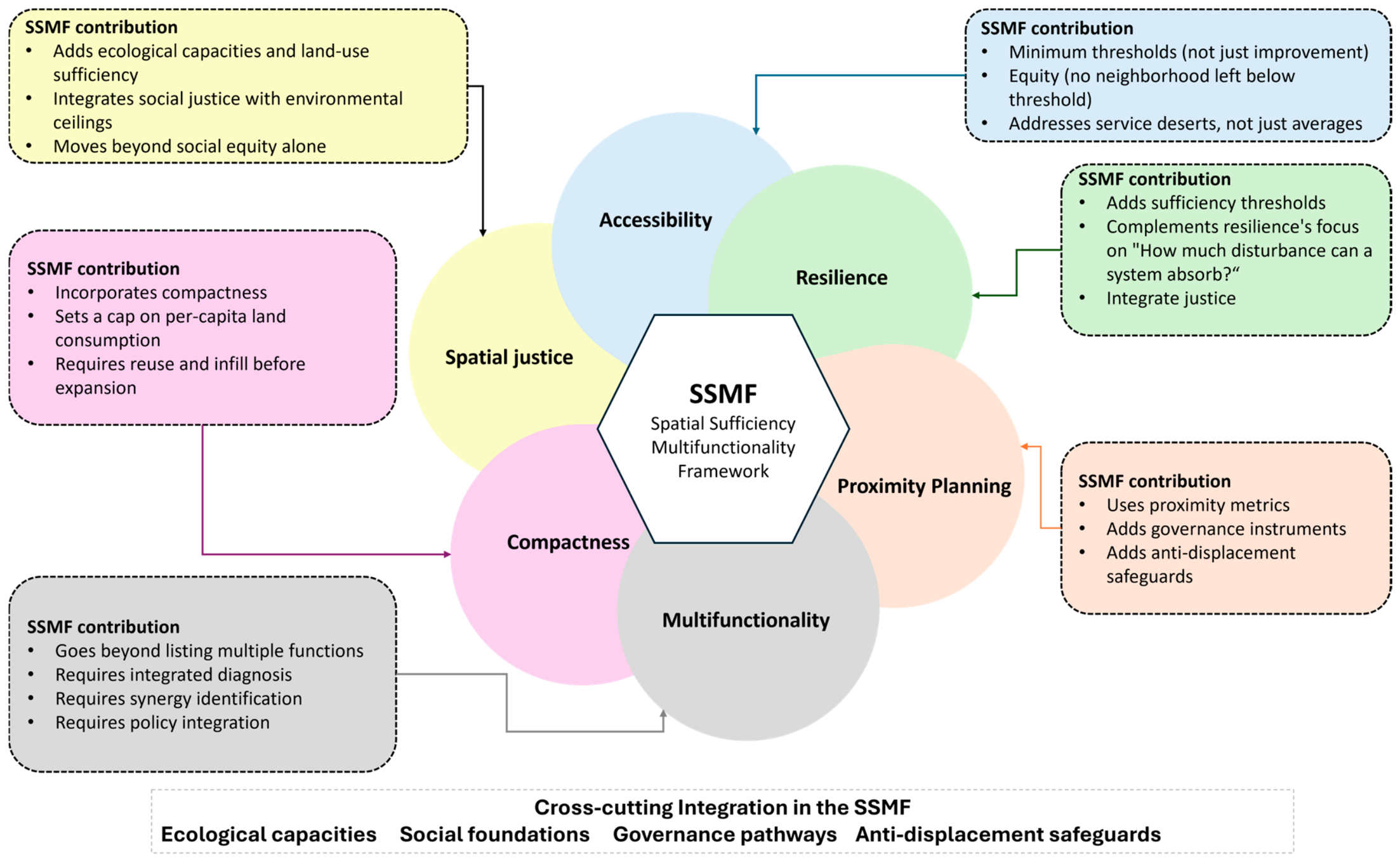
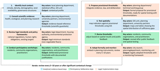
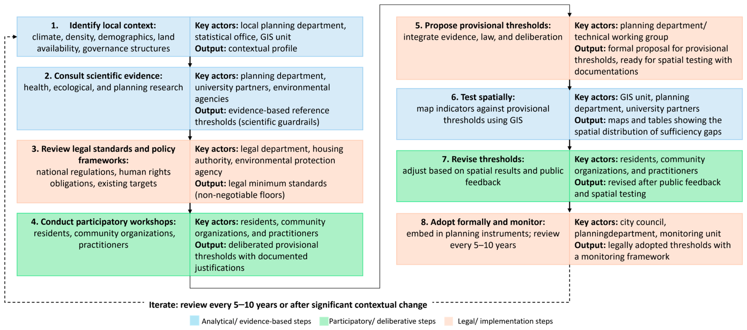
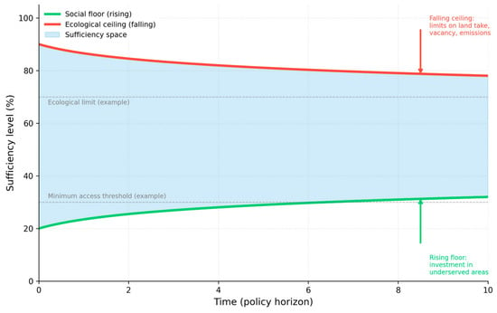
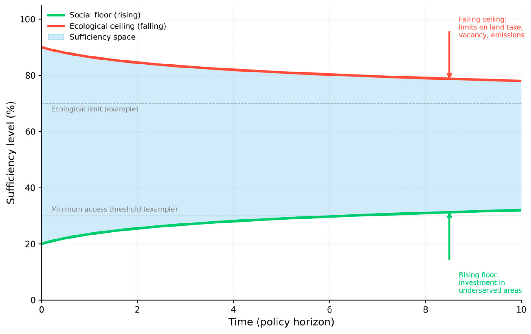
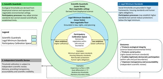
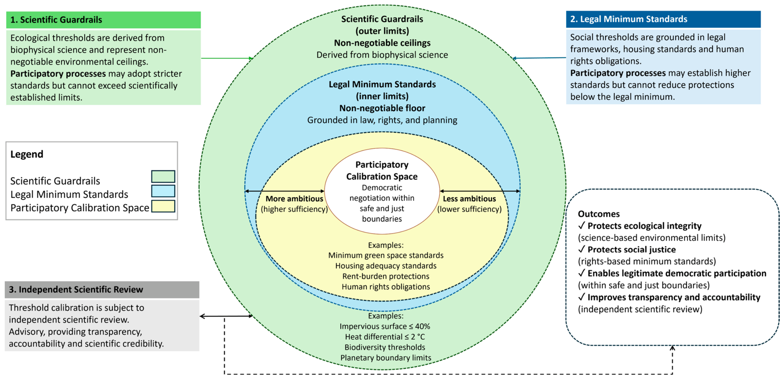
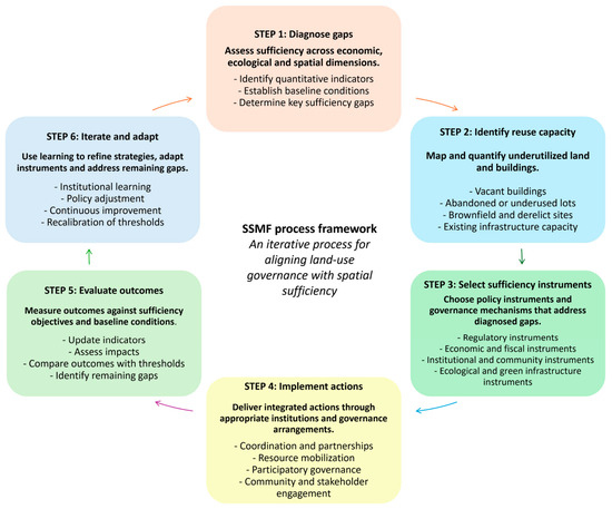
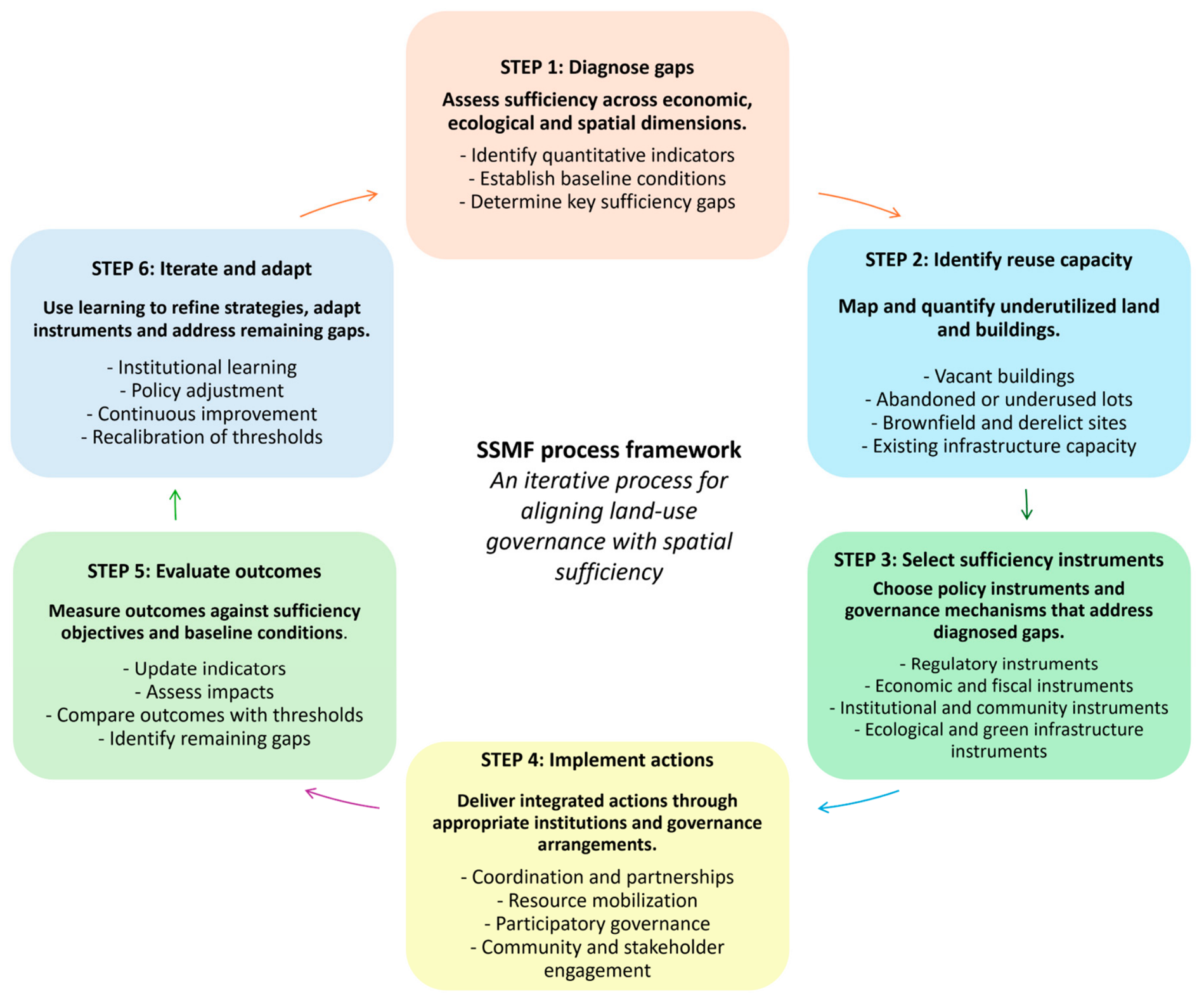
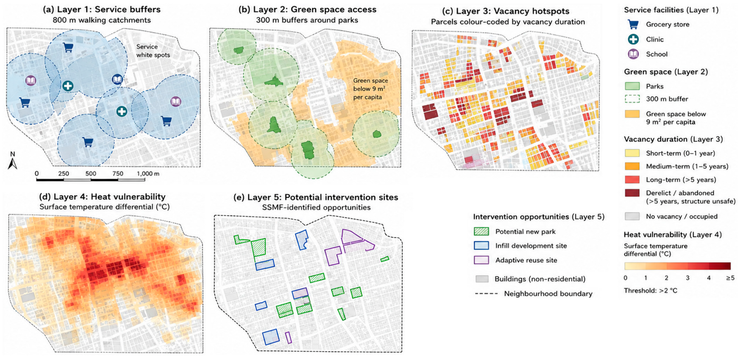

Disclaimer/Publisher’s Note: The statements, opinions and data contained in all publications are solely those of the individual author(s) and contributor(s) and not of MDPI and/or the editor(s). MDPI and/or the editor(s) disclaim responsibility for any injury to people or property resulting from any ideas, methods, instructions or products referred to in the content. |
© 2026 by the author. Licensee MDPI, Basel, Switzerland. This article is an open access article distributed under the terms and conditions of the Creative Commons Attribution (CC BY) license.