


Abstract
Pedestrian accessibility is a key determinant of spatial experience, cultural heritage visibility, and urban integration in historical cities. This study analyzes pedestrian accessibility in Mudurnu—a UNESCO Tentative List site and Cittaslow—using a multi-scale, integrated space syntax approach. By combining axial and segment analyses, statistical validations, and Kernel Density Estimation (KDE), the research examines the relationship between urban morphology and pedestrian movement potential. Spatial data developed through open-access maps and field validations were analyzed via depthmapX 0.8 and QGIS 3.40.11 software. Syntactic indicators—integration, connectivity, choice, and intelligibility—were calculated at global and local scales, alongside synergy and points of interest (POI) correlations. The results indicate that mobility is concentrated along the north–south Bolu–Yıldırım Beyazıt–Ankara axis, while secondary networks in traditional residential areas remain poorly integrated. Low intelligibility (R2 = 0.06) indicates local spatial configurations provide insufficient cognitive guidance, and moderate synergy (R2 = 0.33) suggests partial harmony between scales. Segment and KDE results highlight concentrated mobility, with secondary networks emerging after logarithmic transformation. Consequently, Mudurnu exhibits fragmented accessibility and low legibility. These findings demonstrate that multi-scale space syntax analysis is an effective decision-support tool for pedestrian-oriented planning and sustainable urban design in historical cities.
1. Introduction
Pedestrian accessibility is one of the key determinants of the urban experience and plays a central role in shaping the movement patterns that define the spatial perception of the built environment [1]. Particularly in historic cities, pedestrian mobility is not limited to physical access alone but also directly influences cultural continuity, spatial integration, and the experience of urban identity [2]. In this regard, optimizing accessibility in areas with historical significance through urban design interventions is important not only for enhancing physical connectivity but also for preserving existing cultural identity, fostering pedestrian-friendly tourism destinations, and supporting urban sustainability goals [3]. This approach also aligns with the vision of creating inclusive, safe, and livable cities emphasized by the United Nations Sustainable Development Goals (Goal 11) [4].
Historic cities listed on the UNESCO World Heritage List or Tentative List face significant planning and management challenges in relation to balancing the preservation of their cultural values with contemporary accessibility requirements. Factors such as increasing vehicle use, visitor pressure, and inadequate pedestrian infrastructure can negatively impact accessibility and the user experience in historic environments [2,5,6,7]. This situation complicates the sustainable preservation of cultural heritage sites and their integration into public life [8].
Mudurnu, the focus of this study, is a significant historical settlement that developed along the Silk Road; it was included on the UNESCO World Heritage Tentative List in 2015 under the title “Historical Ahi City” and was awarded the Cittaslow designation in 2018. The city, which is notable for its unique Ottoman urban fabric, traditional residential architecture, and public space layout, is also a significant cultural heritage site [9]. However, as stated in the Mudurnu Cultural Heritage Area Management Plan (2024–2028) [10], insufficient parking, traffic management issues, and deficiencies in pedestrian infrastructure negatively impact walkability in the city. This situation limits the experience of the historic environment and prevents the full realization of the urban space’s potential.
Geographic Information System (GIS)-based spatial analyses, network analyses, and statistical methods based on user perception are widely used in the assessment of pedestrian accessibility [11,12,13]. However, accessibility is a spatial phenomenon too complex to be explained solely by distance-based criteria [14]. For this reason, the space syntax approach, which highlights the impact of spatial configuration on pedestrian movement, has become an important area of research in recent years [15,16,17,18].
A review of the existing literature reveals that studies evaluating pedestrian accessibility using space syntax have increased significantly in recent years. However, the majority of current research focuses on single-scale analyses or a limited number of space syntax indicators. This situation prevents the multi-layered structure of pedestrian mobility from being adequately explained, particularly in historic cities with complex morphological structures. Furthermore, only a limited number of studies in the literature have been found that integrate syntactic indicators with urban functions, tourist attractions, and user experience within a holistic framework. In particular, there is a lack of comprehensive research that simultaneously evaluates the relationships between pedestrian accessibility, spatial configuration, and cultural heritage focal points in historic cities listed on the UNESCO World Heritage Tentative List—integrating axial and segmental analyses, addressing global and local scales concurrently, and linking syntactic indicators with different spatial data layers such as points of interest (POI).
This study aims to address this gap in the literature by analyzing pedestrian accessibility in the historic city center of Mudurnu using a multi-scale and integrated approach within the framework of space syntax theory. In this context, the study aims to identify the effects of the spatial configuration of the historic urban fabric on pedestrian mobility, assess the location and visibility of cultural heritage sites within the spatial accessibility system, and explain these relationships within a multi-layered analytical framework. Accordingly, the research seeks to the study focuses on the following questions: how the spatial configuration of the Mudurnu historic city center affects pedestrian accessibility at global and local scales; how the relationships between the spatial distribution of cultural heritage sites and other points of interest and syntactic indicators are shaped; and which areas are priority intervention zones in the context of accessibility and cultural heritage visibility.
The study is based on a multi-layered, science-based analytical framework that evaluates spatial configurations using numerical simulation models within the context of urban morphology and pedestrian mobility potential. In this regard, the study employs both axial and segmental analyses, evaluating fundamental syntactic indicators such as integration, connectivity, choice, intelligibility, and synergy at both the global and local scales. In the segmental analyses, choice values representing movement potential were analyzed using both raw data and data subjected to logarithmic normalization. The results obtained were integrated with points of interest (POI) data and Kernel Density Estimation (KDE) analyses. Additionally, the characteristic features of spatial patterns were evaluated using statistical distribution measures such as skewness and kurtosis. In this regard, the study not only reveals spatial accessibility patterns in historic cities but also contributes to the development of the walkability literature in historic cities by offering an integrated approach that evaluates the position and visibility of cultural heritage elements within the urban mobility system through syntactic indicators. Furthermore, the findings are expected to provide a scientifically grounded decision-support framework that can guide decision-makers during Mudurnu’s UNESCO World Heritage nomination process.
2. Literature Review
The primary determinant in improving urban accessibility is the creation of pedestrian-friendly environments and the enhancement of walkability [19]. While Gehl [20] addresses accessibility within the framework of urban spatial organization prioritizing pedestrian comfort and spatial interaction [21], Whyte [22] focuses on the impact of micro-scale relationships between individuals and space on public life [23]. These approaches demonstrate that walkability cannot be reduced solely to physical infrastructure but is a multi-layered phenomenon encompassing social, perceptual, and spatial dimensions. Huang et al. [24] also note that walkable street networks support spatial vitality by forming urban axes and, particularly in historic environments, strengthen integration. In evaluating walkability, factors such as the quality of pedestrian infrastructure, land-use diversity, street network density, and connectivity levels, as well as environmental factors determining safety and comfort levels, are taken into account [25]. Furthermore, components such as landscape design and spatial esthetics are factors that influence pedestrian behavior through elements like attractiveness, imaginability, and the perception of safety [26].
The literature on the design of walkable environments proposes various evaluation criteria. Southworth [25] defines walkability in terms of key spatial parameters such as connectivity, transportation integration, land-use diversity, and safety. However, recent studies do not limit walkability to physical access alone but address it within the framework of multidimensional components such as mobility, comfort, safety, diversity, and spatial attractiveness [27,28,29]. In this context, it is emphasized that the urban environment must have spatial qualities that encourage individuals to walk [30]. It is noted that interventions such as ensuring sidewalk continuity, increasing the number of crosswalks, implementing speed control measures, and improving wayfinding systems both enhance safety and promote pedestrian mobility [31,32]. These approaches in the literature demonstrate that pedestrian accessibility can only be assessed through multidimensional and holistic analyses, and that existing issues must be addressed within their spatial context. Especially in historic city centers, walkability is considered a key tool for enhancing the visibility of cultural heritage, supporting public life, and developing sustainable conservation policies [28].
Historic cities listed on the UNESCO World Heritage Tentative List require special sensitivity in terms of accessibility, conservation, and management due to their outstanding universal value [21]. Previous research has reported that these areas face significant spatial challenges due to heavy visitor pressure, increasing motor vehicle use, and uncontrolled urbanization processes [5]. While increasing vehicle density in World Heritage sites in Japan complicates the preservation of the historic fabric [33], unsustainable transportation decisions in Oaxaca negatively impact pedestrian mobility [6]. Similarly, it has been emphasized that inadequacies in pedestrian infrastructure in George Town also limit accessibility (Fan et al., 2024) [34]. These studies clearly demonstrate the necessity of pedestrian-focused planning approaches in historic cities.
Geographic Information System (GIS)-based spatial analyses, network analyses, and statistical methods based on user perception are widely used in the assessment of pedestrian accessibility [11,12,35]. However, accessibility is a spatial phenomenon too complex to be explained solely by distance-based criteria [14]. In this context, the space syntax method stands out as a powerful tool that reveals pedestrian movement potential by analyzing the configurational structure of urban space [30]. The space syntax approach can predict pedestrian flows by analyzing the topological characteristics of the street network and provides an analytical foundation for urban design interventions [36,37]. The decisive influence of factors such as the configuration of the road network, the level of connectivity, and spatial hierarchy on pedestrian behavior increases the method’s importance, particularly in historic environments [38,39,40].
The literature on space syntax provides a robust theoretical and analytical framework for explaining the relationships between spatial configuration and pedestrian movement in historic cities. First used by in the analysis of urban spatial configurations, this approach has demonstrated that urban space is not merely a physical arrangement but also a system that directs movement patterns and social interactions [38]. In other words, spatial configuration can quantitatively measure accessibility by analyzing street networks from a topological perspective and develop models representing pedestrian movement [41]. Within this approach, syntactic indicators such as integration, connectivity, choice, and intelligibility are used as fundamental tools for evaluating urban spatial performance [7]. Through these indicators, the relative position of each street within the network is defined, and pedestrian movement potential can be analytically simulated based on this topological structure [42]. In this regard, space syntax enables the identification of issues in the existing pedestrian landscape and facilitates the generation of predictive and measurable data that can guide design interventions [34].
The effect of spatial configuration on pedestrian behavior is also related to cognitive perception and wayfinding processes. The literature indicates that individuals’ capacity to perceive their environment and navigate is largely shaped by their spatial experience within a radius of approximately 400 m, or in other words, a walking distance of about 5 min [14,25,32,39,43,44]. It is stated that there is a strong relationship between the level of spatial integration at this scale and the density of points of interest (POI), and that axes with high integration values generate more intense pedestrian movement and spatial vitality [39,45]. Particularly in historic environments, such axes stand out as areas where cultural and tourist focal points cluster and form the fundamental components of the urban experience [30].
Empirical studies also support this theoretical framework. Hillier and Hanson [38] demonstrated that axes with high integration values within London’s historical fabric serve as focal points for public mobility. Kubat [17], in his analyses of walled cities in Anatolia, determined that streets with high integration values align with urban cores and areas of intensive public use. In their study of London’s districts with distinct morphological characteristics, Penn et al. [46] identified strong correlations between street network integration values and pedestrian and vehicular movements, thereby quantitatively demonstrating the decisive role of spatial configuration in mobility. Furthermore, the logarithmic transformation approach used in the aforementioned study provides a significant methodological contribution by balancing the variance in spatial data, thereby enhancing the statistical reliability of the analyses.
The space syntax approach is also effectively utilized in conservation, renewal, and tourism-focused planning processes in historic cities. In this context, Eyüboğlu et al. [47] developed urban renewal strategies in Galata, Istanbul, through space syntax analyses. Önder and Gigi [9] demonstrated how spatial organization directs pedestrian mobility in the Historic Peninsula. Similar findings are also noted in the international literature. Mansouri and Ujang [2] showed that tourist movements in Kuala Lumpur are concentrated along axes with high integration values, while Wang et al. [11] demonstrated that the spatial distribution of tourism activities in Nanjing strongly aligns with syntactic indicators. These studies demonstrate that the relationship between urban functions and spatial structure can be made more visible through the combined use of space syntax data with methods such as Kernel Density Estimation (KDE).
In recent years, the integration of space syntax analyses with GIS-based methods has been regarded as a significant methodological advancement [48]. Fan et al. [34] developed design policies aimed at improving pedestrian infrastructure in the George Town UNESCO World Heritage Site by combining space syntax indicators with GIS data. Similarly, Zhang et al. [45] analyzed space syntax and GIS data using a hybrid approach in Beijing’s Qianmen historic district to develop recommendations for enhancing pedestrian mobility. These studies demonstrate that spatial analyses are not merely explanatory but can also serve as decision-support and design-guiding tools. In this context, it is noted that spatial syntax analyses are directly linked to the United Nations Sustainable Development Goals (SDG 11). While segment analysis and walkability-based assessments are linked to SDG 11.2, which aims to develop accessible and safe transport systems [49], integration and legibility indicators are evaluated under SDG 11.4, which envisions the preservation and sustainable use of cultural heritage in historic environments. Additionally, the integration of high-pedestrian-traffic corridors with public open spaces is linked to SDG 11.7, which aims to develop inclusive and accessible public spaces [4,20]. Additionally, Dino et al. [37] and Alemdar and Özkan Özbek [50] have demonstrated that issues such as unplanned growth, spatial fragmentation, and low legibility negatively impact the pedestrian experience in historic cities. In the existing literature, apart from the case studies of Safranbolu, Bursa, and Beypazarı—which holistically address the location and visibility of cultural heritage elements within the spatial accessibility framework—no comprehensive space syntax study has been found that jointly evaluates pedestrian accessibility and the relationships between cultural heritage sites and spatial configurations. This situation highlights the need for new research aimed at a multidimensional assessment of pedestrian accessibility, particularly in historic cities with complex morphological structures.
3. Materials and Methods
3.1. Study Area
The historical center of Mudurnu was selected as the research area for this study. Mudurnu is a district in the province of Bolu, located in Turkey’s Western Black Sea Region. The district center is characterized by a valley-type settlement situated between the Hisar and Kulaklı hills. The study area is located at 30.572 degrees longitude and 40.868 degrees latitude [19]. According to 2025 Turkish Statistical Institute (TurkStat) data, approximately 26% (5036 people) of Mudurnu’s population (19,066 people) lives in the district center [51].
Mudurnu, which developed as a major trade center along the Silk Road throughout history, has a unique urban morphology and a strong spatial organization as a result of this characteristic [52]. Mudurnu’s historic city center was designated as an urban conservation area by Decision No. 1609 dated 15 January 1991, and subsequently placed under legal protection with the approval of the Conservation-Oriented Zoning Plan in 1995 [10,44,52]. The town of Mudurnu, selected as the research area, was included in the UNESCO World Heritage Tentative List in 2015 under the “Ahilik” theme and joined the Cittaslow (Slow City) network in 2018 [10,53]. Due to its conservation status, unique urban fabric, and historical heritage elements, Mudurnu constitutes a suitable sample area for examining the relationship between pedestrian accessibility and spatial experience within the scope of space syntax theory (Figure 1).
Figure 1.
Location of the study area (a), photographs of Mudurnu (b), and historical heritage elements (c).
Mudurnu’s organic urban fabric, shaped by topographical features and its sloping terrain, has led to urban mobility developing along a single main axis (Bolu–Ankara Street) running north–south. A significant portion of the historical points of interest (POIs) are located along this axis. Uncontrolled vehicle parking, particularly observed in areas containing historical points of interest, narrows the usable area of pedestrian walkways and increases vehicle–pedestrian interaction. Wide, irregular intersection connections within the urban fabric weaken the spatial continuity of the street network. A significant number of historical mansions are located in side streets outside the main axis. The sloping topography and limited navigational possibilities affect the accessibility and legibility of these mansions, hindering the spread of tourism activity into the inner streets. Furthermore, operational problems in the management of registered buildings and the lack of informational and directional signs to support legibility also negatively impact the perception of the city from a pedestrian perspective.
3.2. Method
The study was conducted in four main phases: data collection, the creation of a spatial data infrastructure, the performance of syntactic and statistical analyses, and the evaluation of results. In the first phase, open-access spatial data related to the study area were obtained and validated. In the second phase, a multi-layered data infrastructure was established to enable a comprehensive analysis of the relationships between urban morphology, pedestrian mobility potential, and functional concentration. In the third phase, using a dataset specific to the historic city center of Mudurnu, indicators of connectivity, integration, choice, intelligibility, and synergy were analyzed within the framework of space syntax theory. Additionally, the relationships between historical and functional focal points and the spatial network were evaluated. In the final phase, the findings were assessed through an integrated approach, and Mudurnu’s pedestrian mobility potential, spatial organization, and patterns of functional concentration were quantitatively identified (Figure 2).
Figure 2.
Flowchart of study.
3.2.1. Data Processing and Spatial Data Infrastructure
A multi-source dataset was generated for the spatial analyses conducted in this study. The primary data sources consist of OpenStreetMap (OSM) road network data, Google Maps-based spatial data, and up-to-date 1:1000-scale topographic maps. The data validation process was supported by field observations and Google Earth imagery. All data layers were converted to the EPSG:32636 coordinate system to ensure spatial consistency and processed in the QGIS 3.40.11 environment. The urban road network was restructured using “LineString” geometry to suit the analyses. In the creation of axial maps, the “longest sightline” principle of space syntax theory was adopted, and the axes were manually defined based on the longest and unobstructed sightlines to represent the pedestrian perspective. For segment analyses, OSM-based road network data was used; topological errors in the dataset were corrected based on basemap data and field observations to make it suitable for analysis. Additionally, a points of interest (POI) dataset representing the functional structure of the urban system was created. POI data was obtained from OSM, and missing data was supplemented using Google Maps and field observations. The dataset includes public, commercial, and cultural functions located within the urban site boundaries that represent Mudurnu’s historical and socio-cultural structure.
3.2.2. Space Syntax-Based Syntactic Analyses
Axial and segment analyses based on space syntax theory were conducted using depthmapX 0.8 software to evaluate the spatial structure and pedestrian mobility potential of Mudurnu’s historic urban fabric. The analyses examined relationships regarding spatial accessibility, mobility potential, and spatial perception at both the global and local scales. As part of the axial analyses, connectivity, global integration (HHRn), and local integration (HHR3) parameters were calculated to reveal the spatial hierarchy and accessibility structure of the urban system. Accordingly, in Mudurnu, global integration (HHRn) was calculated to determine the accessibility level of the entire city, and local integration (HHR3) was calculated to determine the environmental accessibility within a three-step distance. Subsequently, connectivity was calculated to determine pedestrians’ spatial perception and wayfinding capacity at the local scale. An intelligibility analysis was conducted to determine the relationship between local and global connectivity. In this context, the relationship between connectivity and global integration (Rn) values was evaluated using linear regression analysis, and the coefficient of determination (R2) was calculated. The scatter plot of the obtained distribution was created in the depthmapX 0.8 environments. High R2 values indicate that the urban space is more easily perceived by users and that the spatial organization exhibits a holistic structure [36,38,39,54]. The angular metric segment analysis method was used in segment analyses to model both the sensitivity of pedestrian mobility to changes in direction and physical distance [20,24]. The analyses were conducted at two different scales. Analyses were conducted at the global scale (Rn) to determine the city’s overall spatial structure and main transportation corridors, and at the local scale (R400 m) to determine pedestrian accessibility at the neighborhood level. The 400 m radius used in the local analyses corresponds to the 5 min walking distance widely accepted in the literature [14,21,38,55,56,57,58]. In this context, global and local integration values were calculated using the T1024 parameter in the depthmapX 0.8 environments. A “choice” analysis was conducted to identify potential traffic flows on the urban network. The choice value indicates how frequently a segment is selected among the shortest routes within the network and is considered an important indicator of potential pedestrian and vehicle traffic density [59]. Accordingly, in Mudurnu, choice analyses were conducted at the global scale (Global_T1024_Choice_Rn) to identify major urban movement corridors and strategic transit routes, and at the local scale (T1024_R400_metric) to determine intra-neighborhood pedestrian mobility and alternative shortcut connections. The study also conducted a synergy analysis to determine the level of integration within the urban system at different scales. In this analysis, the synergy value was calculated based on the determination coefficient (R2) between local integration (R400) and global integration (Rn) values. High synergy values indicate that POI points are accessible, that there is a strong alignment between local mobility and the urban structure, and that the system functions holistically. Low synergy values, on the other hand, indicate that the urban fabric is more fragmented or has an organic spatial structure [38]. For the study, to analyze urban morphology in greater detail, outliers dominating the spatial structure based on the results of the Segment_T1024_Global integration analysis were identified by applying rule-based filtering in the QGIS 3.40.11 environment. Accordingly, a threshold value was determined by considering the spatial synergy between global and local integration values and the clustering pattern observed in the distribution graph. The main axes that remained above the determined threshold value and possessed outlier characteristics were filtered; subsequently, these axes were labeled on the map to visualize their spatial distributions. Following this conceptual evaluation, in the final stage of the study, the spatial relationships between the metric choice values obtained from the segment analyses and the POI dataset were examined. By analyzing the effect of choice values obtained at global and local scales on POI distribution, the relationship between mobility potential and functional concentration was quantitatively established. Through this approach, the extent to which the spatial capacity offered by the traditional urban fabric aligns with current usage patterns was assessed.
3.2.3. Statistical Analyses
In this study, statistical analyses were conducted using SPSS Statistics 22.0 software to quantitatively evaluate the relationships among syntactic parameters derived from spatial configuration analyses and to reveal the spatial performance of the urban system. To determine the level of intelligibility, the relationship between the connectivity and integration (Rn) values obtained from axial analyses was examined, and the corresponding R2 value was calculated. Similarly, in the synergy analysis, the relationship between the local and global integration values obtained from segment analyses was evaluated using the R2 coefficient. The R2 values obtained were interpreted based on the threshold values proposed by Hillier [15]. Accordingly, an R2 value above 0.70 indicates a very high level of intelligibility and strong synergy. A value in the 0.40–0.70 range indicates a high and significant relationship, while a value in the 0.30–0.50 range indicates a moderate relationship. An R2 value below 0.20, however, indicates weak coherence and low synergy [15]. Additionally, to enable a comprehensive interpretation of Mudurnu’s spatial structure, descriptive statistics were calculated for all syntactic parameters obtained from axial and segment analyses. In this context, the mean, standard deviation, minimum, and maximum values were determined to reveal the general distribution characteristics of the dataset.
3.2.4. Data Normalization and Kernel Density Analysis
In this study, data normalization was applied because the choice values obtained from space syntax analyses exhibited high variance, and zero values had the potential to introduce errors in logarithmic operations. Accordingly, the choice values obtained at both the global (Choice_Rn) and local scales (Choice_R400) were subjected to a logarithmic transformation. The normalization process was performed in the QGIS 3.40.11 environment using the Log10(Choice + 1) transformation function, as recommended in the literature [59]. This transformation enhances the comparability of analysis results by balancing data distribution, particularly in urban networks with outliers [46]. To assess the relationship between spatial arrangement values and urban functions, syntactic parameters of street segments were transferred to the POI dataset. The “Nearest Neighbor-Based Attribute Join” method was used in this process [43,59]. Therefore, each POI is associated with the spatial layout values of the nearest street segment. To represent the building–street interaction and the visual connection at the pedestrian scale, buffer zones with a 20 m radius were created around the POI points. This distance is accepted in the literature as an appropriate threshold value representing the perception of the immediate surroundings and the facade–public space relationship from the perspective of the pedestrian experience [21,59,60]. However, in Mudurnu’s historical urban structure, characterized by narrow streets, an organic road network, dead-end streets, and traditional Ottoman residential fabric, building–public space relationships and visual interactions can occur over shorter distances. Here, the 20 m buffer distance is used not to represent a complete line of sight, but rather as an analytical approach to assess the interactions with the immediate environment at the pedestrian scale and the relationships that cultural heritage focal points establish with public space. Using the obtained normalized choice values and POI data, Kernel Density Estimation (KDE) analysis was applied to determine spatial density patterns. In the analyses, the bandwidth parameter was set to 250 m to represent the spatial effect of pedestrian accessibility and prevent overgeneralization [34]. As a result of the analyses, Mudurnu’s mobility potential, spatial organization, and functional concentration patterns were analyzed through a comprehensive approach by establishing a quantitative relationship between the spatial structure data obtained from axial and segment analyses and the distribution of POIs.
4. Results
4.1. Axial Analysis
Axial analyses conducted on the urban fabric of Mudurnu reveal that the settlement exhibits a spatial hierarchy and a monocentric organization. The fact that the global integration (HHRn) values range from 0.26 to 1.00 and the average integration value is calculated as 0.2622 ± 0.1691 indicates that the city has a medium-to-low level of global integration on a general scale. However, high integration values concentrated along specific axes form a strong spatial core. According to the analysis results, high integration values are concentrated along the north–south axis extending through Bolu Street–Yıldırım Beyazıt Street–Selahattin Baysal Street (0.33–0.37) (Figure 3). The location of key public and historical POI points such as the Mudurnu District Governor’s Office, City Hall, Yıldırım Beyazıt Mosque, and Hamam along these axes demonstrates that this corridor constitutes the city’s spatial core and main axis. The fact that the highest integration values on a global scale were determined on Ankara Street (0.39) and Hisaraltı Street (1.00), which connects to the Clock Tower, reveals that accessibility is directed toward specific historical focal points. In particular, the high integration capacity of Hisaraltı Street demonstrates that the area around the Clock Tower and Hisar Hill is one of the city’s major spatial focal points. The decrease in integration values observed as one moves from the main thoroughfares toward the inner streets, however, indicates that the historical residential fabric is only partially integrated with the main circulation system. In local integration (HHR3) analyses, values were found to range from 0.64 to 1.96, with the average value rising to 1.046 ± 0.414 (Figure 3). This indicates increased accessibility at the neighborhood scale and the formation of a more distinct hierarchical structure at the micro-spatial scale. High local integration values are particularly concentrated along the Bolu Street–Yıldırım Beyazıt axis–Arasta connection–Meydan Street route. The clustering of key POIs such as the District Governor’s Office, City Hall, Arasta Bazaar, Yıldırım Beyazıt Mosque and Bathhouse, and the Clock Tower along this axis reveals that this area constitutes the strongest pedestrian interaction zone forming the historical core of Mudurnu.
Figure 3.
Axial Integration HHRn (a) and HHR3 (b) (POIs are indicated by numbers in the figure (see Figure 1 for POI names).
In local integration (HHR3) analyses, it was determined that values ranged from 0.64 to 1.96 and that the average value rose to 1.046 ± 0.414 (Figure 3). This increase indicates that accessibility has improved at the neighborhood scale and that a more distinct hierarchical structure has emerged at the microspatial scale. High local integration values are particularly concentrated along the axes running from Bolu Street to the Yıldırım Beyazıt axis, the Arasta connection, and Meydan Street. The clustering of key POIs such as the District Governor’s Office, City Hall, Arasta Bazaar, Yıldırım Beyazıt Mosque and Bathhouse, and the Clock Tower along this axis reveals that this area constitutes the strongest pedestrian interaction zone forming the historical core of Mudurnu. The fact that the streets surrounding the Armutçular, Keyvanlar, Haytalar, and Fuatbeyler Mansions produce low-to-moderate levels of integration indicates that the traditional residential fabric has only a limited connection to the main circulation system. While the Yıldırım Beyazıt Mosque and its surroundings form a strong focal point at the local scale, the fact that the mansion districts remain at a moderate level indicates that these areas have not integrated sufficiently despite their potential. This situation demonstrates that a significant portion of the civil architectural heritage is not sufficiently nourished by pedestrian mobility and carries the risk of spatial fragmentation. In the southern part of the city, the area around Değirmen and Sakalar Streets, connected to Ankara Avenue, forms a secondary local focal point due to the influence of historical structures such as the Bökesoylar and Madanlar Mansions. This area within Hızırfakı Neighborhood serves as a morphological welcome and transition zone for users accessing the city center via Ankara Avenue.
The connectivity analysis conducted to assess the local permeability of the Mudurnu urban network reveals the city’s morphological nodes and areas of spatial isolation. Connectivity values range from one to six, with an average value calculated as 2.47 ± 0.93 (Figure 4). This distribution indicates that the street network exhibits a heterogeneous spatial pattern in terms of connectivity capacity. It was determined that the highest connectivity values are concentrated around Arasta Bazaar, the vicinity of Yıldırım Beyazıt Mosque and Hamam, the Municipal connection axis, and the intersections of Karaaslan Street, Meydan Street, and Beşkavak Street. These areas form strong local transit nodes between the historic core and new development areas. In particular, the positioning of POIs around Arasta Bazaar and the Municipality along high-connectivity axes indicates that these areas possess a strong directional capacity at the local scale. The area surrounding the Yıldırım Beyazıt Mosque and Hamam, meanwhile, stands out as the strongest spatial focal point within the local system. The moderate connectivity observed in the southern part of the city along the Hacı Şakirler Mansion and TOKİ connection axes indicates that these areas serve as secondary local focal points. However, the inability of this connectivity to establish sufficient continuity with the global integration system results in a fragmented accessibility pattern across the city and limits the holistic experience of the historical fabric.
Figure 4.
Connectivity analysis (POIs are indicated by numbers in the figure (see Figure 1 for POI names)).
The results of the intelligibility analysis indicate that Mudurnu exhibits a low level of spatial intelligibility (R2 = 0.06) (Figure 5). This low coefficient of determination reveals that locally perceived spatial configurations fail to provide sufficient cognitive guidance or adequate orientation regarding the city as a whole, thereby resulting in weak spatial legibility. Consequently, navigating and perceiving areas outside the primary axes becomes particularly challenging for first-time visitors. Furthermore, while high connectivity and local integration values are strongly concentrated around the Arasta Bazaar, Yıldırım Beyazıt Mosque, and the Municipality, the failure of this effect to extend into the surrounding neighborhoods underscores the weak spatial continuity between the historic core and secondary street networks.
Figure 5.
Intelligibility analysis.
4.2. Segment Analysis
The results of the Angular Segment Analysis using metric radius, conducted to reveal pedestrian mobility and spatial orientation patterns within Mudurnu’s urban fabric, indicate that the city’s hierarchical transportation network has a decisive influence on pedestrian accessibility. The analyses utilized R400 (local scale) and Rn (global scale) radii. The integrated structure of the urban system was evaluated using Segment T1024 global–local integration and T1024 global–local choice parameters.
An examination of the urban morphology reveals that Mudurnu exhibits a linear urban growth model developing in a north–south direction. In the global Segment T1024 integration analysis, metric integration values were found to range from 4 to 117.4, with a mean integration value of 84 ± 29 (Figure 6a). The highest integration values are concentrated on Bolu Street (122) and its continuation, Yıldırım Beyazıt Street (122). These main axes branch off towards the south along Ankara Street (121) and Ahmet Selahattin Baysal Street (118–120), connecting to various functional focal points. Ankara Street’s connection to the Babas Hot Springs indicates that this axis serves as a cultural and recreational access route. The integration value of Demirciler Street, located within the boundaries of the historic Arasta Bazaar, was calculated as 113.7998, while the integration value of Karaaslan 1 Street, which serves as the connecting axis for the Mudurnu Municipality, was calculated as 113.784. It was observed that integration values decrease in the inner streets behind Demirciler Street and in the minor streets connecting to these axes. It was determined that integration values decrease in the inner streets located behind Demirciler Street and in the capillary streets connecting to these axes. The connection of Ahmet Selahattin Baysal Street to the TOKİ housing areas reflects urban development trends. The fact that Meydan Street and Beşkavak Street (between 110 and 115) exhibit integration values within these development areas demonstrates that there are distinct sub-hubs and centers of attraction with high accessibility potential outside the main axis throughout the city. The lowest integration values, however, were observed in the peripheral axes surrounding Karacakaya Farm.
Figure 6.
T1024 Integration (global (a), R400 (b) (POIs are indicated by numbers in the figure (see Figure 1 for POI names)).
Local-scale R400 integration analyses show that pedestrian mobility is highly concentrated along the historic core. The metric integration values for Segment R400 integration range from 4 to 108, with a mean value of 30.2 ± 15.72 (Figure 5). According to the analysis results, the highest values are concentrated on Bolu Street (101–108) and Yıldırım Beyazıt Street (72.79–91). Karaaslan 1 Street (88.54) and Meydan Street (79.98) are also among the axes with high local integration values (Figure 6b). Additionally, it was observed that local integration values (68.74–72.81) vary in the section where Ahmet Selahaddin Baysal Street diverges from Ankara Street and the axis branches off. The facade visibility and visual focal point effect of the Clock Tower, located at the intersection of these axes, enhance spatial perception and orientation capacity at the pedestrian scale. On Ahmet Selahaddin Baysal Street, at the axis connection corresponding to the Arkeopark location, the local integration value was determined to be (75.63). It was observed that integration values decrease along the connection line between Yıldırım Beyazıt Street and the Archaeopark within the study area, and that spatial continuity exhibits discontinuities along this line (Figure 6b). When examining the spatial distribution of historic mansions, Taş Mektep Street, where the Beyzadeler Mansion is located, forms a strong micro-focal point at the neighborhood scale with an integration value of 75.82. In the narrow streets where registered mansions such as the Keyvanlar, Armutçular, Haytalar, Bökesoylar, Madanlar, and Fuatbeyler are located, it was found that integration values ranged between 30.52 and 68.75. These streets, which exhibit lower integration values compared to Taş Mektep Street and the main thoroughfares, indicate that the secondary thoroughfares lined with historic mansions are only partially integrated into the main pedestrian circulation system, and that a significant portion of the cultural heritage elements remain relatively outside the main pedestrian network.
It has been observed that global and local integration values intersect particularly between the Arasta Bazaar and the Yıldırım Beyazıt Mosque. This area constitutes the core zone where the highest levels of spatial integration in the study area are concentrated. Similarly, the overlap of global and local integration values along Bolu Street and Yıldırım Beyazıt Street indicates that these axes serve as both an intra-city transit corridor and a hub for daily pedestrian circulation. Furthermore, the concentration of the highest integration values along these same axes reveals that spatial mobility is concentrated within specific corridors.
The correlation analysis conducted between global and local integration values reveals a moderate relationship, indicating a partial spatial synergy (R2 = 0.33) (Figure 7). The results of the space syntax analysis indicate that the level of integration of historical axes within the capillary street fabric is lower than that of the main axes, due to the influence of organic street geometry and cul-de-sac morphology. To more clearly highlight the morphological differentiation and visually emphasize the spatial patterns, a threshold value was applied to the T1024 integration values (109.5), and the main axes representing outliers in the distribution were filtered and labeled, as shown in Figure 7a.
Figure 7.
Segment outlier axes (a), Synergy values (b).
When examining the relationship between local integration (R400) and global integration (T1024) in Figure 7b, a moderate level of spatial synergy (R2 = 0.33) was found between the two variables. It is observed that spaces with high accessibility at the local scale do not always fully align with the most integrated parts of the system at the global scale, yet a certain structural relationship exists between them. The clustering pattern observed in the scatter plot reveals that local and global mobility potentials partially work together within Mudurnu’s historic urban fabric, though this relationship is not homogeneous across the entire system.
The results of the global choice analysis reveal that transit potential is not homogeneously distributed across the city, exhibiting a strong spatial polarization concentrated along specific main axes (Figure 8). Global choice values range from 0 to 2,350,670, with a mean value calculated as 371,915 ± 591,327. The highest choice values are concentrated along Bolu Street and Ankara Street. These axes function as the primary spatial corridors directing through- and to-movement dynamics within the city. Key public, commercial, and historical landmarks—such as the Mudurnu District Governorate, the Municipality, various commercial functions, and the Yıldırım Beyazıt Mosque and Bathhouse—are situated along these axes. Particularly, the entrance axis connecting Bolu Street to the District Governorate and the Municipality stands out as the segment with the highest through-movement potential in the system, driven by its public nodes and dense commercial activities. On a global scale, the high choice values generated by the axes housing the Yıldırım Beyazıt Mosque and Bathhouse demonstrate that these structures are not merely historical and cultural landmarks, but also function as spatial regulators directing urban movement flows. The alignment of urban attractors along these corridors underscores their role as primary movement axes organizing the flow of daily life. The choice map indicates that potential movement flows are heavily concentrated on the main axes and spread only marginally into the secondary street network. This spatial configuration reveals that Mudurnu’s circulation system possesses a transit-oriented and hierarchical structure. However, field observations demonstrate that the pressure of vehicle parking, particularly concentrated along these main corridors, restricts pedestrian mobility and negatively impacts the quality of the spatial experience.
Figure 8.
T1024 global choice (a) and T1024 local choice (b) (POIs are indicated by numbers in the figure (see Figure 1 for POI names)).
Conversely, local choice analyses reveal that daily pedestrian mobility is concentrated along specific segments, creating a fragmented movement pattern at the neighborhood scale (Figure 7). Local choice values range from 0 to 5242, with the mean value calculated as 655.76 ± 760.94. The high standard deviation indicates that movement potential across the city is unevenly distributed, with certain axes functioning as dominant transit routes at the local scale. The highest local choice value was recorded on Ahmet Selahattin Baysal Street (5242), followed by Bolu Street (5123). In contrast, the decline in choice values towards the inner streets of the Arasta Bazaar and the areas with traditional residential fabric indicates that these spaces are less frequently selected as pedestrian movement corridors.
This situation reveals that a significant portion of the cultural heritage lies outside the primary walking paths, thereby limiting its experiential potential. Specifically, the low-to-moderate choice values generated by the axes housing the Keyvanlar, Hacı Abdullahlar, Haytalar, and Beyzadeler Mansions indicate that these areas function as local spatial focal points disconnected from the main transit system. When evaluating the overall segment choice pattern, it is evident that potential movement flows in Mudurnu are concentrated along the primary corridors, while the inner streets containing the historic residential fabric exhibit a quieter, decelerated spatial character with lower through-movement potential.
4.3. Statistical Validation
In the segment analyses of Mudurnu’s urban network, the wide distribution range of raw choice values (0–2,350,670) and the high standard deviation necessitated evaluating the data distribution through skewness and kurtosis analyses (Table 1) [46,59]. The findings indicate that the high kurtosis value at the local scale confirms a significant deviation from a normal distribution, demonstrating that movement potential is heavily concentrated along specific axes. Furthermore, the positive skewness observed in both global and local choice distributions reveals that movement flows are accumulated along a limited number of primary corridors. Particularly in the local choice analysis, the high kurtosis value underscores a strong spatial hierarchy and a distinct polarization within the system. This statistical pattern demonstrates that primary axes such as Bolu Street, Yıldırım Beyazıt Street, and Ahmet Selahattin Baysal Street generate high movement potential, whereas the inner streets of the historic residential fabric remain as quiet spatial areas with lower through-movement capacity.
Table 1.
Statistical distribution of global and local choice values.
4.4. Logarithmic Transformation of Global and Local Choice Values and Kernel Density Estimation (KDE)
In the raw global choice analyses, it was determined that Bolu Street and Ankara Street form the primary corridors of the city’s movement network. However, this situation led to the suppression of secondary streets and historic bazaar connections within the analyses. Therefore, to balance data density and enhance the visibility of the secondary street network’s potential, a logarithmic transformation was applied to both global and local choice values. Following the logarithmic transformation, the global choice values were found to range from 0 to 6.37, with a mean value of 4.69 ± 1.40 (Table 2) [59]. Post-transformation, a reduction in the extreme polarization of the data distribution was observed, making the movement networks within the secondary streets more legible (Figure 9). Specifically, the medium-density patterns that emerged around Meydan Street and Yeni Kent Street indicate that these axes generate a secondary level of movement potential. Furthermore, the spatial relationships between primary public attractors—such as Mudurnu State Hospital, BAİBÜ Mudurnu Campus, and the Bus Terminal—and the main axis became more readable. The density pattern formed around the Municipality Building and the Yıldırım Beyazıt Mosque–Bathhouse complex revealed that it constitutes a significant node within the city’s macro-hierarchy. The continuity of choice values at medium and high density levels along the axes where historical points of interest (POIs) cluster post-transformation demonstrates that the movement pattern in Mudurnu is not solely confined to the primary transit corridors, but that the secondary street network also generates a certain degree of spatial vitality.
Table 2.
Logarithmic normalization of global and local choice values.
Figure 9.
T1024 global choice (a) and T1024 local choice (b) after logarithmic transformation (POIs are indicated by numbers in the figure (see Figure 1 for POI names)).
Following the logarithmic transformation at the local scale, the choice values were found to range from 0 to 3.72, with a mean value of 2.50 ± 0.68. Post-transformation, the extreme movement polarization observed in the raw data was mitigated, rendering intra-neighborhood pedestrian accessibility and the micro-spatial movement hierarchy significantly more legible (Figure 8). Historical connections around the Arasta Bazaar, the Clock Tower, and the Ahiler Museum—which initially exhibited low density in the raw data—became prominent as secondary movement axes following the logarithmic transformation. Notably, the increased visibility of the linkages between the Armutçular and Keyvanlar Mansions and the Yıldırım Beyazıt Mosque underscores the formation of a stronger spatial continuity at the neighborhood scale. Furthermore, it is clearly evident that the axes enveloping the Yıldırım Beyazıt Mosque and the focal points situated along these corridors serve as the primary conduits of the city’s cultural heritage. The enhanced prominence of historical streets outside the primary spine on the local logarithmic choice map demonstrates that Mudurnu offers a low-speed yet continuous pedestrian experience aligned with its Cittaslow (slow city) character. This spatial configuration indicates that movement density is not merely confined to the main transit axes, but that intra-neighborhood connections establish an experiential circulation network at the local scale.
Kernel Density Estimation (KDE) analyses, conducted to evaluate the relationship between logarithmically transformed global choice data and POI distribution, highlighted the areas of high and low spatial synergy in Mudurnu (Figure 10).
Figure 10.
High and low spatial synergy areas in Mudurnu.
The KDE maps demonstrate that areas where potential movement density overlaps with historical public functions constitute the city’s spatial centers of attraction. The Arasta Bazaar, the area surrounding the Yıldırım Beyazıt Mosque–Bathhouse complex, and the Municipal area—defined within the ‘Very High’ density class on the map—were identified as the core spatial synergy hubs where pedestrian mobility and historical functions intersect most intensely. The association of traditional residential heritage sites, such as the Haytalar and Fuatbeyler Mansions, with high-accessibility zones demonstrates that the historic fabric continues to maintain its relationship with the active pedestrian movement system today. The distribution pattern obtained post-normalization reveals that Mudurnu does not merely function as a linear transit corridor but generates a multi-layered movement network composed of axes, squares, and intra-neighborhood connections. Specifically, the density clusters formed within the historic core confirm that the city’s Cittaslow (slow city) character is underpinned by robust spatial integration and pedestrian accessibility. Conversely, when evaluated alongside field observations, the vehicle parking pressure particularly concentrated along the Bolu Street–Ankara Street axes, combined with deficiencies in wayfinding and inadequate speed control measures, negatively impacts the pedestrian experience in the historic core. This situation limits the legibility [43] of cultural heritage areas and weakens pedestrian-oriented spatial continuity.
5. Discussion
The findings obtained from this study reveal that Mudurnu’s spatial organization exhibits a monocentric, hierarchical, and partially fragmented accessibility structure. Axial analysis results indicate that global integration is concentrated along a limited number of primary axes, whereas the inner streets constituting the traditional residential fabric fail to integrate adequately into the overall system due to low connectivity and integration values. This finding aligns with studies highlighting that narrow street structures, cul-de-sac morphology, and topographical barriers—particularly observed in organically developed historic cities—weaken spatial continuity [15,44]. In the specific case of Mudurnu, this fragmented structure renders pedestrian movement dependent on certain main axes, while causing secondary streets to remain marginalized both physically and perceptually.
5.1. Intelligibility and Spatial Legibility
The low intelligibility value (R2 = 0.06) obtained from the axial analysis indicates that local spatial relationships in Mudurnu fail to provide pedestrians with adequate cognitive cues regarding the overall layout of the city. As noted by Hillier [15], this low intelligibility value demonstrates a weak correlation between the local spatial experience and the global system. Due to this weak relationship, users experience difficulties in mentally constructing the macro-structure of the city based on the spatial cues available at their immediate location. The low intelligibility value identified in Mudurnu aligns with findings from space syntax studies conducted in traditional Ottoman–Turkish cities. It has been reported that in historically organic cities such as Safranbolu, Beypazarı, and Bursa, intelligibility values range between 0.05 and 0.25, where the labyrinthine street network and irregular spatial patterns weaken the interface between local movement systems and the global spatial structure [61,62,63,64]. In the international literature, intelligibility values have been reported as 0.261 in Tirana [37], 0.20–0.35 in historical Tuscan towns [65], 0.16–0.28 in historical Chinese settlements [11,36], and 0.489 in Nanxun Canal Town [23]. The fact that Mudurnu’s intelligibility value of 0.06 is lower than all of these examples indicates a relatively weaker correlation between the local and global spatial systems. However, this situation should not be evaluated solely as a deficiency in spatial performance. In historically organic settlements, low intelligibility often emerges as a natural consequence of the historical street fabric, topographical adaptation, and distinct morphological character. While the low intelligibility value observed in Mudurnu imposes certain limitations on wayfinding and spatial legibility, from an alternative perspective, it reveals a significant morphological attribute that reflects the authentic character of the historical urban fabric.
5.2. Integration and the Accessibility of Cultural Heritage
The concentration of the accessibility pattern along specific axes in Mudurnu has created disparities between the historical core and the secondary street network. The analysis results demonstrate that high connectivity and local integration values are concentrated around the Arasta Bazaar and the Yıldırım Beyazıt Mosque. This reveals that the specified areas serve not only as focal points of the historical core but also constitute the strongest spatial centers of the system in terms of pedestrian accessibility. Conversely, the failure to sufficiently transmit this integration effect to the surrounding capillary streets leads to a weakened continuity between the historical core and the capillary street network.
Local integration analyses indicate that the axis located at the divergence point of Ahmet Selahaddin Baysal Avenue and Ankara Avenue produces values ranging between 68.74 and 72.81. The Clock Tower, positioned at this point, constitutes a significant focus for guiding pedestrian movement due to its high visibility and strong quality as a spatial reference. Similarly, the Archeopark area stands out as an accessible micro-center with a local integration value of 75.63. The decrease observed in integration values between the Yıldırım Beyazıt axis and the Archeopark demonstrates that the spatial continuity between these two nodes has weakened and the accessibility advantage has been interrupted.
A similar pattern is observed in the distribution of historical mansions. While the 75.82 integration value of Taş Mektep Street, where the Beyzadeler Mansion is located, creates a strong node at the neighborhood scale, integration values in the streets where the Keyvanlar, Armutçular, Haytalar, Bökesoylar, Madanlar, and Fuatbeyler mansions are situated vary between 30.52 and 68.75. This situation indicates that a significant portion of the cultural heritage assets is integrated with the main pedestrian circulation system only to a limited extent, and the historical residential fabric remains secondary in terms of accessibility.
Conversely, Bolu Avenue, Yıldırım Beyazıt Avenue, and Ankara Avenue emerge as prominent axes in terms of both global and local integration. According to space syntax theory, axes with high integration values are evaluated as areas where movement potential is concentrated and different urban functions tend to cluster [15]. In Mudurnu, it is understood that these axes function not merely as transportation corridors but also as spatial nodes where commercial activities, public uses, and cultural heritage elements are concentrated.
As an example of an organic settlement guided by natural topography, Mudurnu’s layout is shaped according to the valley morphology. Rather than the permeable and linear axes of planned cities, this organic structure exhibits a terraced street pattern that meanders according to the slope. Especially in areas where the slope increases, the narrowing, shifting direction, and occasional dead-ends (cul-de-sacs) of the streets lead to a weakened spatial continuity. It has been highlighted in various studies that a similar morphological structure limits global integration and concentrates accessibility patterns along specific axes in historically organic cities [30,65]. This situation aligns with the literature’s findings indicating that low legibility in historical city centers complicates wayfinding processes and renders the spatial experience of users segmented [36,44].
Particularly in historical cities with similar morphological characters, such as Safranbolu, Beypazarı, and Bursa, it is stated that such organic street networks generate strong social relationships at the neighborhood scale and rich spatial experiences at the human scale [66,67]. It is noted that in historic cities with similar morphological characteristics—such as Safranbolu, Beypazarı, and Bursa—such organic street networks foster strong social ties at the local level and create rich, human-scale spatial experiences. The findings obtained in Mudurnu support these evaluations. The fact that the secondary and tertiary streets, where the historical residential fabric is located, produce low integration values is not merely limited to poor accessibility; it is also intrinsically related to the authentic morphological character of the historical urban fabric. The preservation of traditional property boundaries and the original street fabric in historical cities heavily constrains the creation of new connectivity options in terms of accessibility and the reconfiguration of street geometry [3,66].
The spatial fragmentation observed in Mudurnu should not be viewed merely as a planning issue. The organic street system, which has developed in harmony with the topography, should be regarded as a natural consequence of the historic urban morphology shaped by conservation priorities [66,67,68]. Therefore, the low integration and legibility values identified in Mudurnu do not imply that the historic core is spatially or functionally weak. Relatively low levels of accessibility and integration in organic historic urban fabrics can support human-scale spatial relationships, historical identity, social interaction dynamics, and the continuity of public life [20,66,67,69].
As Jacobs [70], Whyte [22], and Gehl [20] have demonstrated, users’ spatial preferences are linked not only to physical connections but also to perceptual continuity, visual wayfinding, and the quality of public space. Therefore, improving pedestrian accessibility in Mudurnu should not be limited to strengthening street connections alone but must be addressed in conjunction with cognitive wayfinding strategies such as wayfinding systems, visual axis continuity, signage elements, and the enhancement of landmarks [43,44]. In particular, visual relationships perceived on a human scale, the interaction between facades and streets, cultural appeal, and the short-distance pedestrian experience also play a decisive role in the formation of public life [20,67,70]. Gehl [20] notes that sensory and visual perception on a human scale reaches its most effective level at a distance of approximately 20–25 m. Therefore, the 20 m buffer zone used around POI points in this study is considered not merely a technical analysis parameter but a contextual threshold representing the human-scale perceptual influence zone within which users experience the historic environment [20,49].
Furthermore, in Mudurnu, the overhanging bay windows of wooden houses and the winding street layout—despite occasionally obstructing sightlines—establish a strong visual connection between the buildings and the street, creating spaces that can be perceived and experienced on a human scale. This situation demonstrates that evaluating pedestrian movement in the historic environment solely through syntactic accessibility indicators is insufficient; it reveals that pedestrian mobility is closely related to architectural character, visual appeal, and the quality of the spatial experience [20,67,70]. Jacobs [70] explains this phenomenon through the concept of the “eyes on the street”. However, at the core of this approach lies the continuity of the building–facade–street relationship. According to Jacobs, the vitality of public life arises from human-scale spatial relationships that allow users to perceive their surroundings, see one another, and engage in social interaction. Therefore, when evaluating spatial performance in historic environments, in addition to indicators of accessibility and integration, the visual experience of the street space, its architectural character, and user perception must also be taken into account [20,22,70].
Throughout this process, to gain a more comprehensive understanding of mobility patterns in Mudurnu, the focus should not be limited to indicators of spatial integration and legibility; it is also necessary to employ choice analyses that reveal users’ route preferences and transit potential. Unlike axial analyses, segment-based choice analyses enable an evaluation of the urban movement system from a more behavioral perspective by considering users’ route choices, direction-changing behaviors, and transit movements [59,71]. This analytical framework is also related to the “Natural Movement Theory,” which explains the capacity of spatial configuration to generate movement. According to this theory, the geometric and topological structure of the street network is one of the fundamental factors directly influencing user movement [39].
5.3. Choice Analysis
Choice analyses indicate that Bolu Street, Yıldırım Beyazıt Street, and Ankara Street form the backbone of the urban mobility system at both the local and global scales. Since the choice value reflects the potential traffic density and route preference probability of an axis within the network, the concentration of high values on specific axes indicates that movement patterns in Mudurnu produce a strong spatial hierarchy. In this context, these axes function not only as circulation corridors but also as spatial centers of attraction where commercial activities, public uses, and cultural heritage sites cluster. This finding confirms that axes with high movement potential tend to attract commercial and public functions over time, as emphasized in Hillier’s [15] Movement Economy approach. The high choice and integration values observed in Mudurnu along the Arasta Bazaar, the Municipal Area, and the Yıldırım Beyazıt Mosque–Hamam axis indicate that these areas are the strongest spatial focal points of the historic core and that urban life is concentrated along these corridors. Similar results have been obtained in studies conducted in UNESCO heritage sites such as George Town and Nanjing, revealing that axes with high syntactic values play a decisive role in the formation of tourist appeal, pedestrian mobility, and urban vitality [11,34].
5.3.1. Statistical Distribution Characteristics and Spatial Polarization
The concentration of mobility potential along specific axes in Mudurnu raises questions about the extent to which this distribution is balanced. Therefore, an examination of the statistical distribution characteristics of the choice values reveals that the spatial mobility system in Mudurnu exhibits a distinct tendency toward polarization. The movement pattern concentrated along central axes is also reflected in the statistical distribution characteristics. The high kurtosis coefficient of 11.62 calculated for local choice (Choice R400) values indicates that movement potential is concentrated on a limited number of main axes and that a distinct spatial hierarchy has formed within the system. Since a search radius of 400 m—representing approximately a five-minute walking distance—is a commonly used threshold value in modeling local movement patterns [49], the high kurtosis value obtained is assessed as a reflection of Mudurnu’s morphological structure rather than a methodological bias.
The weak spatial integration between the linear main traffic spine shaped by the topography and the secondary and tertiary street networks that form the historic residential fabric limits the balanced distribution of traffic throughout the city. As a result, while high traffic volumes concentrate along Bolu Street, Yıldırım Beyazıt Street, and Ankara Street, the organic inner streets generate lower traffic potential. This situation leads to the concentration of traffic flow in specific corridors and a spatial distribution that increasingly exhibits a polarized structure [15,30].
However, the movement pattern concentrated on the main axes due to high kurtosis values can obscure the relative importance of secondary and tertiary street networks within the system. Therefore, to interpret the distribution of movement in a more balanced manner, it must be evaluated using the results of a logarithmic transformation.
5.3.2. Logarithmic Transformation and the Visibility of Movement Networks
As noted in the literature, logarithmic normalization techniques enhance the interpretability of spatial analyses in organic urban fabrics and improve the visibility of movement networks in side streets [7,41,49,59]. In Mudurnu, the increased prominence of streets extending into historic residential areas following the transformation suggests that these axes may function not only as secondary circulation networks but also as potential movement corridors linking cultural heritage areas to the main movement system. Analyses conducted following the logarithmic transformation have shown that historical streets and traditional residential areas, which were previously overshadowed in the raw choice data, actually possess a certain level of pedestrian movement potential. In particular, the increased visibility of streets housing the Haytalar, Fuatbeyler, Armutçular, and Keyvanlar mansions demonstrates that cultural heritage focal points can generate spatial continuity not only along the main axes but also within the historical street network. This finding aligns with studies emphasizing that focusing solely on highly integrated main axes is insufficient for creating sustainable and inclusive pedestrian networks, and that side streets must also be considered as part of the urban mobility system [7,18]. Consequently, the results of the logarithmic transformation reveal that the historic network of narrow streets in Mudurnu are not passive or non-functional spaces, but can be regarded as complementary movement corridors that support the experience of cultural heritage through appropriate spatial connections and wayfinding strategies.
Highlighting the potential role of historic side streets and cultural heritage sites within the mobility system raises the question of the extent to which these spaces can connect with the city’s overall spatial structure. In assessing this relationship, spatial synergy analyses—which measure the harmony between local and global spatial systems—provide a key indicator.
5.4. Spatial Synergy
The moderate spatial synergy value (R2 = 0.33) obtained in this study indicates a partial alignment between the global spatial structure and local pedestrian movement in Mudurnu. According to Hillier [15], high synergy values enable users to develop a stronger spatial perception of the overall city layout based on their immediate local environment. The moderate synergy value identified in Mudurnu reveals that while the urban system is not completely fragmented, a strong spatial continuity between the macro and micro scales has not been fully established. Particularly, the limited integration of internal streets—where the historical residential fabric is located—with the global accessibility system causes a significant portion of cultural heritage sites to remain isolated from the main pedestrian movement network. Similar results have been obtained in studies conducted on organic historical urban fabrics, indicating that low-to-moderate synergy values lead to the concentration of urban vitality along specific axes [11,45,49]. However, the moderate synergy observed in Mudurnu should not be interpreted as an entirely negative condition. On the contrary, this result demonstrates that the historical core maintains a certain degree of relationship with the main movement system, and spatial continuity can be enhanced through appropriate urban design interventions. Strengthening the physical and visual connectivity between the main axes and historical side streets, improving wayfinding systems, and establishing stronger links between cultural points of interest and movement corridors emerge as primary intervention areas that could enhance the alignment between the local and global spatial systems.
These findings obtained from the spatial synergy analyses are also supported by the KDE results, which reveal the distribution of points of interest and pedestrian densities. The high-density clusters observed around the Arasta Bazaar, the Municipality, the Yıldırım Beyazıt Mosque, and the Turkish Bath (Hamam) in Mudurnu indicate that these areas serve as the primary spatial attraction centers of the historical core. Furthermore, the specified nodes coincide with the axes possessing high integration and choice values. This demonstrates a strong relationship between the syntactic analyses and the observed usage densities.
Conversely, the limited dispersion of density into the surrounding historical street network indicates that urban vitality is concentrated within specific nodes, and a significant portion of the historical residential fabric participates in the movement system at a secondary level. This situation shows that spatial attractiveness and pedestrian mobility in Mudurnu are moderately effective in the relationship between local and global systems. It also highlights that urban vitality and pedestrian mobility do not display a homogeneous distribution throughout the city but rather cluster at specific nodes. A similar condition has been reported in numerous studies on historical cities, indicating that pedestrian mobility and public activities concentrate along axes with high syntactic values [11,15,49].
5.5. Kernel Density Estimation and Spatial Attraction Nodes/Centers/Points
KDE analyses in Mudurnu demonstrate that instead of spreading evenly across the city layout, urban vitality and user movements are concentrated within specific nodes. When integrated with points of interest, it is observed that cultural points of interest (POIs) such as the Clock Tower, the Archeopark, the Yıldırım Beyazıt Mosque, and the Arasta Bazaar enhance spatial attractiveness, thereby supporting the concentration of user movements in particular areas. Especially strong visual reference points like the Clock Tower and the Archeopark—defined as landmarks by Lynch [43]—facilitate wayfinding and strengthen spatial perception in the city. This situation shows that movement patterns in historical environments are not solely limited to the configuration of the street network but are also related to nodes carrying cultural attractiveness and symbolic value.
Conversely, the low-density levels observed in secondary street networks, where registered mansions are concentrated, indicate that a significant portion of the cultural heritage assets maintains only a limited relationship with visitor movements. These results underscore the importance of strengthening the physical, visual, and functional connections between cultural heritage nodes and main movement corridors. In this context, the “distributed centrality” approach proposed by Cutini [65] offers a viable strategy aimed at dispersing urban vitality more evenly across the historical environment rather than concentrating it within a single center. Integrating historical side streets into existing movement corridors and reinforcing the spatial continuity between heritage nodes could contribute to a more balanced distribution of pedestrian movements and enable a holistic experience of the historical environment.
5.6. Synthesis
The factors limiting the holistic experience of the historic environment are not limited to spatial configuration alone. Field observations indicate that vehicle–pedestrian interactions exert significant pressure on walkability. In particular, the pressure from traffic and roadside parking, which is concentrated along Bolu and Ankara streets, restricts pedestrian mobility and reduces the quality of the spatial experience in the historic environment. This situation aligns with studies highlighting how vehicle pressure negatively impacts pedestrian accessibility and the quality of public spaces in historic cities [6,33]. Considering Mudurnu’s “Cittaslow” identity, it is clear that a vehicle-priority transportation approach is incompatible with the historic fabric. Therefore, to enhance pedestrian accessibility, it is necessary to implement speed-reducing measures, controlled vehicle access, parking management, and shared space applications on main arteries to mitigate vehicle–pedestrian conflicts, as well as to develop traffic calming strategies [21,55].
In this regard, the historic streets where the Haytalar, Keyvanlar, Armutçular, and Fuatbeyler mansions are located serve as complementary corridors capable of connecting cultural heritage sites to the main circulation system. Pedestrian-priority street layouts, high-quality public space designs, wayfinding elements, and cultural route planning implemented in these areas can enhance the accessibility, legibility, and visibility of the historic environment. Such interventions will prevent cultural heritage sites from being concentrated solely along the main axes, thereby enabling the adoption of a “distributed centrality” approach that encompasses historic side streets and allows for a more balanced distribution of visitor traffic throughout the area.
The findings, obtained from a planning and conservation perspective, indicate the necessity of strengthening the physical and visual connectivity between the historical core and secondary heritage areas [3,72]. In this context, implementing pedestrian-priority transportation approaches [20,25], wayfinding and signage systems that facilitate spatial cognition [43,73], and uninterrupted pedestrian access networks emerge as primary intervention areas that will enhance spatial legibility and the experiential quality of cultural heritage at the human scale. Furthermore, the clustering of movement intensity along specific axes provides local authorities with vital decision-support data for balancing visitor distribution, parking regulations, and public space utilization [67,69]. Mitigating vehicular pressure to support pedestrian mobility will not only increase the quality of urban life but will also directly contribute to the sustainable management of the historical fabric [74,75]. Nevertheless, this study entails certain methodological limitations. The primary constraint of the research is that pedestrian movement potential was predicted through syntactic modeling based on angular metric segment analyses [76]. Additionally, since the study focuses on the current spatial configuration of the historical and registered urban environment, the daily, seasonal, and tourism-oriented temporal variations in pedestrian mobility could not be incorporated into the evaluation. This situation limits the comparison of static syntactic findings with dynamic pedestrian movement data and time-dependent behavioral shifts [77].
In future research to follow this study, it would be beneficial to collect pedestrian movement data based on empirical observations (e.g., counts, tracking studies) and integrate it with spatial pattern analyses [59,78]. In particular, a detailed examination of circulation, route preferences, and momentary movement patterns will contribute to a more comprehensive understanding of spatial behaviors in historic urban fabrics [67,79]. It is anticipated that the findings will serve as a foundation for developing urban design principles and implementation guidelines that support the preservation and sustainable use of historic environments [74,75]. In this regard, the study not only contributes to the analysis of the existing spatial structure but also establishes a research infrastructure capable of guiding future conservation and design decisions.
Based on the findings of the spatial analysis of Mudurnu, the syntactic parameters, morphological characteristics, and identified urban issues are summarized in Table 3.
Table 3.
Comprehensive synthesis of Mudurnu spatial analysis findings.
Taken together with the findings presented in Table 3, the spatial structure of Mudurnu developed around a strong primary backbone. However, local and global accessibility are insufficiently integrated. Based on the findings of the analysis of integration, choice, intelligibility and synergy analyses, while pedestrian movement is concentrated along specific main axes, historical street network and several cultural heritage focal points have limited integration to this movement system. In particular, the clustering of high choice values along certain corridors and the low level of intelligibility reveal a weakened spatial continuity between the historic core and the secondary street network. On the contrary, the KDE and logarithmic normalization results suggest that some historic streets located outside the main axes also have the potential to function as pedestrian movement corridors. This finding highlights the importance of strengthening spatial integration to enhance the visibility, accessibility, and sustainable management of cultural heritage assets.
6. Conclusions
In this study, pedestrian accessibility in the historic city center of Mudurnu, which is on the UNESCO Tentative List, was examined using a multi-scale and integrated approach within the framework of space syntax theory. The syntactic findings obtained explain the decisive role of spatial organization on pedestrian behavior in historic cities by revealing the structural relationships between urban morphology, movement potential, and the experience of cultural heritage through quantitative data. The analysis results indicate that the spatial configuration of Mudurnu is concentrated around a strong primary axis developing along Bolu, Yıldırım Beyazıt, and Ankara Streets (in a north–south direction). Global and local scale integration and choice analyses have revealed that urban movement flow is directed by a limited number of highly permeable axes. In particular, the high kurtosis value (Kurtosis: 11.62) obtained in the local choice analysis confirms that movement potential is not homogeneously distributed, resulting in spatial polarization within the city. While these findings indicate the dominance of a hierarchical accessibility structure in the urban fabric, they also demonstrate spatial segregation due to the weak integration of the secondary street networks, which house the traditional residential fabric, with the primary axes.
The low value (R2 = 0.06) obtained from the intelligibility analysis proves that the structural relationship between local spatial patterns and the city as a whole is weak, and that users struggle to form a strong cognitive map of the entire city based on their street-scale experiences. The moderate relationship (R2 = 0.33) obtained in the synergy analysis indicates a partial alignment between the local and global systems; however, it also shows that this relationship has not reached a sufficient level in terms of spatial continuity and integration. The failure of the strong micro-foci concentrated around the Arasta Bazaar, Yıldırım Beyazıt Mosque, and Clock Tower to integrate into the entirety of the city causes a significant portion of cultural heritage sites to remain outside the main pedestrian circulation network, thereby limiting their experiential potential.
These findings also demonstrate that spatial performance in historic cities cannot be explained solely by indicators of accessibility and integration. In Mudurnu, the experiential qualities offered by visual relationships perceived on a human scale, architectural character, cultural appeal, and the historic street fabric, together with syntactic parameters, play a role in shaping pedestrian movement and public vitality. In the existing settlement, the overhanging eaves of wooden houses extending into the street, the facade–street interaction, and the human-scale visual experience have a significant impact on user movements. Analyses of the 20 m buffer zone, however, reveal that this relationship becomes particularly pronounced around points of cultural interest. Logarithmic transformation and Kernel Density Estimation (KDE) analyses conducted as part of the study balanced the spatial polarization observed in the raw data, revealing that the historic street networks—which were overshadowed in the raw choice analyses—actually possess movement potential at certain levels. The results of the logarithmic transformation indicate that historic side streets have the potential to form complementary movement corridors connecting cultural heritage focal points through appropriate wayfinding, visual continuity, and pedestrian-oriented design interventions.
In conclusion, this study demonstrates that multi-scale analyses based on spatial configuration provide a robust analytical framework for explaining the relationships between pedestrian accessibility, spatial integration, and cultural heritage management in historic cities. The findings align with the low legibility and fragmented spatial integration patterns reported in organic historic cities, while also revealing the impact of Mudurnu’s unique morphological structure on these relationships. Furthermore, logarithmic transformations and density analyses reveal that historic alleys possess a higher mobility potential than appears at first glance and that, with appropriate design interventions, they can form complementary movement corridors connecting cultural heritage focal points. In this regard, the study offers a data-driven decision-support model for developing pedestrian-priority transportation, distributed centrality, sustainable conservation, and visitor management strategies in historic cities listed on the UNESCO Tentative List. The study’s findings contribute to the development of pedestrian-focused transportation policies and public space strategies for local governments and planning agencies. These findings enable conservation experts and site managers to assess the accessibility and visibility of cultural heritage sites, while allowing urban designers to formulate spatial interventions and design decisions for areas with high pedestrian mobility. Furthermore, the study establishes a significant research foundation for future work that will be supported by the integration of advanced spatial analyses based on visibility and isovist.
Author Contributions
The lead author of this study is K.P.K.A. Conceptualization, K.P.K.A. and N.K.; methodology, K.P.K.A.; software, K.P.K.A. and A.İ.A. validation, N.K. and B.K.Y. formal analysis, K.P.K.A.; investigation, K.P.K.A. and N.K.; resources, N.K., K.P.K.A. and B.K.Y.; data curation, K.P.K.A., N.K., and A.İ.A.; writing—original draft preparation, K.P.K.A., N.K. and B.K.Y.; writing—review and editing, N.K. and K.P.K.A., visualization, K.P.K.A. and A.İ.A.; supervision, K.P.K.A. and N.K. All authors have read and agreed to the published version of the manuscript.
Funding
This research received no external funding.
Institutional Review Board Statement
Not applicable.
Informed Consent Statement
Not applicable.
Data Availability Statement
The raw data supporting the conclusions of this article will be made available by the authors on request.
Conflicts of Interest
The authors declare no conflicts of interest.
References
- Yunitsyna, A.; Shtepani, E. Investigating the socio-spatial relations of the built environment using the space syntax analysis—A case study of Tirana city. Cities 2023, 133, 104147. [Google Scholar] [CrossRef] [Scilit]
- Mansouri, M.; Ujang, N. Space syntax analysis of tourists’ movement patterns in the historical district of Kuala Lumpur, Malaysia. J. Urban. Int. Res. Placemaking Urban Sustain. 2017, 10, 163–180. [Google Scholar] [CrossRef] [Scilit]
- Bandarin, F.; Van Oers, R. The Historic Urban Landscape: Managing Heritage in an Urban Century; Wiley-Blackwell: Hoboken, NJ, USA, 2012. [Google Scholar]
- Chen, D.; Wang, R.; Xiao, Y. Enhancing cultural heritage accessibility through space syntax: A case study of the archaeological site of the wooden water gate of southern Yue State. J. Asian Archit. Build. Eng. 2025, 1–18. [Google Scholar] [CrossRef] [Scilit]
- Körmeçli, P.Ş. Accessibility of urban tourism in historical areas: Analysis of UNESCO World Heritage Sites in Safranbolu. Sustainability 2024, 16, 2485. [Google Scholar] [CrossRef] [Scilit]
- Barrera-Fernández, D.; Hernández-Escampa, M. Walkability in the historic city of Oaxaca, Mexico. Event Manag. 2019, 23, 573–598. [Google Scholar] [CrossRef] [Scilit]
- Zaleckis, K.; Doğan, H.A.; Arce, N.L. Evaluation of the Interventions to Built Heritage: Analysis of Selected Façades of Kaunas by Space Syntax and Sociological Methods. Sustainability 2022, 14, 4784. [Google Scholar] [CrossRef] [Scilit]
- Yıldırım, A.E. Urban Conservation Projects and Governance: An Investigation Toward Developing Applicable Organizational Models for Turkey’s Historic Towns Through the Cases of Gaziantep, Kuşadası and Mudurnu. Ph.D. Thesis, Ankara University, Ankara, Türkiye, 2011. [Google Scholar]
- Önder, D.E.; Gigi, Y. Reading urban spaces by the space-syntax method: A proposal for the South Haliç Region. Cities 2010, 27, 260–271. [Google Scholar] [CrossRef] [Scilit]
- Yıldırım, A.E. Mudurnu Kültürel Miras Alanı Yönetim Planı 2014–2018: Özet bilgiler. Mudurnu Belediyesi, 2014, 1–20. Available online: https://terramudurnu.com/wp-content/uploads/2024/02/Mudurnu-KMAYP-Kitapcik_Ozet-Bilgiler-20141015k.pdf (accessed on 23 June 2026).
- Wang, M.; Yang, J.; Hsu, W.-L.; Zhang, C.; Liu, H.-L. Service facilities in heritage tourism: Identification and planning based on space syntax. Information 2021, 12, 504. [Google Scholar] [CrossRef] [Scilit]
- Ewing, R.; Handy, S. Measuring the unmeasurable: Urban design qualities related to walkability. J. Urban Des. 2009, 14, 65–84. [Google Scholar] [CrossRef] [Scilit]
- Taşkıran, A.A.; Binan, C.Ş. UNESCO World Heritage List and Transboundary Serial Heritage Concept: The Potential of Turkey. Megaron 2020, 15, 67–83. [Google Scholar] [CrossRef] [Scilit]
- Wang, F.; Xu, Y. Estimating O–D travel time matrix by Google Maps API: Implementation, advantages, and implications. Ann. GIS 2011, 17, 199–209. [Google Scholar] [CrossRef] [Scilit]
- Hillier, B. Space Is the Machine: A Configurational Theory of Architecture; Cambridge University Press: Cambridge, UK, 1996; pp. 161–169. [Google Scholar]
- Koohsari, M.J.; Mavoa, S.; Villanueva, K.; Sugiyama, T.; Badland, H.; Kaczynski, A.T.; Owen, N.; Giles-Corti, B. Public open space, physical activity, urban design and public health: Concepts, methods and research agenda. Health Place 2015, 33, 75–82. [Google Scholar] [CrossRef] [Scilit] [PubMed]
- Kubat, A.S. The morphological characteristics of Anatolian fortified towns. Environ. Plan. B Plan. Des. 1997, 24, 95–123. [Google Scholar] [CrossRef] [Scilit]
- Shakibamanesh, A.; Karimian, B. Utilizing space syntax techniques to understand the relationship between spatial configuration and walkability in urban neighborhoods (Case study: Valiasr neighborhood, Tehran). Urban Plan. Constr. 2024, 2, 40–54. [Google Scholar] [CrossRef] [Scilit]
- Şahin Körmeçli, P. Analysis of walkable street networks by using the space syntax and GIS techniques: A case study of Çankırı City. ISPRS Int. J. Geo-Inf. 2023, 12, 216. [Google Scholar] [CrossRef] [Scilit]
- Gehl, J. Cities for People; Island Press: Washington, DC, USA, 2010; pp. 1–288. [Google Scholar]
- Guzmán, P.C.; Pereira Roders, A.R.; Colenbrander, B.J.F. Measuring links between cultural heritage management and sustainable urban development: An overview of global monitoring tools. Cities 2017, 60, 192–201. [Google Scholar] [CrossRef] [Scilit]
- Whyte, W.H. The Social Life of Small Urban Spaces; The Conservation Foundation: Washington, DC, USA, 1980; pp. 1–125. [Google Scholar]
- Xu, Y.; Rollo, J.; Esteban, Y. Evaluating experiential qualities of historical streets in Nanxun canal town through a space syntax approach. Buildings 2021, 11, 544. [Google Scholar] [CrossRef] [Scilit]
- Huang, J.; Hu, X.; Wang, J.; Lu, A. How diversity and accessibility affect street vitality in historic districts? Land 2023, 12, 219. [Google Scholar] [CrossRef] [Scilit]
- Southworth, M. Designing the walkable city. J. Urban Plan. Dev. 2005, 131, 246–257. [Google Scholar] [CrossRef] [Scilit]
- Basu, N.; Oviedo-Trespalacios, O.; King, M.; Kamruzzaman, M.; Haque, M.M. The influence of the built environment on pedestrians’ perceptions of attractiveness, safety and security. Transp. Res. Part F Traffic Psychol. Behav. 2022, 87, 203–218. [Google Scholar] [CrossRef] [Scilit]
- Frank, L.D.; Sallis, J.F.; Conway, T.L.; Chapman, J.E.; Saelens, B.E.; Bachman, W. Many pathways from land use to health: Associations between neighborhood walkability and active transportation, body mass index, and air quality. J. Am. Plan. Assoc. 2006, 72, 75–87. [Google Scholar] [CrossRef] [Scilit]
- Masoumzadeh, S.; Pendar, H. Walking as a medium of comprehending contextual assets of historical urban fabrics. Urban Res. Pract. 2021, 14, 50–72. [Google Scholar] [CrossRef] [Scilit]
- Manzolli, J.A.; Oliveira, A.; Neto, M.C. Evaluating walkability through a multi-criteria decision analysis approach: A Lisbon case study. Sustainability 2021, 13, 1450. [Google Scholar] [CrossRef] [Scilit]
- Karimi, K. A configurational approach to analytical urban design: ‘Space syntax’ methodology. Urban Des. Int. 2012, 17, 297–318. [Google Scholar] [CrossRef] [Scilit]
- Caisarina, İ.; Harahap, S.A.; Rani, H.A. Pedestrian and its safety in historical area of Banda Aceh: An observation. In Proceedings of the 3rd International Conference on Rebuilding Place (ICRP2018), Banda Aceh, Indonesia, 13–14 September 2018; pp. 199–206. Available online: https://icrp2018.wixsite.com/icrp18 (accessed on 20 April 2026).
- Ercan, M.A.; Belge, Z.S. A micro-scale walkability model for more livable cities. METU J. Fac. Archit. 2017, 34, 234–265. [Google Scholar] [CrossRef] [Scilit]
- Yuan, K.; Abe, H.; Otsuka, N.; Yasufuku, K.; Takahashi, A. A comprehensive evaluation of walkability in historical cities: The case of Xi’an and Kyoto. Sustainability 2023, 15, 5525. [Google Scholar] [CrossRef] [Scilit]
- Fan, M.; Hedayati Marzbali, M.; Abdullah, A.; Maghsoodi Tilaki, M.J. Using a space syntax approach to enhance pedestrians’ accessibility and safety in the historic city of George Town, Penang. Urban Sci. 2024, 8, 6. [Google Scholar] [CrossRef] [Scilit]
- Şahin Körmeçli, P. Evaluating accessibility of street network in neighborhood by space syntax method: The case of Çankırı. ICONARP Int. J. Archit. Plan. 2023, 11, 625–649. [Google Scholar] [CrossRef] [Scilit]
- Xu, Y.; Rollo, J.; Jones, D.S.; Esteban, Y.; Tong, H.; Mu, Q. Towards sustainable heritage tourism: A space syntax-based analysis method to improve tourists’ spatial cognition in Chinese historic districts. Buildings 2020, 10, 29. [Google Scholar] [CrossRef] [Scilit]
- Dino, I.G.; Griffiths, S.; Karimi, K. The space syntax of the design process. In Proceedings of the 11th International Space Syntax Symposium, Lisbon, Portugal, 3–7 July 2017; Karimi, K., Ed.; IST Press: Lisbon, Portugal, 2017; pp. 147.1–147.16. [Google Scholar]
- Hillier, B.; Hanson, J. The Social Logic of Space; Cambridge University Press: Cambridge, UK, 1984; pp. 1–281. [Google Scholar]
- Hillier, B.; Penn, A.; Hanson, J.; Grajewski, T.; Xu, J. Natural movement: Or, configuration and attraction in urban pedestrian movement. Environ. Plan. B Plan. Des. 1993, 20, 29–66. [Google Scholar] [CrossRef] [Scilit]
- Porta, S.; Crucitti, P.; Latora, V. The network analysis of urban streets: A primal approach. Environ. Plan. B Plan. Des. 2006, 33, 705–725. [Google Scholar] [CrossRef] [Scilit]
- Barthelemy, M. From paths to blocks: New measures for street patterns. Environ. Plan. B Urban Anal. City Sci. 2017, 44, 256–271. [Google Scholar] [CrossRef] [Scilit]
- Arslan, H.D.; Ergener, H. Comparative analysis of shopping malls with different plans by using space syntax method. Ain Shams Eng. J. 2023, 14, 102063. [Google Scholar] [CrossRef] [Scilit]
- Lynch, K. The Image of the City; MIT Press: Cambridge, MA, USA, 1960; pp. 1–194. [Google Scholar]
- Long, Y.; Baran, P.K. Does intelligibility affect place legibility? Understanding the relationship between objective and subjective evaluations of the urban environment. Environ. Behav. 2012, 44, 616–640. [Google Scholar] [CrossRef] [Scilit]
- Zhang, W.; Wang, P.; Chen, Y.; Sheng, Q.; Zhang, W.; Zheng, J.; Chen, S. Renovation design of an urban historic district based on space syntax: A case study of the Qianmen area in Beijing. Buildings 2026, 16, 226. [Google Scholar] [CrossRef] [Scilit]
- Penn, A.; Hillier, B.; Banister, D.; Xu, J. Configurational modelling of urban movement networks. Environ. Plan. B Plan. Des. 1998, 25, 59–84. [Google Scholar] [CrossRef] [Scilit]
- Eyüboğlu, E.; Kubat, A.S.; Ertekin, Ö. A New urban planning approach for the regeneration of an historical area within Istanbul’s central business district: Practice note. J. Urban Des. 2007, 12, 295–312. [Google Scholar] [CrossRef] [Scilit]
- Sirjani, A. Assessing Urban Walkability: A Space Syntax Evaluation of Public Space Design. Ph.D. Thesis, Budapest University of Technology and Economics, Doctoral School of Architecture, Budapest, Hungary, 2024. [Google Scholar]
- Van Nes, A.; Yamu, C. Introduction to Space Syntax in Urban Studies; Springer Nature: Cham, Switzerland, 2021. [Google Scholar]
- Alemdar, Ö.; Özkan Özbek, M. Examination of the relationships between pedestrian mobility and land use with space syntax and wayfinding methods in Kadıköy Historical Center. J. Archit. Sci. Appl. 2021, 6, 77–96. [Google Scholar] [CrossRef] [Scilit]
- Turkish Statistical Institute (TurkStat). Address Based Population Registration System (ABPRS) Results 2025. 2026. Available online: https://www.tuik.gov.tr (accessed on 10 May 2026).
- Koçan, N. Historical urban protection and example of Mudurnu (Bolu). Ordu Univ. J. Sci. Technol. 2012, 2, 93–102. [Google Scholar]
- Kırmacı, E.; Bilici, N.S. Local residents’ perception of and support for tourism in cittaslow destinations: The case of Mudurnu. Int. Anatol. J. Soc. Sci. 2026, 10, 97–112. [Google Scholar] [CrossRef] [Scilit]
- Longley, P.A.; Goodchild, M.F.; Maguire, D.J.; Rhind, D.W. Geographic Information Systems and Science, 4th ed.; Wiley: Hoboken, NJ, USA, 2015. [Google Scholar]
- Pereira Roders, A. The historic urban landscape approach in action: Eight years later. In Reshaping Urban Conservation: The Historic Urban Landscape Approach in Action; Pereira Roders, A., Bandarin, F., Eds.; Springer: Singapore, 2019; Volume 2, pp. 21–54. [Google Scholar] [CrossRef] [Scilit]
- Karamitov, K.; Antonova, D.P. Pedestrian accessibility assessment using spatial and network analysis: A case of Sofia city. Int. Arch. Photogramm. Remote Sens. Spat. Inf. Sci. 2022, 48, 53–60. [Google Scholar] [CrossRef] [Scilit]
- Duany, A.; Plater-Zyberk, E. Towns and Town-Making Principles; Rizzoli: New York, NY, USA, 1991. [Google Scholar]
- Calthorpe, P. The Next American Metropolis: Ecology, Community, and the American Dream; Princeton Architectural Press: New York, NY, USA, 1993; pp. 1–160. [Google Scholar]
- Al-Sayed, K.; Turner, A.; Hillier, B.; Iida, S.; Penn, A. Space Syntax Methodology, 4th ed.; Bartlett School of Architecture, UCL: London, UK, 2014. [Google Scholar]
- Choi, J.; Lee, E.; Roberts, D.C. Reshaping tribal road network using public information. J. Geogr. Inf. Syst. 2014, 6, 594–604. [Google Scholar] [CrossRef]
- Kubat, A.S.; Özer, Ö. Investigation and evaluation of the impacts of the proposals related with the Golden Horn Cultural Valley Project on Galata area. İTÜ Derg. Seri A Mimar. Plan. Tasarım. 2008, 7, 85–98. [Google Scholar]
- Özer, Ö.; Kubat, A.S. Walkability: Perceived and measured qualities in action. A|Z ITU J. Fac. Archit. 2014, 11, 101–117. [Google Scholar]
- Topçu, M.; Kubat, A.S. Morphological comparison of two historical Anatolian towns. In Proceedings, 6th International Space Syntax Symposium; İstanbul Technical University: İstanbul, Türkiye, 2007. [Google Scholar]
- Çelik, Z. The Remaking of Istanbul: Portrait of an Ottoman City in the Nineteenth Century (No. 2); University of California Press: Berkeley, CA, USA, 1993. [Google Scholar]
- Cutini, V. Centrality and land use: Three case studies on the configurational hypothesis. Cybergeo Eur. J. Geogr. 2001, 188, 1–26. [Google Scholar] [CrossRef] [Scilit]
- Kropf, K. Urban tissue and the character of towns. Urban Des. Int. 1996, 1, 247–263. [Google Scholar] [CrossRef] [Scilit]
- Ujang, N. Place attachment and continuity of urban place identity. Procedia-Soc. Behav. Sci. 2012, 49, 156–167. [Google Scholar] [CrossRef] [Scilit]
- Conzen, M.R.G. Alnwick, Northumberland: A study in town-plan analysis. In Institute of British Geographers Publication No. 27; George Philip: London, UK, 1960; pp. 1–122. [Google Scholar]
- Hillier, B.; Vaughan, L. The city as one thing. Prog. Plan. 2007, 67, 205–230. [Google Scholar]
- Jacobs, J. The Death and Life of Great American Cities; Random House: New York, NY, USA, 1961. [Google Scholar]
- Özbek, M.Ö.; Ertürk, F.; Çelebi, T.T.; Kınacı, Y.; Caymaz, G.F.Y. Interpretations and comparisons of pedestrian movement and land use activities in Kadıköy region using space syntax method. Str. Art. Urban Creat. 2022, 8, 48–61. [Google Scholar] [CrossRef] [Scilit]
- Trancik, R. Finding Lost Space: Theories of Urban Design; Van Nostrand Reinhold: New York, NY, USA, 1986. [Google Scholar]
- Arthur, P.; Passini, R. Wayfinding: People, Signs, and Architecture; McGraw-Hill: New York, NY, USA, 1992. [Google Scholar]
- Orbaşlı, A. Architectural Conservation: Principles and Practice; Blackwell Publishing: Oxford, UK, 2008. [Google Scholar]
- Rodwell, D. Conservation and Sustainability in Historic Cities; Blackwell Publishing: Oxford, UK, 2007. [Google Scholar]
- Hillier, B.; Iida, S. Network and psychological effects in urban movement. In Spatial Information Theory: International Conference, COSIT 2005, Ellicottville, NY, USA, 14–18 September 2005; Cohn, A.G., Mark, D.M., Eds.; Lecture Notes in Computer Science; Springer: Berlin/Heidelberg, Germany, 2005; Volume 3693, pp. 475–490. [Google Scholar] [CrossRef] [Scilit]
- Bafna, S. Space syntax: A brief introduction to its logic and analytical techniques. Environ. Behav. 2003, 35, 17–29. [Google Scholar] [CrossRef] [Scilit]
- Penn, A. Space syntax and spatial cognition: Or why the axial line? Environ. Behav. 2003, 35, 30–65. [Google Scholar] [CrossRef] [Scilit]
- Marcus, L. Spatial capital and how to measure it: An outline of an analytical theory of the social performativity of urban form. In Proceedings of the 6th International Space Syntax Symposium; İstanbul Technical University: İstanbul, Türkiye, 2007; pp. 5.1–5.11. Available online: https://urn.kb.se/resolve?urn=urn:nbn:se:kth:diva-53316 (accessed on 14 May 2026).
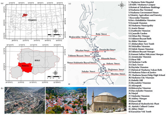
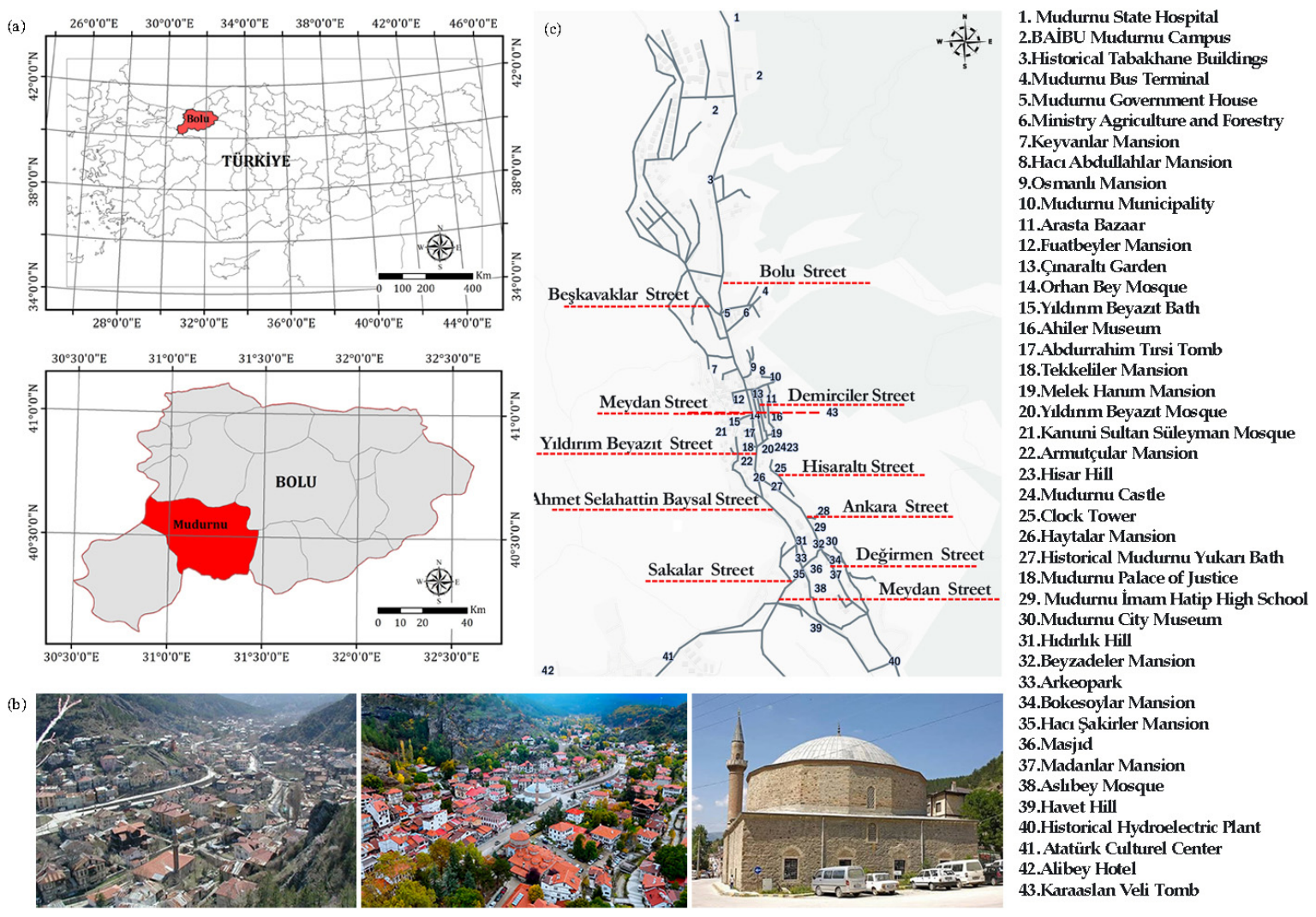
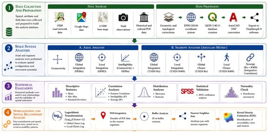
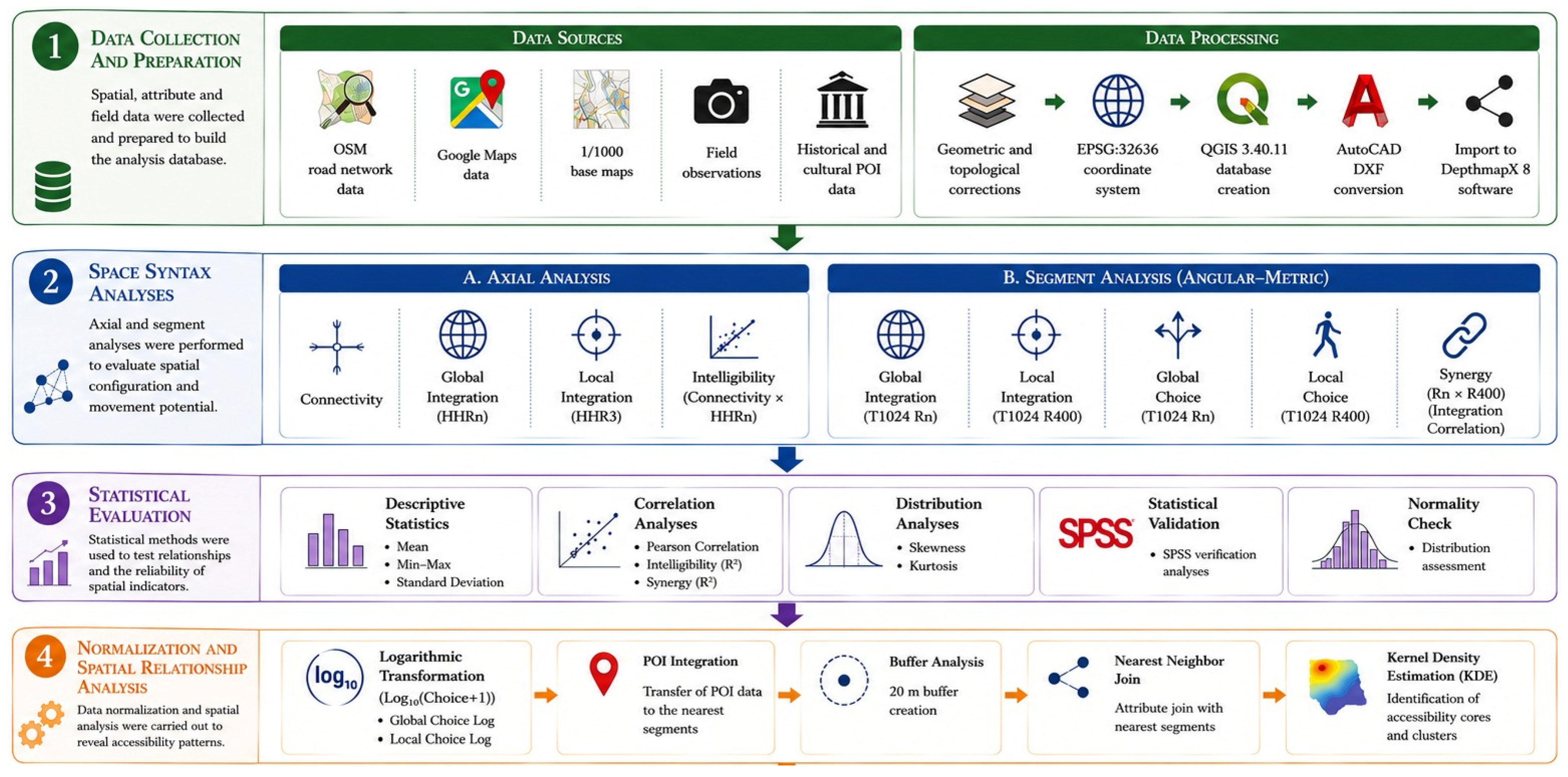
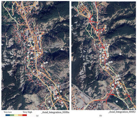
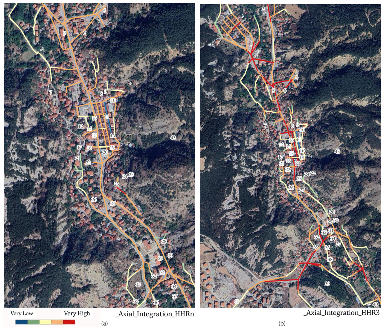
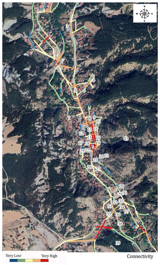
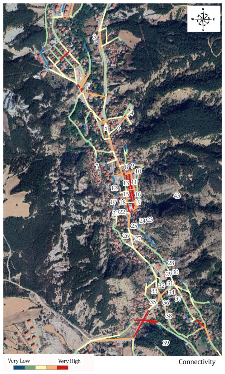
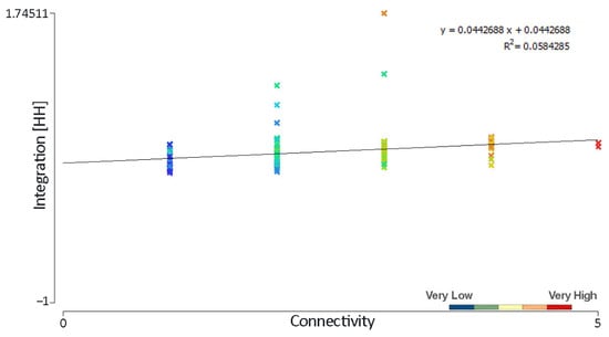
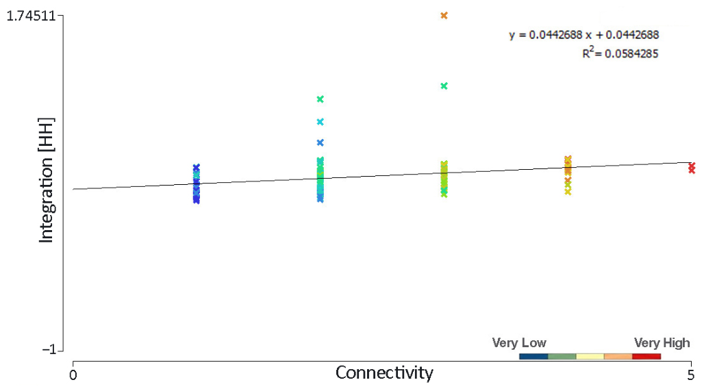
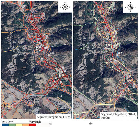
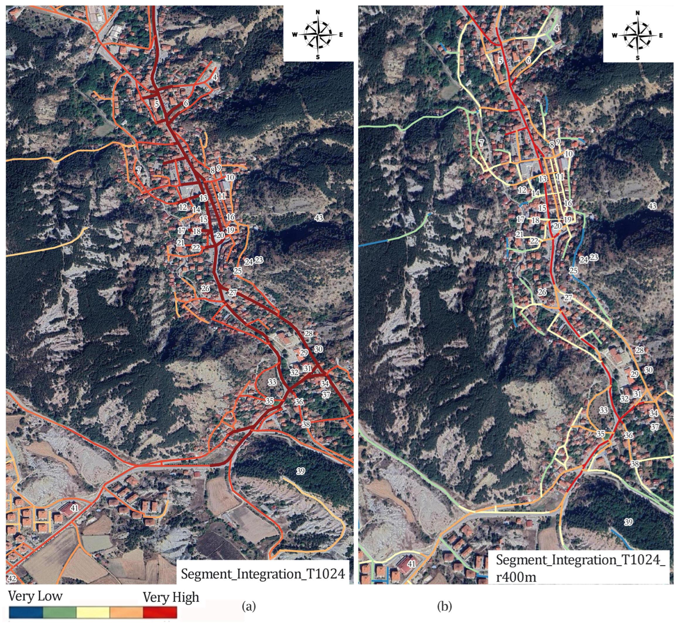
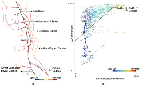
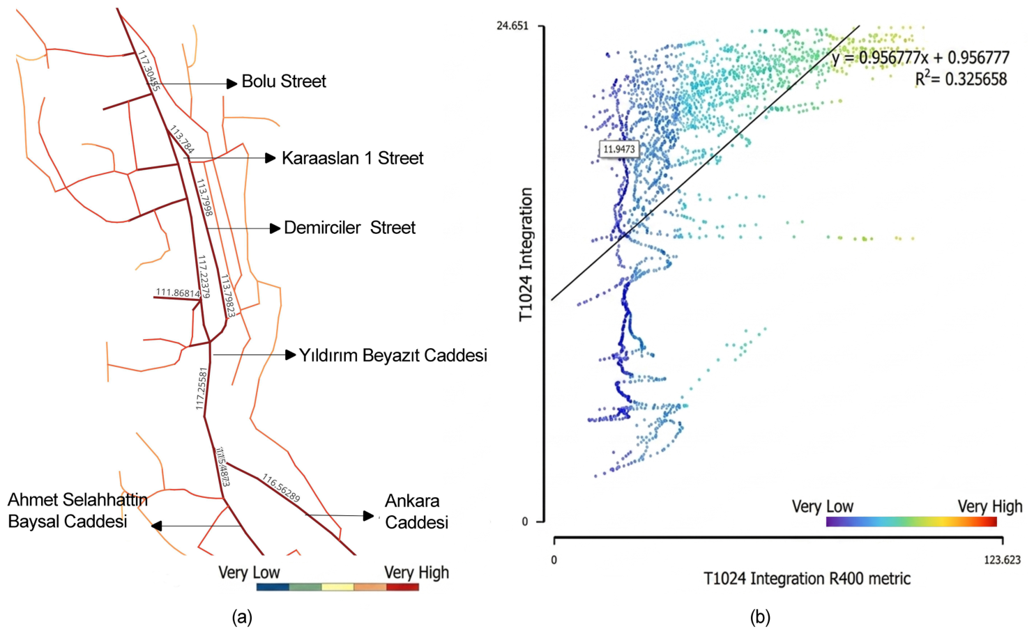
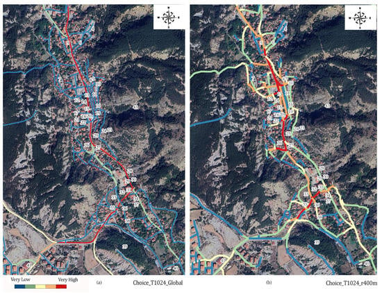
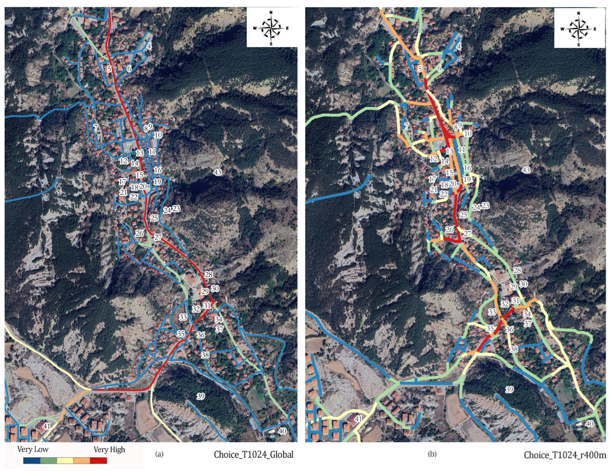
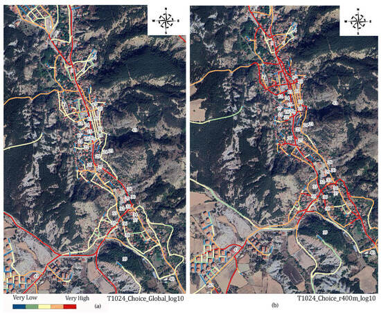
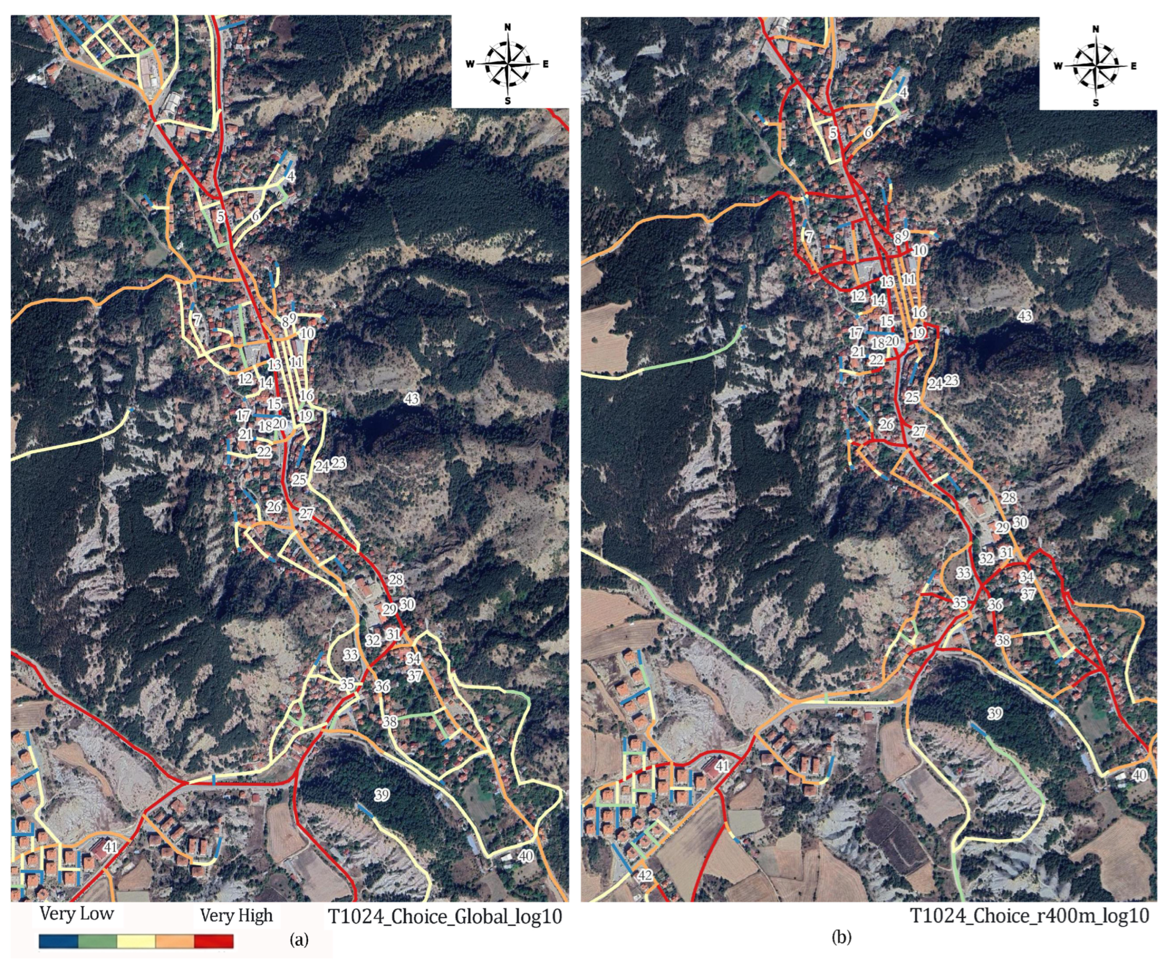
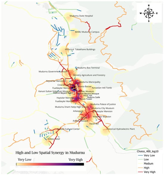
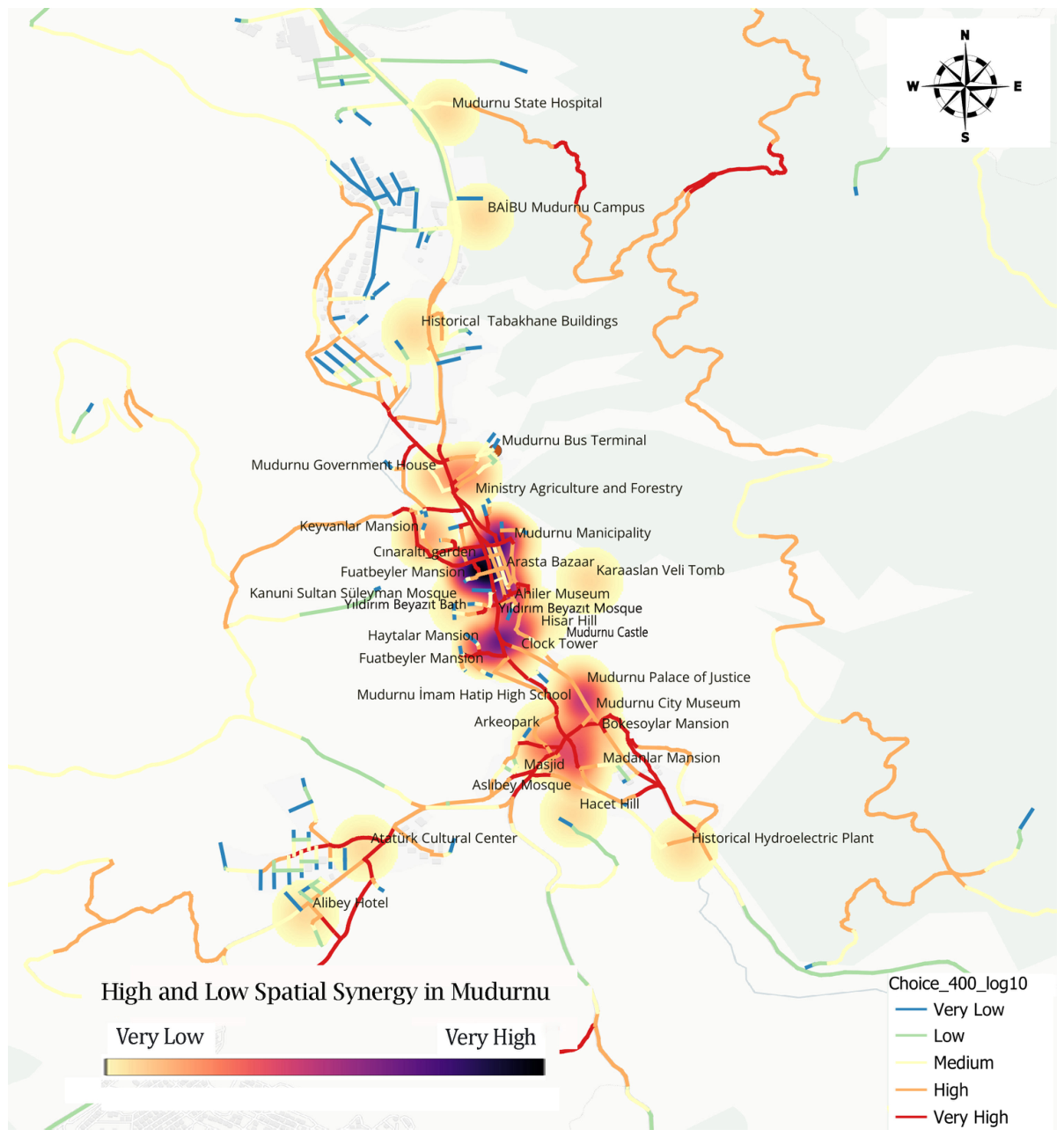

Disclaimer/Publisher’s Note: The statements, opinions and data contained in all publications are solely those of the individual author(s) and contributor(s) and not of MDPI and/or the editor(s). MDPI and/or the editor(s) disclaim responsibility for any injury to people or property resulting from any ideas, methods, instructions or products referred to in the content. |
© 2026 by the authors. Licensee MDPI, Basel, Switzerland. This article is an open access article distributed under the terms and conditions of the Creative Commons Attribution (CC BY) license.