


Abstract
As a typical human–nature coupled region, the coordination between the agricultural resource–environment system and regional development in the Fujian-Taiwan region is crucial for sustainable development. However, the underlying mechanisms and scale heterogeneity of this relationship remain unclear. This study employed a comprehensive evaluation approach to assess Agricultural Resource and Environmental Carrying Capacity (ARECC) and Regional Development Level (RDL) in the Fujian-Taiwan region in 2010, 2015, and 2019. A Coupling Coordination Degree (CCD) model was used to quantify the coordination relationship, while a geographical detector was applied to identify influencing factors at multiple scales. The main findings are as follows: (1) ARECC in Fujian increased gradually (average value: 0.046 → 0.052 → 0.075), whereas Taiwan exhibited a decline followed by recovery (average value: 0.449 → 0.408 → 0.491), with overall levels remaining higher than those of Fujian. RDL in Fujian was generally higher than that in Taiwan (average value: 0.260 > 0.212), and the average growth rate of Taiwan’s counties and cities was lower than that of Fujian (10.42% < 16.62%). (2) Overall, Fujian maintained a comparatively balanced relationship between ARECC and RDL, with maladjustment occurring only in Nanping City. In contrast, Taiwan experienced a substantially higher degree of maladjustment, with 40.90% of its counties and cities falling into maladjusted categories. Spatially, CCD in Fujian displayed a gradient decline from Fuzhou toward the southern, northern, and western regions, while high- and low-value areas in Taiwan were interspersed. (3) The coupling coordination mechanism exhibited significant scale heterogeneity, and corresponding differentiated regulation strategies were proposed. These findings contribute to a deeper understanding of the coordination mechanisms between ARECC and RDL in the Fujian–Taiwan region and provide references for promoting cross-regional agricultural collaboration and sustainable development.
1. Introduction
In the process of rapid regional development, agricultural resource–environment are not only recipients of increasing pressures but also fundamental elements underpinning regional economic and social development [1,2]. The agricultural ecological environment provides crucial ecosystem services—such as water conservation, soil retention, local climate regulation, and disaster risk reduction—and thus plays an important supporting role in regional development [3]. However, in many regions experiencing rapid economic growth and population expansion, such as Central Asia and China, agricultural resources essential for food production—particularly water and land—are becoming increasingly scarce [4,5,6]. With the United Nations Sustainable Development Goals (SDGs) setting the objective of achieving food security and promoting sustainable agriculture (SDG2) [7], increasing attention has been paid to the interdependence among environmental protection, economic growth, and social well-being [8]. Since 1978, China has achieved remarkable economic growth and large-scale industrialization and urbanization. The intensification of resource and spatial exploitation has also resulted in reductions in cropland area and increasing water scarcity [9], thereby posing threats to China’s ecological security, resource security, and food security [10]. This phenomenon is particularly pronounced in the developed coastal regions of southeastern China, where large populations coexist with limited available arable land [11]. In this region, severe land scarcity and ecological vulnerability mean that ARECC has become a critical bottleneck constraining further regional development. Changes in this capacity affect not only agricultural productivity but also urban expansion, industrial development, and population agglomeration [12]. The human–land system is defined as a complex adaptive system arising from the dynamic interactions between human activities and the geographical environment [13]. Achieving a dynamic balance between socioeconomic development and the protection of agricultural resource–environment aligns with the core tenets of research on human–land systems and regional sustainability. Therefore, an in-depth analysis of the coordination between the agricultural resource–environment system and regional development is of significant practical relevance and academic value.
Agricultural resource–environment underpin regional development by providing essential support through food supply and ecosystem services. Owing to pronounced intra-national disparities in development and resource endowments in China, ensuring reliable supplies of energy, water, and food has become a central challenge for regional socioeconomic development [14]. Fundamentally, farmland protection represents a critical pathway for safeguarding food security, social stability, and sustainable development [15]. The impacts of regional development on agricultural resource–environment are inherently nonlinear. For example, infrastructure development is widely recognized as a key driver of regional economic growth and sustainability [16]. However, infrastructure expansion—particularly road construction—can adversely affect the sustainability of agricultural land by occupying cropland and high-quality soils, thereby reducing food production and disrupting agro-ecosystem balance [17]. Similarly, the rapidly increasing demand for food driven by population growth in China has stimulated the expansion of agricultural land [18]. Nevertheless, the combined effects of population growth and economic expansion on changes in agricultural land use have exacerbated the loss of farmland ecosystem services [19]. Natural resources are indispensable to human well-being [20]; however, economic growth and improvements in human well-being have often been achieved at the cost of rapidly increasing natural resource use [21]. The integration of agricultural economic development with environmental protection can advance sustainable development in China, thereby fostering a balanced trajectory among economic growth, social well-being, and environmental conservation [22].
The agricultural resource–environment system is composed of resource subsystems (e.g., cultivated land, water) and environmental subsystems (e.g., climate, soil quality, natural disasters), with its carrying capacity reflecting the balance threshold between agricultural activities and the resource–environment system. Some scholars have applied coupling coordination models to study the relationships between resource and environmental carrying capacity (RECC) and regional economy [23], water resources, socio-economy and the ecological environment [24], urbanization and the ecological environment [25,26]; ecosystem resilience and regional economy [27]; as well as water resource carrying capacity and high-quality urban economic development [28]. However, there is still a lack of research on the coupling and coordination between the agricultural resource–environment system and the regional development system, including the identification of key influencing factors and the analysis of their mechanisms of interaction. The main methods for identifying influencing factors include the geographical detector [29], random-effects panel Tobit model [30], obstacle degree model [31], linear regression model [32], and Geographic spatiotemporal weighted model [33]. However, existing studies remain limited in revealing the heterogeneity of influencing factors across spatial scales, leading to an incomplete understanding of regional differences. The geographical detector, which does not rely on linear assumptions, excels in revealing spatial heterogeneity and detecting factor interactions. These advantages make it particularly suitable for spatial causal identification and the determination of dominant factors in coupling coordination mechanisms [34]. Regarding the optimization of coordination, some scholars have identified influencing factors to propose targeted strategies for coordinating RECC with regional economic development [23], while others have recommended differentiated strategies of “classified measures + coordinated development” for balancing ecosystem resilience and regional economy [27]. Additionally, scholars have proposed countermeasures at micro-, meso-, and macro-levels based on changes in the coordination between urbanization and the ecological environment [26]. However, optimization strategies for different types of coordination zones have not yet been established, which are essential for promoting efficient resource allocation and strengthening regional complementarity to achieve classified governance.
The Fujian–Taiwan region is located in the economically developed coastal area of southeastern China. Fujian and Taiwan share geographical proximity, similar climatic conditions, and comparable agricultural resource endowments, while exhibiting substantial differences in economic development levels, resource utilization patterns, and regional development pathways. These similarities and contrasts provide an ideal setting for examining the coordination relationship between ARECC and RDL under different development models. Therefore, the Fujian–Taiwan region serves as a representative and meaningful case for this study. In contrast to existing studies that predominantly emphasize national scales, various administrative units, or comparative analyses of mountain–plain and coastal areas [29,30,35,36], systematic research focusing on the Fujian–Taiwan region remains relatively limited. Earlier investigations primarily focused on comparisons of cultivated land [37], construction land [38], and ecological sustainability [39] between Fujian and Taiwan, and subsequently expanded to topics such as the coupling between urbanization quality and ecological environmental stress [40], as well as inequalities in urban development [41].
In summary, existing studies have provided a solid theoretical and methodological foundation for analyzing the coordination between agricultural resource–environment systems and regional development systems, yet notable gaps remain in cross-regional comparisons and in-depth investigations. First, existing comparative studies on the Fujian–Taiwan region have mainly focused on the coupling relationship between urbanization quality and ecological environmental pressure [40], while relatively limited attention has been paid to the coordination between ARECC and regional development, and a systematic analytical framework has yet to be established. Second, although separate evaluations of Resource and Environmental Carrying Capacity (RECC) and RDL have been conducted in Fujian and Taiwan [42,43,44], comparative studies examining the coupling and coordination relationship between these two systems across regions remain scarce, particularly quantitative assessments at the Fujian–Taiwan regional scale. Third, most existing studies have focused on analyses at the overall regional scale and have paid insufficient attention to spatial heterogeneity among different types of regions. As a result, a multi-scale framework integrating the overall, coordination zones and maladjustment zones has not yet been developed, limiting the understanding of heterogeneous driving mechanisms across spatial levels. Finally, research on differentiated regulation strategies for coordinated and maladjusted areas remains relatively limited, and a systematic policy optimization pathway that simultaneously considers regional characteristics and developmental-stage differences has yet to be established.
Building on this, the study selects the Fujian–Taiwan region as a representative case, and establishes an analytical framework to assess the coupling and coordination stages between agricultural resource–environment systems and regional development systems, identify influencing factors across multiple scales (overall—coordination zone—maladjustment zone), and reveal their underlying mechanisms, on which basis zonal optimization strategies are proposed. This study addresses the following research questions: (1) How have ARECC and RDL evolved across space and time in the Fujian–Taiwan region? (2) What is the degree of coupling and coordination between ARECC and RDL, and how does it differ between Fujian and Taiwan? (3) Which factors exert the most significant influence on coupling coordination at different spatial scales? (4) How do the driving mechanisms differ between coordination zones and maladjustment zones? The study consists of the following components: (1) applying a comprehensive analysis method to quantitatively evaluate ARECC and RDL in Fujian and Taiwan, and to uncover the spatiotemporal differentiation of their coupling levels; (2) employing a coupling coordination model to analyze the interaction intensity between agricultural resource–environment systems and regional development systems in Fujian and Taiwan; (3) utilizing the geographical detector approach to identify influencing factors across three scales—entire region, coordination zones, and maladjustment zones; (4) on this basis, summarizing the coordination mechanisms between agricultural resource–environment systems and regional development systems in Fujian and Taiwan, and proposing targeted optimization and regulation strategies for different zones. The findings aim to guide the optimal allocation of agricultural resources, strengthen environmental protection, and promote high-quality regional development, thereby offering practical insights into exploring cooperative agricultural development pathways and sustainable regional development models for Fujian and Taiwan (Figure 1).
Figure 1.
Research framework.
2. Data and Methods
2.1. Study Area
2.1.1. Overview of Fujian
Fujian (115°50′–120°43′ E, 23°32′–28°19′ N) is located along the southeastern coast of China. It covers a land area of 121,400 km2 and is characterized by prominent ecological vulnerability. Approximately 89% of the province consists of mountainous and hilly terrain, with thin and erosion-prone soil layers; the region experiences uneven precipitation, frequent heavy rainfall, and typhoons, leading to recurrent flood and drought disasters; the soil is generally poor in fertility, and the ecological system exhibits low stability. As of 2023, the administrative structure includes one sub-provincial city, eight prefecture-level cities, and the Pingtan Comprehensive Experimental Zone (Figure 2). The gross output value of agriculture, forestry, animal husbandry, and fishery reached 585.49 billion CNY (+3.40% YoY). The grain cultivation area was 844.41 × 10³ ha (+0.39% YoY), with a total grain output of 5.14 × 10⁶ t (+0.70% YoY).
Figure 2.
Location map of the study area.
There are pronounced regional economic disparities within Fujian. Coastal areas—including Xiamen, Fuzhou, and four other cities—account for one-third of the province’s land area but are home to 81.47% of the population and contribute 84.19% of the GDP (the provincial GDP in 2023 was 5.78 trillion CNY). In contrast, the three inland cities house only 18.53% of the population and account for 15.81% of the GDP.
2.1.2. Overview of Taiwan
Taiwan (119°11′03″–124°34′30″ E, 21°45′25″–25°56′30″ N) is situated on the eastern side of the Taiwan Strait, facing mainland China across the sea, with a land area of approximately 36,000 km2. The terrain is predominantly mountainous and hilly, accounting for about two-thirds of the total area, while flatlands and basins are limited and scattered. The island is geologically active, frequently experiencing earthquakes, typhoons, and flood disasters. As of 2023, Taiwan comprised six directly governed municipalities, thirteen counties, and three county-administered cities (Figure 2). The total output value of agriculture, forestry, animal husbandry, and fishery amounted to 123.74 billion CNY (+3.59% YoY). The rice cultivation area was 222 × 103 ha (−7.11% YoY), and rice output totaled 1.46 × 10⁶ t (−7.36% YoY).
Development across the island is uneven, with the north dominated by high-tech industries and the service sector, while the south is concentrated with traditional industries. Population is densely concentrated in the north and sparse in the south, leading to a high concentration of public resources in the northern region [45]. In 2023, Taiwan’s GDP was 525.05 billion CNY, with a resident population of 23.75 million.
Fujian and Taiwan naturally share ecologically and culturally homologous resources, while differing in regional development stages, driving forces, and socioeconomic systems, making them a representative area for studying the evolution of human-natural coupled systems. Investigating the coordination between the agricultural resource–environment system and regional development in Fujian and Taiwan is of great significance for ensuring regional food and ecological security. It also provides a scientific basis for exploring pathways to coordinated agricultural development and sustainable regional development models between Fujian and Taiwan.
2.2. Research Methods
2.2.1. Data Acquisition
Given the substantial disruptions caused by the COVID-19 pandemic after 2019, this study selected 2019 as the endpoint of analysis in order to examine the coupling and coordination relationship between ARECC and RDL under pre-pandemic conditions. Accordingly, the years 2010, 2015, and 2019 were chosen as the observation periods for the analysis. The spatial data used in this study include: (1) Spatial data: Soil data were obtained from the Institute of Soil Science, Chinese Academy of Sciences, and the National Tibetan Plateau Data Center (http://data.tpdc.ac.cn/); Digital Elevation Model (DEM) data were retrieved from the Geospatial Data Cloud (http://www.gscloud.cn/); Temperature, precipitation, and atmospheric environmental data were collected from historical records of meteorological stations in Fujian and Taiwan; Total water resource data were obtained from the Water Resources Bulletin of Fujian and Taiwan for the years 2010, 2015, and 2019. (2) Socioeconomic statistical data: These data were derived from the Statistical Yearbooks and Statistical Communiqués of Fujian’s administrative divisions for the years 2010, 2015, and 2019, as well as from Taiwan’s Statistical Yearbook and the Statistical Abstract of Urban and Regional Development.
These datasets provide comprehensive indicators related to agriculture, population, economic output, and regional development, which form the foundation for the subsequent analysis.
2.2.2. Evaluation of ARECC
In 2020, China’s Ministry of Natural Resources issued the Guidelines for the Evaluation of Resource and Environmental Carrying Capacity and Land Development Suitability (Trial) (hereinafter referred to as the “Double Evaluation”), which established the objective assessment of resource and environmental carrying capacity as a fundamental basis for territorial spatial planning, the improvement of spatial governance, and regional development [46]. The evaluation index system for ARECC in this study was developed based on the technical framework of the Territorial Spatial Planning “Dual Evaluation” system. It primarily reflects the resource endowment conditions and environmental constraints that support agricultural production, including topography, soil, climate, water resources, and agrometeorological disasters, thereby characterizing the potential for agricultural production and the resource–environment support capacity of a region. In addition, drawing on previous studies conducted in the mountainous and hilly regions of southern China, several indicators were appropriately adjusted to better suit the study area. The evaluation was then carried out at the county level (Table 1). The integrated evaluation method is a key approach for comprehensively assessing ARECC within the “Dual Evaluation” framework. It enables the integration of multidimensional information, including resource endowments, environmental constraints, and agricultural production conditions, thereby providing a comprehensive representation of regional ARECC. Compared with evaluations based on individual indicators, the integrated approach effectively reduces the one-sidedness of assessment results and enhances their systematicity and comprehensiveness. Moreover, this method is consistent with the technical specifications of the “Dual Evaluation” framework, ensuring strong scientific rigor, authority, and regional comparability. It also provides a unified composite evaluation result for subsequent coupling–coordination analysis. The specific methods are as follows:
Table 1.
Evaluation system for ARECC.
Land resources: Based on slope classification and combined with soil texture, the evaluation results of land resources are integrated and divided into five grades: high, relatively high, medium, relatively low, and low. Areas with a silt content ≥80% were directly assigned the lowest level. For areas with silt content between 60% and 80%, the land resource evaluation grade is determined by reducing the slope grade by one level.
Water resources: The final classification of water resource carrying capacity was determined by selecting the higher of two indicators—annual precipitation and available water resources. Five grades were defined: abundant, relatively abundant, moderate, relatively scarce, and scarce.
Natural disasters: Following the “Double Evaluation” methodology and considering the actual meteorological conditions in Fujian and Taiwan, three major meteorological disaster types were selected: heavy rainfall and flooding, heat stress, and strong wind events. Historical records of these events were compiled. The annual frequency of each disaster type was calculated based on long-term observational data, and regions were classified into five levels according to the occurrence frequency: ≤20%, (20%, 40%], (40%, 60%], (60%, 80%], and >80%.
2.2.3. Evaluation of RDL
Based on previous studies [48,49,50,51], and considering the specific conditions of the Fujian–Taiwan region, this study constructs an evaluation index system for regional development levels across four dimensions—population development, economic development, infrastructure, and social well-being—by adhering to the principles of scientific rigor and system integrity, commonality and transferability, as well as dynamism and coordination (Table 2). A comprehensive evaluation method is then applied to systematically assess regional development levels in Fujian and Taiwan for the years 2010, 2015, and 2019. The entropy weight method was adopted because it determines indicator weights objectively based on the information contained in the data, thereby reducing subjective bias and enhancing comparability across regions and years. This approach supports the construction of a reliable RDL index. Given that social well-being data in Fujian Province are only relatively complete at the prefecture-level city scale during the study period, this study evaluates regional development levels using prefecture-level cities as the analytical units for Fujian and municipalities/counties as the units for Taiwan.
Table 2.
Evaluation system for RDL.
2.2.4. Coupling Coordination Model
The coupling coordination model is used to describe the degree of interactive influence between two or more systems. It effectively reflects the level of mutual interaction and influence between systems and can be used to assess whether the systems are developing harmoniously. This study employs the Coupling Coordination Degree (CCD) model to characterize the level of coordinated development between ARECC and RDL, thereby addressing the research question concerning the coordination relationship between agricultural resource–environment carrying capacity and regional development. The calculation formulas are Equations (1)–(3).
where S1 is ARECC of Fujian and Taiwan; S2 is RDL of Fujian and Taiwan; C is the coupling degree, with a value range of [0, 1]. A larger C value indicates a stronger interaction and mutual influence between the agricultural resource–environment system and regional development system; T is the comprehensive evaluation index of both systems (agricultural resources–environment system and regional development system); α and β are coefficients to be determined and are set as α = β = 0.5. This specification is based on the assumption of subsystem equivalence within the social-economic-natural complex system theory, which posits that each subsystem plays an equally important role in regional sustainable development; D is the CCD between the agricultural resource–environment system and regional development system. In practice, C ∈ (0, 1] and D ∈ (0, 1). A higher D value indicates a higher level of coordination between the agricultural resource–environment system and regional development system, whereas a lower D implies a weaker coupling relationship.
Given that several RDL indicators were only available at the municipal level, the county-level ARECC scores were aggregated to the municipal scale before calculating the CCD, thereby ensuring spatial-scale consistency between the two subsystems.
Robustness and Uncertainty Analysis. To evaluate the robustness and uncertainty of the coupling–coordination results, a sensitivity analysis was conducted with respect to the weighting scheme. While keeping the indicator system unchanged, the weight coefficients assigned to the agricultural resource–environment system and the regional development system were adjusted (α = 0.4, β = 0.6; α = 0.6, β = 0.4), and the CCD was recalculated accordingly.
Based on this model and following the classification approach proposed by Tan et al. [52], the coupling relationship between the agricultural resource–environment system and regional development system is categorized into ten types (Table 3). According to the established CCD classification criteria, regions with CCD values of 0.8–0.9 are classified as “good coordination”, while those with CCD values of 0.9–1.0 are classified as “high-quality coordination”, indicating a higher level of coordinated development between the two subsystems.
Table 3.
CCD and corresponding coordination types.
2.2.5. Identification of Influencing Factors
The geographical detector is a set of statistical methods used to detect spatial stratified heterogeneity and to identify the underlying driving forces [53]. It includes four types of detectors: factor detector, interaction detector, risk detector, and ecological detector. The geographical detector method can quantitatively identify the explanatory power of different influencing factors on the spatial differentiation of coupling coordination through the q-statistic, without requiring strict statistical assumptions such as linear relationships or normal distributions. This makes it particularly suitable for analyzing the complex nonlinear relationships that commonly exist within resource–environment and regional development systems. In addition, the method can reveal interaction effects among factors as well as patterns of spatial heterogeneity, which closely aligns with the objective of this study to uncover the mechanisms underlying spatial differences in the coupling coordination between ARECC and RDL. Therefore, the geographical detector was adopted to investigate the driving factors influencing coupling coordination. This analysis was conducted at three spatial scales: the entire Fujian-Taiwan region, coordinated zones, and maladjusted zones.
(1) Factor Detector
The factor detector uses the q-value to measure the degree of spatial heterogeneity in the dependent variable Y, and to assess the extent to which an independent factor X explains the spatial variation of Y [53]. The expression is given as Equation (4).
where h = 1, …, L is the strata (i.e., classifications or partitions) of variable Y or factor X; Nh, and N is the number of units in stratum h and in the entire study area, respectively; and σ2 are the variances of Y within stratum h and the whole region, respectively; the value of q ranges from 0 to 1, where a larger q indicates a stronger explanatory power of the independent variable X for the spatial variation of Y, and vice versa.
(2) Interaction Detector
This method identifies the interaction between different risk factors (Xs), specifically assessing whether the combined effect of two factors (X1 and X2) enhances or weakens their individual explanatory power for the dependent variable Y, or whether the factors act independently. The evaluation process involves calculating the individual q-values of X1 and X2 on Y, denoted as q(X1) and q(X2), respectively. Then, the q-value of their interaction, q(X1 ∩ X2), is calculated. By comparing q(X1), q(X2), and q(X1 ∩ X2), the nature of their relationship can be determined. The interaction between two factors can be classified into six types: independent, bi-factor enhancement, nonlinear enhancement, nonlinear weakening, uni-factor nonlinear weakening and interaction [53].
3. Results and Analysis
3.1. Analysis of ARECC
Based on Table 1, the “Double Evaluation” integrated approach was applied to assess the individual factors of ARECC in Fujian and Taiwan for the years 2010, 2015, and 2019, and to synthesize the overall carrying capacity. The resulting raster outputs were then normalized by administrative units, with counties/districts as the zoning units in Fujian and cities/counties as the zoning units in Taiwan.
During the study period, the ARECC in Fujian showed a slight improvement but remained at a relatively low overall level, with small differences among the study units. Dongshan County exhibited both the highest average carrying capacity and the largest increase (+0.2322).
From the perspective of spatial distribution (Figure 3), ARECC in Fujian remained at an overall medium–low level during the study period. Between 2010 and 2015, medium–low-value areas were relatively concentrated, and medium-value areas gradually extended from the southeastern coast toward the southwest, exhibiting a “high in the south, low in the north” pattern. Between 2015 and 2019, the distribution became more scattered, with medium-value areas continuing to expand northward, while high-value areas appeared only sporadically in Dongshan County of Zhangzhou City. In contrast, Taiwan’s carrying capacity was overall significantly higher than that of Fujian. From 2010 to 2015, medium–high value areas were continuously distributed over large regions, with high-value areas mainly located in western and northern Taiwan, including Tainan City, Chiayi County, as well as Taipei City and Keelung City, exhibiting a west-to-east decreasing spatial gradient. Between 2015 and 2019, most study units reached relatively high levels, with the concentration of medium–high and high-value areas further strengthened, and high-value areas remaining focused in northern and western Taiwan.
Figure 3.
Spatial distribution of ARECC in Fujian and Taiwan in 2010, 2015, and 2019.
3.2. Spatiotemporal Patterns of RDL
Based on Table 2 and using a comprehensive evaluation method, the RDL of Fujian and Taiwan in 2010, 2015, and 2019 were assessed.
According to Figure 4, overall, Fujian’s regional development level was higher than that of Taiwan during the study period. Across the three time points, both Fujian and Taiwan showed increases in regional development level, while Fujian recorded a higher growth rate than Taiwan. Among the core cities, in Taiwan, Taipei City maintained a “single-peak pattern,” recording the highest RDL across all three time points (average value: 0.437), while Chiayi County and Taitung County exhibited the lowest values. In Fujian, Fuzhou City ranked second only to Taipei City (average value: 0.357), and experienced an 18.58% increase by 2019, surpassing other cities in Fujian and Taiwan. The southeastern cities of Xiamen City and Quanzhou City in Fujian followed closely, with multi-year average values of 0.335 and 0.320, respectively, positioning them behind Taipei City and Fuzhou City.
Figure 4.
Spatial distribution of RDL in Fujian and Taiwan in 2010, 2015, and 2019.
Spatially, Taiwan exhibited a “tripolar” distribution of high-value clusters, with New Taipei City and Taoyuan City in the north, Taichung City in the center, and Kaohsiung City in the south forming three prominent regional development centers. This spatial configuration began to take shape in the 1960s [54] and remained stable between 2010 and 2019, with all four cities showing steady growth and an average development increase of 11.47%. In Fujian, the top three cities in terms of development level—Fuzhou City, Xiamen City, and Quanzhou City—were concentrated in the eastern and southeastern coastal areas. Notably, Sanming City in Fujian demonstrated remarkable growth over the past decade, rising from 0.173 in 2010 (+25.43%) to 0.312 in 2019 (+34.48%), ranking fourth after the “Fuzhou-Xiamen-Quanzhou” cluster. Ningde City remained the city with the lowest development level in Fujian. In Taiwan, counties with relatively low development levels were located primarily in the central region (Nantou and Yunlin Counties), southern region (Pingtung, Penghu, and Chiayi Counties), eastern region (Hualien and Taitung Counties), and the offshore Kinmen-Matsu area (Kinmen and Lienchiang Counties), collectively forming extensive low-value zones along Taiwan’s eastern and central inland areas.
3.3. Coupling Coordination Analysis Between Agricultural Resource–Environment System and Regional Development System
Using the coupling coordination model and Excel, the CCD between ARECC and RDL in Fujian and Taiwan for the years 2010, 2015, and 2019 were calculated (Figure 5).
Figure 5.
Spatial distribution of CCDs between agricultural resources–environment system and regional development system in Fujian and Taiwan in 2010, 2015, and 2019.
As shown in Figure 5 and Table 3, during the study period, the coupling coordination degree of cities in the Fujian–Taiwan region exhibited stage-specific variations, characterized by either fluctuations or slight increases across different time points. In terms of coordination types, the overall degree of coupling maladjustment in Fujian was relatively mild. Except for Nanping City, all other cities were classified as coordination types, indicating a positive and mutually reinforcing interaction between the agricultural resource–environment system and the regional development system. Spatially, the CCD in Fujian peaked in Fuzhou City and Quanzhou City and gradually decreased toward the southern, northern, and western regions. In contrast, the degree of coupling maladjustment in Taiwan was more pronounced than in Fujian. The area of coupling maladjustment zones was substantial, with nearly half of the municipalities and counties classified as maladjustment types. The spatial pattern exhibited “high in the north and south, sub-high in the central region, and low in the transitional zones”: high-value areas were stably distributed in northern and southern Taiwan, the central region formed sub-high-value zones, and the transitional areas between north-central and central-south displayed low values.
According to Table 4, when the weights assigned to ARECC and RDL were adjusted to 0.4:0.6 and 0.6:0.4, respectively, only minor changes were observed in the average CCD values. Moreover, the regional coordination categories and overall spatial distribution patterns remained largely unchanged. These results indicate that the model exhibits strong robustness and reliability with respect to variations in weight settings.
Table 4.
Sensitivity analysis results.
Combining the evaluation results of ARECC and RDL in the Fujian–Taiwan region, Taiwan exhibits a relatively high level of ARECC, while its RDL remains lower than that of Fujian. This imbalance between ARECC and RDL constrains the improvement of coupling coordination. In contrast, although Fujian’s overall ARECC is slightly lower than that of Taiwan, its RDL has improved more rapidly, and a stronger synergistic relationship has been maintained between ARECC and RDL. As a result, Fujian demonstrates a higher CCD. These findings suggest that a higher level of ARECC does not necessarily translate into a higher level of coordinated development. In recent years, Fujian has promoted the synergistic advancement of agricultural resources and environmental protection and regional development through policies such as agricultural modernization, ecological civilization construction, and rural revitalization, thereby achieving a higher level of coordination. By comparison, Taiwan’s advantages in agricultural resources and environmental endowments have not been fully transformed into broader regional development advantages, resulting in a certain degree of mismatch between ARECC and RDL.
3.4. Influencing Factors
The scores of each factor related to ARECC and RDL in Fujian and Taiwan were imported into the geographical detector based on different regional scales. The model was used to obtain the explanatory power (q-values) of each factor across the entire Fujian–Taiwan region, as well as within areas classified as coupling coordinated zones and coupling maladjusted zones between agricultural resources–environment system and regional development system. Additionally, the interactive q-values between pairs of factors were calculated. All detection factors passed significance tests at various confidence levels.
3.4.1. Regional Scale: Entire Fujian and Taiwan
(1) Agricultural resource–environment system
At the overall spatial scale, Fujian and Taiwan exhibit distinct differences in the resource-development driving structures. For the agricultural resources and environment system, Fujian is primarily driven by land resources (q = 0.822) and water resources (q = 0.427), while other factors contribute only marginally. Pairwise interactions among factors display enhancing effects (Figure 6), indicating that soil and water conditions not only directly determine Fujian’s coupling coordination level but also maintain a dominant role when interacting with environmental conditions, disaster risks, and other elements. In Taiwan, the agricultural environmental factor serves as the primary driver (q = 0.626), followed by land resources (q = 0.452). Interactions among these factors generate multiplicative effects (Figure 7), forming a dual-core “environment–land” driving structure (key interaction q = 0.979), demonstrating that coupling coordination in Taiwan is highly dependent on the synergistic configuration of ecological environment and land resources.
Figure 6.
Interaction effects of ARECC factors on the coupling coordination between agricultural resources–environment system and regional development system across Fujian. (Different colors represent the factors of ARECC, and the width of each ribbon indicates the strength of the interaction effect. The numerical value displayed on each ribbon corresponds to the associated q-value).
Figure 7.
Interaction effects of ARECC on the coupling coordination between agricultural resources–environment system and regional development system across Taiwan. (Different colors represent the factors of ARECC, and the width of each ribbon indicates the strength of the interaction effect. The numerical value displayed on each ribbon corresponds to the associated q-value).
Regarding the regional development system, Fujian exhibits a dual “economy-population” driving mechanism (C6 q = 0.635 > C5 q = 0.545; C3 q = 0.493), with relatively balanced contributions at the criterion level (B1 ≈ B2 > B3 ≈ B4). Social well-being (B4) acts as a leverage factor through the pathway “government investment → stimulation of economic/population elements → enhancement of coordination” (Table 5). In contrast, Taiwan exhibits a “dual-weak” pattern, with only C9 (q = 0.363), C1 (q = 0.359), and C10 (q = 0.346) serving as effective drivers. Contributions at the criterion level show a decreasing trend and are all below 0.25, forming a shallow driving chain dominated by population, logistics, and services, which is insufficient to support deep coupling coordination. Overall, Fujian relies on the synergistic advancement of soil-water conditions and multidimensional development elements, whereas Taiwan depends on environmental sensitivity and limited basic elements. Consequently, the pathways and effectiveness of promoting coupling coordination between agricultural resource–environment and regional development differ markedly between the two regions.
Table 5.
Interactive detection results of each factor of RDL on the dominant factors of the coupling and coordination of agricultural resources–environment system and regional development system in the whole Fujian region.
3.4.2. Coupling Coordination Zones
Within the coupling coordination zone, the dominant mechanisms in Fujian and Taiwan exhibit marked differences. For the agricultural resources and environment system, Fujian shifts from an overall “soil-water-dominated” pattern to an “environment-dominated” type, with the agricultural environment emerging as the primary factor (q = 0.607) and land resources as secondary (q = 0.546). Pairwise interactions among factors generally display enhancing effects (Figure 8), forming a dual-core “environment-land” collaborative structure (interaction q = 0.904), which shapes the coordination pattern through the combined influence of ecological constraints and basic carrying capacity.
Figure 8.
Interaction effects of ARECC on the coupling coordination between agricultural resources–environment system and regional development system across Fujian’s coordinated zones. (Different colors represent the factors of ARECC, and the width of each ribbon indicates the strength of the interaction effect. The numerical value displayed on each ribbon corresponds to the associated q-value).
In Taiwan, the system exhibits a “disaster-sensitive” characteristic, with natural disasters serving as the absolute dominant factor (q = 0.696) and jointly forming the supporting system with land (q = 0.643), water resources (q = 0.581), and agricultural climate (q = 0.578). Interaction analysis (Figure 9) indicates that all factors exhibit nonlinear enhancing effects, with interaction q values generally exceeding 0.85. Natural disasters maintain the highest contribution across all interaction combinations, forming a radiative enhancement network centered on disaster risk.
Figure 9.
Interaction effects of ARECC on the coupling coordination between agricultural resources–environment system and regional development system across Taiwan’s coordinated zones. (Different colors represent the factors of ARECC, and the width of each ribbon indicates the strength of the interaction effect. The numerical value displayed on each ribbon corresponds to the associated q-value).
For the regional development system, the coupling coordination zone in Fujian exhibits a dual-core “economy-livelihood” driving structure. Economic factors such as C6 (q = 0.529) and C9 (q = 0.508), along with social well-being factors such as C18 (q = 0.632) and C26 (q = 0.577), make prominent contributions. At the criterion level, B2 (q = 0.399) and B4 (q = 0.397) carry similar weights, forming a comprehensive driving structure in which productive factors and livelihood protection collaboratively enhance coordination. Interactions among these factors show significant strengthening effects (Table 6). In Taiwan, the coupling coordination zone displays a “three-tier driving chain,” with overall driving strength notably higher than at the overall scale. C8 (q = 0.674) and C13 (q = 0.636) serve as the core drivers, while C10 (q = 0.596), C6 (q = 0.539), and C4 (q = 0.512) form the secondary driving group. At the criterion level, B3 (q = 0.440) contributes the most, exceeding B2 (q = 0.417) and B1 (q = 0.413). Notably, C5 (q = 0.036) contributes minimally, indicating that under Taiwan’s market-dominated structure, the degree of agricultural product commercialization and logistics efficiency serve as key levers for promoting coordination between the resource and development systems, while fiscal interventions play a limited regulatory role.
Table 6.
Interaction detection results of RDL factors on dominant factors in the coupled coordination zones between agricultural resource–environment system and regional development system in Fujian.
3.4.3. Coupling Maladjustment Zones
In the agricultural resource–environment system, only Nanping City in Fujian is classified as a coupling maladjustment zone. Its dominant factors remain concentrated in land resources (q = 0.734) and water resources (q = 0.722), consistent with the overall spatial results, indicating that insufficient soil and water conditions are the primary limiting factors. In Taiwan, the maladjustment zones form a composite “outlying islands–core city belt” structure, including Penghu County, Kinmen County, Lienchiang County, and nine counties along the north–south axis of the main island. The primary conflicts arise from agricultural environmental degradation (q = 0.866) and land resource constraints (q = 0.692), compounded by agricultural disasters (q = 0.509), leading to coupling maladjustment. Interaction analysis (Figure 10) indicates that combinations of disasters with land and environmental factors exhibit the strongest nonlinear enhancement (interaction q = 0.951), forming a “resource degradation–disaster amplification” vicious cycle, which constitutes the key mechanism underlying coupling disorder in Taiwan.
Figure 10.
Interaction effects of ARECC factors on the maladjustment zones between agricultural resource–environment system and regional development system in Taiwan. (Different colors represent the factors of ARECC, and the width of each ribbon indicates the strength of the interaction effect. The numerical value displayed on each ribbon corresponds to the associated q-value).
Regarding the regional development system, the primary pressure sources in Nanping City, Fujian, are concentrated in social well-being and economic factors. C18 (q = 0.762) serves as the strongest driver, followed by C5, C11, C6, and C12 (q values ranging from 0.51 to 0.65). Infrastructure factors (C15, C16) contribute moderately, while population density has a relatively weak impact. In Taiwan’s maladjustment zones, regional development factors generally exhibit a “balanced weak influence” pattern, with individual factor driving forces being relatively low. C7 (q = 0.438) and C17 (q = 0.375) show comparatively prominent effects. At the criterion level, social well-being B4 (q = 0.241) slightly exceeds infrastructure B3 (q = 0.238) and economic level B2 (q = 0.217). Although interaction effects are generally enhanced (Table 7), the weak single-factor driving forces are insufficient to effectively compensate for the structural deficiencies of the agricultural resource–environment system. In particular, the limited ARECC in Keelung City, Taipei City, Hsinchu City, Hsinchu County and the outlying islands, coupled with relatively high development levels, creates a mismatch that underlies the observed coupling maladjustment.
Table 7.
Interaction detection results of RDL factors on dominant factors in maladjustment zones between agricultural resource–environment system and regional development system in Taiwan.
The interaction effects identified above reveal the dominant combinations of factors influencing coupling coordination. Their underlying transmission mechanisms and regional differences will be further discussed in Section 4.2.
4. Discussion
4.1. Coupling Coordination Characteristics Between Agricultural Resource–Environment System and Regional Development System in Fujian and Taiwan
During the study period, the coupling coordination between the agricultural resource–environment system and the regional development system in the Fujian-Taiwan region showed stage-specific variations, with coordination levels fluctuating or slightly increasing across different time points. Liu and Xin [55] investigated the coupling and coordinated development relationships among economy, science and technology, ecology, resources, and social development (ESERS) across Chinese provinces. Their findings indicated a shift toward positive coordination and balance in the eastern, central, and western regions of China, which is consistent with the results of this study.
From the perspective of the social-economic-natural coupled ecosystem theory, most cities in Fujian maintain a relatively high degree of coordination, primarily due to the formation of stable positive feedback mechanisms among regional natural resources, industrial structure, and social development elements. However, Nanping City is the only city in Fujian exhibiting coupling maladjustment, where the system’s contradictions reflect a typical feedback coupling maladjustment caused by a mismatch between resource endowment and development conversion efficiency within the coupled ecosystem. Nanping City has a population density of only 129 persons/km2, less than half of the provincial average. Limited fiscal revenue results in insufficient infrastructure investment and weak economic driving forces, which in turn constrains improvements in residents’ well-being. Although Nanping City enjoys favorable hydrothermal conditions, abundant precipitation, and predominantly red soils suitable for various timber and economic crops [56], its substantial resource base is constrained by a high proportion of mountainous and hilly terrain, underdeveloped transportation, severe population outflow, and limited capacity to attract talent. Consequently, resource endowments cannot be effectively converted into drivers of regional development [57]. This structural characteristic of “high resources–low conversion–weak feedback” leads to coupling maladjustment between the two systems, consistent with the path-dependent mechanisms highlighted in coupled ecosystem theory, where coupling maladjustment among internal system elements triggers systemic feedback disruptions.
In contrast, nearly half of Taiwan’s cities fall within coupling maladjustment zones, with mechanisms fundamentally different from those in Fujian. In the early stages of agricultural development, Taiwan possessed abundant agricultural resources and high ARECC, with “production-oriented agriculture” sustaining regional economic growth for an extended period. However, since the late 1960s, following the rise of industry, the production structure, management practices, and functions of Taiwanese agriculture have undergone substantial transformations [58]. Accompanying the rapid expansion of high-tech industries such as semiconductors and mechanical automation, the Technology Development Program (TDP) promoted technological upgrading in emerging industries [59], while the service sector also grew rapidly. Taiwan’s industrial structure has thus evolved comprehensively toward secondary and tertiary industry dominance. The relative share of agriculture in the economy has steadily declined, with diversified value chains such as leisure agriculture, experiential agriculture, and agricultural cultural services gradually supplanting the traditional agricultural dominance. Against this backdrop, a structural misalignment has emerged between the “high-resource baseline” of the agricultural resource–environment system and the “highly urbanized–highly service-oriented–highly technological” regional development system, resulting in low or even maladjusted coupling coordination between the two systems. The correlation between regional development and agricultural resource–environment has weakened or even decoupled, preventing agricultural resources from directly contributing to regional economic growth as they do in Fujian, highlighting the complex interactive relationship between regional development and agricultural resources and environment.
From the perspective of sustainable development system theory, the coordination pattern in Fujian tends toward an internally synergistic “natural–economic–social” system, where system coordination depends on the concurrent enhancement of resource base support and industrial structure optimization. In contrast, Taiwan’s coupling mechanism exhibits a “development degree excessively high–coordination insufficient” pattern, in which the pace of regional economic development exceeds the carrying and regulatory capacity of the agricultural resource–environment system, generating persistent structural coupling maladjustment. This explains why Taiwan’s overall CCD is lower than that of Fujian.
4.2. Similarities and Differences in the Coupling Coordination Mechanism Between Agricultural Resource–Environment System and Regional Development System in Fujian and Taiwan
(1) Agricultural resource–environment system
From the perspective of the agricultural resource–environment system, the mechanisms underlying coupling coordination and coupling maladjustment differ significantly between Fujian and Taiwan. In Fujian, coupling coordination is primarily driven by the interaction between the agricultural environment and land subsystems. The underlying mechanism is that a favorable agricultural ecological environment enhances land-use efficiency, while high-quality land resources provide a stable foundation for agricultural production. By improving agricultural production potential, resource allocation efficiency, and ecological support capacity, these two factors jointly strengthen the carrying capacity of the agricultural resource–environment system and promote coordinated system evolution.
In contrast, the coordination process in Taiwan is jointly dominated by disaster-related factors and land resources. Given the relative scarcity of land resources and the high frequency of natural disasters in Taiwan, land development and utilization are continuously constrained by disaster risks. Only when land-use intensity is dynamically matched with disaster prevention and mitigation capacity can agricultural production stability and ARECC be maintained. Consequently, a coordination pathway characterized by “disaster constraints–land adaptation–system coordination” has emerged.
Correspondingly, coupling maladjustment in Fujian is mainly associated with deficiencies in the land–water resource nexus, reflecting an imbalance between land resource development and water resource availability. When agricultural expansion and land-use demands exceed the region’s capacity to supply water resources, resource constraints become increasingly pronounced, weakening the support capacity of the agricultural resource–environment system and undermining coordinated regional development. In Taiwan, however, maladjustment is primarily characterized by an environmental pressure–oriented deficiency involving the agricultural environment and land subsystems. Intensive land use, coupled with ecological and environmental constraints, places persistent pressure on the resource–environment system, thereby reducing system resilience and long-term sustainability. Overall, maladjustment in Fujian mainly reflects development constraints arising from imbalances in resource allocation, whereas in Taiwan it is more closely associated with the accumulation of ecological pressures under increasingly constrained environmental carrying capacity.
(2) Regional development system
Within the regional development system, coupling coordination in both Fujian and Taiwan is driven primarily by regional economic development; however, the transmission mechanisms differ substantially. In Fujian, coordinated development is mainly promoted by the upgrading of the regional economic structure (B2), which further generates synergistic effects through improvements in social welfare (B4). On the one hand, industrial restructuring facilitates the concentration of resources in more efficient sectors, thereby enhancing the quality of economic development. On the other hand, improvements in public services and residents’ well-being strengthen the inclusiveness and sustainability of regional development. Together, these processes form a transmission pathway of “economic upgrading–welfare improvement–coordination enhancement.”
In Taiwan, the coordination mechanism is characterized by a structure of “economic dynamism–infrastructure support–coordinated development.” Market vitality, represented by wholesale and retail sales (B2), strengthens resource flows and industrial linkages, while well-developed transportation infrastructure (B3) reduces factor mobility costs and improves regional accessibility. These effects jointly enhance the overall coordination of regional development. Therefore, coupling coordination in Taiwan relies more heavily on the synergy between market economic activity and infrastructure networks.
The mechanisms underlying coupling maladjustment exhibit even greater differences between the two regions. In Fujian, maladjustment displays the characteristics of a structural and compound deficiency, whereby multiple subsystems—including economic development, social welfare, and infrastructure—simultaneously exhibit relative weaknesses. These deficiencies reinforce one another, reducing resource allocation efficiency, weakening development momentum, and ultimately diminishing the capacity of the regional development system to support and respond to the agricultural resource–environment system. By contrast, the explanatory power of regional development factors in Taiwan is relatively balanced, reflecting a pattern of “balanced but weak influence” maladjustment. In this case, no single factor constitutes the dominant constraint; rather, none of the subsystems has developed sufficient comparative advantages or support capacity, thereby limiting improvements in overall system coordination.
In summary, the differences in coupling coordination mechanisms between Fujian and Taiwan stem from the combined effects of resource endowment conditions, ecological and environmental constraints, economic structural characteristics, and path dependence in development trajectories. Fujian’s coordinated evolution is more strongly driven by improvements in resource allocation efficiency and industrial upgrading, whereas Taiwan is more heavily influenced by the combined effects of land constraints, disaster risks, and market network structures. These differences imply that the two regions should adopt distinct optimization strategies to enhance the synergy between agricultural resource–environment carrying capacity and regional development. The coupling coordination and maladjustment mechanisms between the agricultural resource–environment system and regional development system in Fujian and Taiwan are illustrated in Figure 11 and Figure 12:
Figure 11.
The coupling coordination mechanism between agricultural resource–environment system and regional development system in Fujian.
Figure 12.
The coupling coordination mechanism between agricultural resource–environment system and regional development system in Taiwan.
4.3. Zonal Optimization and Regulation Strategies
4.3.1. Optimization Strategies for Coordination Zones
Fujian should focus on maintaining a positive coupling between agricultural resource–environment and regional development. In terms of agricultural resource–environment, high-standard farmland construction and soil improvement projects can be implemented to promote intensive land use, while smart irrigation systems and water-saving agricultural technologies should be deployed to ensure a sustainable supply of land and water resources. For ecological management, farmland ecological monitoring platforms can be established, intelligent pest and disease control implemented, and ecological compensation and soil and water conservation incentive mechanisms developed. Regarding regional development, policies should support the integration of secondary and tertiary industries with agriculture and agri-tourism, improve rural education, healthcare, and cultural infrastructure, and establish science and technology innovation funds to promote agricultural mechanization and digital management, thereby strengthening agriculture’s capacity to support regional development.
In Taiwan’s coordination zones, the agricultural resource–environment system is sensitive to disasters. A comprehensive agricultural disaster monitoring and early warning system, crop insurance, and emergency response mechanisms should be established. Additionally, measures such as reforestation on sloped and high-risk areas, soil and water conservation, and demonstration of ecological agriculture should be promoted. For regional development, the wholesale and retail sector and agricultural logistics networks should be optimized, cold chain and transport hub facilities constructed, and the industrialization of leisure agriculture and specialty agricultural products encouraged to enhance agriculture’s contribution to the regional economy.
4.3.2. Regulation Strategies for Maladjustment Zones
In areas such as Nanping City in Fujian, the agricultural resource–environment system is constrained by “land–water resources.” Land consolidation, renovation of farmland irrigation facilities, and upgrading of irrigation systems should be carried out, alongside the promotion of high-yield, water-saving crop cultivation and ecological restoration projects. For regional development, social welfare investment should be increased to raise residents’ disposable income, improve education and healthcare conditions, and support the development of local secondary and tertiary industries. Information and communication infrastructure should also be constructed to enhance support for the agricultural resources and environment system.
In Taiwan’s maladjustment zones, the agricultural resource–environment system is primarily constrained by the “agricultural environment–land” nexus. Agricultural disaster insurance and emergency response mechanisms should be established for high-risk areas, while measures such as slope-based soil and water conservation, reforestation, ecological agriculture, and soil improvement technologies should be promoted to enhance environmental resilience. For regional development, emphasis should be placed on developing industry, transportation, logistics, and financial services, alongside infrastructure enhancement projects. Integrating leisure agriculture with a high-tech industry layout can facilitate synergistic development between agriculture and emerging industries, thereby improving overall coupling coordination.
4.4. The Role of Institutional Environment and Development Context in Shaping Coordination Patterns
One of the most notable findings of this study is that Taiwan exhibits a higher level of ARECC, whereas Fujian achieves a higher CCD. This finding suggests that a higher ARECC does not necessarily translate into a higher level of coordinated development. Therefore, even regions with relatively limited agricultural resource endowments can attain a high level of coordination, provided that resource utilization and regional development progress in a more synchronized manner.
The differences observed between Fujian and Taiwan may also be associated with their distinct institutional environments and policy contexts. In recent years, Fujian has actively implemented strategies related to rural revitalization, agricultural modernization, ecological civilization construction, and coordinated regional development. These initiatives have promoted the deep integration of agricultural resources and environmental conservation with socioeconomic development, thereby strengthening the coordination between ARECC and RDL. In contrast, Taiwan benefits from relatively favorable agricultural resource endowments and ecological conditions, resulting in a higher ARECC. However, the transformation of these resource advantages into broader regional development outcomes is influenced by multiple factors, including agricultural structure, development pathways, and governance mechanisms. Consequently, a higher carrying capacity does not necessarily lead to superior coordination performance.
This finding indicates that while resource endowments provide the foundation for sustainable development, institutional environments, policy implementation, and development strategies play a crucial role in determining whether these advantages can be effectively translated into coordinated regional development outcomes.
4.5. Innovations, Limitations, and Future Directions
Compared with previous studies, the contributions of this study can be summarized in three aspects. First, existing studies have largely treated ARECC and RDL as independent research domains, with limited attention paid to their interactions and co-evolutionary mechanisms. From the perspective of the coordinated evolution of ARECC and RDL, this study develops a coupling–coordination analytical framework to reveal the dynamic interactions between resource–environment constraints and regional development, thereby enriching the theoretical understanding of the relationship between carrying capacity and regional sustainable development. Second, by focusing on the Fujian–Taiwan region and introducing a cross-regional comparative perspective, this study moves beyond the predominant focus on single regions or areas sharing similar institutional settings. It reveals the heterogeneous characteristics and underlying mechanisms of coordinated development under different institutional environments and resource endowment conditions, providing new empirical evidence for cross-regional sustainability research. Third, to address the limitation that existing studies generally identify influencing factors only at the aggregate regional scale and thus fail to adequately capture spatial heterogeneity, this study establishes a multi-scale analytical framework encompassing the overall, coordination zones and maladjustment zones. By integrating evaluation, measurement, diagnosis, and regulation into a unified analytical process, the framework enables the precise identification and differentiated interpretation of driving factors across different regional types, thereby providing methodological support for region-specific governance and high-quality regional development.
Transferability and External Applicability of the Research Framework. Although this study focuses on the Fujian–Taiwan region, its implications extend beyond the specific study area. The proposed coupling–coordination analytical framework integrates the assessment of ARECC, the measurement of RDL, coupling–coordination analysis, and the identification of driving factors, thereby providing a systematic approach for investigating the interactions between resource–environment constraints and regional development. In particular, the multi-scale analytical framework encompassing the overall, coordination zones and maladjustment zones enables the identification of key driving factors and their heterogeneous effects across different spatial levels, providing a scientific basis for differentiated regulation strategies. Consequently, the proposed framework is not only applicable to the Fujian–Taiwan region but can also be extended to other regions facing challenges in balancing resource–environment constraints with socioeconomic development, especially coastal regions, island regions, cross-regional development zones, and agricultural areas under considerable resource and environmental pressure. The findings offer methodological references and policy insights for promoting the synergistic advancement of environmental protection and high-quality development in these regions.
Nevertheless, this study has several limitations that require further research: (1) Limitations in data timeliness and continuity. Due to the difficulty of obtaining consistent cross-departmental data, this study utilized only three cross-sectional datasets (2010, 2015, and 2019). Although these observations are sufficient to capture the major trends and overall patterns during the study period, they may not fully reflect the continuous long-term evolutionary dynamics of ARECC and RDL. In addition, the analysis is limited to the pre-pandemic period ending in 2019. Future research could incorporate more recent post-pandemic data to continuously track and evaluate the dynamic evolution of ARECC and RDL, thereby providing a more comprehensive understanding of their long-term interactions and development trajectories. (2) Inconsistency in research scale. Although the coupling–coordination analysis was conducted using municipal-level data to ensure consistency between the two subsystems, the aggregation of county-level ARECC results to the municipal scale may have reduced information on within-city heterogeneity, thereby introducing potential aggregation and scale effects. Future studies could perform coupling–coordination analyses at the county level when finer-scale socioeconomic data become available, allowing for a more comprehensive examination of the spatial heterogeneity of coordinated development within regions. (3) Reliability of the geographical detector analysis. After dividing the study area into coordinated and maladjusted regions, the number of samples within certain subgroups was reduced, which may have affected the stability of the geographical detector results to some extent. Although the geographical detector is a nonparametric method with relatively low requirements regarding sample distributions and is well suited for identifying factors underlying spatial differentiation, smaller sample sizes may increase the influence of individual observations on the q-statistic. Therefore, the results of this study should primarily be interpreted as revealing the relative explanatory power of influencing factors and their differential characteristics. The related findings should be further validated using larger sample sizes and longer time-series data in future research. (4) Weight specification of the model. Although the sensitivity analysis demonstrated that the overall spatial distribution patterns and main conclusions remained stable under different weight combinations, the relative importance of the two subsystems may vary across regions and development stages. Therefore, alternative weighting schemes that incorporate expert knowledge, policy priorities, or data-driven approaches may provide additional insights into the coupling relationship between the two systems. Future research could further explore dynamic and region-specific weighting methods to better capture the evolving interactions between the agricultural resource–environment system and regional development.
5. Conclusions
To investigate the coupling coordination mechanism between the agricultural resource–environment system and the regional development system in Fujian and Taiwan, this study established a comparative analytical framework. Specifically, it applied a comprehensive analysis method to quantitatively evaluate ARECC and RDL, thereby revealing their spatiotemporal differentiation patterns; employed a coupling coordination model to measure the degree of coordination between the two systems; and utilized the geographical detector to identify influencing factors at multiple scales (entire region, coordination zones, and maladjustment zones). On this basis, the study clarified the coupling mechanism between the two systems and proposed region-specific optimization and regulation strategies. The main findings are as follows:
- During the study period, ARECC in Fujian showed a modest upward change, while Taiwan experienced a decline followed by a pronounced recovery. Throughout the study period, Taiwan maintained a significantly higher ARECC than Fujian. In terms of RDL, Fujian generally outperformed Taiwan, with Fuzhou exhibiting the highest value within Fujian. Although Taipei achieved the highest RDL across the entire Fujian–Taiwan region, its growth rate lagged behind that of Fujian.
- Fujian generally exhibited a benign and promotive coupling-coordination relationship, with only mild overall disequilibrium, whereas Taiwan experienced more severe coupling disequilibrium, with nearly half of its cities and counties in an uncoordinated state. Spatially, the CCD in Fujian peaked in Fuzhou and gradually declined toward its southern, northern, and western areas, while in Taiwan, high- and low-value zones were interwoven.
- Multi-scale analysis of influencing factors indicates that the coupling coordination mechanisms between agricultural resource–environment and regional development systems in Fujian and Taiwan exhibit significant scale heterogeneity and system differences. At the overall scale, coupling coordination in Fujian is primarily driven by agricultural land and water resource conditions, together with economic factors represented by industrial employment and fiscal capacity, whereas Taiwan relies more on the synergistic effects of agricultural environment-land resources and market-oriented development factors such as commerce, trade, and transportation infrastructure. In the coupling coordination zones, Fujian exhibits a dual-system coordination mechanism driven by the synergy between “agricultural environment-land carrying capacity” and “economic-social welfare,” while Taiwan displays a vulnerability-driven coordination pathway dominated by “disaster-land constraints” and “commerce-transport networks.” In the coupling maladjustment zones, Fujian is primarily constrained by land and water resources, compounded by insufficient social welfare and economic scale, whereas Taiwan exhibits coupling maladjustment due to the combined effects of agricultural environmental degradation, land constraints, and weakly balanced driving forces from industrial and infrastructure factors. Therefore, targeted zoning and optimization strategies for coordination and maladjustment zones are proposed to achieve the goals of protecting resources and the environment, ensuring food security, and promoting regional sustainable development.
Author Contributions
Conceptualization, S.L. and Y.F.; methodology, S.L. and Y.F.; software, X.W.; visualization, S.L.; formal analysis, S.L.; resources, X.W.; data curation, X.W.; writing—original draft preparation, S.L.; supervision, Y.S.; writing—Review & editing, Y.S. All authors have read and agreed to the published version of the manuscript.
Funding
This research was funded by Major Project of the National Natural Science Foundation of China (NSFC), grant number 72394402.
Data Availability Statement
Data will be made available on request.
Conflicts of Interest
The authors declare no conflict of interest.
References
- Rosa, L.; Chiarelli, D.D.; Rulli, M.C.; Dell’Angelo, J.; D’Odorico, P. Global agricultural economic water scarcity. Sci. Adv. 2020, 6, eaaz6031. [Google Scholar] [CrossRef] [Scilit] [PubMed]
- Usman, M.; Anwar, S.; Yaseen, M.R.; Makhdum, M.S.A.; Kousar, R.; Jahanger, A. Unveiling the dynamic relationship between agriculture value addition, energy utilization, tourism and environmental degradation in South Asia. J. Public Aff. 2022, 22, e2712. [Google Scholar] [CrossRef] [Scilit]
- Wood, S.A.; Karp, D.S.; DeClerck, F.; Kremen, C.; Naeem, S.; Palm, C.A. Functional traits in agriculture: Agrobiodiversity and ecosystem services. Trends Ecol. Evol. 2015, 30, 531–539. [Google Scholar] [CrossRef] [Scilit] [PubMed]
- Zhao, Y.; Zhang, Y.; Li, X.; Qian, C. Assessment on Land-Water Resources Carrying Capacity of Countries in Central Asia from the Perspective of Self-Supplied Agricultural Products. Land 2022, 11, 278. [Google Scholar] [CrossRef] [Scilit]
- Chen, Y.; Chen, A.; Zhang, D. Evaluation of resources and environmental carrying capacity and its spatial-temporal dynamic evolution: A case study in Shandong Province, China. Sust. Cities Soc. 2022, 82, 103916. [Google Scholar] [CrossRef] [Scilit]
- Du, S.; Gao, M.; Li, Q.; Guo, A. Pixel scale spatiotemporal patterns of agricultural water and land resources carrying capacity guide precision resource management. Comput. Electron. Agric. 2025, 236, 110455. [Google Scholar] [CrossRef] [Scilit]
- United Nations. Transforming Our World: The 2030 Agenda for Sustainable Development; United Nations: New York, NY, USA, 2015. [Google Scholar]
- Feng, T.; Xiong, R.; Huan, P. Productive use of natural resources in agriculture: The main policy lessons. Resour. Policy 2023, 85, 103793. [Google Scholar] [CrossRef] [Scilit]
- Li, J.M.; Li, Z.H. Physical limitations and challenges to Grain Security in China. Food Secur. 2014, 6, 159–167. [Google Scholar] [CrossRef] [Scilit]
- Liu, L.; Xu, X.L.; Chen, X. Assessing the impact of urban expansion on potential crop yield in China during 1990-2010. Food Secur. 2015, 7, 33–43. [Google Scholar] [CrossRef] [Scilit]
- Zhang, X.; Xu, Y.; Li, L.; Dai, E.; Xu, W. Regional Differentiation and Classification for Carrying Constraints on the Resources and Environment of China. J. Resour. Ecol. 2018, 9, 135–145. [Google Scholar] [CrossRef] [Scilit]
- Li, J.; Zhang, Z.; Ma, L.; Gu, Q.; Wang, K.; Xu, Z. Assessment on the Impact of Arable Land Protection Policies in a Rapidly Developing Region. ISPRS Int. J. Geo-Inf. 2016, 5, 69. [Google Scholar] [CrossRef] [Scilit]
- Liu, Y.; Huang, X.; Liu, Y. Detection of long-term land use and ecosystem services dynamics in the Loess Hilly-Gully region based on artificial intelligence and multiple models. J. Clean. Prod. 2024, 447, 141560. [Google Scholar] [CrossRef] [Scilit]
- Zhang, B.; Wang, Q.; Liu, Y.; Zhang, Y.; Wu, X.; Sun, X.; Qiao, H. Uneven development within China: Implications for interprovincial energy, water and arable land requirements. J. Environ. Manag. 2020, 261, 110231. [Google Scholar] [CrossRef] [Scilit] [PubMed]
- Zhou, Y.; Li, X.; Liu, Y. Cultivated land protection and rational use in China. Land Use Policy 2021, 106, 105454. [Google Scholar] [CrossRef] [Scilit]
- Prus, P.; Sikora, M. The Impact of Transport Infrastructure on the Sustainable Development of the Region—Case Study. Agriculture 2021, 11, 279. [Google Scholar] [CrossRef] [Scilit]
- Bacior, S.; Prus, B. Infrastructure development and its influence on agricultural land and regional sustainable development. Ecol. Inform. 2018, 44, 82–93. [Google Scholar] [CrossRef] [Scilit]
- Alexander, P.; Rounsevell, M.D.; Dislich, C.; Dodson, J.R.; Engström, K.; Moran, D. Drivers for global agricultural land use change: The nexus of diet, population, yield and bioenergy. Glob. Environ. Change 2015, 35, 138–147. [Google Scholar] [CrossRef] [Scilit]
- Marques, A.; Martins, I.S.; Kastner, T.; Plutzar, C.; Theurl, M.C.; Eisenmenger, N.; Huijbregts, M.A.J.; Wood, R.; Stadler, K.; Bruckner, M.; et al. Increasing impacts of land use on biodiversity and carbon sequestration driven by population and economic growth. Nat. Ecol. Evol. 2019, 3, 628–637. [Google Scholar] [CrossRef] [Scilit] [PubMed]
- Satrovic, E.; Cetindas, A.; Akben, I.; Damrah, S. Do natural resource dependence, economic growth and transport energy consumption accelerate ecological footprint in the most innovative countries? The moderating role of technological innovation. Gondwana Res. 2024, 127, 116–130. [Google Scholar] [CrossRef] [Scilit]
- Schandl, H.; Hatfield-Dodds, S.; Wiedmann, T.; Geschke, A.; Cai, Y.; West, J.; Newth, D.; Baynes, T.; Lenzen, M.; Owen, A. Decoupling global environmental pressure and economic growth: Scenarios for energy use, materials use and carbon emissions. J. Clean. Prod. 2016, 132, 45–56. [Google Scholar] [CrossRef] [Scilit]
- Yang, Z.; Solangi, Y.A. Analyzing the relationship between natural resource management, environmental protection, and agricultural economics for sustainable development in China. J. Clean. Prod. 2024, 450, 141862. [Google Scholar] [CrossRef] [Scilit]
- Wang, X.; Bu, X.; Wang, J.; Du, L.; Hong, Z.; Shi, G.; Baqiatullah. Study on the coordination and factors affecting the coupling of resource and environmental carrying capacity and regional economy in ecologically fragile areas. Ecol. Indic. 2024, 167, 112656. [Google Scholar] [CrossRef] [Scilit]
- Zhou, R.; Jin, J.; Wu, C.; Zhou, L.; Zhang, L.; Cui, Y.; Zhang, Y.; Zhou, Y. Connection number based model for coordination development evaluation of regional water resources, social economy and ecological environment complex system. J. Environ. Manag. 2023, 339, 117913. [Google Scholar] [CrossRef] [Scilit] [PubMed]
- Lei, X.; Liu, H.; Li, S.; Luo, Q.; Cheng, S.; Hu, G.; Wang, X.; Bai, W. Coupling coordination analysis of urbanization and ecological environment in Chengdu-Chongqing urban agglomeration. Ecol. Indic. 2024, 161, 111969. [Google Scholar] [CrossRef] [Scilit]
- Zou, C.; Zhu, J.; Lou, K.; Yang, L. Coupling coordination and spatiotemporal heterogeneity between urbanization and ecological environment in Shaanxi Province, China. Ecol. Indic. 2022, 141, 109152. [Google Scholar] [CrossRef] [Scilit]
- Liu, B.; Sun, Y.; Luo, X.; Zhang, D.; Qian, Z. Research on Yellow River Basin ecosystem resilience and regional economic coupling coordination. J. Nat. Conserv. 2025, 88, 127047. [Google Scholar] [CrossRef] [Scilit]
- Yang, S.; Li, Z.; Zhang, Z.; Yu, K. Coordinating high-quality economic development and water resources carrying capacity in the Yangtze River Basin cities: Achieving sustainable development goals. J. Hydrol. Reg. Stud. 2025, 60, 102502. [Google Scholar] [CrossRef] [Scilit]
- Sui, G.H.; Wang, H.X.; Cai, S.Y.; Cui, W.D. Coupling coordination analysis of resources, economy, and ecology in the Yellow River Basin. Ecol. Indic. 2023, 156, 14. [Google Scholar] [CrossRef] [Scilit]
- Cai, J.; Li, X.; Liu, L.; Chen, Y.; Wang, X.; Lu, S. Coupling and coordinated development of new urbanization and agro-ecological environment in China. Sci. Total Environ. 2021, 776, 145837. [Google Scholar] [CrossRef] [Scilit] [PubMed]
- Han, H.; Guo, L.; Zhang, J.; Zhang, K.; Cui, N. Spatiotemporal analysis of the coordination of economic development, resource utilization, and environmental quality in the Beijing-Tianjin-Hebei urban agglomeration. Ecol. Indic. 2021, 127, 107724. [Google Scholar] [CrossRef] [Scilit]
- Ma, X.; Yuan, H. Ecological footprint and carrying capacity of agricultural water-land-energy nexus in China. Ecol. Indic. 2024, 168, 112786. [Google Scholar] [CrossRef] [Scilit]
- Zhang, J.; Dong, Z. Assessment of coupling coordination degree and water resources carrying capacity of Hebei Province (China) based on WRESP2D2P framework and GTWR approach. Sust. Cities Soc. 2022, 82, 103862. [Google Scholar] [CrossRef] [Scilit]
- Xu, W.; Jin, J.; Zhang, J.; Yuan, S.; Liu, Y.; Guan, T.; He, R.; Zhu, L. Coupling coordination degree, interaction relationship and driving mechanism of water resources carrying capacity of Beijing-Tianjin-Hebei urban agglomeration in China. J. Clean. Prod. 2025, 504, 145433. [Google Scholar] [CrossRef] [Scilit]
- Li, W.W.; Yi, P.T.; Zhang, D.N.; Zhou, Y. Assessment of coordinated development between social economy and ecological environment: Case study of resource-based cities in Northeastern China. Sust. Cities Soc. 2020, 59, 8. [Google Scholar] [CrossRef] [Scilit]
- Zeng, X.; Xiang, H.; Xue, Y.; Su, Y.; Tong, Y.; Mao, Z. A scenario-based optimization frame to adjust current strategy for population-economy-resource-environment harmony in an urban agglomeration, China. Sust. Cities Soc. 2021, 67, 102710. [Google Scholar] [CrossRef] [Scilit]
- Chen, J.F.; Wei, S.Q.; Chang, K.T.; Tsai, B.W. A comparative case study of cultivated land changes in Fujian and Taiwan. Land Use Policy 2007, 24, 386–395. [Google Scholar] [CrossRef] [Scilit]
- Lai, M. A comparative study on urban land use planning system between China and Taiwan. WIT Trans. Ecol. Environ. 2002, 54, 497–506. [Google Scholar] [CrossRef]
- Zhao, M.; Cai, W.; Yuan, S.; Hao, S. Study on the Sustainable Development of Eco-environment of Fujian and Taiwan Provinces of China Based on Ecological Footprint Model. In Proceedings of the 2009 International Conference on Environmental Science and Information Application Technology; IEEE: New York, NY, USA, 2009; pp. 158–161. [Google Scholar]
- Lin, X.; Lu, C.; Song, K.; Su, Y.; Lei, Y.; Zhong, L.; Gao, Y. Analysis of Coupling Coordination Variance between Urbanization Quality and Eco-Environment Pressure: A Case Study of the West Taiwan Strait Urban Agglomeration, China. Sustainability 2020, 12, 2643. [Google Scholar] [CrossRef] [Scilit]
- Yun, G.; Ye, Y.; Yang, T.; Wu, Z.; He, Y.; Wei, F. Nighttime light derived assessment of regional inequality of socioeconomic development across Taiwan Strait since the 21st century. Cities 2024, 151, 105102. [Google Scholar] [CrossRef] [Scilit]
- Shi, Q.; Wang, W.; Zhang, L.; Li, J. Changes in and prediction of land carrying capacity in Fujian Province from a dietary nutrition perspective. Sci. Rep. 2024, 14, 31346. [Google Scholar] [CrossRef] [Scilit] [PubMed]
- Yu, S.H. Benchmarking and Performance Evaluation Towards the Sustainable Development of Regions in Taiwan: A Minimum Distance-Based Measure with Undesirable Outputs in Additive DEA. Soc. Indic. Res. 2019, 144, 1323–1348. [Google Scholar] [CrossRef] [Scilit]
- Chang, P.-L.; Hwang, S.-N.; Cheng, W.-Y. Using data envelopment analysis to measure the achievement and change of regional development in Taiwan. J. Environ. Manag. 1995, 43, 49–66. [Google Scholar] [CrossRef] [Scilit]
- Hou, J. From Dual Disparities to Dual Squeeze: The Emerging Patterns of Regional Development in Taiwan. Berkeley Plan. J. 2012, 14, 4–22. [Google Scholar] [CrossRef] [Scilit]
- Liu, Y.; Zhou, Y. Territory spatial planning and national governance system in China. Land Use Policy 2021, 102, 105288. [Google Scholar] [CrossRef] [Scilit]
- Zhong, T.Y.; Huang, X.J.; Zhang, X.Y.; Wang, K. Temporal and spatial variability of agricultural land loss in relation to policy and accessibility in a low hilly region of southeast China. Land Use Policy 2011, 28, 762–769. [Google Scholar] [CrossRef] [Scilit]
- Deng, X.; Liang, L.; Wu, F.; Wang, Z.; He, S. A review of the balance of regional development in China from the perspective of development geography. J. Geogr. Sci. 2022, 32, 3–22. [Google Scholar] [CrossRef] [Scilit]
- Jiang, L.; Zuo, Q.; Ma, J.; Zhang, Z. Evaluation and prediction of the level of high-quality development: A case study of the Yellow River Basin, China. Ecol. Indic. 2021, 129, 107994. [Google Scholar] [CrossRef] [Scilit]
- Xu, W.; Sun, H.; Zhu, B.; Bai, W.; Yu, X.; Duan, R.; Kou, C.; Li, W. Analysis of Factors Affecting the High Subjective Well-Being of Chinese Residents Based on the 2014 China Family Panel Study. Int. J. Environ. Res. Public Health 2019, 16, 2566. [Google Scholar] [CrossRef] [Scilit] [PubMed]
- Yang, L.; Zhou, X.; Gu, X.; Liang, Y. Impact mechanism of ecosystem services on resident well-being under sustainable development goals: A case study of the Shanghai metropolitan area. Environ. Impact Assess. Rev. 2023, 103, 107262. [Google Scholar] [CrossRef] [Scilit]
- Tan, S.; Liu, Q.; Han, S. Spatial-temporal evolution of coupling relationship between land development intensity and resources environment carrying capacity in China. J. Environ. Manag. 2022, 301, 113778. [Google Scholar] [CrossRef] [Scilit] [PubMed]
- Wang, J.F.; Li, X.H.; Christakos, G.; Liao, Y.L.; Zhang, T.; Gu, X.; Zheng, X.Y. Geographical detectors-based health risk assessment and its application in the neural tube defects study of the Heshun Region, China. Int. J. Geogr. Inf. Sci. 2010, 24, 107–127. [Google Scholar] [CrossRef] [Scilit]
- United Nations University. Taiwan’s Urban System and Regional Distribution. In Emerging World Cities in Pacific Asia; Fuchs, R.J., Brennan, E., Chamie, J., Lo, F.C., Uitto, J.I., Eds.; United Nations University Press: Tokyo, Japan, 1996; pp. 207–226. [Google Scholar]
- Liu, X.; Xin, Y. Exploring the characteristics and driving factors of coupling coordination of regional sustainable development: Evidence from China’s 31 provinces. Environ. Sci. Pollut. Res. 2022, 29, 71075–71099. [Google Scholar] [CrossRef] [Scilit] [PubMed]
- Tregear, T.R. A Geography of China, 1st ed.; Routledge: New York, NY, USA, 1965. [Google Scholar]
- Guo, F.; Cao, Y.; Wei, J. Coupling coordination and interactive effects of new urbanization efficiency and eco-efficiency—A case study of Fujian Province. PLoS ONE 2024, 19, e0292921. [Google Scholar] [CrossRef] [Scilit] [PubMed]
- Williams, J.F.; Chang, C.A.Y. Geography in Taiwan. Prof. Geogr. 1985, 37, 219–220. [Google Scholar] [CrossRef] [Scilit]
- Lu, W.-M.; Hung, S.-W. Exploring the operating efficiency of Technology Development Programs by an intellectual capital perspective—A case study of Taiwan. Technovation 2011, 31, 374–383. [Google Scholar] [CrossRef] [Scilit]
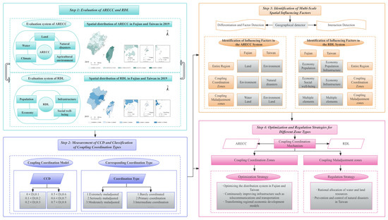
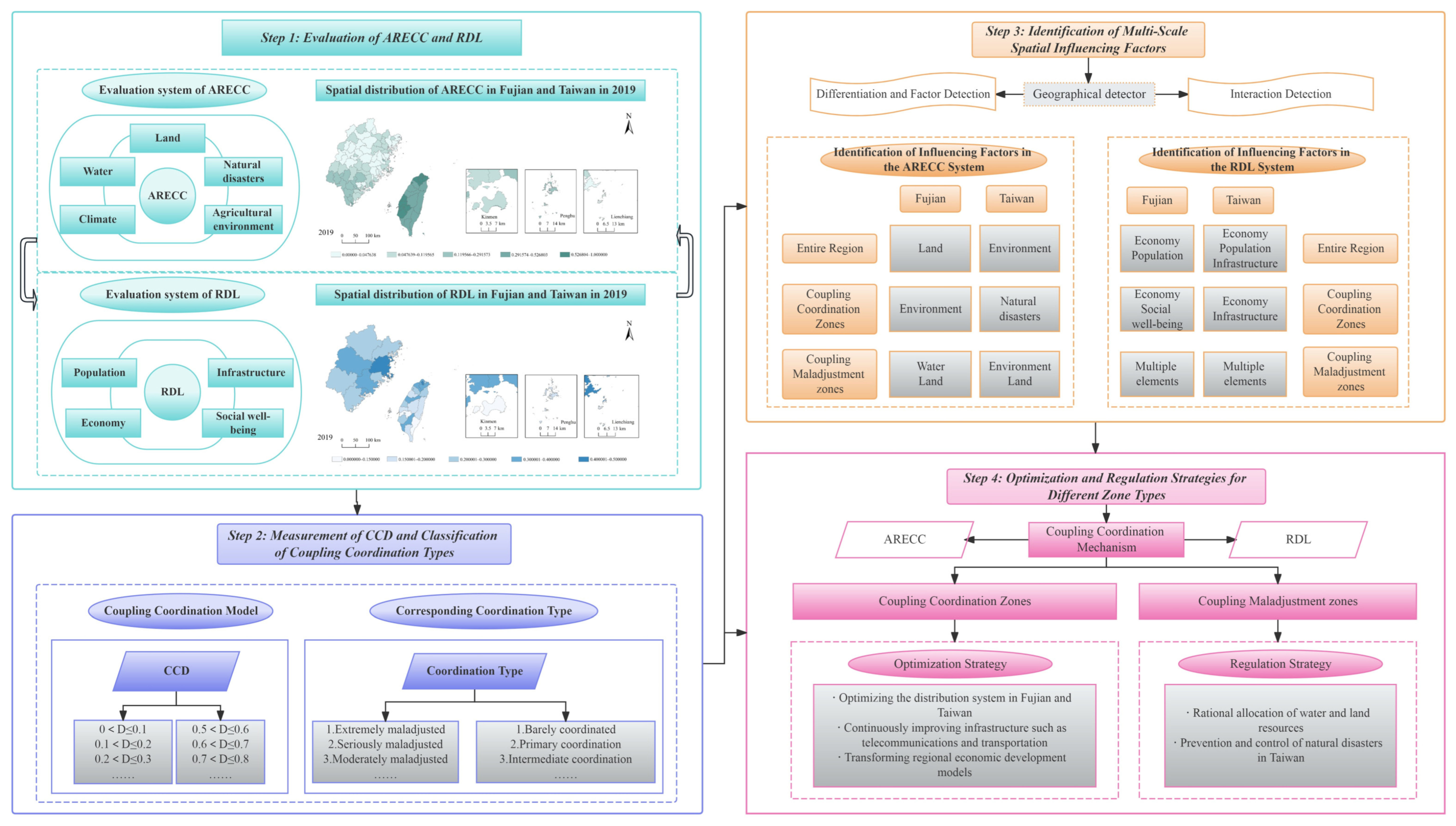
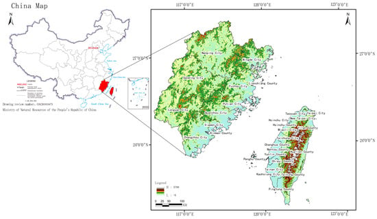
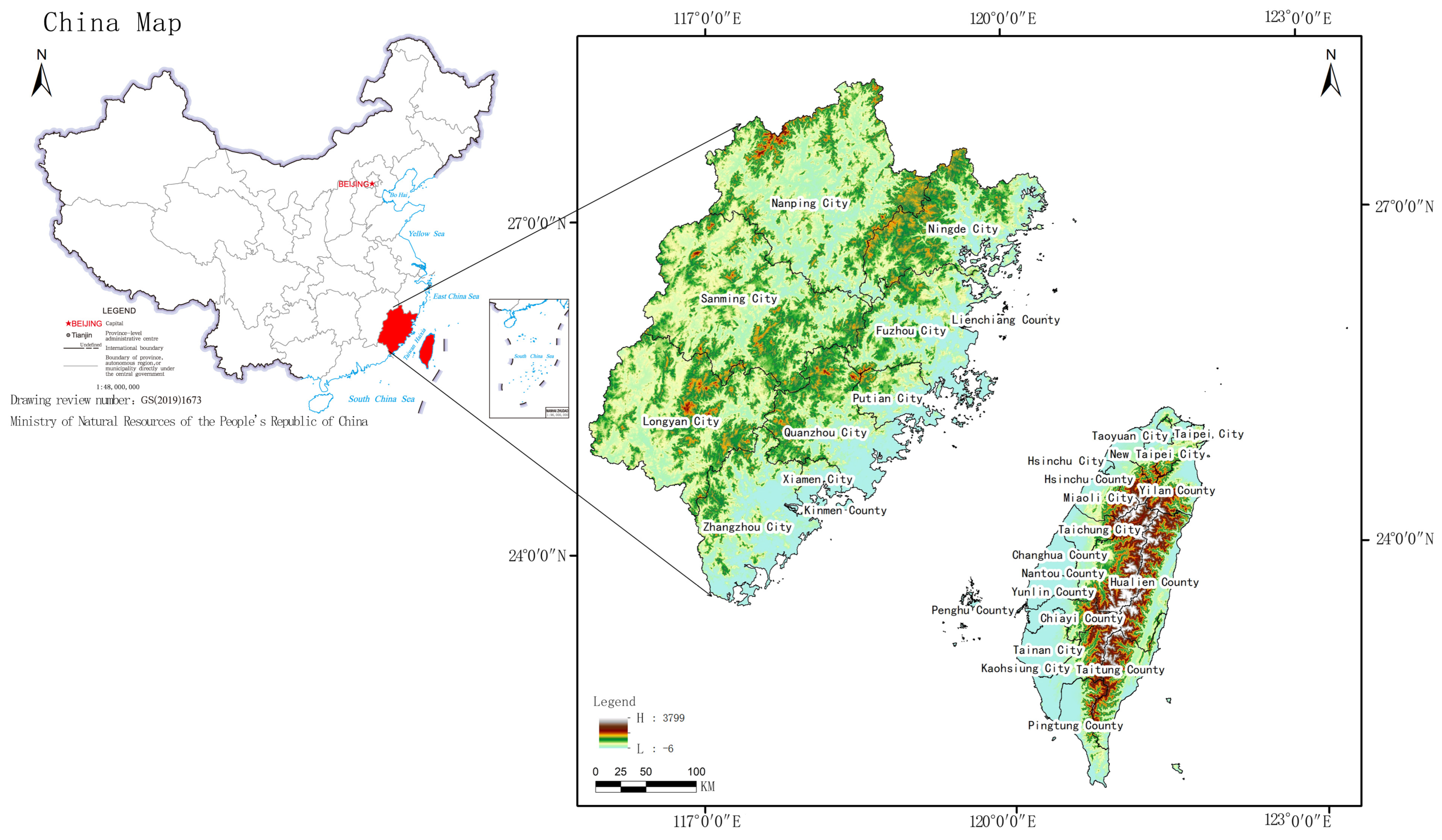
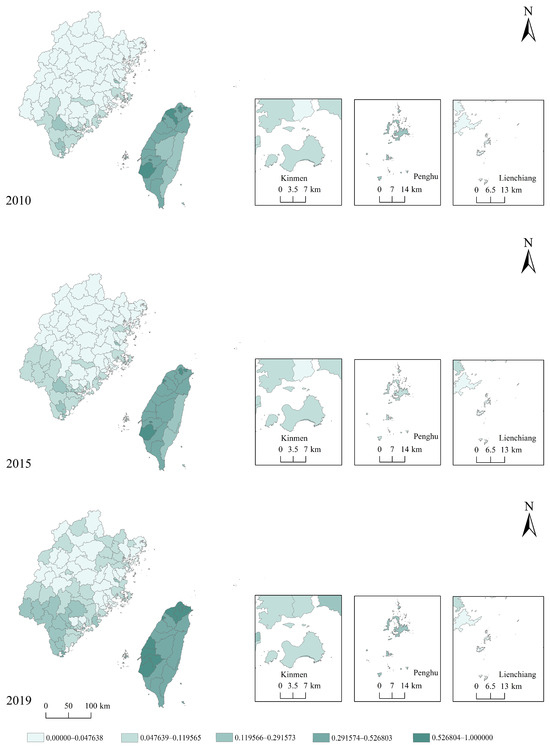
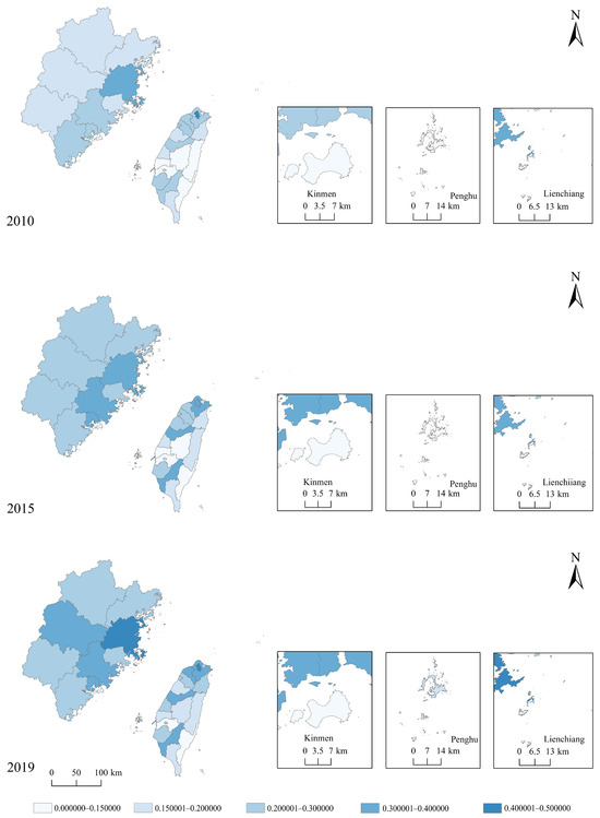
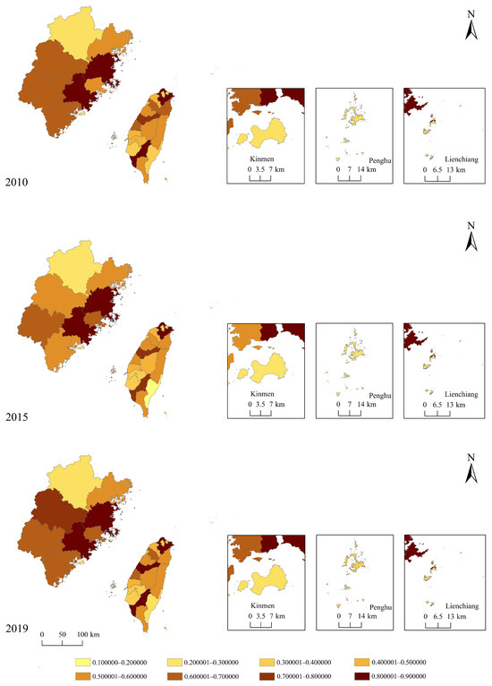
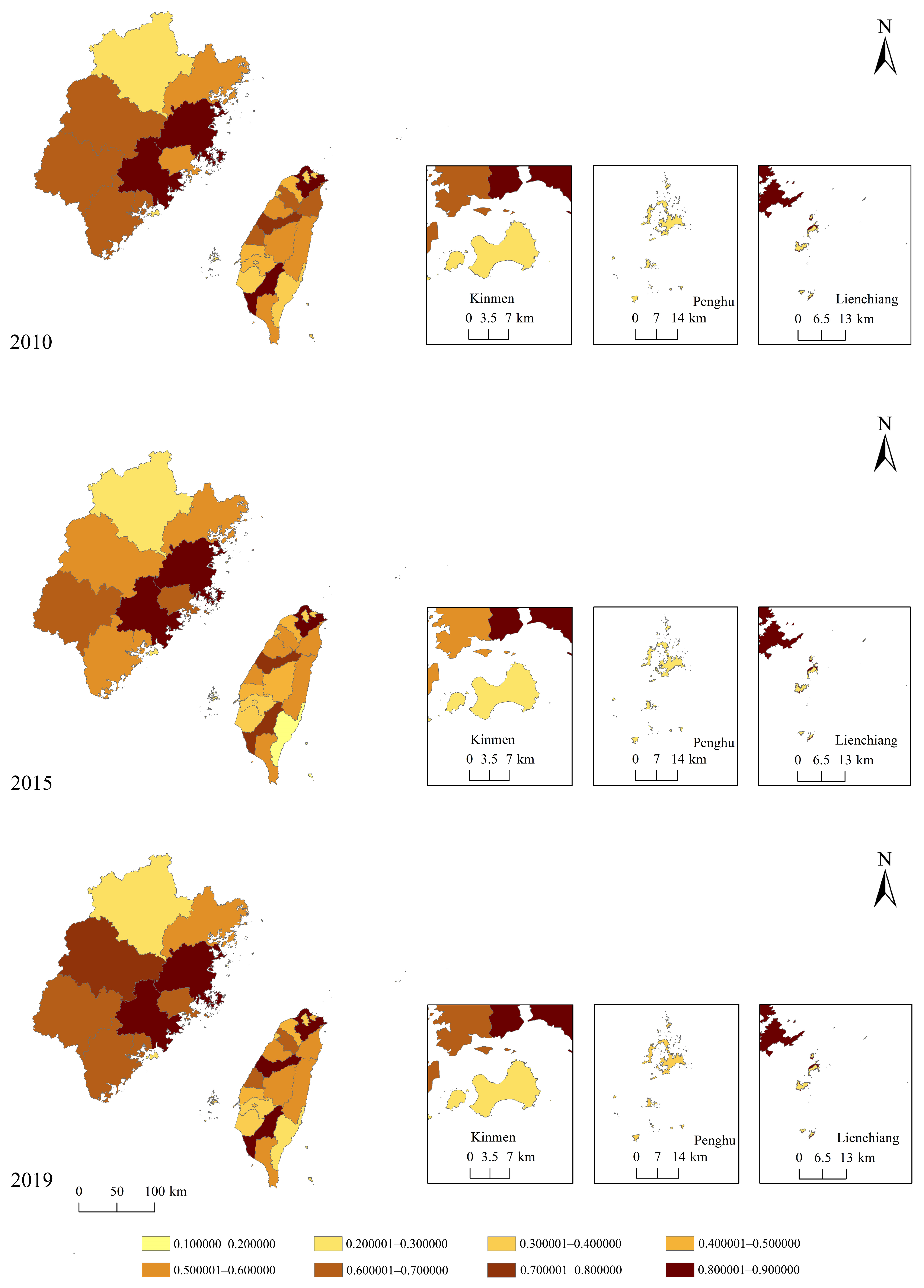
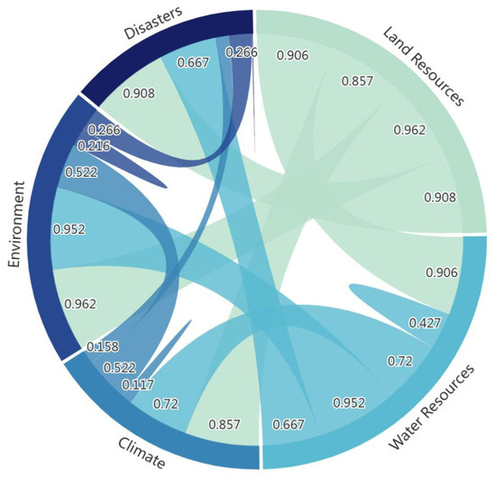
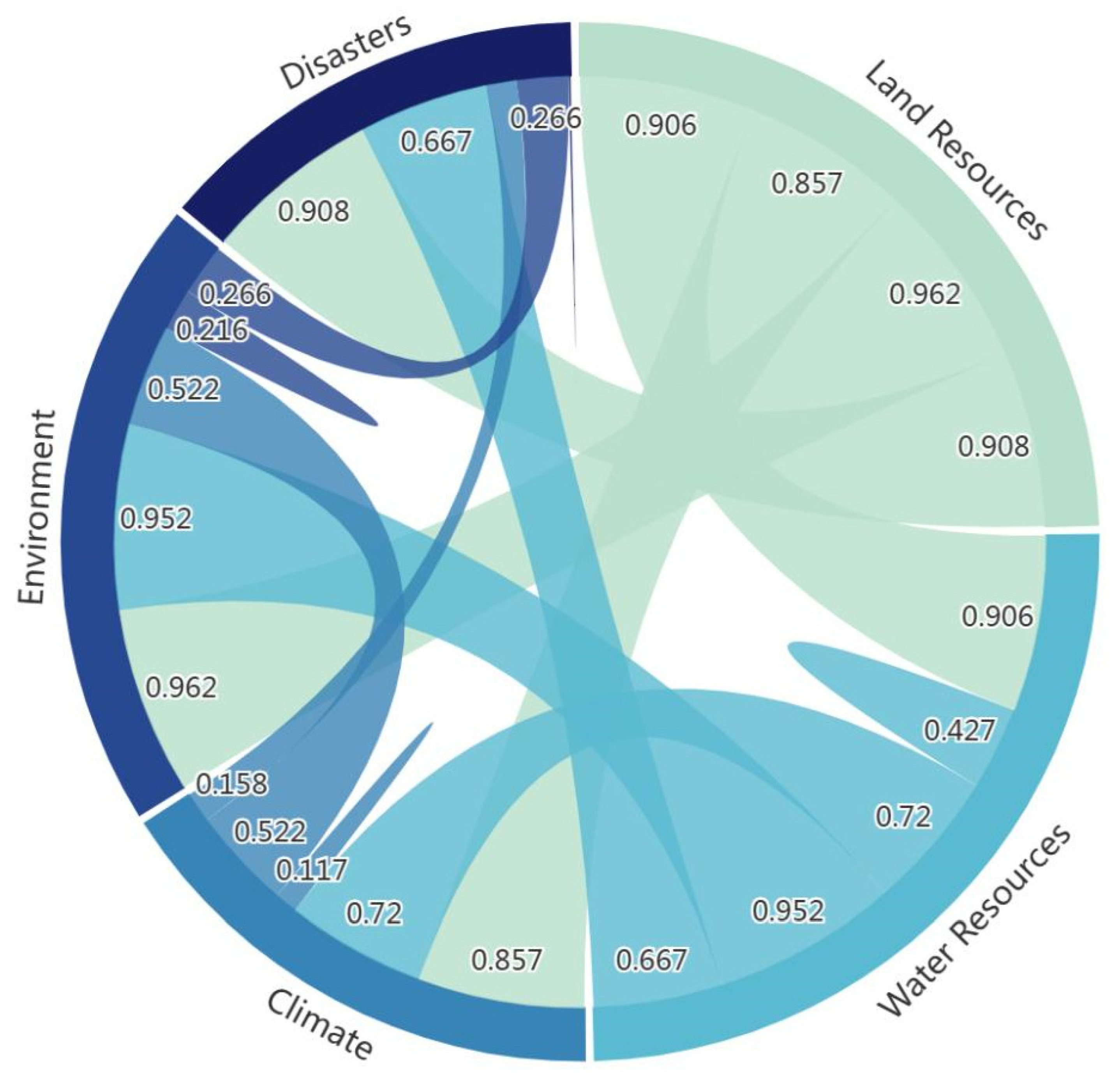
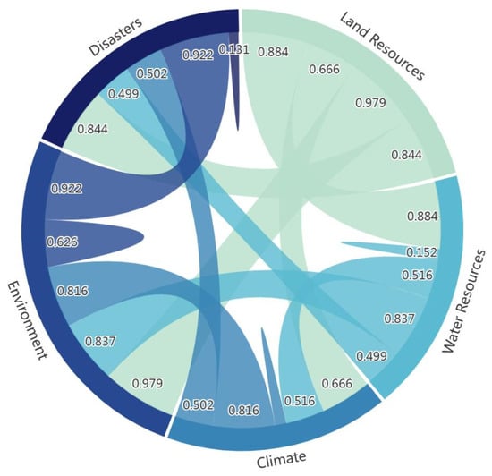
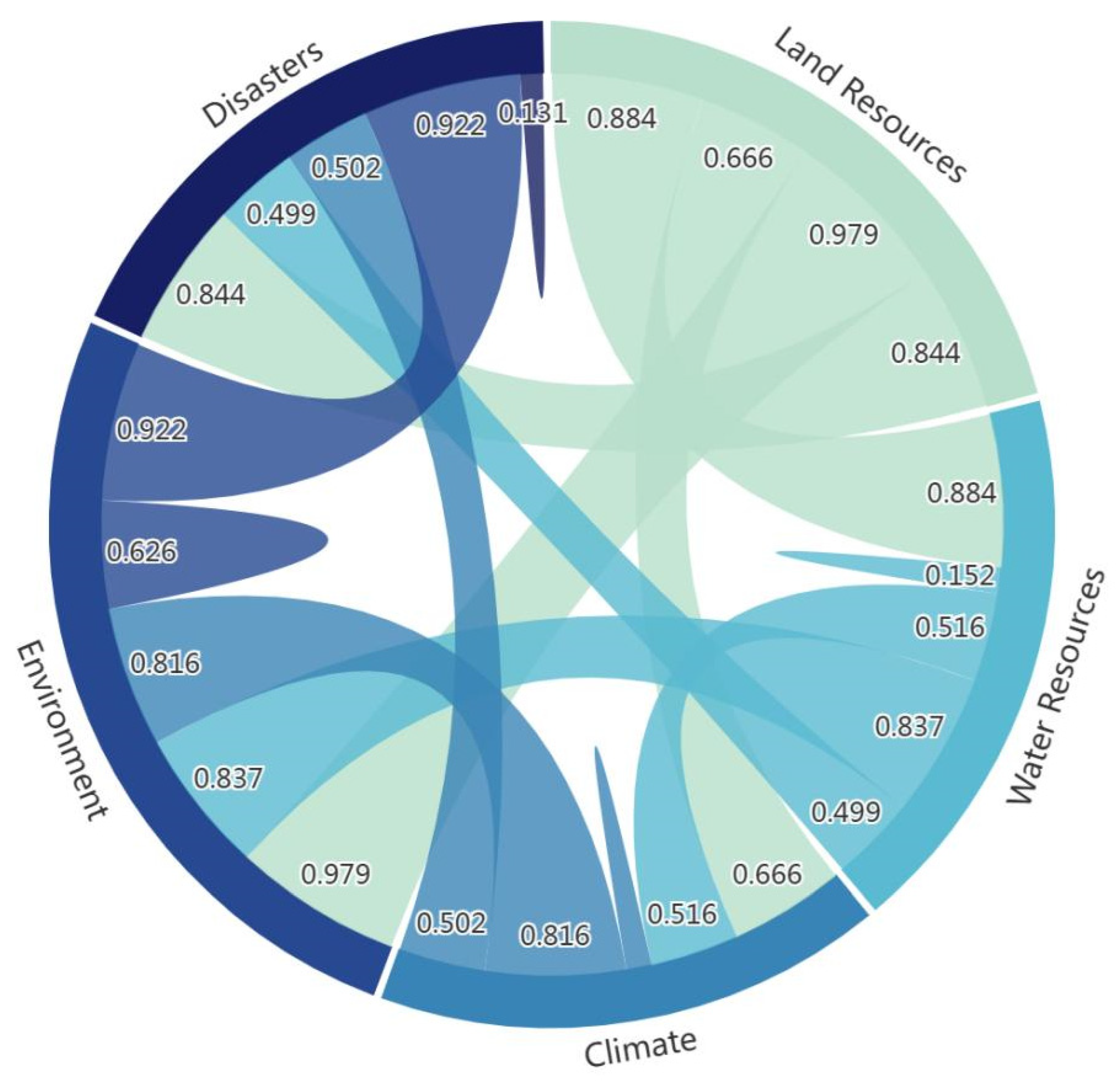
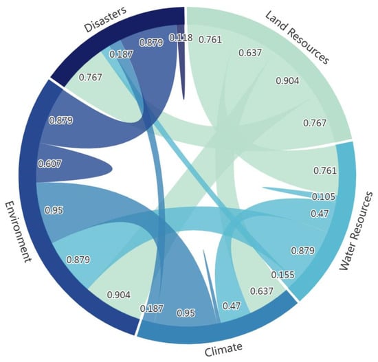
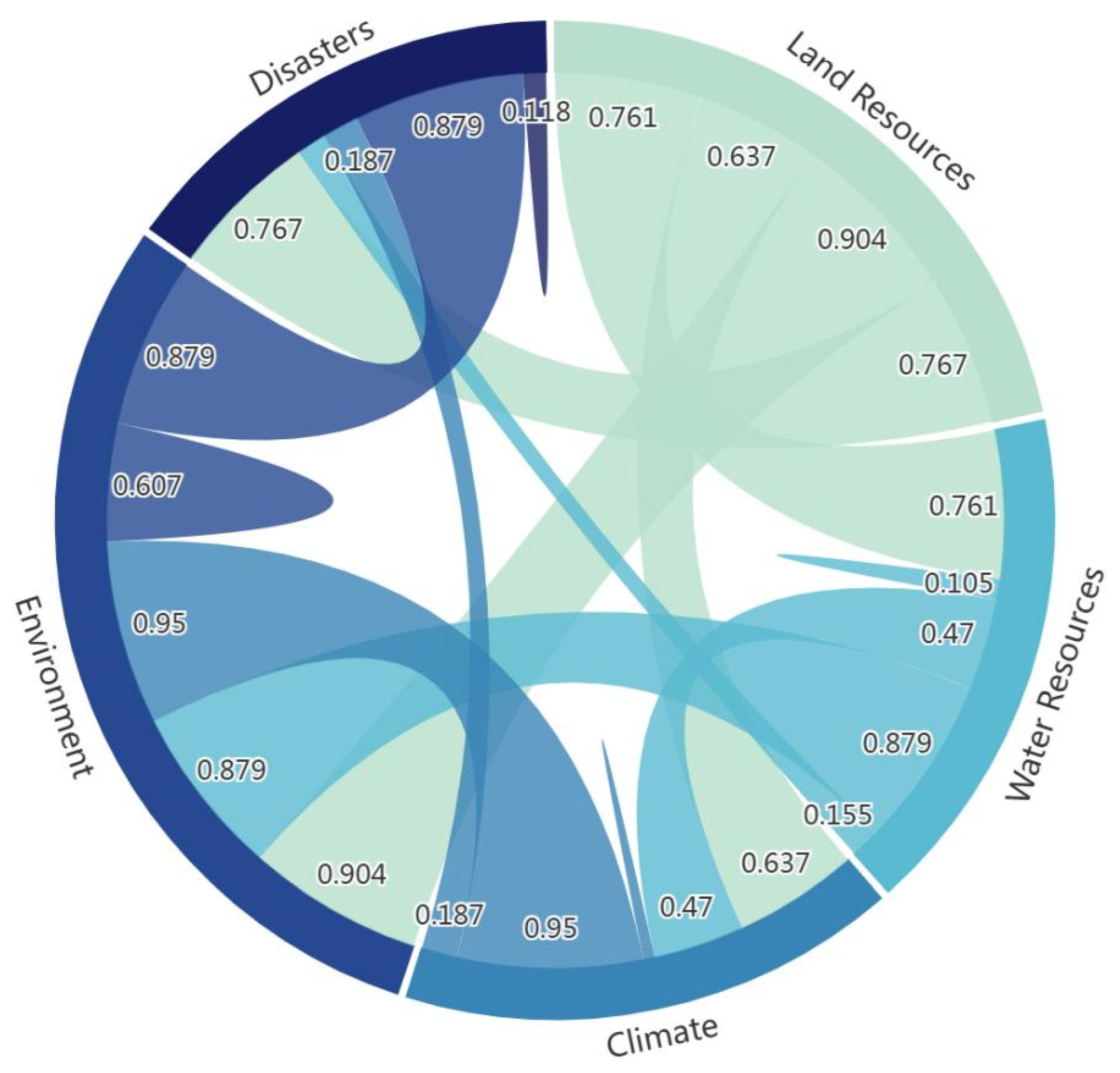
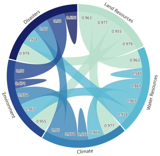
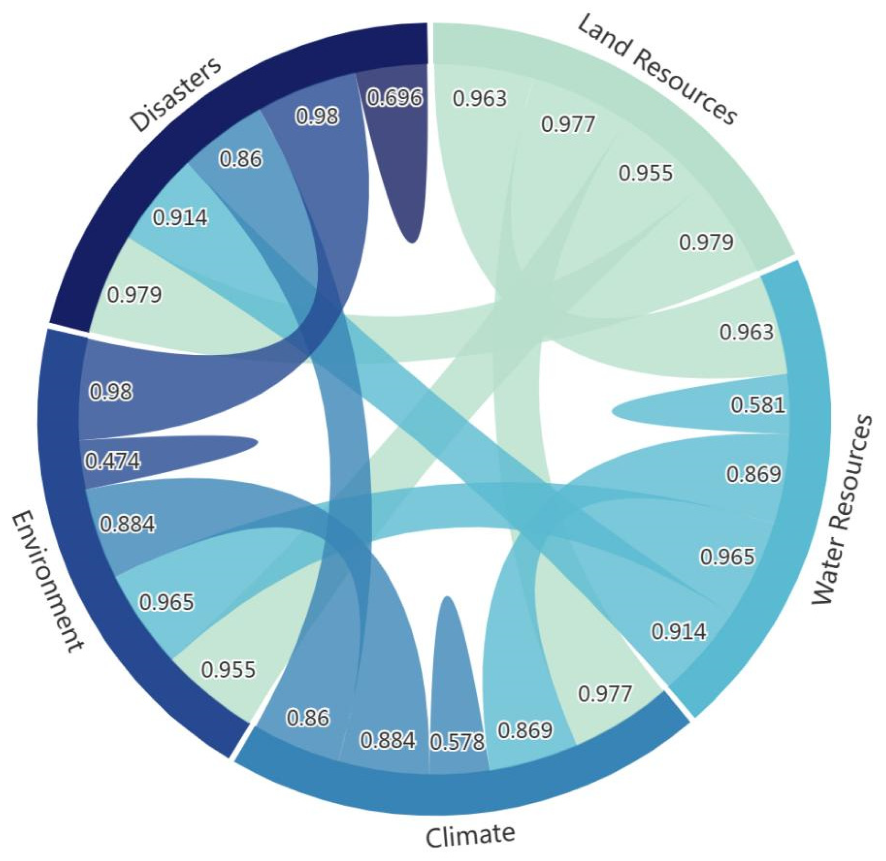
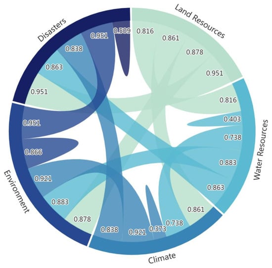
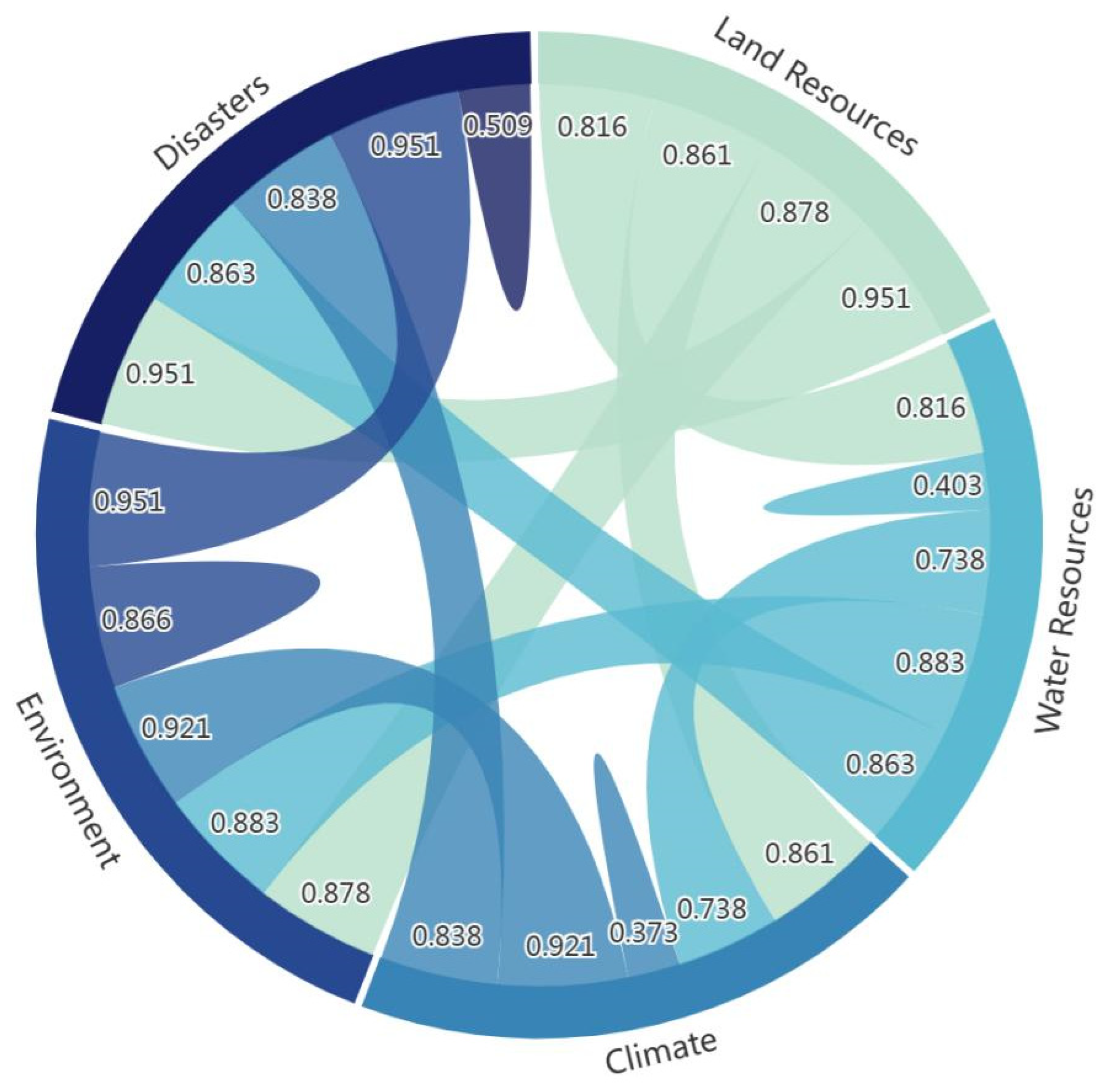
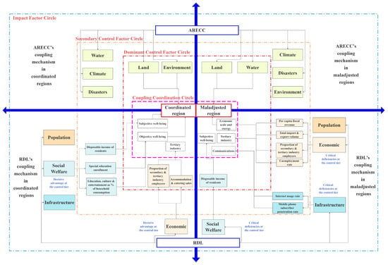
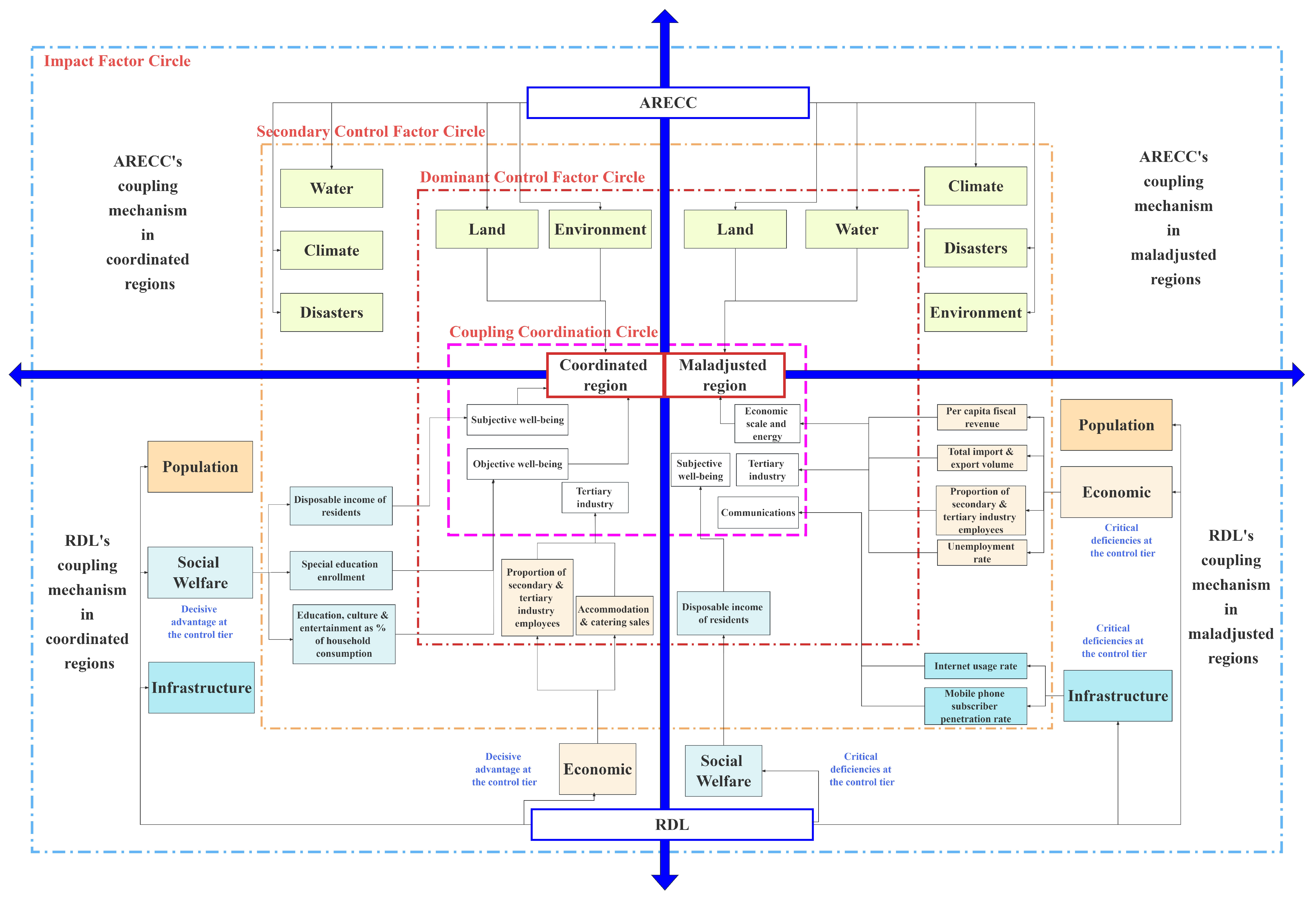
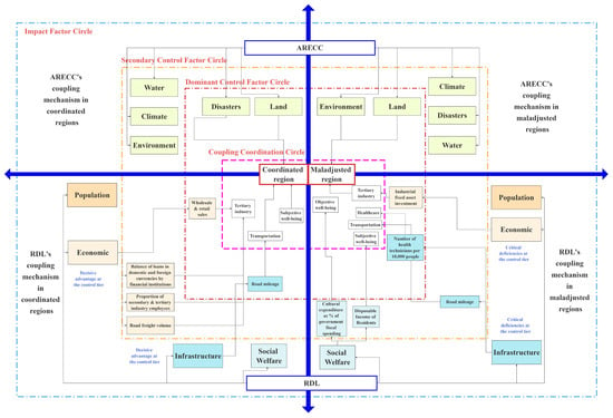
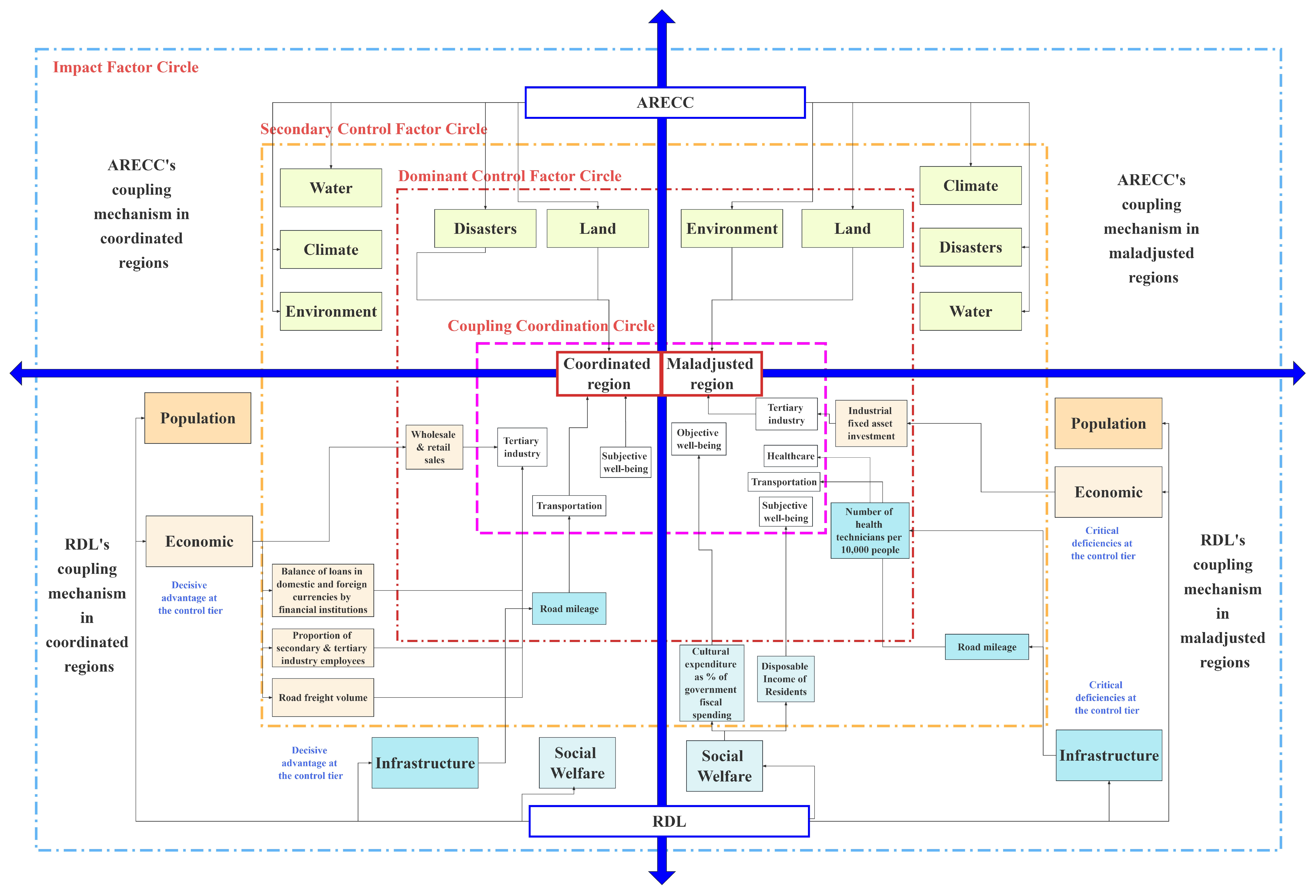

Disclaimer/Publisher’s Note: The statements, opinions and data contained in all publications are solely those of the individual author(s) and contributor(s) and not of MDPI and/or the editor(s). MDPI and/or the editor(s) disclaim responsibility for any injury to people or property resulting from any ideas, methods, instructions or products referred to in the content. |
© 2026 by the authors. Licensee MDPI, Basel, Switzerland. This article is an open access article distributed under the terms and conditions of the Creative Commons Attribution (CC BY) license.