1. Introduction
The Land and Buildings Register (EGiB) is a public register whose purpose is to protect one of the most valuable rights, namely the right to property [
1]. The Land and Buildings Register (EGiB) currently serves as Poland’s cadastre (EGiB) and constitutes the primary public register containing information on real estate, particularly land and buildings. It is a key component of the spatial planning system, and its data is widely used in both the public and private sector—particularly in investment, planning and legal processes. The quality and timeliness of cadastral information are of direct importance to the proper functioning of the property market and, consequently determine the efficiency and effectiveness of many stages of the investment process. Recent literature also confirms that data quality, maintenance, and continuous updating remain key global challenges for cadastral systems [
2,
3].
The quality of cadastral data relating to property can affect the investment process in various ways. Clearly defined boundaries enhance the effectiveness of investments by providing legal certainty and reducing disputes over land ownership [
4,
5,
6]. Establishing property boundaries is time-consuming and involves analysing documentation, including historical records; it also requires the participation of property owners, administrative bodies, and potential investors. Ensuring that property boundaries are accurately defined is one of the fundamental tasks of the cadastral system [
7,
8,
9]. Precisely defined boundaries make it possible to determine the scope of the rights attached to a property correctly [
6,
10,
11]. Contemporary studies emphasise that improving cadastral data structures and their gradual modernisation is a long-term, iterative process that requires the continuous refinement of digital cadastral databases [
12].
Accurate and detailed demarcation of property boundaries in the cadastre (EGiB) reduces the market transaction costs, as there is no longer any need to engage a surveyor or waste time on the boundary demarcation process [
13]. Projects involving the determination and demarcation of property boundaries on the ground improve the identification of the scope of property rights. Such modernisation works increase local authorities’ revenue from property taxes [
14], while also promoting greater respect for property rights among neighbouring landowners. This in turn, translates into increased land use and long-term investment in land [
4]. Clearly defined boundaries also encourage investment in property, such as irrigation and soil conservation [
5]. In this context, fit-for-purpose approaches and renewal strategies are increasingly proposed as effective methods of improving cadastral systems, particularly in countries facing heterogeneous data quality [
15].
In Poland, the boundaries of all properties are ultimately to be defined with an accuracy of no more than 0.1 m relative to the national geodetic control network [
16]. If the cadastral data specifying the location of the boundary do not meet these accuracy requirements, a developer planning to construct a building within the minimum permitted distances from the boundary (i.e., 4 m if the building has windows or doors facing the boundary, and 3 m if the building has no openings on the wall facing the boundary) must commission a surveyor to determine the position of these boundaries on the ground and to measure them to the required accuracy [
17]. This approach adds further months to the investment process. Although the regulations provide for exceptions, depending, among other things, on the width of the parcel, the type of development, the provisions of the local development plan or the planning permission decision, there is no doubt that the correct determination of the boundaries of a registered parcel is of crucial importance. Uncertainty regarding the location of boundaries may increase the likelihood of a boundary dispute arising.
The accuracy and reliability of data on property boundaries affect the quality of other data, such as the area or dimensions of a parcel of land, information which is crucial for investment decisions [
6,
18]. Inaccurate data regarding property boundaries can lead to errors in property valuation, affecting property prices and resulting in the misallocation of resources [
19,
20,
21,
22]. Accurate data significantly narrows the valuation gap. Valuations based on inaccurate data may even raise concerns about the credibility of the valuation profession [
23]. In addition, numerous studies highlight that the positional accuracy of cadastral maps remains a persistent issue, particularly in the case of digitised or historical sources [
24,
25,
26,
27]. Inaccurate and inconsistent data also prevent the use of modern automated valuation methods [
20,
22,
28,
29]. The lack of an up-to-date, unified database of standardised property information is considered to be the main cause of delays in property transactions [
30].
The geometric and descriptive data recorded in the EGIB database (cadastral register) include not only the boundaries and areas of parcels but also land use classifications, as well as information on buildings [
17], and form the basis for design processes. Research conducted in different countries shows that the methods used for cadastral updating, including field data acquisition and system modernisation, significantly influence data quality and usability [
31,
32,
33,
34]. In Poland, the investment process relating to the construction of buildings is governed primarily by the provisions of the Construction Law [
35] and the Regulation on the technical requirements to be met by buildings and their siting [
36]. In addition to the distances between buildings and parcel boundaries mentioned above, these regulations also specify the minimum distances between buildings and other buildings, as well as from certain types of land use, including, in particular, woodland. The regulations specify the minimum distances that buildings must be kept from the forest boundary, which is defined as the land-use boundary. The distances required by law depend on the type of building, its intended use and its fire resistance class. The primary aim of the new regulations remains to ensure fire safety and environmental protection. In the context of cadastral data, it is essential to correctly classify land use, as an incorrect classification may lead to an inaccurate assessment of the permissibility of development or necessitate a change to the design. A separate issue is the identification of land use boundaries from raster maps and their inclusion in the EGiB database.
The provisions of [
35,
36] also govern the minimum distances between buildings, particularly in relation to fire safety requirements and ensuring adequate lighting and natural light in rooms. These distances depend on the intended use of the buildings, their height, their fire resistance rating, and the location of windows and doors. In design practice, the assessment of these requirements is based on spatial data derived from the design map and the EGiB database. The poor quality of geometric data in the EGiB database, resulting, for example, from data sources other than direct measurement—such as the vectorisation of raster maps—may lead to an incorrect assessment of compliance with distance requirements and complicate the investment process. Compliance with the specified distance requirements in the planning process depends directly on the clear and precise definition of: the boundaries of the parcel, the location of existing and proposed buildings, and the type and boundaries of land uses.
Poor-quality cadastral data, particularly regarding boundary points, parcel boundaries or existing buildings, may result in the proposed structure being incorrectly located and, consequently, lead to the need to amend the design, obtain a planning exemption or even suspend the project.
EGiB data form the basis for analyses carried out as part of spatial planning, as well as for the preparation of planning documents, including general plans, local spatial development plans (MPZP) and the issuance of development consent decisions [
37]. Accurately defining the extent of property rights is important in spatial planning and land use planning [
38,
39]. Parcel boundaries, land use designations and building data serve as a reference point for planning decisions. As authors specialising in spatial data infrastructure point out, a lack of consistency between the EGiB and planning documents can lead to ambiguities in interpretation and difficulties in project implementation [
40]. In particular, outdated data on land use or incorrect parcel boundaries may result in the land being incorrectly classified in terms of its permitted development use. In an urban context, the precise demarcation of land use boundaries helps to manage urban development and supports sustainable urban planning [
40,
41].
A key aspect of cadastral data quality in Poland is that, under current legislation, the EGiB (Real Estate Cadastre) serves as a reference register for other public systems and registers. This highlights the fundamental importance of this register within the legal system and the property sector. Although the Central Office of Geodesy and Cartography is responsible for overseeing the maintenance of the EGiB, the task of regularly updating and making the data available falls to district administrators, acting as district-level geodesy and cartography authorities [
42]. In practice, this results in variations in database quality and format across the country despite a uniform legal framework, which poses a significant problem. From 1 January 2023, GML has become the only acceptable format for the exchange and sharing of cadastral data. However, delays in the introduction of the interoperable GML data format continue to limit the ability to automatically verify, analyse and process spatial information, and they negatively affect the efficiency of investment and administrative tasks. Although uniform legal provisions are in force, a variety of technical and technological solutions are still used in practice, and there are differences in database structures and data export formats. This results in significant variations in the quality and availability of cadastral data across the country, thereby hindering the efficient handling of investment and administrative processes.
The literature emphasises that the effectiveness of a cadastral system depends largely on the extent to which it is integrated with legal, technical and planning registers [
43]. In the European context, the integration of public registers is examined within the framework of the Infrastructure for Spatial Information (INSPIRE) initiative, whose aim is to ensure the interoperability of spatial data [
44]. It is pointed out that effective data exchange between registers requires not only standardised formats (e.g., GML), but also semantic consistency and unambiguous attribute definitions.
Cadastral data that is insufficiently accurate, out of date, available in various formats, or inconsistent with other registers poses significant risks to those involved in investment processes. Despite extensive research on cadastral data quality, positional accuracy, system modernisation, and the interoperability of land administration systems, there remains a lack of studies that explicitly examine how deficiencies in cadastral data translate into specific risks at different stages of the investment process. In particular, existing literature rarely addresses:
the relationship between the quality of key cadastral components (such as boundary points, land use classifications, and building data) and the practical consequences for surveying and design activities,
the extent to which variations in data quality across spatial units influence legal, technical, temporal, and economic risks faced by investors,
the impact of heterogeneous and non-standardised cadastral databases on the efficiency of investment processes at the national scale.
This gap is especially evident in Poland, where the Land and Buildings Register (EGiB) functions as a reference register for other public systems, yet its data quality remains uneven across administrative units and strongly dependent on historical development and the degree of database modernisation [
45].
In response to this gap, the study addresses the following research questions: (1) How does the quality and level of development of cadastral data in the EGiB vary across different types of settlement units, and how has this quality changed between 2022 and 2026? (2) What types of deficiencies and irregularities in cadastral data—particularly those related to boundary points, land use, and buildings—are most relevant for surveying studies conducted in the investment process? (3) What kinds of risks (legal, technical, temporal, and financial) arise from insufficient cadastral data quality, and how do they affect the course and efficiency of the investment process?
2. Materials and Methods
The study areas were selected to obtain a sample representative of cadastral data characteristics across Poland and were divided into four groups: provincial capitals (W), county seats (P), smaller towns (M), and rural municipalities (G). The selected research areas differ in terms of settlement size and degree of urbanisation. Three study areas were selected within each group: provincial capitals (W), county towns (P), smaller towns (M), and rural municipalities (G).
In the case of urban areas (groups W, P, and M), the study sites were located outside the city centres. For the rural municipalities group (G), the study areas were situated near the centre of the locality serving as the administrative seat of the municipality. The selected sites were partially undeveloped but located in the vicinity of existing buildings. Each research parcel covered an area of approximately 20 hectares.
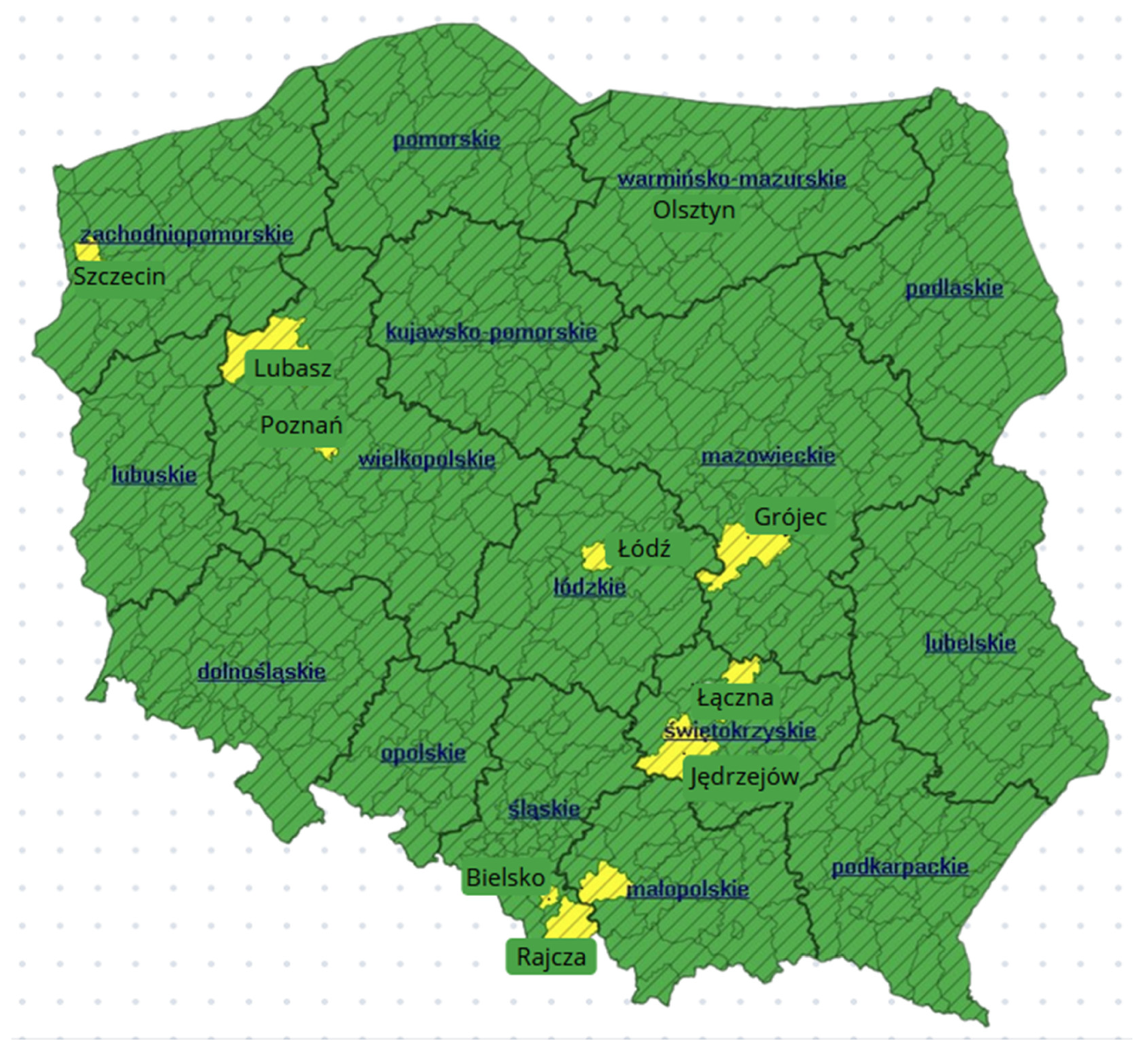
In
Figure 1, the counties containing the study areas are marked in yellow.
In response to requests submitted to the authorities responsible for maintaining the District Geodetic and Cartographic Resource, access was granted to EGiB database files and cadastral maps for each study parcel. The data were obtained on two occasions, in March 2022 and March 2026, which enabled the analysis of changes occurring in the cadastral data over a four-year period. It is worth noting that, in accordance with [
42], the source data used in the research can be obtained without restriction, either for a fee or, in certain cases, free of charge, following the submission of a standardised application form applicable throughout Poland [
46].
At the initial stage of the study, the quality of the source data was assessed by identifying the format of the provided datasets and evaluating the maturity level of the databases for both analysed periods. The database maturity assessment was performed using the methodology developed by [
47] (
Table 1).
Three types of data disclosed in the EGiB database—boundary points, land use categories, and buildings—were subjected to detailed analysis in each study area. These datasets constitute the fundamental information required for design and investment processes.
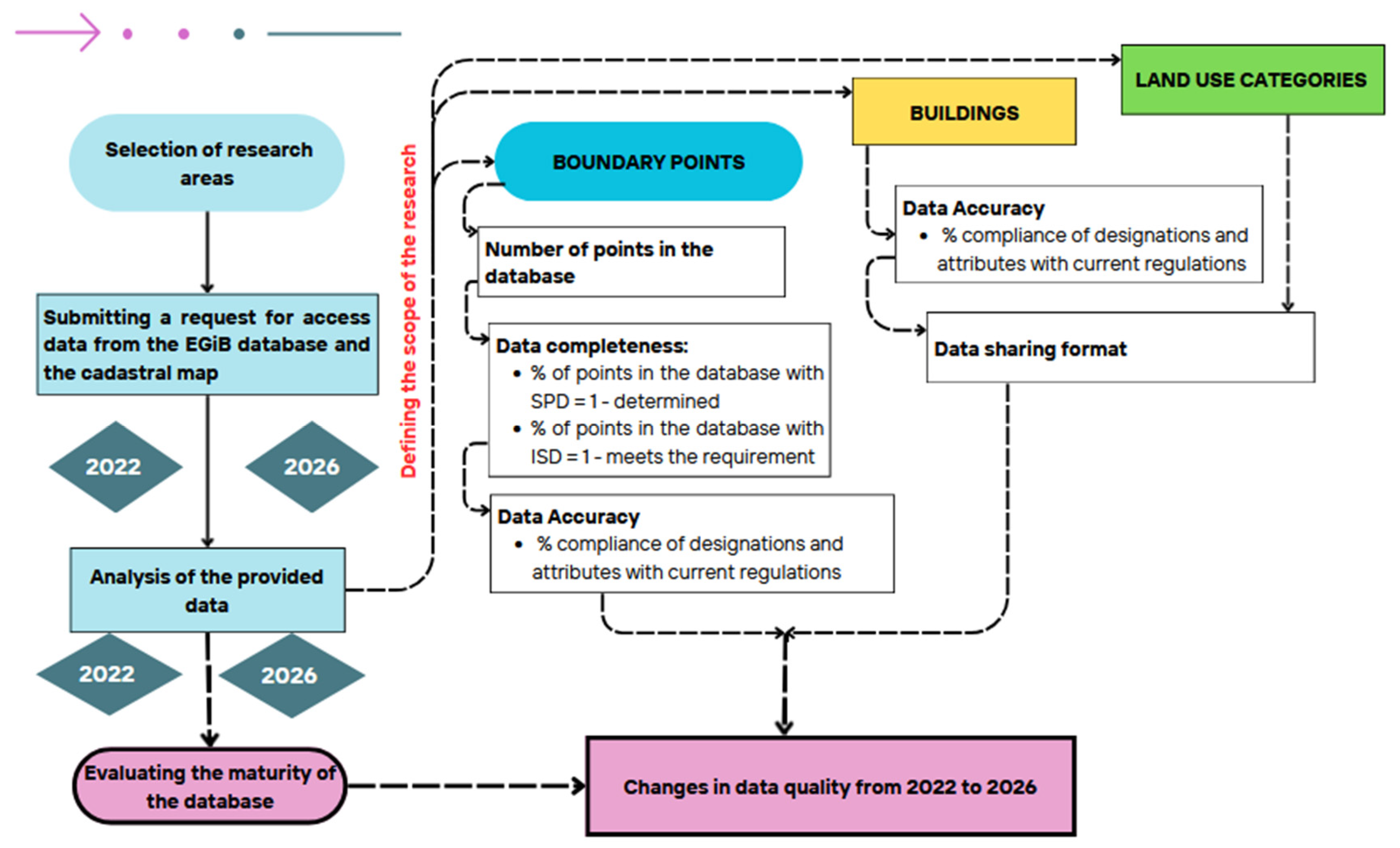
Figure 2 presents a flowchart illustrating the individual stages of the research methodology.
First, the format in which the data for each study area had been provided was verified. Subsequently, data quality aspects, including the completeness, accuracy, and timeliness of both graphical and attribute data, were assessed for areas where the data were available in the form of a full object-oriented EGiB database. The most detailed analyses were conducted for boundary points. The SPD (method of data acquisition) and ISD (accuracy) attributes assigned to parcel boundary points are mandatory elements of the EGiB database [
17] and play a crucial role in assessing property boundaries, particularly in the context of surveying work related to investment processes.
Completeness was defined as the percentage of records containing missing attribute values [
48]. Additionally, the proportion of boundary points representing the highest data quality level—i.e., points for which the “Method of obtaining boundary point data (SPD)” attribute was recorded as “fixed”—was calculated.
For boundary points, it was also possible to estimate the percentage of points meeting the highest accuracy standards, defined as a positional accuracy of 0–10 cm relative to the control network. In the EGiB database, such points are marked with the attribute “Information on compliance with accuracy standards for boundary points (ISD)” assigned the value “1—compliant”.
The currency of the data was assessed as the percentage of compliance of designations and attributes with current regulations [
17] for all three datasets.
All analyses were conducted using data collected in 2022 and 2026. The resulting tables present the areas in which data quality improved over time. The analyses were performed using QGIS software (version 3.40).
3. Results
The table below (
Table 2) presents the characteristics of the EGiB data obtained for the study areas in 2022 and 2026. The availability of a given data format is indicated by the symbol “X”. The information was compiled to identify the formats in which the data were provided for each study area and to assess the level of database development using the adopted methodology [
47].
In the case of study areas located in larger cities, the EGiB database had already been maintained as a comprehensive object-oriented database by 2022. In smaller towns and rural areas, the databases were either unavailable or only partially available, mainly for measurement data that had recently been incorporated into the resource. Older data remained available in the form of cadastral maps. The table indicates whether a complete database is maintained for a given area or whether only a partial database is available.
In the authors’ opinion, the situation identified in the Lubasz municipality in 2022 was the most problematic in terms of spatial data usability. In this study area, part of the data was stored in databases, part in vector map form, and part in the form of raster scans of historical cadastral maps. For most study areas, the cadastral map was provided in vector format, usually as a .dxf file. In some areas, such as Jędrzejów, the cadastral map was available in a hybrid format combining vector and raster data, with no vector data available for land use and classification contours.
In the case of areas located in southern Poland (formerly under the Austrian partition), historical cadastral maps are still made available as part of the EGiB cadastral documentation. For the study area located within Żywiec County, in the municipality of Rajcza, in addition to the cadastral map and the partially developed EGiB database, a copy of a historical paper cadastral map at a scale of 1:2880 was also obtained. This map presented the boundaries and numbering of former cadastral parcels. However, these materials were not used in the analyses conducted in this study.
3.1. Detailed Results of the Boundary Point Studies
An analysis of the quality of boundary point data across all study areas for the year 2022 revealed that the point attributes and designations complied with the provisions of the Regulation on the Land and Building Register [
17] that remained in force until 2021. In practice, this meant that instead of the currently applicable attribute ‘Method of obtaining boundary point data (SPD)’ (permitted attribute values: 1—fixed/determined or 2—unfixed/undetermined), the previous designations were still in use: ZRD (attribute values 1–9). Similarly, for the currently applicable attribute ‘Information on compliance with accuracy standards for boundary points (ISD)’ (permitted attribute values: 1—meets or 2—does not meet)—the BPP attribute values (1–6) were displayed. The analyses were carried out in accordance with current regulations, applying the principles set out in Annex 4 to the Regulation [
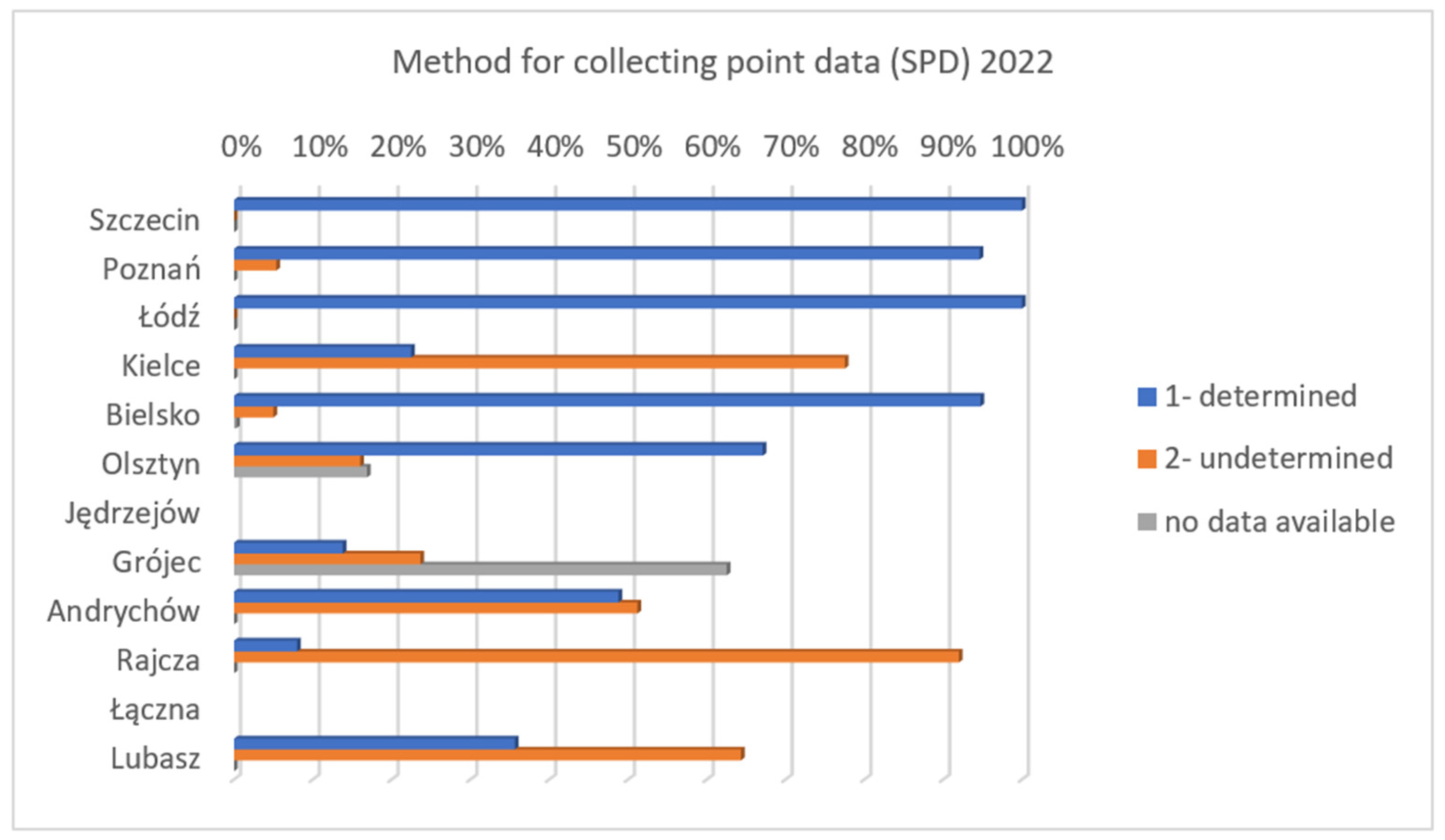
17]. The following charts (
Figure 3 and
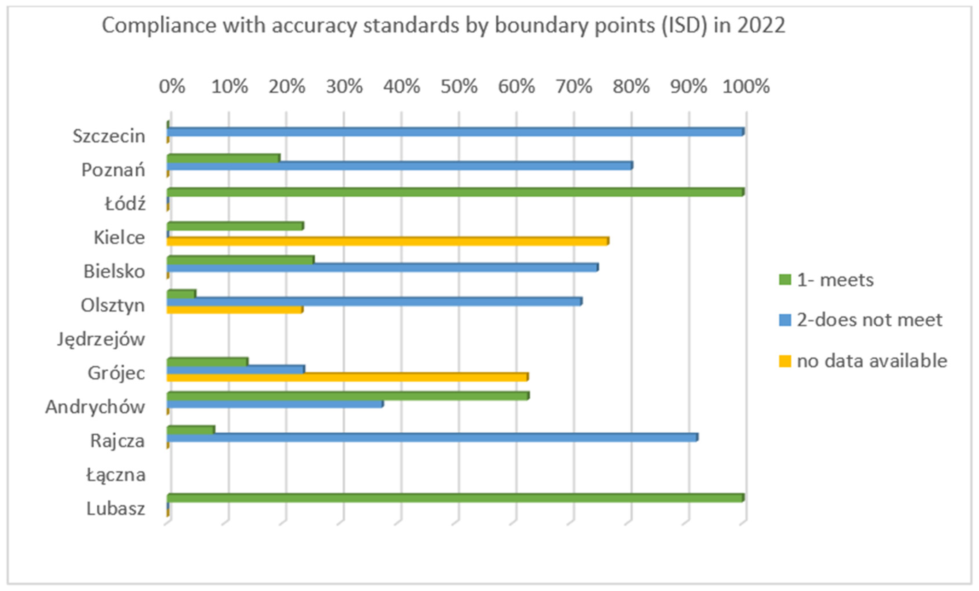
Figure 4) show the results regarding the percentage of boundary points with the SPD and ISD attributes, as well as points listed in the EGiB database without attribute values assigned, calculated on the basis of data from 2022.
The data analysis revealed significant variation in the status of boundary point determination across the analysed study areas (
Figure 3). In large cities such as Łódź, Poznań, and Szczecin, the proportion of points classified as “determined” exceeded 80–90%, indicating a high level of reliability and positional accuracy of the recorded data. A different situation was observed in rural areas and smaller towns, including Rajcza, Lubasz, and Olszyna, where boundary points with an “undetermined” status predominated. The results confirm that the quality of cadastral boundary data is strongly related to the type and size of the settlement unit. Urban areas are characterised by a higher level of completeness and reliability of cadastral data, whereas rural areas still contain a substantial proportion of boundary points with undetermined status. This may lead to legal and technical difficulties in surveying, investment, and property management procedures. In three study areas—Grójec, Olszyna, and Lubasz—boundary points without assigned attribute values were also identified.
Figure 4 presents the proportion of boundary points that meet and do not meet the applicable accuracy standards in the analysed study areas.
The results revealed significant variation in data quality among the analysed districts and towns. The highest proportion of boundary points meeting the accuracy requirements was recorded in Łódź and Lubasz, where the share approached 100%. In the Andrychów study area, more than half of the boundary points complied with the accuracy standards specified in the applicable regulations. A different situation was observed in other areas. In Rajcza, Olsztyn, Bielsko-Biała, and, unexpectedly, also in Szczecin and Poznań, points classified in the database as not meeting the accuracy criteria predominated, in some cases accounting for more than 80–90% of all boundary points. Boundary points without assigned attribute values were identified in three study areas: Grójec, Olsztyn, and Kielce.
The analyses also revealed clear differences in the distribution of boundary point attributes related to the method of obtaining boundary point data (SPD) and compliance with accuracy standards (ISD) across the study areas. In the case of the SPD attribute, a distinct pattern was observed, with a higher proportion of “determined” points occurring in urban areas such as Łódź, Poznań, and Szczecin, whereas rural and less urbanised areas, including Rajcza and Grójec, were dominated by points with an “undetermined” status. This phenomenon may be explained by the greater intensity of surveying activities and more frequent database updates in urban areas, which facilitate the incorporation of new survey results into the cadastral database.
However, the ISD analysis did not reveal an equally clear relationship. Importantly, points classified as “determined” under the SPD attribute did not always simultaneously meet the applicable accuracy standards defined by the ISD attribute. This indicates that the determination status of a boundary point alone does not guarantee its compliance with current positional accuracy requirements.
The combined analysis of both attributes demonstrates a lack of full consistency between the legal or procedural status of a boundary point and its actual positional accuracy. The obtained results indicate the need for further updating and verification of cadastral data, particularly in rural areas where data derived from historical cadastral maps with limited measurement accuracy still predominate.
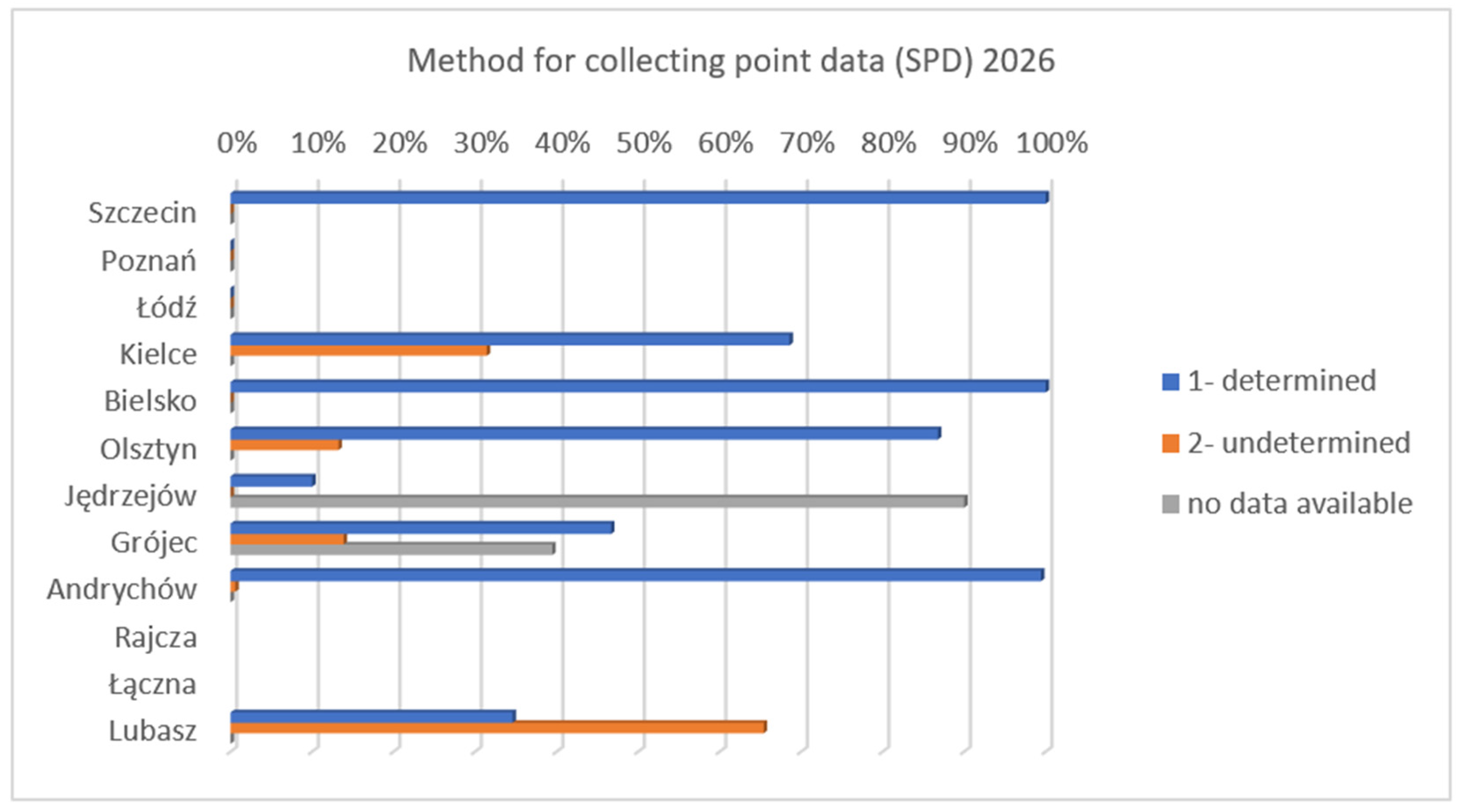
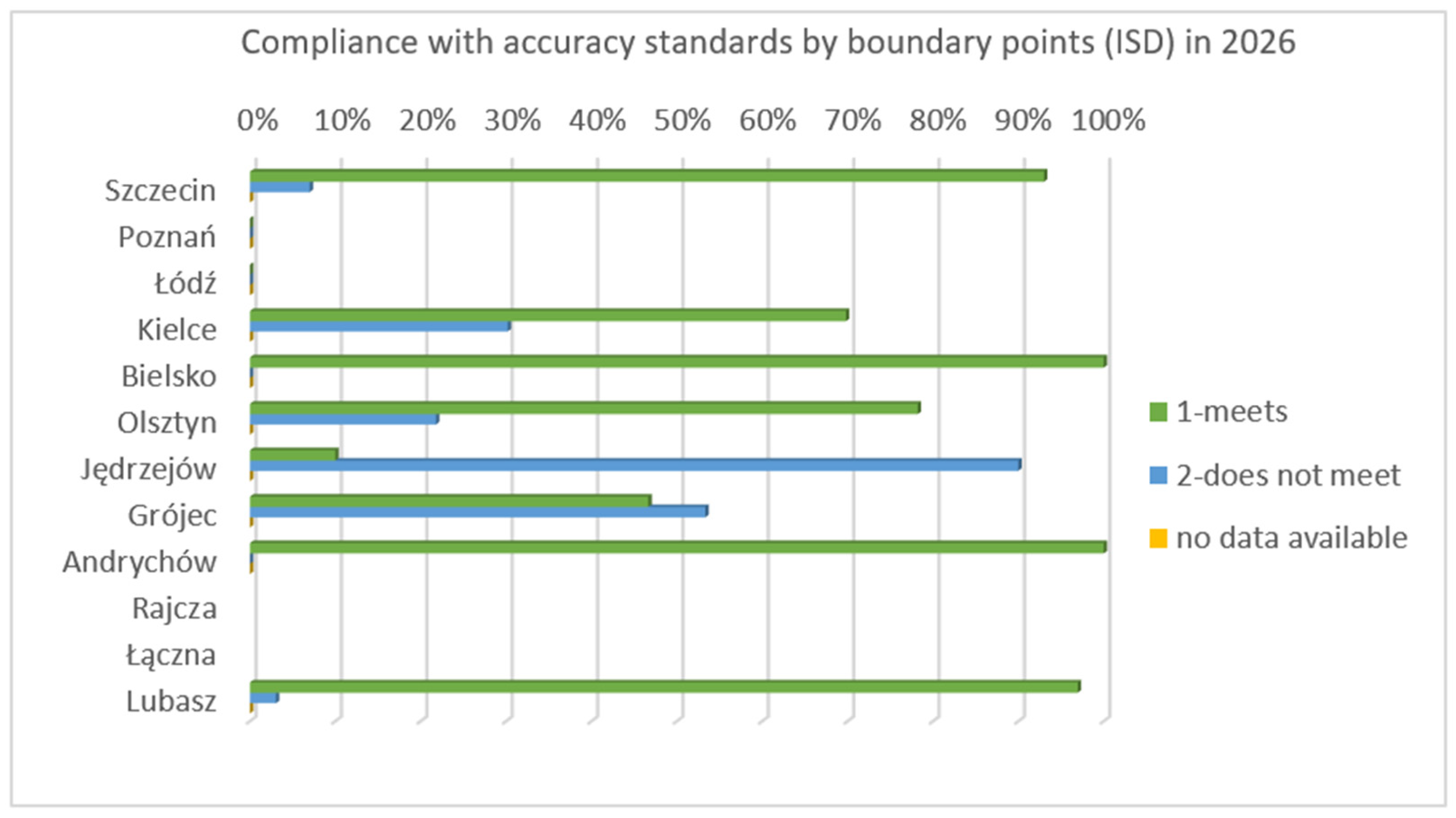
Figure 5 and
Figure 6 present the percentage distribution of boundary points assigned SPD and ISD attributes, based on the data collected in 2026. In the case of the Poznań and Łódź study areas, the received GML files did not contain boundary point attributes, despite the fact that such attributes had been available in previous years. Consequently, analyses for these areas could not be performed.
Significant differences were observed in the methods used to acquire boundary point data (SPD) across the analysed territorial units. The highest proportion of points with a “determined” status was recorded in areas such as Szczecin, Bielsko-Biała, and Andrychów, where this share approached 100%. In contrast, areas such as Jędrzejów were characterised by a substantial proportion of records classified as “no data”, indicating considerable gaps in the available information regarding the status of boundary points.
In some locations, including Lubasz and Kielce, a significant proportion of boundary points had an “undetermined” status, which may indicate the absence of reliable source documentation required to assign an unambiguous status to these points. The analysis also identified areas with a highly heterogeneous data structure, such as Grójec, where all three categories occurred at a substantial level.
Based on the data presented in
Figure 6, significant variation was observed in the degree of compliance with boundary point accuracy standards (ISD) across the analysed units. The highest proportion of points meeting the accuracy requirements was recorded in areas such as Lubasz, Andrychów, Bielsko-Biała, and Szczecin, where this indicator approached 100%, which may indicate that comprehensive modernisation works had previously been carried out in these areas. A different situation was observed in areas such as Grójec, Olsztyn, and Kielce, where a substantial proportion of boundary points did not meet the applicable accuracy standards. At the same time, the coexistence of significant proportions of both compliant and non-compliant points within a single administrative unit may indicate inconsistencies in data quality and varying levels of cadastral data modernization.
A comparison of the SPD and ISD results for 2026 revealed a clear relationship between the method of obtaining boundary point data and the accuracy of their disclosure in the EGiB database. Administrative units characterised by a high proportion of points classified as “determined” also tended to demonstrate a high level of compliance with accuracy standards. Conversely, areas with a substantial proportion of “no data” or “undetermined” entries were frequently associated with lower levels of compliance with the applicable accuracy requirements.
This situation may indicate the need for comprehensive modernisation works or may result from inconsistencies in source materials and the limited availability of surveying documentation. The obtained results confirm that the quality of boundary point data in the EGiB database varies significantly between different areas and depends largely on the history of surveying works, the extent of cadastral modernisation processes, and the frequency of database updates. Comprehensive modernisation activities contribute simultaneously to improving both data completeness (SPD) and geometric accuracy (ISD), thereby significantly increasing the reliability of parcel boundary data.
Table 3 below shows the percentage change (difference between 2026 and 2022) for the two breakpoint attributes analyzed, as well as the number of breakpoints identified in the database.
As shown in
Table 3 above, over the last four years there has been a process of organising data on boundary points in the databases for the areas under analysis. The quality of point data relating to the SPD attribute has improved across all areas. The same applies to the ISD attribute. As of 2026, no boundary points without an assigned attribute were identified in any of the analysed areas. In the Jędrzejów and Lubasz study areas, a significant increase in the number of boundary points recorded in the EGiB database was observed, which may indicate that comprehensive database updating and modernisation works had been carried out. Similarly, in the Szczecin area, changes were identified in the ISD attribute values assigned to boundary points previously disclosed in the database. In the Kielce study area, a substantial proportion of the points identified in 2022 as lacking attribute values were subsequently classified as “does not meet” in 2026. This explains the percentage increase in the number of points assigned this attribute value in the database.
3.2. Detailed Results of Land Use Surveys
No errors were identified in the land use classifications contained in the data made available for the analysed study areas in either 2022 or 2026. It should be noted that land use classifications have not undergone significant changes since 2015, which has substantially contributed to maintaining consistency within the EGiB databases.
Table 4 below presents an overview of the available datasets and identifies the areas and scope in which improvements were observed regarding the quality and availability of land use and boundary-related data.
In the case of the Jędrzejów study area, land use information in 2022 was available only in the form of a raster cadastral map. The data obtained for 2026 indicate a significant improvement in the digitisation level of the database. For the areas of Kielce, Grójec, and Łączna, the data were made available in the form of cadastral maps in DXF format. In five of the twelve study areas (Kielce, Lubasz, Łączna, Grójec, and Poznań), it was found in 2022 that classification contours and land use contours were not maintained as separate database layers but functioned as a single combined layer. This solution should be regarded as inconsistent with the provisions of the EGiB Regulation. Furthermore, it results in ambiguity and inconsistencies in the designation of cadastral map layers. The analyses highlighted the need to align database management practices with the currently applicable legal regulations.
The analyses carried out in 2026 revealed a significant improvement in data quality in the Jędrzejów, Grójec, and Kielce study areas. In the Rajcza area, in connection with the ongoing database modernisation works, it was indicated that the previous EGiB database had largely been based on data derived from the vectorisation of historical materials. Currently, only vector data are available and provided upon request in DXF format.
A further issue is the lack of systematic disclosure, within the database attributes, of information concerning the sources of land use data. Such information is essential for assessing data reliability; however, current regulations do not require these attributes to be recorded in the EGiB database. Among all analysed study areas, only Szczecin provided this type of information. This made it possible to determine that 11% of land parcels had been identified on the basis of field measurements performed with reference to a geodetic control network, while the remaining parcels were classified as originating from an “unspecified source”.
Several cases of errors in land use contours were also identified, resulting from the vectorisation of raster cadastral maps. The limited accuracy of this method leads to distortions of contour boundaries, which may negatively affect the quality of spatial analyses and the reliability of data used in investment and planning processes.
3.3. Detailed Survey Results for Buildings
Graphical and attribute data relating to buildings are published in the EGiB database with the accuracy required for details in accuracy class I, i.e., to within 10 cm of the national grid. In practice, some databases contain buildings derived from various data sources, such as the digitisation of old base maps, and not always from direct surveying measurements.
Table 5 below presents a summary of the data received regarding buildings and a comparison of the situation in 2022 and 2026.
The analyses carried out in this study showed that, in 2022, comprehensive EGiB property databases for buildings were maintained primarily in large cities—both provincial and district capitals. Among medium-sized towns (M), only Andrychów provided building data in GML format. These included both graphical and attribute-based elements. For the remaining areas in this group and the three areas classified under group G, only graphical data in DXF format was available. In addition, in Lubasz, some of the new buildings were displayed in vector format in the database, whilst the rest were shown in a hybrid format combining vector data (DXF) with raster data. In areas where only vector data was available, it was found that outdated designations were frequently used, such as the symbol ‘mj’ for single-family residential buildings. The fact that the designations of building parts are no longer in line with current regulations leads to inconsistencies in the database. Furthermore, information on the source of the data was included in the building attributes only in the Szczecin, Poznań and Łódź areas. This made it possible to establish that in Szczecin 71%, in Poznań 86%, and in Łódź, 100% of the graphical and descriptive data in 2022 were derived from geodetic surveys carried out on the control network. The remaining data were mostly derived from the digitisation of raster cadastral maps. The identification of issues relating to building data also brought other significant matters to light. Data obtained through digitisation is only detected during on-site verification surveys. In the case of features entered into the EGiB database on the basis of the vectorisation of raster cadastral maps, the geometric accuracy often exceeds the permissible threshold of 10 cm, which reduces the quality of the entire database. It is recommended that the databases be checked periodically using photogrammetric methods. In several areas, it was also found that new buildings had not been disclosed. It should be noted that, as regards information on buildings, a significant improvement in the quality of data in the databases was observed in 2026. In the Jędrzejów and Lubasz areas, building data is provided in GML format and is fully compliant with current regulations.
3.4. Implications of Cadastral Data Deficiencies for Investment Risk
The results presented in
Section 3.1,
Section 3.2 and
Section 3.3 demonstrate that deficiencies in cadastral data quality are not limited to technical characteristics of the EGiB database but have direct and practical consequences for the construction investment process. In particular, limitations related to the reliability of boundary point data, inconsistencies in land-use information, incomplete building records, and heterogeneity of data formats translate into different types of risks affecting investors, surveyors, and designers.
These risks can be classified into four main categories: legal, technical, temporal, and financial. They arise at various stages of the investment process, including the preparation of the design map, site analysis, design development, and administrative procedures. Their consequences most often include delays in project preparation, the need for additional surveying work, increased costs, and reduced reliability of design assumptions (
Table 6).
The results indicate that the most significant risks are associated with boundary point data quality, directly affecting legal certainty and compliance with regulations. Additional risks arise from incomplete land-use and building data as well as heterogeneous data formats, leading mainly to delays and increased costs.
4. Discussion and Conclusions
An analysis of cadastral databases (EGiB) in the study areas reveals significant spatial variation in data quality across Poland. In large urban centers, most boundary points are recorded in the EGiB database with attribute values that are fixed and meet accuracy requirements. In smaller towns and rural areas, points with undetermined attributes and data derived from the vectorization of raster maps still predominate. This spatial variation is consistent with findings from other countries, where the quality of cadastral data depends on historical development, updating methods, and institutional capacity [
2,
3,
33].
In the databases analysed, the attributes describing the boundary points varied over time. The research carried out identified a lack of full consistency between the attributes of the SPD (method of obtaining boundary point data (SPD) and the ISD (compliance with point position accuracy requirements). The observed lack of clear rules for determining the values of SPD and ISD attributes may stem from insufficiently precise guidelines regarding their definition and practical application. It should be considered whether current legal regulations and technical guidelines clearly define the criteria for assigning these attributes. It is possible that, during certain processes of modernising the land and buildings register, the applicable regulations were misinterpreted, resulting in surveyors incorrectly assigning values to attributes. This phenomenon may partly explain the inconsistencies identified in the areas of research analysed. Similar inconsistencies in attribute definition and interpretation have been highlighted in studies on land administration systems, particularly in the context of evolving data models and multi-source cadastral databases [
9,
43].
Legal provisions governing cadastral data relating to land use and classification boundaries have remained relatively stable since 2015. As research based on 2022 data has shown, for most areas this data was not fully organised into object-oriented databases. Furthermore, it was found that the sources of the data for the land uses had not been disclosed, which limits the ability to assess the reliability of the information. The lack of metadata describing data sources is widely recognised as a limitation for assessing spatial data reliability and is addressed in international standards for geographic information quality [
48] as well as cadastral data quality studies [
10].
Cadastral building data is of significantly higher quality in large cities, where comprehensive property databases are maintained in GML format and include a data source attribute. In smaller organisations, data is often available only in graphical (DXF) or hybrid formats, and some features are derived from digitised raster maps, which reduces their accuracy. This is consistent with previous research indicating that data derived from digitised cadastral maps often does not meet contemporary positional accuracy requirements [
24,
25,
26,
27].
Improving the quality and consistency of EGiB data requires clarifying the regulations concerning the attributes of boundary points and introducing an obligation to record data sources in databases, including for data on land use and buildings. This need corresponds to broader European initiatives aimed at improving spatial data interoperability, such as INSPIRE [
44], and to studies emphasising the importance of integrated land administration systems [
43].
An analysis of cadastre (EGiB) data over a four-year period reveals a significant improvement in the quality of data in the EGiB databases in smaller towns and villages. In light of our own research, it can be concluded that the lack of standardisation in the maintenance of EGiB databases and the variations in how these databases are managed by district-level authorities continue to hinder effective integration with other registers. These issues have a direct impact on the quality of the data used in the investment process. Further research should focus on developing standardised methods for assessing the quality of cadastral data and comparing it with other public registers. Such gradual improvement confirms that cadastral modernisation is an iterative and long-term process, as highlighted in previous studies on the development of digital cadastral systems [
2,
12].
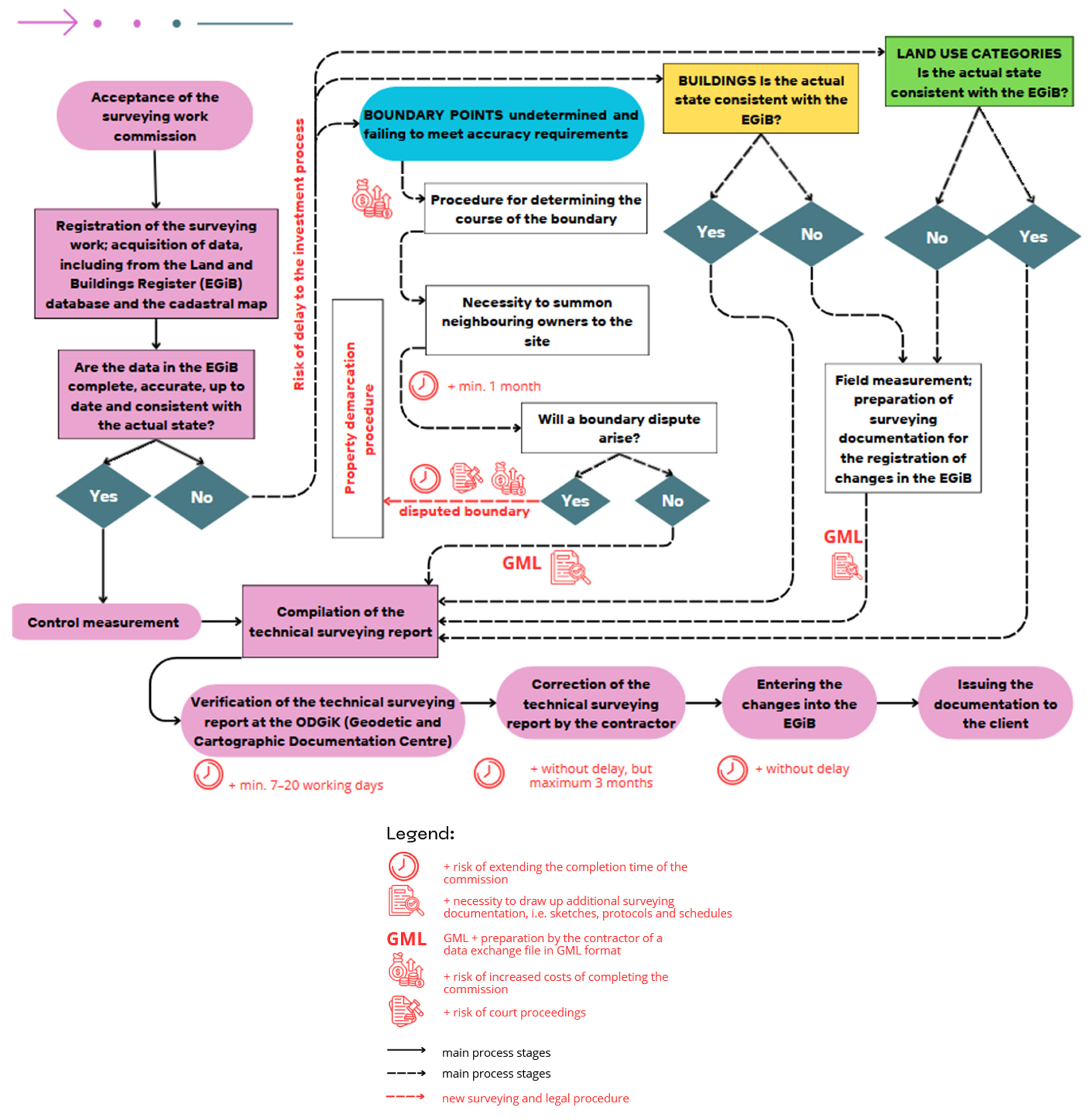
The procedure for producing a map for design purposes, as the primary surveying study in the investment process in Poland, comprises stages ranging from the acceptance of the commission and the notification of the surveying work, through the analysis of the quality of cadastral data and fieldwork, to the production of a digital map, its verification, and its inclusion in the database and handover to the client. As part of the study, a detailed analysis was carried out of this procedure, as set out in [
17,
18,
37,
42], identifying potential risks [
45]. Particular attention was paid to the risks arising from ambiguities in the data on parcel boundaries. The consequences of the identified risks primarily affect investors and involve the possibility of delays in the preparation of the map, as well as increased costs resulting from the need to carry out additional surveying work, in particular the demarcation of property boundaries. Where boundary data is of poor quality or has not been established, the resulting map has limitations regarding its use for positioning buildings at the minimum distance from parcel boundaries. An additional note often appears on the map at this point. The main source of these risks is the poor quality of information on boundary points. Research has shown that the proportion of boundary points marked with the attribute undetermined is significantly higher in smaller towns and rural areas, which in practice increases the risk of delays and higher costs for investment projects in these areas.
The clear correlation observed between the values of the boundary point attributes for ISD and SPD indicates the need for a more in-depth analysis of the relationship between these attributes. In particular, it seems appropriate to consider modifying the rules for their designation in order to minimise misinterpretations. It should be noted that similar trends were not as pronounced in the 2022 data, whereas in the analysis of the 2026 data they become significant and clear-cut. This change may indicate difficulties in interpreting the current technical regulations and the need to clarify them.
In response to the identified challenges, a procedure has been developed that integrates issues related to cadastral data quality with risks arising from legal and administrative processes. This approach can support investors in optimising decision-making in the presence of data uncertainties and may be adaptable to other countries following appropriate local adjustments (
Figure 7). Although the study focuses on Poland, similar issues related to heterogeneous cadastral data quality and the presence of legacy datasets have been widely reported in other countries, particularly those with historically complex cadastral systems [
2,
3,
31,
32].
This study is based on a limited number of study areas and two observation periods (2022 and 2026), which may not fully reflect the spatial and temporal variability of cadastral data quality across Poland. The analysis focuses only on selected components of the EGiB database (boundary points, land use, and buildings), and its results depend on the reliability of available attributes, which may themselves be inconsistent. Furthermore, although the study identifies key types of risks, it does not quantify their economic impact or fully assess all factors influencing data quality differences between regions.
The results of the analyses carried out indicate a need for further research into the quality and consistency of EGiB data, particularly in light of the practical implications of their use in investment and administrative procedures. It also seems important to conduct research into the possibilities of automating quality control and data validation processes, which could help to enhance their reliability and harmonise standards across the country.