


Abstract
The ongoing development of the economy and society has increasingly intensified the imbalance between the supply and demand of land resources. Achieving coordinated development between socio-economic growth and the “Production-Living-Ecological” functions of land-use is therefore a key foundation for high-quality regional development. In light of this, this study focuses on Henan Province at the county level. Building on a theoretical framework that examines the relationship between socio-economic development and the “Production-Living-Ecological” functions of land-use, we employed methods including the entropy method, linear weighting method, mechanical equilibrium model, and curve estimation model. These were used to explore the evolution characteristics and interactive relationship between socio-economic development and the “Production-Living-Ecological” functions at the county level in Henan Province. The findings reveal that: (1) The socio-economic development level of counties in Henan showed an overall upward trend during the study period, with the average value rising from 0.2320 in 2010 to 0.2702 in 2023. High-level areas were mainly concentrated in the central region around Zhengzhou. (2) The overall level of the “Production-Living-Ecological” functions of land-use in Henan’s counties followed a gradually increasing trend, with a relatively stable evolution process. The functional levels in northern, central, and eastern Henan were notably higher than those in the western and southern regions. (3) There is a significant positive correlation between the socio-economic development level of counties in Henan and the comprehensive level of the “Production-Living-Ecological” functions of land-use. Moreover, socio-economic development exerts a one-way influence on the functional level of “Production-Living-Ecological” in land-use. Identifying the interactive relationship between socio-economic factors and these land-use functions can provide quantitative references and a decision-making basis for rationally adjusting the “Production-Living-Ecological” functions across different stages of development.
1. Introduction
As a key carrier of socio-economic development and ecological construction [1,2], land within territorial space is constantly undergoing a dynamic process where its production, living, and ecological functions interact and influence each other [3]. With the continuous progress of socio-economic development, the demand for land resources keeps increasing [4], leading to significant changes in land-use structure. This process has gradually disrupted the balance among the “Production-Living-Ecological” functions of land-use, resulting in issues such as disordered spatial structure and insufficient coordination among functions, which seriously constrain the capacity for regional sustainable development [5,6]. Therefore, against the backdrop of ongoing socio-economic advancement, scientifically identifying the evolutionary patterns of these three land-use functions and deeply analyzing their interactive mechanisms have become crucial tasks for achieving sustainable socio-economic growth and coordinated management of land’s multiple functions.
Establishing a territorial spatial pattern described as “intensive and efficient production spaces, livable and moderate residential spaces, and ecologically sound landscapes” is a key strategic goal put forward at the 18th National Congress of the Communist Party of China [7]. The report of the 20th National Congress further stressed the need to “promote green, low-carbon, and high-quality development, build a Beautiful China, and provide the people with high-quality ‘Production-Living-Ecological’ spaces” [8]. In this context, research on the “Production-Living-Ecological” functions of land-use has grown rapidly. Scholars have explored this topic from different angles. Some studies focus on the functions themselves, often using systematic classification methods to create evaluation systems for measuring their value [3,9]. Other research looks at how these spatial functions change over time and across regions [10,11], as well as the relationships between production, living, and ecological functions [12,13]. Another important area of study examines the wider effects of the “Production-Living-Ecological” spatial patterns. This includes their impact on regional environmental quality and spatial structure improvement. Practical applications of this research include assessing ecological benefits [14,15], evaluating urban and rural spatial planning [16,17], and supporting the balanced use of rural resources [18,19,20,21,22].
Socio-economic factors are the core drivers of change in land-use functions. While socio-economic development intensifies conflicts between human activity and land resources and poses challenges to sustainability [23], it also strongly promotes the transformation of the “Production-Living-Ecological” functions and reshapes their interrelations [24]. In this context, some researchers have begun to study the influence of socio-economic factors on land-use functions. Studies show that socio-economic systems directly affect the formation and evolution of “Production-Living-Ecological” spatial patterns through multiple pathways. Economic development has a direct and significant impact on these functions through industrial upgrading, increased capital investment, and technological progress [25]. Factors such as GDP per capita, fiscal expenditure, and agricultural security play key roles in shaping the coordinated evolution of integrated land-use functions in both urban and rural areas [26]. As industrial structures continue to optimize and upgrade, coordination among these functions is further enhanced [27]. The influence of the social subsystem is more complex, primarily reshaping the structure and quality of living spaces through population agglomeration, urbanization, and changing demands for public services. Research indicates that population density and urbanization levels are positively correlated with living functions, but often negatively correlated with ecological functions [28]. Through literature review, it can be observed that traditional research often treats socioeconomic factors, such as GDP growth, industrial structure, and population agglomeration, as unidirectional external drivers influencing land-use patterns, focusing primarily on how they shape the spatial distribution of “Production-Living-Ecological” functions [29]. However, this perspective fails to fully capture the essence of land systems as coupled “Social-Ecological” systems. It overlooks how the functions and benefits provided by land-use, through mechanisms such as resource constraints, environmental feedback, and changes in well-being in turn reshape socioeconomic structures and processes, forming a dynamic whole with complex feedback loops. To address this limitation, recent studies have begun advocating for the construction of an integrated “Social-Economic-Ecological” coupled system analysis framework [30]. For instance, drawing on systems theory, socioeconomic subsystems and the “Production-Living-Ecological” functional subsystems are modeled within a unified, interactive system. Under this framework, socioeconomic activities not only alter land cover and use but are also deeply constrained in their development pathways and vulnerabilities by the land system’s capacities for product supply, ecological regulation, and cultural services. Additionally, benefit evaluation models are employed to treat economic, social, and ecological benefits as an integrated whole, analyzing the spatiotemporal evolution of trade-offs and synergies within the multifunctionality of cultivated land [27]. These studies provide entry points for understanding interactions among subsystems. Nevertheless, existing literature pays insufficient attention to the county level, a critical basic unit for implementing territorial spatial planning and differentiated policies, leaving its micro-level mechanisms underexplored. Moreover, current research methods predominantly focus on evaluation or driving factor analysis, while chain studies that systematically integrate “theoretical framework–comprehensive assessment–relationship diagnosis–mechanism explanation” remain relatively scarce.
As one of the nine provincial-level spatial planning pilot areas designated by the Central Leading Group for Comprehensively Deepening Reforms, Henan Province is characterized by both rapid economic development and profound land-use transformation [31], making it an ideal region for exploring the evolution and intrinsic relationships between socioeconomic dynamics and the “Production-Living-Ecological” functions. Against this backdrop, the contributions of this paper are mainly reflected in the following two aspects:
- (1)
- Innovation in research perspective: This study precisely focuses on the county-level administrative units in Henan Province, covering the period from 2010 to 2023, a critical phase of rapid urbanization and territorial spatial planning. Guided by systems thinking, it investigates the evolutionary characteristics and interactive mechanisms between socioeconomic factors and “Production-Living-Ecological” functions at the county scale. This approach effectively addresses the gaps in existing research regarding the linkage between meso- and micro-scales and empirical studies on the transformation of typical agricultural regions, providing a novel and refined perspective for understanding the spatial differentiation of human–land relationships.
- (2)
- At the methodological level, this study establishes a complete logical chain encompassing “theoretical framework–comprehensive assessment–relationship diagnosis–mechanistic explanation,” aiming to systematically reveal the coupled relationships within regional human–land systems. Firstly, based on coupled social-ecological systems theory, an interactive theoretical analysis framework is constructed, which integrates the socioeconomic subsystem and the “Production-Living-Ecological” functional subsystem of land-use within a unified feedback system, thereby transcending the traditional unidirectional driving paradigm. Secondly, by employing the entropy weight method and the comprehensive evaluation index method, independent and objective multidimensional quantitative assessments of the two major systems are conducted, addressing the issues of state measurement and comparability in complex systems. Subsequently, correlation analysis is used to diagnose and visually represent the macro-level associations between the two systems. Finally, leveraging econometric tools such as nonlinear regression models, specific interaction pathways and dynamic mechanisms between the two systems are delineated in depth, completing a comprehensive scientific demonstration that spans theoretical deduction, state assessment, relationship diagnosis, and the revelation of underlying mechanisms.
Therefore, through scale-specific focus and methodological integration, this study aims to deepen the understanding of the micro-level mechanisms underlying the complex interactions between socioeconomic systems and land-use functions, while providing scientific references for territorial spatial optimization and policy formulation in similar regions.
2. Theoretical Framework
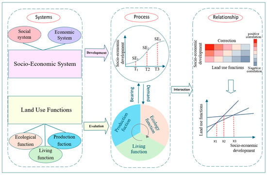
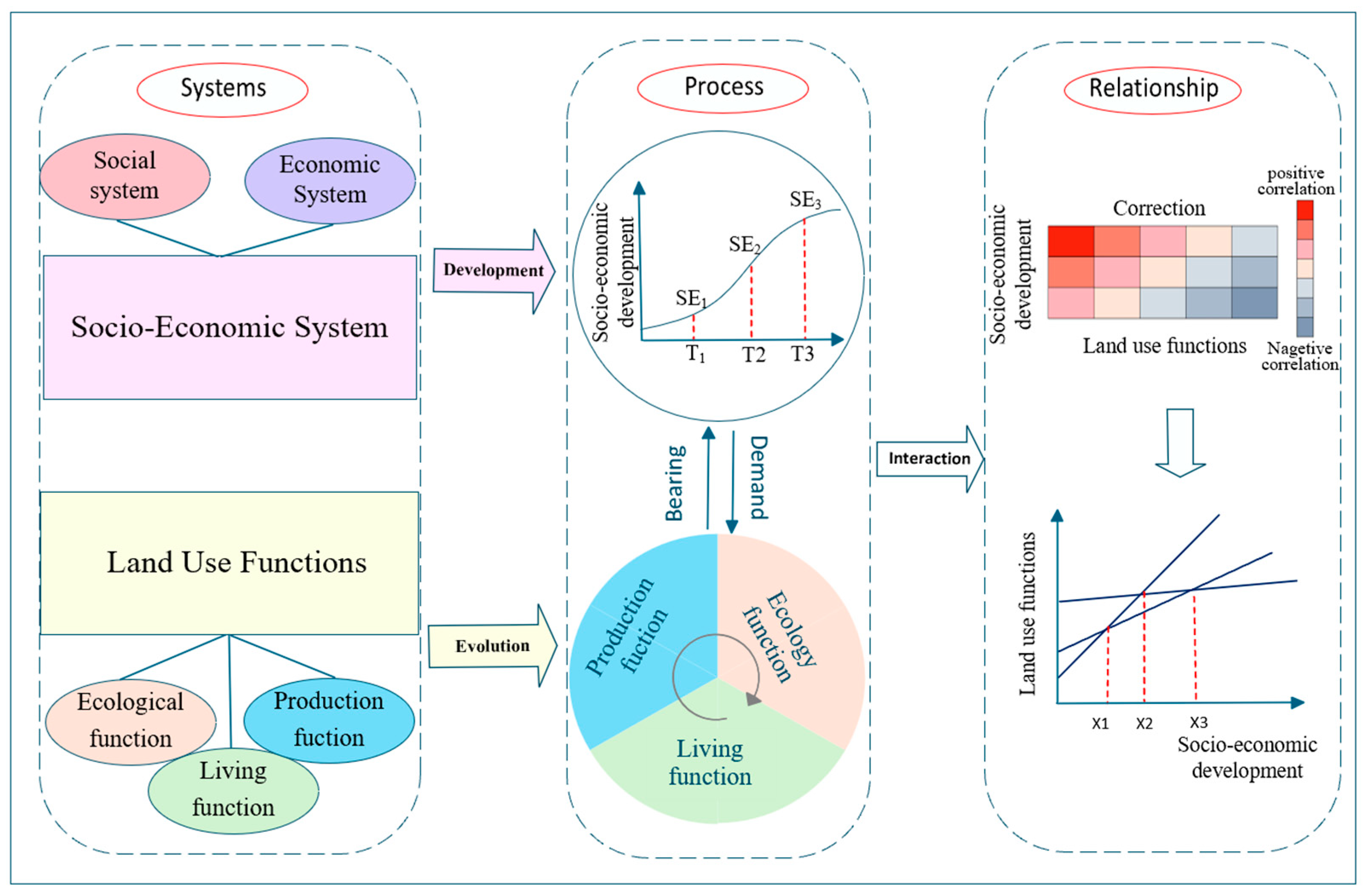
The interaction between socio-economic factors and the “Production-Living-Ecological” functions of land-use is a multi-dimensional and systemic process [32]. The socio-economic system consists of two subsystems: The social system and the economic system; while the land-use system is organized around three core functions: Production, living, and ecology. The elements within these two major systems do not correspond in a simple one-to-one manner; rather, the essence of their relationship lies in how these elements interact both within and across systems. Therefore, in alignment with the research objectives and key scientific questions of this study, we first clarify the theoretical framework that explains the interaction process and mechanisms between socio-economic development and the “Production-Living-Ecological” functions of land-use (Figure 1). This provides a theoretical foundation for the empirical analysis that follows.
Figure 1.
Theoretical Framework Diagram.
Both the socio-economic system and the “Production-Living-Ecological” functions of land-use contain both natural and human elements [33]. The socio-economic system includes the social system and the economic system, with key elements such as finance, arable land, and consumption. The “Production-Living-Ecological” functions are formed by different types of land-use. Within their own systems, these elements interact to maintain the system’s characteristics. At the same time, they continuously interact across systems, connecting and supporting the functions of different systems [34]. The socio-economic system continues to develop over time. At the same time, the composition of key elements within the land-use system—such as arable land, forest land, grassland, and construction land—gradually becomes more diverse and undergoes mutual transformation [6]. The elements involved in the interaction between urbanization and land-use functions also shift from “single-element” to “multi-element” interactions. Moreover, the complex relationships between these key elements show clear evolutionary characteristics across both time and space.
There is a close two-way interaction between the socio-economic system and the “Production-Living-Ecological” functions of land-use. This study primarily employs correlation analysis and regression analysis to reveal the “relationship” between the two systems. The socio-economic system directly changes the spatial arrangement and functional structure of land-use through urbanization, industrialization, population growth, and policy actions [35]. This change is especially clear in regions experiencing rapid urbanization, often leading to conflicts between production and ecological functions [36]. In turn, land-use provides resources for production, spaces for living, and environmental protection for socio-economic development [37]. Correlation analysis is used to preliminarily determine the existence and direction of statistical associations between the two systems, while regression analysis further characterizes the specific pathways and nonlinear features through which socio-economic subsystems influence the “Production-Living-Ecological” functions.
3. Materials and Methods
3.1. Overview of the Study Area
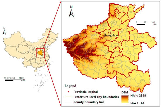
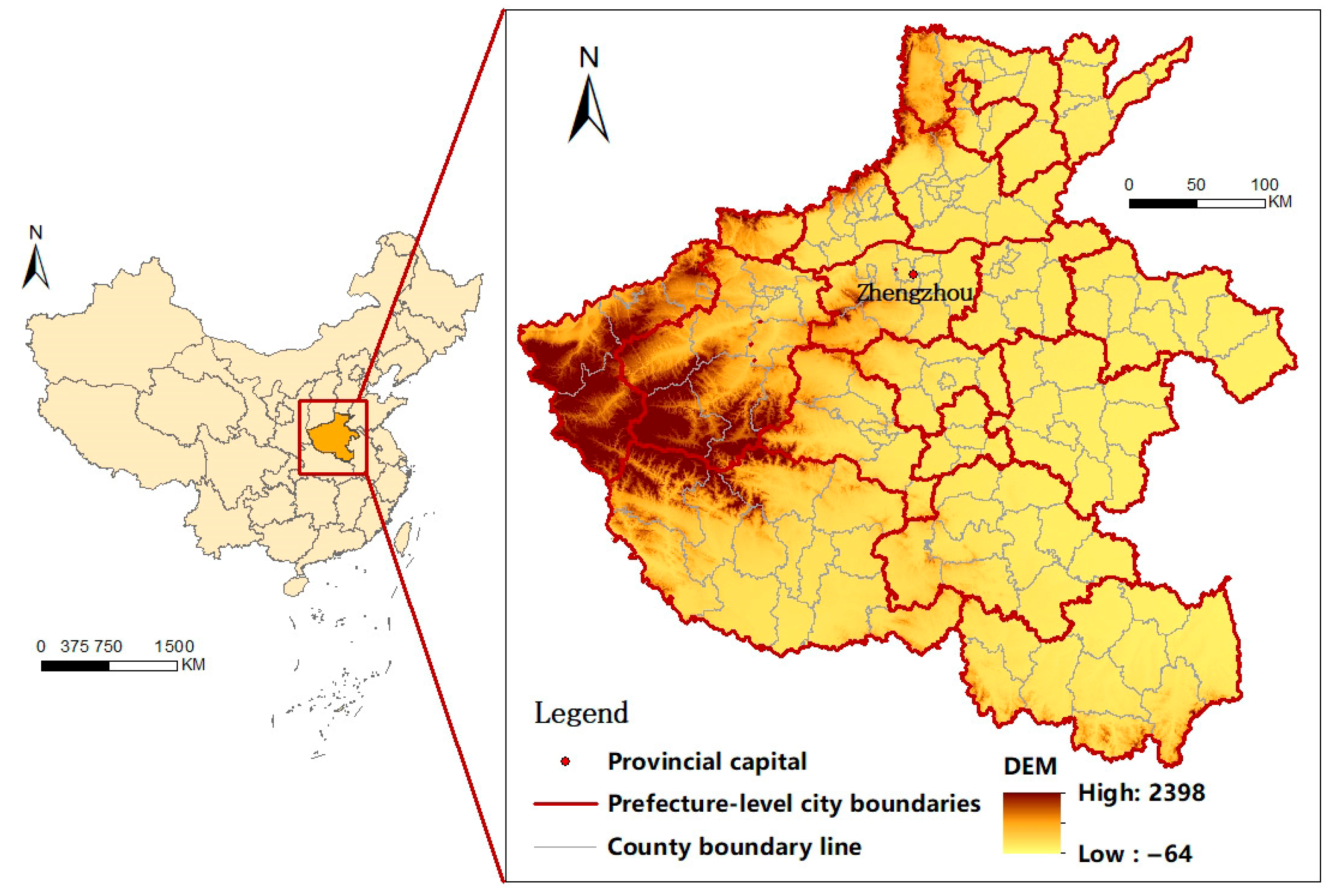
Henan Province is located between 31°23′ and 36°22′ N latitude and 110°21′ and 116° E longitude. Situated in central China along the middle and lower reaches of the Yellow River, it lies in the transitional zone between China’s second and third topographic terraces. The terrain is mostly mountainous and hilly in the west, while the east is dominated by vast plains, resulting in a general slope from west to east (Figure 2). The province covers a land area of 167,000 square kilometers.
Figure 2.
Overview Map of the Study Area.
Henan holds a key position in China’s east–west economic development gradient and is an important hub in the national integrated transport network. The advancement of the Central Region Rise strategy, the strategic layout of the Central Plains Urban Cluster, and the development of the Zhengzhou Metropolitan Area have collectively driven steady economic growth in Henan. By 2024, the province’s GDP reached 6358.999 billion Yuan, with a year-end resident population of 97.85 million and an urbanization rate of 59.22%. As a major agricultural, populous, and economic province in China, Henan has experienced rapid urbanization and industrialization during the study period. Examining the evolutionary characteristics and interactive mechanisms between socio-economic development and the “Production-Living-Ecological” functions of land-use is essential for enhancing their coordination. This will help promote high-quality socio-economic development in Henan Province.
3.2. Data Sources
Socio-economic statistical data—including indicators such as Gross Domestic Product (GDP), total retail sales of consumer goods, and local general fiscal expenditure—were obtained from the officially published Henan Statistical Yearbook (2011–2024). These data were spatially processed and aligned with corresponding raster data. Land-use data were sourced from the Resource and Environment Science and Data Center of the Chinese Academy of Sciences, which is widely recognized for its high authority and reliability (Table 1). Land-use classification was primarily based on the Land-Use Status Classification standards (GB/T21010-2007, GB/T21010-2017) and the Technical Regulations for the Second National Land Survey (TD/T1014-2007) [38,39,40].
Table 1.
Data Sources.
3.3. Research Methodology
3.3.1. Development of the Indicator System
The investigation of the interaction mechanisms between socio-economic development and the “Production-Living-Ecological” functions of land-use involves both urban socio-economic development and land-use change processes. The indicator system must not only capture the intrinsic characteristics of socio-economic and land-use systems but also accurately reflect the interrelationships among their constituent elements. Under the principles of scientific rigor and data availability and considering the direction and impact of individual indicators within the evaluation system, along with potential logical relationships between indicators, targeted evaluation frameworks were constructed separately for socio-economic development levels and the “Production-Living-Ecological” functions of land-use.
- (1)
- Socio-economic Evaluation System. For socio-economic development indicators, this study adopts a comprehensive evaluation framework based on literature review and data accessibility, which reflects regional economic characteristics [41,42]. Indicators such as per capita fiscal expenditure, per capita arable land area, and proportion of construction land reflect social development status; while per capita GDP, disposable income of urban residents, and per capita retail sales of consumer goods reflect economic strength. A three-level evaluation system consisting of six indicators was established, as shown in Table 2.Table 2. Henan Province Socio-Economic System Evaluation Form.
- (2)
- The “Production-Living-Ecological” Evaluation System. When classifying the “Production-Living-Ecological” functions of land-use, it is necessary to establish a classification and evaluation system based on land-use categories. From the perspective of industrial structure, human productive activities are mainly divided into three sectors, with corresponding land types classified as primary sector land, secondary sector land, and tertiary sector land. In line with the attributes and content of these three sectors: Primary sector land mainly includes land types related to agriculture, forestry, animal husbandry, and fisheries; Secondary sector land primarily refers to land types used for industrial manufacturing; Tertiary sector land mainly comprises land types for commercial and service purposes. Acknowledging the objective reality of composite land-use functions, the concepts of semi-productive land and weakly productive land are introduced. Semi-productive land refers to land-use types where the production function is roughly equivalent to other functions, with no clear primary or secondary relationship among various functions. Weakly productive land refers to land-use types where the production function plays a secondary role compared to other functions. Following this spatial classification and evaluation framework for the “Production-Living-Ecological” functions of land-use, classifications for residential land and productive land are established. Based on relevant research [3,43], each land-use category is graded into four levels according to its functional intensity: Full functionality (5 points), semi-functionality (3 points), weak functionality (1 point), and functionality deficiency (0 points). By comprehensively referencing the Classification of Land-Use Status (GB/T21010-2007, GB/T21010-2017) and the Classification of Urban Land-Use and Standards for Planning and Construction Land (GBJ137-90, GB50137-2011) [44,45], the current land-use status in Henan Province was categorized and organized, with corresponding “Production-Living-Ecological” spatial evaluation scores assigned (Table 3).Table 3. Henan Province Land-Use Classification System and Scoring Criteria for “Production-Living-Ecological” Functions.
Based on the classification and scoring of “Production-Living-Ecological” functions within jurisdictional areas, and utilizing various land-use datasets, the total value of production, living and ecological functions undertaken by different land-use types was calculated according to their functional intensity. This further enabled the assessment of “Production-Living-Ecological” levels within the jurisdictional areas of counties across Henan Province (Table 4).
Table 4.
Evaluation Index System of “Production-Living-Ecological” of Land-Use in Henan Province.
3.3.2. Data Processing
Indicator attributes with differing meanings exhibit marked variations. To unify the comparative scale of evaluation metrics and enhance assessment accuracy, we employ the standard deviation method to process the acquired data.
where denotes the raw value of the th indicator for the th city, represents the mean of the th indicator, and signifies the standard deviation of the th indicator.
While employing the entropy method and utilizing MATLAB R2019b software for further processing of the evaluation indicators, a shift transformation [46] is applied to the standardized data to eliminate interference from negative values in the computational process. Calculations reveal that the domain of is −4 ≤ ≤ 4. Following coordinate transformation, we obtain:
Based on Equation (2), normalize the data after translation transformation:
To calculate the information entropy value for the th indicator in the evaluation metric system:
where and .
To calculate the information weight for indicator :
3.3.3. Comprehensive Index Evaluation Method
The comprehensive index evaluation method is employed to assess the functional levels of the “Production-Living-Ecological” functions of land-use:
In the formula, , , and represent the levels of production, living, and ecological functions of the national territory space respectively.
3.3.4. Mechanical Balance Model
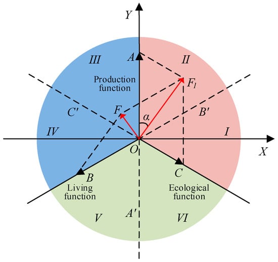
The mechanical equilibrium model can be employed to measure the balance relationships among multidimensional elements within a system. Drawing upon relevant research findings [47], this study utilizes the mechanical equilibrium model to construct a deviation model for the “Production-Living-Ecological” functions of land-use. The conceptual model is illustrated in Figure 3, where OA, OB, and OC denote the evaluation indices for production, living, and ecological functions of land-use respectively. The coordination state of the “Production-Living-Ecological” can be expressed via polar coordinates: (F,θ). The polar radius F represents the deviation index between the resultant force and the equilibrium point O; a larger deviation index indicates poorer coordination among the “Production-Living-Ecological” function of land-use. The polar angle θ indicates the deviation angle of the resultant force F, reflecting the specific characteristics of the coordination between the “Production-Living-Ecological” functions of land-use. Considering the conceptual model interpretation and computational procedures, the direction angles of OA, OB, and OC are defined as π/2, 7π/6, and 11π/6, respectively. By extending OA, OB, and OC in reverse, the space formed by the combined forces of the “Production-Living-Ecological” function of land-use is divided into six quadrants (Figure 3). The vector characteristics of each quadrant are clarified to further determine the evolution characteristics of the dominant land-use function [12].
Figure 3.
Conceptual Model of the Deviation Index of the “Production-Living-Ecological” Functions of Land-Use.
During the calculation process, the resultant force F1 between OA and OC are first computed. Similarly, the resultant force F between F1 and OB is calculated using the following formula:
4. Results
4.1. Evolutionary Characteristics of the Socio-Economic System
4.1.1. Characteristics of the Evolution of the Social System
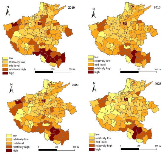
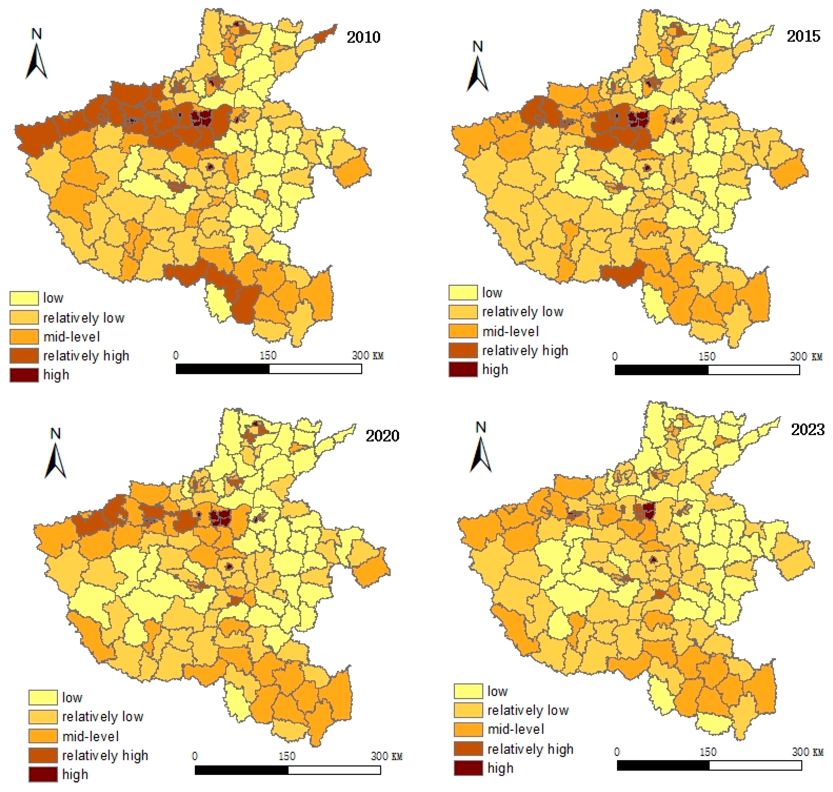
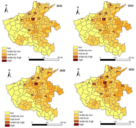
During the study period, the development level of Henan Province’s social system exhibited a continuous upward trend, with the mean value steadily rising from 0.2470 in 2010 to 0.2895 in 2023, indicating a significant overall improvement in regional social welfare (Figure 4). This evolutionary process profoundly reflects the combined effects of population mobility patterns and spatial planning guidance.
Figure 4.
Social System Hierarchy Distribution Map of Henan Province, 2010–2023.
In 2010, high-value areas of the social system were mainly concentrated in Zhengzhou and the western and southern regions of Henan, with the southern high-value area being the largest. This pattern was closely related to the population distribution characteristics of Henan’s traditional agricultural areas. In the Huang-Huai agricultural regions of southern Henan, such as Zhumadian, Nanyang, and Xinyang, the large population base and abundant per capita cultivated land resources meant that the social system primarily relied on the scale of the agricultural population for support. By 2015, although the southern region remained a high-value area, its relative advantage began to weaken. During this period, the approval and construction of the Zhengzhou Airport Economy Zone and the implementation of the Central Plains Urban Agglomeration plan intensified the trend of population agglomeration toward the Zhengzhou-centered metropolitan area. The spatial allocation of social resources gradually shifted from being dominated by the agricultural foundation to being driven by urban attraction. In 2020 and 2023, the spatial pattern of the social system stabilized, with the distribution of high-value areas remaining largely consistent. The changes during this phase benefited from Henan Province’s in-depth implementation of a categorized county development strategy. Through territorial spatial planning, public service resources were directed toward county seats. Concurrently, the “Quality Improvement Project for One Hundred Cities” promoted the expansion and quality enhancement of county towns, transforming social development from localized high-value agglomeration to balanced improvement across the entire region.
This evolutionary trajectory indicates that the development of Henan Province’s social system is gradually moving away from a sole reliance on population size and shifting toward a more balanced development path guided by spatial planning and supported by public services.
4.1.2. Characteristics of Economic System Evolution
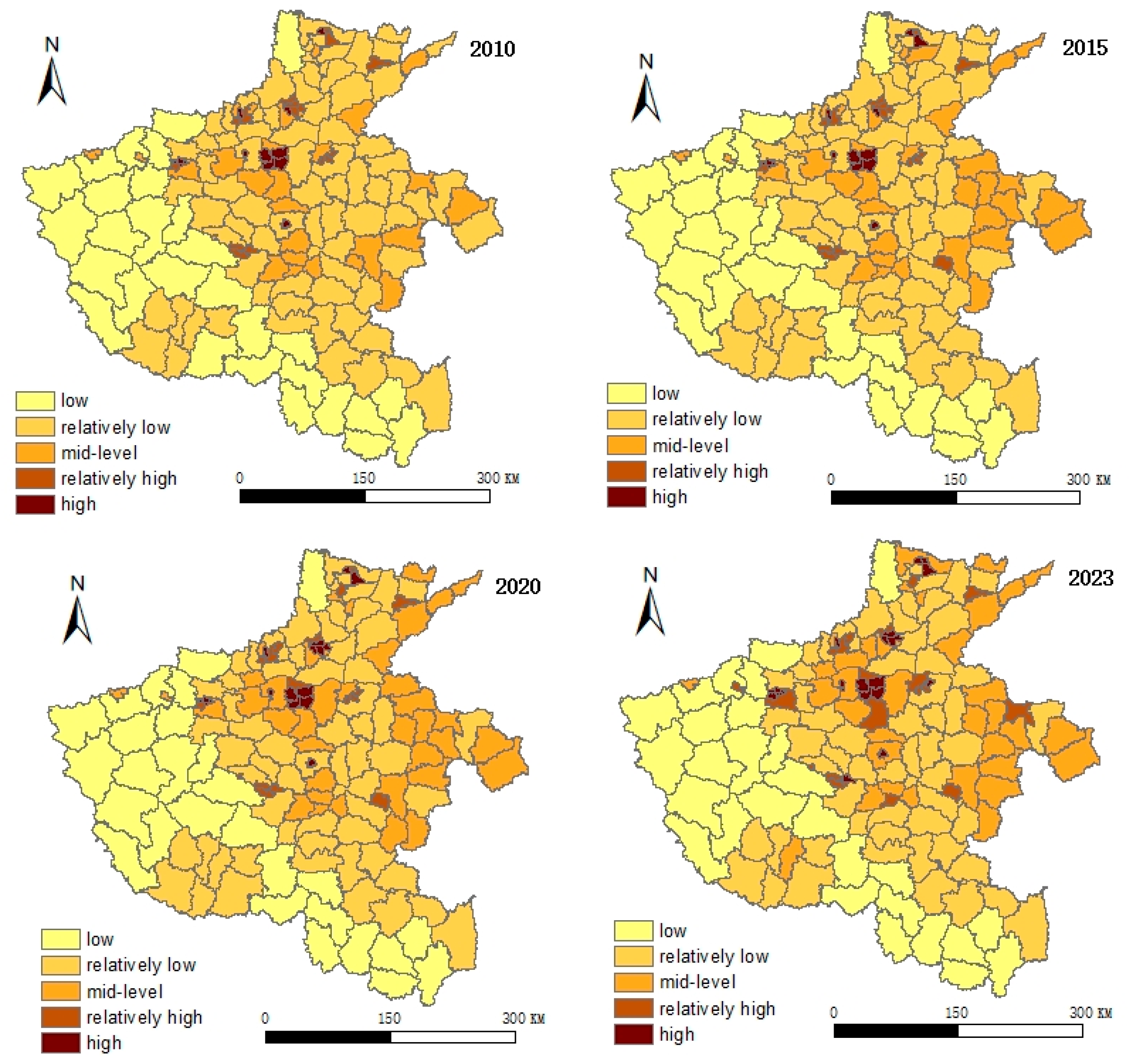
During the study period, Henan Province’s economic system experienced sustained growth centered on Zhengzhou, with its development momentum gradually diffusing to surrounding areas such as the southwestern region (Figure 5). This spatial diffusion pattern resulted from the combined effects of specific industrial policies and regional development planning.
Figure 5.
Economic System Grade Distribution Map of Henan Province, 2010–2023.
In 2010, economic activity was highly concentrated in Zhengzhou and the counties along the Zhengzhou-Luoyang industrial corridor, reflecting the characteristic initial-stage concentration of factors toward the core under traditional growth pole theory. During this period, the construction of the Zhengdong New Area and the advancement of Zhengzhou-Kaifeng integration accelerated the enhancement of the provincial capital’s carrying capacity. By 2015, the development intensity of the central region had further strengthened. Beyond Zhengzhou’s radiation effects, this was closely related to the province’s vigorous promotion of industrial agglomeration zone construction policies. A number of specialized industrial parks were upgraded to provincial-level industrial agglomeration zones, spatially consolidating and reinforcing the economic density of the core area. By 2020, the economic center of gravity had begun to diffuse from the central region to surrounding areas. The significant improvement in the southwestern region’s economic level directly responded to the spatial deployment of the provincial regional coordinated development strategy. For instance, Nanyang City was explicitly designated as a provincial sub-center to focus on cultivating new energy industries, while Pingdingshan City leveraged its nylon new material industry chain to build industrial clusters. This differentiated industrial layout successfully channeled development momentum from the single core to potential regions. By the end of the study period in 2023, with Henan Province’s in-depth implementation of the high-quality development strategy for county economies—through the construction of a “one county, one provincial-level development zone” and the reform of delegating powers and empowering counties—regional economic disparities had further narrowed.
4.1.3. Characteristics of Socio-Economic System Evolution
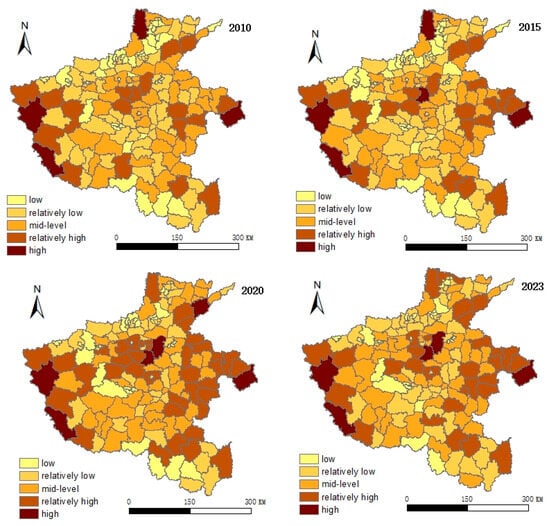
During the study period, the comprehensive development level of Henan Province’s socioeconomic system exhibited a steady upward trend, with regional disparities gradually narrowing (Figure 6). This evolutionary process profoundly reflects the deep integration of social development and economic transformation within the framework of spatial planning platforms.
Figure 6.
Evolution Characteristics of Socio-Economic Comprehensive Level from 2010 to 2023.
In 2010, the mean value of the system’s comprehensive level was 0.2320, with high-value areas concentrated in the central and western counties. This indicated an overall factor-driven development stage, where interactions between the social and economic subsystems remained relatively weak. By 2015, the mean value had increased to 0.2500, marking the initial implementation of the “industry-city integration” concept through territorial spatial planning. The planning and construction of the Zhengzhou metropolitan area not only promoted industrial agglomeration but also facilitated the coordinated arrangement of living service facilities, achieving preliminary spatial synergy between economic development and social services. In 2020, the comprehensive level further rose to 0.2601, with significant improvement in regional development imbalances. This fully demonstrated the governance effectiveness of the “multiple plans integration” territorial spatial planning system. By optimizing urban development boundaries and industrial spatial patterns, this system effectively guided the orderly concentration of populations into key development areas, promoted the spatial alignment of public service facilities with economic growth poles, and strengthened the synergistic interaction between social and economic subsystems. By the end of the study period in 2023, the mean comprehensive level had further increased to 0.2702, with continuously enhanced regional coordination. The significant improvement during this period was primarily attributed to Henan Province’s in-depth implementation of the “high-quality development of county economies” strategy. Through territorial spatial planning, this strategy provided categorized guidance for county development directions, strengthening the industrial carrying capacity of advantaged counties while promoting the establishment of industrial collaboration functional zones among adjacent counties, thereby steering socioeconomic development into a higher-quality stage of synergy. Thus, the optimization of the comprehensive socioeconomic system essentially reflects the modernization of spatial governance. Through a unified planning blueprint, social and economic policies are systematically integrated, guiding resource factors to concentrate in advantageous spaces and driving the transformation of counties from single-dimensional growth toward high-quality composite system development.
4.2. Evolution Characteristics of Land-Use’s “Production-Living-Ecological” Functions
4.2.1. Evolution of the Comprehensive Level of Land-Use’s “Production-Living-Ecological” Functions
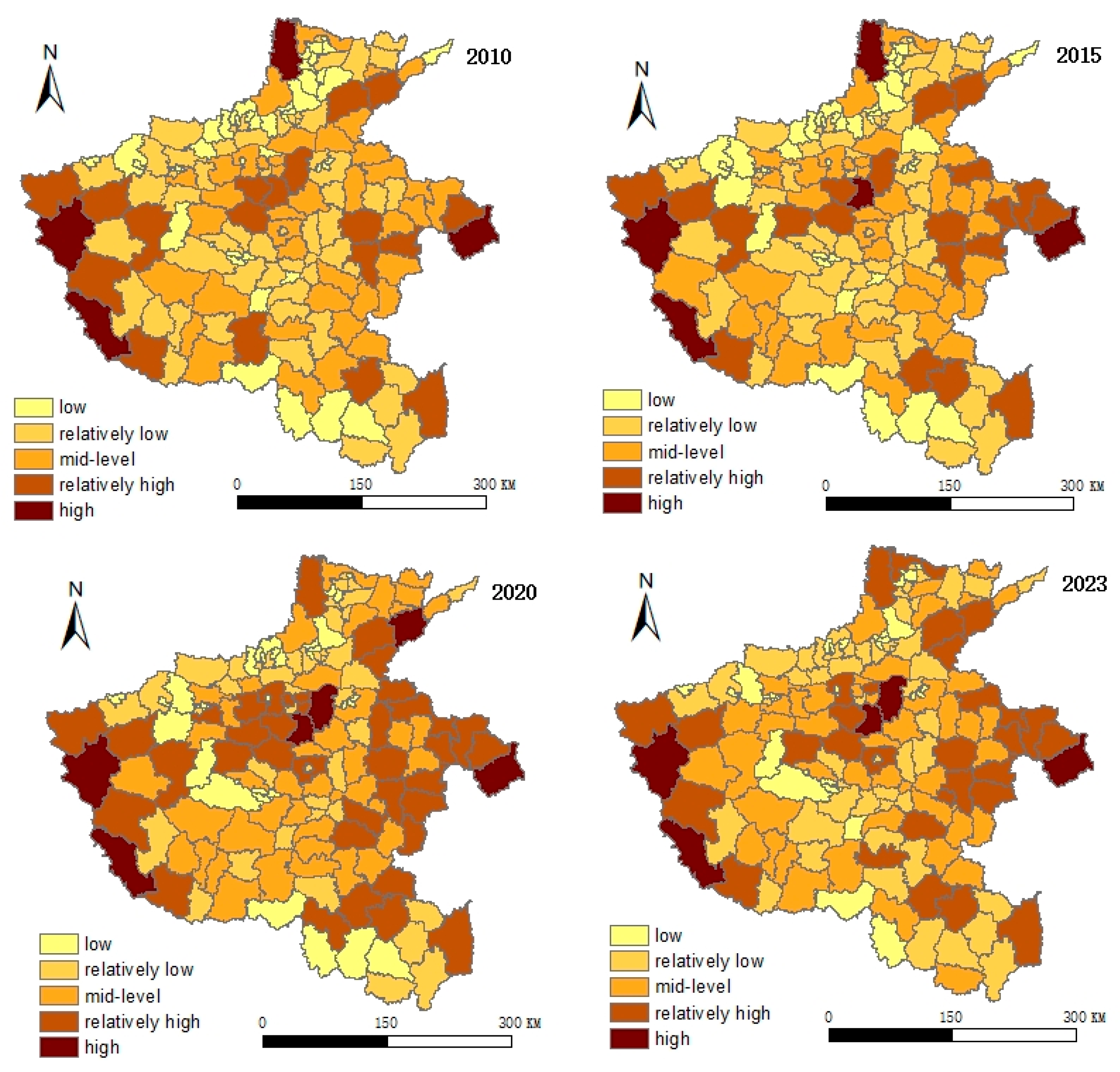
From 2010 to 2023, the comprehensive level of the “Production-Living-Ecological” functions of land-use in Henan Province exhibited an overall trend of gradual growth, with a relatively stable evolution process. During the study period, the “Production-Living-Ecological” functions of land-use in northern, central, and eastern Henan were generally higher than those in western and southern Henan (Figure 7). Specifically, the average values in northern, central, and eastern Henan were 0.3802, 0.3987, and 0.3723, respectively, while those in western and southern Henan were 0.3484 and 0.3083. At the study’s outset, Henan’s “Production-Living-Ecological” land-use functions exhibited a relatively high average level of 0.3801, with minimal variation between cities. By the study’s conclusion, the province’s average “Production-Living-Ecological” land-use function level had gradually increased to 0.3921. The evolution trends in Lushi County, Guangshan County, Luoshan County, and Shangcheng County remained relatively stable. Hongqi District, Guancheng Hui District, Chuanhui District, Wenfeng District, and Jinshui District exhibited the most pronounced increases, rising by 0.0691, 0.0747, 0.0852, and 0.0907 respectively over the study period. Overall, the “Production-Living-Ecological” functions of land-use in Henan Province exhibited a gradual upward trajectory, with relatively minor regional disparities among cities. The northern, central, and eastern regions of Henan demonstrated particularly favorable development trends in these functions.
Figure 7.
Evolution Characteristics of the Comprehensive Level of the “Production-Living-Ecological” Functions of Land-Use.
4.2.2. Evolution Characteristics of the “Production-Living-Ecological” Function Deviation Index
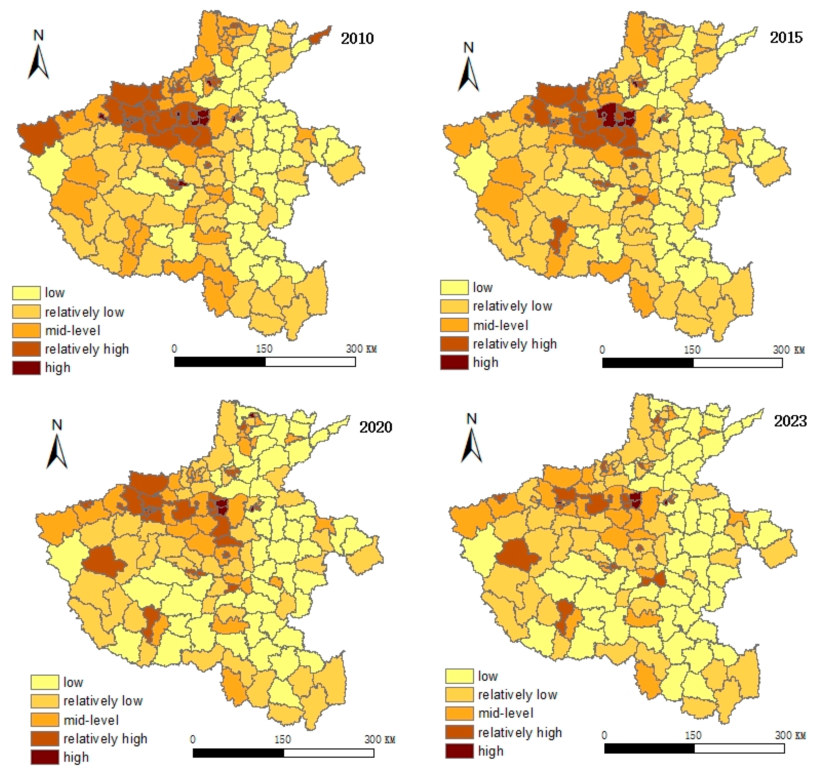
From 2010 to 2023, the deviation indices for the “Production-Living-Ecological” functions of land-use in Henan Province exhibited relatively pronounced variations, ranging between 0.0130 and 0.5505 (Figure 8). The fluctuation amplitude in the evolution of these indices was notably greater in the central and eastern regions of Henan, whereas the trends in northern and southern Henan remained comparatively stable. In 2010, the average deviation index for the “Production-Living-Ecological” functions of land-use in Henan Province stood at 0.1388, with minimal variation between different cities. By 2023, the average deviation index had increased to 0.1757. During the study period, 18 regions including Fengqiu County, Neixiang County, Lushan County, and Xin’an County exhibited a slight downward trend in their land-use “Production-Living-Ecological” function deviation indices. The most pronounced upward trends were observed in Jinshui District, Xinmi City, Xinzheng City, and Zhongmu County, with respective increases of 0.1150, 0.1191, 0.1652, and 0.3162 over the study period. Overall, Henan Province’s land-use “Production-Living-Ecological” function deviation index maintained a steady growth trend, with relatively pronounced regional disparities. Central and Western Henan exhibited higher deviation indices than Northern, Eastern, and Southern Henan.
Figure 8.
Evolution Characteristics of the “Production-Living-Ecological” Function Deviation Index, 2010–2023.
4.3. Evolutionary Characteristics of the Interaction Between Socio-Economic Systems and “Production-Living-Ecological” Functions of Land-Use
4.3.1. Correlation Analysis Between Socio-Economic Systems and “Production-Living-Ecological” Functions of Land-Use
Following the visualization of trends linking socio-economic factors with the “Production-Living-Ecological” functions of land-use, Pearson’s correlation coefficient was used to conduct an in-depth quantitative analysis of the relationship between the two systems (Figure 9). From 2010 to 2023, at the subsystem level, socio-economic development showed a negative correlation with each of the three land-use functions: Production, living, and ecological. This indicates that rapid socio-economic progress may have certain negative impacts on these functions on a local scale. For example, economic growth may temporarily encroach on ecological space, while urban expansion could reduce local production efficiency. However, at the overall system level, there was a stable and significant positive correlation between the comprehensive socio-economic development level and land-use functions (with correlation coefficients ranging from 0.697 to 0.725). This suggests that socio-economic development does not simply enhance individual functions in isolation, but rather promotes the coordinated development of all functions at a higher level by optimizing spatial structures and adjusting resource allocation.
Figure 9.
Correlation characteristics between socio-economic systems and the “Production-Living-Ecological” functions of land-use.
4.3.2. The Relationship Between Urbanization and the “Production-Living-Ecological” Functions of Land-Use
Mathematical analysis of the relationship between socio-economic factors and the “Production-Living-Ecological” functions of land-use can further delineate the patterns of change in the intensity of these functions across varying levels of socio-economic development. Using regression analysis through SPSS 26.0 statistical software, we employed Henan Province’s social development level (), economic development level (), and comprehensive socio-economic level ( as independent variables, with the integrated “Production-Living-Ecological” functions of land-use () as the dependent variable. Regression analysis was conducted, yielding the following mathematical model of the functional relationship (Table 5).
Table 5.
Exploring the Quantitative Relationship between Socio-economic Factors and the “Production-Living-Ecological” Functions of Land-Use through Regression Analysis.
The significance levels of all regression models are below 0.01 (p < 0.01), indicating high statistical significance. In terms of functional form, the three models exhibit distinct pathways of influence, profoundly reflecting the nonlinear characteristics of how different socioeconomic subsystems impact land-use’s “Production-Living-Ecological” functions.
The relationship between social development level and the “Production-Living-Ecological” functions follows a cubic function (R2 = 0.317), displaying a wave-like pattern of “decline-rise-decline.” This suggests that the impact of social development on land functions exhibits significant stage-based fluctuations. This pattern closely aligns with the urbanization process at the county level in Henan Province: In the early stages of urbanization, the concentration of population in county towns leads to the expansion of residential land, temporarily encroaching upon ecological and agricultural space and causing a brief decline in “Production-Living-Ecological” functions. As public service facilities improve and urban-rural integration policies take effect, social development begins to positively contribute to land function enhancement. However, in later stages, if social resources become overly concentrated in core urban areas, peripheral regions may once again experience functional marginalization. In contrast, the relationship between economic development level and the “Production-Living-Ecological” functions follows a quadratic function (R2 = 0.387), with an upward-opening curve that continues to rise. This indicates that economic growth has a cumulative enhancing effect on land function optimization. This finding corroborates the implementation effects of Henan Province’s policies on “upgrading industrial agglomeration zones” and “promoting high-quality development of the county economy”; as industries transition from resource-intensive to intensive and efficient models, economic development and land function optimization gradually form a positive interaction. Furthermore, the comprehensive socioeconomic model exhibits the highest goodness of fit (R2 = 0.522), with a significantly positive quadratic coefficient (1.377), revealing the amplifying effect of coordinated social and economic development on the “Production-Living-Ecological” functions. This mathematical characteristic suggests that neither social progress nor economic growth alone can fully explain the evolution of “Production-Living-Ecological” functions; only their synergistic interaction generates a systemic gain of “1 + 1 > 2.” This aligns closely with Henan Province’s recent “industry–city integration” strategy. Taking the Zhengzhou metropolitan area as an example, territorial spatial planning has synchronized industrial layout with public service provision, ensuring spatial carriers for economic growth while enhancing the quality of life and ecological well-being of urban and rural residents. Additionally, the higher R2 value (0.522) of the comprehensive model compared to the single-factor models confirms that, as a complex system, the evolution of “Production-Living-Ecological” functions is inevitably influenced by multiple factors. This is consistent with existing research conclusions that “land-use functions result from the interplay between socioeconomic and natural conditions.” In future territorial spatial planning practices, Henan Province should continue to strengthen spatial coordination between social and economic policies, guiding counties toward a high-quality development path that transitions from “single-dimensional growth” to “multifunctional optimization.” It is worth noting that the fitting effect of the reverse regression model decreased significantly (with a relatively low R2 value), indicating a significant difference in the direction of interaction between the two systems.
5. Discussion
5.1. Unidirectional Driving Mechanism Dominated by Development Stages
This study finds that the intensity of the socio-economic system’s impact on the “Production-Living-Ecology” functions is significantly higher than the reverse effect. This directional asymmetry diverges from the bidirectional feedback anticipated by existing coupled systems theory; however, this finding does not negate the validity of the theory but rather provides an important contextual and scale-specific refinement. In the context of Henan Province, this phenomenon precisely reflects the stage-specific characteristics typical of rapidly developing regions. Research indicates that when a region is in a stage of accelerated urbanization and deepening industrialization, socioeconomic drivers such as capital accumulation, infrastructure investment, and population agglomeration often dominate, while the “Production-Living-Ecological” functions of the land system primarily exhibit passive responses and adaptive adjustments. This observation aligns with the findings of Xu et al. [48] on the Yangtze River Economic Belt, suggesting that during specific developmental stages, socioeconomic expansion may become the dominant order parameter in system evolution. This implies that the immediate bidirectional equilibrium feedback assumed in theoretical models may require longer cycles or specific thresholds to fully manifest in real-world complex systems [49]. The contribution of this study lies in providing an empirical case of “asymmetric dominance in specific stages” for coupled system theory through detailed county-level panel data, thereby deepening our understanding of the diverse evolutionary pathways in human-land system dynamics.
5.2. Micro-Deconstruction of Macro-Level Patterns Based on County-Level Empirical Data
The spatial analysis conclusions of this study further highlight the profound implications of scale transformation when applying macro-level theories to local governance. While many studies focus on urban agglomerations or economic belt scales to reveal the synergistic or trade-off patterns between socioeconomic factors and land functions at the macro-regional level [50], this study shifts its perspective to the county level. It uncovers significant internal heterogeneity masked by the overall upward trend at the provincial level: a stark contrast exists between the high-value agglomeration centered on Zhengzhou and the relative lag in western and southern Henan. This echoes the spatiotemporal differentiation patterns of cultivated land multifunctionality observed by Xing and Lu [51] in major grain-producing areas. However, this study further explicitly links such differentiation to the spatial gradients of economic and social development. This suggests that the “coordinated development” observed at the macro-regional level may not uniformly benefit all areas synchronously or evenly in its underlying mechanisms. Instead, this macro-level scenario is more likely the result of an imbalanced interplay, shaped by the strong radiating and driving effects of core growth poles and the passive, delayed responses of peripheral regions, or even the transfer of development opportunities due to the absorption of resources and factors. Therefore, through detailed county-scale analysis, this study reveals the micro-level heterogeneous foundations underlying macro-level trends. This serves as a caution against the risks of “one-size-fits-all” policies and provides direct scientific evidence for implementing differentiated and targeted regional spatial regulation measures.
5.3. Implications for Promotion in Similar Regions Globally
As a typical region in China where rapid urbanization and agricultural modernization are intertwined, Henan Province serves as an illustrative case whose research findings can offer valuable empirical paradigms and methodological tools for many regions worldwide facing similar developmental stages and challenges, such as parts of Southeast Asia, South Asia, Latin America, and Africa. First, the pattern identified in this study—that “socioeconomic factors may exhibit stage-specific unidirectional dominance during certain developmental phases”—provides an important theoretical reference for understanding human–land relationships in other rapidly developing regions. By proactively recognizing and assessing the potential pressures of such imbalanced drivers on the sustainable multifunctionality of land, these regions can adopt forward-looking strategies to avoid the pitfalls of the “develop first, manage later” approach. Second, the methodological chain of “theoretical framework–comprehensive assessment–relationship diagnosis–mechanism explanation” established in this study constitutes a versatile and replicable technical toolkit. Regions around the world can directly apply or adapt this approach to quantitatively evaluate the interactive dynamics and spatial imbalance patterns between socioeconomic development and land-use functions within their own contexts, thereby providing a scientific basis for implementing localized and precise territorial spatial regulation. Finally, Henan’s differentiated policy practices, ranging from “core growth promotion” to “peripheral conservation,” offer actionable governance insights for addressing regional development imbalances and functional conflicts globally.
6. Conclusions and Implications
6.1. Conclusions
This study takes Henan Province as a case study, covering the period from 2010 to 2023. It establishes a multidimensional evaluation index system for socio-economic development and a corresponding system for assessing the “Production-Living-Ecological” functions of land-use. Using entropy and linear weighting methods, the research traces the developmental trends of both socio-economic conditions and the “Production-Living-Ecological” functions. Pearson’s correlation analysis further clarifies the relationship between socio-economic development and these land-use functions, while a curve estimation model explicitly defines their functional relationship. The main findings are as follows:
- (1)
- The overall socio-economic development level of counties in Henan Province showed an upward trend. During the study period, high-value areas in the social subsystem gradually expanded from the Zhengzhou core and the southern agricultural zone toward the southeastern and northwestern parts of the province. The economic subsystem evolved from a Zhengzhou-centered single-core model into a multi-core parallel development pattern. The coordinated evolution of these two subsystems jointly drove the progress of Henan’s socio-economic system, with its overall level rising from 0.2320 at the beginning of the study to 0.2702 by the end. Throughout this process, Zhengzhou consistently played a leading role as a dual-core engine of “industry-city integration,” effectively promoting the province’s socio-economic growth and regional balance, thereby laying a solid foundation for sustainable development.
- (2)
- The “Production-Living-Ecological” functions of land-use in Henan exhibited a slow but overall growth trend, with relatively small regional disparities among cities. Spatially, these functions were significantly higher in northern, central, and eastern Henan than in the western and southern regions. Temporally, the evolution of these functions remained relatively stable, with the average level gradually increasing from 0.3801 at the start of the study to 0.3921 by its conclusion.
- (3)
- From 2010 to 2023, the socio-economic system and “Production-Living-Ecology” (PLE) functions in Henan counties exhibited overall synergy, local tensions, and unidirectional dominance. Their comprehensive levels showed a stable positive correlation (r = 0.697–0.725), but subsystems were negatively correlated, reflecting tensions between economic growth and ecological space, and between urban expansion and production efficiency during rapid development. Regression analysis showed that social development follows a cubic curve, economic development follows a quadratic curve, and their synergy has a significant amplification effect (R2 = 0.522). A unidirectional dominance was observed: Socio-economics significantly influences PLE functions, while the reverse effect is insignificant, confirming that in rapidly developing regions, socio-economics acts as the dominant driver in land functions responding adaptively.
6.2. Policy Recommendations
Based on the empirical findings regarding the developmental stages, functional characteristics, and their interrelationships in different regions of Henan Province, the following differentiated and targeted policy recommendations are proposed to achieve high-quality and sustainable development across the province:
- (1)
- Central Henan Core Region (Zhengzhou Metropolitan Area)
As a high-value socioeconomic agglomeration area with significant growth in “Production-Living-Ecological” functions, the Central Henan region has entered a critical phase of transitioning from scale expansion to quality enhancement. Policy priorities should shift toward “quality improvement and synergy,” strictly controlling the addition of new construction land and vigorously promoting urban renewal and the redevelopment of existing land to alleviate functional trade-off pressures under high-intensity development. Simultaneously, the region should establish a regional ecological compensation fund to encourage the core growth pole to support ecological functional areas within the province, transforming economic advantages into ecological responsibilities. Furthermore, the strict enforcement of spatial bottom lines, such as permanent basic farmland and ecological protection redlines, is essential to ensure the stability of the “Production-Living-Ecological” spatial structure.
- (2)
- Northern and Eastern Henan Development Regions
With relatively good coordination between socioeconomic development and “Production-Living-Ecological” functions, Northern and Eastern Henan serve as key areas for ensuring provincial food security and ecological conservation. Policies should focus on “consolidation and integration.” While strictly protecting arable land and promoting water-efficient and eco-friendly agriculture to consolidate “production” and “ecological” functions, efforts should be intensified to deepen the integration of primary, secondary, and tertiary industries in rural areas. Support should be provided for developing value-added agricultural processing, rural tourism, and other industries to enhance the agricultural value chain and translate the multifunctionality of land into broader economic and social benefits. It is recommended to implement “comprehensive land consolidation at the county level” to systematically optimize the territorial spatial pattern and improve the resilience and efficiency of regional “Production-Living-Ecological” functions.
- (3)
- Western and Southern Henan Potential Regions
While socioeconomic drivers are relatively weak in Western and Southern Henan, these regions boast strong ecological foundations and stable functional performance. Policies must adhere to the principle of “ecological priority and distinctive development,” strictly controlling development activities that could harm dominant ecological functions. Provincial fiscal transfers should be precisely directed toward ecological protection, restoration, and basic public service facilities to directly enhance the supply capacity of ecological products and improve living environments. Development pathways should leverage high-quality ecological resources to foster characteristic industries such as under-forest economy, ecotourism, and health and wellness. Exploring a “flying economy” cooperation model with the Central Henan core region is recommended, whereby the core region provides capital and management expertise, while local areas offer space and labor, sharing benefits to realize the economic value of ecological assets.
- (4)
- Provincial Coordination Mechanisms
To ensure the effective implementation of these regional strategies, the provincial level should establish a “classified county development assessment system,” setting different performance evaluation indicators for growth poles, main production areas, and ecological zones. This will fundamentally guide localities to develop in alignment with their primary functional positioning. Additionally, a provincial regional coordination platform should be established to facilitate consultation and implementation mechanisms for issues such as ecological compensation, industrial collaboration, and joint infrastructure development. This will promote the rational and efficient flow of factors across regions and address imbalances in regional development.
This study exhibits certain methodological limitations. Firstly, while the classical regression model employed effectively reveals the fundamental direction and form of interaction between the socio-economic system and the land-use system’s “Production-Living-Ecological” functions, its design remains unable to fully address complex econometric issues such as potential spatial autocorrelation, endogeneity, and latent reverse causality. Secondly, the study focuses on the overall relationship between the two systems, failing to quantitatively decompose the specific underlying factors driving or moderating this relationship (such as particular types of industrial policy, infrastructure investment directions, or differences in land management systems). Future research could introduce spatial econometric models, instrumental variable methods, and more refined mediation analyses to identify causal relationships more cleanly and clarify the underlying mechanisms.
Author Contributions
R.F.: Conceptualization, methodology, formal analysis, original draft writing, proofreading and editing. W.W.: Resources, investigation, visualization, original draft writing. L.Q.: Conceptualization, verification. W.H.: Conceptualization, Data curation, Funding acquisition, Writing—original draft preparation, Writing—review and editing. F.C.: Software, formal analysis, data organization. W.C.: Research guidance, proofreading and editing. All authors have read and agreed to the published version of the manuscript.
Funding
This work was supported by the Scientific and Technological Innovation Project of “The Open Competition Mechanism to Select the Best Candidates” of Natural Resources in Henan Province (Grant No. 2024-11), Henan Province Soft Science Research Program Project (Grant No. 252400410078), and Henan Province Science and Technology Research and Development Program Joint Fund (Key Project) (Grant No. 235200810024).
Data Availability Statement
Data will be made available on request.
Conflicts of Interest
The authors declare that they have no known competing financial interests or personal relationships that could have appeared to influence the work reported in this paper.
References
- Kuang, W.H. Discussion on Several Issues Concerning the Change of Territorial Spatial Pattern and the Implementation of Beautiful Vision Planning in the New Era. Resour. Sci. 2019, 41, 23–32. [Google Scholar]
- Ma, C.H.; An, S.W.; Wen, Q.; Hua, Y.Q.; Li, C.H. Evolution of Territorial Spatial Pattern and Its Driving Mechanism Based on Land Use Transfer Flow: A Case Study of Yuanzhou District, Ningxia. Arid Land Geogr. 2022, 45, 925–934. [Google Scholar]
- Liu, J.L.; Liu, Y.S.; Li, Y.R. Classification Evaluation and Spatial-Temporal Pattern Analysis of “Production-Living-Ecological Spaces” in China. Acta Geogr. Sin. 2017, 72, 1290–1304. [Google Scholar]
- Yao, Y.L.; Pan, H.Z.; Cui, X.Y.; Wang, Z. Do compact cities have higher efficiencies of agglomeration economies? A dynamic panel model with compactness indicators. Land Use Policy 2022, 115, 106005. [Google Scholar] [CrossRef] [Scilit]
- Liu, Y.S.; Li, J.T.; Yang, Y.Y. Strategic adjustment of land use policy under the economic transformation. Land Use Policy 2018, 74, 5–14. [Google Scholar] [CrossRef] [Scilit]
- Fan, Y.T.; Gan, L.; Hong, C.Q.; Jessup, L.H.; Jin, X.B.; Pijanowski, B.C.; Sun, Y.; Lv, L.G. Spatial identification and determinants of trade-offs among multiple land use functions in Jiangsu Province, China. Sci. Total Environ. 2021, 772, 145022. [Google Scholar] [CrossRef] [Scilit]
- Fan, X.J.; Bi, T.Y. Pattern Evolution and Driving Mechanism of “Production-Living-Ecological Spaces” in Rocky Desertification Areas of Yunnan Border. Res. Soil Water Conserv. 2025, 32, 424–436. [Google Scholar]
- Wang, G.H. Unswervingly Following the Path of Chinese Modernization Featuring Harmony Between Humanity and Nature. Qiushi 2023, 11, 35–40. [Google Scholar]
- Han, Z.T.; Shi, J.F.; Wu, J.H.; Wang, Z. A Method for Identifying “Production-Living-Ecological Spaces” Based on POI Data and Quadtree Idea. J. Geo-Inf. Sci. 2022, 24, 1107–1119. [Google Scholar]
- Jiao, G.Y.; Yang, X.Z.; Huang, Z.Q.; Zhang, X.; Lu, L. Analysis on the Evolution Characteristics and Possible Influencing Factors of Pattern and Function of County-Level “Production-Living-Ecological Spaces”: A Case Study of Wuyuan County, Jiangxi Province. J. Nat. Resour. 2021, 36, 1252–1267. [Google Scholar]
- Li, J.S.; Sun, W.; Yu, J.H. Evolution and Regional Differences of Production-Living-Ecological Spaces in the Yellow River Basin: A Comparison Between Resource-Based and Non-Resource-Based Cities. Resour. Sci. 2020, 42, 2285–2299. [Google Scholar]
- Kang, Q.; Guo, Q.X.; Ding, Y.; Zhang, Y. Analysis of Synergy/Trade-off Relationships of “Production-Living-Ecological” Functions in Shanxi Province. J. Nat. Resour. 2021, 36, 1195–1207. [Google Scholar]
- Feng, Y.W.; Zhen, J.H. Research on the Evolution and Synergy/Trade-off Relationships of Territorial Space Functions: A Case Study of the Hohhot-Baotou-Ordos Region in Inner Mongolia. Arid Zone Res. 2022, 39, 1642–1654. [Google Scholar]
- Han, M.; Kong, X.L.; Li, Y.L.; Wei, F.; Kong, F.B.; Huang, S.P. Eco-Environmental Effects and Spatial Differentiation Mechanism of “Production-Living-Ecological” Land Use Transformation in the Yellow River Delta. Sci. Geogr. Sin. 2021, 41, 1009–1018. [Google Scholar]
- Gao, X.; Liu, Z.W.; Li, C.X.; Cha, S.; Song, Z.; Zhang, X. Study on Land Use Function Transformation and Eco-Environmental Effects in Xiong’an New Area Based on “Production-Living-Ecological Spaces”. Acta Ecol. Sin. 2020, 40, 7113–7122. [Google Scholar]
- Nong, X.X.; Wu, B.; Chen, T.Z.; Cheng, L. Suitability Evaluation of Territorial Space in Liuzhou City Based on “Production-Living-Ecological” Functions. Planners 2020, 36, 26–32. [Google Scholar]
- Liu, W.; Tang, X.M.; Liang, M.Y.; Kong, F.J.; Sun, X.; Wang, H. Optimization of Territorial Comprehensive Consolidation and Ecological Restoration Models from the Perspective of Supply-Demand Matching of “Production-Living-Ecological” Functions. Trans. Chin. Soc. Agric. Eng. 2025, 41, 290–299. [Google Scholar]
- Chen, Q.Q.; Wang, X.F.; Ma, L.Y. Spatiotemporal Distribution Characteristics and Influence Mechanism of Rural Tourism Destinations in Shaanxi Province from the Perspective of “Production-Living-Ecological” Functions. J. Shaanxi Norm. Univ. Nat. Sci. Ed. 2025, 53, 61–75. [Google Scholar]
- Zhang, Y.L.; Li, X.; Sun, S.L. Suitability Evaluation and Optimization of Rural Space Based on the Coordination of “Production-Living-Ecological Spaces”: A Case Study of Beishakou Township, Xiong’an New Area. Urban Dev. Stud. 2019, 26, 116–124. [Google Scholar]
- Zou, Y.F.; Rao, Y.F.; Luo, Y.T.; Gu, X.X.; Li, X.R.; Lv, C.H. Layout Optimization of Rural Settlements Based on Production-Living-Ecological Functions and Their Coordination. Resour. Sci. 2022, 44, 2260–2275. [Google Scholar] [CrossRef] [Scilit]
- Zou, Y.F.; Yi, C.F.; Du, P.P.; Liu, H.Y.; Lv, C.H.; Zhang, L.Y.; Wu, P.Q.; Wang, Z.C. Revitalization Paths for Different Types of Rural Settlements in Farming-Pastoral Ecotone Considering Production-Living-Ecological Functions and Vitality. Trans. Chin. Soc. Agric. Eng. 2025, 41, 264–276. [Google Scholar]
- Yang, D.L.; Sun, J.W.; Zhang, Y.; Luo, J.; Zhao, Y.Y.; Zhang, J. Type Division of Rural Settlement Consolidation in Karst Mountainous Areas Based on “Production-Living-Ecological” Functions: A Case Study of Qixingguan District. China Land Sci. 2021, 35, 80–89. [Google Scholar] [CrossRef] [Scilit]
- Zhou, Y.; Chen, M.X.; Tang, Z.P.; Mei, Z.A. Urbanization, land use change, and carbon emissions: Quantitative assessments for city-level carbon emissions in Beijing-Tianjin-Hebei region. Sustain. Cities Soc. 2021, 66, 102701. [Google Scholar] [CrossRef] [Scilit]
- Yu, Z.X.; Xu, E.Q.; Zhang, H.Q.; Shang, E.R. Spatio-Temporal Coordination and Conflict of Production-Living-Ecology Land Functions in the Beijing-Tianjin-Hebei Region, China. Land 2020, 9, 170. [Google Scholar] [CrossRef] [Scilit]
- Feng, Y.K.; Zhai, S.Y.; Jiang, X.T.; Luo, J.; Yan, P.; Dong, C.; Han, J. Simulation of “Production-Living-Ecological” Space and Assessment of Ecological Effects in the Central Plains Urban Agglomeration: Based on FLUS Model and SSP Scenarios. Acta Ecol. Sin. 2023, 43, 8292–8308. [Google Scholar]
- Yuan, S.F.; Wu, M.H.; Yang, L.X.; Zhu, C.M.; Huang, J.Y.; Zhang, Y. Spatio-temporal Evolution, Regional Differences and Driving Factors of the Synergistic Effects of Urban-Rural Territorial Space “Production-Living-Ecological” Functions in Zhejiang Province. Trans. Chin. Soc. Agric. Eng. 2025, 41, 295–305. [Google Scholar]
- Sun, Y.Y.; Zhang, L.; He, G.Y.; Lei, X.Q. Spatio-temporal Evolution and Influencing Factors of Coupling Coordination of “Production-Living-Ecological” Functions in Wuhan City from the Perspective of Urban-Rural Gradient. Trans. Chin. Soc. Agric. Eng. 2025, 41, 261–271. [Google Scholar]
- Chen, X.; Shi, Z.Q.; Zhu, W.B.; Huo, J.; Ma, R.; Xue, H.; Yan, Y. Spatio-temporal Pattern Evolution and Influencing Factors of the Coupling Coordination of Rural Production-Living-Ecological Functions: A Case Study of Counties in Henan Province. J. Henan Univ. (Nat. Sci. Ed.) 2023, 53, 151–162. [Google Scholar]
- Cheng, Q.; Lu, Y.J.; Wang, T.L.; Lu, X.F. Study on the Evolution of the Urban Land Use and the Driving Mechanism from the Perspective of the “Productive-Living-Ecological Spaces”. Sustainability 2025, 17, 237. [Google Scholar] [CrossRef] [Scilit]
- Du, G.; Chai, L.; Li, Y. Theoretical explanation and research framework of cultivated land use system. Prog. Geogr. 2022, 41, 1288–1299. [Google Scholar] [CrossRef] [Scilit]
- Wei, Y.Y.; Zhang, L.T.; Wang, Q.Y.; He, M.Z.; Zheng, Z.H. Impacts of Soil and Water Conservation Investment on Agricultural Economy and Ecosystem Service Value in Henan Province. Res. Soil Water Conserv. 2024, 31, 265–275. [Google Scholar]
- Dadashpoor, H.; Azizi, P.; Moghadasi, M. Land use change, urbanization, and change in landscape pattern in a metropolitan area. Sci. Total Environ. 2019, 655, 707–719. [Google Scholar] [CrossRef] [Scilit]
- Zhang, J.; Li, S.N.; Lin, N.F.; Lin, Y.; Yuan, S.F.; Zhang, L.; Zhu, J.X.; Wang, K.; Gan, M.Y.; Zhu, C.M. Spatial identification and trade-off analysis of land use functions improve spatial zoning management in rapid urbanized areas, China. Land Use Policy 2022, 116, 106058. [Google Scholar] [CrossRef] [Scilit]
- Li, X.; Lv, X.; Yin, R.M.; Fang, B.; Jin, T. Spatial Equilibrium State and Its Time Evolution of the Multi-functionalization of Regional Land Use in the Eastern China. Pol. J. Environ. Stud. 2021, 30, 2827–2841. [Google Scholar] [CrossRef] [Scilit]
- Fu, J.X. Changes and Driving Forces of Land Use Functions of “Production-Living-Ecological Spaces” in the Fenhe River Basin from 1980 to 2020. Chin. J. Appl. Ecol. 2023, 34, 1901–1911. [Google Scholar]
- Luo, Y.H.; Li, P.X.; Xiao, W.Y.; Cai, X. Research Progress and Prospects of Eco-environmental Effects of Land Use Transition. Ecol. Sci. 2024, 43, 220–231. [Google Scholar]
- Yu, Z.Y.; Zhang, H.Q.; Xu, E.Q. Extraction of China’s Forestland Types Based on the “Production-Living-Ecological” Perspective. J. Nat. Resour. 2021, 36, 1136–1148. [Google Scholar]
- GB/T 21010-2007; Current Land Use Condition Classification. Standardization Administration of China: Beijing, China, 2007.
- GB/T 21010-2017; Current Land Use Condition Classification. Standardization Administration of China: Beijing, China, 2017.
- TD/T 1014-2007; Technical Regulations for the Second National Land Survey. Ministry of Land and Resources of the People’s Republic of China: Beijing, China, 2007.
- Zhong, Q.K.; Li, Z.; He, Y.J. Coupling Evaluation and Spatial-Temporal Evolution of Land Ecosystem Services and Economic-Social Development in a City Group: The Case Study of the Chengdu-Chongqing City Group. Int. J. Environ. Res. Public Health 2023, 20, 5095. [Google Scholar] [CrossRef] [Scilit] [PubMed]
- Su, S.L. Study on the Coupling Coordination Between Ecological Environment and Economic Development in Ningxia Hui Autonomous Region. Res. Soil Water Conserv. 2021, 28, 367–374. [Google Scholar]
- Jin, X.X.; Lu, Y.L.; Lin, J.H.; Shao, X.H.; Hu, G.; Li, X. Spatio-temporal Pattern Evolution and Functional Measurement of Production-Living-Ecological Space in Min Delta Urban Agglomeration. Acta Ecol. Sin. 2018, 38, 4286–4295. [Google Scholar]
- GBJ 137-90; Classification of Urban Land-Use and Standards for Planning and Construction Land. Ministry of Construction of the People’s Republic of China: Beijing, China, 1990.
- GB 50137-2011; Classification of Urban Land-Use and Standards for Planning and Construction Land. Ministry of Housing and Urban-Rural Development of the People’s Republic of China: Beijing, China, 2011.
- He, W.K.; Yang, J.; Li, X.S.; Sang, X.J.; Xie, X.T. Research on the interactive relationship and the optimal adaptation degree between land use benefit and industrial structure evolution: A practical analysis of Jiangsu province. J. Clean. Prod. 2021, 303, 127016. [Google Scholar] [CrossRef] [Scilit]
- Zhang, Y.; Long, H.; Tu, S.; Ge, D.; Ma, L.; Wang, L. Spatial identification of land use functions and their tradeoffs/synergies in China: Implications for sustainable land management. Ecol. Indic. 2019, 107, 105550. [Google Scholar] [CrossRef] [Scilit]
- Xu, L.; Chen, S.S.; Xu, Y. How does urban agglomeration integration promote ecological civilization construction? Evidence from the Yangtze River Economic Belt. J. Clean. Prod. 2021, 279, 123644. [Google Scholar]
- Chen, J.Y.; Jiang, B.; Bai, Y.; Xu, X.B.; Alatalo, J.M. Quantifying ecosystem services supply and demand shortfalls and mismatches for management optimisation. Sci. Total Environ. 2019, 650, 1426–1439. [Google Scholar] [CrossRef] [Scilit] [PubMed]
- Yin, Z.; Liu, Y.; Tang, L.; Zhou, W.; Pan, Y. Spatial-temporal evolution of agricultural land utilization benefits and tradeoffs/synergies in the Beijing-Tianjin-Hebei region. Ecol. Indic. 2023, 156, 111110. [Google Scholar] [CrossRef] [Scilit]
- Xing, X.W.; Lu, F. Spatio—Temporal evolution trajectories and dynamic interactions of arable land multifunctionality in China’s major grain-producing regions. Front. Environ. Sci. 2025, 13, 1647659. [Google Scholar] [CrossRef] [Scilit]



Disclaimer/Publisher’s Note: The statements, opinions and data contained in all publications are solely those of the individual author(s) and contributor(s) and not of MDPI and/or the editor(s). MDPI and/or the editor(s) disclaim responsibility for any injury to people or property resulting from any ideas, methods, instructions or products referred to in the content. |
© 2026 by the authors. Licensee MDPI, Basel, Switzerland. This article is an open access article distributed under the terms and conditions of the Creative Commons Attribution (CC BY) license.