


Abstract
Small-scale and gradual renewal has become an increasingly important approach to the conservation and renewal of historic areas, emphasizing fine-grained interventions at the building level. However, conventional manual workflows struggle to effectively link value assessment with differentiated renewal decision-making, or to handle large volumes of heterogeneous information during the gradual process. This study develops an expert decision-support framework based on multidimensional value assessment for small-scale and gradual renewal in historic areas, integrating this method into a multi-module platform to create a data-driven workflow. This workflow enables a cyclical process throughout the gradual renewal process, encompassing building information management, the assessment of morphological and non-morphological renewal values, and decision-making regarding building renewal pathways. It was applied to a 20-year renewal process in Gunan Street. The application demonstrated that the workflow can establish a longitudinal database of the historic area and identify changes in spatial characteristics across different stages. The variations in quantitative assessment results intuitively reveal the value and shortcomings of the past renewal. For renewal decision-making, the study infers recommended renewal pathways based on morphological and non-morphological decision scores for each building, alongside decision thresholds across these two dimensions. The overall decision matching degree is used to ensure that existing decision thresholds remain consistent with the actual renewal pathways of precedent buildings that serve as guiding examples. This study presents an attempt to provide support for expert decision-making through a data-driven workflow, and demonstrates the potential of digital methods to support small-scale and gradual historic-area renewal. The findings reflect a broader shift in heritage renewal practice from static, experience-based interventions toward dynamic, evidence-informed, and adaptive processes.
1. Introduction
1.1. Background
Cities around the world have undergone continuous development over thousands of years, giving rise to diverse urban landscapes and distinctive cultural traditions [1]. As important carriers of historical and cultural heritage [2], historic areas not only embody the physical forms and spatial patterns of different historical periods but also the social relationships [3], cultural practices, and collective memories associated with everyday life [4]. Internationally, it is increasingly recognized that the renewal of historic areas has become a key issue in achieving a balance between cultural heritage preservation and socio-economic development throughout the process of urban evolution [5,6]. In recent years, with the continued advancement of urban renewal in China and the growing recognition of heritage conservation and cultural continuity, the conservation and renewal of historic areas have received increasing attention in both research and practice [7]. A growing number of historic areas have been incorporated into conservation and renewal frameworks. The aim is to improve the environmental quality of existing urban areas, while strengthening their role in cultural continuity and local economic development [8]. Alongside the increasing implementation of renewal practices, researchers have also sought more effective approaches to guide these processes.
Early renewal practices were strongly influenced by the logic of real estate development and commercial operation [9], with urban spatial improvement and the enhancement of land-based economic value often serving as primary objectives [10]. Except for historic buildings and cultural heritage buildings required to be retained by relevant regulations, most other buildings were commonly demolished and replaced through uniform approaches for commercial use. Such practices could improve infrastructure and spatial environments within a relatively short period and generate substantial economic returns. However, they also resulted in the replacement of large numbers of existing buildings with similarly designed new constructions and the displacement of original residents. Consequently, the spatial character and social structure of historic areas were substantially transformed, while intangible historical and cultural information was lost and the continuity of authentic everyday life was undermined [11]. These tensions are not exclusive to China, but reflect a broader challenge in historic area conservation and renewal: how to accommodate contemporary needs without undermining the heritage values and social relationships that give these places their distinctive character [5].
These concerns have contributed to a broader understanding of historic areas as living environments rather than static collections of heritage assets [12]. Conservation and renewal practices have increasingly explored alternatives to large-scale comprehensive redevelopment, putting greater emphasis on local transformation, continuity, and responsiveness to diverse needs [13]. Driven by this shift, conservation and renewal practices of historic areas in China have gradually moved away from large-scale comprehensive redevelopment toward a small-scale and gradual renewal approach [14]. The new approach places greater emphasis on localized interventions, continuous transformation, and diverse needs [15]. Under this approach, renewal is further disaggregated into fine-grained spatial units, such as individual plots and buildings. The specific characteristics of each unit are investigated to identify its values and renewal needs [16], while the needs and preferences of individual residents are also considered [17]. Differentiated conservation and renewal actions can then be formulated for different units according to their specific conditions. In terms of temporal implementation, small-scale and gradual renewal does not require the entire historic area to reach a predetermined and uniform spatial state at a single point in time [18]. Instead, renewal can proceed continuously alongside the evolution of the area, with interventions for individual units being adjusted according to changing conditions and emerging objectives [19]. This approach therefore allows conservation and renewal to remain adaptive throughout the long-term transformation of historic areas.
However, while the small-scale and gradual approach reduces the physical scale of individual interventions, it substantially increases the complexity of the information and decision-making involved. Renewal practitioners must deal with a large number of spatial units while continuously integrating heterogeneous information distributed across different sources [20]. This information includes survey drawings, historical records, building inventory forms, and planning documents. These data provide the basis for assessing the multidimensional values of individual units across different domains, which may interact with or even conflict with one another [21]. The final renewal action must be derived by jointly considering these values and various contextual constraints [22]. So, small-scale and gradual renewal can be understood as a complex process. In this process, multi-source information management, multidimensional value assessment, and differentiated renewal decision-making are continuously connected. Moreover, information associated with individual units, particularly non-morphological information, may change over time. The renewal process therefore requires repeated cycles of assessment and decision-making throughout the continuous transformation of the historic area. Conventional workflows that rely primarily on drawings for information management and on designers’ experience-based judgments for problem identification and design formulation are increasingly insufficient for such requirements. More effective methods are needed to address the multidomain issues and complex workflows associated with small-scale and gradual renewal. In particular, it is essential to establish a methodological framework capable of conducting multidimensional value assessments based on vast amounts of heterogeneous information throughout the gradual renewal process, while effectively linking these assessments to differentiated design decision-making. This framework is a critical prerequisite for supporting refined design decisions and effectively implementing the small-scale and gradual renewal model in practice.
1.2. Literature Review and Research Objectives
1.2.1. Value Assessment and Decision-Support Methods for Historic Areas Renewal
The assessment of spatial values provides an important basis for identifying renewal problems and formulating renewal strategies in historic areas. Existing studies have developed relatively mature methods for analyzing physical characteristics, including spatial density [23], configurational relationships [24], and land use [25]. For example, SpaceMatrix establishes relationships between different spatial types and density indicators [26], while network-based approaches have been adapted to examine configurational characteristics in Chinese historic areas [27]. Beyond physical morphology, increasing attention has been paid to the social [28] and economic values [29]. As renewal objectives have become more comprehensive, multidimensional assessment frameworks have emerged to integrate different value domains [30] and support building-level evaluation [31].
Alongside value assessment, decision-support methods have been introduced into renewal practice. Performance-based [32] and evidence-based approaches [33] emphasize the use of measurable information to support design decisions [34]. Mathematical approaches such as Multi-Attribute Value Theory (MAVT) [35], Analytic Hierarchy Process (AHP) [36], and Technique for Order Preference by Similarity to Ideal Solution (TOPSIS) [37] have been applied to evaluate alternatives and prioritize renewal strategies.
These studies demonstrate that comprehensive theoretical foundations for value assessment and decision support have been established. Value assessment has expanded from single-domain analysis toward multidimensional approaches [38]. Design decision-making has gradually shifted from experience-based judgment toward evidence-based [39] and multi-attribute approaches [40]. However, the transition from assessment results to concrete renewal actions remains insufficiently developed. Existing decision-support models often focus on comparing predefined alternatives, whereas computational approaches that directly translate assessment results into differentiated renewal actions remain limited. Moreover, multidimensional assessment and decision-making depend on the acquisition and computation of large volumes of heterogeneous information. When renewal is applied to a large number of individual buildings, substantial amounts of fragmented information need to be continuously collected and updated. The repeated cycles of analysis and decision-making place considerable demands on data processing. Conventional workflows based on manual information processing and professional judgment are therefore difficult to sustain.
1.2.2. Digital Technologies for Information Management, Value Assessment, and Decision-Making
Existing studies have developed various digital technologies for information management, spatial analysis, assessment, and collaborative decision-making. These technologies provide new capabilities for investigating complex historic environments. At the level of information management, ArcGIS [41], Heritage Building Information Modelling (HBIM) [42], and City Information Modelling (CIM) [43] can integrate spatial, building, and heritage-related information, while data encoding standards [44] and database technologies [45] can support more flexible information management. In spatial analysis and assessment, statistical analysis software [46], specialized analytical software [47], and algorithm-based approaches [48] have been used to identify multidimensional characteristics and relationships within historic environments. Digital technologies have also been applied to decision support and multi-stakeholder collaboration in urban renewal. Existing data platforms have been extended with collaborative decision-making functions to address practical requirements. These technologies include spatial decision-support systems [49], collaborative information platforms [50], participatory digital tools [51], crowdsourcing systems [52], and collective intelligence models [53].
These studies indicate that digital technologies can effectively support multiple stages and domains of historic areas renewal. However, most existing digital tools and methods remain centered on individual stages or specific tasks. Differences in data structures and forms of output among technological tools mean discontinuities in information flows across different stages of the workflow. This limitation becomes particularly important in small-scale and gradual renewal, which involves a large number of building-level decision-making objects and requires continuous iteration. Therefore, an integrated technical workflow that connects the data flows of information management, multidimensional assessment, and renewal decision-making is still needed.
1.2.3. Research Questions and Objectives
The review of existing studies indicates that extensive theoretical frameworks for analytical assessment and design decision-making have been established in the conservation and renewal of historic areas. A wide range of digital technologies supporting information management, analysis, and decision-making at different stages has also been developed. Nevertheless, two key gaps remain. First, an explicit mapping mechanism between multidimensional value assessment results and concrete renewal actions at the building level remains underdeveloped. Second, information management, value assessment, and design decision-making are commonly implemented through separate tools or methods. An integrated data flow capable of connecting these stages and supporting iterative incremental renewal has yet to be established. In response to these requirements, this study develops a continuous workflow designed to support expert decision-making in small-scale and gradual renewal practice. This workflow begins by evaluating the buildings’ value for renewal based on complex information, subsequently derives recommendations for differentiated renewal pathways from the assessment results, and develops a repeatable digital method to implement this process.
Specifically, to address the research gaps identified above, this study investigates three interrelated research questions:
(1) How can heterogeneous building data be leveraged to systematically evaluate the multidimensional value of buildings in historic areas for the purpose of urban renewal? This question is addressed by developing a multidimensional value assessment system that integrates design-related morphological and non-morphological characteristics and translates building data into quantitative value assessment results.
(2) How can design-related assessment results be translated into differentiated building renewal pathways? This question is addressed by establishing a decision-making mechanism that relates value assessment results to the importance of specific assessment criteria regarding renewal objectives, thereby recommending appropriate intervention pathways for individual buildings.
(3) How can the proposed value assessment and decision-making methods be implemented and applied to support renewal practice? This question is addressed by developing a multi-module platform integrating data management, value assessment, and design decision-making, and applying the technical workflow to the Gunan Street Historic and Cultural District in Yixing, China. The case study examines the application of the proposed methods in organizing diachronic building information, assessing multidimensional building value in the context of renewal, and determining recommended renewal pathways.
2. Materials and Methods
2.1. Study Area
The Gunan Street Historic and Cultural District (hereafter referred to as Gunan Street) is located in Dingshu Town, Yixing City, Jiangsu Province, China. It is one of the region’s most representative historic areas associated with the cultural heritage of Yixing purple clay pottery. Today, Gunan Street retains the spatial structure established since the Qing Dynasty, with Shushan Bridge and the Shushan Dragon Kiln defining the three major sections of South Street, East Street, and West Street (Figure 1). South Street, as the main street, continues to preserve a distinctive spatial configuration in which narrow and elongated multi-courtyard buildings are arranged along both sides of the street in a fishbone-like pattern. One side extends toward the hillside of Shushan, while the other faces the river and forms a continuous riverside embankment (Figure 2). A considerable number of historic buildings have also been preserved. Meanwhile, traditional purple clay pottery production remains active through local craftsmen and workshops.
Figure 1.
The spatial layout of Gunan Street.
Figure 2.
The spatial configuration of South Street.
Gunan Street also faces development challenges commonly encountered by traditional historic areas in China. On the one hand, the decline of traditional handicrafts has weakened the economic foundation that once supported the district, resulting in industrial decline and an outflow of younger residents. On the other hand, the long history of the district has resulted in aging and deteriorating buildings, together with inadequate modern municipal infrastructure. The existing built environment can no longer fully meet contemporary requirements for living and production. Balancing conservation and development has consequently become a major challenge in the revitalization of Gunan Street.
In response to these challenges, a nearly 20-year renewal process has been implemented in Gunan Street. The renewal process initially adopted a combination of top-down and bottom-up approaches. As a representative example of small-scale and gradual renewal in the historic area, Gunan Street has also encountered the challenges inherent in this approach. The design team needs to continuously integrate and manage complex information that changes across different stages of the renewal process, particularly the diverse spatial information generated by residents’ construction activities. However, existing practice lacks an effective means of integrating such information, and even a complete base map has not been established. At the same time, professionals need to assess how successive renewal interventions have affected the characteristics of the district as a whole and its individual building units, identify remaining problems, and determine priorities for subsequent renewal. However, the fragmented nature of existing information makes such assessments difficult. As a result, individual renewal projects have largely been developed independently, making it difficult to systematically evaluate their effectiveness or determine whether they collectively contribute to the intended renewal objectives. These practical needs provide an important application context for the present study. Accordingly, Gunan Street is selected as the case study to establish the proposed assessment and decision-making framework and to develop corresponding digital tools. The application aims to demonstrate how a data-driven workflow can support small-scale and gradual renewal.
2.2. Building Value Assessment and Design Decision-Making Framework Based on Renewal Practice
Small-scale and gradual renewal relies on the comprehensive analysis and assessment of individual buildings within a historic area to identify the problems and potential values. Different assessment results can then be used to determine the renewal pathway that best corresponds to the characteristics of each unit [54]. In this study, building value is understood as a multidimensional, renewal-oriented construct. It refers to the building-level characteristics that are relevant to determining differentiated interventions in small-scale and gradual renewal. On this basis, this study establishes a building value assessment and design decision-making framework that integrates complex information, multidimensional value assessment, and differentiated renewal pathway determination. Value assessment identifies and systematically compares the characteristics of individual buildings that are relevant to renewal. Renewal decision-making subsequently interprets these assessment results in relation to the objectives of the renewal process and translates them into differentiated intervention pathways. This framework provides a theoretical and methodological basis for small-scale and gradual renewal.
2.2.1. Building Renewal Value Assessment Incorporating Morphological and Non-Morphological Characteristics
The characteristics that determine the appropriate renewal pathway for individual buildings can be divided into two dimensions: morphological characteristics and non-morphological characteristics. Morphological characteristics describe the existing spatial conditions of a building and its relationship with the surrounding urban fabric, thereby informing the physical and functional implications of potential interventions [55]. Non-morphological characteristics capture the planning requirements, heritage-related considerations, and socioeconomic conditions that may constrain or support such interventions [56]. The quantitative indicators used to assess these two dimensions constitute the building renewal value assessment model that supports subsequent design decision-making. The indicator system is intended to provide an operational basis for comparing renewal-related characteristics, rather than an exhaustive representation of all factors.
To establish a consistent scale for assessing characteristics across different domains, all assessment results in the model are normalized to scores ranging from 0 to 1. A higher score indicates that the specific building characteristic contributes more effectively to achieving the renewal objectives. The scoring method is determined according to the characteristic’s original measurement form and semantic meaning. For ordinal characteristics with clearly distinguishable levels, scores are assigned according to the original rank. For spatial characteristics that can be classified into different value types, established analytical methods are used to obtain the corresponding categories before score assignment. For binary or multi-category characteristics lacking intuitive difference in value, scores are assigned according to how the characteristics typically influence the renewal process.
Assessment Mechanism for Morphological Characteristics
Morphological characteristics provide a direct basis for design interventions and encompass information related to both the existing spatial conditions of buildings and their surrounding environments. Principles underlying contemporary design decision-making, particularly those related to residential livability and urban vitality, can be summarized into three major morphological concerns: appropriate spatial geometry and intensity, adequate accessibility, and a suitable degree of functional mix [57]. Accordingly, the morphological characteristics of buildings are organized in this study into three categories: ontological characteristics, accessibility characteristics, and functional characteristics.
(1) Ontological Characteristics
Ontological characteristics refer to the geometric properties of a building and information related to its existing spatial conditions. These characteristics provide a basis for assessing whether the existing spatial configuration can accommodate particular renewal design objectives.
Geometric characteristics are the most direct manifestation of a building’s ontological characteristics. In practice, the quality of a building’s geometry is largely determined by its compatibility with the traditional urban fabric. The geometric parameters of an individual building alone are insufficient to characterize its relationship with the surrounding traditional fabric. This relationship needs to be examined at the plot level, where multiple buildings and courtyards collectively form a larger spatial unit.
This study adopts the SpaceMatrix [58] framework to classify the geometric characteristics of buildings according to four indicators of their corresponding plot units: Floor Space Index (FSI), Ground Space Index (GSI), Layer, and Open Space Ratio (OSR). The resulting spatial types are then evaluated according to their compatibility with the traditional urban fabric, and corresponding scores are assigned to represent the geometric characteristics of buildings (Figure 3). The specific conversion from spatial types to assessment scores is presented in Table 1.
Figure 3.
The compatibility of SpaceMatrix spatial types with the traditional urban fabric.
Table 1.
The spatial types based on SpaceMatrix and corresponding scores.
Although this study focuses on the overall utilization and renewal pathways of buildings from an urban design perspective, detailed building characteristics such as building condition, facade condition, and structural type can strongly influence the specific renewal interventions adopted in practice. These characteristics are also incorporated into the assessment of ontological characteristics.
The condition of buildings and their facades is assessed based on the “five maps and one table” survey system commonly used in investigations of historic areas in China. The building quality and facade quality are classified into four grades: excellent, good, fair, and poor. Corresponding assessment scores are assigned to each grade (Table 2).
Table 2.
The building quality/facade quality grades and corresponding scores.
The spatial structural adaptability of a building represents the degree to which its existing spatial structure can accommodate new functions or patterns of use. For traditional residential buildings, multi-story buildings generally provide greater potential for accommodating diverse functions than single-story buildings. Similarly, modern frame structures tend to offer greater adaptability for renovation than brick-and-concrete structures. Based on these considerations, the spatial structural adaptability of each building is assessed using two parameters: number of stories and structural type. Corresponding assessment scores are assigned according to their respective characteristics (Table 3).
Table 3.
Methods for obtaining the spatial structural adaptability scores.
(2) Accessibility Characteristics
Accessibility characteristics refer to the patterns of accessibility between a spatial unit and its surrounding spatial elements, as well as its relative position within the overall historic area. Accessibility is essentially a problem of spatial topological relationships and can be quantitatively analyzed using Space Syntax theory [59]. In this study, accessibility is assessed from two complementary perspectives. External accessibility describes the ease with which a building can be reached through the street network. Internal accessibility describes the degree of connectivity between a building and its surrounding building courtyards.
External accessibility is primarily determined by the configurational characteristics of the street network. The street network of the entire district is abstracted into a connected node–edge graph model based on topological relationships, with the city’s major roads outside the district boundaries serving as the starting points [60]. For each street in the district, two Space Syntax indicators, depth value and connectivity value, are calculated [61]. In addition, the proportion of adjacent streets with lower depth values is introduced as a supplementary indicator. These three indicators are jointly used to characterize the public properties of each street (Figure 4). Subsequently, after standardizing the three indicators and aligning their directional values, an improved K-Means clustering analysis is performed [62]. This improved K-Means algorithm first sorts all samples and then selects initial cluster centers based on the number of clusters, thereby ensuring the stability of the clustering results. The number of clusters is determined based on the scale of the district, and the streets are categorized into levels of publicness according to the clustering results. For each building, the highest publicness level among the streets directly connected to it is used to represent its external accessibility level (Figure 5).
Figure 4.
The calculation method of three indicators used to describe the public properties of streets: (a) street network status; (b1) depth values in node–edge network; (b2) connectivity values in node–edge network; (b3) the proportion of adjacent streets with lower depth values in node–edge network; (c1) depth values in street network; (c2) connectivity values in street network; (c3) the proportion of adjacent streets with lower depth values in street network.
Figure 5.
The calculation method of external accessibility levels of buildings: (a) layout of buildings and courtyards; (b) external accessibility levels in node–edge network; (c) external accessibility levels in layout of buildings and courtyards.
Internal accessibility is determined by the connectivity between each building and its surrounding spatial units. A graph model is constructed based on the connections between buildings, courtyards, and roads [63]. Based on an adaptation of Space Syntax theory, building-specific depth value and building-specific connectivity value are introduced to assess internal accessibility within the graph model. The building-specific depth value represents the minimum number of spatial transitions required to reach a building from the external street network. It reflects differences in movement costs resulting from the complexity of building courtyard layouts. The building-specific connectivity value represents the number of surrounding streets and other plot units that can be accessed from a given building. It reflects the diversity of its local access conditions (Figure 6). After normalizing these two indicators and adjusting their directional values, improved K-Means clustering is performed to classify the buildings into different levels of internal accessibility. The number of clusters is likewise determined based on the scale of the district.
Figure 6.
The calculation method of two indicators used to describe the internal accessibility levels of buildings: (a) layout of buildings and courtyards; (b1) building-specific depth values in node–edge network; (b2) building-specific connectivity values in node–edge network; (c1) building-specific depth values in layout of buildings and courtyards; (c2) building-specific connectivity values in layout of buildings and courtyards.
Finally, a corresponding external or internal accessibility assessment score is then assigned to each building according to its external or internal accessibility level (Table 4).
Table 4.
Correspondence between accessibility level and accessibility score.
(3) Functional Characteristics
The capacity of historic areas to accommodate everyday living and production activities is a key concern in spatial research. Therefore, when examining the morphological characteristics of buildings, the functional distribution associated with building use also constitutes an important dimension. Buildings are the basic spatial units through which functions are defined. Based on the common functional composition of historic areas, building functions are classified into four types: residential, commercial, mixed residential–commercial, and service. Accordingly, the functional characteristics of buildings are evaluated from two complementary perspectives: the functional distribution and the surrounding functional distribution.
A single plot unit often constitutes the primary spatial setting for the daily activities of a household. Therefore, the functional distribution is represented by the functional mix of the plot unit to which the building belongs. The proportions of different functions within each plot are calculated as follows:
where Wf is the area proportion of function f in the plot, n is the total number of buildings of this function in the plot, Ai is the area of building i, and Ap is the total area of buildings within the plot. It should be particularly emphasized that, since it is difficult to distinguish the specific functional area in mixed residential–commercial buildings, the area is calculated based on residential and commercial areas each accounting for 50%. The functional mix of a plot unit is
where Fp is the functional mix within the plot area, Wl is the area proportion of residential functions, Wb is the area proportion of commercial functions, and Ws is the area proportion of service functions.
In historic areas, residents’ daily activities typically extend across multiple plots within the district. Therefore, this study further introduces the concept of surrounding functional mix, which represents the overall degree of functional mixing within the pedestrian catchment area surrounding each building. Specifically, the combined functional mix of all buildings accessible within a specified walkable distance from each building along the district street network is calculated. The walkable distance is determined by the actual spatial conditions of each district. Because areas at different distances involve different levels of travel costs, a gravity index is introduced as an inverse distance-decay function when calculating the functional area proportions within the accessible area [64]. After incorporating the gravity-based distance decay, the proportion of each function within the catchment area of a given building is calculated as follows:
where Wfk is the “area” ratio of function f within the walkable range of building k, m is the total number of buildings within the reachable range of building k, n is the total number of buildings with function f within the reachable range of building k, β is the distance-decay exponent and it is typically set to 0.005 for the scale of walking, A represents the building area, and d represents the distance between buildings along the road network.
After obtaining the functional mix and surrounding functional mix of each plot, the functional mix classification is determined using the framework adapted from Hoek’s research [65] (Figure 7).
Figure 7.
The calculation method of functional-mix types.
Among the eight functional-mix types, a higher functional mix indicates a greater capacity to accommodate diverse activities. Buildings located within such plots are assigned higher assessment scores. The detailed correspondence between functional-mix types and assessment scores is presented in Table 5.
Table 5.
Correspondence between functional-mix types and assessment scores.
Assessment Mechanism for Non-Morphological Characteristics
Gradual renewal also needs to consider a range of non-morphological information that is not directly reflected in the spatial conditions of buildings. Such information is closely related to renewal processes and covers diverse domains, including policy, economic, historical, and social considerations. In this study, these characteristics are organized into three categories: planning compliance, historical and cultural value, and socioeconomic conditions. Non-morphological characteristics generally lack direct quantitative measures. Therefore, for each characteristic, classification rules are established according to its typical influence on practical renewal processes, and the resulting categories are subsequently translated into corresponding assessment scores.
(1) Planning Compliance
Planning compliance reflects the extent to which gradual renewal responds to existing planning policies. It represents the consistency between the current function of a building and the land-use requirements specified in relevant statutory plans. This consistency indicates whether the existing use of a building is consistent with the overall development objectives of the historic area.
Two planning documents currently have a direct influence on gradual renewal practices in historic areas in China: the Regulatory Detailed Plan and the Conservation Plan. Since the function of each building is treated as a single dominant category in this study, planning compliance can be directly assessed by comparing the building’s current function with the corresponding land-use designation specified in the planning documents. The assessment scores for compliance with the Regulatory Detailed Plan and Conservation Plan are assigned as either 0 or 1, representing non-compliance or compliance.
(2) Historical and Cultural Value
Historical and cultural value constitutes a core dimension of historic areas. These values are derived from personal association and community affinity with elements of the built environment that have meaning for the present generation and are to be transmitted to the next [66]. These values are not static but subject to inter-generational change [12,67]. In gradual renewal, assessing such characteristics provides a basis for retaining historical information and maintaining local identity in subsequent renewal design. The historical and cultural value addressed in this study does not represent an exhaustive interpretation of all historical information. It refers to the operationalized characterization of historical and cultural factors that can be identified through existing data and that influence choices regarding building renewal. Such value is primarily assessed across three aspects: historical age value, historical features value, and custom value. These aspects encompass several quantifiable characteristics of inhabited buildings within historic areas that offer a relatively direct reflection of their current historical and cultural value.
Historical age value is assessed according to whether a building has been officially designated as a historic building and, for buildings without such designation, according to their construction period. The designation of historic buildings by the relevant housing authorities provides strong guidance for urban renewal practice. Therefore, buildings officially designated as historic buildings are assigned the highest historical age value. For other buildings, corresponding assessment scores are assigned according to their recorded construction period (Table 6).
Table 6.
The method for determining the historical age value of buildings.
Historical feature value is assessed based on the architectural feature grading in the “five maps and one table” survey system. Rather than simply considering whether a building is old or new, this assessment focuses on the extent to which its architectural character is compatible with the traditional spatial environment. Similar to the assessment of building quality, a four-grade classification is applied to the historical feature: excellent, good, fair, and poor. Corresponding historical feature scores are then assigned according to these grades (Table 7).
Table 7.
The architectural feature grades and corresponding scores.
Custom value is assessed based on historical records and field surveys, with particular attention to whether a building has historically accommodated representative local cultural or vernacular activities. In practical assessments, the extent of such cultural functions can generally be classified into three levels according to local characteristics and the scale of activities accommodated: major, general, and none. Corresponding custom value scores are assigned to buildings according to these categories (Table 8).
Table 8.
The extent of cultural functions and corresponding scores.
(3) Socioeconomic Conditions
Socioeconomic conditions represent a direct consideration in gradual renewal design and are closely related to the practical drivers of renewal projects. A reasonable assessment of socioeconomic conditions can help characterize the relationship between potential investment and benefits, and support a balance between conservation and development. However, accurately estimating economic inputs and returns in actual renewal projects is highly complex and extends beyond the scope of design work. Therefore, based on selected quantifiable information, this study conducts a preliminary estimation of socioeconomic conditions to characterize several potentially significant conditions and values influencing the choice of renewal pathways. Three aspects are considered: property rights adaptability, industrial vitality, and capacity expansion potential.
Property rights issues are an unavoidable consideration in historic area renewal and represent a key social challenge that must be addressed. In practice, interventions for each building must account for the intentions of its property owners, and different property rights conditions can substantially affect the difficulty and cost of renewal. Since owner preferences are difficult to quantify directly, this study uses property rights type as a proxy for the general difficulty of implementing renewal interventions, thereby incorporating social considerations into the quantitative assessment framework. Building ownership in historic areas is commonly classified into directly managed public buildings, self-managed public buildings, enterprise-owned buildings, public–private co-owned buildings, and privately owned buildings. Multiple-owner situations may also occur within privately owned buildings. In practice, renewal of public buildings generally involves limited property-right constraints, whereas renewal of privately owned buildings requires closer negotiation with property owners. Multiple ownership further increases the costs of communication and interest coordination. Based on these considerations, corresponding property rights adaptability scores are assigned according to the ownership type of each building (Table 9). This assessment result reflects only the general level of difficulty posed by social factors within the expert decision-making process.
Table 9.
The ownership type and corresponding property rights adaptability scores.
Industrial vitality is defined according to the type of industry accommodated by each building. Unlike functional classification, however, the classification focuses on the development status and economic role of the activities accommodated within the building. Following the objectives of gradual renewal, industries that leverage historical and cultural resources to foster broader economic development, such as cultural tourism, innovative retail, and high-end services, are classified as emerging industries. Businesses that merely meet the daily needs of residents, without contributing to the continuity of historical culture or industrial innovation, are classified as ordinary industries. Buildings used exclusively for residential purposes are classified as having no industrial activity. Corresponding industrial vitality scores are assigned according to these categories (Table 10).
Table 10.
The industry type and corresponding industrial vitality scores.
Capacity expansion potential represents the potential for further expansion of the built-up area of a spatial unit. Increasing building area is an important means of improving the efficiency of limited land resources during renewal and can substantially affect the potential economic benefits of a project. In this study, capacity expansion potential is assessed by comparing the current floor area ratio of the plot with the maximum floor area ratio permitted by the Regulatory Detailed Plan. If the current floor area ratio is lower than the regulatory maximum, the plot is considered to have remaining capacity for additional development, and the development capacity score of the buildings within the plot is assigned a value of 1. Otherwise, the plot is considered to have no remaining capacity for generating additional economic value through increased development intensity, and the corresponding score is assigned a value of 0.
Unified Assessment Model for Renewal Design Decision-Making
Based on the calculation and classification methods described above, this study establishes a unified assessment model for evaluating the multi-domain renewal value of buildings. The model consists of two dimensions: morphological characteristics and non-morphological characteristics. Each dimension contains three components, which are further divided into multiple subcomponents. This three-level assessment structure translates characteristics from different domains into dimensionally consistent assessment scores (Figure 8). All contents of the assessment model are presented in Appendix A.
Figure 8.
Unified assessment model for morphological and non-morphological characteristics.
In this model, the value of each subcomponent is represented by a discrete score ranging from 0 to 1. The score serves primarily as a normalization mechanism. This process discretizes continuous variables primarily to improve interpretability and comparability in a rule-based design decision context. The assessment results remain interpretable to designers and can be explicitly linked to the subsequent renewal pathway rules. This model should not be understood as an attempt to objectively quantify the value of the various aspects. It represents a decision-oriented characterization of selected building attributes under a specific temporal and contextual condition.
2.2.2. Design Decision Mechanism
Establishment and Validation of the Renewal Pathway Decision Framework
After establishing the unified assessment model for the morphological and non-morphological characteristics of buildings, the next step is to derive the most appropriate renewal pathway based on a comprehensive consideration of their multi-domain characteristics. It requires an integrated decision-making framework that connects the processes of assessment and strategy selection.
The unified assessment model provides assessment results for numerous subcomponents in the morphological and non-morphological dimensions for each building. Each assessment result contributes to the determination of the renewal pathway to varying degrees. Therefore, it is necessary to distinguish the relative influence of different components and subcomponents on renewal strategies according to different design priorities. A weighting model provides a common approach for addressing this problem [68]. By combining the weighting model with the assessment model, a hierarchical renewal pathway decision framework is established. The assessment scores of subcomponents and components are successively multiplied by their corresponding weights, ultimately producing a renewal decision score for each building in the two dimensions (Figure 9). The specific calculation is as follows:
where T represents the overall decision score for this dimension, Sj represents the overall decision score for the component j under this dimension, and Wj represents the weight of this component. sij represents the assessment score of the subcomponent i within this component, and wij represents the weight of this subcomponent. The above weights should obviously satisfy the following formula:
Figure 9.
Getting renewal decision score for each building.
Through this process, the renewal decision scores of each building in both the morphological and non-morphological dimensions are normalized to the range of 0–1. They provide two complementary dimensions of evidence for the subsequent determination of recommended renewal pathways.
The determination of weights essentially involves introducing expert judgment to characterize the relative importance of multiple indicators. This study adopts the fuzzy analytic hierarchy process (FAHP) to establish a weighting model covering all levels of the assessment hierarchy [69,70]. A corresponding fuzzy complementary judgment matrix (hereafter judgment matrix) is constructed for the subcomponents within each component and for the components within each dimension to derive their respective weights. For example, given a judgment matrix consisting of n indicators, where W = (W1, W2, …, Wi, …, Wn) is the weight vector of R, the weight calculation formula for each indicator in this set of indicators is
Wi is the final weight of indicator i, rij is the importance of indicator i relative to indicator j in the matrix, and n is the number of indicators in the judgment matrix.
Professional practitioners can assign scores in each judgment matrix according to different design priorities in the gradual renewal process, thereby obtaining decision scores for each building under the corresponding weighting scheme. However, the scores in the judgment matrices are determined by experts based on subjective assessment. A consistency validation mechanism is introduced to control potential logical inconsistencies in expert judgments. The validation mechanism consists of two levels: individual consistency validation and group consistency validation among multiple experts.
At the individual level, each judgment matrix constructed by an individual practitioner is subjected to a consistency test. The basic principle is to examine whether the judgment matrix satisfies approximate transitivity. This requires a measure of compatibility between matrices [71]. Given two complementary judgment matrices with the same number of indicators, their consistency can be evaluated using the following compatibility index:
where I(A, B) represents the compatibility index between matrix A and matrix B, where matrix and matrix , and n is the total number of indices in matrix A and matrix B.
The compatibility index characterizes the degree of deviation between two judgment matrices. A value closer to 0 indicates stronger consistency between the two matrices. In practical applications, a threshold, denoted as α, is generally specified, with α commonly set to 0.1. If the compatibility index is smaller than α, the two matrices are considered sufficiently consistent.
It should be noted that this individual consistency test is intended to identify potential cyclic contradictions within matrices of order three or higher. A second-order matrix cannot produce a logical cycle. Consequently, second-order matrices do not require a consistency test, and their compatibility index is directly set to 0.
To perform this test, a characteristic matrix is constructed from the weight vectors W = (W1, W2, …, Wi, …, Wn) derived from the corresponding judgment matrices. The calculation formula for each item in the characteristic matrix is as follows:
where Wi is the weight of the indicator i in the matrix, and Wj is the weight of the indicator j in the matrix.
The resulting characteristic matrix W* is itself a complementary judgment matrix. If the original judgment matrix is perfectly consistent, it should be reconstructable from its characteristic matrix W*. By calculating the compatibility index between the original judgment matrix and its characteristic matrix W*, and examining whether the index is below the specified threshold α, it is possible to identify substantial cyclic contradictions or deviations from transitivity in the original matrix. This determines whether the current judgment matrix possesses sufficient consistency for weight derivation. If a judgment matrix fails the consistency validation, the practitioner who provided the judgments must revise the pairwise comparison scores until the matrix passes the validation.
At the group level, it is necessary for the weighting results to reflect the broad consensus of various professionals involved in the renewal design of historic areas, such as planners and architects. In conventional AHP-based multi-expert review, each expert is generally required to construct a complete judgment matrix, followed by individual consistency testing of all matrices. This procedure can become highly cumbersome and may reduce the practical feasibility of the decision-making method. Therefore, this study introduces a group consistency validation mechanism based on expert review of the derived weighting results, which examines whether different professionals reach a sufficient level of consensus regarding the resulting weights.
The process begins with a lead expert, who is typically selected based on the specific project. The role is filled by an expert who has long been responsible for the renewal of the historic area, possesses a thorough understanding of the project’s specific circumstances, and commands extensive professional expertise. The lead expert completes the judgment matrices and derives the primary weighting results. The judgment matrix constructed by the expert must first pass an individual consistency test. Other professionals do not reconstruct the judgment matrices. Instead, they are asked to rate the level of agreement with the existing weights, based on their own understanding of the relative importance of the various issues within the current renewal project. A five-point integer scale from 1 to 5 is used to represent the level of agreement with the weights of each component and subcomponent, with higher values indicating stronger agreement.
The degree of consensus among multiple experts is then quantified through statistical analysis of the mean and dispersion of their agreement values. First, the highest and lowest agreement values are removed to reduce the influence of potentially extreme individual evaluations. The arithmetic mean of the agreement values is used to represent the overall level of expert agreement with each weight. The coefficient of variation reflects the relative dispersion of evaluations among experts and is used to identify whether the group exhibits substantial disagreement. At the same time, the coefficient of variation can be used to avoid the influence of differences in the magnitude of the values. The corresponding calculations of the mean and coefficient of variation are as follows:
where m represents the total number of professionals participating in the result review, xi represents the rating of the professional’s acceptance of the current indicator weight result, and represents the mean of the acceptance values for the current indicator weight result. A higher value indicates a higher overall level of acceptance. CV represents the coefficient of variation of the acceptance ratings for the current indicator weight result, reflecting the dispersion of evaluations among different professionals. A smaller value indicates stronger consistency in group opinions. Thresholds are established for both the mean agreement value and the coefficient of variation. If either indicator exceeds or falls below its corresponding threshold, the level of agreement or consensus is considered insufficient. The appropriateness of the corresponding weight must be reconsidered, and the relevant judgment matrix should be adjusted accordingly.
The individual consistency validation and group consistency validation jointly form a two-stage validation process of weight results. The first stage ensures the internal logical rationality of each judgment matrix, while the second stage establishes consensus among multiple professionals. The resulting weights are not absolute or universally applicable. They only serve as appropriate decision-making parameters tailored to the specific context of the historic area’s renewal. This mechanism for deriving and verifying weights avoids the substantial reduction in efficiency that could result from repeatedly revising judgment matrices. It is better aligned with the iterative and practical requirements of small-scale and gradual renewal.
From Decision Scores to Recommended Renewal Pathways
Based on the renewal-pathway decision framework, the multi-attribute values of each building are transformed into a two-dimensional coordinate for the morphological and non-morphological dimensions. These two scores are used to determine the corresponding renewal pathway. In small-scale and gradual renewal practice in historic areas, building interventions can generally be classified into four pathways: extensive renewal interventions on existing buildings, typically termed demolition and reconstruction (hereafter reconstruction); design optimizations based on existing buildings, typically termed adaptive renovation (hereafter renovation); maintaining the status with minimal intervention, typically termed retention (hereafter retention); and retaining the existing spatial status while altering the mode of use and function, typically termed functional replacement (hereafter replacement) [72]. The rationale for this classification lies in the complementary roles of the two dimensions. The level of morphological value indicates whether the existing space is sufficient to support subsequent production and daily activities. The level of non-morphological value reflects whether the building’s intangible characteristics are sufficiently worthy of preservation. By combining these value assessments with the principles derived from numerous cases in actual renewal practice, the relationship between the two value dimensions and the corresponding renewal pathways can be inferred. Buildings with low values in both dimensions are assigned to reconstruction; those with low morphological but high non-morphological value are assigned to renovation; those with high values in both dimensions are assigned to retention; and those with high morphological but low non-morphological value are assigned to replacement (Figure 10).
Figure 10.
Four renewal pathways derived from two-dimensional decision scores.
The classification of these four renewal pathways depends on two decision threshold values, Tm and Tn, which distinguish high and low decision scores in the morphological and non-morphological dimensions. In small-scale and gradual renewal projects, the renovation of historic buildings and the implementation of earlier pilot projects are typically prioritized. They involve independent design and execution processes and can guide the renewal of the whole district. There is no need to include them in the decision-making framework, but their two-dimensional decision scores and actual renewal pathways can both be identified, they can serve as precedent buildings for calibrating the two thresholds.
Since precedent buildings were not originally renewed according to the decision framework in this study, their actual pathways may not be fully consistent with the model-based classification. In order to ensure that the decision threshold can reflect the actual situation of the precedent building to the greatest extent, the concept of overall decision matching degree (hereafter matching degree) is introduced to identify the optimal decision thresholds. The matching degree measures how well the actual renewal pathways of precedent buildings are reproduced under the given decision thresholds. In the practice of small-scale and gradual renewal, designers often assign a more significant guiding role to larger-scale, higher-quality pilot projects, viewing them as benchmarks for broader renewal initiatives. Consequently, it also incorporates building area and value information to reflect differences in their contributions. The calculation of the matching degree is as follows:
where Wd is the matching degree of the current decision threshold, m is the total number of precedent buildings in the historical area, n is the total number of precedent buildings that match the actual renewal path according to the current decision threshold, A represents the building area, and Mx and My represent the morphological and non-morphological decision scores of the precedent building.
Based on this calculation, the decision thresholds are iteratively adjusted until the matching degree reaches its maximum value. The resulting Tm and Tn are adopted as the optimal decision thresholds (Figure 11). These decision thresholds demonstrate a high degree of consistency with the actual renewal pathways of precedent buildings. The threshold-calibration procedure establishes an empirical correspondence between the assessment results and the observed renewal pathways of precedent buildings. In this way, the decision mechanism incorporates the guiding influence of these precedent buildings on the gradual renewal process, ultimately generating recommended renewal pathways for all buildings based on a mechanism that reflects the specific local renewal context.
Figure 11.
The method for calculating decision thresholds.
These decision thresholds and the two-dimensional decision scores jointly constitute the decision mechanism for building renewal. Rather than providing a universal classification system applicable to all renewal contexts, this mechanism establishes a decision-support framework based on value assessment and expert judgment. The recommended renewal pathways of all buildings can be rapidly determined, serving as a reference for the development of detailed renewal design schemes.
2.3. Development of a Multi-Module Platform for Information Recording, Value Assessment and Renewal Decision-Making
A theoretical framework alone is insufficient to support the complex practical processes in small-scale and gradual renewal. A corresponding technical system is also required to translate the proposed methods into an operational workflow. A multi-module platform was developed based on the methodological framework presented in Section 2.2. The platform consists of three modules corresponding to the renewal process: the Data Management Module, the Value Assessment Module, and the Design Decision Module. The three modules share a synchronized data structure and collectively support the process from building information integration to renewal design decision-making.
2.3.1. Data Management Module
The Data Management Module is the first major component of the platform and is designed to manage the complex information involved in small-scale and gradual renewal. Drawing-based workflows are inadequate for the temporal management and continuous updating of complex information. The Data Management Module can continuously incorporate the latest conditions, thereby providing the comprehensive information required by subsequent value assessment and decision-making processes (Figure 12).
Figure 12.
The interface of the Data Management Module.
The Data Management Module can interact with external data in multiple formats. Its primary means of information acquisition is through DXF-format maps containing spatial and other detailed information. Different types of information are recorded on separate layers within the DXF file. The Data Management Module can directly read these layers and convert the information into structured data within the platform.
The module can also export various types of building information stored within the platform to local files in different formats. Multi-dimensional value assessment results and renewal decision results can be directly exported as analytical maps of the historic area or as CSV files containing the complete building-level information. These graphical and tabular outputs can be directly incorporated into design-oriented workflows.
In addition to local files, the Data Management Module can interact with a PostgreSQL database deployed on a cloud server. The cloud database stores detailed information on the historic area at different stages. Through network-based data transmission, the Data Management Module can retrieve information corresponding to any historical stage from the cloud database and load it into the local platform as a working base map. Conversely, all information within the platform can be uploaded to the cloud database and recorded as a new stage in the temporal sequence (Figure 13).
Figure 13.
Information input and output of Data Management Module.
Another major function of the Data Management Module is to support information collection and updating during field surveys. The module provides integrated functions for information entry and modification, allowing users to record the latest changes to each building. Through synchronization with the cloud database, information can also be immediately uploaded and made available to different professionals for retrieval and further use. A collaborative digital information management process can be established.
2.3.2. Value Assessment Module
The Value Assessment Module serves as the intermediate component of the platform, linking complex building information with subsequent decision-making results. It evaluates the multi-dimensional characteristics of individual buildings based on the corresponding information and calculates the assessment values of each component in the unified assessment model (Figure 14). The results are also visualized through analytical maps.
Figure 14.
The interface of the Value Assessment Module.
The backend of this module consists of analytical and clustering algorithms for different domains, which are developed by translating the evaluation methods into executable computational procedures. After the algorithms are executed, users can query the detailed parameters of any building within the historic area. The module can also calculate the average assessment value per unit building area for a specific characteristic across the entire historic area. This allows users to assess the overall effects of renewal interventions and subsequent spatial changes throughout the gradual renewal process.
Certain specific parameters can be adjusted within this module. These include the number of clusters used to derive accessibility ratings, as well as the walkable distance used in evaluating functional distribution. Adjusting these parameters allows the assessment results to be adapted to specific analytical requirements and improves the appropriateness of subsequent design decisions.
2.3.3. Design Decision Module
The Design Decision Module is the outcome-oriented component of the platform. It determines the recommended renewal pathway for each building, providing a direct basis for subsequent small-scale and gradual renewal interventions (Figure 15).
Figure 15.
The interface of the Design Decision Module.
Corresponding to the multi-attribute design decision mechanism, the decision algorithm uses the multi-dimensional assessment results generated by the Value Assessment Module as its input. It first calculates the two-dimensional decision scores based on the predefined weights and then determines the renewal pathway according to the decision thresholds. Users enter importance ratings into the judgment matrices through the module interface. The module automatically calculates the corresponding weights and performs the individual consistency test. It then evaluates group consistency based on the agreement values with the weights provided by multiple experts. The module also incorporates an algorithm for calculating the matching degree, allowing users to iteratively adjust the decision thresholds until the required level of matching is achieved. Upon completion of these procedures, the Design Decision Module automatically generates the recommended renewal pathway for every building.
It should be noted that the three modules are not intended to operate as a one-time linear process. Instead, they can be repeatedly executed throughout the renewal decision-making process. On the one hand, users can continuously adjust evaluation parameters, weights, and decision thresholds within the Value Assessment Module and the Design Decision Module to explore results that better correspond to evolving renewal objectives. On the other hand, the three modules can operate iteratively through real-time data exchange. When new information is updated through the Data Management Module, the Value Assessment Module can immediately recalculate the corresponding assessment results, which can then be transferred to the Design Decision Module to generate updated renewal pathway recommendations. Through this multi-module platform, the proposed workflow enables the automated integration of building information, value assessment, and renewal decision-making.
3. Results
3.1. Diachronic Information Integration and Value Assessment of Gunan Street
3.1.1. Selection and Integration of Diachronic Information
Three representative years were selected to characterize the diachronic evolution of Gunan Street. Data from 2008 were selected as the first-stage dataset, representing the initial spatial conditions before large-scale interventions. The basic data for this stage were mainly derived from historical maps, historical documents, and historical images collected during earlier research.
Data from 2018 were selected as the second-stage dataset, representing the spatial conditions of the district after infrastructure upgrades and the completion of several demonstration projects. These data were derived from field surveys and project records collected at that time, together with oblique aerial photography covering the entire district.
Data from 2025 were selected as the third-stage dataset. This spatial condition represents the state following large-scale resident-led renewal. The data sources include accumulated project information, detailed aerial imagery, and the latest planning documents.
The diachronic information from the three stages was compiled into DXF files readable by the platform. Instances of missing or contradictory historical data were resolved through inferences based on existing records or interviews with local residents. These ambiguous data primarily concern certain non-morphological information regarding over 20 buildings in the 2008 dataset. Additional recent information was supplemented through the Data Management Module based on field surveys. The datasets from all three stages were also uploaded to the cloud database, forming a diachronic dataset of Gunan Street.
Over this twenty-year period, the fundamental spatial layout of Gunan Street remained unchanged. However, significant changes occurred regarding the detailed characteristics of the buildings. These detailed changes need to be monitored and assessed through the value assessment module.
3.1.2. Characteristics Assessment During the Diachronic Evolution
Based on the diachronic data from the three stages of Gunan Street, the platform was used to calculate the morphological and non-morphological assessment results for all buildings in each stage. The average assessment value per unit building area was also calculated at each stage to provide an intuitive representation of changes in the overall conditions of the district during the gradual renewal process.
Assessment Results for Morphological Characteristics
(1) Ontological Characteristics
The comparison of ontological characteristics for buildings at the three stages is shown in Figure 16. The geometric characteristics assessment reflects the basic urban fabric of buildings within the district. The unit-area assessment score of all buildings remained largely unchanged, staying at approximately 0.92. Most areas retain a low-rise and high-density configuration. This indicates that the implemented renewal construction has had little impact on the original traditional spatial pattern, allowing the locally distinctive arrangement of buildings and courtyards to be maintained.
Figure 16.
The comparison of ontological characteristics for buildings at the three stages.
Building quality and building facade quality are the most direct indicators of the effects of building renewal. In terms of temporal change, only several demonstration projects had been completed by 2018, and the overall building quality and facade quality had not improved substantially. By 2025, the comprehensive implementation of resident-led renewal had significantly improved both indicators. Their unit-area assessment scores increased from 0.35 and 0.29 to 0.49 and 0.50. In terms of spatial distribution, both building quality and facade quality were generally low before large-scale renewal began. Following the expansion of renewal activities, major areas with strong visual impacts, including the main streets of South Street and West Street, underwent large-scale renewal. The improvement in building quality was less pronounced than that in facade quality because many historical buildings and heritage buildings along South Street can only undergo limited repair. The spatial distribution also indicates that buildings located deeper within the blocks and away from the streets have changed relatively little. Existing renewal activities have focused on more public areas along the main streets.
The assessment of overall spatial structural adaptability shows a slight improvement, but no substantial change. This is because newly constructed demonstration projects generally adopted new spatial layouts and structural systems. In contrast, the traditional buildings have generally been renovated on the basis of their existing brick-and-timber structures, resulting in limited changes to their spatial structures.
Overall, the changes in these indicators demonstrate that nearly two decades of gradual renewal have preserved the traditional urban fabric while improving the quality of buildings in important locations to a certain extent. Top-down construction of demonstration projects alone has not produced a significant improvement in the overall spatial quality of the district. Instead, improvements to the overall environment have depended more heavily on the widespread implementation of resident-led renewal.
(2) Accessibility Characteristics
The analysis of accessibility characteristics is one of the main focuses of this study. The proposed method was used to calculate the accessibility indicators of all buildings at each stage and derive assessment values for external and internal accessibility through clustering (Figure 17). In terms of the indicators themselves, the average accessibility indicators of buildings remained broadly at the same level across the three stages. The average assessment value in 2018 was relatively the highest. This is because the gradual renewal of Gunan Street did not substantially alter the overall road network structure. Therefore, accessibility indicators per unit area would not be expected to change significantly, and greater attention should instead be paid to their spatial distribution.
Figure 17.
The comparison of accessibility characteristics for buildings at the three stages.
Spatially, the conditions in 2008 and 2018 were relatively similar. Buildings with the highest accessibility were scattered throughout the district, while buildings along the main streets of South Street and West Street generally received the second-highest accessibility rating. Numerous buildings in the central area of West Street and on the eastern side of South Street near Shushan had relatively low accessibility because they could only be reached through narrow lanes or multiple courtyard transitions. The accessibility of buildings around the northern and southern entrances of Gunan Street had begun to improve by 2018. Large areas of low accessibility were no longer present, and buildings within several renewed nodes also exhibited relatively high accessibility. This demonstrates the role of top-down renewal in improving key areas of the district. The spatial distribution of accessibility in 2025 shows a more substantial improvement. Buildings along both sides of South Street and West Street and along the main urban road to the north have undergone focused renewal and achieved the highest accessibility assessment values. The high accessibility around most areas at the northern and southern entrances of Gunan Street has also been maintained. The area south of Youcheqiao River has benefited from the opening of a riverside road, resulting in improved accessibility. These changes demonstrate that the main streets and waterways containing the historical and cultural resources have become its most public areas. The overall renewal process has been consistent with the renewal objectives. At the same time, several multi-story residential buildings that are unsuitable for further development, such as the three residential buildings west of Shushan Bridge, have changed from having relatively high accessibility to having lower accessibility. This indicates that traditional small-scale buildings have gained greater public importance than large-scale multi-story residential buildings, thereby providing more suitable spaces for accommodating new functions and making the spatial structure more compatible with industrial development needs.
(3) Functional Characteristics
Functional replacement and industrial upgrading are among the major objectives of renewal in Gunan Street. Functional characteristics represent another major dimension of its diachronic spatial transformation. The analysis results for the functions of individual buildings and the surrounding functional mix at different stages are shown in Figure 18.
Figure 18.
The comparison of functional characteristics for buildings at the three stages.
In terms of functional distribution, almost all buildings in Gunan Street were used for residential purposes in 2008, except for a small number of buildings providing service functions. By 2018, a small amount of non-residential functions had been introduced through several existing renewed nodes, while residents had also begun to conduct commercial activities in their own houses. At this stage, the overall change in functional distribution remained limited. From 2018 to 2025, as the spatial environment was renewed, the traditional purple-clay industry began to return, stimulating the development of various cultural activities. The range of functions within the district consequently expanded rapidly. New commercial functions were mainly distributed along the main streets of South Street and West Street and along the northern arterial road. These new functions were highly concentrated in areas with high environmental quality and accessibility. Numerous residential buildings along the main streets were converted into commercial uses, whereas areas with lower public accessibility remained predominantly residential.
Changes in the surrounding functional mix were even more pronounced. Based on the scale and the patterns of daily life along Gunan Street, the walkable distance has been defined as 300 m. In both 2008 and 2018, almost all buildings were surrounded primarily by residential functions within daily walking areas, indicating a severe lack of functional diversity for everyday activities. By 2025, with the introduction of numerous new functions, the areas along Gunan Street had largely become zones with a mixture of all three functional types within the daily living range. This indicates that the main spatial areas of Gunan Street had evolved into functionally mixed living environments capable of supporting a wider range of everyday activities. Areas around the southern entrance of the district and parts of northern West Street had become areas with mixed commercial and residential functions, reflecting the impact of the large-scale introduction of commercial activities into public areas. The surrounding functional mix changed from 96%:0%:4% to 75%:15%:10%. This change further confirms the increasing functional diversity within the daily living areas and is broadly consistent with the intended spatial renewal objectives.
Assessment Results for Non-Morphological Characteristics
(1) Planning Compliance
Planning compatibility was assessed by comparing the existing spatial conditions with the recent Dingshu Historical Urban Area Regulatory Detailed Plan (hereafter referred to as the regulatory plan) and the Conservation Plan for Gunan Street (hereafter referred to as the conservation plan) (Figure 19).
Figure 19.
The comparison of planning compliance for buildings at the three stages.
The regulatory plan designates most areas along South Street as commercial land, the area around the southern entrance as cultural land, and portions of the northwestern area as commercial land. The southeastern area contains designated heritage land and educational land associated with the existing school and heritage buildings. The remaining area is designated for residential use. The conservation plan provides more detailed requirements. While following the main principles of the regulatory plan, it additionally designates some areas of West Street as mixed residential–commercial land. Most areas along South Street are designated as commercial land, with more detailed cultural land designations at the building level.
Comparison of these planning requirements with the diachronic spatial conditions shows that the areas along South Street and around the southern entrance exhibited the greatest discrepancies from the planning requirements in 2008. As gradual renewal progressed, new commercial and cultural exhibition functions were continuously introduced, gradually increasing compatibility with the planning requirements. Development did not completely follow the functional designations specified in the planning documents. Instead, additional commercial functions emerged in response to local conditions in parts of West Street and along the northern arterial road. Nevertheless, designated uses such as heritage land and educational land were sufficiently respected.
(2) Historical and Cultural Value
Historical and cultural value includes the assessment of historical age value, historical feature value and custom value (Figure 20).
Figure 20.
The comparison of historical and cultural value for buildings at the three stages.
Except for historical feature value, these assessments are based primarily on inherent historical information and do not change substantially during gradual renewal. The assessment results indicate that these non-material attributes have generally been preserved throughout the renewal process. Buildings with high historical age value and custom value are concentrated mainly along South Street, except for two heritage sites in the eastern part of the district. These areas have received particular attention during renewal. Historical and cultural resources have been used to restore various functions, including traditional purple-clay workshops and master studios. The public accessibility of spaces along the main street has also been maintained. However, the analysis also reveals that several relatively old buildings without official heritage building status were directly reconstructed during previous renewal activities. This further demonstrates the need for a more comprehensive decision-making mechanism for the renewal pathway.
Historical feature value is the component of historical and cultural value most directly affected by changes in the surrounding environment. Before renewal, Gunan Street retained some residential buildings with relatively high historical feature value, but disorderly extensions and alterations by residents had also caused many houses to deviate substantially from the traditional architectural character. With the implementation of comprehensive renewal, resident-led renovation under design guidance restored the architectural character of many buildings. By 2025, the historical feature scores of many residential buildings along Gunan Street and West Street had increased substantially compared with the pre-renewal condition. The average historical feature scores of the entire district also increased from 0.25 to 0.38. This change demonstrates that resident-led renewal under higher-level design guidance can contribute more positively to the continuity of local historical character than unregulated construction.
(3) Socioeconomic conditions
Socioeconomic conditions include property rights adaptability, industrial vitality, and capacity expansion potential. Their assessment results are shown in Figure 21.
Figure 21.
The comparison of socioeconomic conditions for buildings at the three stages.
Property rights information mainly functions as a constraint during gradual renewal and generally remains stable, except for government acquisition of properties at several key nodes. Existing property rights in Gunan Street are relatively fragmented, with some public housing but a larger proportion of privately owned residences. Therefore, the current approach combining top-down and bottom-up renewal is consistent with the actual property rights conditions.
The assessment of industrial vitality is closely associated with the introduction of new functions. In 2008, Gunan Street was dominated by residential use and supported almost no industrial activities. By 2018, several industries had been introduced through the renewal of key nodes. By 2025, various types of industries had spread throughout the district, with new industries concentrated mainly along the main street of South Street. In addition to traditional commercial activities, the introduction of locally distinctive cultural–creative businesses further enhanced the overall vitality of the district.
The capacity expansion potential is directly related to building density within the district, and its assessment results did not change substantially during the gradual renewal process. This is because the spatial fabric and structure of the main areas of South Street and West Street have been largely preserved throughout the transformation. The only area with substantial change is the southeastern part of the district, where several buildings were demolished as a group, creating vacant land for new construction. In practice, the courtyard building clusters within the district have continued to follow the traditional spatial pattern during renewal. Even where additional development capacity exists, large-scale increases in building volume have generally not been pursued. This is consistent with the gradual renewal objective of preserving the historical urban fabric.
In summary, this study examined changes in six categories of value assessments during the diachronic evolution of Gunan Street from both morphological and non-morphological dimensions. The results indicate that, with the progression of renewal, Gunan Street has undergone substantial improvements in both its spatial environment, represented by building quality and accessibility, and its patterns of use and vitality, represented by functional distribution and industrial development. The directions of spatial and industrial development are also broadly compatible with multiple constraints, including the preservation of historical and cultural resources and the requirements of planning documents. At the same time, the characteristics assessment reveals remaining problems from multiple perspectives and identifies limitations in some previous renewal interventions that relied primarily on manual experience. These findings provide comprehensive quantifiable evidence for subsequent design decision-making.
3.2. Design Decision Results and Validation for Gunan Street
3.2.1. Application of Design Decision Mechanism to Renewal in Gunan Street
To further demonstrate the practical value of the proposed technical methods for small-scale and gradual renewal, a more refined design decision-making process was conducted based on the value assessment results of Gunan Street in 2025.
Following the design decision framework, the weights of all subcomponents and components first needed to be determined and validated, so that the two-dimensional decision scores of each building could be calculated. An architect who has been involved in the Gunan Street renewal project for over a decade and has completed the design of multiple demonstration projects was invited to serve as the lead expert. The lead expert provides ratings in the judgment matrices within the decision-making system. The rating results of the judgment matrices are provided in Appendix B. Based on these results, the decision weights of all subcomponents and components were calculated, followed by individual and group consistency validation.
The individual consistency validation was conducted by calculating the compatibility index between each judgment matrix used to obtain the weights and its corresponding characteristic matrix. The weights of all subcomponents and components, together with the compatibility indices of the corresponding matrices, are presented in Table 11 and Table 12. The calculated compatibility indices of all matrices were below 0.1, indicating that the weighting process maintained logical consistency in the judgments.
Table 11.
The results of the weights and the compatibility index of each component matrix.
Table 12.
The results of the weights and the compatibility index of each dimension matrix.
To further ensure that the resulting weights were acceptable to a broader group of professionals, seven experts who had participated in or were familiar with the gradual renewal of Gunan Street were invited to evaluate their agreement with the above weights. They included urban planners, architects, and heritage conservation specialists, all of whom possessed experience in architectural renewal projects within historic areas. This process was used to determine whether the weights obtained from the primary expert could achieve sufficient group consensus. Each expert rated their agreement with each weight on a scale from 1 to 5. After collecting the ratings, the highest and lowest ratings were removed, and the mean and coefficient of variation were calculated from the remaining five ratings for each weight. The agreement ratings provided by the experts are presented in Appendix C, and the statistical results are shown in Table 13 and Table 14.
Table 13.
The mean and coefficient of variation for each subcomponent weight.
Table 14.
The mean and coefficient of variation for each component weight.
Considering that the decision results serve as guidelines for the renewal of Gunan Street, the task requires a moderate level of rigor. Accordingly, based on a principle of moderate rigor, a mean agreement rating of no less than 4 was defined as a high level of expert agreement, and a coefficient of variation below 0.25 was defined as a high degree of agreement among experts. These two values were adopted as practical criteria for identifying a sufficiently consistent level of expert recognition within the Gunan Street, rather than as universal statistical cut-offs. Based on the calculation results, all weight agreement ratings passed the group consistency validation. The participating experts had sufficient consensus regarding the current weighting results.
Based on the assessment results and the above weights, the two-dimensional decision scores of all buildings were obtained. The decision thresholds of the morphological and non-morphological decision scores were then derived to determine the recommended renewal pathways. The renewal approach adopted in Gunan Street has been to promote widespread resident-led renewal through the reconstruction of selected demonstration projects and the conservation and renovation of heritage buildings. Therefore, the demonstration projects and renovated heritage buildings were selected as precedent buildings for deriving the decision thresholds. Newly built demonstration projects generally have high spatial quality and should be assigned to retention or replacement pathways. Heritage buildings necessarily possess high non-morphological value. Accordingly, buildings that have already undergone renovation should generally be retained, whereas those that have not yet been renovated should be assigned to renovation or retention depending on their specific conditions. Based on these principles, the morphological decision threshold suitable for renewal decision-making in Gunan Street was determined to be 0.45, while the non-morphological decision threshold was determined to be 0.35. Under these decision thresholds, the matching degree among the precedent buildings reached a maximum of 0.97 (Figure 22), indicating a strong consistency between the decision thresholds and the renewal pathways of the precedent buildings. Consequently, utilizing these decision thresholds to determine building renewal pathways makes it possible to simulate the process by which precedent buildings drive broader renewal activities along Gunan Street.
Figure 22.
Alignment between the actual renewal pathways and the decision-making results about the precedent buildings in Gunan Street.
Based on the established decision thresholds, recommended renewal pathways were assigned to all buildings in Gunan Street (Figure 23). Along South Street, many buildings are either completed demonstration projects or historic buildings. Most remaining residential buildings have achieved relatively high spatial quality and non-morphological scores through resident-led renewal, and are classified as suitable for retention in their current state. This pattern also reflects the effects of previous renewal activities, which have been concentrated primarily along South Street. By contrast, some buildings farther from the main streets have not undergone comprehensive renewal, so renovation or replacement strategies are recommended for them.
Figure 23.
The recommended renewal pathways for all buildings in Gunan Street.
In the West Street area, buildings within the renewed sections along both sides of West Street and the Youcheqiao River generally exhibit relatively high spatial and environmental quality. Most are classified as suitable for retention in their current state or for replacement. A large area along the main road on the northern side of the district has good accessibility and has also undergone a certain degree of renewal. Although these buildings have considerable potential for environmental improvement, their spatial and environmental qualities have not yet been effectively integrated with the area’s historical and cultural resources. Accordingly, most are assigned to the replacement pathway. Many buildings in the inner West Street area have relatively low non-morphological value. As they have not undergone resident-led renewal, their morphological value is also low. Under the current assessment and decision-making framework, reconstruction is the most effective approach for these buildings. Similarly, the area east of the main entrance has not undergone systematic renewal, so reconstruction or replacement is recommended for the majority of its buildings.
Overall, the decision results largely reflect the influence of the gradual renewal activities undertaken in Gunan Street. At the district scale, relatively few buildings are assigned to renovation. This is because the extensive gradual renewal efforts in recent years have already addressed most buildings possessing non-morphological value, significantly enhancing their spatial quality. There are not many buildings left with a high morphological score but a low non-morphological score. Most buildings are classified as suitable for retention or replacement, which is also consistent with the higher spatial quality of the buildings that have already undergone renewal. Notably, a significant number of buildings are categorized for replacement, suggesting that many of the buildings already renewed remain underutilized. In practice, the observation that some buildings have been left vacant following their renewal serves as a direct manifestation of this issue. It will be necessary to repurpose these buildings by integrating them with local historical and cultural resources. Buildings recommended for reconstruction are concentrated mainly in the inner West Street area and east of the main entrance, where comprehensive renewal has yet to take place. This indicates that future renewal efforts will largely focus on these lower-value buildings. In such areas, subsequent renewal can rely on limited design guidance while allowing residents greater freedom in their individual renewal activities. It is important to emphasize that all decision results are recommendations generated within the assessment and decision-making framework developed in this study, rather than final implementation decisions. When carrying out the actual renewal work, it is necessary to conduct a comprehensive assessment that takes into account residents’ wishes alongside other practical constraints.
3.2.2. Sensitivity Analysis of Design Decision Mechanism
To conduct a preliminary examination of how the current decision-making approach influences decision outcomes, a sensitivity analysis was conducted on the decision parameters [73]. Since the recommended renewal pathways are determined by the weighted decision scores and the corresponding decision thresholds, it was necessary to assess the extent to which variations in these parameters may affect the decision results. During the analysis, the weights of the six components and the two decision thresholds were subjected to perturbations. The resulting changes in the decision outcomes were then used to provide an initial assessment of sensitivity. The setting of the disturbance size should be moderate, which can not only reflect the impact of indicator changes on the decision-making results, but also not lose its meaning because the value is too large. Specifically, a bidirectional 5% perturbation was applied to both the weights and the decision thresholds. Given that these values fall within the 0–1 range, this corresponds to an adjustment of ±0.05. When the weight of one component is perturbed, the weights of the other two components within the same dimension are adjusted equally (by adding or subtracting 0.025 to each) to ensure that the sum of the weights for all components in that dimension remains 1 after the perturbation. By applying the same magnitude of perturbation to both the weights and the decision thresholds, it becomes easier to compare the relative sensitivity of the decision outcomes to each of the individual indicators. The resulting renewal pathways were compared with the baseline classification to assess the extent to which the decisions were affected by parameter variations.
The results are presented in Table 15 and Table 16. To visualize these changes more intuitively, we introduce the concept of the area change rate. It is defined as the proportion of the total building area where the renewal pathway changed following parameter adjustments, relative to the original decision outcome. The formula for its calculation is as follows:
where RA represents the area change rate, n represents the total number of buildings, m represents the total number of buildings where the renewal pathway changed, and A represents the building area.
Table 15.
Impact of changes in component weights on renewal pathway results.
Table 16.
Impact of changes in decision thresholds on renewal pathway results.
The area change rates indicate that minor perturbations in component weights result in slight changes to the overall decision outcomes. However, changes to certain specific weights can still bring significant changes of over 10% to the decision results. This suggests that while the recommended renewal pathways are generally not highly sensitive to weight perturbations, the impact of adjustments to specific weights remains non-negligible. In contrast, changes to the decision thresholds lead to significant alterations of 14–38% in decision outcomes, indicating that the decision results are highly sensitive to variations in decision thresholds. To further verify this, we calculated the total area of all buildings falling within a range of ±0.05 of the decision thresholds. This result is 42,984 m2, accounting for 58% of the total building area in Gunan Street. This finding further underscores the high sensitivity of the decision results to changes in decision thresholds.
This preliminary sensitivity analysis shows that even if the condition of the buildings remains unchanged, the weights formed by expert scoring and the decision thresholds based on precedent buildings will have an impact on the design decision of the building. In particular, the decision thresholds convert continuous decision scores into discrete renewal pathways and exert a more direct influence on the final decision outcomes. Consequently, in practical application, the decision outcomes provided by this research method are only recommended strategies that are based on the current evaluation system and expert judgment. Furthermore, a rigorous and cautious process must be employed to derive the weights and decision thresholds, with the aim of minimizing any uncertainty in the final decision outcomes introduced by the decision-making process itself.
4. Discussion
For the design tasks centered on individual buildings in small-scale and gradual renewal of historic areas, this study developed a data-driven technical workflow to support expert decision-making, integrating information management, multidimensional value assessment, and renewal design decision-making. The application to Gunan Street demonstrates how the method proposed in this research addresses the three questions the study aims to resolve. First, the Data Management Module links complex information to individual building units and establishes a diachronic database that can be continuously updated. The Value Assessment Module can provide multidomain assessment results for any state of the historic area, enabling designers to accurately identify changes in building characteristics and values across the three stages of 2008, 2018, and 2025 and use the assessment results as quantitative evidence for subsequent renewal decisions. Such changes are reflected not only in the variation in quantitative indicators but also in their spatial distribution. Second, the Design Decision Module can determine recommended renewal pathways for building units based on the precedent buildings in Gunan Street and the corresponding assessment results. The matching degree for the precedent buildings reached 0.97, indicating that the current decision threshold and corresponding rule-based decision mechanism aligns with the actual renewal pathways of precedent buildings that play a guiding role in the renewal process. Sensitivity analysis further reveals that the decision thresholds exert a greater influence on the decision outcomes than the weights do. Third, the integration of data management, value assessment, and design decision-making within a unified platform establishes an operational workflow that can be reapplied as building information and conditions change. This demonstrates the technical feasibility and procedural repeatability of the proposed approach in the case study, but does not in itself establish improvements in renewal outcomes.
The results indicate that the main value of the proposed assessment and decision-making approach does not lie in providing comprehensive standards detached from the specific context, but in providing a means of rapidly identifying differences among individual buildings when determining renewal pathways. This can be understood as a process of standardizing and structuring the judgment rules that were previously embedded in relatively implicit professional decision-making. The approach is particularly useful when the assessment and decision-making process relies on clear rules and requires balancing the individual differences in specific building units with the consistency of the decision-making framework for the historic area as a whole. Its practical effectiveness in improving renewal processes and outcomes, however, requires further validation.
The proposed technical approach is not limited to Gunan Street and can be extended to other historic areas in China. The transferability of the approach is enabled by combining a stable workflow structure with adjustable weights and decision thresholds. Different historic areas with varying conditions and renewal objectives do not need to directly replicate the assessment and decision-making parameters developed for Gunan Street. Instead, they can recalibrate the weights and thresholds to suit specific circumstances while maintaining the same modular structure, thereby better aligning with the need for context-specific renewal. Furthermore, this technical approach has the potential for application in international contexts. Achieving a balance between the conservation and development of historic areas over the long term [67] is a global challenge [5,6]. From this perspective, a structured workflow linking value assessment to differentiated renewal decisions may offer a useful methodological reference for contexts facing similar challenges. However, the transferability of the approach should not be equated with the universal applicability of its assessment criteria or decision rules. When applying this method internationally, the content of the assessment framework must be adapted to local realities, ensuring that the technical process remains effective across diverse contexts.
Compared with existing studies, this study addresses several methodological limitations in current renewal practices.
At the methodological level, existing research has developed multidomain value assessment methods [28]. Design decision mechanisms and decision models can also address scheme comparison under multi-objective conditions [35,37]. However, value assessment methods generally focus on value identification and classification as their main outputs [31]. Decision models likewise tend to have relatively fixed inputs and outputs and are commonly used to compare predefined alternatives [36]. Assessment results cannot usually be directly mapped onto specific design interventions and still require further interpretation by professionals. For small-scale and gradual renewal involving a large number of building units, this manually interpreted transition can become a key constraint on work efficiency and decision-making consistency. In contrast, the data-linked value assessment and design decision framework proposed in this study establishes a direct and rule-based mapping between the two steps. By quantifying and structuring repetitive judgment processes within decision-making, the approach can generate consistent decision results for large numbers of buildings in practical applications.
At the technical level, existing studies have developed a range of effective technical methods for data management [45], value assessment [74,75], and design decision-making [51,52]. However, these methods are generally developed for specific tasks within the renewal design process [41,47,49] rather than for the continuously iterative workflow of gradual renewal. As a result, the individual stages are logically disconnected, and interfaces between different technical methods are limited. For small-scale and gradual renewal, such combinations of technical methods may fail to support the requirements of the complete practical work, reducing their practical value. The technical workflow proposed in this study connects different stages through a unified data flow and integrates them into a single multi-module platform. The main contribution lies in the integration of technical methods and the continuity of data flow, which enable the approach to better accommodate the complex and iterative workflow of small-scale and gradual renewal.
At the same time, several limitations were identified during the application of the proposed technical approach and require further investigation.
First, the value assessment process in the current methodological framework converts complex and heterogeneous characteristics into quantitative indicators. The use of discrete and normalized scores facilitates the integration of different types of information and provides an interpretable basis for rule-based decision-making. But it inevitably involves a certain degree of abstraction and simplification. Moreover, quantitative scores serve as representations of building-related information intended to support design decisions, and incorporate a degree of subjective judgment and predefined value orientations. These limitations are particularly evident in the assessment of certain non-morphological characteristics, especially historical and cultural value and socioeconomic conditions. For example, the industrial vitality score reflects the contribution of a specific assessment criterion rather than providing a comprehensive ranking of social value. Its inclusion in the composite assessment may nevertheless introduce a value orientation that places greater emphasis on industrial activity into the decision-making framework, potentially influencing the resulting renewal pathways. These limitations constrain the generalizability of the proposed method. The assessment results in this study should be understood as representations tailored to a specific decision-making context, rather than absolute measurements of building value. Future research should explore how a broader range of factors can be incorporated into value assessment while maintaining the interpretability required for design decision-making, as well as develop more effective approaches to indicator quantification and calibration.
Second, the weighting process in the current decision-making mechanism is based on pairwise comparisons of the factors and expert agreement assessment. This improves the internal consistency of the weighting process but does not fully ensure the objectivity of the decision-making process. Different expert compositions, renewal objectives, or local contexts may lead to different weighting results, and the resulting weights have not been validated against a more objective external benchmark. Although sensitivity analysis indicates that the decision outcome is not highly sensitive to weight perturbations, this result merely demonstrates that when there are small changes in weights, the decision results may not undergo significant changes. This observation holds true only for the majority of scenarios within the range of weight variations tested and does not establish that alternative weighting procedures would produce identical results. This finding should not be interpreted as equating the current weight-derivation method with a fully independent multi-expert weighting procedure. The current scheme should be understood as an expert-informed and context-specific weighting scheme rather than a fully objective measurement of the relationships among the indicators. Future research could compare independently derived expert weights and alternative aggregation procedures across different expert groups and case contexts.
Third, sensitivity analysis reveals that the decisions regarding building renewal pathways are highly sensitive to changes in decision thresholds. This sensitivity reflects an inherent limitation of the proposed design decision mechanism: buildings with decision scores close to classification boundaries may be assigned different renewal pathways following relatively small threshold adjustments, even when their underlying characteristics remain unchanged. Furthermore, the current overall decision matching degree can only be used to ensure that the decision thresholds remain consistent with the actual renewal pathways of precedent buildings. It does not serve as validation for the effectiveness of the decision outcomes. Moreover, the renewal path of precedent buildings often does not include reconstruction, further exacerbating the one-sidedness of decision thresholds. Therefore, the current renewal pathways represent only preliminary classifications of appropriate interventions based on the existing mechanism and require more comprehensive validation before practical implementation. Future research could further examine threshold-setting procedures using broader expert consultation, comparative case studies, and contextual evidence. For buildings located close to decision thresholds, a mechanism for more refined assessment based on their specific characteristics should be introduced when determining their renewal pathways.
Fourth, the limitations of top-down, expert-led decision-making must be acknowledged. When addressing cultural and social issues, expert assessment and decision-making alone cannot fully capture the value and significance of these issues, and the resulting decisions may not be directly applicable in practice. This is because such issues involve multiple stakeholders, including residents, government authorities, property owners, and other relevant groups, and should also be understood as changing over time. The current approach does not directly incorporate the preferences and negotiation processes of these groups into the assessment and decision-making model and can only be regarded as an expert-led decision-support tool. Accordingly, the current decision results should only be understood as renewal pathway recommendations derived from expert judgment, rather than as final plans that must be followed in practice. Future research could introduce a multi-agent interaction mechanism into the existing assessment and decision-making framework. For instance, this might involve incorporating resident preferences into the assessment of cultural and social values, expanding the process of determining decision weights to include a diverse range of participants, and adding interactive interfaces to the platform to transform it into a collaborative tool. Such an approach would integrate residents’ preferences, public-sector requirements, and other relevant considerations into the overall process. At the same time, mechanisms should be established to enable assessment and decision-making parameters to be reconsidered continuously as historical evidence, social recognition, and renewal objectives change.
Fifth, the reliability of the diachronic assessment is constrained by the completeness and accuracy of historical information. Missing or uncertain building information from different periods may lead to uncertainty in the corresponding indicator values and subsequently affect assessment and decision-making results. Although the lack of historical information, such as the 2008 data for Gunan Street, will not affect the current decision-making results, it can still introduce bias into the diachronic assessment of specific characteristics, making it difficult for professionals to accurately control the specific changes brought by gradual renewal. This also means that the proposed approach relies on the collection and management of large amounts of fragmented and heterogeneous information. The technical workflow mainly provides professionals with a convenient means of updating and archiving information in real time, but the information itself still relies primarily on professionals to obtain it through field surveys, drawing compilation, and document review. This requires substantial manual effort and remains unable to fully resolve the problem of incomplete information. Future research could further incorporate machine learning and multimodal data processing technologies to automatically extract and identify characteristic information from building images, remote sensing data, and other digital sources. Uncertainty representation could also be incorporated into the assessment process. These improvements would help enhance the scalability of the approach and the reliability of its results.
Finally, although the current platform-centered technical workflow can effectively support different stages of small-scale and gradual renewal, the platform still operates as a relatively independent system. Its interoperability with mainstream platforms such as GIS and BIM remains limited. This situation restricts its further integration with existing design workflows. Future research could establish more comprehensive data exchange mechanisms based on standardized spatial data formats, allowing the proposed workflow to be embedded into a broader digital design environment.
In summary, current methodological practices have provided preliminary evidence that the methodological framework proposed in this study supports value assessment and design decision-making, while also confirming the practical feasibility of the technical approach. However, the abstraction and simplification inherent in the value assessment process mean that evaluations are limited to specific decision-making contexts. Furthermore, the reliance on subjective expert judgment for determining weights and deriving renewal pathways, combined with limited participation from diverse stakeholders, constrains the findings to recommended renewal pathways rooted in expert opinion. Issues such as data uncertainty further limit the scalability of the technical approach and diminish the reliability of the results. Consequently, the method presented in this study should currently be interpreted only as a preliminary, expert-based decision-support tool tailored to specific renewal scenarios. To enhance its applicability in practice and improve the validity of decision outcomes, future development should focus on three directions:
(1) Improving the multidimensional building value assessment system. The assessment process should incorporate a more comprehensive scope of evaluation and minimize reliance on criteria based on predetermined values. Additionally, it should integrate mechanisms for more context-sensitive calibration mechanisms and explicit uncertainty representation so that the assessment results can provide a more reliable basis for design decision-making.
(2) Developing a decision-making mechanism that integrates stakeholder preferences with professional assessment. This mechanism requires objective processes for determining weights and identifying renewal pathways. The decision-making process could incorporate the perspectives of residents and other relevant stakeholders. Procedures need to be established to balance the preferences of multiple groups and facilitate a dynamic decision process, thereby developing a more reliable collaborative decision-making model.
(3) Extending the technical framework. Further development in multimodal data acquisition, multi-stakeholder interaction, and interoperability with mainstream digital platforms would allow data-driven methods to become more deeply integrated into practical renewal design workflows.
5. Conclusions
This study develops an expert decision-support framework based on multidimensional value assessment for small-scale and gradual renewal in historic areas, integrating the framework into a multi-module platform to establish a data-driven workflow. The findings address the three research questions. First, heterogeneous building data can be organized within a unified diachronic database and translated into multidimensional assessment results, enabling the identification of changes in building characteristics and value distributions over time. Second, assessment results can be linked to context-specific decision rules to recommend differentiated renewal pathways for individual buildings. Third, the integration of data management, value assessment, and design decision-making into a unified digital platform establishes an operational workflow that can be reapplied as information and conditions change. The contribution of this study lies not in proposing a new standalone assessment algorithm, but in integrating existing assessment and decision-making methods into an operational framework for practical renewal. Nevertheless, the current approach remains subject to limitations associated with the simplification of value representations, the limited incorporation of stakeholder perspectives, expert-dependent weighting, historical data uncertainty, and threshold-sensitive classification. Therefore, this framework should be regarded as a methodological exploration rather than a validated solution for various work scenarios.
Within the traditional field of heritage conservation and renewal, the significance of digital technologies should not be understood merely as replacing conventional methods or improving their efficiency. Their deeper value lies in promoting changes in both the working methods and underlying concepts of heritage conservation and renewal. Compared with conventional workflows that have long relied on field surveys, drawing-based documentation, and professional experience, digital methods enable renewal design to gradually shift from one-time experience-based judgment toward iterative research based on continuously updated information. This study offers an exploration and provides insights precisely from this perspective. Future research can further align with practical needs by exploring more comprehensive methods for data processing, characteristics quantification, weighting across diverse populations, and retrieving renewal pathways, while also integrating diverse stakeholder perspectives to refine the methodological framework. In the future, with the further development and application of emerging digital technologies, heritage conservation and renewal may evolve toward a more open, dynamic, and collaborative working system. In this context, digital technologies can serve as an important means of transforming conservation and renewal from static preservation toward adaptive reuse, from one-time planning toward continuous governance, and from experience-driven practice toward collaborative decision-making.
Author Contributions
Conceptualization, Z.S. and P.T.; methodology, Z.S. and Y.H.; software, Z.S.; validation, J.L. and X.Z.; formal analysis, Z.S. and Y.H.; investigation, Z.S. and X.Z.; resources, P.T.; data curation, Z.S.; writing—original draft preparation, Z.S.; writing—review and editing, Z.S., J.L., X.Z., Y.S. and P.T.; visualization, Z.S.; supervision, P.T. and Y.S.; project administration, P.T. and Y.S.; funding acquisition, P.T. and Z.S. All authors have read and agreed to the published version of the manuscript.
Funding
This research was funded by the Postgraduate Research & Practice Innovation Program of Jiangsu Province (No. KYCX24_0416).
Data Availability Statement
The raw data supporting the conclusions of this article will be made available by the authors on request. The foundational data involves specific information regarding every household within the neighborhood. As this data potentially raises privacy concerns, it cannot be made publicly available.
Conflicts of Interest
The authors declare no conflicts of interest.
Appendix A
Table A1.
All contents of the unified assessment model.
Appendix B
Table A2.
The fuzzy complementary judgment matrix of morphological characteristics.
Table A3.
The fuzzy complementary judgment matrix of non-morphological characteristics.
Table A4.
The fuzzy complementary judgment matrix of ontological characteristics.
Table A5.
The fuzzy complementary judgment matrix of accessibility characteristics.
Table A6.
The fuzzy complementary judgment matrix of functional characteristics.
Table A7.
The fuzzy complementary judgment matrix of planning compliance.
Table A8.
The fuzzy complementary judgment matrix of historical and cultural value.
Table A9.
The fuzzy complementary judgment matrix of socioeconomic conditions.
Appendix C
Table A10.
The agreement ratings of the subcomponents provided by the experts.
Table A11.
The agreement ratings of the components provided by the experts.
References
- Zheng, H.W.; Shen, G.Q.; Wang, H. A Review of Recent Studies on Sustainable Urban Renewal. Habitat Int. 2014, 41, 272–279. [Google Scholar] [CrossRef] [Scilit]
- Spennemann, D.H.R. What Actually Is a Heritage Conservation Area? A Management Critique Based on a Systematic Review of New South Wales (Australia) Planning Documents. Heritage 2023, 6, 5270–5304. [Google Scholar] [CrossRef] [Scilit]
- Zhu, Y.; González Martínez, P. Heritage, Values and Gentrification: The Redevelopment of Historic Areas in China. Int. J. Herit. Stud. 2022, 28, 476–494. [Google Scholar] [CrossRef] [Scilit]
- Mehanna, W.A.E.-H.; Mehanna, W.A.E.-H. Urban Renewal for Traditional Commercial Streets at the Historical Centers of Cities. Alex. Eng. J. 2019, 58, 1127–1143. [Google Scholar] [CrossRef] [Scilit]
- Yeoh, B.S.; Huang, S. The Conservation-Redevelopment Dilemma in Singapore: The Case of the Kampong Glam Historic District. Cities 1996, 13, 411–422. [Google Scholar] [CrossRef] [Scilit]
- Boussaa, D. Urban Regeneration and the Search for Identity in Historic Cities. Sustainability 2018, 10, 48. [Google Scholar] [CrossRef] [Scilit]
- Wang, Y.; Jin, C.; Wang, T.; Xu, D. The Interpretation of Historical Layer Evolution Laws in Historic Districts from the Perspective of the Historic Urban Landscape: A Case Study in Shenyang, China. Land 2025, 14, 1029. [Google Scholar] [CrossRef] [Scilit]
- Xie, J.; Heath, T. Conservation and Revitalization of Historic Streets in China: Pingjiang Street, Suzhou. J. Urban Des. 2017, 22, 455–476. [Google Scholar] [CrossRef] [Scilit]
- Yi, Z.; Liu, G.; Lang, W.; Shrestha, A.; Martek, I. Strategic Approaches to Sustainable Urban Renewal in Developing Countries: A Case Study of Shenzhen, China. Sustainability 2017, 9, 1460. [Google Scholar] [CrossRef] [Scilit]
- Yao, Z.; Jiang, C. Imitation, Reference, and Exploration—Development Path to Urban Renewal in China (1985–2017). J. Urban Hist. 2020, 46, 728–746. [Google Scholar] [CrossRef] [Scilit]
- Ye, L.; Peng, X.; Aniche, L.Q.; Scholten, P.H.T.; Ensenado, E.M. Urban Renewal as Policy Innovation in China: From Growth Stimulation to Sustainable Development. Public Adm. Dev. 2021, 41, 23–33. [Google Scholar] [CrossRef] [Scilit]
- Spennemann, D.H.R. The Shifting Baseline Syndrome and Generational Amnesia in Heritage Studies. Heritage 2022, 5, 2007–2027. [Google Scholar] [CrossRef] [Scilit]
- Nachmany, H.; Hananel, R. The Urban Renewal Matrix. Land Use Policy 2023, 131, 106744. [Google Scholar] [CrossRef] [Scilit]
- Dong, Y.; Han, D. Publicity beyond Boundaries: Spatial Inheritance and Dynamic Regeneration of Duicao Alley at Xiaoxihu Block. Archit. J. 2022, 1, 17–21. [Google Scholar] [CrossRef]
- Han, Y.; Dong, Y.; You, F.; Ji, T.; Qiu, Z. A Methodological Framework for Adaptive Reuse Integrating Structural and Spatial Coordination: Evidence from the Xiaoxihu Historic Block, Nanjing, China. Front. Archit. Res. 2026. [Google Scholar] [CrossRef] [Scilit]
- Dong, Y.; Han, D.; Trisciuoglio, M. A Graphical Method of Presenting Property Rights, Building Types, and Residential Behaviors: A Case Study of Xiaoxihu Historic Area, Nanjing. Front. Archit. Res. 2022, 11, 1077–1091. [Google Scholar] [CrossRef] [Scilit]
- Zhuang, T.; Qian, Q.K.; Visscher, H.J.; Elsinga, M.G.; Wu, W. The Role of Stakeholders and Their Participation Network in Decision-Making of Urban Renewal in China: The Case of Chongqing. Cities 2019, 92, 47–58. [Google Scholar] [CrossRef] [Scilit]
- He, X. Evidence-Informed Renewal Zoning for Sustainable Urban Heritage Tourism: A Comparative Study of the Kuanzhai Alley and Daci Temple Historic Districts in Chengdu, China. Sustainability 2026, 18, 4037. [Google Scholar] [CrossRef] [Scilit]
- Li, X. Urban Renewal of Historic Districts: The Renovation of Lihuangpi Road Neighborhood in Wuhan. J. Urban Manag. 2026, 15, 375–390. [Google Scholar] [CrossRef] [Scilit]
- Xu, K.; He, Y.; Chen, Y.; Zhou, M. Morphological Resilience Evaluation Research on the Conservation and Renewal of Historic Districts: A Case Study on Xijie Historic District, Quanzhou. Front. Archit. Res. 2026, 15, 424–444. [Google Scholar] [CrossRef] [Scilit]
- Zhou, T.; Zhou, Y.; Liu, G. Comparison of Critical Success Paths for Historic District Renovation and Redevelopment Projects in China. Habitat Int. 2017, 67, 54–68. [Google Scholar] [CrossRef] [Scilit]
- Zhang, S.; Liu, L.; Fang, X.; Chen, G.; Ma, S. Barriers to the Renewal of Old Residential Communities in High-Density Urban Areas: Evidence from China. Sustainability 2025, 17, 10745. [Google Scholar] [CrossRef] [Scilit]
- Chan, S.H.Y.; Donner, R.V.; Lämmer, S. Urban Road Networks—Spatial Networks with Universal Geometric Features? Eur. Phys. J. B 2011, 84, 563–577. [Google Scholar] [CrossRef] [Scilit]
- Lyu, Y.; Abd Malek, M.I.; Ja`afar, N.H.; Sima, Y.; Han, Z.; Liu, Z. Unveiling the Potential of Space Syntax Approach for Revitalizing Historic Urban Areas: A Case Study of Yushan Historic District, China. Front. Archit. Res. 2023, 12, 1144–1156. [Google Scholar] [CrossRef] [Scilit]
- Manaugh, K.; Kreider, T. What Is Mixed Use? Presenting an Interaction Method for Measuring Land Use Mix. J. Transp. Land Use 2013, 6, 63–72. [Google Scholar] [CrossRef] [Scilit]
- Zhang, C.; Shao, D.; Yang, J.; Liu, X. A Multifractal Method Based on Spacematrix Type Units for Analysing Cross-Scale Characteristics of Urban Morphology. Front. Archit. Res. 2025, 14, 1132–1145. [Google Scholar] [CrossRef] [Scilit]
- Song, Y.; Zhang, Y.; Han, D. Measurement Method of Urban Block Form Based on “Access Structure”. City Plan. Rev. 2024, 48, 98–106. [Google Scholar]
- Jones, S. Wrestling with the Social Value of Heritage: Problems, Dilemmas and Opportunities. J. Community Archaeol. Herit. 2017, 4, 21–37. [Google Scholar] [CrossRef] [Scilit]
- Licciardi, G.; Amirtahmasebi, R. The Economics of Uniqueness: Investing in Historic City Cores and Cultural Heritage Assets for Sustainable Development; Licciardi, G., Amirtahmasebi, R., Eds.; World Bank Group: Washington, DC, USA, 2012. [Google Scholar]
- Wang, H.; Shen, Q.; Tang, B.; Lu, C.; Peng, Y.; Tang, L. A Framework of Decision-Making Factors and Supporting Information for Facilitating Sustainable Site Planning in Urban Renewal Projects. Cities 2014, 40, 44–55. [Google Scholar] [CrossRef] [Scilit]
- Huang, L.; Zheng, W.; Hong, J.; Liu, Y.; Liu, G. Paths and Strategies for Sustainable Urban Renewal at the Neighbourhood Level: A Framework for Decision-Making. Sustain. Cities Soc. 2020, 55, 102074. [Google Scholar] [CrossRef] [Scilit]
- Hensel, M.U.; Sørensen, S.S. Performance-Oriented Architecture and Urban Design: Relating Information-Based Design and Systems-Thinking in Architecture. FormAkademisk 2019, 12, 2. [Google Scholar] [CrossRef] [Scilit]
- Zhuang, W. Architecture in Transformation: A Rethinking on Architectural Programming and Architecture. New Archit. 2017, 3, 18–22. [Google Scholar]
- Si, G.; Zhuang, W.; Liang, S. The Framework and Logic of Post-Occupancy Evaluation of Block-Oriented Space. Archit. J. 2024, 2, 36–42. [Google Scholar] [CrossRef]
- Ferretti, V.; Bottero, M.; Mondini, G. Decision Making and Cultural Heritage: An Application of the Multi-Attribute Value Theory for the Reuse of Historical Buildings. J. Cult. Herit. 2014, 15, 644–655. [Google Scholar] [CrossRef] [Scilit]
- Wang, G.; Liu, S. Adaptability Evaluation of Historic Buildings as an Approach to Propose Adaptive Reuse Strategies Based on Complex Adaptive System Theory. J. Cult. Herit. 2021, 52, 134–145. [Google Scholar] [CrossRef] [Scilit]
- Doğan, U.; Koçak Güngör, M.; Bostancı, B.; Yılmaz Bakır, N. GIS Based Urban Renewal Area Awareness and Expectation Analysis Using Fuzzy Modeling. Sustain. Cities Soc. 2020, 54, 101945. [Google Scholar] [CrossRef] [Scilit]
- Bandarin, F.; Oers, R. van The Historic Urban Landscape: Managing Heritage in an Urban Century; John Wiley & Sons: Hoboken, NJ, USA, 2012. [Google Scholar]
- Cushing, D.F.; Miller, E. Creating Great Places: Evidence-Based Urban Design for Health and Wellbeing; Routledge: New York, NY, USA, 2019. [Google Scholar]
- Polat, G. Urban Renewal Project Selection Using the Integration of AHP and PROMETHEE Approaches. Procedia Eng. 2016, 164, 339–346. [Google Scholar] [CrossRef] [Scilit]
- García-Esparza, J.A.; Tena, P.A. A GIS-Based Methodology for the Appraisal of Historical, Architectural, and Social Values in Historic Urban Cores. Front. Archit. Res. 2020, 9, 900–913. [Google Scholar] [CrossRef] [Scilit]
- Murphy, M.; McGovern, E.; Pavia, S. Historic Building Information Modelling (HBIM). Struct. Surv. 2009, 27, 311–327. [Google Scholar] [CrossRef] [Scilit]
- Wu, L.; Leng, J.; Wu, S. Intelligent Perception and Data Mining Technology of City Information Modeling CIM in Urban Renewal. In Proceedings of the 2024 3rd International Conference on Data Analytics, Computing and Artificial Intelligence (ICDACAI), Zakopane, Poland, 18–20 October 2024; pp. 627–632. [Google Scholar]
- Egusquiza, A.; Prieto, I.; Izkara, J.L.; Béjar, R. Multi-Scale Urban Data Models for Early-Stage Suitability Assessment of Energy Conservation Measures in Historic Urban Areas. Energy Build. 2018, 164, 87–98. [Google Scholar] [CrossRef] [Scilit]
- Song, Z.; Jin, Y.; Zhu, X.; Wang, X.; Tang, P.; Song, Y. A Cognitive Model and Data-Driven Technology Path for Conservation Planning in Chinese Residential Historic Areas. Front. Archit. Res. 2026. [Google Scholar] [CrossRef] [Scilit]
- Ding, J.; Ma, S. Comparative Analysis of Habitation Behavioral Patterns in Spatial Configuration of Traditional Houses in Anhui, Jiangsu, and Zhejiang Provinces of China. Front. Archit. Res. 2020, 9, 54–66. [Google Scholar] [CrossRef] [Scilit]
- Zabihi, M.; Mostafazadeh, R.; Sedaghati Gonabadi, I. Analyzing the Spatial Patterns and Changes in Urban Green Spaces of an under Rapid Urbanization Area through Landscape Metrics. Adv. Space Res. 2025, 76, 2779–2794. [Google Scholar] [CrossRef] [Scilit]
- Wu, J.; Lu, Y.; Gao, H.; Wang, M. Cultivating Historical Heritage Area Vitality Using Urban Morphology Approach Based on Big Data and Machine Learning. Comput. Environ. Urban Syst. 2022, 91, 101716. [Google Scholar] [CrossRef] [Scilit]
- Omidipoor, M.; Jelokhani-Niaraki, M.; Moeinmehr, A.; Sadeghi-Niaraki, A.; Choi, S.-M. A GIS-Based Decision Support System for Facilitating Participatory Urban Renewal Process. Land Use Policy 2019, 88, 104150. [Google Scholar] [CrossRef] [Scilit]
- Pratt, W.S. Development of the Digital Design Environment ProjectWiseTM—Phase 1. Available online: https://rosap.ntl.bts.gov (accessed on 5 July 2026).
- Tian, L.; Liu, J.; Liang, Y.; Wu, Y. A Participatory E-Planning Model in the Urban Renewal of China: Implications of Technologies in Facilitating Planning Participation. Environ. Plan. B Urban Anal. City Sci. 2023, 50, 299–315. [Google Scholar] [CrossRef] [Scilit]
- Marra, A.; Fabbrocino, G. Crowd-Based Tools for Indirect Condition Assessment and Conservation of Cultural Heritage. In Digital Heritage. Progress in Cultural Heritage: Documentation, Preservation, and Protection; Ioannides, M., Fink, E., Cantoni, L., Champion, E., Eds.; Springer International Publishing: Cham, Switzerland, 2021; pp. 38–50. [Google Scholar]
- Markopoulou, A. Smart Who? Collective Intelligence Urban Design Models. Archit. Des. 2020, 90, 122–127. [Google Scholar] [CrossRef] [Scilit]
- Kou, H.; Zhou, J.; Chen, J.; Zhang, S. Conservation for Sustainable Development: The Sustainability Evaluation of the Xijie Historic District, Dujiangyan City, China. Sustainability 2018, 10, 4645. [Google Scholar] [CrossRef] [Scilit]
- Wang, J.; Wang, W.; Lu, C.; Guo, Z. Multidimensional Assessment and Planning Strategies for Historic Building Conservation in Small Historic Towns: A Case Study of Xiangzhu, China. Buildings 2025, 15, 3553. [Google Scholar] [CrossRef] [Scilit]
- Wu, W.; Yang, Y. Balancing Heritage Conservation and Urban Renewal: A Cultural Sustainability Evaluation Approach for Historic Districts. J. Urban Plan. Dev. 2026, 153, 04026107. [Google Scholar] [CrossRef] [Scilit]
- Montgomery, J. Making a City: Urbanity, Vitality and Urban Design. J. Urban Des. 1998, 3, 93–116. [Google Scholar] [CrossRef] [Scilit]
- Pont, M.B.; Haupt, P. Spacematrix: Space, Density and Urban Form-Revised Edition; TU Delft OPEN Books: Delft, The Netherlands, 2023. [Google Scholar]
- Hillier, B.; Leaman, A.; Stansall, P.; Bedford, M. Space Syntax. Environ. Plan. B Plan. Des. 1976, 3, 147–185. [Google Scholar] [CrossRef] [Scilit]
- Ge, X.; Han, D. Sustainability-Oriented Configurational Analysis of the Street Network of China’s Superblocks: Beyond Marshall’s Model. Front. Archit. Res. 2020, 9, 858–871. [Google Scholar] [CrossRef] [Scilit]
- Yang, D.; Liu, X. A Framework for Mapping Urban Spatial Evolution: Quantitative Insights from Historical GIS and Space Syntax in Xi’an. Sustainability 2025, 17, 3113. [Google Scholar] [CrossRef] [Scilit]
- Na, S.; Xumin, L.; Yong, G. Research on K-Means Clustering Algorithm: An Improved k-Means Clustering Algorithm. In Proceedings of the 2010 Third International Symposium on Intelligent Information Technology and Security Informatics, Jian, China, 2–4 April 2010; pp. 63–67. [Google Scholar]
- Wang, H.; Ye, Z.; Liu, M.; Ding, Y.; Qin, T. A Synoptic Description on the Application of Discrete GeometrySystem in Architectural Computational Design. Architect 2023, 5, 12–19. [Google Scholar]
- Hansen, W.G. How Accessibility Shapes Land Use. J. Am. Inst. Plan. 1959, 25, 73–76. [Google Scholar] [CrossRef] [Scilit]
- van den Hoek, J. The MXI (Mixed-Use Index) an Instrument for Anti-Sprawl Policy. In Proceedings of the 44th ISOCARP Congress, Dalian, China, 19–23 September 2008. [Google Scholar]
- Vecco, M. A Definition of Cultural Heritage: From the Tangible to the Intangible. J. Cult. Herit. 2010, 11, 321–324. [Google Scholar] [CrossRef] [Scilit]
- de la Torre, M. Values and Heritage Conservation. Herit. Soc. 2013, 6, 155–166. [Google Scholar] [CrossRef] [Scilit]
- Yang, Y.; Yu, B.; Tai, H.; Shen, L.; Liu, F.; Wang, S. A Methodology for Weighting Indicators of Value Assessment of Historic Building Using AHP with Experts’ Priorities. J. Asian Archit. Build. Eng. 2022, 21, 1814–1829. [Google Scholar] [CrossRef] [Scilit]
- Demirel, T.; Demirel, N.Ç.; Kahraman, C. Fuzzy Analytic Hierarchy Process and Its Application. In Fuzzy Multi-Criteria Decision Making; Kahraman, C., Ed.; Springer Optimization and Its Applications; Springer: Boston, MA, USA, 2008; Volume 16, pp. 53–83. [Google Scholar]
- Ahmed, F.; Kilic, K. Fuzzy Analytic Hierarchy Process: A Performance Analysis of Various Algorithms. Fuzzy Sets Syst. 2019, 362, 110–128. [Google Scholar] [CrossRef] [Scilit]
- Chen, H.; Zhao, J. Research on Compatibility of Fuzzy Judgement Matrices. Oper. Res. Manag. Sci. 2004, 1, 44–47. [Google Scholar]
- Pang, Z.; Song, Y.; Han, D.; Dong, Y.; Sun, Z. Stakeholder-Policy-Space: An Analytical Model for the Multiple Implementation Paths of Urban Regeneration. City Plan. Rev. 2024, 48, 51–63. [Google Scholar]
- Borgonovo, E.; Plischke, E. Sensitivity Analysis: A Review of Recent Advances. Eur. J. Oper. Res. 2016, 248, 869–887. [Google Scholar] [CrossRef] [Scilit]
- Zhang, W.; Zhang, X.; Wu, G. The Network Governance of Urban Renewal: A Comparative Analysis of Two Cities in China. Land Use Policy 2021, 106, 105448. [Google Scholar] [CrossRef] [Scilit]
- Huang, X.; Gong, P.; Wang, S.; White, M.; Zhang, B. Machine Learning Modeling of Vitality Characteristics in Historical Preservation Zones with Multi-Source Data. Buildings 2022, 12, 1978. [Google Scholar] [CrossRef] [Scilit]
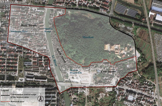
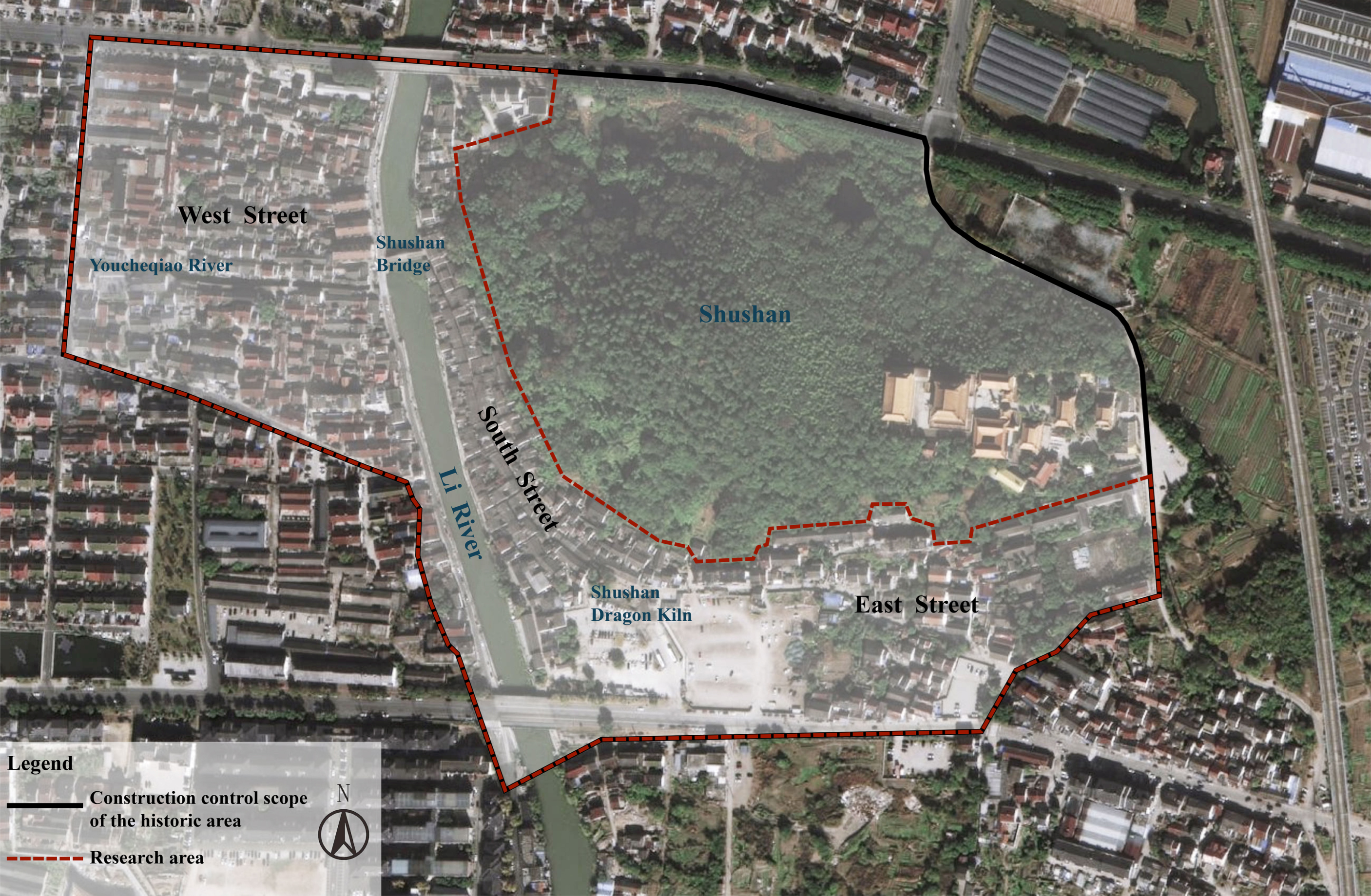
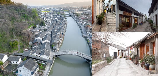
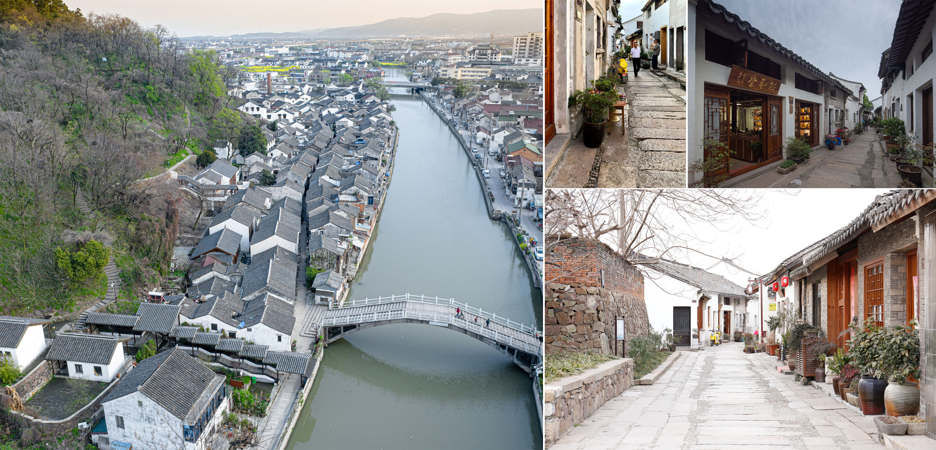
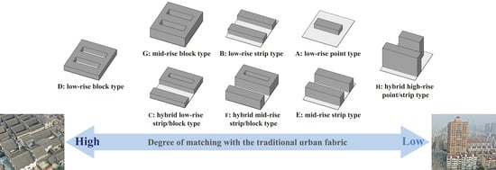
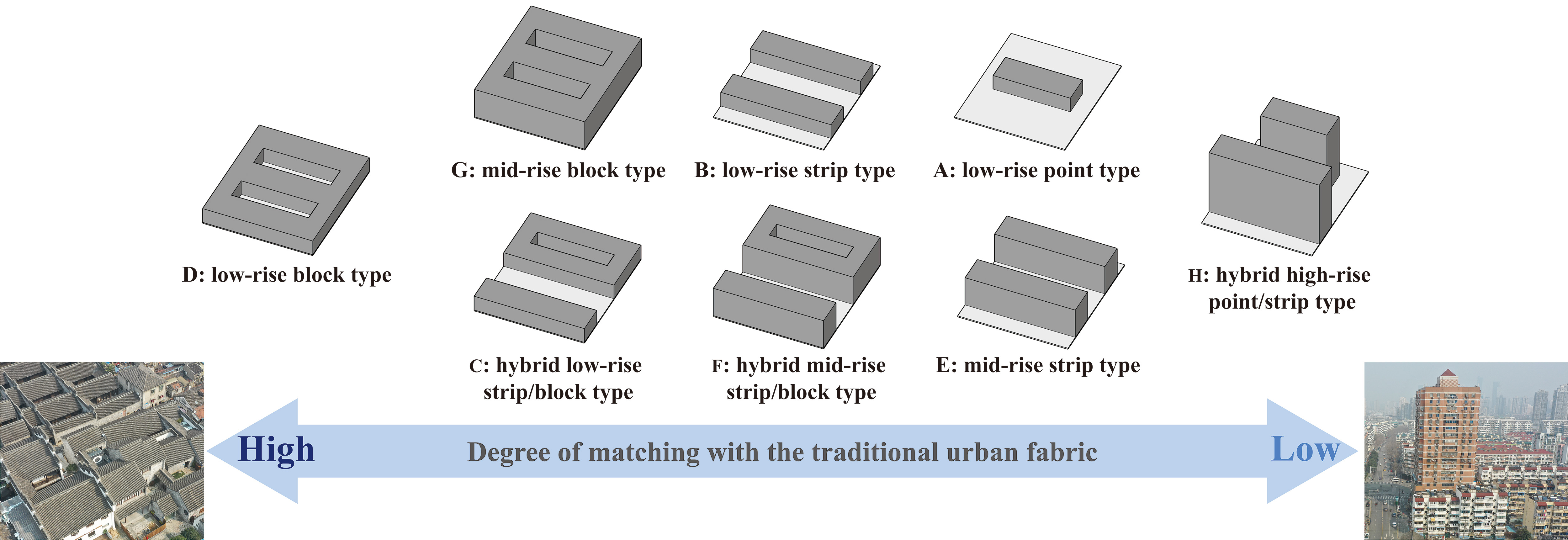
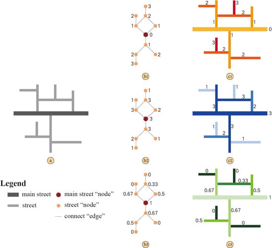
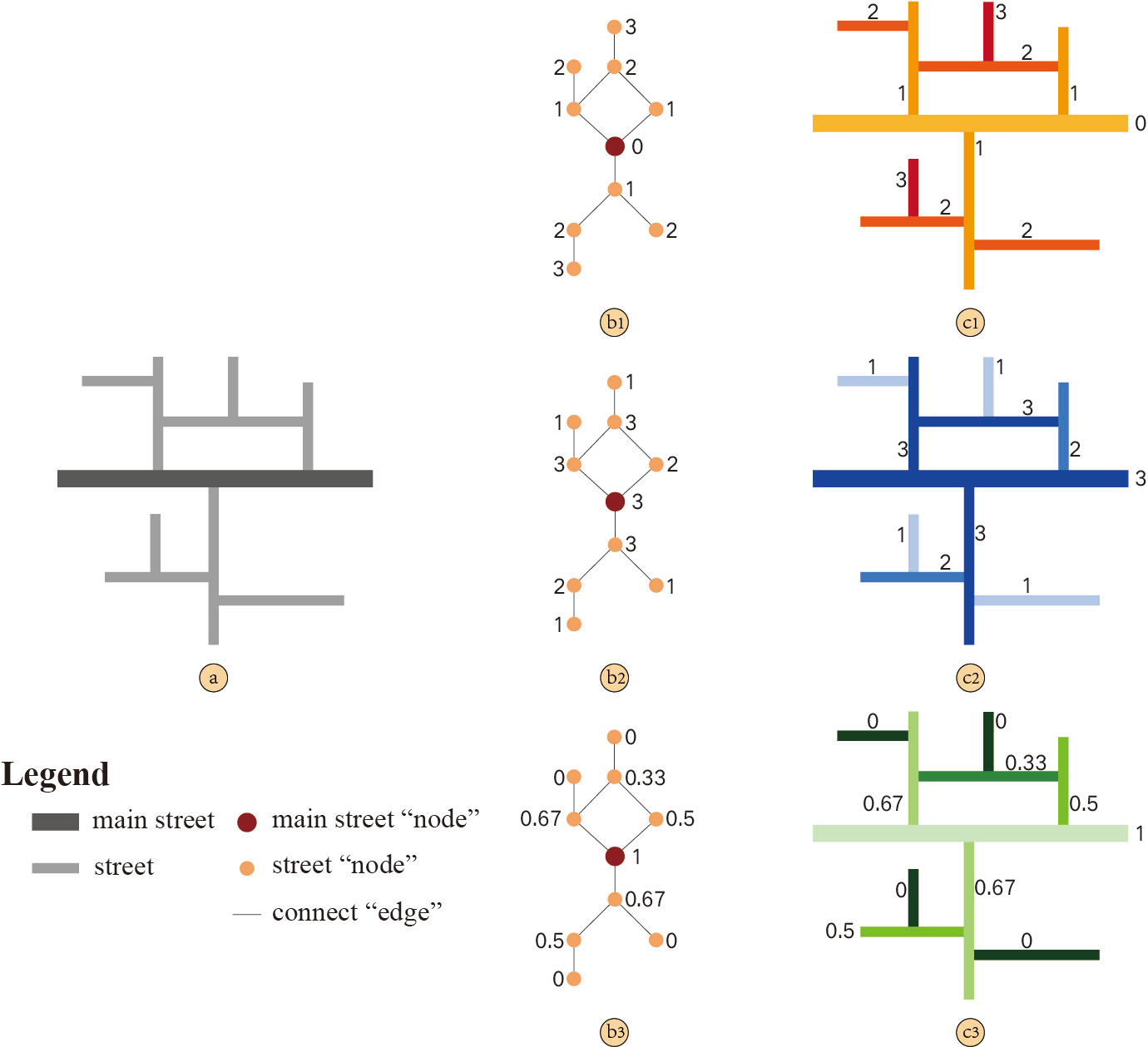
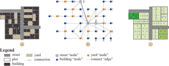
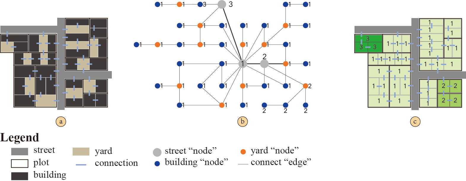
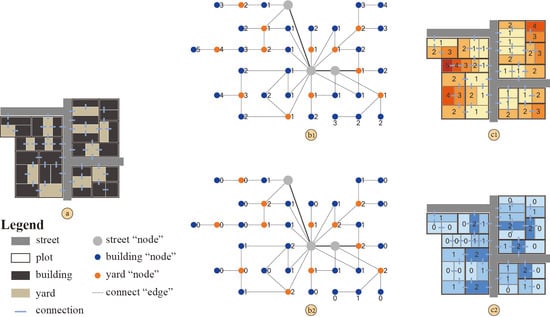
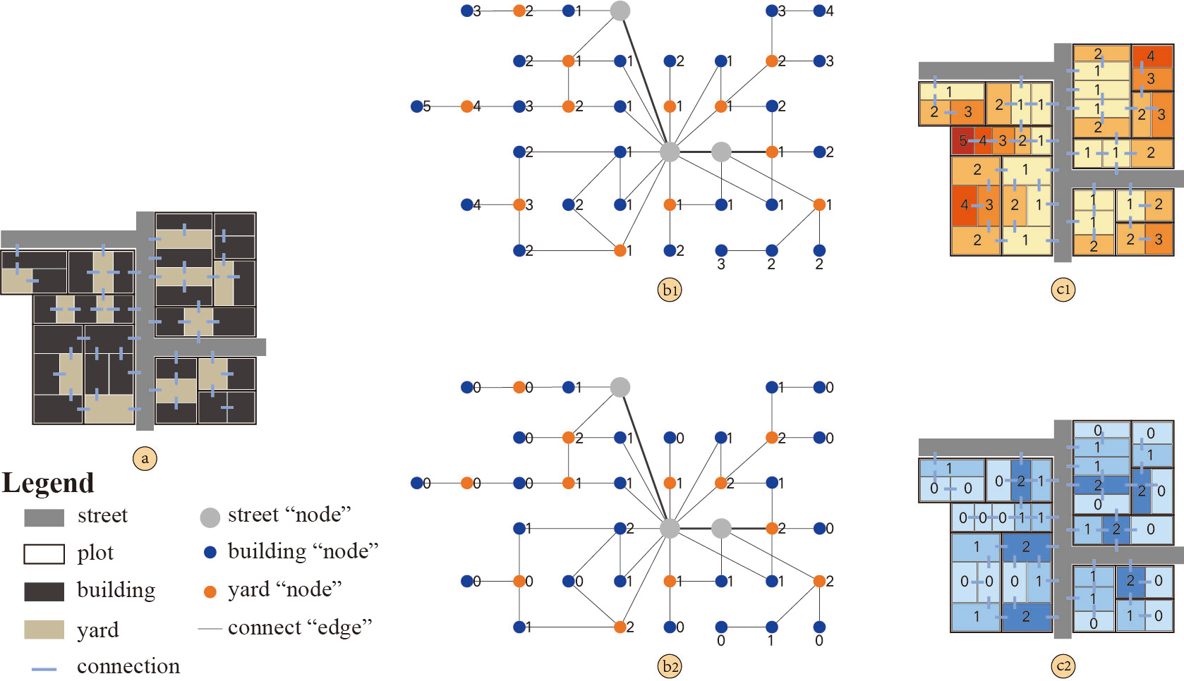
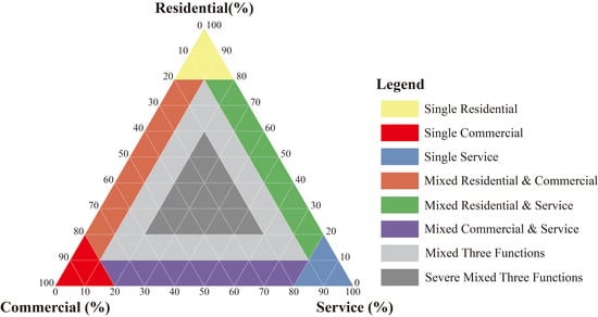
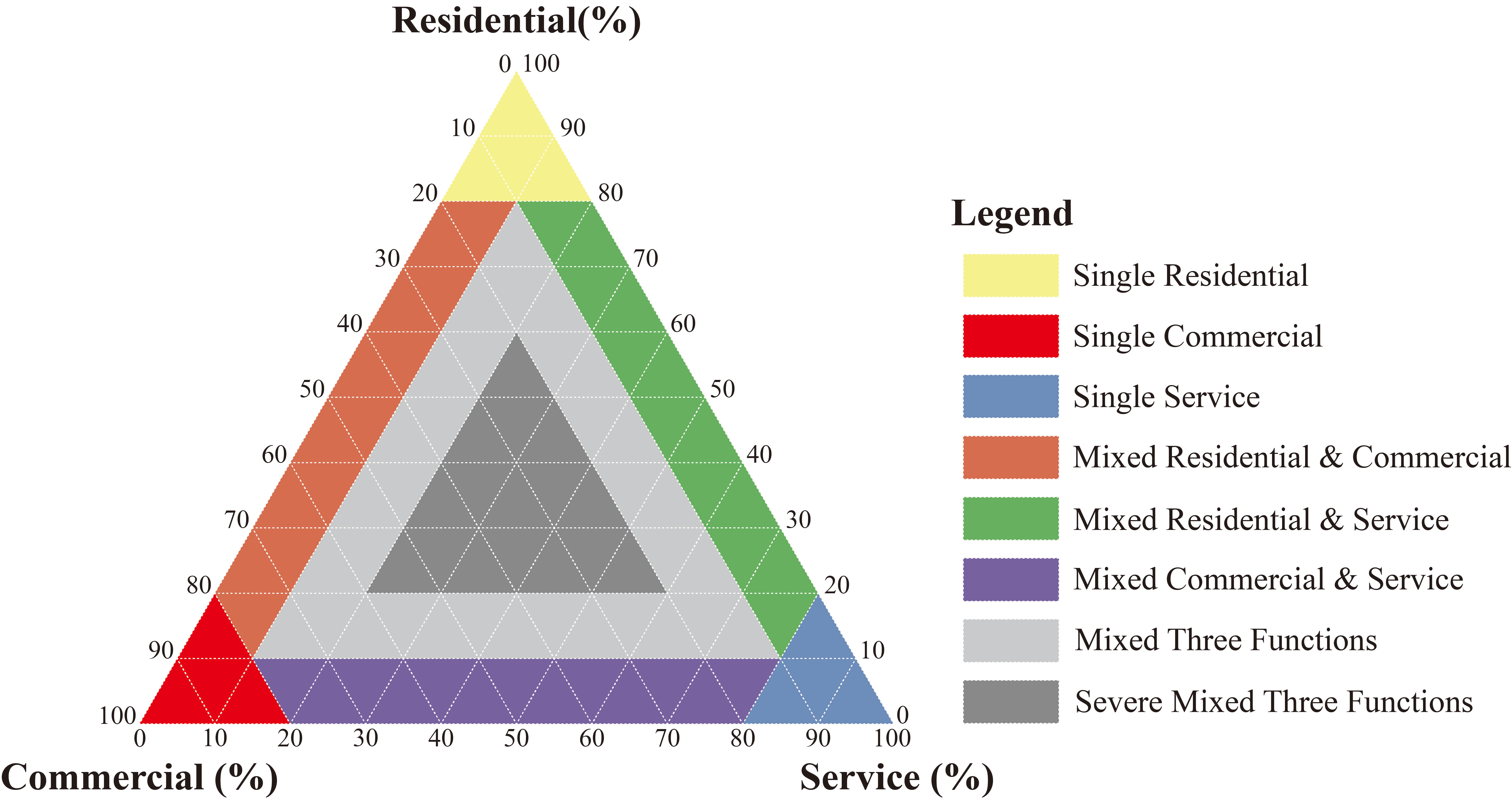
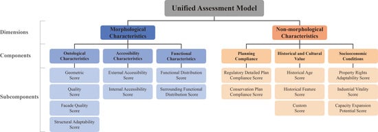
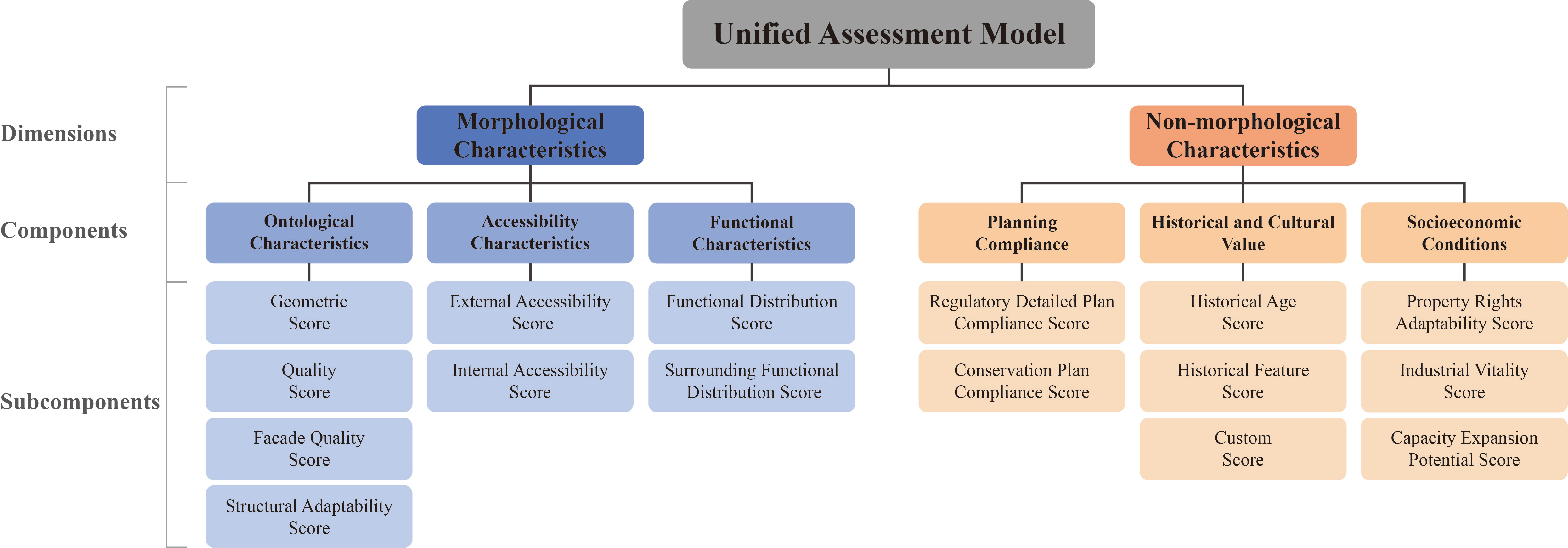
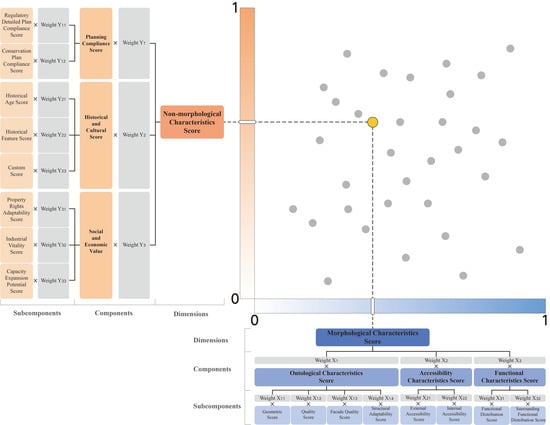
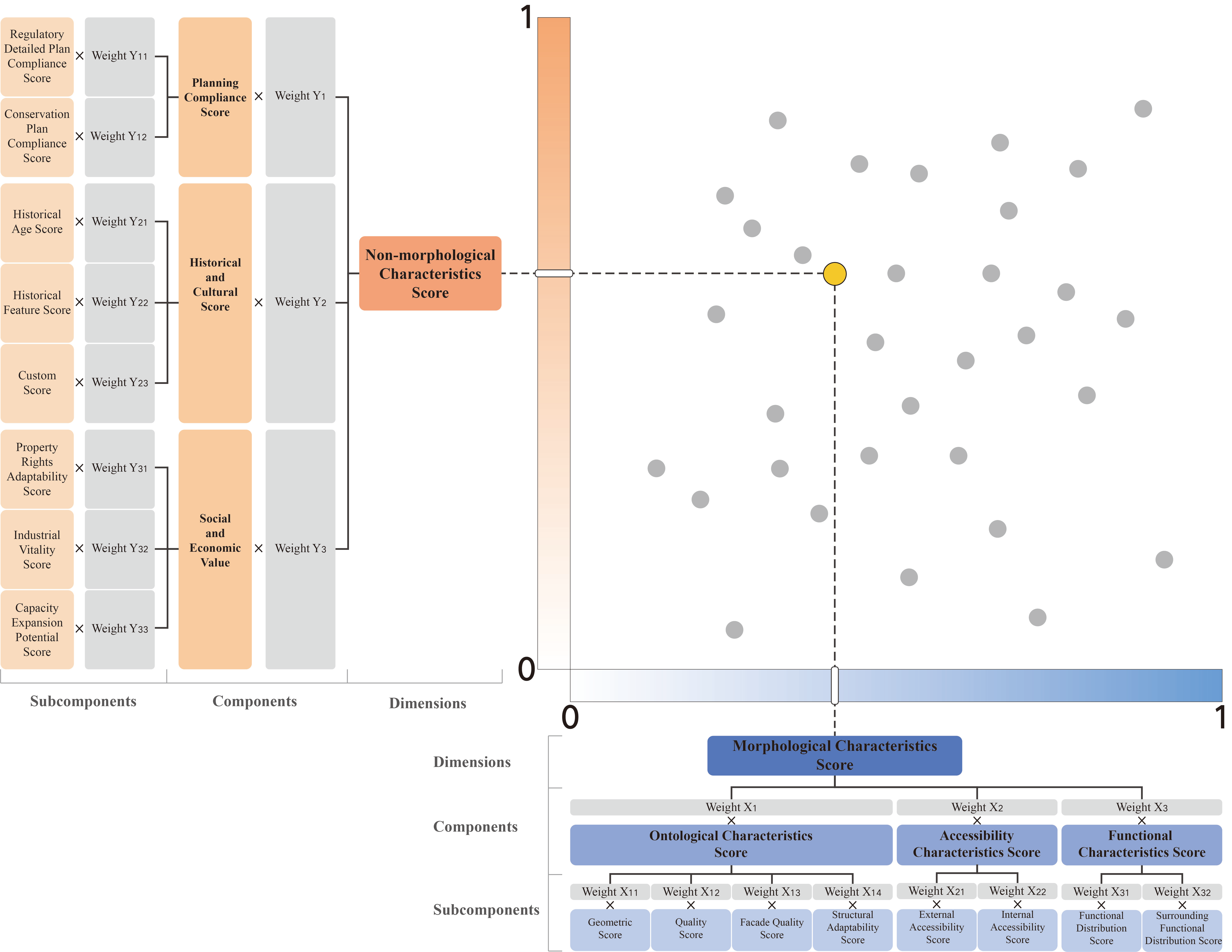
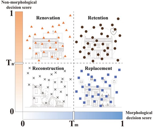
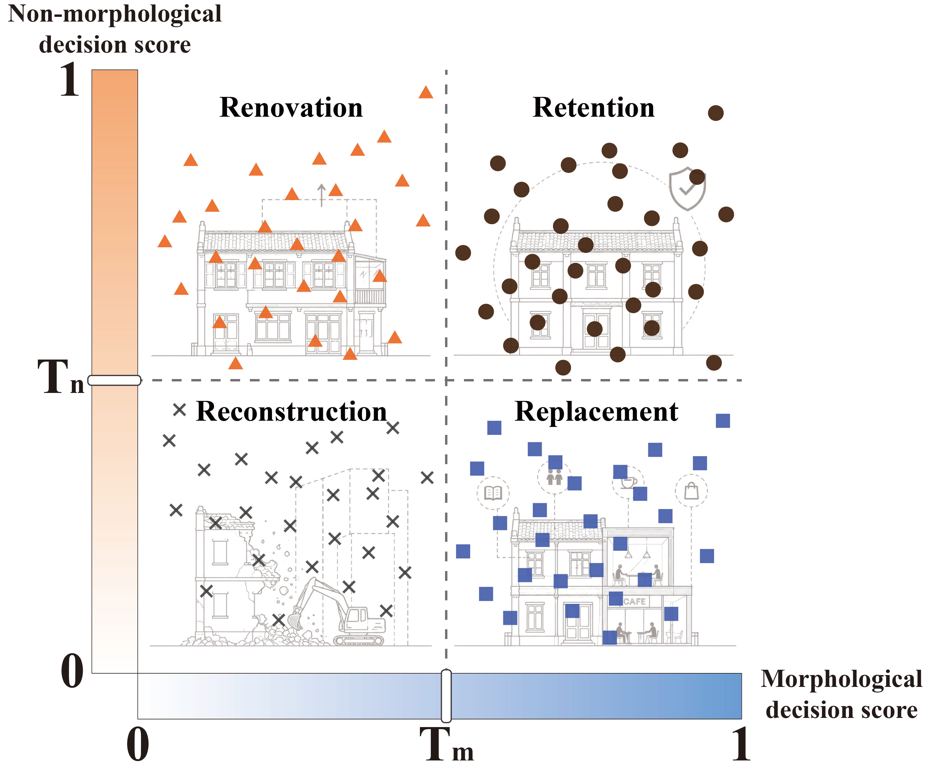
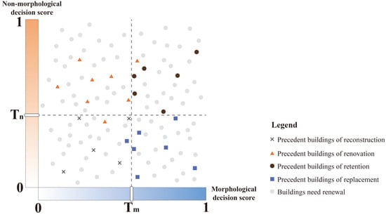
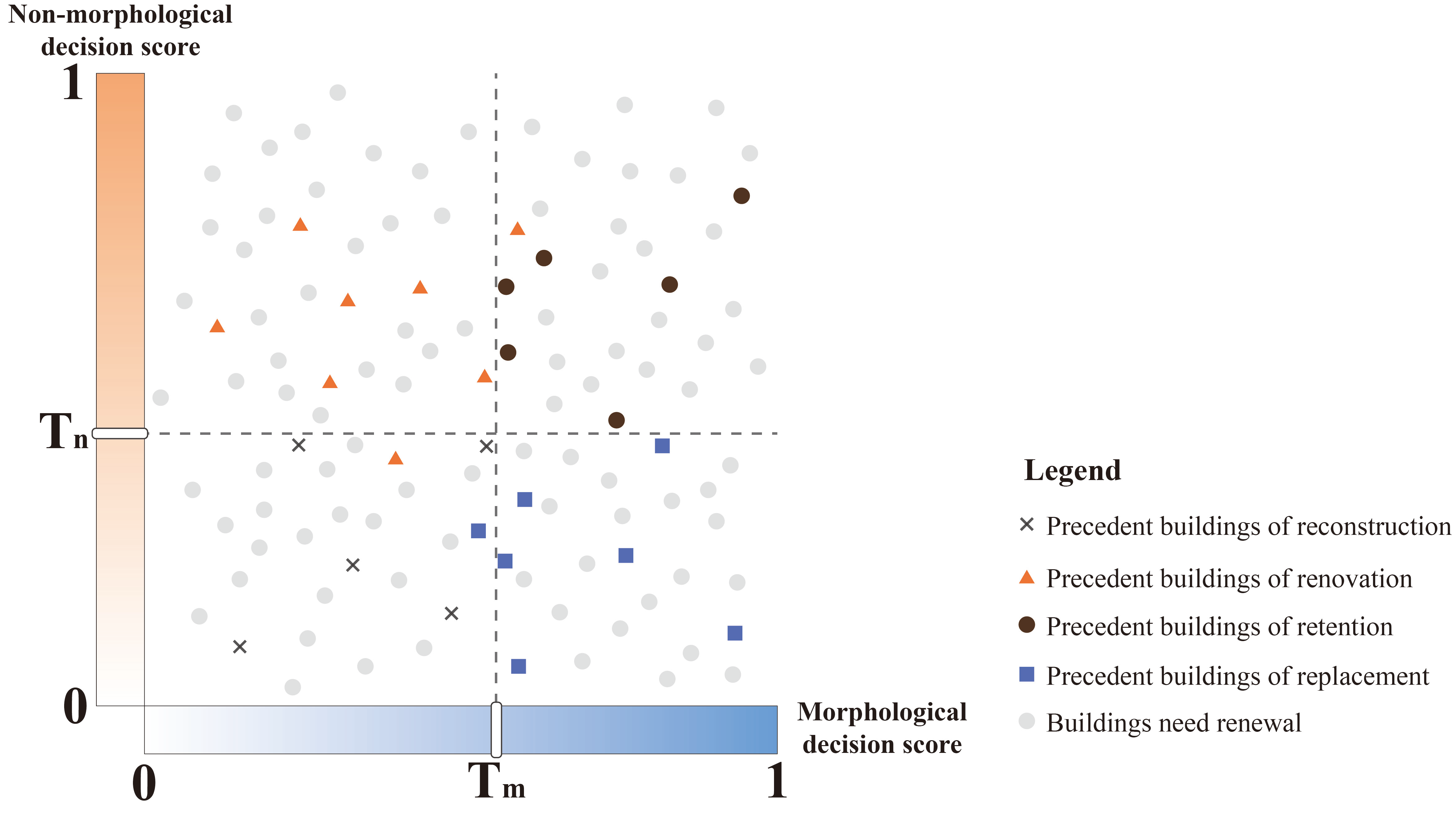
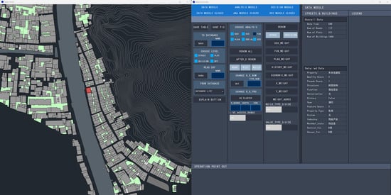
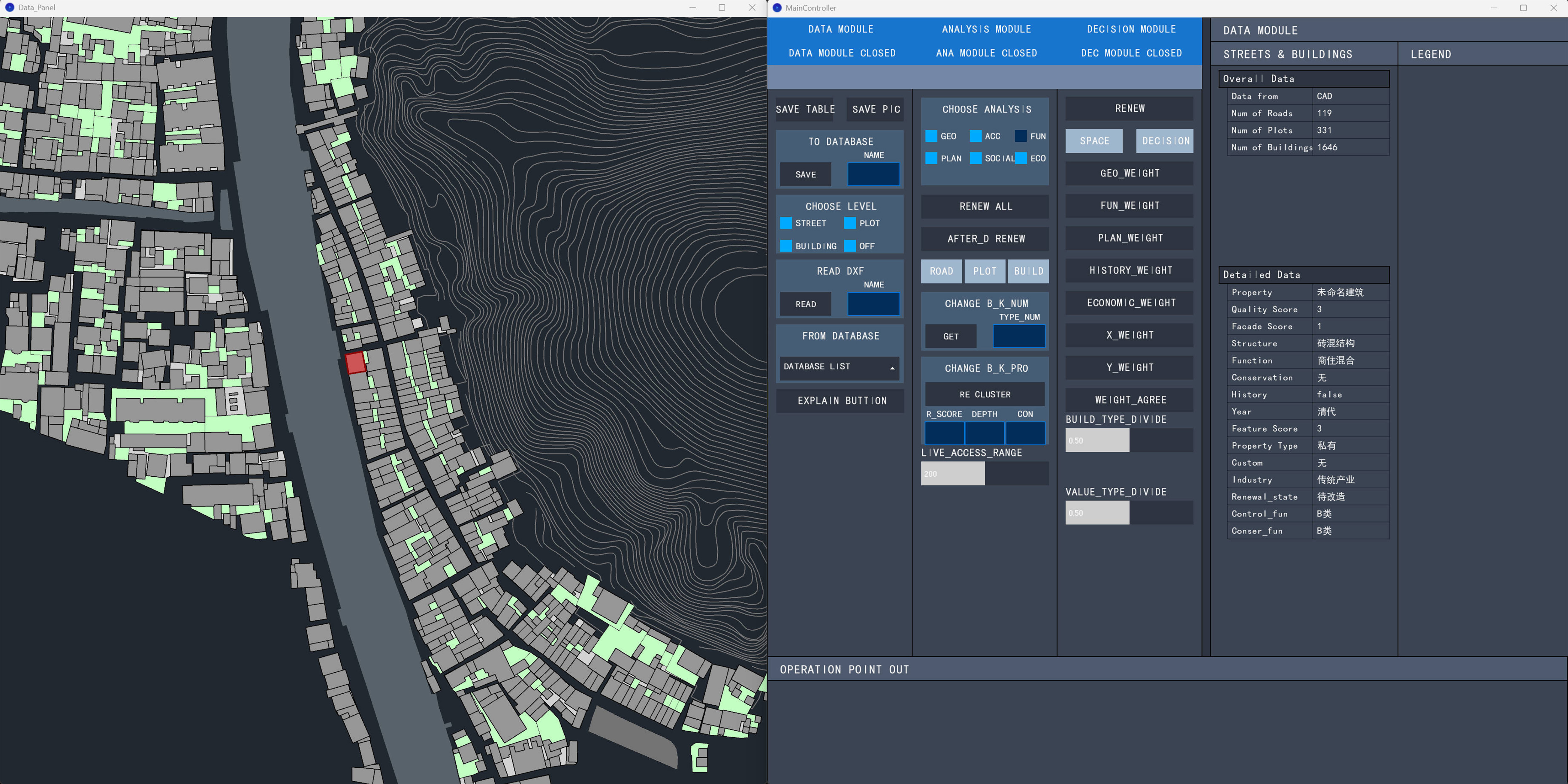
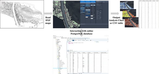
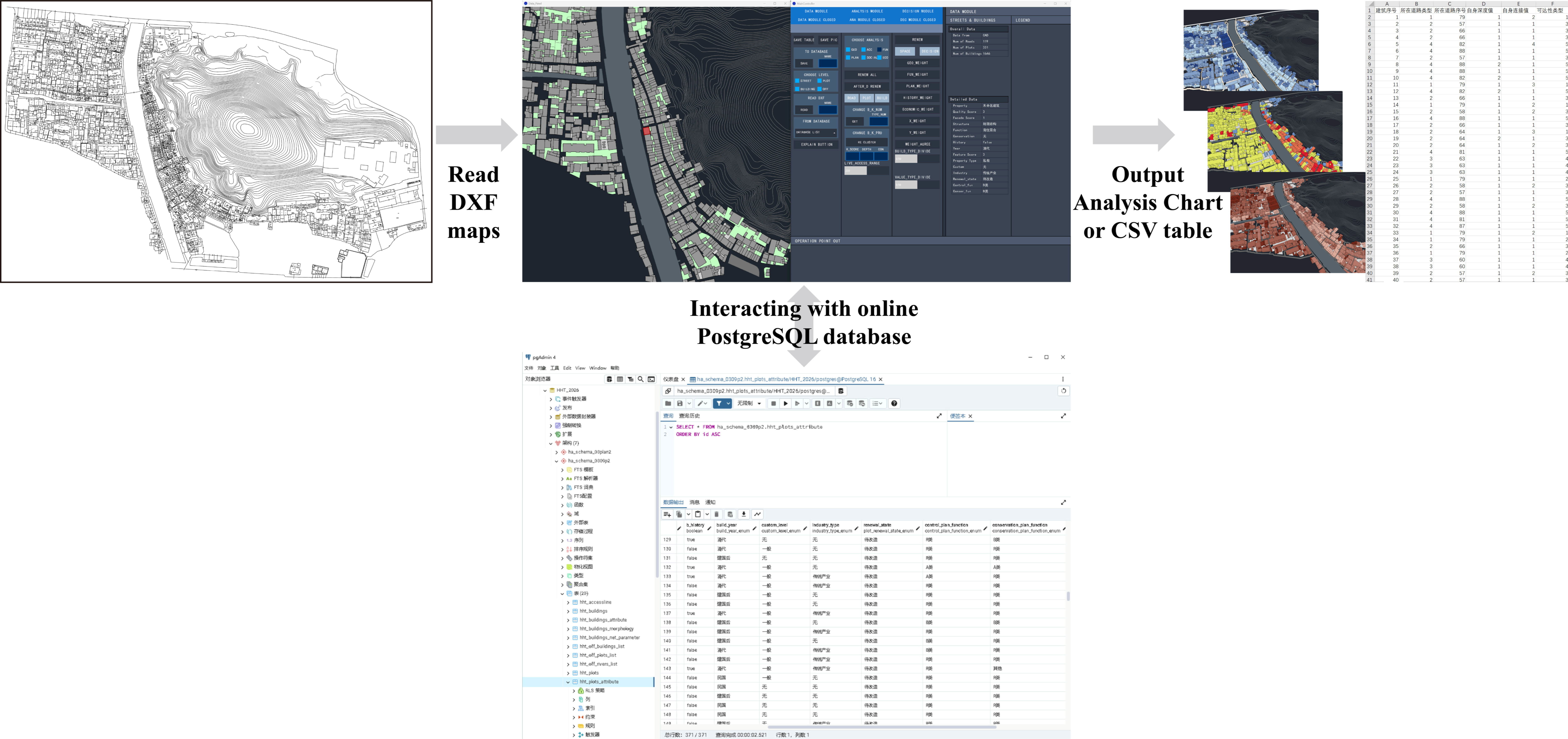
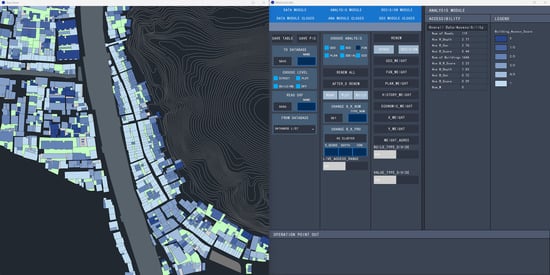
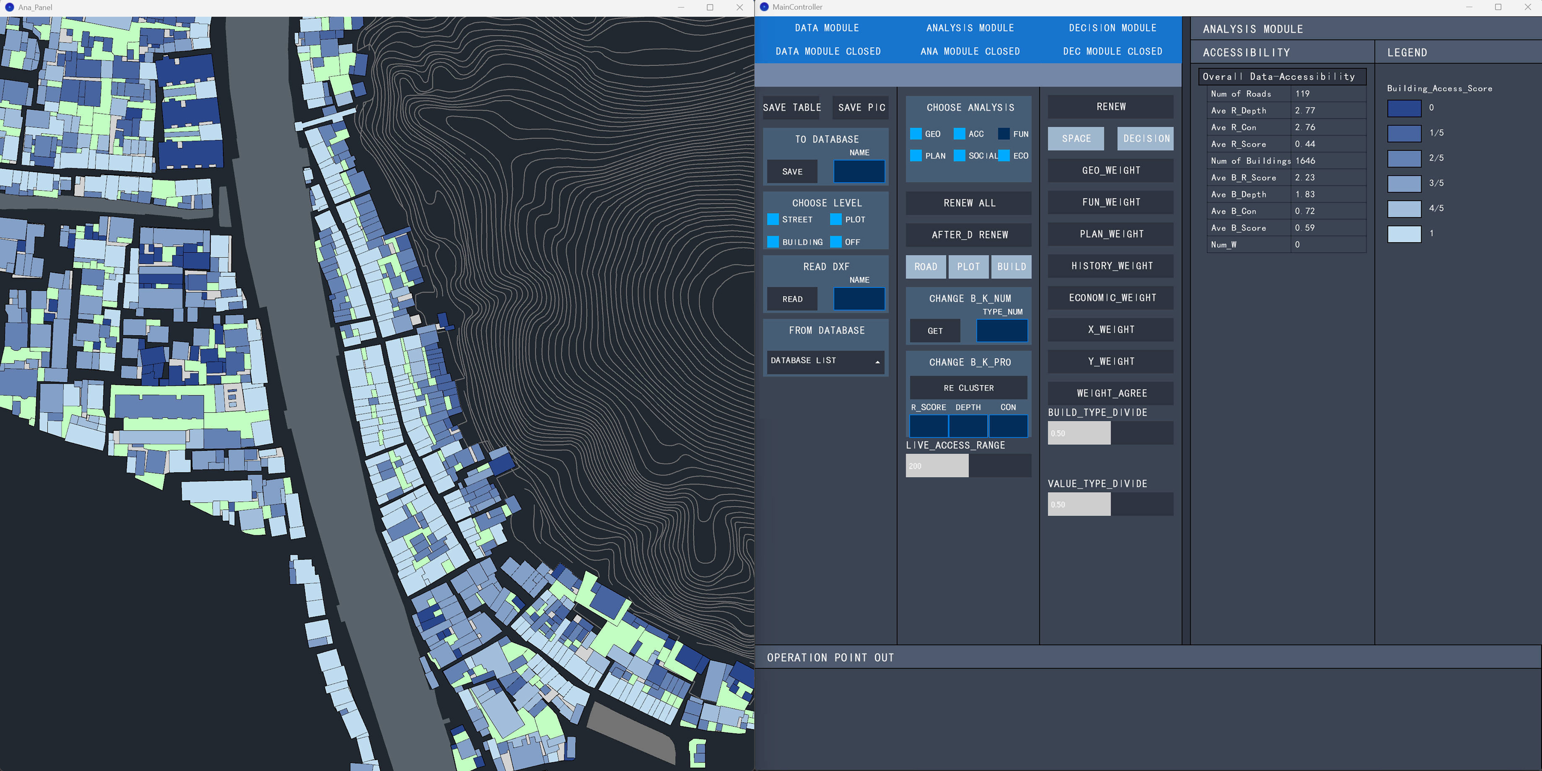
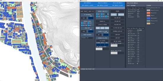
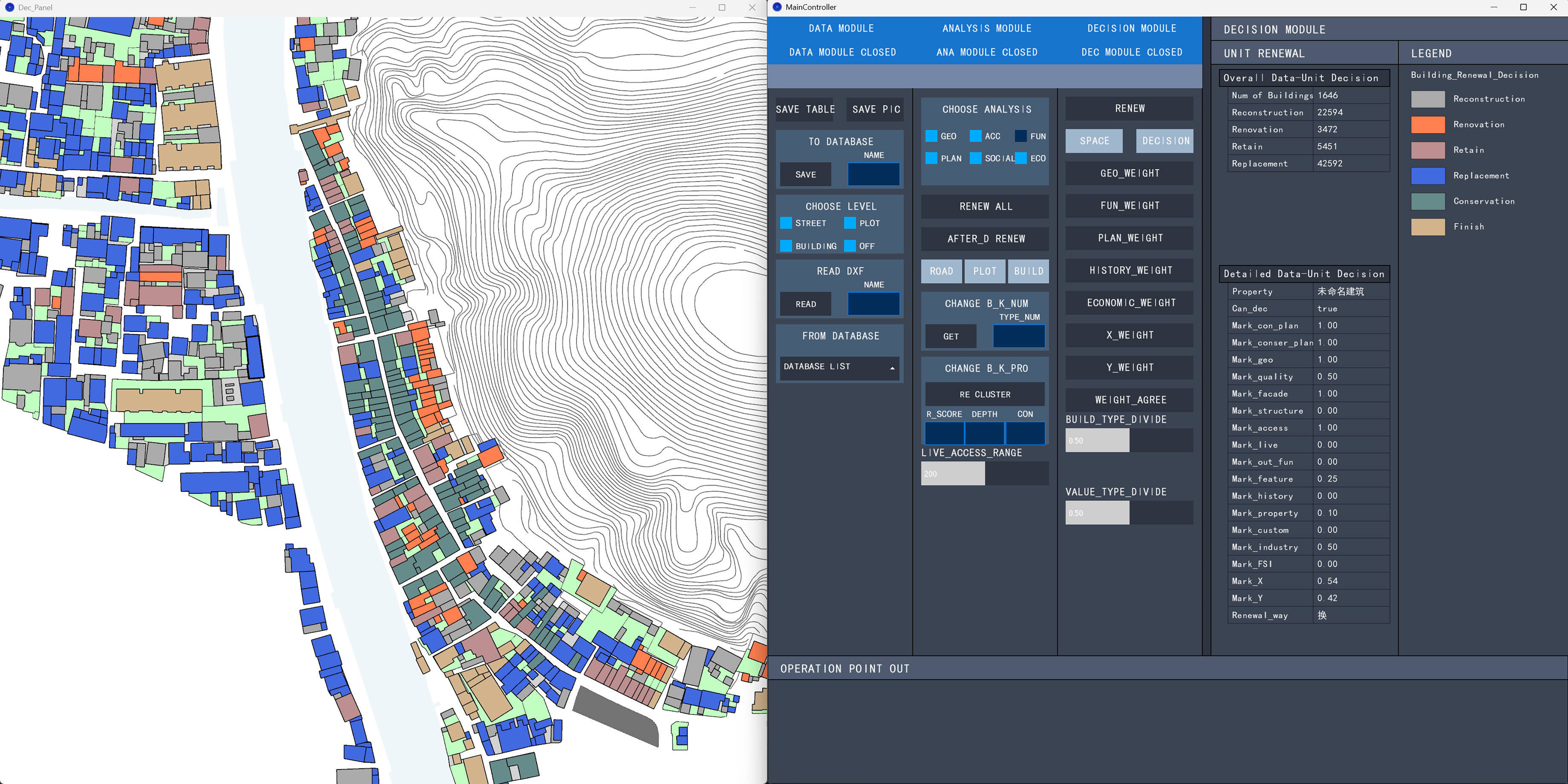
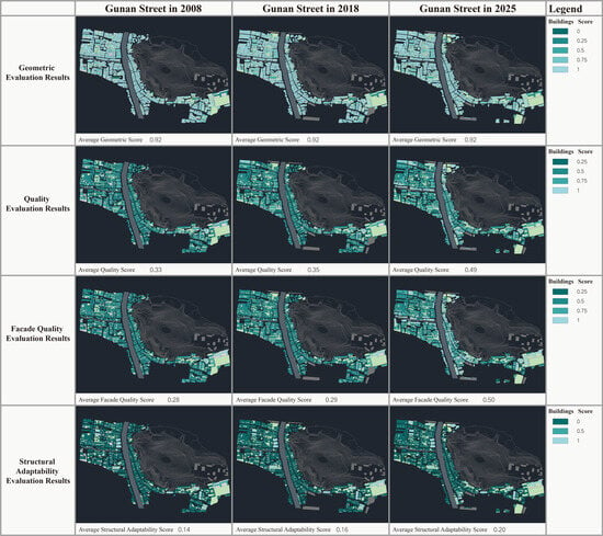
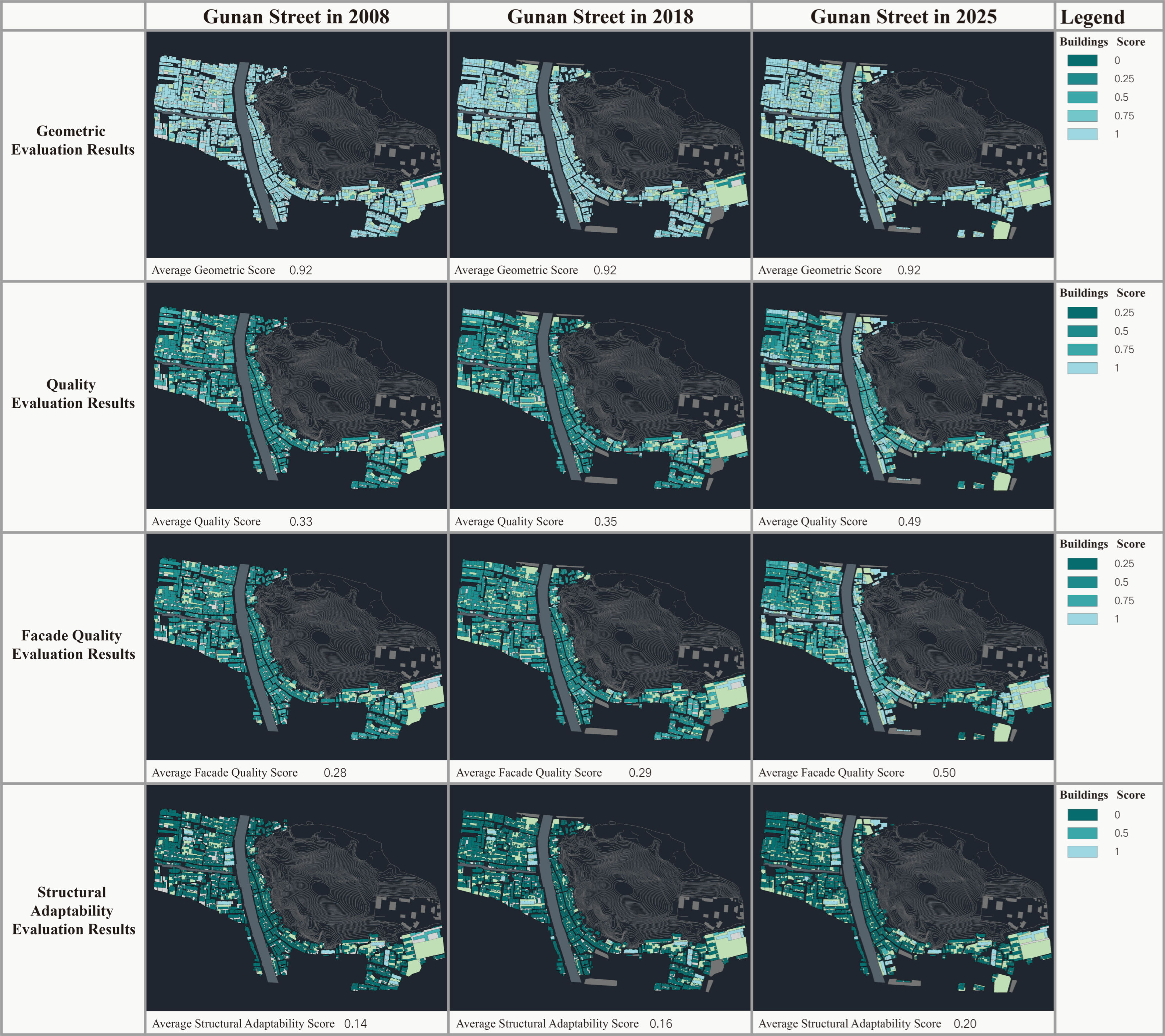
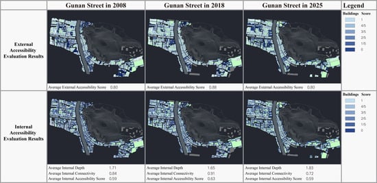
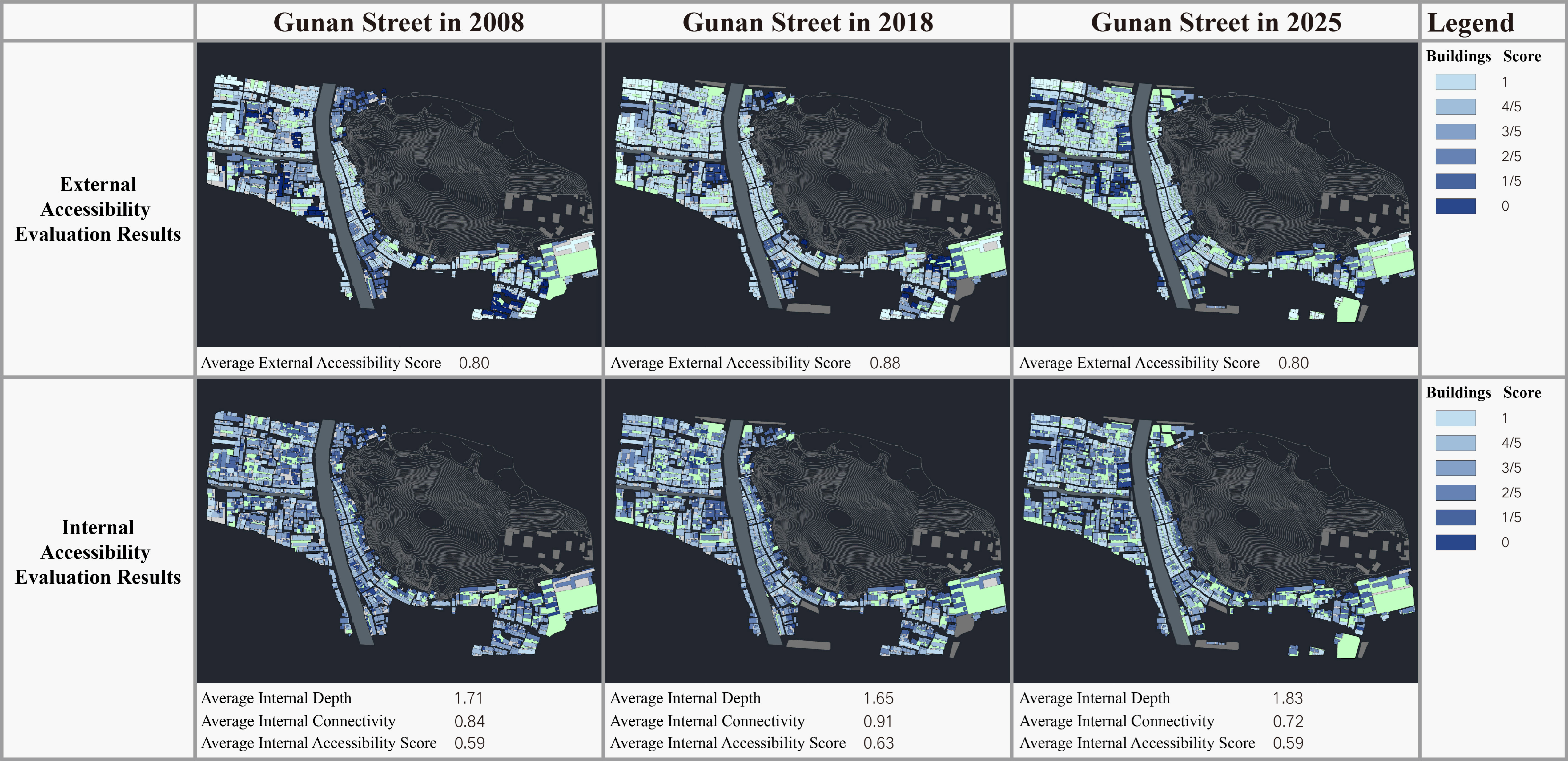
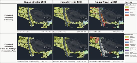
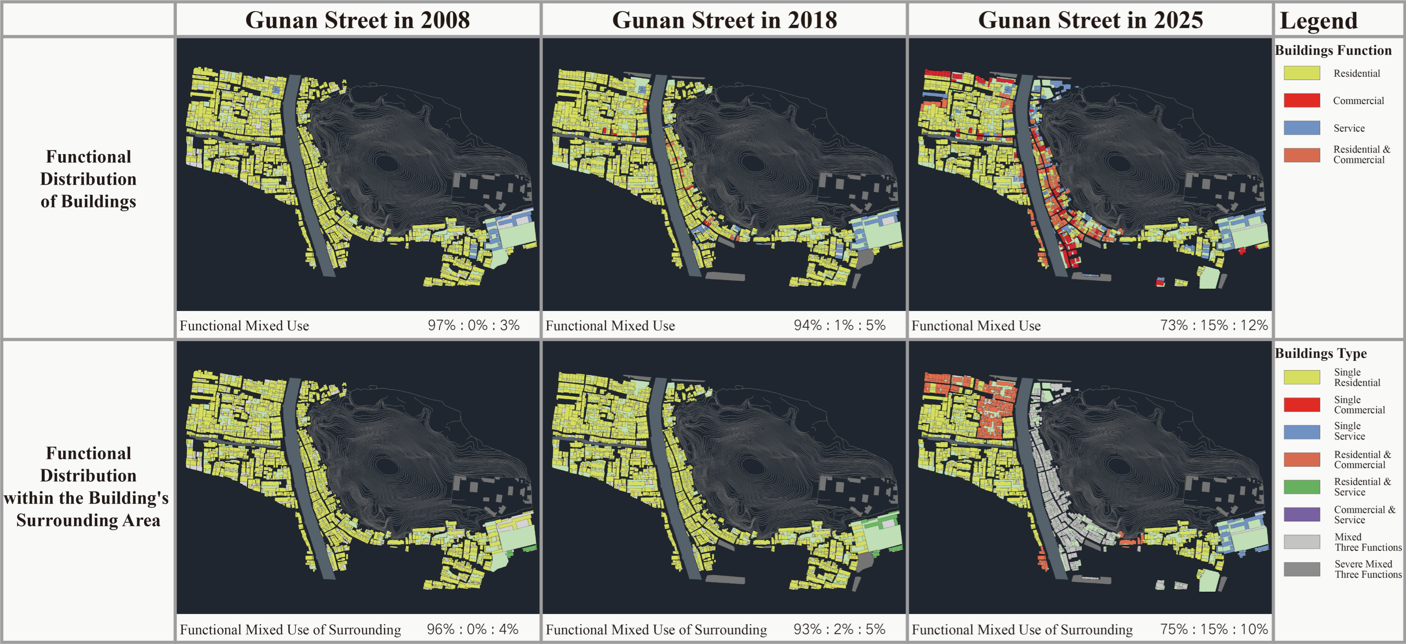
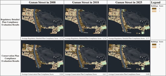
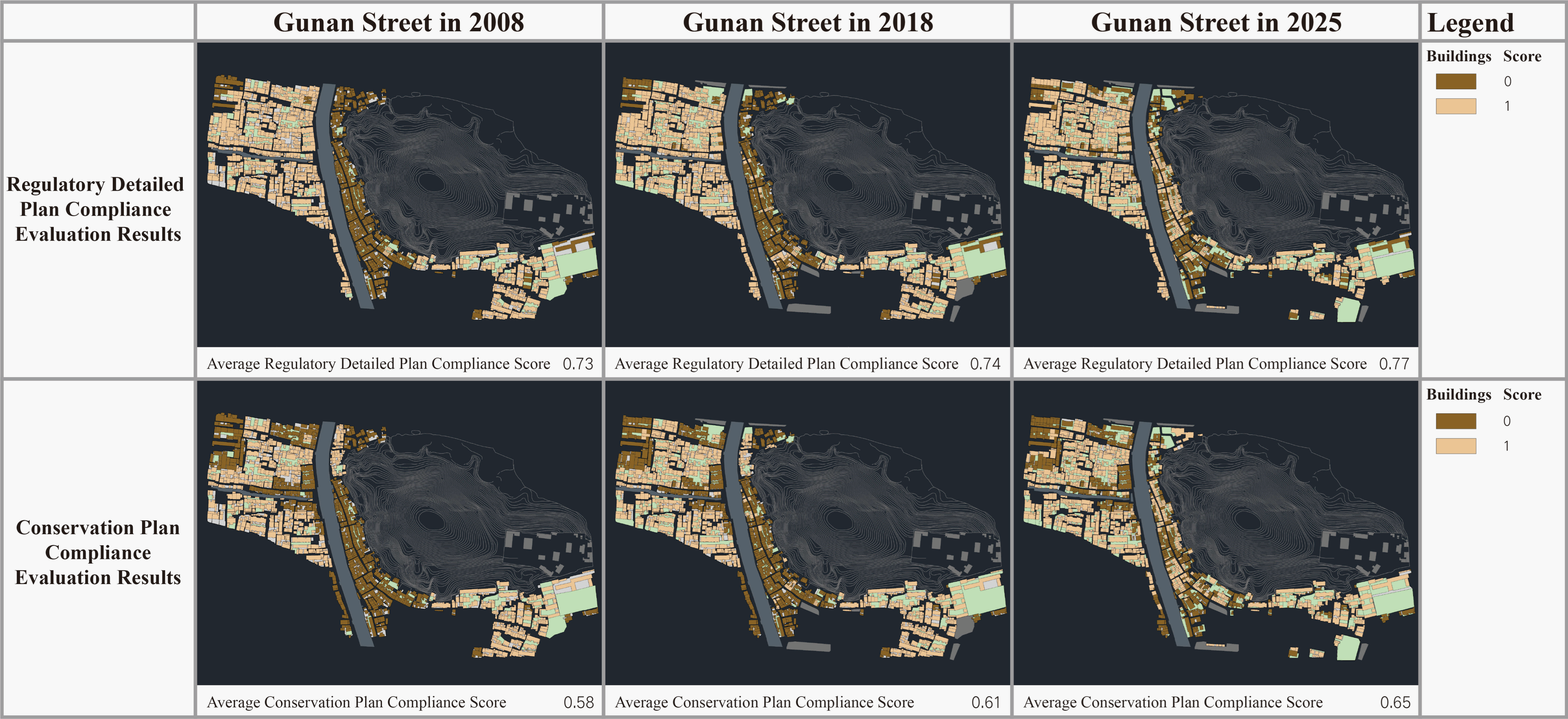
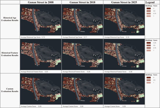
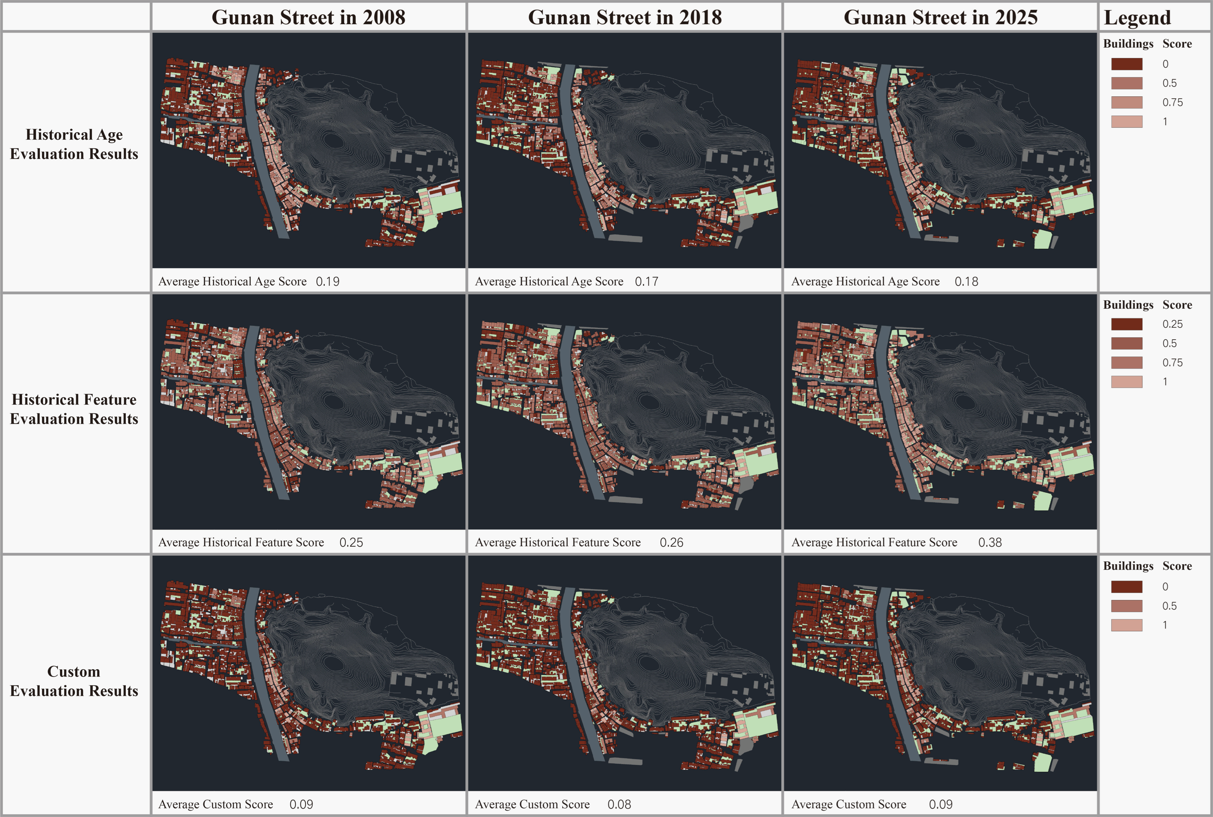
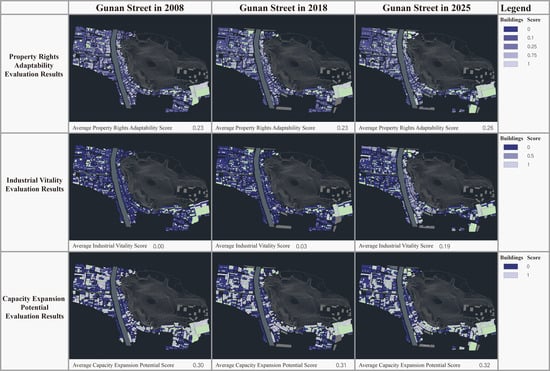
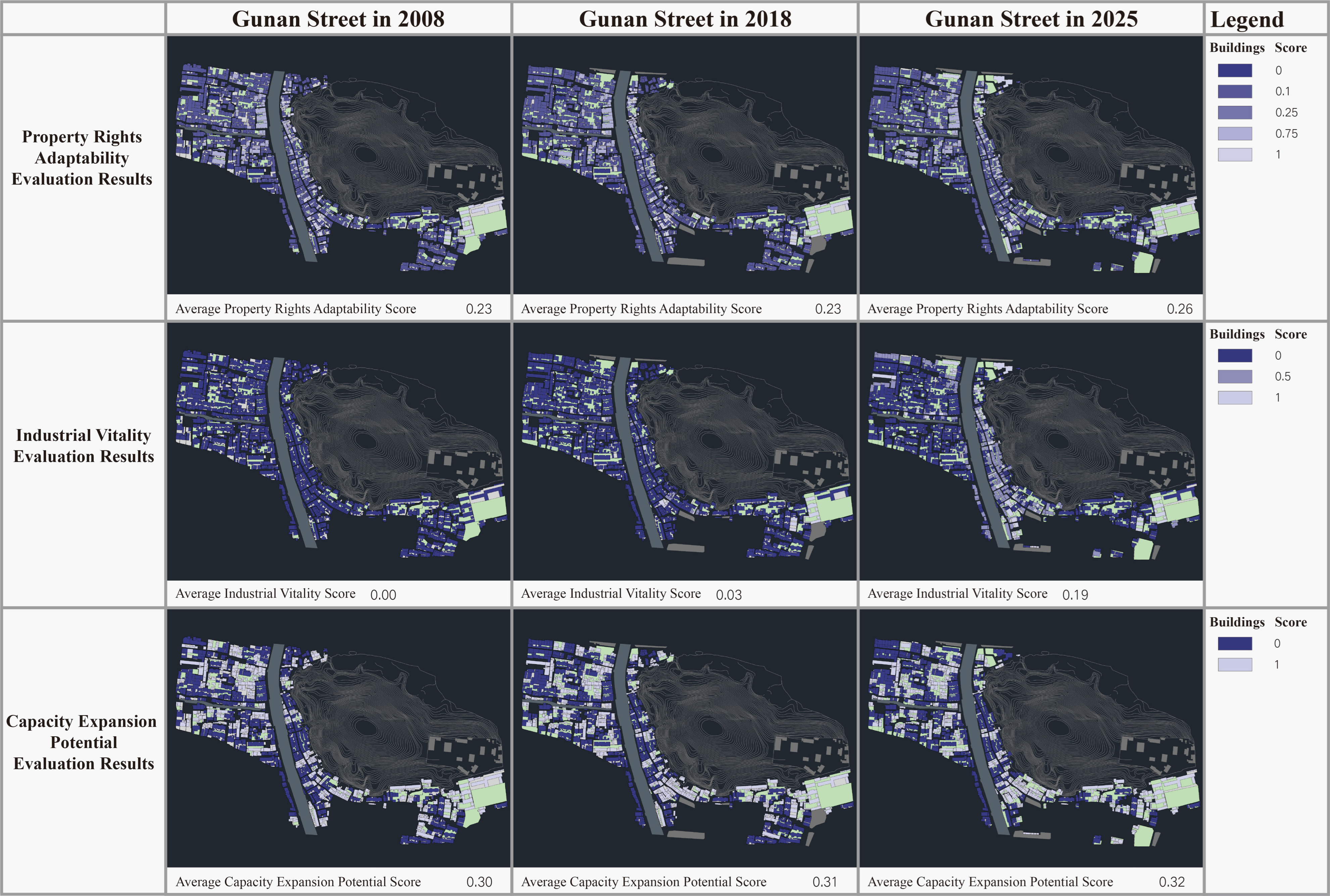
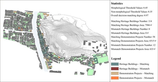
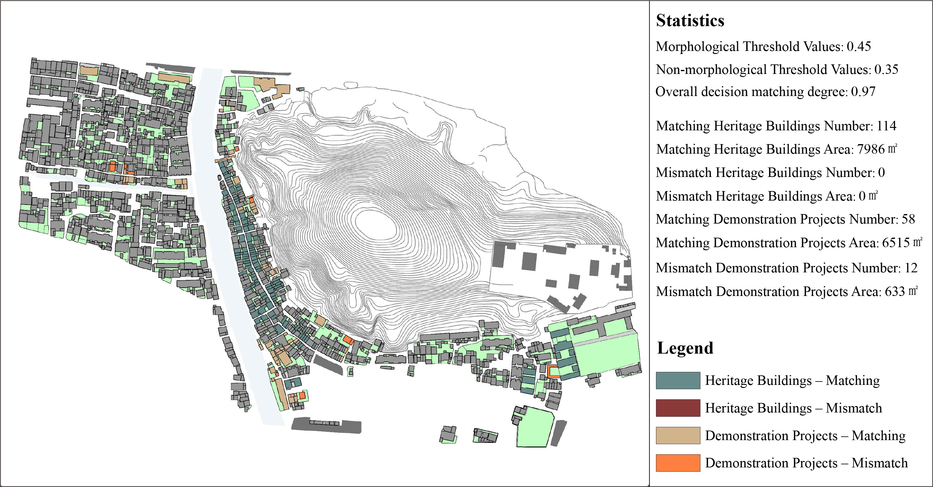
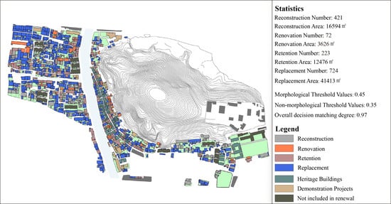
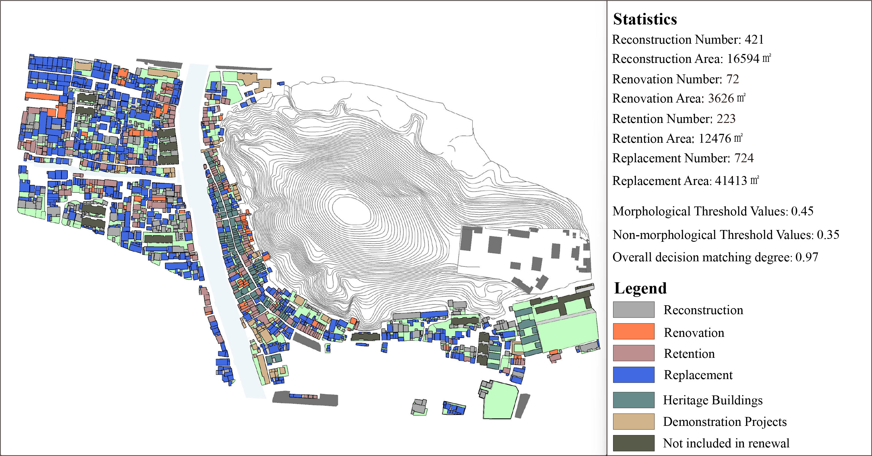

Disclaimer/Publisher’s Note: The statements, opinions and data contained in all publications are solely those of the individual author(s) and contributor(s) and not of MDPI and/or the editor(s). MDPI and/or the editor(s) disclaim responsibility for any injury to people or property resulting from any ideas, methods, instructions or products referred to in the content. |
© 2026 by the authors. Licensee MDPI, Basel, Switzerland. This article is an open access article distributed under the terms and conditions of the Creative Commons Attribution (CC BY) license.