


Abstract
Regional-scale rural landscapes mediate between macro-scale national landscapes and micro-scale local landscapes. The diversity of their types, and their multi-scale spatial characteristics, remain understudied. Taking China’s Leizhou Peninsula as an example, this study builds a pathway linking landscape zoning, characteristic analysis, and mechanism analysis. A multi-factor overlay divides the peninsula into four subregions: Leibei Plain Zone, Nandu River Delta Plain Zone, Leibei–Leinan Volcanic Platform Zone, Coastal Plain and Terrace Zone. A multi-scale system for analyzing landscape character is then constructed. The four zones differ markedly at the macro scale in village-point distribution and at the meso scale in landscape pattern. At the micro scale they converge on a shared village morphology. We then constitute the mechanism of this differentiation through the human–land relationship. Natural constraint acts at the macro scale, the agricultural production at the meso scale, and the anchoring of local culture at the micro scale. The four zones therefore call for different practical implications. The study develops a transferable multi-scale analytical framework, which provides a reference for rural landscape research in other regions and theoretical support for rural landscape protection and planning at the regional scale.
1. Introduction
Rural landscapes result from long-term interaction between natural processes and human activity, which constitute a distinct landscape type with specific form, structure, and function [1,2,3]. Shaped by regional natural conditions and cultural practices, they are inherently diverse and spatially heterogeneous [4]. Rural landscapes also carry cultural, social, economic, and aesthetic values that are central to regional development [5]. Rapid urbanization in China has disrupted this balance since the late twentieth century. Urban expansion and unregulated rural construction have degraded villages and their landscape character. The number of natural villages (i.e., rural settlements distinct from administratively designated villages) fell from 3.537 million in 2000 to 2.363 million in 2020, a net loss of 1.174 million [6]. Many characteristic villages now face disappearance, landscape fragmentation, and erosion of regional identity [7,8]. A recurrent cause is that planners underrate the multiple values of rural landscapes and so disregard regional differences, applying urban models indiscriminately [9,10]. China’s 14th Five-Year Plan (2021-2025) placed rural revitalization as its development strategy. Because rural landscapes differ markedly among regions and in compositional complexity, protecting their diversity requires analysis at the regional scale. That scale links the national and local levels and can integrate large ecological spaces crossing administrative boundaries [11,12]. Such regional-scale analysis is essential to maintaining national landscape diversity, preserving vernacular culture, and sustaining rural development [13].
Two properties of the rural landscape make regional-scale analysis difficult. First, the rural landscape is a composite of interacting ecological, production, and living systems [14]. The ecological landscape forms the natural substrate and centers on protecting the natural environment and maintaining biodiversity [15]. The production landscape supplies material products through agriculture, animal husbandry, and forestry and is shaped mainly by economic activity [16]. The living landscape is organized around the village system and encodes historical and cultural meaning, while providing for residence, social interaction, and recreation [17,18]. Because differentiation of the rural landscape is governed by several interacting factors, its classification and zoning must consider multiple driving forces at once. Second, as a complex system the rural landscape is spatially heterogeneous and hierarchically organized, and it presents markedly different features at different spatial scales [19]. Existing studies have advanced understanding of individual components, such as ecosystem services [15], rural spatial form [17] and settlement morphology [18], or of a single spatial scale. The cross-scale structure of these features, and a consistent way to describe them across levels, remain poorly characterized. Answering them requires multi-scale analysis that combines quantitative indicators with qualitative description at each level [19,20,21].
Characterizing these features first requires defining the spatial units to which they belong, and landscape zoning provides them. It divides a territory into regions according to selected geographic elements and is an established means of revealing the spatial differentiation of rural landscape features. Accordingly, research on rural landscape differentiation has increasingly moved towards typology and zoning [22,23]. Its precision depends on how the spatial scale and the evaluation unit are defined [21,24]. Existing studies mostly adopt provincial, county, or town administrative boundaries as zoning units [25], whereas the village is the smallest basic unit of rural administration. The resulting boundaries are coarser than the units at which rural landscapes actually differentiate. Existing methods also fall into two families that are usually applied in isolation. Top-down methods overlay existing thematic maps such as climate, landform, and ethnicity; they are objective and easy to apply, but their divisions are difficult to reconcile and integrate [26]. Bottom-up methods build a database of landscape-characteristic information and then cluster its elements. They delineate landscape types more accurately, but they remain subjective and laborious and tend to neglect the environmental dependence of rural landscapes [27,28]. How to combine the strengths of the two sides to make zoning becomes both efficient and precise remains unresolved.
Zoning and characterization establish where and what, but not why. Landscape research has long been criticized for documenting spatial patterns while neglecting the processes behind them, so that the driving forces of differentiation lacked sufficient argument [29]. Where those forces have been quantified, the analysis has usually been confined to one case-study area or one spatial scale [20]. Rural landscape differentiation, however, arises from combinations of political, economic, cultural, technological, and natural forces operating at different levels [30]. Current studies have begun to relate landscape characterization to the analysis of driving forces [12]. The traditions that describe what a landscape is and those that ask why it is so are also increasingly treated as complementary rather than alternative [31]. These strands have not been assembled into a complete pathway. A framework that aligns where the zones are, what their features are at each scale, and why they differ is therefore still missing. Without one, spatial planning lacks a coherent basis for translating landscape differentiation into differentiated, place-based governance.
To address these gaps, this study focuses on the regional-scale rural landscape. It asks three questions: how to divide rural landscape zones on a more objective and efficient basis, how to characterize features at different spatial scales, and why they differ between zones. Three contributions follow. The first is the framework: it links landscape zoning, characteristic analysis and mechanism analysis into one continuous research route. The second is the zoning method: it takes village-level administrative boundaries as units and applies a multi-factor overlay, which makes rural landscape zoning more accurate and more efficient. The third is the multi-scale analysis: moving beyond existing single-scale work, it examines rural landscapes at macro-scale regions, meso-scale village groups and micro-scale settlement spaces.
The study area is the Leizhou Peninsula. Geographically, as the third largest peninsula in China, it contains the largest Quaternary volcanic field and the largest tropical agricultural region in China. Culturally, the Leizhou Peninsula is one of the four major cultural zones in Guangdong province, integrating a variety of cultural attributes, including marine, volcanic, and tropical agriculture [32,33,34,35]. The diversity and uniqueness of the rural landscape resources of the Leizhou Peninsula provide sufficient rural cases for this study. This study aims to achieve the following four objectives: (1) constructing a rural landscape research framework; (2) conducting landscape zoning of the rural landscapes of the Leizhou Peninsula; (3) comparatively analyzing the rural landscape character of each subregion across multiple spatial scales; and (4) deriving practical implications for its conservation and planning.
2. Study Area and Data
2.1. Study Area
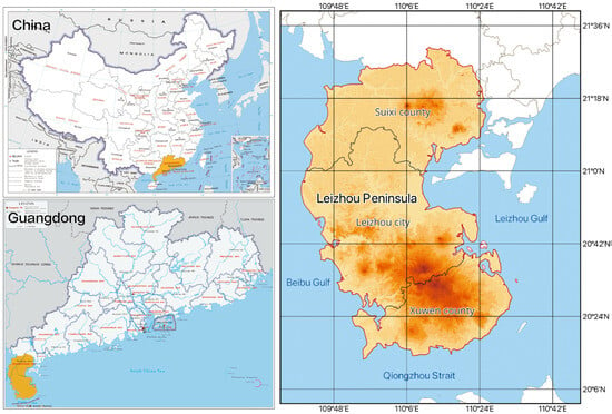
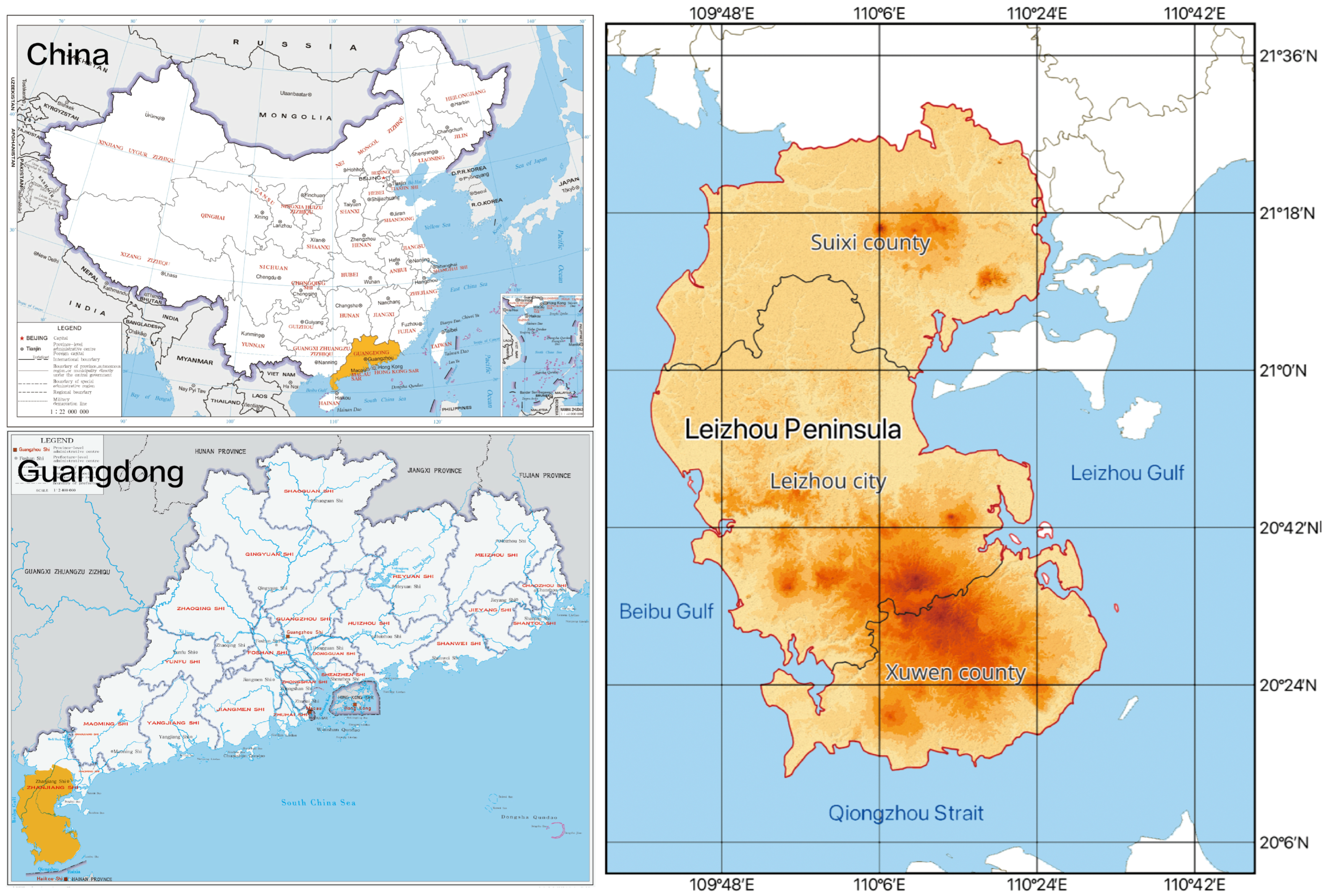
The Leizhou Peninsula is located at the southernmost end of mainland China (20°03′ N–21°05′ N, 109°06′ E–110°05′ E). It is bordered by the Beibu Gulf to the west and the South China Sea to the east, and the Qiongzhou Strait to the south, across which lies Hainan Island. Its scope covers six county-level jurisdictions of the prefecture-level city of Zhanjiang: Chikan District, Xiashan District and Mazhang District, together with Suixi County, Leizhou City and Xuwen County. The total land area is approximately 8435 km2 (Figure 1). The study period is defined as the traditional period before the 1980s. This period immediately preceded China’s reform and opening up, when the rural landscape of the study area remained relatively well preserved [33,34].
Figure 1.
Location and administrative scope of the Leizhou Peninsula.
2.2. Data Sources and Processing
We compiled three groups of data for the Leizhou Peninsula 1:
- •
- Village historical data: The village list was compiled from the village gazetteer compiled by the monograph [35]. A total of 972 villages within the study area were identified, and QGIS 3.44 software was used to perform spatial registration for each village and to obtain its geographic coordinate information.
- •
- Raster map data: The geomorphological map of the Leizhou Peninsula was derived from [36], and the soil map from the Resource and Environment Science and Data Registration and Publishing System of China [37]; The climatic map of Guangdong Province was obtained from [38], and the linguistic map was derived from [39].
- •
- Geospatial information data: The village-level administrative boundaries were derived from the Third National Land Survey of Guangdong Province (2020), provided by the Guangdong Provincial Department of Natural Resources [40]. The digital elevation model (DEM, 30 m resolution) and the hydrological vector dataset [41] were obtained from the Geospatial Data Cloud. The 1980 land use data of Zhanjiang City (CNLUCC, 30 m resolution) were derived from the Resource and Environment Science and Data Registration and Publishing System of China [42].
All collected data were spatially corrected and georeferenced using QGIS 3.44. The Georeferencer aligns unreferenced raster or vector layers with known coordinate systems using Ground Control Points [43]. The dataset was subsequently checked for spatial alignment and positional accuracy to support village-level spatial analysis.
3. Methodology
3.1. Research Framework
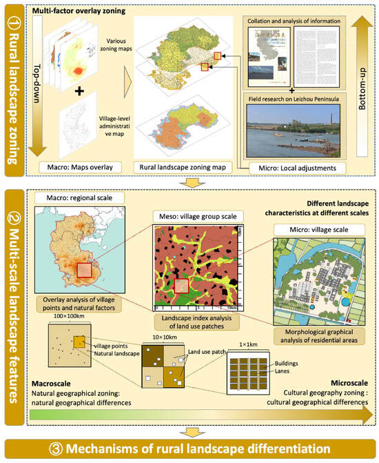
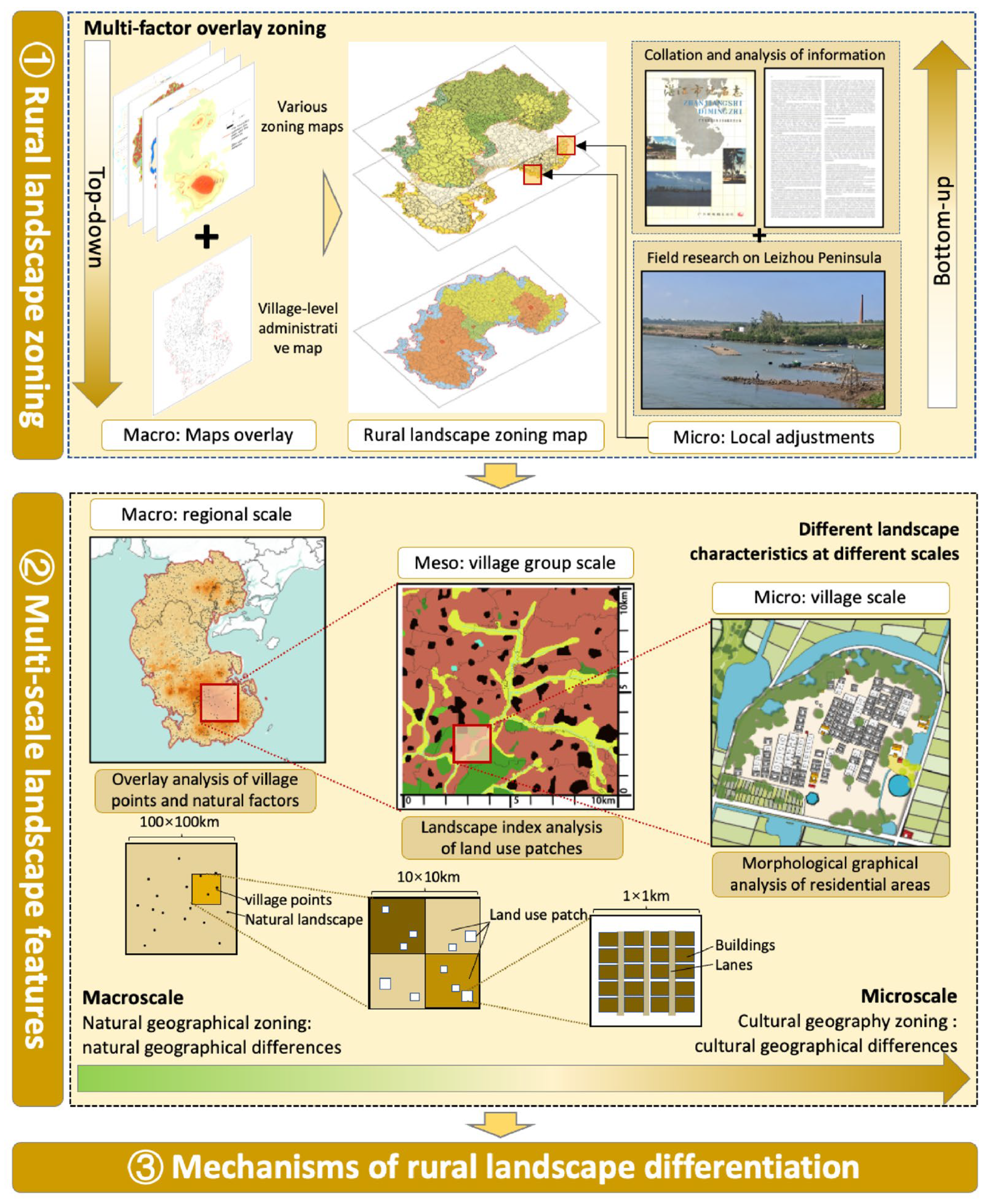
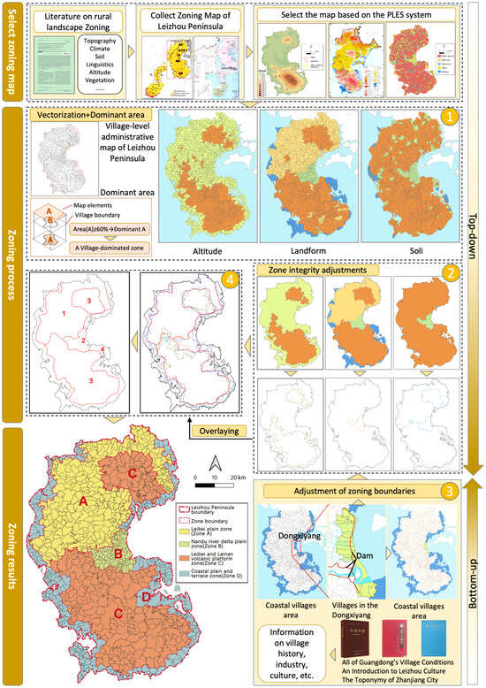
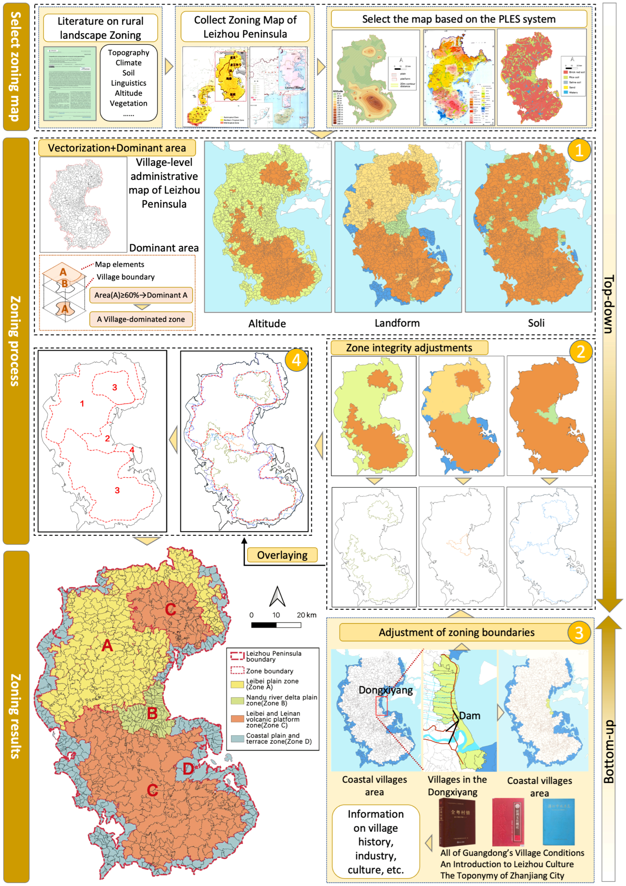
Rural landscapes are highly diverse and exhibit pronounced scale dependence: their patterns and expressions change with the scale of observation [44]. This study establishes a research pathway of “landscape zoning, characterization, and mechanism analysis” for rural landscape differentiation. Its aim is to zone the rural landscapes of the Leizhou Peninsula systematically and to interpret their characteristics at multiple scales. The analysis proceeds in three steps (Figure 2). The first step is landscape zoning, which combines top-down and bottom-up approaches. In the top-down procedure, maps of the key factors associated with rural landscape differentiation on the Leizhou Peninsula were selected and overlaid onto the village-level administrative map, producing a preliminary zoning framework that ensures systematic completeness. In the bottom-up procedure, to overcome the limited spatial detail of the top-down maps, field surveys and documentary collection across the Leizhou Peninsula were used to adjust the preliminary delineation, guided by the principles of evidence triangulation and minimal intervention. Finally, more accurate zoning results were obtained.
Figure 2.
Research framework.
The second step is a comparative analysis of landscape characteristics at different scales within each subregion. Rural landscapes exhibit a distinct nested hierarchical structure [45], grading from natural-geographic attributes at the macro scale to cultural-geographic attributes at the micro scale [46]. A nested classification system was constructed to enable an integrated and structured analysis of the rural landscape system. At the macro scale, villages were treated as coordinate points and overlaid with natural-geographic features such as elevation and water system, and the spatial distributions of villages relative to these factors were compared. At the meso scale, grid quadrats of 10 km×10 km were established [47]. That extent fully encompasses the rural landscape system composed of settlements, farmland, water and other land-cover patches. Landscape metrics were then computed to compare landscape patterns among the subregions.
At the micro scale, representative villages were selected from each subregion using three inclusion criteria: (1) the village had been established before 1980; (2) its economy remains dominated by primary-sector activities (farming, forestry, animal husbandry, and fishery); and (3) its historic landscape elements remained well preserved, including the buildings, street and lane. The spatial morphology of village was analyzed by using mapping methods.
The third step is mechanism analysis. Building on the preceding analyzes, the causes of landscape differentiation among the regions were systematically examined from the perspective of human–land relationships. Practical implications for conservation and planning were proposed ultimately.
3.2. Landscape Zoning Approach Based on Multi-Factor Overlay
A rural landscape is a complex whole formed by natural conditions and by human production and lifestyle, so delineating its units requires considering several factors and their interactions at once. Multi-factor overlay zoning is a core tool for the scientific identification and delineation of rural landscape character. It is implemented in a GIS and integrates heterogeneous elements from several dimensions, such as the natural environment and human society, into a single spatial framework [48]. Adjusting the delineation against three zoning principles then improves the robustness of the result [49]. The first is the dominance principle, under which the dominant factors are selected from the complex set of influencing factors and used for zoning. The second is the hierarchical principle, which requires that when landscapes are zoned at different levels, a higher-level unit contains all the content of the lower-level units within it. The units form a hierarchical containment relation from the macro to the micro level. The third is the integrity principle, under which small patches are merged into adjacent areas so that each zone remains spatially continuous and internally unified.
3.3. Multi-Scale Landscape Characteristic Analysis
3.3.1. Overlay Analysis Method
Overlay analysis superimposes raster layers that share a common coordinate system, so that geographic elements carrying several attributes can be examined together and their joint distribution described [50]. A rural landscape results from the superimposition and interaction of multiple elements. At the macro scale, villages were represented as points, and nearest neighbor index analysis and kernel density estimation were used to characterize their spatial distribution. These village points were then overlaid on the terrain and water-system layers to examine their spatial relation to the natural environment.
- •
- Nearest Neighbor Index Analysis
The nearest neighbor index (R) can be used to determine the spatial distribution type of the village [51]. Its calculation formula is:
where represents the average distance between each point and its nearest neighbor; is the theoretical nearest neighbor distance when point elements are randomly distributed; represents the number of point elements; represents the research area; and represents the number of point elements per unit area. When = 1, point elements tend to be randomly distributed; when > 1, point elements tend to be uniformly distributed; and when < 1, point elements tend to be aggregated.
- •
- Kernel Density Analysis
The kernel density value is one of the indicators for measuring spatial differentiation patterns [52].
where represents the kernel weighting function, is the distance from the density estimation point to , is the bandwidth, and denotes the number of villages. The greater the kernel density, the more concentrated the distribution of villages [53].
3.3.2. Landscape Index Analysis
At the meso scale, landscape indices were used to analyze the spatial pattern of land use and settlement within the countryside. Landscape indices quantify the spatial pattern and composition of a landscape and are widely used to identify and analyze the external form and internal structure of rural land use [54,55]. One representative 10 km × 10 km grid was selected from each subregion, because at this scale the within-zone variety of landscape structures can still be captured while remaining comparable across subregions. The landscape pattern of land use in the Leizhou Peninsula was analyzed with Fragstats 4.2 [56]. Five indices were selected to quantify that pattern in each subregion: Percentage of Landscape (PLAND), Largest Patch Index (LPI), Shannon’s Diversity Index (SHDI), Mean Patch Area (AREA_MN), and Aggregation Index (AI) (Table 1).
Table 1.
Landscape indices used in this study, with abbreviations, interpretation and units.
3.3.3. Mapping Analysis of Village Spatial Morphology
Mapping depicts the spatial structure of rural landscapes and efficiently expresses and interprets the geographic phenomena and spatial information of villages at different scales [57]. At the micro scale, field survey and mapping were combined to analyze one representative village in each subregion. Three landscape elements were examined: village plan, the layout of buildings and lanes, and public space.
4. Results
4.1. Landscape Zoning
4.1.1. Selection of Zoning Factors
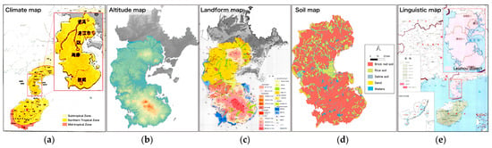
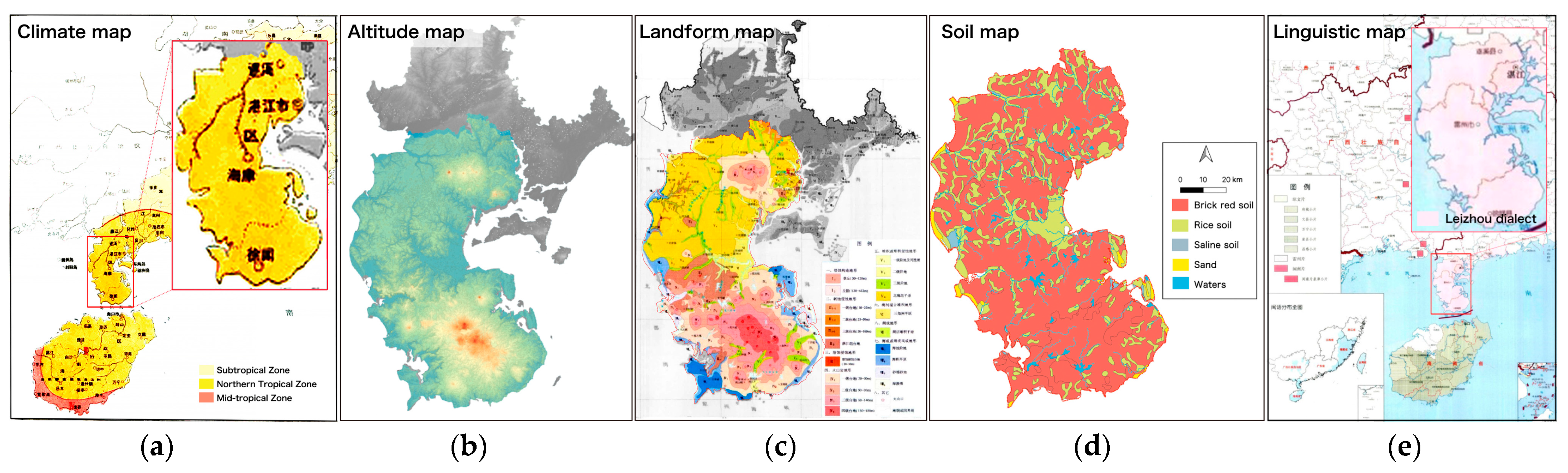
Rural landscape zoning is a complex procedure whose core task is to identify the factors that govern landscape differentiation. Three criteria guided the selection of factors. First, the factors had to be among those generally accepted in existing rural landscape research. Second, they had to cover the candidate drivers of rural landscape differentiation as seen from the perspective of production–living–ecological spaces (PLES) [58]. Third, the relevant data for the study area had to be scientifically sound and available. Factors frequently used in existing rural zoning include altitude, landform, climate, drainage, soil and dialect [59]. Assembling the thematic maps available for the Leizhou Peninsula showed that these factors are intricately related. The PLES framework provided the structure through which those relations could be resolved. At the ecological level, altitude and landform vary markedly across the Leizhou Peninsula, whereas climate does not, since the whole peninsula has a northern tropical climate (Figure 3a). Altitude and landform were adopted as zoning factors at this level (Figure 3b,c). At the production level, soil type varies across Leizhou Peninsula and was adopted as the third factor (Figure 3d). At the living level, the whole peninsula falls within a single dialect area, that of the Leizhou dialect, so dialect shows no differentiation and was not used (Figure 3e). Three factors were selected: altitude, landform and soil.
Figure 3.
Raster maps of Leizhou Peninsula: (a) Climate; (b) Altitude; (c) Landform; (d) Soil; (e) Linguistics. (a) Climate map: The climate of the whole region is north tropical climate. (b) Altitude map: Ranges from −49 to 247 m, and the terrain is mainly divided into plains (≤15 m) and tableland (>15 m). (c) Landform map: Mainly divided into accumulation plains, coastal terraces and plains, volcanic terraces and delta. plains. (d) Soil map: Mainly divided into brick red soil and paddy soil (accounting for more than 97%; other types are ignored). (e) Linguistic map: The language of the whole region is the Leizhou dialect.
4.1.2. Zoning Process
The zoning proceeded in four steps (Figure 4):
Figure 4.
Rural landscape zoning process for the Leizhou Peninsula.
(1) Vectorization and overlay with village-level administrative boundaries. In QGIS 3.44, the raster maps were georeferenced, vectorized and overlaid on the village-level administrative division map. We set the dominance threshold at 60% of the area of a village unit, which is a commonly used threshold in land use classification research. That is, when one class covers more than 60% of a village unit, that village is assigned to that class [60,61]. The terrain of the peninsula was classified into tablelands and plains, and landform into accumulation plains, coastal terraces and plains, volcanic terraces and delta plains. Soil was classified into two types, laterite and paddy soil.
(2) Zone integrity adjustments. Following the integrity principle of Section 3.2, the three factor maps were adjusted to remove fragmentation, and the boundary of each zone was extracted.
(3) Local correction through a bottom-up procedure. Drawing on published sources for the peninsula [62] and on field survey, we corrected the zones where factor overlay alone was misleading. Fishing is a major industry of the coastal villages and distinguishes them clearly from inland villages, so those villages were grouped into a coastal zone. Specifically, the central coastal stretch of the Dongxiyang region was nevertheless excluded. A well-developed water-conservancy system there makes rice cultivation the main industry of both inland and coastal villages, its coastal villages were kept out of the coastal zone.
(4) Overlay of the corrected maps. The three maps were then overlaid and adjusted to produce the final rural landscape zoning map of the Leizhou Peninsula.
4.1.3. Zoning Results
Each subregion is named after its geographical location and its landform character, and its attributes are listed in Table 2. The Leibei Plain Zone (Zone A) covers about 2612 km2 and comprises most of Suixi County and the north-west of Leizhou City. The Nandu River Delta Plain Zone (Zone B) covers about 340 km2, mainly the eastern part of Leizhou City and the middle and lower reaches of the Nandu River. The Leibei–Leinan Volcanic Platform Zone (Zone C) consists of two separate parts, which together amount to 3526 km2. The northern part covers the north-east of Suixi County (about 671 km2), and the southern part covers most of Xuwen County and the south of Leizhou City (about 2855 km2). The Coastal Plain and Terrace Zone (Zone D) covers about 1957 km2, comprising the coast of the peninsula except the Dongxiyang coastal strip (Section 4.1.2).
Table 2.
Information of the landscape zoning.
4.2. Multi-Scale Landscape Characteristics
4.2.1. Overlay Analysis of Village Points and Natural Factors
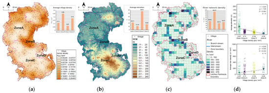
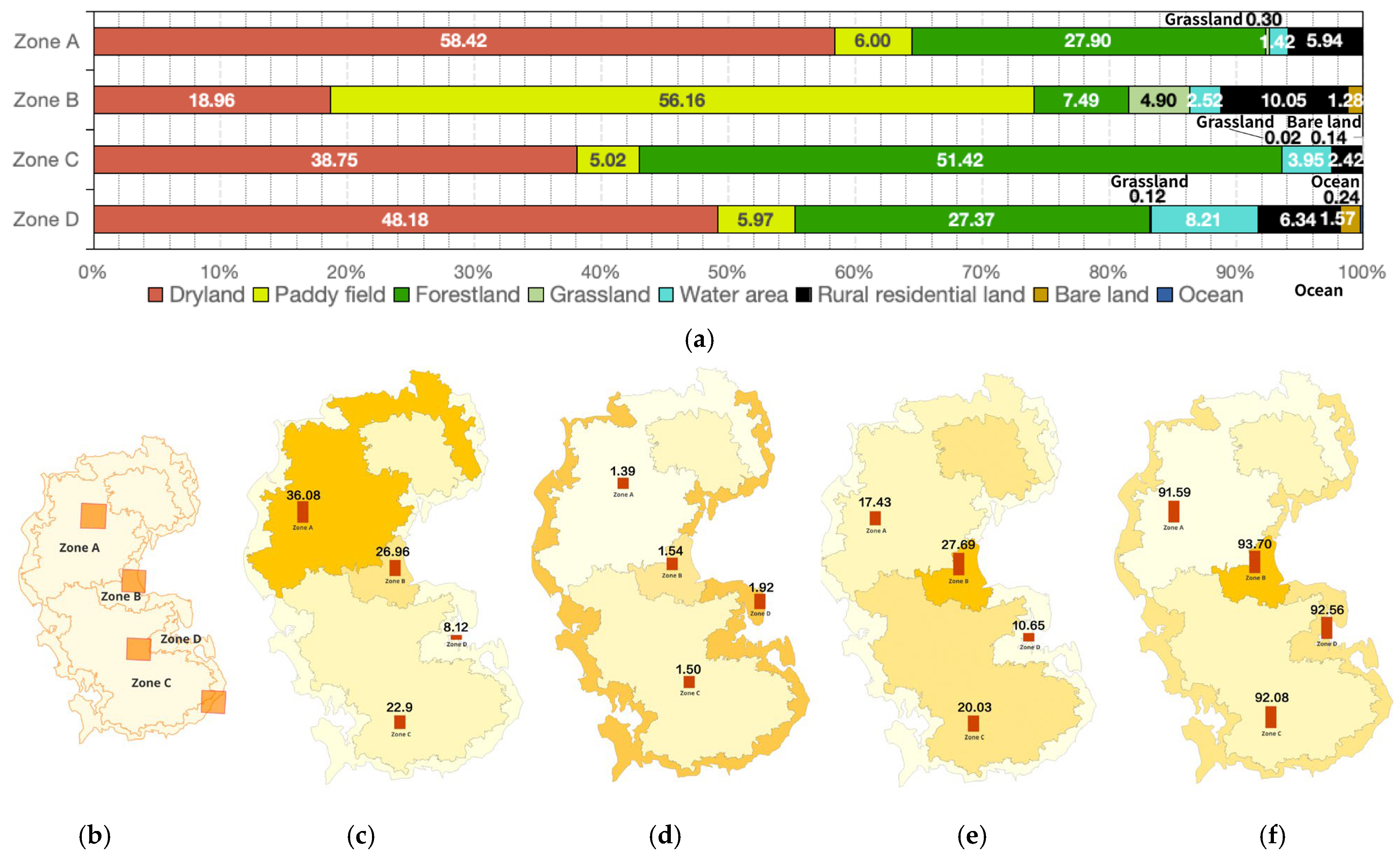
At the macro scale, villages on the Leizhou Peninsula are clustered: the nearest neighbor index (R = 0.553, p < 0.001, i.e., R < 1) confirms this arrangement as clustered. Kernel density estimation further shows that rural settlements across the peninsula are sparse in the center and dense at the periphery, and that villages concentrate most strongly in the urban belt of Zhanjiang–Leizhou, the political and economic core of the peninsula. Average village density differs markedly among the four subregions, decreasing in the order Zone B (0.25) > Zone D (0.18) > Zone A (0.11) > Zone C (0.07) pcs/km2 (Figure 5a). Overall, density declines from the coastal zone towards the interior.
Figure 5.
Overlay analysis of village points with natural factors: (a) Average village density; (b) Average elevation; (c) Average river density; (d) Correlation analysis (exact permutation test, where p denotes the exact p-value).
The spatial distribution of villages on the Leizhou Peninsula is associated with elevation and rivers. Overlaying village points on the elevation map shows that mean village elevation across the subregions decreases in the order Zone C (56.41) > Zone A (22.11) > Zone D (16.64) > Zone B (11.14)(m, Figure 5b). Overlaying village points on average river density shows that average river density decreases in the order Zone B (184.57) > Zone A (86.30) > Zone D (75.77) > Zone C (63.13) (m/km2, Figure 5c). From a descriptive summary, village density decreases monotonically with average elevation across the four zones (Spearman ρ = −1.00, exact p = 0.083, n = 4). In contrast, it increases with river density across the four zones (Spearman ρ = 0.80, exact p = 0.333, n = 4) (Figure 5d).
4.2.2. Landscape Index Analysis of Landscape Patches
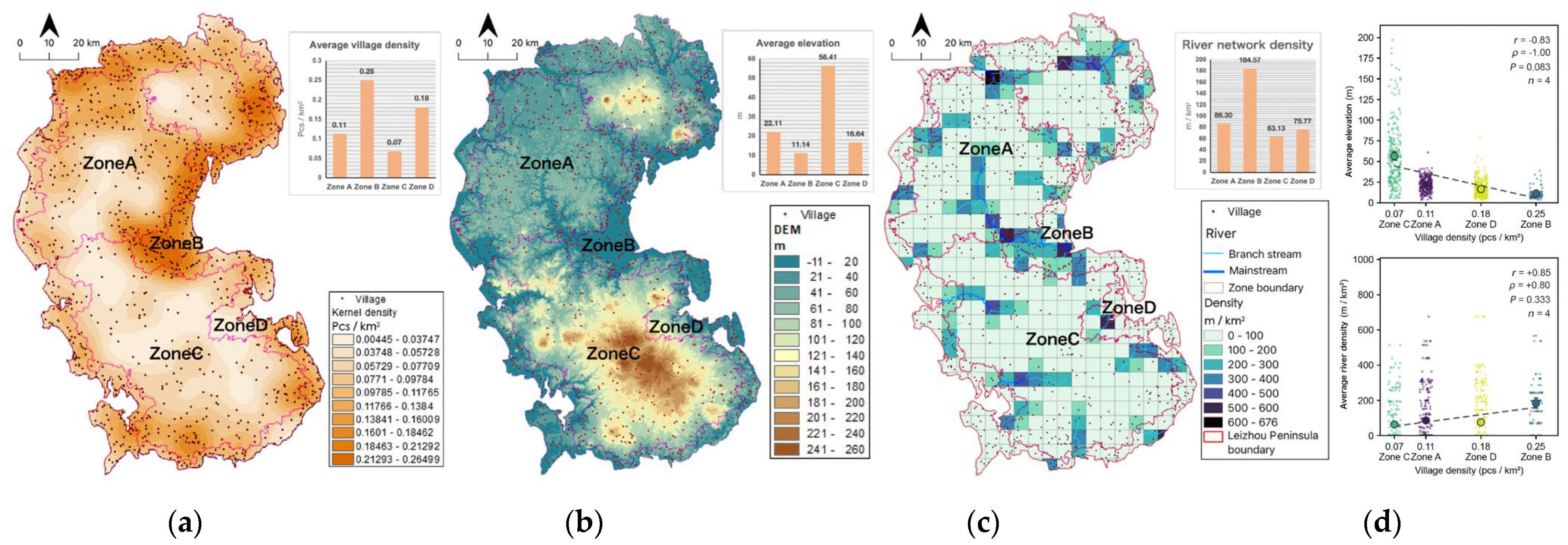
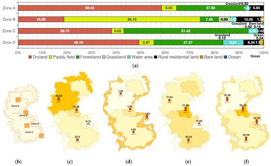
At the meso scale, the four grids selected in Section 3.3.2 (Figure 6b) were used to analyze the landscape patches of the Leizhou Peninsula. In each subregion the composition is dominated by five land types: dry land, paddy fields, forest land, water areas and residential areas. Together they account for more than 95% of the landscape (PLAND; Figure 6a). Dry land is the dominant type in Zone A and Zone D, at 58.42% and 48.18% of the landscape respectively. Paddy fields dominate Zone B, at 56.16%, and forest land dominates Zone C, at 51.42%.
Figure 6.
Landscape index analysis of landscape patches: (a) PLAND; (b) location of the sample grids; (c) LPI; (d) SHDI; (e) AREA_MN; (f) AI. In (b–f), darker colors indicate higher values.
The subregions differ widely in the largest patch index (LPI) and in Shannon’s diversity index (SHDI). LPI ranks, from high to low, as Zone A (36.08), Zone B (26.96), Zone C (22.92) and Zone D (8.12). The land patches of Zone A are the least fragmented and the most spatially continuous (Figure 6c). SHDI ranks as Zone D (1.92), Zone B (1.54), Zone C (1.50) and Zone A (1.39). Patch types are richest and most evenly distributed in Zone D, and least so in Zone A (Figure 6d).
Mean patch area (AREA_MN) of rural residential patches ranks from high to low as Zone B (27.69), Zone C (20.03), Zone A (17.43) and Zone D (10.65). Residential patches are largest in Zone B and smallest in Zone D (Figure 6e). The aggregation index (AI) ranks as Zone B (93.70), Zone D (92.56), Zone C (92.08) and Zone A (91.59). Residential patches are most tightly clustered in Zone B, where village groups show the strongest aggregation (Figure 6f).
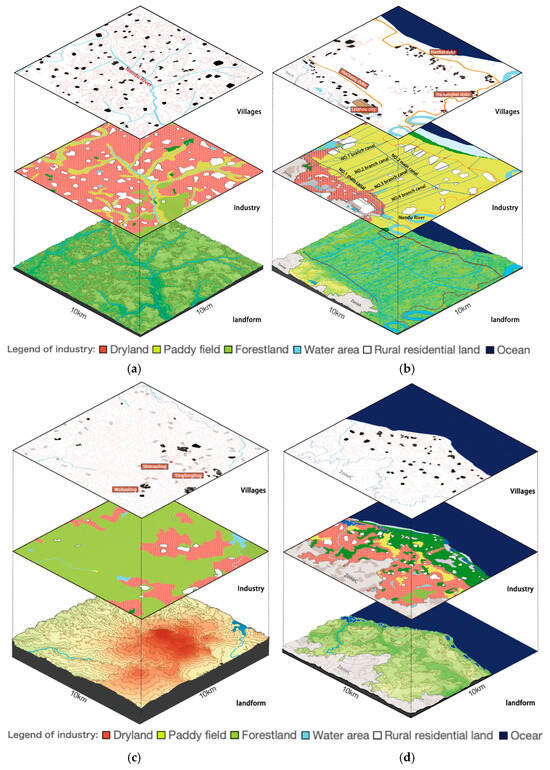
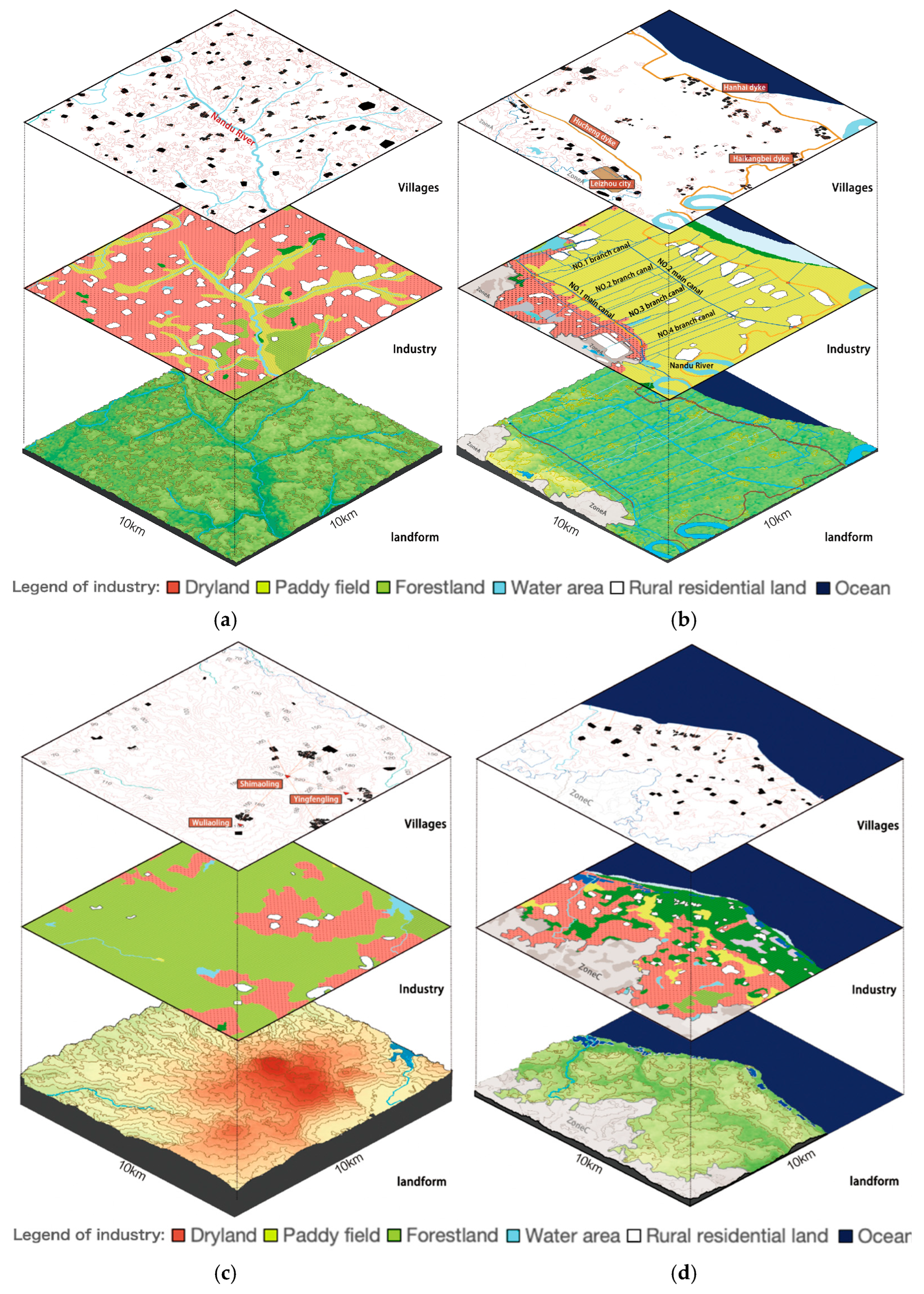
The subregions also differ in landform, industry and village pattern. Zone A is flat and crossed by many small seasonal rivers. Its industry is mainly dry farming, and most villages stand on the high ground flanking the rivers (Figure 7a). Zone B was originally a low-lying plain where numerous irrigation canals were built historically, establishing rice cultivation as the dominant production type. Dikes were built along the coast and along the Nandu River to exclude floods. Villages were sited mainly near the dikes or on the high ground at the hill–plain junction (Figure 7b). Zone C has the highest elevation and contains numerous volcanic craters and volcanic terraces. Its industry is mainly economic forestry, and most villages lie around the craters (Figure 7c). Zone D consists of plains and terraces, and its industries are mainly dry farming and fishing. Its villages generally face the sea and are arranged linearly along the coast (Figure 7d).
Figure 7.
Spatial characteristics of landform, industries, and villages: (a) Zone A; (b) Zone B; (c) Zone C; (d) Zone D.
4.2.3. Analysis of Village Spatial Morphology
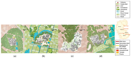
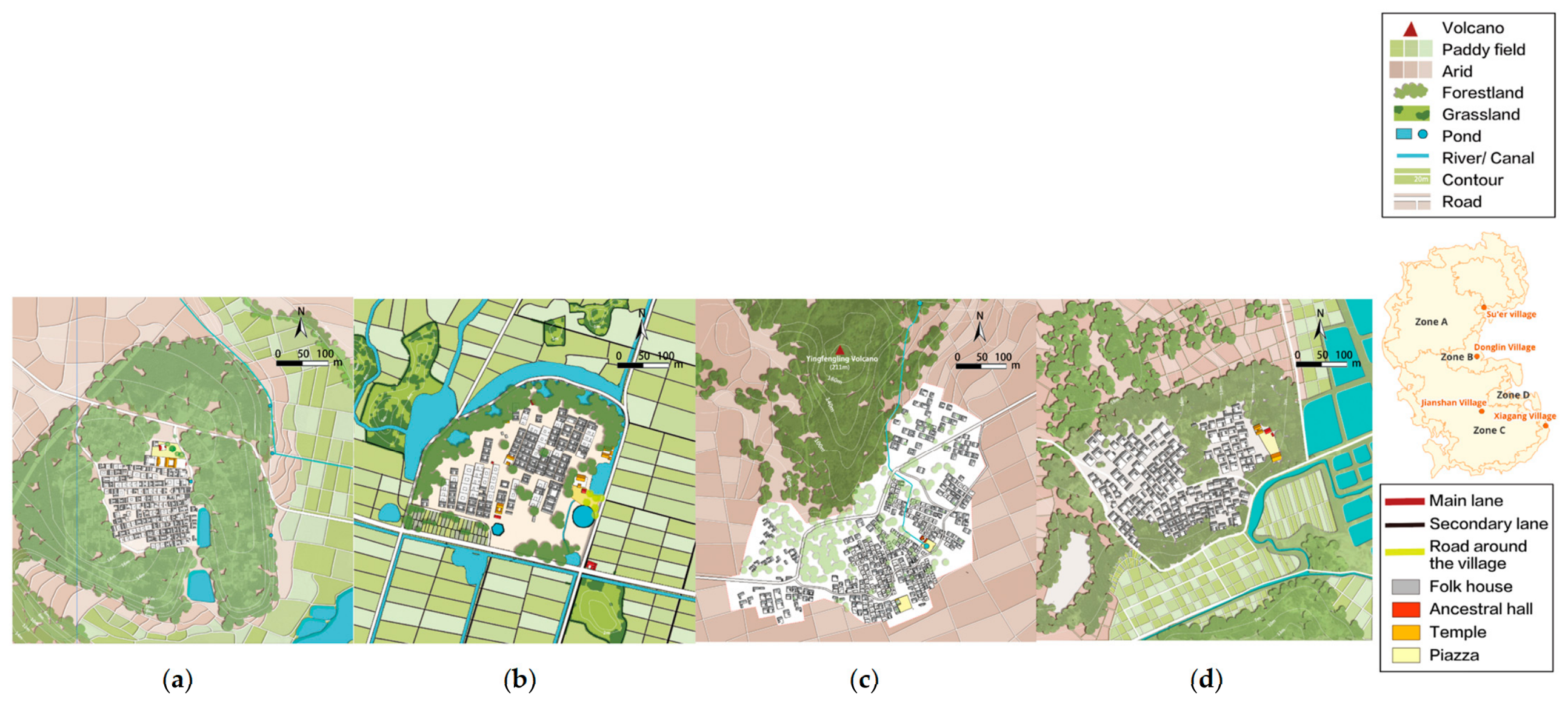
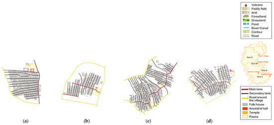
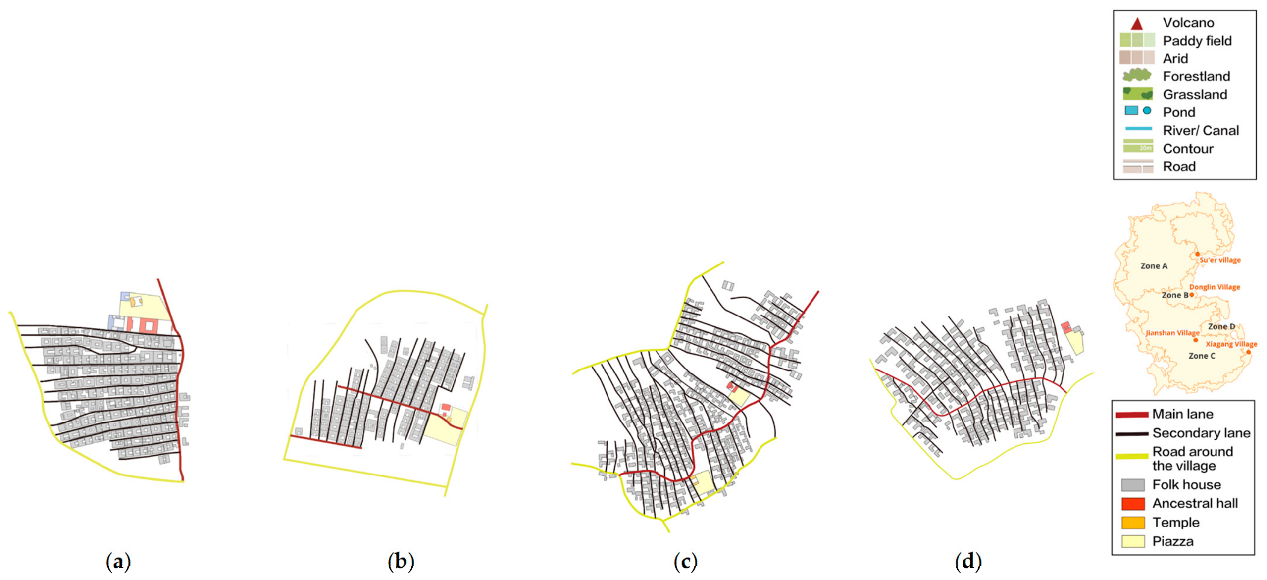
At the micro scale, the villages of the four subregions share a common layout pattern. Four villages were selected, one in each subregion: Su’er in Zone A, Donglin in Zone B, Jianshan in Zone C and Xiagang in Zone D. Their building layout, street and lane morphology and public space were analyzed. In all four, buildings are arranged in a comb layout and the arrangement is regular and compact (Figure 8a–d). Circulation is organized through a three-level lane hierarchy consisting of the village perimeter road, main lanes and secondary lanes. The main lanes connect the village entrance with the interior, while the secondary lanes run generally perpendicular to them and connect the entrances of individual buildings. In public space, all four place ancestral halls and temples with their forecourts at the village entrance, where they serve as the space for villagers’ activities (Figure 9a–d).
Figure 8.
Plans of the four villages: (a) Su’er; (b) Donglin; (c) Jianshan; (d) Xiagang.
Figure 9.
Streets and public spaces of the four villages: (a) Su’er; (b) Donglin; (c) Jianshan; (d) Xiagang.
5. Discussion
5.1. A Human–Land Interpretation of the Differentiation of Rural Landscape Types
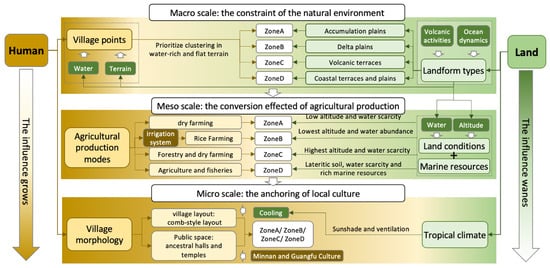
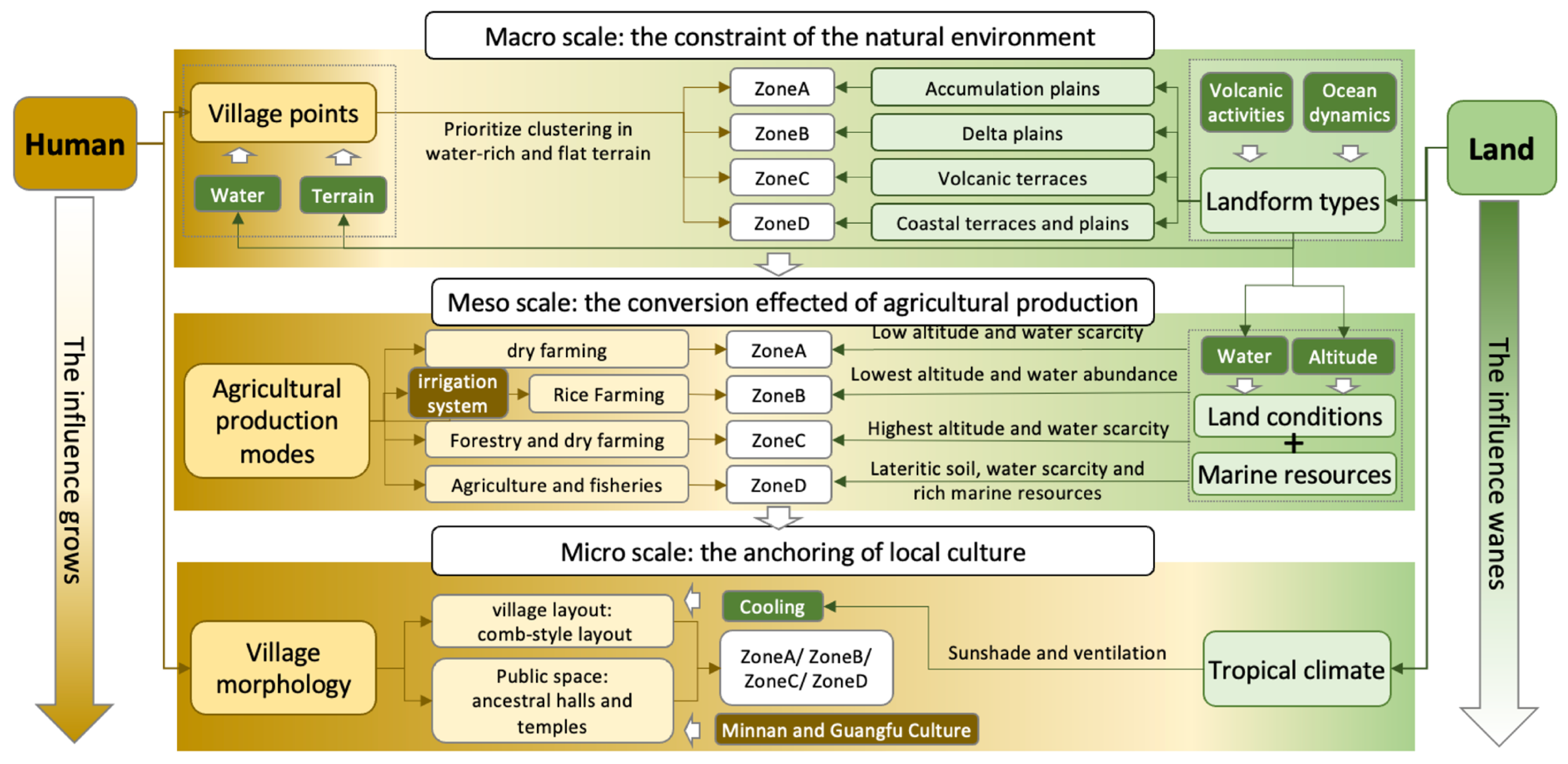
Section 3 and Section 4 established what the four subregions are and where their boundaries lie. They did not explain why the subregions differ. That question turns on the human–land relationship, because a rural landscape is a geographical entity produced by the coupled interaction of the physical environment and the human social system, and that coupling is also what makes its structure, function and spatial distribution differentiate [63]. The four subregions differentiate systematically from the macro to the meso scale (Figure 10).
Figure 10.
Mechanisms of rural landscape differentiation from a human–land relationship perspective.
5.1.1. Macro Scale: The Fundamental Shaping Role of the Natural Environment
At the macro scale the human–land relationship takes the form of constraint and dependence. Quaternary volcanism built the relief skeleton of the peninsula, high in the interior and low towards the periphery [64], and with it the radial drainage that carries short rivers from the higher interior down to the coast. Within that structure, elevation indicates a site’s position in the drainage network and therefore the area that drains to it, that is, the water potentially available to it [65]. Lower sites command larger contributing areas. Settlement follows that gradient, which is why average village density decreases from the coast towards the interior. At this tier the environment constrains without prescribing: it bounds where villages can be situated. Terrain and water are already established predictors of where villages occur [51,66], and the constraint becomes decisive where water is scarce [67]. Those studies treat terrain and water as direct predictors. Our data add one qualification. On the peninsula the association is likely to run indirectly, through a relief skeleton that redistributes water: the variable most strongly associated with village density is elevation, and we read elevation as a surrogate for water availability rather than a property of terrain form. An assessment that screens on terrain form alone would therefore miss the hydrological pathway along which the association plausibly operates [65].
5.1.2. Meso Scale: The Transformative Role of Agricultural Production Methods
At the meso scale, the human–land relationship is expressed as differences in agricultural production. Water scarcity extends across the whole Leizhou Peninsula: a tropical monsoon climate with high year-round evaporation and unevenly distributed rainfall is superimposed on the radial drainage [68]. Dry farming is accordingly a regional default rather than a local preference. Each subregion is characterized by the production strategy that suits the water it can command through the year. Zone A ranks second by mean village elevation (22.11 m) and second by river-network density (86.30 m/km2), yet it is farmed as dryland. Its drainage consists of small seasonal streams (Section 4.2.2), so a dense network does not translate into water available through the year, and its villages sit on the high ground flanking those streams. Zone C is the highest subregion (56.41 m) and has the sparsest river network (63.13 m/km2), which places it at the headwaters where water is least accessible. Economic forestry occupies its highest ground, and dry farming the lower parts where irrigation is easier. Zone D lies lower than Zone A (16.64 m) but has a sparser river network (75.77 m/km2). What distinguishes Zone D is not a larger supply of fresh water but access to the sea, which adds fishing to dry farming [69]. Zone B departs from this pattern. It is the lowest-lying subregion (11.14 m) and the most exposed to flooding. A historical network of canals and dikes there secures water for cultivation through the year and holds back floods, so the subregion supports paddy rice cultivation [70]. Comparable evidence comes from other historic irrigation districts [71,72]. Production is therefore the tier at which deliberate human intervention is documented, and the tier at which the macro-scale gradient may be locally modified [22,23].
5.1.3. Micro Scale: Spatial Anchoring of Regional Culture
At the micro scale the human–land relationship appears as the correspondence between culture and village morphology. That correspondence is not new: culture is already an established correlate of rural settlement morphology [26]. The villages of the four subregions converge on one morphology, and it has two components. The first is the comb-style building layout, which is consistent with the need for ventilation and cooling under the tropical climate [73]. The second is the ancestral halls and temples that occupy the public space, which correspond to the ancestor and deity beliefs that immigrants from the Guangfu and Minnan areas brought to the peninsula [33]. Both operate at the scale of the peninsula rather than of the subregions, so at the micro scale the subregions show no differentiation. That outcome is what a single cultural region produces. Culture is therefore a conditional variable in landscape character assessment: it discriminates where cultures differ and unifies where they do not. In multi-ethnic regions, entering ethnic culture as a characterizing element does disclose differences among landscape character types [74]. On the Leizhou Peninsula, where one culture covers the whole area, it unifies [26,74].
5.2. Practical Implications for Conservation and Planning
Zoning is only useful if it can be acted on. On the Leizhou Peninsula the instruments already exist. The “Hundred Counties, Thousand Towns and Ten Thousand Villages High-Quality Development Project” of Guangdong Province makes classification-based, differentiated measures a basic principle [75]. Its companion opinion on comprehensive land consolidation assigns tasks of agricultural-land improvement, village-land improvement and ecological restoration [76]. The Territorial Spatial Master Plan of Zhanjiang City (2021–2035) exercises statutory control through cultivated land and permanent basic farmland, ecological protection red lines and historical–cultural protection lines. It also sets provisions such as “two ecological shields”, “one belt and three zones” and “multiple corridors” [77]. Neither instrument resolves the differences inside the peninsula. The first classifies villages by administrative rank; the second divides the city into only three townscape zones. The four subregions can fill that gap as second-level landscape character units beneath the statutory master plan, because they carry exactly the internal differentiation that both instruments currently flatten.
5.2.1. Zone A: Tropical Dry-Farming Landscape
Zone A displays a typical tropical dry-farming pattern: dry farming covers 58.42% of the landscape, forms the most contiguous patches (largest patch index 36.08) and shows the lowest diversity (SHDI 1.39), and its villages occupy the high ground along seasonal streams (Figure 7a). The forest and farmland-protection components of comprehensive land consolidation cover precisely the field boundaries and village-edge woods that carry this zone’s character [76]. The water-saving, high-efficiency modern agricultural zone designated for the area of Zone A likewise accords with the zone’s rain-fed adaptation to water scarcity [77]. Protection here therefore depends less on new restrictions than on not treating this mosaic structure as an obstacle to contiguous-plot consolidation. Three measures follow. Small storage facilities belong in the planned “hundred reservoirs, thousand ponds and ten thousand pools” water-supply network. Field boundaries and shelterbelts should count as objects of farmland protection rather than as an obstacle to contiguous-development targets. The dry-farming system itself can be promoted as a demonstration of water-saving agriculture.
5.2.2. Zone B: Irrigated Rice-Growing Landscape
Rice cultivation in Zone B is not a product of natural endowment: paddy fields account for 56.16% of the landscape, and the rural settlement patches are the largest and most aggregated (mean patch area 27.68; aggregation index 93.70). The basis of this cultivation is a historical system of irrigation works and sea dikes [70], of the kind documented in other historic irrigation districts [71,72]. The paddy fields also serve flood detention. The Zhanjiang master plan builds habitat-corridor networks along rivers such as the Nandu River and designates greenways and blueways along them [77]. Comprehensive land consolidation lists irrigation and drainage among the integrated requirements of high-standard farmland [76]. If the two proceed independently, the ecological corridor and the production system are split into two separate objects; only by routing the greenways along the canal system and holding the flood-detention space of the paddy fields under use control can the two be integrated. A heritage survey of the canal–dike–gate–pond network should therefore be completed before consolidation works begin, leaving a channel for later recognition under the World Heritage Irrigation Structures (WHIS) and the national water-heritage systems [78].
5.2.3. Zone C: Volcanic Geological Landscape
Zone C lies in the headwater area, with forest covering 51.42% of the landscape and villages distributed around volcanic craters (Figure 7c). The Zhanjiang master plan designates the central forest land of the Leizhou Peninsula as an ecological shield [77]. It explicitly requires the restoration of tropical monsoon forest and the conversion of pure eucalyptus stands. As a member of the Global Geoparks Network, the Leiqiong UNESCO Global Geopark bears a dual obligation of geoheritage protection and community sustainable development for the volcanic landforms of this zone [79]. Forest adjustment must therefore take as its premise the retention of the village-edge woods and of the visible link between villages and landforms. New housing at the crater rims falls under the provision that construction shall in principle not damage the hillside geology [76], and reconstruction is guided by townscape control to continue using basalt masonry. In this way the crater, the forest, the villages and the building material are managed as a single unit rather than divided between geoheritage protection and village administration, laying the groundwork for volcanic geotourism.
5.2.4. Zone D: Coastal Landscape
Zone D is the most internally heterogeneous (SHDI 1.92), combining dry farming with fishery. Its settlement patches are the smallest (AREA_MN 10.65). The Measures for the Protection and Utilization of Coastlines govern the shoreline segment by segment under three categories: strict protection, restricted development and optimized utilization [80]. Over the same coastal sections, the Zhanjiang master plan designates a coastal aquaculture belt pointing to marine ranching clusters [77]. It also designates the marine ecological protection chain of the Leizhou Peninsula, pointing to mangrove restoration. The two overlap, and that overlap is the problem to be managed. Salt pans and pearl ponds that still operate should be retained as living production. The shoreline should be managed segment by segment under the classification system, with requisition-compensation balance. Mangrove creation is better pursued through planting–aquaculture coupling than by clearing aquaculture ponds. In the Zhanjiang case, mangrove cover within coupled ponds rose from less than 10% to about 60% while aquaculture output and fishers’ livelihoods were maintained [81].
5.3. Limitations and Prospects
Three limits bound what the results above can support:
First, the framework is transferable but not universal. It zones on village units, characterizes across scales, and interprets through the human–land relationship. Each of those steps has to be re-specified for a new region, from the choice of zoning factors to the definition of scale levels and the reading of mechanisms. The micro-scale result is the clearest case. Culture unified the four subregions because the Leizhou Peninsula is a single culture area. In a region where several cultures meet, culture would have to enter the analysis as a differentiating variable rather than a constant.
Second, this study is a static typological and morphological analysis that does not take time into account. Working from a single cross-section, it addresses the diversity and multi-scale nature of rural landscapes. This study can serve as a basis for subsequent evolutionary analysis. Future research should therefore attend to dynamic comparison and regularity analysis across periods.
Third, this study concerns rural landscapes of the traditional period, and the data used in the analysis were compiled in different years. Precise vector data for earlier periods are particularly lacking. The analysis therefore rests on a sufficient familiarity with the region. Field surveys and the consultation of historical records serve as corroborating evidence, so that subjective error is kept within reasonable bounds. Future research could draw more extensively on the methods and materials of archaeology, history and related disciplines to compensate for these limitations.
6. Conclusions
The diversity of China’s regional-scale rural landscapes is being eroded, and one recurrent cause is that planning has been led by a uniform, urban-derived model that disregards regional differences. We addressed that problem with a framework that links three steps in sequence: landscape zoning, characteristic analysis and mechanism analysis.
The zoning step divides the Leizhou Peninsula into four subregions containing village-level units, finer than the administrative boundaries conventionally used. The characterization step shows that the subregions differentiate in a scale-dependent way rather than a cumulative one. They diverge at the macro and meso scales and converge at the micro scale, so no single-scale description of a regional rural landscape is complete. The mechanism step reads that pattern through the human–land relationship and locates each cause at a different tier. Natural constraint shapes the macro pattern. Agricultural production converts it at the meso scale. Regional culture unifies the micro scale, here because the peninsula is a single culture area rather than because culture is inherently unifying.
Theoretically, the framework offers a reference for rural landscape studies in other regions and a baseline for future evolutionary and comparative research. Practically, the subregions can serve as a reference for second-level landscape character units beneath the statutory master plan. Each then carries its own strategy: developing water-saving agriculture in Zone A, conserving the canal–dike system in Zone B to become a member of the WHIS, promoting volcanic geotourism in Zone C, and managing the shoreline segment by segment in Zone D. The planning implication is that is that a regional-scale rural landscape is not protected by applying a single rule throughout, but by acting at the scale where intervention takes effect and on the units where difference actually lies.
Author Contributions
Author Contributions: Conceptualization, J.F.; methodology, J.F.; software, J.F.; validation, J.F.; formal analysis, J.F.; investigation, J.F.; resources, J.F.; data curation, J.F.; writing-original draft preparation, J.F.; writing-review and editing, Y.P.; visualization, J.F.; supervision, Y.P.; project administration, Y.P.and Y.S.; funding acquisition, Y.P. and Y.S.; All authors have read and agreed to the published version of the manuscript.
Funding
Independent Research Project of the State Key Laboratory of Subtropical Building and Urban Science: 2023ZB09; Guangdong Basic and Applied Basic Research Foundation: 2025A1515011540; China Scholarship Council: 202506150134.
Data Availability Statement
The data presented in this study are available upon request from the corresponding author.
Acknowledgments
We thank the reviewers for their constructive comments, which helped improve this manuscript. We are also grateful to Bailiang Deng of Guangdong Ocean University, Zhijian Chen of the Zhanjiang Municipal Museum, Chungui Deng of the Leizhou City Cultural Center, and Qiyong You of Fucheng Town for their valuable assistance during the fieldwork.
Conflicts of Interest
The authors declare no conflicts of interest.
Note
| 1 | The 1982 Constitution restored township people’s governments and designated villagers’ committees as grassroots self-governing organs; nationwide reorganization was completed by the end of 1984 and was later codified in the Organic Law of Villagers’ Committees (1998, amended 2018). Village-level administrative boundaries have since remained stable, with only minor adjustments. No village-level boundary layer exists for 1980. The first national land survey, launched in 1984 under State Council Document No. 70 and with its results unified to the reference date of 31 October 1996, was the first nationwide mapping of rural land-ownership boundaries. The earliest publicly available village-level vector dataset in China is the 2020 edition, and that edition was adopted here. |
References
- Agnoletti, M. Rural landscape, nature conservation and culture: Some notes on research trends and management approaches from a (southern) European perspective. Landsc. Urban Plan. 2014, 126, 66–73. [Google Scholar] [CrossRef] [Scilit]
- Antrop, M. Why landscapes of the past are important for the future. Landsc. Urban Plan. 2005, 70, 21–34. [Google Scholar] [CrossRef] [Scilit]
- Fan, J.H.; Wei, C.; Li, S.Z. Concept and development of rural landscape. Trop. Geogr. 2009, 29, 285–289, 306. (In Chinese) [Google Scholar]
- Meentemeyer, V.; Box, E.O. Scale effects in landscape studies. In Landscape Heterogeneity and Disturbance; Turner, M.G., Ed.; Springer: New York, NY, USA, 1987; pp. 15–34. [Google Scholar]
- Ettanen, S.; Vitikainen, A. Land consolidation and the value of rural cultural landscape. Nord. J. Surv. Real Estate Res. 2017, 11, 37–47. [Google Scholar]
- Ministry of Housing and Urban–Rural Development of the People’s Republic of China. China Urban–Rural Construction Statistical Yearbook; China Statistics Press: Beijing, China, 2000. (In Chinese) [Google Scholar]
- Zui, H.; Min, T. Characterizing the cultural landscape of traditional Chinese settlements through genome maps. Heliyon 2024, 10, e39418. [Google Scholar] [CrossRef] [Scilit] [PubMed]
- Bian, J.; Chen, W.; Zeng, J. Spatial distribution characteristics and influencing factors of traditional villages in China. Int. J. Environ. Res. Public Health 2022, 19, 4627. [Google Scholar] [CrossRef] [Scilit] [PubMed]
- Xiao, L.; Shi, P.; Lin, T.; Chen, N.; Huang, S. Rural Morphology and Forces Driving Change in Rapidly Urbanizing Areas: A Case Study in Fujian, China. Int. J. Environ. Res. Public Health 2021, 18, 4590. [Google Scholar] [CrossRef] [Scilit] [PubMed]
- Bao, Z.T.; Zhou, J.Y. Phenomenon, reasons, and countermeasures for contemporary rural landscape decline. City Plan. Rev. 2014, 38, 76–84. (In Chinese) [Google Scholar]
- Ge, D. The characteristics and multi–scale governance of rural space in the new era in China. Acta Geogr. Sin. 2023, 78, 1849–1868. (In Chinese) [Google Scholar]
- Liu, D.; Liu, S.; Bai, Z.; Shen, P.; Dong, Y. Hybrid Rural Landscape Characterization and Typological Governance Strategies in Metropolitan Fringe Areas Based on Machine Learning: A Case Study of Baoshan District, Shanghai. Land 2026, 15, 256. [Google Scholar] [CrossRef] [Scilit]
- Wu, X.; Chen, R.; Zhang, Y.L. Recognition and assessment method of rural landscape characters for multi–type and multi–scale collaborative transmission: Taking the Horqin Right Front Banner, Inner Mongolia of northern China as an example. J. Beijing For. Univ. 2022, 44, 111–121. (In Chinese) [Google Scholar]
- Liu, S.; Wu, L.; Xiang, C.; Dai, W. Revitalizing rural landscapes: Applying cultural landscape gene theory for sustainable spatial planning in Linpu Village. Buildings 2024, 14, 2396. [Google Scholar] [CrossRef] [Scilit]
- Zheng, Y.; Dian, Y.; Guo, Z.; Yao, C.; Wu, X. A functional zoning method in rural landscape based on high–resolution satellite imagery. Remote Sens. 2023, 15, 4920. [Google Scholar] [CrossRef] [Scilit]
- Wang, C.; Ge, B.; Yuan, X.; Luo, P.; Song, Y. Multi–scaled landscape character assessment of the Longchuan River Basin, China: Integrating ecological units and administrative hierarchies. Sustainability 2026, 18, 3106. [Google Scholar] [CrossRef] [Scilit]
- Balestrieri, M. Theories and methods of rural landscape classification in Europe: The Italian approach. Int. J. Rural Manag. 2015, 11, 156–174. [Google Scholar] [CrossRef] [Scilit]
- Hamilton, K.; Selman, P. The ‘landscape scale’ in planning: Recent experience of bio–geographic planning units in Britain. Landsc. Res. 2005, 30, 549–558. [Google Scholar] [CrossRef] [Scilit]
- Bullen, J. LANDMAP Methodology Overview; Natural Resources Wales: Cardiff, UK, 2017. [Google Scholar]
- Song, Z.; Zhao, Y.; Long, B. A quantitative method for cultural landscape zoning in traditional Chinese villages and its applications: A case study based on Chongqing. South Archit. 2022, 2, 1–10. (In Chinese) [Google Scholar] [CrossRef]
- Terkenli, T.S.; Gkoltsiou, A.; Kavroudakis, D. The interplay of objectivity and subjectivity in landscape character assessment: Qualitative and quantitative approaches and challenges. Land 2021, 10, 53. [Google Scholar] [CrossRef] [Scilit]
- Xu, N.; Chen, W.; Pan, S.; Liang, J.; Bian, J. Evolution characteristics and formation mechanism of production–living–ecological space in China: Perspective of main function zones. Int. J. Environ. Res. Public Health 2022, 19, 9910. [Google Scholar] [CrossRef] [Scilit] [PubMed]
- Luo, Q.; Zhang, Y.; Zhou, J.; Jia, X. Classifying and Enhancing Strategies for Rural Landscapes Based on Dominant Ecosystem Service: A Case Study of Wuhan. Landsc. Archit. Front. 2025, 13, 56–68. [Google Scholar] [CrossRef] [Scilit]
- Wei, Y.; Zhang, Y.; Chen, L.; Chen, H.; Zhang, X.; Liu, P. Production–living–ecological space transition and its eco–environmental effects based on an improved area–weighted method: A case study of Gangcheng District, a typical industrial base in China. Front. Environ. Sci. 2022, 10, 972786. [Google Scholar] [CrossRef] [Scilit]
- Yue, M.; Ariffin, N.F.M.; Aziz, F.A.; Xiao, H.; Mengyao, Y. The transformation of rural spatial form and its contributing factors in China: A literature review. Int. J. Acad. Res. Bus. Soc. Sci. 2023, 13, 1894–1913. [Google Scholar] [CrossRef] [Scilit] [PubMed]
- Li, G.; Jiang, G.; Jiang, C.; Bai, J. Differentiation of spatial morphology of rural settlements from an ethnic cultural perspective on the Northeast Tibetan Plateau, China. Habitat Int. 2018, 79, 1–9. [Google Scholar] [CrossRef] [Scilit]
- Wu, J.; Jelinski, D.E.; Luck, M.; Tueller, P.T. Multiscale analysis of landscape heterogeneity: Scale variance and pattern metrics. Geogr. Inf. Sci. 2000, 6, 6–19. [Google Scholar] [CrossRef] [Scilit] [PubMed]
- Plieninger, T.; Draux, H.; Fagerholm, N.; Bieling, C.; Bürgi, M.; Kizos, T.; Kuemmerle, T.; Primdahl, J.; Verburg, P.H. The driving forces of landscape change in Europe: A systematic review of the evidence. Land Use Policy 2016, 57, 204–214. [Google Scholar] [CrossRef] [Scilit]
- Bürgi, M.; Hersperger, A.M.; Schneeberger, N. Driving forces of landscape change—Current and new directions. Landsc. Ecol. 2004, 19, 857–868. [Google Scholar] [CrossRef] [Scilit]
- Hersperger, A.M.; Bürgi, M. Going beyond landscape change description: Quantifying the importance of driving forces of landscape change in a Central Europe case study. Land Use Policy 2009, 26, 640–648. [Google Scholar] [CrossRef] [Scilit]
- Wang, Y.C.; Dong, Q.Z. Integrated framework and technical path for multi–level nested assessment of landscape character. Landsc. Archit. 2025, 32, 87–95. (In Chinese) [Google Scholar] [CrossRef] [Scilit]
- Tao, J.; Xiao, D.; Qin, Q.; Zhuo, X.; Wang, J.; Chen, H.; Wang, Q. Climate–Adaptive Design of Historic Villages and Dwellings in a Typhoon–Prone Region in Southernmost Mainland China. Int. J. Archit. Herit. 2022, 16, 117–135. [Google Scholar] [CrossRef] [Scilit]
- Zeng, Y. An Analysis of the Spatial Morphology of Cohesive Village in Leizhou Peninsula of Western Guangdong Province. J. Chin. Archit. Urban. 2023, 5, 1224. [Google Scholar] [CrossRef] [Scilit]
- Long, H.; Liu, Y.; Li, X.; Chen, Y. Building new countryside in China: A geographical perspective. Land Use Policy 2010, 27, 457–470. [Google Scholar] [CrossRef] [Scilit]
- Zhanjiang City Place Names Compilation Committee. Zhanjiang City Place Names; Guangdong Provincial Map Publishing House: Zhanjiang, China, 1989; pp. 1–399. [Google Scholar]
- Wen, H.H. Study on Circulation Pattern and Numerical Modeling of Groundwater Flow in Leizhou Peninsula. Ph.D. Thesis, China University of Geosciences, Beijing, China, 2013. [Google Scholar]
- Resource and Environment Science and Data Center, Chinese Academy of Sciences. Spatial Distribution Data of Soil Types in China. Available online: https://www.resdc.cn/data.aspx?DATAID=145 (accessed on 9 October 2026).
- Guangdong Provincial Meteorological Bureau. Climate Atlas of Guangdong Province; Guangdong Map Publishing House: Guangzhou, China, 1989; pp. 1–238. [Google Scholar]
- Wurm, S.A.; Rong, L.; Baumann, T.; Lee, M.W. Language Atlas of China; Longman Group (Far East) Limited: London, UK, 1987; p. 5. [Google Scholar]
- Department of Natural Resources of Guangdong Province. Village–Level Administrative Boundary Data of Guangdong Province from the Third National Land Survey (2020). Available online: https://nr.gd.gov.cn/ (accessed on 9 October 2026).
- Geospatial Data Cloud Site, Computer Network Information Center, Chinese Academy of Sciences. Basic Geographic Vector Data of China (Administrative Boundaries, Rivers and Roads). 2019. Available online: https://www.gscloud.cn/ (accessed on 9 October 2026).
- Xu, X.; Liu, J.; Zhang, S.; Li, R.; Yan, C.; Wu, S. China Multi–Period Land Use Remote Sensing Monitoring Dataset (CNLUCC); Data Registration and Publishing System of the Resource and Environment Science and Data Center; Chinese Academy of Sciences: Beijing, China, 2018; Available online: https://www.resdc.cn/DOI/doi.aspx?DOIid=54 (accessed on 9 October 2026).
- QGIS Development Team. QGIS Geographic Information System, Version 3.44; QGIS.ORG: Laax, Switzerland, 2025. Available online: https://qgis.org (accessed on 9 October 2026).
- Mao, Q.; Wu, Z.; Deng, Y.; Sun, J.; Bai, H.; Gong, L.; Jiang, Z. Assessing the “Scale of Effect”: The Impact of Multi–Scale Landscape Characteristics on Urban Bird Species Taxonomic and Functional Diversity. Diversity 2023, 15, 943. [Google Scholar] [CrossRef] [Scilit]
- Cullum, C.; Rogers, K.H.; Brierley, G.; Witkowski, E.T.F. Ecological Classification and Mapping for Landscape Management and Science: Foundations for the Description of Patterns and Processes. Prog. Phys. Geogr. Earth Environ. 2016, 40, 38–65. [Google Scholar]
- Yang, D.; Gao, C. Analysis of Five Topics in Multi–Scale Identification of Landscape Characters in Europe. Landsc. Archit. 2024, 31, 14–22. [Google Scholar] [CrossRef] [Scilit]
- Zhang, Z.; Wu, X.; Chen, S.; Jia, L.; Wang, Q.; Zhang, Z.; Li, M.; Jia, R.; Lin, Q. Spatial Pattern and Driving Mechanisms of Settlements in the Agro–Pastoral Ecotone of Northern China: A Case Study of Eastern Inner Mongolia. Land 2025, 14, 1268. [Google Scholar] [CrossRef] [Scilit]
- Liu, Y.; Zhou, Y.; Li, Y. Rural Regional System and Rural Revitalization Strategy in China. Acta Geogr. Sin. 2019, 74, 2511–2528. (In Chinese) [Google Scholar]
- Yang, B.; Chen, H.; Li, G.; He, Y. Concept, Identification and Division of Village and Town Settlements in China. Econ. Geogr. 2021, 41, 165–175. (In Chinese) [Google Scholar] [CrossRef]
- Wang, L. Research on the Technology Mechanism and Effectiveness of Map–Overlay Method in Landscape Planning and Design. Master’s Thesis, Xi’an University of Architecture and Technology, Xi’an, China, 2019. [Google Scholar]
- Wang, Z.; Zhu, J.; Wu, Z. Study on the spatial distribution characteristics of traditional villages and their response to the water network system in the lower yangtze river basin. Sci. Rep. 2024, 14, 22586. [Google Scholar] [CrossRef] [Scilit] [PubMed]
- Wang, X.; Xi, J.; Yang, D.; Chen, T. Spatial Differentiation of Rural Touristization and Its Determinants in China: A Geo–Detector–Based Case Study of Yesanpo Scenic Area. J. Resour. Ecol. 2016, 7, 464–471. [Google Scholar] [CrossRef] [Scilit]
- Bi, S.; Du, J.; Tian, Z.; Zhang, Y. Investigating the Spatial Distribution Mechanisms of Traditional Villages from the Human Geography Region: A Case Study of Jiangnan, China. Ecol. Inform. 2024, 81, 102649. [Google Scholar] [CrossRef] [Scilit]
- Ebenezer, P.A.; Kavitha, A.R. A Review on Use of Land Metrics in Land Use and Land Cover. In Proceedings of the 2021 5th International Conference on Electronics, Communication and Aerospace Technology (ICECA), Coimbatore, India, 2–4 December 2021; pp. 320–325. [Google Scholar]
- You, T.; Yan, S. Spatial Differentiation and Driving Force Detection of Rural Settlements in the Yangtze River Delta Region. Sustainability 2023, 15, 8774. [Google Scholar] [CrossRef] [Scilit]
- McGarigal, K.; Cushman, S.A.; Ene, E. FRAGSTATS v4: Spatial Pattern Analysis Program for Categorical and Continuous Maps; University of Massachusetts: Amherst, MA, USA, 2012. [Google Scholar]
- Yang, C. Use of Digital Technology in Mapping Rural Cultural Landscapes and Their Human–Nature Interactions. In The Routledge Handbook of Cultural Landscape Heritage in the Asia–Pacific; Routledge: Abingdon, UK, 2022; pp. 517–531. [Google Scholar]
- Lin, G.; Jiang, D.; Fu, J.; Zhao, Y. A Review on the Overall Optimization of Production–Living–Ecological Space: Theoretical Basis and Conceptual Framework. Land 2022, 11, 345. [Google Scholar] [CrossRef] [Scilit]
- Fang, L.; Wang, Y. Multi–Disciplinary Determination of the Rural/Urban Boundary: A Case Study in Xi’an, China. Sustainability 2018, 10, 2632. [Google Scholar] [CrossRef] [Scilit]
- Loveland, T.R.; Reed, B.C.; Brown, J.F.; Ohlen, D.O.; Zhu, Z.; Yang, L.; Merchant, J.W. Development of a Global Land Cover Characteristics Database and IGBP DISCover from 1 Km AVHRR Data. Int. J. Remote Sens. 2000, 21, 1303–1330. [Google Scholar] [CrossRef] [Scilit]
- Friedl, M.A.; Sulla–Menashe, D.; Tan, B.; Schneider, A.; Ramankutty, N.; Sibley, A.; Huang, X. MODIS Collection 5 Global Land Cover: Algorithm Refinements and Characterization of New Datasets. Remote Sens. Environ. 2010, 114, 168–182. [Google Scholar] [CrossRef] [Scilit]
- Situ, S. An Introduction to Leizhou Culture; Guangdong People’s Publishing House: Guangzhou, China, 2014; pp. 1–508. [Google Scholar]
- Shi, Z.; Ma, L.; Zhang, W.; Gong, M. Differentiation and Correlation of Spatial Pattern and Multifunction in Rural Settlements Considering Topographic Gradients: Evidence from Loess Hilly Region, China. J. Environ. Manag. 2022, 315, 115127. [Google Scholar] [CrossRef] [Scilit] [PubMed]
- Liu, Q.; Li, Y.; Cheng, Y.; Zhang, Y.; Li, Y.; Qi, W.; He, L. Cenozoic Tectono–Thermal Modeling of the Leiqiong Region, Beibuwan Basin, South China: Insights into the Geodynamic Mechanisms of Late Cenozoic Volcanism. Tectonics 2026, 45, e2025TC009122. [Google Scholar] [CrossRef] [Scilit]
- Beven, K.J.; Kirkby, M.J. A Physically Based, Variable Contributing Area Model of Basin Hydrology. Hydrol. Sci. J. 1979, 24, 43–69. [Google Scholar] [CrossRef] [Scilit]
- Liu, Y.; Ke, X.; Wu, W.; Zhang, M.; Fu, X.; Li, J.; Jiang, J.; He, Y.; Zhou, C.; Li, W.; et al. Geospatial Characterization of Rural Settlements and Potential Targets for Revitalization by Geoinformation Technology. Sci. Rep. 2022, 12, 8399. [Google Scholar] [CrossRef] [Scilit] [PubMed]
- Zhang, W.; Ma, L.; Li, H.; Wang, X. Trends in the Future Evolution of Rural Settlements in Oasis–Desert Areas under Water Use Simulation Scenarios: Take the Hexi Corridor Region of China as an Example. Landsc. Urban Plan. 2024, 248, 105110. [Google Scholar] [CrossRef] [Scilit]
- Liu, H.; Liang, H.; Miao, H.; Fan, J. Crops Water Supply and Agro–Drought Disaster in Leizhou Peninsula. Sci. Geogr. Sin. 2010, 30, 273–277. (In Chinese) [Google Scholar] [CrossRef]
- Dang, J. Study on Landscape Characteristics of Traditional Settlements in Leizhou Peninsula. Master’s Thesis, South China University of Technology, Guangzhou, China, 2023. (In Chinese) [Google Scholar]
- Pan, Y.; Fan, J.W.; Shi, Y. Study on Landscape Characteristics of Traditional Settlements in Leizhou Coastal Ocean Field under the Influence of Water Conservancy Development. New Archit. 2024, 2, 40–45. (In Chinese) [Google Scholar]
- Zhang, X.; San, C.; He, L. Transformation in the Vernacular Landscape of the Chatan Weir Irrigation Area, China. Irrig. Drain. 2025, 74, 1338–1353. [Google Scholar] [CrossRef] [Scilit]
- Wang, Y.; Pendlebury, J.; Nolf, C. The Water Heritage of China: The Polders of Tai Lake Basin as Continuing Landscape. Plan. Perspect. 2023, 38, 949–974. [Google Scholar] [CrossRef] [Scilit]
- Miao, Y.; Chiou, S.-C. Study on the Wind Environment of the Architecture Communities: Traditional Typical Min Nan Human Settlements’ Case. Math. Probl. Eng. 2013, 2013, 467076. [Google Scholar] [CrossRef] [Scilit]
- Liu, Y.; Li, X.; Lu, S.; Xie, L.; Huang, Z. Identifying Landscape Character in Multi–Ethnic Areas in Southwest China: The Case of the Miao Frontier Corridor. Land 2025, 14, 1571. [Google Scholar] [CrossRef] [Scilit]
- CPC Guangdong Provincial Committee. Decision on Implementing the “Hundred Counties, Thousand Towns and Ten Thousand Villages High–Quality Development Project” to Promote Coordinated Urban–Rural and Regional Development; CPC Guangdong Provincial Committee: Guangzhou, China, 2023. Available online: https://www.gd.gov.cn/zwgk/zcjd/snzcsd/ (accessed on 12 October 2026). (In Chinese)
- General Office of the CPC Guangdong Provincial Committee; General Office of the People’s Government of Guangdong Province. Opinions on Deepening Comprehensive Land Consolidation to Support the “Hundred Counties, Thousand Towns and Ten Thousand Villages High–Quality Development Project”; CPC Guangdong Provincial Committee: Guangzhou, China, 2025. Available online: https://nr.gd.gov.cn/xwdtnew/zwdt/content/post_4669039.html (accessed on 12 October 2026). (In Chinese)
- Zhanjiang Municipal People’s Government. Territorial Spatial Master Plan of Zhanjiang City (2021–2035); Approved by the People’s Government of Guangdong Province, Document No. Yue Fu Han [2023] No. 248. Zhanjiang Municipal People’s Government: Zhanjiang, China, 2023. Available online: https://www.gdwc.gov.cn/zjwcls/attachment/0/246/246662/2024350.pdf (accessed on 12 October 2026). (In Chinese)
- International Commission on Irrigation and Drainage. World Heritage Irrigation Structures (WHIS); ICID: New Delhi, India, 2014; Available online: https://icid-ciid.org/award/whis (accessed on 12 October 2026).
- UNESCO. Leiqiong UNESCO Global Geopark (China). Global Geoparks Network: Approved 2006. Revalidated 2010, 2014, 2016 and 2024. Available online: https://www.unesco.org/en/ggp/leiqiong (accessed on 12 October 2026).
- State Oceanic Administration. Measures for the Protection and Utilization of Coastlines; Document No. Guo Hai Fa [2017] No. 2; State Oceanic Administration: Beijing, China, 2017. (In Chinese) [Google Scholar]
- Department of Territorial Spatial Ecological Restoration; Ministry of Natural Resources. Typical Cases of Marine Ecological Protection and Restoration, 2025: Mangrove Planting–Aquaculture Ecological Coupling in Zhanjiang, Guangdong; Ministry of Natural Resources: Beijing, China, 2025. (In Chinese) [Google Scholar]

Disclaimer/Publisher’s Note: The statements, opinions and data contained in all publications are solely those of the individual author(s) and contributor(s) and not of MDPI and/or the editor(s). MDPI and/or the editor(s) disclaim responsibility for any injury to people or property resulting from any ideas, methods, instructions or products referred to in the content. |
© 2026 by the authors. Licensee MDPI, Basel, Switzerland. This article is an open access article distributed under the terms and conditions of the Creative Commons Attribution (CC BY) license.