


Abstract
Land consolidation has evolved into an important instrument of rural spatial governance, yet standardized planning and engineering approaches may weaken locally distinctive spatial characteristics and cultural continuity. The Hupai Jiangnan practice in Fuwei Village, Shanghai, provides a case for examining how cultural considerations can be incorporated into land consolidation. It involves three interconnected processes: cultural analysis, planning translation, and implementation and safeguards. Cultural analysis identifies culturally significant characteristics and their spatial carriers, planning translation converts them into requirements for spatial organization and control, and implementation arrangements carry these requirements into project delivery. The case shows that cultural embedding enables place-specific knowledge to inform decisions on retaining, adapting, restoring, or restructuring spatial elements during land consolidation. Its broader relevance lies in this planning mechanism rather than in the replication of particular cultural forms, offering a locally responsive approach to reducing the homogenizing effects of standardized land consolidation.
1. Introduction
Land consolidation, as a pivotal approach to optimizing human–land relationships, represents an almost inevitable policy choice for many countries once socioeconomic development reaches a certain stage [1]. It originated in agrarian societies as field re-parceling intended to improve cultivation convenience and enhance production efficiency. With the rapid advance of industrialization and urbanization, land consolidation has progressively been incorporated into practices aimed at mitigating urban-rural land-use tensions, coordinating spatial development, and improving living environments. It has increasingly become a key policy instrument for safeguarding food security, advancing rural revitalization, and supporting the sustainable development of territorial space [2].
The evolution of land consolidation models essentially mirrors emerging demands for rural spatial governance induced by transformations in production systems and the restructuring of spatial configurations [3]. Over this trajectory, land consolidation has continuously integrated multidisciplinary methods from surveying and mapping, spatial planning, and engineering, thereby shifting from a technically oriented intervention at the “field-parcel scale” to a comprehensive governance instrument at the “village-township scale” [4]. Accordingly, land consolidation not only reshapes landscapes but also substantively alters land values. By reconfiguring land-use structures and the layout of infrastructure, it steers the allocation of population and productive factors toward greater efficiency, exerting profound medium- to long-term influences on urban-rural and regional development pathways [5].
From a global perspective, the evolution of land consolidation reveals a broadly shared transition from agricultural engineering toward more comprehensive rural spatial governance [1]. In Europe, early consolidation primarily addressed land fragmentation and inadequate agricultural infrastructure through parcel amalgamation, land reallocation, and engineering works [6]. After World War II, its objectives progressively expanded to rural infrastructure improvement, village development, ecological restoration, biodiversity conservation, and landscape management [7]. A similar transition occurred in many Asian countries, although land consolidation was more closely tied to food security, land reform, smallholder support, and state-led rural development [8]. Japan gradually extended consolidation from farmland improvement toward ecological restoration and the regulation of urban-rural spatial expansion [9,10], while South Korea combined farmland restructuring with improvements in rural living conditions and household incomes [11,12]. China developed large-scale land consolidation relatively late, initially focusing on cultivated land protection and agricultural productivity [2]. Its subsequent expansion focused on coordinating urban and rural construction land, optimizing territorial spatial patterns, and incorporating ecological restoration and rural revitalization [13]. Despite diverse institutional contexts, these evolutionary trajectories reveal a shared transformation of land consolidation from a primarily agricultural engineering intervention into a multi-objective instrument of rural spatial governance.
Land consolidation, as an integrated governance instrument, has improved agricultural productivity, land-use efficiency, and environmental quality while profoundly reshaping rural spatial configurations [14,15,16]. However, consolidation schemes dominated by functional optimization and engineering standards often pay insufficient attention to local cultural values and their spatial carriers [17,18]. Even when cultural elements are incorporated into land consolidation practices, they are frequently considered only after the core spatial framework and engineering scheme have largely been determined, and are mainly expressed through landscape enhancement or village beautification [19]. Under this approach, culture tends to function as an additional layer of spatial representation rather than as a substantive consideration shaping the formation of land consolidation schemes. Such modes of intervention are often insufficient to address the cultural implications of spatial restructuring [7,20]. As a result, some projects have achieved more intensive land use and larger-scale agricultural operations while also contributing to the homogenization of rural forms, the disruption of local cultural landscapes, and the technical removal of spatial features that embody local memory [20,21,22]. This tendency to prioritize physical development while giving insufficient consideration to cultural carrying capacity is particularly evident in the restructuring of peri-urban areas surrounding megacities [23,24]. Landscape conservation and cultural heritage planning likewise address the loss of local landscape and cultural values associated with spatial development. However, these approaches generally focus on the protection, management, and continuity of identified landscape characteristics or heritage values [25,26]. In land consolidation, the more critical issue is how a broader range of place-specific cultural meanings and their spatial carriers can be incorporated into core planning decisions to mitigate the erosion of local spatial characteristics and cultural continuity under standardized spatial interventions.
Shanghai, a global city in the Yangtze River Delta with deep historical ties to the Jiangnan water-town region, provides a particularly relevant setting for examining this tension. Its rural areas feature dense hydrographic networks and distinctive human-ecological landscapes shaped by long-term interactions among agriculture, settlements, and waterways [27,28]. These areas face sustained pressure from urban expansion [29] while also supporting agricultural production and safeguarding food security during extreme events [30]. Since the 1950s, land consolidation has played an important role in improving agricultural efficiency in Shanghai’s rural areas, reshaping their spatial structure through the infilling of minor waterways, straightening of channels, consolidation of small plots into larger fields, and restructuring of rural settlements [31]. As Shanghai has entered a phase of slower urban expansion and placed greater emphasis on rural ecology, cultural heritage, and regional identity [32], land consolidation is increasingly expected not only to improve land-use efficiency but also to maintain the spatial characteristics and cultural continuity of the Jiangnan countryside [31]. This raises a more specific planning question: how can local cultural values move beyond post hoc landscape expression and substantively inform the formation of land consolidation schemes?
The “Hupai Jiangnan” initiative in rural Shanghai provides an empirical setting for examining this question. Drawing on Jiangnan cultural imagery, vernacular landscapes, local ways of life, and their spatial carriers, the initiative aims to integrate place-specific cultural characteristics into contemporary land consolidation practice [27]. Focusing on this initiative, this study examines how local cultural values and their spatial carriers are identified and translated into requirements for spatial organization and planning control, with the aim of reconciling land-use optimization with local cultural continuity and place identity.
2. Conceptual Clarification and Analytical Framework
2.1. Conceptual Clarification
- Land Consolidation
In the context of contemporary territorial spatial governance in China, land consolidation is no longer understood narrowly as farmland rearrangement or the reclamation of abandoned land. Rather, it refers to a systematic process of optimizing land structure, tenure relations, and ecological conditions through the combined use of engineering interventions, institutional design, and spatial planning, building on existing land-use patterns [33]. It is oriented toward improving the efficiency of land resource allocation, upgrading production and living environments, and advancing major national strategies such as rural revitalization and territorial spatial planning [34]. Its core concern therefore lies in how existing land resources and spatial functions can be reorganized and coordinated more effectively through appropriate spatial and institutional arrangements [35,36].
Accordingly, this study conceptualizes land consolidation as an integrated spatial governance practice that carries multiple development objectives. Through interventions in land parcels, infrastructure, ecological systems, and landscape elements, land consolidation reshapes rural material space and landscape patterns while improving land use efficiency and environmental quality. As rural revitalization and locally grounded development have gained prominence, land consolidation has also become increasingly involved in the organization of rural living space, public space, and place identity. In this sense, land consolidation as discussed in this study is not a neutral technical project, but a comprehensive governance process through which multiple development objectives are translated into spatial interventions within specific local contexts.
- 2.
- Hupai Jiangnan
Hupai Jiangnan has emerged in recent years as a core concept in Shanghai’s efforts to advance rural revitalization, conserve distinctive village character, and guide rural spatial restructuring, and has gradually been formalized through policy and planning. Compared with the conventional Jiangnan imagery that broadly refers to the region, Hupai Jiangnan foregrounds Shanghai’s specific natural and historical foundations shaped by its location at the Yangtze River estuary, coastal land formation, and the development of polder fields. It highlights a continuous and composite blue-green structure articulated as “shoal-water-field-forest-lake-grass”, the settlement forms embedded in dense river networks and polder systems, and the spatial organization through which ecological functions, agricultural production, and rural habitation can coexist in a relatively integrated manner [37,38]. It also brings to the fore the openness, diversity, and modernity associated with “Hupai”, overlaying the refined aesthetics of Jiangnan water towns with Shanghai’s industrial-commercial legacy and contemporary metropolitan culture. Through this reframing, Hupai Jiangnan conveys an ethos that is distinct from both traditional Jiangnan and the generic “pastoral countryside”.
As a planning discourse and spatial vision, Hupai Jiangnan extends beyond the description of rural character. In this study, it therefore serves as a place-based planning concept that guides how local cultural characteristics and their spatial carriers are interpreted and incorporated into land consolidation practice in rural Shanghai.
- 3.
- Cultural Embedding
Embeddedness is a foundational concept in economic sociology and economic geography. Polanyi used it to emphasize that economic action is situated within social relations and institutional arrangements rather than operating autonomously [39,40]. Granovetter later developed the concept from a network perspective, challenging explanations that abstract economic behavior from its social context [41]. Subsequent work in economic sociology and institutional theory extended embeddedness to structural, political, cognitive, and cultural dimensions, highlighting the social and cultural conditions that shape institutional and organizational behavior [42]. Cultural embeddedness is particularly concerned with how values, symbolic meanings, locally grounded knowledge, and shared understandings influence action and institutional arrangements, and how these influences may be expressed and reproduced through spatial forms and everyday practices [43].
Applied to land consolidation and rural planning, cultural embedding concerns how local historical memory, aesthetic preferences, everyday practices, and place-specific meanings are incorporated into planning objectives and spatial interventions. It is closely aligned with the locally responsive orientation of place-based planning, while focusing more specifically on how cultural considerations shape spatial restructuring decisions [44]. In this study, cultural embedding serves as an analytical lens for examining how local cultural elements are identified, reinterpreted, and incorporated into the spatial practices of land consolidation under the Hupai Jiangnan initiative.
2.2. Analytical Framework
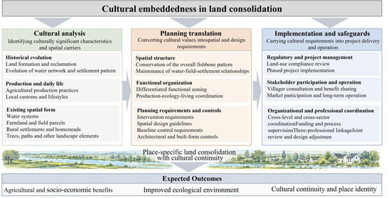
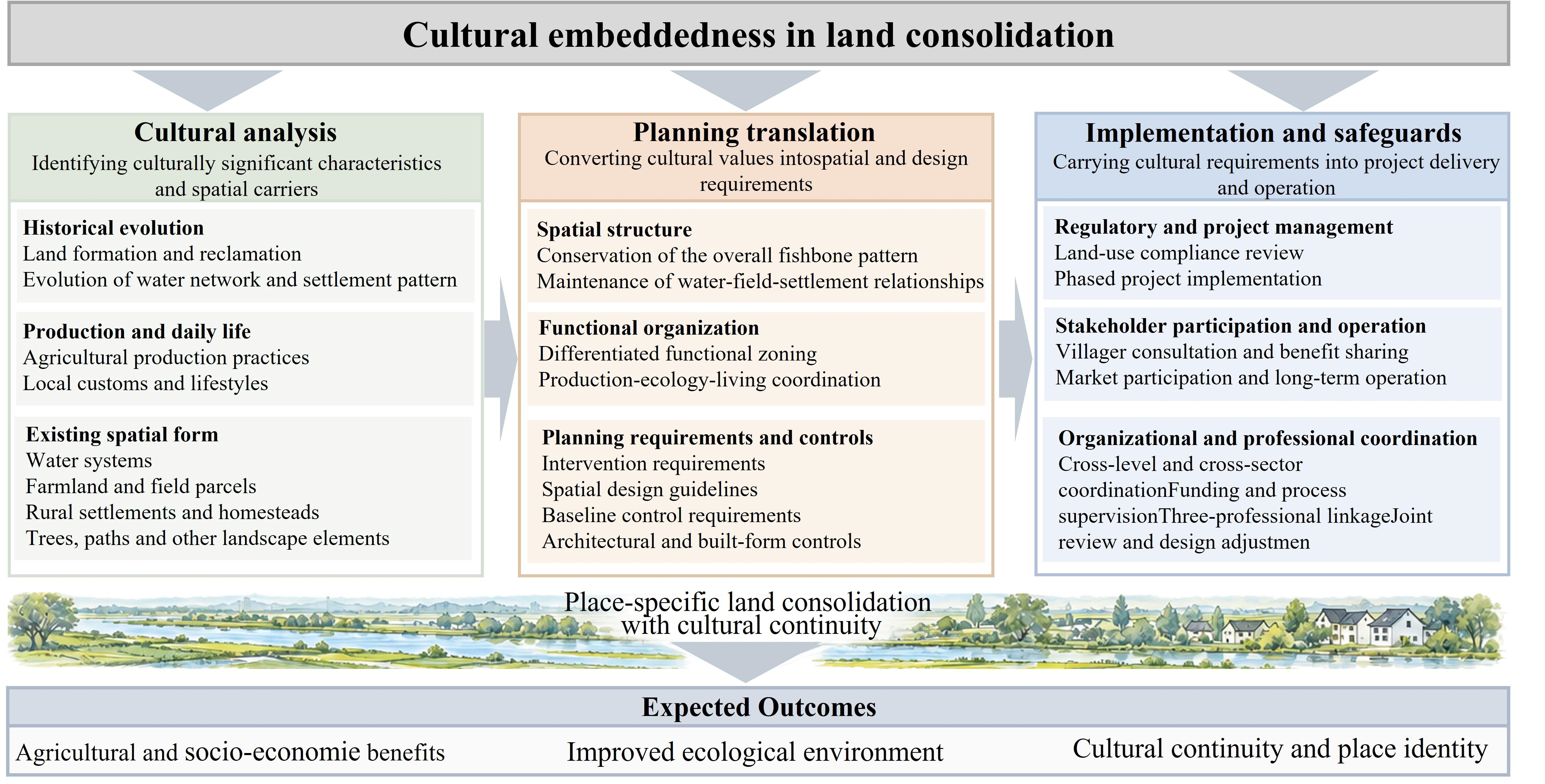
This study uses cultural embedding as an analytical lens to examine how cultural considerations are incorporated into land consolidation under the Hupai Jiangnan initiative. Based on the planning process observed in the case, the analysis focuses on three interconnected processes: cultural analysis, planning translation, and implementation and safeguards (Figure 1).
Figure 1.
Analytical framework.
Within the Hupai Jiangnan practice, cultural analysis focuses on identifying culturally significant characteristics and their spatial carriers through three interrelated dimensions of historical evolution, production and daily life, and existing spatial form. Historical evolution examines the processes of land formation, reclamation, and settlement development that have shaped local landscapes. Production and daily life considers agricultural practices, local customs, and everyday activities associated with these landscapes. Existing spatial form examines water systems, field patterns, rural settlements, and their spatial relationships as material carriers of local cultural meanings. Together, these dimensions provide a basis for distinguishing culturally significant spatial characteristics from general physical landscape features.
The three processes also provide a framework for examining the empirical evidence from the Fuwei case. For cultural analysis, historical and planning documents, spatial imagery, field observations, and practitioner consultations are used to examine how culturally significant characteristics and their spatial carriers were identified in the Hupai Jiangnan practice. For planning translation, planning schemes, design drawings, and technical reports are examined to trace how the identified cultural characteristics were translated into spatial structure, functional organization, design requirements, and planning controls. For implementation and safeguards, project documents, implementation arrangements, field observations, and practitioner consultations are used to examine how the resulting planning requirements were incorporated into subsequent project arrangements, supported by regulatory arrangements, stakeholder participation, and professional coordination.
3. Case Study and Methods
3.1. Case Selection
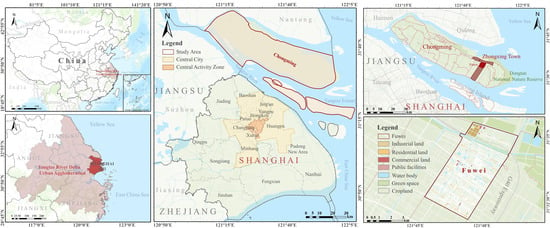
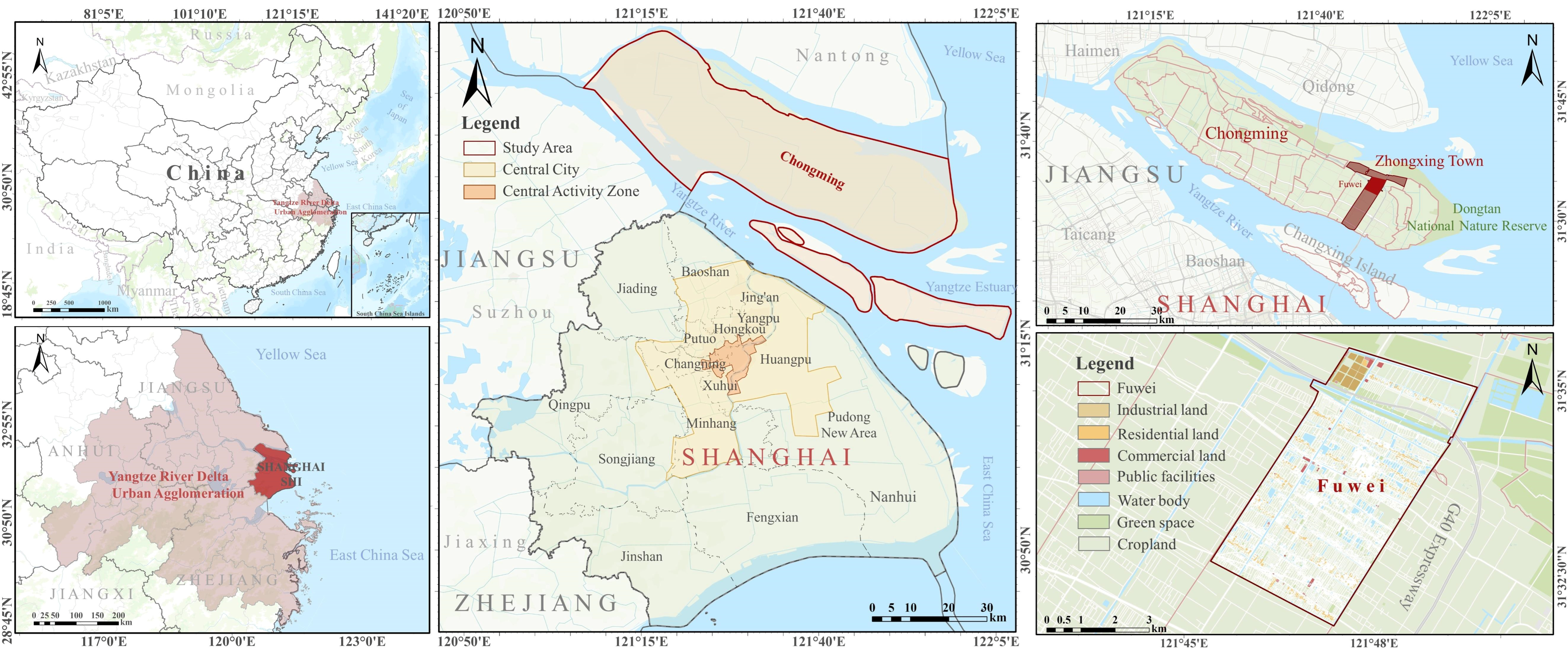
Fuwei Village is located in Zhongxing Town, Chongming District, Shanghai (Figure 2), within an estuarine sand island landscape shaped by sediment deposition and successive land reclamation [45]. As a representative village included in the Hupai Jiangnan initiative, it retains a distinctive spatial structure shaped by the interaction of waterways, farmland, and rural settlements. Its low-lying terrain is organized by a dense water network comprising trunk canals, secondary canals, and field ditches, which is closely associated with elongated agricultural parcels and linear settlements, forming a characteristic fishbone pattern [46]. This historically formed spatial structure reflects local reclamation practices and the long-standing relationships among water management, agricultural production, and rural life. It carries local historical and cultural meanings while also providing a spatial basis for agricultural production, ecological conservation, and village development. Consequently, land consolidation interventions involving waterways, farmland, and rural settlements also concern the continuity of these historically formed spatial relationships.
Figure 2.
Geographic location of the research area.
These characteristics make Fuwei a suitable case for examining how local cultural considerations inform land consolidation decisions. Its selection from among the Hupai Jiangnan pilot villages was also informed by the availability of relatively comprehensive planning and project materials, historical spatial imagery, and field evidence. These materials allow the study to trace how culturally significant characteristics and their spatial carriers were identified, translated into planning requirements, and incorporated into subsequent implementation arrangements.
3.2. Data Sources and Analysis
The study draws primarily on documentary materials, supplemented by field investigation, informal consultations, and spatial imagery. Twelve key documents were selected based on their relevance to the historical development, cultural characteristics, planning requirements, and implementation arrangements of the Fuwei case and the Hupai Jiangnan initiative, as well as the reliability of their sources. These documents include four historical gazetteers of Chongming County and Zhongxing Town, one municipal planning document, four implementation schemes for the Fuwei, Tianmashan, Xicen, and Xinyuan pilot areas, public notice materials for the Fuwei land consolidation project, one township government work report, and a township development planning draft. Documentary materials were obtained from relevant government departments, planning and design organizations, publicly available sources, and project archives. The four pilot implementation schemes are non-public planning documents. The historical gazetteers provided evidence of historical geography, settlement development, land-use transformation, and local socioeconomic changes. The Fuwei implementation scheme and related project materials provided the main evidence for examining planning objectives, spatial characteristics, planning requirements, intervention measures, and implementation arrangements, while the municipal planning document and implementation schemes from other pilot areas provided institutional context and illustrative evidence of variations in planning arrangements. The township government work report and development planning draft further provided information on pilot initiation and local development objectives. Details of the documents, including their dates, access status, and analytical purposes, are presented in Table 1.
Table 1.
Key documentary materials used in the case study.
Field investigation was conducted in November 2025. Site observations focused on the water system, field pattern, settlement form, ecological spaces, and relevant land consolidation interventions. Informal, open-ended consultations involved 11 individuals, including two designers and two government officials selected for their involvement in the planning and implementation process, and seven local residents approached during the field investigation. These consultations helped clarify planning decisions and implementation arrangements and provided contextual information on local production practices, everyday life, and spatial use.
Historical satellite imagery obtained from Google Earth provided additional spatial evidence. Historical images corresponding to 1985, 2005, 2010, and 2015 were selected based on image availability and interpretability. The raster images used for analysis had pixel sizes of 19.04 m for 1985 and 9.53 m for 2005, 2010, and 2015. The images were processed in ArcGIS 10.5 using the WGS 84 coordinate reference system. Visual interpretation focused on the relationships among trunk canals, secondary waterways, elongated agricultural parcels, and settlements. Comparison across the four periods was used to reconstruct changes in the water, field, and settlement structure and to support the interpretation of the fishbone morphology presented in Figure 3.
The qualitative analysis followed the three processes defined in the analytical framework. Evidence from documentary materials, historical imagery, field observations, and informal consultations was organized according to whether it concerned cultural analysis, planning translation, or implementation and safeguards. Materials relevant to multiple processes were examined across the corresponding stages. Triangulation was conducted by cross-checking evidence from different sources concerning the same spatial characteristics, planning requirements, and implementation arrangements. Historical accounts of land reclamation and settlement development were cross-checked against historical imagery and field observations to examine spatial characteristics and their evolution. Planning schemes and project documents were compared to trace how identified cultural characteristics were translated into spatial requirements and proposed land consolidation interventions. Information from informal consultations was used to contextualize local practices and clarify planning and implementation arrangements.
4. Results
4.1. Identifying Culturally Significant Spatial Characteristics and Carriers
In the Hupai Jiangnan initiative, land consolidation is used to explore how a highly urbanized megacity can sustain its “Jiangnan gene” through appropriate rural spatial forms, land-use practices, and cultural imagery under the broader context of national modernization and the Rural Revitalization Strategy, while coordinating protection and development. Accordingly, land consolidation is considered within a longer historical process in which urban development intersects with Jiangnan agrarian traditions. Through an analysis of historical trajectories and spatial elements, the initiative examines three related dimensions: natural foundations, settlement texture, and local customs, thereby identifying spatial elements and relationships of local historical and cultural significance.
In Fuwei, this analysis begins with the island’s history of land formation and reclamation as an estuarine sand island. Chongming is an estuarine alluvial island formed through long-term sediment deposition and hydrodynamic processes in the Yangtze River estuary. Sediment accumulation within the estuarine channels produced shifting sandbars that gradually coalesced into larger landmasses under changing hydrological conditions [45]. Its low elevation, saline soils, and exposure to tidal and storm surge hazards made reclamation, drainage, and flood protection central to subsequent land use and settlement. Local communities progressively constructed embankments, enclosed polders, and reclaimed land as mudflats expanded. Reclamation during the 1950s and 1960s enclosed extensive mudflats in northeastern Chongming behind sea dikes, subdivided the reclaimed land into relatively regular agricultural units, and established a trunk canal system [47]. These processes contributed to the formation of regular field patterns and linear settlements organized along canals and roads. Figure 3 illustrates the subsequent evolution of this spatial pattern from 1985 to 2015.
Figure 3.
Evolution of the fishbone spatial morphology identified from satellite imagery.
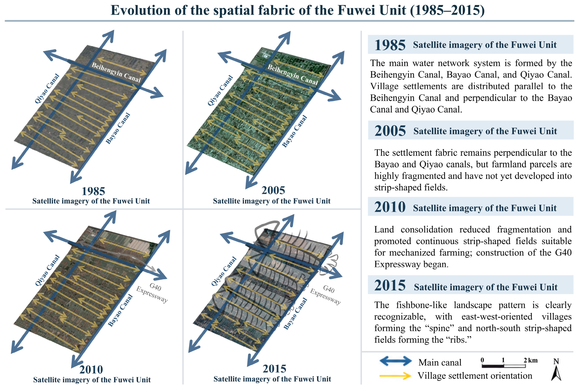
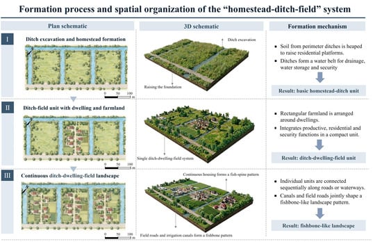
The historical logic of “building polders along accreting shoals, defining fields through polders, and forming villages in relation to water” remains visible in the present landscape. Along the river-facing edge, the seawall and connected trunk waterways form a continuous linear structure. Secondary canals and field ditches extend to both sides in an approximately orthogonal pattern, dividing farmland into relatively regular blocks. Within this structure, settlement and homestead patterns developed in response to local hydrological and production conditions. The “ditch-homestead-field” compound unit connects living space, protective and drainage infrastructure, production plots, and water access within a compact spatial arrangement. Multiple units are linked along roads or waterways, forming a continuous fishbone-like texture together with dikes, canals, field boundaries, and paths (Figure 4).
Figure 4.
Diagram of the formation of the “ditch-homestead-field” system.
The fishbone spatial morphology emerged from long-term interactions between the estuarine environment and historical polder development. This structure has shaped local production and everyday life while providing a material basis and spatial setting for the development and continuation of distinctive cultural practices. Polder construction and flood defense relied on collective labor, gradually fostering a vernacular ethic of solidarity and mutual aid. The same polder landscape also supported an integrated system of rice cultivation and fisheries through strip fields and a dense water network [48], shaping a local food culture centered on rice and aquatic products and structuring everyday life around farming seasons and flood cycles. In addition, local customs, traditional crafts, and folk performances were also connected to local production, everyday life, and spatial organization in different ways. In a polder landscape historically exposed to flooding and other natural hazards, zaohua (stove flower decorations) and tiger-head shoes expressed aspirations for abundant harvests, prosperity, and protection, while homespun weaving and luhua puxie (reed-flower footwear) reflected the use of local agricultural and wetland resources in household production. Itinerant biandan (shoulder-pole) performances formed part of rural social life and cultural exchange, drawing on village paths, field margins, and settlement spaces as settings for these activities. These relationships were identified through local gazetteers, field observations, and informal consultations with local residents. Meanwhile, Fuwei’s proximity to the Dongtan wetlands and its location along a major migratory corridor introduce new ecological and public-use considerations for the conservation and adaptation of the existing fishbone spatial structure.
By examining Fuwei’s natural foundations, settlement texture, and local customs together, the Hupai Jiangnan initiative identifies the historical and cultural significance of its spatial characteristics. The fishbone morphology is therefore identified not merely as a visible expression of local landscape character, but as an important spatial structure carrying local historical and cultural values. This distinction helps determine which elements require protection, which spatial relationships should be maintained, and which areas may be adjusted with caution. It also provides the basis for translating Fuwei’s historical and cultural characteristics into subsequent planning controls and landscape guidance.
4.2. Translating Cultural Characteristics into Planning Requirements
After clarifying the values embedded in the estuarine sand-island foundation, the polder-field fishbone settlement texture, and the associated production practices and folk culture, the Fuwei unit is positioned within the Hupai Jiangnan initiative as a key area for demonstrating an estuarine sand-island landscape, a fishbone spatial configuration, and the making of a bird-friendly countryside through land consolidation. Unlike a typical agricultural area, Fuwei is situated within the broader spatial framework of the Dongtan wetland and the Yangtze River Estuary ecological corridor. It therefore assumes a compound mandate. It must meet agricultural production needs and contribute to quota balancing, while also serving as a demonstrative site for conserving the polder-field fishbone character and creating habitat for migratory birds. In this positioning, the fishbone texture is translated into a set of binding baseline constraints and character-guidance principles that coordinate landscape conservation, rural construction, industrial development, and ecological protection.
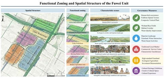
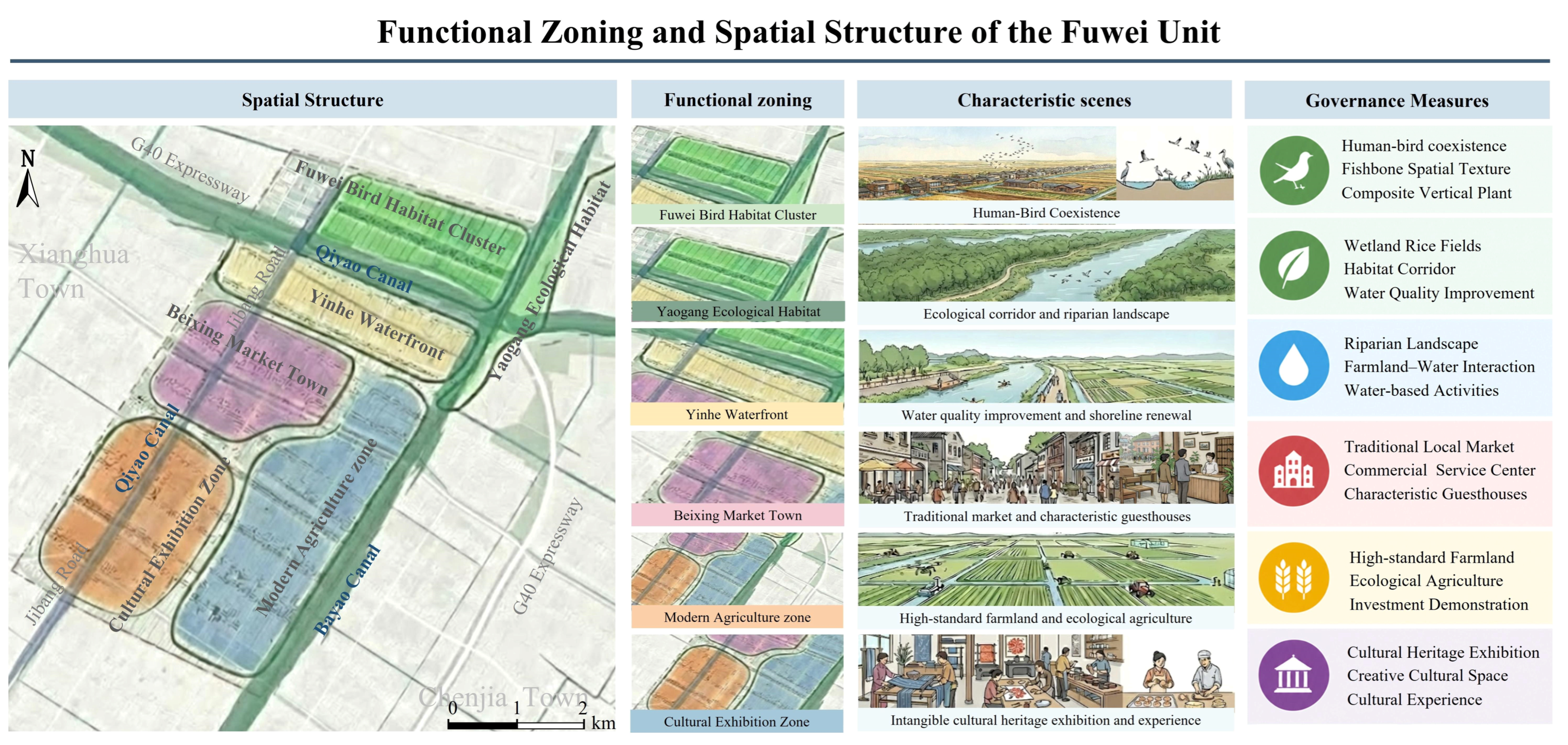
The fishbone spatial structure provides the main organizing basis for this translation. Rather than treating water, fields, woodlands, roads, and homesteads as separate engineering objects, the plan considers them as interconnected spatial carriers whose relationships collectively define the local landscape character. Their arrangement is retained at the overall pattern level while allowing differentiated adjustment according to ecological, production, and living requirements. This principle is further expressed through six functional zones, each emphasizing a different aspect of the identified cultural and spatial characteristics. The Fuwei Bird Habitat Cluster combines the fishbone polder landscape with migratory bird habitat and ecological education at the interface with the Dongtan National Nature Reserve. The Xiaogang Ecological Habitat follows the existing water system and connects riverbank restoration and habitat improvement with the local water landscape. The Yinhe Waterfront strengthens the relationship between fields and waterways through watershed restoration, shoreline improvement, and waterside activities. The Beixing Market Town extends existing settlement and old town memory into commercial, cultural, and tourism functions through the reuse of local buildings and spaces. The Cultural Exhibition Zone incorporates local crafts and performances, including zaohua, shoulder pole drama, homespun weaving, and traditional pastry making, into cultural display and participation. The Modern Agriculture Zone retains the basic polder and water structure while adapting agricultural production to contemporary technical and organizational requirements.
In the Fuwei implementation scheme, these differentiated spatial functions are further translated into proposed land consolidation interventions across five directions: managing water, configuring fields, expanding woodlands, improving roads, and upgrading homesteads (Figure 5). Water related measures retain the existing hierarchy of trunk waterways, secondary canals, and field ditches while improving irrigation, drainage, flood conveyance, water quality, and habitat conditions. Dredging of the Yinhe and Xiaogang channels, reinforcement of polder embankments, and upgrading of culverts and sluices are combined with watershed restoration and the creation of shallow water mudflats and wetland rice paddies. These measures allow contemporary hydraulic and ecological requirements to be accommodated without disrupting the water based spatial order of the fishbone structure.
Figure 5.
Spatial structure, functional zoning, and governance measures.
Field related measures combine farmland improvement with the continuation of the existing polder pattern. In the Modern Agriculture Zone, parcel consolidation and high standard farmland development are organized in relation to the orientation of waterways and the fishbone structure. Adjustments to parcel shape and scale therefore accommodate contemporary agricultural production while retaining the strip form and directional order of the traditional field pattern. Woodland measures follow the existing water and polder structure, with native vegetation and protective forest belts arranged along major waterways and polder embankments to strengthen ecological connectivity and provide habitat for birds. The relationships among cultural characteristics, planning requirements, and proposed interventions are summarized in Table 2.
Table 2.
Cultural embedding in planning and interventions.
Road and homestead interventions similarly retain the spatial relationships identified in the cultural analysis. Road improvements largely follow the existing relationship among trunk waterways, roads, and strip fields while improving accessibility and connecting birdwatching areas, the rural market, and cultural activity nodes. In this way, improvements to mobility are incorporated without substantially altering the coordinated structure of road, water, and field networks. Homestead measures retain the characteristic relationship between residential plots, surrounding water, and adjacent farmland. Ecological revetments, small waterside paths, and native planting strengthen these connections, while guidance on building massing, height, and color regulates incremental renewal in relation to the existing strip settlement form and Jiangnan water town character.
Through these translations, the cultural characteristics identified in Fuwei are incorporated into land consolidation not as isolated symbolic elements, but as requirements governing spatial relationships, functional organization, and specific forms of intervention. The fishbone spatial structure therefore serves as the basis for coordinating contemporary production, ecological restoration, rural development, and the continuation of local landscape character.
4.3. A Living Approach to Cultural Conservation and Transmission
In the Hupai Jiangnan practice, the cultural requirements formulated during the planning stage were incorporated into specific project arrangements through a coordinated set of implementation and institutional mechanisms. Departing from the conventional static, blueprint-oriented and museum-like approach to cultural preservation, the Fuwei practice sought to make previously implicit cultural markers spatially explicit, embed them into spatial regeneration, and sustain their visibility through everyday use and long-term operation. Its principal contribution at this stage therefore lies not simply in preserving cultural elements as physical objects, but in establishing spatial and operational conditions intended to support the continued expression and transmission of local cultural meanings in lived space.
At the initial stage, a place-making team consisting of planners, architects, and landscape architects provides professional and technical support for identifying cultural meanings and translating them into spatial controls and design interventions. Planners coordinate the positioning of the planning unit, spatial structure, and functional zoning within the land-use control framework, and translate cultural meanings and public-interest requirements into control drawings, indicator systems, and project lists. Architects further interpret these requirements through building form, public space, interface scale, and spatial details, ensuring that new interventions remain compatible with the existing village morphology and local character. Landscape architects work at a broader spatial scale, addressing water systems, shelterbelt networks, field ridges, vegetation, and sequences of public spaces, with particular attention to maintaining the continuity of the relationships among water, fields, roads, and settlements identified through the cultural analysis.
More importantly, the same team also supports the organization of a series of place-based cultural activities, including village walks, intangible cultural heritage activities, agricultural learning programs, biodiversity activities, and festivals [27]. For example, a participatory cultural heritage event held in Fuwei in August 2024 brought together the professional team, local officials, village representatives, and intangible cultural heritage practitioners. Through demonstrations and discussions, participants shared local cultural knowledge and expressed needs for exhibition spaces, workshops, and heritage-related products [49]. In December 2025, a further public event brought together government agencies, professional teams, enterprises, community residents, and other organizations, during which the Fuwei planning scheme and a proposed operational plan were presented [50].
These activities involve local villagers, urban visitors, enterprises, and other organizations, while their dissemination through online media further expands their influence and strengthens the visibility of local cultural meanings. By promoting cultural exchange, attracting visitors, and creating opportunities for tourism-related activities and local economic participation, these activities are intended to support the continued use and vitality of regenerated rural spaces. Over time, the combination of spatial improvement, cultural programming, and continued participation is expected to contribute to the formation of a more recognizable local cultural identity, place brand, and sense of belonging. By linking physical spatial improvement with subsequent public services and cultural activities, this approach seeks to enable cultural meanings to be expressed not only through spatial construction, but also through continued use.
Over the medium and long term, villagers are expected to become more involved in project implementation, subsequent place-making, and operation. At the planning stage, the Fuwei land consolidation project scheme was publicly displayed at the village committee from 2 to 16 November 2025, with channels provided for residents to submit comments through the village committee or township government [51]. When projects involve tenure adjustment, site selection, public space, or other issues directly affecting local production and everyday use, such consultation procedures provide opportunities for residents to express their concerns and offer input for subsequent adjustments during project implementation.
Market actors are likewise incorporated into longer-term implementation and operation. They participate mainly through facility development and subsequent service provision, linking industrial activities, public services, and operational functions with the spatial and cultural objectives established through planning. In Fuwei, Wanhe Agriculture, a major local organic farming enterprise, has become involved as the whole-village operator, with plans to connect agricultural production facilities, organic rice fields, and wetland rice paddies through agricultural tourism and ecological experiences [52]. Where market participation is involved, performance requirements concerning spatial quality, ecological conditions, and the continuity of local character are intended to guide project management. At the same time, proposed benefit-sharing arrangements with village collectives seek to connect employment, operating revenues, and collective assets with local interests. These include potential rental income from collectively held properties and revenues from birdwatching services. In this way, the implementation of cultural requirements is intended to extend beyond project construction into subsequent use and operation.
5. Discussion
5.1. Comparison of Land Consolidation Practices
Growing demands for cultivated land protection, ecological restoration, rural living environment improvement, and rural revitalization have progressively broadened the objectives and scope of land consolidation [2]. As consolidation tasks have increased and the range of intervention objects has expanded, standardized technical procedures and project based implementation have become established, substantially improving implementation efficiency [53]. However, when similar technical approaches are applied across rural areas with different natural settings, historical trajectories, and spatial conditions, locally accumulated distinctiveness may be weakened, disrupting distinctive landscape structures, settlement patterns, and daily activities, and ultimately producing more homogeneous development outcomes [54].
To facilitate scheme preparation, engineering implementation, and project management, complex rural spaces are typically translated into relatively clearly defined intervention objects, with roads, water systems, land parcels, settlements, and other spatial elements adjusted according to standardized technical requirements [55]. Yet many local characteristics are the cumulative outcome of long term interactions among the natural environment, agricultural production, settlement evolution, and everyday life, and are embodied in specific spatial relationships [56]. When generic technical approaches are used to reshape these spatial elements, such historically formed relationships may be simplified or even removed, causing local characteristics to disappear and differences between regions to gradually diminish [57]. In recent years, ecological restoration, village beautification, and landscape enhancement have improved local landscape character to some extent. However, because these measures are often introduced after the basic spatial structure has already been adjusted, their effects are largely confined to improvements in environmental and visual quality and have limited capacity to reconstruct altered spatial structures or restore their connections with local production and everyday life [58].
Cultural embedding provides a pathway for addressing this problem by introducing cultural analysis and planning translation before major spatial interventions are finalized [59]. It identifies the historical, productive, social, and everyday meanings carried by existing spatial elements and selects those that play an important role in maintaining local spatial continuity [60]. These cultural characteristics and their spatial carriers are then translated into requirements for spatial organization, design, and planning control, providing a supplementary basis for deciding whether particular spatial elements should be retained, adapted, restored, or restructured. Through differentiated and targeted adjustment rather than uniform intervention, the approach aims to improve production conditions, infrastructure, and ecological quality while retaining, as far as possible, locally distinctive spatial forms, organizational relationships, and patterns of daily use, thereby maintaining existing spatial differences and place character across different localities [61].
Other Hupai Jiangnan pilot schemes suggest that this pathway does not prescribe a fixed and uniform spatial image, but instead allows for differentiated spatial expressions under different local conditions. The Xicen pilot in Qingpu builds on its lake and polder environment and the interconnected spatial fabric of lou (canals), zhao (small waterways), wei (polder settlements), and tang (ponds), forming a locally distinctive system composed of waterways, settlements, and waterside spaces. Xinyuan in Jinshan emphasizes the checkerboard polder pattern formed through the long term coexistence of water, farmland, and settlements. Tianmashan in Songjiang draws on historically documented mountain and water patterns, with particular attention to the continuity of historical waterways and landscape view corridors. These examples highlight differences in culturally significant spatial carriers and corresponding planning priorities across local settings. At the conceptual level, their commonality lies in identifying locally distinctive spatial characteristics and using them to inform proposed land consolidation interventions.
5.2. Generalizable Pathway of Cultural Embedding
The broader value of the Hupai Jiangnan practice lies primarily in its planning mechanism rather than in any specific cultural element, spatial form, or design language. Historical trajectories, production practices, environmental conditions, and settlement patterns vary considerably across regions, and the culturally significant spatial characteristics identified in each locality will therefore differ accordingly. What can be transferred is the mechanism through which local cultural knowledge is incorporated into land consolidation decision making, allowing information embedded in historical memory, local experience, and everyday practices to inform spatial planning and project implementation.
The operation of this process depends on several enabling conditions. Cultural analysis requires sufficient knowledge of local history, production practices, everyday use, and spatial evolution to distinguish culturally significant characteristics from general landscape features [60]. Planning translation then requires professional and institutional capacity to convert this knowledge into spatially explicit requirements that can be coordinated with cultivated land protection, ecological restoration, infrastructure improvement, and other land consolidation tasks [62]. These requirements also need to remain effective during implementation. Participation by multiple actors can help clarify local priorities and reduce discrepancies between professional interpretation and local experience, while project lists, design requirements, process supervision, and clear responsibilities provide channels through which agreed requirements can be carried into project delivery [13]. Continued maintenance of public spaces, water systems, routes, and other relevant spatial carriers further depends on appropriate arrangements for subsequent management and stewardship. Transferability therefore depends not only on the ability to identify local cultural characteristics, but also on the capacity to translate, coordinate, implement, and maintain the resulting requirements [63].
These conditions also define the limits of transferability. All Hupai Jiangnan pilot villages are located within the administrative territory of Shanghai. In essence, they are planned and spatially intervened in as constituent parts of the Shanghai global city-region, where rural space functions as a highly scarce complement to the predominantly urban spatial structure of a megacity. On the one hand, the fiscal, technical, and policy resources invested in these pilot areas far exceed those available to ordinary rural areas. This is particularly evident in the early pilot projects, which have served as demonstration sites through which the Shanghai municipal government has concentrated resources to establish a distinctive cultural identity for the rural areas of the megacity. On the other hand, the actors involved in Hupai Jiangnan extend well beyond those conventionally associated with rural development. Social capital, technical and professional elites, and urban “digital nomads” from the wider Shanghai metropolitan region have been attracted by the scarcity and distinctive cultural and ecological qualities of rural space and have become increasingly involved in its development and regeneration.
Against the broader trend of rural population loss in China, with older people and children increasingly constituting a large share of the remaining rural population, the involvement of external actors has become one of the most realistic, and to some extent inevitable, means of supporting rural spatial and cultural revitalization. In the longer term, however, the role of external actors in culturally embedded comprehensive land consolidation may become substantially greater than that of local residents. This raises a more fundamental question: whose culture is being embedded, and through what forms of spatial transformation? It remains to be seen whether these interventions constitute regeneration genuinely embedded in inherited local culture, or whether imaginaries of the “Jiangnan water town” and idealized rural life are themselves reshaping the Hupai Jiangnan pilot areas.
6. Conclusions
The Hupai Jiangnan practice illustrates how cultural embedding operates within land consolidation through cultural analysis, planning translation, and implementation and safeguards. Its significance lies in bringing place-specific cultural knowledge into spatial organization, planning control, and project implementation, rather than treating culture mainly as an additional layer of landscape expression. This provides an additional basis for deciding which spatial elements and relationships should be retained, adapted, restored, or restructured alongside contemporary production, ecological, and land-use requirements.
The transferability of this mechanism depends on the availability of local knowledge and on sufficient professional, institutional, and implementation capacity to translate cultural interpretation into spatial requirements. The Fuwei case is situated in Shanghai, where planning coordination and technical support are relatively strong, and the Hupai Jiangnan initiative remains at an early stage of implementation. Current evidence therefore does not allow an assessment of its long-term social, cultural, and spatial effects. Further comparative and longitudinal research is needed to examine how the mechanism operates under different institutional and resource conditions and whether culturally informed spatial requirements can be sustained over time.
Author Contributions
Conceptualization, Z.Z. and Y.C.; methodology, Z.Z. and Y.C.; software, Z.Z.and Y.C.; validation, Y.C.; formal analysis, Z.Z.; investigation, Z.Z.; resources, Y.C., F.L. and D.X.; data curation, Z.Z.; writing—original draft preparation, Z.Z.; writing—review and editing, Y.C.; visualization, Z.Z.; supervision, Y.C., F.L. and D.X.; project administration, Y.C.; funding acquisition, Y.C. All authors have read and agreed to the published version of the manuscript.
Funding
This research was funded by the National Social Science Fund of China (Grant No. 25SGC194).
Institutional Review Board Statement
This study primarily involved documentary analysis, historical satellite imagery analysis, and non-interventional field observations of rural spatial environments conducted in public and semi-public outdoor settings. Informal consultations with local residents, designers, and government officials served solely to provide supplementary contextual information. No sensitive personal information or medical data were collected, and the manuscript does not disclose individual participants’ statements or personally identifiable information. In accordance with the ethical guidelines applicable to social science research in China and relevant institutional ethical review requirements, formal ethical review and approval were not required for this study.
Informed Consent Statement
Verbal informed consent was obtained from all 11 consultation participants prior to their participation. Given the informal, non-interventional nature of the field consultations, verbal rather than written consent was adopted, as formal written procedures could affect the spontaneity and openness of on-site discussions. All participants were informed of the research purpose and participated voluntarily. No direct quotations or personally identifiable information from participants are reported in this study.
Data Availability Statement
The data presented in this study are available on request from the corresponding author.
Acknowledgments
We would like to thank the anonymous reviewers for their valuable comments and suggestions for improving this paper.
Conflicts of Interest
The authors declare no conflicts of interest.
References
- Zang, Y.; Yang, Y.; Liu, Y. Toward serving land consolidation on the table of sustainability: An overview of the research landscape and future directions. Land Use Policy 2021, 109, 105696. [Google Scholar] [CrossRef] [Scilit]
- Zhou, Y.; Li, Y.; Xu, C. Land consolidation and rural revitalization in China: Mechanisms and paths. Land Use Policy 2020, 91, 104379. [Google Scholar] [CrossRef] [Scilit]
- Chen, K.; Chen, Y.; Long, H.; Li, N. How does land consolidation affect rural development transformation? J. Geogr. Sci. 2024, 34, 417–438. [Google Scholar] [CrossRef] [Scilit]
- Li, Y.; Wu, W.; Liu, Y. Land consolidation for rural sustainability in China: Practical reflections and policy implications. Land Use Policy 2018, 74, 137–141. [Google Scholar] [CrossRef] [Scilit]
- Li, S.; Song, W. Research progress in land consolidation and rural Revitalization: Current status, characteristics, regional differences, and evolution laws. Land 2023, 12, 210. [Google Scholar] [CrossRef] [Scilit]
- Jiang, Y.; Tang, Y.-T.; Long, H.; Deng, W. Land consolidation: A comparative research between Europe and China. Land Use Policy 2022, 112, 105790. [Google Scholar] [CrossRef] [Scilit]
- de Vries, W.T. Social aspects in land consolidation processes. Land 2022, 11, 452. [Google Scholar] [CrossRef] [Scilit]
- Dorner, P.; Thiesenhusen, W.C. Selected land reforms in East and Southeast Asia: Their origins and impacts. Asian-Pac. Econ. Lit. 1990, 4, 65–95. [Google Scholar] [CrossRef] [Scilit]
- Osawa, T. Overlap relationship between the priority of land consolidation and the floodplain wetland potential in paddy field. Ecol. Res. 2024, 39, 242–249. [Google Scholar] [CrossRef] [Scilit]
- Sorensen, A. Land readjustment and metropolitan growth: An examination of suburban land development and urban sprawl in the Tokyo metropolitan area. Prog. Plan. 2000, 53, 217–330. [Google Scholar] [CrossRef] [Scilit]
- Burmeister, L.L. State, industrialization and agricultural policy in Korea. Dev. Change 1990, 21, 197–223. [Google Scholar] [CrossRef] [Scilit]
- Baek, I.R.; Kim, P.S.; Lee, S.C. Contributions and limitations of Saemaul Undong in Korea for regional development and welfare improvement in less developed countries. Public Adm. Dev. 2012, 32, 416–429. [Google Scholar] [CrossRef] [Scilit]
- Guo, Y.; Wang, J. Land consolidation in rural China: Historical stages, typical modes, and improvement paths. Land 2023, 12, 491. [Google Scholar] [CrossRef] [Scilit]
- Duan, J.; Ren, C.; Wang, S.; Zhang, X.; Reis, S.; Xu, J.; Gu, B. Consolidation of agricultural land can contribute to agricultural sustainability in China. Nat. Food 2021, 2, 1014–1022, Correction in Nat. Food 2022, 3, 179. [Google Scholar] [CrossRef] [Scilit] [PubMed]
- Molnárová, K.J.; Sklenička, P.; Bohnet, I.C.; Lowther-Harris, F.; van den Brink, A.; Moghaddam, S.M.; Fanta, V.; Zástěra, V.; Azadi, H. Impacts of land consolidation on land degradation: A systematic review. J. Environ. Manag. 2023, 329, 117026. [Google Scholar] [CrossRef] [Scilit] [PubMed]
- Yin, Q.; Zhou, S.; Lv, C.; Zhang, Y.; Sui, X.; Wang, X. Comprehensive land consolidation as a tool to promote rural restructuring in China: Theoretical framework and case study. Land 2022, 11, 1932. [Google Scholar] [CrossRef] [Scilit]
- Kupidura, A.; Łuczewski, M.; Home, R.; Kupidura, P. Public perceptions of rural landscapes in land consolidation procedures in Poland. Land Use Policy 2014, 39, 313–319. [Google Scholar] [CrossRef] [Scilit]
- Czarnecka, A.; Stępnik, K.; Krupowicz, W.; Home, R. Integrating place attachment and social capital in land consolidation procedures for sustainable landscape development. J. Rural. Stud. 2026, 123, 104095. [Google Scholar] [CrossRef] [Scilit]
- Peng, J.; Yan, S.; Strijker, D.; Wu, Q.; Chen, W.; Ma, Z. The influence of place identity on perceptions of landscape change: Exploring evidence from rural land consolidation projects in Eastern China. Land Use Policy 2020, 99, 104891. [Google Scholar] [CrossRef] [Scilit]
- Asiama, K.O.; Bennett, R.; Zevenbergen, J.; Mano, A.D.S. Responsible consolidation of customary lands: A framework for land reallocation. Land Use Policy 2019, 83, 412–423. [Google Scholar] [CrossRef] [Scilit]
- Wuczyński, A.; Kujawa, K.; Pielech, R.; Grzesiak, W.; Jarzembowski, P.; Wierzcholska, S.; Dajdok, Z. Changes in structural composition of field margins and related landscape homogenization following EU accession of Poland. Sci. Rep. 2025, 15, 3793. [Google Scholar] [CrossRef] [Scilit] [PubMed]
- Cocco, V.; Chakir, R.; Mouysset, L. Guilty or scapegoat? Land consolidation and hedgerow decline. J. Environ. Econ. Manag. 2025, 133, 103196. [Google Scholar] [CrossRef] [Scilit]
- Tan, J.; Gu, K.; Zheng, Y. Peri-urban planning: A landscape perspective. Plan. Theory 2024, 23, 42–63. [Google Scholar] [CrossRef] [Scilit]
- Li, J. Culture and tourism-led peri-urban transformation in China–The case of Shanghai. Cities 2020, 99, 102628. [Google Scholar] [CrossRef] [Scilit]
- Agnoletti, M. Rural landscape, nature conservation and culture: Some notes on research trends and management approaches from a (southern) European perspective. Landsc. Urban Plan. 2014, 126, 66–73. [Google Scholar] [CrossRef] [Scilit]
- Sánchez, M.L.; Cabrera, A.T.; Del Pulgar, M.L.G. Guidelines from the heritage field for the integration of landscape and heritage planning: A systematic literature review. Landsc. Urban Plan. 2020, 204, 103931. [Google Scholar] [CrossRef] [Scilit]
- Li, Z.; Tang, M.; Liu, Q.; Zhu, Y.; Deng, F. Quantitative Morphological Resolution of Preservation–Renewal Conflicts for “Shanghai-Style Jiangnan” Villages, China. Land 2026, 15, 798. [Google Scholar] [CrossRef] [Scilit]
- Chai, B. Long-term spatiotemporal dynamics of urban land and surface water bodies in Shanghai over the past 90 years using old maps and dense Landsat time series. Habitat Int. 2026, 168, 103702. [Google Scholar] [CrossRef] [Scilit]
- Ren, W.; Meligrana, J.; Zhang, Z.; Anderson, B. Balancing Economic Development and the Preservation of Agricultural Land: An Evaluation of Shanghai’s Municipal Land Use Plan. Urban Policy Res. 2008, 26, 481–496. [Google Scholar] [CrossRef] [Scilit]
- Wang, J.; Ran, W. Research on the supply point mechanism of Shanghai during the closure of COVID-19 in 2022 from the perspective of urban resilience. Nat. Hazards 2024, 120, 12755–12768. [Google Scholar] [CrossRef] [Scilit]
- Shi, Y.; Cao, X.; Fu, D.; Wang, Y. Comprehensive value discovery of land consolidation projects: An empirical analysis of Shanghai, China. Sustainability 2018, 10, 2039. [Google Scholar] [CrossRef] [Scilit]
- Shi, Y.; Zheng, J.; Zheng, B. Multidimensional effect analysis of typical country park construction in Shanghai. Ecol. Indic. 2024, 160, 111866. [Google Scholar] [CrossRef] [Scilit]
- Zhou, Y.; Li, P.; Zhang, Q.; Cheng, G. Socio-economic impacts, challenges, and strategies for whole-region comprehensive land consolidation in China. Land Use Policy 2025, 150, 107461. [Google Scholar] [CrossRef] [Scilit]
- Jiang, Y.; Long, H.; Tang, Y.-t.; Deng, W. Measuring the role of land consolidation to community revitalization in rapidly urbanizing rural China: A perspective of functional supply-demand. Habitat Int. 2025, 155, 103237. [Google Scholar] [CrossRef] [Scilit]
- Zhao, Q.; Jiang, G.; Wang, M. The Allocation Change of Rural Land Consolidation Type Structure under the Influence Factors of Different Geographical and Economic Development of China. Int. J. Environ. Res. Public Health 2023, 20, 5194. [Google Scholar] [CrossRef] [Scilit] [PubMed]
- Huang, Q.; Li, M.; Chen, Z.; Li, F. Land consolidation: An approach for sustainable development in rural China. Ambio 2011, 40, 93–95. [Google Scholar] [CrossRef] [Scilit] [PubMed]
- Wang, Y.-W.; Pendlebury, J.; Nolf, C. The water heritage of China: The polders of Tai Lake Basin as continuing landscape. Plan. Perspect. 2023, 38, 949–974. [Google Scholar] [CrossRef] [Scilit]
- Zuo, Y.; Zhang, L. Research on Local Ecosystem Cultural Services in the Jiangnan Water Network Rural Areas: A Case Study of the Ecological Green Integration Demonstration Zone in the Yangtze River Delta, China. Land 2023, 12, 1373. [Google Scholar] [CrossRef] [Scilit]
- Polanyi, K. The Great Transformation: The Political and Economic Origins of Our Time; Beacon Press: Boston, MA, USA, 2001. [Google Scholar]
- Gemici, K. Karl Polanyi and the antinomies of embeddedness. Socio-Econ. Rev. 2008, 6, 5–33. [Google Scholar] [CrossRef] [Scilit]
- Granovetter, M. Economic action and social structure: The problem of embeddedness. Am. J. Sociol. 1985, 91, 481–510. [Google Scholar] [CrossRef] [Scilit]
- Dequech, D. Cognitive and cultural embeddedness: Combining institutional economics and economic sociology. J. Econ. Issues 2003, 37, 461–470. [Google Scholar] [CrossRef] [Scilit]
- Krippner, G.R.; Alvarez, A.S. Embeddedness and the intellectual projects of economic sociology. Annu. Rev. Sociol. 2007, 33, 219–240. [Google Scholar] [CrossRef] [Scilit]
- Lou, S.; Chen, Y.; Feng, J.; Zhang, L. Reconstruction of rural cultural space and planning base on the perspective of “Social-Spatial” theory: A case study in Zhuma Township, Zhejiang Province. Buildings 2025, 15, 671. [Google Scholar] [CrossRef] [Scilit]
- Wu, S.; Chen, R.; Meadows, M.E. Evolution of an estuarine Island in the anthropocene: Complex dynamics of Chongming Island, Shanghai, PR China. Sustainability 2019, 11, 6921. [Google Scholar] [CrossRef] [Scilit]
- Bao, J.; Gao, S. Wetland utilization and adaptation practice of a coastal megacity: A case study of Chongming Island, Shanghai, China. Front. Environ. Sci. 2021, 9, 627963. [Google Scholar] [CrossRef] [Scilit]
- Bao, J.; Gao, S. Long-term reclamation of tidal flats of Chongming Island and ecological security of Yangtze estuary, China. Reg. Environ. Change 2024, 24, 74. [Google Scholar] [CrossRef] [Scilit]
- Wan, N.-F.; Li, S.-X.; Li, T.; Cavalieri, A.; Weiner, J.; Zheng, X.-Q.; Ji, X.-Y.; Zhang, J.-Q.; Zhang, H.-L.; Zhang, H. Ecological intensification of rice production through rice-fish co-culture. J. Clean. Prod. 2019, 234, 1002–1012. [Google Scholar] [CrossRef] [Scilit]
- Rural Planning Research Rural Field Notes, Part IV: Fuwei Bird Gathering—A Cultural Atlas. Available online: https://ghzyj.sh.gov.cn/cm/20240902/d7f139300b0b48f785c0d0f4187449d6.html (accessed on 18 August 2026).
- Zhongxing Town Government. Hupai Idyllic Countryside, Fuwei Bird Gathering: Launch of the Hupai Jiangnan Zhongxing–Fuwei Unit Development and the Fourth Dongtan Public Birdwatching Season. Available online: https://www.shcm.gov.cn/jzpd/014004/014004002/20251208/70a575c5-48a7-4f93-b359-8dc75471b6b7.html (accessed on 18 August 2026).
- Shanghai Construction Land and Land Consolidation Affairs Center. Public Display Boards for the 2025 Municipal Land Consolidation Project in the Fuwei Unit, Zhongxing Town, Chongming District: Integrated Design‑Construction‑Survey. 2025. Available online: https://www.shcm.gov.cn/ (accessed on 18 August 2026).
- Xie, M. Exploring Bird-Friendly Development on an Estuarine Sand Island. Xinmin Evening News; p. 3. 8 April 2026. Available online: https://paper.xinmin.cn/html/xmwb/2026-04-08/3/235682.html (accessed on 18 August 2026).
- Yin, Q.; Sui, X.; Ye, B.; Zhou, Y.; Li, C.; Zou, M.; Zhou, S. What role does land consolidation play in the multi-dimensional rural revitalization in China? A research synthesis. Land Use Policy 2022, 120, 106261. [Google Scholar] [CrossRef] [Scilit]
- Wei, K.; He, Y.; Wang, M.; Zhu, R.; Wang, Z. Identification, inheritance and restoration of traditional village landscape gene: A case study of Lidipo village in Tongchuan, Shaanxi Province. npj Herit. Sci. 2025, 13, 18. [Google Scholar] [CrossRef] [Scilit]
- Li, P.; Chen, Y.; Hu, W.; Li, X.; Yu, Z.; Liu, Y. Possibilities and requirements for introducing agri-environment measures in land consolidation projects in China, evidence from ecosystem services and farmers’ attitudes. Sci. Total Environ. 2019, 650, 3145–3155. [Google Scholar] [CrossRef] [Scilit] [PubMed]
- Tang, L.; Li, J.; Ding, W. Geomorphological change and rural settlement patterns: Study of the formation mechanisms of strip villages in Jiangsu, China. River Res. Appl. 2023, 39, 1300–1315. [Google Scholar] [CrossRef] [Scilit]
- Li, J.; Ye, M.; Xue, M.; Geng, L.; Lin, F. Evolution Characteristics and Development Mechanism of Rural Settlement Spatial Form Under the Guidance of Chinese Policies—A Case Study of Central Village in Huotong Town, Fujian Province. Buildings 2025, 15, 4424. [Google Scholar] [CrossRef] [Scilit]
- Lan, X.; Ku, H.B.; Zhan, Y. Aesthetic governance and China’s rural toilet revolution. Dev. Change 2024, 55, 219–243. [Google Scholar] [CrossRef] [Scilit]
- Patiwael, P.R.; Groote, P.; Vanclay, F. Does local planning culture influence the effectiveness of impact assessments?: Reflecting on infrastructure projects in a Dutch UNESCO World Heritage site. Impact Assess. Proj. Apprais. 2022, 40, 254–265. [Google Scholar] [CrossRef] [Scilit]
- Fagerholm, N.; Eilola, S.; Kisanga, D.; Arki, V.; Käyhkö, N. Place-based landscape services and potential of participatory spatial planning in multifunctional rural landscapes in Southern highlands, Tanzania. Landsc. Ecol. 2019, 34, 1769–1787. [Google Scholar] [CrossRef] [Scilit]
- Shen, J.; Li, Y.; Wang, Y. Nesting landscape character and personality assessment to intensify rural landscape regionality and uniqueness. Environ. Impact Assess. Rev. 2025, 110, 107705. [Google Scholar] [CrossRef] [Scilit]
- Trop, T. From knowledge to action: Bridging the gaps toward effective incorporation of Landscape Character Assessment approach in land-use planning and management in Israel. Land Use Policy 2017, 61, 220–230. [Google Scholar] [CrossRef] [Scilit]
- Zhao, J.; Jiang, Y.; Yao, J.; Tan, S. From static to dynamic: A phased evolution framework for multi-stakeholder collaborative governance in comprehensive land consolidation. Land Use Policy 2026, 170, 108191. [Google Scholar] [CrossRef] [Scilit]

Disclaimer/Publisher’s Note: The statements, opinions and data contained in all publications are solely those of the individual author(s) and contributor(s) and not of MDPI and/or the editor(s). MDPI and/or the editor(s) disclaim responsibility for any injury to people or property resulting from any ideas, methods, instructions or products referred to in the content. |
© 2026 by the authors. Licensee MDPI, Basel, Switzerland. This article is an open access article distributed under the terms and conditions of the Creative Commons Attribution (CC BY) license.