


Abstract
Historic urban areas in inland resource-based cities are often reshaped by overlapping changes in roads, public services, industry, housing, and everyday land use. However, these changes are not always clearly connected to differentiated conservation and renewal decisions. Taking the Taiyuan historical urban area as a case, this study aims to clarify how multi-period historical spatial evidence can be used to interpret morphological evolution, road accessibility, land-use transformation, and their conservation-renewal implications. Standard deviational ellipse analysis, kernel density estimation, and space syntax were used to separately examine urban form, land-use concentration, and road-network accessibility. Taiyuan changed from a compact walled city into a complex urban structure involving internal infill, local extension, and functional reorganization. The historical core retained its importance for commercial services, public administration, and highly accessible streets. New clusters appeared near peripheral transport nodes and residential expansion areas. The road network became more regular and better connected. Land use shifted from residential-administrative embeddedness to a differentiated pattern. Based on the three lines of evidence, four conservation-renewal zones are identified: key conservation, fabric repair, adaptive reuse, and coordinated renewal. Beyond the Taiyuan case, the study provides a case-based approach for linking historical map translation, HGIS analysis, and conservation-renewal zoning in inland historic urban areas.
1. Introduction
The focus of historic urban conservation has gradually shifted from individual monuments, historic districts, and buildings of architectural character to the broader historic landscapes formed through long-term urban development. The Historic Urban Landscape (HUL) approach emphasizes that a historic urban area should not be understood as a static collection of remains from a particular period, but as the cumulative result of natural geography, the built environment, social life, economic activity, and cultural memory [1,2]. From this perspective, research on historic cities needs not only to identify visible material remains, but also to explain how spatial relationships formed in different historical periods have been continued, altered, or reorganized. In recent years, the concept of “historic layering” has increasingly been used to operationalize the HUL approach by identifying historical layers, examining attributes within each layer, and analysing relationships among layers, thereby explaining the formation of historic landscapes and their implications for conservation and renewal [3].
Urban morphology provides an important spatial basis for understanding the layering of historic landscapes. Streets, plots, building fabrics, land use, and boundary forms do not exist in isolation; rather, they are spatial assemblages gradually shaped by institutional arrangements, transport organization, topography and water systems, and everyday use [4,5]. Historical maps are particularly valuable in this context. They record urban boundaries, roads, water systems, gates, temples, administrative offices, markets, and other spatial elements, while also preserving the ways in which urban order and functional organization were represented in specific periods [6]. With the development of Geographic Information Systems (GIS) and Historical Geographic Information Systems (HGIS), the latter being an extension of GIS specifically designed to manage, analyze, and visualize spatiotemporal data from historical sources, the image-based information contained in historical maps can be translated into polygon, line, and point datasets, enabling cross-period overlay measurement and comparison. However, differences in surveying accuracy, map scale, symbolic representation, and spatial semantics may affect the reliability of historical map analysis. Historical map translation should therefore go beyond cartographic reconstruction and make explicit the rules of georeferencing, vectorization, attribute coding, and error control.
In recent years, a growing body of HGIS and historical map translation studies has emerged in research on Chinese historic cities. At the same time, GIS-based space-syntax studies have provided tools for translating street networks into comparable analytical representations [7,8]. Studies of Nanjing and Pingjiang have used historical maps, archival materials, and spatial data to construct multi-period spatial layers for interpreting the layering characteristics of historic urban landscapes. Research on Kaifeng, Zhongzhou, and Changsha has further combined historical map translation with urban morphology, boundary change, and road-network analysis to reveal the spatial reorganization of historic urban areas across different periods [9,10,11,12,13,14,15,16,17]. These studies indicate that historical maps are no longer merely pictorial evidence of the past; they can also serve as foundational materials for spatial databases, indicator-based analysis, and conservation management. At the same time, many of these studies give priority to morphological reconstruction, value-space identification, or conservation-area delineation. The relationship among historical urban form, road-network accessibility, and land-use functional transformation has received less attention as a combined analytical problem within one comparable framework.
The HUL approach has gradually shifted research on historic urban areas from formal identification to conservation, renewal, and change management. Recent studies on historic districts and historic cities have examined historical layering, landscape value, spatial continuity, conservation practice, and conservation-oriented zoning from different perspectives [18,19,20,21,22,23,24]. These works show that the value of a historic urban area is not defined only by the age of its remains or the number of heritage assets. It is also shaped by street patterns, public spaces, functional continuity, and residents’ everyday life. This perspective has broadened the basis of historic urban conservation. At the same time, it raises a methodological issue. When historic landscape value is supported by several kinds of spatial evidence, these forms of evidence need to be organized in a clear and verifiable way. They also need to be translated into a framework that can support conservation and renewal decisions.
Road networks link inherited urban form with present-day urban life. In the Conzenian tradition, urban morphology treats the town plan as a historical record and focuses on the persistence and transformation of streets, plots, building fabrics, fringe belts, and morphological regions [4,5,25,26]. This approach is useful for identifying how inherited urban tissues remain legible, are interrupted, or are reorganized over time, and it has also informed morphological approaches to conservation zoning [21,22,23,24]. By contrast, space syntax, sDNA, and related network analysis methods focus more on the topological structure of street networks, using indicators such as integration, choice, and connectivity to explain centrality, route-choice potential, and local linkage within road systems [7,8,27,28,29,30,31,32,33,34,35,36,37,38].
Land-use change provides another line of evidence for understanding functional transformation in historic urban areas. Land-use dynamic degree, transition matrices, kernel density analysis, and related spatial measures can reveal the expansion, contraction, relocation, and replacement of different functional types. Previous studies have also shown that land-use transitions are closely associated with urban expansion, landscape fragmentation, ecological effects, and land-use efficiency [39,40,41,42,43,44]. At the same time, digital heritage technologies, including UAV remote sensing, three-dimensional point clouds, deep learning, semantic classification, and machine learning, are expanding the range of data sources available for research on historic cities and cultural heritage [45,46,47,48,49,50,51]. However, in studies where historical maps constitute the primary source material, map symbols, changing place names, functional attributes, and local memory still need to be interpreted together with local gazetteers, historical documents, visual materials, and field verification. The present study therefore does not seek simply to add more data types. Instead, it examines morphological evolution, road-network accessibility, and land-use functional change as three parallel lines of evidence within the same HGIS framework, so as to interpret the continuity and reorganization of historic urban areas.
The Taiyuan historical urban area provides a representative case through which to examine these issues. Located in the Fen River Basin on the northern edge of the Jinzhong Basin, Taiyuan has long served political, military, commercial, and transport functions. Its spatial evolution has been shaped by the prefectural-city system of northern China, the distribution of religious buildings, historical urban imagery, and the inherited structure of the traditional city [52,53,54,55,56,57,58]. Since the modern period, railways, roads, industrial facilities, and modern planning interventions have gradually entered the city, transforming its spatial structure from that of a traditional prefectural city into a more complex urban form shaped jointly by provincial-capital functions and resource-based development [59,60,61,62,63,64,65]. Unlike coastal port cities or historic urban areas strongly oriented toward tourism consumption, conservation and renewal pressures in the Taiyuan historical urban area arise more from the continuation of administrative functions, the reorganization of transport infrastructure, the adjustment of industrial space, and the renewal of everyday residential environments. Research on urban heritage spatial continuity also suggests that conservation should not focus only on surviving remains, but should also consider the relationships among heritage sites, street patterns, and the surrounding urban context [66]. Nevertheless, studies of the Ming–Qing prefectural city and its surrounding historical urban area remain limited in terms of multi-period historical map georeferencing, spatial element translation, road-accessibility calculation, land-use functional agglomeration, and conservation-renewal zoning.
Existing studies have provided useful approaches for historical map interpretation, urban morphology, road-network analysis, and land-use change. However, these aspects are often discussed separately, and the operational steps of translating historical maps into comparable GIS layers are not always made explicit. This study therefore uses Taiyuan as a case to examine morphological evolution, road accessibility, and land-use transformation in parallel within an HGIS framework, and then uses these findings to support a case-based conservation-renewal interpretation.
Against this background, this study focuses on the Taiyuan historical urban area. Rather than treating urban form, road networks, and land use as separate lines of description, it places them within a common HGIS framework based on comparable historical map translation. Using standard deviational ellipse analysis, kernel density estimation, and space syntax, the study examines morphological evolution, land-use transformation, and road accessibility as three connected forms of spatial evidence. These results are then used to support conservation-renewal zoning. The study addresses four questions: (1) How did the morphological boundary, spatial center of gravity, and expansion direction of the Taiyuan historical urban area change during the Qing Dynasty (1644–1912), the Republican period (1912–1949), and the modern period (1949-present)? (2) How did road-network accessibility evolve across these periods? (3) How did land-use composition and functional agglomeration change across these periods? (4) Based on these parallel analyses, what differentiated conservation-renewal zones can be identified? Together, the three analyses provide complementary evidence for interpreting the continuity and reorganization of the historical urban area, and offer a case-based reference for differentiated conservation and renewal in inland resource-based provincial capitals.
2. Materials and Methods
2.1. Study Area
Taiyuan is located in the inland region of northern China. It is the capital of Shanxi Province and an important city in the Fen River Basin on the northern edge of the Jinzhong Basin. The city lies close to the Fen River to the west, while its eastern, western, and northern surroundings are influenced by mountains and hilly terrain. The basin setting, river system, and transport corridors have together shaped Taiyuan’s long-term spatial structure. Unlike riverine or coastal cities whose development was closely tied to waterborne transport or port functions, Taiyuan’s urban growth has been shaped more by its role as a regional administrative center, its position along inland transport routes, and the development of coal-related resource industries. Since the modern period in particular, the combined effects of railways, roads, industrial development, and regional central-place functions have made Taiyuan a representative case for examining the spatial transformation of inland resource-based cities in China.
In socio-economic terms, Taiyuan is an inland provincial capital that has continued to experience modest population growth. According to the 2024 Statistical Communiqué of Taiyuan, the city had a permanent population of 5.5147 million at the end of 2024, an increase of 60,276 people over the previous year. Based on the city’s administrative area of 6988 km2, the average population density was approximately 789 persons/km2. The urbanization rate reached 89.67%, indicating a high level of urban population concentration. These conditions are relevant to this study because renewal pressure in the Taiyuan historical urban area is related not only to heritage conservation, but also to continuing population concentration, public-service demand, transport restructuring, and the transformation of an inland resource-based provincial capital.
The study area is the Taiyuan historical urban area (Figure 1), which mainly refers to the Ming–Qing Taiyuan prefectural city and the surrounding expansion areas formed during the Republican and modern periods. The “historical urban area” discussed in this study is different from the Jinyang ancient city site southwest of Taiyuan, as the two differ in both historical period and spatial location. The study area is situated in Taiyuan’s central urban district, close to the Fen River on its western side. It retains a relatively clear traditional street pattern, public-service nodes, and commercial living spaces, while also being continuously affected by modern road reconstruction, residential expansion, and functional renewal.
Figure 1.
Location of the study area.
Taiyuan’s historical form changed through several stages. In the Qing Dynasty, the prefectural city was mainly bounded by its walls and gates. Roads, residential space, commercial activity, and public administration were concentrated within the walled area, forming a compact urban structure. In the Republican period, railways, roads, industrial facilities, and modern public buildings began to reshape the old city. The city walls gradually lost part of their spatial control, and some urban functions extended beyond the former boundary. In the modern period, urban construction has moved clearly outside the old city. Residential areas, public services, green spaces, and industrial facilities have grown in the surrounding areas. Yet the historical core still plays an organizing role in commercial services, public administration, and road accessibility.
Taiyuan was selected as the study area first because it preserves relatively continuous historical map materials. Maps and present-day spatial data from the Qing Dynasty, the Republican period, and the modern period provide a basis for historical map georeferencing, spatial element vectorization, and cross-period comparison. More importantly, Taiyuan is not a historic city in a narrow or singular sense. It was a prefectural city during the Ming and Qing dynasties, later served for a long period as a provincial capital, and was deeply influenced by modern transport construction, industrial development, and the transformation of resource-based cities. Within the same study area, it is therefore possible to observe the continuity of the traditional walled-city structure, the adjustment of the road system, and the outward expansion of industrial and residential functions. Taking Taiyuan as the case makes it possible to examine the spatial continuity and conservation-renewal needs of historical urban areas in inland resource-based cities from the perspectives of urban morphological evolution, street-network organization, and land-use transformation.
2.2. Data Sources and Pre-Processing
The data used in this study mainly include historical maps from the Qing Dynasty, urban survey maps from the Republican period, modern remote sensing imagery, and current land-use data (Table 1). The Qing-period materials were primarily used to identify the city wall boundary, gate locations, street pattern, and major functional nodes of the Taiyuan prefectural city. The Republican-period materials were used to extract spatial elements such as modern road adjustments, public buildings, commercial facilities, and industrial facilities. The modern data provided basic information on the current road network, land-use types and building distribution within the study area. Together, these three groups of materials constitute the spatial basis for cross-period comparison. The empirical analysis is based on three temporal snapshots, 1911, 1936, and 2025, which are used to represent the late Qing, Republican, and modern periods, respectively.
Table 1.
Data sources and extracted spatial elements.
Because maps from different periods vary in surveying accuracy, scale, and symbolic representation, the original materials were standardized before formal analysis. Image rectification and coordinate unification were first carried out for the Qing Dynasty, Republican-period, and modern materials, so that urban boundaries, roads, and functional land uses could be compared within a common spatial framework. The city wall boundary, road centerlines, land-use types, and functional nodes were then interpreted according to map annotations, legend symbols, historical documents, and present-day spatial data. To reduce the uncertainty of individual historical maps, the vectorized results were checked against relatively stable spatial features, including city gates, main roads, river channels, temples, and public buildings, and the land-use interpretation was compared with local gazetteers, historical studies, and modern base maps.
These materials were selected because they provide relatively complete and comparable information on urban boundaries, road networks, and land-use elements. The three years should therefore be understood as representative temporal snapshots rather than continuous records of the entire historical periods.
For data classification, the extracted spatial elements were organized into comparable boundary, road, and land-use datasets for the three periods. The land-use categories were standardized as commercial and service facility land, public administration and service land, residential land, green space and plaza land, and industrial facility land. These datasets formed the basis for the later analysis of urban form, road accessibility, and land-use functions.
The vectorization results were cross-checked to limit the influence of errors in individual historical maps. Stable spatial features, including roads, city gates, river channels, and public buildings, were used as reference points. They were used to judge whether the georeferenced positions were reliable. Land-use interpretation was also compared with local gazetteers, historical studies, and modern base maps. This comparison helped avoid assigning functional types from map symbols alone. After pre-processing, three spatial databases were established for the Qing Dynasty, the Republican period, and the modern period, covering boundaries, roads, and land use.
2.3. Research Framework
The study followed the four-module framework shown in Figure 2. First, an HGIS database was constructed by georeferencing and vectorizing historical maps and modern spatial data. Comparable layers of spatial base, urban boundary, road network, and land use were established for the Qing Dynasty, the Republican period, and the modern period.
Figure 2.
Research method framework diagram.
The second module examined spatial morphology and the clustering tendency of mapped land-use elements. The standard deviational ellipse (SDE) was used to describe the mean center, directional tendency, and dispersion of the historical urban area in each period. Kernel density estimation (KDE) was used to identify the clustering tendency of mapped land-use elements, while the original land-use polygons and land-use statistics were retained for interpreting land-use area and functional change.
The third module analysed road-network accessibility. Space syntax was used to calculate integration, choice, and connectivity for the three periods, and scatter plots were used to compare the relationship between local connectivity and overall accessibility.
The fourth module examined land-use transition. The five land-use categories were compared both within each period and across the three periods to identify functional continuity, replacement, and relocation.
Together, these modules provided the morphological, accessibility, and land-use evidence used for the conservation-renewal zoning criteria discussed in Section 2.7.
2.4. Historical Map Georeferencing and Vector Translation
Historical map translation was used to examine spatial change in the Taiyuan historical urban area based on the three selected temporal snapshots. Based on HGIS vectorization, the spatial information was organized into four layers, as shown in Figure 3.
Figure 3.
Hierarchical historical map translation for the Qing Dynasty, Republican period, and modern period. The figure is based on a late Qing survey map, a Republican-period planning map, and modern high-resolution satellite imagery, and translates the spatial base, urban boundary, road network, and land-use information of the Taiyuan historical urban area into layered spatial data.
Layer 1 defines the spatial baseline for the three selected snapshots. The 2025 modern high-resolution satellite image, together with national geospatial reference data, was used as the base spatial reference for overlaying the historical maps. The 1911 late Qing map and the 1936 Republican-period plan were then georeferenced to this reference framework in ArcGIS (version 10.8.0.12790, Esri, Redlands, CA, USA) using a second-order polynomial transformation. The modern satellite image was checked within the same coordinate system before the boundary, road-network, and land-use layers for the three snapshots were overlaid and compared. Control points were selected from stable features, including city gates, temple intersections, clear building corners, road intersections, and river channels, and were used only when the same feature could be identified in at least two periods. The acceptable RMSE differed according to source quality: below 5 m for the modern reference, below 10 m for the Republican-period map, and below 12 m for the Qing map after iterative adjustment (Table 2).
Table 2.
Georeferencing quality assessment for the three periods.
Layer 2—Defense and Administrative Boundaries: Urban defense systems and administrative borders were extracted as polygon features. City walls, gates, and moats were traced along visible historical map evidence; damaged or obscured wall segments were interpolated by connecting adjacent intact sections. For the modern period, the former city wall trace was retained as a reference line rather than a physical boundary. Administrative boundaries were digitized from official planning documents and checked against the georeferenced base maps.
Layer 3—Transportation Skeleton: Road networks for each period were manually digitized as centerlines from the corresponding base maps. Where historical roads were depicted as double-line corridors or shaded strips, the geometric midline was extracted. Modern road centerlines were derived from OpenStreetMap and adjusted against satellite imagery. Road intersections and disconnected segments were then checked and corrected to ensure the network continuity required for space syntax analysis.
Layer 4—Land Use Zoning: To facilitate comparative analysis of functional transitions across periods, land-use types were consolidated into five categories: commercial and service facility land, public administration and service land, residential land, green space and plaza land, and industrial facility land. Classification criteria were adapted to each period’s source materials: Qing map legends and temple labels, Republican planning reports and cadastral records, and the modern national standard GB/T 21010-2017 [67].
2.5. Spatial Analysis Methods
To quantitatively reveal the evolutionary patterns and structural changes in the urban space, two complementary spatial analysis methods were applied:
2.5.1. Standard Deviational Ellipse (SDE)
The standard deviational ellipse (SDE) was used to describe the spatial orientation and dispersion of the urban area in each period. It calculates the mean center, rotation angle, and the lengths of the major and minor axes. The formula is:
where and are the coordinates for feature , and and represent the mean center of the features.
In this study, the SDE analysis was based on representative points derived from the vectorized urban boundary and land-use features. For polygon features, centroid points were used as input features. The analysis was not intended to measure individual parcels or road-network nodes, but to describe the overall spatial tendency of the historical urban area in each period. The mean center indicates the relative position of spatial concentration; the rotation angle reflects the dominant direction of extension. All SDE results in this study are reported at one standard deviation. The major axis length indicates the directional dispersion of the input centroid points along the principal axis, and the minor axis length indicates dispersion perpendicular to that direction.
These indicators were used to compare whether the historical urban area remained compact around the old city or became more extended and spatially reorganized over time.
2.5.2. Kernel Density Estimation (KDE) and Land-Use Functional Density Analysis
Kernel density estimation (KDE) was used to examine the spatial clustering tendency of mapped land-use elements in each temporal snapshot. Before calculation, land-use polygons interpreted from historical maps and modern spatial data were converted into representative points, with one centroid point generated for each polygon and used as the input point. The same conversion rule was applied to the 1911, 1936, and 2025 datasets. Because the source maps differ in detail and spatial representation, the number of generated points may be affected by parcel subdivision and by how a land-use function was depicted in each period. The resulting density surfaces should therefore be understood as the density of mapped land-use elements, rather than the actual area or development intensity of land use. A continuous density surface was produced for each temporal snapshot with a 500 m search radius and a 10 m cell size. The 500 m radius was selected after comparing several search radii between 200 m and 800 m, as it corresponded most clearly with known historical functional areas and the scale of Taiyuan’s historical core. The same parameters were applied to the three temporal snapshots to ensure comparability. The KDE results were interpreted together with the original land-use polygons and land-use statistics. KDE was calculated as follows:
where is the density estimate at location , is the location of land-use point , is the kernel function, is the search radius, and is the number of points.
To examine the spatial reorganization of urban functions, KDE was also applied separately to the same five land-use categories: commercial and service facility land, public administration and service land, residential land, green space and plaza land, and industrial facility land. For each category, density surfaces were generated for the Qing Dynasty, Republican period, and modern period. The analysis combined two comparisons: first, a cross-sectional comparison among different land-use types within the same period; second, a temporal comparison of the same land-use type across the three periods. This design made it possible to identify both the overall concentration of land-use elements and the continuity, transfer, and reorganization of specific urban functions over time.
2.6. Space Syntax Analysis of Road Networks
To examine the topological structure of the evolving road network, space syntax analysis was performed using Depthmap software (Depthmap+ Beta1.0). An axial map was generated for each period’s road network. Integration, choice, and connectivity were calculated to describe global accessibility, potential through-movement, and local street connection, respectively.
2.6.1. Integration
Integration quantifies the degree to which a street segment is connected to the entire system. It is derived from the mean depth of each node:
where is the shortest topological distance from node to node , and is the total number of nodes. The integration value is then computed as:
Higher integration values indicate greater accessibility and centrality.
2.6.2. Choice
Choice quantifies the probability of a street segment being selected as part of a shortest path, based on betweenness centrality:
where is the total number of shortest paths from node to node , and is the number of those paths that pass through node . Higher choice values indicate a greater role in through-movement.
2.6.3. Connectivity
Connectivity describes the local linkage capacity of each axial line. It refers to the number of other axial lines directly connected to a given axial line and can be expressed as:
where is the connectivity value of axial line , and is the number of axial lines directly connected to .
In this study, integration, choice, and connectivity were calculated for the Qing, Republican, and modern road networks using Depthmap. To compare the relationship between local connection and global accessibility, scatter plots were generated with connectivity as the horizontal axis and integration as the vertical axis. The fitted R2 values were used to indicate how closely local street connections were associated with the overall accessibility structure in each period.
2.7. Conservation-Renewal Zoning Criteria
The conservation-renewal zoning was developed through a comparative reading of three forms of spatial evidence: morphological continuity, road accessibility, and functional transformation. Morphological continuity refers to the persistence of historical boundaries, street patterns, spatial nodes, and recognizable land-use traces. Road accessibility refers to the relative position of an area in the integration, choice, and connectivity results. Functional transformation refers to the degree to which land-use functions were retained, replaced, relocated, or newly concentrated across the Qing Dynasty, Republican period, and modern period. These three forms of evidence were not converted into a weighted composite index. Instead, they were used to identify the main conservation-renewal issue represented by each area.
When the three forms of evidence indicated different conditions, classification was based on the dominant spatial problem rather than on the simple addition of indicators. Areas with continuous historical streets, stable spatial nodes, and limited functional replacement were given priority for conservation, even when their road accessibility was not the highest. Areas where historical traces remained but the street fabric or spatial boundary had been weakened were classified as fabric repair areas. Areas with recognizable historical structure and relatively strong accessibility were interpreted as suitable for adaptive reuse, because they still supported everyday public activity. Areas with weak historical continuity but strong functional replacement or development pressure were classified as coordinated renewal areas.
Based on these criteria, the historical urban area of Taiyuan was divided into four conservation-renewal categories. These categories are intended to guide conservation and renewal decisions in different parts of the study area. They should be understood as relative conservation-renewal types within the Taiyuan case, rather than as fixed administrative control units. Table 3 summarizes the decision rules used to translate the three forms of evidence into the four zoning categories.
Table 3.
Decision matrix for conservation-renewal zoning.
The boundaries shown in Figure 13 were drawn at the block scale. Existing streets, former city-wall traces, changes in road accessibility, and differences in land-use function were used as the main spatial references. The classification followed the decision rules summarized in Table 3, while the final boundary adjustment considered the continuity of blocks, street interfaces, and recognizable historical traces. The zoning should therefore be understood as a case-based conservation-renewal interpretation supported by comparable GIS layers, rather than as a directly transferable computational procedure or a final administrative boundary.
3. Results
3.1. Historical Map Translation and Multi-Layer Spatial Reconstruction
Based on historical maps and remote sensing imagery from the Qing Dynasty, the Republican period, and the modern period, the main spatial elements of the Taiyuan historical urban area were georeferenced, vectorized, and represented as layered spatial data. Figure 3 shows the spatial structure obtained through historical map translation for the three periods. A layered decomposition approach was adopted, including the base-map reference layer, boundary layer, road layer, and land-use layer. Through coordinate unification, urban extents, street networks, and functional land uses from different periods were placed within a common spatial framework for comparison.
As shown in Figure 3, the spatial structure of the Taiyuan prefectural city in the Qing Dynasty was primarily defined by its city walls and gates, while internal roads and functional spaces were constrained by the enclosed walled-city pattern. During the Republican period, the original outline of the old city was largely retained, but the road form and functional layout had begun to undergo local adjustments, with some areas showing trends toward road regularization and functional differentiation. In the modern period, the spatial control once exerted by the city wall boundary weakened markedly. Urban functions expanded outward, the road network became denser, and land-use types became more diverse. The comparison indicates that the Taiyuan historical urban area changed from an enclosed structure defined by the late Qing city wall into a transitional form in the Republican period, characterized by a more regular boundary and differentiated road structure.
3.2. Directional Change in Urban Form
The standard deviational ellipse (SDE) results reveal changes in the spatial distribution direction, degree of dispersion, and mean center of the Taiyuan historical urban area across different periods (Figure 4, Table 4). They indicate that morphological change in the Taiyuan historical urban area was not a simple process of outward expansion.
Figure 4.
Comparison of directional spatial distribution across the Qing Dynasty, Republican period, and modern period.
Table 4.
Elliptical difference analysis comparison results.
In the Qing Dynasty, the SDE occupied a relatively small area, and the urban form remained compact. The city walls and gates largely defined the spatial extent of urban activity. Construction was concentrated inside the prefectural city, giving the whole structure the character of a closed traditional walled city.
In the Republican period, the SDE area expanded, indicating a wider distribution of spatial elements, from which a moderate increase in construction activity can be inferred. Road improvement, public facilities, and residential growth weakened the former control of the city wall. The old city experienced internal infill, while some urban space extended into adjacent areas.
In the modern period, the SDE showed a more balanced shape. The major and minor axes became more coordinated, and the mean center shifted back toward the historical core. Although construction had already moved beyond the old wall, the historical core still influenced the spatial center and the overall direction of urban form.
These results suggest that the Taiyuan historical urban area changed through adjustment and reorganization around the old city, rather than through simple outward sprawl.
3.3. Functional Agglomeration and Diffusion
Kernel density estimation was used to examine the internal spatial structure of the Taiyuan historical urban area (Figure 5). The analysis focuses on changes in land-use concentration from the late Qing period to the modern period. It compares the density patterns of land-use elements in the Qing Dynasty, the Republican period, and the modern period.
Figure 5.
Kernel density patterns of land-use elements in the Taiyuan historical urban area: (a) Qing Dynasty; (b) Republican period; (c) modern period.
The KDE results show clear changes in spatial agglomeration across the three periods. In the Qing Dynasty (Figure 5a), land use showed a single-core pattern. The high-density area was mainly located in the central part of the walled city. Functional elements were organized around the traditional urban center. Peripheral areas had much lower density. This pattern reflects the enclosed and compact land-use structure of the Qing-period old city.
In the Republican period (Figure 5b), the high-density area began to extend outward from the original core. Spatial differences also became more visible. Several secondary clusters appeared in nearby areas. These changes suggest that modern commercial, public administration, and residential functions had begun to reshape the earlier urban structure.
In the modern period (Figure 5c), high-density areas formed a multi-centered clustered pattern. The historical core still retained a high level of land-use density. At the same time, new clusters appeared in peripheral areas. Compared with the Qing Dynasty and the Republican period, the modern density pattern was more complex. Functional space shifted from a single-core structure toward a multi-centered and multi-clustered form.
Table 5 shows changes in land-use quantity and occupied site area across the three periods. Both values increased over time. The increase in land-use quantity was greater than the increase in occupied area. This may suggest that the Taiyuan historical urban area did not change only through spatial expansion. Functional intensity may also have increased within and around the historical core, although this inference is based on the number of mapped land-use elements rather than on an independent measure of development intensity. The area expanded at a relatively moderate pace, while land use appears to have become more intensive.
Table 5.
Number and area of occupied sites in three phases.
3.4. Street Network Accessibility and Topological Reorganization
The space syntax results show that the road network of the Taiyuan historical urban area changed markedly over the three periods. The quantitative results in Table 6 indicate that this change was not a simple accumulation of road segments. The network shifted from a dense, small-scale street system toward a larger corridor structure with higher overall accessibility.
Table 6.
Three-stage spatial syntax statistics.
In the Qing Dynasty, the road system largely followed the street pattern of a traditional walled city (Figure 6a). Street density was high within the city, but the network retained an organic layout. A clear hierarchy among roads had not yet developed.
Figure 6.
Integration and choice analysis of the Qing-period road network: (a) roads and major city-gate locations; (b) integration analysis; (c) choice analysis.
As the main points of external connection, the city gates strongly influenced the orientation of principal streets and the organization of movement. The integration results show that high-value streets were concentrated in the urban core and along the main streets near the gates, indicating that these routes carried the principal connections between the core area and external spaces (Figure 6b). Within the Qing-period network, through-movement was concentrated on a limited number of core streets, producing a dual structure characterized by strong movement potential along main streets and weaker movement potential within smaller alleys. (Figure 6c).
During the Republican period, the road network underwent local regularization while largely retaining the street fabric inherited from the Qing Dynasty (Figure 7a). Some road alignments became straighter, and the connections among streets and alleys became clearer than in the Qing period. The integration results show that high-value roads remained concentrated around the urban core and major thoroughfares, while their axial extension effect became more pronounced (Figure 7b). Within the Republican-period network, modern urban renewal improved network connectivity, but the persistence of curved streets and local dead ends meant that direct through-movement at the citywide scale remained limited.
Figure 7.
Integration and choice analysis of the Republican-period road network: (a) roads and major city-gate locations; (b) integration analysis; (c) choice analysis.
In the modern period, the road system became more regular and grid-like, extending further beyond the old city (Figure 8a). The reduction in road number reflects the spatial restructuring associated with modern urban planning. By removing some low-grade, circuitous streets and widening major roads to create longer lines of sight and movement, the modern road network improved overall through-movement efficiency despite a reduction in local street segments. The integration results show that high-value roads were no longer confined to the former historical core, but extended more widely into emerging peripheral areas, forming a more polycentric accessibility pattern (Figure 8b). Highly integrated modern arterial roads redistributed through-traffic, reducing the dependence on the historical core as the sole movement node and producing a modern traffic structure characterized by rapid through-movement and more balanced local accessibility (Figure 8c).
Figure 8.
Integration and choice analysis of the modern road network: (a) roads and major city-gate locations; (b) integration analysis; (c) choice analysis.
Taken together, the integration and choice analyses indicate that the road network evolved from a core-oriented traditional street system into a more balanced and polycentric accessibility structure. This change reflects both the continuation of the historical core and the reorganization of movement during modernization.
Scatter plots were drawn to compare the topological structure of the road networks in the three periods (Figure 9). The horizontal axis represents connectivity, and the vertical axis represents integration. The R2 value here measures the linear fit between the two variables, indicating the proportion of variance in Integration explained by connectivity in a simple regression; it reflects the strength of statistical association rather than direct functional coordination. In the Qing Dynasty, most road segments were concentrated in the low-connectivity range. The statistical association between connectivity and integration was weak. This result shows that local connection capacity was only loosely related to overall accessibility. The network still retained the organic structure of traditional streets and alleys. In the Republican period, the distribution shifted slightly toward higher connectivity values. The fitted R2 also increased modestly. This suggests that some roads gained stronger local connections and higher integration within the whole network. In the modern period, the distribution expanded further along the connectivity axis, and the statistical association between integration and connectivity became stronger. This reflects a closer statistical association between local connectivity and overall accessibility in the modern road system. Overall, the road network of the Taiyuan historical urban area gradually shifted from a weakly hierarchical traditional street structure to a more regular and better-connected modern transport network.
Figure 9.
Scatter plots of road-network analysis across the Qing Dynasty, Republican period, and modern period: (a) Qing Dynasty; (b) Republican period; (c) modern period.
To relate the KDE and space syntax results more directly, we further compared the location of high-density land-use areas with the main high-accessibility street structures in each period. This comparison is qualitative rather than a segment-level correlation, because the KDE results are expressed as density surfaces, whereas the space syntax results are calculated on axial lines. For the same reason, the space syntax indicators are interpreted here as relative measures of accessibility within each period’s own network, focusing on spatial patterns rather than absolute numerical comparisons across periods. In the Qing period, both functional concentration and higher accessibility were mainly located within the walled city. In the Republican period, commercial and public-service functions began to extend along major streets, while the accessible street structure also expanded outward from the historical core. In the modern period, accessibility became more polycentric, and land-use clusters also appeared around peripheral transport and residential expansion areas. These results suggest that the historical core retained the clearest overlap between functional agglomeration and road accessibility, while new peripheral nodes gradually became more prominent.
3.5. Land-Use Functional Differentiation and Layered Transformation
In the Qing Dynasty, land use in the Taiyuan historical urban area was generally characterized by a residential-dominated pattern with embedded functions (Figure 10a). The statistics (Table 7) show that residential land was much more numerous than commercial service and public administration land, while factories and green spaces or plazas were relatively limited. This reflects a lower level of urban construction intensity and a spatial structure centered on everyday living functions. Residential land formed large contiguous areas and occupied the main space within the city. Public administration and service land, together with commercial service land, was often embedded within residential areas in clustered forms. Green spaces and plazas were mainly distributed along the city wall and in scattered open spaces, while factory land was limited in quantity and appeared only in a few local areas.
Figure 10.
Land-use types and kernel density analysis of major land-use categories in the Qing Dynasty: (a) overall distribution of the five land-use categories; (b) commercial and service facility land; (c) public administration and service land; (d) residential land; (e) green space and plaza land; (f) industrial facility land.
Table 7.
Quantity and area of land-use types in the Taiyuan historical urban area.
The KDE results for each land-use type further show that commercial service functions were highly concentrated in the old-city core, forming a clear single-center pattern (Figure 10b). High-density areas of public administration and service functions overlapped strongly with residential space, indicating the interweaving of administration, residence, and everyday services in the traditional city (Figure 10c,d). High-density areas of green space and plazas were small in scale and relatively dispersed, mainly attached to the city wall and local open spaces (Figure 10e). Industrial facilities had not yet formed continuous clusters and were generally characterized by low-intensity, point-like distribution (Figure 10f). Overall, the functional space of the Qing-period Taiyuan prefectural city was still based on residential life, with commercial and public administration functions embedded in the historical core and relatively low development intensity in peripheral and edge areas.
During the Republican period, land use in the Taiyuan historical urban area began to show clearer functional differentiation (Figure 11a). In terms of the change in the number of land-use elements (Table 7), commercial service land increased slightly and public administration land remained relatively stable compared with the Qing Dynasty, while residential land increased markedly and industrial land decreased. This may suggest that urban construction during this period was mainly characterized by infill growth of residential space, while early industrial functions either declined or moved outward.
Figure 11.
Land-use types and kernel density analysis of major land-use categories in the Republican period: (a) overall distribution of the five land-use categories; (b) commercial and service facility land; (c) public administration and service land; (d) residential land; (e) green space and plaza land; (f) industrial facility land.
Residential land still occupied a dominant position, while public administration, commercial services, and industrial functions became more differentiated. Industrial land also shifted from scattered point-like distribution to small-scale clustered patches. The KDE results show that the high-density areas of commercial services gradually changed from the Qing-period single-core pattern to a “core + secondary centers” structure, with linear agglomeration belts forming along major roads (Figure 11b). The density range of public administration and service functions expanded further and covered more administrative and public-service nodes (Figure 11c). Residential density became more continuous than in the Qing Dynasty, reflecting the infill growth of population and construction activities within the old city (Figure 11d).
Green spaces and plazas remained mainly attached to the city wall and surrounding open spaces, although small concentrated patches had begun to appear locally (Figure 11e). High-density areas of factories started to form, indicating that modern industrial and logistics activities had begun to affect the internal space of the old city (Figure 11f). Overall, while the Taiyuan historical urban area continued its traditional residential pattern during the Republican period, commercial services, public administration, and factories began to differentiate spatially, promoting a shift from single-core organization toward multi-node connections within the city.
In the modern period, land use in and around the Taiyuan historical urban area showed clear characteristics of functional complexity and polycentric organization (Figure 12a). The statistics (Table 7) indicate a marked restructuring of urban functions: the numbers of commercial service land and public administration land increased substantially, and green space and plaza land also grew. At the same time, residential land remained relatively stable compared with the Republican period, rather than increasing linearly with urban expansion, while industrial land showed a modest rebound. These changes may tentatively suggest that modern urban development moved beyond simplex residential expansion and shifted toward a more comprehensive improvement of public services, commercial facilities, and ecological space.
Figure 12.
Land-use types and kernel density analysis of major land-use categories in the modern period: (a) overall distribution of the five land-use categories; (b) commercial and service facility land; (c) public administration and service land; (d) residential land; (e) green space and plaza land; (f) industrial facility land.
The KDE results for each functional type show that commercial services formed a networked pattern of “one main center with multiple secondary centers”, with both the extent and intensity of high-density areas increasing (Figure 12b). The density field of public administration and service functions expanded further and overlapped with modern public functions (Figure 12c). Residential functions showed a pattern of outward extension combined with local clustering, forming a group-like distribution characterized by broad dispersion and small-scale concentration (Figure 12d). High-density areas of green space and plazas became more continuous than in the previous two periods, and some areas developed into relatively large open spaces (Figure 12e). Industrial facilities formed relatively independent high-density clusters in peripheral areas, indicating that modern functional zoning exerted a stronger influence on the spatial structure of the old city (Figure 12f).
Overall, land use in the Taiyuan historical urban area shifted from the residential dominance and embedded functions of the Qing Dynasty, through functional differentiation and axial agglomeration in the Republican period, toward polycentric organization and peripheral expansion in the modern period. Although the absolute number of mapped features is partly influenced by differences in map scale and symbolisation, the directional trends—functional differentiation, axial agglomeration, and peripheral expansion—are consistently reflected in the spatial patterns shown in Figure 10, Figure 11 and Figure 12 and are further corroborated by the morphological and accessibility analyses. The partial continuity of functions in the historical core, together with the relocation of functions to peripheral areas, has shaped the functional layering and reorganization of the historic urban landscape.
Taken together, Figure 10, Figure 11 and Figure 12 show that land-use change was not limited to areal expansion. It also involved the relocation of functions and the reorganization of spatial relationships between the historical core and peripheral areas. The historical core continued to concentrate administrative, public-service, and commercial functions, while some residential, industrial, and transport-related functions became more prominent in peripheral areas.
3.6. Conservation-Renewal Zoning Based on Morphological Continuity, Road Accessibility, and Land-Use Functions
Based on the preceding analyses, this section evaluates conservation and renewal directions for different parts of the Taiyuan historical urban area. The assessment focuses on how morphological continuity, road accessibility, and land-use transformation are combined in different spatial zones.
The results show that spatial change in the Taiyuan historical urban area was not uniform. The historical core still retains many continuous elements. Traditional streets, public-space nodes, and commercial service spaces show a spatial overlap in this area. The core therefore remains the main zone where historical structure and everyday urban life are closely connected. Around the former city wall and along some extensions of traditional streets, historical boundaries and street traces remain visible. However, modern road construction and land-use replacement have weakened their spatial continuity. Peripheral expansion areas show a different condition. They have stronger transport accessibility and functional capacity, but weaker historical continuity. This pattern reflects the impact of modern functional reorganization on the areas surrounding the historical core.
Four conservation-renewal categories were identified for the Taiyuan historical urban area. Key conservation areas refer to places with strong historical continuity and a well-preserved traditional spatial structure. These areas usually retain inherited street frameworks and historical functional nodes, and should therefore prioritize the protection of street scale, spatial interfaces, and the relationships among traditional public spaces.
Fabric repair areas mainly include places where historical traces remain, but spatial continuity has been interrupted. Renewal should follow the logic of the historical urban fabric in these areas. Street reconnection and small-scale public spaces can be used to improve the legibility of the old urban structure.
Adaptive reuse areas are generally located in places with both historical continuity and good transport accessibility. These areas retain a historical spatial basis and support everyday urban activities, making them suitable for moderate cultural display, community commerce, and public-service functions while maintaining existing street scale and spatial patterns.
Coordinated renewal areas are mainly located in peripheral or edge zones with stronger functional intensity but weaker historical continuity. These areas can accommodate a certain degree of functional renewal, but development intensity, building volume, and road interfaces should be carefully controlled to avoid weakening the spatial relationship between peripheral urban areas and the historical core.
The named areas in Figure 13 are taken from Taiyuan’s official heritage documents. Their sources include the Notice on Publishing the List of Historical and Cultural Character Areas and Historical Buildings, the draft Taiyuan Historical and Cultural City Conservation Plan (2020–2035), and the Taiyuan Historical and Cultural City Protection Regulations (effective 1 May 2023). They provide the planning context and place-name reference for the zoning analysis. The four colored categories, however, are not copied directly from the existing plan, nor are they generated by an automatic classification model. They were delineated by combining the existing planning framework with the three parallel analyses in this study: morphological evolution, road accessibility, and land-use transformation. According to the decision rules in Table 3, the zoning boundaries were delineated at the block scale by comparing the continuity of historical form, the relative accessibility of the road network, and the degree of land-use transformation. Figure 13 should therefore be read as a case-based analytical conservation-renewal interpretation that translates the preceding spatial analyses into differentiated conservation and renewal implications, rather than as a new official protection boundary, a directly transferable computational zoning procedure, or a quantitative classification derived from land-use statistics alone. A detailed zonal breakdown of land-use composition would require finer-grained parcel-level data and is considered a direction for future refinement.
Figure 13.
Conservation-renewal zoning of the Taiyuan historical urban area.
Figure 14 is used to illustrate the ground-level spatial conditions corresponding to the zoning categories in Figure 13. These photographs were not used to generate the zoning boundaries, but provide visual references for the retained street fabrics, public-space nodes, commercial service spaces, and peripheral historical traces discussed in the zoning analysis.
Figure 14.
Representative ground-level views of the Taiyuan historical urban area: (a) Gongjiemen Gate, showing the former city-gate trace; (b) Zhenyuan Bridge site of Taiyuan prefectural city, showing archaeological remains of historical infrastructure; (c) pocket park in a historical district, showing a public-space node; (d) former Governor’s Mansion, showing a historical public-administration node; (e) Food Street archway near the former Governor’s Mansion, showing the entrance to a historical commercial-service space; (f) Chunyang Palace, showing a historical cultural node; (g) back alleys of Zhonglou Street, showing retained traditional street fabric; (h) Zhonglou Street, showing the renewed historical commercial street; (i) Shouyimen Gate and Wuyi Square, showing the transformation of a former gate area into a modern urban square.
4. Discussion
Unlike previous studies that have often focused on a single historical layer or on value identification, this study emphasizes the interrelationships among morphological boundaries, road accessibility, and land-use functions, and treats them as the main evidence for understanding conservation and renewal directions in the Taiyuan historical urban area.
4.1. Morphological Evolution of the Taiyuan Historical Urban Area Beyond Simple Outward Expansion
Existing HGIS studies of historic cities often compare boundaries, roads, and functions along a common temporal axis to explain how ancient urban forms were reshaped by political institutions, natural environments, or transport systems [13,14,15,16,17,18]. Such studies provide an important methodological basis for long-term morphological analysis of historic urban areas. However, the logic of change in Taiyuan is not entirely the same. Located in inland northern China, Taiyuan is not a city whose spatial center shifted primarily through waterborne transport or port development. In recent decades, changes in the Taiyuan historical urban area have been closely associated with administrative functions, resource-based industries, railway and road transport, and the expansion of modern residential areas. Taiyuan therefore did not simply expand outward from the old city; rather, it was gradually incorporated into the modern urban system as new functions continued to enter and reorganize the existing urban structure. These factors are used here as historical contexts for interpreting the spatial patterns identified in the analysis, rather than as independent variables directly tested in the model.
The findings further show that morphological continuity in the Taiyuan historical urban area is not the result of static preservation, but a spatial condition formed through repeated functional adjustment and urban reorganization. Although construction expanded beyond the former city wall in the modern period, the historical core continued to influence the distribution of commercial services, public services, and road accessibility. Compared with cities where new districts simply replace old urban cores, the Taiyuan case demonstrates the continuing role of historical urban areas in the functional reorganization of the modern city.
4.2. Spatial Relationships Among Historic Streets, Functional Agglomeration, and Accessibility
The space syntax and land-use KDE results indicate that continuity in the Taiyuan historical urban area is not maintained solely by a small number of historic buildings or old street names. More importantly, the historical core remains the area where traditional streets and alleys, commercial and public-service functions, and relatively high road accessibility are notably brought together. Compared with studies such as the Changsha case, which focus mainly on the morphological evolution of street networks [18], the Taiyuan case further shows that changes in the road network cannot be understood only through street quantity, form, or topology. They also need to be interpreted together with shifts in the location of functional agglomeration in order to explain why the historical core continues to have strong spatial organizing capacity.
Across the three periods, the relationship between street accessibility and functional agglomeration changed, but the historical core remained a persistent organizing area. In the traditional city, centrality was produced through the overlap of road movement, administrative functions, commercial activity, and residential life. During later transformation, new roads, factories, and peripheral residential areas changed the spatial structure, but functional change continued to follow existing streets and nodes to a considerable extent. In the modern period, stronger road connectivity did not replace the old city center; instead, it linked the historical core with new peripheral nodes within a wider functional network.
This finding is consistent with the HUL perspective, which emphasizes the continuity of historical spatial relationships. It also suggests that the value of a historic urban area should not be judged only by building age or the number of surviving remains [1,3,23,24,25]. In the Taiyuan historical urban area, places where street form, functional density, and road accessibility are all relatively high are both the most concentrated areas of historical structure and the areas facing strong contemporary use and renewal pressure. Conservation and renewal in such areas should therefore not be limited to facade improvement or the restoration of individual buildings. Instead, street scale, public-space nodes, pedestrian connections, and surrounding functional organization should be considered together. Only by linking the historic street framework with present-day commercial services, public services, and everyday needs can the historical core continue to sustain urban life under conservation.
4.3. Land-Use Transformation in the Context of an Inland Resource-Based City
The land-use results further clarify the nature of change in the Taiyuan historical urban area. The change was not limited to the expansion of built-up space or the increase in land-use types. It was more directly reflected in the redistribution of functions among the old-city core, major roads, and peripheral areas. Across the Qing Dynasty, the Republican period, and the modern period, the locations of industrial, commercial, residential, and public administration functions changed continuously. These spatial shifts reflect Taiyuan’s transition from a traditional prefectural city to a modern inland provincial capital and resource-based city.
The historical sequence shows that land-use differentiation did not simply replace the old-city structure. Commercial, administrative, residential, and industrial functions were reorganized through existing roads, spatial nodes, and peripheral expansion areas. This process is consistent with the self-adjustment of inland cities in Taiyuan’s modern planning and construction. These factors are used here as historical contexts for interpreting the spatial patterns identified in the analysis, rather than as independent variables directly tested by the model.
Modern land-use change further reflects Taiyuan’s particular position as a resource-based provincial capital. The spatial transformation of resource-based cities is usually not limited to the expansion of construction land, but also involves the adjustment of industrial land, improvements in land-use efficiency, industrial relocation, and ecological restoration. In the Taiyuan historical urban area, these influences did not take the form of industrial functions occupying the old-city core. Instead, industry gradually moved outward, while residential, commercial, and public-service spaces remained relatively dense in the historical core and extended along transport nodes. Related research has also shown that land-use change in Taiyuan is closely associated with urban expansion, industrial adjustment, and ecological spatial change. This suggests that the modern transformation of the Taiyuan historical urban area did not follow a single path of old-city decline and new-district replacement, but rather involved the coexistence of functional continuity in the historical core and functional reorganization in peripheral areas.
Therefore, land-use transformation in the Taiyuan historical urban area should not be understood only through increases or decreases in the number of different land-use categories. Greater attention should be paid to the spatial relationships formed after functional relocation. The continued concentration of commercial services and public administration functions in the old-city core indicates that the historical core still participates in the operation of the city. The outward movement of factories shows that resource-based industries and modern functional zoning are reshaping the surrounding space of the historical urban area. The extension of residential and public-service functions along transport axes further suggests that the historical urban area has been incorporated into a broader everyday living network. For an inland resource-based city such as Taiyuan, conservation and renewal of the historical urban area should not be understood simply as cultural display or static preservation. It should also respond to the spatial pressures created by old-city life, public services, transport connections, and industrial transformation.
4.4. Interpreting Historic Landscape Zoning for Conservation and Renewal
The conservation-renewal zoning should be understood as an analytical interpretation of differentiated spatial conditions, rather than as an administrative control boundary. Its value lies in linking historical spatial continuity, road accessibility, and functional change with conservation-renewal decisions at the block scale. This approach is consistent with the Historic Urban Landscape perspective, historic layering, and morphological conservation thinking, which emphasize the relationships among inherited urban form, everyday function, and change management [1,2,3,32,33,34,35,36].
Key conservation areas are those where historical continuity remains strong and the street framework is relatively intact. Their value is not limited to old buildings or surviving remains. It also comes from the relationship between street scale, public-service nodes, road accessibility, and everyday use. For these areas, conservation should control excessive commercial replacement. It should also maintain the scale, section, and movement pattern of traditional streets and alleys. Facade improvement and single-building repair are not enough. The street network, public spaces, and community life need to be considered together.
Fabric repair areas are usually located near the former city wall or along extensions of traditional streets. Historical boundaries, old street traces, or some functional nodes can still be recognized. Yet modern roads and land-use replacement have weakened spatial continuity. These areas should not be simply reconstructed. They are also not suitable for high-intensity renewal. A more suitable approach is to reconnect broken historical traces. Boundary markers, pedestrian routes, small open spaces, and public facilities can help restore the legibility and public value of the old-city structure.
Adaptive reuse areas are mainly places where historical continuity and road accessibility are both relatively strong. They still retain a historical spatial base and support daily urban activities. These conditions make them suitable for cultural display, commerce, and public services. The Taiyuan historical urban area, however, is not only a tourism-oriented space. It is closely linked to everyday life in the city center. Adaptive reuse should therefore be kept at an appropriate intensity. New service functions should meet local residents’ needs, while the existing street pattern and spatial scale are maintained.
Coordinated renewal areas are mainly located in peripheral or edge zones, where transport connections and functional capacity are relatively strong but historical continuity is weaker. These areas are more closely related to industrial relocation, road-network restructuring, and residential expansion in the transformation of Taiyuan as a resource-based city. In such areas, historical reconstruction should not be the primary objective. Instead, development intensity, building volume, road interfaces, and open-space organization should be carefully managed. Appropriate renewal at this scale can help maintain spatial links between the historical core and surrounding areas, relieve functional pressure on the core, and reduce the risk that peripheral development will fragment the overall landscape relationship of the old city.
These zoning types show that the Taiyuan historical urban area should not be managed through a single conservation-renewal strategy. Conservation, repair, adaptive reuse, and coordinated renewal address different spatial conditions and levels of renewal pressure. The broader aim is to preserve historical spatial relationships while allowing the old city to remain part of everyday urban life.
4.5. Limitations and Future Research
This study has several limitations. The analysis is based on historical maps, survey maps, and remote sensing imagery from the Qing Dynasty, the Republican period, and the modern period. These materials differ in scale, survey accuracy, symbolic representation, and original institutional purpose. Although georeferencing, vector translation, and cross-checking with multiple sources were used to reduce errors, historical maps cannot be treated as equivalent to modern survey data. Some street locations, road boundaries, and land-use functions may therefore remain uncertain. Future research could incorporate maps, planning documents, and archival materials from additional periods, and provide more detailed error assessment and uncertainty representation for key spatial elements.
Second, the zoning should be regarded as an analytical basis for differentiated renewal, rather than as a final administrative boundary. If applied to planning practice, it should be further verified at the block and plot scales by incorporating street interfaces, building condition, listed heritage assets, population density, public-service demand, property relations, and residents’ patterns of use.
Third, as an inland resource-based provincial capital, Taiyuan has experienced historical urban change closely related to industrial transformation, industrial relocation, transport infrastructure development, and ecological spatial adjustment. This study has discussed these influences from the perspective of land-use change, but the mechanisms through which resource-based urban transformation affects the surrounding space of the historical urban area can be further examined. Future work could incorporate industrial distribution, POI data, planning texts, street-view images, and interviews to analyse the relationships among industrial adjustment, everyday life, and spatial governance, thereby enabling historical map analysis to better support conservation and renewal practice. In the present study, however, administrative functions, industrial development, transport construction, and residential expansion are used as historical contexts for interpreting spatial change, rather than as independent causal variables tested by the analysis.
Future research should also link HGIS analysis with field investigation, social data, and block-level renewal practice. This would help identify which historical spaces remain in use, which have been disrupted, and which may be reconnected through fabric repair or functional guidance. In this way, historical maps would move beyond spatial reconstruction and morphological comparison. They could offer more direct support for conservation and renewal in the Taiyuan historical urban area.
5. Conclusions
This study examined the Taiyuan historical urban area using historical maps, survey maps, and remote sensing imagery from the Qing Dynasty, the Republican period, and the modern period. It combined HGIS-based vector translation, standard deviational ellipse analysis, kernel density estimation, and space syntax. These methods were used to analyse changes in urban form, road accessibility, and land-use functions. Taken together, the three analyses provide complementary evidence for understanding the long-term transformation of Taiyuan’s historical urban area and for supporting differentiated conservation-renewal zoning. The main conclusions are as follows.
(1) The Taiyuan historical urban area did not evolve through simple outward expansion. In the Qing Dynasty, city walls and gates were the main spatial controls of the Taiyuan prefectural city. Construction and functional activities were concentrated within the walled area, giving the city a compact form. In the Republican period, railways, roads, industry, and modern public facilities weakened the control of the old city wall. The changes were mainly seen in internal infill, road adjustment, and local functional strengthening. They did not produce large-scale spatial sprawl. In the modern period, construction extended beyond the old city boundary, and peripheral functions continued to grow. The historical core, however, still remained important for commercial services, public administration, and road organization. This morphological change shows a process of spatial reorganization shaped by provincial-capital functions and resource-based urban development.
(2) The road network changed from a traditional street-and-alley structure to a modern road system. In the Qing Dynasty, road organization was strongly shaped by the city walls and gates. High-integration and high-choice roads were concentrated in core streets and around the city gates. During the Republican period, the road network retained the traditional framework while undergoing local regularization and extension, and the role of secondary roads began to increase. In the modern period, although the number of roads decreased compared with the Republican period, overall integration increased, indicating a shift from a fine-grained traditional street network toward a higher-grade modern road structure with stronger connectivity efficiency. The correlation between connectivity and integration increased from 0.128 in the Qing Dynasty to 0.338 in the modern period, showing stronger coordination between local connectivity and overall accessibility.
(3) Land-use change reflects the transformation of the Taiyuan historical urban area from a traditional prefectural city into a modern inland resource-based city. In the Qing Dynasty, residential land formed the basis of the urban structure, with commercial services and public administration functions embedded within it, while factories were scattered. During the Republican period, factories began to cluster locally outside the city, and the service ranges of commercial and public administration functions expanded. In the modern period, commercial services, public administration, green spaces and plazas, and industrial facilities became more differentiated, while peripheral areas took on more modern urban functions. Compared with coastal port cities or tourism-oriented historic urban areas, Taiyuan’s land-use transformation is more closely associated with provincial-capital functions, resource-based industries, transport organization, and residential expansion.
(4) The historical core has not been completely replaced by modern urban functions. The historical core remains an area where historical structure is strongly concentrated, and everyday life and public-service activities continue to cluster there. Therefore, the value of the Taiyuan historical urban area should not be assessed only by building age or the number of surviving remains. Attention should also be paid to the relationships among street patterns, public-service nodes, transport accessibility, and urban functions.
(5) Based on evidence from morphological evolution, road accessibility, and land-use functions, this study classifies conservation and renewal in the Taiyuan historical urban area into four categories: key conservation areas, fabric repair areas, adaptive reuse areas, and coordinated renewal areas. Key conservation areas should maintain street scale, spatial sections, and traditional public-space relationships. Fabric repair areas should restore the legibility of historical space through boundary identification, pedestrian connections, and small-scale public-space improvements. Adaptive reuse areas should continue community commerce and public services while maintaining the existing street pattern, with moderate cultural display. Coordinated renewal areas should control development intensity, building volume, and road interfaces, while maintaining spatial links between peripheral renewal areas and the historical core. For inland resource-based provincial capitals such as Taiyuan, historical urban conservation is not a matter of static restoration. It is a form of spatial governance. It must coordinate historical spatial continuity, modern functional renewal, and the pressure brought by industrial transformation.
Author Contributions
Conceptualization, L.L. and Q.Z.; methodology, L.L. and Q.Z.; software, Q.Z.; validation, L.L., Q.Z., J.H. and X.L.; formal analysis, L.L. and Q.Z.; investigation, L.L., Q.Z., J.H. and X.L.; resources, L.L.; data curation, L.L., Q.Z., J.H. and X.L.; writing—original draft preparation, L.L. and Q.Z.; writing—review and editing, L.L., Q.Z. and J.H.; visualization, Q.Z. and X.L.; supervision, L.L.; project administration, L.L.; funding acquisition, L.L. All authors have read and agreed to the published version of the manuscript.
Funding
This research was funded by the 2025 Annual Funding Project of the Shanxi Provincial Cultural Relics Protection Fund, grant number sxswbjj020, and the Youth Scientific Research Project of the Basic Research Program of Shanxi Province, grant number 202303021212062.
Data Availability Statement
The original contributions presented in this study are included in the article. Further inquiries can be directed to the corresponding authors.
Conflicts of Interest
The authors declare no conflicts of interest.
References
- Ginzarly, M.; Houbart, C.; Teller, J. The Historic Urban Landscape approach to urban management: A systematic review. Int. J. Herit. Stud. 2019, 25, 999–1019. [Google Scholar] [CrossRef] [Scilit]
- Taylor, K. The Historic Urban Landscape paradigm and cities as cultural landscapes. Challenging orthodoxy in urban conservation. Landsc. Res. 2016, 41, 471–480. [Google Scholar] [CrossRef] [Scilit]
- Cai, R.; Nasu, S. Adopting the “historic layering” concept from the Historic Urban Landscape approach as a methodological framework for urban heritage conservation. Int. J. Herit. Stud. 2025, 31, 573–591. [Google Scholar] [CrossRef] [Scilit]
- Whitehand, J.W.R.; Gu, K. Research on Chinese urban form: Retrospect and prospect. Prog. Hum. Geogr. 2006, 30, 337–355. [Google Scholar] [CrossRef] [Scilit]
- Kristjánsdóttir, S. Roots of urban morphology. ICONARP Int. J. Archit. Plan. 2019, 7, 15–36. [Google Scholar] [CrossRef] [Scilit]
- Pinho, P.; Oliveira, V. Cartographic analysis in urban morphology. Environ. Plan. B Plan. Des. 2009, 36, 107–127. [Google Scholar] [CrossRef] [Scilit]
- Jiang, B.; Claramunt, C. Integration of space syntax into GIS: New perspectives for urban morphology. Trans. GIS 2002, 6, 295–309. [Google Scholar] [CrossRef] [Scilit]
- Turner, A. From axial to road-centre lines: A new representation for space syntax and a new model of route choice for transport network analysis. Environ. Plan. B Plan. Des. 2007, 34, 539–555. [Google Scholar] [CrossRef] [Scilit]
- Fuchs, R.; Verburg, P.H.; Clevers, J.G.P.W.; Herold, M. The potential of old maps and encyclopaedias for reconstructing historic European land cover/use change. Appl. Geogr. 2015, 59, 43–55. [Google Scholar] [CrossRef] [Scilit]
- Burt, J.E.; White, J.; Allord, G.; Then, K.M.; Zhu, A.-X. Automated and semi-automated map georeferencing. Cartogr. Geogr. Inf. Sci. 2020, 47, 46–66. [Google Scholar] [CrossRef] [Scilit]
- Alvares-Sanches, T.; Osborne, P.E.; James, P.A.B.; Bahaj, A.S. Tracking a city’s center of gravity over 500 years of growth from a time series of georectified historical maps. Cartogr. Geogr. Inf. Sci. 2020, 47, 524–536. [Google Scholar] [CrossRef] [Scilit]
- Zhang, N.; Liu, F.; Zhao, P.; Sun, S.; Tan, L.; Zeng, Y.; Duan, S.; Fang, X. Extraction and digital translation of urban spatial elements based on a series of historical maps. Mob. Inf. Syst. 2022, 2022, 8241523. [Google Scholar] [CrossRef] [Scilit]
- Bai, X.; Jiao, X.; Sakai, T.; Xu, H. Mapping the past with historical geographic information systems: Layered characteristics of the historic urban landscape of Nanjing, China, since the Ming Dynasty (1368-2024). Herit. Sci. 2024, 12, 283. [Google Scholar] [CrossRef] [Scilit]
- Mu, P.Y.; Fraser, S.E.; Peng, M. Simulating urban evolution by H-GIS and H-BIM: A temporal and spatial study of Pingjiang map. Herit. Sci. 2024, 12, 392. [Google Scholar] [CrossRef] [Scilit]
- Zhu, Y.; Huang, Y. HGIS based analysis of urban morphological evolution in historic Kaifeng. npj Herit. Sci. 2026, 14, 32. [Google Scholar] [CrossRef] [Scilit]
- Lang, X.; Wei, G.; Han, G.-S. Study on the layering of the Zhongzhou ancient city based on historical map translation. J. Asian Archit. Build. Eng. 2026, 25, 3740–3760. [Google Scholar] [CrossRef] [Scilit]
- Zheng, B.; Tian, F.; Lin, L.; Fan, J. Study on the morphological analysis and evolution of the street network in the historic urban area of Changsha City from 1872–2023. Land 2024, 13, 738. [Google Scholar] [CrossRef] [Scilit]
- Li, X.; Zhou, X.; Weng, F.; Ding, F.; Wu, Y.; Yi, Z. Evolution of cultural landscape heritage layers and value assessment in urban countryside historic districts: The case of Jiufeng Sheshan, Shanghai, China. Herit. Sci. 2024, 12, 96. [Google Scholar] [CrossRef] [Scilit]
- Wang, S.; Gu, K. Pingyao: The Historic Urban Landscape and planning for heritage-led urban changes. Cities 2020, 97, 102489. [Google Scholar] [CrossRef] [Scilit]
- Jiang, J.; Zhou, T.; Han, Y.; Ikebe, K. Urban heritage conservation and modern urban development from the perspective of the Historic Urban Landscape approach: A case study of Suzhou. Land 2022, 11, 1251. [Google Scholar] [CrossRef] [Scilit]
- Whitehand, J.W.R.; Gu, K. Urban conservation in China: Historical development, current practice and morphological approach. Town Plan. Rev. 2007, 78, 643–670. [Google Scholar] [CrossRef] [Scilit]
- Birkhamshaw, A.J.; Whitehand, J.W.R. Conzenian urban morphology and the character areas of planners and residents. Urban Des. Int. 2012, 17, 4–17. [Google Scholar] [CrossRef] [Scilit]
- He, Q.; Larkham, P.; Wu, J. Evaluating historic preservation zoning using a landscape approach. Land Use Policy 2021, 109, 105737. [Google Scholar] [CrossRef] [Scilit]
- Gu, K. From urban landscape units to morphological coding: Exploring an alternative approach to zoning in Auckland, New Zealand. Urban Des. Int. 2014, 19, 159–174. [Google Scholar] [CrossRef] [Scilit]
- Conzen, M.P. How cities internalize their former urban fringes: A cross-cultural comparison. Urban Morphol. 2009, 13, 29–54. [Google Scholar] [CrossRef] [Scilit]
- Griffiths, S.; Vaughan, L. Mapping spatial cultures: Contributions of space syntax to research in the urban history of the nineteenth-century city. Urban Hist. 2020, 47, 488–511. [Google Scholar] [CrossRef] [Scilit]
- Strano, E.; Nicosia, V.; Latora, V.; Porta, S.; Barthelemy, M. Elementary processes governing the evolution of road networks. Sci. Rep. 2012, 2, 296. [Google Scholar] [CrossRef] [Scilit] [PubMed]
- Barthelemy, M.; Bordin, P.; Berestycki, H.; Gribaudi, M. Self-organization versus top-down planning in the evolution of a city. Sci. Rep. 2013, 3, 2153. [Google Scholar] [CrossRef] [Scilit] [PubMed]
- Masucci, A.P.; Stanilov, K.; Batty, M. Limited urban growth: London’s street network dynamics since the 18th century. PLoS ONE 2013, 8, e69469. [Google Scholar] [CrossRef] [Scilit] [PubMed]
- Al Sayed, K.; Hanna, S.; Penn, A. Urban growth: Modelling street network growth in Manhattan (1642–2008) and Barcelona (1260–2008). Front. Built Environ. 2022, 8, 949441. [Google Scholar] [CrossRef] [Scilit]
- Boeing, G. Urban spatial order: Street network orientation, configuration, and entropy. Appl. Netw. Sci. 2019, 4, 67. [Google Scholar] [CrossRef] [Scilit]
- Fleischmann, M.; Feliciotti, A.; Kerr, W. Evolution of urban patterns: Urban morphology as an open reproducible data science. Geogr. Anal. 2022, 54, 536–558. [Google Scholar] [CrossRef] [Scilit]
- D’Acci, L. Orientational versus esthetical urban street morphology parameterization in Space Syntax. Spat. Cogn. Comput. 2019, 19, 172–189. [Google Scholar] [CrossRef] [Scilit]
- Batty, M. Integrating space syntax with spatial interaction. Urban Inform. 2022, 1, 4. [Google Scholar] [CrossRef] [Scilit]
- Li, Q.; Peng, K.; Cheng, P. Community-level urban green space equity evaluation based on spatial design network analysis (sDNA): A case study of central Wuhan, China. Int. J. Environ. Res. Public Health 2021, 18, 10174. [Google Scholar] [CrossRef] [Scilit] [PubMed]
- Ma, F. Spatial Equity Analysis of Urban Green Space Based on Spatial Design Network Analysis (sDNA): A Case Study of Central Jinan, China. Sustain. Cities Soc. 2020, 60, 102256. [Google Scholar] [CrossRef] [Scilit]
- Liang, Z.; Várady, G.; Zagorácz, M.B. Application of normalizing least angle choice in the evolution of Zhanjiang. Pollack Period. 2022, 17, 133–138. [Google Scholar] [CrossRef] [Scilit]
- Yamu, C.; van Nes, A.; Garau, C. Bill Hillier’s legacy: Space syntax—A synopsis of basic concepts, measures, and empirical application. Sustainability 2021, 13, 3394. [Google Scholar] [CrossRef] [Scilit]
- Liu, S.; He, S. A spatial analysis model for measuring the rate of land use change. J. Nat. Resour. 2002, 17, 533–540. (In Chinese) [Google Scholar] [CrossRef]
- Yuan, Z.; Zhou, L.; Sun, D.; Hu, F. Impacts of urban expansion on the loss and fragmentation of cropland in the major grain production areas of China. Land 2022, 11, 130. [Google Scholar] [CrossRef] [Scilit]
- Zhou, Y.; Cao, W.; Zhou, J. Land-use transfer and its ecological effects in rapidly urbanizing areas: A case study of Nanjing, China. Sustainability 2024, 16, 10615. [Google Scholar] [CrossRef] [Scilit]
- Zou, Y.; Meng, J.; Zhu, L.; Han, Z.; Ma, Y. Characterizing land use transition in China by accounting for the conflicts underlying land use structure and function. J. Environ. Manag. 2024, 349, 119311. [Google Scholar] [CrossRef] [Scilit] [PubMed]
- Ma, Z.; Duan, X.; Wang, L.; Wang, Y.; Kang, J.; Yun, R. A scenario simulation study on the impact of urban expansion on terrestrial carbon storage in the Yangtze River Delta, China. Land 2023, 12, 297. [Google Scholar] [CrossRef] [Scilit]
- Wei, S.; Tang, X.; Zhao, C. Coupling coordination mechanisms and spatial differentiation between urban expansion and ecosystem services in valley-type cities of semi-arid regions. Land 2026, 15, 853. [Google Scholar] [CrossRef] [Scilit]
- Pan, J.; Han, W. Spatial-temporal changes of urban morphology of provincial capital cities or above in China. J. Nat. Resour. 2013, 28, 470–480. (In Chinese) [Google Scholar] [CrossRef]
- Liu, C.; Cao, Y.; Yang, C.; Zhou, Y.; Ai, M. Pattern identification and analysis for the traditional village using low altitude UAV-borne remote sensing: Multifeatured geospatial data to support rural landscape investigation, documentation and management. J. Cult. Herit. 2020, 44, 185–195. [Google Scholar] [CrossRef] [Scilit]
- Li, Z.; Wang, T.; Sun, S. Research on quantitative analysis methods for the spatial characteristics of traditional villages based on three-dimensional point cloud data: A case study of Liukeng Village, Jiangxi, China. Land 2024, 13, 1261. [Google Scholar] [CrossRef] [Scilit]
- Guo, Z.; Feng, C.-C. Using multi-scale and hierarchical deep convolutional features for 3D semantic classification of TLS point clouds. Int. J. Geogr. Inf. Sci. 2020, 34, 661–680. [Google Scholar] [CrossRef] [Scilit]
- Lu, Y.; Xu, S.; Liu, S.; Wu, J. An approach to urban landscape character assessment: Linking urban big data and machine learning. Sustain. Cities Soc. 2022, 83, 103983. [Google Scholar] [CrossRef] [Scilit]
- Zhang, H.; Shu, B.; Wei, Y.; Liu, Y.; Huang, J. Research on spatiotemporal evolution patterns and driving mechanisms of material cultural heritage based on machine learning. npj Herit. Sci. 2026, 14, 249. [Google Scholar] [CrossRef] [Scilit]
- Xiao, M.; Zhang, R. Multi-scale spatial patterns and driving mechanisms of historical and cultural resources in the Beijing-Tianjin-Hebei region. npj Herit. Sci. 2026, 14, 204. [Google Scholar] [CrossRef] [Scilit]
- Chen, X. Consideration on the urban spatial morphology and operation of Taiyuan, China from the religious building perspective. Front. Archit. Res. 2022, 11, 239–254. [Google Scholar] [CrossRef] [Scilit]
- Ma, J.; Shen, Y.; Gao, L.; Zhou, X. Reconstruction of the Historical Impression of Datong, Taiyuan; Southeast University Press: Nanjing, China, 2013. (In Chinese) [Google Scholar]
- Qiao, H. Historical Notes on Urban Planning and Construction in Taiyuan; Shanxi Science and Technology Press: Taiyuan, China, 2007. (In Chinese) [Google Scholar]
- Guo, K. Urban planning and spatial evolution processes in Taiyuan and relevant influencing factors. Highlights Sci. Eng. Technol. 2023, 51, 192–199. [Google Scholar] [CrossRef] [Scilit]
- Li, L. A Historical Study on Urban Planning and Construction in Modern Taiyuan (1881–1949). Ph.D. Thesis, Xi’an University of Architecture and Technology, Xi’an, China, 2020. (In Chinese) [Google Scholar]
- Taiyuan Municipal Urban and Rural Planning Bureau. Retrospect and Prospect: 60 Years of Urban Planning and Construction in Taiyuan; Shanxi People’s Publishing House: Taiyuan, China, 2010. (In Chinese) [Google Scholar]
- Li, L. Transformation and independent exploration of modern inland cities from the perspective of localization: The case of urban planning and construction in Taiyuan (1881–1949). The Architect 2025, 4, 14–23. (In Chinese) [Google Scholar]
- Gaubatz, P.; Hanink, D. Learning from Taiyuan: Chinese cities as urban sustainability laboratories. Geogr. Sustain. 2020, 1, 118–126. [Google Scholar] [CrossRef] [Scilit]
- Yan, Y. Urban Spatial Expansion of Taiyuan Based on Smart Growth Theory. Master’s Thesis, Shanxi Normal University, Linfen, China, 2013. (In Chinese) [Google Scholar]
- Zhang, N.; Zhang, H.; Li, A. Analysis of urban expansion characteristics and driving forces of Taiyuan based on nighttime light images. Bull. Surv. Mapp. 2022, 11, 79–83, 105. (In Chinese) [Google Scholar]
- Zhao, Y.; Sun, H. The spatiotemporal changes and causes of flood disasters in Taiyuan City over the past thousand years. Hist. Geogr. Res. 2024, 44, 82–93. (In Chinese) [Google Scholar]
- Hou, F.; Wang, L.; Meng, Y.; Li, T. Land-use transition and its ecological effects in Taiyuan, Shanxi Province. Bull. Soil Water Conserv. 2025, 45, 397–407. (In Chinese) [Google Scholar]
- Qin, Z.; Liang, Y.; An, S.; Dou, Y. Evolution and determinants of population agglomeration in less developed metropolitan areas: A case study of the Taiyuan Metropolitan Area, China. Chin. Geogr. Sci. 2024, 34, 739–751. [Google Scholar] [CrossRef] [Scilit]
- Chen, Y.; Chang, J.; Li, Z.; Ming, L.; Li, C.; Li, C. Coupling coordination and spatiotemporal analysis of urban compactness and land-use efficiency in resource-based areas: A case study of Shanxi Province, China. Land 2023, 12, 1658. [Google Scholar] [CrossRef] [Scilit]
- Jiang, J.; Zang, T.; Xing, J.; Ikebe, K. Spatial distribution of urban heritage and landscape approach to urban contextual continuity: The case of Suzhou. Land 2023, 12, 150. [Google Scholar] [CrossRef] [Scilit]
- GB/T 21010-2017; Current Land Use Classification. China Standards Press: Beijing, China, 2017.
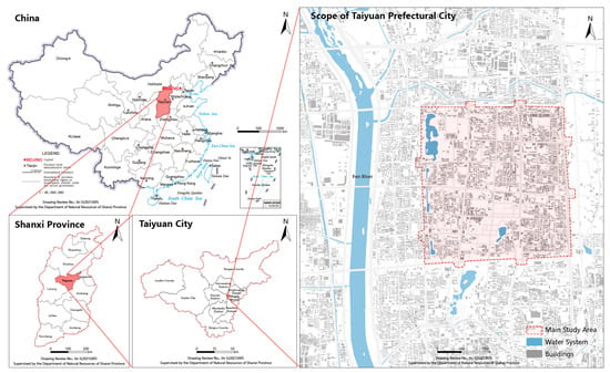
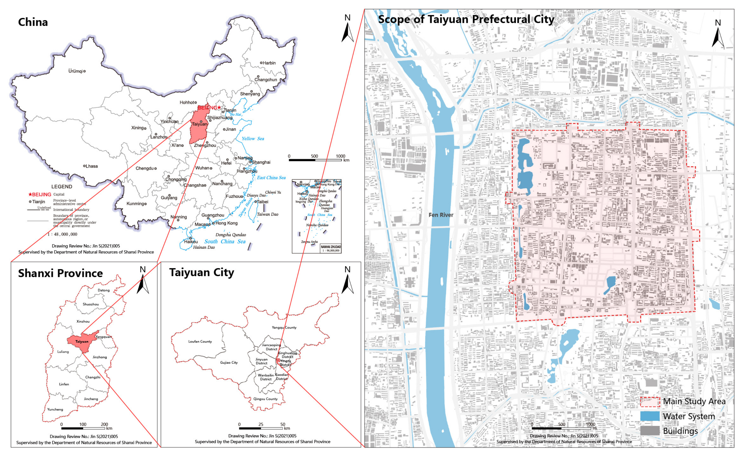
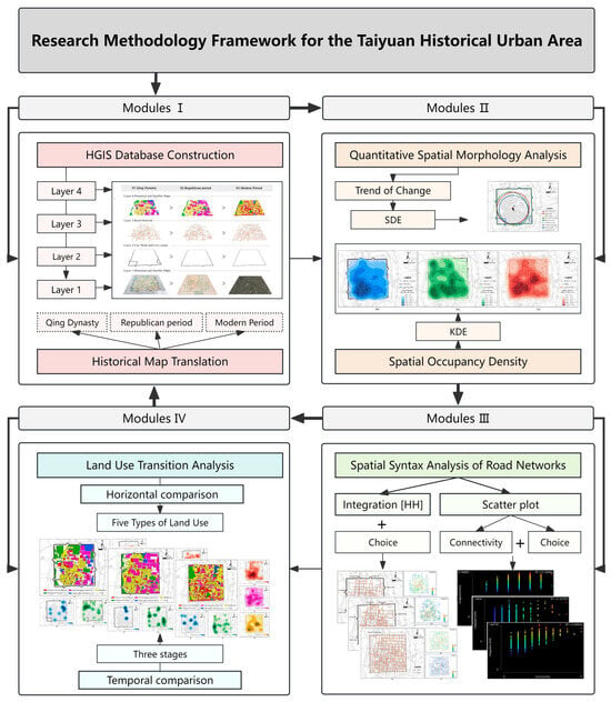
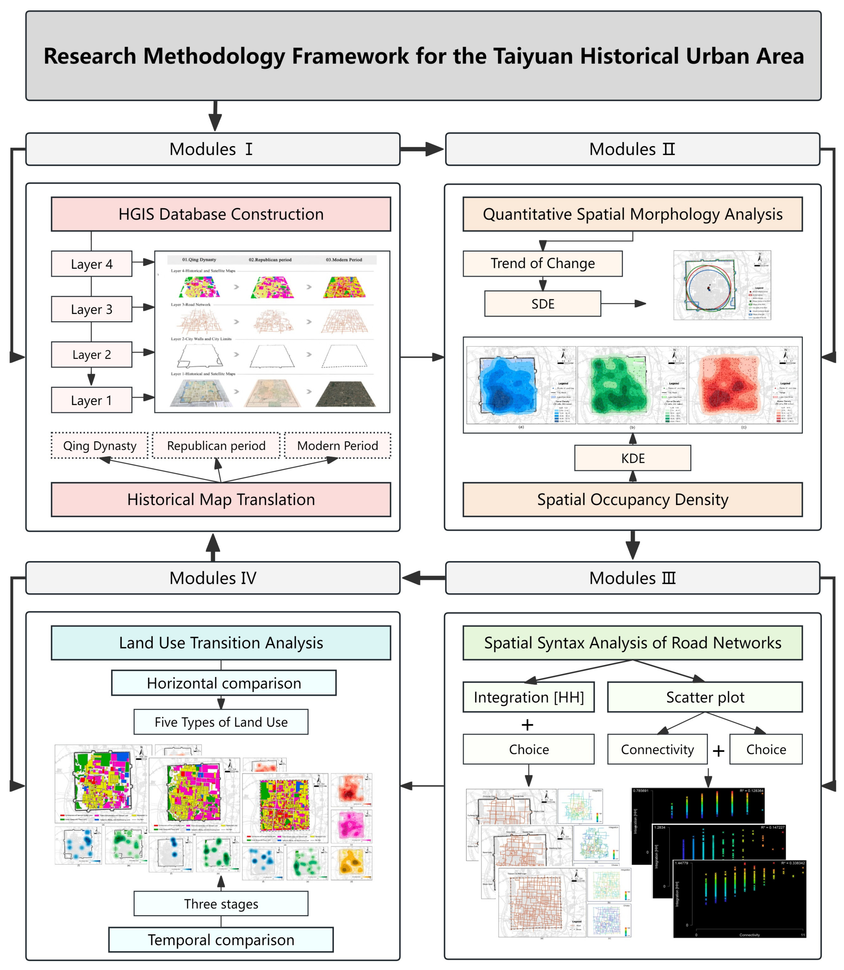
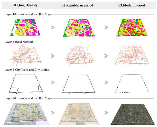
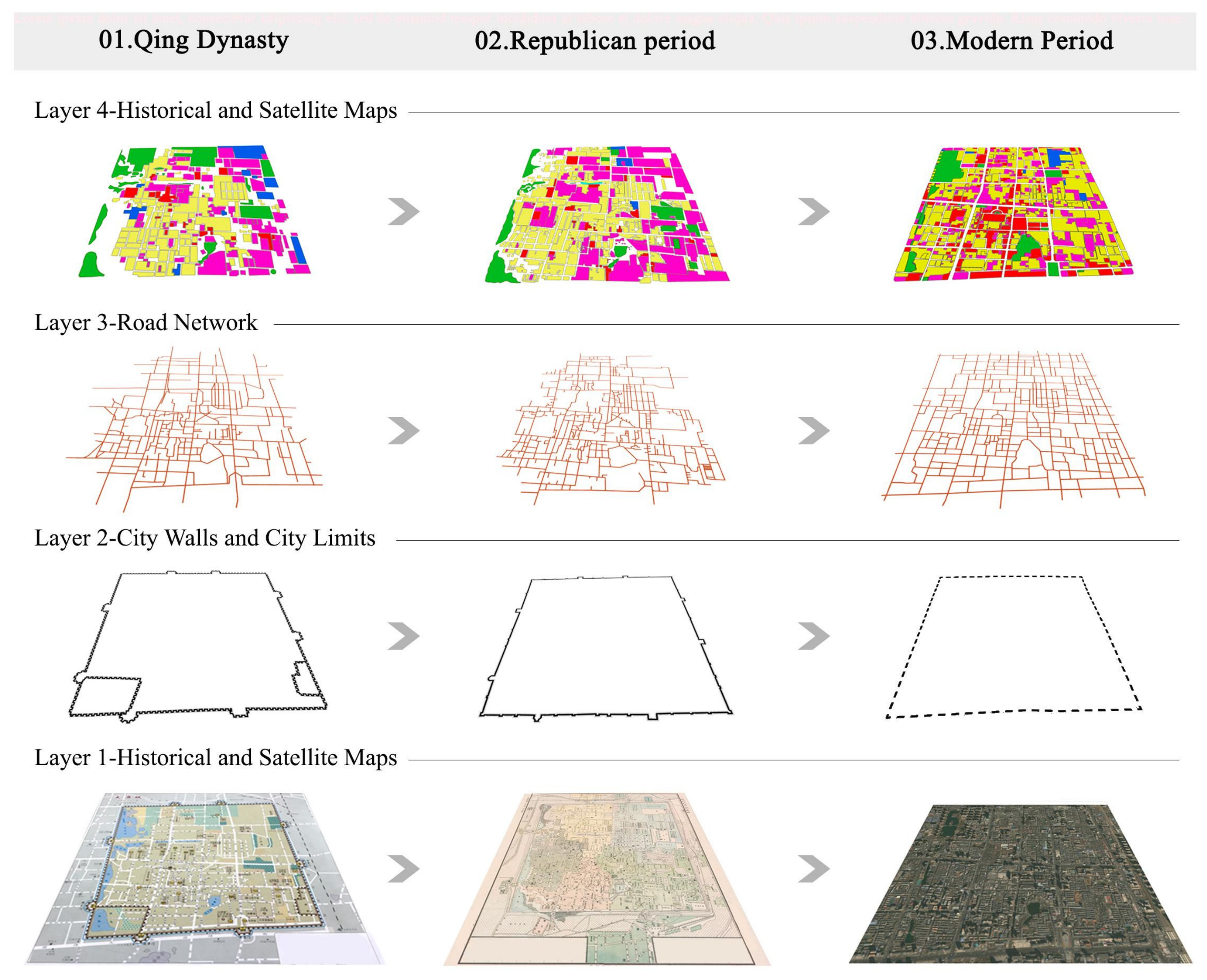
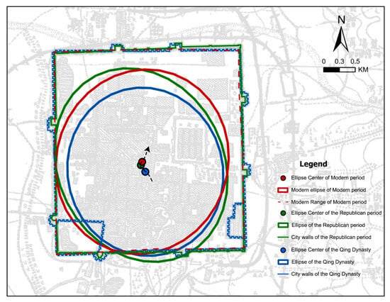
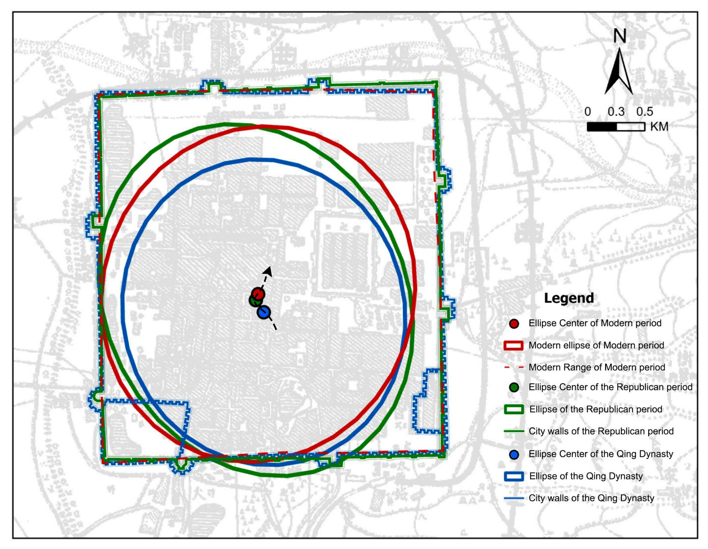
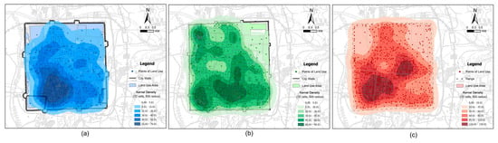
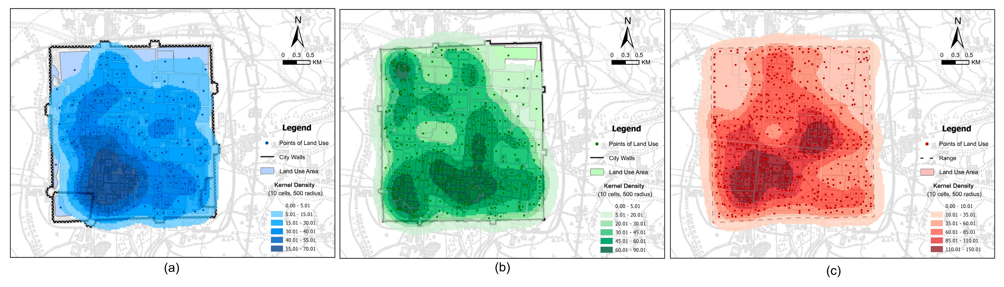
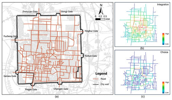
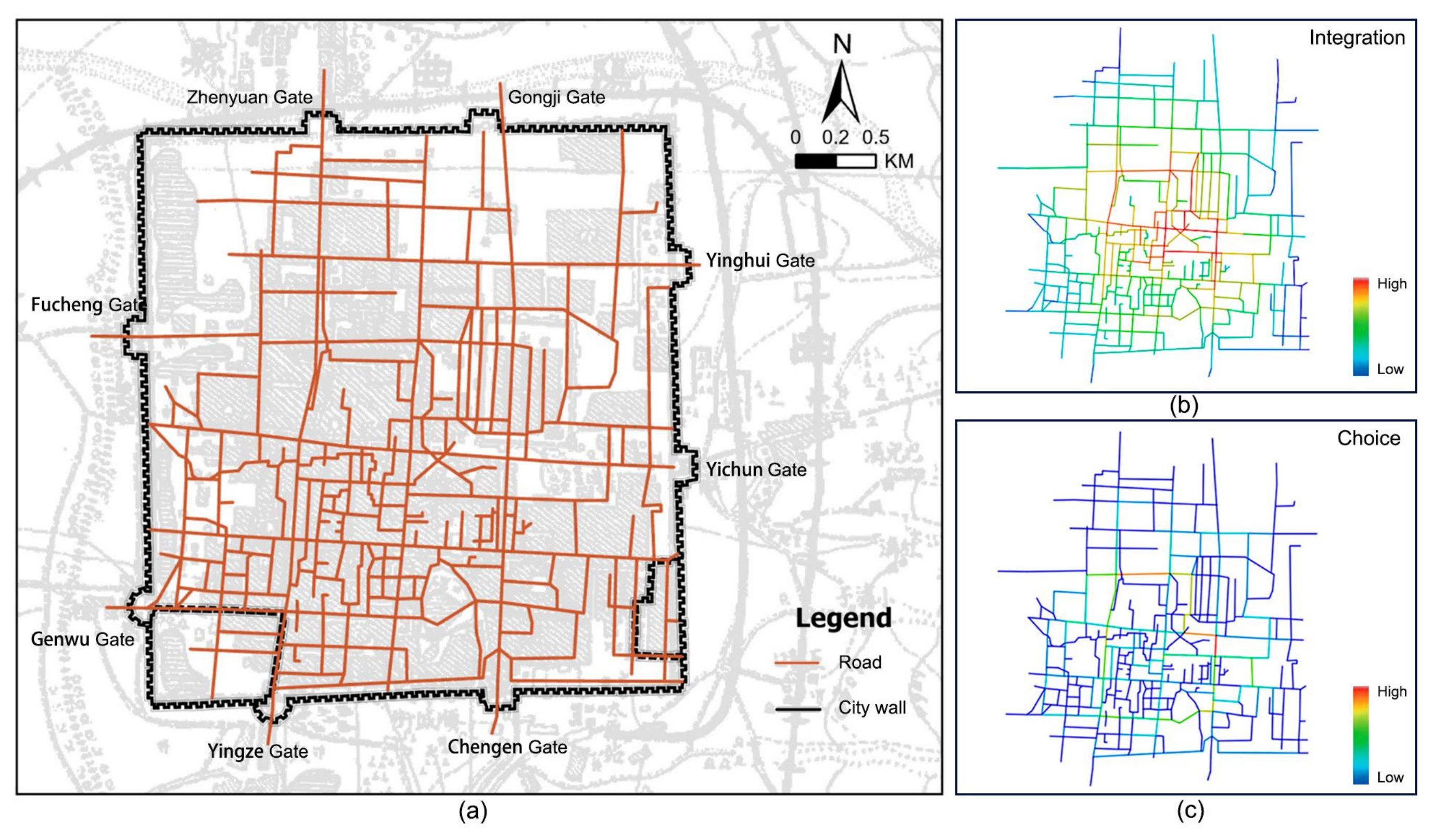
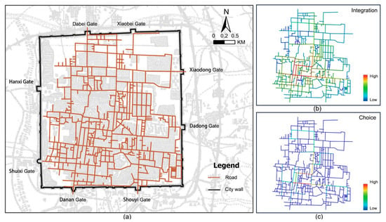
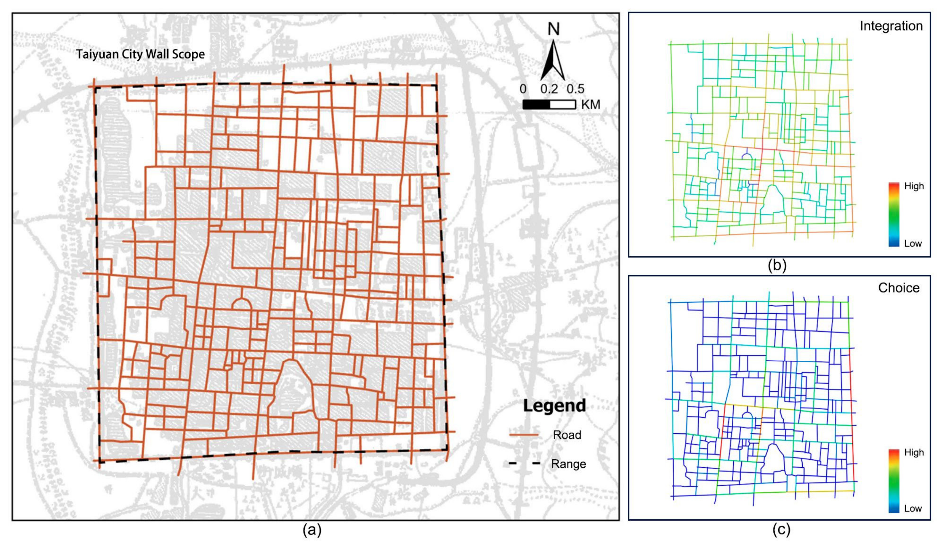
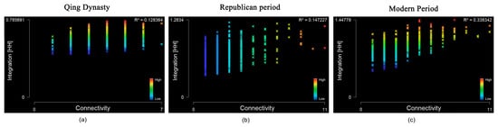
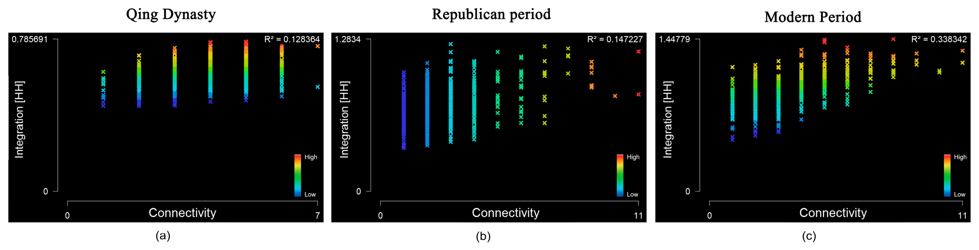
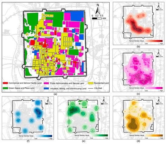
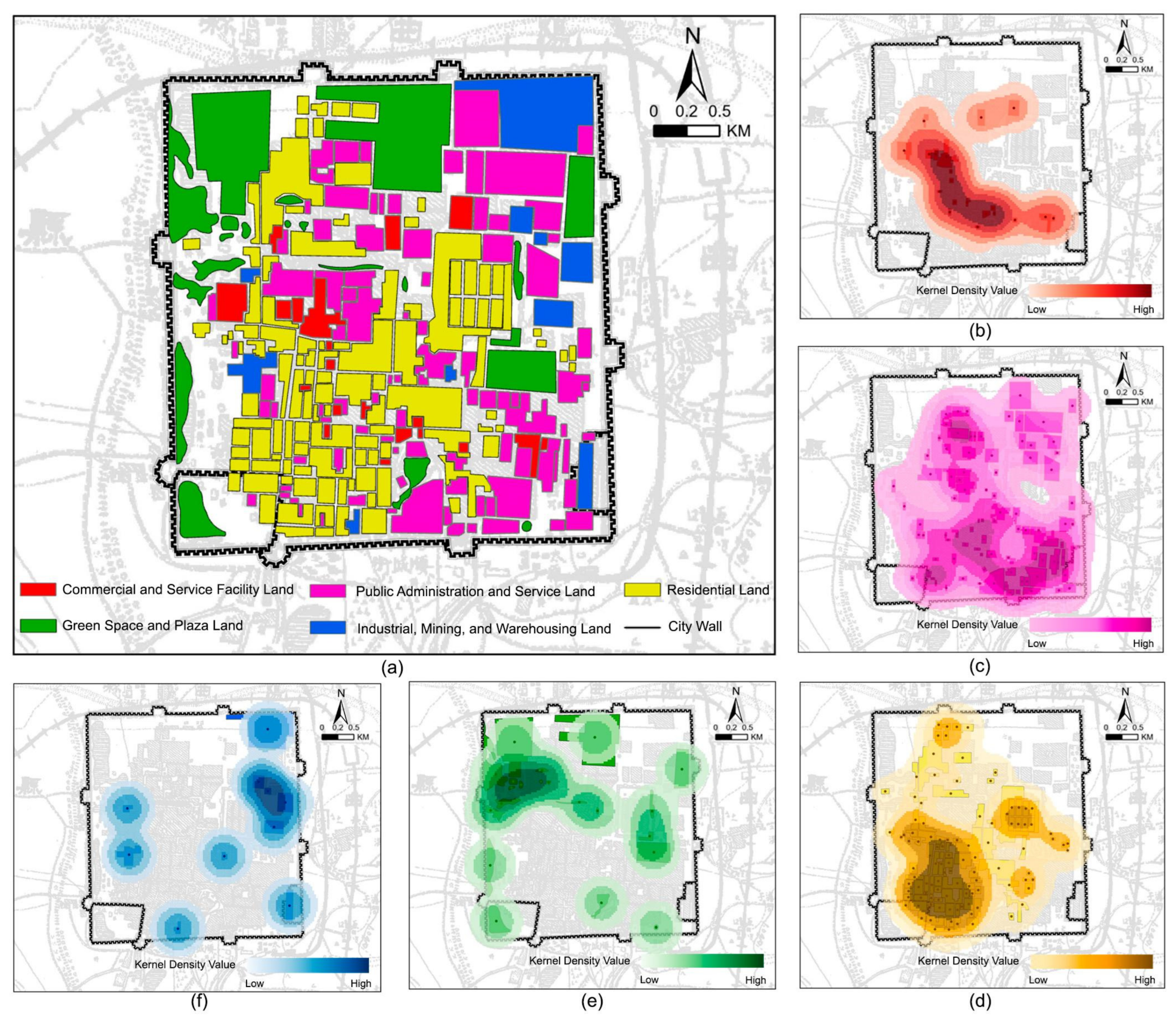
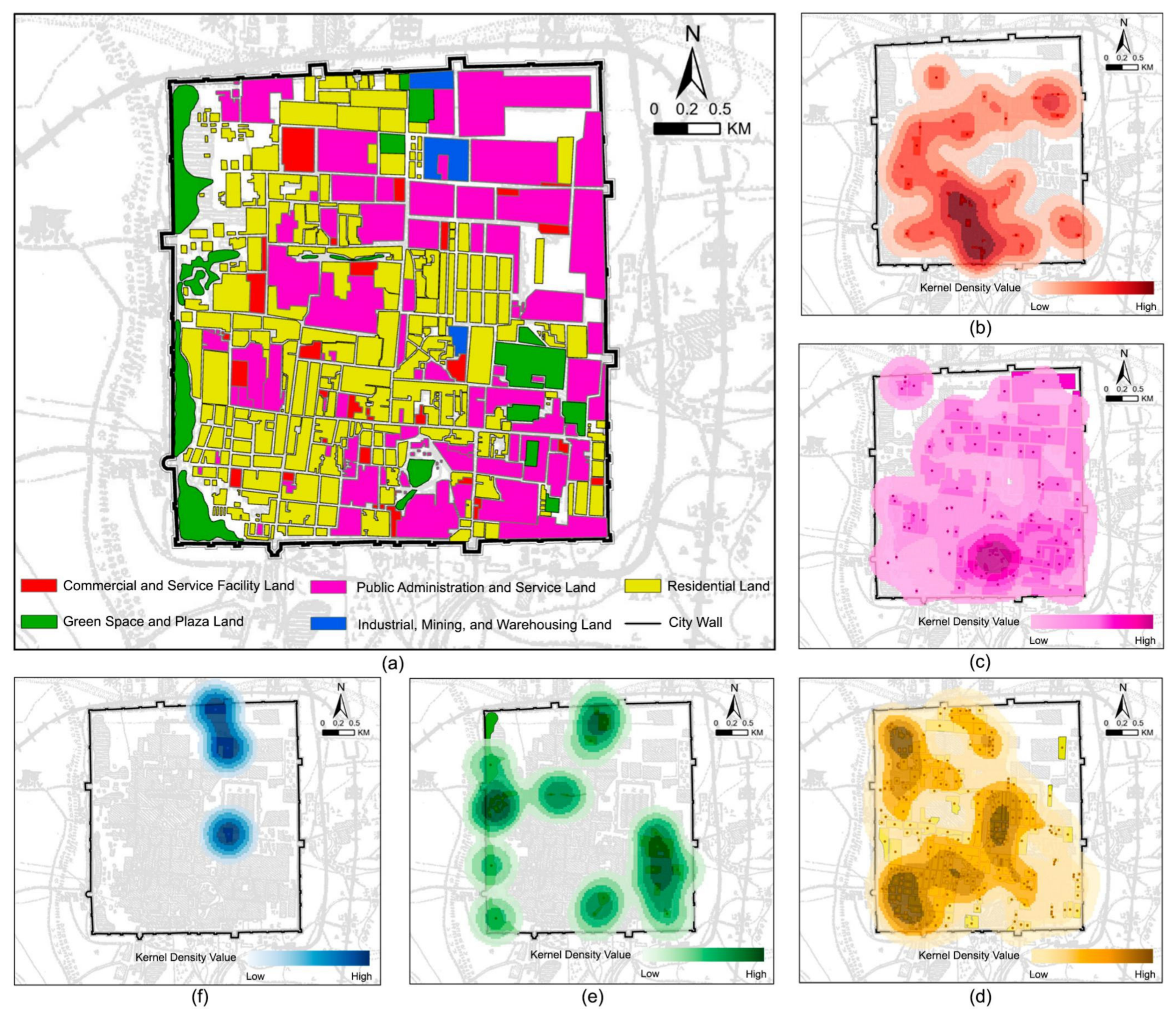
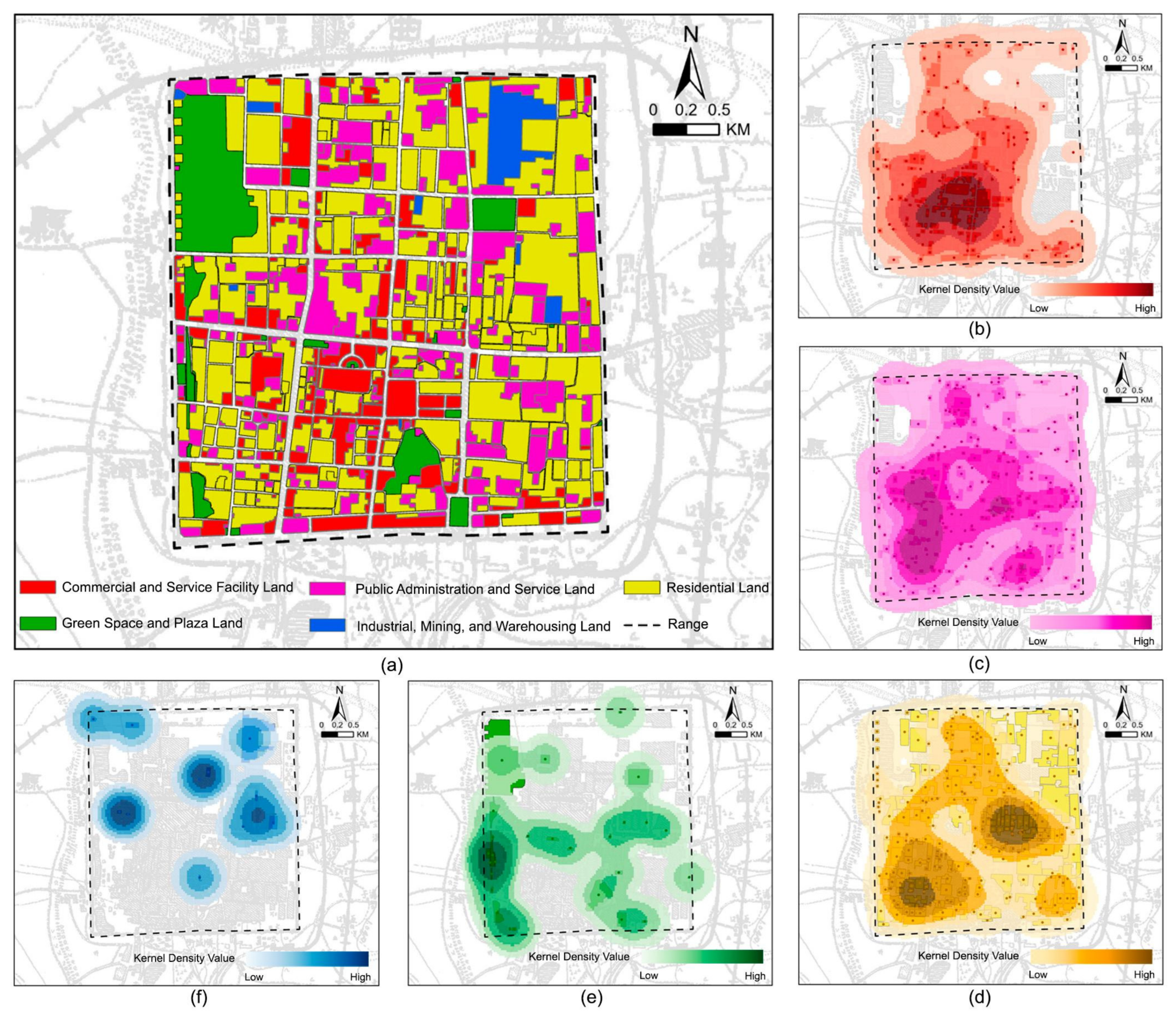
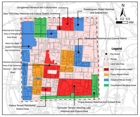
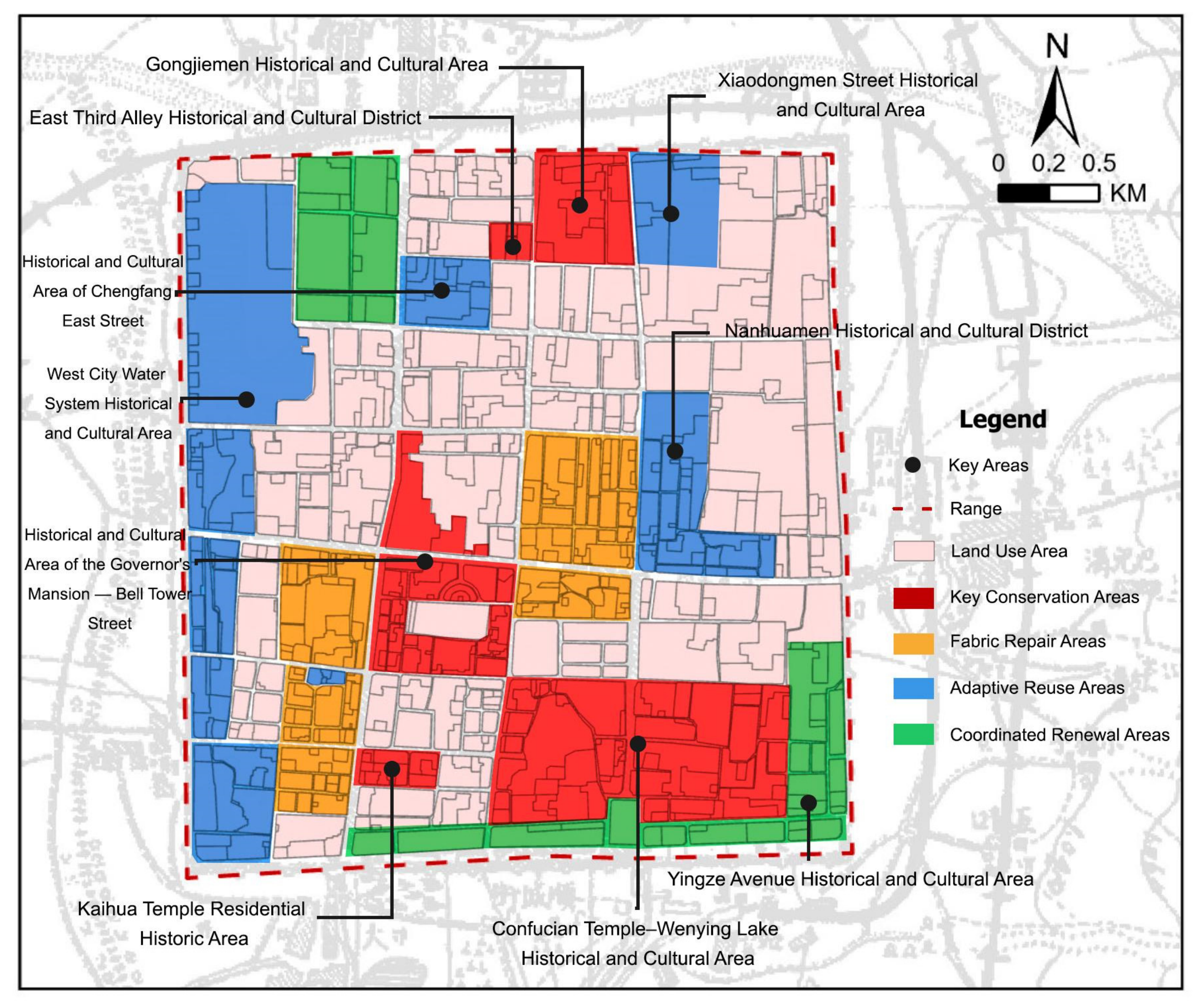
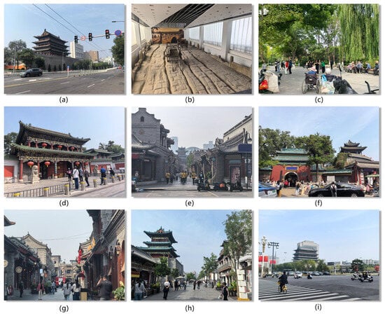
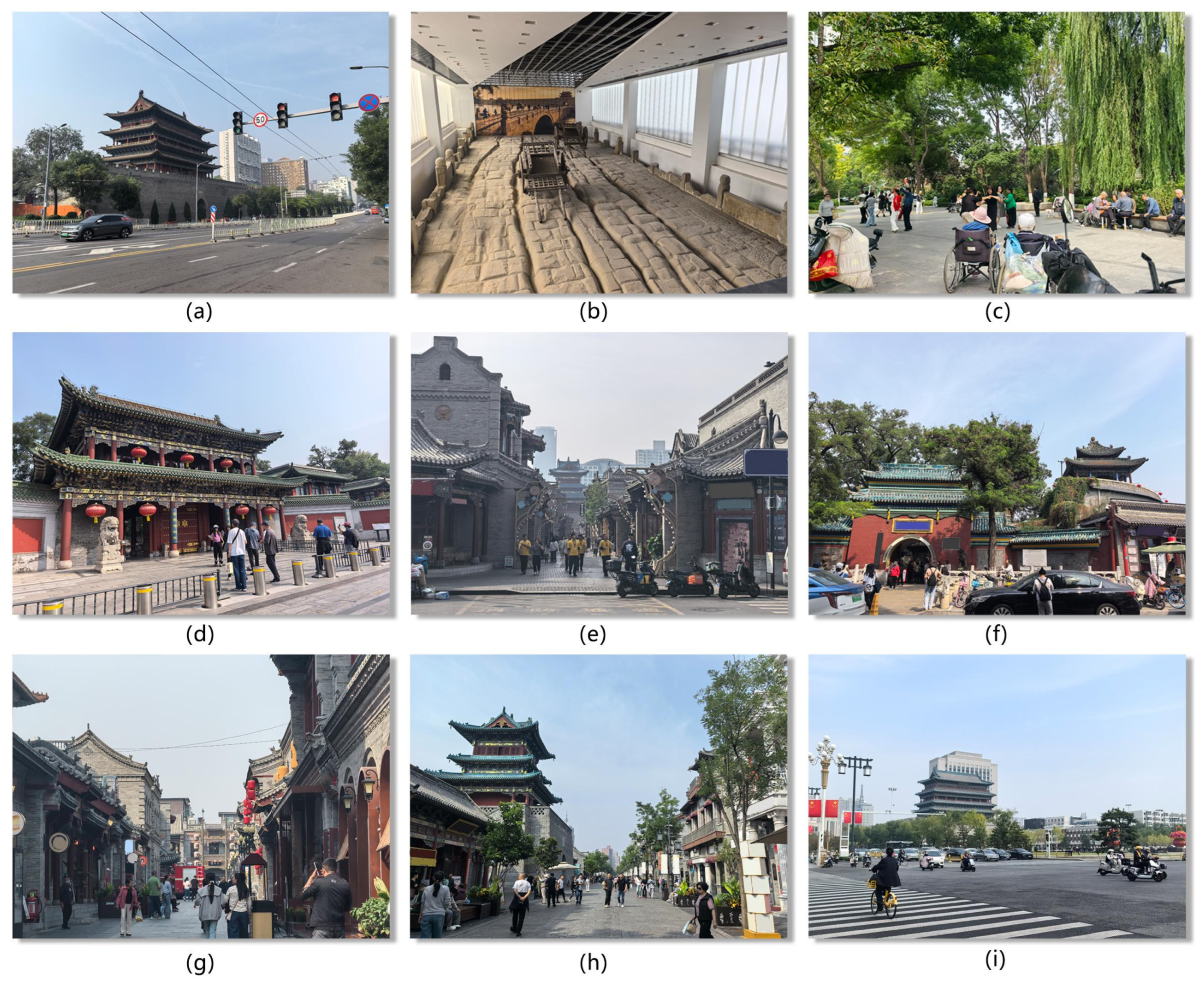

Disclaimer/Publisher’s Note: The statements, opinions and data contained in all publications are solely those of the individual author(s) and contributor(s) and not of MDPI and/or the editor(s). MDPI and/or the editor(s) disclaim responsibility for any injury to people or property resulting from any ideas, methods, instructions or products referred to in the content. |
© 2026 by the authors. Licensee MDPI, Basel, Switzerland. This article is an open access article distributed under the terms and conditions of the Creative Commons Attribution (CC BY) license.