


Abstract
The rise of tourism in historical cities has become a widely observed global phenomenon. As both urban heritage and channels of movement, streets influence the spatial distribution of tourism-related functions. It is important to understand how this influence has evolved over time. This study examines the temporal changes of tourism-related functional spaces in the historical city of Pingyao, China, between 2009 and 2023. During this period, tourism expanded rapidly, while the street network, as heritage, remained stable. Kernel density estimation, space syntax, and Mann–Whitney U tests are used to map functional concentration, quantify street configuration, and test whether the association between them changed between 2009 and 2023. The findings show that street network configuration, through its differentiated movement potential, continuously influenced the spatial distribution of tourism-related functions. However, attraction, commercial, and accommodation functions followed distinct distributional logics that also shifted differently over time. Space syntax indicators were extended into the temporal dimension to track these associations, revealing both their explanatory value and their limitations in this application. Based on these temporal associations, planning and management strategies are offered that may help to better adapt the actual use of streets to their functional potential.
1. Introduction
In historical cities and areas, tourism has become one of the key driving forces for urban renewal and development, bringing about significant influence on spatial restructuring and functional distribution [1]. This transformation exposes a particular tension, as urban morphology and built heritage both attract large tourist flows and bear the intensive use of space these flows generate [2,3,4]. This tension is a widespread challenge, for example, in Prague (Czech Republic) [5], Palma (Spain) [6], and Kyoto (Japan) [7].
Tourism provides crucial economic support for heritage conservation and reuse [8], contributes to improvements in the built environment [9], and serves as a tool for national image building [10]. However, its rapid growth has also generated unprecedented social and spatial pressures, including traffic congestion and the overuse of public spaces [11], and growing inequalities in the urban spatial resource allocation due to capital concentration in tourism-related activities [12]. These pressures have prompted extensive scholarly debate on how tourism can continue to drive the renewal of historical cities while avoiding such spatial overuse [3,4]. These authors identify the necessity of balancing the inherent spatial limitations of historical cities and the continuously expanding spatial demands of tourism development.
In this context, the present study focuses on street networks, which play a dual role in historical cities. On the one hand, as urban heritage, their structural form and historical value directly attract tourists. On the other hand, as channels of movement and accessibility [11,13], they also influence the distribution of functional spaces along them over time. Lefebvre argues that space should not be understood merely as a geographic location or container of action, but that spatial arrangement itself constitutes a productive force that actively shapes the social relations and practices unfolding within it [14,15]. Benjamin illustrates this point through Haussmann’s rebuilding of Paris. By widening and straightening the streets, Haussmann made it difficult for workers to build barricades and confront the ruling class. The long, straight boulevards also made the power of the bourgeoisie visible throughout the city [16]. These examples indicate that the spatial features of the streets reflect class relations and the ruling ideology. At the same time, de Certeau uses the street as an example to show that although streets are planned by urban authorities, individuals can still use and interpret this existing structure in different ways by walking through it [17]. Building on these classical theories, this study argues that the street network should not be understood merely as a physical container for functional space. Rather, its spatial features actively engage with how that space is used, that is, how functions are realized along it, while leaving room for individual practices to vary in how the street network is used.
However, less attention has been paid to how streets’ own spatial features have, over time, influenced the distribution of tourism-related functions. Existing studies typically treat the relationship between street networks and functional distribution as static. Space syntax, a widely used tool for analyzing street configuration, has typically been applied to examine this relationship as a snapshot in time, overlooking how the association between street configuration and functional distribution may evolve over time [18]. Meanwhile, in addressing the overuse of limited historical space, most strategies focus on regulating the intensity of spatial resource use, such as assessing tourist carrying capacity [19], or introducing tourism taxes and short-term rental regulations [20]. The role that street features themselves play in shaping functional distribution has received far less attention and remains underutilized as a means of guiding tourism-related space use.
Therefore, this study focuses on the temporal changes in the relationship between street networks and tourism-related functions in historical cities, using Pingyao (China), a UNESCO World Heritage Site, as a case study. Regulated by heritage conservation policies [21,22], the street network within the walled city has remained configurationally stable over the past three decades, while growing tourism demand has driven the expansion of tourism-related functional space. This stability gives Pingyao dual significance for studying historic city street networks, both methodological and practical. Methodologically, space syntax theory holds that street network configuration determines the distribution of economic activity [23], an influence confirmed in many cases, including studies in Manhattan (US), Barcelona (Spain) [24], and Changsha (China) [25]. However, in these cases, street configuration continues to densify and expand alongside urban development, making configuration itself a continuously changing variable. This makes it difficult to cleanly identify and verify whether the influence of street configuration on functional distribution persists over time. Practically, as a historic city where street form itself is protected as cultural heritage, Pingyao is also representative of the broader challenge facing historic cities in balancing heritage conservation with the pressures of expanding tourism-related functional space.
This study makes several contributions. First, it provides an empirical case examining how the association between this evolving functional distribution and street features changed between 2009 and 2023. Second, based on these temporal associations, it offers planning and management strategies for tourism-related functions. Third, from a methodological perspective, it extends the use of space syntax indicators into the temporal dimension, examining their capacity and limitations in capturing the evolving relationship between street movement potential and the distribution of tourism-related functions.
2. Literature Review
2.1. Static Relationship Between Street and Tourism-Related Function
Street network configuration is closely associated with tourism-related functions through the movement of people, and its role as a channel for movement has attracted increasing attention. One research perspective uses tourists’ actual movement patterns as a proxy to examine this relationship [26,27]. Tourism-related functional spaces typically include attractions, restaurants, accommodation, and tourism-oriented retail services. Studies show that the influence of tourist movement and dwell time on functional spatial distribution varies across functional types. For example, in Madrid, Spain, sightseeing, shopping, and accommodation were found to display differentiated patterns of tourist concentration [28], while in Görlitz, Germany, dining venues were found to cluster in areas with higher tourist flow, with dwell time and walking speed also differing between dining and attraction sites [29]. The close association between certain tourism-related functions and pedestrian flows has also been widely discussed. Commercial activities in particular rely heavily on dense pedestrian flows, as confirmed in Barcelona (Spain) [30], Bologna (Italy) [31], and Buenos Aires (Argentina) [32].
2.2. Space Syntax for Street Configuration and Tourism-Related Function
Space syntax offers an analytical framework for quantifying the movement potential of street networks, grounded in the assumption that people perceive and navigate space through the spatial configuration features of street networks [33]. In space syntax theory, a segment is the basic spatial unit used to compute street configuration features, derived by dividing the street network at each intersection [34]. Configuration, in turn, refers to the relational properties of a street network, specifically, how each segment is connected to all others, determining its relative position within the system as a whole [35,36]. Building on this, Hillier proposed that street network configuration generates differentiated movement potential across streets, which in turn shapes the spatial location of economic activities [23,37]. Given the close relationship between streets and human movement, flow-driven economic activities, including tourism-related functions such as shopping and dining, are closely associated with street networks [38,39].
Although it has been criticized for overlooking key factors in wayfinding and street configuration, such as 3D information and attractors, space syntax still serves as a powerful quantitative tool [40,41]. Empirical studies have widely applied space syntax to examine how street network configuration influences human movement and the spatial distribution of urban functions, including commercial and tourism-related spaces [24,42,43]. In Beijing, China, streets with higher accessibility tend to attract large volumes of tourists [38]. In Lisbon, Portugal, configurational features of the street network impose long-term constraints on the clustering and location of commercial spaces, leading to dynamic patterns of spatial evolution across periods [44]. However, these studies tend to apply space syntax as a static tool, examining the spatial association between street configuration and functional distribution while paying less attention to whether this association changes over time. In other words, street configuration is treated as a fixed consequence rather than as an active, continuously evolving component of functional change.
3. Materials and Methods
3.1. Overview of the Case Study
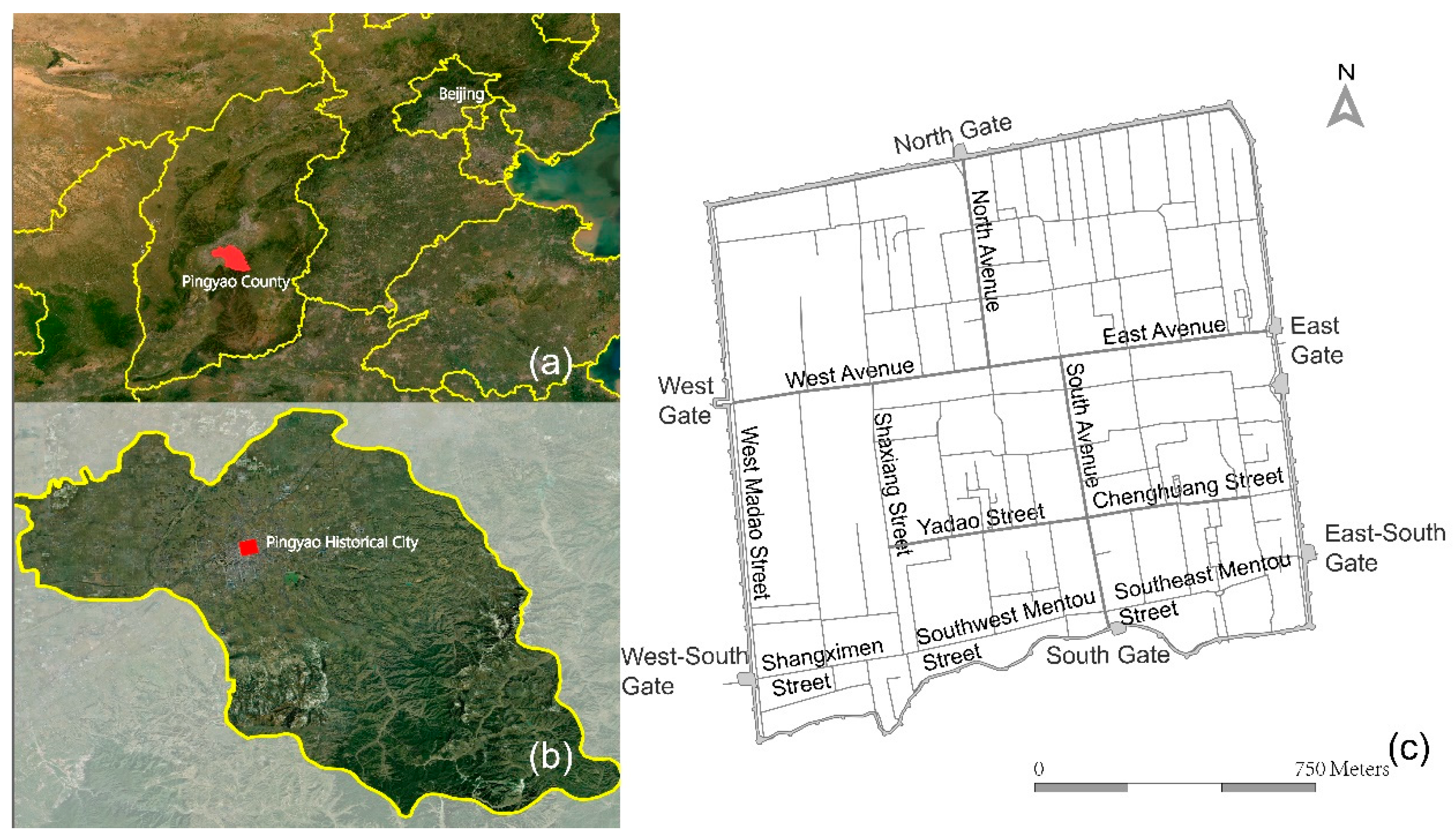
As shown in Figure 1, the study area refers to the ancient city of Pingyao, located in Shanxi province, northern China. The area within Pingyao’s city walls has remained fixed at around 2.25 km2 since its original establishment in the 14th century [45]. The city largely retains its imperial urban structure, featuring well-preserved urban morphology and rich architectural heritage [46,47]. It is enclosed by defensive walls, within which the street network follows a grid pattern. City gates function as key nodes of traffic flows, and the avenues connecting these gates serve as the main streets, namely South Avenue, North Avenue, East Avenue, and West Avenue. South Avenue lies along the city’s central axis and has functioned as the main commercial corridor since the mid-15th century.
Under the constraints of relevant legal regulations, the street network has undergone minimal change since 1985 [47,48]. Based on field survey data and comparisons with historical maps, the overall structure of the street network can be considered stable. Today, tourists predominantly explore the city on foot [49,50]. As this study examines the relationship between street networks and the spatial distribution of tourism-related functions, the street movement potential modeled using space syntax is based on pedestrian movement.
Figure 1.
Location of the study area: (a) location of Pingyao County within Shanxi Province; (b) location of the ancient city of Pingyao within Pingyao County, and (c) the ancient City of Pingyao: boundary outline, street network, and main street names. Source: drawing by the first author based on the administrative map of Pingyao [51].
In 1997, Pingyao was inscribed on the UNESCO World Heritage List, after which its cultural heritage tourism grew rapidly, driven by cultural festivals and conservation initiatives [52], with annual tourist numbers rising steadily to 10.12 million in 2024 alone [53]. This sustained growth has driven a substantial expansion of tourism-related functions within the historical urban fabric. The resulting tension between a stable street network and rapidly evolving tourism-related functional spaces provides a particularly suitable context for examining how functional transformations unfold within a persistent street network.
3.2. Data Collection
This study draws on two types of data: a street network dataset that remains stable in structure, and tourism-related functional space data. Focusing on the period of rapid tourism development, the study examines how tourism-related functional spaces evolved in relation to the street network.
3.2.1. Street Network Dataset Collection
Space syntax theory emphasizes the influence of street network configuration on individual route choice [24]. Within this framework, the angular change and metric distance measures were found to be crucial for quantifying the extent to which individual street segments and their intersections influence potential pedestrian flows [34,54]. To employ these measures, road centre-line data were collected, which were derived from OpenStreetMap (OSM) street vector data (2023), and subsequently refined through fieldwork surveys. Then, the road centre-line network was preprocessed, including geometry repair, removal of duplicate features, and clipping to the study area boundary. And it was converted into a segment-based street network, yielding 618 street segments in total. Space syntax analyses were then conducted in DepthmapX software (v0.8.0). Notably, because the street network remained stable throughout the study period, space syntax values were computed only once and applied uniformly across time.
Previous studies indicate that the influence of street network configuration on movement potential varies depending on factors such as mode of transport and the spatial range of activity, and different space syntax indicators have been developed to capture these varying influences [43,55]. As tourists rely on the overall network structure when navigating unfamiliar environments, this study adopts indicators that capture street network configuration at the global scale, facilitating analysis of tourists’ overall perception of the urban street network [55]. In addition, studies have shown that Normalized Angular Choice (NACH) and Normalized Angular Integration (NAIN) are closely associated with the clustering of commercial, entertainment, and attraction functions, providing further justification for adopting these two indicators [56,57,58]. Furthermore, because both indicators are normalized, they are also suitable for comparing street network configuration across different time periods. Taken together, NACH and NAIN are used in this study to capture tourist movement potential as modeled by the street network, and to examine their associations with the spatial distribution of tourism-related functions.
NACH measures the likelihood that a street segment will be chosen when travelers move from one segment to another within the city; streets with higher NACH values thus serve as frequent, convenient paths [59] that carry larger movement volumes [60], potentially influencing the distribution of functional spaces along them. NAIN measures how close each street is to all other streets within the city network, reflecting its overall accessibility and spatial centrality [59]. A higher NAIN value indicates greater ease of access, which is associated with higher movement presence and the clustering of social and retail activities [23,61]. A prior study has shown that NACH exhibits stronger explanatory power than NAIN for commercial space in particular [62]. However, whether this difference extends to other functional types, and how these associations evolve over time, remains underexamined.
It should be noted that NACH and NAIN capture the movement potential inherent in the street network, modeling the likelihood that streets channel movement based on their configurational relationships, rather than actual tourist flows. Street configuration is also not the sole factor influencing pedestrian movement; land use and associated activities [63], as well as urban wayfinding systems [64], may further attract tourist flows. This study, therefore, treats movement potential as an analytical measure derived from street configurational features, on the basis of which it examines the association between street network and the spatial distribution of tourism-related functional spaces.
3.2.2. Tourism-Related Functional Space
Function refers to the primary uses or activities that occur within space, serving as both an attractor and repellent of people’s movement across different parts of the city [65,66]. In urban tourism research, although strictly distinguishing whether space users are tourists or residents is difficult [13], spatial units that primarily serve tourists in tourism-dominated historical cities can be defined as tourism-related functional space.
Following Ashworth’s classification principles [2], this study categorizes tourism-related functions into three types: accommodation, commercial, and attractions, based on the primary activities each space unit serves. Attractions refer to spaces whose primary function is to attract tourists. The commercial category comprises facilities providing consumer services. The accommodation category includes lodging facilities. The specific examples of each category are provided in Table 1.
Table 1.
Category of tourism-related functions.
3.2.3. Tourism-Related Functional Space Dataset Collection
Data on tourism-related functional space were collected for 2009 and 2023, drawn mainly from land use maps, fieldwork surveys, and satellite imagery. Specifically, the datasets include land use maps [22], field data collected by the first author in December 2023 and January 2024, and Point of Interest (POI) data from 2009 sourced from the Amap Open API (https://console.amap.com/dev/index, access on 20 September 2025), which provides geocoded information on the spatial distribution of urban facilities and functional activities.
Constrained by heritage conservation policies, tourism-related functions in the case area are accommodated mainly within architectural courtyards whose physical scale and morphology have undergone limited structural changes between 2009 and 2023. Accordingly, data were collected as polygon attributes and mapped in a GIS environment, with each polygon representing a spatial unit associated with a primary function and attribute information, including location and functional type, at each time point.
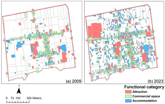
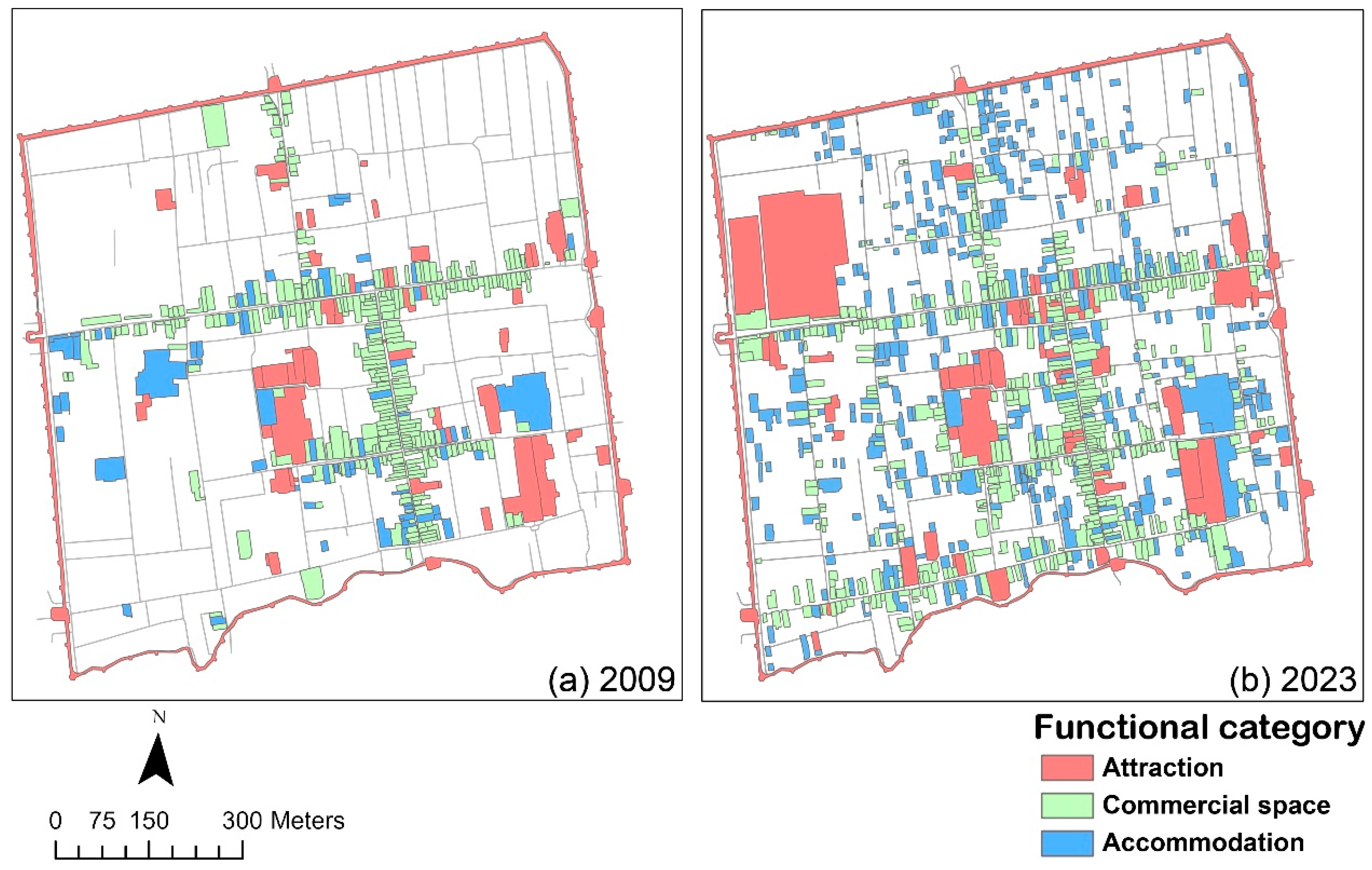
Figure 2 illustrates the spatial distribution of tourism-related functions in 2009 and 2023, respectively. Several limitations regarding functional overlap and data completeness should be noted. First, primary and secondary functions may coexist within a single spatial unit, for example, gift shops within museums, in which case units are classified by their primary function. Second, differences in counting approaches between the two study periods mean that the 2009 dataset, derived from land-use statistics and POI records, assigns a single functional category per unit, whereas the 2023 field survey dataset records multiple functions within the same unit. As a result, 37 units in 2023 host both commercial and accommodation functions. As these represent a small proportion of the total dataset (37 out of 1026 units), their overall impact is limited, and they are excluded from statistical analysis to avoid inaccuracy.
Figure 2.
Spatial distribution of tourism-related functions in 2009 (a) and 2023 (b). Source: drawing by the first author. 2009 data based on land use maps [22] and Point of Interest (POI) data from 2009 sourced from the Amap Open API. 2023 data based on field data collected by the first author in December 2023 and January 2024.
Data collection for this study is subject to certain limitations. Tourism accommodation extends beyond formal hotels and guesthouses to include private residences that have been converted into tourist accommodation, which are difficult to identify reliably from available datasets. Given this constraint, the study does not aim to establish an absolute functional classification of spaces, but instead focuses on the association between the spatial distribution of different types of tourism-related functional space and street features, and on whether this association changes over time.
3.3. Data Analysis
3.3.1. Overall Functional Distribution and Street Configuration
To explore the temporal changes of tourism-related functions, the overall spatial distribution of tourism-related functional space in 2009 and 2023 was compared. These functional spaces were simplified into point features by deriving the centroid of each polygon, and Kernel Density Estimation (KDE) was employed to measure the spatial density and concentration patterns of functions in each period. The results of KDE across the two time periods were subsequently overlaid with space syntax measures to identify temporal shifts in functional concentration patterns in relation to the street network structure.
To examine the temporal relationship between functional distribution and the configuration characteristics of associated streets, this study used street segments derived from space syntax analysis as the basic unit of analysis. Each functional space was first matched to its adjacent street segment based on the location of its primary entrance, and was then assigned the NACH and NAIN values of that segment. This procedure resulted in the construction of a street-segment-level functional dataset.
To confirm whether the distribution of tourism-related functional space is linked to the NACH and NAIN values of street segments, and whether this link differs between the two parameters, street segments were further categorized based on their corresponding NACH and NAIN values. Because NACH and NAIN values of the street network did not change across years, this classification only needed to be performed once. All street segments in this case were first split into High and Low groups by NACH, and split again into High and Low groups by NAIN, using the median of each measure as the cut point. This way, the High and Low groups had an equal number of segments for both measures. Putting these two groupings together yielded four quadrants (HH, HL, LH, LL) for the whole street network. To account for potential differences in street capacity across quadrants, the total street length within each quadrant was also calculated as a reference measure. Because each functional space had already been matched to its adjacent street segment, it accordingly inherited the quadrant classification of that segment. On this basis, the number of street segments hosting tourism-related functional space within each quadrant was counted separately for 2009 and 2023, and normalized by dividing by that year’s citywide total of such segments, yielding the relative share of each quadrant for that year. Finally, differences in these shares among the four quadrants within the same year were compared to assess whether functional space was concentrated in particular types of street configuration, while changes in the share of each quadrant between the two years were compared to assess whether this concentration pattern shifted over time.
3.3.2. Differences in Functional Categories
Tourism-related functions were classified into three categories: attraction, commercial, and accommodation, and the number of each type was counted for every street segment in 2009 and 2023.
To visualise how each functional category relates to street configuration, NAIN and NACH values were grouped into intervals of equal width (NAIN: 0.05-unit intervals ranging from 2.15 to 2.5; NACH: 0.2-unit intervals ranging from 0 to 1.6). For each interval, the relative shares represent the normalized concentration degree of that functional type for that year. This procedure was applied separately for NAIN and NACH, yielding overlaid histograms that enable direct visual comparison of how the association between street configuration and each functional category shifted over time.
The temporal change in the relationship between each functional type’s spatial distribution and street configuration was further quantified. The medians of NACH and NAIN were calculated for the street segments linked to each functional unit (attraction, commercial, and accommodation), for both 2009 and 2023. Since the data were found not to follow a normal pattern (Shapiro–Wilk test), non-parametric tests (Mann–Whitney U) were employed to check whether the NACH and NAIN values of street segments linked to the same functional type differed significantly between 2009 and 2023.
4. Results
4.1. Overall Temporal Change of Tourism-Related Functions
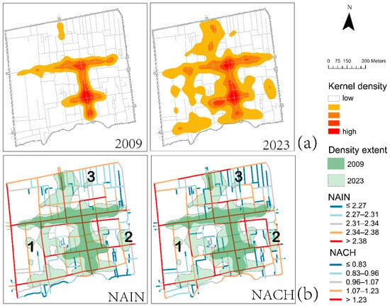
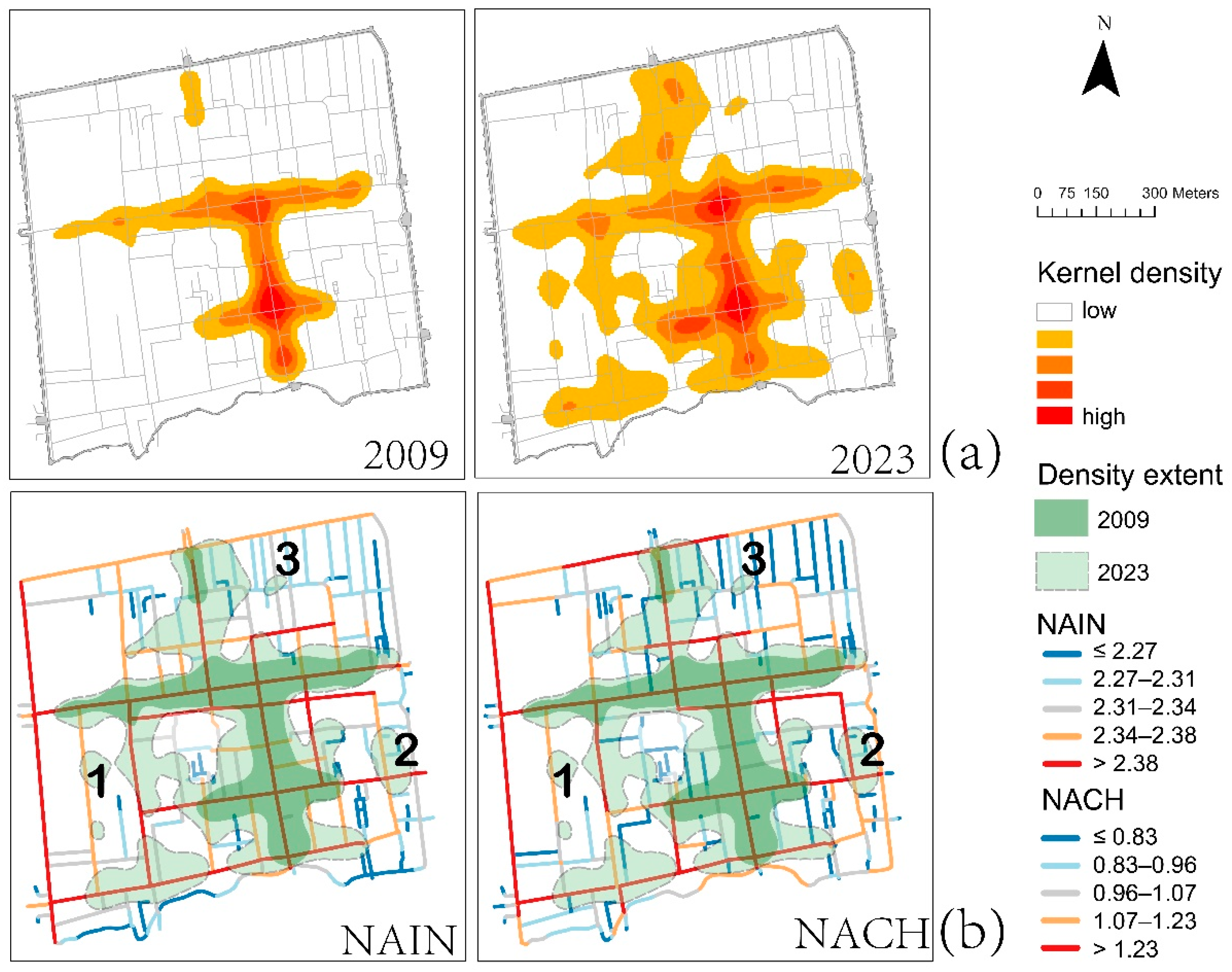
Kernel Density Estimation was employed to analyze the spatial distribution of tourism-related functions (Figure 3). Although a high-density core persisted throughout 2009–2023, its structure and extent changed markedly: functional spaces were concentrated in a few locations in 2009, but had expanded outward by 2023, with medium- and low-density areas broadening substantially. This expansion aligned with street network configuration (Figure 3b): high- and medium-density areas corresponded primarily to street segments with high NAIN (>2.38) and NACH (>1.23) values, indicating that street configuration was significantly related to the clustering and expansion of tourism-related functions over time.
Figure 3.
Spatial distribution of tourism-related functions and street network configuration. (a) Kernel density of tourism-related functions in 2009 and 2023. (b) Spatial extent of tourism-related functional density overlaid with street-level space syntax (NAIN and NACH); labels 1, 2 and 3 indicate tourism functional clusters not associated with high NACH or NAIN values. Note: the number and boundary of these KDE-derived clusters are based on the computation parameters used in this study. Source: drawing by the first author.
However, high NACH and NAIN values are not the sole predictor of tourism-related function clusters. As shown in Figure 3b, locations marked 1, 2 and 3 exhibit notable clustering despite low NAIN (≤2.38) and NACH (≤1.23) values. These areas share a common feature in that their clustering appears to be influenced by proximity to tourist attractions and traffic hubs, such as the city gate (marked 1) or neighboring attractions (marked 2, 3), rather than by street network configuration.
4.2. Temporal Changes in NACH and NAIN
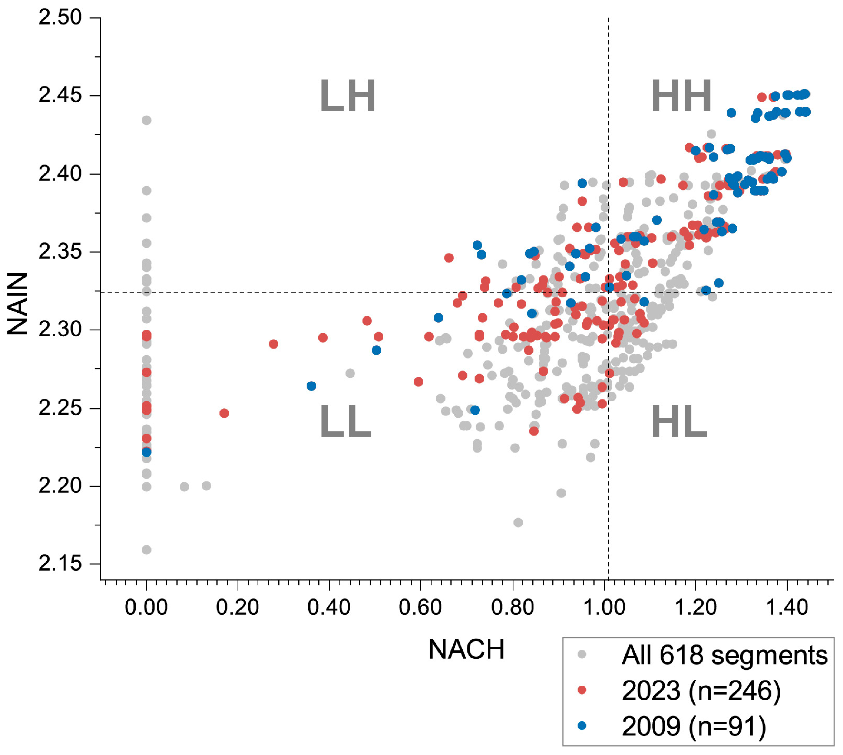
While the KDE results point to a general relationship between functional density and street configuration, a further analysis was conducted to test whether the links differ between NACH and NAIN. Street segments were classified into four quadrants based on the median NACH and NAIN values (1.02 for NACH and 2.32 for NAIN), so that the high and low groups each contain an equal number of segments. Specifically, HH indicates high NACH and high NAIN; HL indicates high NACH and low NAIN; LH indicates low NACH and high NAIN; LL indicates low NACH and low NAIN. Figure 4 shows the distribution of NACH and NAIN values across the street segments on which tourism-related functional space was located in 2009 and 2023, respectively.
Figure 4.
Quadrant distribution of NACH and NAIN values for all street segments and street segments hosting tourism-related functional space, in 2009 and 2023. Dotted lines indicate the median NACH (1.02) and NAIN (2.32) values of all street segments. n refers to the number of street segments hosting at least one tourism-related functional unit in that year.
As shown by the grey points in Figure 4, the street network is concentrated mainly in the HH and LL quadrants. Tourism-related functional space, however, expanded over time, as visualized in Figure 3a. Figure 4 offers a clearer representation of this expansion in terms of street configuration values, showing that the street segments hosting tourism-related functional space were concentrated mainly in the HH quadrant in 2009, whereas by 2023 they had expanded toward quadrants with lower NAIN and NACH values.
Table 2 further compares the share of street segments, the share of street length, and the share of tourism-related functional space in each quadrant. Here, the share of street segments refers to the proportion of all street segments falling within each quadrant of NACH and NAIN values while the share of street length refers to the corresponding proportion of total street length. The share of tourism-related functional space refers to the proportion of tourism-function street segments falling within the same quadrants, relative to the citywide total of such segments. By comparing these two shares, this analysis clarifies whether tourism-related functional space exhibits a distributional preference across NACH and NAIN values.
Table 2.
Distribution of tourism-related functional space across NACH and NAIN quadrants, 2009 and 2023.
Table 2 shows that street segments are generally distributed within HH and LL quadrants, each accounting for 37.70% of the total. The corresponding share of street length varies across the four quadrants: HH accounts for the largest share (46.38%), indicating greater capacity, whereas the length shares of the other three quadrants remain close to their respective shares of street segments. In both years, tourism-related functional space was concentrated in the HH quadrant, far beyond its corresponding share of street segments: 88.30% in 2009 and 76.66% in 2023. In other quadrants, by contrast, tourism-related functional space accounted for a smaller share than street segments and street length did, showing that such functions tend to concentrate on streets with high NACH and high NAIN values.
In addition, although HL and LH share the same proportion of street segments, LH’s share of street length is nearly double that of HL (14.62% versus 7.65%), indicating that LH does offer greater capacity for tourism-related functions. In 2009, only 0.10% of tourism-related functional space fell in HL, compared with 6.47% in LH. By 2023, the figures were 1.94% for HL and 8.02% for LH. This gap is far larger than the twofold capacity difference alone can explain, showing that street accessibility also has a significant influence. This indicates that tourism-related functional space rarely settles on streets with high through-movement potential but poor accessibility. However, it is still found on streets with poor through-movement potential but high accessibility. In other words, when NACH and NAIN diverge, tourism-related functions tend to concentrate on streets with high accessibility.
In summary, tourism-related functional space remained most concentrated in the HH quadrant throughout the study period, though its share declined from 88.30% in 2009 to 76.66% in 2023, while the shares of all other quadrants increased, most notably in LL. This indicates that, over time, although HH streets remain the most concentrated location for tourism-related functions, the relationship between functions and street configuration is increasingly differentiated. The following section will therefore examine, for different types of tourism-related functions, the relationship between functional distribution and the street network.
4.3. Transition Patterns of Tourism-Related Functional Categories
This section examines the numbers and spatial distribution of commercial, accommodation, and attraction functions, and their association with street configurational properties, across 2009 and 2023.
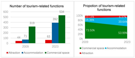
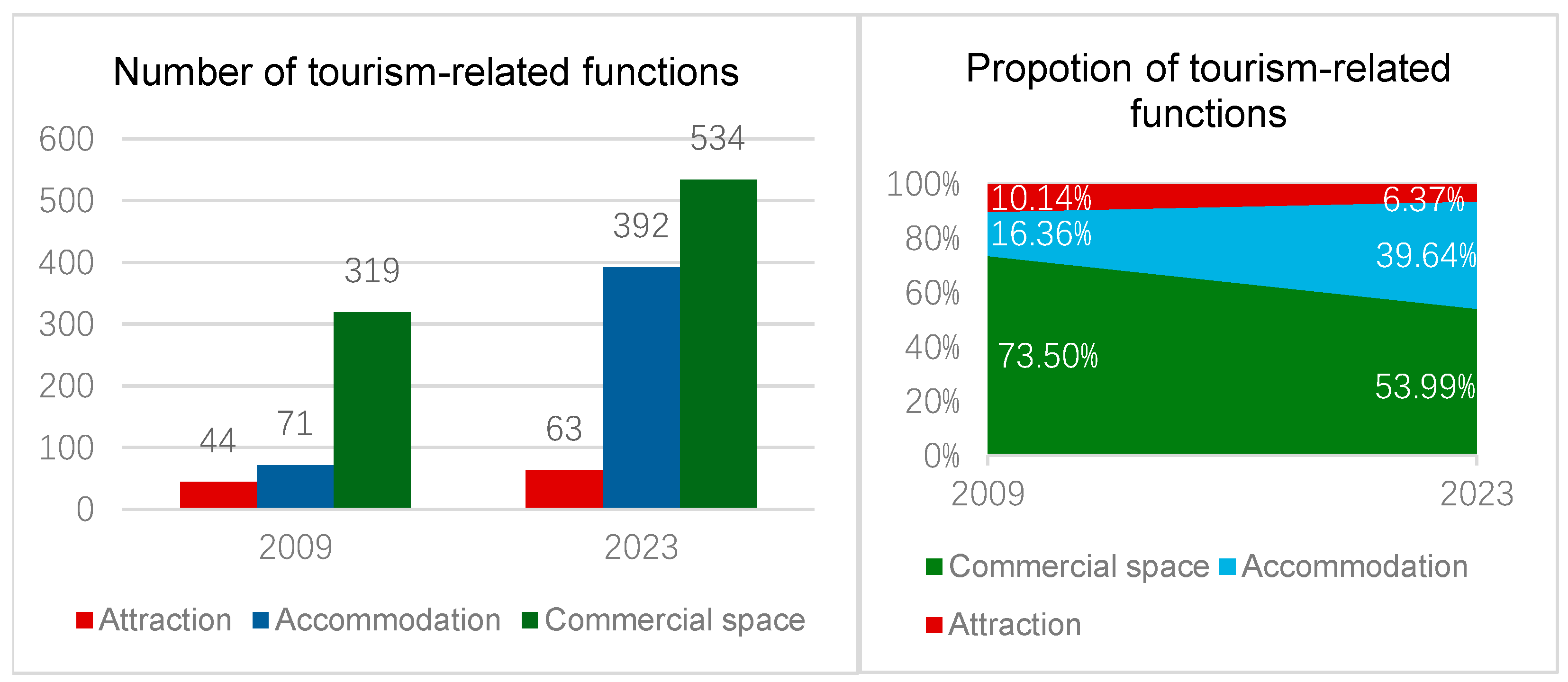
A total of 434 tourism-related functional spaces were identified in 2009, rising to 989 by 2023. As shown in Figure 5, all three categories grew at different rates: commercial spaces increased from 319 to 534, though their share declined from 73.50% to 53.99%; accommodation spaces saw the greatest growth, rising from 71 to 392 (16.36% to 39.64%); while attraction spaces remained the smallest category. Their count grew from 44 to 63, but their share of the total fell from 10.14% to 6.37%. These changes reflect not only overall numerical growth, but also a structural shift in function.
Figure 5.
The number and proportion of tourism-related functions in 2009 and 2023.
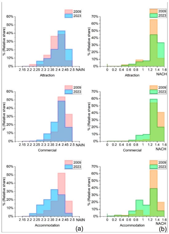
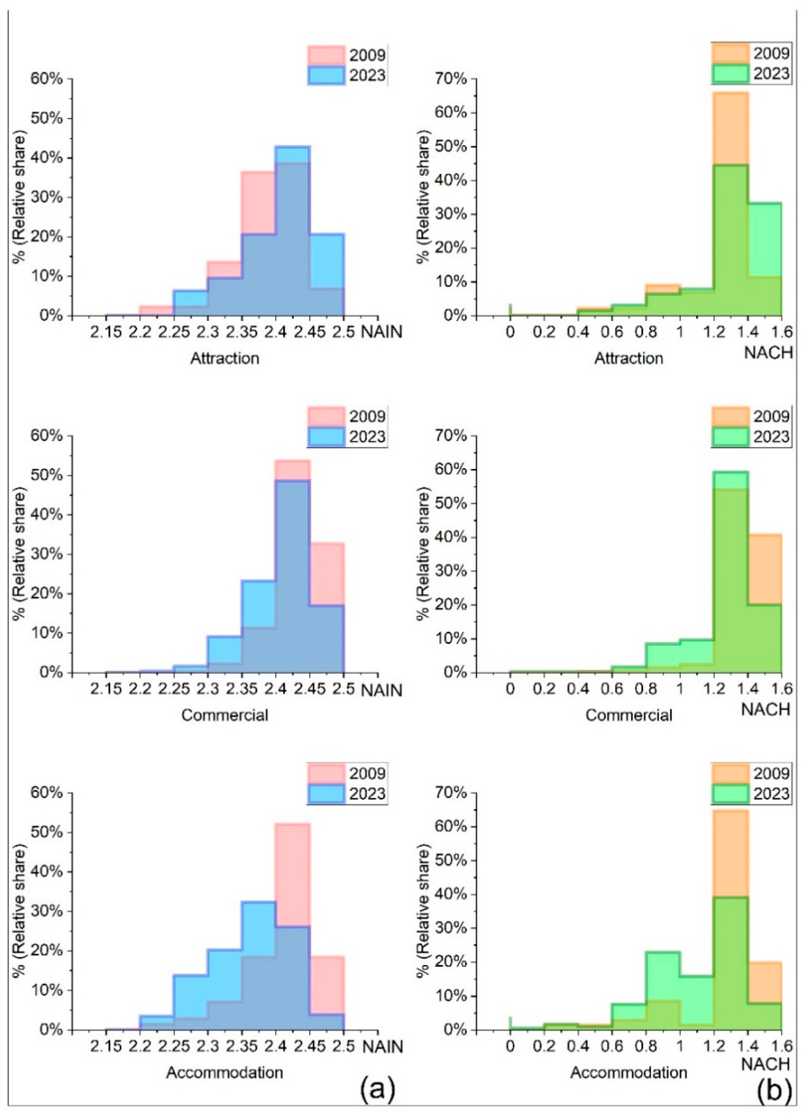
Figure 6 shows the relative concentration of each functional type across the full range of NAIN and NACH values. Because the total number of tourism-related functions varies across categories and over time, proportions were then used to allow comparison across functional types and years. The y-axis represents the proportion of each functional type per street segment relative to the citywide total of that function in the corresponding year.
Figure 6.
Relative share of attraction, commercial, and accommodation functions across street segments in relation to street-segment NAIN (a) and NACH (b) values, in 2009 and 2023.
From Figure 6, it can be seen that the association between the three functional categories and street configuration follows distinct temporal trajectories. Attraction spaces tend to be distributed along streets with higher accessibility and through-movement potential. The highest-value range showed the largest increase in share among all value ranges for both dimensions, rising by 22% for NACH (1.4–1.6) and 14% for NAIN (2.45–2.5). Table 3 confirms this trend, with the NAIN median rising from 2.395 to 2.413, whereas the corresponding increase in NACH did not reach statistical significance (p = 0.051).
Table 3.
Comparison of NACH and NAIN values of street segments hosting tourism-related functions between 2009 and 2023 (Mann–Whitney U test).
Commercial spaces continued to be concentrated along streets with high through-movement potential and accessibility, though their distribution gradually diffused toward secondary-configuration streets over time. As shown in Figure 6, over 80% of commercial space was clustered within a NAIN range of 2.4–2.5 and a NACH range of 1.2–1.6 in 2009. By 2023, the highest sub-ranges had declined by over 15% for NAIN (2.45–2.5) and 12% for NACH (1.4–1.6), with lower sub-ranges increasing correspondingly in both cases. Table 3 confirms this trend, with both medians declining significantly (NAIN from 2.440 to 2.412 and NACH from 1.396 to 1.342, both p < 0.001).
Accommodation spaces were initially concentrated along streets with high through-movement potential and accessibility, but their dependence on high street configuration declined markedly over time. As shown in Figure 6, accommodation space was clustered within a NAIN range of 2.4–2.45 (53%) and a NACH range of 1.2–1.4 (65%) in 2009. By 2023, the second-highest sub-ranges had declined by 26% for NAIN (2.4–2.45) and 35% for NACH (1.2–1.4), with lower sub-ranges increasing correspondingly (NAIN: 2.25–2.4; NACH: 0.6–1.2). Table 3 confirms this trend, with both medians declining significantly (NAIN from 2.412 to 2.362 and NACH from 1.354 to 1.084, both p < 0.001).
Taken together, both commercial and accommodation functions shifted toward streets with lower accessibility and through-movement potential (their Δ Median values in Table 3 are negative). Specifically, commercial’s decline was comparatively slight (ΔNACH = −0.054, ΔNAIN = −0.028), while accommodation exhibited the most pronounced shift (ΔNACH = −0.270). Attraction spaces, by contrast, shifted toward streets with higher accessibility and through-movement potential (Δ Median values are positive). These changes in category help explain the differentiated pattern across quadrants shown in Table 2. Accommodation grew faster than any other category. It showed the most pronounced shift toward the LL quadrant, and this shift accounts for much of the increase in that quadrant’s share. By contrast, commercial spaces remained concentrated on high-configuration streets, although this concentration gradually diffused over time. This continued concentration helped the HH quadrant stay dominant, even as its overall share declined.
Notably, a small proportion of accommodation and attraction spaces, but no commercial spaces, are located along the streets with 0 NACH values (see Figure 6b). These streets correspond to dead-end or isolated segments with no through-movement potential. This distinction suggests that a portion of accommodation and attraction spaces operate as route destinations, attracting visitors through deliberate access rather than passing-by flows. Commercial spaces, by contrast, appear to require passing-by traffic to operate.
These findings form the basis for the planning classifications presented in Section 5.3. For example, the relative share of commercial space per street segment in 2023 could be used to assess whether high-configuration streets have sufficiently attracted commercial activity. Segments were classified into three concentration levels using the Natural Breaks (Jenks) method, with high concentration defined as a relative share exceeding 0.0193, while segments below this value were classified as moderate to low concentration.
5. Discussion
5.1. Contributions and Limitations of Space Syntax
The findings of this study validate the established view that street network configuration influences economic activities through movement potential, and further provide new empirical evidence from a temporal dimension. As the street network remained stable, space syntax variables, NACH and NAIN, continued to predict the distribution of tourism-related functions along them. This indicates that the impact of street configuration on functional distribution is not a static or one-time constraint, but a continuous influence that persists over time while becoming differentiated across functional types.
In space syntax, NACH represents through-movement potential, and NAIN represents street accessibility [23,61]. This study found a high overlap between the NACH and NAIN values of street networks, with streets where both values are simultaneously high or simultaneously low, together comprising over 74% of the total. In other words, streets with high accessibility in this case are highly likely to be streets more readily selected as through routes. This can be attributed, according to space syntax theory, to the city’s grid layout, which is more easily comprehended by travelers, leading to a high overlap between route choices and accessibility [34]. This overlap between differently configured streets, in turn, causes tourism-related functions governed by different locational logics to be distributed on the same streets. In this case, commercial spaces, which depend more on passing-by flow, and attraction spaces, which depend more on high accessibility, despite following different locational logics, are similarly concentrated on HH streets.
Differences between NACH and NAIN values within the same street network have also been identified in the case of Shichahai, Beijing, where these two space syntax indicators were found to coincide at the global scale but diverge at the local scale across historical periods [67]. A comparative study of four Chinese historic towns, including Pingyao, similarly found that the function aggregation correlates more strongly with integration (which NAIN normalizes) than with choice (which NACH normalizes), though without accounting for why [62]. Our findings extend their results by inferring this reason and showing that NAIN is a stronger predictor of tourism-related functional distribution than NACH. Specifically, more tourism-related functions were located on streets with poor through-movement potential but with high accessibility (LH) than on streets with the reverse pattern (HL). As shown in Table 2, the difference in street length between these two quadrants is about twofold, far smaller than the resulting gap in functional space, indicating that street length is not the sole reason for this divergence, and that accessibility is also an important factor. After breaking down by functional category, this tendency becomes more specific. Along streets with an NACH value of 0 (i.e., dead-end or isolated segments), only attractions and accommodation spaces were present, while no commercial spaces appeared. This extreme case shows that attraction and accommodation spaces can exist on streets with low through-movement potential, while commercial spaces remain dependent on passing-by flow, a pattern that may explain why NAIN better predicts tourism-related functional distribution overall.
It should be noted that NACH and NAIN capture the movement potential inherent in the street network, modeling the likelihood that streets channel movement based on their configurational relationships, rather than actual tourist flows. Street configuration is also not the sole factor influencing movement; land use and associated activities [63], as well as urban wayfinding systems [64], may further attract tourist flows. This is also observable in the present case. As shown in Figure 3b, localized clustering along low-NAIN and low-NACH segments suggests that, alongside the overall preference for high-accessibility streets discussed above, transport hubs and attraction spaces can also attract tourism-related functional clusters.
5.2. Temporal Change of Tourism-Related Functions
Overall, the results show that the spatial distribution of tourism-related functions expanded over time, and this expansion was closely associated with street NACH and NAIN values. A large proportion of tourism-related functions remained concentrated along streets in the core area (the HH quadrant), confirming that Pingyao’s stable street network has kept this core of tourism-related functions in place. By contrast, in the Changsha case, as the street network expanded and grew denser over time, the accessibility of the old city declined, and new economic centers emerged elsewhere [25]. At the same time, functions increasingly spread beyond this core, with the share in the LL quadrant increasing the most, indicating emerging internal differentiation in how tourism-related functions relate to street configuration.
Divided into attraction, commercial, and accommodation functions, each category shows a distinct trend over time in both quantity and spatial distribution. In terms of numerical growth, accommodation increased the most, followed by commercial spaces, while attraction spaces increased the least. This can be attributed to their differences in spatial scale, operational actors, and decision-making processes. Commercial spaces and small guesthouses are typically operated by individual entrepreneurs and can respond quickly to market demand [2,68]. In contrast, attraction functions are largely associated with cultural heritage, managed by collective organizations or government authorities [22]. Their designation and renovation typically require complex approval procedures and substantial investment [69], which constrains the pace at which attraction functions can grow. For instance, in this case, Yide Guesthouse, a residential courtyard of approximately 1500 m2, was converted into a functioning guesthouse within a year [70]. By contrast, the Rishengchang Draft Bank, now functioning as a heritage museum of comparable scale (1402 m2), underwent a restoration process spanning 15 years [71].
In terms of spatial distribution, the relationships between the three tourism-related functional categories and street configuration followed distinct trajectories in both direction and magnitude over time. Attraction spaces exhibited the smallest change, with their distribution concentrating further along high-configuration streets; the other two categories shifted in the opposite direction. Commercial spaces remained largely dependent on high-configuration streets overall, showing only a slight diffusion toward secondary streets. Accommodation spaces exhibited the most pronounced change among the three categories, shifting substantially toward lower-configuration streets. This divergence did not stem from any structural change in the street network itself, but rather reflects differences in the locational logic of the three functional categories.
This pattern in the distribution of attraction spaces echoes explanations offered in prior research. Attractions located on highly accessible streets are more likely to gain visitor attention and exposure, which raises their public recognition and attracts subsequent development investment [72].
That most commercial spaces remained concentrated on high-NACH, high-NAIN streets over time is consistent with prior research, which emphasizes commercial spaces’ dependence on through-movement flows [31,57,73], and sustained pedestrian activities associated with short-stay visits [58].
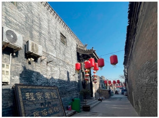
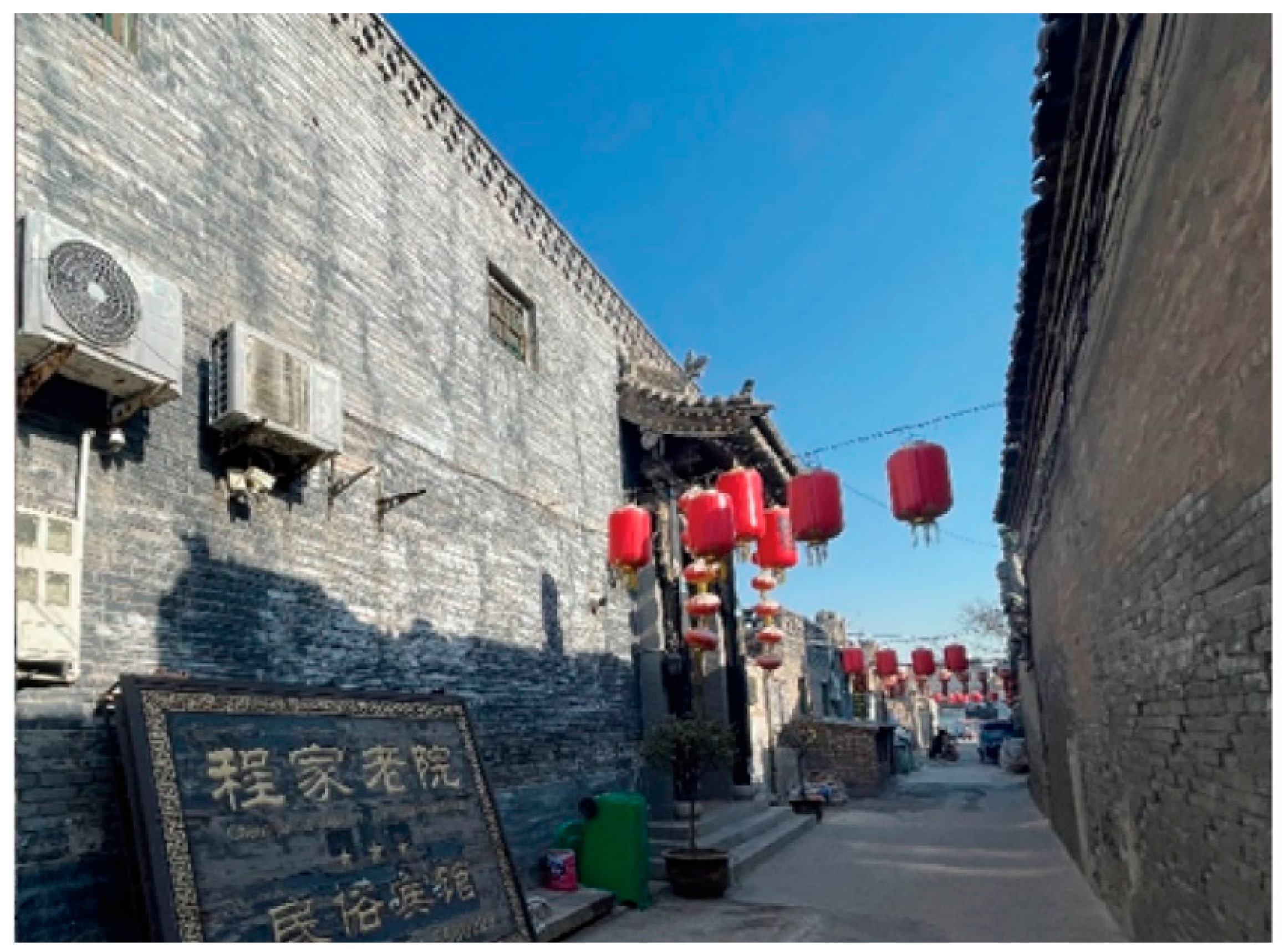
While prior studies suggest that accommodation spaces are weakly related to street accessibility [62,74], this study finds that the locational preference of accommodation spaces shifted markedly over time. Accommodation was initially concentrated on higher-configuration streets, but as the number of units grew substantially over the study period, it increasingly spread toward lower-configuration streets. Drawing on field observations, two complementary factors may help explain this shift in locational preference. First, accommodation functions are characterised by long stays and limited spatial capacity [2], making pedestrian flow less critical in location selection than it is for commercial spaces. Second, historical courtyards away from main streets tend to meet growing tourist demand for cultural experiences [67,75]. Consistent with this, accommodation along lower-configuration streets is mostly guesthouses converted from private residences or historical courtyards (Figure 7).
Figure 7.
A small-scale guesthouse located in an alley off North Avenue, with low configuration values (NAIN of 2.30 and NACH of 0.64). The sign reads “Chengjia Guesthouse”. Source: Photo taken by the first author, December 2023.
5.3. Spatial Planning and Management Implications
The findings offer practical implications for tourism spatial planning and management, particularly for historical cities characterised by stable street networks and sustained tourism expansion. The persistence of street networks does not constrain the expansion of tourism-related functions; rather, street configuration continuously influences their spatial distribution through differentiated movement potential. Accordingly, planning and management should incorporate dynamic strategies that address the evolving spatial distribution and functional transition of tourism-related uses.
In this regard, street configuration can serve as an effective tool to evaluate the spatial layout of tourism functions. Although functional distribution broadly corresponds to street configuration, this correspondence is not uniformly realized in practice, and localised spatial mismatches are difficult to correct through spontaneous functional adjustment alone. Particularly, cultural heritage attractions require long-term preservation rather than market-driven relocation. Differentiated planning strategies for each function type can therefore be systematically derived from this correspondence.
Taking commercial functions as an example, North Avenue exhibits high configurational values but remains at moderate to low levels of commercial concentration, indicating that the movement potential embedded in its street configuration may not yet have been fully realized in commercial use. For such streets, planning could prioritise monitoring visitor flow and evaluating the possibility of encouraging commercial functions to locate there. A similar principle applies in Beijing’s Qianmen area, where public space located in high-accessibility areas of the existing street network is recommended as priority zones for recreational development [42]. For high-configuration streets with high commercial concentration, management should prioritise monitoring visitor flow and preparing measures to relieve potential congestion.
Unlike commercial functions, accommodation and attraction functions do not require strategies based on functional concentration. The shift of accommodation towards moderate to low configuration streets reflects growing differentiation in accommodation type and scale. Planning should follow this trend, providing guidance on functional positioning and operational scale according to each street’s configurational context. Attraction functions, constrained by the fixed locations of heritage resources, have limited spatial flexibility. For attractions along high-configuration streets, the focus should be on monitoring visitor flow and preparing measures to relieve potential overcrowding. For those streets, such as Southeast Mentou Street, limited accessibility of the street network may constrain visitors’ ability to reach them. To address this, planning should prioritise improving their connectivity to high-configuration streets and wayfinding. Specific measures could draw on approaches identified in relevant studies, such as visual guides and designated tour routes [62].
Building on the findings, street segments were classified using two measures already established in the Results. Configurational level came from Section 4.1 (Figure 3b), and commercial concentration level came from commercial-space share in 2023 reported at the end of Section 4.3. Planning recommendations follow this classification. Street segments with high configuration values but moderate-to-low commercial concentration are classified as having latent potential for commercial expansion. This classification does not apply to accommodation and attraction functions, as their planning recommendations do not assess functional concentration. The identification process and corresponding recommendations are summarised in Table 4. It should be noted that these classifications are based on street configuration, with functional concentration also considered for commercial functions, rather than on direct measurements of visitor flow, crowding, or spatial capacity. In practice, assessments of street configuration’s movement potential should therefore be combined with actual visitor-flow monitoring and spatial capacity indicators.
Table 4.
Planning and management recommendations for tourism-related functions.
6. Conclusions
This study examines the temporal changes of tourism-related functional spaces and their relationship with the street network in Pingyao between 2009 and 2023. Rather than acting as a static constraint, the persistent street network exerted a continuous influence on the distribution of tourism-related functions over time.
The results show that tourism functions expanded within the persistent street network, with each functional category following a distinct trajectory in its association with street configuration over time. Attraction spaces concentrated further along high-configuration streets; commercial spaces remained largely dependent on high-configuration streets, with only slight diffusion toward secondary streets; and accommodation spaces shifted substantially from high- to lower-configuration streets. The space syntax indicators used to model movement potential, NACH and NAIN, also differed in their capacity to predict these temporal shifts across functional types: attraction and accommodation spaces showed weaker dependence on NACH (pass-through potential), whereas commercial spaces remained closely associated with it.
Methodologically, this study treats Pingyao’s stable street network as a fixed variable. Space syntax is used to quantify its movement potential, and the relationship between this potential and the degree of functional space concentration is compared across different time points to examine the influence of street configuration on functional distribution. This approach is particularly well suited to other historical cities or areas similarly constrained by heritage conservation policies that require the long-term preservation of street layouts, such as historical walled towns in China or Europe. The method proposed in this study offers a reusable analytical framework for tracking how a stable spatial structure continues to shape functional distribution as it evolves.
However, this method has limitations. First, it relies on movement potential as a proxy, not actual visitor flow data. Therefore, it cannot directly capture how crowded streets actually are. Second, an analysis using street length as a proxy for locational capacity suggests that street configuration is not the sole factor influencing tourism-related functional concentration. However, due to its scope this analysis does not incorporate other dimensions of street capacity, such as building frontage width and height. Third, the quantitative analysis is based mainly on the number of tourism-related functional spaces at the street-segment level. It does not account for other potentially important dimensions, such as spatial scale and functional mix. These dimensions may also shape how well a functional space attracts flow [76,77]. Future research could integrate these factors to develop a more comprehensive understanding of functional evolution patterns in historical cities. In addition, the implications drawn from this study risk favouring continued tourism expansion while overlooking the needs of local residents. How to balance tourism development with local residents’ daily activities should be further explored.
Nonetheless, the findings demonstrate that a physically stable street network does not imply a static functional pattern, and tourism-related activity in Pingyao has continued to redistribute and diversify across the street network, following distinct trajectories for different functional types. Therefore, planning and management of functional patterns in historical cities should recognize their temporal changes.
Author Contributions
Conceptualization, A.L., T.K. and K.L.; methodology, A.L., T.K. and K.L.; software, A.L.; validation, A.L., T.K. and K.L.; formal analysis, A.L.; investigation, A.L.; resources, A.L.; data curation, A.L.; writing—original draft preparation, A.L.; writing—review and editing, T.K. and K.L.; visualization, A.L.; supervision, T.K. and K.L.; project administration, A.L. All authors have read and agreed to the published version of the manuscript.
Funding
This research received no external funding. The APC was funded by MOVEMENTS, MOBILITIES, NETWORKS PROJECT, grant number 1005P6303003.
Data Availability Statement
The NACH and NAIN values underlying the Mann–Whitney U test results in Table 3 have been deposited in Zenodo (DOI: 10.5281/zenodo.23184041) and will be made publicly accessible upon publication of this article. Other data generated or analyzed during this study are available from the corresponding author upon reasonable request.
Acknowledgments
We would like to thank the anonymous reviewers and the editors for their valuable comments, which helped us to improve the paper.
Conflicts of Interest
The authors declare no conflicts of interest.
References
- Amore, A. Tourism and Urban Regeneration: Processes Compressed in Time and Space; Routledge: Abingdon Oxon, UK; New York, NY, USA, 2020. [Google Scholar]
- Ashworth, G.J.; Tunbridge, J.E. The Tourist-Historic City: Retrospect and Prospect of Managing the Heritage City; Routledge: London, UK, 2000; p. 334. [Google Scholar]
- Theobald, W.F. Global Tourism, 3rd ed.; Butterworth-Heinemann: Maryland Heights, MO, USA, 2004; p. xxvi, 561. [Google Scholar]
- Russo, A.P. The “vicious circle” of tourism development in heritage cities. Ann. Tour. Res. 2002, 29, 165–182. [Google Scholar] [CrossRef] [Scilit]
- Hoffman, L.M.; Musil, J. Prague, Tourism and the Post-Industrial City; A Great Cities Institute Working Papers; Great Cities Institute, University of Illinois at Chicago: Chicago, IL, USA, 2009. [Google Scholar]
- González-Pérez, J.M. The dispute over tourist cities. Tourism gentrification in the historic Centre of Palma (Majorca, Spain). Tour. Geogr. 2020, 22, 171–191. [Google Scholar] [CrossRef] [Scilit]
- Anderson, M.B. The commodification gap and the contradictory dynamics of cultural monopoly rent: Insights from Kyoto, Japan. Int. J. Urban Reg. Res. 2026, 50, 349–365. [Google Scholar] [CrossRef] [Scilit]
- Pearce, D.G.; Butler, R.W. (Eds.) Tourism Development; Routledge: London, UK, 1999; p. 284. [Google Scholar]
- Uysal, Ü.E.; Özden, P. Cultural tourism as a tool for urban regeneration in Istanbul. Trans. Ecol. Environ. 2012, 167, 389–400. [Google Scholar] [CrossRef] [Scilit]
- Lak, A.; Gheitasi, M.; Timothy, D.J. Urban regeneration through heritage tourism: Cultural policies and strategic management. J. Tour. Cult. Change 2020, 18, 386–403. [Google Scholar] [CrossRef] [Scilit]
- Chiang, Y.-C.; Deng, Y. City gate as key towards sustainable urban redevelopment: A case study of ancient Gungnae City within the modern city of Ji’an. Habitat Int. 2017, 67, 1–12. [Google Scholar] [CrossRef] [Scilit]
- Kim, H.M.; Thai, H.M.H. The spatial mismatch between foreign direct investment and street networks: Evidence from Hanoi, Vietnam. Habitat Int. 2024, 151, 103152. [Google Scholar] [CrossRef] [Scilit]
- Ashworth, G.J. Urban tourism: Still an imbalance in attention. In Classic Reviews in Tourism; Cromwell Press: Wiltshire, UK, 2003; pp. 143–163. [Google Scholar]
- Lefebvre, H. Space: Social product and use value. In Critical Sociology: European Perspective; Freiberg, J., Ed.; Irvington Publishers: New York, NY, USA, 1979. [Google Scholar]
- Lefebvre, H. The Production of Space; Blackwell: Oxford, UK, 1991. [Google Scholar]
- Benjamin, W. The Arcades Project; Belknap Press of Harvard University Press: Cambridge, MA, USA, 2002; pp. 23–25. [Google Scholar]
- De Certeau, M. The Practice of Everyday Life; Universiy of California Press: Berkeley, CA, USA; Los Angeles, CA, USA; London, UK, 1984; pp. 91–110. [Google Scholar]
- Yang, Y.; Li, X.; Fang, G.; Xu, Y.; Hu, X.; Cai, Y. Antagonistic coexistence: Unpacking spatial dynamics in tourism-transformed living ethnic community-based heritage sites. Tour. Geogr. 2026, 28, 676–701. [Google Scholar] [CrossRef] [Scilit]
- Glasson, J. Oxford: A heritage city under pressure: Visitors, impacts and management responses. Tour. Manag. 1994, 15, 137–144. [Google Scholar] [CrossRef] [Scilit]
- Cocola-Gant, A.; Lopez-Gay, A. Transnational gentrification, tourism and the formation of ‘foreign only’ enclaves in Barcelona. Urban Stud. 2020, 57, 3025–3043. [Google Scholar] [CrossRef] [Scilit]
- Standing Committee of the Shanxi Provincial People’s Congress. Shanxisheng Pingyao Gucheng Baohu Tiaoli [Regulations on the Conservation of Pingyao Ancient City, Shanxi Province]; Standing Committee of the Shanxi Provincial People’s Congress: Taiyuan, China, 2018. [Google Scholar]
- Pingyao County Government; UNESCO. Pingyao’s Conservation and Planning Guideline; Pingyao County Government: Jinzhong, China, 2015.
- Hillier, B. Cities as movement economies. In Intelligent Environments; Droege, P., Ed.; Elsevier: Amsterdam, The Netherlands, 1997; pp. 295–344. [Google Scholar]
- Al Sayed, K.; Turner, A.; Hanna, S. Cities as emergent models: The morphological logic of Manhattan and Barcelona. In Proceedings of the 7th International Space Syntax Symposium, Stockholm, Sweden, 8–11 June 2009. [Google Scholar]
- Lu, Z. Integrated Conservation Analysis Based on Space Syntax Method. Doctoral Dissertation, Jiangnan University, Wuxi, China, 2012. [Google Scholar]
- Mckercher, B.; Lau, G. Movement patterns of tourists within a destination. Tour. Geogr. 2008, 10, 355–374. [Google Scholar] [CrossRef] [Scilit]
- Shoval, N.; Ahas, R. The use of tracking technologies in tourism research: The first decade. Tour. Geogr. 2016, 18, 587–606. [Google Scholar] [CrossRef] [Scilit]
- Salas-Olmedo, H.M.; Moya-Gómez, B.; García-Palomares, J.C.; Gutiérrez, J. Tourists’ digital footprint in cities: Comparing big data sources. Tour. Manag. 2018, 66, 13–25. [Google Scholar] [CrossRef] [Scilit]
- Modsching, M.; Kramer, R.; Hagen, K.T.; Gretzel, U. Using location-based tracking data to analyze the movements of city tourists. Inf. Technol. Tour. 2008, 10, 31–42. [Google Scholar] [CrossRef] [Scilit]
- Porta, S.; Latora, V.; Wang, F.; Rueda, S.; Strano, E.; Scellato, S.; Cardillo, A.; Belli, E.; Càrdenas, F.; Cormenzana, B.; et al. Street centrality and the location of economic activities in Barcelona. Urban Stud. 2012, 49, 1471–1488. [Google Scholar] [CrossRef] [Scilit]
- Porta, S.; Strano, E.; Iacoviello, V.; Messora, R.; Latora, V.; Cardillo, A.; Wang, F.; Scellato, S. Street centrality and densities of retail and services in Bologna, Italy. Environ. Plan. B Plan. Des. 2009, 36, 450–465. [Google Scholar] [CrossRef] [Scilit]
- Scoppa, M.D.; Peponis, J. Distributed attraction: The effects of street network connectivity upon the distribution of retail frontage in the city of Buenos Aires. Environ. Plan. B Plan. Des. 2015, 42, 354–378. [Google Scholar] [CrossRef] [Scilit]
- Hillier, B.; Penn, A.; Hanson, J.; Grajewski, T.; Xu, J. Natural movement: Or, configuration and attraction in urban pedestrian movement. Environ. Plan. B Plan. Des. 1993, 20, 29–66. [Google Scholar] [CrossRef] [Scilit]
- Yamu, C.; Van Nes, A.; Garau, C. Bill Hillier’s legacy: Space syntax—A synopsis of basic concepts, measures, and empirical application. Sustainability 2021, 13, 3394. [Google Scholar] [CrossRef] [Scilit]
- Hillier, B.; Hanson, J. The Social Logic of Space; Cambridge University Press: Cambridge, UK, 1989; p. 296. [Google Scholar]
- Hillier, B.; Iida, S. Network and psychological effects in urban movement. In Spatial Information Theory; Cohn, A.G., Mark, D.M., Eds.; Springer: Berlin/Heidelberg, Germany, 2005; Volume 3693, pp. 475–490. [Google Scholar]
- Penn, A.; Hillier, B.; Banister, D.; Xu, J. Configurational modelling of urban movement networks. Environ. Plan. B Plan. Des. 1998, 25, 59–84. [Google Scholar] [CrossRef] [Scilit]
- Liu, Z.; Wang, S.; Wang, F. Isolated or integrated? Planning and management of urban renewal for historic areas in Old Beijing city, based on the association network system. Habitat Int. 2019, 93, 102049. [Google Scholar] [CrossRef] [Scilit]
- Amen, M.A.; Afara, A.; Nia, H.A. Exploring the link between street layout centrality and walkability for sustainable tourism in historical urban areas. Urban Sci. 2023, 7, 67. [Google Scholar] [CrossRef] [Scilit]
- Ascensão, A.; Costa, L.; Fernandes, C.; Morais, F.; Ruivo, C. 3D space syntax analysis: Attributes to be applied in landscape architecture projects. Urban Sci. 2019, 3, 20. [Google Scholar] [CrossRef] [Scilit]
- Wang, J.; Zhu, Q.; Mao, Q. The three-dimensional extension of space syntax. In Proceedings of the 6th International Space Syntax Symposium, Istanbul, Turkey, 12–15 June 2007; pp. 12–15. [Google Scholar]
- Zhu, H.; Liu, J.; Liu, H.; Wang, X.; Ma, Y. Recreational Business District boundary identifying and spatial structure influence in historic area development: A case study of Qianmen area, China. Habitat Int. 2017, 63, 11–20. [Google Scholar] [CrossRef] [Scilit]
- Li, Y.; Xiao, L.; Ye, Y.; Xu, W.; Law, A. Understanding tourist space at a historic site through space syntax analysis: The case of Gulangyu, China. Tour. Manag. 2016, 52, 30–43. [Google Scholar] [CrossRef] [Scilit]
- Colaço, R.; de Abreu e Silva, J. Commercial land use change and growth processes—An assessment of retail location in Lisbon, Portugal, 1995–2020. J. Urban Manag. 2024, 12, 157–170. [Google Scholar] [CrossRef] [Scilit]
- Pingyao Chronicle Research Institution. Pingyao Jiuzhi Sanzhong [Compilation of Three Old Chronicles of Pingyao]; Shanxi Economy Publisher: Taiyuan, China, 2022. [Google Scholar]
- Whitehand, J.W.R.; Conzen, M.P.; Gu, K. Plan analysis of historical cities: A Sino-European comparison. Urban Morphol. 2016, 20, 139–158. [Google Scholar] [CrossRef] [Scilit]
- UNESCO. Practical Conservation Guidelines for Traditional Courtyard Houses and Environment in the Ancient City of Pingyao. Available online: https://unesdoc.unesco.org/ark:/48223/pf0000234622 (accessed on 20 December 2022).
- Ruan, Y.S. Historical ancient city Pingyao and protection planning. Time Archit. 1986, 2, 53–57. (In Chinese) [Google Scholar] [CrossRef]
- Du, L. Pingyao Gucheng Zhi [The Chronicle of Pingyao Ancient City]; Shanxi People’s Publishing House: Taiyuan, China, 2002; pp. 185–186. [Google Scholar]
- Zhang, X. Spatial Structure of a Tourism Destination: The Case of Pingyao. Master’s Thesis, Capital Normal University, Beijing, China, 2006; p. 57. [Google Scholar]
- National Geomatics Center of China. Administration Division of the People’s Republic of China; National Geomatics Center of China: Beijing, China, 2025. [Google Scholar]
- An, J. Pingyao Shenyi Shilu [Records of Pingyao’s World Heritage Nomination]; Shanxi Economy Publisher: Taiyuan, China, 2007; pp. 162–168. [Google Scholar]
- Cultural and Tourism Department of Shanxi Province. Reply of the Shanxi Provincial Department of Culture and Tourism to Proposal No. 1325 of the third Session of the 14th Provincial People’s Congress; Cultural and Tourism Department of Shanxi Province: Taiyuan, China, 2025. [Google Scholar]
- Turner, A.; Dalton, N. A simplified route choice model using the shortest angular path assumption. In Proceedings of the 8th International Space Syntax Symposium, Delft, The Netherlands, 13–17 June 2005. [Google Scholar]
- Li, C.L.; Liu, X.Y.; Qi, T.Y.; Lv, G. Research on optimization strategy of street-style commercial space in Pingyao Ancient City based on the theory of space syntax. Urban Archit. 2021, 18, 99–104. [Google Scholar]
- Wang, M.; Liu, J.; Zhang, S.; Zhu, H.; Zhang, X. Spatial pattern and micro-location rules of tourism businesses in historic towns: A case study of Pingyao, China. J. Destin. Mark. Manag. 2022, 25, 100721. [Google Scholar] [CrossRef] [Scilit]
- Wu, F.; Li, L. A study on the spatial distribution of people flow in historical ancient cities based on the efficiency of spatial composition. J. Hum. Settl. West China 2020, 35, 61–68. [Google Scholar]
- Wang, M.; Yang, J.; Hsu, W.-L.; Zhang, C.; Liu, H.-L. Service facilities in heritage tourism: Identification and planning based on space syntax. Information 2021, 12, 504. [Google Scholar] [CrossRef] [Scilit]
- Hillier, W.; Yang, T.; Turner, A. Normalising least angle choice in Depthmap—and how it opens up new perspectives on the global and local analysis of city space. J. Space Syntax. 2012, 2, 155–193. [Google Scholar]
- Kostakos, V. (Ed.) Space Syntax and Pervasive Systems; Springer: Dordrecht, The Netherlands, 2010; Volume 99, p. 24. [Google Scholar]
- Hillier, B.; Vaughan, L. The city as one thing. Prog. Plan. 2007, 67, 205–230. [Google Scholar]
- Liao, P.; Yu, R.; Gu, N.; Soltani, S. A syntactical spatio-functional analysis of four typical historic Chinese towns from a heritage tourism perspective. Land 2022, 11, 2181. [Google Scholar] [CrossRef] [Scilit]
- Monokrousou, K.; Giannopoulou, M. Interpreting and predicting pedestrian movement in public space through space syntax analysis. Soc. Behav. Sci. 2016, 223, 509–514. [Google Scholar] [CrossRef] [Scilit]
- Edwards, D.; Griffin, T. Understanding tourists’ spatial behaviour: GPS tracking as an aid to sustainable destination management. J. Sustain. Tour. 2013, 21, 580–595. [Google Scholar] [CrossRef] [Scilit]
- Dovey, K.; Pafka, E. Mapping Urbanities: Morphologies, Flows, Possibilities; Routledge Taylor & Francis Group: New York, NY, USA, 2018; pp. 19–20. [Google Scholar]
- Jacobs, J. The Death and Life of Great American Cities; Random House: New York, NY, USA, 1961. [Google Scholar]
- Wang, F.; Li, J.; Yu, F.; He, H.; Zhen, F. Space, function, and vitality in historic areas: The tourismification process and spatial order of Shichahai in Beijing. Int. J. Tour. Res. 2018, 20, 335–344. [Google Scholar] [CrossRef] [Scilit]
- Liu, J.M.; Tao, W.; Guo, Y.Z. Discussion on the tourism development of traditional dwelling houses: A case study of Pingyao Ancient City. Geogr. Res. 2000, 19, 264–270. [Google Scholar]
- Wang, S.-Y. Tradition, Memory and the Culture of Place: Continuity and Change in the Ancient City of Pingyao, China; University of Colorado: Denver, CO, USA, 2008. [Google Scholar]
- Shanxi Provincial People’s Government. Shanxi: Xiangcun Minsu Buru Pinpaihua Fazhan Shidai [Shanxi: Rural Homestays Enter an Era of Branded Development]. Available online: http://www.shanxi.gov.cn/ywdt/sxyw/202209/t20220926_7170951.shtml (accessed on 27 May 2026).
- Zhao, P. Ri Sheng Chang piao hao zong hao jiu zhi bao hu xiu shan gong cheng shu yao [A summary of the conservation and restoration project of the Rishengchang Draft Bank headquarters site]. Wenwu Shijie (World Cult. Relics) 2013, 3, 61–65. [Google Scholar]
- Jansen-Verbeke, M. Tourismification of Historical Cities. Ann. Tour. Res. 1998, 25, 739–742. [Google Scholar] [CrossRef] [Scilit]
- Ling, M.X.; Wang, Y. Spatial structure of commercial activities in the urban village: A syntactic analysis based on multivariate data. In Proceedings of the 12th Space Syntax Symposium, Beijing, China, 8–13 July 2019. [Google Scholar]
- Topcu, M. Old and new city: Morphological analysis of Antakya. In Proceedings of the Eighth International Space Syntax Symposium, Santiago, Chile, 3–6 January 2012. [Google Scholar]
- Yang, T.; Li, M.; Shen, Z. Between morphology and function: How syntactic centers of the Beijing city are defined. J. Urban Manag. 2015, 4, 125–134. [Google Scholar] [CrossRef] [Scilit]
- Song, Y.; Merlin, L.; Rodriguez, D. Comparing measures of urban land use mix. Comput. Environ. Urban Syst. 2013, 42, 1–13. [Google Scholar] [CrossRef] [Scilit]
- Van Nes, A.; Berghauser Pont, M.; Mashhoodi, B. Combination of space syntax with spacematrix and the mixed use index. In Proceedings of the 8th Space Syntax Conference, Santiago, Chile, 3–6 January 2012; p. 29. [Google Scholar]

Disclaimer/Publisher’s Note: The statements, opinions and data contained in all publications are solely those of the individual author(s) and contributor(s) and not of MDPI and/or the editor(s). MDPI and/or the editor(s) disclaim responsibility for any injury to people or property resulting from any ideas, methods, instructions or products referred to in the content. |
© 2026 by the authors. Licensee MDPI, Basel, Switzerland. This article is an open access article distributed under the terms and conditions of the Creative Commons Attribution (CC BY) license.