


Abstract
Long-term Earth observation has reliably documented vegetation greening, biomass increases, and the mitigation of rocky desertification across the South China karst. However, “greening” alone neither demonstrates an incremental effect of ecological restoration interventions nor substitutes for the verification of functional recovery in hydrology, soils, carbon, biodiversity, and ecosystem resilience. Based on structured searches completed on 10 August 2026 in the Web of Science Core Collection, Scopus, and China National Knowledge Infrastructure (CNKI), which yielded 837 records in total, this review is organized around three evidence chains: the identification of state changes, the attribution of intervention effects, and the verification of ecological functions. The available evidence indicates that (1) optical, microwave, LiDAR, thermal infrared, and UAV observations have clear advantages for monitoring vegetation cover, canopy structure, aboveground biomass, evapotranspiration, and landscape patterns; (2) key functional variables, including soil thickness, soil physicochemical properties, groundwater processes, soil and dissolved carbon, and species composition, can generally only be constrained indirectly and must be jointly validated using field plots, sensor observations, laboratory analyses, and process models; and (3) existing quasi-experimental studies in karst regions show that, where project boundaries, implementation timing, and comparable controls are available, methods such as difference-in-differences can strengthen the credibility of intervention-effect identification, although such evidence remains limited. Future research should prioritize function-oriented multi-source Earth observation products, independent validation across years and catchments, the explicit representation of uncertainty, and testable designs such as BACI and DID, thereby advancing remote sensing from merely documenting surface greening to providing verifiable evidence for judging ecosystem functional recovery.
1. Introduction
Karst landscapes are widely distributed worldwide. The South China karst is characterized by dense populations, an intensive use of sloping cropland, and large-scale ecological engineering, making it a representative region for testing whether improvements in surface conditions are translated into ecosystem functional recovery [1]. Soluble bedrock, exposed rock, shallow and discontinuous soils, and well-developed fracture-conduit systems promote rapid rainfall infiltration and subsurface transfer, generating highly heterogeneous surface–subsurface hydrological processes and pronounced spatiotemporal mismatches in soil and water resources [2,3,4]. Consequently, even when the vegetation cover increases, critical-zone processes such as soil formation, groundwater recharge, soil and water conservation, and carbon cycling may recover at different rates [5,6,7]. This asynchronous aboveground–belowground coupling means that ecological degradation in karst landscapes cannot be reduced to “sparse vegetation,” and restoration success cannot be judged solely from increases in vegetation cover or greenness.
Over the past two decades, large-scale programs including the conversion of cropland to forest and grassland, comprehensive rocky desertification control, hillside closure for natural regeneration, and ecological relocation have created representative regional settings for evaluating karst ecological restoration [8,9]. Remote-sensing research has expanded from mapping the rocky desertification extent and severity to assessing the NDVI, leaf area index, fractional vegetation cover, biomass, and integrated ecological quality. Multiple studies have shown significant greening accompanied by biomass increases in the South China karst since 2000 [10,11]. Tong et al. quantified the contribution of ecological engineering to vegetation dynamics using long time series [12], while Liao et al. identified the changes in ecosystem health from the perspectives of vegetation vigor, landscape organization, resilience, and service provision [13]. Thus, state monitoring provides strong evidence that the surface vegetation has changed, but additional evidence is still required to determine whether those changes were caused by restoration and whether they represent functional recovery.
Detecting change, however, is not equivalent to demonstrating successful restoration. The transition from greening to the verification of functional recovery raises two interrelated scientific questions. The first concerns the attribution of intervention effects: climate variability, atmospheric CO2 change, cropland abandonment, population relocation, and ecological engineering often occur simultaneously, and trend decomposition or estimates of the “contribution of human activities” describe statistical associations rather than causal effects supported by comparable controls and an explicit counterfactual [14,15]. The second concerns functional verification: the NDVI, vegetation cover, and canopy structure primarily characterize changes in the surface spectral and structural properties and cannot directly demonstrate the synchronous recovery of the soil formation, runoff regulation, groundwater recharge, carbon persistence, biodiversity, or ecosystem resilience. Ecosystem services, economic benefits, and spatial decision-making are important, but their interpretation depends on ecological functions having been measured reliably and the boundaries of the evidence having been clearly defined. Accordingly, this review treats these issues as extensions for management translation rather than as a parallel core theme alongside functional verification.
Based on this understanding, the review is organized around a progression from evidence of a state change to evidence of functional recovery. Earth observation is treated as a cross-scale source of evidence rather than a substitute for ground-based process observations. Two questions are addressed: (1) Which state changes associated with ecological restoration in the South China karst can be reliably identified using remote sensing and Earth observation, and what are the associated error, scale, and extrapolation limits? (2) How can multi-source Earth observation be integrated with surface and subsurface process observations, long-term field plots, and testable attribution designs to verify whether key functions related to water, soil, carbon, biodiversity, and resilience have recovered, while distinguishing restoration effects from background changes in climate and land use?
2. Methods
2.1. Conceptual Boundaries, Evidence Types, and Analytical Framework
This review distinguishes three levels—ecological state, ecological process, and ecological function—while treating ecosystem services and management decision-making as downstream applications of functional evidence. “Ecological state” includes observable attributes such as vegetation cover, exposed bedrock fraction, canopy structure, land surface temperature, and landscape pattern; “ecological process” includes water movement, erosion and deposition, carbon and nitrogen cycling, succession, and species interactions; and “ecological function” refers to the capacities generated by these processes within the system, such as primary production, soil retention, runoff regulation, carbon maintenance, pollination, and habitat maintenance. Ecosystem services are the contributions of ecosystem functions to people and, therefore, cannot substitute for functional recovery itself [16,17]. Accordingly, increases in service value or composite indices are not treated directly as evidence of successful ecological restoration.
Three types of evidence are distinguished throughout the review. Type A comprises direct empirical evidence from ecological restoration studies in the South China karst; Type B comprises transferable methodological evidence from other karst regions, non-karst ecosystems, or adjacent disciplines; and Type C comprises conceptual recommendations derived from the first two types that still require testing in karst regions.
2.2. Literature Search and Evidence Screening
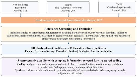
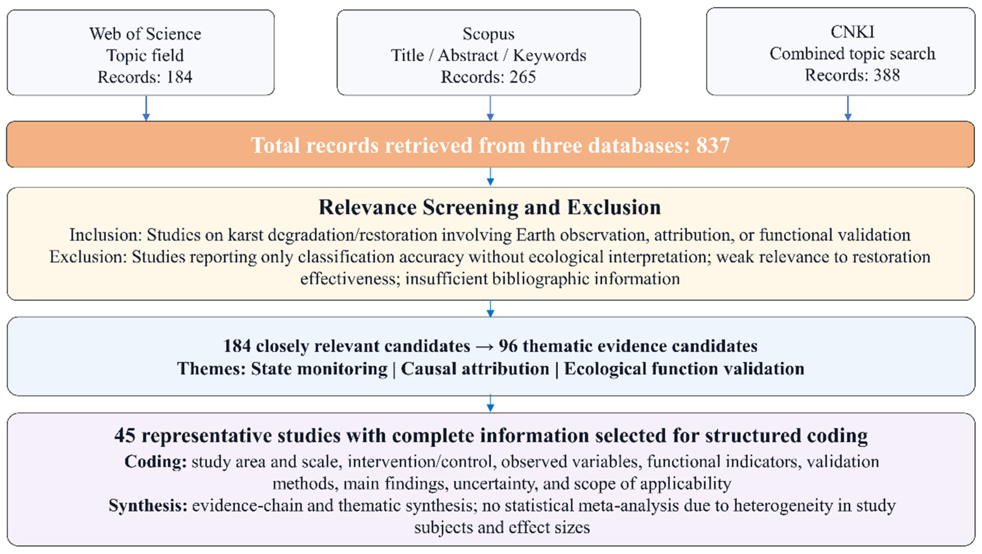
A structured search of the Web of Science Core Collection, Scopus, and China National Knowledge Infrastructure (CNKI) was completed on 10 August 2026 (Figure 1), with no lower bound on publication year. In Web of Science, the Topic field was searched using TS = ((karst OR “rocky desertification”) AND (“ecological restoration” OR “vegetation restoration” OR afforestation OR “natural regeneration”) AND (“remote sensing” OR “Earth observation” OR satellite OR UAV OR LiDAR OR SAR OR monitoring)). Scopus used the corresponding TITLE-ABS-KEY combination. For CNKI academic journals, combined topic searches were conducted using “karst/karst geology/rocky desertification × ecological restoration/ecosystem restoration/rocky desertification control × remote sensing/satellite/UAV/LiDAR/monitoring.” The three databases returned 184, 265, and 388 records, respectively, for a total of 837 records before deduplication.
Figure 1.
Literature search and evidence-screening workflow for Earth observation studies of karst ecological restoration.
Evidence screening followed a tiered workflow of broad retrieval, relevance screening, thematic candidacy, and in-depth coding. First, duplicates were checked using DOI, title, and author information. Title and abstract screening then excluded records that reported only classification accuracy without ecological interpretation, had weak relevance to restoration effectiveness, consisted only of policy advocacy without methodological or empirical support, or contained insufficient bibliographic information, resulting in 184 closely relevant candidates. Second, to prevent a predefined analytical framework from determining evidence selection, coverage of specific assessment stages was not used as an inclusion criterion for the 45 studies selected for in-depth analysis. Instead, 96 thematic evidence candidates were divided into three themes—state monitoring, causal attribution, and ecological function verification—with 32 studies in each theme. Finally, 45 studies were selected from the 96 candidates for in-depth structured coding based on (1) direct relevance to the core research questions, (2) clarity of study design and control/validation information, (3) completeness of data and methodological information, and (4) representativeness across evidence types and scales. Coding fields included study area and scale, intervention and control, observed variables, functional indicators, validation approach, main findings, uncertainty, evidence type, and scope of applicability.
3. Research Progress
3.1. What Can Earth Observation Reliably Answer? Ecological State Changes and Their Boundaries
3.1.1. From Land-Cover Mapping to Long-Term Change Detection
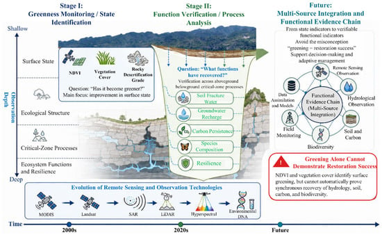
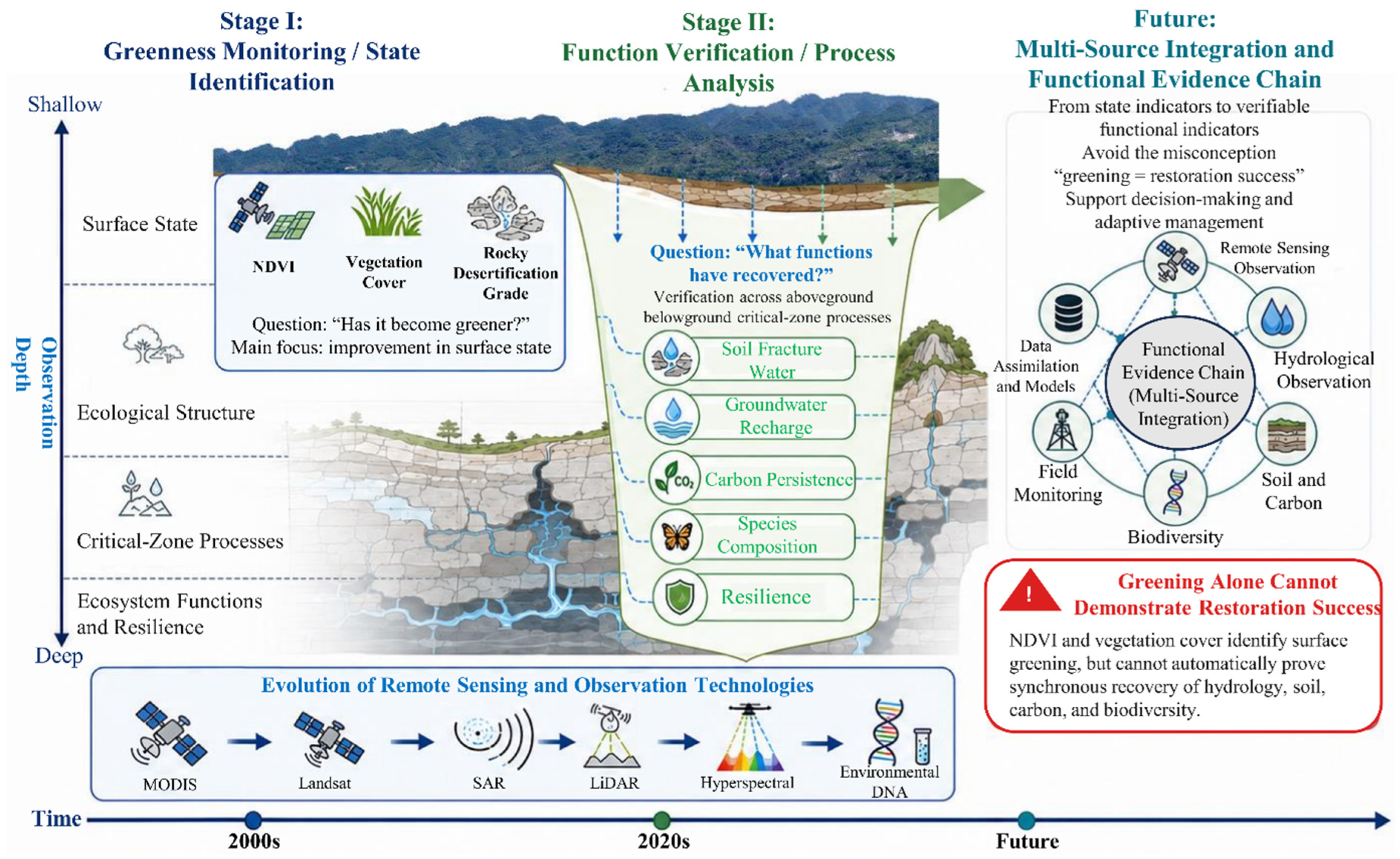
The evolution of the monitoring and assessment research on karst ecological restoration is illustrated in Figure 2. Early remote-sensing studies in karst regions focused on identifying mosaics of exposed rock, vegetation, and soil, and, subsequently, classifying the rocky desertification severity. Because medium-resolution pixels may contain rock, sparse shrub-grass vegetation, cropland, and shadow simultaneously, conventional remote-sensing classification can compress a continuous degradation gradient into discrete classes. Yue et al. simultaneously retrieved vegetation and exposed-bedrock fractions [18], while Qi et al. compared sub-pixel methods and showed that fractional-cover estimation and spectral unmixing are better suited to highly heterogeneous karst surfaces [19]. More recently, UAV multispectral imagery and machine learning have extended observations to field and hillslope scales, enabling the identification of fragmented vegetation patches and exposed bedrock [20], although the regional transfer of local models remains constrained by sensor differences, sample representativeness, and phenology.
Figure 2.
Schematic evolution of research stages in monitoring and evaluating karst ecological restoration.
MODIS, Landsat, and multi-source vegetation indices have shifted the research question from “How much rocky desertification exists at a given time?” to “How do trajectories evolve over multiple years?” Hou et al. analyzed the relationships between the growing-season NDVI and climate variables [21], Tong et al. overlaid long-term trends with the spatial distribution of ecological engineering projects [22], and Brandt et al. used satellite observations to demonstrate pronounced greening and biomass increases in the South China karst [10]. Vegetation succession mapping has also shown directional transitions among cropland, shrub–grassland, and forest within intervention areas [23]. Since the beginning of this century, the vegetation structure and productivity have generally improved in many treated areas, indicating that persistent degradation is not the only trajectory.
The quality of time-series imagery directly determines the credibility of conclusions about karst ecological restoration monitoring and assessment. Clouds, aerosols, terrain shadows, sensor transitions, and outliers can generate spurious trends; in regions with a large interannual precipitation variability, short temporal windows may also misinterpret wet years as project effects. The NDVI reconstruction methods reviewed by Li et al. show that smoothing, gap filling, and cross-sensor harmonization should be accompanied by the transparent reporting of parameters and uncertainty [24]. Cloud-computing platforms have substantially lowered the barriers to long-term time-series processing [25], but “computable” does not necessarily mean “comparable”: without consistent topographic correction, quality masking, and reference-site selection, large-area products may still conceal systematic bias.
3.1.2. From a Single Greenness Metric to Multidimensional Ecological Quality
As research objectives have broadened, the NDVI has increasingly been combined with net primary productivity, land surface temperature, moisture, dryness, landscape connectivity, and carbon storage. Deng et al. revealed the coupling among land use, NDVI, and land surface temperature [26]; Ye and Kuang used a modified remote sensing ecological index to evaluate ecological quality in southeastern Chongqing [27]; and Wu et al. linked landscape ecological quality to the benefits of rocky desertification control [28]. Liao et al. showed through composite indicators that ecological restoration improved regional ecosystem health [13]. Such indices are useful for compressing multidimensional information into interpretable spatial patterns and can also support a county-level performance assessment.
However, the interpretability of composite indices depends on indicator weights, ecological meaning, and whether different functions are substitutable. Greenness, moisture, and low land surface temperature are often assumed to be “good,” whereas exposed rock, dryness, and built-up land are assumed to be “bad.” Nevertheless, natural karst outcrops may provide a distinctive habitat value, and open shrub-grass systems should not automatically be regarded as targets for afforestation. Composite ecological indices are therefore appropriate for regional screening or early warning only when three conditions are simultaneously met: the indicator directions have a clear ecological basis, the weighting and standardization procedures are transparent, and no critical functional threshold is concealed by a single aggregate score. If the objective is to determine whether hydrological, soil, carbon, or biodiversity functions have recovered, or if a function has a non-substitutable safety threshold, a single composite index should not be used as the final criterion; instead, individual functional indicators and their uncertainties should be retained.
Moving from “state” toward “function” requires more than simply adding indices; it requires clarity about what Earth observation can directly observe, what it can only proxy, and what must be validated with ground data. Imaging spectroscopy, microwave, LiDAR, and thermal infrared observations can provide information on leaf traits, canopy water status, canopy height, aboveground biomass, and evapotranspiration [29,30], thereby placing relatively strong constraints on the vegetation structure and aboveground processes. In contrast, roots, soil profiles, groundwater, soil carbon, and species composition generally cannot be measured directly from satellite data. Lausch et al. proposed linking Earth observation to taxonomic, structural, and functional biodiversity [31], while Randin et al. emphasized that species-distribution models still require ground-based species records and scale matching [32]. The objective of multi-source integration should therefore shift from merely improving the classification accuracy to building a verifiable evidence chain spanning canopy, soil, groundwater, and species communities.
3.1.3. Regionally Consistent Findings and Spatial Heterogeneity
The most consistent conclusion across the literature is that many managed areas in the South China karst have experienced substantial vegetation recovery over the past two decades, whereas the evidence explaining why recovery occurred and which functions recovered synchronously is markedly weaker. Attribution analyses by Zhang et al., long-term vegetation-dynamics studies by Tong et al., and forest-carbon studies by Luo et al. all show a pronounced spatial heterogeneity in restoration outcomes [33,34,35]. Topography, lithology, soil, precipitation, and human activities jointly modulate restoration rates [36,37,38]. Within the same project, depressions, gentle slopes, and areas with relatively continuous soil can green rapidly, whereas steep slopes, peak-cluster terrain, and highly exposed rocky areas remain constrained by soil and water limitations. Increases in county-scale mean NDVI may also coexist with local degradation, the high mortality in monospecific plantations, or declining groundwater recharge. Regional greening therefore cannot be interpreted directly as the comprehensive recovery of ecological functions.
3.1.4. Uncertainty, Reproducibility, and Baseline Consistency
Long-term remote sensing has substantially improved the regional monitoring of karst ecological restoration, but the reliability of conclusions depends on whether uncertainty is explicitly represented [24,30]. Errors arise from sensor radiometric and geometric differences, clouds and terrain shadows, mixed pixels, and cross-sensor conversion, as well as from training-sample representativeness, model parameters, and the transformation of remote-sensing proxies into ecological attributes [19,39,40]. The highly fragmented mosaic of exposed rock, soil, and vegetation makes medium-resolution pixels particularly susceptible to scale uncertainty. Spatial blocking and validation across years and catchments can reduce overly optimistic estimates caused by spatial autocorrelation and spatiotemporal extrapolation and are therefore valuable validation strategies [41,42], although direct comparisons of these strategies remain limited in karst restoration studies.
Baseline consistency is another prerequisite for judging whether recovery has occurred. Vegetation indices in karst regions respond strongly to interannual climate variability; using an anomalously dry or wet year as a single baseline may amplify or suppress subsequent change [21]. Differences among regions in classification rules, thresholds, and indicator definitions can also reduce comparability. This issue is particularly important in long-term studies because the spectral responses and NDVI differ systematically among sensor generations; without cross-sensor calibration, artificial discontinuities may be introduced into the time series [24,30]. Roy et al. demonstrated quantifiable differences in the reflectance and NDVI between Landsat-7 ETM+ and Landsat-8 OLI, indicating the need for transformation and harmonization to maintain temporal continuity [39]. Accordingly, when algorithms or products are upgraded, historical data should preferably be reprocessed using a consistent version, with multi-year pre-intervention baselines, common reference sites, and stable indicator definitions established simultaneously. Deviations from historical baselines, climate-matched controls, and reference ecosystems should also be reported [17,22].
Reproducibility requires that image inventories, quality masks, topographic correction, sample sources, feature variables, model parameters, thresholds, and uncertainty-propagation methods all be traceable and versioned [40]. Measurement/model uncertainty should also be distinguished from scenario uncertainty. The former arises from observational error, sampling, and the model structure and can be reduced through calibration and independent samples; the latter arises from future changes in climate, markets, and policy and should be managed through multiple-scenario comparisons. Because uncertainty metrics are not standardized across products, sensors, and ecological indicators, final products should provide quality flags, confidence intervals, scope of applicability, and evidence grades rather than a single deterministic “effectiveness map.”
3.2. From “Greening” Monitoring to Verification of Ecological Restoration Effectiveness and Functional Recovery
3.2.1. Why Did Conditions Improve? From Trend Decomposition to Counterfactual Causal Attribution
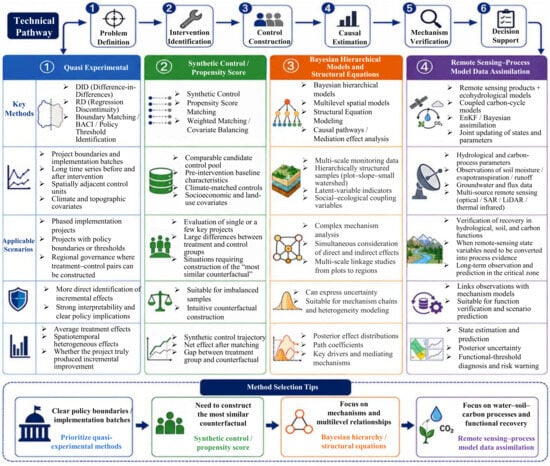
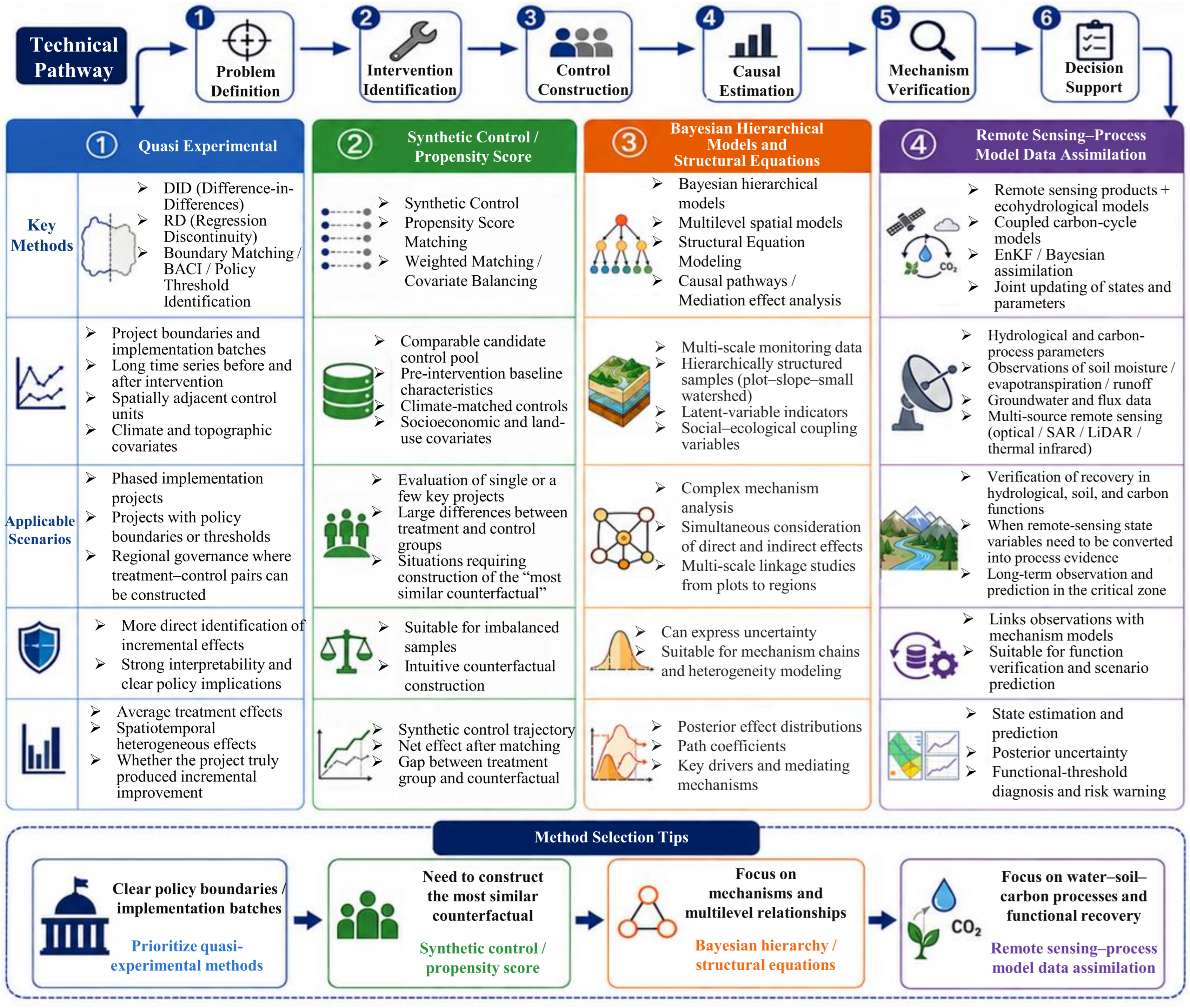
Answering “Why did conditions improve?” requires a strict distinction between driver attribution and the causal effects of interventions (Figure 3). Driver attribution uses long-term NDVI, LAI, or productivity series to estimate the statistical contributions of precipitation, temperature, CO2, and human activities [21,33]. Intervention-effect analysis, by contrast, asks “What would have happened without restoration?” and, therefore, requires a credible counterfactual. Because the spatial allocation of karst ecological restoration projects is usually non-random, project and non-project areas may differ systematically in initial rocky desertification severity, topography, accessibility, and governance capacity. Simple before–after comparisons or residual analyses cannot fully remove this site-selection bias. Causal diagrams, BACI, difference-in-differences (DID), matching, and synthetic controls can strengthen the identification of incremental effects only when intervention boundaries, implementation timing, control units, and assumptions such as parallel trends are clearly specified.
Figure 3.
Methodological system and technical pathways for causal attribution of karst ecological restoration.
Quasi-experimental examples are beginning to emerge in karst regions. Zhang et al. applied generalized DID with remote-sensing time series in peak-cluster depressions of South China to evaluate ecological restoration projects, identifying a significant positive effect on regional greening while also showing a strong heterogeneity across geomorphological settings and levels of human disturbance [43]. Pang and Ran used panel data from 88 counties in Guangxi from 2006 to 2016 and DID to assess the county-level economic effects of the Rocky Desertification Control Project; parallel-trend and robustness tests demonstrated the feasibility of quasi-experimental designs under a phased policy implementation [44]. However, their outcome was economic development and, therefore, cannot be substituted for evidence of ecological function. By comparison, Tong et al. evaluated long-term vegetation effects using climate-corrected remote-sensing residuals and project inputs [12], which still represents a relatively strong driver attribution rather than complete counterfactual identification. Thus, DID/BACI approaches have considerable potential where policy cohorts, project boundaries, and comparable controls are available, but causal studies directly targeting water, soil, carbon, and biodiversity functions in karst regions remain scarce.
The feasibility of causal designs is constrained by data availability. Minimum requirements include project boundaries or implementation cohorts, explicit implementation years, sufficiently long pre- and post-intervention Earth observation series, and the ability to construct comparable controls. Enhanced datasets may include the project type, tree species and planting density, management intensity, subsidies, groundwater abstraction, land-use withdrawal, and population relocation; a comprehensive mechanistic evaluation additionally requires soil, hydrological, biodiversity, and social-survey data. When the data are insufficient, the strength of causal language should be reduced, with conclusions limited to “associated with restoration” rather than “caused by restoration.” Even when an average treatment effect is estimated, effect modifiers such as slope position, soil thickness, drought frequency, and initial degradation severity should be analyzed to avoid allowing a single mean effect to obscure spatial heterogeneity.
3.2.2. What Functions Have Recovered? Multi-Source Validation of Water–Soil–Carbon–Biodiversity–Resilience
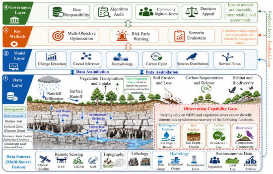
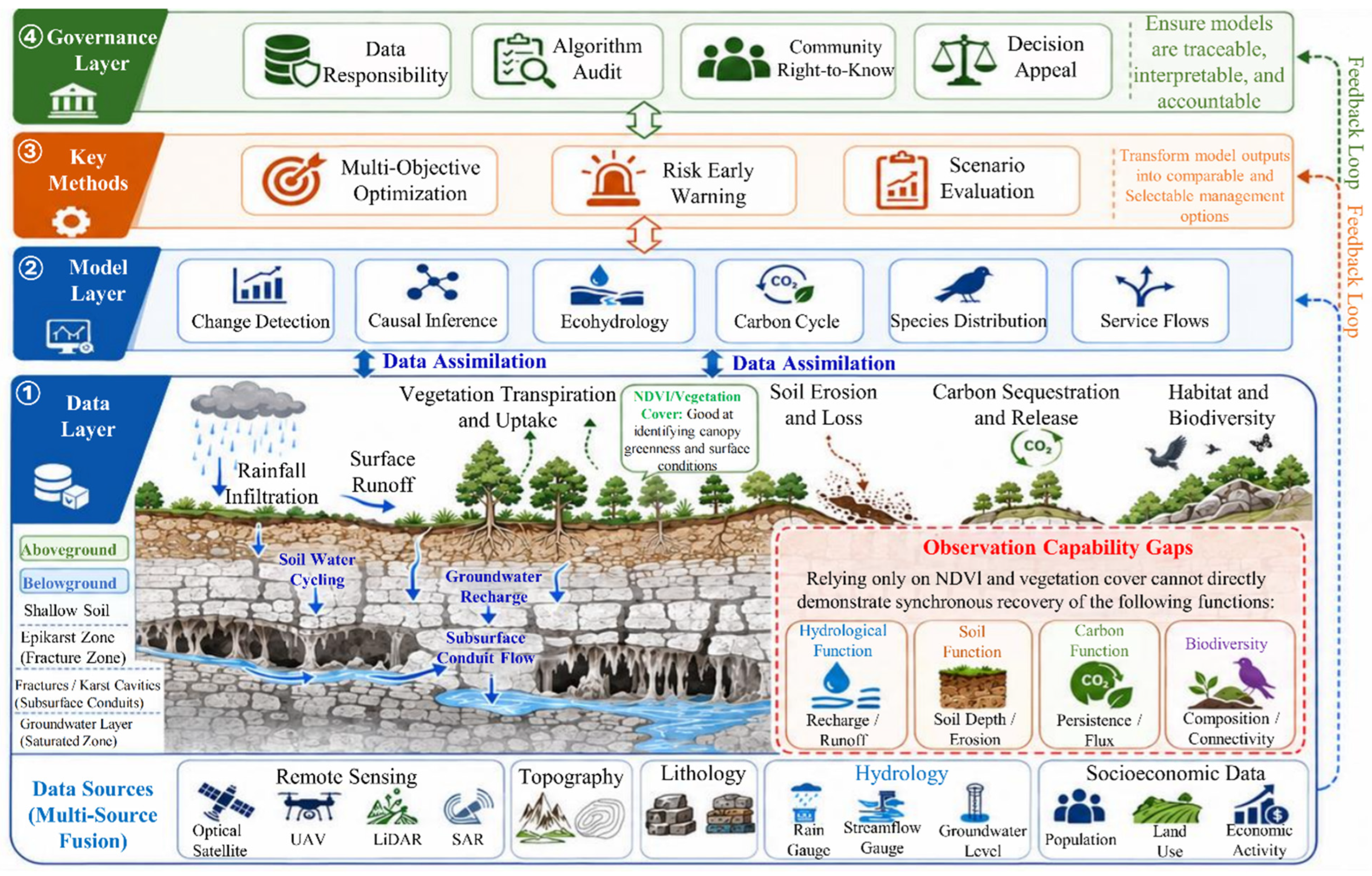
The verification of functional recovery in karst ecological restoration must move beyond the “visible canopy” to coupled aboveground–belowground processes (Figure 4; Table 1). Earth observation provides broad-area, continuous, and repeatable spatial information, but observability differs among functional domains. For hydrological and soil processes, remote sensing can observe precipitation, evapotranspiration, surface water, vegetation stress, topography, and exposed-rock/erosion patterns, but it cannot replace measurements of spring discharge, underground-river flow, soil moisture, infiltration, and hydrochemistry. For the carbon cycle, LiDAR, optical, and microwave observations can constrain the canopy structure, aboveground biomass, and productivity, whereas soil organic/inorganic carbon, dissolved carbon, carbonate weathering, and groundwater-carbon dynamics still depend mainly on field sampling, laboratory analysis, and process models. For biodiversity, Earth observation can characterize the habitat structure and connectivity, but species composition and functional traits still require field plots, environmental DNA, camera traps, and acoustic data.
Figure 4.
Coupled aboveground–subsurface processes and observation–capability gaps in the karst critical zone.
Table 1.
Observation combinations linking state indicators to functional evidence.
An assessment of hydrological function should, at minimum, distinguish between rainfall input, canopy interception, soil water, hillslope runoff, leakage, spring discharge, underground-river flow, and water quality [45]. Remote sensing can estimate precipitation, evapotranspiration, surface-water extent, and vegetation water use, whereas ground sensors, spring monitoring, and tracer experiments are needed to identify the fracture-conduit flow and changes in the dry-season water supply [46]. The research by Xiao et al. on afforestation and the regional water-supply balance in Southwest China suggests that large-scale greening may be accompanied by increased water consumption [47]. Hydrological restoration evidence from the Loess Plateau can serve only as a methodological and mechanistic reference and should not be mechanically extrapolated to karst systems [48,49]. Hydrological functional recovery should therefore be judged using a combination of remote-sensing moisture/vegetation signals, hillslope or small-catchment hydrological observations, and climate-matched baselines, rather than inferred solely from the NDVI or mean annual evapotranspiration.
Soil function is one of the domains in which the limits of remote sensing are most evident. High-resolution imagery and DEMs can identify exposed bedrock, erosion pathways, topographic position, and changes in vegetation cover, but the soil thickness, aggregate stability, carbon–nitrogen–phosphorus fractions, infiltration capacity, soil biota, and microbial functions require field profiles, samples, and experimental measurements [7,50,51,52,53]. Remote sensing is therefore well-suited to spatial stratification, sampling design, and regional extrapolation, but should not be described as directly quantifying the recovery of soil functions. Cross-regional products must report the geomorphological and soil-thickness ranges represented by ground samples and flag areas outside the calibration domain as having a lower evidence grade.
Carbon function requires distinctions among aboveground vegetation carbon, soil carbon, dissolved carbon, and carbonate-related processes. Studies by Zhang et al., Tong et al., and Luo et al. support the conclusion that ecological restoration can increase vegetation carbon stocks or carbon uptake [33,34,35]. Such aboveground carbon changes can be relatively well-constrained by remote sensing and inventory data. In contrast, soil organic/inorganic carbon, dissolved inorganic/organic carbon, carbonate weathering, and groundwater–carbon coupling generally cannot be directly quantified from satellite data and require joint support from soil/water samples, flux measurements, hydrochemistry, and models [54,55,56].
Biodiversity provides more direct evidence that “high greenness does not equal complete recovery.” A meta-analysis by Chen et al. of 108 studies and 6505 observations from the South China karst found that biodiversity and ecosystem services in restored sites were, on average, approximately 29% and 18% higher than in degraded sites, respectively, yet remained approximately 14% and 29% lower than in intact reference ecosystems; the outcomes were also significantly moderated by the restoration approach, vegetation type, and restoration duration [57]. This quantitative evidence demonstrates that restoration can generate genuine functional gains, but greening and functional recovery are neither synchronous nor equivalent. Earth observation can characterize habitat structure, canopy heterogeneity, and connectivity [58], whereas species composition, nativeness, functional traits, and cave-surface communities still require validation using field plots, environmental DNA, camera traps, and acoustic observations.
Ecosystem resilience represents the temporal dimension of functional assessment. Multi-year remote-sensing series can quantify the resistance, recovery time, variability, and persistent anomalies before and after drought or disturbance, but whether these statistics predict functional collapse or restoration failure must be tested against independent drought, fire, pest, disease, or other disturbance events. The critical-transition study by Dakos et al. was based primarily on simulated ecological time series [59] and, therefore, supports a candidate method rather than demonstrating that early warning has been robustly validated in karst restoration. A more practical current pathway is to pair long-term satellite trajectories with continuous observations from field plots, small catchments, and groundwater systems to evaluate whether functions persist under extreme events and how rapidly they recover.
3.2.3. Cross-Functional Synthesis: From Indicator Aggregation to a Verifiable Evidence Chain
The core of a cross-functional assessment is not to combine ever more indicators into a single weighted score, but to preserve the interpretability and non-substitutability of individual functions. Hydrological security, soil formation, biodiversity, and carbon persistence operate at different process scales and have different risk thresholds; a marked deterioration in any critical function should not be “offset” by improvements in greenness or other indicators. An integrated assessment should therefore establish an evidence chain of state change, functional proxy, independent process validation, reference state/threshold, and uncertainty, with the evidence grade reported separately for each functional domain.
Ecosystem services and economic value may be treated as outcome variables following functional recovery, but they cannot be used retrospectively as substitutes for functional evidence [60,61,62]. Model-estimated service supply or monetary value is not equivalent to actual household income, fiscal returns, or social welfare. “Realized benefits” should be discussed only when service flows, beneficiaries, actual use, or avoided losses have been independently measured [63,64].
The most robust conclusion from the current evidence is not that “all functions have recovered,” but that evidence for an improved surface state is strongest, direct support exists for the recovery of some functions, and substantial asynchrony remains among functions and restoration stages. For example, meta-analytic evidence on biodiversity and ecosystem services shows that restored sites perform substantially better than degraded sites but still do not reach intact reference ecosystems [57]. Restoration effectiveness should therefore be judged by whether the distance to the reference state has narrowed, whether critical functional thresholds have been met, and whether uncertainty is acceptable, rather than by whether a single composite score has increased.
3.2.4. Trade-Offs Among Key Functions: Carbon–Water and Structure–Diversity
One of the most representative functional trade-offs in karst ecological restoration is the carbon–water relationship. Increasing woody cover generally raises the aboveground biomass and vegetation carbon stocks, but may also increase evapotranspiration and reduce shallow soil water or dry-season flow, particularly in areas with thin soils, frequent drought, and high-density plantations [47]. Carbon gains must therefore be evaluated jointly with actual evapotranspiration, soil–water dynamics, and spring-flow changes; in zones sensitive to groundwater recharge, hydrological constraints should be treated as hard constraints that cannot be offset by carbon benefits.
Another key trade-off concerns rapid canopy establishment versus biodiversity and long-term resilience. High-density, fast-growing plantations can rapidly increase the NDVI and aboveground carbon; yet, if the species composition is simplified, the root competition is intense, or the habitat structure is homogenized, a “high-greenness–low-diversity–high-drought-risk” state may emerge [65]. By contrast, the spectral change may be slower during the early stages of natural recovery, while the species composition and structure may gradually converge toward reference ecosystems. Earth observation should therefore be interpreted alongside evidence on species, soils, and hydrology, rather than treating canopy greening as a substitute for improvement in other functions.
3.2.5. Minimum Evidence Set for Assessing Functional Recovery
Based on the evidence above, the assessment of functional recovery in karst ecological restoration should record at least five categories of information simultaneously: (1) a clearly defined restoration target, project boundary, and implementation time; (2) long-term Earth observation state variables that can be compared with historical baselines and controls; (3) process indicators for water, soil, carbon, biodiversity, or resilience that directly correspond to the research objective; (4) independent ground/subsurface or laboratory validation and its spatial representativeness; and (5) the error, confidence intervals, scope of applicability, and evidence type. The results should be described as “ecosystem functional recovery” only when the state change, functional change, and intervention attribution corroborate one another at the same spatial and temporal scales. When only some conditions are met, more conservative terms such as “state improvement,” “improvement in functional proxies,” or “associated with restoration” should be used.
3.3. Capability Boundaries, Scale Matching, and Uncertainty in Earth Observation Assessment of Ecosystem Functional Recovery
3.3.1. Direct Observation, Proxy Estimation, Model Assimilation, and Ground Validation
Earth observation variables can be organized into four levels according to their distance from the target function. The first level comprises surface states that can be observed directly or near-directly, such as the land cover, exposed bedrock fraction, canopy height, and surface-water extent. The second comprises model-retrieved biophysical proxies such as aboveground biomass, evapotranspiration, and vegetation water content. The third comprises functional variables that require linkage through data assimilation or process models, such as soil water, runoff, carbon fluxes, and habitat suitability. The fourth comprises variables that remote sensing cannot measure independently and that require field or laboratory data, such as the soil thickness, soil–carbon fractions, groundwater chemistry, microorganisms, and species composition. As the level increases, the requirements for ground calibration, mechanistic assumptions, and uncertainty reporting should increase accordingly, preventing remote-sensing proxies from being equated directly with ecological functions.
3.3.2. Applicability Boundaries of Composite Ecological Indices and Multi-Criteria Assessment
The main value of composite ecological indices and multi-criteria methods such as AHP/MCDA lies in transparently organizing multidimensional information rather than proving that one method is inherently superior to another [66,67]. Composite indices are suitable for large-area screening and long-term early warning, but indicator direction, standardization, weighting, and uncertainty must be disclosed, and the results for critical individual functions must be retained. Where hydrological security, biodiversity, or soil conservation has a non-substitutable threshold, severe deterioration should not be compensated by improvements in other indicators through weighting. AHP/MCDA can provide a basic operational framework for translating validated functional evidence into restoration priorities because its structure is transparent and can incorporate expert and stakeholder judgments, but the subjectivity in weights must be exposed through consistency tests, weight perturbation, and scenario sensitivity analysis [68].
Pareto multi-objective optimization is suitable for comparing alternatives when constraints such as budget, water availability, ecological limits, and land opportunity costs are explicit and genuine objective conflicts exist. The global study by Strassburg et al. and the Danube River case by Funk et al. illustrate the potential of such approaches [69,70], but do not directly establish their superiority for karst restoration. Whether AHP/MCDA or multi-objective optimization is used, the outputs should, at minimum, include the sensitivity to weights/parameters, input-data uncertainty, and the stability of priorities across scenarios, rather than only a deterministic “optimal solution map.”
3.3.3. Cross-Scale Validation, Independent Testing, and Continuous Updating
Functional recovery in karst landscapes is strongly scale-dependent: plot-scale soil thickness and plant survival, hillslope-scale runoff and erosion, small-catchment spring flow and groundwater recharge, and regional vegetation-climate responses cannot be substituted by a product at a single spatial resolution [71,72]. Validation designs should, where possible, isolate observational objects and use spatial blocking, together with independent tests across years, catchments, or geomorphological units, to distinguish the model fit within the training domain from generalization in the deployment domain [42,73]. Validation strategies that still lack direct comparative evidence in karst settings should be explicitly presented as methodological recommendations, and their added value should be quantified preferentially through replicated multi-site studies.
The primary value of continuous observation is to establish auditable temporal trajectories rather than to pursue increasingly complex digital systems. Optical remote sensing is affected by clouds and terrain shadows; SAR is sensitive to moisture and structure; LiDAR provides three-dimensional structure; and thermal infrared data constrain evapotranspiration and stress. Groundwater observations, soil sensors, flux measurements, field plots, environmental DNA, and camera/acoustic monitoring complement processes invisible to satellites. Multi-source data assimilation can update ecohydrological or carbon models under explicitly characterized observation error and provide posterior uncertainty. Following algorithm upgrades, historical time series should be versioned and reprocessed to avoid mistaking product changes for ecological change.
3.3.4. Minimum Operationalization for Management Translation: AHP/MCDA, Sensitivity Analysis, and Causal Testing
Validated functional evidence can be organized into a minimum operational decision workflow. First, ecological state and functional-recovery outcomes form the criteria layer, with hydrology, soil, carbon, biodiversity, resilience, and implementation feasibility standardized separately. Second, AHP or other MCDA approaches can be used to derive transparent weights, with priority stability evaluated through consistency tests, ±10–20% weight perturbations, alternative weighting schemes, and an uncertainty analysis of input data. Third, non-negotiable constraints related to water sources, biodiversity, and severe erosion should be treated as hard constraints rather than compensable weights [74,75]. Finally, historical project outcomes or new BACI/DID designs should be used to test whether priority areas actually produce better functional outcomes. Such tools have empirical value only if they improve predictive accuracy, reduce misallocation, shorten adjustment time, or improve functional outcomes; in data-scarce areas, transparent multi-criteria rules and simple process models may be more reliable than highly complex platforms.
4. Future Directions: Function-Oriented Earth Observation and Testable Validation
4.1. Establishing Implementable Causal Evaluation Designs for Karst Restoration
Future research should shift causal identification from post hoc interpretation to the project-design stage. In regions with clear project boundaries and phased implementation cohorts, BACI, DID, event-study designs, regression discontinuity, or boundary matching can be prioritized. Where policy controls are difficult to construct, studies should, at minimum, preserve multi-year pre-intervention series, establish climate- and geomorphology-matched references, and disclose limitations arising from unobserved confounding. New projects should record objectives, boundaries, timing, engineering type, implementation intensity, and management information so that Earth observation pixels, small catchments, and field plots can be matched to actual interventions. The generalized DID example of Zhang et al. [43] demonstrates the practical feasibility of such designs in the South China karst, but they still need to be extended to functional outcomes involving water, soil, carbon, and biodiversity.
Causal effects must also be cross-validated against mechanistic evidence. If DID or matching models indicate that a project increased the NDVI but no corresponding changes are observed in survival, canopy structure, hydrology, or carbon outcomes, only a surface-greening effect can be confirmed. If evapotranspiration increases while spring flow declines, alternative explanations such as precipitation anomalies and groundwater abstraction must also be tested. Remote sensing should therefore provide broad coverage, long time series, and spatial controls; ground experiments should provide mechanisms and bias calibration; and process models should connect variables that cannot be observed directly. Together, these three components form testable evidence of restoration effects.
4.2. Developing Function-Oriented Multi-Source Earth Observation Products
The next generation of products should move beyond “land-cover/greenness products” toward integrated products with explicit functional meaning, while clearly stating the observational capability boundaries. Priority products could include evapotranspiration–soil water–spring flow, erosion–sediment connectivity, canopy height–aboveground biomass–carbon persistence, and habitat structure–species distribution. Each product should specify its observation target, spatial support scale, coverage of training/calibration data, error sources, applicable geomorphological settings, and processes that cannot be interpreted directly, and should be validated in independent regions. For variables such as soil carbon, groundwater carbon, and species composition, ground or laboratory data should be treated as indispensable components of the product rather than as optional “validation attachments.”
Product outputs should shift from static deterministic values to “temporal trajectories + uncertainty + scope of applicability.” In peak-cluster depressions affected by frequent mixed pixels, shadows, and clouds, quality flags and confidence intervals should be provided simultaneously. Cross-sensor fusion should record sensor versions, calibration methods, and reprocessing strategies. In addition to accuracy, artificial-intelligence models should report the geographic coverage of training samples, spatially independent validation, and failure cases in the deployment domain [40,41,42]. Only when product error and applicability domains are traceable should observed changes be used in judgments of functional recovery.
4.3. Building an Integrated Airborne–Spaceborne–Ground Functional Validation Network
A single satellite product cannot adequately characterize the coupled aboveground–belowground processes of vegetation, soil, fractures, groundwater, and carbon cycling within the karst critical zone. Future work should develop a multiscale coordinated system combining satellite-based regional monitoring, UAV/high-resolution imagery for local diagnosis, sensor-based process observations at hillslope and small-catchment scales, and mechanistic validation using field plots and laboratory analyses. Repeatable observation units should be established across peak clusters, depressions, hillslopes, valleys, different lithologies, and restoration stages. Validation networks should not attempt the high-frequency, full-coverage measurement of every variable; instead, they should target variables for which remote-sensing proxies are most uncertain and most likely to alter functional judgments. Stratified sampling and long-term revisits should be used to establish scale-transfer relationships from point to hillslope, small catchment, and region, thereby improving the reliability of extrapolation. For sensitive species and groundwater processes, tiered authorization and controlled access may be adopted, but metadata, quality-control procedures, and auditable validation records should be retained to balance data security, reproducibility, and long-term comparability.
4.4. Strengthening Uncertainty, Cross-Regional Transferability, and Management Interpretability
Future research should place equal emphasis on whether evidence can be transferred and on how accurate it is locally (Table 2). Functional models should, at minimum, report the results from spatial blocking and validation across years or catchments, with errors stratified by geomorphological type, slope position, rocky desertification severity, and sensor conditions. When the models are transferred to new lithological, climatic, or management contexts, applicability-domain checks and recalibration should precede interpretation. For management translation, transparent approaches such as AHP/MCDA can integrate validated functional indicators with implementation feasibility, but the weight sensitivity, scenario uncertainty, and priority stability must be evaluated simultaneously. More complex Pareto optimization or digital platforms can serve as subsequent tools [76,77], but their value should be tested by whether they improve actual functional outcomes rather than by the model complexity or visualization sophistication.
Table 2.
Core evidence requirements and deliverables for Earth observation research on karst ecological restoration.
5. Conclusions
Long-term Earth observation provides relatively consistent evidence that the South China karst has experienced vegetation greening, biomass increases, and the mitigation of rocky desertification over the past two decades. However, these findings mainly demonstrate changes in the ecological state and do not automatically establish a causal incremental effect of restoration interventions, much less the synchronous recovery of water, soil, carbon, biodiversity, and resilience. The current evidence base is clearly hierarchical: the evidence for the surface-state change is strongest; vegetation carbon and some hydrological and erosion functions have greater support; whereas soil profiles, groundwater-carbon processes, species composition, and resilience under extreme events still depend heavily on ground and laboratory observations.
Accordingly, the assessment of karst ecological restoration should shift from “increased greenness” to “verifiable functional recovery.” The appropriate role of Earth observation is to provide broad-area, continuous, and comparable information on states and proxies, integrated with independent surface/subsurface observations, process models, and credible counterfactual designs. Quasi-experimental methods such as BACI and DID can improve the credibility of intervention attribution when project boundaries, implementation timing, and comparable controls are available, but they cannot replace mechanistic validation. Likewise, soil properties, groundwater processes, soil/dissolved carbon, and species composition should not be described as variables that can be comprehensively quantified from satellite observations alone.
This review therefore proposes a more focused evidence pathway: first, reliably identify the ecological state changes; second, assess whether those changes can be attributed to specific interventions; and, third, verify the functional recovery through multi-source observations of water, soil, carbon, biodiversity, and resilience, while explicitly reporting the scale, uncertainty, and scope of applicability throughout. Composite ecological indices and AHP/MCDA can support screening and management translation, but non-compensatory constraints on critical functions must be retained and sensitivity analyses conducted. Pareto optimization and digital decision-support tools should be regarded as extensions that still require empirical testing in karst settings.
Overall, “greening” is the starting point rather than the endpoint of the karst ecological restoration assessment. Future progress depends on linking long-term Earth observation with small-catchment hydrology, soil profiles, carbon processes, biodiversity surveys, and independent causal designs, so that every claim of “functional recovery” can answer three questions: Is the mechanistic relationship between the observed variable and the target function clear? Can the restoration effect be distinguished from background change? Over what spatial and temporal range is the conclusion valid? Only when these conditions are met can Earth observation evolve from a change-detection tool into a verifiable source of evidence for ecological restoration effectiveness.
Author Contributions
Conceptualization: D.H.; Methodology: D.H.; Data curation: Z.Z. (Zhenzhen Zhang), Y.L. (Ya Li), and H.L.; Formal analysis: D.H. and Y.L. (Ying Luo); Visualization: C.H. and Y.Y.; Writing—original draft: D.H.; Writing—review and editing: D.H. and Z.Z. (Zhongfa Zhou); Supervision and funding acquisition: D.H. and Z.Z. (Zhongfa Zhou). All authors have read and agreed to the published version of the manuscript.
Funding
This research was funded by the Guizhou Provincial Key Technology R&D Program (Qiankehe [2023] General No. 211), the Guizhou Province Natural Resources Open Project (Guizhou Natural Resources Science and Technology Cooperation [2026] KFORSGK General 01), the Guizhou Provincial Key Laboratory Construction Project (Qian Ke He Ping Tai [2025] 014), and the Guizhou Provincial 2025 Central Government-Guided Local Science and Technology Development Fund Project (Qian Ke He Zhong Yin Di [2025] 031).
Data Availability Statement
No new data were created or analyzed in this study. Data sharing is not applicable to this article.
Conflicts of Interest
The authors declare no conflicts of interest.
References
- Wang, K.; Zhang, C.; Chen, H.; Yue, Y.; Zhang, W.; Zhang, M.; Qi, X.; Fu, Z. Karst landscapes of China: Patterns, ecosystem processes and services. Landsc. Ecol. 2019, 34, 2743–2763. [Google Scholar] [CrossRef] [Scilit]
- Xu, C.; Xu, X.; Liu, M.; Li, Z.; Zhang, Y.; Zhu, J.; Wang, K.; Chen, X.; Zhang, Z.; Peng, T. An improved optimization scheme for representing hillslopes and depressions in karst hydrology. Water Resour. Res. 2020, 56, e2019WR026038. [Google Scholar] [CrossRef] [Scilit]
- Chen, H.; Hu, K.; Nie, Y.; Wang, K. Analysis of soil water movement inside a footslope and a depression in a karst catchment, Southwest China. Sci. Rep. 2017, 7, 2544. [Google Scholar] [CrossRef] [Scilit] [PubMed]
- Liu, X.; Liu, W.; Chen, X.; Wang, L.; Zhang, Z.; Peng, T. Estimating fracture characteristics and hydraulic conductivity from slug tests in epikarst of southwest China. J. Hydrol. Reg. Stud. 2024, 53, 101777. [Google Scholar] [CrossRef] [Scilit]
- Yan, Y.; Dai, Q.; Yang, Y.; Yan, L.; Yi, X. Epikarst shallow fissure soil systems are key to eliminating karst drought limitations in the karst rocky desertification area of SW China. Ecohydrology 2022, 15, e2372. [Google Scholar] [CrossRef] [Scilit]
- Zhang, J.; Chen, H.; Fu, Z.; Wang, K. Effects of vegetation restoration on soil properties along an elevation gradient in the karst region of southwest China. Agric. Ecosyst. Environ. 2021, 320, 107572. [Google Scholar] [CrossRef] [Scilit]
- Green, S.M.; Dungait, J.A.; Tu, C.; Buss, H.L.; Sanderson, N.; Hawkes, S.J.; Xing, K.; Yue, F.; Hussey, V.L.; Peng, J.; et al. Soil functions and ecosystem services research in the Chinese karst Critical Zone. Chem. Geol. 2019, 527, 119107. [Google Scholar] [CrossRef] [Scilit]
- Qiu, S.; Peng, J.; Zheng, H.; Xu, Z.; Meersmans, J. How can massive ecological restoration programs interplay with social-ecological systems? A review of research in the South China karst region. Sci. Total Environ. 2022, 807, 150723. [Google Scholar] [CrossRef] [Scilit] [PubMed]
- Feng, Q.; Zhou, Z.; Zhu, C.; Luo, W.; Zhang, L. Quantifying the ecological effectiveness of poverty alleviation relocation in karst areas. Remote Sens. 2022, 14, 5920. [Google Scholar] [CrossRef] [Scilit]
- Brandt, M.; Yue, Y.; Wigneron, J.P.; Tong, X.; Tian, F.; Jepsen, M.R.; Xiao, X.; Verger, A.; Mialon, A.; Al-Yaari, A.; et al. Satellite-observed major greening and biomass increase in South China karst during recent decade. Earth’s Future 2018, 6, 1017–1028. [Google Scholar] [CrossRef] [Scilit]
- Chen, C.; Park, T.; Wang, X.; Piao, S.; Xu, B.; Chaturvedi, R.K.; Fuchs, R.; Brovkin, V.; Ciais, P.; Fensholt, R.; et al. China and India lead in greening of the world through land-use management. Nat. Sustain. 2019, 2, 122–129. [Google Scholar] [CrossRef] [Scilit] [PubMed]
- Tong, X.; Wang, K.; Brandt, M.; Yue, Y.; Liao, C.; Fensholt, R. Assessing future vegetation trends and restoration prospects in the karst regions of southwest China. Remote Sens. 2016, 8, 357. [Google Scholar] [CrossRef] [Scilit]
- Liao, C.; Yue, Y.; Wang, K.; Fensholt, R.; Tong, X.; Brandt, M. Ecological restoration enhances ecosystem health in the karst regions of southwest China. Ecol. Indic. 2018, 90, 416–425. [Google Scholar] [CrossRef] [Scilit]
- Larsen, A.E.; Meng, K.; Kendall, B.E. Causal analysis in control–impact ecological studies with observational data. Methods Ecol. Evol. 2019, 10, 924–934. [Google Scholar] [CrossRef] [Scilit]
- Van Cleemput, E.; Adler, P.B.; Suding, K.N.; Rebelo, A.J.; Poulter, B.; Dee, L.E. Scaling-up ecological understanding with remote sensing and causal inference. Trends Ecol. Evol. 2025, 40, 122–135. [Google Scholar] [CrossRef] [Scilit] [PubMed]
- Alexander, S.; Aronson, J.; Whaley, O.; Lamb, D. The relationship between ecological restoration and the ecosystem services concept. Ecol. Soc. 2016, 21, 34. [Google Scholar] [CrossRef] [Scilit]
- Gann, G.D.; McDonald, T.; Walder, B.; Aronson, J.; Nelson, C.; Jonson, J.; Hallett, J.; Eisenberg, C.; Guariguata, M.; Liu, J.; et al. International principles and standards for the practice of ecological restoration. Restor. Ecol. 2019, 27, S1–S46. [Google Scholar] [CrossRef] [Scilit]
- Yue, Y.; Wang, K.; Zhang, B.; Jiao, Q.; Liu, B.; Zhang, M. Remote sensing of fractional cover of vegetation and exposed bedrock for karst rocky desertification assessment. Procedia Environ. Sci. 2012, 13, 847–853. [Google Scholar] [CrossRef] [Scilit]
- Qi, X.; Zhang, C.; Wang, K. Comparing remote sensing methods for monitoring karst rocky desertification at sub-pixel scales in a highly heterogeneous karst region. Sci. Rep. 2019, 9, 13368. [Google Scholar] [CrossRef] [Scilit] [PubMed]
- Pan, W.; Wang, X.; Sun, Y.; Wang, J.; Li, Y.; Li, S. Karst vegetation coverage detection using UAV multispectral vegetation indices and machine learning algorithm. Plant Methods 2023, 19, 7. [Google Scholar] [CrossRef] [Scilit] [PubMed]
- Hou, W.; Gao, J.; Wu, S.; Dai, E. Interannual variations in growing-season NDVI and its correlation with climate variables in the southwestern karst region of China. Remote Sens. 2015, 7, 11105–11124. [Google Scholar] [CrossRef] [Scilit]
- Tong, X.; Wang, K.; Yue, Y.; Brandt, M.; Liu, B.; Zhang, C.; Liao, C.; Fensholt, R. Quantifying the effectiveness of ecological restoration projects on long-term vegetation dynamics in the karst regions of Southwest China. Int. J. Appl. Earth Obs. Geoinf. 2017, 54, 105–113. [Google Scholar] [CrossRef] [Scilit]
- Qi, X.; Wang, K.; Zhang, C. Effectiveness of ecological restoration projects in a karst region of southwest China assessed using vegetation succession mapping. Ecol. Eng. 2013, 54, 245–253. [Google Scholar] [CrossRef] [Scilit]
- Li, S.; Xu, L.; Jing, Y.; Yin, H.; Li, X.; Guan, X. High-quality vegetation index product generation: A review of NDVI time series reconstruction techniques. Int. J. Appl. Earth Obs. Geoinf. 2021, 105, 102640. [Google Scholar] [CrossRef] [Scilit]
- Amani, M.; Ghorbanian, A.; Ahmadi, S.A.; Kakooei, M.; Moghimi, A.; Mirmazloumi, S.M.; Moghaddam, S.H.A.; Mahdavi, S.; Ghahremanloo, M.; Parsian, S.; et al. Google earth engine cloud computing platform for remote sensing big data applications: A comprehensive review. IEEE J. Sel. Top. Appl. Earth Obs. Remote Sens. 2020, 13, 5326–5350. [Google Scholar] [CrossRef] [Scilit]
- Deng, Y.; Wang, S.; Bai, X.; Tian, Y.; Wu, L.; Xiao, J.; Chen, F.; Qian, Q. Relationship among land surface temperature and LUCC, NDVI in typical karst area. Sci. Rep. 2018, 8, 641. [Google Scholar] [CrossRef] [Scilit] [PubMed]
- Ye, X.; Kuang, H. Evaluation of ecological quality in southeast Chongqing based on modified remote sensing ecological index. Sci. Rep. 2022, 12, 15694. [Google Scholar] [CrossRef] [Scilit] [PubMed]
- Wu, Z.; Zhu, D.; Xiong, K.; Wang, X. Dynamics of landscape ecological quality based on benefit evaluation coupled with the rocky desertification control in South China Karst. Ecol. Indic. 2022, 138, 108870. [Google Scholar] [CrossRef] [Scilit]
- Verrelst, J.; Malenovský, Z.; Van der Tol, C.; Camps-Valls, G.; Gastellu-Etchegorry, J.-P.; Lewis, P.; North, P.; Moreno, J. Quantifying vegetation biophysical variables from imaging spectroscopy data: A review on retrieval methods. Surv. Geophys. 2019, 40, 589–629. [Google Scholar] [CrossRef] [Scilit] [PubMed]
- Pettorelli, N.; Schulte to Bühne, H.; Tulloch, A.; Dubois, G.; Macinnis-Ng, C.; Queirós, A.M.; Keith, D.A.; Wegmann, M.; Schrodt, F.; Stellmes, M.; et al. Satellite remote sensing of ecosystem functions: Opportunities, challenges and way forward. Remote Sens. Ecol. Conserv. 2018, 4, 71–93. [Google Scholar] [CrossRef] [Scilit]
- Lausch, A.; Bannehr, L.; Beckmann, M.; Boehm, C.; Feilhauer, H.; Hacker, J.; Heurich, M.; Jung, A.; Klenke, R.; Neumann, C.; et al. Linking Earth Observation and taxonomic, structural and functional biodiversity: Local to ecosystem perspectives. Ecol. Indic. 2016, 70, 317–339. [Google Scholar] [CrossRef] [Scilit]
- Randin, C.F.; Ashcroft, M.B.; Bolliger, J.; Cavender-Bares, J.; Coops, N.C.; Dullinger, S.; Dirnböck, T.; Eckert, S.; Ellis, E.; Fernández, N.; et al. Monitoring biodiversity in the Anthropocene using remote sensing in species distribution models. Remote Sens. Environ. 2020, 239, 111626. [Google Scholar] [CrossRef] [Scilit]
- Zhang, X.; Yue, Y.; Tong, X.; Wang, K.; Qi, X.; Deng, C.; Brandt, M. Eco-engineering controls vegetation trends in southwest China karst. Sci. Total Environ. 2021, 770, 145160. [Google Scholar] [CrossRef] [Scilit] [PubMed]
- Tong, X.; Brandt, M.; Yue, Y.; Ciais, P.; Rudbeck Jepsen, M.; Penuelas, J.; Wigneron, J.-P.; Xiao, X.; Song, X.-P.; Horion, S.; et al. Forest management in southern China generates short term extensive carbon sequestration. Nat. Commun. 2020, 11, 129. [Google Scholar] [CrossRef] [Scilit] [PubMed]
- Luo, D.; Zhou, Z.; Zhang, L.; Chen, Q.; Huang, D.; Feng, Q.; Wu, T.; Wu, L. Evolution and driver analysis of forest carbon stocks in karst mountainous areas of southwest China in the context of rocky desertification management. Catena 2024, 246, 108335. [Google Scholar] [CrossRef] [Scilit]
- Zhou, Q.; Wei, X.; Zhou, X.; Cai, M.; Xu, Y. Vegetation coverage change and its response to topography in a typical karst region: The Lianjiang River Basin in Southwest China. Environ. Earth Sci. 2019, 78, 191. [Google Scholar] [CrossRef] [Scilit]
- Chang, J.; Li, Q.; Zhai, L.; Liao, C.; Qi, X.; Zhang, Y.; Wang, K. Comprehensive assessment of rocky desertification treatment in Southwest China karst. Land Degrad. Dev. 2024, 35, 3461–3476. [Google Scholar] [CrossRef] [Scilit]
- Gao, J.; Jiang, Y.; Anker, Y. Contribution analysis on spatial tradeoff/synergy of Karst soil conservation and water retention for various geomorphological types: Geographical detector application. Ecol. Indic. 2021, 125, 107470. [Google Scholar] [CrossRef] [Scilit]
- Roy, D.P.; Kovalskyy, V.; Zhang, H.; Vermote, E.F.; Yan, L.; Kumar, S.; Egorov, A. Characterization of Landsat-7 to Landsat-8 reflective wavelength and normalized difference vegetation index continuity. Remote Sens. Environ. 2016, 185, 57–70. [Google Scholar] [CrossRef] [Scilit] [PubMed]
- Persello, C.; Wegner, J.D.; Hänsch, R.; Tuia, D.; Ghamisi, P.; Koeva, M.; Camps-Valls, G. Deep learning and earth observation to support the sustainable development goals: Current approaches, open challenges, and future opportunities. IEEE Geosci. Remote Sens. Mag. 2022, 10, 172–200. [Google Scholar] [CrossRef] [Scilit]
- Olofsson, P.; Foody, G.M.; Herold, M.; Stehman, S.V.; Woodcock, C.E.; Wulder, M.A. Good practices for estimating area and assessing accuracy of land change. Remote Sens. Environ. 2014, 148, 42–57. [Google Scholar] [CrossRef] [Scilit]
- Roberts, D.R.; Bahn, V.; Ciuti, S.; Boyce, M.S.; Elith, J.; Guillera-Arroita, G.; Hauenstein, S.; Lahoz-Monfort, J.J.; Schröder, B.; Thuiller, W.; et al. Cross-validation strategies for data with temporal, spatial, hierarchical, or phylogenetic structure. Ecography 2017, 40, 913–929. [Google Scholar] [CrossRef] [Scilit]
- Zhang, X.; Peng, L.; Zhou, D.; Ma, Z. A multi-method framework for unveiling nonlinear and interactive drivers of vegetation restoration: A case study in the South China Karst. J. Environ. Manag. 2026, 413, 130371. [Google Scholar] [CrossRef] [Scilit] [PubMed]
- Juan, P.; Ruiping, R. Does the Rocky Desertification Control Project promote county economic development?: An empirical analysis based on DID methods using 88 counties’ panel data of Guangxi. Resour. Sci. 2019, 41, 196–206. [Google Scholar]
- Chen, L.; Zhang, K.; Wang, G. Dynamic response of soil water to rainfall for different runoff plots on a karst hillslope. Geoderma 2025, 460, 117394. [Google Scholar] [CrossRef] [Scilit]
- Poff, N.L.; Richter, B.D.; Arthington, A.H.; Bunn, S.E.; Naiman, R.J.; Kendy, E.; Acreman, M.; Apse, C.; Bledsoe, B.P.; Freeman, M.C.; et al. The ecological limits of hydrologic alteration (ELOHA): A new framework for developing regional environmental flow standards. Freshw. Biol. 2010, 55, 147–170. [Google Scholar] [CrossRef] [Scilit]
- Xiao, Y.; Xiao, Q.; Sun, X. Ecological risks arising from the impact of large-scale afforestation on the regional water supply balance in southwest China. Sci. Rep. 2020, 10, 4150. [Google Scholar] [CrossRef] [Scilit] [PubMed]
- Liang, W.; Bai, D.; Wang, F.; Fu, B.; Yan, J.; Wang, S.; Yang, Y.; Long, D.; Feng, M. Quantifying the impacts of climate change and ecological restoration on streamflow changes based on a B udyko hydrological model in China’s Loess Plateau. Water Resour. Res. 2015, 51, 6500–6519. [Google Scholar] [CrossRef] [Scilit]
- Ma, Z.; Yan, N.; Wu, B.; Stein, A.; Zhu, W.; Zeng, H. Variation in actual evapotranspiration following changes in climate and vegetation cover during an ecological restoration period (2000–2015) in the Loess Plateau, China. Sci. Total Environ. 2019, 689, 534–545. [Google Scholar] [CrossRef] [Scilit] [PubMed]
- Cao, W.; Xiong, Y.; Zhao, D.; Tan, H.; Qu, J. Bryophytes and the symbiotic microorganisms, the pioneers of vegetation restoration in karst rocky desertification areas in southwestern China. Appl. Microbiol. Biotechnol. 2020, 104, 873–891. [Google Scholar] [CrossRef] [Scilit] [PubMed]
- Pan, L.-D.; Li, R.; Shu, D.-C.; Zhao, L.-N.; Chen, M.; Jing, J. Effects of rainfall and rocky desertification on soil erosion in karst area of Southwest China. J. Mt. Sci. 2022, 19, 3118–3130. [Google Scholar] [CrossRef] [Scilit]
- Chen, H.; Jin, D.C.; Lin, D.D.; Wang, P.J.; Zhou, Z. Change of community structure of soil mites in the early stage of ecological restoration in moderate rocky desertification of Karst area, Guizhou Province, China. Chin. J. Appl. Ecol./Yingyong Shengtai Xuebao 2018, 29, 4152. [Google Scholar]
- Li, C.; Wang, Z.; Li, Z.; Xu, X. Research progress of soil erosion in karst areas of Southwest China. Carsologica Sin. 2022, 41, 962–974. [Google Scholar]
- Kang, Z.; Chen, J.; Yuan, D.; He, S.; Li, Y.; Chang, Y.; Deng, Y.; Chen, Y.; Liu, Y.; Jiang, G.; et al. Promotion function of forest vegetation on the water & carbon coupling cycle in karst critical zone: Insights from karst groundwater systems in south China. J. Hydrol. 2020, 590, 125246. [Google Scholar] [CrossRef] [Scilit]
- Huang, W.; Huang, F.; Xie, Y.; Guo, Y.; Cao, J.; Zhi, C. Mechanism of Soil Improvement Affecting Soil Organic Carbon and Karst Processes: Implications for Carbon Sequestration. Adv. Earth Sci. 2025, 40, 559–576. [Google Scholar]
- Yan, Y.; Wang, W.; Huang, Y.; Hu, B.; Fan, Y.; Huang, J. Spatial and temporal variations of vegetation carbon sinks in southwest karst and non-karst regions and climate impact factors. Carsologica Sin. 2025, 44, 680–691. [Google Scholar]
- Chen, Y.; Cheng, C.; Xiong, K.; Rong, L.; Zhang, S. Quantifying the biodiversity and ecosystem service outcomes of karst ecological restoration: A meta-analysis of South China Karst. Catena 2024, 245, 108278. [Google Scholar] [CrossRef] [Scilit]
- Hilty, J.; Worboys, G.L.; Keeley, A.; Woodley, S.; Lausche, B.J.; Locke, H.; Carr, M.; Pulsford, I.; Pittock, J.; White, J.W.; et al. Guidelines for Conserving Connectivity Through Ecological Networks and Corridors; IUCN: Gland, Switzerland, 2020. [Google Scholar]
- Dakos, V.; Carpenter, S.R.; Brock, W.A.; Ellison, A.M.; Guttal, V.; Ives, A.R.; Kéfi, S.; Livina, V.; Seekell, D.A.; van Nes, E.H.; et al. Methods for detecting early warnings of critical transitions in time series illustrated using simulated ecological data. PLoS ONE 2012, 7, e41010. [Google Scholar] [CrossRef] [Scilit] [PubMed]
- Zhang, M.; Wang, K.; Liu, H.; Zhang, C.; Yue, Y.; Qi, X. Effect of ecological engineering projects on ecosystem services in a karst region: A case study of northwest Guangxi, China. J. Clean. Prod. 2018, 183, 831–842. [Google Scholar] [CrossRef] [Scilit]
- Xu, G.; Xiong, K.; Shu, T.; Shi, Y.; Chen, L.; Zheng, L.; Fan, H.; Zhao, Z.; Yang, Z. Bundling evaluating changes in ecosystem service under karst rocky desertification restoration: Projects a case study of Huajiang-Guanling, Guizhou province, Southwest China. Environ. Earth Sci. 2022, 81, 302. [Google Scholar] [CrossRef] [Scilit]
- Jiang, S.; Xiong, K.; Xiao, J. Structure and stability of agroforestry ecosystems: Insights into the improvement of service supply capacity of agroforestry ecosystems under the karst rocky desertification control. Forests 2022, 13, 878. [Google Scholar] [CrossRef] [Scilit]
- Pascual, U.; Phelps, J.; Garmendia, E.; Brown, K.; Corbera, E.; Martin, A.; Gomez-Baggethun, E.; Muradian, R. Social equity matters in payments for ecosystem services. Bioscience 2014, 64, 1027–1036. [Google Scholar] [CrossRef] [Scilit]
- Calvet-Mir, L.; Corbera, E.; Martin, A.; Fisher, J.; Gross-Camp, N. Payments for ecosystem services in the tropics: A closer look at effectiveness and equity. Curr. Opin. Environ. Sustain. 2015, 14, 150–162. [Google Scholar] [CrossRef] [Scilit]
- Hua, F.; Bruijnzeel, L.A.; Meli, P.; Martin, P.A.; Zhang, J.; Nakagawa, S.; Miao, X.; Wang, W.; McEvoy, C.; Peña-Arancibia, J.L.; et al. The biodiversity and ecosystem service contributions and trade-offs of forest restoration approaches. Science 2022, 376, 839–844. [Google Scholar] [CrossRef] [Scilit] [PubMed]
- Maes, J.; Egoh, B.; Willemen, L.; Liquete, C.; Vihervaara, P.; Schägner, J.P.; Grizzetti, B.; Drakou, E.G.; La Notte, A.; Zulian, G.; et al. Mapping ecosystem services for policy support and decision making in the European Union. Ecosyst. Serv. 2012, 1, 31–39. [Google Scholar] [CrossRef] [Scilit]
- Villa, F.; Bagstad, K.J.; Voigt, B.; Johnson, G.W.; Portela, R.; Honzák, M.; Batker, D. A methodology for adaptable and robust ecosystem services assessment. PLoS ONE 2014, 9, e91001. [Google Scholar] [CrossRef] [Scilit] [PubMed]
- Xiong, L.; Li, R. Assessing and decoupling ecosystem services evolution in karst areas: A multi-model approach to support land management decision-making. J. Environ. Manag. 2024, 350, 119632. [Google Scholar] [CrossRef] [Scilit] [PubMed]
- Strassburg, B.B.; Iribarrem, A.; Beyer, H.L.; Cordeiro, C.L.; Crouzeilles, R.; Jakovac, C.C.; Braga Junqueira, A.; Lacerda, E.; Latawiec, A.E.; Balmford, A.; et al. Global priority areas for ecosystem restoration. Nature 2020, 586, 724–729, Correction in Nature 2022, 609, E7. [Google Scholar] [CrossRef] [Scilit] [PubMed]
- Funk, A.; Martínez-López, J.; Borgwardt, F.; Trauner, D.; Bagstad, K.J.; Balbi, S.; Magrach, A.; Villa, F.; Hein, T. Identification of conservation and restoration priority areas in the Danube River based on the multi-functionality of river-floodplain systems. Sci. Total Environ. 2019, 654, 763–777. [Google Scholar] [CrossRef] [Scilit] [PubMed]
- Sparrow, B.D.; Edwards, W.; Munroe, S.E.; Wardle, G.M.; Guerin, G.R.; Bastin, J.F.; Morris, B.; Christensen, R.; Phinn, S.; Lowe, A.J. Effective ecosystem monitoring requires a multi-scaled approach. Biol. Rev. 2020, 95, 1706–1719. [Google Scholar] [CrossRef] [Scilit] [PubMed]
- Cumming, G.S.; Cumming, D.H.; Redman, C.L. Scale mismatches in social-ecological systems: Causes, consequences, and solutions. Ecol. Soc. 2006, 11, 14. [Google Scholar] [CrossRef] [Scilit]
- Araújo, M.B.; Anderson, R.P.; Márcia Barbosa, A.; Beale, C.M.; Dormann, C.F.; Early, R.; Garcia, R.A.; Guisan, A.; Maiorano, L.; Naimi, B.; et al. Standards for distribution models in biodiversity assessments. Sci. Adv. 2019, 5, eaat4858. [Google Scholar] [CrossRef] [Scilit] [PubMed]
- Gou, M.; Li, L.; Ouyang, S.; Shu, C.; Xiao, W.; Wang, N.; Hu, J.; Liu, C. Integrating ecosystem service trade-offs and rocky desertification into ecological security pattern construction in the Daning river basin of southwest China. Ecol. Indic. 2022, 138, 108845. [Google Scholar] [CrossRef] [Scilit]
- Ying, B.; Liu, T.; Ke, L.; Xiong, K.; Li, S.; Sun, R.; Zhu, F. Identifying the landscape security pattern in karst rocky desertification area based on ecosystem services and ecological sensitivity: A case study of Guanling county, Guizhou province. Forests 2023, 14, 613. [Google Scholar] [CrossRef] [Scilit]
- Tsakiridis, N.L.; Samarinas, N.; Kalopesa, E.; Zalidis, G.C. Cognitive soil digital twin for monitoring the soil ecosystem: A conceptual framework. Soil Syst. 2023, 7, 88. [Google Scholar] [CrossRef] [Scilit]
- Wang, Y.; Wang, L.; Han, W.; Yan, J. Digital twin of earth: A novel information framework for managing a sustainable earth. Innov. Geosci. 2024, 2, 100092. [Google Scholar] [CrossRef] [Scilit]

Disclaimer/Publisher’s Note: The statements, opinions and data contained in all publications are solely those of the individual author(s) and contributor(s) and not of MDPI and/or the editor(s). MDPI and/or the editor(s) disclaim responsibility for any injury to people or property resulting from any ideas, methods, instructions or products referred to in the content. |
© 2026 by the authors. Licensee MDPI, Basel, Switzerland. This article is an open access article distributed under the terms and conditions of the Creative Commons Attribution (CC BY) license.