


Abstract
This article analyzes the state of water resources in the Guercif Plain (Morocco) under the combined effects of drought and increasing consumption pressures. The study adopts a quantitative and analytical approach based on climatic and hydrological data, demographic information, and Landsat satellite imagery. The main findings reveal pronounced rainfall variability with an overall declining tendency, with drought years accounting for approximately 58% of the observation period. This climatic context has been accompanied by strong interannual fluctuations in the discharge of Oued Melloulou, with a slight long-term declining trend, along with a continuous and accelerating groundwater decline in the Tafrata aquifer at an average rate of 0.98 m per year. The analysis also indicates an estimated urban water deficit approaching 77% under peak demand conditions in 2025. Furthermore, NDVI-based analysis of satellite imagery highlights a marked expansion of irrigated areas in the Guercif Plain, increasing from about 2% of the total plain area in 1985 to approximately 9% in 2020. This vegetation expansion is largely associated with irrigation development, suggesting increasing pressure on groundwater resources rather than recovery linked to rainfall conditions. Overall, the findings raise critical concerns regarding the long-term sustainability of water resources and underscore the need for integrated and adaptive water-management strategies under persistent drought conditions.
1. Introduction
Water resources worldwide are under unprecedented stress due to climate change, rapid population growth, and rising demand from agricultural, industrial, and urban sectors, transforming the global water crisis into one of the most urgent challenges of the twenty-first century [1,2,3]. Ensuring sufficient freshwater availability has become a defining challenge for human livelihoods, economic stability, and ecosystem sustainability [1]. Recent studies highlight that water scarcity is not solely climate-driven but increasingly shaped by structural imbalances between renewable supply and growing anthropogenic demand [4,5].
Global freshwater scarcity is worsening due to deepening imbalances in water demand and distribution across regions and sectors [6,7]. Consumption patterns and international trade dynamics redistribute water stress across basins [8,9]. Projections indicate that more than half of the world’s population will face severe water scarcity by the end of the century unless transformative policies are implemented [10,11]. This underscores the urgency of integrated water resource management, adaptive governance, and climate-resilient infrastructure [2,12,13].
In Morocco, water scarcity is even more acute due to climate change and increasing water consumption pressures [14,15]. The country has experienced a significant warming trend, declining annual precipitation, and increased aridity, particularly in semi-arid regions, exacerbating stress on surface and groundwater resources [16]. As a result, per capita renewable water availability has dropped to less than 600 m3 annually [17]. Reduced recharge rates, over-extraction of aquifers, and recurrent droughts have accelerated groundwater depletion across several basins [18].
Moreover, population growth and rapid urbanization exacerbate freshwater scarcity, particularly in urban areas where water demand is expected to rise substantially in the coming decades [19]. In Morocco, demographic growth, urbanization, and rising living standards have increased water demand across domestic, industrial, and agricultural sectors, intensifying pressure on limited water resources [20]. Strengthening water governance has become a national priority, calling for participatory management, technological innovation (e.g., desalination and wastewater reuse), and enhanced institutional coordination [21,22]. Transitioning to resilient water systems depends on coherent institutional structures and adaptive governance models capable of integrating technological solutions with cross-sectoral policies [23,24].
Within this broader context, the Guercif Plain represents a local case study that mirrors both national and global dynamics of water scarcity. The area is subject to multiple pressures on its water resources, including recurring droughts that disrupt rainfall patterns and rising consumption driven by agricultural expansion and population growth. These combined drivers have intensified the imbalance between supply and demand, positioning Guercif as a microcosm of Morocco’s broader water challenges. In particular, the interplay between climatic variability and socio-economic pressures raises critical questions about the resilience of local water systems and their capacity to sustain livelihoods and ecosystems under mounting stress.
Several research gaps persist in the Guercif Plain. First, previous studies have not applied multi-scale drought indices (SPI-3 and SPI-12) to capture both short-term agricultural drought and long-term hydrological drought in this region. Second, the quantitative relationship between NDVI trends and irrigation expansion has not been established. Third, water demand estimates for different sectors (domestic, industrial, agricultural) lack uncertainty quantification. Fourth, the relative contributions of climatic variability versus anthropogenic pressures to groundwater decline remain unquantified. This study addresses these gaps by integrating climatic, hydrological, remote sensing, and demographic data within a unified analytical framework.
This study tests the hypothesis that recurrent drought and increasing water consumption are major contributing factors to groundwater depletion in the Guercif Plain, and that the expansion of irrigated agriculture, as reflected by NDVI trends, is associated with declining groundwater levels.
To address these gaps and test the hypothesis, this study aims to:
- (i)
- Characterize drought dynamics using multi-scale SPI indices (SPI-3 and SPI-12) based on monthly rainfall records from 1980 to 2020;
- (ii)
- Map the spatio-temporal evolution of irrigated areas using NDVI time-series analysis (1985–2020) and assess its relationship with groundwater decline;
- (iii)
- Quantify water demand across domestic, industrial, and agricultural sectors based on available hydrometeorological data and official regional reports;
- (iv)
- Evaluate the long-term sustainability of groundwater resources under combined climatic and anthropogenic pressures.
2. Materials and Methods
2.1. Study Area
The Guercif Plain is located in eastern Morocco; it is bounded by the Taza corridor to the west and the Taourirt corridor to the east, and it lies along the Moulouya river basin in a south–north orientation. It constitutes an extensive lowland covering an area of approximately 6000 km2 [25]. Within this depression, four smaller plains can be distinguished, collectively forming what is known as the Guercif Plain. According to one description, “…in the Guercif basin, wide plains are spread out which, in fact, form a single plain; however, the presence of multiple watercourses crossing it has resulted in its division into several quasi-homogeneous plains…” [26]. These plains are Tafrata Plain, Ejjel Plain, Sangal Plain, and Maarouf Plain (Figure 1). Administratively, this lowland is shared between the provinces of Guercif and Taourirt, which belong, according to the new regional division, to the Oriental Region of the country.
Figure 1.
Geographical location of the study area in Morocco, northwest Africa.
The Guercif Plain possesses relatively significant water resources, mainly due to the surrounding mountainous belt, which contributes to the recharge of the plain’s aquifers, in addition to the presence of a dense hydrographic network crossing the area, essentially composed of the Moulouya river and its tributaries; the Melloulou river and the Mssoun river. The plain also hosts highly important groundwater aquifers, whose characteristics vary from one aquifer to another depending on the physical setting in which they occur. Accordingly, four main aquifers can be distinguished, corresponding to the principal plains forming the Guercif Plain. All these aquifers are recharged by inflows from the surrounding highlands as well as by the rivers that traverse them (Figure 2).
Figure 2.
Surface and Groundwater Resources in the Guercif Plain. Source of statistical data: ABHM, 2025.
Groundwater constitutes the main source of water supply for both domestic and agricultural needs in the Guercif Plain, highlighting its critical role in sustaining the local population and economic activities. Its importance stems from the limited and highly variable surface water availability, which is strongly influenced by seasonal and interannual rainfall fluctuations. The reliance on groundwater is particularly significant during dry periods, when surface runoff is minimal and drought conditions intensify, ensuring continuity of water supply for drinking, irrigation, and other essential uses. This heavy dependence also underscores the vulnerability of the aquifer systems, as over-extraction can rapidly lead to declines in water levels, reduced discharge from wells, and long-term degradation of resource sustainability, making effective management and monitoring essential.
2.2. Data
To address the research problem and assess the extent to which drought and increasing consumption pressures affect water resources in the Guercif Plain, a quantitative and analytical approach was employed based on climatic, hydrological, demographic, and remote sensing datasets.
Precipitation data were obtained from three meteorological stations (Guercif, Maghraoua, and Aknoul) provided by the Hydraulic Basin Agency of Moulouya (ABHM). The main characteristics of these stations are summarized in Table 1. Measurements are recorded at a monthly temporal resolution. The Guercif station is the only station located within the study area (Guercif Plain), providing direct local measurements. The Maghraoua and Aknoul stations, although located outside the plain, were selected because they are situated in the upstream mountainous areas surrounding the Guercif depression, which control the runoff feeding the river systems that cross the plain.
Table 1.
Main characteristics of the meteorological and hydrological stations used in the study.
The spatial distribution of these stations is shown in Figure 3. The precipitation time series for all three stations are continuous over the period 1980–2020, with no missing values. These stations are operated by the Moroccan meteorological authorities under standardized monitoring procedures aligned with World Meteorological Organization (WMO) recommendations. Following WMO guidelines, daily measurement uncertainty is estimated at ±1 mm for precipitation.
Figure 3.
Location of the studied meteorological and hydrological monitoring stations in the Guercif plain and its surroundings.
Temperature data were obtained from the Guercif meteorological station, managed by the Moulouya Hydraulic Basin Agency (ABHM). Measurements are recorded at a monthly temporal resolution, providing a continuous time series over the period 1980–2020 with no missing values. In accordance with the technical standards of the Moroccan National Meteorological Directorate (DGM), the measurement uncertainty is estimated at ±0.1 °C for daily maximum and minimum temperature, ensuring the reliability of the long-term thermal trends analyzed in this study.
River discharge data for the Melloulou River were obtained from ABHM at the Guercif gauging station (Table 1 and Figure 3). Measurements are recorded at a monthly temporal resolution. Although two hydrological stations exist within the study area, the second station (located on the Moulouya River) was not selected due to numerous missing values and discontinuous time series. The Guercif station was chosen because it provides complete and continuous discharge data over the period 1980–2020 with no missing values. Discharge is estimated using the stage-discharge rating curve method. Although specific measurement uncertainty is not provided by ABHM, the rating curve approach is widely accepted for hydrological studies in semi-arid regions.
Groundwater level data were obtained from the Guercif Hydrological Subdivision (SHG). To improve the spatial representativeness of the analysis, records from two strategic monitoring boreholes were used. The first borehole, representing the Tafrata aquifer, provides a continuous semi-annual time series for the period 1980–2020 and is located at coordinates X: 711,898 m, Y: 411,372 m (Z: 469 m). The second borehole, representing the Ejjel aquifer, provides discontinuous but complementary records covering two periods (1988–2006 and 2010–2023), and is located at coordinates X: 675,754 m, Y: 408,828 m (Z: 408 m). Both locations are referenced to the Morocco Lambert Conformal Conic Projection (Zone 2). The Ejjel records were incorporated as supplementary evidence to assess whether the depletion trends identified in the Tafrata aquifer are also observable in another major hydrogeological sector of the Guercif Plain.
Borehole data were obtained from the National Office of Electricity and Drinking Water (ONEE)—Guercif branch, which relies entirely on groundwater abstraction to supply the city of Guercif. A total of 19 boreholes distributed across different zones of the Guercif Plain were analyzed over the period 1984–2020. Borehole depths range from 40 m to 300 m, and discharge rates vary between 5 L/s and 20 L/s. The dataset includes information on borehole location, depth, discharge, and operational status (active or abandoned).
Population data were obtained from the High Commission for Planning of Morocco (HCP). The data cover the period 1982–2024, corresponding to national censuses conducted every 10 years (1982, 1994, 2004, 2014, and 2024). The population figures refer to Guercif city, located in the center of the study plain. The time series is complete with no missing values.
Landsat satellite imagery was used to assess the spatial dynamics of irrigated agricultural expansion between 1985 and 2020. Table 2 summarizes the metadata and spatial characteristics of the Landsat images utilized in the study. Image preprocessing included geometric correction and spatial-resolution enhancement using the Pan-Sharpening technique (Semi-Automatic Classification Plugin in QGIS 3.44). The Normalized Difference Vegetation Index (NDVI) was calculated as NDVI = (NIR − Red)/(NIR + Red) to map vegetation density and irrigated areas.
Table 2.
Metadata and spatial characteristics of the Landsat images utilized in the study.
2.3. Methodology
Tools employed to process and analyze the available data included statistical processing of rainfall averages and temporal variability analysis.
Climatic aridity was first assessed using a set of widely recognized bioclimatic and aridity indices in order to characterize the general climatic context of the Guercif Plain. These included:
- The Gaussen ombrothermic index: This index is used to define the duration and intensity of the dry season based on the principle that a month is considered dry if the total monthly precipitation (P in mm) is less than or equal to twice the mean monthly temperature (T in °C), expressed as P ≤ 2T [27].
- The Emberger pluviothermic coefficient (Q2): Suited for Mediterranean climates, this quotient classifies the bioclimate based on the severity of winter and summer aridity. It is calculated as Q2 = 2000P/(M2 − m2), where P is the mean annual precipitation (mm), M is the mean maximum temperature of the warmest month (K), and m is the mean minimum temperature of the coldest month (K) [28].
- The De Martonne aridity index (I): Widely used to assess the degree of aridity, this index is calculated as I = P/(T + 10), where P is the mean annual precipitation (mm) and T is the mean annual temperature (°C). The resulting value classifies regions on a scale from arid to humid [29].
Together, these indices provide a multi-dimensional assessment of the degree of aridity and allow the positioning of the study area within established bioclimatic classifications.
To analyze drought dynamics more precisely, the Standardized Precipitation Index (SPI), as developed by McKee, Doesken, and Kleist, was calculated at the annual timescale using the following formula [30]:
where:
SPI = (x − μ)/σ
- x: is the observed annual precipitation,
- μ: is the long-term mean precipitation,
- σ: is the standard deviation of precipitation.
The SPI transforms precipitation data into a standardized series, enabling the assessment of drought severity and recurrence over multiple time periods. In this study, a multi-scale approach was adopted to better capture the spatial and functional differentiation of drought processes. SPI-12 was applied to the upstream stations (Maghraoua and Aknoul) in order to characterize long-term precipitation deficits affecting basin-scale recharge and surface water availability. In contrast, both SPI-3 and SPI-12 were calculated for the Guercif station to distinguish between short-term agricultural drought conditions, which directly influence irrigation demand, and longer-term hydrological stress affecting groundwater and overall water-resource dynamics.
This multi-temporal approach allows for a more comprehensive understanding of drought propagation from upstream areas to downstream zones and helps to link climatic variability with both water availability and water demand across the study area.
Linear regression analysis was also applied to evaluate long-term trends in the discharge of the Melloulou River and in groundwater levels. Groundwater trend analysis relied on piezometric records from the two principal aquifers of the Guercif Plain, namely the Tafrata and Ejjel aquifers, which together constitute the most important groundwater reserves of the study area (Figure 2). The Tafrata aquifer was selected as the primary reference series because it provides the most continuous long-term monitoring record (1980–2020), allowing robust detection of temporal groundwater trends. To strengthen the spatial representativeness of the analysis, supplementary records from the Ejjel aquifer were also incorporated. Although the Ejjel series contains temporal discontinuities, it provides valuable complementary evidence from another major hydrogeological sector of the plain. The combined assessment of these two strategic aquifers made it possible to distinguish localized variability from broader groundwater depletion patterns across the Guercif Plain. Previous studies have also used linear regression in groundwater research, particularly for predicting recharge dynamics and assessing sustainability under changing climatic conditions [31]. To strengthen the robustness of trend detection, statistical significance tests were performed using JASP statistical software (Version 0.96.0.0, JASP Team, Amsterdam, The Netherlands). Linear regression models were applied to the main hydro-climatic variables (annual rainfall, River discharge, and groundwater depth), with time used as the independent variable. The significance of the observed trends was evaluated using the associated p-values at the 95% confidence level (p < 0.05). In addition, coefficients of determination (R2) were used to assess the proportion of variance explained by each model.
To complement these parametric analyses, Kendall’s tau rank correlation was also applied to test the presence of monotonic temporal trends in the same variables. This non-parametric statistic is particularly suitable for environmental time series that may deviate from normality. Furthermore, Bayes Factors (BF10) were calculated to quantify the strength of evidence in favor of the alternative hypothesis (presence of a temporal trend) relative to the null hypothesis (absence of trend) based on the interpretive scale proposed by Jeffreys [32]. The combined use of regression statistics, Kendall’s tau, and Bayes Factors provided a more robust and comprehensive evaluation of long-term hydro-climatic changes in the Guercif Plain.
In line with the research objectives aimed at tracking the dynamics of irrigated areas in the Guercif Plain, satellite data were employed as a complementary tool for hydrological and demographic datasets.
To ensure accurate and realistic cartographic representation, the satellite images underwent a series of pre-processing operations as described by Ali and Jaber [33]. These included geometric correction and spatial-resolution enhancement using the Pan-Sharpening technique through the Semi-Automatic Classification Plugin (SCP) available in QGIS 3.44.
Following these pre-processing steps, spectral indices were calculated and classification procedures were implemented. To process and interpret the satellite imagery, classification techniques were applied using Erdas IMAGINE 16.8.2, with the objective of distinguishing between agricultural, residential, and vacant areas. This was achieved through the application of the Supervised Classification method, one of the most widely used approaches in land-use mapping [34]. The classification outputs were subsequently validated through a multi-step verification process, including visual cross-checking with high-resolution Esri imagery available in ArcGIS 10.7.0 and Google Earth Pro 7.3.7, consistency analysis with NDVI spatial patterns, and field-based knowledge of land-use characteristics in the study area. In addition, for the 2020 image, a post-classification accuracy assessment based on 50 randomly distributed reference points yielded an overall classification accuracy of 94%, confirming the reliable identification of irrigated parcels. For the 1985 image, where comparable high-resolution reference imagery is unavailable, validation relied on methodological consistency through the use of the same Landsat satellite series, identical NDVI thresholds, similar seasonal acquisition dates, and consistency with the known historical distribution of agricultural land in the Guercif Plain.
To support classification and validate vegetated classes, the Normalized Difference Vegetation Index (NDVI) was calculated as an additional spectral indicator of vegetation vigor. The NDVI expresses chlorophyll density in plant tissues and is derived from the red (Red) and near-infrared (NIR) spectral bands according to the following equation:
NDVI = (NIR − R)/(NIR + R)
NDVI values range from −1 to +1, where higher positive values indicate dense and healthy vegetation, values close to zero correspond to bare or sparsely vegetated surfaces, and negative values generally indicate water bodies [35,36,37].
NDVI time-series analysis enabled the detection of changes in irrigated agricultural areas and their spatial concentrations. Similar approaches have been widely used in hydrological and agricultural monitoring, where machine learning methods have proven effective in detecting vegetation dynamics and irrigation practices [38]. This approach helps to link spatial transformations in irrigated agriculture with the state of water resources, both in terms of depletion intensity and increasing pressure on surface and groundwater, thereby clarifying the interactive relationship between the expansion of agricultural activity and the limited availability of water resources. Recent studies in Morocco and North Africa have emphasized the importance of integrating satellite-derived indices with hydrological datasets to assess water scarcity and agricultural expansion, reinforcing the relevance of NDVI-based monitoring in semi-arid regions [39].
Finally, a synthesis was developed, integrating climatic, demographic, and agricultural data to provide a deeper understanding of the interactions between natural constraints and human pressures shaping the current water situation, and to explain the trends driving the expansion of irrigated lands and their implications for available water resources in the Guercif Plain.
3. Results
3.1. Climatic Aridity and Drought Conditions
The results derived from the application of aridity indices reveal that the Guercif depression is characterized by persistent dry conditions. The Gaussen ombrothermic index shows that, over the 40-year study period, average monthly precipitation (mm) remains consistently lower than twice the mean monthly temperature (°C), indicating the dominance of arid conditions throughout the year (Figure 4). This classification is corroborated by the Emberger pluviothermic coefficient, which places the Guercif station within the arid bioclimatic domain [40]. Furthermore, the De Martonne aridity index confirms this climatic constraint by classifying the area within the semi-arid range, highlighting the structural water stress affecting the region [41].
Figure 4.
Ombrothermic (Gaussen) diagram for the Guercif station (1980–2020). Source of statistical data: ABHM, 2025.
Temperature records at the Guercif station show a clear long-term warming trend, with the mean annual temperature rising from 19.03 °C during 1946–1954 [42] to 19.87 °C during 2014–2024 [43]. This increase in temperature amplifies evapotranspiration rates, reduces soil moisture, and intensifies water stress in both natural ecosystems and irrigated agriculture. Simultaneously, rainfall analysis over the 1980–2020 period indicates that the mean annual precipitation was 152 mm (Figure 5), a notable decline from the approximately 200 mm recorded during 1933–1963 [44]. This long-term reduction in rainfall, combined with rising temperatures, has led to a pronounced decrease in natural recharge of aquifers and surface water resources, exacerbating the vulnerability of the Guercif Plain to droughts and further highlighting the urgent need for adaptive water management strategies that can address both climatic and anthropogenic pressures.
Figure 5.
Evolution of the mean annual rainfall at the Guercif station (1980–2020). Source of statistical data: ABHM, 2025.
The rainfall series reveals pronounced interannual variability, reflecting the high climatic instability that characterizes semi-arid environments. Annual precipitation fluctuates between extreme values, with the highest amount recorded in 1995 (244.8 mm) and the lowest in 1983 (61 mm). Linear regression indicates a slight negative rainfall trend (−0.086 mm/year); however, this trend was not statistically significant (p = 0.887, R2 = 0.001), suggesting high interannual variability and the absence of a clear long-term decline. This interpretation is further supported by the non-parametric Kendall’s tau test, which also revealed a non-significant negative monotonic association between time and rainfall (τ = −0.045; BF10 = 0.220). The cumulative effect of even a small decline over several decades contributes to a significant reduction in water availability and aquifer recharge potential.
The Standardized Precipitation Index (SPI) analysis for the period 1980–2020 further highlights the predominance of drought conditions, with a clear alternation between wet and dry years (Figure 6). Dry years account for approximately 54% of the observation period, indicating a structural tendency toward water deficit rather than occasional anomalies. The most severe drought occurred in 1983 (SPI = −2.02), while the wettest year was 1995 (SPI = +2.09). These contrasting extremes illustrate the high climatic variability affecting the region, which complicates water-resource planning and increases the vulnerability of both surface and groundwater systems to prolonged dry spells. Over time, the recurrence of drought years limits natural recharge processes and reinforces the imbalance between water supply and demand in the Guercif Plain.
Figure 6.
Evolution of the Standardized Precipitation Index (SPI) values at the Guercif station (1980–2020). Source of statistical data: ABHM, 2025.
To complement the annual SPI analysis and better capture drought variability across different temporal scales, the SPI was also computed at short-term (SPI-3) and medium-term (SPI-12) time scales for the Guercif station (Figure 7).
Figure 7.
Multi-scale Standardized Precipitation Index (SPI-3 and SPI-12) at the Guercif station (1980–2020). Source of statistical data: ABHM, 2025.
Over the period 1980–2020, the SPI-12 results reveal the persistence of drought conditions over longer periods, highlighting several prolonged dry phases, particularly during the early 1980s, the late 1990s (SPI-12 reaching approximately −2.0) the mid-2000s (around −1.5), and after 2015 (around −2.5). These extended drought episodes indicate cumulative precipitation deficits that significantly affect groundwater recharge and surface water availability.
In contrast, the SPI-3 series shows a higher frequency of short-term drought events, reflecting strong intra-annual variability in rainfall. Numerous extreme negative values are observed, with SPI-3 dropping below −3 during several periods (e.g., 1984, 1997, and 2019), and reaching minimum values of approximately −3.5. These short-duration droughts are particularly relevant for agricultural activity, as they directly impact soil moisture conditions and crop development.
Conversely, wet conditions are also more pronounced at the short time scale, with SPI-3 peaks exceeding +2 during certain years (e.g., 1992, 2000 and 2008), highlighting the irregular and highly variable nature of rainfall in the region.
The comparison between SPI-3 and SPI-12 highlights the multi-scale nature of drought in the Guercif Plain, where short-term climatic fluctuations are superimposed on longer-term hydrological deficits. This reinforces the structural character of water scarcity in the region and its compounded effects on both agricultural systems and water resources.
At the regional scale, the SPI analysis conducted at the Maghraoua and Aknoul stations reveals a similar pattern of climatic variability, with drought years representing approximately 59% of the observation period at Maghraoua and 56% at Aknoul (Figure 8). This high proportion confirms that water deficit conditions are not confined to the Guercif Plain alone but rather reflect a broader regional tendency affecting the upstream catchments that contribute to its hydrological balance. The recurrence of drought across these stations limits surface runoff and groundwater recharge at the basin scale, and hence the overall availability of water resources. The spatial coherence in drought conditions highlights the structural nature of climatic stress in the region and reinforces the vulnerability of downstream areas like the Guercif Plain, which depend on upstream inflows for both surface and subsurface recharge.
Figure 8.
Evolution of the Standardized Precipitation Index (SPI) values at the Maghraoua and Aknoul stations (1980–2020). Source of statistical data: ABHM, 2025.
To further characterize hydrological drought at the catchment scale, the Standardized Precipitation Index at a 12-month timescale (SPI-12) was calculated for the Maghraoua and Aknoul stations. At Maghraoua (Figure 9).
Figure 9.
Temporal evolution of the 12-month Standardized Precipitation Index (SPI-12) at the Maghraoua and Aknoul stations (1980–2020). Source of statistical data: ABHM, 2025.
At Maghraoua, the most severe drought episodes occurred in 1983 (SPI-12 ≈ −2.8) and 1999 (≈−1.5), with persistently negative values observed during the period 2015–2020. At Aknoul, SPI-12 reached minimum values of approximately −2.5, with prolonged dry conditions recorded throughout the 1980s and 1990s, and the period 2012–2017.
These SPI-12 trends indicate the occurrence of sustained cumulative precipitation deficits over annual to multi-annual periods, reflecting persistent hydrological drought conditions in the upstream catchments. Such conditions are likely to reduce surface runoff generation and limit groundwater recharge processes. Given that the Guercif Plain partly depends on inflows from wadis originating in these highland areas, these prolonged deficits may contribute to reduced water availability downstream, thereby reinforcing the declining groundwater trends observed in Section 3.3.2.
3.2. Demographics and Water Demand
Beyond the climatic constraints highlighted above, the water resources of the Guercif Plain are also subject to increasing anthropogenic pressures. Demographic growth, urban expansion, and the intensification of irrigated agriculture have significantly raised water demand over recent decades. These human-driven factors, combined with recurrent drought conditions, have contributed to a growing imbalance between water supply and consumption, further aggravating the vulnerability of local water resources.
The population of Guercif city increased from 11,340 inhabitants in 1982 to a peak of 90,880 in 2014, before declining to 79,267 in 2024 (Figure 10). This decline is largely explained by the resettlement program implemented in the peripheral slum area known as Hay Hamria. Between the two census periods, the state demolished the informal housing units and relocated their residents. Consequently, a considerable number of families temporarily settled outside the city until the neighborhood was rebuilt, which contributed to the apparent reduction in the recorded population. Overall, the city experienced strong demographic growth over recent decades. This rapid increase substantially raised domestic water demand, as well as the needs for public services, sanitation, and urban infrastructure. The expansion of the urban area also exerted greater pressure on nearby water resources, especially groundwater, which remains the main source of supply for the city. Such demographic dynamics, when combined with limited and highly variable water availability, have intensified the imbalance between supply and demand. Similar trends have been observed in other semi-arid regions, where rapid urban growth accelerates groundwater abstraction and increases the vulnerability of local water systems to drought periods.
Figure 10.
Evolution of the population of Guercif city between 1982 and 2024. Source of statistical data: HCP, 2025.
In Guercif city, average daily domestic water consumption is estimated at about 55 L per capita, while industrial and administrative uses account for approximately 5 L and 7 L per capita per day, respectively. Although these values may appear moderate compared with consumption levels in larger wealthy urban centers, their cumulative impact becomes significant when combined with rapid population growth and limited water availability. In a semi-arid environment such as the Guercif Plain, where water resources are inherently scarce and highly variable, even relatively modest increases in per capita consumption can lead to substantial pressure on groundwater reserves, especially during prolonged drought periods.
By early 2025, in Guercif city, drinking water demand had reached an average of about 158 L/s, with peak values approaching 205 L/s. In contrast, the available groundwater supply did not exceed 116 L/s, resulting in a deficit estimated at nearly 77%, calculated as (205 − 116) ÷ 116 × 100, i.e., the shortfall relative to available groundwater resources under peak demand conditions in 2025. This clarification indicates that the deficit refers to the inability of groundwater resources to meet maximum recorded demand, as documented by the National Office of Electricity and Drinking Water—Guercif branch. This gap between supply and demand highlights the structural imbalance affecting the local water system and reflects the limited capacity of existing groundwater resources to meet growing urban needs. As an emergency measure, water from the Zobzit River has been diverted to supply the treatment station, pending the completion of the Targa Oumadi Dam. However, such temporary solutions do not address the underlying causes of water scarcity, which are linked to both climatic variability and increasing consumption pressures.
Agricultural water demand also constitutes a major component of total water consumption in the Guercif Plain. According to the Moulouya Hydraulic Basin Agency, groundwater abstraction for irrigation was estimated at approximately 10 hm3/year, supplying nearly 10,500 ha of irrigated land [45]. This figure confirms the strategic dependence of local agriculture on groundwater resources. However, irrigation in the plain does not rely exclusively on groundwater pumping, as part of the cultivated area is supplied by surface water through two irrigation perimeters (Taddart and Ejjel) covering approximately 5760 ha [46]. Therefore, the difference between total irrigated land and groundwater-irrigated land can be partly explained by the contribution of river-based irrigation systems.
To better understand the role of agricultural expansion in shaping the dynamics of water demand in the Guercif Plain, it is necessary to jointly examine changes in vegetation cover and the evolution of irrigated areas over time. Remote sensing–based indicators, particularly the Normalized Difference Vegetation Index (NDVI), provide a reliable proxy for detecting spatial and temporal variations in vegetation density, while the estimation of irrigated surfaces allows for a direct assessment of agricultural water use. The combined analysis of these two indicators offers a more comprehensive understanding of how agricultural development has contributed to increasing pressure on local water resources.
The combined spatio-temporal analysis of NDVI and irrigated area evolution between 1985 and 2020 reveals a marked transformation of vegetation patterns in the Guercif Plain (Figure 11). In 1985, vegetation cover was generally sparse, with low NDVI values dominating most of the plain. Moderate NDVI values were spatially limited and mainly concentrated along the main river corridors, reflecting restricted agricultural activity largely dependent on natural soil moisture and surface water availability.
Figure 11.
Coupled spatio-temporal evolution of NDVI and irrigated areas in the Guercif Plain 1985–2020, based on satellite imagery.
By 2020, NDVI values show a clear spatial expansion across the plain, with moderate to high values extending well beyond the hydrographic network. Maximum NDVI values reached approximately 0.57, and vegetation density increased in substantial areas previously characterized by weak or discontinuous cover. This expansion coincides spatially with zones of irrigated agriculture and reflects the growing use of groundwater pumping and regular irrigation.
To quantify this evolution, NDVI values were reclassified into vegetation density classes and converted into surface areas. The results show a significant increase in irrigated land, which expanded from about 6623 ha in 1985, representing nearly 2% of the total plain area, to approximately 29,579 ha in 2020, corresponding to 8.59%. This represents an average annual increase of around 656 ha over the 1985–2020 period.
The spatial correspondence between areas exhibiting high NDVI values and the expanded irrigated surfaces indicates that the observed increase in vegetation cover is primarily associated with agricultural intensification rather than with natural climatic improvement. This trend highlights the growing dominance of irrigated farming systems in reshaping land cover patterns in the Guercif Plain. Although this expansion has enhanced agricultural productivity, it has also been accompanied by increased water withdrawals, particularly from groundwater resources, within a context of low rainfall and semi-arid climatic conditions.
The strong correspondence between NDVI growth and the expansion of irrigated areas indicates that recent improvements in vegetation cover are largely driven by irrigation practices rather than by favorable climatic conditions. This trend reflects a growing dependence on groundwater resources to sustain agricultural production, thereby intensifying pressure on already fragile hydrological systems. Such transformations in land and water use patterns are expected to have direct consequences on both surface runoff and groundwater levels, which are examined in the following section.
3.3. Streamflow and Groundwater Evolution
The impacts of the combined effects of recurrent drought and increasing human pressures are clearly reflected in the dynamics of water resources in the Guercif Plain, affecting both surface runoff and groundwater systems.
3.3.1. Impact of Drought on Surface Runoff
The analysis of the average annual discharge of the Melloulou River at the Guercif station over the period 1980–2020 reveals pronounced interannual variability, reflecting the strong sensitivity of surface runoff to climatic fluctuations. Peak discharge values were recorded during exceptionally wet years, particularly in 1995, when average flows exceeded 23 m3/s. In contrast, several years—such as 1983, 1998, 2004, and 2017–2018—were characterized by markedly low discharges, in some cases falling below 3 m3/s, indicating severe hydrological deficits.
Beyond these short-term fluctuations, the long-term trend shows a slight downward trajectory in river discharge, with an estimated decline of approximately −0.058 m3/s per year. However, based on the statistical significance tests, this trend is not statistically significant (p = 0.451), and the linear trend explains only a minimal fraction of the total variance (R2 = 0.015). This result is further supported by the non-parametric Kendall’s tau test, which revealed only a weak and non-significant negative association between time and river discharge (τ = −0.096; BF10 = 0.297), confirming that discharge variability is dominated by interannual fluctuations rather than a consistent long-term decline. This suggests the hydrological regime is characterized more by high interannual variability than by a consistent long-term linear reduction (Figure 12). Still, the negative trend is consistent with a progressive reduction in surface water availability over the study period, which could be caused by the observed warming, slight decrease in rainfall, and the increasing irregularity of precipitation patterns. The overall evolution of the Melloulou River discharge therefore reflects a hydrological regime increasingly dominated by low-flow conditions, despite the occurrence of occasional wet years.
Figure 12.
Evolution of the Average Discharge of the Melloulou River at Guercif (1980–2020). Source of statistical data: ABHM, 2025.
The observed reduction in surface runoff and the increasing frequency of low-flow conditions inevitably affect groundwater systems, particularly in regions where aquifer recharge is closely linked to river flows and infiltration processes. In the Guercif Plain, surface water and groundwater form an interconnected hydrological system, in which any persistent decline in river discharge is expected to translate into reduced recharge of aquifers. To assess the response of groundwater resources to these combined climatic and anthropogenic pressures, the following section examines the temporal evolution of groundwater levels in the main aquifers of the Guercif Plain.
3.3.2. Decline in the Groundwater Level
Annual groundwater abstraction in the Guercif depression is estimated at approximately 54.5 million m3, of which nearly 96% is allocated to irrigation purposes [42]. This dominant share highlights the central role of agricultural water use in shaping groundwater dynamics across the plain. Piezometric records indicate a pronounced and sustained decline in groundwater levels (increase in groundwater depth), particularly within the Tafrata aquifer (Figure 13).
Figure 13.
Temporal evolution of groundwater levels in the Tafrata Plain (1980–2020). Source of statistical data: SHG, 2025.
During the 1980s, groundwater depth values in this aquifer were around −10 m, but they progressively deepened over time, reaching nearly −55 m by 2020. Linear regression analysis reveals a highly significant long-term trend (p < 0.001), corresponding to an average annual deepening rate of approximately 0.98 m/year. The high coefficient of determination (R2 = 0.871) confirms the robustness of this temporal pattern. This interpretation is further supported by the non-parametric Bayesian Kendall’s tau test, which indicates a very strong negative monotonic association between time and groundwater levels (τ = −0.959; BF10 = 2.602 × 10¹⁵). The decisive Bayes Factor provides overwhelming evidence that groundwater decline is systematic and persistent rather than the result of random interannual variability. In addition, the trajectory suggests that depletion accelerated during the last two decades, as reflected by the steeper decline observed in the later part of the series. Overall, this trend reflects a growing imbalance between abstraction rates and natural recharge, resulting in a marked lowering of the groundwater table in the Guercif Plain.
To enhance the spatial representativeness of the groundwater analysis, the study extended its investigation to the Ejjel aquifer, located within the same hydrogeological system of the Guercif Plain (Figure 14). The temporal analysis of the Ejjel aquifer reveals two distinct phases of decline: a moderate depletion during the 1988–2006 period (R2 = 0.406; slope = −0.07 m/year), followed by a marked acceleration between 2010 and 2023. During this latter phase, groundwater depth increased from approximately 15 m in 2010 to nearly 41 m in 2023, corresponding to a sharp depletion rate of 2.30 m/year with a high coefficient of determination (R2 = 0.94). These results are consistent with the statistically significant long-term decline identified in the Tafrata aquifer and reinforce the interpretation of a generalized groundwater-stress pattern. The synchronized depletion observed across both the Tafrata and Ejjel aquifers, despite the fragmented nature of some piezometric records, provides stronger spatial evidence that groundwater decline affects multiple sectors of the Guercif Plain rather than representing a localized anomaly, likely linked to the combined effects of recurrent drought and intensifying agricultural water demand.
Figure 14.
Temporal evolution of groundwater levels in the Ejjel aquifer: From moderate decline (1988–2006) to accelerated depletion (2010–2023). Source of statistical data: SHG, 2025.
This broader pattern is further corroborated by operational data from drinking-water boreholes. Technical records indicate an average borehole depth of approximately 146 m, with a mean discharge of only 16.6 L/s, reflecting the relatively limited hydraulic productivity of the exploited aquifers. The operational status of these boreholes further illustrates the degree of pressure affecting groundwater resources in the Guercif Plain. Out of a total of 19 boreholes, 42% have already been abandoned due to declining yields associated with groundwater depletion, while only 58% remain operational (Figure 15) [47].
Figure 15.
Status of groundwater wells in the Guercif Plain. Source of statistical data:SHG, 2025.
This distribution points to a significant loss of functional water infrastructure over time, as a substantial proportion of boreholes have ceased to provide sufficient yields. The increasing number of abandoned wells constitutes a clear indicator of the declining groundwater potential and the growing difficulty of securing reliable drinking-water supplies from existing aquifers.
Overall, the results presented above highlight the combined effects of climatic variability and increasing anthropogenic pressures on both surface and groundwater resources in the Guercif Plain. Recurrent droughts, declining rainfall, and rising temperatures have led to reduced river discharge and limited aquifer recharge, while rapid population growth, urban expansion, and the intensification of irrigated agriculture have further amplified water demand. The observed trends in NDVI, the expansion of irrigated areas, declining river flows, falling groundwater levels, and the increasing proportion of abandoned wells collectively indicate a hydrological system under significant stress. These findings set the stage for a detailed discussion of the mechanisms driving water scarcity, the implications for sustainable resource management, and potential adaptation strategies, which are addressed in the following section.
4. Discussion
The results highlight the central role of groundwater as the primary source of water supply in the Guercif Plain, while also revealing increasing stress on these resources. The observed decline in groundwater levels, combined with the variability of surface runoff, indicates growing pressure on the local hydrological system. Both climatic variability and rising water demand appear to contribute to this situation. The following discussion therefore examines the respective roles of natural and anthropogenic drivers, before considering their combined effects on water-resource sustainability.
Climatic factors play an important role in defining the natural limits of water availability in the Guercif Plain. Increased rainfall variability and rising temperatures have reduced the natural recharge potential of both surface and groundwater resources, while prolonged dry periods have accentuated hydrological deficits. The climatic analysis confirms the predominance of arid to semi-arid conditions [40,41]. Although a numerical long-term decline in rainfall is observed (Figure 5), this trend is statistically non-significant (p = 0.887), suggesting that hydrological stress is driven more by the high frequency and intensity of drought events rather than a consistent reduction in total precipitation. This is further evidenced by the predominance of negative SPI values (Figure 6) and synchronized drought patterns in upstream stations (Figure 8). Together, these trends indicate recurrent drought conditions that place sustained climatic stress on the hydrological network feeding the Guercif Plain. While the localized rainfall decline is statistically non-significant, the high frequency of these events is consistent with broader attribution studies showing that human-induced climate change has intensified dry-season water availability deficits across extra-tropical latitudes, including Mediterranean-type climates [48]. Furthermore, the faster warming rates observed in dry regions globally, which intensify the terrestrial water cycle and increase precipitation variability, provide a broader context for the high interannual variability and systemic drought conditions observed in this study [49].
Human-induced pressures further compound this hydrological vulnerability. Rapid demographic growth and urban expansion in Guercif city (Figure 10) are closely associated with an increasing domestic water demand. The observed deficit between supply and demand projected for 2025, where current groundwater abstractions appear insufficient to meet peak requirements, indicates the limited capacity of existing aquifers to sustain rising consumption rates. This structural imbalance reflects a localized intensification of water stress, mirroring findings from other semi-arid regions globally, such as southeastern Australia. In those contexts, research has demonstrated that failing to account for projected increases in anthropogenic water demand can lead to a significant underestimation of future water stress, particularly when coupled with climatic variability [50].
Agricultural intensification represents a major driver of anthropogenic water stress. Irrigated land expanded from 6623 ha in 1985 to 29,579 ha in 2020, while groundwater depth simultaneously increased by nearly 45 m in the Tafrata aquifer. This temporal convergence strongly suggests that irrigation expansion intensified groundwater abstraction beyond natural recharge rates. As indicated by the NDVI analysis and satellite-derived mapping (Figure 11), this transformation reflects a shift toward more water-intensive cropping systems sustained by groundwater pumping. While this transformation has likely enhanced productivity, it coincides with the statistically significant decline in groundwater levels (p < 0.001) observed in the study area. This suggests that increased abstraction rates for irrigation are a major contributor to aquifer depletion. Regional development strategies, such as the Green Morocco Plan, provide a context for this agricultural expansion; however, the resulting pressure highlights the challenges of reconciling intensive farming with the natural limits of semi-arid environments. This dynamic is particularly evident in the adjacent Tafrata Plain, where overexploitation of wells has been linked to commercial agriculture and a subsequent decline in groundwater levels [51]. Such patterns of intensification can reduce vegetation resilience to rainfall variability, a phenomenon documented across global drylands where anthropogenic pressure drives systemic environmental changes [52].
The combined evidence indicates a coupled cause–effect mechanism. On the supply side, recurrent drought conditions and prolonged SPI-12 deficits reduced runoff generation and recharge opportunities. On the demand side, irrigated land expanded by more than fourfold (from 6623 ha to 29,579 ha), while urban demand reached a peak deficit of 77% in 2025. Under these simultaneous pressures, groundwater became the balancing source, resulting in statistically significant aquifer depletion in both Tafrata (0.98 m/year) and Ejjel (2.30 m/year during 2010–2023).
These interacting pressures are further reflected in the observed dynamics of both surface and groundwater resources. While the discharge of the Melloulou River (Figure 12) exhibits pronounced fluctuations rather than a statistically significant linear decline (p = 0.451), these irregularities constrain the reliability of surface water availability. Conversely, the continuous and significant decline in groundwater levels in the Tafrata aquifer (p < 0.001, Figure 13) is consistent with the cumulative impact of intensive extraction and limited natural recharge. This interpretation is reinforced by the Ejjel aquifer (Figure 14), which exhibits a similar depletion trajectory, with a moderate decline during 1988–2006 followed by a marked acceleration between 2010 and 2023 (approximately 2.30 m/year; R2 = 0.94). The recurrence of declining groundwater trends across both aquifers suggests that depletion is not a localized anomaly, but a generalized response to simultaneous drought stress and increasing agricultural abstraction across the Guercif Plain. The high proportion of abandoned wells (Figure 15) further underscores the severity of this groundwater stress and the vulnerability of the local water-supply system. The potential interconnection between these dynamics is critical; as suggested by Bouguelba [51].
These findings indicate that the Guercif Plain is experiencing a growing water imbalance, driven by the interplay between climatic variability and intensifying human pressures. The convergence of recurrent drought events and rising water demand poses a potential threat to the long-term sustainability of both surface and groundwater resources. More broadly, the situation in the Guercif Plain serves as a local manifestation of patterns observed across many global drylands, where the combined effects of climate variability and anthropogenic activities increase the pressure on limited water resources, thereby heightening environmental vulnerability [48,52].
This study provides an integrated analysis of the Guercif Plain as a coupled socio-hydrological system, exploring the links between climatic variability and human water consumption. Unlike previous works that often-examined drought impacts or groundwater use in isolation, this research synthesizes climatic indicators (rainfall trends, SPI, and temperature) with demographic, urban, and agricultural drivers of demand. By merging satellite-derived NDVI analysis with socio-economic data, the study offers a holistic framework to interpret the observed interactions between resource availability and anthropogenic pressures. This integrated perspective not only advances the understanding of water stress in semi-arid Morocco but also establishes a methodological reference for analyzing similar socio-hydrological systems in other vulnerable drylands.
If current trends of intensive groundwater abstraction and recurrent drought persist, the Guercif Plain may likely experience intensified hydrological stress. The statistically significant depletion rates observed in this study suggest that further declines in groundwater levels could lead to increased well abandonment and place the agricultural economy under severe pressure. These findings underscore the urgent need for proactive and integrated water management. Implementing adaptive and participatory strategies is essential to mitigate these risks and to enhance the long-term sustainability of water resources in the face of both climatic and anthropogenic challenges.
It is important to acknowledge certain limitations of this study. Although groundwater analysis was expanded to include two monitoring boreholes representing the Tafrata and Ejjel aquifers, data availability remains uneven across the Guercif Plain. The Tafrata series provides the most continuous long-term record and was therefore used as the principal reference for trend detection, whereas the Ejjel series contains temporal discontinuities and was used as complementary evidence. Consequently, while the dual-aquifer framework substantially improves spatial representativeness compared with a single-station approach, it may not fully capture the hydrogeological heterogeneity of all sub-sectors of the Guercif Plain. In addition, given the long temporal coverage of the available records, some historical observations may include irregular measurement frequency or estimated values. Furthermore, unregistered or illegal wells are not systematically documented, which may lead to an underestimation of actual groundwater abstraction pressures.
A further methodological constraint concerns the delineation of the study area. The Guercif Plain was considered as a geographical unit, whereas official statistics are generally compiled according to administrative boundaries. Since the plain is shared by several rural communes, no single statistical framework exists for the entire plain. This spatial mismatch restricts the availability of accurate sectoral data, especially for agricultural water consumption at the plain scale.
Regarding remote sensing analysis, the NDVI assessment was based on selected Landsat images representing key benchmark years rather than a continuous annual time series. Although this approach is suitable for identifying long-term land-cover changes, it may not capture short-term fluctuations in cropping patterns or interannual variability. In addition, the 30 m spatial resolution of Landsat imagery may overlook small agricultural parcels or mixed land-cover pixels. NDVI values also indicate vegetation vigor and density rather than direct irrigation volumes or actual water consumption, and therefore should be interpreted as a proxy indicator of irrigated agricultural dynamics rather than a direct measure of water use.
Furthermore, while the socio-economic projections are rooted in historical data and observed trends, they are inherently subject to uncertainty. Factors such as future policy shifts, market-driven changes in crop selection, or abrupt economic transitions could alter the projected water demand trajectories. Therefore, these scenarios should be interpreted as plausible pathways rather than deterministic forecasts.
Despite these uncertainties, the core findings of the present study remain robust because they are supported by multiple independent and converging lines of evidence. Climatic stress is consistently reflected in rainfall records, SPI indices, and temperature trends. Groundwater depletion is demonstrated by the statistically significant decline observed in the Tafrata aquifer and corroborated by similar accelerated depletion patterns in the Ejjel aquifer. Likewise, the expansion of irrigated land is supported by both NDVI analysis and supervised land-use classification. The convergence of climatic, hydrological, demographic, and remote-sensing indicators increases confidence that the identified water imbalance represents a real and persistent process in the Guercif Plain rather than an artifact of any single dataset.
Future research should prioritize high-resolution, real-time monitoring of groundwater extraction and incorporate dynamic modeling that accounts for various agricultural and urban development scenarios, providing a more adaptive framework for water management in the Guercif Plain.
Addressing this challenge requires integrated water-management strategies that account for both supply limitations and demand-side pressures. Based on the observed expansion of irrigated areas (Figure 11) and the continuous decline in the Tafrata aquifer (Figure 13), immediate policy interventions should prioritize: (1) establishing a participatory groundwater management contract with local farmers to set sustainable abstraction quotas, (2) providing targeted subsidies for the conversion to high-efficiency drip irrigation only in areas where it can be demonstrated that this reduces net water consumption (rather than expanding the irrigated perimeter), (3) implementing a mandatory metering system for all groundwater abstraction points, coupled with a tiered pricing structure (progressive block tariffs) that reflects the scarcity value of water. Such a system would serve a dual purpose: it would generate accurate, real-time data on actual groundwater use, addressing a key limitation of this study, while creating a direct economic incentive for farmers to adopt water-saving practices. The revenues generated from higher consumption tiers could be reinvested in supporting agricultural extension services or subsidizing drip irrigation equipment, thereby closing the loop between measurement, pricing, and sustainable resource management, and (4) investing in alternative water sources for Guercif city, such as the treatment and reuse of wastewater, to reduce reliance on groundwater for domestic supply, as urban demand is projected to rise (Figure 10). As demonstrated by research on human-water systems, proactive management and adaptation, including demand management, are essential not only to mitigate water stress but also to build resilience against projected climatic and demographic changes [50,51].
Beyond demand-side management, long-term sustainability in the Guercif Plain also depends on increasing water storage and enhancing recharge opportunities. In this regard, the Targa Oumadi Dam, currently under construction south of Guercif on Oued Zobzit, one of the main tributaries of the Melloulou River, represents a major strategic project for the region. Located about 72 km from Guercif city, the dam has a planned storage capacity of 287 million m3. According to data from the Provincial Directorate of Water Infrastructure in Guercif (2025), construction progress had reached approximately 90%, with completion expected by mid-2026 [53]. The project is expected to support small- and medium-scale irrigation schemes in the Guercif Plain, contribute to groundwater recharge along the Melloulou and Moulouya Rivers, secure drinking-water supply for Guercif city, reduce flood risk, and limit sedimentation pressures on the downstream Mohammed V Dam. This project illustrates the important role that integrated surface-water infrastructure may play in strengthening long-term water resilience in the study area.
5. Conclusions
This study assessed the water balance of the Guercif Plain by examining the intertwined effects of climatic variability and anthropogenic pressures. The findings reveal a structural water imbalance driven by the interaction between recurrent drought, agricultural intensification, and urban growth. The analysis provides clear evidence that surface water resources—characterized by pronounced discharge fluctuations in the Melloulou River- and groundwater reserves—reflected in the statistically significant lowering of aquifer levels (p < 0.001)—are both under increasing stress.
The magnitude of this imbalance is illustrated by the estimated water deficit approaching 77% under peak demand conditions in early 2025. This figure reflects a severe mismatch between peak urban water demand and the currently available groundwater supply, it also indirectly signals increasing pressure on groundwater resources, a trend further reflected by the high proportion of abandoned wells documented in this study. These findings indicate that water-resource vulnerability is already affecting the study area.
In addressing its research objectives, this study makes two key contributions. First, it provides an integrated, quantitative diagnosis of the Guercif Plain as a coupled socio-hydrological system, demonstrating that climatic variability and human drivers operate through interconnected feedback processes. Second, it shows that current water stress is structural rather than episodic, requiring long-term adaptation in water governance.
Addressing this challenge requires a shift toward proactive and adaptive management. The proposed interventions—including participatory abstraction quotas, mandatory metering with tiered pricing, and the integration of new infrastructure such as the Targa Oumadi Dam for runoff storage and water security—offer a strategic starting point. Ultimately, aligning regional development with available water resources will be essential to ensure the long-term viability of agriculture and the well-being of local communities.
Author Contributions
Conceptualization, L.E.H. and A.B.; methodology, M.B.; formal analysis, L.E.H. and J.K.; investigation, L.E.H.; data curation, R.K.; writing—original draft preparation, L.E.H.; writing—review and editing, N.Y.K., L.E.H. and R.K.; visualization, R.K.; supervision, N.Y.K. All authors have read and agreed to the published version of the manuscript.
Funding
This research received no external funding.
Data Availability Statement
The data supporting the findings of this study were obtained from official meteorological, hydrological, and demographic records in Morocco, particularly from the Hydraulic Basin Agency of the Moulouya and the High Commission for Planning of Morocco. Satellite data were derived from Landsat imagery, which is publicly available through the United States Geological Survey EarthExplorer platform: https://earthexplorer.usgs.gov (accessed on 14 December 2025).
Acknowledgments
The authors would like to express their sincere gratitude to the staff of the Hydraulic Basin Agency of the Moulouya and the High Commission for Planning in Morocco for their valuable assistance and for providing access to the meteorological, hydrological, and demographic data used in this study. The authors reviewed and edited the output and take full responsibility for the content of this publication.
Conflicts of Interest
The authors declare no conflicts of interest.
References
- Damkjaer, S.; Taylor, R. The Measurement of Water Scarcity: Defining a Meaningful Indicator. Ambio 2017, 46, 513–531. [Google Scholar] [CrossRef] [Scilit]
- World Bank. Global Water Security and Sanitation Partnership: Annual Report 2023; World Bank: Washington, DC, USA, 2023. [Google Scholar]
- UNESCO World Water Assessment Programme. The United Nations World Water Development Report 2024: Water for Prosperity and Peace; UNESCO: Paris, France, 2024. [Google Scholar]
- Mekonnen, M.M.; Hoekstra, A.Y. Four Billion People Facing Severe Water Scarcity. Sci. Adv. 2016, 2, e1500323. [Google Scholar] [CrossRef] [Scilit] [PubMed]
- Veldkamp, T.I.E.; Wada, Y.; Aerts, J.C.J.H.; Döll, P.; Gosling, S.N.; Liu, J.; Masaki, Y.; Oki, T.; Ostberg, S.; Pokhrel, Y.; et al. Water Scarcity Hotspots Travel Downstream Due to Human Interventions in the 20th and 21st Century. Nat. Commun. 2017, 8, 15697. [Google Scholar] [CrossRef] [Scilit]
- Jones, E.R.; Bierkens, M.F.P.; van Vliet, M.T.H. Current and Future Global Water Scarcity Intensifies When Accounting for Surface Water Quality. Nat. Clim. Chang. 2024, 14, 629–635. [Google Scholar] [CrossRef] [Scilit]
- Biswas, A.; Sarkar, S.; Das, S.; Dutta, S.; Choudhury, M.R.; Giri, A.; Bera, B.; Bag, K.; Mukherjee, B.; Banerjee, K.; et al. Water Scarcity: A Global Hindrance to Sustainable Development and Agricultural Production—A Critical Review of the Impacts and Adaptation Strategies. Camb. Prism. Water 2025, 3, e4. [Google Scholar] [CrossRef] [Scilit]
- Hoekstra, A.Y.; Mekonnen, M.M.; Chapagain, A.K.; Mathews, R.E.; Richter, B.D. Global Monthly Water Scarcity: Blue Water Footprints versus Blue Water Availability. PLoS ONE 2012, 7, e32688. [Google Scholar] [CrossRef] [Scilit] [PubMed]
- Dalin, C.; Wada, Y.; Kastner, T.; Puma, M.J. Groundwater Depletion Embedded in International Food Trade. Nature 2017, 543, 700–704. [Google Scholar] [CrossRef] [Scilit]
- Döll, P.; Müller Schmied, H.; Schuh, C.; Portmann, F.T.; Eicker, A. Global-Scale Assessment of Groundwater Depletion and Related Groundwater Abstractions: Combining Hydrological Modeling with Information from Well Observations and GRACE Satellites. Water Resour. Res. 2014, 50, 5698–5720. [Google Scholar] [CrossRef] [Scilit]
- Hejazi, M.; Edmonds, J.; Clarke, L.; Kyle, P.; Davies, E.; Chaturvedi, V.; Wise, M.; Patel, P.; Eom, J.; Calvin, K.; et al. Long-Term Global Water Projections Using Six Socioeconomic Scenarios in an Integrated Assessment Modeling Framework. Technol. Forecast. Soc. Change 2014, 81, 205–226. [Google Scholar] [CrossRef] [Scilit]
- Organisation for Economic Co-Operation and Development. Managing Water for Future Generations: OECD Water Outlook 2023; OECD Publishing: Paris, France, 2023. [Google Scholar]
- Gupta, J.; Pahl-Wostl, C. Editorial on Global Water Governance. Ecol. Soc. 2013, 18, 54. [Google Scholar] [CrossRef] [Scilit]
- Food and Agriculture Organization. The State of the World’s Land and Water Resources for Food and Agriculture—Systems at Breaking Point (SOLAW 2022); Food and Agriculture Organization of the United Nations: Rome, Italy, 2022. [Google Scholar]
- Fahdi, G.; Azdem, D.; Lamchaimech, A.; Benrhanem, M.; Mabrouki, J.; Hajjaji, S.E. Analysis of the Impact of Climate Change on Water Resources: Case of the Tensift Basin (Morocco). Water Conserv. Manag. 2024, 8, 461–465. [Google Scholar] [CrossRef] [Scilit]
- El Moçayd, N.; Kang, S.; Eltahir, E.A.B. Climate Change Impacts on the Water Highway Project in Morocco. Hydrol. Earth Syst. Sci. 2020, 24, 1467–1483. [Google Scholar] [CrossRef] [Scilit]
- Ministère de l’Équipement et de l’Eau. Rapport National sur les Ressources en eau; Ministère de l’Équipement et de l’Eau: Rabat, Morocco, 2023. [Google Scholar]
- Hssaisoune, M.; Bouchaou, L.; Sifeddine, A.; Bouimetarhan, I.; Chehbouni, A. Moroccan Groundwater Resources and Evolution with Global Climate Changes. Geosciences 2020, 10, 81. [Google Scholar] [CrossRef] [Scilit]
- He, C.; Liu, Z.; Wu, J.; Pan, X.; Fang, Z.; Li, J.; Bryan, B.A. Future Global Urban Water Scarcity and Potential Solutions. Nat. Commun. 2021, 12, 4667. [Google Scholar] [CrossRef] [Scilit] [PubMed]
- Haddadi, M.E.; Lahjouji, H.; Tabaa, M. The Nexus Between Economic Growth and Water Stress in Morocco: Empirical Evidence Based on ARDL Model. Sustainability 2025, 17, 6990. [Google Scholar] [CrossRef] [Scilit]
- Edelenbos, J.; Teisman, G. Water Governance Capacity: The Art of Dealing with a Multiplicity of Levels, Sectors and Domains. Int. J. Water Gov. 2013, 1, 89–108. [Google Scholar] [CrossRef] [Scilit]
- Lema, M.W. Sustaining Rural Livelihoods through Participatory Water Governance: A Review of Community-Driven Water Resource Management Models in East and Central Africa. Front. Water 2025, 7, 1704600. [Google Scholar] [CrossRef] [Scilit]
- Riazi, F.; Fidélis, T.; Matos, M.V.; Sousa, M.C.; Teles, F.; Roebeling, P. Institutional Arrangements for Water Reuse: Assessing Challenges for the Transition to Water Circularity. Water Policy 2023, 25, 218–236. [Google Scholar] [CrossRef] [Scilit]
- Governance and Economics of Desalination and Reuse. Available online: https://www.worldbank.org/en/topic/water/publication/governance-and-economics-of-desalination-and-reuse (accessed on 14 February 2026).
- Colletta, B. Evolution Néotectonique de la Partie Méridionale du Bassin de Guercif (Maroc Oriental). Ph.D. Thesis, Université Scientifique et Médicale de Grenoble, Grenoble, France, 1977. [Google Scholar]
- Bengrich, M. Desertification and Sand Mobility, Experimental Study in the Guercif Basin and Its Margins. Ph.D. Thesis, Mohammed I University, Faculty of Letters and Human Sciences, Oujda, Morocco, 2011. [Google Scholar]
- Gaussen, H. Théorie et classification des climats et des microclimats. In Proceedings of the Actes du VIIIe Congrès International de Botanique; Centre National de la Recherche Scientifique (CNRS): Paris, France, 1954; pp. 125–130. [Google Scholar]
- Emberger, L. La végétation de la région méditerranéenne: Essai d’une classification des groupements végétaux. Rev. Générale de Bot. 1930, 42, 641–662. [Google Scholar]
- De Martonne, E. Une nouvelle fonction climatologique: L’indice d’aridité. Meteorologie 1926, 2, 449–458. [Google Scholar]
- McKee, T.B.; Doesken, N.J.; Kleist, J. The Relationship of Drought Frequency and Duration to Time Scales. In Proceedings of the 8th Conference on Applied Climatology; American Meteorological Society: Boston, MA, USA, 1993; pp. 179–184. [Google Scholar]
- Huang, X.; Gao, L.; Crosbie, R.S.; Zhang, N.; Fu, G.; Doble, R. Groundwater Recharge Prediction Using Linear Regression, Multi-Layer Perception Network, and Deep Learning. Water 2019, 11, 1879. [Google Scholar] [CrossRef] [Scilit]
- Jeffreys, H. Theory of Probability; Oxford Classic Texts in the Physical Sciences; Oxford University Press: Oxford, UK, 1961; ISBN 978-0-19-850368-2. [Google Scholar]
- Ali, A.H.; Jaber, H.S. Monitoring Degradation of Wetland Areas Using Satellite Imagery and Geographic Information System Techniques. Iraqi J. Agric. Sci. 2020, 51, 1474–1485. [Google Scholar] [CrossRef] [Scilit]
- Green, R.; Kempka, D.; Lackey, L. Unsupervised Classification of Multispectral Images. IEEE Trans. Geosci. Remote Sens. 1979, 17, 33–41. [Google Scholar]
- Tucker, C.J. A Spectral Method for Determining the Percentage of Green Herbage Material in Clipped Samples. Remote Sens. Environ. 1980, 9, 175–181. [Google Scholar] [CrossRef] [Scilit]
- Khalaf, A.B.; Al-Jibouri, A.I.J. Detection Land Cover Changes of the Baquba City for the Period 2014–2019 Using Spectral Indices. Iraqi J. Agric. Sci. 2020, 51, 805–815. [Google Scholar] [CrossRef] [Scilit]
- Al-Jbouri, S.Q.; Al-Timimi, Y.K. Assessment of Relationship Between Land Surface Temperature and Normalized Different Vegetation Index Us-Ing Landsat Images in Some Regions of Diyala Governorate. Iraqi J. Agric. Sci. 2021, 52, 793–801. [Google Scholar] [CrossRef] [Scilit]
- Lebrini, Y.; Boudhar, A.; Htitiou, A.; Hadria, R.; Lionboui, H.; Bounoua, L.; Benabdelouahab, T. Remote Monitoring of Agricultural Systems Using NDVI Time Series and Machine Learning Methods: A Tool for an Adaptive Agricultural Policy. Arab. J. Geosci. 2020, 13, 796. [Google Scholar] [CrossRef] [Scilit]
- Elmotawakkil, A.; Sadiki, A.; Enneya, N. Predicting Groundwater Level Based on Remote Sensing and Machine Learning: A Case Study in the Rabat-Kénitra Region. J. Hydroinform. 2024, 26, 2639–2667. [Google Scholar] [CrossRef] [Scilit]
- Massoudi, M. Socio-Economic and Spatial Transformations in the Guercif Plains: Manifestations and Management Measures (the Weljman Plain as a Case Study). Ph.D. Thesis, Mohammed V University, Faculty of Letters and Human Sciences, Rabat, Morocco, 2021. [Google Scholar]
- El Hani, L.; Bouberia, A.; Briouel, R. Climate change and the challenge of water resources sustainability in the Guercif Basin. In Proceedings of the National Conference on Climate Change and Spatial Transformations: Current Status and Future Prospects; Hodaifa Publications: Oujda, Morocco, 2019; pp. 37–47. [Google Scholar]
- Hydraulic Basin Agency of Moulouya. Climatic and hydrological Datasets of the Guercif Plain; Technical Report; Hydraulic Basin Agency of Moulouya: Oujda, Morocco, 2025. [Google Scholar]
- Guercif Hydrological Subdivision. Climatic and Hydrological Datasets of the Guercif Plain; Technical Report; Guercif Hydrological Subdivision: Guercif, Morocco, 2025. [Google Scholar]
- Carlier, P.; Simonot, M. Ressources en eau du Maroc, le Bassin de Guercif; Service Géologique du Maroc: Rabat, Morocco, 1971; pp. 3–7. [Google Scholar]
- Agence de Bassin Hydraulique de la Moulouya. Etude du Plan Directeur d’Aménagement Intégré des Ressources en Eau du Bassin de la Moulouya; Agence de Bassin Hydraulique de la Moulouya: Oujda, Morocco, 2009. [Google Scholar]
- Direction Régionale de l’Agriculture. Monographie Agricole de la Province de Guercif; Technical Report; Direction Régionale de l’Agriculture: Guercif, Morocco, 2020. [Google Scholar]
- National Office of Electricity and Drinking Water. Water Consumption Statistics for Guercif City; Technical Report; National Office of Electricity and Drinking Water: Guercif, Morocco, 2025. [Google Scholar]
- Padrón, R.S.; Gudmundsson, L.; Decharme, B.; Ducharne, A.; Lawrence, D.M.; Mao, J.; Peano, D.; Krinner, G.; Kim, H.; Seneviratne, S.I. Observed Changes in Dry-Season Water Availability Attributed to Human-Induced Climate Change. Nat. Geosci. 2020, 13, 477–481. [Google Scholar] [CrossRef] [Scilit]
- Guan, Y.; Gu, X.; Slater, L.J.; Li, X.; Li, J.; Wang, L.; Tang, X.; Kong, D.; Zhang, X. Human-Induced Intensification of Terrestrial Water Cycle in Dry Regions of the Globe. NPJ Clim. Atmos. Sci. 2024, 7, 45. [Google Scholar] [CrossRef] [Scilit]
- Mehran, A.; AghaKouchak, A.; Nakhjiri, N.; Stewardson, M.J.; Peel, M.C.; Phillips, T.J.; Wada, Y.; Ravalico, J.K. Compounding Impacts of Human-Induced Water Stress and Climate Change on Water Availability. Sci. Rep. 2017, 7, 6282. [Google Scholar] [CrossRef] [Scilit] [PubMed]
- Bouguelba, S. Groundwater Resources Management in the Eastern Moroccan Steppes: Agricultural Exploitation Pressures and Sustainability Challenges—A Case Study of the Tafrata Plain. Kufa J. Arts 2025, 1, 332–347. [Google Scholar] [CrossRef] [Scilit]
- Abel, C.; Horion, S.; Tagesson, T.; De Keersmaecker, W.; Seddon, A.W.R.; Abdi, A.M.; Fensholt, R. The Human–Environment Nexus and Vegetation–Rainfall Sensitivity in Tropical Drylands. Nat. Sustain. 2020, 4, 25–32. [Google Scholar] [CrossRef] [Scilit]
- Provincial Directorate of Water Infrastructure. Technical Data on Targa Oumadi Dam Project; Provincial Directorate of Water Infrastructure: Guercif, Morocco, 2025. [Google Scholar]
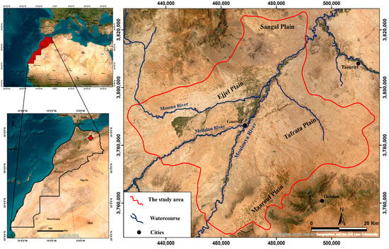
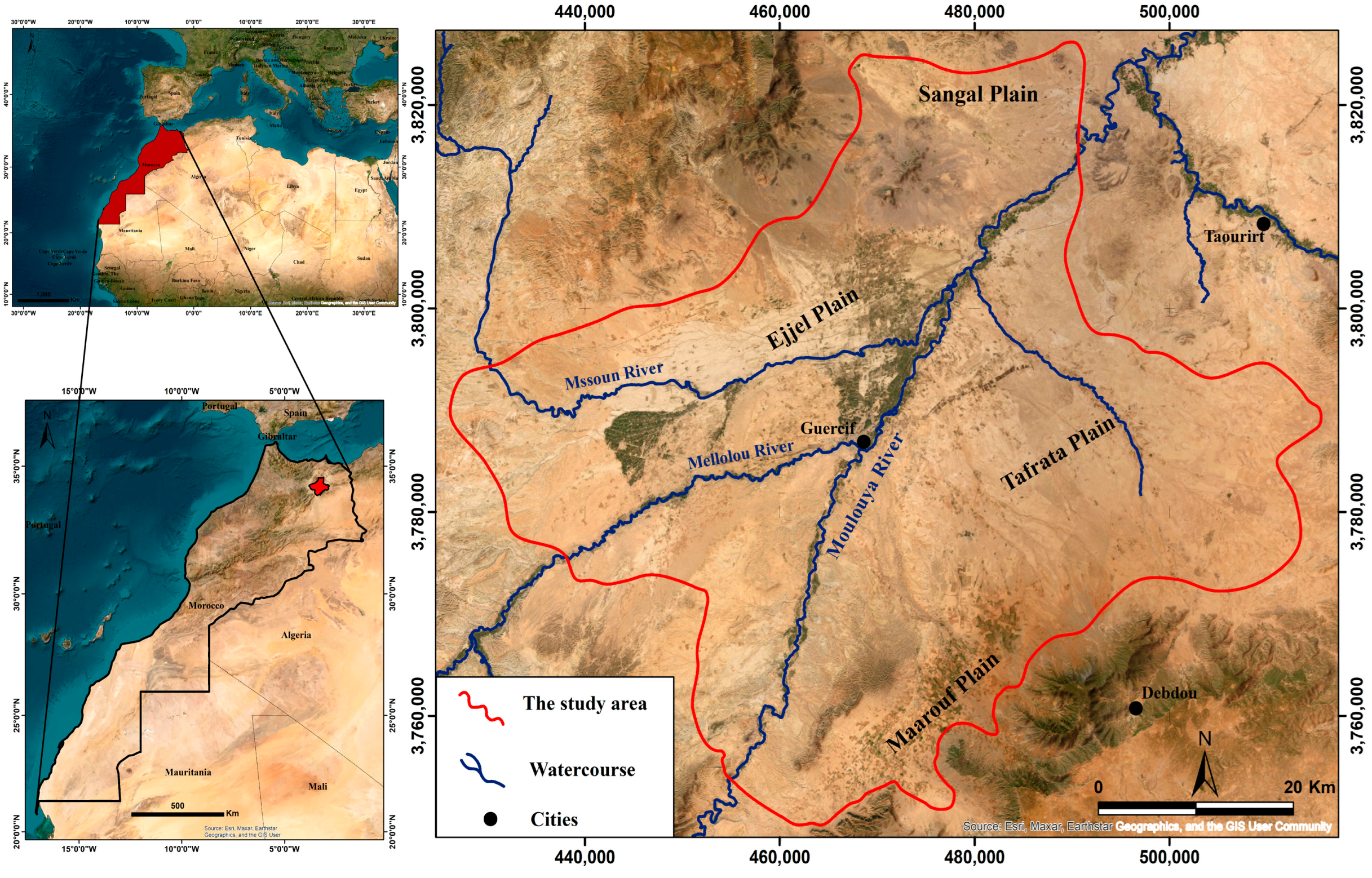
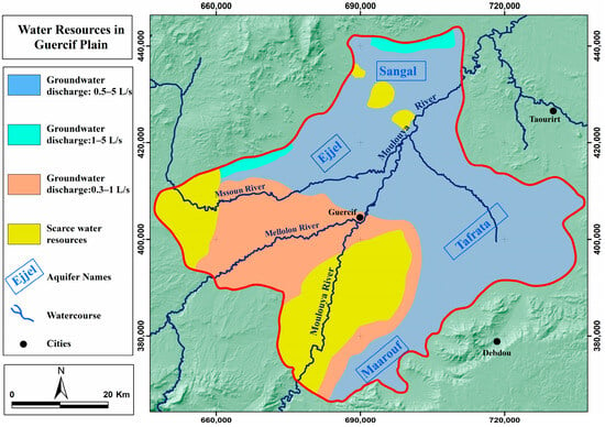
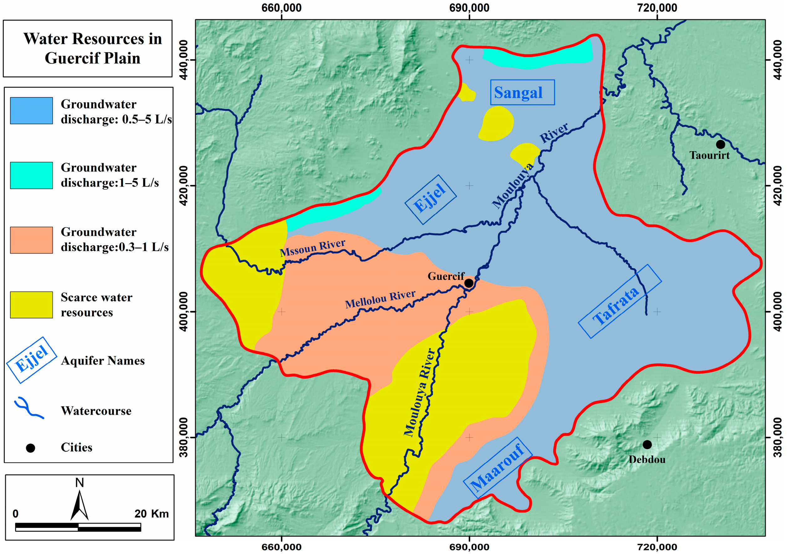
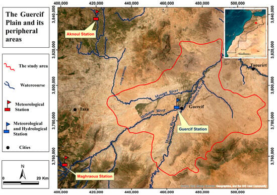
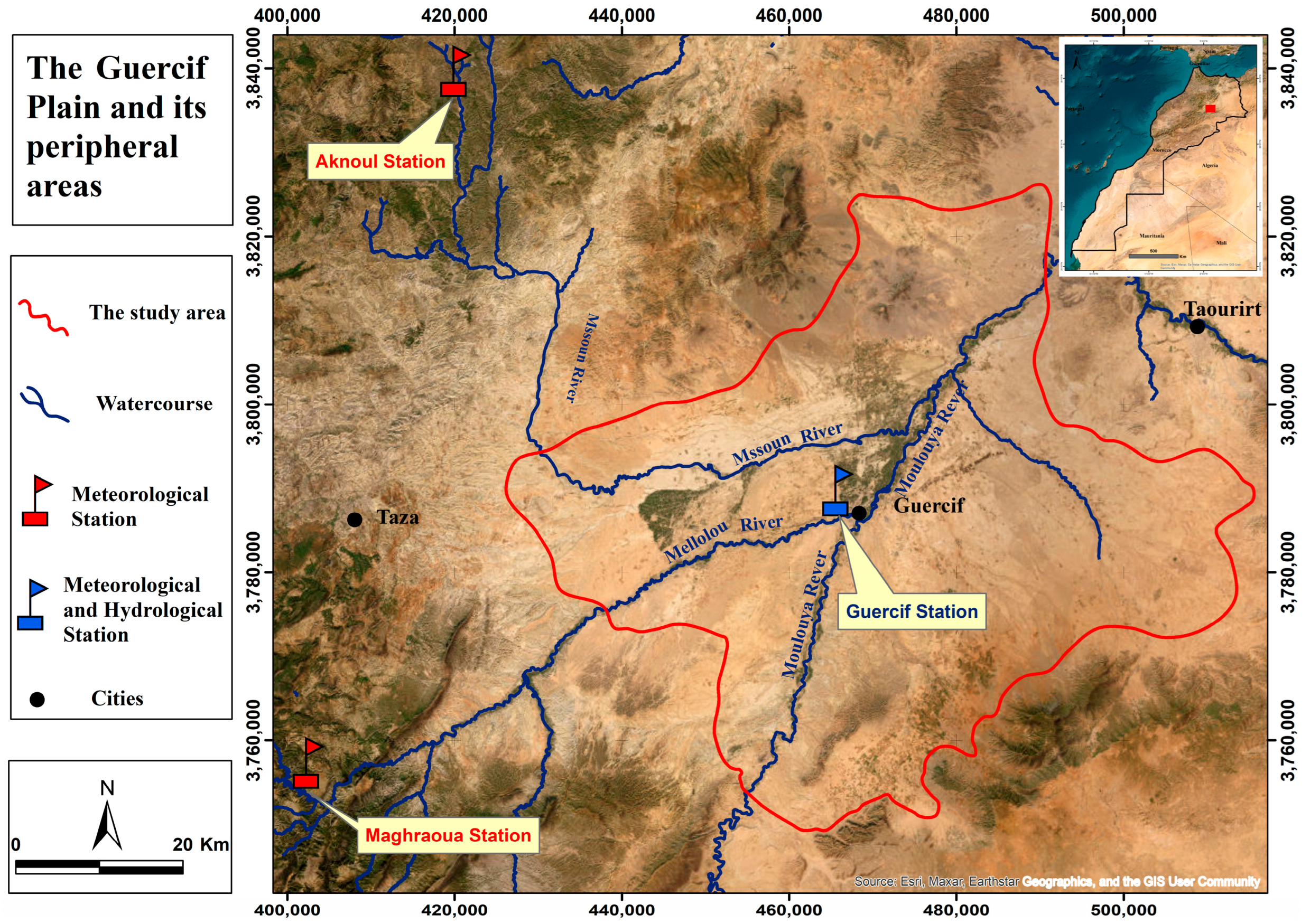
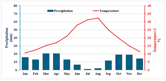
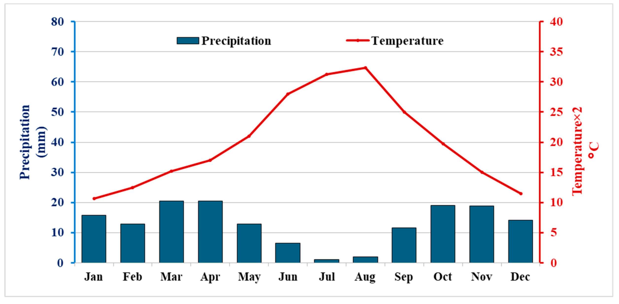
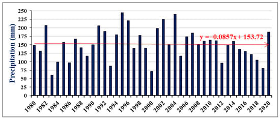
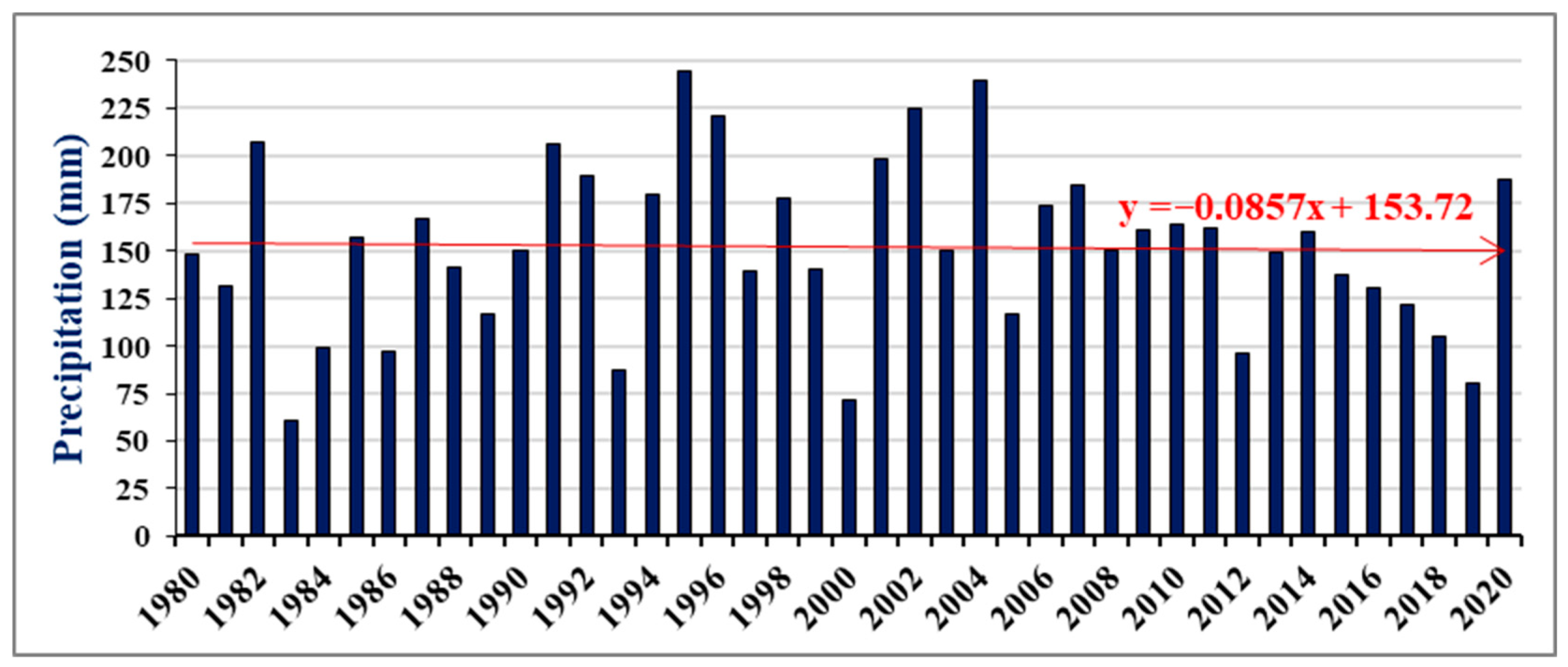
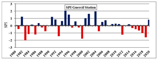
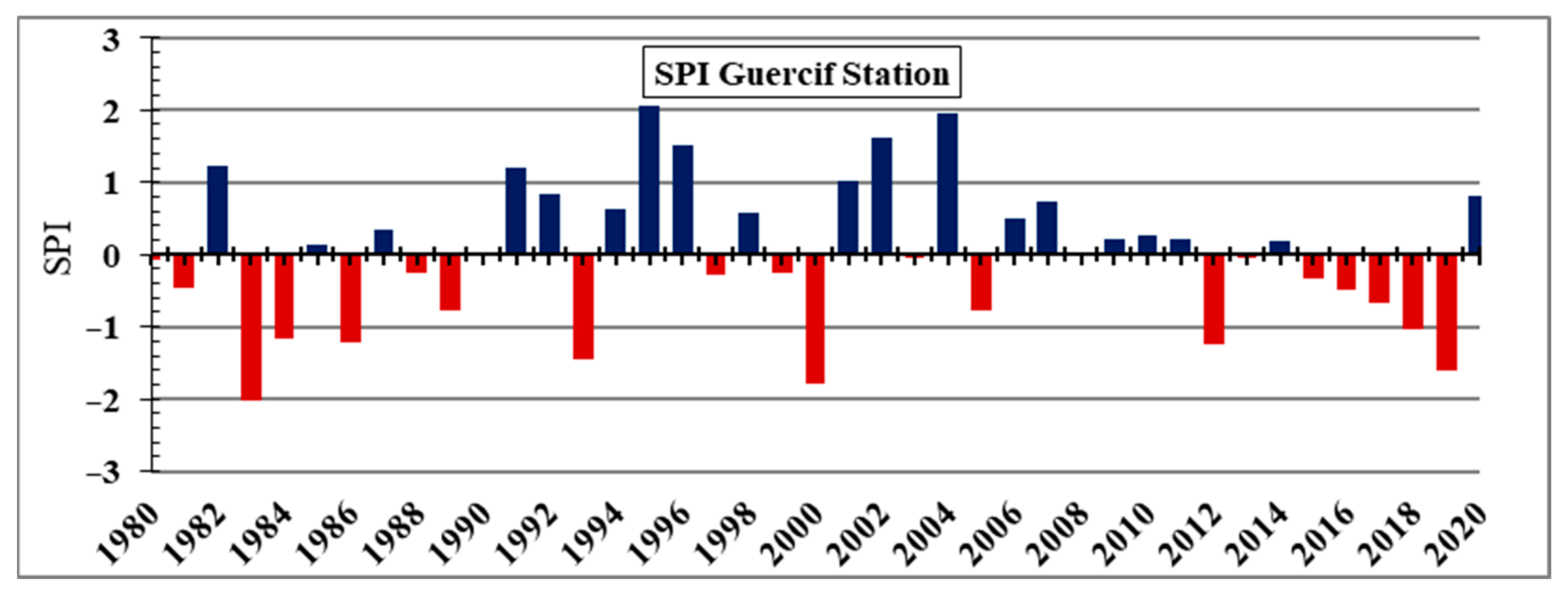
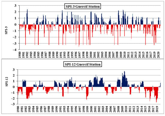
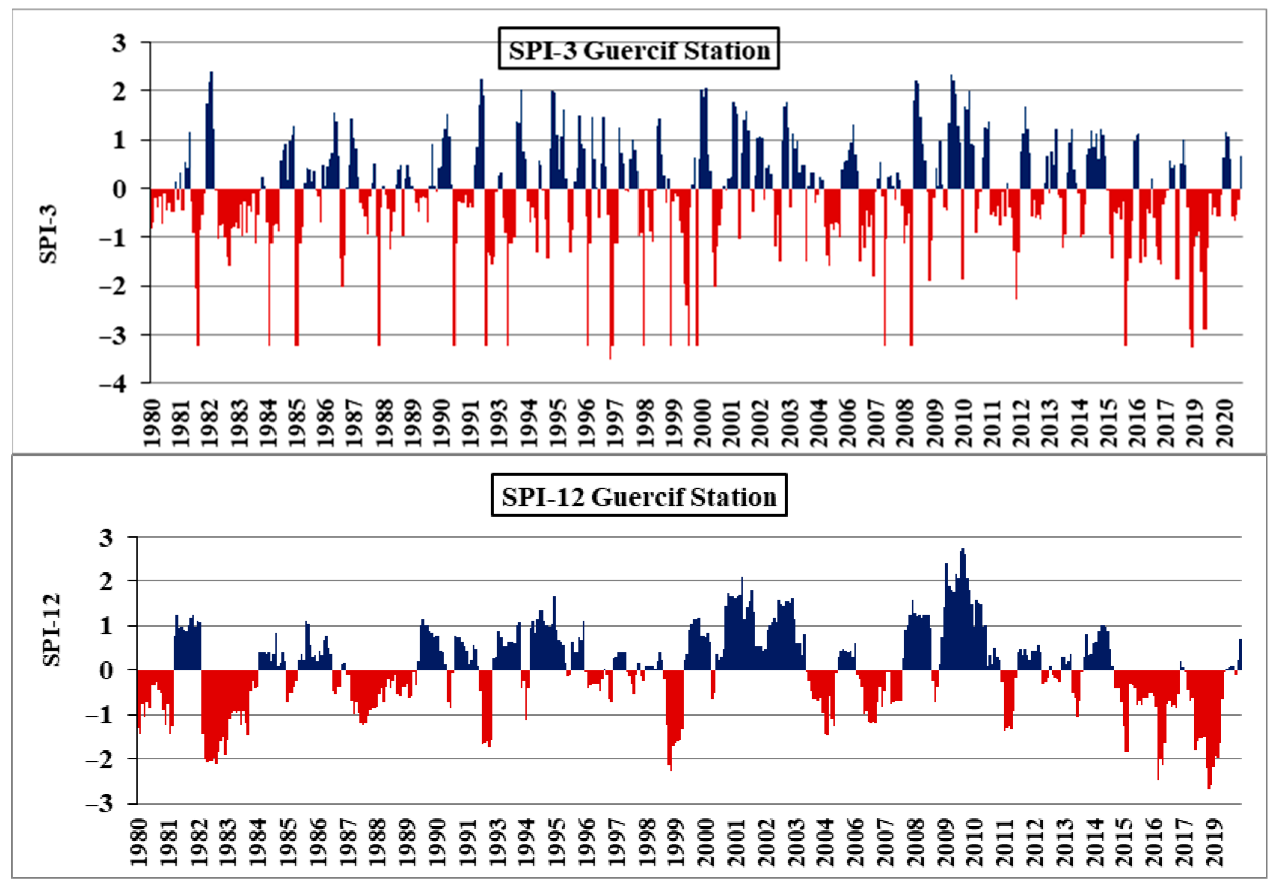
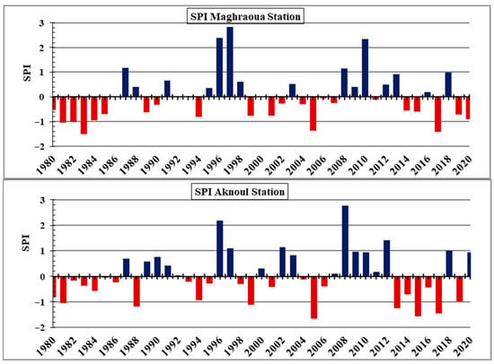
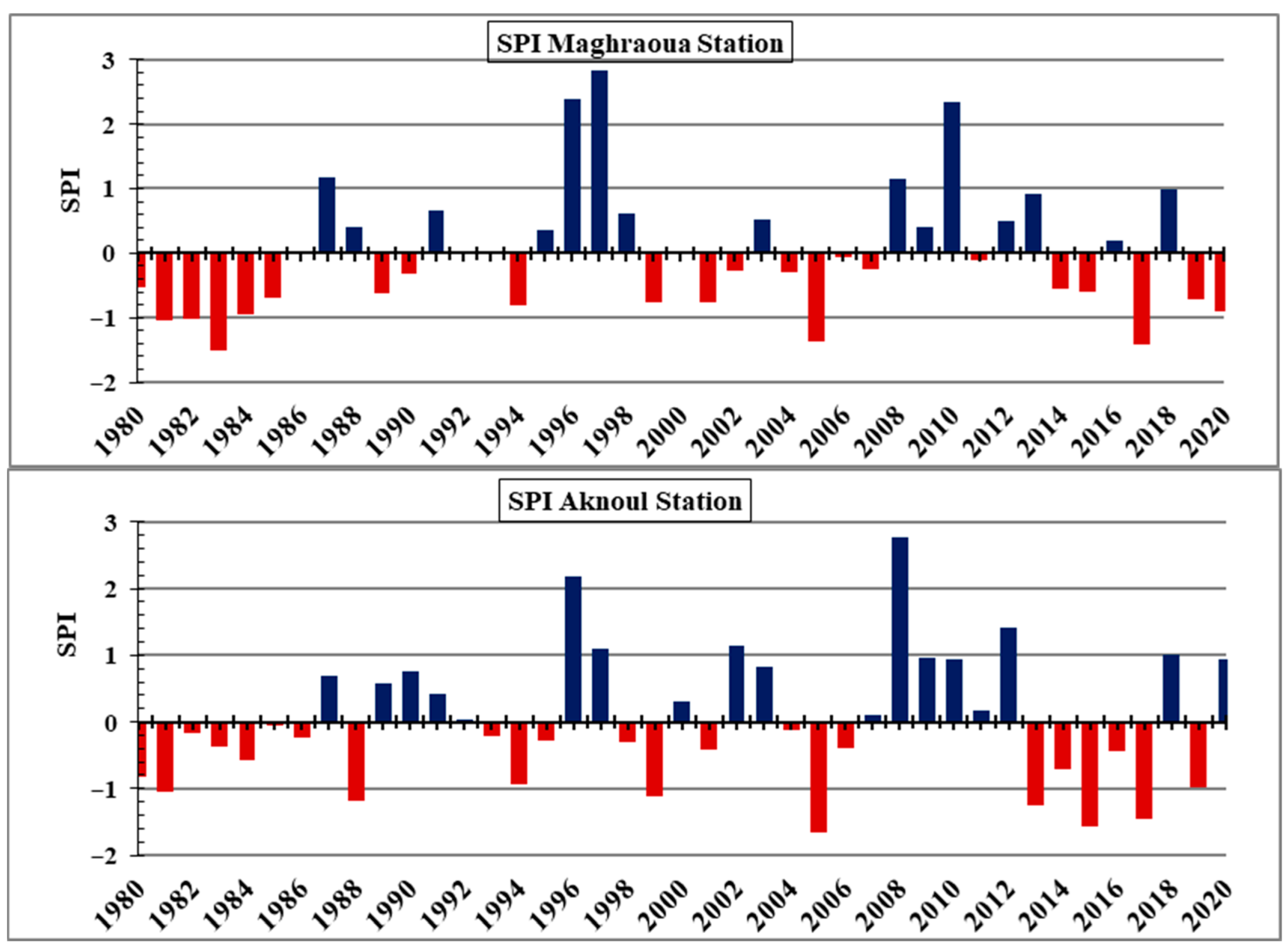
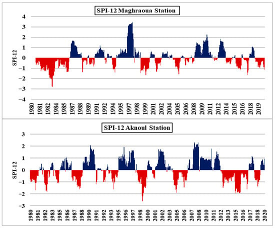
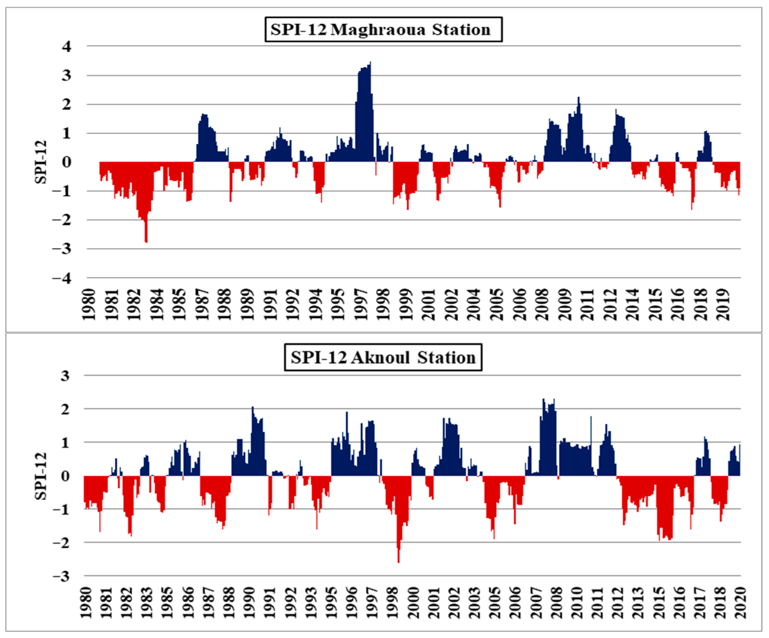
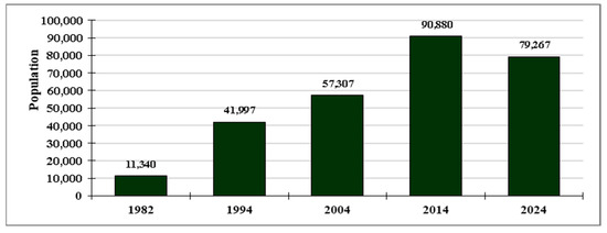
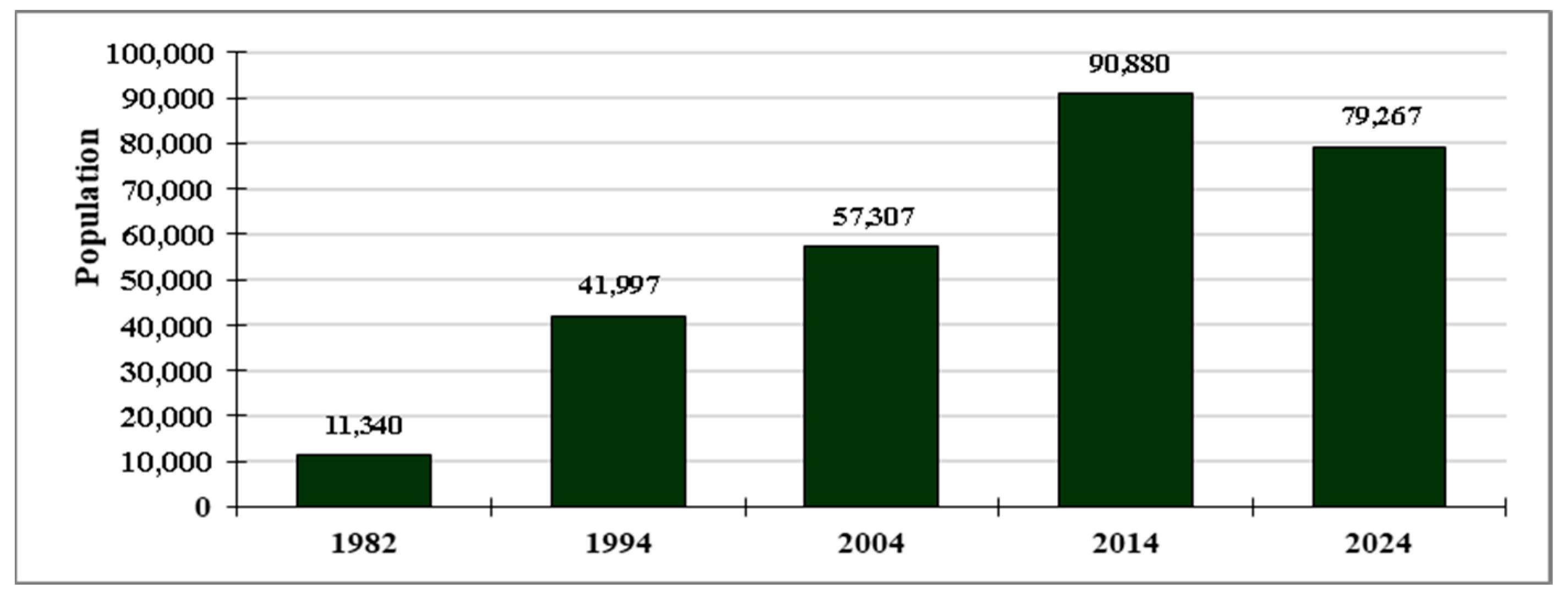
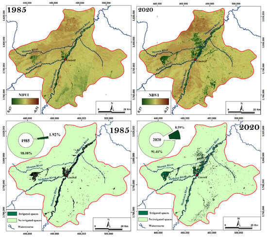
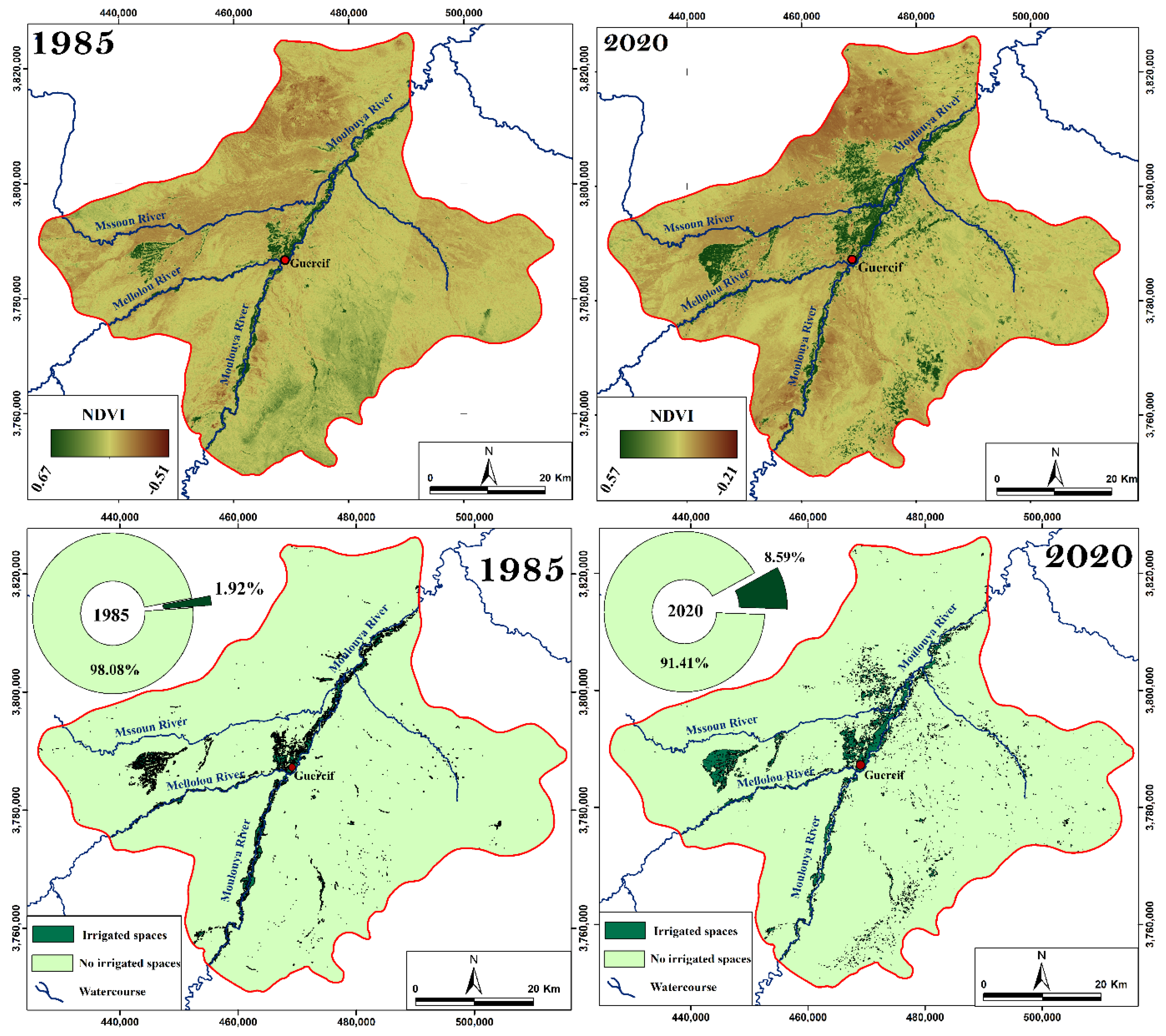
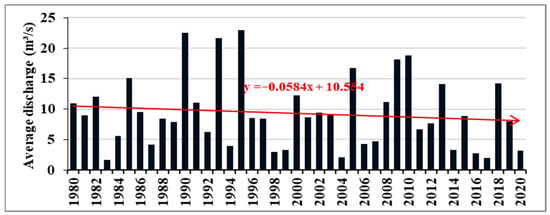
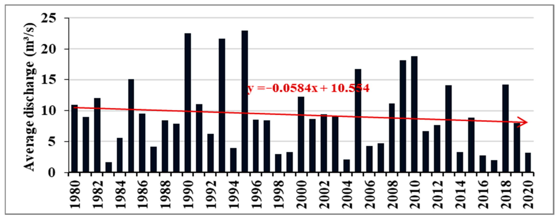
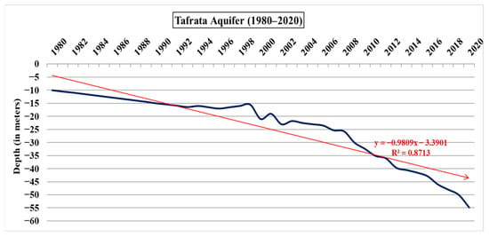
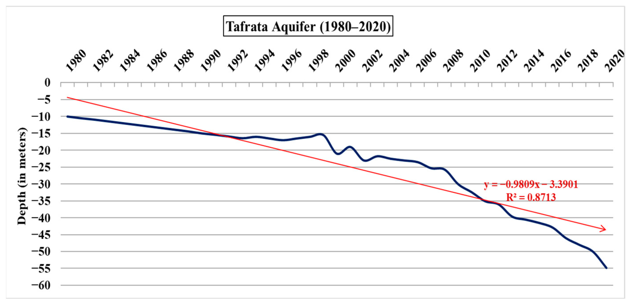
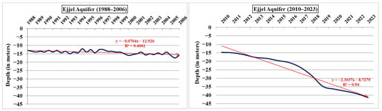
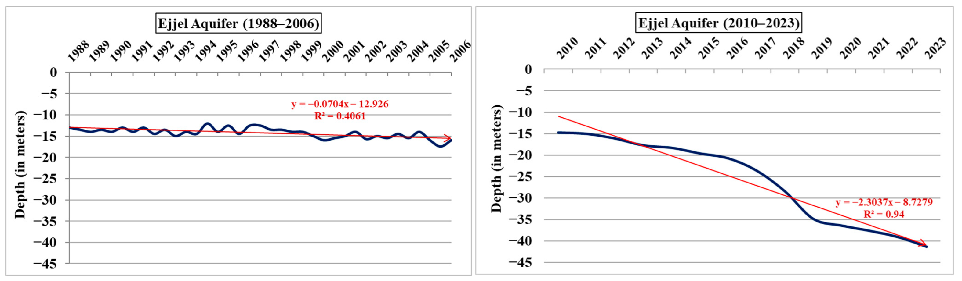
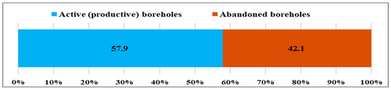
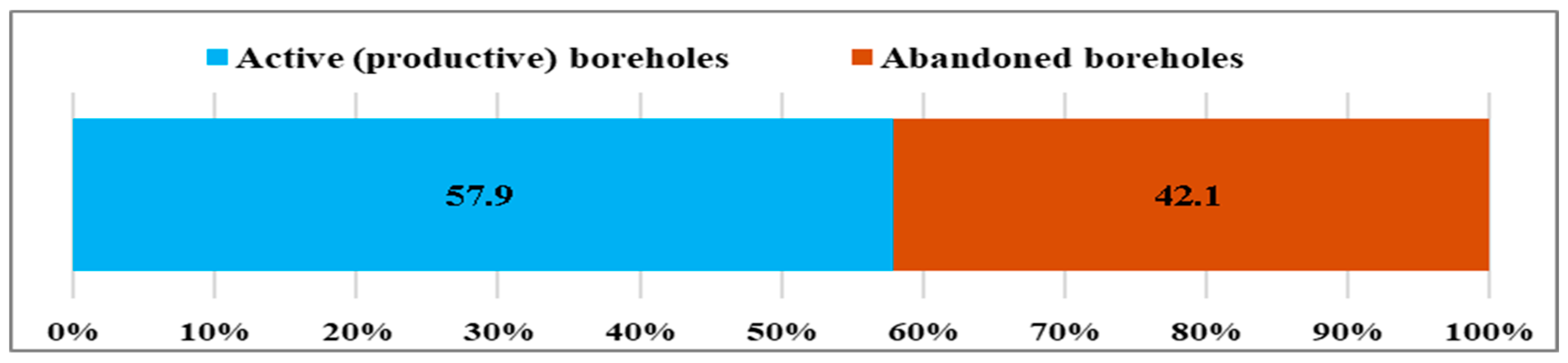

Disclaimer/Publisher’s Note: The statements, opinions and data contained in all publications are solely those of the individual author(s) and contributor(s) and not of MDPI and/or the editor(s). MDPI and/or the editor(s) disclaim responsibility for any injury to people or property resulting from any ideas, methods, instructions or products referred to in the content. |
© 2026 by the authors. Licensee MDPI, Basel, Switzerland. This article is an open access article distributed under the terms and conditions of the Creative Commons Attribution (CC BY) license.