


Abstract
Sediment yield remains a major challenge in erosion-prone watersheds because it affects reservoir capacity, water quality, hydraulic infrastructure, and ecological stability. Although numerous studies have examined sediment yield estimation and sediment control, these topics are often treated separately, limiting the development of integrated watershed management strategies. Unlike many existing sediment yield review papers that focus primarily on predictive models, erosion processes, or management measures in isolation, this study provides an integrated synthesis of sediment yield estimation methods and sediment control strategies within a single watershed management framework for erosion-prone environments. The review covers empirical models, traditional sampling, physically based models, and emerging data-driven tools such as artificial intelligence, machine learning, remote sensing, and sensor-based monitoring, alongside structural, vegetative, and adaptive sediment control measures. The reviewed literature indicates three major trends: increasing integration of GIS and remote sensing with conventional models, wider use of process-based models for scenario analysis, and rapid growth of AI-based methods for real-time and nonlinear prediction. The findings further show that no single estimation or control strategy is universally applicable; performance depends strongly on watershed scale, sediment connectivity, land use, climatic regime, and data availability. Overall, the review highlights the need for integrated, adaptive, and site-specific sediment management frameworks that combine predictive modeling, monitoring technologies, and practical control interventions to improve long-term watershed resilience.
1. Introduction
Sediment yield is a key measure of geomorphic activity and is commonly defined as the amount of sediment per unit area removed from a watershed by flowing water that reaches or passes a point of interest within a given period [1,2]. It commonly arises from land erosion processes, particularly during high-intensity rainfall events that increase soil erosivity [3]. Sediment yield is especially pronounced in erosion-prone watersheds, where natural conditions and human-induced disturbances interact to accelerate soil erosion and sediment transport [4]. In such watersheds, particularly those characterized by steep topography, degraded vegetation cover, and intense precipitation, sediment production can reach critical and often unsustainable levels. For example, the Pisha sandstone region of China’s Loess Plateau records some of the highest sediment yields in the world, with specific sediment yield values ranging from 34.32 t/(ha·a) to 123.80 t/(ha·a), largely due to its steep slopes and highly erodible sandstone formations [5]. These conditions contribute to downstream siltation, reduced reservoir storage capacity, deteriorated water quality, and declining agricultural productivity [6]. At the same time, anthropogenic activities such as deforestation, mining, poor agricultural practices, and unplanned urban development further intensify watershed degradation and sediment transport [7]. As erosion processes become more severe, the hydrological and ecological integrity of watersheds is progressively compromised, underscoring the need for sustainable and effective sediment management.
In water resources engineering, sediment management plays a vital role in maintaining the performance and service life of dams, irrigation systems, canals, and drainage infrastructure [6]. Excessive sedimentation reduces reservoir capacity, shortens the lifespan of hydraulic structures, and increases operation and maintenance costs [8]. Sediment-laden runoff also degrades water quality and adversely affects aquatic ecosystems, recreational water use, and public health [9]. For this reason, accurate sediment yield estimation and effective sediment control are essential to the planning, design, and implementation of resilient water resources systems [10].
Despite extensive studies on sediment yield modeling and sediment control strategies, the two are often discussed independently, resulting in limited integrative synthesis between advances in prediction methods and their application to practical watershed management [11,12]. This gap has become more important with the rapid development of artificial intelligence, remote sensing, and real-time monitoring technologies, which now offer new opportunities to improve both sediment estimation and sediment control within a more unified and adaptive framework [13,14].
Another major challenge in sediment yield research is the persistent difference between erosion measured at the plot scale and sediment response observed at the basin scale. Plot-scale erosion experiments are useful for understanding detachment and surface transport processes under controlled or localized conditions, but basin-scale sediment yield reflects a more complex response that includes channel routing, temporary storage, floodplain deposition, sediment connectivity, and later remobilization. As a result, sediment produced on hillslopes does not necessarily translate directly into sediment delivered at the watershed outlet. This scale discrepancy remains a major source of uncertainty in sediment yield estimation and highlights the need for more integrated frameworks that account for sediment transfer pathways and storage dynamics.
In this context, the present review examines sediment yield estimation and sediment control as closely linked components of integrated watershed management. It evaluates a range of structural and non-structural sediment control measures commonly applied in watershed systems, with particular emphasis on their effectiveness under varying environmental conditions. Specifically, this review (1) synthesizes empirical, physically based, and data-driven models for sediment yield estimation; (2) evaluates structural, vegetative, and adaptive control measures across different watershed contexts; and (3) identifies methodological limitations, research gaps, and future directions needed to improve predictive accuracy and support long-term watershed resilience. By linking advances in empirical, physically based, and data-driven estimation methods with structural, vegetative, and adaptive control strategies, this review offers a more comprehensive perspective than studies that treat these themes independently.
What distinguishes this review from existing sediment yield review papers is its explicit integration of predictive modeling, sediment transfer processes, and practical control interventions, allowing comparative evaluation not only of estimation methods themselves but also of how these methods inform real-world sediment management across different watershed settings.
2. Concepts and Definitions
Sediment yield is defined as the total amount of sediment exported from a watershed over a specific period. It is typically expressed in mass per unit time (e.g., tons per year), volume per unit time (e.g., MCM per year), or depth equivalent (e.g., mm per year). On the other hand, the yearly average sediment production calculated from long-term historical data is used to predict the sediment yield from a watershed [15]. Sediment production refers to the total amount of soil detached within a watershed, whereas sediment yield represents only the fraction that is delivered to a defined outlet. The relationship between erosion, sediment transport, intermediate storage, and sediment delivery can be conceptualized as a cascading process within the watershed system. As illustrated in Figure 1, sediment generated on hillslopes is transported through flow pathways, temporarily stored within landscape components such as floodplains or channels, and ultimately delivered to the watershed outlet as sediment yield. It is determined by geomorphologic factors such as soil, topography, land use, and land cover, also, some hydrological factors, namely, rainfall, runoff, and peak flow characteristics [14,16,17,18]. Sediment yield is primarily driven by soil erosion caused by water. It represents the portion of eroded soil that is effectively transported and delivered from upland areas to downstream locations within a watershed [19]. A study by Ali et al. (2021) [20] utilized the Revised Universal Soil Loss Equation (RUSLE) model to estimate potential soil erosion and sediment yield, which demonstrated the direct relationship between water-induced soil erosion and sediment yield. Furthermore, a great contribution to sediment yield can be influenced by anthropogenic factors such as urbanization, industrialization, deforestation, mining, and agricultural practices [21,22]. For instance, the study of Abua et al. (2023) [22] concluded that the reduction in reforested areas and agricultural activities is one of the reasons for the increase in sedimentation in water bodies. This shows that human-induced factors significantly contribute to sediment yield in the watershed.
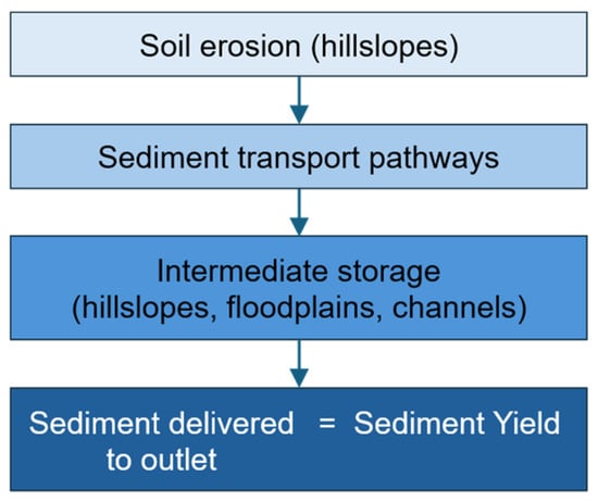
Figure 1.
Conceptual schematic illustrating the relationship between soil erosion, sediment transport pathways, intermediate storage, and sediment yield delivered to the watershed outlet.
While closely related, soil erosion and sediment delivery are distinct processes. Soil erosion involves the detachment and movement of soil particles from the land surface due to agents like water, wind, or gravity [23]. In contrast, sediment delivery pertains to the portion of eroded soil that is actually transported to and deposited in downstream locations such as floodplains, rivers, lakes, and reservoirs. Not all eroded material reaches these endpoints; some is redeposited within the landscape before reaching the watershed outlet [24,25,26]. This distinction is critical in watershed-scale analysis because management interventions targeting erosion sources may not directly correspond to reductions in sediment yield without considering sediment transport pathways and storage mechanisms [27].
In addition, sediment yield should not be interpreted solely as a direct function of erosion magnitude, because the movement of sediment through a watershed is strongly influenced by sediment connectivity, intermediate storage, and remobilization processes. Sediment connectivity describes how efficiently eroded material is transferred from source areas to channels and downstream outlets, while storage may occur temporarily in hillslopes, colluvial zones, floodplains, valley bottoms, and channel beds. Previously deposited material may later be remobilized during subsequent runoff events, creating a time-lagged and spatially variable response. When these processes are simplified or omitted in sediment models, substantial uncertainty can arise in downstream routing and sediment delivery predictions.
2.1. Scale of Sediment Yield Analysis
The scale of sediment yield analysis is important in the interpretation of erosion data and the design of effective management strategies. The term “scale” refers to the spatial and temporal extent at which sediment yield is assessed, ranging from small plots or hillslopes to entire watersheds or river basins [28,29]. Sediment yield is the result of complex interactions where in terms of spatial and temporal scales, there is variation among erosion processes, sediment transport, and deposition; these are influenced by topography, climate, land use, and human activities [30,31]. Therefore, understanding these scale-dependent dynamics is crucial for accurately estimating sediment budgets and implementing effective soil and water conservation strategies.
The spatial scale at which it is assessed heavily influences the magnitude and variability of results due to the interaction of erosion, transport, and deposition processes across different parts of the watershed [29,31]. For smaller scales such as plots or hillslopes, sediment yield measurements typically reflect short-term, localized erosion processes with minimal re-deposition, often resulting in relatively high values [32,33]. In contrast, larger catchment or basin-scale studies tend to report lower net sediment yields due to sediment being stored temporarily or permanently along channels, floodplains, and depositional zones within the watershed [33].
The influence of spatial scale on sediment yield observations is illustrated conceptually in Figure 2. Measurements obtained at small spatial scales often report higher erosion rates, whereas sediment yield observed at the watershed outlet is typically lower due to sediment transport, temporary storage, and deposition processes occurring along hillslopes, floodplains, and channel networks.
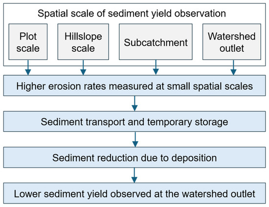
Figure 2.
Conceptual illustration of the influence of spatial scale on sediment yield observations.
In addition, sediment yield is highly variable within a given spatial scale. In some cases, a small portion of the landscape contributes disproportionately to total sediment output [34,35]. For instance, localized disturbances, such as logging, wildfires, or unregulated agriculture, can heighten sediment production by one to two orders of magnitude compared to undisturbed areas [32,33]. Meanwhile, post-disturbance sediment yields in forested regions have been observed to be higher than the baseline levels due to minimal re-deposition and rapid mobilization of erodible materials [32]. Similarly, refs. [36,37,38] emphasized that sediment hotspots, although limited in spatial coverage, contribute disproportionately to basin-wide sediment loads. These areas are typically linked to altered land cover, steeper slopes, and intensified rainfall erosivity. Hence, it is important to understand the spatial variability of sediment sources since it is critical for prioritizing erosion control interventions and optimizing watershed management strategies [39,40].
Generally, recognizing scale effects plays a pivotal role in designing sediment control measures. Studies [41,42,43] indicate that soil conservation practices effective at the field level may have limited impact on downstream sediment yield if midstream storage and reactivation zones are not addressed. Similarly, sediment trapping structures, such as check dams or reservoirs, must be strategically placed within the sediment routing network to intercept sediment critical source areas [44,45]. The findings of these studies underscore the necessity of considering spatial variability and scale when implementing sediment control measures. By strategically placing interventions in areas that contribute most significantly to sediment transport, watershed management efforts can therefore achieve better efficiency and effectiveness in reducing sediment yield [46,47].
In addition to spatial scale, temporal scale is equally important. Sediment yield exhibits strong inter-annual and seasonal variability, particularly in regions dominated by extreme rainfall events or episodic disturbances such as wildfire or land-use conversion. Short-term monitoring may overestimate or underestimate long-term sediment yield trends, emphasizing the need for extended datasets in model calibration and validation [48,49].
2.2. Key Factors Affecting Sediment Yield
Sediment yield is governed by a complex interplay of natural and anthropogenic factors that vary across spatial and temporal scales. It is essential to understand these driving forces as it is used to predict sediment dynamics, identify critical source areas, and formulate effective watershed management strategies. This section provides a detailed discussion of the principal factors that influence sediment yield.
2.2.1. Natural Factors
As noted earlier, sediment yield is influenced by a range of geomorphologic and hydrologic variables such as soil properties, topography, rainfall, vegetation cover, and hydrologic network structure. The relationship among these variables explains the spatial heterogeneity of sediment yield observed within and among watersheds [50].
Topography strongly influences sediment production. Steep slopes and high relief increase overland flow velocity, which accelerates the detachment and transport of soil particles. Vente and Poesen (2005) [14] demonstrated that slope gradient and topographic indices are among the most critical predictors of sediment yield at both plot and basin scales. Studies also in the Chinese Loess Plateau by Shi et al. (2014) [16] and Zhang et al. (2015) [17] concluded that slope length and steepness significantly affect sediment output, due to enhanced runoff generation.
In addition to regional studies, global research has consistently identified topographic variables, specifically slope gradient and relief, as major controls in sediment yield. Vanmaercke et al. (2014) [51] discussed through multivariate regression that relief alone could explain a significant portion of the variability in sediment export across continents. Similarly, Jansson (1988) [52] concluded that sediment yields increase predictably with steeper slopes and watershed elevation, emphasizing the role of topography in both humid and arid environments.
However, topographic influence is often mediated by land cover and soil conditions, indicating that slope gradient alone may not sufficiently explain sediment yield variability without integrating other controlling factors [53].
Rainfall intensity and erosivity are key climate-related controls of sediment yield, especially in semi-arid and Mediterranean-type of environments where short, high-intensity storms dominate hydrological responses [54,55,56]. These rainfall events generate strong energy that enhances the detachment and transport soil particles. The study of Lloveras et al. (2017) [54] indicated that intense rainfall events could greatly affect topsoil loss and sediment transport in Mediterranean catchments. Also, Guesri et al. (2020) [55] demonstrated that rainfall erosivity was the dominant factor that influences seasonal sediment production, with up to 68% of the variance in sediment yield explained by erosivity during autumn.
In regions experiencing increasing rainfall variability and extreme storm frequency, the contribution of rainfall erosivity to sediment yield may intensify, underscoring the importance of incorporating climate variability into predictive models [57,58].
Soil properties and lithology influence the erodibility of a landscape, thereby affecting sediment detachment, transport, and eventual yield. Key factors such as soil cohesion, organic matter content, infiltration capacity, and surface roughness determine the susceptibility of soils to erosive [14,51,59,60]. Vente and Poesen (2005) [14] highlighted that these properties are important inputs in physically based and semi-quantitative sediment yield models, as they govern the resistance of the soil to detachment under varying hydrological and topographical conditions. Furthermore, Vanmaercke et al. (2014) [51] discussed that sediment yields are generally higher in regions with highly erodible soils or weak lithological formations, despite challenges in quantitatively integrating these variables at larger spatial scales due to limited data variability. These results highlight the importance of considering soil and geological variability when modeling erosion processes and developing site-specific sediment control strategies.
In addition to rainfall and topographic controls, geomorphic disturbances such as landslides can significantly increase sediment production in watershed systems. Recent global-scale investigations have shown that earthquake and rainstorm-induced landslides are strongly influenced by topographic and morphological characteristics, which control sediment mobilization and downstream sediment delivery pathways. Numerical simulations of catastrophic landslide processes have also demonstrated how large-scale slope failures can rapidly mobilize significant sediment volumes across terrestrial and submarine environments [61,62].
Vegetation cover plays a vital role in the reduction in sediment yield through interception of raindrop impact, increase in surface roughness, enhance infiltration, and reduce overland flow velocity. Dense vegetation, especially in the form of riparian buffers and grass strips, acts as a physical barrier that traps sediments before they can be transported downstream [63,64,65]. Yuan et al. (2009) [63] showed that vegetative buffer strips with widths 5–6 m can reduce sediment loads by up to 80% in agricultural catchments, thus, increasing deposition and reducing flow energy. However, Zhang et al. (2017) [4] studies that deforestation and grassland degradation in the Chinese Loess Plateau significantly increased sediment delivery to river systems, highlighting the importance of vegetative cover in stabilizing landscapes and reducing erosion risks.
Vegetation also influences sediment connectivity by disrupting flow pathways and promoting temporary sediment storage, thereby reducing the efficiency of sediment transfer from source areas to watershed outlets [66,67].
2.2.2. Anthropogenic Factors
Human-induced activities significantly contribute to increased sediment yield in watersheds. Urbanization, industrialization, deforestation, mining, and agricultural practices disrupt the natural balance of erosion and sediment transport by altering land cover, soil structure, and hydrological flow paths [48,68]. As discussed by Walton et al. (2023) [21] and Abua et al. (2023) [22], these activities elevate sediment production through increased runoff, soil exposure, and connectivity between sediment sources and streams. Take for example, the study of Abua et al. (2023) [22], it was found out that reductions in forest cover and the expansion of agricultural areas were key drivers of sedimentation in local water bodies, highlighting the cumulative effect of land-use change on downstream sediment loads.
Deforestation removes vegetative cover that stabilizes soil and intercepts rainfall, thereby increasing the vulnerability of landscapes to erosion. In regions such as the Loess Plateau, Zhang et al. (2015) [17] reported substantial increases in sediment yield following deforestation and grassland degradation.
Agricultural practices, especially tillage and monocropping on sloped terrain, disturb soil surfaces and reduce infiltration capacity. This intensifies overland flow and sediment detachment. The study of Pimentel et al. (1995) [69] emphasized that conventional agriculture accelerates soil erosion far beyond natural replenishment rates. Moreover, recent advances emphasize how tillage-induced changes in microtopography alter sediment dynamics. Luo et al. (2023) [70] found that ridge tillage systems increase hydrological-sediment connectivity by modifying surface flow paths and enhancing sediment transport efficiency.
Mining operations, particularly those using open-pit and artisanal methods, strip vegetation and disturb large surface areas, thereby increasing sediment mobilization. These activities often occur near headwater streams, directly impacting sediment delivery to downstream systems. Kusimi et al. (2021) [71] studied a forested river basin in Ghana and found that sediment yield increased substantially in areas undergoing artisanal gold mining, even in otherwise densely vegetated catchments. The study highlighted that mining-related land cover changes disrupted the hydrological balance and exposed large surface areas to erosion processes.
Urban development introduces impervious surfaces, which amplify surface runoff and decrease infiltration. This leads to increased erosion of adjacent, exposed soils and contributes to sediment accumulation in urban drainage systems. Zhou et al. (2019) [72] indicated that rapid urban land-use conversion leads to increased surface runoff and sediment transport, particularly high-intensity storm events. Similarly, McVey et al. (2023) [73] noted that urban expansion often intensifies sediment connectivity by channelizing flows and reducing natural retention zones. However, not all urbanization effects result in higher sediment yields over the long term. The study of Bello et al. (2017) [74] reported that increased built-up areas could lead to lower sediment yields, particularly during peak rainfall events. This was attributed to the replacement of erodible surfaces with impervious pavements. However, it was also discussed that while sediment yield may decrease, the quality and volume of stormwater discharge may still pose ecological risks.
Overall, anthropogenic activities often modify not only sediment production rates but also sediment routing pathways, thereby altering sediment connectivity and delivery efficiency at multiple spatial scales. The summary of factors affecting watersheds are summarized in Table 1.

Table 1.
Summary of factors affecting the sediment yield in watersheds.
The interactions among natural drivers, anthropogenic pressures, erosion processes, sediment routing dynamics, and downstream impacts operate as an interconnected system rather than isolated components. Sediment connectivity and intermediate storage play critical roles in determining the efficiency of sediment transfer from source areas to watershed outlets. The integrated relationships among these elements are conceptualized in Figure 3.
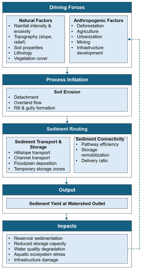
Figure 3.
Conceptual framework of sediment yield dynamics in erosion-prone watersheds, illustrating the interactions among natural and anthropogenic drivers, erosion processes, sediment routing mechanisms, connectivity controls, and downstream impacts. The dashed arrow represents feedback mechanisms where sediment-related impacts influence future anthropogenic responses and watershed management decisions.
3. Review Methodology
This review adopts an organized and integrative approach to investigate new and existing techniques for estimating and controlling sediment yield in watersheds that are prone to erosion. It encompasses a broad scope that includes empirical, physically based, and AI-driven models, as well as structural, vegetative, and technological sediment control strategies. To structure the synthesis, references were thematically classified into three core domains: estimation methods, control strategies, and watershed-specific applications. This framework facilitates a more focused discussion of key innovations, persistent challenges, and evolving trends in sediment management across diverse hydrological and geographic settings.
This review was conducted following methodological guidance from the Cochrane Handbook for Systematic Reviews of Interventions and the Joanna Briggs Institute (JBI) Manual for Evidence Synthesis [75]. The review process followed a structured systematic approach for identifying, screening, and synthesizing relevant literature related to sediment yield estimation and control in erosion-prone watersheds. The reporting of this study adhered to the PRISMA 2020 (Preferred Reporting Items for Systematic Reviews and Meta-Analyses) guidelines to ensure transparency in the literature identification, screening, eligibility assessment, and synthesis. The completed PRISMA checklist is provided in the Supplementary Materials.
Due to the environmental engineering scope of this review, the study protocol was not registered in registries such as PROSPERO, which are primarily designed for health-related systematic reviews.
3.1. Literature Sources and Selection Criteria
The literature search focused on peer-reviewed studies that address sediment yield estimation and control across different watershed contexts. Scopus and ScienceDirect served as the primary databases due to their broad coverage of hydrology, environmental science, and water resources engineering. Additional sources were drawn from institutional repositories, global sediment management programs, as well as journals published by MDPI, Elsevier, and Springer.
The search was limited to articles published from 2000 to 2025, allowing the inclusion of both foundational models and recent technological innovations. Studies were filtered based on methodological rigor, relevance to sediment dynamics, and application of field-based or modeling techniques. Preference was given to works involving empirical models, process-based simulations, and advanced tools such as machine learning, remote sensing, or sensor-based monitoring. Search keywords included combinations of “sediment yield,” “soil erosion,” “watershed management,” “sediment modeling,” “RUSLE,” “SWAT,” “machine learning,” “artificial intelligence,” “sediment control,” and “best management practices.” Boolean operators were applied to refine the results across databases.
Studies were included if they: (1) presented quantitative estimation of sediment yield; (2) evaluated sediment control measures or management interventions; and/or (3) applied empirical, physically based, remote sensing, sensor-based, or AI/ML modeling tools within a watershed-scale context. Eligible studies included peer-reviewed journal articles and selected high-relevance institutional or programmatic publications that contributed directly to sediment yield estimation or control in erosion-prone watersheds.
Studies were excluded if they: (1) focused solely on theoretical erosion mechanics without watershed-scale application; (2) addressed erosion or sediment transport only at plot scale without discussion of watershed sediment delivery or control implications; (3) lacked sufficient methodological detail or relevance to sediment yield estimation or control; or (4) were duplicate records identified across databases. The review was limited to studies published in English between 2000 and 2025.
This selection process allowed the review to cover a wide range of strategies while focusing on real-world applicability. Although reviewed studies span various spatial and temporal scales, methodological variability, such as differences in data quality input, watershed size, and modeling resolution, may influence the consistency of cross-study comparisons. A total of 107 references were retained for detailed synthesis after screening for relevance and duplication.
Following PRISMA guidelines, the study selection process involved several stages, including literature identification, duplicate removal, title and abstract screening, and full-text eligibility assessment. Records retrieved from the selected databases were initially screened based on titles and abstracts to determine their relevance to the review objectives, after which articles meeting the preliminary criteria were subjected to full-text evaluation to confirm eligibility according to the predefined inclusion and exclusion criteria. Through this PRISMA-based screening process, 107 studies were retained as the core evidence base for structured synthesis. The larger total of 163 references cited in the manuscript includes not only these core studies, but also additional supporting references used for conceptual background, definitions, methodological context, and broader discussion. Thus, the 107 studies represent the screened review dataset, whereas the 163 references represent the complete bibliography cited throughout the paper.
The detailed study identification and selection process is illustrated in the PRISMA flow diagram (Figure 4), which presents the number of records identified, screened, excluded, and ultimately included in the synthesis.
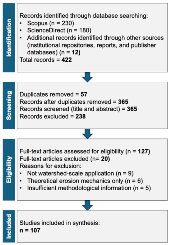
Figure 4.
PRISMA 2020 flow diagram illustrating the literature identification, screening, eligibility, and inclusion process for studies included in this systematic review.
3.2. Thematic Classification
For the purpose of facilitating a structured synthesis of the reviewed literature, studies included were classified into three main thematic clusters that reflect the dominant research trends in sediment yield estimation and control. These domains provide a clear focus to examine methodological developments, intervention strategies, and context-specific watershed applications. The thematic boundaries are not mutually exclusive, as several studies overlap across categories.
The first cluster, estimation methods, includes studies that are focused on techniques for quantifying sediment yield from watersheds. This group covers traditional empirical models such as the Universal Soil Loss Equation (USLE), its revised versions (RUSLE, MUSLE), physically based models like the Soil and Water Assessment Tool (SWAT), and advanced data-driven approaches including artificial intelligence (AI) and machine learning (ML) algorithms. These studies provide the backbone for understanding erosion dynamics and predicting sediment output across different scales and data conditions.
The second cluster, control measures, encompasses the literature that examines structural, vegetative, and adaptive interventions to reduce sediment yield. Structural measures include check dams, terraces, and silt traps. Meanwhile, vegetative methods focus on reforestation, buffer strips, and cover cropping, while adaptive approaches integrate climate-informed planning and best management practices (BMPs). The effectiveness of these interventions is typically assessed through field data, modeling tools, or remote sensing techniques.
The third cluster, watershed applications, includes case studies and applied research that evaluate estimation and control methods in specific watershed types, agricultural, urban, forested, and mountainous. These studies emphasize the spatial variability of sediment dynamics and offer context-based insights into the suitability and performance of interventions under varying environmental and land-use conditions.
This thematic framework enables cross-comparison between modeling approaches and management interventions, highlighting areas of convergence, divergence, and methodological advancement. The thematic classification is summarized in Table 2.
Table 2.
Summary of Thematic Classification.
To further illustrate the relevance and generalizability of the reviewed literature across methodological approaches and watershed contexts, a literature relevance analysis diagram is presented in Figure 5.
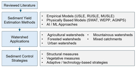
Figure 5.
Literature relevance analysis illustrating how the reviewed literature connects sediment yield estimation approaches, watershed application contexts, and sediment control strategies.
3.3. Temporal and Source Distribution
The publication years of the 153 references were analyzed to evaluate the recency and development of research in sediment yield estimation and control. References were grouped into five time intervals based on year of publication, as shown in Figure 6. Results show that 32% of the references were published from 2022 to 2025, while 30% account for 2018 to 2021. This reflects a growing interest in sediment modeling and control techniques in recent years, especially considering technological advancements, climate impacts, and integrated watershed management practices.
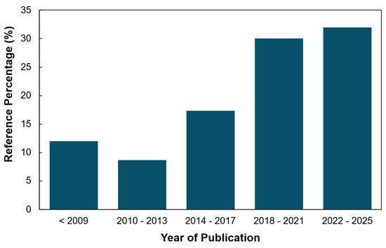
Figure 6.
Reference distribution based on year of publication.
Moreover, most references were sourced from peer-reviewed journal articles, supplemented by several institutional publications and technical reports. This combination enabled a balanced review of academic modeling techniques, empirical field studies, and applied control strategies. The representation of recent literature demonstrates the ongoing refinement of sediment estimation tools and a widening scope toward interdisciplinary and technology-integrated watershed management. The increasing proportion of recent publications suggests a transition from traditional empirical approaches toward hybrid, data-driven, and technology-supported modeling frameworks.
4. Models for Sediment Yield Estimation
Various models have been developed to estimate sediment yield from watersheds [76]. Consequently, accurate estimation and control of sediment yield are critical aspects of effective watershed management, as these provide the basis for appropriate mitigation measures and support sustainable watershed planning and management [76]. To better understand the applicability and limitations of these models, it is important to recognize the theoretical principles on which they are based. In general, sediment yield models differ according to how they represent erosion detachment, sediment transport, deposition, runoff generation, and watershed routing. Some models are derived from empirical relationships based on observed data, whereas others are founded on physical process equations or data-driven techniques that capture statistical and nonlinear patterns. These theoretical differences strongly influence model structure, input requirements, scale applicability, interpretability, and predictive performance. In line with this, this section outlines the different methods and models used for sediment yield estimation, from foundational approaches to current and emerging methods in the field.
4.1. Empirical Models
Empirical models are one of the foundations of sediment modeling, and estimation has been used in areas with limited data [77]. These models are founded on statistical or regression-based relationships derived from observed erosion and sediment yield data. Their theoretical basis lies in correlating sediment response with watershed characteristics such as rainfall, slope, soil type, land use, and cover factors. Because of this, empirical models are generally simple, practical, and accessible for watershed-scale applications, although their reliability depends strongly on the similarity between the calibration conditions and the watershed where they are applied. One of the pioneers and most significant empirical methods is the universal soil loss equation (USLE), and its improved version is the revised universal soil loss equation (RUSLE) [78]. This method has served as a foundational tool in erosion modeling and remains widely used worldwide [79]. This model provides estimation of annual soil loss considering parameters such as rainfall and runoff, soil erodibility, slope length, slope steepness, cover and management, and support practice [78].
In modern times, this model is still being studied and used in combination with Geographic Information System (GIS) and emerging methods for effective soil erosion estimation [79,80]. Furthermore, Pham et al. (2018) [80] used USLE and GIS to estimate soil erosion in a river basin in Vietnam. The study highlighted that the use of USLE and GIS can serve as a practical approach in providing an estimate of soil erosion using available data sources, which could support future soil erosion management.
Moreover, advanced developments have been made to address the limitations of USLE; improved models have been developed, such as the Revised Universal Soil Loss Equation (RUSLE) and the Modified Universal Soil Loss Equation (MUSLE), to enhance the estimation of soil erosion and sediment yield [79,81]. RUSLE was also used to estimate the sediment yield that affects dams, particularly the Godebe dam, combined with the Sediment Delivery Ratio approach. This method was utilized to compute the annual soil loss and then apply the SDR equation to determine the fraction of eroded soil that reached the dam. It was found that by using these combined methods, the watershed is highly vulnerable to erosion, as well as the sediment yield delivered to the dam [82].
However, empirical models are generally region-specific and are calibrated under particular environmental conditions, which may limit their transferability across different climatic and geomorphic settings. Their simplified structure, while advantageous in data-scarce environments, may not fully capture dynamic sediment transport processes and temporal variability [83,84].
In addition to these models, Tabarestani et al. (2022) [85] used empirical models, specifically modified Pacific Southwest Inter-Agency Committee (MPSIAC), the erosion potential method (EPM), and Fournier to assess erosion and sediment yield in a watershed. The models are compared to field measurements, which revealed that the EPM and MPSIAC provided good accuracy, and the Fournier model was not an efficient method. Overall, Empirical models are advantageous, especially in areas with data limitations, and one of the disadvantages of empirical models is that they often give accurate results only where the method is developed, as these models are developed and tested in a controlled environment [77].
Representative applications demonstrate the practical usefulness of empirical methods in data-scarce environments. For instance, the integration of USLE with GIS in a river basin in Vietnam showed that the method can provide workable soil erosion estimates using available spatial data, while the combined RUSLE-SDR approach applied to the Godebe Dam watershed demonstrated its usefulness in identifying erosion vulnerability and estimating the fraction of sediment delivered to the reservoir.
4.2. Traditional Sampling Methods
Furthermore, a sediment yield can be estimated with traditional sampling, which involves collecting samples from a river and performing quantifications based on samples collected over a period of time [85]. This traditional method is laborious, time-consuming, and can be costly when it comes to field investigations and laboratory tests [86]. On the other hand, the advantages of this model are that it provides accurate and reliable estimation, and it is a widely accepted method for estimation. Furthermore, a study by Tabarestani et al. (2022) [85] used field measurements to test the reliability of the developed empirical model. Specifically, a current meter was used to measure the velocity of flow, and a Helly-smith sample was used to measure the bed load sediment. The sediment was estimated by collecting samples after a period of time, and the samples collected were analyzed in a laboratory. Although this method is useful, it has been shifting with the use of sensors recently for a more efficient and effective estimate of sediment deposition and erosion [87].
While traditional sampling provides high reliability, it may fail to capture peak sediment transport during extreme storm events due to temporal sampling limitations [88,89].
4.3. Physically Based Models
Another model for sediment yield estimation uses a physically based model, which uses physical equations and parameters to simulate sediment transport and stream flows [90]. These models are grounded in the mechanics of hydrology, soil erosion, and sediment transport, and they typically represent processes such as rainfall-runoff transformation, soil particle detachment, overland flow erosion, channel transport, and deposition using governing equations based on conservation principles. In particular, they attempt to simulate actual watershed behavior through the conservation of mass for sediment and the conservation of momentum and mass for water flow, allowing a more process-oriented representation of erosion and sediment movement. Because of this mechanistic foundation, physically based models are especially useful for scenario analysis and for evaluating watershed responses under changing environmental conditions, although they generally require more detailed input data and calibration. Recent momentum-based investigations have further strengthened physically based sediment transport modeling by showing how flow momentum redistribution governs sediment flux behavior in complex river confluences. Zhang et al. (2025) demonstrated that momentum-based analysis can improve understanding of sediment transport pathways and flux exchanges in multi-channel hydraulic systems, highlighting the value of process-based approaches for resolving complex sediment dynamics [91]. The equations used for these models to simulate the process are conservation of mass for sediment and Conservation of Momentum and Mass for Water Flow [90].
An example of this model is the Soil and Water Assessment Tool (SWAT), which uses information about weather, soil properties, topography, vegetation, and land management practices to model [92]. Additionally, Pandey et al. (2016) [90] reviewed fifty physically based models for erosion and sediment yields and concluded that SWAT, Water Erosion Prediction Project (WEPP), Agricultural Non-point Source Model (AGNPS), Areal Nonpoint Source watershed Environment Response Simulation (ANSWERS), and Systeme Hydrologique Europian-TRANsport (SHETRAN) are the models that showed promising results for simulation of sediment estimation.
Recent developments in hydrological modeling have also introduced distributed frameworks capable of dynamically recognizing runoff generation mechanisms and incorporating anthropogenic impacts. These advances improve the representation of watershed-scale hydrological processes and sediment transport dynamics by integrating both natural hydrological responses and human-induced alterations within a unified modeling structure [93].
While physically based methods are effective, the major factors that affect the performance and reliability of physically based models are the input data and parameters [90,94,95]. This is one of the disadvantages of this model, as it requires extensive input data for its accuracy.
However, physically based models offer advantages in scenario simulation, climate change impact assessment, and evaluation of best management practices, due to their mechanistic representation of hydrological and sediment transport processes [96].
Published case studies also show the effectiveness of physically based models for process representation and watershed-scale assessment. For example, SWAT and other process-based models reviewed in the literature have shown promising performance for sediment estimation because they can account for hydrologic variability, land management practices, and spatial watershed conditions.
4.4. Artificial Intelligence and Machine Learning Methods
In modern sediment yield estimation, artificial intelligence (AI) offers advanced modeling capabilities because it can effectively capture complex and nonlinear relationships that are often difficult to represent using conventional methods [97]. Commonly applied AI-based approaches include machine learning (ML), artificial neural networks (ANN), fuzzy logic systems, and deep learning (DL) [97,98,99,100]. These methods are particularly useful where sediment yield is influenced by multiple interacting hydrologic and environmental variables, allowing more flexible and potentially more accurate prediction than traditional linear approaches.
Several studies demonstrate the growing effectiveness of AI-based methods in sediment applications. Almubaidin et al. (2023) [97] applied ML to improve sediment transport modeling and found that the exponential Gaussian process regression model provided the best overall performance among several tested algorithms, although regression trees, support vector machines, ensemble trees, and neural networks also showed strong predictive potential. Similarly, Noh et al. (2024) [101] developed a real-time suspended sediment estimation system using horizontal acoustic Doppler current profilers combined with support vector regression, demonstrating improved accuracy compared with traditional methods and supporting real-time decision-making. AI models have developed over the years, making them a powerful tool for sediment yield estimation. However, despite strong predictive performance, AI and ML models face challenges related to interpretability, generalization across different watersheds, and dependence on large, high-quality datasets [102,103]. Nia et al. (2023) [104] also modeled rainfall-runoff-sediment yield relationships using five ML algorithms and reported that ANFIS and Elman neural networks were especially effective because of their ability to capture nonlinear and temporal patterns.
At the same time, the current literature shows increasing convergence between data-driven and process-based approaches. For instance, Hermassi et al. (2025) [105] used SWAT under a multi-objective calibration framework to estimate sediment yield and identify erosion hotspots, while Silva et al. (2023) [106] applied SWAT to evaluate best management practices for reducing soil erosion, reinforcing the model’s broad applicability in watershed sediment studies [106,107,108]. Hybrid AI approaches are also increasingly being explored for geomorphic and sediment-related processes, with interpretable models showing promise for improving nonlinear prediction while retaining greater explanatory value [109].
Summary
Overall, the reviewed sediment yield estimation models show clear trade-offs between simplicity, physical realism, and predictive flexibility. Empirical models such as USLE and RUSLE remain practical and widely used, especially in data-limited settings, but their calibration is often environment-specific, which reduces transferability across contrasting climatic, geomorphic, and land-use conditions. In addition, their application may still depend on long-term or representative datasets, which are frequently unavailable in undeveloped watersheds. Mechanistic models such as SWAT and WEPP provide a stronger physically based representation of hydrological and erosion processes, making them valuable for scenario analysis and watershed-scale assessment; however, their usefulness is often constrained by extensive input data requirements, calibration demands, and implementation complexity. In contrast, emerging AI and ML approaches offer strong predictive power for nonlinear and multivariable sediment relationships, yet important concerns remain regarding interpretability, generalization to dissimilar watersheds, and dependence on large, high-quality datasets. These trade-offs indicate that no single modeling approach is universally superior, and that model selection should be guided by watershed characteristics, data availability, study objectives, and the desired balance between interpretability and predictive performance.
5. Sediment Control Measures
5.1. Classification and Emerging Approaches
The management of sediment is categorized into reducing sediment yield, routing of sediments, removing deposited sediment, and utilizing adaptive strategies [110]. Reducing sediment yield can be done by controlling the source of sedimentation. This is achieved by reforestation [111] and using trap sediments upstream, such as check dams [112]. Routing of sediments is implemented by managing or redirecting runoff to control sediments. According to Morris (2020) [110], the basic strategies for this are classified into sediment bypass, which incorporates diversion of clear water into storage and muddy water around storage, and sediment pass-through, which involves the use of vent turbid density current, drawdown sluicing, and compartmented reservoir. The removal of sediments includes hydraulic flushing, hydraulic dredging, and dry excavation [113]. Lastly, adaptive strategies involve focusing on or redistributing sediments, increasing storage, improving operational efficiency, modifying infrastructure, decreasing delivery of benefits, and re-purposing or decommissioning reservoirs [110]. Table 3 presents the different method/model used in sediment management per category.
Table 3.
Integrated sediment management continuum enumerating the progression of control strategies from source-based erosion reduction to adaptive and monitoring-supported management systems.
These categories highlight that sediment management strategies operate at different stages of the sediment continuum—from source control to in-channel interception and post-deposition removal—requiring coordinated watershed-scale planning.
To establish effective management, regular monitoring of sediment yield is necessary. This is where the emerging technologies for sediment management play a significant role [115,116]. Figure 7 presents the conceptual comparison of sediment yield estimation models based on relative data requirements and degree of process representation. In reservoirs, several AI modeling frameworks have been studied to solve river sediment problems, establishing their effectiveness in the field [117]. Complementing this, Nda et al. (2023) [118] reviewed ML for sediment prediction and concluded that ML demonstrates exceptional performance in forecasting as it handles complex patterns. In addition, DL techniques are also used to significantly improve the data processing in models. A study by Latif et al. (2022) [119] studied the potential of AI techniques as an alternative model for sediment transport modeling and showed that Long Short-Term Memory (LSTM), a DL technique, provided the most accurate sediment load forecast in the studied area.
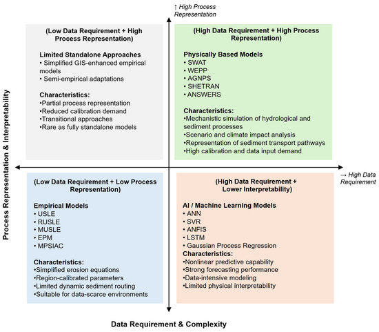
Figure 7.
Conceptual comparison of sediment yield estimation models based on relative data requirements and degree of process representation. Empirical models require minimal data but provide simplified representations, physically based models offer strong mechanistic simulation with higher data demands, while AI/ML approaches provide advanced nonlinear predictive capability but reduced interpretability. Hybrid approaches represent emerging integration pathways.
These advancements indicate strong potential for real-time sediment forecasting; however, successful implementation depends on data availability, calibration, computational capacity, and institutional readiness for technology integration [116,120].
Similarly to reservoirs, sediment control in rivers and channels comes with structural and non-structural measures. For instance, the study of Barbini et al. (2024) [121] presents a combination of deposition areas and retention basins with check dams as an alternative approach for controlling the volume of sediment in channel debris. The dimensions of the structures were determined with the help of hydraulic modeling, allowing for the best mitigative effect. The debris-flow modeling showed that most sediment volume transported is controlled, with only a small amount of solid discharge flows downstream. Moreover, Zhang and Yang (2022) [122] studied the interaction of precipitation, vegetation, and erosion in a river basin, exploring the critical role of vegetation in reducing the source of sediment. With the use of a sediment rating curve, the effect of vegetation was noticed in reducing soil erosion. The study concluded that among the conservation measures, vegetation demonstrated the most effectiveness, indicating that one of the effective measures in sediment control is controlling the source.
In subsurface infrastructure systems, leakage-induced erosion can also contribute to sediment mobilization and structural instability. Laboratory investigations have shown that engineered control measures can effectively reduce seepage-driven erosion and improve the stability of underground structures subjected to sediment transport processes [123].
While structural measures provide immediate interception of sediment, vegetative approaches typically offer longer-term stabilization benefits by improving soil structure and reducing erosion at the source [124,125].
Additionally, smart sediment monitoring systems are now integrated into water resource management, potentially making an impact on sediment management. For instance, a study by Wang et al., 2024 [126] introduces an innovative approach to the continuous monitoring of turbidity in stormwater. This low-cost sensor was able to establish a statistically significant relationship with a commercial hand-held turbidimeter, demonstrating its reliability in in situ turbidity monitoring. There is significant potential in this study as these sensors can be used to monitor erosion events and track sediment transport to perform effective sediment control. It also allows for real-time and long-term monitoring in watersheds, offering best management practices in sediment control.
In urban catchments, sediment accumulation within drainage infrastructure can significantly influence hydraulic performance and flood risk. High-resolution numerical simulations have demonstrated that pipeline siltation alters flow dynamics within stormwater systems and may reduce drainage capacity during extreme rainfall events. Recent optimization frameworks have also incorporated sediment accumulation effects when designing resilient green–grey infrastructure systems for urban flood management [127,128].
Another emerging technique in monitoring and management is the use of the remote sensing technique, specifically the Unmanned Aerial Vehicle (UAV) [129]. The study of Alexiou et al. (2020) [129] used UAV photogrammetry to estimate annual sediment yield on a retention dam in a watershed. By conducting UAV surveys and applying Structure-from-Motion (SfM) techniques, the model accurately measures topsoil change and erosion patterns in the area, allowing for precise sediment estimation. The estimated sediment of UAV-Sfm was evaluated and compared with traditional soil erosion models such as RUSLE and Pan-European Soil Erosion Risk Assessment (PESERA). Although the measurements were higher than the erosion models, the researchers suggested that it could serve as a reference guide on sediment yield, especially in mountainous catchments.
In hydraulic and coastal engineering contexts, sediment interactions with structural foundations are also an important consideration in sediment management. Recent studies have investigated the coupling mechanisms between fluid flow, sediment transport, and structural foundations, highlighting the effectiveness of anti-scour countermeasures in mitigating erosion and protecting infrastructure from sediment-induced damage [130].
These remote sensing tools improve spatial resolution and reduce field labor requirements; however, their effectiveness depends on terrain accessibility, calibration accuracy, and cost considerations [89,131].
Furthermore, innovative techniques have proven their capability in adaptive management of sediment yield. This is an important consideration, especially with the hydrological variability induced by climate change [132,133]. Modeling tools support adaptive management as they allow decision makers to simulate different techniques in a watershed before implementing them. For instance, Toma and Meja (2024) [134] utilized SWAT to assess the water resource and sediment yield in response to climate change. From gathered historical data and parameters, projected impacts on water resources and sediment yield in a specific watershed were produced and investigated. The integration of the SWAT model was successful in simulating the impacts of climate change, and this offers key information in planning for sediment yield control and sustainable environmental resources.
Similarly, Babel et al. (2021) [111] demonstrated the adaptation measures for sediment yield using a bio-physical model, which is SWAT. Using the model, the ecosystem-based adaptation measures such as reforestation, filter strips, contouring, terracing, and grassed watersheds were simulated in a tropical watershed with historical hydrological data gathered. With the effectiveness of the SWAT model in evaluating ecosystem-based adaptation methods, this management strategy is a step towards adaptive management and restoration of the watershed, informing river basin managers and government agencies of the implementation of EBA measures.
These findings emphasize that effective sediment control increasingly relies on coupling predictive modeling with adaptive implementation strategies, particularly under non-stationary climatic conditions.
5.2. Effectiveness of Sediment Control Measures
The effectiveness of sediment control measures varies widely depending on site-specific factors such as topography, soil properties, hydrologic conditions, and the design and placement of the intervention. Published studies have provided extensive evidence on the capacity of both structural and non-structural interventions to reduce sediment yield and improve watershed stability [135,136].
As mentioned in the study of Silva et al. (2023) [106], Bertoni and Lombardi Neto (2014) [137] classified sediment control measures into three major approaches. (1) Soil management involves techniques that improve soil structure and foster plant growth, thereby increasing resistance to erosion. This includes practices such as conservation tillage, residue management, and the use of organic fertilizers. (2) Vegetative measures make use of vegetation to buffer the impact of raindrops and surface runoff, with methods such as crop rotation, cover cropping, and strip cropping. (3) Lastly, structural practices integrate engineered interventions to alter surface topography and manage runoff, including contour farming, terracing, and grassed waterways.
Polyakov et al. (2014) [138] demonstrated that in semiarid watersheds, the installation of check dams led to a 60% reduction in runoff events from minor rainstorms and retained approximately 50% of the total sediment yield over four years. This emphasizes the capacity of well-sited structural controls to intercept sediment in upland catchments. However, the researchers [138] also noted that the effectiveness of these structures’ storage capacity could diminish, and the risks of downstream erosion could increase. In another study by Schwindt et al. (2018) [139], it was found that sediment connectivity plays a crucial role in determining control efficiency, with measures that disrupt lateral and longitudinal sediment transport pathways being more effective when tailored to landscape-scale sediment fluxes. These results proved that sediment control is effective; strategies must be aligned with watershed-scale processes and adaptively managed based on site-specific feedback.
Consistent with these findings, Wang et al. (2021) [140] provided evidence from the Chabagou watershed in the Chinese Loess Plateau, where integrated conservation measures, including terracing, afforestation, and dam construction, led to substantial reductions in runoff erosion power (by 89.2%) and area-specific sediment yield (by 69.2%). Moreover, the study revealed that these interventions not only reduced sediment yield but also altered flood regimes, shifting them from high-erosive to low-erosive classifications, and modified the sediment response even under similar hydrodynamic conditions. These results support that sediment control is most effective when it accounts for watershed-scale dynamics and is adaptively managed through feedback-informed design.
In a related context, Theofanidis et al. (2025) [141] focused on the post-wildfire performance of torrential erosion control structures in a Mediterranean watershed and highlighted the importance of immediate intervention. The study found that check dams constructed shortly after fire events were significantly more effective in reducing sediment yield compared to delayed installations. Early implementation capitalized on the critical erosion window following wildfire disturbance, whereas postponed construction led to reduced sediment capture and increased downstream transport. These findings reinforce the need for both timely and strategically placed sediment control structures, particularly in environments that are prone to rapid hydrologic response and geomorphic instability.
Although structural measures can provide immediate sediment interception and short-term control benefits, their continued effectiveness depends heavily on regular maintenance, sediment removal, and proper long-term operation.
Meanwhile, vegetative buffer strips have been widely recognized in reducing sediment delivery from agricultural and disturbed landscapes. These vegetated zones function by slowing surface runoff, enhancing infiltration, and physically tapping sediment before it reaches water bodies [142,143]. According to Borrelli et al. (2017) [144], the presence of riparian vegetation could significantly reduce sediment yield in sloped terrains by improving soil structure and decreasing overland flow energy, with effectiveness increasing with vegetation density and canopy coverage. Moreover, Hao et al. (2021) [145] demonstrated that plant roots can mitigate significantly erodibility under concentrated flow conditions. The study [145] emphasized that root morphology and density influenced the soil’s resistance to erosion, especially in sandy soils, by enhancing cohesion and reducing detachment capacity.
Vegetation structure can also influence sediment transport through its interaction with flow turbulence. Experimental investigations have shown that submerged flexible vegetation can significantly reduce shear-layer turbulence and consequently mitigate sediment transport compared to rigid canopy structures, emphasizing the role of vegetation flexibility in sediment stabilization [146].
The study of Ren et al. (2023) [147] showed that the impact of major drivers (i.e., climate, land use, and landscape engineering measures) on reducing streamflow and sediment varied greatly at Upper to Middle Yellow River Basin. It was found out that for the past 40 years, the decreased streamflow and sediment have been achieved primarily by landscape engineering measures, such as terraces, dams, water and sediment diversion projects, and reservoirs. However, climate and land use have increased sediment yield in the upstream area which could negatively affect sediment reduction. This was also supported by the study conducted by Regasa and Nones (2024) [148] where Land Use/Land Cover (LULC) changes increase soil erosion rate in the Fincha sub-watershed. Thus, to reduce the current rate of soil erosion it was suggested to implement management solutions such as terracing, inter-cropping, contour farming, strip cropping, and conservation tillage [149] depending on the local characteristics of the watershed. The SWAT modeling outcomes presented in the study [148] demonstrated that the use of Best Management Practices (BMPs) is effective in reducing soil erosion across multiple spatiotemporal scales.
While vegetative measures offer important long-term stabilization and ecological benefits, their erosion-control effectiveness usually develops gradually and may require an establishment period before full performance is achieved.
5.3. Suitability of Methods to Different Watershed Contexts
The effectiveness of sediment control strategies may depend on different environmental and hydrological conditions and may not be applicable to any condition. A critical understanding of these factors, such as geology, climate, land use, and topography, leads to the development of suitable strategies in a specific watershed [150]. With different land use, the various types of watersheds are agricultural, forested, urban, mountainous, or mixed.
Agricultural activities are one of the contributors to soil erosion in the watershed. To minimize this effect, scientists and agriculturists tend to use different methods to minimize and manage sediments [151]. For instance, Ahmad et al. (2020) [152] synthesized the biological and mechanical methods used in agriculture in Asia to control soil erosion. The biological methods or practices that were mostly used and preferred were tillage operations and mulching. On the other hand, few studies have employed mechanical practices such as contour farming, micro basin tillage, and geotextile, but they have also been seen to be effective in reducing soil erosion rates [152]. Additionally, Prasetyo et al. (2021) [153] evaluated vegetation cover for soil erosion control in an agricultural watershed by modeling it. With the use of the RUSLE model and spatial analysis tools, it was proven that the increase in vegetation can significantly reduce soil erosion in agricultural watersheds. It was noted that the land slope was a significant factor in the sites that were contributing to soil erosion.
Additionally, mountainous watersheds also produce high sediment yields as their properties accelerate runoff and erosion. Estimating the sediment yield in these watersheds can be a challenge because of their terrain [154,155]. Alexiou et al. (2023) [129] proposed accurate sediment yield measurements for mountainous catchments using UAVs and models such as PESERA and RUSLE. This remote sensing method was seen to be advantageous in complex mountainous catchments, acquiring high-accuracy soil loss measurements in these watersheds. Additionally, structural measures such as check dams have also been proven to be effective in reducing erosion yield in mountainous watersheds [156]. This method is widely used in several countries, and the study of Abbasi et al. (2019) [156] revealed that this method is a widespread and effective soil conservation structure, significantly reducing sediment yield in watersheds.
The reviewed literature indicates that no single sediment control strategy is universally applicable across all watershed conditions. Structural measures such as check dams and retention basins provide immediate sediment interception but require long-term maintenance and periodic sediment removal to sustain effectiveness. Vegetative measures, including reforestation and riparian buffers, offer longer-term stabilization benefits and additional ecosystem services; however, their performance depends on establishment time and climatic suitability [157,158].
Adaptive and technology-integrated approaches, particularly those supported by modeling tools such as SWAT and AI-based forecasting systems, enable scenario-based evaluation and dynamic planning under climate variability. The effectiveness of sediment control strategies is therefore strongly influenced by spatial scale, sediment connectivity, hydrological regime, and land-use characteristics [159,160].
Overall, integrated sediment management frameworks that combine source control, structural interception, real-time monitoring, and predictive modeling demonstrate the highest potential for sustainable watershed-scale sediment reduction.
Sediment control strategies operate along a continuum ranging from source reduction to adaptive, technology-supported management. The integrated sediment management framework is illustrated in Figure 8.
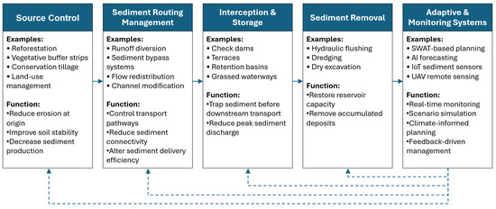
Figure 8.
Integrated sediment management continuum illustrating the progression from source control to adaptive and monitoring-supported strategies. The framework emphasizes that effective sediment management requires coordinated interventions across multiple stages of the sediment transfer system.
The effectiveness of sediment control strategies is also strongly influenced by site-specific watershed characteristics, and therefore no single measure can be considered universally optimal under all environmental conditions.
6. Synthesis of Findings, Practical Challenges, and Recommendations
As sediment yield continues to pose significant challenges in erosion-prone watersheds, a comprehensive understanding of existing estimation and control approaches becomes essential for effective watershed management. This section synthesizes the key insights drawn from the reviewed literature, identifies gaps and limitations in current methodologies, and offers recommendations to guide future research and practical implementations. It particularly emphasizes the evolving role of technology in the enhancement of accurate and adaptable estimation and control strategies of sediment yield.
6.1. Synthesis of Findings
The reviewed literature shows that a wide range of traditional, empirical, physically based, and emerging methods have been developed to estimate sediment yield in watersheds. Empirical models such as USLE, RUSLE, and MUSLE remain widely used because of their practicality and suitability for data-limited environments, whereas physically based models provide more comprehensive process representation through physics-based equations and parameters. Emerging methods, particularly AI and machine learning, further expand predictive capability by capturing nonlinear and multi-variable interactions. Across the reviewed studies, three dominant trends are evident: increasing integration of GIS and remote sensing with empirical models, expanded use of physically based models for scenario simulation and climate impact analysis, and rapid adoption of machine learning techniques for real-time forecasting and high-dimensional data analysis. The reviewed literature highlights several persistent challenges in sediment yield estimation and control, but these challenges also point to specific research priorities. First, the limited transferability of empirical and data-driven models across contrasting watershed settings indicates the need for concurrent multi-site validation studies that test model performance under different climatic, topographic, and land-use conditions. Second, uncertainty in downstream sediment routing remains high where sediment connectivity, temporary storage, and remobilization processes are poorly represented; future work should therefore focus on integrating these processes more explicitly into watershed-scale modeling frameworks. Third, the temporal limitations of conventional field observations reduce the ability to capture event-based sediment dynamics, particularly during extreme storms; this gap can be addressed through expanded deployment of low-cost sensor networks and real-time monitoring systems. Finally, the growing influence of climate variability and land-use change means that sediment management can no longer rely on stationary assumptions, and future studies should incorporate dynamic climate scenarios and adaptive planning frameworks into both estimation and control strategies. These directions provide a more actionable pathway for advancing sediment management research and practice.
At the same time, this review indicates a growing integration of structural, non-structural, and technology-based sediment control strategies, evaluated across agricultural, forested, urban, and mixed watershed contexts. These findings show that no single modeling or control strategy is universally applicable across all watershed conditions, since performance depends strongly on spatial scale, sediment connectivity, data availability, climatic regime, and land-use characteristics. Overall, while both conventional and emerging techniques offer valuable tools for estimating and controlling sediment yield, the literature increasingly supports integrated, adaptive, and data-informed approaches as the most promising direction for sustainable watershed-scale sediment management. The summary of this synthesis is presented in Table 4.
Table 4.
Summary of key references categorized by thematic focus.
6.2. Challenges and Research Gaps
Although traditional sediment yield estimation and control have proven their value in various scenarios, these methods still face challenges.
6.2.1. Data and Model Limitations
In terms of sediment yield estimates, the challenge in data-driven estimates, such as USLE, is that it struggles in undeveloped and unmonitored areas to satisfy long-term data requirements [161] and is often applicable only where the models are developed [77].
As for the physically based models, limitations such as large data requirements, complexity, and limited user-friendliness, uncertainty in model validation are being faced despite their effectiveness [162]. Emerging methods tend to solve these challenges but still face deficiencies, especially AI and ML, as these models come with limitations, especially in terms of model generalization, reliance on data, and lack of transparency [163].
Additionally, many studies lack long-term validation datasets, limiting confidence in predictive reliability under extreme events or climate non-stationarity.
6.2.2. Scale and Connectivity Gaps
A recurring gap in the literature is the mismatch between plot-scale erosion studies and basin-scale sediment yield observations. Sediment connectivity, storage, and remobilization processes are not consistently integrated into modeling frameworks, resulting in uncertainty in sediment routing predictions.
Future research should prioritize multi-scale validation and improved representation of sediment delivery ratios and connectivity indices.
6.2.3. Control and Implementation Constraints
Furthermore, sediment control measures such as structural and vegetative measures also face challenges as they come with budget constraints [164], are often hard to maintain, and require time to establish before becoming effective in sediment control. As for remote sensing and high-quality sensors, these technologies are limited, may not provide high-resolution data in some areas, and they need to be calibrated and validated to produce reliable data.
Institutional capacity, policy integration, and long-term monitoring commitment remain underexplored but critical factors influencing sediment management success.
6.3. Recommendations
Building upon the identified research gaps, targeted recommendations are proposed to strengthen future sediment yield estimation and control strategies. To ensure direct alignment between limitations and strategic directions, Table 5 synthesizes the primary research gaps and corresponding recommendations for future research and watershed management. Beyond this structured alignment, several strategic directions deserve emphasis. Future sediment yield estimation should prioritize the integration of remote sensors, IoT systems, remote sensing technologies, and advanced AI algorithms, since higher-resolution spatial and temporal data can enhance predictive performance and support real-time sediment monitoring. In parallel, adaptive and data-informed sediment control structures should be further developed, particularly through the incorporation of climate change scenarios into modeling frameworks to improve the long-term design and resilience of sediment management infrastructure. Source-oriented and nature-based solutions such as reforestation and vegetative buffers should also be prioritized, as identifying sediment hotspots and controlling erosion at its origin enables more efficient and sustainable watershed-scale management.
Table 5.
Identified research gaps in sediment yield estimation and control, and corresponding strategic recommendations for future research and watershed management.
Overall, the reviewed literature indicates that future sediment management should move beyond isolated estimation or control measures toward integrated frameworks that combine source control, structural interception, real-time monitoring, and predictive modeling within a unified watershed management strategy. Such frameworks are likely to provide more sustainable and adaptive sediment management, particularly under conditions of rapid land-use change and hydroclimatic uncertainty. Future investigations should therefore prioritize the expansion of low-cost sensor networks for continuous field monitoring, the implementation of concurrent multi-site validation studies to improve model robustness and generalization across diverse watershed conditions, and the integration of dynamic climate scenarios into sediment estimation and control frameworks to address non-stationarity in hydrological and erosion processes. These advances will be essential for improving both the scientific reliability and practical applicability of sediment management systems.
Summary
Table 6 summarizes the relationship between watershed context, dominant sediment generation processes, and the sediment control strategies most commonly recommended in the reviewed literature. The comparison shows that sediment management is highly context-specific, as the dominant erosion and transport mechanisms vary considerably among agricultural, forested, urban, mountainous, and mixed watershed systems. Agricultural watersheds are commonly associated with sheet and rill erosion, making source-control measures such as contour farming, vegetative strips, and conservation tillage particularly relevant. In contrast, forested and mountainous watersheds often involve stronger influences from slope instability, channel erosion, and sediment connectivity, which require combinations of revegetation, slope stabilization, and structural interception measures. Urban watersheds are more strongly affected by stormwater-driven sediment transport and construction-related erosion, highlighting the importance of drainage control, detention systems, and site-specific sediment management practices. Overall, the table reinforces that effective sediment control cannot rely on a single universal solution, but must instead be matched to watershed type, dominant sediment processes, and local management objectives.
Table 6.
Watershed context, dominant sediment processes, and recommended sediment control strategies from the reviewed literature.
7. Conclusions
Sediment yield estimation and control in erosion-prone watersheds require an integrated, adaptive, and scale-sensitive approach. Although substantial progress has been achieved through empirical, physically based, and data-driven modeling techniques, as well as through structural and vegetative control measures, the reviewed literature consistently shows that no single method is universally applicable across diverse watershed conditions. Instead, effective sediment management depends on the coordinated integration of predictive modeling, source-based control strategies, sediment routing considerations, and climate-informed planning frameworks. The review further highlights that uncertainty in sediment yield assessment is strongly influenced by the mismatch between plot-scale erosion processes and basin-scale sediment response, particularly where sediment connectivity, temporary storage, remobilization, and downstream routing are insufficiently represented.
This review demonstrates that the future of sediment yield management lies in the convergence of process-based understanding, advanced data analytics, real-time monitoring technologies, and adaptive watershed-scale implementation strategies. Based on the synthesis of the reviewed literature, the following specific conclusions are drawn:
- Empirical models such as USLE, RUSLE, and MUSLE remain practical and widely applicable, particularly in data-scarce environments, because of their relative simplicity and modest data requirements. However, their simplified structure and environment-specific calibration limit their ability to represent dynamic sediment transport processes and reduce their transferability across contrasting climatic, geomorphic, and land-use settings.
- Physically based models, including SWAT, WEPP, and related frameworks, provide stronger mechanistic representation of hydrological and sediment transport processes and are particularly suitable for scenario analysis, climate impact assessment, and evaluation of best management practices. Nevertheless, their application is often constrained by extensive input data requirements, calibration demands, and model complexity.
- Machine learning and artificial intelligence approaches demonstrate strong predictive capability in capturing nonlinear sediment–hydrological interactions and supporting real-time forecasting. However, challenges related to model interpretability, transferability across dissimilar watersheds, and dependence on large, high-quality datasets remain significant limitations to their broader application.
- Sediment control measures—whether structural, vegetative, or adaptive—are highly site-specific, and their effectiveness depends on watershed scale, sediment connectivity, topography, soil conditions, hydrological regime, land-use characteristics, and long-term maintenance capacity. Structural measures can provide immediate sediment interception but require routine maintenance and sediment removal, whereas vegetative interventions offer long-term stabilization benefits but require time to become fully established.
- Sustainable sediment yield management requires integrated watershed-scale frameworks that combine predictive modeling, source-based control strategies, structural interception, real-time monitoring technologies, and climate-informed adaptive planning. The reviewed studies suggest that future progress will depend on improved representation of sediment transfer processes, wider use of low-cost monitoring systems, stronger multi-site model validation, and the incorporation of dynamic climate scenarios to address non-stationarity in hydrological and erosion processes.
Overall, the principal contribution of this review is the development of an integrated and up-to-date synthesis that connects sediment yield prediction with sediment control practice, thereby providing a stronger basis for adaptive, scale-sensitive, and context-specific watershed management. By synthesizing estimation methods, sediment transfer dynamics, and control strategies within a single framework, this review extends beyond conventional sediment yield reviews that focus mainly on model development or isolated management practices, and instead provides a more decision-oriented basis for adaptive watershed sediment management.
Based on the synthesis of the reviewed literature, five priorities are recommended for future research and practice. First, low-cost sensor networks and real-time monitoring systems should be expanded to improve sediment observations in data-scarce watersheds. Second, multi-basin validation and benchmarking studies should be prioritized to improve the transferability and generalization of empirical, physically based, and AI/ML models. Third, watershed-scale models should better represent sediment connectivity, temporary storage, remobilization, and delivery processes in order to reduce routing uncertainty. Fourth, dynamic climate scenarios should be integrated into sediment estimation and control frameworks to address non-stationarity in hydrological and erosion processes. Fifth, practitioners should adopt integrated management frameworks that combine source control, structural interception, predictive modeling, and adaptive monitoring to support more sustainable and context-specific watershed management. These priorities reflect the main analytical contribution of this review and provide a more decision-oriented basis for advancing sediment management research and implementation.
Supplementary Materials
The following supporting information can be downloaded at: https://www.mdpi.com/article/10.3390/w18060751/s1, Table S1: Completed PRISMA Check list.
Author Contributions
Conceptualization, C.E.F.M. and K.P.V.R.; methodology, C.E.F.M., K.P.V.R., J.G.S. and G.C.E.P.; software, K.P.V.R., J.G.S. and G.C.E.P.; validation, K.P.V.R. and C.E.F.M.; formal analysis, J.G.S. and G.C.E.P.; investigation, J.G.S. and G.C.E.P.; resources, K.P.V.R. and C.E.F.M.; writing—original draft preparation, J.G.S. and G.C.E.P.; writing—review and editing, K.P.V.R. and C.E.F.M.; visualization, J.G.S. and G.C.E.P. and K.P.V.R.; supervision, K.P.V.R. and C.E.F.M. All authors have read and agreed to the published version of the manuscript.
Funding
This research received no external funding.
Data Availability Statement
No new data were created or analyzed in this study.
Conflicts of Interest
The authors declare no conflicts of interest.
Abbreviations
The following abbreviations are used in this manuscript:
| AGNPS | Agricultural Non-point Source Model |
| AI | Artificial Intelligence |
| ANFIS | Adaptive Neuro-Fuzzy Inference Systems |
| ANN | Artificial Neural Network |
| ANSWERS | Areal Nonpoint Source watershed Environment Response Simulation |
| BMPs | Best Management Practices |
| DL | Deep Learning |
| EPM | Erosion Potential Method |
| GIS | Geographic Information System |
| LLR | Local Linear Regression |
| LSTM | Long Short-Term Memory |
| LULC | Land Use/Land Cover |
| ML | Machine learning |
| MPSIAC | Modified Pacific Southwest Inter-Agency Committee |
| MUSLE | Modified Universal Soil Loss Equation |
| PESERA | Pan-European Soil Erosion Risk Assessment |
| RUSLE | Revised Universal Soil Loss Equation |
| SfM | Structure-from-Motion |
| SHETRAN | Hydrologique Europian-TRANsport |
| SVR | support vector regression |
| SWAT | Soil and Water Assessment Tool |
| UAV | Unmanned Aerial Vehicle |
| USLE | Universal Soil Loss Equation |
| WEPP | Water Erosion Prediction Project |
References
- White, S. Sediment Yield Prediction and Modeling. In Encyclopedia of Hydrological Sciences; Wiley: Hoboken, NJ, USA, 2006. [Google Scholar]
- Sediment Yield and Runoff Frequency of Small Drainage Basins in the Mojave Desert, California and Nevada. Available online: https://pubs.usgs.gov/fs/2006/3007/ (accessed on 10 January 2026).
- Pratama, F.; Wulandari, S.; Rohmat, F.I.W. Modeling Sediment Accumulation in Pare Reservoir Using HEC-RAS 2D: Assessing Storage Capacity over a 10-Year Period. Results Eng. 2025, 25, 104333. [Google Scholar] [CrossRef]
- Zhang, L.; Karthikeyan, R.; Zhang, H.; Tang, Y. Estimation of Sediment Yield Change in a Loess Plateau Basin, China. Water 2017, 9, 683. [Google Scholar] [CrossRef]
- Xie, F.; Zhao, G.; Mu, X.; Tian, P.; Gao, P.; Sun, W. Sediment Yield in Dam-Controlled Watersheds in the Pisha Sandstone Region on the Northern Loess Plateau, China. Land 2021, 10, 1264. [Google Scholar] [CrossRef]
- Morris, G.L.; Fan, J. Reservoir Sedimentation Handbook; McGraw-Hill Book Co.: New York, NY, USA, 1998. [Google Scholar]
- Maximus, J.K. Assessing Watershed Vulnerability to Erosion and Sedimentation: Integrating DEM and LULC Data in Guyana’s Diverse Landscapes. HydroResearch 2025, 8, 178–193. [Google Scholar] [CrossRef]
- Kondolf, G.M.; Gao, Y.; Annandale, G.W.; Morris, G.L.; Jiang, E.; Zhang, J.; Cao, Y.; Carling, P.; Fu, K.; Guo, Q.; et al. Sustainable Sediment Management in Reservoirs and Regulated Rivers: Experiences from Five Continents. Earths Future 2014, 2, 256–280. [Google Scholar] [CrossRef]
- Batalla, R.J.; Vericat, D. Hydrological and Sediment Transport Dynamics of Flushing Flows: Implications for Management in Large Mediterranean Rivers. River Res. Appl. 2009, 25, 297–314. [Google Scholar] [CrossRef]
- Abebe, T.; Leta, O.T. Sediment yield estimation and effect of management options on sediment yield of Kesem Dam watershed, Awash Basin, Ethiopia. Sci. Afr. 2020, 9, e00425. [Google Scholar] [CrossRef]
- Sommerlot, A.R.; Nejadhashemi, A.P.; Woznicki, S.A.; Giri, S.; Prohaska, M.D. Evaluating the Capabilities of Watershed-Scale Models in Estimating Sediment Yield at Field-Scale. J. Environ. Manag. 2013, 127, 228–236. [Google Scholar] [CrossRef]
- De Vente, J.; Poesen, J.; Verstraeten, G.; Govers, G.; Vanmaercke, M.; Van Rompaey, A.; Arabkhedri, M.; Boix-Fayos, C. Predicting Soil Erosion and Sediment Yield at Regional Scales: Where Do We Stand? Earth Sci. Rev. 2013, 127, 16–29. [Google Scholar] [CrossRef]
- Tena, A.; Batalla, R.J.; Vericat, D.; López-Tarazón, J.A. Suspended Sediment Dynamics in a Large Regulated River over a 10-Year Period (the Lower Ebro, NE Iberian Peninsula). Geomorphology 2011, 125, 73–84. [Google Scholar] [CrossRef]
- de Vente, J.; Poesen, J. Predicting Soil Erosion and Sediment Yield at the Basin Scale: Scale Issues and Semi-Quantitative Models. Earth Sci. Rev. 2005, 71, 95–125. [Google Scholar] [CrossRef]
- Rai, R.K.; Singh, V.P.; Upadhyay, A. Hydrologic Computations. Plan. Eval. Irrig. Proj. 2017, 83–229. [Google Scholar] [CrossRef]
- Shi, Z.H.; Huang, X.D.; Ai, L.; Fang, N.F.; Wu, G.L. Quantitative Analysis of Factors Controlling Sediment Yield in Mountainous Watersheds. Geomorphology 2014, 226, 193–201. [Google Scholar] [CrossRef]
- Zhang, H.Y.; Shi, Z.H.; Fang, N.F.; Guo, M.H. Linking Watershed Geomorphic Characteristics to Sediment Yield: Evidence from the Loess Plateau of China. Geomorphology 2015, 234, 19–27. [Google Scholar] [CrossRef]
- Zeng, C.; Zhang, F.; Lu, X.; Wang, G.; Gong, T. Improving Sediment Load Estimations: The Case of the Yarlung Zangbo River (the Upper Brahmaputra, Tibet Plateau). Catena 2018, 160, 201–211. [Google Scholar] [CrossRef]
- Walling, D.E. Human Impact on Land-Ocean Sediment Transfer by the World’s Rivers. Geomorphology 2006, 79, 192–216. [Google Scholar] [CrossRef]
- Ali, A.A.; Al-Abbadi, A.M.; Jabbar, F.K.; Alzahrani, H.; Hamad, S. Predicting Soil Erosion Rate at Transboundary Sub-Watersheds in Ali Al-Gharbi, Southern Iraq, Using RUSLE-Based GIS Model. Sustainability 2023, 15, 1776. [Google Scholar] [CrossRef]
- Walton, R.E.; Moorhouse, H.L.; Roberts, L.R.; Salgado, J.; Ladd, C.J.T.; Do, N.T.; Panizzo, V.N.; Van, P.D.T.; Downes, N.K.; Trinh, D.A.; et al. Using Lake Sediments to Assess the Long-Term Impacts of Anthropogenic Activity in Tropical River Deltas. Anthr. Rev. 2024, 11, 442–462. [Google Scholar] [CrossRef]
- Abua, M.A.; Igelle, E.I.; Eneyo, V.B.; Abali, T.P.; Akpan, N.A.; Archibong, E.P.; Abdelrahman, K.; Fnais, M.S.; Andráš, P.; Eldosouky, A.M. Predicting Sediment Yield on Different Landuse Surfaces in Calabar River Catchment, Nigeria. Heliyon 2023, 9, e19071. [Google Scholar] [CrossRef]
- Ferro, V.; Nicosia, A. Soil Erosion Measurement Techniques and Field Experiments. Water 2023, 15, 2846. [Google Scholar] [CrossRef]
- Desai, A.N.; Kant, R. Geotextiles Made from Natural Fibres. Geotext. Des. Appl. 2016, 61–87. [Google Scholar] [CrossRef]
- Department of Irrigation and Drainage Malaysia. Urban Stormwater Management Manual for Malaysia; Department of Irrigation and Drainage Malaysia: Cyberjaya, Malaysia, 2012; ISBN 9789839304244.
- Xiao, H.; Li, Z.; Chang, X.; Huang, B.; Nie, X.; Liu, C.; Liu, L.; Wang, D.; Jiang, J. The Mineralization and Sequestration of Organic Carbon in Relation to Agricultural Soil Erosion. Geoderma 2018, 329, 73–81. [Google Scholar] [CrossRef]
- Florsheim, J.L.; Pellerin, B.A.; Oh, N.H.; Ohara, N.; Bachand, P.A.M.; Bachand, S.M.; Bergamaschi, B.A.; Hernes, P.J.; Kavvas, M.L. From Deposition to Erosion: Spatial and Temporal Variability of Sediment Sources, Storage, and Transport in a Small Agricultural Watershed. Geomorphology 2011, 132, 272–286. [Google Scholar] [CrossRef]
- Ballio, F.; Brambilla, D.; Giorgetti, E.; Longoni, L.; Papini, M.; Radice, A. Evaluation of Sediment Yield from Valley Slopes: A Case Study. In Proceedings of the WIT Transactions on Engineering Sciences; WIT: Southampton, UK, 2010; Volume 67, pp. 149–160. [Google Scholar]
- Kumar, S.; David Raj, A.; Mariappan, S. Fallout Radionuclides (FRNs) for Measuring Soil Erosion in the Himalayan Region: A Versatile and Potent Method for Steep Sloping Hilly and Mountainous Landscapes. Catena 2024, 234, 107591. [Google Scholar] [CrossRef]
- Yang, S.Y.; Jan, C.D.; Yen, H.; Wang, J.S. Characterization of Landslide Distribution and Sediment Yield in the TsengWen River Watershed, Taiwan. Catena 2019, 174, 184–198. [Google Scholar] [CrossRef]
- Araújo, J.C.; Knight, D.W. A review of the measurement of sediment yield in different scales. REM Rev. Esc. Minas 2005, 58, 257–265. [Google Scholar] [CrossRef]
- Wohlgemuth, P.M. Post-Fire Erosion Control Research on the San Dimas Experimental Forest: Past and Present. In Proceedings of the First Interagency Conference on Research in the Watersheds, Washington, DC, USA, 27–30 October 2003. [Google Scholar]
- Benavides-Solorio, J.D.D.; MacDonald, L.H. Measurement and Prediction of Post-Fire Erosion at the Hillslope Scale, Colorado Front Range. Int. J. Wildland Fire 2005, 14, 457–474. [Google Scholar] [CrossRef]
- Mills, C.F.; Bathurst, J.C. Spatial Variability of Suspended Sediment Yield in a Gravel-Bed River across Four Orders of Magnitude of Catchment Area. Catena 2015, 133, 14–24. [Google Scholar] [CrossRef]
- Church, M. Interpreting Sediment Yield Scaling. Earth Surf. Process. Landf. 2017, 42, 1895–1898. [Google Scholar] [CrossRef]
- Megahan, W.E.; King, J.G. Erosion, Sedimentation, and Cumulative Effects in the Northern Rocky Mountains. In A Century of Forest and Wildland Watershed Lessons; Society of American Foresters: Bethesda, MD, USA, 2004. [Google Scholar]
- Nguyen, B.Q.; Kantoush, S.A.; Vo, N.D.; Sumi, T. Framework for Reservoir Sedimentation Estimation Using the Hydrological Model and Campaign—A Case Study of A Vuong Reservoir in Central Vietnam. Int. J. Sediment Res. 2025, 40, 78–90. [Google Scholar] [CrossRef]
- Dutta, S. Soil Erosion, Sediment Yield and Sedimentation of Reservoir: A Review. Model. Earth Syst. Environ. 2016, 2, 123. [Google Scholar] [CrossRef]
- Sherriff, S.C.; Rowan, J.S.; Fenton, O.; Jordan, P.; Ó hUallacháin, D. Sediment Fingerprinting as a Tool to Identify Temporal and Spatial Variability of Sediment Sources and Transport Pathways in Agricultural Catchments. Agric. Ecosyst. Environ. 2018, 267, 188–200. [Google Scholar] [CrossRef]
- Gao, P.; Zhang, Z. Spatial Patterns of Sediment Dynamics within a Medium-Sized Watershed over an Extreme Storm Event. Geomorphology 2016, 267, 25–36. [Google Scholar] [CrossRef]
- Chen, J.; Li, Z.; Xiao, H.; Ning, K.; Tang, C. Effects of Land Use and Land Cover on Soil Erosion Control in Southern China: Implications from a Systematic Quantitative Review. J. Environ. Manag. 2021, 282, 111924. [Google Scholar] [CrossRef]
- Minella, J.P.G.; Merten, G.H.; Walling, D.E.; Reichert, J.M. Changing Sediment Yield as an Indicator of Improved Soil Management Practices in Southern Brazil. Catena 2009, 79, 228–236. [Google Scholar] [CrossRef]
- Servanzi, L.; Quadroni, S.; Espa, P. Hydro-Morphological Alteration and Related Effects on Fish Habitat Induced by Sediment Management in a Regulated Alpine River. Int. J. Sediment Res. 2024, 39, 514–530. [Google Scholar] [CrossRef]
- Carrera-Villacrés, D.; Gavilanes, P.; Brito, M.J.; Criollo, A.; Chico, A.; Carrera-Villacrés, F. Water and Sediment Quantity and Quality Generated in Check Dams as a Nature-Based Solutions (NbS). Water 2025, 17, 810. [Google Scholar] [CrossRef]
- Bartos, M.; Kerkez, B. Hydrograph Peak-Shaving Using a Graph-Theoretic Algorithm for Placement of Hydraulic Control Structures. Adv. Water Resour. 2019, 127, 167–179. [Google Scholar] [CrossRef]
- Dutal, H.; Reis, M. Identification of Priority Areas for Sediment Yield Reduction by Using a GeoWEPP-Based Prioritization Approach. Arab. J. Geosci. 2020, 13, 1024. [Google Scholar] [CrossRef]
- Sommerlot, A.R.; Pouyan Nejadhashemi, A.; Woznicki, S.A.; Prohaska, M.D. Evaluating the Impact of Field-Scale Management Strategies on Sediment Transport to the Watershed Outlet. J. Environ. Manag. 2013, 128, 735–748. [Google Scholar] [CrossRef]
- Vanmaercke, M.; Poesen, J.; Govers, G.; Verstraeten, G. Quantifying Human Impacts on Catchment Sediment Yield: A Continental Approach. Glob. Planet. Change 2015, 130, 22–36. [Google Scholar] [CrossRef]
- Smetanová, A.; Le Bissonnais, Y.; Raclot, D.; Pedro Nunes, J.; Licciardello, F.; Le Bouteiller, C.; Latron, J.; Rodríguez Caballero, E.; Mathys, N.; Klotz, S.; et al. Temporal Variability and Time Compression of Sediment Yield in Small Mediterranean Catchments: Impacts for Land and Water Management. Soil Use Manag. 2018, 34, 388–403. [Google Scholar] [CrossRef]
- Birkinshaw, S.J.; Bathurst, J.C. Model Study of the Relationship between Sediment Yield and River Basin Area. Earth Surf. Process. Landf. 2006, 31, 750–761. [Google Scholar] [CrossRef]
- Vanmaercke, M.; Poesen, J.; Broeckx, J.; Nyssen, J. Sediment Yield in Africa. Earth Sci. Rev. 2014, 136, 350–368. [Google Scholar] [CrossRef]
- Jansson, M.B. A Global Survey of Sediment Yield. Geogr. Annaler. Ser. A Phys. Geogr. 1988, 70, 81–98. [Google Scholar] [CrossRef]
- Haregeweyn, N.; Poesen, J.; Nyssen, J.; Govers, G.; Verstraeten, G.; de Vente, J.; Deckers, J.; Moeyersons, J.; Haile, M. Sediment Yield Variability in Northern Ethiopia: A Quantitative Analysis of Its Controlling Factors. Catena 2008, 75, 65–76. [Google Scholar] [CrossRef]
- Rodriguez-Lloveras, X.; Corella, J.P.; Benito, G. Modelling the Hydro-Sedimentary Dynamics of a Mediterranean Semiarid Ungauged Watershed Beyond the Instrumental Period. Land Degrad. Dev. 2017, 28, 1506–1518. [Google Scholar] [CrossRef]
- Guesri, M.; Megnounif, A.; Ghenim, A.N. Rainfall Erosivity and Sediment Yield in Northeast Algeria: K’sob Watershed Case Study. Arab. J. Geosci. 2020, 13, 299. [Google Scholar] [CrossRef]
- Xu, Z.; Zhang, S.; Yang, X. Water and Sediment Yield Response to Extreme Rainfall Events in a Complex Large River Basin: A Case Study of the Yellow River Basin, China. J. Hydrol. 2021, 597, 126183. [Google Scholar] [CrossRef]
- de Almeida, W.S.; Seitz, S.; de Oliveira, L.F.; de Carvalho, D.F. Duration and Intensity of Rainfall Events with the Same Erosivity Change Sediment Yield and Runoff Rates. Int. Soil Water Conserv. Res. 2021, 9, 69–75. [Google Scholar] [CrossRef]
- Chen, Y.; Wei, T.; Li, J.; Xin, Y.; Ding, M. Future Changes in Global Rainfall Erosivity: Insights from the Precipitation Changes. J. Hydrol. 2024, 638, 131435. [Google Scholar] [CrossRef]
- Jain, M.K.; Kothyari, U.C. Estimation of Soil Erosion and Sediment Yield Using GIS. Hydrol. Sci. J. 2000, 45, 771–786. [Google Scholar] [CrossRef]
- Fang, K.; Tan, D.Y.; Zhang, C.C.; Shi, S.G.; Sang, H.W.; Shi, B. Nature-Based Profiling of Subsurface Soil Stiffness Driven by Tidal Forces. Geophys. Res. Lett. 2025, 52, e2025GL118702. [Google Scholar] [CrossRef]
- Huangfu, W.; Qiu, H.; Wang, J.; Wang, N.; Zhang, Y.; Liu, Y.; Boloorani, A.D.; Ullah, M. Topographic and Morphological Effects of Global Earthquake- and Rainstorm-Induced Landslides. Geosci. Front. 2026, 17, 102215. [Google Scholar] [CrossRef]
- Li, L.; Gao, X.; Chen, Y.; Zhou, Z.; Tu, W.; Chen, D.; Jiang, X.; Shang, C. Simulation of Catastrophic Submarine Landslide Processes at Model and Engineering Scales Using SPH: A Case Study. Eng. Fail. Anal. 2025, 178, 109703. [Google Scholar] [CrossRef]
- Yuan, Y.; Bingner, R.L.; Locke, M.A. A Review of Effectiveness of Vegetative Buffers on Sediment Trapping in Agricultural Areas. Ecohydrology 2009, 2, 321–336. [Google Scholar] [CrossRef]
- Lee, K.-H.; Schultz, R.C. Sediment and Nutrient Removal in an Established Multi-Species Riparian Buffer. J. Soil Water Conserv. 2003, 58, 1–8. [Google Scholar] [CrossRef]
- Dosskey, M.G.; Vidon, P.; Gurwick, N.P.; Allan, C.J.; Duval, T.P.; Lowrance, R. The Role of Riparian Vegetation in Protecting and Improving Chemical Water Quality in Streams. JAWRA J. Am. Water Resour. Assoc. 2010, 46, 261–277. [Google Scholar] [CrossRef]
- Liao, H.; He, Y. The Temporal Variation of Sediment Connectivity from 1982 to 2020 in the Wei River Basin, China. Hydrol. Process. 2023, 37, e15042. [Google Scholar] [CrossRef]
- Wang, L.; Zhang, Y.; Jia, J.; Zhen, Q.; Zhang, X. Effect of Vegetation on the Flow Pathways of Steep Hillslopes: Overland Flow Plot-Scale Experiments and Their Implications. Catena 2021, 204, 105438. [Google Scholar] [CrossRef]
- Tang, Q.; He, X.; Bao, Y.; Zhang, X.; Guo, F.; Zhu, H. Determining the Relative Contributions of Climate Change and Multiple Human Activities to Variations of Sediment Regime in the Minjiang River, China. Hydrol. Process. 2013, 27, 3547–3559. [Google Scholar] [CrossRef]
- Pimentel, D.; Harvey, C.; Resosudarmo, P.; Sinclair, K.; Kurz, D.; Mcnair, M.; Crist, S.; Shpritz, L.; Fitton, L.; Saffouri, R.; et al. Environmental and Economic Costs of Soil Erosion and Conservation Benefits. Science 1995, 267, 1117–1123. [Google Scholar] [CrossRef] [PubMed]
- Luo, J.; Zheng, Z.; Li, T.; He, S.; Tarolli, P. Impact of Tillage-Induced Microtopography on Hydrological-Sediment Connectivity and Its Hydrodynamic Understanding. Catena 2023, 228, 107168. [Google Scholar] [CrossRef]
- Kusimi, J.M.; Amisigo, B.A.; Banoeng-Yakubo, B.K. Sediment Yield of a Forest River Basin in Ghana. Catena 2014, 123, 225–235. [Google Scholar] [CrossRef]
- Zhou, M.; Deng, J.; Lin, Y.; Belete, M.; Wang, K.; Comber, A.; Huang, L.; Gan, M. Identifying the Effects of Land Use Change on Sediment Export: Integrating Sediment Source and Sediment Delivery in the Qiantang River Basin, China. Sci. Total Environ. 2019, 686, 38–49. [Google Scholar] [CrossRef]
- McVey, I.; Michalek, A.; Mahoney, T.; Husic, A. Urbanization as a Limiter and Catalyst of Watershed-Scale Sediment Transport: Insights from Probabilistic Connectivity Modeling. Sci. Total Environ. 2023, 894, 165093. [Google Scholar] [CrossRef]
- Bello, A.A.D.; Hashim, N.B.; Haniffah, R.M. Impact of Urbanization on the Sediment Yield in Tropical Watershed Using Temporal Land-Use Changes and a GIS-Based Model. J. Water Land Dev. 2017, 34, 33–45. [Google Scholar] [CrossRef]
- Kolaski, K.; Logan, L.R.; Ioannidis, J.P.A. Guidance to best tools and practices for systematic reviews. JBI Evid. Synth. 2023, 21, 1699–1731. [Google Scholar] [CrossRef]
- Zantet Oybitet, M.; Sambeto Bibi, T.; Abdulkerim Adem, E. Evaluation of Best Management Practices to Reduce Sediment Yield in the Upper Gilo Watershed, Baro Akobo Basin, Ethiopia Using SWAT. Heliyon 2023, 9, e20326. [Google Scholar] [CrossRef]
- Aga, A.O.; Melesse, A.M.; Chane, B. An Alternative Empirical Model to Estimate Watershed Sediment Yield Based on Hydrology and Geomorphology of the Basin in Data-Scarce Rift VALLEY Lake Regions, Ethiopia. Geosciences 2020, 10, 31. [Google Scholar] [CrossRef]
- About the Universal Soil Loss Equation. Available online: https://www.ars.usda.gov/midwest-area/west-lafayette-in/national-soil-erosion-research/docs/usle-database/research/ (accessed on 22 January 2026).
- Alewell, C.; Borrelli, P.; Meusburger, K.; Panagos, P. Using the USLE: Chances, Challenges and Limitations of Soil Erosion Modelling. Int. Soil Water Conserv. Res. 2019, 7, 203–225. [Google Scholar] [CrossRef]
- Pham, T.G.; Degener, J.; Kappas, M. Integrated Universal Soil Loss Equation (USLE) and Geographical Information System (GIS) for Soil Erosion Estimation in A Sap Basin: Central Vietnam. Int. Soil Water Conserv. Res. 2018, 6, 99–110. [Google Scholar] [CrossRef]
- Ganasri, B.P.; Ramesh, H. Assessment of Soil Erosion by RUSLE Model Using Remote Sensing and GIS—A Case Study of Nethravathi Basin. Geosci. Front. 2016, 7, 953–961. [Google Scholar] [CrossRef]
- Getachew Abebe, T.; Woldemariam, A. Spatial Distribution Mapping of Erosion and Sediment Yield Estimation Using RUSLE and Arc GIS of Ayigebire Watershed, North Shewa Zone of Amhara Region, Ethiopia. Water-Energy Nexus 2024, 7, 124–134. [Google Scholar] [CrossRef]
- Baar, A.W.; Boechat Albernaz, M.; van Dijk, W.M.; Kleinhans, M.G. Critical Dependence of Morphodynamic Models of Fluvial and Tidal Systems on Empirical Downslope Sediment Transport. Nat. Commun. 2019, 10, 4903. [Google Scholar] [CrossRef] [PubMed]
- Aksoy, H. Modelling Sediment Transfer in Rivers: Challenges in Modelling Sediment Matters. In Sediment Matters; Springer: Berlin/Heidelberg, Germany, 2015; pp. 61–81. [Google Scholar] [CrossRef]
- Tabarestani, E.S.; Afzalimehr, H.; Sui, J. Assessment of Annual Erosion and Sediment Yield Using Empirical Methods and Validating with Field Measurements—A Case Study. Water 2022, 14, 1602. [Google Scholar] [CrossRef]
- Brand, E.; Chen, M.; Montreuil, A.L. Optimizing Measurements of Sediment Transport in the Intertidal Zone. Earth Sci. Rev. 2020, 200, 103029. [Google Scholar] [CrossRef]
- Matos, T.; Martins, M.S.; Henriques, R.; Goncalves, L.M. Design of a Sensor to Estimate Suspended Sediment Transport in Situ Using the Measurements of Water Velocity, Suspended Sediment Concentration and Depth. J. Environ. Manag. 2024, 365, 121660. [Google Scholar] [CrossRef]
- Sandoval, S.; Bertrand-Krajewski, J.L.; Caradot, N.; Hofer, T.; Gruber, G. Performance and Uncertainties of TSS Stormwater Sampling Strategies from Online Time Series. Water Sci. Technol. 2018, 78, 1407–1416. [Google Scholar] [CrossRef]
- Kumar, S.; Godrej, A.; Post, H.; Berger, K. The Value of Intensive Sampling—A Comparison of Fluvial Loads. Water Resour. Manag. 2019, 33, 4303–4318. [Google Scholar] [CrossRef]
- Pandey, A.; Himanshu, S.K.; Mishra, S.K.; Singh, V.P. Physically Based Soil Erosion and Sediment Yield Models Revisited. Catena 2016, 147, 595–620. [Google Scholar] [CrossRef]
- Zhang, J.; Geng, Y.; Li, Z.; Li, P.; Wang, T.; Xu, G.; Yu, K.; Wang, W.; Wang, P.; Guo, M. Modeling Sediment Flux in River Confluences: A Comprehensive Momentum-Based Study. Water Resour. Res. 2025, 61, e2024WR039154. [Google Scholar] [CrossRef]
- Neitsch, S.L.; Arnold, J.G.; Kiniry, J.R.; Williams, J.R. Soil and Water Assessment Tool Theoretical Documentation Version 2009; College of Agriculture and Life Sciences: New York, NY, USA, 2011. [Google Scholar]
- Wang, Y.; Zhang, K.; Luo, Y.; Zhang, Q.; Li, Z.; Yao, C.; Chen, X.; Wang, S.; Liu, J.; Zhang, C.; et al. GHydroMod-SIM-DAI v1.0: A New Distributed Hydrological Model Capable of Dynamically Recognizing Runoff Generation Mechanisms and Accounting for Aboveground and Underground Anthropogenic Impacts. J. Hydrol. 2025, 663, 134184. [Google Scholar] [CrossRef]
- Chia, V.; Mbajiorgu, C.C.; Chia, V.D.; Mbajiorgu, C.C. A Comparative Study of KINEROS2 and AGNPS Models in the Estimation of Runoff and Sediment Yield from an Agricultural Watershed. Niger. J. Hydrol. Sci. 2018, 6, 36–49. [Google Scholar]
- Abdelwahab, O.M.M.; Bingner, R.L.; Milillo, F.; Gentile, F. Effectiveness of Alternative Management Scenarios on the Sediment Load in a Mediterranean Agricultural Watershed. J. Agric. Eng. 2014, 45, 125–136. [Google Scholar] [CrossRef]
- Gull, S.; Shah, S.R. Watershed Models for Assessment of Hydrological Behavior of the Catchments: A Comparative Study. Water Pract. Technol. 2020, 15, 261–291. [Google Scholar] [CrossRef]
- Abid Almubaidin, M.A.; Latif, S.D.; Balan, K.; Ahmed, A.N.; El-Shafie, A. Enhancing Sediment Transport Predictions through Machine Learning-Based Multi-Scenario Regression Models. Results Eng. 2023, 20, 101585. [Google Scholar] [CrossRef]
- Shaukat, N.; Hashmi, A.; Abid, M.; Aslam, M.N.; Hassan, S.; Sarwar, M.K.; Masood, A.; Shahid, M.L.U.R.; Zainab, A.; Tariq, M.A.U.R. Sediment Load Forecasting of Gobindsagar Reservoir Using Machine Learning Techniques. Front. Earth Sci. 2022, 10, 1047290. [Google Scholar] [CrossRef]
- Yadav, A.; Pajjuri, M.; Tanuja, K.L.; Nagarjuna, P.; Satyannarayana, P. Estimation of Suspended Sediment Yield Using Artificial Neural Network Model. Int. J. Innov. Technol. Explor. Eng. 2020, 9, 3249–3253. [Google Scholar] [CrossRef]
- Kumar, P.S.; Praveen, T.V.; Prasad, M.A. Simulation of Sediment Yield Over Un-Gauged Stations Using MUSLE and Fuzzy Model. Aquat. Procedia 2015, 4, 1291–1298. [Google Scholar] [CrossRef]
- Noh, H.; Son, G.; Kim, D.; Park, Y.S. H-ADCP-Based Real-Time Sediment Load Monitoring System Using Support Vector Regression Calibrated by Global Optimization Technique and Its Applications. Adv. Water Resour. 2024, 185, 104636. [Google Scholar] [CrossRef]
- Lamane, H.; Mouhir, L.; Moussadek, R.; Baghdad, B.; El Bilali, A. Leveraging Machine Learning for Accurate and Interpretable Suspended Sediment Concentration Predictions. In Proceedings of the European Geosciences Union General Assembly 2025 (EGU25), Vienna, Austria, 27 April–2 May 2025. [Google Scholar] [CrossRef]
- Rajaee, T.; Jafari, H. Two Decades on the Artificial Intelligence Models Advancement for Modeling River Sediment Concentration: State-of-the-Art. J. Hydrol. 2020, 588, 125011. [Google Scholar] [CrossRef]
- Moghaddam Nia, A.; Misra, D.; Kashani, M.H.; Ghafari, M.; Sahoo, M.; Ghodsi, M.; Tahmoures, M.; Taheri, S.; Jaafarzadeh, M.S. Runoff and Sediment Yield Processes in a Tropical Eastern Indian River Basin: A Multiple Machine Learning Approach. Land 2023, 12, 1565. [Google Scholar] [CrossRef]
- Hermassi, T.; Jarray, F.; Tlili, W.; Achour, I.; Mechergui, M. Integrative Hydrologic Modelling of Soil and Water Conservation Strategies: A SWAT-Based Evaluation of Environmental Resilience in the Merguellil Watershed, Tunisia. Front. Water 2025, 7, 1521812. [Google Scholar] [CrossRef]
- Silva, T.P.; Bressiani, D.; Ebling, É.D.; Reichert, J.M. Best Management Practices to Reduce Soil Erosion and Change Water Balance Components in Watersheds under Grain and Dairy Production. Int. Soil Water Conserv. Res. 2024, 12, 121–136. [Google Scholar] [CrossRef]
- Gashaw, T.; Dile, Y.T.; Worqlul, A.W.; Bantider, A.; Zeleke, G.; Bewket, W.; Alamirew, T. Evaluating the Effectiveness of Best Management Practices on Soil Erosion Reduction Using the SWAT Model: For the Case of Gumara Watershed, Abbay (Upper Blue Nile) Basin. Environ. Manag. 2021, 68, 240–261. [Google Scholar] [CrossRef] [PubMed]
- Girolamo, D.A. Effectiveness and Feasibility of Different Management Practices to Reduce Soil Erosion in an Agricultural Watershed. Land Use Policy 2019, 90, 104306. [Google Scholar]
- Ma, T.; Wu, L.; Zhou, J.; Zhang, H.; Xiao, H. An Interpretable Hybrid Model for Predicting Step-like Landslide Displacement: A Case Study in the Three Gorges Reservoir. Nat. Hazards 2025, 121, 21441–21458. [Google Scholar] [CrossRef]
- Morris, G.L. Classification of Management Alternatives to Combat Reservoir Sedimentation. Water 2020, 12, 861. [Google Scholar] [CrossRef]
- Babel, M.S.; Gunathilake, M.B.; Jha, M.K. Evaluation of Ecosystem-Based Adaptation Measures for Sediment Yield in a Tropical Watershed in Thailand. Water 2021, 13, 2767. [Google Scholar] [CrossRef]
- Ke, G.; Cheng, S.; Li, Z.; Wang, T.; Wu, H.; Zhen, Y. Impact of Different Types of Sediment-Filled Check Dam Systems on Runoff Erosion Dynamics in a Loess Plateau Watershed. Int. J. Sediment Res. 2025, 40, 322–332. [Google Scholar] [CrossRef]
- Koli, N.J.; Todkar, A.A.; Birange, N.R.; Sadale, P.C.; Chougule, P.S. Review of Sedimentation Removal Technique in Dam. Int. J. Sci. Res. Dev. 2024, 11, 14–16. [Google Scholar]
- Pham, L.T.; Luo, L.; Finley, A. Evaluation of Random Forests for Short-Term Daily Streamflow Forecasting in Rainfall- And Snowmelt-Driven Watersheds. Hydrol. Earth Syst. Sci. 2021, 25, 2997–3015. [Google Scholar] [CrossRef]
- Ji, C.; Cao, Y.; Li, X.; Pei, X.; Sun, B.; Yang, X.; Zhou, W. A Review of the Satellite Remote Sensing Techniques for Assessment of Runoff and Sediment in Soil Erosion. J. Hydrol. Hydromech. 2024, 72, 252–267. [Google Scholar] [CrossRef]
- Rai, A.K.; Kumar, A. Continuous Measurement of Suspended Sediment Concentration: Technological Advancement and Future Outlook. Measurement 2015, 76, 209–227. [Google Scholar] [CrossRef]
- Tao, H.; Al-Khafaji, Z.S.; Qi, C.; Zounemat-Kermani, M.; Kisi, O.; Tiyasha, T.; Chau, K.W.; Nourani, V.; Melesse, A.M.; Elhakeem, M.; et al. Artificial Intelligence Models for Suspended River Sediment Prediction: State-of-the Art, Modeling Framework Appraisal, and Proposed Future Research Directions. Eng. Appl. Comput. Fluid Mech. 2021, 15, 1585–1612. [Google Scholar] [CrossRef]
- Nda, M.; Adnan, M.S.; Yusoff, M.A.B.M.; Nda, R.M. An Overview of Machine Learning Techniques for Sediment Prediction. Eng. Proc. 2023, 56, 204. [Google Scholar] [CrossRef]
- Latif, S.D.; Chong, K.L.; Ahmed, A.N.; Huang, Y.F.; Sherif, M.; El-Shafie, A. Sediment Load Prediction in Johor River: Deep Learning versus Machine Learning Models. Appl. Water Sci. 2023, 13, 79. [Google Scholar] [CrossRef]
- Gupta, D.; Hazarika, B.B.; Berlin, M.; Sharma, U.M.; Mishra, K. Artificial Intelligence for Suspended Sediment Load Prediction: A Review. Environ. Earth Sci. 2021, 80, 346. [Google Scholar] [CrossRef]
- Barbini, M.; Bernard, M.; Boreggio, M.; Schiavo, M.; D’Agostino, V.; Gregoretti, C. An Alternative Approach for the Sediment Control of In-Channel Stony Debris Flows with an Application to the Case Study of Ru Secco Creek (Venetian Dolomites, Northeast Italy). Front. Earth Sci. 2024, 12, 1340561. [Google Scholar] [CrossRef]
- Yang, J.; Zhang, H.; Yang, W. Coupling Effects of Precipitation and Vegetation on Sediment Yield from the Perspective of Spatiotemporal Heterogeneity across the Qingshui River Basin of the Upper Yellow River, China. Forests 2022, 13, 396. [Google Scholar] [CrossRef]
- Peng, S.; Li, C.; Luo, G.; Li, Y.; Pan, H.; Cao, H.; Liang, S. Laboratory Investigation Effects of Control Measures for Leakage-Induced Erosion on Seepage Interactions in Defective Underground Structures. Tunn. Undergr. Space Technol. 2025, 161, 106593. [Google Scholar] [CrossRef]
- Blanco, H.; Lal, R. Mechanical Structures and Engineering Techniques. Soil Conserv. Manag. 2023, 299–329. [Google Scholar] [CrossRef]
- Blanco-Canqui, H.; Lal, R. Mechanical Structures and Engineering Techniques. Princ. Soil Conserv. Manag. 2010, 285–319. [Google Scholar] [CrossRef]
- Wang, M.; Shi, B.; Catsamas, S.; Kolotelo, P.; McCarthy, D. A Compact, Low-Cost, and Low-Power Turbidity Sensor for Continuous In Situ Stormwater Monitoring. Sensors 2024, 24, 3926. [Google Scholar] [CrossRef]
- Di, D.; Fang, H.; Zhang, Z.; Lin, K.; Liu, M.; Jia, H. Multi-Objective Optimization Framework for Enhancing the Sustainability and Resilience of Green-Grey Infrastructure: A Perspective Incorporating the Impact of Pipeline Siltation on Flood Simulation. J. Clean. Prod. 2026, 538, 147382. [Google Scholar] [CrossRef]
- Di, D.; Wang, R.; Fang, H.; Shi, M.; Sun, B.; Wang, N.; Li, B. High-Resolution Analysis of Hydraulic Response Characteristics of Silted Stormwater Pipeline and Manholes in Urban Catchments Using GASM-TranGRU and CFD-DEM. Eng. Appl. Comput. Fluid Mech. 2025, 19, 2447389. [Google Scholar] [CrossRef]
- Alexiou, S.; Efthimiou, N.; Karamesouti, M.; Papanikolaou, I.; Psomiadis, E.; Charizopoulos, N. Measuring Annual Sedimentation through High Accuracy UAV-Photogrammetry Data and Comparison with RUSLE and PESERA Erosion Models. Remote Sensors 2023, 15, 1339. [Google Scholar] [CrossRef]
- Sha, F.; Xu, J.; Gu, S.; Dong, Y.; Xiao, W. A Review on Fluid-Sediment and Foundation-Sediment Coupling Mechanisms and Anti-Scour Countermeasures. Mar. Struct. 2025, 103, 103843. [Google Scholar] [CrossRef]
- Kumar, D.; Pradhan, A.K.; Jain, R.; Kumar, V.; Murmu, S.; Samal, I.; Chaurasia, H.S. Remote Sensing in Precision Agriculture: Current Status and Applications. In Artificial Intelligence and Smart Agriculture: Technology and Applications; Springer Nature: Singapore, 2024; pp. 23–41. [Google Scholar] [CrossRef]
- Zhang, H.; Meng, C.; Wang, Y.; Wang, Y.; Li, M. Comprehensive Evaluation of the Effects of Climate Change and Land Use and Land Cover Change Variables on Runoff and Sediment Discharge. Sci. Total Environ. 2020, 702, 134401. [Google Scholar] [CrossRef]
- Petkovšek, G. Adapting Reservoir Flushing Strategies to Changing Hydro-Climatic Conditions. Proc. Inst. Civ. Eng. Water Manag. 2023, 177, 137–147. [Google Scholar] [CrossRef]
- Toma, M.B.; Meja, M.F. Water Resource and Sediment Yield Response under the Dynamics of Historical and Future Climate Change in Ethiopia. Ecohydrol. Hydrobiol. 2025, 25, 100658. [Google Scholar] [CrossRef]
- Mekonnen, M.; Keesstra, S.D.; Stroosnijder, L.; Baartman, J.E.M.; Maroulis, J. Soil Conservation Through Sediment Trapping: A Review. Land Degrad. Dev. 2015, 26, 544–556. [Google Scholar] [CrossRef]
- Lucas-Borja, M.E.; Piton, G.; Yu, Y.; Castillo, C.; Antonio Zema, D. Check Dams Worldwide: Objectives, Functions, Effectiveness and Undesired Effects. Catena 2021, 204, 105390. [Google Scholar] [CrossRef]
- Bertoni, J. Conservação Do Solo; Ícone Editora: São Paulo, Brazil, 2008. [Google Scholar]
- Polyakov, V.O.; Nichols, M.H.; McClaran, M.P.; Nearing, M.A. Effect of Check Dams on Runoff, Sediment Yield, and Retention on Small Semiarid Watersheds. J. Soil Water Conserv. 2014, 69, 414–421. [Google Scholar] [CrossRef]
- Schwindt, S.; Franca, M.J.; Reffo, A.; Schleiss, A.J. Sediment Traps with Guiding Channel and Hybrid Check Dams Improve Controlled Sediment Retention. Nat. Hazards Earth Syst. Sci. 2018, 18, 647–668. [Google Scholar] [CrossRef]
- Wang, S.S.; Li, Z.B.; Zhang, L.T.; Ma, B. Influences of Conservation Measures on Runoff and Sediment Yield in Different Intra-Event-Based Flood Regimes in the Chabagou Watershed. Sci. Rep. 2021, 11, 15595. [Google Scholar] [CrossRef] [PubMed]
- Theofanidis, A.; Kastridis, A.; Sapountzis, M. Effectiveness of Torrential Erosion Control Structures (Check Dams) Under Post-Fire Conditions—The Importance of Immediate Construction. Land 2025, 14, 629. [Google Scholar] [CrossRef]
- Liu, X.; Zhang, X.; Zhang, M. Major Factors Influencing the Efficacy of Vegetated Buffers on Sediment Trapping: A Review and Analysis. J. Environ. Qual. 2008, 37, 1667–1674. [Google Scholar] [CrossRef] [PubMed]
- Ding, W.; He, X.; Chen, W. Runoff and Sediment Reduction by Riparian Buffer Filters on Steep Slopes. Proc.-Int. Conf. Comput. Distrib. Control Intell. Environ. Monit. CDCIEM 2011, 2011, 998–1001. [Google Scholar] [CrossRef]
- Borrelli, P.; Robinson, D.A.; Fleischer, L.R.; Lugato, E.; Ballabio, C.; Alewell, C.; Meusburger, K.; Modugno, S.; Schütt, B.; Ferro, V.; et al. An Assessment of the Global Impact of 21st Century Land Use Change on Soil Erosion. Nat. Commun. 2017, 8, 2013. [Google Scholar] [CrossRef] [PubMed]
- Hao, H.; Qin, J.; Sun, Z.; Guo, Z.; Wang, J. Erosion-Reducing Effects of Plant Roots during Concentrated Flow under Contrasting Textured Soils. Catena 2021, 203, 105378. [Google Scholar] [CrossRef]
- Liu, C.; Shan, Y.; Li, F.; Liu, X.; Nepf, H. Submerged Flexible Canopies Produce Weaker Shear-Layer Turbulence and Mitigate Sediment Transport, Compared to Rigid Model Canopies. Geophys. Res. Lett. 2025, 52, e2025GL117007. [Google Scholar] [CrossRef]
- Ren, D.; Liu, S.; Wu, Y.; Xiao, F.; Patil, S.D.; Dallison, R.J.H.; Feng, S.; Zhao, F.; Qiu, L.; Wang, S.; et al. Quantifying Natural and Anthropogenic Impacts on Streamflow and Sediment Load Reduction in the Upper to Middle Yellow River Basin. J. Hydrol. Reg. Stud. 2024, 53, 101788. [Google Scholar] [CrossRef]
- Regasa, M.S.; Nones, M. Modeling Best Management Practices to Reduce Future Sediment Yield in the Fincha Watershed, Ethiopia. Int. J. Sediment Res. 2024, 39, 737–749. [Google Scholar] [CrossRef]
- Bekele, B.; Gemi, Y. Soil Erosion Risk and Sediment Yield Assessment with Universal Soil Loss Equation and GIS: In Dijo Watershed, Rift Valley Basin of Ethiopia. Model. Earth Syst. Environ. 2021, 7, 273–291. [Google Scholar] [CrossRef]
- Shekar, P.R.; Mathew, A. GIS-based assessment of soil erosion and sediment yield using the revised universal soil loss equation (RUSLE) model in the Murredu Watershed, Telangana, India. HydroResearch 2024, 7, 315–325. [Google Scholar] [CrossRef]
- Majoro, F.; Wali, U.G.; Munyaneza, O.; Naramabuye, F.-X.; Mukamwambali, C. On-Site and Off-Site Effects of Soil Erosion: Causal Analysis and Remedial Measures in Agricultural Land—A Review. Rwanda J. Eng. Sci. Technol. Environ. 2020, 3, 1–19. [Google Scholar] [CrossRef]
- Nasir Ahmad, N.S.B.; Mustafa, F.B.; Muhammad Yusoff, Y.; Didams, G. A Systematic Review of Soil Erosion Control Practices on the Agricultural Land in Asia. Int. Soil Water Conserv. Res. 2020, 8, 103–115. [Google Scholar] [CrossRef]
- Prasetyo, A.; Setyawan, C.; Ngadisih; Tirtalistyani, R. Vegetation Cover Modelling for Soil Erosion Control in Agricultural Watershed. In Proceedings of the IOP Conference Series: Earth and Environmental Science; IOP Publishing Ltd.: Bristol, UK, 2021; Volume 653. [Google Scholar]
- Sedighi, F.; Khaledi Darvishan, A.; Zare, M.R. Effect of Watershed Geomorphological Characteristics on Sediment Redistribution. Geomorphology 2021, 375, 107559. [Google Scholar] [CrossRef]
- Tsige, M.G.; Malcherek, A. Deriving a Soil Loss Equation for Sediment Yield Estimation. 2024; preprint. [Google Scholar] [CrossRef]
- Abbasi, N.A.; Xu, X.; Lucas-Borja, M.E.; Dang, W.; Liu, B. The Use of Check Dams in Watershed Management Projects: Examples from around the World. Sci. Total Environ. 2019, 676, 683–691. [Google Scholar] [CrossRef] [PubMed]
- France, R.L.; Patton, A.S.M.; Aitchison, P.W. Modeling Reforestation’s Role in Climate-Proofing Watersheds from Flooding and Soil Erosion. Am. J. Clim. Change 2019, 08, 387–403. [Google Scholar] [CrossRef]
- McBride, M.; Hession, W.C.; Rizzo, D.M. Riparian Reforestation and Channel Change: How Long Does It Take? Geomorphology 2010, 116, 330–340. [Google Scholar] [CrossRef]
- Chiang, L.C.; Shih, P.C.; Lu, C.M.; Jhong, B.C. Strategies Analysis for Improving SWAT Model Accuracy and Representativeness of Calibrated Parameters in Sediment Simulation for Various Land Use and Climate Conditions. J. Hydrol. 2023, 626, 130124. [Google Scholar] [CrossRef]
- Rodríguez-Blanco, M.L.; Arias, R.; Taboada-Castro, M.M.; Nunes, J.P.; Keizer, J.J.; Taboada-Castro, M.T. Sediment Yield at Catchment Scale Using the SWAT (Soil and Water Assessment Tool) Model. Soil Sci. 2016, 181, 326–334. [Google Scholar] [CrossRef]
- Chuenchum, P.; Xu, M.; Tang, W. Estimation of Soil Erosion and Sediment Yield in the Lancang-Mekong River Using the Modified Revised Universal Soil Loss Equation and GIS Techniques. Water 2020, 12, 135. [Google Scholar] [CrossRef]
- Andualem, T.G.; Hewa, G.A.; Myers, B.R.; Peters, S.; Boland, J. Erosion and Sediment Transport Modeling: A Systematic Review. Land 2023, 12, 1396. [Google Scholar] [CrossRef]
- Gacu, J.G.; Monjardin, C.E.F.; Mangulabnan, R.G.T.; Pugat, G.C.E.; Solmerin, J.G. Artificial Intelligence (AI) in Surface Water Management: A Comprehensive Review of Methods, Applications, and Challenges. Water 2025, 17, 1707. [Google Scholar] [CrossRef]
- Atienza, E.F.; Hipolito, D.M. Challenges on Risk Management of Sediment-Related Disasters in the Philippines. Int. J. Eros. Control Eng. 2010, 3, 85–91. [Google Scholar] [CrossRef][Green Version]
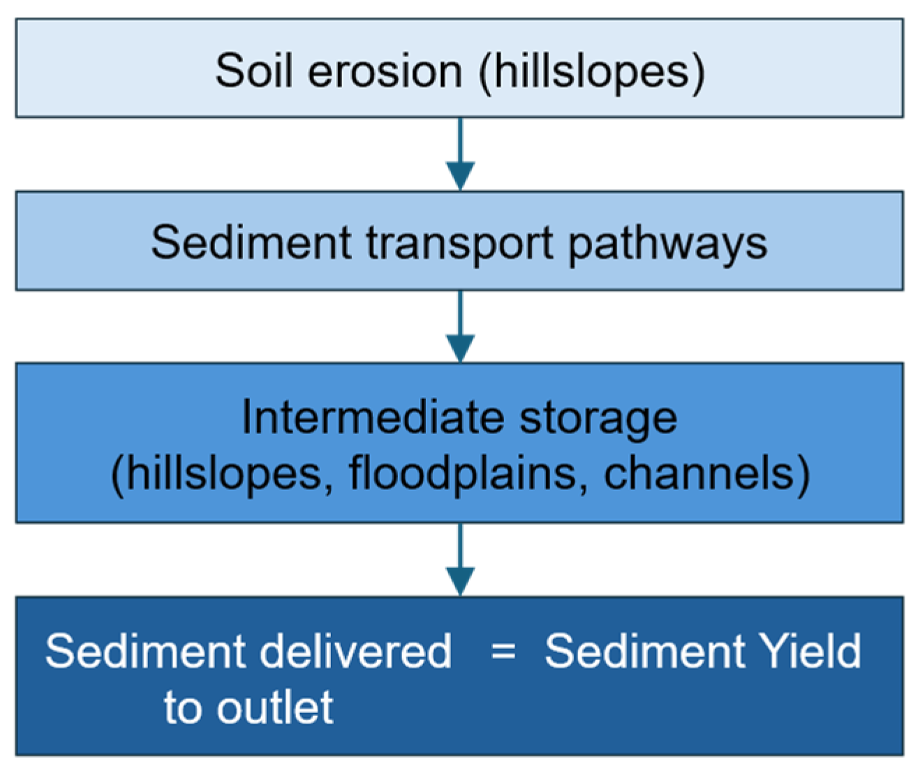
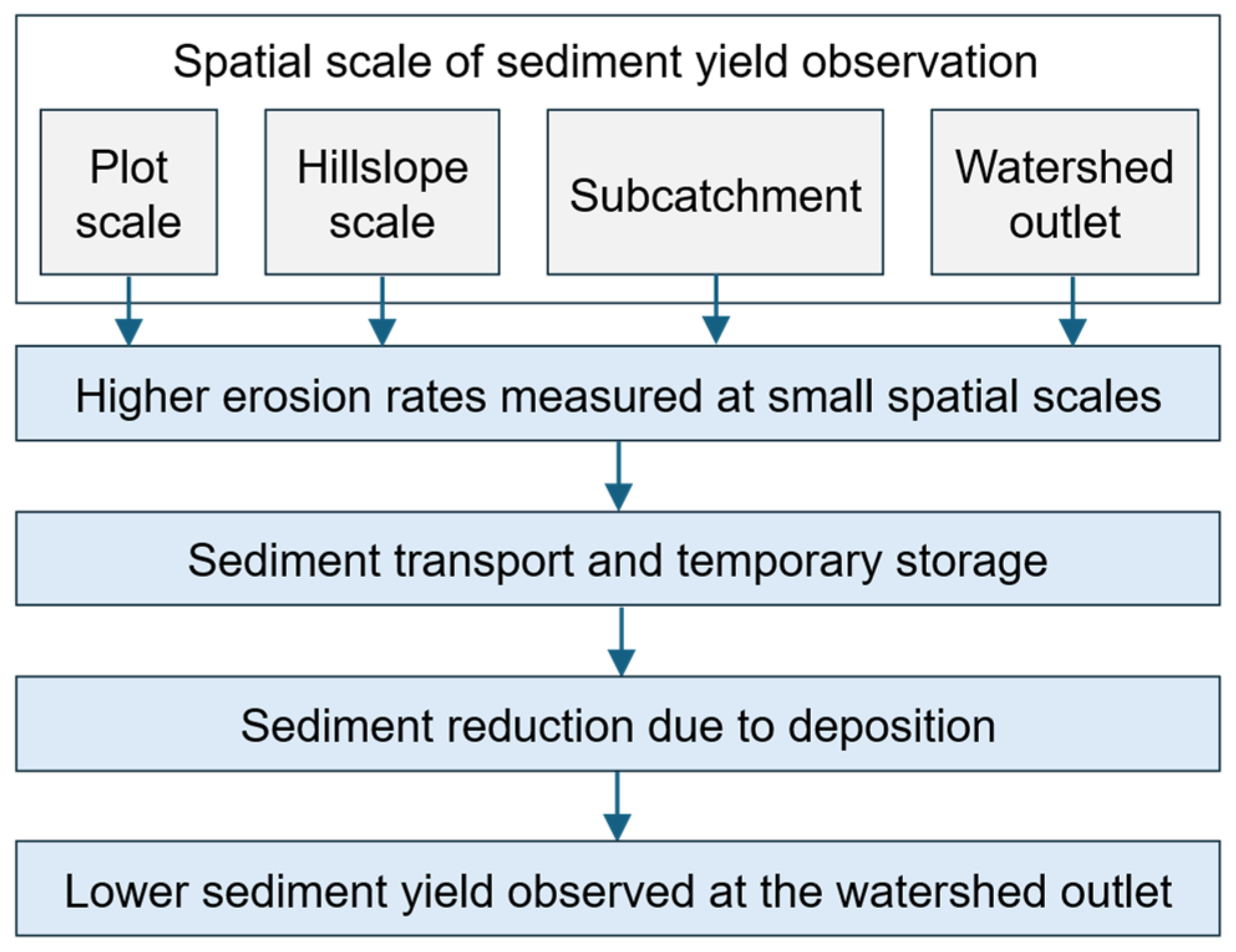
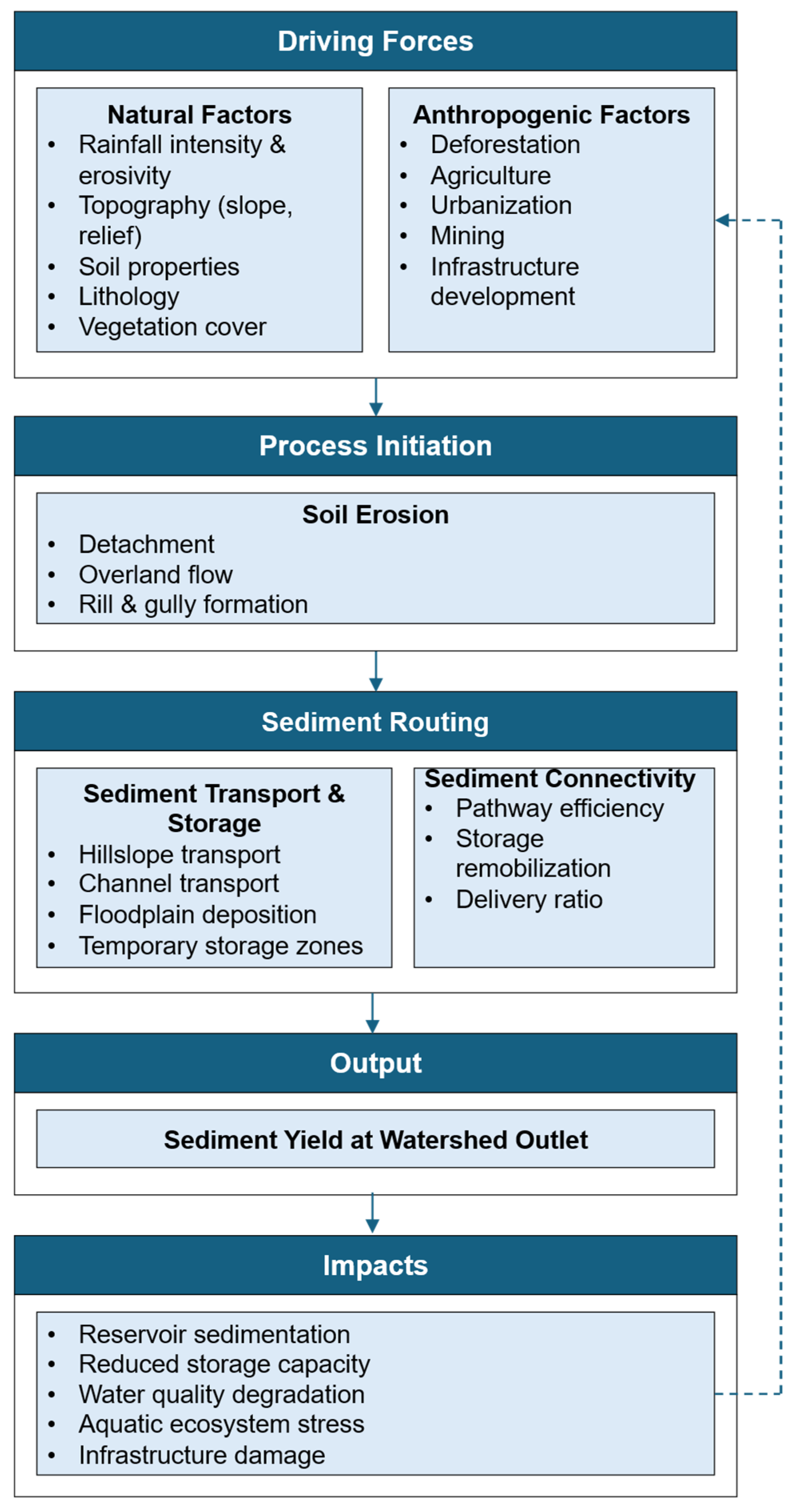
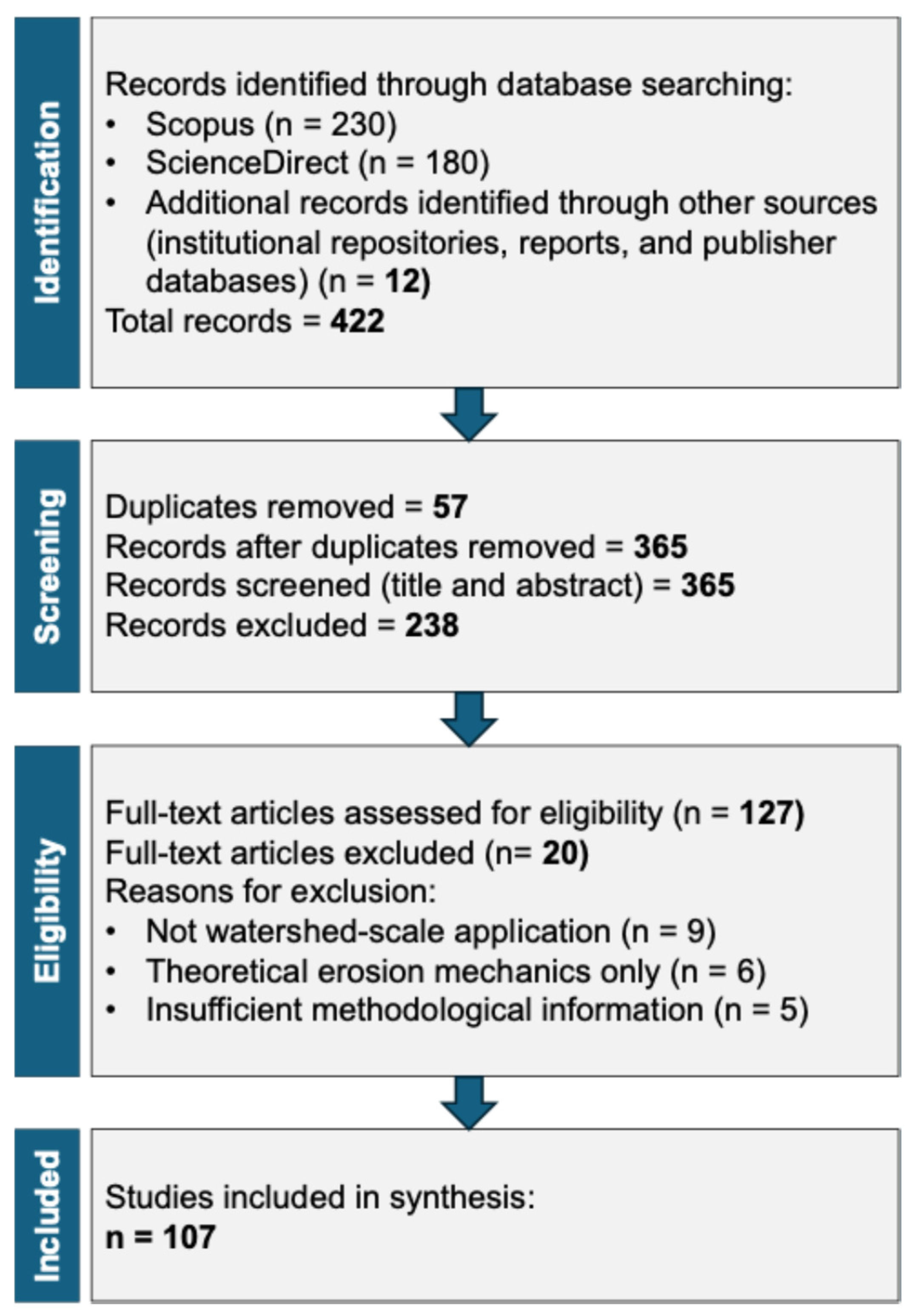
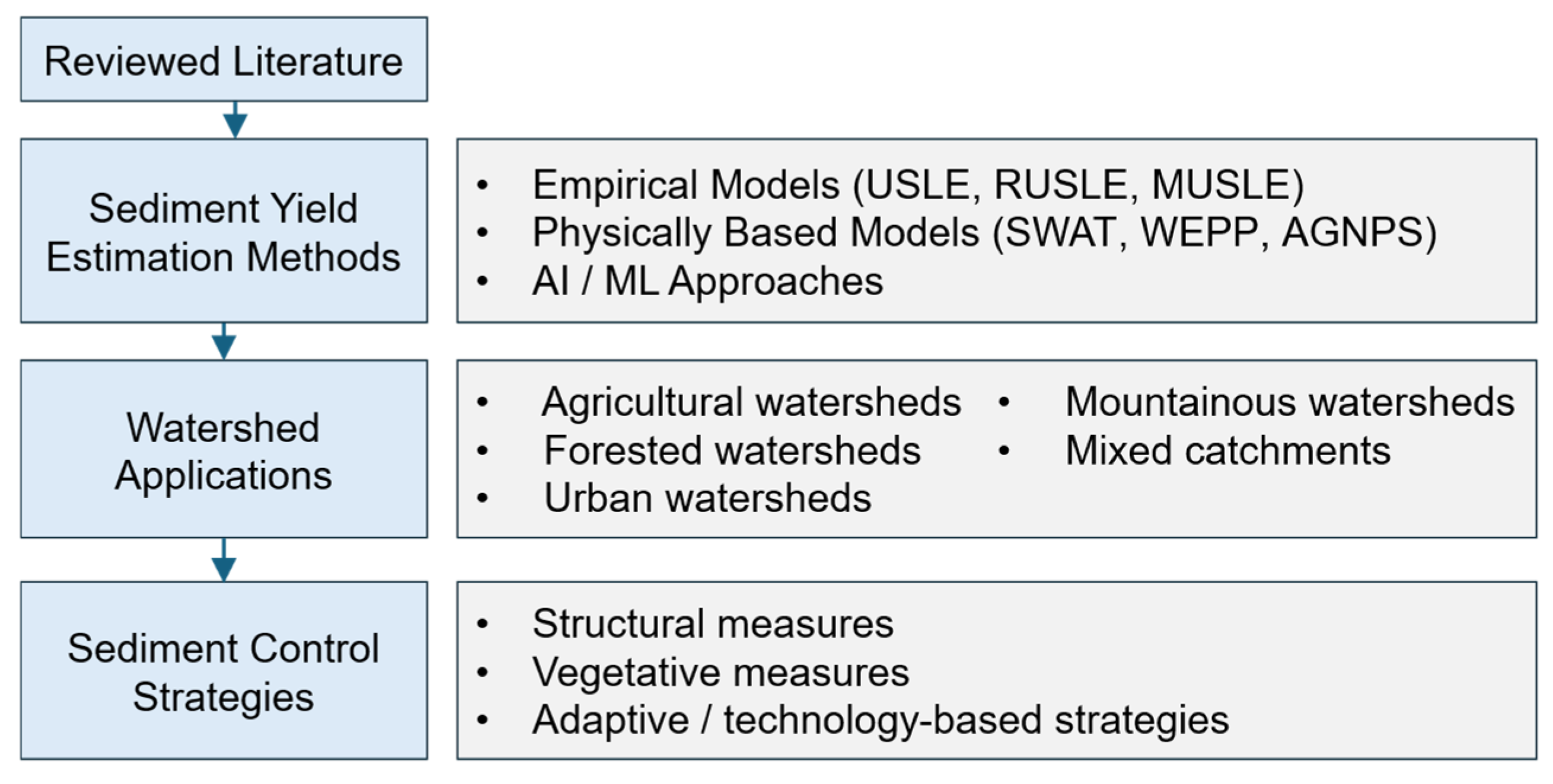
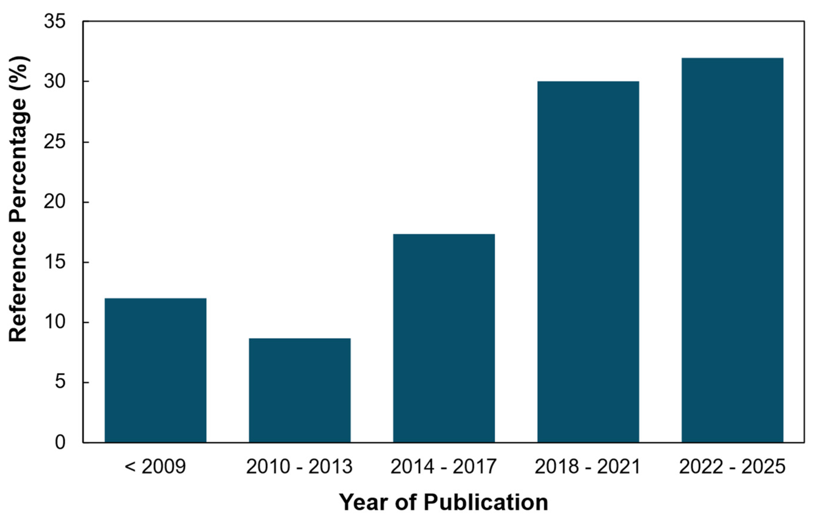
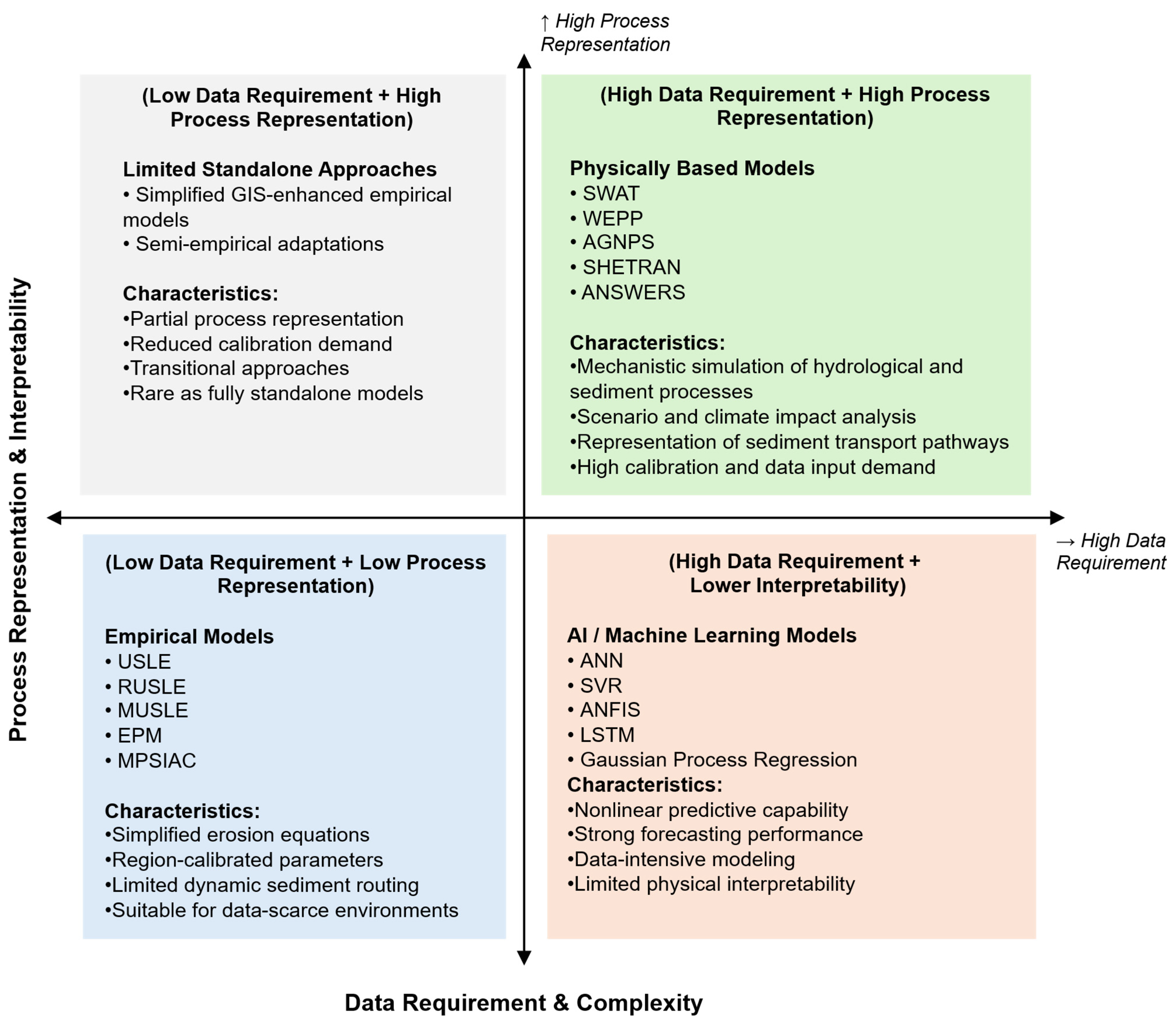
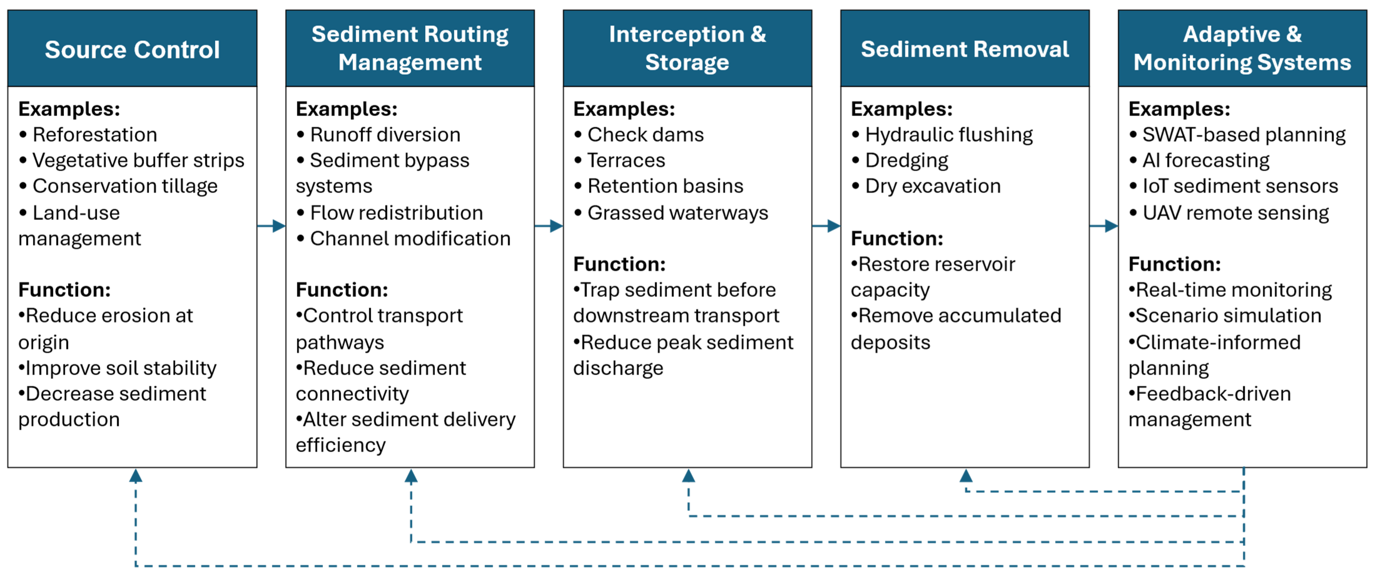
Disclaimer/Publisher’s Note: The statements, opinions and data contained in all publications are solely those of the individual author(s) and contributor(s) and not of MDPI and/or the editor(s). MDPI and/or the editor(s) disclaim responsibility for any injury to people or property resulting from any ideas, methods, instructions or products referred to in the content. |
© 2026 by the authors. Licensee MDPI, Basel, Switzerland. This article is an open access article distributed under the terms and conditions of the Creative Commons Attribution (CC BY) license.