Groundwater Recharge in Crisis: Analyzing the Impact of Urban Growth on Monterrey’s Aquifer Health in the Face of the Rio Grande’s Current Conditions

 , , and
Abstract
1. Introduction
2. Materials and Methods
2.1. Study Area
2.2. Regional Geology, Stratigraphy, and Hydrogeological Setting
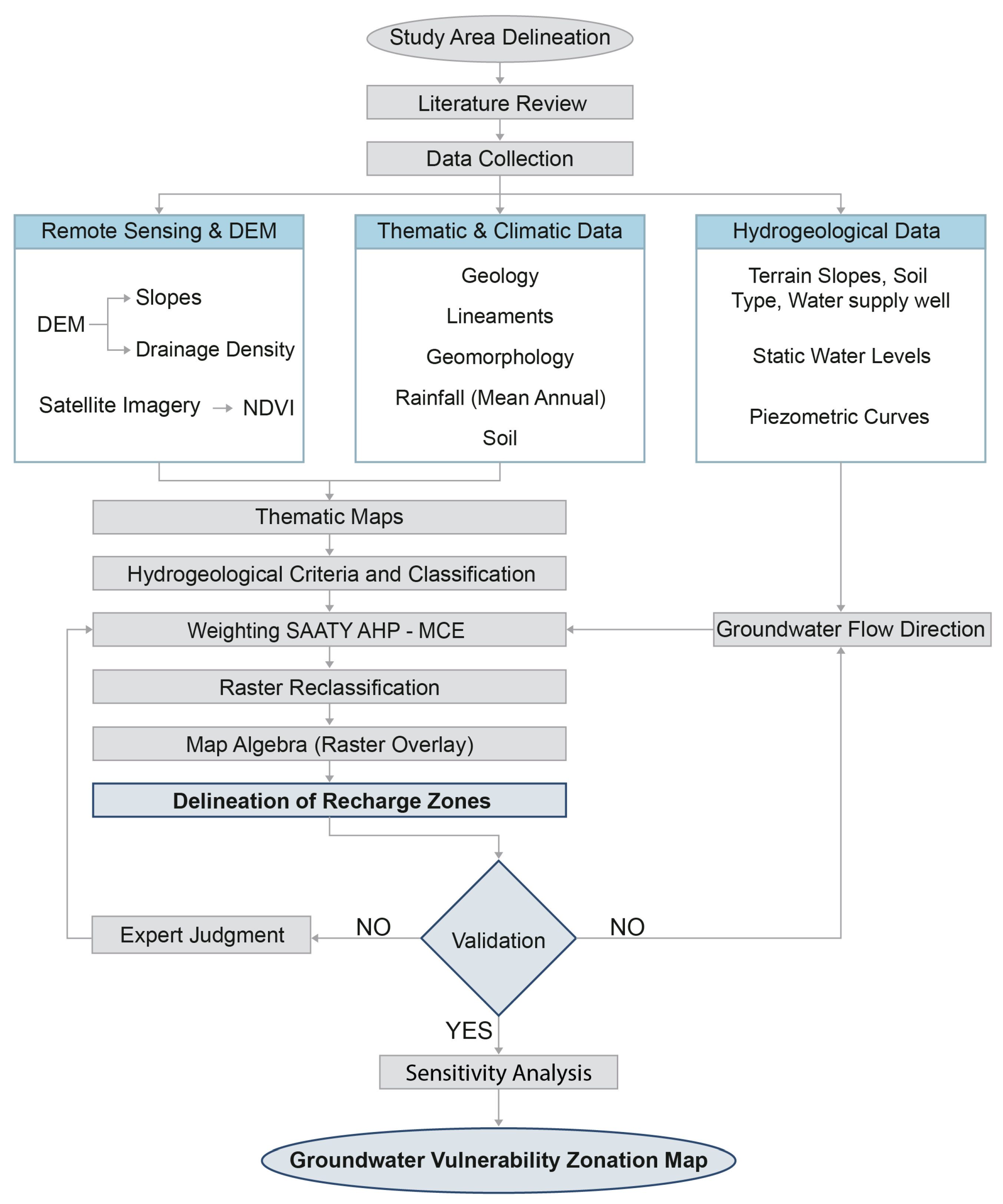
2.3. AHP Procedure
- Utilization of Saaty’s AHP method [56]: The AHP method was applied through the construction of pairwise comparison matrices (denoted as ), where = 1 and the off-diagonal elements are reciprocals ( = 1/). The weighting factors for the classification criteria and the resulting sub-criteria were computed using the eigenvector (), derived from the maximum absolute eigenvalue () of the pairwise comparison matrix [75] as shown in Equation (1):
- 3.
- Normalized weights (NW): The normalized weight for each classification criterion is denoted as wi (i = 1, 2, …, n).
- 4.
- Sensitivity Analysis: A sensitivity analysis was conducted to assess the robustness of the results and validate the consistency of the pairwise comparisons using the following mathematical expressions:
- The Consistency Index () evaluates the degree of consistency in the pairwise comparison matrix, calculated using Equation (2):where denotes the consistency index, λmax is the maximum or principal eigenvalue of the pairwise comparison matrix, and n is the order of the matrix.
- The Consistency Ratio () evaluates the consistency of the judgments of Saaty’s scale using Equation (3):where is the Consistency Ratio, and the consistency index of a randomly generated pairwise comparison matrix for different values of , as shown in Table 1:
- 5.
- Assigning weights and Normalized Weights for thematic layers: Weights were assigned to each thematic map (geology, structural lineaments, etc.), and the NW for each pixel (30 m × 30 m) in the thematic maps for both 1990 and 2022 were calculated (see below and Section S2, Supplementary Materials).
- 6.
- Spatial analysis using GIS: GIS spatial analysis tools were used to overlay the thematic maps and calculate the Groundwater Potential Index (GWPI) for each pixel, using Equation (4):where GWPI refers to the Groundwater Potential Index, Geo to geology, LD to lineaments, GM to the geomorphology of terrain, SP to slope, DD to drainage density, SL to soil type, LULC to land use and land cover, and PPT to precipitation (rainfall). The subscripts w and wi represent the weights and the NW of the thematic layers, respectively. This process allowed the assignment of groundwater potential to each pixel.
- 7.
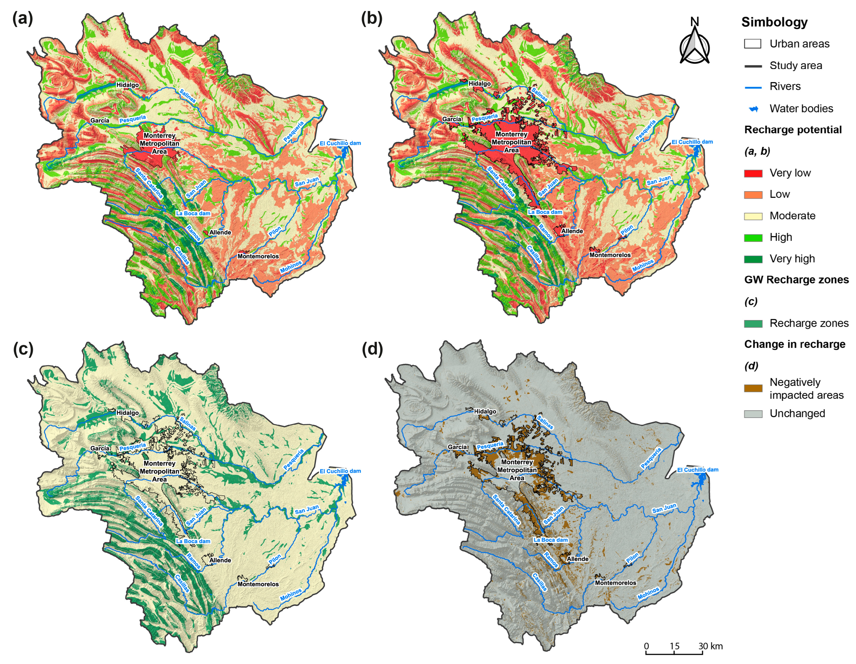
- Delineation of Recharge Zones: Based on the range of calculated GWPI values (Equation (4)), groundwater recharge zones were classified into five potential categories: very high (>25), high (20–25), moderate (15–20), low (10–15), and very low (<10).
- 8.
- Validation strategies: Two validation strategies were developed:
- Comparing the geology reported in the recharge zones.
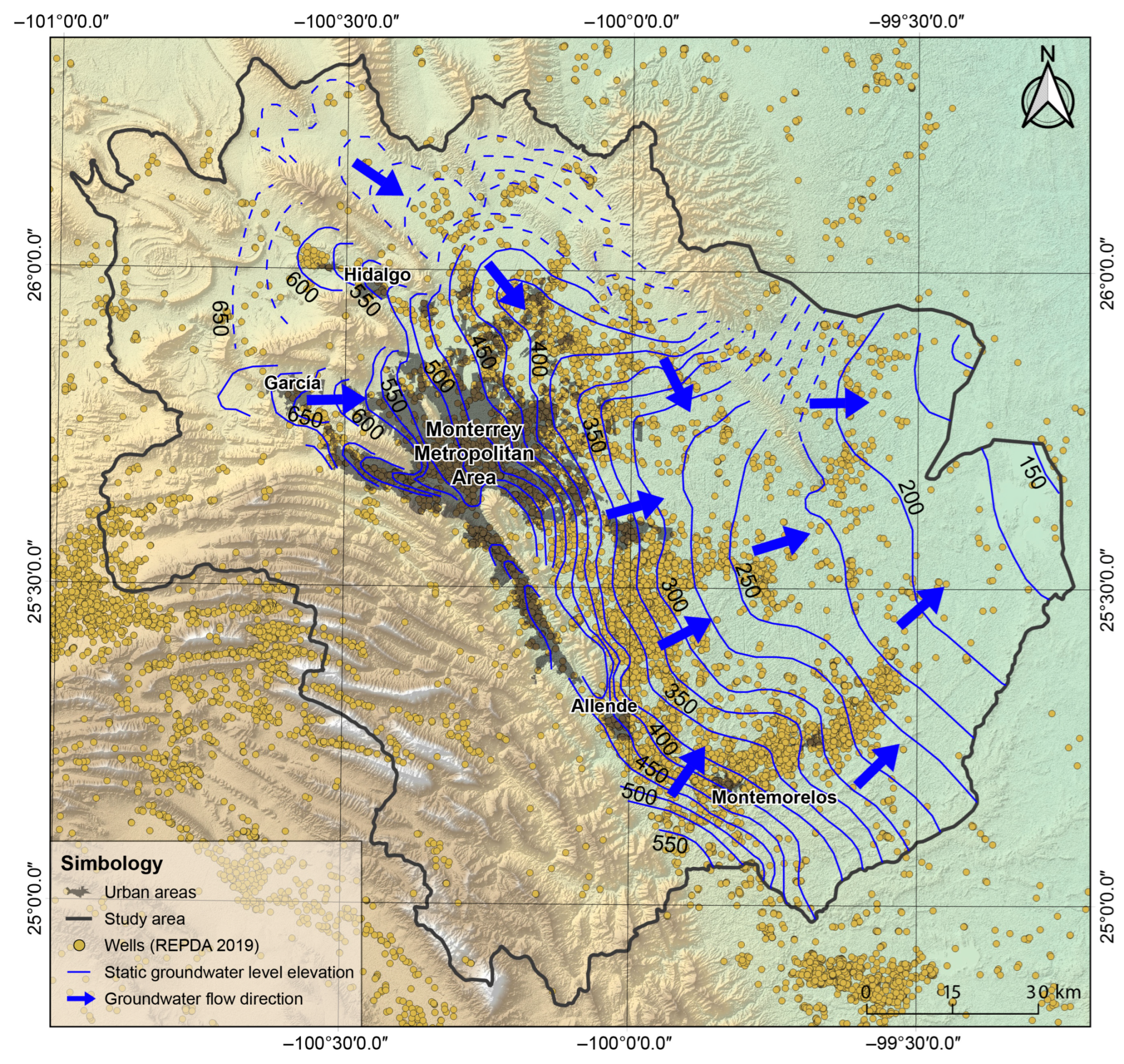
- Comparing available literature data related to potentiometric levels, recharge zones, and discharge zones.
- 9.
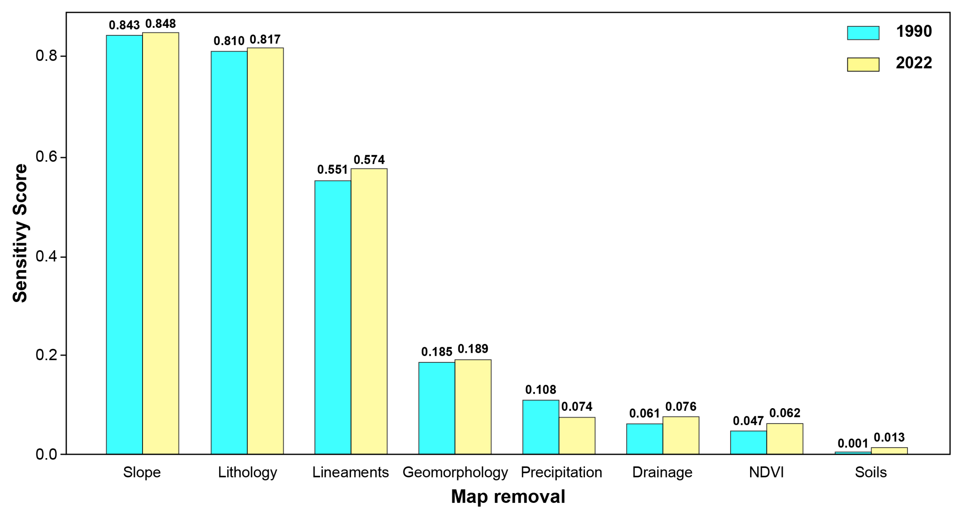
- Layer-removal sensitivity analysis using SI, Kappa, Sobol, RMSE: This approach evaluated robustness by sequentially removing thematic layers and quantifying spatial agreement, variance contribution, and pixel-wise deviations.
- 10.
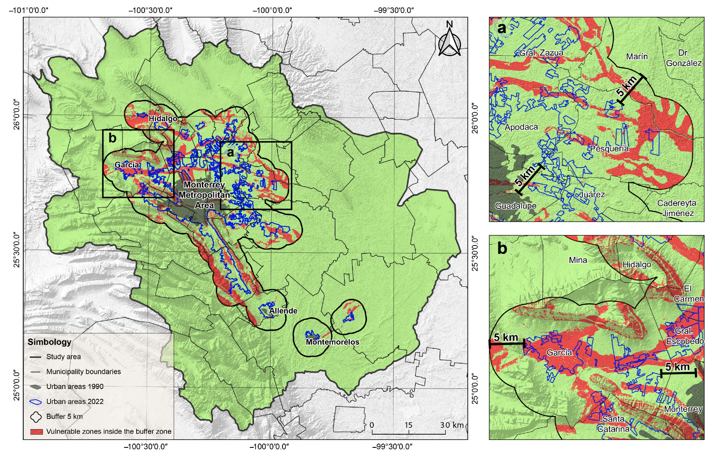
- Delineation of Vulnerable Zones: Vulnerable zones were delineated within a 5 km buffer, which was used as a projection of urban growth over the 32-year study period (1990–2022) [77].
2.4. Selection and Weighting of Groundwater Recharge Influencing Factors
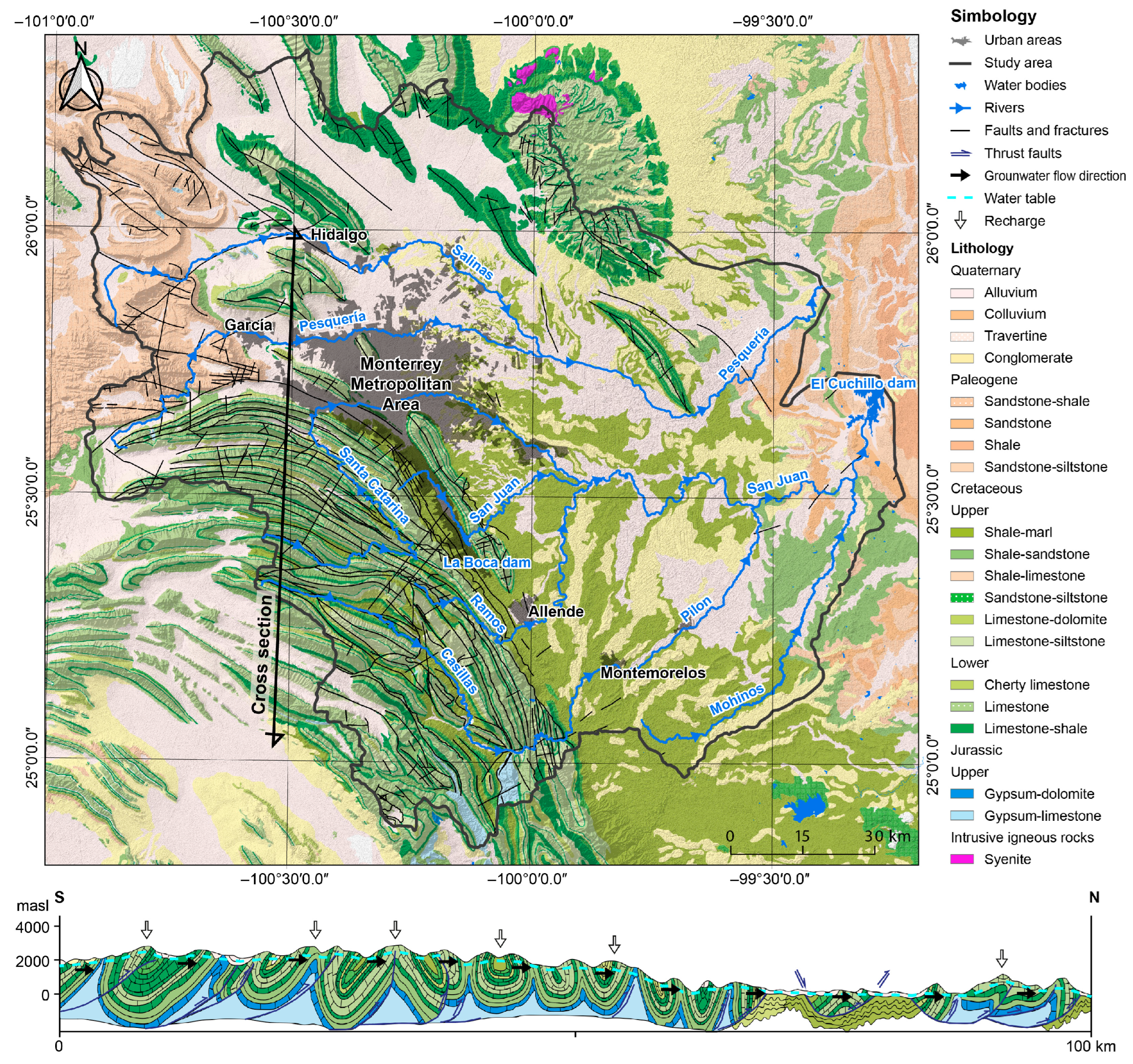
- Geology: Thirty-two lithological units were grouped into six classes according to aquifer recharge potential, ranging from very favorable to slightly favorable; Cretaceous carbonate sequences show the highest recharge potential, followed by Quaternary sediments, whereas shales and clay-rich formations exhibit the lowest potential.
- Structural lineaments were classified into eight classes, depending on the type of lineament and its extent, with regional faults being the most important for recharge and areas with no structural lineaments being the least relevant for recharge.
- Terrain slope was classified into five classes, with slopes below 5% considered the most favorable for groundwater recharge, whereas slopes exceeding 45% were regarded as having negligible relevance to the recharge process.
- Geomorphology, assigned a lower (fourth-level) importance in the analysis, was derived from the INEGI base map and classified into eight classes, with karst systems being the most favorable for recharge and lacustrine terrain the least favorable.
- Precipitation was classified into five classes, with the highest weight assigned to areas receiving more than 1000 mm of rainfall and the lowest weight to areas with less than 400 mm, reflecting their relative importance for groundwater recharge.
- Drainage density was classified into seven classes, with the highest weight assigned to areas with densities below 1 km/km2 and the lowest weight to areas exceeding 50 km/km2, indicating minimal favorability for groundwater recharge.
- NDVI was classified into five classes, with the highest weight and greatest recharge favorability assigned to areas with NDVI values greater than 0.4, while areas with NDVI values below 0.1 were considered unfavorable for groundwater recharge.
- Soil type was classified into four classes (A, B, C, and D) according to the USDA Hydrologic Soil Groups classification, with Group A considered highly favorable for groundwater recharge and Group D the least favorable.
2.5. Sensitivity Analysis
- (i).
- Similarity Index (SI): Measures pixel-wise spatial agreement between the base map and each removal scenario [89]. Values range from 0–100%, with higher values indicating greater similarity and lower sensitivity. The SI was computed using Equation (5).
- (ii).
- Cohen’s Kappa coefficient (κ): Evaluates categorical agreement between recharge potential classes, accounting for chance [90]. Values <0.4 indicate poor agreement (high sensitivity), while values >0.8 indicate almost perfect agreement. This coefficient is calculated using the following Equation (6):where Po is the proportion of observed agreement and Pe is the proportion of agreement expected by chance. This index is particularly valuable in spatial analyses because it considers the categorical structure of recharge classes rather than merely quantitative similarity [91].
- (iii).
- Sobol Index (S): A variance-based global sensitivity measure that quantifies the contribution of each input layer to total model variance [92]. It is approximated using the following Equation (7):where Var(B − Rᵢ) is the variance of pixel-wise differences between the base and removal scenarios, and Var(B) is the total variance of the base map. This metric provides a variance-based quantification of each layer’s contribution to overall model uncertainty [93].
- (iv).
- Root Mean Square Error (RMSE): Quantifies the magnitude of pixel-wise deviations between maps [94], as shown in Equation (8):where K is the total number of pixels in the map or dataset, Bk the value of the k-th pixel in the predicted map or model output, Rk the value of the k-th pixel in the reference map or ground truth. Larger RMSE values indicate greater deviation from the baseline model, reflecting a stronger influence of the re-moved layer on model output.
3. Results and Discussion
3.1. Potential Groundwater Recharge Zones
3.2. Method Validation
3.3. Sensitivity Analysis
3.4. Changes Between 1990 and 2022
3.5. Vulnerable Zones in the MMA
3.6. Limitations and Future Work
4. Conclusions
Supplementary Materials
Author Contributions
Funding
Data Availability Statement
Acknowledgments
Conflicts of Interest
Abbreviations
| AHP | Analytic Hierarchy Process |
| CI | Consistency Index |
| CONAGUA | National Water Commission |
| CONAPO | National Population Council |
| CR | Consistency Ratio |
| GIS | Geographic Information System |
| GWPI | Groundwater Potential Index |
| GWPS | Groundwater Potential Sites |
| GWRZ | Groundwater Recharge Zones |
| INEGI | National Institute of Statistics and Geography |
| LULC | Land Use and Land Cover |
| MCE | Multi-Criteria Evaluation |
| MMA | Monterrey Metropolitan Area |
| NDVI | Normalized Difference Vegetation Index |
| REPDA | Public Register of Water Rights |
| RI | Random Consistency Index |
| RMSE | Root Mean Square Error |
| RS | Remote Sensing |
| SADM | Monterrey Water Utility |
| SGM | Mexican Geological Service |
| USEPA | United States Environmental Protection Agency |
References
- Gleeson, T.; Cuthbert, M.; Ferguson, G.; Perrone, D. Global groundwater sustainability, resources, and systems in the Anthropocene. Annu. Rev. Earth Planet. Sci. 2020, 48, 431–463. [Google Scholar] [CrossRef] [Scilit]
- Mukherjee, A.; Jha, M.K.; Kim, K.W.; Pacheco, F.A.L. Groundwater resources: Challenges and future opportunities. Sci. Rep. 2024, 14, 28540. [Google Scholar] [CrossRef] [Scilit]
- Jasechko, S.; Seybold, H.; Perrone, D.; Fan, Y.; Shamsudduha, M.; Taylor, R.G.; Fallatah, O.; Kirchner, J.W. Rapid groundwater decline and some cases of recovery in aquifers globally. Nature 2024, 625, 715–721. [Google Scholar] [CrossRef] [Scilit]
- La Vigna, F. Urban groundwater issues and resource management, and their roles in the resilience of cities. Hydrogeol. J. 2022, 30, 1657–1683. [Google Scholar] [CrossRef] [Scilit]
- Borah, G. Urban water stress: Climate change implications for water supply in cities. Water Conserv. Sci. Eng. 2025, 10, 20. [Google Scholar] [CrossRef] [Scilit]
- Biswas, A.; Sarkar, S.; Das, S.; Dutta, S.; Choudhury, M.R.; Giri, A.; Bera, B.; Bag, K.; Mukherjee, B.; Banerjee, K.; et al. Water scarcity: A global hindrance to sustainable development and agricultural production—A critical review of the impacts and adaptation strategies. Camb. Prism. Water 2025, 3, e4. [Google Scholar] [CrossRef] [Scilit]
- Amparo-Salcedo, M.; Pérez-Gimeno, A.; Navarro-Pedreño, J. Water security under climate change: Challenges and solutions across 43 countries. Water 2025, 17, 633. [Google Scholar] [CrossRef] [Scilit]
- Pacheco-Treviño, S.; Manzano-Camarillo, M.G. The socioeconomic dimensions of water scarcity in urban and rural Mexico: A comprehensive assessment of sustainable development. Sustainability 2024, 16, 1011. [Google Scholar] [CrossRef] [Scilit]
- Consejo Nacional de Población—CONAPO. Available online: https://datos.gob.mx/organization/conapo (accessed on 11 January 2025).
- INEGI. Marco Geoestadístico; INEGI: Aguascalientes, Mexico, 2023. [Google Scholar]
- Aguilar-Barajas, I.; Sisto, N.P.; Ramírez-Orozco, A.I. Agua para Monterrey. Logros, Retos y Oportunidades para Nuevo León y México, 1st ed.; SADM: Monterrey, Mexico; Technological Institute of Monterrey: Monterrey, Mexico, 2015. [Google Scholar]
- Magaña, V.; Herrera, E.; Ábrego-Góngora, C.J.; Ávalos, J.A. Socioeconomic drought in a Mexican semi-arid city: Monterrey Metropolitan Area, a case study. Front. Water 2021, 3, 579564. [Google Scholar] [CrossRef] [Scilit]
- Cullell, J.M. Monterrey Descubre la Escasez de Agua: “Huele todo a drenaje”; El País: Madrid, Spain, 2022; Available online: https://elpais.com/mexico/2022-06-11/monterrey-descubre-la-escasez-de-agua-huele-todo-a-drenaje.html/ (accessed on 13 March 2025).
- Comisión Nacional del Agua (CONAGUA). Estudio de Actualización Geohidrológica de los Acuíferos 1906, Área Metropolitana de Monterrey; 1912 Citrícola Norte; 1916 Navidad Potosí-Raíces; Comisión Nacional del Agua (CONAGUA): Mexico City, Mexico, 2014. [Google Scholar]
- Comisión Nacional del Agua (CONAGUA). Determinación de la Disponibilidad de Agua en el Acuífero Campo Buenos Aires, Estado de Nuevo León. Subdirección General Técnica. Gerencia de Aguas Subterráneas. Subgerencia de Evaluación y Ordenamiento de Acuíferos; Comisión Nacional del Agua (CONAGUA): Mexico City, Mexico, 2015. [Google Scholar]
- Comisión Nacional del Agua (CONAGUA). Actualización de la Disponibilidad de Agua en el Acuífero Área Metropolitana de Monterrey, Estado de Nuevo León. Subdirección General Técnica. Gerencia de Aguas Subterráneas. Subgerencia de Evaluación y Ordenamiento de Acuíferos; Comisión Nacional del Agua (CONAGUA): Mexico City, Mexico, 2015. [Google Scholar]
- Comisión Nacional del Agua (CONAGUA). Actualización de la Disponibilidad Media Anual de Agua en el Acuífero Paredón (0508), Estado de Coahuila; Comisión Nacional del Agua (CONAGUA): Mexico City, Mexico, 2020. [Google Scholar]
- Comisión Nacional del Agua (CONAGUA). Actualización de la Disponibilidad Media Anual de Agua en el Acuífero Saltillo-Ramos Arizpe (0510), Estado de Coahuila; Comisión Nacional del Agua (CONAGUA): Mexico City, Mexico, 2020. [Google Scholar]
- Comisión Nacional del Agua (CONAGUA). Actualización de la Disponibilidad Media Anual de Agua en el Acuífero Región Manzanera-Zapaliname (0511), Estado de Coahuila; Comisión Nacional del Agua (CONAGUA): Mexico City, Mexico, 2020. [Google Scholar]
- Comisión Nacional del Agua (CONAGUA). Actualización de la Disponibilidad Media Anual de Agua en el Acuífero Área Metropolitana de Monterrey (1906), Estado de Nuevo León; Comisión Nacional del Agua (CONAGUA): Mexico City, Mexico, 2020. [Google Scholar]
- Comisión Nacional del Agua (CONAGUA). Actualización de la Disponibilidad Media Anual de Agua en el Acuífero Campo Buenos Aires (1907), Estado de Nuevo León; Comisión Nacional del Agua (CONAGUA): Mexico City, Mexico, 2020. [Google Scholar]
- Comisión Nacional del Agua (CONAGUA). Actualización de la Disponibilidad Media Anual de Agua en el Acuífero Campo Mina (1908), Estado de Nuevo León; Comisión Nacional del Agua (CONAGUA): Mexico City, Mexico, 2020. [Google Scholar]
- Comisión Nacional del Agua (CONAGUA). Actualización de la Disponibilidad Media Anual de Agua en el Acuífero Campo Durazno (1909), Estado de Nuevo León; Comisión Nacional del Agua (CONAGUA): Mexico City, Mexico, 2020. [Google Scholar]
- Comisión Nacional del Agua (CONAGUA). Actualización de la Disponibilidad Media Anual de Agua en el Acuífero Campo Topo Chico (1910), Estado de Nuevo León; Comisión Nacional del Agua (CONAGUA): Mexico City, Mexico, 2020. [Google Scholar]
- Comisión Nacional del Agua (CONAGUA). Actualización de la Disponibilidad Media Anual de Agua en el Acuífero Cañón del Huajuco (1911), Estado de Nuevo León; Comisión Nacional del Agua (CONAGUA): Mexico City, Mexico, 2020. [Google Scholar]
- Comisión Nacional del Agua (CONAGUA). Actualización de la Disponibilidad Media Anual de Agua en el Acuífero Citrícola Norte (1912), Estado de Nuevo León; Comisión Nacional del Agua (CONAGUA): Mexico City, Mexico, 2020. [Google Scholar]
- Comisión Nacional del Agua (CONAGUA). Actualización de la Disponibilidad Media Anual de Agua en el Acuífero China-General Bravo (1913), Estado de Nuevo León; Comisión Nacional del Agua (CONAGUA): Mexico City, Mexico, 2020. [Google Scholar]
- Comisión Nacional del Agua (CONAGUA). Actualización de la Disponibilidad Media Anual de Agua en el Acuífero Campo Jaritas (1918), Estado de Nuevo León; Comisión Nacional del Agua (CONAGUA): Mexico City, Mexico, 2020. [Google Scholar]
- Comisión Nacional del Agua (CONAGUA). Actualización de la Disponibilidad Media Anual de Agua en el Acuífero Campo Papagayos (1920), Estado de Nuevo León; Comisión Nacional del Agua (CONAGUA): Mexico City, Mexico, 2020. [Google Scholar]
- Comisión Nacional del Agua (CONAGUA). Actualización de la Disponibilidad Media Anual de Agua en el Acuífero El Carmen-Salinas-Victoria (1924), Estado de Nuevo León; Comisión Nacional del Agua (CONAGUA): Mexico City, Mexico, 2020. [Google Scholar]
- International Boundary and Water Commission (IBWC). Minute 331; International Boundary and Water Commission (IBWC): El Paso, TX, USA, 2024. Available online: https://www.ibwc.gov/wp-content/uploads/2024/11/Min331_English.pdf (accessed on 1 December 2025).
- International Boundary and Water Commission (IBWC). Utilization of Waters of the Colorado and Tijuana Rivers and of the Rio Grande: Treaty Between the United States of America and Mexico; International Boundary and Water Commission (IBWC): El Paso, TX, USA, 1944. Available online: https://www.ibwc.gov/wp-content/uploads/2022/11/1944Treaty.pdf (accessed on 1 December 2025).
- Siebert, S.; Burke, J.; Faures, J.M.; Frenken, K.; Hoogeveen, J.; Döll, P.; Portmann, F.T. Groundwater use for irrigation—A global inventory. Hydrol. Earth Syst. Sci. 2010, 14, 1863–1880. [Google Scholar] [CrossRef] [Scilit]
- De León-Gómez, H.; Dávila Pórcel, R.A.; Aranda Maltez, L.M. Diagnóstico del estado de las aguas subterráneas de Monterrey. In Temas Actuales de Hidrología Subterránea; UANL: San Nicolás de los Garza, Mexico, 2013. [Google Scholar]
- Mora, A.; Mahlknecht, J.; Rosales-Lagarde, L.; Hernández-Antonio, A. Assessment of major ions and trace elements in groundwater supplied to the Monterrey metropolitan area, Nuevo León, Mexico. Environ. Monit. Assess. 2017, 189, 394. [Google Scholar] [CrossRef] [Scilit]
- Torres-Martínez, J.A.; Mora, A.; Knappett, P.S.; Ornelas-Soto, N.; Mahlknecht, J. Tracking nitrate and sulfate sources in groundwater of an urbanized valley using a multi-tracer approach combined with a Bayesian isotope mixing model. Water Res. 2020, 182, 115962. [Google Scholar] [CrossRef] [Scilit]
- de León-Gómez, H.; Martin del Campo-Delgado, M.A.; Esteller-Alberich, M.V.; García-González, S.; Cruz-López, A.; de León-Rodríguez, H.D.; Pérez-Martínez, M.; Guerra-Cobián, V.H. Estimation and validation of groundwater vulnerability of an urban aquifer using GIS and DRASTIC: City of Monterrey, Mexico. Environ. Earth Sci. 2021, 80, 247. [Google Scholar] [CrossRef] [Scilit]
- Gutiérrez, M.; Alarcón-Herrera, M.T.; Espino-Valdés, M.S.; Valenzuela-García, L.I. Current state of arsenic, fluoride, and nitrate groundwater contamination in northern Mexico: Distribution, health impacts, and emerging research. Water 2025, 17, 1990. [Google Scholar] [CrossRef] [Scilit]
- Tuinhof, A.; Foster, S.; Van Steenbergen, F.; Talbi, A.; Wishart, M. Groundwater Management Policy for Sub-Saharan Africa; World Bank: Washington, DC, USA, 2011; Available online: https://www.worldbank.org (accessed on 21 August 2025).
- Mengistu, T.D.; Chang, S.W.; Kim, I.-H.; Kim, M.-G.; Chung, I.-M. Determination of potential aquifer recharge zones using geospatial techniques for Proxy Data of Gilgel Gibe catchment, Ethiopia. Water 2022, 14, 1362. [Google Scholar] [CrossRef] [Scilit]
- Surinaidu, L.; Muthuwatta, L.; Amarasinghe, U.A.; Jain, S.K.; Ghosh, N.C.; Kumar, S.; Singh, S. Reviving the Ganges Water Machine: Accelerating surface water and groundwater interactions in the Ramganga sub-basin. J. Hydrol. 2016, 540, 207–219. [Google Scholar] [CrossRef] [Scilit]
- Kuisi, M.A.; Mashal, K.; Al-Qinna, M.; Hamad, A.A.; Margana, A. Groundwater vulnerability and hazard mapping in an arid region: Case study, Amman-Zarqa Basin (AZB)-Jordan. J. Water Resour. Prot. 2014, 6, 297–318. [Google Scholar] [CrossRef]
- United Nations (UNO). Informe Mundial Sobre el Desarrollo de los Recursos Hídricos. 2022. Available online: https://www.unesco.org (accessed on 21 August 2025).
- Shao, Z.; Huq, M.E.; Cai, B.; Altan, O.; Li, Y. Integrated remote sensing and GIS approach using fuzzy-AHP to delineate and identify groundwater potential zones in semi-arid Shanxi Province, China. Environ. Model. Softw. 2020, 134, 104868. [Google Scholar] [CrossRef] [Scilit]
- Ake, G.E.; Kouame, K.J.; Fofana, D.; Sekouba, O.; Koffi, A.B.; Jourda, J.P. Cartography for the aquifer potential recharge areas of the Department of Aboisso (South-East Côte d’Ivoire). J. Geosci. Environ. Prot. 2019, 7, 49–68. [Google Scholar] [CrossRef]
- Todd, D.K.; Mays, L.W. Groundwater Hydrology; John Wiley & Sons: Hoboken, NJ, USA, 2004. [Google Scholar]
- Gebru, H.; Gebreyohannes, T.; Hagos, E. Identification of groundwater potential zones using analytical hierarchy process (AHP) and GIS-remote sensing integration, the Case of Golina River Basin, Northern Ethiopia. Int. J. Adv. Remote Sens. GIS 2020, 9, 3289–3311. [Google Scholar] [CrossRef] [Scilit]
- Omar, P.J.; Dwivedi, S.B.; Dikshit, P.K. Sustainable development and management of groundwater in Varanasi, India. In Advances in Water Resources Engineering and Management: Select Proceedings of TRACE 2018; Springer: Singapore, 2019; pp. 201–209. [Google Scholar]
- Waikar, M.L.; Nilawar, A.P. Identification of groundwater potential zone using remote sensing and GIS technique. Int. J. Innov. Res. Sci. Eng. Technol. 2014, 3, 12163–12174. [Google Scholar]
- Ahmad, R.; Srivastava, P.K. Hydrogeomorphological mapping using geospatial techniques for assessing the groundwater potential of Rambiara River Basin, Jammu and Kashmir, India. J. Earth Syst. Sci. 2012, 121, 699–713. [Google Scholar]
- Sajil-Kumar, P.J.; Elango, L.; Schneider, M. GIS and AHP Based Groundwater Potential Zones Delineation in Chennai River Basin (CRB), India. Sustainability 2022, 14, 1830. [Google Scholar] [CrossRef] [Scilit]
- Rajesh, J.; Pande, C.B.; Kadam, S.A.; Gorantiwar, S.D.; Shinde, M.G. Exploration of groundwater potential zones using analytical hierarchical process (AHP) approach in the Godavari river basin of Maharashtra in India. Appl. Water Sci. 2021, 11, 182. [Google Scholar] [CrossRef] [Scilit]
- Suliman, M.; Samiullah, S.; Ali, M. Identification of Potential Groundwater Recharge Sites in a Semi-arid Region of Pakistan Using Saaty’s Analytical Hierarchical Process (AHP). Geomat. Environ. Eng. 2022, 16, 53–70. [Google Scholar] [CrossRef] [Scilit]
- Melese, T.; Belay, T. Groundwater potential zone mapping using analytical hierarchy process and GIS in Muga Watershed, Abay Basin, Ethiopia. Glob. Chall. 2022, 6, 2100068. [Google Scholar] [CrossRef] [Scilit]
- Jallow, A.G.; Diongue, D.M.L.; Emvoutou, H.C.; Mama, D.; Faye, S. Groundwater recharge zone mapping using GIS-based analytical hierarchy process and multi-criteria evaluation: Case study of Greater Banjul area. Am. J. Water Resour. 2020, 8, 182–190. [Google Scholar] [CrossRef] [Scilit]
- Saaty, T.L. The Analytic Hierarchy Process; McGraw-Hill: New York, NY, USA, 1980. [Google Scholar]
- Al-Abadi, A.; Al-Shamma, A. Groundwater Potential Mapping of the Major Aquifer in Northeastern Missan Governorate, South of Iraq by Using Analytical Hierarchy Process and GIS. J. Environ. Earth Sci. 2014, 4, 125–149. [Google Scholar]
- Saaty, T.L. A scaling method for priorities in hierarchical structures. J. Math. Psychol. 1977, 15, 234–281. [Google Scholar] [CrossRef] [Scilit]
- Sonwane, K.; Usmani, H.U. Assessment of groundwater potential zones using geographic information system and analytic hierarchy process (AHP) techniques in Chhoti Kali Sindh Watershed in Ujjain district, Madhya Pradesh, India. J. Sci. Technol. 2021, 6, 122–131. [Google Scholar]
- Kolli, M.K.; Opp, C.; Groll, M. Mapping of potential groundwater recharge zones in the Kolleru Lake catchment, India, by using remote sensing and GIS techniques. Nat. Resour. 2020, 11, 10-4236. [Google Scholar] [CrossRef]
- Breña Naranjo, A. Monterrey y su día cero. Perspect. IMTA 2022, 27, 1–6. Available online: https://www.imta.gob.mx/gobmx/DOI/perspectivas/2022/b-imta-perspectivas-2022-27.pdf (accessed on 24 August 2025). [CrossRef] [Scilit]
- Padilla y Sánchez, R.J. Geologic Evolution of the Sierra Madre Oriental Between Linares, Concepción del Oro, Saltillo and Monterrey, México. Ph.D. Thesis, University of Texas at Austin, Austin, TX, USA, 1982. [Google Scholar]
- Padilla y Sánchez, R.J. Post-Paleozoic tectonics of northeast Mexico and its role in the evolution of the Gulf of Mexico. Geofís. Int. 1986, 25, 157–207. [Google Scholar] [CrossRef] [Scilit]
- Goldhammer, R.K. Mesozoic sequence stratigraphy and paleogeographic evolution of northeast Mexico. In Mesozoic Sedimentary and Tectonic History of North-Central Mexico; Geological Society of America Special Paper 340; Geological Society of America: Boulder, CO, USA, 1999; pp. 1–58. [Google Scholar]
- Carrillo-Bravo, J. Geología del anticlinorio Huizachal-Peregrina al NW de Ciudad Victoria. Boletín Asoc. Mex. Geólogos Pet. 1961, 13, 1–98. [Google Scholar]
- Servicios de Agua y Drenaje de Monterrey (SADM). Análisis de Alternativas de Fuentes de Abastecimiento a la Zona Metropolitana de Monterrey, N.L.; SADM: Monterrey, Mexico, 2011. [Google Scholar]
- Consejo de Recursos Minerales (COREMI). Carta Geológico-Minera Río Bravo, Clave G14-7, Escala 1:250,000. Estados de Coahuila, Nuevo León y Zacatecas; Secretaría de Economía: Mexico City, Mexico, 2000. [Google Scholar]
- Consejo de Recursos Minerales (COREMI). Carta Geológico-Minera Río Bravo, Clave G14-8, Escala 1:250,000. Estados de Nuevo León y Tamaulipas; Secretaría de Economía: Mexico City, Mexico, 2003. [Google Scholar]
- Servicio Geológico Mexicano (SGM). Informe de la Carta Geológica-Minera Garza García G14-C25; Servicio Geológico Mexicano: Pachuca, Mexico, 2016. [Google Scholar]
- Padilla y Sánchez, R.J. Las estructuras de la curvatura de Monterrey, estados de Coahuila, Nuevo León, Zacatecas y San Luis Potosí. Rev. Mex. Cienc. Geológicas 1985, 6, 1–20. [Google Scholar]
- Chávez-Cabello, G.; Cossio-Torres, T.; Peterson-Rodriguez, R.H. Change of the maximum principal stress during the Laramide Orogenic Curvature: Integrating paleomagnetic and structural analyses. In Geological Society of America Special Paper 383; Geological Society of America: Boulder, CO, USA, 2004; pp. 145–159. [Google Scholar]
- Velázquez, L.; Ordaz, A. Provincias hidrogeológicas de México. Boletín Soc. Geológica Mex. 1993, 52, 15–33. [Google Scholar] [CrossRef] [Scilit]
- Teixeira, J.; Chaminé, H.I.; Carvalho, J.M.; Pérez-Alberti, A.; Rocha, F. Hydrogeomorphological mapping as a tool in groundwater exploration. J. Maps 2013, 9, 263–273. [Google Scholar] [CrossRef] [Scilit]
- Minjárez Sosa, J.I.; Gutiérrez Anguamea, G.A.; Monreal, R.; Grijalva Noriega, F.J.; Tapia-Villaseñor, E.M. Hydrogeomorphologic Mapping of the San Pedro Aquifer; Universidad de Sonora: Hermosillo, Mexico, 2022. [Google Scholar]
- Duguma, T.A.; Duguma, G.A. Assessment of groundwater potential zones of upper Blue Nile river basin using multi-influencing factors under GIS and RS environment: A case study on guder watersheds, abay basin, Oromia region, Ethiopia. Geofluids 2022, 2022, 1172039. [Google Scholar] [CrossRef] [Scilit]
- Sangana, P.; Deus, D.; Chaula, J. Delineation of groundwater potential zones using GIS-based multi-criteria data analysis: A case study of Dodoma City, Tanzania. Int. Eur. Ext. Enablement Sci. Eng. Manag. 2019, 7, 184–202. [Google Scholar]
- Gobierno de Monterrey; IMPLANC Monterrey. Plan Municipal de Desarrollo Urbano para Monterrey 2040; Gobierno de Monterrey: Monterrey, Mexico, 2023. [Google Scholar]
- Igwe, O.; Ifediegwu, S.I.; Onwuka, O.S. Determining the occurrence of potential groundwater zones using integrated hydro-geomorphic parameters, GIS and remote sensing in Enugu State, Southeastern, Nigeria. Sustain. Water Resour. Manag. 2020, 6, 39. [Google Scholar] [CrossRef] [Scilit]
- Instituto Nacional de Estadística y Geografía (INEGI). Biblioteca Digital de Mapas. Available online: https://www.inegi.org.mx (accessed on 5 November 2023).
- Servicio Geológico Mexicano (SGM). Geoinfomex. Available online: https://www.gob.mx/sgm/articulos/conoce-el-sistema-de-consulta-de-informacion-geocientifica-geoinfomex/ (accessed on 5 November 2023).
- Giles, K.A.; Lawton, T.F. Attributes and evolution of an exhumed salt weld, La Popa basin, northeastern Mexico. Geology 1999, 27, 323–326. [Google Scholar] [CrossRef] [Scilit]
- United States Geological Survey (USGS). EarthExplorer. Available online: https://earthexplorer.usgs.gov/ (accessed on 12 March 2024).
- Comisión Nacional del Agua (CONAGUA). Sistema Nacional de Información del Agua (SINA). Available online: https://sina.conagua.gob.mx/ (accessed on 10 January 2024).
- Climate Hazards Center (CHIRPS). Climate Hazards Group InfraRed Precipitation with Stations. Available online: https://www.chc.ucsb.edu/data/chirps (accessed on 12 March 2024).
- NASA Goddard Space Flight Center. MODIS NDVI M. Available online: https://neo.gsfc.nasa.gov/view.php?datasetId=MOD_NDVI_M (accessed on 12 November 2024).
- Napolitano, P.; Fabbri, A.G. Single-Parameter Sensitivity Analysis for Aquifer Vulnerability Assessment Using DRASTIC and SINTACS; Series of Proceedings and Reports-Intern Assoc Hydrological Sciences; IAHS Publications: Oxfordshire, UK, 1996; Volume 235, pp. 559–566. [Google Scholar]
- Gogu, R.C.; Dassargues, A. Current trends and future challenges in groundwater vulnerability assessment using overlay and index methods. Environ. Geol. 2000, 39, 549–559. [Google Scholar] [CrossRef] [Scilit]
- Chenini, I.; Mammou, A.B.; El May, M. Groundwater recharge zone mapping using GIS-based multi-criteria analysis: A case study in Central Tunisia (Maknassy Basin). Water Resour. Manag. 2010, 24, 921–939. [Google Scholar] [CrossRef] [Scilit]
- Eastman, J.R. IDRISI Selva Manual; Clark University: Worcester, MA, USA, 2012. [Google Scholar]
- Cohen, J. A coefficient of agreement for nominal scales. Educ. Psychol. Meas. 1960, 20, 37–46. [Google Scholar] [CrossRef] [Scilit]
- Congalton, R.G. A review of assessing the accuracy of classifications of remotely sensed data. Remote Sens. Environ. 1991, 37, 35–46. [Google Scholar] [CrossRef] [Scilit]
- Sobol’, I.M. Global sensitivity indices for nonlinear mathematical models and their Monte Carlo estimates. Math. Comput. Simul. 2001, 55, 271–280. [Google Scholar] [CrossRef] [Scilit]
- Lilburne, L.; Tarantola, S. Sensitivity analysis of spatial models. Int. J. Geogr. Inf. Sci. 2009, 23, 151–168. [Google Scholar] [CrossRef] [Scilit]
- Chen, Y.; Yu, J.; Khan, S. Spatial sensitivity analysis of multi-criteria weights in GIS-based land suitability evaluation. Environ. Model. Softw. 2010, 25, 1582–1591. [Google Scholar] [CrossRef] [Scilit]
- Comisión Nacional del Agua (CONAGUA). Registro Público de Derechos de Agua (REPDA). Available online: https://app.conagua.gob.mx/ConsultaRepda.aspx (accessed on 10 November 2023).
- Jyrkama, M.I.; Sykes, J.F. The impact of climate change on spatially varying groundwater recharge in the Grand River watershed (Ontario). J. Hydrol. 2007, 338, 237–250. [Google Scholar] [CrossRef] [Scilit]
- Healy, R.W. Estimating Groundwater Recharge; Cambridge University Press: Cambridge, UK, 2010. [Google Scholar]



| n | 1 | 2 | 3 | 4 | 5 | 6 | 7 | 8 | 9 | 10 |
|---|---|---|---|---|---|---|---|---|---|---|
| RI | 0.00 | 0.00 | 0.58 | 0.90 | 1.12 | 1.24 | 1.32 | 1.41 | 1.45 | 1.49 |
| Thematic Map | Scale/Resolution | Type of Document | Source/Reference |
|---|---|---|---|
| Geology | 1:250,000 | Shapefile | INEGI [79], SGM [69] |
| Structural Lineaments | 1:250,000 | Shapefile & Images | SGM [69,80], Padilla y Sánchez [70], Giles y Lawton [81] |
| Terrain Slope | 30 m | Digital Elevation Model | USGS [82] |
| Geomorphology | 1:50,000 | Shapefile. Geomorphological Elements | INEGI [79] |
| Precipitation | 30 m | Data bases | CONAGUA [83], CHIRPS [84] |
| Drainage Density | 1:50,000 | Shapefile. Drainage density | INEGI [79] |
| NDVI | 30 m | Raster file | NASA [85] |
| Soil Type | 1:250,000 | Shapefile | INEGI [79] |
| Area 1990 | Area 2022 | Area Difference | ||||
|---|---|---|---|---|---|---|
| km2 | % | km2 | % | km2 | % | |
| Very Low | 1877.1 | 10.9 | 2898.4 | 16.8 | 1021.3 | 54.4 |
| Low | 5487.3 | 31.9 | 5343.4 | 31.1 | −143.9 | −2.6 |
| Moderate | 5905.2 | 34.3 | 5079.7 | 29.5 | −825.5 | −14.0 |
| High | 3219.5 | 18.7 | 3268 | 19.0 | 48.5 | 1.5 |
| Very High | 719.9 | 4.2 | 619.5 | 3.6 | −100.4 | −13.9 |
Disclaimer/Publisher’s Note: The statements, opinions and data contained in all publications are solely those of the individual author(s) and contributor(s) and not of MDPI and/or the editor(s). MDPI and/or the editor(s) disclaim responsibility for any injury to people or property resulting from any ideas, methods, instructions or products referred to in the content. |
© 2026 by the authors. Licensee MDPI, Basel, Switzerland. This article is an open access article distributed under the terms and conditions of the Creative Commons Attribution (CC BY) license.
Share and Cite
Aceves-Padilla, D.; Ledesma-Ruiz, R.; Rodríguez, L.; Nuñez-Flores, D.K.; Vázquez del Carmen, M.M.; Sánchez, R.; Mahlknecht, J. Groundwater Recharge in Crisis: Analyzing the Impact of Urban Growth on Monterrey’s Aquifer Health in the Face of the Rio Grande’s Current Conditions. Water 2026, 18, 616. https://doi.org/10.3390/w18050616
Aceves-Padilla D, Ledesma-Ruiz R, Rodríguez L, Nuñez-Flores DK, Vázquez del Carmen MM, Sánchez R, Mahlknecht J. Groundwater Recharge in Crisis: Analyzing the Impact of Urban Growth on Monterrey’s Aquifer Health in the Face of the Rio Grande’s Current Conditions. Water. 2026; 18(5):616. https://doi.org/10.3390/w18050616
Chicago/Turabian StyleAceves-Padilla, Danael, Rogelio Ledesma-Ruiz, Laura Rodríguez, Daisy K. Nuñez-Flores, Margarito M. Vázquez del Carmen, Rosario Sánchez, and Jürgen Mahlknecht. 2026. "Groundwater Recharge in Crisis: Analyzing the Impact of Urban Growth on Monterrey’s Aquifer Health in the Face of the Rio Grande’s Current Conditions" Water 18, no. 5: 616. https://doi.org/10.3390/w18050616
APA StyleAceves-Padilla, D., Ledesma-Ruiz, R., Rodríguez, L., Nuñez-Flores, D. K., Vázquez del Carmen, M. M., Sánchez, R., & Mahlknecht, J. (2026). Groundwater Recharge in Crisis: Analyzing the Impact of Urban Growth on Monterrey’s Aquifer Health in the Face of the Rio Grande’s Current Conditions. Water, 18(5), 616. https://doi.org/10.3390/w18050616